Retrofitting for Complete Streets
|
|
|
- Camron Nash
- 6 years ago
- Views:
Transcription
1 Retrofitting for Complete Streets Healthy Communities/Active Transportation Columbus March 30, 2010 John LaPlante, PE, PTOE Director of Traffic Engineering

2 What is a Complete Street? A Complete Street is comfortable, convenient & safe for travel via auto, foot, bicycle, & transit
3 Isn t this the same as Context- Sensitive Design? Context-sensitive design: Project-oriented Users adjoining the roadway Complete streets: Process-oriented Users of the rightof-way These approaches are complementary!

4 What s the difference with CSS? Bicyclists, pedestrians, and transit users are more than context Illustration: AARP

5 We know how to build good streets

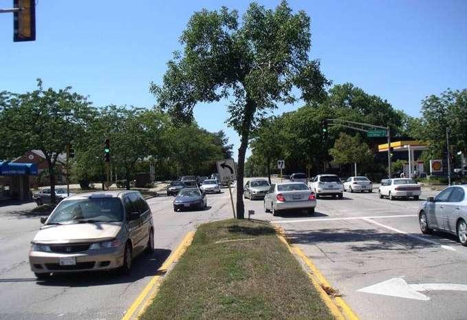
6 Yet many roads are still built like this Recently completed roadway expansion with destinations on both sides of the road. Can you spot the pedestrian?


7 What is a Complete Streets policy? A complete streets policy ensures that the entire right-of-way is planned, designed & operated to provide safe access for all users.


8 Complete streets policies provide for: Pedestrians Bicyclists Transit Motorists Travelers of all ages and abilities US Access Board
9 Why have a complete streets policy? To create a complete network of streets that serve all users To change practice, integrating the needs of all street users into everyday transportation planning practices To ensure every transportation project becomes an opportunity to help create a complete street.

10 Why have a complete streets policy? To bring an overarching vision and consistency to disparate departmental approaches To improve departmental efficiency and streamlining
11 Complete Streets is NOT: A design prescription A mandate for immediate retrofit A silver bullet. Other initiatives, such as context sensitivity, are still needed!


12 CS changes intersection design

13 CS changes bicycling

14 CS changes bicycling


15 CS changes transit
16 Who benefits from Complete Streets? Everybody


17 Who wants Complete Streets? 55% of Americans would rather drive less & walk more Transit is growing faster than population or driving About one-third of Americans don t drive: 21% of Americans over 65. All children under 16. Many low income Americans cannot afford automobiles.


18 Benefits: Older Americans 21% of Americans over 65 do not drive More than 50% of nondrivers stay at home on a given day because they lack transportation options.

19 Benefits: Safety Medians reduced pedestrian crashes 40% Road diets reduce all crashes by at least 29% Countdown clocks reduce all crashes 25%

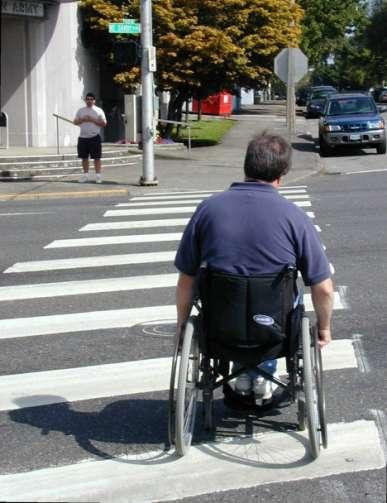
20 Benefits: People with disabilities Complete Streets improve mobility for disabled people and reduce the need for expensive paratransit service


21 Benefits: Better use of transit funds One year of paratransit service for a daily commuter: $38,500 Permanent improvements to make a transit stop accessible: $7,000 - $58,000 Source: Maryland Transit Administration

22 Benefits: Health Americans move without moving 60% of adults are at risk for diseases associated with inactivity: Obesity Diabetes High blood pressure Other chronic diseases


23 Benefits: Physical activity Residents are more likely to walk in a neighborhood with sidewalks. Cities with more bike lanes have higher levels of bicycle commuting

24 Benefits: The environment Less need for more or wider roads Less air/noise pollution/fuel consumption

25 Benefits: Reducing traffic Trips in metro areas: 50% under 3 miles 28% under 1 mile 65% of trips under 1 mile are taken by automobile

26 Benefits: Economic activity Well designed complete streets increase home values, help revitalize commercial areas and support the local economy

27 We know how to build right


28 ITE: Institute of Transportation Engineers AASHTO: American Association of State Highway and Transportation Officials
29 AASHTO Green Book Hierarchies of movement: Expressways Main travel movements High speeds Large traffic volumes Arterials Moderate speed Distribution Collectors Lower speeds Penetration of neighborhoods Local streets Local access FIGURE : Proportion of Service (1) Mobility to Land Use Continuum
30 Functional Class Consequences Arterials primarily to move traffic emphasizing: Operating speed Capacity Design requirements Wider lanes Increased turning radii Access management Traditionally has not addressed: Pedestrians Bicycles Transit FIGURE : Proportion of Service (1) Mobility to Land Use Continuum


31 Functional Class Consequences
32 Designing Walkable Urban Thoroughfares: A Context Sensitive Approach ITE New Recommended Practice

33 CSS Design Framework Context zones: Suburbs to downtowns

34 Thoroughfare Type in Design CSS Design criteria Physical configuration With surrounding context Dimensions for Roadside Traveled way Intersections Target speed (desirable operating speed)

35 Speed Matters High speeds lead to greater chance of serious injury & death
36 Child dart-out: speed is a factor! 150
37 First scenario: Speed 25 MPH 100 = distance covered in 2.5 sec. perception/reaction time Driver applies brakes
38 First scenario: Speed 25 MPH Driver applies brakes 50 stopping distance (wet pavement)
39 First scenario: Speed 25 MPH Result: Nothing happens beyond one scared child, driver & parent!
40 Second scenario: Speed 38MPH 140 = distance covered in 2.5 sec. perception/reaction time Driver applies brakes
41 Second scenario: Speed 38MPH Driver applies brakes
42 Second scenario: Speed 38MPH In the last 10 car slows to 36 MPH
43 Second scenario: Speed 38MPH Result: a high speed crash 150
44 Where do these two scenarios lie on the pedestrian fatality risk scale? Second scenario: Crash speed 36 MPH First scenario: no crash


45 Defining Mobility Typical experience: 45 mph speed 2 min wait at signal

46 Viable alternative: Defining Mobility 2-way progression set for 30 mph
47 Benefit/Cost Analysis Reducing speed from 45 mph to 30 mph For a 5-mile trip, a 3.33-minute delay Assume 30,000 ADT and $20/hr driver cost $ million in loss to economy, right? Wrong! Delay for each person is still 3.33 minutes Less time than their daily stop for Starbucks Community benefit Slower operating speeds Safer and more comfortable ped crossings

48 Roadway Capacity Analysis Design urban roadways to LOS D Designing to LOS C for peak hour means: Unnecessary pavement, waste of tax dollars Increased ped crossing times, thus reducing vehicular movement times Increased operating speeds for other 22 hours
49 Retrofitting urban arterials to Complete Streets Requires arterial traffic calming/taming: 1. Controlling operating speeds 2. Ped-friendly street crossings at unsignalized locations 3. Ped-friendly signalized intersections Requires facilities for nonmotorized users: 1. Pedestrians 2. Bicycles 3. Transit
50 Retrofitting urban arterials to Complete Streets Requires arterial traffic calming/taming: 1. Controlling operating speeds 2. Ped-friendly street crossings at unsignalized locations 3. Ped-friendly signalized intersections Requires facilities for nonmotorized users: 1. Pedestrians 2. Bicycles 3. Transit
51 Control Operating Speeds Signal progression Narrower travel lanes

52 Narrower Travel Lanes 70 mph lane widths not needed to handle 30 mph traffic

53 Narrower Travel Lanes News Flash! 10 and 11-foot lanes are just as safe as 12-foot lanes on urban arterials with posted speeds less than 45 mph
54 Control Operating Speeds Signal progression Narrower travel lanes Road diets


55 Effect of Converting 4-Lane Roads to 3-Lane and TWLTL Classic Road Diet 29% reduction in total crashes/mile
56 Three crash types can be reduced by going from 4 to 3 lanes X 1. Rear enders
57 Three crash types can be reduced by going from 4 to 3 lanes X 2. Side swipes
58 Three crash types can be reduced by going from 4 to 3 lanes X 3. Left turn/broadside
59 Handles 20,000 ADT Dolores Guerrero Valencia Mission S. Van Ness 1998 before Valencia Road Diet after Valencia Road Diet Mission District, San Francisco North-South ADT 59
60 Valencia Street Bicycle Volumes PM peak hour counts bikes/hr bikes/hr Valencia St before bike lanes after bike lanes
61 Control Operating Speeds Signal progression Narrower travel lanes Road diets Tighten corner curb radii


62 Effect of large radius on drivers They drive fast, ignoring pedestrians Tigard OR
63 Control Operating Speeds Signal progression Narrower travel lanes Road diets Tighten corner curb radii Eliminate free flow right turn lanes

64 Free Flow Right Turn Lanes Avoid free-flow flow movements Asheville NC they are difficult for pedestrians to cross Eliminate free flow turns across crosswalks/bikeways Designing Streets for Pedestrian Safety Interchanges & roundabouts 7-10

65 Free Flow Right Turn Lanes Eliminate free flow turns across crosswalks/bikeways
66 Control Operating Speeds Signal progression Narrower travel lanes Road diets Tighten corner curb radii Eliminate free flow right turn lanes Raised medians

67 Raised Medians Continuous raised median 40% reduction in pedestrian crashes

68 Raised Medians Flush median is not a refuge
69 Raised Medians Add a raised island
70 Control Operating Speeds Signal progression Narrower travel lanes Road diets Tighten corner curb radii Eliminate free flow right turn lanes Raised medians Median and parkway landscaping

71 Median/Parkway Landscaping
72 Control Operating Speeds Signal progression Narrower travel lanes Road diets Tighten corner curb radii Eliminate free flow right turn lanes Raised medians Median and parkway landscaping Retain curb parking

73 Retain Curb Parking Eliminating on-street parking encourages cars to go faster and discourages neighborhood business
74 Control Operating Speeds Signal progression Narrower travel lanes Road diets Tighten corner curb radii Eliminate free flow right turn lanes Raised medians Median and parkway landscaping Retain curb parking Curb bulb-outs

75 Curb Bulb-outs Sight distance and sight lines Rather than eliminate parking on approaches Add curb bulb-outs and retain parking
76 Retrofitting urban arterials to Complete Streets Requires arterial traffic calming/taming: 1. Controlling operating speeds 2. Ped-friendly street crossings at unsignalized locations 3. Ped-friendly signalized intersections Requires facilities for nonmotorized users: 1. Pedestrians 2. Bicycles 3. Transit
77 Pedestrian Crossings Narrower travel lanes Road diets

78 Road Diets Old centerline Reclaiming road space creates room for islands
79 Pedestrian Crossings Narrower travel lanes Road diets Tighten corner curb radii

80 Tighten Corner Curb Radii Intersection geometry: Large radii increase crossing distance, and affect crosswalk & ramp placement
 Effective radius")
81 Tighten Corner Curb Radii Actual curb radius (R1) Effective radius (R2)
82 Pedestrian Crossings Narrower travel lanes Road diets Tighten corner curb radii Corner pork chop islands

83 Corner Pork Chop Islands Benefits: Separate conflicts & decision points Reduce crossing distance Improve signal timing Reduce crashes
84 Pedestrian Crossings Narrower travel lanes Road diets Tighten corner curb radii Corner pork chop islands Visible crosswalks and ped warning signs


85 Visible Crosswalks What the pedestrian sees What the driver sees


86 Visible Crosswalks Continental Markings What the pedestrian sees What the driver sees
87 Pedestrian Crossings Narrower travel lanes Road diets Tighten corner curb radii Corner pork chop islands Visible crosswalks and ped warning signs Raised medians


88 Significant findings 1. Median reduces crashes by 40% 2. Pedestrians over 65 are overrepresented in crosswalk crashes 3. Pedestrians are not less vigilant in marked crosswalks: Looking behavior increased after crosswalks installed
89 Pedestrian Crossings Narrower travel lanes Road diets Tighten corner curb radii Corner pork chop islands Visible crosswalks and ped warning signs Raised medians Curb bulb-outs

90 Reduce crossing distance Improve sight distance and sight lines Prevent encroachment by parked cars Create space for curb ramps and landings Curb Bulb-outs
91 Retrofitting urban arterials to Complete Streets Requires arterial traffic calming/taming: 1. Controlling operating speeds 2. Ped-friendly street crossings at unsignalized locations 3. Ped-friendly signalized intersections Requires facilities for nonmotorized users: 1. Pedestrians 2. Bicycles 3. Transit
92 Signalized Intersections 3.5 fps walking speed for FDW and 3.0 fps for W + FDW
93 Pedestrian signal timing Recent studies found that previous 4.0 fps walking speed based on average walking speeds (not 15 th percentile) 2009 MUTCD now recommends using a pedestrian walking speed of 3.5 fps for FDW and 3.0 fps for overall WALK phase
94 Signalized Intersections 3.5 fps walking speed for FDW and 3.0 fps for W + FDW Accessible ramp design

95 Accessible Ramp Design Eliminate movement barriers

96 Accessible Ramp Design

97 Accessible Ramp Design Important design consideration: crosswalks, ramps & sidewalks should line up
98 Signalized Intersections 3.5 fps walking speed for FDW and 3.0 fps for W + FDW Accessible ramp design Countdown clocks

99 Effective Communications 50% of pedestrians in the U.S. do not understand that Flashing Don t Walk really means it is OK to continue walking So we put signs like this to correct the problem


100 Countdown Clocks Pedestrian count-down signal tells pedestrians how much crossing time is left


101 Pedestrian count-down signal tells pedestrians how much crossing time is left Reno NV

102 Countdown Clocks Results from San Francisco: 25% Crash Reduction Factor after countdown signals installed
103 Countdown Clocks in 2009 MUTCD The existing option of using pedestrian countdown displays is now a requirement for all new ped installations
104 Signalized Intersections 3.5 fps walking speed for FDW and 3.0 fps for W + FDW Accessible ramp design Countdown clocks Ped actuated HAWK signals
 Also in 2009")
105 HAWK Pedestrian Hybrid Signal HAWK (High Intensity Activated Crosswalk) Also in 2009 MUTCD


106 Drivers see Beacon Peds see Pedhead
107 Retrofitting urban arterials Requires facilities for nonmotorized users : 1. Pedestrians 2. Transit 3. Bicycles to Complete Streets Requires arterial traffic calming/taming: 1. Controlling operating speeds 2. Ped-friendly street crossings at unsignalized locations 3. Ped-friendly signalized intersections

108 AASHTO Ped Guide Safety is a key consideration Peds are the most vulnerable of all roadway users

109 Sidewalk Design Not after space for future sidewalks is all gone

110 Pedestrians can get by without sidewalks on quiet streets

111 Shoulders serve pedestrians in rural areas


112 Sidewalk Design Set triggers for future sidewalks Development densities Developer requirements Going from open to closed drainage


113 Sidewalks should not end midblock.. Fredericksburg VA Forcing pedestrian into street


114 Sidewalk Design Sidewalks on only one side of the street? Generally not recommended Lacks connectivity Weakens pedestrian safety by requiring unnecessary street crossings

115 Separated sidewalk is uncluttered, pleasant to walk on

116 Parkway separation makes it easy to meet ADA at driveways


117 Narrow curbside sidewalks are inadequate in commercial areas
118 Retrofitting urban arterials Requires facilities for nonmotorized users : 1. Pedestrians 2.Transit 3. Bicycles to Complete Streets Requires arterial traffic calming/taming: 1. Controlling operating speeds 2. Ped-friendly street crossings at unsignalized locations 3. Ped-friendly signalized intersections
119 Transit Objectives Ensure transit stops are convenient and accessible Ensure transit users can safely cross the street at every transit stop Address transit operators concerns Address other road users needs

120 Transit: Bus is most common mode

121 Transit: Only choice for many people

122 Narrow curbside sidewalk provides insufficient space for waiting

123 ... especially when bus comes & people board

124 Bus shelter placement should not obstruct sidewalk

125 Bus shelters must be accessible (Grass is not accessible)

126 Separated sidewalk allows bus shelter placement in planter strip

127 Every bus stop is a pedestrian crossing and all known crossing techniques apply to every bus stop

128 Why? 1. Peds can see traffic 2. Bus driver can move 3. Bus doesn t run over peds Place crosswalks behind bus stop!
129 Retrofitting urban arterials Requires facilities for nonmotorized users : 1. Pedestrians 2. Transit to Complete Streets Requires arterial traffic calming/taming: 1. Controlling operating speeds 2. Ped-friendly street crossings at unsignalized locations 3. Ped-friendly signalized intersections 3.Bicycles

130 Bicycle Facility Selection Shared Roadway Recognizes that most bicycle travel now occurs on streets and highways without bikeway designation
131 Bicycle Facility Selection Signed Shared Roadway Signing should indicate particular advantages to using the route over an alternative

132 Bike lanes most appropriate on urban thoroughfares They get you from one part of town to another efficiently Intersections stop or signal controlled the right way No point in striping local streets with bike lanes

133 Bicycle Facility Selection Bicycle Lanes Before stripping parking, reduce travel lane widths

134 Retrofit Option when: Current lane 22 ft with parking Vehicle speeds 30 mph How to implement: Reduce width of travel and parking lanes Accepted by AASHTO Implemented in Chicago
135 Bike Lanes: Improve Rider Behavior Riders at sites with sidewalks & no bike lanes Riders on sidewalk against traffic Total sw riders: 64% 25% 34% Riders on road with traffic Riders on sidewalk with traffic 39% 1% Riders on road against traffic Source: William Moritz, U.W. - Accident Rates for Various Bicycle Facilities - based on 2374 riders, 4.4 million miles
136 Bike Lanes: Improve Rider Behavior Riders at sites with sidewalks & bike lanes Riders on sw with traffic Total sw riders: 24% Riders on road against traffic Riders on sidewalk against traffic 3% 13% 11% 73% Riders on road with traffic Source: William Moritz, U.W. - Accident Rates for Various Bicycle Facilities - based on 2374 riders, 4.4 million miles
137 RELATIVE DANGER INDEX Of various types of facilities Major Streets w/o bike lanes 1.28 Minor Streets w/o bike lanes 1.04 * Streets with bike lanes 0.5 Mixed-use paths 0.67 Sidewalks 5.32 (* = shared roadway) 1.00 = median Source: William Moritz, U.W. - Accident Rates for Various Bicycle Facilities - based on 2374 riders, 4.4 million miles


138 Benefits: Streets work better Before After Edgewater Drive Orlando, FL
139 Crash Rate (per MVM) Benefits: Streets are safer % Reduction crash every 2.5 days (146 per yr) 1 crash every 4.2 days (87 per yr) 0.0 Before After
140 Parking Utilization Percentage Benefits: On-street parking better utilized 45% 40% 35% 30% 25% 20% 15% 10% 5% 0% 29% Before 41% After
141 Number of Pedestrians Benefits: More people walking % Increase 2,136 2, Before After
142 Number of Bicycles Benefits: More people biking % Increase Before After Complete Streets - District of Columbia - Dec

143 Benefits: Streets people will want

144 What does a Complete Street look like? There is no magic formula

145 The many types of Complete Streets Safe Routes to School

146 The many types of Complete Streets Bikeways on rural roads

147 The many types of Complete Streets Busy multi-modal thoroughfares

148 The many types of Complete Streets Transit routes

149 The many types of Complete Streets A commercial arterial w/ bike lanes & sidewalks

150 The many types of Complete Streets Residential skinny streets

151 The many types of Complete Streets Historic Main Street

152 Complete Streets Are sensitive to the community Serve adjacent land uses Serve all who potentially will use the street

153 Thank you!
154
Retrofitting Urban Arterials into Complete Streets
 Retrofitting Urban Arterials into Complete Streets John N. LaPlante, P.E., P.T.O.E., T.Y. Lin International Prepared for: Illinois Traffic Engineering & Safety Conference Urbana, Illinois October 18, 2007
Creating Complete Streets to Accommodate All Users
 Creating Complete Streets to Accommodate All Users Peter Lagerwey, Toole Design Group plagerwey@tooledesign.com Brian Dougherty, Seattle DOT brian.dougherty@seattle.gov International Conference on Urban
Complete Streets Design Considerations. Second Street Corridor Complete Streets Workshop and Assessment Manchester, NH April 26, 2013
 Complete Streets Design Considerations Second Street Corridor Complete Streets Workshop and Assessment Manchester, NH April 26, 2013 2 nd Street Existing Information Average Annual Daily Traffic Volumes
Highway School, Ithaca NY
 Highway School, Ithaca NY June 1, 2009 Michael Ronkin Designing Streets for Pedestrians and Bicyclists 1 We know how to build right 6 Yet many roads are built like this 7 What is a Complete Street?
City of Albert Lea Policy and Procedure Manual 4.10 ALBERT LEA CROSSWALK POLICY
 4.10 ALBERT LEA CROSSWALK POLICY PURPOSE: Pedestrian crosswalks are an integral part of our transportation infrastructure. To be effective and promote safety, marked crosswalks must be installed after
Designing Complete Streets: What you need to know
 Designing Complete Streets: What you need to know Getting from this to this. Continuous sidewalk Buffer w/trees Bicycle lane Raised median Buildings close to the street Flexibility in design Design and
Street Design Workshop. Existing cross section Traffic volumes Examine adjacent land uses You design future improvements
 Street Design Workshop Existing cross section Traffic volumes Examine adjacent land uses You design future improvements Primary Tools for Street Redesign Road diets Bike lanes Cycle tracks Trails Crosswalks
Implementation challenge 2: Is there room for Complete Streets? Does street classification enable Complete Streets?
 Implementation challenge 2: Is there room for Complete Streets? Does street classification enable Complete Streets? 1 Do we have to widen roads to fit everything? 2 There s room; it needs to be recaptured
Rutgers. October Designing Streets for People LLC
 Rutgers Voorhees Transportation Center October 22 2010 Michael Ronkin Designing Streets for People LLC 1 2 3 4 5 We know how to build right 6 Yet many roads are built like this Recently completed IL 64
Active Transportation Facility Glossary
 Active Transportation Facility Glossary This document defines different active transportation facilities and suggests appropriate corridor types. Click on a facility type to jump to its definition. Bike
REGIONAL BICYCLE AND PEDESTRIAN DESIGN GUIDELINES
 REGIONAL BICYCLE AND PEDESTRIAN DESIGN GUIDELINES November 16, 2011 Deb Humphreys North Central Texas Council of Governments Bicycle and Pedestrian Advisory Committee Snapshot of the Guide 1. Introduction
Agenda. Overview PRINCE GEORGE S PLAZA METRO AREA PEDESTRIAN PLAN
 PRINCE GEORGE S PLAZA METRO AREA PEDESTRIAN PLAN May 28, 2008 Agenda Welcome and introductions Project overview and issue identification Planning context and strengths Design challenges and initial recommendations
Designing for Pedestrian Safety
 Designing for Pedestrian Safety Road Diets Presented by: Peter Lagerwey Senior Planner, Toole Design Group November 3, 2010 Before After Learning Objectives At the end of this module, you will be able
Pedestrian & Bicycle Safety Innovations & Applications
 Pedestrian & Bicycle Safety Innovations & Applications County Engineers Association of Maryland Spring, 2017 Conference May 25, 2017 George Branyan Pedestrian Program Coordinator District Department of
Appendix 3 Roadway and Bike/Ped Design Standards
 Appendix 3 Roadway and Bike/Ped Design Standards OTO Transportation Plan 2040 4/20/2017 Page A3-1 Adopted Standards The adopted OTO Design Standards and Major Thoroughfare Plan are contained herein.
What Is a Complete Street?
 Session 5 Charleen Zimmer, AICP, Zan Associates May 5-7, 2010 What Is a Complete Street? May 2010 5-1 Not a Complete Street More of a Complete Street May 2010 5-2 Benefits of Complete Streets Safety for
Multimodal Through Corridors and Placemaking Corridors
 68 Multimodal Through Corridors and Placemaking Corridors Corridors have different functions in a region. Some corridors are used to get smoothly and rapidly through a region or to get quickly to major
Speed. Scale/design geometrics
 20 30 40 50 60 70 10 80 0 90 Speed Scale/design geometrics Source: New Jersey DOT 15 MPH can mean the difference between crash avoidance and almost certain death Speed Complete Streets Scale/design
Balancing Operation & Safety for Motorized and Non-Motorized Traffic
 Balancing Operation & Safety for Motorized and Non-Motorized Traffic Brian Willham, PE, PTOE Iowa Director - MOVITE June 30, 2014 Learning Objectives: When & Why should we measure the performance of complete
CURBSIDE ACTIVITY DESIGN
 5 CURBSIDE ACTIVITY DESIGN This chapter provides design guidance for separated bike lanes adjacent to curbside activities including parking, loading and bus stops. Typical configurations are presented
10.0 CURB EXTENSIONS GUIDELINE
 10.0 CURB EXTENSIONS GUIDELINE Road Engineering Design Guidelines Version 1.0 March 2017 City of Toronto, Transportation Services City of Toronto Page 0 Background In early 2014, Transportation Services
EXECUTIVE SUMMARY. Vision
 Vision Walking and bicycling in Salt Lake City will be safe, convenient, comfortable, and viable transportation options that connect people to places, foster recreational and economic development opportunities,
Road Diets FDOT Process
 Florida Department of TRANSPORTATION Road Diets FDOT Process Humberto Castillero, PE, PTOE Roadway Design Office Purpose of Guide Develop a statewide lane elimination review process Balance state & local
APPENDIX A: Complete Streets Checklist DRAFT NOVEMBER 2016
 APPENDIX A: Complete Streets Checklist DRAFT NOVEMBER 2016 Complete Streets Checklist MetroPlan Orlando s Complete Streets Checklist is an internal planning tool for staff to further implementation of
Randy Neufeld National Complete Streets Coalition. September 8, 2008
 1 Randy Neufeld National Complete Streets Coalition September 8, 2008 2 National Complete Streets Coalition Steering Committee AARP Association of Pedestrian and Bicycle Professionals Active Living by
DOWNTOWN MIAMI PEDESTRIAN PRIORITY ZONE
 DOWNTOWN MIAMI PEDESTRIAN PRIORITY ZONE AUGUST 6, 2013 DOWNTOWN MIAMI BY THE NUMBERS more than 200,000 people live, work, and play here every day is home to more than 1,000 events each year hosts more
G AT E WAY PLAN. Community BRIEFING KIT GATEWAY BIKE
 G AT E WAY PLAN GATEWAY BIKE Community BRIEFING KIT PLAN August 2016 TABLE OF CONTENTS INTRODUCTION... 1 THE BENEFITS OF A BIKEABLE COMMUNITY... 2 ECONOMY...2 SAFETY...3 HEALTH...3 HOUSEHOLD SPENDING...3
INTERSECTION DESIGN TREATMENTS
 Designing for Bicyclist Safety INTERSECTION DESIGN TREATMENTS LEARNING OUTCOMES Understand intersection design options and features Select appropriate design feature for a bikeway in a given context C1
PRINCE GEORGE S PLAZA METRO AREA PEDESTRIAN PLAN
 PRINCE GEORGE S PLAZA METRO AREA PEDESTRIAN PLAN May 28, 2008 Agenda Welcome and introductions Project overview and issue identification Planning context and strengths Design challenges and initial recommendations
ROAD DIETS. Michael Ronkin. New Partners for Smart Growth Los Angeles, February Designing Streets for Pedestrians and Bicyclists
 ROAD DIETS Michael Ronkin Designing Streets for Pedestrians and Bicyclists New Partners for Smart Growth Los Angeles, February 10 2007 1 Classic Road Diet Two-way street: 4 travel lanes 2 + CTL 2 Portland
Designing for Pedestrian Safety
 Designing for Pedestrian Safety Treatments at Unsignalized Pedestrian Crossings Presented by: Charlie Zegeer PBIC Director August 17, 2010 Crossing Crashes Part 1: General Principles 3 2 Why do people
Chapter 5: Crossing the Street
 Chapter 5: Crossing the Street Whether walking or bicycling, a student s journey to school will more than likely require crossing one or more streets. Per the Safe Routes to School Guide, maintained by
Bicycle Facilities Planning
 Bicycle Facilities Planning Overview Types of Cyclists Purpose for Riding Types of Facilities Bike Lanes Bicycle Boulevards Cycle Tracks Intersections Signals Signing and Marking Discussion Types of Bicyclists
Memo. Introduction. Memphis STP Pedestrian Sidewalk Project
 Memo Memphis STP Pedestrian Sidewalk Project To: Kyle Wagenshutz, City of Memphis From: Matthew Berkow, Collin Chesston, and Anne Eshleman, Alta Planning + Design Date: June 2014 Re: Photo Inventory Introduction
Walk Friendly Communities Engineering Strategies. Carl Sundstrom Walk Friendly Communities Workshop Grandview, MO June 2015
 Walk Friendly Communities Carl Sundstrom Walk Friendly Communities Workshop Grandview, MO June 2015 Module Overview Topics Background and purpose Sidewalks Crossings Traffic calming www.pedbikeimages.org
Cycle Track Design Best Practices Cycle Track Sections
 Design Best Practices Sections It is along street segments where the separation and protection methods of cycle tracks offer more comfort than conventional bicycle lanes, and are more attractive to a wide
Designing for Pedestrian Safety in Washington, DC
 Designing for Pedestrian Safety in Washington, DC February 25, 2014 George Branyan Pedestrian Program Coordinator District Department of Transportation DC Journey to work mode split: 2012 Means of Transportation
West Dimond Blvd Upgrade Jodhpur Street to Sand Lake Road
 West Dimond Blvd Jodhpur St to Sand Lake CSS Transportation Project Summary Municipality of Anchorage Project # 05 005 Project Manager: John Smith, P.E. (MOA PM&E) Project Administrator: Julie Makela,
Multimodal Design Guidance. October 23, 2018 ITE Fall Meeting
 Multimodal Design Guidance October 23, 2018 ITE Fall Meeting Introductions Jessica Wilson TDOT Multimodal Division Office of Multimodal Planning Program Supervisor Jessica.L.Wilson@tn.gov Ali Hangul TDOT
Broad Street Bicycle Boulevard Design Guidelines
 Broad Street Bicycle Boulevard Design Guidelines Building from the strategies introduced in the 2013 Bicycle Transportation Plan and community input received thus far, City Transportation Staff have identified
Appendix A: Crosswalk Policy
 Appendix A: Crosswalk Policy Appendix A: Crosswalk Policy Introduction This citywide Crosswalk Policy is aimed at improving pedestrian safety and enhancing pedestrian mobility by providing a framework
Complete Streets Accessible Networks for an Age-Friendly World
 Complete Streets Accessible Networks for an Age-Friendly World Jana Lynott, AICP Senior Strategic Policy Advisor AARP Public Policy Institute @JanaLynott What are Complete Streets? AARP Bulletin Complete
Access Management Regulations and Standards
 Access Management Regulations and Standards Efficient highway operation Reasonable property access Concept of Access Management The way to manage access to land development while simultaneously preserving
After. Before ROAD DIETS MODULE of 9 Safety Proven Countermeasures.
 Before After ROAD DIETS MODULE 10 1 of 9 Safety Proven Countermeasures http://safety.fhwa.dot.gov/provencountermeasures/fhwa_sa_12_013.htm Learning Objectives At the end of this module, you will be able
Development of Arlington County s Marked Crosswalk Guidelines. Jon Lawler, P.E. Design Engineer Arlington County, VA
 Development of Arlington County s Marked Crosswalk Guidelines Jon Lawler, P.E. Design Engineer Arlington County, VA April 13, 2015 Transportation System Users Residents Estimated 215,000 in 2014 Lowest
NJDOT Complete Streets Checklist
 Background The New Jersey Department of Transportation s Complete Streets Policy promotes a comprehensive, integrated, connected multi-modal network by providing connections to bicycling and walking trip
Safety & Convenience for All Users, in All Modes. Barbara McCann NCSL December 3, 2013
 Safety & Convenience for All Users, in All Modes Barbara McCann NCSL December 3, 2013 Safety & Convenience for All Users? Who was left out when this road was planned? Takaaki Iwabu for Raleigh News Observer
Omaha s Complete Streets Policy
 Omaha s Complete Streets Policy (Adopted August 2015) VISION To create great places and enhance our quality of life, the City of Omaha will provide safe, accessible streets for all users. Complete Streets
PEDESTRIAN ACCOMMODATIONS DPS 201 AT ROUNDABOUTS
 PEDESTRIAN ACCOMMODATIONS DPS 201 AT ROUNDABOUTS WHY THEY WORK FOR PEDESTRIANS IF DESIGNED CORRECTLY Separated sidewalks direct peds to crosswalks Splitter island Slow speed exit Truck apron Crosswalk
Chapter 2: Standards for Access, Non-Motorized, and Transit
 Standards for Access, Non-Motorized, and Transit Chapter 2: Standards for Access, Non-Motorized, and Transit The Washtenaw County Access Management Plan was developed based on the analysis of existing
Appendix C. TRAFFIC CALMING PROGRAM TOOLBOX
 Appendix C. TRAFFIC CALMING PROGRAM TOOLBOX PHASE I...2 Do Not Enter Sign...3 One-Way Sign...4 Turn Prohibition...5 Pavement Markings...6 Speed Monitoring Trailer...7 Neighborhood Speed Watch...8 Police
Off-road Trails. Guidance
 Off-road Trails Off-road trails are shared use paths located on an independent alignment that provide two-way travel for people walking, bicycling, and other non-motorized users. Trails specifically along
CHAPTER 16 PEDESTRIAN FACILITIES DESIGN AND TECHNICAL CRITERIA TABLE OF CONTENTS
 CHAPTER 16 PEDESTRIAN FACILITIES DESIGN AND TECHNICAL CRITERIA TABLE OF CONTENTS Section Title Page 16.1 General... 16-1 16.1.1 AASHTO Reference... 16-1 16.1.2 ADA Requirements... 16-1 16.2 Sidewalks...
Access Location, Spacing, Turn Lanes, and Medians
 Design Manual Chapter 5 - Roadway Design 5L - Access Management 5L-3 Access Location, Spacing, Turn Lanes, and Medians This section addresses access location, spacing, turn lane and median needs, including
Streets. Safe for Pedestrians 20% 2nd 5,000. Are We People-Friendly?
 Streets Safe for Pedestrians 20% Pedestrian deaths account for more than of all traffic-related fatalities in California each year. 600 More than people are killed and another 13,000 are injured every
C. Best Practice Pedestrian Treatment Toolbox
 C. Best Practice Pedestrian Toolbox The Best Practice Pedestrian Toolbox presents the recommended tools in striping, signalization, signage, geometry and other categories for improving both uncontrolled
Report. Typical Sections. City of Middleton, WI
 Report Typical Sections City of Middleton, WI December 2006 Report for City of Middleton, Wisconsin Typical Sections repared by: Traffic Associates LLC and STRAND ASSOCIATES, INC. 910 West Wingra Drive
COMPLETE STREETS DESIGN STATE OF THE PRACTICE
 COMPLETE STREETS DESIGN STATE OF THE PRACTICE Marshall Elizer, PE, PTOE, Senior Principal Michael Sewell, P.E., Senior Vice President Gresham, Smith and Partners (GS&P) SDITE, Monday, March 27, 2017 Acknowledgments
The DC Pedestrian Master Plan
 The DC Pedestrian Master Plan September 28, 2010 George Branyan Pedestrian Program Coordinator District Department of Transportation Presentation Agenda Scope of the Plan Methodology Recommendations Implementation
INDEX. Geometric Design Guide for Canadian Roads INDEX
 Acceleration lane, see Lanes, Acceleration Access, 8.1 Access Management and Functional Classification 8.2 Access Management by Design Classification 8.3 Access Configuration 8.4 Building Set-Back Guidelines
Bridgewater Complete Streets Prioritization Plan and Pedestrian Safety Assessment
 Bridgewater Complete Streets Prioritization Plan and Pedestrian Safety Assessment Presented by Luciano Rabito Manager of Complete Streets Presented to Bridgewater, MA Wednesday, April 26, 2017 6:30 P.M.
SECTION 1 - TRAFFIC PLANNING
 SECTION 1 - TRAFFIC PLANNING 1.1 TRAFFIC OPERATIONS 1.1.1 Roadway Functional Classification The Multnomah County Comprehensive Framework Plan s Policy 34: Trafficways and the Functional Classification
Road Diets: Reconfiguring Streets for Multi-Modal Travel
 Road Diets: Reconfiguring Streets for Multi-Modal Travel Tom Grant, P.E., PTOE What is a Road Diet? Reconfiguration of travel lanes to benefit all roadway users (i.e., Complete Street) Reclaiming the space
Who is Toole Design Group?
 2018 AASHTO Bike Guide Status Update NCHRP 15 60 Amalia Leighton Cody, PE, AICP & Kenneth Loen, PE Washington APWA October 4, 2018 Who is Toole Design Group? TDG is a full service engineering, planning
Complete Streets Policy DAVID CRONIN, P.E., CITY ENGINEER
 Complete Streets Policy DAVID CRONIN, P.E., CITY ENGINEER Complete Streets City Commission adopted a Complete Streets policy in 2012 Complete Streets are road networks that are designed for all users:
Classification Criteria
 SCHEDULE D TO RECOMMENDED OFFICIAL PLAN AMENDMENT NO. 40 SCHEDULE C-4 Road Criteria Criteria Traffic Service Objective Land Service/Access Typical Daily Traffic Volume Flow characteristics Travel Speed
Physical Implications of Complete Streets Policies
 Presentation Overview Physical Implications of Complete Norm Cox, ASLA, LLA Landscape Architect Ann Arbor, Michigan, 10:45 to Noon What Are Complete Streets? What Matters to Bicyclists and Pedestrians
Road Diets and Roundabouts
 Road Diets and Roundabouts Paul Zykofsky, AICP Local Government Commission Sacramento, CA Classic Road Diet 4 to 3 lanes San Antonio TX On-street parking Median Bike Lanes Center Turn-Lane Seattle WA Road
AMATS Complete Streets Policy
 AMATS Complete Streets Policy Table of Contents: Section 1. Definition of Complete Streets Section 2. Principles of Complete Streets Section 3. Complete Streets Policy Section 4. Consistency Section 5.
o n - m o t o r i z e d transportation is an overlooked element that can greatly enhance the overall quality of life for the community s residents.
 N o n - m o t o r i z e d transportation is an overlooked element that can greatly enhance the overall quality of life for the community s residents. 84 Transportation CHAPTER 11 INTRODUCTION Transportation
JCE 4600 Transportation Engineering. Traffic Control
 JCE 4600 Transportation Engineering Traffic Control Human Factors Primary Driving Tasks NAVIGATION GUIDANCE CONTROL What makes a Traffic Control Device Effective? Fulfill a need Command Attention Convey
Defining Purpose and Need
 Advanced Design Flexibility Pilot Workshop Session 4 Jack Broz, PE, HR Green May 5-6, 2010 Defining Purpose and Need In your agency s project development process, when do design engineers typically get
CITY OF SARATOGA SPRINGS PEDESTRIAN CROSSING TOOLBOX
 CITY OF SARATOGA SPRINGS PEDESTRIAN CROSSING TOOLBOX This toolbox is to be used to guide pedestrian crossing improvements within the City of Saratoga Springs. Details for each crossing type are provided.
How to Develop a Pedestrian Safety Action Plan
 How to Develop a Pedestrian Safety Action Plan Course Introduction Presented by: Peter Eun FHWA RC Safety Engineer Ryan Snyder President, Ryan Snyder Associates, LLC Paul Zykofsky Director, Land Use and
Real-Life Cost of Incomplete Streets
 Real-Life Cost of Incomplete Streets Presented by: Sheree Davis New Jersey Department of Transportation State Bicycle & Pedestrian Coordinator 609.530.6551 sheree.davis@dot.state.nj.us 2011 New Jersey
5 CIRCULATION AND STREET DESIGN
 5 CIRCULATION AND STREET DESIGN This chapter describes circulation and streetscape improvements proposed for the Northwest Chico Specific Plan Area. It includes detailed design specifications for existing
MEMORANDUM. Date: 9/13/2016. Citywide Crosswalk Policy
 MEMORANDUM Date: 9/13/2016 Re: Citywide Crosswalk Policy Foreword Through the s Circulation Element and Complete Streets Policy, it is the City s goal to promote walking trips and provide safe facilities
COMPLETE STREETS IN THE UNITED STATES. 200 S. Wacker Drive, Suite L Street NW, Suite Phone: Phone:
 LaPlante 1 COMPLETE STREETS IN THE UNITED STATES AUTHORS: John N. LaPlante, PE, PTOE Barbara McCann Director of Traffic Engineering Executive Director T.Y. Lin International, Inc. National Complete Streets
City of Jeffersonville Complete Streets Workshop
 City of Jeffersonville Complete Streets Workshop Planning for a Healthy Community Proudly brought to you by: WORKSHOP OVERVIEW 1. Complete Streets 101 2. Bloomington-Monroe County MPO Policy 3. Mobile
TOWN OF PORTLAND, CONNECTICUT COMPLETE STREETS POLICY
 TOWN OF PORTLAND, CONNECTICUT COMPLETE STREETS POLICY I. VISION, GOALS & PRINCIPLES VISION To improve the streets of Portland making them safer and more accessible for all users including pedestrians,
DRAFT - CITY OF MEDFORD TRANSPORTATION SYSTEM PLAN Roadway Cross-Sections
 Roadway Cross-Sections Medford s roadway cross-section standards apply to new and reconstructed roads. The crosssections take into consideration roadway function and operational characteristics, including
Transportation Planning Division
 Transportation Planning Division Presentation Outline Study Tasks Recap of Previous Meetings Data Collected Focus Areas within Study Limits Design Principles Tool Box Recommended Concepts Schedule Moving
Town of Mooresville, North Carolina Neighborhood Traffic Calming and Control Device Policy
 Town of Mooresville, North Carolina Neighborhood Traffic Calming and Control Device Policy Adopted January 6, 2014 Town of Mooresville Development Services Department TOWN OF MOORESVILLE NEIGHBORHOOD TRAFFIC
Dr. M.L. King, Jr. Street North Complete Streets Resurfacing Opportunities HOUSING, LAND USE, AND TRANSPORTATION COMMITTEE MARCH 22, 2018
 Dr. M.L. King, Jr. Street North Complete Streets Resurfacing Opportunities HOUSING, LAND USE, AND TRANSPORTATION COMMITTEE MARCH 22, 2018 What s Happening The City plans to mill and resurface Dr. M.L.
City of Birmingham Draft Multi-modal Transportation Plan
 City of Birmingham Draft Multi-modal Transportation Plan City Commission Public Hearing Monday, November 25, 2013 7:30 pm Norman Cox, PLA, ASLA The Greenway Collaborative, Inc. Ann Arbor, Michigan The
Acknowledgements. Mr. David Nicol 3/23/2012. Daniel Camacho, P.E. Highway Engineer Federal Highway Administration Puerto Rico Division
 Daniel Camacho, P.E. Highway Engineer Federal Highway Administration Puerto Rico Division Acknowledgements Mr. David Nicol Director, FHWA Office of Safety FHWA Office of Safety http://safety.fhwa.dot.gov/provencountermeasures/
Built Environment Childhood Obesity Forum September 15, 2010
 Built Environment Childhood Obesity Forum September 15, 2010 TITLE Why do we have cities? Boston MA To minimize travel & maximize exchange (bring people closer together) How have we built our urban roadway
Access Management in the Vicinity of Intersections
 Access Management in the Vicinity of Intersections FHWA-SA-10-002 Technical Summary Photo: Ralph Bentley (used with permission) 0 Access Management is: The design, implementation and management of entry
By Dan Burden, Executive Director Walkable and Livable Communities Institute
 By Dan Burden, Executive Director Walkable and Livable Communities Institute Is this the landscape we want to leave our children? LaJolla Boulevard, Birdrock, San Diego, CA 78 Feet Speeds above
Complete Streets. Designing Streets for Everyone. Sarnia
 Complete Streets Designing Streets for Everyone Sarnia Complete Streets ~ Sarnia ~ 2018 Introduction Our City is made up of a network of streets that we use to go for a walk, cycle to work, drive to the
PEDESTRIAN ACCOMMODATIONS DPS 201 AT INTERCHANGES
 PEDESTRIAN ACCOMMODATIONS DPS 201 AT INTERCHANGES UNDERSTANDING THE ISSUES Intersections of freeway ramp terminals at crossroads are the most critical components of an interchange Challenge: balance mobility
Central Arkansas Regional Transportation Study Area ROADWAY DESIGN STANDARDS And Implementation Procedures
 Central Arkansas Regional Transportation Study Area ROADWAY DESIGN STANDARDS And Implementation Procedures These standards have been prepared for the use of all jurisdictions to incorporate into their
95 th Street Corridor Transportation Plan. Steering Committee Meeting #2
 95 th Street Corridor Transportation Plan Steering Committee Meeting #2 February 18, 2015 PURPOSE OF THE MEETING Update Steering Committee Present Community/Stakeholder Survey Results Present Transportation
Toolbox of Countermeasures and Their Potential Effectiveness to Make Intersections Safer
 8 Toolbox of Countermeasures and Their to Make Intersections Safer Introduction Studies included in the NCHRP 17-18 (3), Guidance for Implementation of the AASHTO Strategic Highway Safety Plan, as well
Aurora Urban Street Standards For Transit Oriented Developments and Urban Centers
 Aurora Urban Street Standards For Transit Oriented Developments and Urban Centers I. Purpose These standards will be applied to create a safe, comfortable, pleasant and pedestrian-friendly multi-modal
STEERING COMMITTEE MEETING June 17, Streetscape Overview Burlington Comprehensive Master Plan
 STEERING COMMITTEE MEETING June 17, 2015 Streetscape Overview Burlington Comprehensive Master Plan 1 Introduction Slide This slide show was presented to the Burlington Steering Committee on June 17, 2015
Master Thoroughfare Plan Roadway Design Guidelines
 WACO METROPOLITAN AREA Master Thoroughfare Plan Roadway Design Guidelines May 2012 DRAFT Waco Metropolitan Planning Organization Waco Master Thoroughfare Plan Context-Sensitive Roadway Design Guidelines
Planning Guidance in the 2012 AASHTO Bike Guide
 Planning Guidance in the 2012 AASHTO Bike Guide Presentation by: RJ Eldridge Peter Lagerwey August 22, 2012 WEBINAR 2: PLANNING GUIDANCE IN THE 2012 AASHTO BIKE GUIDE Today s Webinar Significant Updates
This Chapter sets forth the minimum design, technical criteria and specifications to be used in the preparation of all roadway plans.
 4.1 GENERAL This Chapter sets forth the minimum design, technical criteria and specifications to be used in the preparation of all roadway plans. These Roadway Standards are for new construction and modification
Approaches. Livable Neighborhood Design. Examples. Traditional neighborhood development. CE 594 University of Wisconsin- Milwaukee
 Approaches Livable Neighborhood Design CE 594 University of Wisconsin- Milwaukee Traditional neighborhood design (TND), new urbanism, transit friendly design, transit oriented development and walkable