City of Birmingham Draft Multi-modal Transportation Plan
|
|
|
- Jesse Butler
- 5 years ago
- Views:
Transcription

1 City of Birmingham Draft Multi-modal Transportation Plan City Commission Public Hearing Monday, November 25, :30 pm Norman Cox, PLA, ASLA The Greenway Collaborative, Inc. Ann Arbor, Michigan The Greenway Collaborative, Inc.

2 Planning Process Started September 2012 Web survey in October Visioning workshop in January Preliminary Plan Open House in February May Draft Plan June Draft Plan July Draft Plan Current October Draft Plan Under Consideration And monthly meetings with the project Steering Committee

3 Third Public Hearing October 14, 2013 Draft First Planning Board Public Hearing held in July: Added Executive Summary Changes to the Intersection Improvement section Second Planning Board Hearing held in September Minor Changes to Glossary Clarification on How the Plan will be Used The plan also received public input from a web survey and two public workshops
4 Changes from the September Draft No substantial changes since review and recommendation of approval from Planning Commission Fixed Minor Typos Fixed Glossary of Terms Public input since that time Concerns with 4 to 3 lane conversion on West Maple Concerns with removing signal option on Lake Park and West Maple

5 Executive Summary The Cost of Doing Nothing The Cost of Physical Inactivity Preparing for an Aging Population Positioning Birmingham for the New Economy Economical Implementation Through Long-range Planning How to Use the Master Plan Most residents are within convenient walking and bicycling distance to the majority of destinations in the City. The proposed network, policies and programs will make that a more attractive and safer choice.

6 The Cost of Doing Nothing From 2004 through 2011 automobiles struck: 67 Pedestrians 44 Bicycles Average one a month Tremendous physical and emotional toll on person hit and drivers Comprehensive economic cost nearly 17 million dollars $2.1 million per year $104 per resident each year Cost of Phase 1 & 2 about $2.3 million If phase 1 & 2 reduced crashes as little as 14% this would be viewed as a success from a cost benefit perspective

7 Cost of Physical Inactivity Metro Detroit s residents 1/3 overweight 1/3 obese 28% no physical activity Average cost per person of physical inactivity in 2002 was $1,175 Cardiovascular disease Obesity Diabetes Osteoporosis Mental health disorders Some cancers Growing body of research shows that the physical environment impacts physical activity levels You are 47% more likely to be active at least 30 minutes a day if you live in a neighborhood with sidewalks


8 Preparing for an Aging Population 4 to 3 lane conversions 2.3 % increase in residents 65 and older 2000 to % population involved in 28% of all crashes In 2040, 65+ to make up 20% of population Many improvements will specifically help seniors age in place: Shorter crosswalks Better visibility Traffic calming Better access to transit

9 Positioning Birmingham for the New Economy Massive decline in 25 to 39 year old residents 2000 to 2010 Down 1,131 young adults in 10 years MSU Land Policy Institute Study; target the following for economic growth: Educated youth High-equity immigrants Educated senior citizens Entrepreneurs Pedestrian and bicycle linkages and transit key to attracting this demographic

10 Project Tailored to Birmingham 90% of the cost of proposed improvements are for pedestrian improvements More convenient and safer road crossings Address gaps in the sidewalk system Wayfinding improvements Proposed bicycle system includes a low-stress network utilizing lowspeed roads and connecting pathways Coordinated with transit

11 Economical Implementation Through Long-Range Plan Many of the improvements will be integrated into larger road construction projects Integrating multi-modal elements at the beginning of the process A system perspective rather than a piecemeal approach Focus on a foundation system


12 How to Use the Master Plan Very specific recommendations Reponses to the demands of planning within an existing constricted environment Pragmatic vision of what is currently feasible Use as a guide this is a city-wide view Rapidly changing field Each corridor or intersection should be revisited and studied prior construction Some should be tested


13 Multi-modal Network Responds to the needs of various users and trip types Web Survey Results: About 72% of respondents would walk to work and/or do errands if there was a system of sidewalks, pathways, crosswalks, bike lanes, etc. Around 84% of respondents feel that a complete network for bicycle facilities such as bike lanes, signed routes and trails are very important or somewhat important to making future bicycling trips actually happen


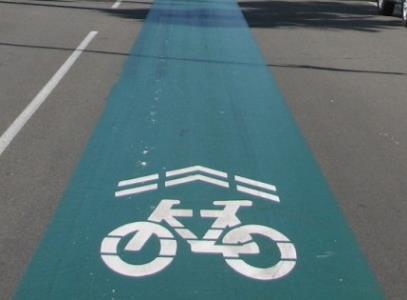
14 Bike Lanes 3.7 miles proposed Web Survey Results: Around 20% of respondents currently bike to work and/or the store on a weekly basis Around 58% would be comfortable riding a bike in a bike lane on a minor road Around 30% would be comfortable riding a bike in a bike lane on a major road If the appropriate facilities were constructed 69% of respondents would be interested in bicycling to work and/or for errands


15 Shared Lane Markings 10.7 miles
16 Neighborhood Connectors 15.4 miles on local roads, 2.2 mi. on pathways Web Survey Results: Around 73% of respondents would be comfortable riding a bike along a Bike Route on a Residential Road Web Survey Results: Around 82% of respondents feel wayfinding signs for suggested bicycle and pedestrian routes to key destinations are very important or somewhat important to making future walking and bicycling trips actually happen


17 Sidewalks 2.5 additional miles along major roads Web Survey Results: About 38% of respondents walk to work and/or the store daily or weekly About 80% of respondents walk for fun and/or exercise daily or weekly Around 79% of respondents feel a complete sidewalk system is very important to non-motorized trips actually happening in the future


18 Road Crossings Curb Extensions 42 Proposed When curb extensions are used on a road with bike lanes, the bike lane continues past the curb extension


19 Road Crossings Crossing Islands 9 Islands, 3 with Rectangular Flashing Beacons Proposed Crossing Island proposed at river trail location Web Survey Results: Around 61% of respondents feel that mid-block crosswalks are very important or somewhat important to making future walking and bicycling trips actually happen


20 Road Crossings Upgrades 18 Locations Proposed Many of the proposed improvements include upgrades such as ramps, detectable warnings, pedestrian signals and high visibility crosswalk markings


21 Specific Intersection Recommendations Prior to implementing any of the alternatives, a detailed engineering study will be undertaken For each of the 8 locations, a number of viable alternatives were identified based on an analysis of existing conditions Some of those alternatives are dependent on other proposed changes to the roadway

 5 Bus Shelters (Not")
22 Network Implementation Plan Summary Costs for first two phases: Phase 1 $1,300,000 Phase 2 $1,000,000 Approximately 15 miles of new facilities are proposed in all four phases: 3.8 Miles of Bike Lanes 0.5 Miles of Buffered Bike lanes 12 Miles of Shared Lane markings 0.2 Miles of Colored Shared Lane Markings 16 Miles of Neighborhood Connector Routes 3.5 Miles Of Pathways & Sidewalks 64 Road Crossing Improvements 2 Tree Extensions 4 Active Transportation Hubs (Not shown on Map) 5 Bus Shelters (Not Shown on Map) 64 Bicycle Hoops (Not shown on Map) 3 enclosed & secured bike rooms (Not shown on Map)


23 A Number of Details Are Provided in Phasing Plan


24 Specific Area Plans Lincoln Street West Maple Road Woodward Avenue Downtown


25 Public and Program Recommendations Transportation Project Coordination and Public Input Bicycle Parking Ordinance Snow Removal ADA transition plan Walking & Bicycling Maps Ped. and Bicycle Counts Pedestrian and Bicycle Crash Tracking Continue with Community Recognition Programs Measurements of Infrastructure Progress
26 City of Birmingham Draft Multi-modal Transportation Plan Questions? Norman Cox, PLA, ASLA The Greenway Collaborative, Inc. Ann Arbor, Michigan The Greenway Collaborative, Inc.
City Birmingham Multi-Modal Transportation Plan Visioning Workshop Results Meeting
 City Birmingham Multi-Modal Transportation Plan Visioning Workshop Results Meeting Monday, January 28, 2013 7:30 PM, City Hall Norman Cox, PLA, ASLA. Ann Arbor, Michigan. www.greenwaycollab.com Community
GIS Based Non-Motorized Transportation Planning APA Ohio Statewide Planning Conference. GIS Assisted Non-Motorized Transportation Planning
 The Purpose of GIS Assisted Network GIS Assisted Non-Motorized Transportation 2011 APA Ohio Statewide Conference Friday, 10:45 AM to Noon Focus on near-term projects wwwgreenwaycollabcom The purpose of
Physical Implications of Complete Streets Policies
 Presentation Overview Physical Implications of Complete Norm Cox, ASLA, LLA Landscape Architect Ann Arbor, Michigan, 10:45 to Noon What Are Complete Streets? What Matters to Bicyclists and Pedestrians
City of Novi Non-Motorized Master Plan 2011 Executive Summary
 City of Novi Non-Motorized Master Plan 2011 Executive Summary Prepared by: February 28, 2011 Why Plan? Encouraging healthy, active lifestyles through pathway and sidewalk connectivity has been a focus
GIS Based Data Collection / Network Planning On a City Scale. Healthy Communities Active Transportation Workshop, Cleveland, Ohio May 10, 2011
 The Purpose of GIS Based Network Planning GIS Based Data Collection / Network Planning Healthy Communities Active Transportation Conference Tuesday, May 10, 2011 10:00 AM Norman Cox, LLA, ASLA. Ann Arbor,
CHAPTER 3: Vision Statement and Goals
 Davidson Walks & Rolls: Active Transportation Master Plan CHAPTER 3 Contents: Overview Vision Statement Measurable Goals Public Outreach CHAPTER 3: Vision Statement and Goals Overview The vision statement
EXECUTIVE SUMMARY. Vision
 Vision Walking and bicycling in Salt Lake City will be safe, convenient, comfortable, and viable transportation options that connect people to places, foster recreational and economic development opportunities,
WALKNBIKE DRAFT PLAN NASHVILLE, TENNESSEE EXECUTIVE SUMMARY NASHVILLE, TENNESSEE
 NASHVILLE, TENNESSEE EXECUTIVE SUMMARY Executive Summary A world-class multi-modal transportation system is essential to a vibrant city and better quality of life. -Mayor Barry The WalknBike plan aims
Perryville TOD and Greenway Plan
 Perryville TOD and Greenway Plan Greenway Glossary Pathway: A bicycle and pedestrian path separated from motorized vehicular traffic by an open space, barrier or curb. Multi-use paths may be within the
City of Ann Arbor Pedestrian Safety & Access Task Force
 City of Ann Arbor Pedestrian Safety & Access Task Force Task Force Meeting Wednesday, October 1 st from 5 to 7 PM Basement Conference Room, Larcom City Hall The Greenway Collaborative, Inc. www.greenwaycollab.com
GRAHAM PEDESTRIAN TRANSPORTATION PLAN
 GRAHAM PEDESTRIAN TRANSPORTATION PLAN Chapter 1 I 1.1 Scope and Purpose n March of 2005, the City of Graham contracted with Greenways Incorporated (GWI) to create a Pedestrian Transportation Plan. The
Creating Complete Streets to Accommodate All Users
 Creating Complete Streets to Accommodate All Users Peter Lagerwey, Toole Design Group plagerwey@tooledesign.com Brian Dougherty, Seattle DOT brian.dougherty@seattle.gov International Conference on Urban
PEDESTRIAN ACTION PLAN
 ATTACHMENT 2 CITY OF SANTA MONICA PEDESTRIAN ACTION PLAN CITY OF SANTA MONICA PEDESTRIAN ACTION PLAN This page intentionally left blank EXECUTIVE SUMMARY CHAPTER 1 EXECUTIVE SUMMARY Setting the Stage
City of Ann Arbor Pedestrian Safety & Access Task Force
 City of Ann Arbor Pedestrian Safety & Access Task Force (PSATF) Community Wide Meeting Wednesday, July 8th 6:30 to 8:30 PM Multi purpose Room, Downtown Library www.a2gov.org/pedsafety The Greenway Collaborative,
Urbana Pedestrian Master Plan
 Urbana Pedestrian Master Plan Recommendations Gabe Lewis, Transportation Planner Champaign County Regional Planning Commission November 15, 2018 Public Meeting #2 Public Input Round #1 Thank You! 10 public
TOWN OF WILLIAMSTON, SC BICYCLE AND PEDESTRIAN MASTER PLAN TOWN OF WILLIAMSTON, SC BICYCLE AND PEDESTRIAN MASTER PLAN
 TOWN OF WILLIAMSTON, SC BICYCLE AND PEDESTRIAN MASTER PLAN Americans Want Choices 55% of Americans would rather drive less & walk more. Transit use is growing faster than population or highway travel.
MASTER BICYCLE AND PEDESTRIAN PLAN
 VILLAGE OF NORTHBROOK MASTER BICYCLE AND PEDESTRIAN PLAN DRAFT PLAN OPEN HOUSE May 2, 2018 AGENDA 1. Community Engagement 2. Vision and Goals 3. General Structure of Plan 4. Recommendations Overview 5.
City of Jacksonville Mobility Fee Update
 City of Jacksonville Mobility Fee Update 2017 Preliminary Analysis May 3, 2017 Carnival Cruise lines photo credit Presentation Overview Public Outreach Process Pedestrian and Bicycle Master Plan Study
This page intentionally left blank.
 This page intentionally left blank. COMMUNITY Coweta Community Overview Coweta Coweta, a residential community located in Wagoner County, is a suburb of Tulsa situated southeast of the metropolitan area
Existing Pedestrian Conditions. PSAC February 8, 2011
 Existing Pedestrian Conditions PSAC February 8, 2011 Contents 1. Project Background & Goals 2. Pedestrian Activity: Where people walk 3. Pedestrian Safety: The conditions people face Project Background
City of Wilsonville 5 th Street to Kinsman Road Extension Project
 City of Wilsonville 5 th Street to Kinsman Road Walking Tour & Neighborhood Workshop Summary Report Public Outreach Overview On July 18 th, 2017, the City of Wilsonville hosted a neighborhood walking tour
Safety & Convenience for All Users, in All Modes. Barbara McCann NCSL December 3, 2013
 Safety & Convenience for All Users, in All Modes Barbara McCann NCSL December 3, 2013 Safety & Convenience for All Users? Who was left out when this road was planned? Takaaki Iwabu for Raleigh News Observer
Arlington s Master Transportation Plan
 Arlington s Master Transportation Plan The Master Transportation Plan (MTP) Adopted in eight parts Goals & Policies element and MTP Map adopted in 2007 Bicycle, Pedestrian and Demand and Systems Management
9/21/2016 VIA . RE: The Knot (DR16-270)
") 9/21/2016 VIA EMAIL Garrett Norman, Assistant Planner City of Sacramento Community Development Department 300 Richards Boulevard, 3 rd Floor Sacramento, CA 95811 RE: The Knot (DR16-270) Dear Mr. Norman:
9/21/2016 VIA EMAIL Garrett Norman, Assistant Planner City of Sacramento Community Development Department 300 Richards Boulevard, 3 rd Floor Sacramento, CA 95811 RE: The Knot (DR16-270) Dear Mr. Norman:
Non-Motorized Transportation 7-1
 Non-Motorized Transportation 7-1 Transportation facilities no longer mean just accommodating a vehicle powered by a combustion engine. Pedestrian and non-motorized facilities are important modes of travel
Downtown Naples Mobility and Connectivity Study. Naples City Council Presentation January 2017
 Downtown Naples Mobility and Connectivity Study Naples City Council Presentation January 2017 Agenda 1. Introduction 2. Scope Review 3. Project Schedule 4. Existing Conditions 5. Public Charrette 6. Mobility
Executive Summary Route 30 Corridor Master Plan
 Route Corridor Master Plan Project Overview The Route Corridor Master Plan is a coordinated multimodal transportation and land use plan for the entire stretch of Route through East Whiteland Township,
Table of Contents Introduction. 2 Purpose of the Plan...2 The Benefits of Walking and Bicycling...3 Vision and Goals of the Plan...
 BICYCLE AND This plan was created through a grant from the Healthy Communities Program with the cooperation of the City of Cynthiana, Cynthiana Main Street, Cynthiana-Harrison County-Berry Joint Planning
o n - m o t o r i z e d transportation is an overlooked element that can greatly enhance the overall quality of life for the community s residents.
 N o n - m o t o r i z e d transportation is an overlooked element that can greatly enhance the overall quality of life for the community s residents. 84 Transportation CHAPTER 11 INTRODUCTION Transportation
San Jose Transportation Policy
 San Jose Transportation Policy Protected Intersections in LOS Policies to Support Smart Growth Presented by: Manuel Pineda City of San Jose Department of Transportation Bay Area Map San Francisco Oakland
City of Charlottesville Bicycle and Pedestrian Master Plan Update
 City of Charlottesville Bicycle and Pedestrian Master Plan Update September 17, 2014 I. Welcome and meeting overview II. Project status update III. Network overview IV. Break-out groups Pedestrian Network
Bicycle-Pedestrian Master Plan: Chapters 3 and 4 Distribution
 Bicycle-Pedestrian Master Plan: Chapters 3 and 4 Distribution Finksburg Planning and Citizens Council March 22, 2018 Overview Progress Citizen Outreach Vision Chapter 3 - Existing Conditions Chapter 4
Bicycle Facilities Planning
 Bicycle Facilities Planning Overview Types of Cyclists Purpose for Riding Types of Facilities Bike Lanes Bicycle Boulevards Cycle Tracks Intersections Signals Signing and Marking Discussion Types of Bicyclists
Introduction. Who is WILMAPCO. Why are walkable communities important
 Walkable Community Workshops Round 1 April 2005 SPONSORED BY WILMAPCO AND CCOBH CITY OF NEW CASTLE EDGEMOOR GARDENS CIVIC ASSOCIATION WITH FUNDING BY DELAWARE DEPARTMENT OF TRANSPORTATION AND THE DELAWARE
Appendix C 3. Bicycle / Pedestrian Planning
 Appendix C 3. Bicycle / Pedestrian Planning BICYCLE/PEDESTRIAN PLANNING 2005 Master Plan GOAL: Provide for safe and convenient bicycle and pedestrian circulation throughout the City. Develop a city-wide
Plant City Walk-Bike Plan
 Plant City Walk-Bike Plan Plant City Commute Mode Share 2.2% 1.4% 2.9% Drove alone 10.2% Carpooled Public transportation (0.1%) Walked Used a Bike (0.4%) 82.9% Taxicab, motorcycle, or other means Worked
Goodlettsville Bicycle and Pedestrian Plan Executive Summary
 Goodlettsville Bicycle and Pedestrian Plan July 2010 In Cooperation with the Nashville Area Metropolitan Planning Executive Organization Summary Introduction Progressive and forward thinking communities
Goal 3: Foster an environment of partnerships and collaboration to connect our communities and regions to one another.
 Non-Motorized Transportation Plan (NMTP) Draft Vision, Goal and,, Tri-County Regional Planning Commission (TCRPC) Purpose The purpose of the Tri-County Regional Planning Commission (TCRPC) Non-Motorized
HYATTSVILLE TRANSPORTATION PLAN. City Council Update March 19, 2018
 HYATTSVILLE TRANSPORTATION PLAN City Council Update March 19, 2018 AGENDA PROJECT GOALS DATA COLLECTION WHAT WE LEARNED NEXT STEPS PROJECT GOALS Identify bicycle and pedestrian needs of the city Evaluate
Bikeway action plan. Bicycle Friendly Community Workshop March 5, 2007 Rochester, MN
 Bikeway action plan Summary The was held on March 5, 2007 at the Rochester Mayo Civic Center. The workshop was hosted by Rochester-Olmsted County Planning Department in collaboration with the League of
Agenda. Overview PRINCE GEORGE S PLAZA METRO AREA PEDESTRIAN PLAN
 PRINCE GEORGE S PLAZA METRO AREA PEDESTRIAN PLAN May 28, 2008 Agenda Welcome and introductions Project overview and issue identification Planning context and strengths Design challenges and initial recommendations
8/31/2016 VIA . RE: Freeport Arco Fuel Station (P16-039)
") 8/31/2016 VIA EMAIL Garrett Norman, Assistant Planner City of Sacramento Community Development Department 300 Richards Boulevard, 3 rd Floor Sacramento, CA 95811 RE: Freeport Arco Fuel Station (P16-039)
8/31/2016 VIA EMAIL Garrett Norman, Assistant Planner City of Sacramento Community Development Department 300 Richards Boulevard, 3 rd Floor Sacramento, CA 95811 RE: Freeport Arco Fuel Station (P16-039)
IBI Group November 5, 2012
 IBI Group Agenda Session 1 3:00 PM Welcome / Sign in 3:10 PM Presentation 3:30 PM Questions? 3:35 PM World Café Discussion 4:45 PM Report on top 3 ideas 4:50 PM Next Steps 5:00 PM Adjourn 2 Agenda Session
Complete Streets Accessible Networks for an Age-Friendly World
 Complete Streets Accessible Networks for an Age-Friendly World Jana Lynott, AICP Senior Strategic Policy Advisor AARP Public Policy Institute @JanaLynott What are Complete Streets? AARP Bulletin Complete
PRINCE GEORGE S PLAZA METRO AREA PEDESTRIAN PLAN
 PRINCE GEORGE S PLAZA METRO AREA PEDESTRIAN PLAN May 28, 2008 Agenda Welcome and introductions Project overview and issue identification Planning context and strengths Design challenges and initial recommendations
Proposed. City of Grand Junction Complete Streets Policy. Exhibit 10
 Proposed City of Grand Junction Complete Streets Policy Exhibit 10 1 City of Grand Junction Complete Streets Policy Vision: The Complete Streets Vision is to develop a safe, efficient, and reliable travel
Washington County SW Beaverton-Hillsdale Hwy. & SW Scholls Ferry Rd.
 Washington County SW Beaverton-Hillsdale Hwy. & SW Scholls Ferry Rd. SW Beaverton-Hillsdale Hwy. & SW Scholls Ferry Rd. Washington County The SW Beaverton-Hillsdale Hwy & SW Scholls Ferry Rd. focus area
NM-POLICY 1: Improve service levels, participation, and options for non-motorized transportation modes throughout the County.
 Transportation PRINCE WILLIAM COUNTY 2008 COMPREHENSIVE PLAN NON-MOTORIZED PLAN CONTENTS Goals, Policies, and Action Strategies Table 4 (Bike Facility Classifications and Descriptions) Table 5 (Bike Facility
Hennepin County Pedestrian Plan Public Comment Report
 Hennepin County Pedestrian Plan Public Comment Report On May 31, 2013, the draft Hennepin County Pedestrian Plan was released for a 45-day public comment period ending July 15, 2013. The county received
Complete Streets 101: The Basics
 Complete Streets 101: The Basics Michigan Municipal League - Capital Conference March 21, 2017 Chip Smith, AICP - Senior Planner - Wade Trim Inc. and City Council member City of Ann Arbor 2017 MML Capital
Rochester Downtown Bicycle Study 2009
 Rochester Downtown Bicycle Study 2009 Relationship of ROCOG Long Range Transportation Plan to Rochester Comprehensive Plan Regional Long Range Transportation Plan (LRTP) is prepared under the auspices
Chapter 7. Transportation. Transportation Road Network Plan Transit Cyclists Pedestrians Multi-Use and Equestrian Trails
 Chapter 7 Transportation Transportation Road Network Plan Transit Cyclists Pedestrians Multi-Use and Equestrian Trails 7.1 TRANSPORTATION BACKGROUND The District of Maple Ridge faces a number of unique
Bridgewater Complete Streets Prioritization Plan and Pedestrian Safety Assessment
 Bridgewater Complete Streets Prioritization Plan and Pedestrian Safety Assessment Presented by Luciano Rabito Manager of Complete Streets Presented to Bridgewater, MA Wednesday, April 26, 2017 6:30 P.M.
Dr. M.L. King, Jr. Street North Complete Streets Resurfacing Opportunities HOUSING, LAND USE, AND TRANSPORTATION COMMITTEE MARCH 22, 2018
 Dr. M.L. King, Jr. Street North Complete Streets Resurfacing Opportunities HOUSING, LAND USE, AND TRANSPORTATION COMMITTEE MARCH 22, 2018 What s Happening The City plans to mill and resurface Dr. M.L.
HARRISON STREET/OAKLAND AVENUE COMMUNITY TRANSPORTATION PLAN
 HARRISON STREET/OAKLAND AVENUE Community Workshop #4: Draft Plan Review December 3, 2009 D E S I G N, C O M M U N I T Y & E N V I R O N M E N T INTRODUCTIONS Key Project Staff: Alisa Shen, Project Manager,
BETHEL ROAD AND SEDGWICK ROAD CORRIDOR STUDY
 DRAFT PLAN City Council Meeting August 14, 2017 STUDY AREA Sedgwick Corridor State Route 160, principal arterial with Class 3 access management designation, commuter and freight route, connection to SR
Chapter 5. Complete Streets and Walkable Communities.
 Chapter 5. Complete Streets and Walkable Communities. 5.1 Description of Complete Streets. Cities throughout the world, and specifically the United States, are coming to embrace a new transportation and
2015 Florida Main Street Annual Conference. Complete Streets Equal Stronger Main Streets
 WHAT ARE COMPLETE STREETS? CASE STUDIES COMPLETING YOUR MAIN STREET 2015 Florida Main Street Annual Conference St. Petersburg, Florida August 19, 2015 WHAT ARE COMPLETE STREETS? CASE STUDIES COMPLETING
Exhibit 1 PLANNING COMMISSION AGENDA ITEM
 Exhibit 1 PLANNING COMMISSION AGENDA ITEM Project Name: Grand Junction Circulation Plan Grand Junction Complete Streets Policy Applicant: City of Grand Junction Representative: David Thornton Address:
City of Ann Arbor Pedestrian Safety & Access Task Force
 City of Ann Arbor Pedestrian Safety & Access Task Force Community Wide Meeting #2 Wednesday, March 25 th 6:30 to 8:30 PM Multi-purpose Room, Downtown Library The Greenway Collaborative, Inc. www.greenwaycollab.com
12/4/2016 VIA . RE: Grocery Outlet Del Paso (DR16-328)
") 12/4/2016 VIA EMAIL Ethan Meltzer, Assistant Planner City of Sacramento Community Development Department 300 Richards Blvd, 3 rd Floor Sacramento, CA 95811 RE: Grocery Outlet Del Paso (DR16-328) Dear Mr.
12/4/2016 VIA EMAIL Ethan Meltzer, Assistant Planner City of Sacramento Community Development Department 300 Richards Blvd, 3 rd Floor Sacramento, CA 95811 RE: Grocery Outlet Del Paso (DR16-328) Dear Mr.
El Camino Real Specific Plan. TAC/CAC Meeting #2 Aug 1, 2018
 El Camino Real Specific Plan TAC/CAC Meeting #2 Aug 1, 2018 Land Use Alternatives Goals and Tradeoffs Parks & open space Housing Retail & services Civic spaces Parking Community gathering spaces 3 Alternatives
Watertown Complete Streets Prioritization Plan. Public Meeting #1 December 14, 2017
 Watertown Complete Streets Prioritization Plan Public Meeting #1 December 14, 2017 Goals for Public Meeting Overview of MassDOT Complete Streets Funding Program Educate the community on Complete Streets
AMATS Complete Streets Policy
 AMATS Complete Streets Policy Table of Contents: Section 1. Definition of Complete Streets Section 2. Principles of Complete Streets Section 3. Complete Streets Policy Section 4. Consistency Section 5.
Pedestrian Project List and Prioritization
 To: Kyle Wagenschutz, City of Memphis CC: From: Anne Conlon and John Cock, Alta Planning + Design Date: December, 2014 Re: Project List Development (Task 3.1-3.2) and Project List Prioritization (Task
Oakland Pedestrian Master Plan Oakland Pedestrian Plan Draft Recommendations Chapter Outline
 EISEN LETUNIC T R A N S P O R T A T I O N, ENVIRO N M E N TA L A N D URBAN PLANNIN G MEMORANDUM To Oakland Pedestrian Plan Technical Advisory Committee & Pedestrian Advisory Group From Victoria Eisen Date
CITY OF COCOA BEACH 2025 COMPREHENSIVE PLAN. Section VIII Mobility Element Goals, Objectives, and Policies
 CITY OF COCOA BEACH 2025 COMPREHENSIVE PLAN Section VIII Mobility Element Goals, Objectives, and Policies Adopted August 6, 2015 by Ordinance No. 1591 VIII MOBILITY ELEMENT Table of Contents Page Number
Solana Beach Comprehensive Active Transportation Strategy (CATS)
") Solana Beach Comprehensive Active Transportation Strategy (CATS) 3.0 Goals & Policies The Solana Beach CATS goals and objectives outlined below were largely drawn from the Solana Beach Circulation Element
Solana Beach Comprehensive Active Transportation Strategy (CATS) 3.0 Goals & Policies The Solana Beach CATS goals and objectives outlined below were largely drawn from the Solana Beach Circulation Element
Chapter 2. Bellingham Bicycle Master Plan Chapter 2: Policies and Actions
 Chapter 2 Bellingham Bicycle Master Plan Chapter 2: Policies and Actions Chapter 2: Policies and Actions The Bicycle Master Plan provides a road map for making bicycling in Bellingham a viable transportation
Kelowna On the Move. Pedestrian and Bicycle Master Plan
 Kelowna On the Move Pedestrian and Bicycle Master Plan Executive Summary April 2016 Purpose of the Plan The Pedestrian and Bicycle Master Plan identifies infrastructure, planning, and policy requirements
If a person walks within this focus area, these are examples of the places he or she could walk to or from:
 Portland Hillsdale Hillsdale Portland The Hillsdale focus area is located in the City of Portland. It is situated approximately three miles from the City of Portland s downtown, 5.5 miles from the City
Agency Advisory Group Meeting #3 and Walk Audit Anchorage Non-Motorized Plan
 Agency Advisory Group Meeting #3 and Walk Audit Anchorage Non-Motorized Plan Friday, May 18 th Walk Audit 10:00-11:30 AM Meeting 11:30 AM 1:00 PM Municipal Planning Department, 4700 Elmore Road, Training
Building Walkable Communities in the North Country - Jefferson Co, NY Sep Mark Fenton;
 Building Walkable Communities in the North Country - Jefferson Co, NY Sep. 2006 Mark Fenton; mark.fenton@verizon.net Mark.Fenton@verizon.net Your region s future: Which will it be? The future of your cities
APPENDIX A: Complete Streets Checklist DRAFT NOVEMBER 2016
 APPENDIX A: Complete Streets Checklist DRAFT NOVEMBER 2016 Complete Streets Checklist MetroPlan Orlando s Complete Streets Checklist is an internal planning tool for staff to further implementation of
5/7/2013 VIA . RE: University Village Safeway Expansion (P13-019)
") 5/7/2013 VIA EMAIL David Hung, Associate Planner Community Development Department, Current Planning Division City of Sacramento 300 Richards Boulevard, 3 rd Floor Sacramento, CA 95811 RE: University Village
5/7/2013 VIA EMAIL David Hung, Associate Planner Community Development Department, Current Planning Division City of Sacramento 300 Richards Boulevard, 3 rd Floor Sacramento, CA 95811 RE: University Village
Pedestrian, Bicycle and Traffic Calming Strategic Implementation Plan. January 18, 2011
 Pedestrian, Bicycle and Traffic Calming Strategic Implementation Plan January 18, 2011 Tonight s Agenda Receive update on project Provide feedback on two policy issues Complete Streets Policy Project Prioritization
Advancing Transportation Choices in Des Moines. MPO Environmental Roundtable January 9, 2018
 Advancing Transportation Choices in Des Moines MPO Environmental Roundtable January 9, 2018 Presented by Jennifer McCoy, PE, PTOE City Traffic Engineer Agenda Des Moines Area Transportation Planning Connect
Telegraph Avenue Complete Streets DRAFT Recommendations. Oakland Public Works Department September 11 and 13, 2014 Open Houses
 Telegraph Avenue Complete Streets DRAFT Recommendations Oakland Public Works Department September 11 and 13, 2014 Open Houses Presentation Overview What are complete streets? What problem are we trying
6/22/2018 VIA . Darcy Goulart, Planning Manager City of Rancho Cordova Planning Department 2729 Prospect Park Drive Rancho Cordova, CA 95670
 6/22/2018 VIA EMAIL Darcy Goulart, Planning Manager City of Rancho Cordova Planning Department 2729 Prospect Park Drive Rancho Cordova, CA 95670 RE: Quick Quack Car Wash (DD9801) Dear Ms. Goulart: WALKSacramento
NJDOT Complete Streets Checklist
 Background The New Jersey Department of Transportation s Complete Streets Policy promotes a comprehensive, integrated, connected multi-modal network by providing connections to bicycling and walking trip
Bicycle and Pedestrian Chapter TPP Update Overview. TAB September 20, 2017
 Bicycle and Pedestrian Chapter TPP Update Overview TAB September 20, 2017 Bicycling & Walking in the Twin Cities Where are we now? The Bike-Pedestrian system Current trends New developments Where are we
KEARNY MESA COMMUNITY PLAN UPDATE
 KEARNY MESA COMMUNITY PLAN UPDATE January 18, 2018 SUBCOMMITTEE MEETING Mobility Concepts and Urban Design Presentation Outline Mobility Concepts: Multimodal Planning Toolbox Presentation and Activities
CRESTON ROAD COMPLETE AND SUSTAINABLE STREETS CORRIDOR PLAN
 CRESTON ROAD COMPLETE AND SUSTAINABLE STREETS CORRIDOR PLAN Preferred Plan Community Presentation September 27, 2017 City of El Paso de Robles in partnership with: Local Government Commission, W-Trans,
MTP BICYCLE ELEMENT UPDATE. November 2017
 MTP BICYCLE ELEMENT UPDATE November 2017 TIME FOR AN UPDATE Bicycle Element adopted in July 2008 Almost 10 years old Many planned facilities have been implemented 10 years more experience in planning,
RESOLUTION NO ?? A RESOLUTION OF THE CITY OF NEPTUNE BEACH ADOPTING A COMPLETE STREETS POLICY
 RESOLUTION NO. 2018-?? A RESOLUTION OF THE CITY OF NEPTUNE BEACH ADOPTING A COMPLETE STREETS POLICY WHEREAS, safe, convenient, and accessible transportation for all users is a priority of the City of Neptune
CONNECTING PEOPLE TO PLACES
 CONNECTING PEOPLE TO PLACES 82 EAST BENCH MASTER PLAN 07 Introduction The East Bench transportation system is a collection of slow moving, treelined residential streets and major arteries that are the
G AT E WAY PLAN. Community BRIEFING KIT GATEWAY BIKE
 G AT E WAY PLAN GATEWAY BIKE Community BRIEFING KIT PLAN August 2016 TABLE OF CONTENTS INTRODUCTION... 1 THE BENEFITS OF A BIKEABLE COMMUNITY... 2 ECONOMY...2 SAFETY...3 HEALTH...3 HOUSEHOLD SPENDING...3
Minutes of the regular meeting of the City of Birmingham Multi-Modal Transportation Board held June 19, 2014.
 CITY OF BIRMINGHAM START-UP MEETING OF THE MULTI-MODAL TRANSPORTATION BOARD THURSDAY, JUNE 19, 2014 City Commission Room 151 Martin Street, Birmingham, Michigan Minutes of the regular meeting of the City
PEDALING FORWARD. A Glance at the SFMTA s Bike Program for SFMTA.COM
 PEDALING FORWARD A Glance at the SFMTA s Bike Program for 2017-2021 SFMTA.COM INTRODUCTION About This Booklet More people from all walks of life see their bicycle as a more convenient way to get where
Vision. Goals and Objectives. Walking
 Vision Walking and biking is an accepted and valued part of everyday life in Portsmouth. People of all ages and abilities include walking and biking as part of their daily activities which helps to make
Bicycle Pedestrian Master Plan Pre Bid Meeting Portsmouth, NH August 15, 2013
 Bicycle Pedestrian Master Plan Pre Bid Meeting Portsmouth, NH August 15, 2013 2005 Master Plan GOAL: Provide for safe and convenient bicycle and pedestrian circulation throughout the City. Develop a city
MASTER BICYCLE AND PEDESTRIAN PLAN
 WELCOME! PLEASE FEEL FREE TO REVIEW THE EXHIBITS THE PRESENTATION WILL BEGIN AT 6:00 PM VILLAGE OF NORTHBROOK MASTER BICYCLE AND PEDESTRIAN PLAN DRAFT EXISTING CONDITIONS REPORT AND PUBLIC MEETING WELCOME!
What s Health Got to Do With It? Health and Land Use Planning
 What s Health Got to Do With It? Health and Land Use Planning CANDACE RUTT, PH.D. EXECUTIVE DIRECTOR APRIL 13 TH, 2016 Planning and Public Health Planning + Public Health Healthy Communities Healthier
2018 Pedestrian and Bicycle and Safe Routes to School Application for Funding Page 1 of 31
 2018 Pedestrian and Bicycle and Safe Routes to School Application for Funding Page 1 of 31 2018 Pedestrian and Bicycle and Safe Routes to School Application for Funding Part 1: General Information Funding
Stakeholder Update. Agenda. Project update Needs Identification Strategy Proposed needs Safety Collectors/Arterials Greenways Local roads
 1 Stakeholder Update May 21, 2018 2 Agenda Project update Needs Identification Strategy Proposed needs Safety Collectors/Arterials Greenways Local roads Proposed Evaluation Criteria Next Steps 1 Project/Schedule
3/10/2016 VIA th Street, Suite 203 Sacramento, CA
 3/10/2016 VIA EMAIL Arwen Wacht, Associate Planner City of Sacramento Community Development Department 300 Richards Boulevard, 3 rd Floor Sacramento, CA 95811 RE: Natomas Fountains (P16-012) Dear Ms. Wacht:
CHAPTER 7 OF THE COMPREHENSIVE PLAN TRANSPORTATION Mobility for all Modes
 CHAPTER 7 OF THE COMPREHENSIVE PLAN TRANSPORTATION 2030 Adopted xxx, xx, xxxx Mobility for all Modes Chapter 7, Page 0, Draft version 48 Context and Vision Why Automobiles Alone are not the Answer Because
6/14/2013 VIA . Evan Compton, Associate Planner Community Development Department City of Sacramento 300 Richards Blvd Sacramento, CA 95814
 6/14/2013 VIA EMAIL Evan Compton, Associate Planner Community Development Department City of Sacramento 300 Richards Blvd RE: Sacramento Natural Foods Co-Op (P13-025) Dear Mr. Compton: WALKSacramento appreciates
Pedestrian and Bicycle Improvements in Balboa Park Station Area
 Pedestrian and Bicycle Improvements in Balboa Park Station Area Jamie Parks & Jen Wong, SFMTA, Livable Streets December 15, 2015 Balboa Park Station CAC Monthly Meeting Vision Zero SF Zero traffic deaths
Multi-Modal Transportation Assessment and Development Strategy. January 13, 2014 Madison County Commission Meeting
 Multi-Modal Transportation Assessment and Development Strategy January 13, 2014 Madison County Commission Meeting Regional Plan for Sustainable Development $1.5 million HUD grant: February 2012-April 2015