ORANGE LINE BUS RAPID TRANSIT SUSTAINABLE CORRIDOR IMPLEMENTATION PLAN
|
|
|
- Neal Casey
- 5 years ago
- Views:
Transcription


1 FINAL PLAN ORANGE LINE BUS RAPID TRANSIT SUSTAINABLE CORRIDOR IMPLEMENTATION PLAN JUNE 29, 2012
2
3 ORANGE LINE BUS RAPID TRANSIT SUSTAINABLE CORRIDOR IMPLEMENTATION PLAN Final Plan June 29, 2012 This is a project for the Los Angeles County Metropolitan Transportation Authority (Metro) with funding provided by the Southern California Association of Governments (SCAG) Compass Blueprint Program. Compass Blueprint assists Southern California cities and other organizations in evaluating planning options and stimulating development consistent with the region s goals. Compass Blueprint tools support visioning efforts, infill analyses, economic and policy analyses, and marketing and communication programs. This report was prepared in fulfillment of Agreement No : Sustainable Development Pilot Projects in the SCAG Region by SCAG under the partial sponsorship of the California Air Resources Board (ARB). Work was completed as of October 7, The contents of this report reflect the views of the author who is responsible for the facts and accuracy of the data presented herein. The contents do not necessarily reflect the official views or policies of SCAG, ARB or the State of California. This report does not constitute a standard, specification or regulation. SCAG shall not be responsible for the City s future use or adaptation of the report. The preparation of this report was also financed in part through grants from the United States Department of Transportation (DOT) and additional financial assistance was provided by the California State Department of Transportation.
4
5 TABLE OF CONTENTS Chapter 1: Introduction... 7 Project Purpose... 7 Study Area... 8 A Brief History of the Orange Line The Orange Line Today Developing the Plan Plan Contents Chapter 2: An Overview of Transit Oriented Districts What are TODs? What are the Features of a Successful TOD? What Are the Benefits of TOD? Chapter 3: Corridor Level Conclusions and Recommendations Transit Land Use and Development Pedestrian Environment and Access Bicycle Environment and Access Chapter 4: Recommended Station Area Improvements Warner Center Canoga De Soto Pierce College Tampa Reseda Balboa Woodley Sepulveda Van Nuys Woodman Valley College Laurel Canyon Chapter 1: Introduction 5
6 North Hollywood Chapter 5: Moving Forward Responsible Actors Funding and Financing Next Steps LIST OF TABLES Table 1: Orange Line Corridor Recommendations by Station Area Table 2: Public and Private Agencies and General Responsibilities Table 3: Corridor Level Recommendations and Public and Private Agency Responsibilities LIST OF FIGURES Figure 1: Orange Line Corridor Map Figure 2: Warner Center Station Area Figure 3: Canoga Station Area Figure 4: De Soto Station Area Figure 5: Pierce College Station Area Figure 6: Tampa Station Area Figure 7: Reseda Station Area Figure 8: Balboa Station Area Figure 9: Woodley Station Area Figure 10: Sepulveda Station Area Figure 11: Van Nuys Station Area Figure 12: Woodman Station Area Figure 13: Valley College Station Area Figure 14: Laurel Canyon Station Area Figure 15: North Hollywood Station Area Orange Line BRT Sustainable Corridor Implementation Plan
7 CHAPTER 1: INTRODUCTION PROJECT PURPOSE In spring of 2011, the Los Angeles County Metropolitan Transportation Authority (Metro), in partnership with the City of Los Angeles, was awarded a grant from the Southern California Association of Governments (SCAG) to prepare the Orange Line Bus Rapid Transit Sustainable Corridor Implementation Plan (Orange Line BRT Sustainable CIP). Metro, the City of Los Angeles, and SCAG retained Raimi + Associates and its consultant team of The Center for Transit Oriented Development and Nelson\Nygaard to assist with the planning effort. The Orange Line BRT Sustainable CIP identifies a range of improvements to the Orange Line and the fourteen station areas on its original alignment such as land use changes, catalyst projects, streetscape improvements, and transit connections that will increase transit use for commuters and discretionary riders, reduce greenhouse gas (GHG) emissions, and advance Metro s sustainable development principles. The four main goals of the Orange Line BRT Sustainable CIP are to: Identify strategies to better integrate transportation and land use decisions; Identify transportation measures that support station area and community plans; Identify and prioritize staff time and resources to implement TOD related projects by determining where improvements will have the most positive impact; and Support Metro s Sustainability Principles. The Orange Line BRT Sustainable CIP is intended to build on the success of the Orange Line by providing recommendations to create a network of transit oriented districts (TODs) at station areas along the corridor. The study further develops the concepts identified in the 2010 CTOD report on Transit Oriented Districts titled Creating Successful Transit Oriented Districts in Los Angeles: A Citywide Toolkit for Achieving Regional Goals. 1 Creating transit oriented districts is one strategy to achieve sustainability in the Los Angeles region. To provide direction for planning and programming activities, Metro developed the Sustainable Communities Planning Framework and associated Countywide Sustainability Planning Policy. The Framework establishes an approach for embedding social, economic, and environmental sustainability throughout Metro s functions, and these principles are at the core of the Orange Line BRT Sustainable CIP. Metro plays a unique role in facilitating a more sustainable future for the Los Angeles region. The agency plans, funds, constructs, and operates a transportation system that improves Angelenos health and well being, strengthens the economy, and enhances the natural environment. 1 Creating Successful Transit Oriented Districts in Los Angeles: A Citywide Toolkit for Achieving Regional Goals. Center for Transit Oriented Development (CTOD), February Chapter 1: Introduction 7
8 Recognizing this, Metro has adopted the following principles: 1. Connect People and Places Access. Better integrate land use and transportation planning to reduce trip lengths and increase travel choices. Prosperity. Reduce transportation costs for residents and provide the mobility necessary to increase economic competitiveness. Green Modes. Promote clean mobility options to reduce criteria pollutants, greenhouse gas emissions, and dependence on foreign oil. 2. Create Community Value Healthy Neighborhoods. Improve public health through traffic safety, reduced exposure to pollutants, and design for walking and biking. Community Development. Design and build transportation facilities that promote infill development, build community identity, and support social and economic activity. Urban Greening: Enhance and restore natural systems to mitigate the impacts of transportation projects on communities and wildlife. 3. Conserve Resources Context Sensitivity. Build upon the unique strengths of Los Angeles County s communities through strategies that match local and regional context and support investment in existing communities. System Productivity. Increase the efficiency and ensure the long term viability of the multimodal transportation system. Environmental Stewardship. Plan and support transportation improvements that minimize material and resource use through conservation, re use, re cycling and re purposing. The Orange Line BRT Sustainable CIP explicitly supports these key priorities, working to advance Metro s Sustainable Communities Planning Framework and Countywide Sustainability Planning Policy by creating transit oriented districts along the Orange Line. This study and the districts that result can be a model for how other transit corridors and stations areas within Metro s service area can develop and how multiple agencies can work together to create transit oriented districts. STUDY AREA The Orange Line BRT is an eighteen mile bus rapid transit system that runs from North Hollywood in the east to Warner Center and Chatsworth in the west (via separate branches). The line traverses the San Fernando Valley from east to west and connects multiple neighborhoods and job centers within the City of Los Angeles. The 260 square mile San Fernando Valley is an urbanized valley located primarily in the City of Los Angeles, defined by the dramatic mountains that encircle it. Home to 1.76 million people and 8 Orange Line BRT Sustainable Corridor Implementation Plan
9 nearly half of the land area in the City of Los Angeles, the San Fernando Valley lies north of the Los Angeles Basin. The fourteen stations along the original segment of the Orange Line, from east to west, are: North Hollywood Laurel Canyon Valley College Woodman Van Nuys Sepulveda Woodley Balboa Reseda Tampa Pierce College De Soto Canoga Warner Center There are multiple destinations of note near the Orange Line, including the bustling North Hollywood neighborhood, Valley College, Pierce College, the Van Nuys Civic Center, Lake Balboa Park, the Van Nuys Airport, Ventura Boulevard, and the major job and retail destination in Warner Center. What is BRT? BRT (bus rapid transit) is an innovative, flexible, and high performance transit mode that uses buses or specialized vehicles on roadways or dedicated lanes to quickly and efficiently transport passengers to their destination. BRT systems can equal or exceed the performance of most rail systems but at a fraction of the cost due to reduced construction, infrastructure, and maintenance needs. Common features of a bus rapid transit system and of the Orange Line that are different from most conventional bus systems include: High capacity vehicles Exclusive bus lanes separated from other roadways Rail like station amenities with level boarding platforms Rail like spacing between stations for fewer stops and express travel times More frequent service Traffic signal priority Real time passenger location and schedule information Off vehicle fare collection Chapter 1: Introduction 9
10 A BRIEF HISTORY OF THE ORANGE LINE The Metro Orange Line is one of the first full featured BRT systems anywhere in the United States. In 1991, Metro used $44.8 million in Proposition 108 funds (the Passenger Rail and Clean Air Bond Act of 1990) to purchase an abandoned railroad line parallel to the Ventura Freeway (U.S. 101). However, the voter approved bond specifically states that funds are to be used only for rail infrastructure and operation. Therefore, funding was contingent on the California Transportation Commission being repaid in current dollars unless the Orange Line is converted to rail within ten years of busway completion (by the year 2015) 2. Initially, Metro considered building rail in the corridor, but this was deemed infeasible both politically and as a result of Metro s decline in revenue at the time. In 1991, State legislation was passed that prohibited the use of the corridor for any form of rail transit other than a deep bore subway located at least twenty five feet below ground. Los Angeles County voters then passed 1998 s Proposition A, which prohibited Metro from using its county sales tax funding to build subways anywhere in the county. As a result, converting the corridor into a subway or light rail was legally prohibited, but political pressure was mounting to use the right of way. After a successful Metro Rapid Demonstration Program of street running rapid bus services, Metro proposed the only available legal option, building a BRT line, which was also highly contested by some neighborhood groups who fought against its development. With a $324 million construction cost, the Metro Orange Line opened in October 2005 as a fourteenmile route primarily consisting of a two lane dedicated busway, operating sixty foot articulated vehicles powered by compressed natural gas. The route crosses thirty four streets and five midblock pedestrian crosswalks. At signalized intersections, it has loop detectors installed to give Orange Line vehicles traffic signal priority. In order to mitigate noise impacts on adjacent neighborhoods, it operates on rubberized asphalt with sound walls on portions of the busway. Adjacent to the busway, Metro has built eight miles of bicycle and pedestrian paths, with designated on street bike lanes for the remaining six miles. There is extensive landscaping along the corridor. On June 30, 2012, a four mile spur was opened off of the main line, toward the north from a point near its western end. This extension utilizes a continuation of the same former rail right of way used by the original segment. THE ORANGE LINE TODAY The Orange Line has proven to be one of Metro s most successful routes, outperforming other Metro rapid transit lines. The Orange Line has exceeded ridership projections, reduced travel times, and eased congestion within the San Fernando Valley. It has also provided greater access to destinations in the 2 William Vincent and Lisa Callaghan, A Preliminary Evaluation of the Metro Orange Line Bus Rapid Transit Project, April 2, 2007, 10 Orange Line BRT Sustainable Corridor Implementation Plan
11 Valley and attracted new riders. Metro s Orange Line serves as an example of what transit agencies can do to feasibly implement sustainable rapid transit through the cost effective option of BRT. The Orange Line operates seven days a week, twenty two hours per day. Vehicles depart every four minutes during the morning and evening peaks. During off peak hours and on weekends, headways range from ten to twenty minutes. The Orange Line also accommodates a series of transit connections. The busway connects to the Metro Rail Red Line subway terminus at North Hollywood. When developing the Orange Line, Metro rerouted several bus lines in the area and added buses to several north south lines in order to ease transit connections with the Orange Line. Orange Line schedules are coordinated with the Red Line to facilitate transfers. The fourteen original Orange Line stations are spaced approximately one mile apart, and they are located near residential areas, commercial activity centers, and major north/south arterials. Each station provides bicycle racks and/or lockers, covered seating, telephones, lighting, and security cameras. Stations also feature variable message signs and real time bus arrival information. Six of the fourteen stations have park and ride lots, supplying a total of 3,800 free parking spaces. Overall, the Orange Line provides a level of service and performance that is often associated with more expensive rail systems. DEVELOPING THE PLAN The Orange Line BRT Sustainable CIP was developed between July 2011 and June The project consisted of three distinct phases: Discovery, Analysis, and Content Development. The Discovery phase occurred between July and October 2011 and involved a significant review of existing conditions of the Orange Line corridor. The results of this phase are included in the appendices to this report and published as a separate document. The second phase was the Analysis phase. During this time, the team identified and analyzed barriers to increasing transit use in the corridor as a whole and at each of the fourteen station areas. After conducting this analysis, the team developed various approaches physical, policy, and programmatic to add additional transit riders. The approaches developed during the process included improving existing transit service, enhancing bicycle and pedestrian access to the stations, and facilitating new development within the station areas. This phase occurred from approximately November 2011 through February The final phase of the project was Content Development. During this phase, the team summarized the results of the Analysis phase and outreach process and prepared the final report. This phase occurred between March and June Throughout the process, the consultant team worked closely with community members, nongovernmental organizations, and public agency staff at Metro and the City of Los Angeles. The following activities occurred during the process: Numerous one on one stakeholder interviews. Chapter 1: Introduction 11
12 Two public workshops in November 2011 to obtain information on key issues and opportunities around each Orange Line station. An online survey that provided information on the issues and opportunities in each station area along the corridor. Four meetings with the Corridor Working Group, which consisted of approximately 20 interest groups and individuals who provided input to the process. Meetings with individual Neighborhood Councils and neighborhood associations along the corridor. The team met with Mid Town North Hollywood, Tarzana, Valley Village, Valley Glen and Van Nuys. The meetings are listed below: o Midtown North Hollywood Neighborhood Council January 31, 2012; March 14, 2012; and April 24, 2012 o Valley Village Neighborhood Council February 23, 2012 and April 26, 2012 o Van Nuys Neighborhood Council April 30, 2012 o Tarzana Neighborhood Council April 24, 2012 o Valley Glen Neighborhood Association February 21, 2012 Working meetings with Metro and City of Los Angeles staff, including a two day team charrette in February The result is a plan that received input from a wide variety of individuals and organizations. PLAN CONTENTS The Orange Line Sustainable Corridor Implementation Plan includes the following sections: Chapter 1: Introduction. This chapter introduces the purpose of the report and provides a background on the Orange Line BRT system. Chapter 2: An Overview of Transit Oriented Districts. This chapter summarizes the concept and benefits of Transit Oriented Development. Chapter 3: Corridor Level Conclusions and Recommendations. This chapter provides an overview of the conclusions of the study and specific recommendations for future corridor wide improvements. Chapter 4: Recommended Station Area Improvements. This chapter provides more detailed information for each station area, including background information, the future intent of each station area, and specific recommendations for improvements that go beyond the corridor wide recommendations. Chapter 5: Moving Forward. This chapter provides a high level roadmap for how the recommendations in the plan will be implemented over time. It includes potential funding 12 Orange Line BRT Sustainable Corridor Implementation Plan
13 sources, priorities for each station area, initial actions, and a list of partners needed to implement the vision and recommendations in this plan. Appendices. At the end of the report area a series of appendices that provide additional information on the project. The appendices are: o o o o o o o Appendix A: Relevant Policy Documents and Implementation Activity Appendix B: Corridor Conditions Appendix C: Station Area Profiles Appendix D: Results from Public Workshops Appendix E: Results from Online Survey Appendix F: Corridor Working Group Outreach List Appendix G: GHG and Health Analysis Chapter 1: Introduction 13
14 This page is intentionally left blank. 14 Orange Line BRT Sustainable Corridor Implementation Plan
15 CHAPTER 2: AN OVERVIEW OF TRANSIT ORIENTED DISTRICTS This chapter provides a brief overview of the characteristics and benefits of transit oriented districts (TODs), which are one tool to achieve the sustainability principles from Chapter I. While TODs share certain attributes, it is important to note that TODs vary greatly in terms of their design, development intensity, and role along a corridor. Some are lower intensity and suburban in character, while others are major destinations with a mix of high intensity uses. Overall, a diversity of TODs is critical to a corridor s success, since each plays a unique role in the overall function of the transit network. The following characteristics and benefits are a guide to the elements of successful TOD. WHAT ARE TODS? Transit oriented districts, or TODs, are areas designed to maximize access and use of public transportation to both reduce auto dependence for residents and workers and increase transit ridership. TODs accomplish these goals by integrating transit planning, development, urban design, streetscape improvement, and reinvestment to create compact, walkable, mixed use neighborhoods that link jobs and housing and are within an easy walk of transit stations. TODs offer people more trip choices, provide additional transit stops and transit lines, and make multiple modes of transportation including walking, cycling, taxis, and car sharing more convenient and connected. Successful TODs exhibit a mutually reinforcing land use and transportation pattern. Typically, TODs are medium or high density mixed use neighborhoods centered on one or more transit facilities, such as a rail station or a bus stop. They are built with a focus on pedestrian scale, pedestrian friendliness, and neighborhood connectivity, utilizing features such as high intersection density, high quality pedestrian street crossings, pedestrian oriented building entries and facades, and sidewalks with adequate widths and buffers. This pedestrian oriented design makes it easier and more comfortable for residents and workers to access transit, since most transit users are pedestrians for at least some portion of their journey to and from a transit stop. WHAT ARE THE FEATURES OF A SUCCESSFUL TOD? Creating a successful TOD involves more than just locating development next to a transit stop. A successful TOD requires safe, comfortable, attractive connections between transit and the surrounding neighborhood, promoting pedestrian movement and transit use. The basic characteristics and strategies of a successful TOD are described individually below, although most are inter related and successful TODs use many at once. Chapter 2: An Overview of Transit Oriented Districts 15
16 PEDESTRIAN FRIENDLY DESIGN Pedestrian friendliness is a key characteristic of TODs. A friendly pedestrian environment helps maintain activity around transit stops, which generally makes other pedestrians feel more comfortable, enhances safety through additional eyes on the street, and helps support neighborhood commercial activity. Typically, pedestrian friendly design means that blocks are shorter and more walkable, sidewalks are adequately sized, there are buffers between pedestrians and street traffic, crossings are well marked, sidewalks and pathways are continuous and safe, sidewalk fronting buildings are inviting and interesting to pedestrians, and the street environment has a pedestrian scale. MIX OF Uses A mix of land uses is important for creating vibrant, attractive transit oriented development. A mix of uses makes it easier to take care of daily needs without driving, such as shopping, working, or dropping kids off at school. This type of activity also, as a result, supports neighborhood businesses thus reinforcing economic vitality of local commercial areas. As a rule of thumb, most successful TODs should seek to have a high level of activity for at least sixteen hours per day, seven days per week. High levels of consistent activity are best achieved through a diverse mix of residential, office, retail, and entertainment destinations. A mix of local, city wide, and regional destinations also increases the attractiveness of a transit stop to people living outside an area. COMPACT DESIGN The goal of compact design is to use land efficiently by intensifying land use in specific locations such as adjacent to transit stations. Compact design allows more efficient use of public amenities like sidewalks, streets, and parks, and complements mixed use, pedestrian friendly design to make pedestrian and bicycle use more convenient by reducing trip lengths. EASY ACCESS TO FREQUENT AND RELIABLE PUBLIC TRANSIT For a development to be transit oriented, it must be easily accessible to frequent, reliable public transit. One important TOD strategy is to ensure that prospective riders can easily find nearby transit stops along a clear, direct, and convenient route. Another basic TOD strategy is to ensure that transit stops are close to where people work, live, and shop. Typically, this means no more than a quarter to half mile walk distance, beyond which studies show that most people are unwilling to walk. Good integration of the transit stop with other modes of travel is also critical, since it maximizes people s choice of routes and mode. This may include co locating bus and train stops, integrating quality bicycle and pedestrian routes and signage, providing better bicycle parking at transit stops, and providing bicycle storage on buses and trains. HOUSING CHOICES A TOD will be most vibrant and viable for the long run if it provides residents of all ages, income levels, and family sizes with adequate housing choices. Without a range of housing types, it is difficult for 16 Orange Line BRT Sustainable Corridor Implementation Plan
17 communities to accommodate a diverse work force, preferences for housing, and the changes in housing needs. WALKABLE AND BIKEABLE NEIGHBORHOODS Walkable neighborhoods are a central strategy for transit oriented development. A walkable neighborhood is one that feels safe at all hours of the day and night both from crime and traffic, and is easily accessible by foot or bicycle, or other means besides an automobile. Encouraging walkable neighborhoods and easy pedestrian access to a transit stop and its surrounding uses supports the vitality, well being and long term success of both the neighborhood, local businesses and the transit that serves them. Bikeable neighborhoods have many of the same benefits and characteristics of walkable neighborhoods high connectivity, a mix of uses and destinations, compact development patterns but often require different on street and off street facilities. WHAT ARE THE BENEFITS OF TOD? TODs offer residents and communities benefits that range from environmental to economic. These include enhanced quality of life for community residents, increased transportation options, reduced household expenses, improved air quality, reduced energy consumption, reduced infrastructure costs, increased bicycle and pedestrian safety, increased economic activity, increased access to community resources, and preservation of open space. ENHANCED QUALITY OF LIFE FOR COMMUNITY RESIDENTS While quality of life is a subjective term that means different things to different people, it generally includes such characteristics as health, safety, mental well being, and comfort. TODs provide quality of life enhancements in a number of ways. They tend to be more walkable, which can lower residents health risks from diabetes and heart disease. They tend to be safer, improving conditions through reduced crime, stress, and traffic accidents. And they tend to be vital and active, providing residents with more amenities and greater personal interaction within their communities. INCREASED OPTIONS FOR MOBILITY TODs offer increased options for mobility and accessibility, especially in congested urban and suburban areas. This is accomplished through a focus on mixed uses, compact design, and making non automobile trips more convenient, with increased accessibility to multiple transit lines and enhanced bicycle and pedestrian facilities. In practice, the increase in options provided to residents results in less time commuting, less miles traveled by automobile, less money spent on transportation, and more options for those residents who are unable to drive. This is a particularly critical benefit as our nation s population becomes older, and more Americans will be unable to drive and will rely on these types of transportation choices. Chapter 2: An Overview of Transit Oriented Districts 17
18 IMPROVED AIR QUALITY AND REDUCED ENERGY CONSUMPTION Automobile use is one of the primary sources of air pollution and energy consumption in the United States, resulting in high rates of asthma and respiratory illnesses along congested freeways and in regions with high automobile use. TODs can improve local and regional air quality and reduce energy consumption and greenhouse gas emissions by facilitating transit use, pedestrian activity, and bicycling. REDUCED INFRASTRUCTURE AND PUBLIC SERVICE COSTS Because TODs rely on compact, mixed use development, they often use infrastructure much more efficiently. For example, compact communities can more easily provide utility service for the same number of people using shorter pipelines. Similarly, when land uses are closer together and automobile use is reduced, communities have less need to maintain long stretches of wide roadways and police and fire response areas can offer service to more people. Though studies have shown that some of the greatest cost savings available to communities are from reduced roadway construction and maintenance costs, compact development can also lower demand for water service, sewer service, and even schools. Additionally, public services such as transit, police and fire protection services become more economically sustainable as well when fewer stations and employees are necessary to serve the same population size. INCREASED SAFETY FOR PEDESTRIAN AND BICYCLISTS Increased walkability and better bicycle infrastructure creates direct safety benefits for bicyclists and pedestrians. It does this through improved traffic control and safety enhancements, which reduce the number and severity of collisions with automobiles. The promotion of non motorized travel modes can help reduce high speed aggressive driving, likely by providing more people with the experience of using multiple transportation options while increasing general awareness of bicyclists, pedestrians, and transit. Simply increasing pedestrian or bicycle activity in an area can also increase safety as these users become more visible and well established. In addition, increased pedestrian and bicycle activity produces more eyes on the street for greater periods of time, which helps discourage crime. ECONOMIC BENEFITS TODs provide many economic benefits. Studies from across the country of areas surrounding transit show that residences close to transit have higher resale values. Increased foot traffic, such as the type encouraged by TODs, tends to increase opportunities for nearby businesses. Reduced automobile use also lowers costs for households and allows for more discretionary income for other activities. 18 Orange Line BRT Sustainable Corridor Implementation Plan
19 CHAPTER 3: CORRIDOR LEVEL CONCLUSIONS AND RECOMMENDATIONS The Orange Line will continue to serve as an important corridor in the San Fernando Valley and in the greater Los Angeles region. Less than a decade old, the line will continue to evolve, attracting new riders, drawing new residents and jobs nearby and refining its local and regional identity. Its critical role as a Valley amenity will be enhanced by the extension to the Chatsworth Metrolink Station, the evolution of the Warner Center and North Hollywood transit districts into major walkable regional mixed use centers, the gradual transformation of other station areas with more transit supportive land uses, and the expansion of connecting north south transit service throughout the Valley and the region. In addition, the Orange Line will naturally gain ridership and popularity over time as Angelenos shift their employment and housing choices to take advantage of the high quality transit service provided by the Orange Line. The station areas along the corridor are and will continue to be diverse places with different identities and roles. Some station areas will continue to be suburban and residential in character, while others will intensify and serve as major regional destinations. As a result, the ridership at each station will not be constant, and land use, transportation, and other interventions will need to be targeted and recalibrated to the unique needs and vision of each changing station area. This chapter contains recommendations for corridor level improvements to both the transit line as a whole, and within the fourteen station areas located along the original corridor. The section is organized by four topic areas: transit; land use and development; pedestrian environment and access; and bicycle environment and access. Figure 1 shows the station areas along the initial segment of the Orange Line. Table 1, located at the end of Chapter 3, summarizes the corridor level improvements recommended for each station area. TRANSIT CONCLUSIONS Since it began service in October 2005, the Orange Line has become one of the most important eastwest connectors in the San Fernando Valley, and one of the few fully functional bus rapid transit systems in the United States. The Orange Line provides links to the broader Los Angeles metropolitan area and has brought opportunities for new transit oriented districts around Orange Line stations. Although it could still be improved in many ways, the Orange Line has been a great success, with high levels of ridership. As a result, the Orange Line is projected to operate at capacity within the next five to eight years, and is already near capacity during peak commute times. This is a key issue to resolve as Metro and the City of Los Angeles seek to increase station access and improve the transit oriented district around each station. In addition, Metro must continue to expand transit service and transit facilities in the San Fernando Valley in order to increase transit mode share, reduce driving and reduce Chapter 3: Corridor Level Conclusions and Recommendations 19
20 greenhouse gas emissions. This includes both local and regional transit service as well as continued expansion of the Orange Line. Combined with increased transit service, improving passenger comfort and information along the Orange Line will be an important task for the coming years, and this has been identified as a priority by many agency staff and members of the public. Finally, given that options for increasing development along the corridor are limited, some of the most promising options to increase transit ridership involve coordinating with nearby employers, schools and residents to provide transit discounts, information, and ridership programs. Students, commuters, and nearby residents are some of the Orange Line s core riders, and will continue to be in the future. With appropriate improvements, in the coming years, the Orange Line will continue to develop as an important regional connector and local anchor for neighborhood activity while offering a clean, healthy, low emitting alternative to driving. And as other transit systems and metropolitan areas throughout the United States explore possibilities for bus rapid transit particularly as rail has proved too expensive for many the Orange Line will also continue to be an important national model. RECOMMENDATIONS Specific Orange Line corridor level recommendations for transit improvements are listed below: Expand Orange Line capacity and improve travel time: According to Metro staff, the Orange Line is operating near capacity during peak periods, with headways of four minutes on its combined segment east of Canoga. In order to both accommodate growing demand for transit and improve customer service (passengers are sometimes passed up by full buses), this issue must be addressed and resolved. Metro should explore a number of policy and physical changes in both the short and long term in order to expand capacity and reduce travel time along the corridor. These strategies include the following: o Short term recommendations to expand capacity and reduce travel time: Signal timing. Metro and LADOT should consider alterations to signal timing and transit signal priority policy and equipment (which would effectively increase capacity by reducing delay). Longer buses. Metro and LADOT should encourage State legislators to consider a policy change allowing Metro to operate longer bi articulated buses on city streets. Orange Line vehicles are already scheduled to be replaced in a few years. There are other strategies that have been considered but should not be implemented: scheduled platoons or convoys of buses that run back to back can create transiton transit delays, and double decker buses increase dwell times (i.e., the time it takes for passengers to get on and off of a bus). 20 Orange Line BRT Sustainable Corridor Implementation Plan
21 o Long term recommendations to expand capacity and reduce travel time: Construct crossing gates. Metro and LADOT should reconsider adding crossing gates at non grade separated intersections. While this idea has been rejected in the past due to its impacts on intersecting automobile traffic, gates could improve transit speed and reliability while increasing safety for motorists, Orange Line passengers, pedestrians, and cyclists alike. Build grade separations in select locations. Grade separations where the Orange Line intersects arterial streets would improve both capacity and speed, and grade separations near the line's busy eastern end could maximize benefits for riders while providing additional flexibility for operations. Using a turnaround at Reseda, short line service could operate east of that station during peak periods, and some Van Nuys Boulevard BRT service could potentially operate in the transit right of way east of that street. (It should be noted, however, that construction of grade separations would impact neighborhoods, and that it might be difficult to accommodate grade separations in some locations.) Convert BRT to rail. While carrying logistical, political, and fiscal challenges, converting the Orange Line to Metro Rail service would increase capacity and improve cost effectiveness, as greater volumes of passengers could be accommodated without an increase in the number of operators required. Improve connections to Burbank Airport, Downtown Burbank and Pasadena. Metro has in the past studied a Tri City Express service connecting the Orange Line to the Gold Line in Pasadena via Burbank and Glendale. Orange Line extensions to Bob Hope Airport and Downtown Burbank have also been proposed. We would not recommend extension of the Orange Line in typical mixed flow traffic conditions, since traffic delays would reduce the reliability of service along the existing Orange Line. However, it might be possible to reliably operate buses along Chandler Boulevard in Burbank by locating platforms adjacent to the Bikeway, thereby allowing buses to stop inline in the traffic lane. (Alternately, the inside lanes might be converted to transit only use, either in a contraflow configuration or using buses with left side doors.) Metro staff have proposed new Rapid service extending to Downtown Burbank, Glendale and Pasadena along Magnolia, Glenoaks, Brand, and Colorado Boulevards. However, existing services between North Hollywood and Burbank operate relatively infrequently, so while increased service could increase ridership, there may not be enough potential transit riders to justify a major investment. Ensure consistent, high quality amenities at nearby bus stops. All bus stops near Orange Line stations should provide shelters, pedestrian scale lighting, seating, and maps and schedules. Some station area recommendations below provide additional guidance on priority station amenities. Institute employer and college incentives. Opportunities may exist for Metro to work with colleges, hospitals, and other major institutions and employers along the Orange Line to incentivize and market transit use. In particular, opportunities may exist at Pierce College, Los Angeles Valley College, Van Nuys Civic Center, and major employers near Warner Center and North Hollywood. (It should be noted that some of these institutions already offer low cost transit passes, and there has been very little response from students and faculty. In these cases, measures ranging from increased Chapter 3: Corridor Level Conclusions and Recommendations 21
22 marketing to additional transportation demand management measures such as parking cash out and universal pass programs may be necessary to increase demand and program effectiveness.) Improve speed, reliability and frequency of connecting transit service. A significant number of Orange Line riders reach the corridor via local and regional transit services and the stations with the highest number of boardings are located on corridors with high frequency transit service. Thus, one strategy to increase Orange Line ridership is to expand local and regional transit service. In the near term, Metro should pursue a strategy of improving transit connections and access to the Orange Line by improving the speed and reliability of connecting services. In some cases, increased speed can allow for improved frequencies at no added cost. Metro is already pursuing such a strategy within the North South Rapidway corridors, but limited capital investments in other corridors may be worth considering. Alternately, nearby stops can be consolidated, although access impacts must be carefully considered. Over the longer term, Metro should pursue a strategy of locating additional resources to allow for improved frequencies and hours of service (including later evening and weekend service) on connecting routes. Create a Metro wide access hierarchy policy. Finally, Metro should consider development of a formal access hierarchy like that used by other transit agencies to prioritize access for different modes in investment and design decisions. Such hierarchies can prove very useful in station design; for example, a typical policy will make clear that accommodations for shared vehicles (kiss and ride, taxi, carshare, and carpool) should be located closer to platforms than single occupant vehicle parking. 22 Orange Line BRT Sustainable Corridor Implementation Plan


23 Photo transformation of Chandler Boulevard with Orange Line Service to Downtown Burbank Existing Conditions Future Conditions Chapter 3: Corridor Level Conclusions and Recommendations 23
24 LAND USE AND DEVELOPMENT CONCLUSIONS Transportation and land use are inextricably linked; the way that one is designed and functions will determine how the other responds. Transit the Orange Line or any other corridor will not reach its full potential without jobs, housing, commercial services, and other supportive land uses within a short distance of its stations. This means that land use will play an important role in the long term success of a transit corridor like the Orange Line. For the Orange Line BRT Sustainable CIP, transit oriented districts within one half mile of each Orange Line station were identified and studied for opportunities to increase transit supportive development. As is discussed in Chapter 2, transit oriented districts share a number of common characteristics, including a mix of uses, compact design, and pedestrian friendly patterns of development. Using these definitions of TOD, the station areas were closely examined to evaluate the existing development pattern and future development potential within each station area, and to determine whether land use and development changes would increase transit ridership. The overall land use and development strategy along the Orange Line should be one of targeted, strategic improvement, not wholesale change. In the majority of station areas along the Orange Line corridor, analysis of existing conditions and future development potential revealed limited opportunities for new development. Within these station areas, significant changes to land use and development patterns would only occur at a detrimental expense to the character of the surrounding neighborhoods. While such change may be a possibility in the future, the majority of those who participated in the Orange Line BRT Sustainable CIP process expressed reservations and concerns about changes to the identity of each station area. While the majority of station areas will experience limited change in the future, Warner Center, Canoga, De Soto, Sepulveda, Van Nuys and North Hollywood could experience intensification over time. For most of these areas, particularly North Hollywood, Warner Center, Canoga, and De Soto the process of redevelopment and land use change has already begun. In addition, most major change areas along the Orange Line are already covered by existing area plans that will continue to be implemented in the future (such as Warner Center, De Soto and Canoga, which are covered by the Warner Center Specific Plan, or North Hollywood and Reseda, which each have plans of their own). In general, the level of potential for land use change and new development in each station area falls into three general categories: 1. Station areas that are relatively stable, where little development will occur in the future. These stations are: a. Valley College b. Woodman 24 Orange Line BRT Sustainable Corridor Implementation Plan
25 c. Woodley d. Balboa e. Tampa f. Pierce College g. De Soto (in areas outside of the Warner Center Specific Plan area) 2. Station areas where a limited amount of development may occur in select locations. These stations are: a. Laurel Canyon, where mixed use and multifamily residential development may occur primarily along Laurel Canyon Boulevard, protecting the character of the single and multifamily residential areas. 3. Station areas where there is the potential for significant new, transit supportive development. The stations in this category are: a. North Hollywood, where development may occur along major corridors and expand the existing arts, entertainment, office and multi family housing development pattern. b. Sepulveda, where development may occur along Sepulveda Boulevard and in the existing industrial areas that may be converted to higher intensity job uses. c. Reseda, where mixed use and higher intensity job uses may occur near the station area. d. Van Nuys, where development may occur along Van Nuys Boulevard north of the station and in the existing industrial areas that may be converted to higher intensity job uses. e. De Soto, in areas covered by the Warner Center Specific Plan. f. Canoga, in areas covered by the Warner Center Specific Plan. g. Warner Center, in areas covered by the Warner Center Specific Plan. RECOMMENDATIONS Based on the analysis and the results of the stakeholder and public outreach process, a series of specific Orange Line corridor level recommendations are below: Create policy to target funding to stations with the greatest capacity to change. Station areas along the Orange Line vary greatly. Some TODs will evolve significantly over time, while others will remain relatively stable with little growth and development. Station areas with a greater capacity for change should receive higher levels of public support, as these are the places that will ultimately be most supportive of existing and expanded transit service. Create programs and activities to enhance the identity of the Orange Line. While transit ridership is relatively high, the Orange Line suffers from a lack of identity and visibility both in the San Fernando Valley and in the Los Angeles region. Relatively few people know about the corridor and even fewer have ridden on the Orange Line. Over time, Metro and the City of Los Angeles should Chapter 3: Corridor Level Conclusions and Recommendations 25
26 create an outreach and education program to better market the Orange Line so that it is more heavily used and is more widely recognized as a community benefit. Activities that could be pursued include the following: o o o o o Branding campaign to create a unique image and identity that resonates with San Fernando Valley residents; Marketing campaigns to expand the public s knowledge of the Orange Line, such as a CicLAvia event elevating the Orange Line bike path as a major regional amenity; Publication of destinations along the Orange Line through marketing materials; Promoting the use of the Orange Line to major employment centers and for special events; and Use of the Orange Line parking lots during non peak times for community events such as festivals and farmer s markets. Enhance destinations along the corridor. Not only will the overall success of the Orange Line be dependent on expanding access to stations from nearby residential areas, but its long term success will also be related to making station areas regional destinations. Many such destinations currently exist, including the North Hollywood Arts District, employment and shopping in Warner Center, Valley College, Pierce College, the Van Nuys Civic Center, and Balboa Park. As the corridor continues to mature and evolve, more destinations and existing destinations should be publicized, which will have the benefit of enhancing the identity of the corridor, promoting ridership during non peak hours and promoting ridership in both directions during peak hours. Create TOD Design Guidelines. Where new development does occur, Metro and the City of Los Angeles should develop comprehensive TOD design guidelines for all new development within station areas, ensuring that new development and public infrastructure improvements are supportive of transit, neighborhood connectivity, and pedestrian activity. The design guidelines should include standards for building location, parking location, façade, window and entryway treatments, building scale and massing, and streetscape design. Over time, buildings that support more pedestrian oriented public space will be an important strategy for more successful transitoriented districts. Create TOD supportive development incentives. The City of Los Angeles is set to begin work updating the City s zoning code and development standards. As part of this process, the City should identify incentives for new development with transit supportive uses and designs. The incentives do not necessarily need to intensify land uses; they should make it easier for projects to achieve the development densities outlined within the existing zoning code. This will allow redevelopment to occur naturally over time, leading to increases in transit ridership. Potential development incentives include the following: o A land use mix that increases transit supportive uses, including neighborhood serving retail and services around stations; 26 Orange Line BRT Sustainable Corridor Implementation Plan
27 o o o Reduced minimum parking requirements in transit oriented districts to support nonautomobile travel; Urban design for walkable streets, including building location, parking location, façade, window and entryway treatments, and building scale and massing ; and Incentives or requirements for green building (such as LEED or GreenPoint Rated) and sustainable redevelopment of larger sites (such as LEED for Neighborhood Development). Implement existing land use and specific plans. There are a large number of vision studies and plans (including Specific Plans, design for development documents, design guidelines and recommendations reports) that have already occurred in the station areas along the Orange Line corridor, including studies for Warner Center, Reseda, Van Nuys and North Hollywood. The City of Los Angeles and local partners should implement existing development plans already in place in these station areas, as many of these plans are supportive of transit oriented districts. Create new specific plans or updated Community Plans. Several stations have the potential for new transit supportive development but lack the unified vision and supporting development standards. New specific plans or updated Community Plans should be developed for the following station areas: o o o o o Sepulveda. This area has a high development potential. There are opportunities to increase land use mix and intensity at the Metro park and ride lot, along Sepulveda Boulevard, and in the non residential areas surrounding the station, but the station area lacks a cohesive vision for the future. North Hollywood. While there are multiple design plans for portions of the North Hollywood station area, a single consolidated specific plan should be created that weaves these plans together into a unified vision for the area. The specific plan should guide new development and public improvements to ensure that future investment is supportive of transit, while also respecting the current identity and character of the district. Van Nuys. Although much of the station area is currently covered by an ordinance that promotes and protects automobile dealers, the entire area should be studied as a potential transit oriented district. Laurel Canyon. There is potential for new low scale mixed use, multifamily, and townhouse development along Laurel Canyon Boulevard near the Orange Line station. During the next Community Plan update, changes in land use should be considered in this corridor. Reseda. The Reseda station area can be transformed into an urban transit village with a diverse mix of residential, retail and employment uses in a pedestrian oriented design. Revisit Industrial Lands Policy. Many of the Orange Line station areas currently have land uses that are zoned as heavy industrial. While the industrial are important sources of jobs, they are generally not as supportive of transit as higher intensity employment uses. The City of Los Angeles should develop a clear policy on the future of these lands, so that over time, they may better support transit through increases in job intensity and project design. For example, the City could allow for Chapter 3: Corridor Level Conclusions and Recommendations 27
28 higher intensity non residential uses, while prohibiting residential development in these areas. This would ensure that the industrial areas remain a source of jobs for Valley residents and make certain these industrial lands support transit. Pursue joint development of Metro property at Orange Line stations. Metro currently owns a significant amount of land around Orange Line stations. Much of this land is currently used as park and ride lots, but all stations, with the exception of North Hollywood, are undersubscribed. Metro should continue with its current program to develop select properties along the Orange Line in order to provide a long term source of transit riders and revenue, while also enhancing the quality of life in the station area. Station areas with the potential for joint development are: o o o o o o North Hollywood Van Nuys Sepulveda Balboa Reseda Canoga Pursue workforce, senior and low income housing. The creation of housing within station areas is critical to the success of transit. Likewise, the San Fernando Valley does not have enough workforce housing and many Orange Line riders qualify as low income, or earn 80% or less than the city median income of about $48,000. Senior housing and special needs housing near transit are also important to locate near transit. Constructing this housing in select Orange Line TODs will have the co benefits of adding potential transit riders (70% of transit riders in the City earn less than $25,000) and providing more housing to this critical demographic. Stations where workforce housing should be pursued include: North Hollywood, Van Nuys, Sepulveda, Reseda, Canoga, and Warner Center. North Hollywood and Canoga stations should be particularly considered for affordable housing, as they offer ready access to a range of job opportunities for the City s lower income residents. Create Modified Parking Requirement (MPR) districts and Off Street Parking Strategies. With the exception of North Hollywood (where changes to station parking are recommended), there is no shortage of parking at any Orange Line station. However, with future development and increased transit demand, it may become necessary to manage parking supply at and around stations in order to ensure availability for transit riders, shoppers, and residents. Fortunately, the City of Los Angeles has recently adopted a robust tool for doing so, Modified Parking Requirement (MPR) districts. MPR districts are designed to be flexible, offering communities a menu of options for parking management, including change of use parking requirements, off site parking allowances, parking maximums, and commercial parking credits. Additional off street parking strategies should also be considered including shared parking, incentives for reduced parking requirements, unbundling parking and reduced parking when transportation demand management (TDM) strategies are in place. 28 Orange Line BRT Sustainable Corridor Implementation Plan
29 PEDESTRIAN ENVIRONMENT AND ACCESS CONCLUSIONS While land use changes are only feasible or desirable around some Orange Line stations, nearly all station areas would benefit from better pedestrian access and facilities. This includes low density, suburban station areas, such as Laurel Canyon or Woodley, as well as more urban station areas including North Hollywood and Van Nuys. In fact, some stations areas, such as Warner Center and Valley College, have transit supportive land uses but incomplete pedestrian facilities, which serves to depress ridership. As a result, improved pedestrian access is a major theme of this Orange Line BRT Sustainable CIP. Regardless of how other changes to land use, transit service, and bicycle facilities proceed, improvements to pedestrian access will continue to be a reliable way to improve Orange Line ridership in the future. The Plan s Station Area Recommendations include a variety of pedestrian improvements for nearly every station along the Orange Line. Common types of improvements recommended include: More direct pedestrian pathways, where possible, throughout the station area, increasing pedestrian connectivity; Safer crossings of arterials streets, particularly near stations; Traffic calming measures, such as bulb outs or road diets, near stations and in areas of heavy pedestrian activity; Beautification of streetscapes, particularly adjacent to and within a quarter mile of stations; Better signage and pedestrian wayfinding around stations; Increased open space around Orange Line stations; and Detailed pedestrian access studies for one half mile distances around all stations. RECOMMENDATIONS Specific Orange Line corridor level recommendations are as follows: Complete pedestrian and streetscape planning around each Orange Line station. The recommended station area improvements in the following chapter address the highest priority pedestrian needs in the immediate vicinity of each station. However, given the limited scope of this Orange Line BRT Sustainable CIP, there should be an additional detailed study and/or plan for pedestrian facilities and streetscape improvements within a one half mile radius of each station. The study and/or plan should identify priority improvements to crosswalks, sidewalks, wheelchair ramps, street trees, street furniture (including lighting and benches) and other pedestrian amenities, as well as traffic calming improvements to roadways.. In particular, the plan should identify locations where pedestrian volumes are relatively high and pedestrian paths relatively indirect, and prioritize locations for new signalized street crossings. It should also consider other elements of pedestrian Chapter 3: Corridor Level Conclusions and Recommendations 29
30 level of service, such as street crossing distances and wait times. It should identify gaps where sidewalks are missing, as well as other areas where facilities may not conform to Americans with Disabilities Act (ADA) guidelines, In general, it should seek to ensure that Orange Line stations are accessible for persons of all ages and mobility levels. A result of the process should be an inventory of the conditions and configurations of sidewalks and wheelchair ramps in each station area. The Non Motorized Access Plan completed for Van Nuys Station in 2006 by Metro and the Los Angeles Bicycle Coalition serves as an example. Improve pedestrian wait and crossing times. Arterial streets adjacent to Orange Line stations are typically very wide, and the time allotted for pedestrians to cross them can be inadequate and potentially dangerous for those with limited mobility, including persons using mobility devices, the elderly, and children. Furthermore, the combination of short phases for crossing pedestrians (and where there are intersections and not just signalized crosswalks, cross traffic) and long (often 90 second) signal cycles results in long waits to cross the street. LADOT will, upon request, study signals cycles for possible adjustment, and it is recommended that they do so at all crosswalks near Orange Line stations, in particular the busy stations of North Hollywood, Van Nuys, Sepulveda and Reseda. Improve signage. While Orange Line signage is generally consistent and attractive, additional signage is needed to more clearly identify availability of pedestrian routes to connecting transit services, as well as station area destinations. Some station area recommendations provide additional guidance on priority signage improvements (Note: as of early 2012, the Metro Board of Directors had approved funding for study of signage and wayfinding improvements at rail stations.) Construct Parks and Plazas. A common theme expressed by the communities along the Orange Line is a lack of parks and open spaces in the Orange Line station areas. As redevelopment occurs along the corridor over time, the City of Los Angeles and Metro should seek opportunities to increase the amount of open space near transit stations. Stations where new parks and plazas should be prioritized as part of new development include: North Hollywood, Laurel Canyon, Van Nuys, Sepulveda, and Reseda. BICYCLE ENVIRONMENT AND ACCESS CONCLUSIONS Providing safe and comfortable bicycle access to Orange Line stations is another way of expanding ridership and reducing greenhouse gas emissions in the San Fernando Valley. The Orange Line already features a multi use trail that parallels the transitway and the City of Los Angeles has adopted a bicycle plan (City of Los Angeles Bicycle Plan 2010) that identifies a future bicycle network. Attention, however, must be given to improving the bicycle network within the three mile access shed around each station. In addition to bicycle network improvements, the Orange Line BRT Sustainable CIP identifies a need for additional bicycle parking at several stations and more capacity for bicycles on buses. The CIP also calls 30 Orange Line BRT Sustainable Corridor Implementation Plan
31 for a number of improvements to the Orange Line Bikeway, both generally and in specific locations. These include better crossings of arterials and other streets, better lighting, and fully connected offstreet facilities in stretches where the Bikeway has gaps. Taken together, these recommendations will increase the number of residents and workers who have safe and convenient bicycle access to the Orange Line. RECOMMENDATIONS Specific Orange Line corridor level recommendations are as follows: Complete bicycle access planning around each Orange Line Station. Given the limited scope of this Orange Line BRT Sustainable CIP and an expressed desire by multiple stakeholders for more focused bicycle planning, there should be a detailed study and/or plan for bicycle access and facilities within the three mile bikesheds around each Orange Line station. Four existing plans could serve as a foundation for this effort: the City of Los Angeles Bicycle Plan, the Metro Orange Line Mode Shift Study, and the non motorized and bicycle only station area plans completed for Van Nuys in 2009 and North Hollywood in 2006 (the latter as part of the Metro Bicycle Transportation Strategic Plan). The station area bicycle planning should identity specific bicycle parking needs, as well as potential markets for additional bike stations (see station area recommendation under North Hollywood Station) and/or bike sharing pods (particularly at and around Van Nuys, Canoga, and Warner Center). Make targeted improvements to the Orange Line Bicycle Path. Create a single plan or priority list for all desired improvements to the Orange Line Bicycle Path, ideally in coordination with the detailed station area bicycle planning described above. In addition to the high priority needs identified in this CIP, important issues to address include: o o o o Points of conflicts between cyclists and private vehicles (including intersections with actuated signals where loop detector sensors could be added, and where curb cuts are not aligned with the path) Points of conflict between cyclists and pedestrians along the path itself Gaps in the Bicycle Path Signage Add Class II lanes on station area arterials. Just as north south bus routes act as feeders to the Orange Line, north south bicycle routes can serve as connectors to the Orange Line Bicycle Path and the Orange Line itself, significantly increasing its reach. The City of Los Angeles s 2010 Bicycle Plan identifies a Backbone Network of streets where there should be Class II bicycle lanes. A high number of the north south arterials passing by Orange Line Stations are included in this Backbone Network, and these should all have Class II lanes, as further specified in station area recommendations below. Create more bicycle friendly neighborhood streets. In addition to a Backbone Network along arterials, the City of Los Angeles Bicycle Plan 2010 identifies a Neighborhood Network along less Chapter 3: Corridor Level Conclusions and Recommendations 31
32 trafficked collector streets. While not specifically identified under the station area recommendations, there should be efforts throughout the Orange Line station areas to make these neighborhood streets more bicycle friendly, with diverters, bicycle boulevard treatments, streetscape improvements, on street stencils, or other improvements. Eliminate bicycle unfriendly storm drain covers. Drains at and near stations with wide slats in which tires can get caught are a hazard to cyclists, and should be replaced immediately. Increase carrying capacity on buses. As currently configured, Orange Line buses can carry up to three bicycles on their external racks. MTA could consider on board bicycle racks similar to those provided on BRT systems in Oregon and Washington State. (During peak periods, re configured bicycle racks could have some impact on capacity, depending on their design.) Expand bicycle parking and improve safety at stations. Many stations currently provide bicycle parking, but over time the amount of parking will need to be expanded, and the types of parking available diversified. This could include additional bicycle racks, electronic day use and long term lockers, and bike stations with secure indoor parking and other amenities in select locations. Secure parking, in particular, is an amenity highly valued by commuters and other choice riders. In addition, steps should be taken to discourage bicycle theft at the stations. This could include improved lighting, increased police presence, enforcement of bicycle related crimes, and increased use of video cameras. 32 Orange Line BRT Sustainable Corridor Implementation Plan
33 Figure 1: Orange Line Corridor Map Chapter 3: Corridor Level Conclusions and Recommendations 33
34 Table 1: Orange Line Corridor Recommendations by Station Area Improvement Corridor North Laurel Valley Van Pierce De Warner Woodman Sepulveda Woodley Balboa Reseda Tampa Canoga Wide Hollywood Canyon College Nuys College Soto Center Transit Expand Orange Line capacity and improve travel time Improve connections to Burbank Airport, Downtown Burbank and Pasadena Improve speed, reliability and frequency of northsouth transit service Ensure consistent, high quality amenities at nearby connecting bus stops Institute employer and college incentives Create a Metro wide mode access hierarchy policy Land Use and Development Create policy to target funding to stations with the greatest capacity to change Create programs and activities to enhance the identity of the Orange Line Enhance destinations along the corridor Create TOD design guidelines Create TOD supportive development incentives Implement existing land use and specific plans Create new specific plans or updated Community Plans Revisit City's industrial land policy Pursue joint development of Metro property at Orange Line stations Pursue workforce and affordable housing Create "modified parking requirement" (MPR) districts 34 Orange Line BRT Sustainable Corridor Implementation Plan
35 Pedestrian Environment and Access Complete pedestrian and streetscape planning around each Orange Line Station Improve pedestrian wait and crossing times Improve signage Construct parks and plazas Improvement Bicycle Environment and Access Complete bicycle access planning around each Orange Line Station Make targeted improvements to the Orange Line bicycle path Corridor Wide North Hollywood Laurel Canyon Valley College Woodman Van Nuys Sepulveda Woodley Balboa Reseda Tampa Pierce College Add Class II lanes on station area arterials Create more bicycle friendly neighborhood streets Eliminate bicycle unfriendly storm drain covers Increase carrying capacity on buses Expand bicycle parking and improve safety at stations De Soto Canoga Warner Center Chapter 3: Corridor Level Conclusions and Recommendations 35
36 This page is intentionally left blank. 36 Orange Line BRT Sustainable Corridor Implementation Plan
37 CHAPTER 4: RECOMMENDED STATION AREA IMPROVEMENTS This chapter provides a general direction and a detailed list of recommendations for each of the fourteen station areas (one half mile from each station) along the Orange Line corridor. Each stationarea section below contains the following sections: Station Area Description. A description of the station location and station features. Station Area Intent. Recommendations for the future character of the station area and its role in increasing transit ridership on the Orange Line. Priority Improvements by Type. This includes a list of recommended improvements in each station area. The list is not intended to be exhaustive and comprehensive but rather a reflection of the recommendations expressed by the public or developed by the CIP team during the process of developing the Orange Line Sustainable Corridor Improvement Plan. These recommendations are intended to support and further the corridor wide recommendations presented in Chapter 3. The categories are: o o o o o o Transit services and facilities Streetscape and pedestrian environment Bicycle access and parking Land use and design Multimodal access Automobile parking Note: If no improvements were identified for a particular category, this is expressed with the phrase none identified. Chapter 4: Recommended Station Area Improvements 37
38 WARNER CENTER STATION AREA DESCRIPTION The Warner Center Station is located on Owensmouth Avenue between Erwin and Oxnard Street in Woodland Hills. The station is the western terminus of the current fourteen station Orange Line, which presently runs in street traffic from the Canoga station to this station. The station area is a major employment and retail destination, but it is designed in an auto oriented format with large surface parking lots and buildings located at a great distance from the street. Except for a portion on the western edge, the entire one half mile area around the station is covered by the Warner Center Specific Plan. Figure 2: Warner Center Station Area. Map shows one half mile distance from station. 38 Orange Line BRT Sustainable Corridor Implementation Plan
39 STATION AREA INTENT The Warner Center station area, which includes the area around the Warner Center and Canoga and a portion of the De Soto station areas, will transform over time from an auto oriented commercial district into a walkable, mixed use area with office, retail, and multi family housing. While the station area has some of the highest densities of all the Orange Line stations, transit ridership is relatively low due in part to the design of the area. Over time, the area will transition into a more walkable area designed to be supportive of transit, and as a result, transit ridership is likely to increase. With the opening of the Chatsworth extension and the implementation of the Specific Plan, the Warner Center area will play a critical role in the future of the Orange Line as one of the major destinations along the corridor, and the station area will support two way, peak time travel along the corridor. Note: The Warner Center Specific Plan will be the guiding policy document for the redevelopment of the Warner Center area. The recommendations below are designed to supplement this document and to support the corridor wide recommendations. PRIORITY IMPROVEMENTS BY TYPE Transit Service and Facilities Improve wayfinding. Directional signage in and around Warner Center Station should be improved over time. Unlike other Orange Line stations, Warner Center is a curbside bus stop, rendering it less visible than other Orange Line stations. Signs should provide directions and, ideally, distances to destinations, and the wayfinding should be designed and located so as to be visible to both pedestrians and cyclists. Streetscape and Pedestrian Environment Upgrade street crossings. The pedestrian network in Warner Center suffers from a number of problems, including an abundance of surface parking lots fronting onto sidewalks and superblocks serving as obstacles to pedestrian pathways. To the extent possible, these issues should be addressed over time. In the near term, however, corner bulb outs could be used to reduce the distances required to cross arterials, and stop sign controlled or signalized crosswalks could be added where long gaps (600 feet or more) exist between them. While the Orange Line station and adjacent bus stop would make bulb outs along Owensmouth Avenue at West Valley Way impractical, they could be installed along major pedestrian paths leading to and away from the station. Create intra block pedestrian paths. Where possible, the pedestrian network should be improved by creating pedestrian cut throughs, midblock passages, and new through streets on the large blocks in the station area, particularly as sites are redeveloped. Bicycle Access and Parking Add bicycle lanes. Class II on street lanes should be added in the area recommended by the City of Los Angeles 2010 Bicycle Plan, Owensmouth and Topanga Canyon Boulevard. Chapter 4: Recommended Station Area Improvements 39
40 Create secure bicycle parking. Warner Center is the only Orange Line station without bicycle lockers. In this case, lockers would have to be located on City of Los Angeles rather than Metro property, and staff has expressed concern about the availability of space on the sidewalk. Install bicycle signage. Signs for cyclists identifying bicycle routes as well as destinations should be installed in the station area. In particular, signs should be used to direct cyclists to the Orange Line Bicycle Path at Canoga Station. Land Use and Design Implement the Warner Center Specific Plan. Land use and design recommendations in the Warner Center Specific Plan should be used to guide future development in order to make the area more supportive of transit oriented districts. Multimodal Access None identified Automobile Parking None identified 40 Orange Line BRT Sustainable Corridor Implementation Plan
41 CANOGA STATION AREA DESCRIPTION The Canoga Station is located mid block off Canoga Avenue between Vanowen Street and Victory Boulevard in Canoga. The station is less than a mile east of Route 27, Topanga Canyon Boulevard, and approximately a mile and a half north of the Canoga Avenue on ramp to the Ventura Freeway (US 101). The entire station area is part of the Warner Center Specific Plan area and the station area (a one half mile buffer around the station) overlaps with both the De Soto station area and the Warner Center station area. The Canoga Station is situated at the junction of and is the transfer point between the two branches of the Orange Line, the original alignment extending south to Warner Center and the more recent extension to Chatsworth to the north. Figure 3: Canoga Station Area. Map shows one half mile distance from station. Chapter 4: Recommended Station Area Improvements 41
42 STATION AREA INTENT The Canoga station area, which includes the area around the Warner Center and a portion of the De Soto station area, will transform over time from an auto oriented commercial district into a walkable, mixed use area with office, retail, and multi family housing. While the station area has some of the highest densities of all the Orange Line stations, transit ridership is relatively low due in part to the design of the area. Over time, the area will transition into a more walkable area designed to be supportive of transit, and as a result, transit ridership is likely to increase. With the opening of the Chatsworth extension and the implementation of the Specific Plan, the Canoga station area will play a critical role in the future of the Orange Line as one of the major destinations along the corridor, and the station area will support two way, peak time travel along the corridor. Note: The Warner Center Specific Plan will be the guiding policy document for the redevelopment of the Warner Center area. The recommendations below are designed to supplement this document and to support the corridor wide recommendations. PRIORITY IMPROVEMENTS BY TYPE Transit Service and Facilities None identified Streetscape and Pedestrian Environment Remove obstacles to pedestrian pathways. In particular, the fence separating the station from the apartment complex to the northeast acts as a barrier. Ideally, an opening should be provided adjacent to the new platforms now under construction. Plant shade trees. The need for additional shade providing canopied trees on sidewalks is especially acute near Canoga Station. Create intra block pedestrian paths. Where possible, the pedestrian network should be improved by creating create pedestrian cut throughs, midblock passages, and new through streets on the large blocks in the station area, particularly as sites are redeveloped. Bicycle Access and Parking Extend the Orange Line Bicycle Path. Metro and the City of Los Angeles should explore ways to extend the Orange Line Bicycle Path, which currently ends at Canoga, south into Warner Center. In particular, it should be considered as part of developing a path through the Pratt & Whitney site connecting to Owensmouth, which as a Bicycle Plan Backbone Network route should feature Class II lanes. Increase the number of bicycle racks. While no data are available, anecdotal experience suggests that additional parking is needed at this station. Racks would need to be located on the sidewalk adjacent to the station, and not on Metro property. 42 Orange Line BRT Sustainable Corridor Implementation Plan
43 Land Use and Design Implement the Warner Center Specific Plan. Land use and design recommendations in the Warner Center Specific Plan should be used to guide future development in order to make the area more supportive of transit oriented districts. Multimodal Access None identified Automobile Parking Develop easier access to the Canoga parking lot. Time should be added to the left turn phase of the signal at Canoga Avenue and the station parking lot entrance, thereby improving station access and safety. Chapter 4: Recommended Station Area Improvements 43
44 DE SOTO STATION AREA DESCRIPTION The De Soto Station is located northwest of the intersection of Victory Boulevard and De Soto Avenue in Winnetka, immediately adjacent to a portion of Pierce College that is primarily in agricultural use. The station is a mile east of Route 27, Topanga Canyon Boulevard, and approximately a mile and a half north of the De Soto Avenue on ramp to the Ventura Freeway (US 101). The station area is just east of the Topanga Plaza, southwest of Sherman Plaza Shopping Center, and north of Woodland Hills Kaiser Hospital. The station area overlaps significantly with the Canoga Station and to a lesser degree with the Warner Center station area. Most of the western half of the station area is covered by the Warner Center Specific Plan. Figure 4: De Soto Station Area. Map shows one half mile distance from station. 44 Orange Line BRT Sustainable Corridor Implementation Plan
45 STATION AREA INTENT In the future, a portion of the station area may experience new development, while the remainder will maintain its current pattern. This portion of the station area covered by the Warner Center Specific Plan will experience new mixed use, commercial, and office development in the future, as defined in the Specific Plan. This portion of the station area will support increased transit use through higher density development and physical design improvements that make the area more walkable. The remainder of the area station area is currently single family homes and agricultural land owned by Pierce College. This portion of the station area is not envisioned to experience any change in use or intensity over time. Efforts should be taken to improve the pedestrian and bicycle access from the adjacent single family neighborhood to the station area, and Metro should work with Pierce College to improve pedestrian connections to the main college campus. PRIORITY IMPROVEMENTS BY TYPE Transit Service and Facilities None identified Streetscape and Pedestrian Environment Provide a sidewalk on the south side of Deering Circle behind the westbound platform. There is no curbline at this location, only an unpaved shoulder. Additionally, platform access should be provided at the western end of the station. Ensure that all pedestrian actuation devices at area crosswalks are functional. Create intra block pedestrian paths. Where possible, the pedestrian network should be improved by creating pedestrian cut throughs, midblock passages, and new through streets on the large blocks in the western portion of station area, particularly as sites are redeveloped. Bicycle Access and Parking Bicycle lanes on De Soto. De Soto Avenue north of Victory Boulevard is a Bicycle Plan Backbone Network route where Class II on street lanes should be provided. Land Use and Design None identified Multimodal Access None identified Automobile Parking None identified Chapter 4: Recommended Station Area Improvements 45
46 PIERCE COLLEGE STATION AREA DESCRIPTION The Pierce College Station is located northeast of the intersection of Victory Boulevard and Winnekta Avenue in Winnetka. The station is approximately one mile north of the Winnekta Avenue on ramp to the Ventura Freeway (US 101) and a little more than two miles east of the Route 27, Topanga Canyon Boulevard. The station is located just northeast of Pierce College. Figure 5: Pierce College Station Area. Map shows one half mile distance from station. STATION AREA INTENT The Pierce College Station plays an important role along the Orange Line as a college and the vocational training school that could become a major destination along the corridor. This may occur through the provision of transit incentives and increased awareness of the corridor. As a result, ridership is expected to increase over time. While ridership may rise, there is very limited opportunity for new development in the station area, outside of the Pierce College campus. The station also sits across from the West Valley Occupational Center, which is at the south east corner of Winnetka and Victory. 46 Orange Line BRT Sustainable Corridor Implementation Plan
47 PRIORITY IMPROVEMENTS BY TYPE Transit Service and Facilities Provide transit incentives and education. Work with Pierce College to provide transit passes and vouchers to their students and employees. This should be part of a larger effort on the Orange Line as described in Chapter 3. Streetscape and Pedestrian Environment Improve pedestrian connections to Pierce College and West Valley Occupational Center. As with Valley College, a significant barrier exists between the campus, the West Valley Occupational Center and Pierce College Station. Athletic fields on the southwest corner of Winnetka Avenue and Victory Boulevard increase the distance from the campus to the station. Unlike at Valley College, where the barrier is a parking lot, the fields do not degrade the quality of the pedestrian environment. Nonetheless, pathways are indirect: if they are not to cut across the fields, pedestrians must walk either south to Brahma Drive, or west to Stadium Way. A new signalized crossing of Victory, perhaps near Oso Avenue at the western edge of the fields and eastern edge of a large parking lot, could improve both safety and convenience. This new pathway should be marked with clear, highly visible signage. Signage and sidewalk improvements should also occur between the Orange Line station and the West Valley Occupational Center. Provide a refuge in the median of Winnetka. The striped median in the crosswalk by the station should be converted to a safety island. Bicycle Access and Parking Add bicycle lanes on Winnetka. From Oxnard extending north to Sherman Way, Winnetka is a Bicycle Plan Backbone Network route where Class II on street lanes should be provided. Land Use and Design Intensify Pierce College. Pierce College should be encouraged to develop a facility plan that increases the number of facilities near the Orange Line station. At present, the campus is set back from the Orange Line and is designed as a commuter campus. As the college expands, new academic and administrative buildings should be located near to the Orange Line station. Explore joint development on the park and ride lot. The potential for joint development on the exiting park and ride lot should be explored. The joint development could provide goods and services for Pierce College students and increase the attractiveness of the Orange Line for students, faculty, and staff. Multimodal Access None identified Automobile Parking None identified Chapter 4: Recommended Station Area Improvements 47
48 TAMPA STATION AREA DESCRIPTION The Tampa Station is located northeast of the intersection of Topham Street and Tampa Avenue in Reseda. The station is approximately half a mile north of the Tampa Avenue on ramp to the Ventura Freeway (US 101), approximately three miles east of Route 27, and five miles west of the San Diego Freeway (I 405). The station rests west of the Sepulveda Basin Recreational Area, southwest of the Van Nuys Airport, and south of California State University Northridge. Figure 6: Tampa Station Area. Map shows one half mile distance from station. STATION AREA INTENT The Tampa Station will remain a suburban TOD, experiencing limited new development in the future. Development that will occur will likely be of a scale and intensity that is slightly higher than existing development. In addition, future improvements should focus on increasing pedestrian, bicycle, and transit access for existing residents and workers. 48 Orange Line BRT Sustainable Corridor Implementation Plan
49 PRIORITY IMPROVEMENTS BY TYPE Transit Service and Facilities None identified Streetscape and Pedestrian Environment Provide a sidewalk on the south side of Topham west of the station. Missing sidewalks so close to a station present obstacles to access (however, a sidewalk in this location would require removal of several mature trees). Provide corner bulb outs on the north side of Topham at Tampa. On the north side of Topham adjacent to the station, the crossing of Tampa Avenue is skewed at an angle and nearly 100 feet long. Reconfiguring Tampa to provide parking on its east side (see following recommendation) would present an opportunity to extend the sidewalk at both corners. Bicycle Access and Parking Consider adding bicycle lanes on Tampa between Highway 101 and Victory. While Tampa is not a Bicycle Plan route, several factors combine to suggest that Class II on street lanes could be added without significant traffic impacts by removing the third northbound travel lane (which ends at Victory Boulevard) and restriping the remaining lanes. The factors supporting adding bicycle lanes on Tampa include: there are no existing or planned north south lanes or paths for one mile in either direction, it is the largest such gap in the corridor, and it has an asymmetrical configuration of the street and existing traffic volumes (average daily traffic, or ADT, of approximately 28,000 at Topham in 2008). If a bike path is developed at some future point along the Los Angeles River, just north of Victory, bike lanes on Tampa could provide an important connection. Provide a buffer between the Bicycle Path and Topham east of Tampa. Where the Bicycle Path is adjacent to traffic just east of Tampa, consider removing the right turn lane from westbound Topham onto northbound Tampa and providing a landscaped buffer. Land Use and Design None identified Multimodal Access None identified Automobile Parking None identified Chapter 4: Recommended Station Area Improvements 49
50 RESEDA STATION AREA DESCRIPTION The Reseda Station is located immediately north of the intersection of Reseda Boulevard and Oxnard Street in Reseda. The station is approximately one half mile north of the Reseda Boulevard on ramp to the Ventura Freeway (US 101), four miles east of Route 27, Topanga Canyon Boulevard, and less than four miles west of the Victory Boulevard on ramp of the San Diego Freeway (I 405). The station area is located northwest of the Sepulveda Basin Recreational Area, south of California State University Northridge, and southwest of the Van Nuys airport. Figure 7: Reseda Station Area. Map shows one half mile distance from station. 50 Orange Line BRT Sustainable Corridor Implementation Plan
51 STATION AREA INTENT Over time, the area around the Reseda station will transform into an urban transit village with a diverse mix of retail, residential and employment uses. The area will become significantly more walkable and bikable with wide sidewalks, street trees, improved pedestrian crossings and public spaces. The area immediately around the Orange Line station will include mixed use development of three to four stories with neighborhood serving retail on the ground floor and residential or office uses on the upper floors. Uses along Oxnard east and west of the station and on Topham west of the station will generally remain as employment uses but transform over time with greater employment densities and more attractive frontages. Outside of these areas, the development will taper down in building height and intensity to the single and multi family residential areas. Future development in this area should be guided by a new specific plan or zoning/design overlay for the station area and informed by the Tarzana Crossing study prepared by the City of Los Angeles in PRIORITY IMPROVEMENTS BY TYPE Transit Service and Facilities None identified. Streetscape and Pedestrian Environment Create public plaza near the station. Identify a location at or near the intersection of Reseda and Oxnard to create a public plaza for the residents, workers and transit riders. Provide bump outs or a median on Reseda. Along Reseda Boulevard near the station, construct bump outs or a center median refuge island to improve pedestrian safety and reduce crossing times. Beautify Oxnard Street. Construct a variety of pedestrian improvements along Oxnard Street near the Reseda station. Such improvements could include additional street trees, pedestrian crosswalks, traffic calming, green streets, mini parks, and shared use of alleys. Replace chain link fencing with landscaping. The chain link fencing adjacent to the Orange Line parking lots should be replaced with landscaping or more attractive fencing, and it should provide more frequent pedestrian cut throughs. Bicycle Access and Parking Improve the Orange Line Bicycle Path between Reseda and Balboa. The Bicycle Path in this segment is currently discontinuous, with poorly signed alternate routes. Off street bike paths exist along Balboa and Oxnard, as well as a connecting path through Sepulveda Basin, and the path along Oxnard is parallel to the transitway; with improvements and signage, these could effectively be made part of the Orange Line Bicycle Path. (This route is preferable to the northern route along Victory Boulevard, White Oak Avenue, and Reseda Boulevard, which includes on street bike lanes. The proposed route would improve the safety and comfort of riders because it is entirely off street, and because it more closely follows the transitway, meaning it provides greater legibility.) Chapter 4: Recommended Station Area Improvements 51
52 Improved bicycle lanes on Reseda. The lane markings on the existing Class II bicycle lanes along Reseda should be improved. Increase the number of bicycle racks. While no data are available, anecdotal experience suggests that additional parking is needed at this station. Racks would need to be located on the sidewalk adjacent to the station, and not on Metro property. Land Use and Design Prepare a Specific Plan or zoning/design overlay for the Station Area. One of the initial tasks should be to prepare a station area Specific Plan or zoning/design overlay for the Reseda station. The plan should engage the community to identify specific zoning and development regulations and implementation actions that will transform the area into a mixed use transit district. Implement the Tarzana Crossing Plan. Specific urban design recommendations in the Tarzana Crossing plan should be incorporated into the zoning code and other regulatory documents. Attract neighborhood goods and services. A variety of neighborhood serving goods and services should be attracted to the station area and could include a grocery store and/or other fruit and vegetable store. Programming of park and ride lots. Allow the community to use the Metro parking lots for regular and special events. Such events could include weekly farmers markets, flea markets or arts and crafts fairs. Explore joint development on park and ride lots. Over time, Metro should explore the development of the park and ride lots with transit supportive uses, while maintaining some of the parking at the station. Multimodal Access Reconfigure Oxnard. With an ADT near Reseda Boulevard of between 11,000 and 12,000 vehicles, Oxnard is a strong candidate for reconfiguration to improve pedestrian conditions. The street currently features four through lanes near Reseda and left and right turn lanes at Reseda. Given existing volumes, however, traffic could be accommodated using two fewer lanes. At Reseda adjacent to the station, the curb along the north side of the street should be realigned and bulb outs provided at the corners to reduce street width. Elsewhere, the street could simply be restriped, allowing parallel parking that was recently removed from the north side of the street to be restored. Automobile Parking Implement shared parking districts. One barrier to adding new uses, such as restaurants and retail, is the significant amount of new parking that is required. Since Metro may not pursue joint development on the park and ride lots, the City should explore the use of the parking lots to allow for new uses and more intense uses on the surrounding the station. This could allow for new uses over time without needing to build new high cost parking. 52 Orange Line BRT Sustainable Corridor Implementation Plan
53 Photo transformation of the Reseda station area into a vibrant, mixed use transit village. Existing Conditions Future Conditions Chapter 4: Recommended Station Area Improvements 53
54 BALBOA STATION AREA DESCRIPTION The Balboa Station is located at Victory and Balboa Boulevard, a main arterial intersection in Van Nuys. It is located at the southeast corner of the intersection adjacent to Balboa Lake Park, a major destination along the Orange Line corridor. The station is approximately one mile from the Balboa entrance and exit to the Ventura Freeway, US 101. Across from the station is a small commercial plaza to the north, Birmingham High School to the northwest, and a series of office buildings to the west. The station is centrally located along the Orange Line and is between the Woodley and Reseda Stations. Figure 8: Balboa Station Area. Map shows one half mile distance from station. STATION AREA INTENT The Balboa station area will remain suburban oriented, experiencing little land use change or intensification in the future. This is because the area is primarily single family, public facilities, and publicly owned open space. While there may be little new development, Lake Balboa Park, the Sepulveda Basin Recreation Area, and other public amenities should be promoted as destinations in 54 Orange Line BRT Sustainable Corridor Implementation Plan
55 order to increase non peak ridership. To do so, pedestrian and bicycle connections between the Orange Line station and the recreational facilities should be improved, signage should be added, and Metro and the City of Los Angeles should promote the recreation amenities as a destination along the corridor. PRIORITY IMPROVEMENTS BY TYPE Transit Service and Facilities Promote Lake Balboa Park and other recreational amenities. Metro and the City of Los Angeles should promote Lake Balboa Park, Sepulveda Basin, and the other recreation amenities as destinations along the corridor. Streetscape and Pedestrian Environment Add pedestrian crossings. A crosswalk at the Orange Line, to the south of the transitway, should be added. Bicycle Access and Parking Improve the Orange Line Bicycle Path between Reseda and Balboa. The Bicycle Path in this segment is currently discontinuous, with poorly signed alternate routes. Off street bike paths exist along Balboa and Oxnard, as well as a connecting path through Sepulveda Basin, and the path along Oxnard is parallel to the transitway; with improvements and signage, these could effectively be made part of the Orange Line Bicycle Path. (This route is preferable to the northern route along Victory Boulevard, White Oak Avenue, and Reseda Boulevard, which includes on street bike lanes. The proposed route would improve the safety and comfort of riders because it is entirely off street, and because it more closely follows the transitway, meaning it provides greater legibility.) Add bicycle lanes on Balboa. North of Victory, Balboa is a Bicycle Plan Backbone Network route, and Class II on street lanes should be provided. Also, directional signage indicating the route should be installed at the transition point between the lanes and Class I path paralleling Balboa south of Victory. Improve bicycle connections to Sepulveda Basin. Bicycle connections into the Sepulveda Recreation Area from the Orange Line Bicycle Path and the Class I bicycle path along Balboa should be improved. These improvements should include lighting along paths. Land Use and Design None Identified Multimodal Access None identified Automobile Parking None identified Chapter 4: Recommended Station Area Improvements 55
56 WOODLEY STATION AREA DESCRIPTION The Woodley Station is located directly south of the intersection of Victory Boulevard and Woodley Avenue in Van Nuys. The station is half a mile west of the Victory Boulevard on ramp to the San Diego Freeway (I 405) and approximately two miles northeast of the Balboa on ramp to the Ventura Freeway (US 101). The station area is located directly north of the Sepulveda Basin Recreational Area and south of the Van Nuys Airport. Figure 9: Woodley Station Area. Map shows one half mile distance from station. STATION AREA INTENT The Woodley station area will remain suburban oriented, and it will experience little land use change or intensification in the future. This is because the area is primarily single family, public facilities, and publicly owned open space. While there may be little new development, Lake Balboa Park, the Sepulveda Basin Recreation Area, and other public amenities should be promoted as destinations along the Orange Line in order to increase non peak ridership. To do so, pedestrian and bicycle connections 56 Orange Line BRT Sustainable Corridor Implementation Plan
57 between the Orange Line station and the recreational facilities should be improved, signage should be added, and Metro and the City of Los Angeles should promote the recreation amenities as a destination along the corridor. PRIORITY IMPROVEMENTS BY TYPE Transit Service and Facilities Promote Lake Balboa Park and other recreational amenities. Metro and the City of Los Angeles should promote Lake Balboa Park, Sepulveda Basin, and the other recreation amenities as destinations along the corridor. Streetscape and Pedestrian Environment Add a bulb out on the southeast corner of Woodley and Victory. This bulb out should extend into Woodley, and it would require closing the right turn lane from northbound Woodley onto eastbound Victory. This crossing is particularly important, as it is aligned with the Orange Line Bicycle Path. Install sidewalks on Woodley. To improve access to the surrounding open space, a new sidewalk on both sides of Woodley should be added for at least the first several blocks south of Woodley Station. Install sidewalk on south side of Victory. A new sidewalk should be installed on the south side of Victory extending in both directions from Woodley Station. The Orange Line Bicycle Path in this segment is not suitable for pedestrian use. Bicycle Access and Parking Improve bicycle connections to Sepulveda Basin. Bicycle connections should be improved from the Orange Line Bicycle Path and Woodley Class II on street lanes to the Sepulveda Basin Recreation Area. Improve the transition between bicycle lanes and path on Woodley. Wayfinding signage and onstreet markings should be improved to help cyclists transition between the Class II bicycle lanes on Woodley north of Victory and the Class I bicycle path along Woodley south of Victory. Land Use and Design None identified Multimodal Access None identified Automobile Parking None identified Chapter 4: Recommended Station Area Improvements 57
58 SEPULVEDA STATION AREA DESCRIPTION The Sepulveda Station is located northwest of the intersection of Sepulveda Boulevard and Oxnard Street in Van Nuys. The station is half a mile southeast of the Victory Boulevard on ramp to the San Diego Freeway (I 405) and immediately east of the freeway. The station area is bisected by the 405 freeway and approximately one third of the station area is west of the freeway and inaccessible to the station. One feature of the station is its location approximately 800 feet west of the Orange Line s intersection with Sepulveda Boulevard. This, combined with the proximity to the 405 freeway limits the amount of active land uses within half a mile of the station. Figure 10: Sepulveda Station Area. Map shows one half mile distance from station. 58 Orange Line BRT Sustainable Corridor Implementation Plan
59 STATION AREA INTENT The Sepulveda Station has the potential to become a significant new transit oriented district. Primary areas for development include a Metro joint development site on the existing park and ride lot, redevelopment of the industrial parcels, and new development along Sepulveda Boulevard. With the addition of new uses, the area could transform from an auto oriented corridor into a vibrant destination and mixed use district. Such a direction would increase ridership along the corridor and provide walkable destinations for area residents and businesses. PRIORITY IMPROVEMENTS BY TYPE Transit Service and Facilities Move station closer to Sepulveda Boulevard. Sepulveda Station is approximately 800 feet west of Sepulveda Boulevard and connecting bus stops. If funding can be found, the platforms should be relocated to a point just west of Sepulveda (to accommodate the eastbound platform, the transitway and bikeway would have to be realigned, and the access lane from Sepulveda to the parking lot closed; a new lane could be provided as part of future redevelopment). Alternately, the access lane could be replaced by a sidewalk wider than the existing narrow sidewalk to the south of the transitway. Streetscape and Pedestrian Environment Add bulb outs and colorize crosswalk at Sepulveda. This crossing is both very wide and very important, as it aligns with the Orange Line Bicycle Path, it connects the station to the northbound Route 734 Rapid stop, and there are no crosswalks to the north or south for some distance. Bulbouts would have to be relatively modest in order to avoid acting as obstacles to curbside bus operations on Sepulveda, but could serve to visually narrow the street and provide a visual cue for drivers. Application of the same red color treatment used for crosswalks in the Van Nuys Civic Center/Van Nuys station area would also serve to increase visibility and safety. Improve pedestrian connections to Orange Line station. Over time and as possible, pedestrian pathways across nearby barriers such as the station parking lot and large industrial parcels (the adjacent 405 freeway is also a barrier, but only open space lies on its other side, accessible via the Orange Line bikeway) should be created or improved. If the parking lot is not redeveloped in the near term, pedestrian entrances could be added at Orion and Langdon Avenues. Extend the neighborhood streetscape to the station. The high quality streetscape and tree cover of the surrounding neighborhoods such as along Erwin Street and Butcher Avenue northwest of the station should be extended into the non residential area around Sepulveda Station. Prioritize street cleaning and maintenance. Street and sidewalk cleaning and maintenance around Sepulveda Station should be prioritized, as they appear to be dirtier and less well maintained than other station areas along the Orange Line. Chapter 4: Recommended Station Area Improvements 59
60 Bicycle Access and Parking Add bicycle lanes on Sepulveda. Sepulveda is a Bicycle Plan Backbone Network route, where Class II on street lanes should be provided. Reduce Orange Line Bicycle Path loitering. Responsible agencies should reduce loitering and homeless encampments on the bicycle path between Van Nuys and Sepulveda Stations. Land Use and Design Create a new specific plan. A Specific Plan for the Sepulveda station area should be created. The Specific Plan should explore how to make the station area a more transit supportive district with a more diverse mix of uses. Expand event venue. Opportunities to use the station as a venue for large public events could be explored. Improve transitions between residential and commercial. New commercial or mixed use buildings should match the scale and character of the adjacent homes, use height step backs, and avoid parking lots or fencing fronting housing. Combined with better a streetscape (i.e., trees and landscaping) and pedestrian facilities, this will improve transitions between residential neighborhoods and the commercial and industrial areas surrounding Sepulveda Station, while encouraging access to the station. Pursue joint development. Metro is currently pursuing a joint development opportunity at the Sepulveda Station, and these efforts should continue. This is because the park and ride lot is significantly undersubscribed. Multimodal Access None identified Automobile Parking None identified 60 Orange Line BRT Sustainable Corridor Implementation Plan


61 Photo transformation of the Sepulveda Boulevard south of the Orange Line into a mixed use, pedestrian oriented corridor. Existing Conditions Streetscape Improvements Chapter 4: Recommended Station Area Improvements 61


62 Future Conditions 62 Orange Line BRT Sustainable Corridor Implementation Plan
63 VAN NUYS STATION AREA DESCRIPTION The Van Nuys Station is located one block north of the intersection of Van Nuys Boulevard and Oxnard Street, two main arterials in Van Nuys. The station is roughly two miles east of the Victory Boulevard onramp to the San Diego Freeway (I 405), a mile and a half north of the Van Nuys Boulevard on ramp to the Ventura Freeway (US 101), and approximately three miles west of the Hollywood Freeway, California Route 170. The station area is located directly north of the Sherman Oaks Hospital, east of the Sepulveda Basin Recreational Area, and south of the Van Nuys Government Center. Figure 11: Van Nuys Station Area. Map shows one half mile distance from station. Chapter 4: Recommended Station Area Improvements 63
64 STATION AREA INTENT The Van Nuys station area will continue to expand its role as a destination on the Orange Line corridor. Over time, revitalization could occur within the station area, building on the Van Nuys Civic Center and the main street character of Van Nuys Boulevard between the Orange Line right of way and Victory Boulevard. In addition, Van Nuys Boulevard is a candidate for expanded bus service that, if implemented, will likely increase transit service on the corridor. Potential development areas are the industrial parcels south of the Orange Line, Van Nuys Boulevard south of the station on underperforming retail parcels, and the park and ride lot located southeast of the station. In addition, there are significant opportunities to improve bicycle and pedestrian connections to the station from surrounding areas. These improvements should only occur after a future development plan for the area is created. PRIORITY IMPROVEMENTS BY TYPE Transit Service and Facilities Develop seamless connections to rapid transit on Van Nuys. Major transit improvements to this corridor, a North South Rapidway, are currently under study as part of a separate environmental process. Care should be taken to ensure that connections between this service and Orange Line platforms are as short, direct, and clear (in terms of both sightlines and signage) as possible. Add signage for Rapid connections. Signs directing passengers from Orange Line platforms to Route 761 stops, which are some distance from platforms (Rapid buses cannot fit into stops closer to the station), should be added. Create a Civic Center marketing plan. Metro and the City should work together to create a coordinated program of marketing, transit incentives, parking policies, and/or other measures to increase transit ridership to the Civic Center, which is one of the most important centers of jobs and activity along the Orange Line. Streetscape and Pedestrian Environment Implement recommendations from the Transit Hub Non Motorized Access Plan. The plan, a joint effort of Metro and the Los Angeles Bicycle Coalition completed in 2009, made a number of recommendations for improvements to intersections throughout the station area, including zebra crosswalks, upgraded wheelchair ramps, corner bulb outs, median refuges, advance stop lines, countdown signals, and audible push buttons. Many of these recommendations are relatively lowcost, yet they have not yet been implemented. (Note: LADOT policy is to provide ladder rather than zebra crossings, and only at select locations such as mid block adjacent to schools. If ladder crossings cannot be provided, high visibility alternatives should be used instead.) Improve crosswalk at station. The left turn lane on northbound Van Nuys Boulevard at Bessemer should be removed, and a median refuge island and a bulb out on the east side of Van Nuys Boulevard at the Orange Line crosswalk (a bulb out could not be provided on the west side without relocating the Route 233 bus stop farther from the station) should be provided. 64 Orange Line BRT Sustainable Corridor Implementation Plan
65 Make streetscape improvements north of the station. Significant streetscape improvements on Van Nuys north of the station and along other major roadways should be made, emulating the highquality streetscape on the east side of Van Nuys south of Delano. Streetscape improvements should be governed by the Van Nuys CBD Streetscape improvement plan. Where possible, plant shadeproviding canopied trees. Update and install new station landscaping. New landscaping should be updated and installed at the Van Nuys Station, including landscaping in place of the fence around the station parking lot. Provide a pedestrian connection between parking lot and area to east. An additional opening in the fence or replacement landscaping should be provided at the northeastern corner of the parking lot. Reduce pedestrian crossing distances along Van Nuys. Particularly north of the station towards the Civic Center, measures should be implemented to reduce crossing distances and increase safety and comfort including median refuges and curb bulb outs. Bicycle Access and Parking Implement recommendations from the Transit Hub Non Motorized Access Plan. In addition to pedestrian recommendations, the plan made a number of recommendations to stripe bike lanes or sharrow stencils on bike routes in the station area. These recommendations are generally even less expensive than the plan s pedestrian recommendations, yet they have not yet been implemented. Add bicycle lanes on Van Nuys. Given changes to the street to be identified through the Van Nuys Rapidway environmental process, Class II bicycle lanes on Van Nuys Boulevard could be added as called for in Bicycle Plan. Increase enforcement against parking on the bicycle path. Sheriff s Deputies and other vehicles could be prevented from using the Orange Line bicycle path for vehicle parking, and then ensure that deputies have designated parking options in another location. Reduce bicycle path loitering. Loitering and homeless encampments should be reduced on the bicycle path between Van Nuys and Sepulveda Stations. Land Use and Design Prepare a specific plan for the station area. This area has the potential to become a more intense transit oriented district with a diverse mix of transit supportive uses. While there is a streetscape improvement plan and design guidelines for Van Nuys Boulevard north of the station, no comprehensive vision and development plan exists for the station area. Preparing a specific plan for this area should be a priority given the large opportunity that exists in the station area. Specific ideas that should be addressed in the development of the specific plan include: o Exploring the potential for creating urban format auto dealerships (such as auto dealers mixed vertically with other uses) to better capitalize on the proximity to the Orange Line station; Chapter 4: Recommended Station Area Improvements 65
66 o o o o Determining if the industrial parcels can be converted to higher intensity employment uses that increase the number of workers within ½ mile of the Orange Line; Determining whether there will be increased bus service (such as BRT) in Van Nuys Boulevard and revising the streetscape plan accordingly; Exploring a redesign of the Van Nuys government center to face the street rather than being an inward facing campus (which is its current design); and Re visiting the Van Nuys design guidelines and exploring zoning and development standards for Van Nuys Boulevard north of the station. Pursue joint development on Metro Parcels. The Metro owned park and ride parcels present an opportunity for new, transit supportive development given their size and utilization rate. Metro should continue to explore development on these parcels, particularly in conjunction with a specific plan for the station area. Attract neighborhood goods and services. A variety of neighborhood serving goods and services should be attracted to the station area that could include a grocery store and/or other fruit and vegetable store. Multimodal Access None identified Automobile Parking None identified 66 Orange Line BRT Sustainable Corridor Implementation Plan
67 WOODMAN STATION AREA DESCRIPTION The Woodman Station is located one block east of the intersection of Woodman Avenue and Oxnard Street in Sherman Oaks. The station is just over half a mile from the Valley College Station and is half a mile from the western boundary of Valley College. Unlike many of the other stations, the Woodman Station is not located on a street with high traffic volumes. Figure 12: Woodman Station Area. Map shows one half mile distance from station. STATION AREA INTENT The Woodman Station will remain a suburban transit district, experiencing no change in use or intensity over time. There is the potential to add a limited amount of mixed use development and neighborhood goods and services on the non residential parcels immediately adjacent to the station. To increase transit ridership, improvements should be made to the pedestrian and bicycle facilities around the station to enhance connectivity from the surrounding residential neighborhoods. Chapter 4: Recommended Station Area Improvements 67
68 PRIORITY IMPROVEMENTS BY TYPE Transit Service and Facilities Add signage at Woodman and Oxford directing pedestrians to station. Additionally, signage at the Orange Line station should provide directions to nearby bus stops. Streetscape and Pedestrian Environment Create a pedestrian cut through to Woodman. A designated pedestrian cut through between Oxnard Street and Woodman Avenue, parallel to, but separate from, the Orange Line Bicycle Path should be created to reduce conflicts with cyclists. Bicycle Access and Parking Improve the Orange Line Bicycle Path crossing of Woodman. The Orange Line Bicycle Path crossing of Oxnard is especially problematic for both cyclists and pedestrians, as it heavily skewed or angled, resulting in a very long crossing distance. A number of measures could be used to improve the safety and convenience of this crossing, including loop detection sensors, flashing beacons, colorization and other measures. Similar measures could be implemented at the adjacent crossing of Woodman; here, a bulb out on the east side of the street could improve connections between Woodman, a major bicycle route, and the Path by providing northbound cyclists with a place to corral before proceeding west. Add a bicycle lane to Woodman. Woodman is a Bicycle Plan Backbone Network route and a Priority II project in the Five Year Implementation Strategy. Bike lanes already exist between Oxnard and Burbank Boulevard; these could be extended south to the existing lanes on Chandler, improving network connectivity, for relatively little cost, and this should be done in the short term. Ultimately, the lanes should be extended farther north and south. Land Use and Design None identified Multimodal Access None identified Automobile Parking None identified 68 Orange Line BRT Sustainable Corridor Implementation Plan
69 VALLEY COLLEGE STATION AREA DESCRIPTION The Valley College Station is located at both the northeast and southwest corner of Fulton Avenue and Burbank Boulevard in Sherman Oaks. The station area is located immediately southwest of Los Angeles Valley College. Figure 13: Valley College Station Area. Map shows one half mile distance from station. STATION AREA INTENT The Valley College Station will remain a suburban transit district, and it will generally experience no change in use or intensity over time. There is the potential to add a limited amount of mixed use development and neighborhood goods and services on the non residential parcels immediately adjacent to the station. In addition, there is a potential for the construction of new academic and administrative buildings on the Valley College campus that could increase transit ridership. Improvements should also be made to the pedestrian and bicycle facilities around the station to increase connectivity from the surrounding residential neighborhoods. Chapter 4: Recommended Station Area Improvements 69
70 PRIORITY IMPROVEMENTS BY TYPE Transit Service and Facilities Provide transit incentives. Valley College could provide transit passes and vouchers to their students and employees. This should be part of a larger effort on the Orange Line as described in Chapter 3. Streetscape and Pedestrian Environment Improve pedestrian paths to Valley College and Grant High School. The Valley College parking lot adjacent to the Orange Line station acts as a barrier and degrades the quality of pedestrian paths alongside it. If possible, Metro should work with Valley College to provide a pedestrian path through the parking lot, and shade providing canopied trees should be planted between the lot and the sidewalk along Burbank Boulevard. These pathways should be marked with clear, highly visible signage. Where possible, add bulb outs at the intersection of Burbank and Fulton. It should be possible to add bulb out at most corners of this skewed section, with its long crossings, without interfering with bus movements. In particular, sidewalk extensions into Fulton on the north side of the intersection would enhance safety and convenience for cyclists using the Orange Line Bicycle Path. Extend Valley College pedestrian character. In conjunction with the Valley College, the pedestrian orientation and character of the campus should be extended into surrounding neighborhoods and commercial areas. Bicycle Access and Parking Create a bicycle connection to Valley College. A direct bicycle connection between Valley College Station and Valley College should be created using bicycle lanes on Fulton. Land Use and Design Add affordable housing. Affordable housing could be added to the station area, which currently has none. Add a variety of neighborhood goods and services. A variety of neighborhood goods and services such as a grocery store, fruit and vegetable vendor, and/or other food vendors could be added to the Valley College station area, encouraging activity in the station area and providing students and station users with healthy food options. Intensify Valley College. Valley College should be encouraged to develop a facility plan that increases the number of facilities near the Orange Line station. At present, the campus is set back from the Orange Line and is designed as a commuter campus. As the college expands, new academic and administrative buildings should be located near to the Orange Line station. Multimodal Access None identified 70 Orange Line BRT Sustainable Corridor Implementation Plan
71 Automobile Parking Provide on street parking on Fulton. With an ADT of approximately 13,000 vehicles, Fulton provides excess capacity for traffic. Currently, some curbside parking is provided on the east side of the street. Parallel parking should be provided along both curbs, and the street should be restriped to provide one through lane in each direction plus left turn lanes, as well as Class II on street bicycle lanes between the Orange Line Bicycle Path and Hatteras Street, the western entrance to the Valley College campus. Chapter 4: Recommended Station Area Improvements 71
72 LAUREL CANYON STATION AREA DESCRIPTION The Laurel Canyon Station is located at the intersection of Laurel Canyon Boulevard and Chandler Boulevard in North Hollywood. The station is a mile north of the Laurel Canyon Boulevard on ramp to the Ventura Freeway (US 101) and less than a mile southwest of the Burbank Boulevard on ramp to the Hollywood Freeway, California Route 170. Figure 14: Laurel Canyon Station Area. Map shows one half mile distance from station. 72 Orange Line BRT Sustainable Corridor Implementation Plan
73 STATION AREA INTENT Located approximately one mile from the North Hollywood Orange and Red Line stations, the Laurel Canyon Orange Line station area has some of the highest residential densities of any station area along the Orange Line corridor. The area contains a mix of single and multi family residential uses supported by neighborhood and sub regional retail and commercial uses. As such, the station is a feeder station for the Orange Line and not a destination. Despite its advantages, the area has relatively low transit ridership compared with other stations. Given the existing intensity of the area, the Laurel Canyon station is not expected to change significantly in the future. The future conditions in the station area should be of a village character along Laurel Canyon supported by a range of single and multi family housing within half a mile of the station. New mixed use and townhouse and multi family housing of two to three stories could occur along Laurel Canyon Boulevard to enhance the village character desired by the residents. While there may not be significant development in the future, efforts should be made to capitalize on the large number of housing units within one half mile of the Orange Line station. These recommendations include outreach and education about transit to area residents, improvements to the streetscape to enhance pedestrian comfort and safety, and enhances to the bicycle network serving the Orange Line station. Taken together, the transit district can become a more complete neighborhood mixed use center, and transit ridership can increase over time. PRIORITY IMPROVEMENTS BY TYPE Transit Service and Facilities None identified Streetscape and Pedestrian Environment Calm traffic along Chandler. While there is currently a proposal to increase the speed on Chandler Boulevard between Lankershim Boulevard and Coldwater Canyon Avenue from 35 to 45 miles per hour, traffic speeds should be reduced and traffic calming devices should be installed. Among the techniques that should be considered are: speed feedback" signs to increase awareness of speeding; coloring the existing bicycle lanes; making crosswalks more visible and potentially using textured pavers at Laurel Canyon and other intersections; adding corner bulb outs; and, visually narrowing the roadway by planting trees with arching canopies. Additional signalized crossings could also improve pedestrian connectivity while slowing traffic. These could be similar in design to the existing crossings at Agnes, Goodland, and Leghorn Avenues; Bellingham Avenue, midway between Laurel Canyon and Corteen Place, is one candidate for such treatment. (Note: these signals would have the greatest traffic impact if they were timed on a fixed cycle and synchronized for a slower progression; however, this would have a greater impact on Orange Line running times than pedestrian actuation.) Chapter 4: Recommended Station Area Improvements 73
74 Provide additional median refuges. Redesign left turn lanes on Chandler so that the Orange Line medians can be extended across crosswalks. The current high speed configuration of these lanes is unnecessary, and tightening their radii would have an additional traffic calming effect. Bicycle Access and Parking Improve connections between the Orange Line Bicycle Path and Chandler Bicycle Path. Between the eastern end of the Orange Line Bicycle Path at Coldwater Canyon Avenue and the western end of the Chandler Bicycle Path at Vineland Avenue is a 2.6 mile segment in which Class II on street bicycle lanes exist. It may be possible to improve these lanes, and connectivity between the offstreet paths, using a combination of improved signage, wider lanes, colored pavement and buffers from traffic consisting of striping, and/or soft hit posts. Implement consistent striping of the Laurel Canyon bicycle lane. The existing Class II bicycle lane along Laurel Canyon Boulevard should be more consistently striped, and it should be extended past Oxnard, as called for in the Bicycle Plan. Land Use and Design Consider mixed use on Laurel Canyon Boulevard. A study should be conducted to explore how to attract mixed use development or multi family housing along Laurel Canyon Boulevard. This study could be a focused design study, or it could be conducted as part of a future community plan update. The goal will be to create a village character to the neighborhood that many Valley Village residents desire. Enhance artisan and artistic support businesses. The community expressed an interest in attracting specific artisan and artistic support businesses to the blocks between Magnolia and Chandler along Laurel Canyon, and to blend these new businesses with the existing unique businesses in that corridor, such as the Airbrush makeup institute, Frend s Beauty Supply Store, Carter Sexton, Metropolitan Pit Stop, Eclectic Company Theater, and Kulak s Woodshed. Specific ideas include a community theater, art gallery, hobby shop, antique shop, bike shop, used record store, and serviceoriented businesses, such as a wine and cheese shop, pub, or café. The goal would be to attract businesses that would augment or complement, not threaten the existing business base. Multimodal Access None identified Automobile Parking None identified 74 Orange Line BRT Sustainable Corridor Implementation Plan
75 NORTH HOLLYWOOD STATION AREA DESCRIPTION The North Hollywood Station is located at the intersection of Tujunga Avenue and Chandler Boulevard in North Hollywood. The station is east of the North Hollywood Arts District. This station is a transfer point between the Red Line and the Orange Line and is the eastern terminus of the Orange Line system. The station area is also a location of redevelopment over the past decade. Figure 15: North Hollywood Station Area. Map shows one half mile distance from station. STATION AREA INTENT The North Hollywood station area will continue to evolve as a diverse, mixed use, and high intensity transit district, as currently envisioned in existing planning documents prepared by the City of Los Angeles. The transit district should be both an origin (with significant residential uses) and a destination (with office and arts and cultural uses) and the district will be one of the major activity centers along the Orange Line. Components of the vision are as follows: Chapter 4: Recommended Station Area Improvements 75
76 Expand the district s role as an arts and culture destination with new galleries, theaters, and creative office space; Expand the office uses in the area to continue the trend of being a major office destination for the San Fernando Valley; Continue the development of multi family housing and mixed use development along the major corridors in the area including Lankershim, Burbank, Vineland Tujunga, and Magnolia; Pursue joint development in the park and ride lot so long as replacement parking is provided with new development; Preserve existing residential areas and buffer these areas from the new development; Improve the streetscape throughout the area with street trees and pedestrian amenities, such as pedestrian scaled lighting and benches; Build new small parks and plazas to provide meeting spaces and recreation areas for residents, visitors, and employees of the area; and Transition the roadways from auto oriented streets to multi modal roadways that provide safe and attractive space for all users, including bicycles, pedestrians, and transit. PRIORITY IMPROVEMENTS BY TYPE Transit Service and Facilities Connect the Orange Line and Red Line. Construction is planned to begin soon on a Red Line station entrance on the west side of Lankershim. If for some reason this project should not go forward, the existing at grade crossing of Lankershim could be improved by adding bulb outs at both ends of the crosswalk (in tandem with this, the bus stop just to the south would need to be shifted closer to the corner of Chandler s southern branch) and by eliminating the northbound left turn lane from Lankershim onto the northern branch of Chandler and replacing it with a median island refuge for pedestrians. Relocate the bus stop. If the parcel on the northwestern corner of Lankershim and Chandler s northern branch is redeveloped, eliminate the existing curb cut and relocate the southbound Metro bus stop currently located to the south of Chandler s southern branch to this location. Ensure station elevator accessibility. Improve access for persons with mobility difficulties at North Hollywood Station elevators, which are currently obstructed and difficult to access. Provide stop amenities. As recommended at the corridor level, all bus stops in the vicinity of Orange Line stations should provide shelters, pedestrian scale lighting, seating, and maps and schedules. At North Hollywood, this should include the off street bus bays to the east of the Red Line portal. Improve signage and wayfinding. It is especially important that signage directing pedestrians between transit stops be improved in the area of North Hollywood Station, a major regional hub. 76 Orange Line BRT Sustainable Corridor Implementation Plan
77 Streetscape and Pedestrian Environment Improve arterial pedestrian improvements. Pedestrian volumes are relatively high in the North Hollywood station area, and there are multiple broad arterial streets along and across which pedestrian conditions could be improved. Corner bulb outs along Lankershim within the NoHo Arts District should be a high priority (see recommendation under Multimodal Access ). Install new pedestrian crossing lights. Stop sign or signal controlled mid block crosswalks in arterial segments where distances between pedestrian crossings are greater than six hundred feet, such as Lankershim between Magnolia and Weddington and Magnolia at Blakeslee, should be installed. Repair sidewalks. Broken and crumbling pavement in the station area should be repaired. Enhance station landscaping. Trees and landscaping, including shade producing canopied trees, at the station itself, should be used to enhance the experience of visitors and neighbors. Improve pedestrian connections under the Hollywood Freeway. Using wider sidewalks, lighting and other measures, pedestrian connections under the freeway should be improved. Bicycle Access and Parking Provide a bikestation/multi mobility hub. An enhanced facility for cyclists should be provided at this regional transportation hub. This plan makes no recommendations regarding staffing, valet parking, day use lockers, repair and rental facilities, showers, or other elements of a bikestation; decisions on amenities should be made by Metro staff upon assessment of demand and costs. We would recommend inclusion of a carsharing pod and electric vehicle charging stations. Implement recommendations from the Metro Bicycle Transportation Strategic Plan. The plan, completed in 2006, made eighteen recommendations to stripe bike lanes and make other improvements within a fifteen hundred foot radius of North Hollywood Station. Most of the recommended improvements are relatively low cost in most cases, a few thousand dollars yet few have been made. Improve connections between the Orange Line Bicycle Path and Chandler Bicycle Path. Between the eastern end of the Orange Line Bicycle Path at Coldwater Canyon Avenue and the western end of the Chandler Bicycle Path at Vineland Avenue is a 2.6 mile segment in which Class II on street bicycle lanes exist. It may be possible to improve these lanes, and connectivity between the offstreet paths, using a combination of improved signage, wider lanes, colored pavement and buffers from traffic consisting of striping, and/or soft hit posts. Land Use and Design Increase active, transit oriented land uses. The station area should continue to increase the intensity and variety of transit oriented land uses that encourage ridership and cater to riders, including jobs, housing, and active ground floor uses such as shops and restaurants. Create a coordinated specific plan for North Hollywood. A coordinated specific plan for the North Hollywood station area should be created to expand on existing activities and develop a unified vision for the future. Chapter 4: Recommended Station Area Improvements 77
78 Multimodal Access Add Lankershim bicycle lanes and parklets. Lankershim Boulevard is designated by the Bicycle Plan as a Backbone Network route; Class II lanes should be added if possible. In the North Hollywood Arts District, sidewalks could also be widened at corners using bulb outs and effectively widened elsewhere using parklets. Parklets are platforms in the parking lane, at sidewalk level, providing seating and landscaping, and often tables; they are typically built and maintained by adjacent merchants. In San Francisco, where they have become relatively common, they are regulated to ensure that they are available for public use, and are not just for restaurant or cafe patrons. While fees are charged, San Francisco s program does not require that lost meter revenues be reimbursed, recognizing parklets as a contribution to the public realm. Southern California s first parklet debuted in Long Beach in January, and parklets are planned in Downtown Los Angeles. Use parking revenues to improve access. Current Metro policy allows fees to be charged only for reserved spaces in its parking lots, and caps the number of spaces that can be reserved, or for which a fee can be charged. This limits the agency's ability to manage its parking supply, and incentivizes driving to stations rather than using connecting Metro service or other modes (this is exacerbated by Metro's fare policy, which charges for each boarding rather than providing free or low cost transfers). It also reduces the revenue available for improvements to access such as those recommended throughout this document. Among Orange Line station lots, only North Hollywood suffers from low availability. If policy were amended, it might be desirable to charge a nominal fee for unreserved parking here, to monitor occupancy, and to then adjust the fee as necessary to ensure availability of 10 or 15 percent. Alternately, the number of reserved/paid spaces could be increased. In either case, revenues from parking should ideally be used to fund improvements to access at that station, including both the improvements recommended here as well as the improvements recommended by the Metro Bicycle Transportation Strategic Plan in Automobile Parking Develop a parking management plan. A comprehensive parking plan for the North Hollywood station area should be developed that jointly manages all public parking in the area, both at the station and curbside on surrounding streets (including permit and zone parking), replaces the existing surface parking at the station with structured parking as part of joint development (ideally, station and development parking should be shared, and the amount of patron parking provided may be reduced from existing levels depending on existing as well as projected future demand, thereby making available additional space for revenue generating housing or commercial uses), and explores shared parking opportunities on nearby properties. This may require implementation of a MPR district (see corridor level recommendations). This plan should focus on restricting spillover impacts from station patron parking in the surrounding area and may include demand management strategies 78 Orange Line BRT Sustainable Corridor Implementation Plan
79 CHAPTER 5: MOVING FORWARD This chapter describes who is responsible for different activities or investments that need to occur, where to seek funding for these strategies, and where to start. RESPONSIBLE ACTORS Public agencies and organizations in the land use planning, transportation, housing, and development fields all have some responsibility for implementation of the plan activities identified above. Table 2 shows the activities for which each actor typically takes primary responsibility, or plays a support role. Table 2: Public and Private Agencies and General Responsibilities Agency Public City of Los Angeles Department of City Planning City of Los Angeles Department of Transportation City of Los Angeles Housing Department Los Angeles Unified School District Los Angeles Community College District Los Angeles County Metropolitan Transportation Authority Los Angeles County Department of Public Health Private Business / Neighborhood Associations Developers (Market Rate) Developers (Affordable) Community Development Financial Institutions General Responsibilities Lead land use planning and visioning efforts. Lead planning and investments related to transit services, bicycle, pedestrian, and street improvements. Monitor existing income restricted housing stock, support development of new housing for low income residents. Provide support role to offering transportation choices for students, teachers and staff as appropriate. Provide support role to offering transportation choices for students, teachers and staff. Lead transit improvements and joint development projects as appropriate. Support other transportation projects in partnership with city. Support land use efforts in station areas. Support land use, development, transportation, open space, and amenity improvements that benefit the health of County residents. Support land use visioning and planning, transportation improvement efforts. Advocate for broader support of efforts that might benefit business or neighborhood districts. Lead programs such as wayfinding, marketing, programs such as farmer's markets. Support broader use of transportation choices by employers, workers, local residents. Engage in land use planning and visioning efforts, work with Metro on Joint Development projects as appropriate, develop projects supporting land use vision and TOD principles, offer tenants incentives to use transportation choices. Engage in land use planning and visioning efforts, work with Metro on Joint Development projects as appropriate, develop projects supporting land use vision and TOD principles, offer tenants incentives to use transportation choices. Support development and preservation of affordable housing and community supportive uses for low income residents and workers, through financing mechanisms and technical assistance. Chapter 5: Moving Forward 79
80 Table 3 shows the recommendations for each topic area and each actor that typically takes primary responsibility or plays a support role to other lead actors. The activities correspond with the list of activities described in Chapter Orange Line BRT Sustainable Corridor Implementation Plan
81 Table 3: Corridor Level Recommendations and Public and Private Agency Responsibilities City of Los Angeles Public Other Public Agencies Private Improvement Department of City Planning Department of Transportation Housing Department Los Angeles County Metropolitan Transportation Authority Los Angeles Unified School District Los Angeles Community College District Businesses / Neighborhood Associations and Councils Developers (Market Rate) Community Development Financial Institutions Transit Expand Orange Line capacity and improve travel time Improve connections to Burbank Airport, Downtown Burbank and Pasadena Improve speed, reliability and frequency of northsouth transit service Ensure consistent, high quality amenities at nearby connecting bus stops Institute employer and college incentives Create a Metro wide mode access hierarchy policy Land Use and Development Create policy to target funding to stations with the greatest capacity to change Create programs and activities to enhance the identity of the Orange Line Enhance destinations along the corridor Create TOD design guidelines Create TOD supportive development incentives Implement existing land use and specific plans Create new specific plans or updated Community Plans Primary Responsibility Support Role Chapter 5: Moving Forward 81
82 City of Los Angeles Public Other Public Agencies Private Improvement Department of City Planning Department of Transportation Housing Department Los Angeles County Metropolitan Transportation Authority Los Angeles Unified School District Los Angeles Community College District Businesses / Neighborhood Associations and Councils Developers (Market Rate) Revisit City's industrial land policy Pursue joint development of Metro property at Orange Line stations Pursue workforce and affordable housing Create "modified parking requirement" (MPR) districts Pedestrian Environment and Access Complete pedestrian and streetscape planning around each Orange Line station Improve pedestrian wait and crossing times Improve signage Construct parks and plazas Bicycle Environment and Access Complete bicycle access planning around each Orange Line station Make targeted improvements to the Orange Line bicycle path Add Class II lanes on station area arterials Create more bicycle friendly neighborhood streets Eliminate bicycle unfriendly storm drain covers Increase carrying capacity on buses Expand bicycle parking and improve safety at stations Primary Responsibility Support Role Community Development Financial Institutions 82 Orange Line BRT Sustainable Corridor Implementation Plan
83 FUNDING AND FINANCING There are a variety of federal, state, regional/county, and local funding mechanisms available to support implementation of the activities outlined in previous chapters. Grant programs from public agencies, however, regularly change or expire over time and therefore this chapter does not provide significant detail on individual grant programs. However, further detail on these programs can be gathered from a variety of sources and come from a specific set of public agencies or organizations including the following. FEDERAL Department of Transportation (DOT): The Federal Highways Administration (FHWA) and the Federal Transit Administration (FTA) administer a range of grant programs that could be instrumental sources of funding for the Orange Line BRT Sustainable Corridor Implementation Plan. FHWA also maintains an office in Los Angeles that can provide information on grant opportunities. Current relevant funding activities include: o o o o o FTA Small Starts and New Starts (transit); FTA Bus Livability Initiative (transit, bus facilities, intermodal transfers); FTA Discretionary Bus and Bus Facilities: State of Good Repair (transit, bus facilities, intermodal transfers); FHWA Transportation, Community, and System Preservation (planning, transit, bus facilities, pedestrian and bicycle facilities); and Transportation Improvements Generating Economic Recovery (TIGER) (large scale transit infrastructure improvements). Department of Housing and Urban Development (HUD): The federal Partnership for Sustainable Communities is currently administered by the HUD Office of Sustainable Communities. This Office may continue to function as a clearinghouse for grant opportunities from HUD, DOT, and the Environmental Protection Agency. Additionally, a range of HUD grants will be available for affordable housing production and preservation. HUD maintains an office in Los Angeles that can provide information on grant opportunities. Current relevant funding activities include: o o o Building Neighborhood Capacity Program Training and Technical Assistance (land use); Capacity Building for Community Development and Affordable Housing (affordable housing); and Affordable Housing Finance: Project Based Section 8, Section 202 (elderly housing), Section 811 (disability housing). Chapter 5: Moving Forward 83
84 Environmental Protection Agency (EPA). While EPA does not generally provide significant grants for infrastructure improvements, its Brownfields and Smart Growth Implementation Assistance Programs may offer grant opportunities for eligible projects. Current activities include: o o o o o Brownfields Assessment Grant Program (land use); Brownfield Economic Development Initiative (land use planning, job creation); Brownfields and Lands Revitalization (land use planning and cleanup); Smart Growth Technical Assistance (planning); and Building Blocks for Sustainable Communities (planning). Department of the Treasury. The Department of the Treasury administers a number of tax credit programs that can be used for specific development related activities. These, however, are typically regulated and allocated by other local agencies or organizations. Current relevant funding activities include: o o Low Income Housing Tax Credits (California Housing Finance Agency); and New Markets Tax Credits (CDFIs: Enterprise Community Partners and Low Income Investment Fund). Other Agencies. Recently the Center for Disease Control (CDC), the United States Department of Agriculture (USDA), the Economic Development Administration (EDA), and the Small Business Administration have offered programs or grants that address specific issues related to sustainability. Current relevant funding activities include: o o o USDA Healthy Food Financing Initiative; EDA Planning and Local Technical Assistance Programs for Innovation Based Economic Development Efforts (job creation); and Small Business Innovation Research Program (job creation). For further information and an updated list of federal grant opportunities, please consult with regional offices for the above agencies or visit center/federalgrant opportunities/. STATE Department of Transportation (CalTrans). CalTrans administers a number of planning and transportation infrastructure programs. Examples of these planning programs are listed below. Transportation infrastructure programs are typically coordinated with the Southern California Association of Governments (SCAG), or Metro, through the Long Range Transportation Plan. CalTrans, however, administers several programs that could be used to fund bicycle or pedestrian improvements. Current relevant funding activities include: o Bicycle Transportation Account (bicycle facilities); 84 Orange Line BRT Sustainable Corridor Implementation Plan
85 o o o o Community Based Transportation Planning Grants (transit, pedestrian, bicycle, streets); Environmental Justice Grants; Highway Safety Improvements Program; and Safe Routes to School. Housing and Community Development (HCD). HCD administers a number of programs supporting land use planning, transit oriented development, and affordable housing preservation and production. Many of these programs have been funded by propositions or other legislation with an expiring time frame, but similar programs may exist in the future. Current relevant funding activities include: o o o Infill Infrastructure Grant Program; Predevelopment Loan Program; and Proposition 1c TOD Housing Program (now expired). Strategic Growth Council. Created by Senate Bill 732 (SB 732), the Strategic Growth Council administers several infrastructure and planning grants funded through Proposition 84 bonds. While the majority of the bond allocation has been committed to projects, there may be other funding sources administered by the Strategic Growth Council in the future. Current relevant funding activities include: o o o Proposition 84 Sustainable Communities Planning Grant Program (land use planning); Proposition 84 Urban Greening Planning Grant Program (parks, open space, other greening); and Proposition 84 Urban Greening Projects Grant Program (parks, open space, other greening). Infrastructure and Economic Development Bank. The State Infrastructure and Economic Development Bank provides revolving loan funds and bonds for infrastructure projects within the State of California. As they provide loans and not grants, some local revenue streams must be in place to take advantage of these programs. Current relevant funding activities include: o o Infrastructure State Revolving Fund Program; Industrial Development Revenue Bond Program (for upgrading of manufacturing facilities) (streets, transit facilities). REGIONAL AND COUNTY Southern California Association of Governments (SCAG). As the region s Metropolitan Planning Organization (MPO), SCAG is responsible for developing the regional transportation plan, which prioritizes infrastructure investments. Additionally, SCAG leads a number of sustainability related efforts and is responsible for implementation of SB 375. Current relevant funding activities include: Chapter 5: Moving Forward 85
86 o Compass Blueprint Demonstration Projects (planning). Los Angeles County Metropolitan Transportation Authority (Metro). In addition to managing local transportation funding, Metro allocates federal Surface Transportation Program (STP) and Congestion Management and Air Quality (CMAQ) funds to transportation related planning, operations, and infrastructure. Current relevant funding activities include: o o Call for Projects (transit, streets, pedestrian and bicycle facilities and operations); and Transit Oriented Development Planning Grants (regulatory changes such as revision to general plans and/or specific plans). LOCAL Local funding mechanisms exist to fund planning, affordable housing, development, streetscape, pedestrian, bicycle, and other infrastructure improvements. The majority of City managed funding programs, such as the general fund, Community Development Block Grants (CDBG), and other sources, however, are highly constrained, particularly in this current time period. A number of other local funding mechanisms rely on the creation of districts that generate revenue from local businesses, property owners, or new development. These include Infrastructure Finance Districts (also known as Mello Roos districts), other types of assessment districts, impact fees on new development, business improvement districts, and property based business improvement districts (PBIDs). Some of these types of districts already exist along the Orange line. For example, developers in the Warner Center Specific Plan Area pay a transportation impact fee based on the number of new auto trips that their development is expected to generate. Funds from this fee are devoted to transportation demand management programs and have been used to fund the Warner Center Specific Plan study that is currently underway. There is also some expectation that, with the dissolution of redevelopment agencies in California, the state legislature will pass a new law to allow for the use of tax increment financing districts in other ways. These types of local financing mechanisms can be used for a number of activities described in this plan. However, some of these mechanisms, such as impact fees and Infrastructure Finance Districts, will only generate significant revenue in areas expected to accommodate new development. Therefore, those station areas that envision significant land use change should undergo specific planning or other land use planning efforts prior to implementation of any of these mechanisms. Some of the possible uses of these mechanisms include: Impact Fees, Assessment Districts, Infrastructure Finance Districts: streets, pedestrian and bicycle facilities, transit improvements, other infrastructure, transportation demand management (TDM), and affordable housing Business Improvement Districts / Property Based Business Improvement Districts: wayfinding and signage, TDM, business façade improvements, business attraction Additionally, a number of local funding and financing programs exist to support the development of affordable housing. Again, these sources are severely constrained, and are often packaged with other 86 Orange Line BRT Sustainable Corridor Implementation Plan
87 affordable housing funding sources. The City of Los Angeles Housing Department administers these local sources. Current relevant funding activities include: Affordable Housing Bond Program; Affordable Housing Trust Fund; and New Generation Fund. NEXT STEPS While implementation of some of the activities identified in this report will require stronger political support than currently exists, other activities can be readily implemented, resulting in immediate, additional contributions of the Orange Line corridor to regional sustainability goals. Recommended short term next steps are described below. These activities have been prioritized for a number of different reasons including: Political feasibility. These investments or activities have widespread support, based on the outreach completed for this plan. Opportunity. Investments or activities take advantage of a short term opportunity (i.e. a funding source that might disappear later), or an opportunity that may not exist in the longer term due to changing circumstances (i.e. land that is available today that may be developed tomorrow). Cost versus benefit. If relatively low cost or low effort investments can potentially result in significant sustainability related outcomes for the station area or corridor, these investments might be a higher priority. Addressing existing or potential high performers first. Station areas with high ridership or transit mode share may be prioritized first for investments that can maintain and enhance this ridership. Similarly, station areas may be prioritized if they are designated for significant change that can enhance sustainability outcomes (for example, in terms of development or new transit service). The following are the immediate next steps that should be implemented as a result of this study: 1. Address Orange Line capacity situation. As is discussed earlier, the Orange Line is nearing capacity and ridership is expected to increase over time through mode shifts and the opening of the extension to Canoga. A critical first step in the continual improvement of the Orange Line is to address the expected capacity issues in the future. Given the long time frame to implement most of the potential capacity improvements, it is critical that a plan be developed in the near future for how this will occur. 2. Improve North/South transit service and facilities. Many Orange Line riders, access the Orange Line via connecting transit service. Thus, improving the quality of connecting service is critical to Chapter 5: Moving Forward 87
88 the continued expansion of ridership. Immediate next steps include finalizing plans for new Metro Rapid service and improving bus facilities and stops near the Orange Line stations. 3. Improve pedestrian environment around Orange Line stations. There are a number of relatively low cost pedestrian improvements identified in this report that could improve pedestrian safety around the Orange Line stations. These include modifying pedestrian signal timing and making improvements to crosswalks, particularly crosswalks that provide connections between Orange Line platforms and nearby bus stops. In the immediate future, the existing 35 mph speed limit on Chandler Boulevard should not be increased to 45 mph. 4. Adopt the Warner Center Specific Plan Update. The City is nearly complete in its adoption of the updated Warner Center Specific Plan. This will allow for greater intensification and pedestrian orientation of the Warner Center, which will offer more transportation choices to local residents and workers and strengthen the role of Warner Center as a destination on the corridor. 5. Develop station area plans for Sepulveda, Reseda, Van Nuys, North Hollywood Stations. The market momentum already experienced in North Hollywood may face a stumbling block with the dissolution of CRA/LA. A station area plan for the North Hollywood area can solidify the vision of North Hollywood as a more intensive growth center. Likewise, opportunities created in the Van Nuys, Reseda and Sepulveda station areas through significant development potential, local support for growth and change, and planned Measure R North South Rapid Bus improvements could be leveraged with a station area plan. The City of Los Angeles, with funding from Metro or other sources, should prepare specific plans or zoning updates within the next three years in order to leverage the next development cycle. 6. Continue Joint Development opportunities. Metro should continue its efforts on joint development at stations along the Orange Line corridor with a particular emphasis on North Hollywood and Sepulveda. 7. Conduct detailed pedestrian access studies for one half mile around key stations. While this study identified a number of specific improvements around the Orange Line stations, a focused and detailed study should be conducted at all Orange Line stations, with a particular emphasis on several stations: Reseda, Van Nuys, Sepulveda, Laurel Canyon and North Hollywood. Once identified, the City and Metro should package the recommended pedestrian access improvements and seek federal and state funding for a package of improvements. 8. Conduct detailed bicycle access studies for up to 3 miles around key stations. This study identified a number of bicycle related improvements around the Orange Line, however a detailed, thorough study is needed to identify the specific bicycle improvements needed around each station. These studies should build on the City of Los Angeles Bicycle Plan and other efforts. Once identified, the City and Metro should package the recommended bicycle network improvements and seek federal funding for a package of improvements. 9. Apply for a Federal Bus Livability or State of Good Repair Grant for Improved Intermodal Transfers with North South Rapid Buses. Submit a combined grant application for improved bus 88 Orange Line BRT Sustainable Corridor Implementation Plan
89 stops, crossings, and signalization at key north south bus transfers such as Reseda, Sepulveda, and Van Nuys. This implementation plan provides support for such an application, and the grouping of multiple station areas into a single application results in efficiencies in securing grant funding. 10. Expand bicycle parking at key stations. Many Orange Line riders today access the stations on bicycle, but each bus can accommodate just three bikes, and parkingat some stations is limited. Expanding bicycle capacity is a cost effective strategy for improving access to the Orange Line. Chapter 5: Moving Forward 89
90 This page is intentionally left blank. 90 Orange Line BRT Sustainable Corridor Implementation Plan
91 Appendix A: Relevant Policy Documents and Implementation Activity A - 1
92 A - 2 Orange Line BRT Sustainable Corridor Implementation Plan
93 CITY OF L.A. GENERAL PLAN AND ZONING Status: Adopted 1995, Re-adopted 2001 The General Plan is the guiding policy document for the City of Los Angeles and, as required by State law, it covers a number of topics including land use, transportation, open space and housing. Due to its size, the City of Los Angeles created a very broad Citywide General Plan (which was adopted in 1995 and readopted in 2001) and then is implementing the vision and policy of the General Plan through 35 Community Plans. At the core of the General Plan is the General Plan Framework Element. This Element is a long-range, citywide, comprehensive growth strategy that sets a citywide context to guide the update of the community plan and citywide elements. The strategy framework does not include specific land use designations but rather provides the overall direction for land use change in the City if and when growth occurs. The General Plan Framework sets forth a conceptual relationship between land use and transportation on a citywide basis and defines new land use categories which better describe the character and function of the city as it has evolved over time. The new categories - Neighborhood District, Community Center, Regional Center, Downtown Center and Mixed Use Boulevards - are broadly described (with ranges of intensity/density, heights and lists of typical uses) and generally shown on a long range land use diagram. Because it is citywide, the Framework cannot anticipate every detail. Therefore, the community plans must be looked to for final determinations as to boundaries, land use categories, intensities and heights that fall within the ranges described by the Framework. The Orange Line study area is located in the San Fernando Region of the City of Los Angeles. The study area falls within numerous Community Plan areas as follows: North Hollywood/Valley Village Covers the North Hollywood and Laurel Canyon station areas. Encino/Tarzana - Covers the southern half (the south side of the Orange Line) of the Woodley, Balboa, Reseda and Tampa Stations Reseda/West Van Nuys - Covers the northern half (the north side of the Orange Line) of the Woodley, Balboa, Reseda and Tampa station areas Canoga Park, Winnetka, Woodland Hills Covers the Pierce College, De Soto, Canoga and Warner Center station areas. Thus, land use and policy guidance for the Orange Line will be guided by multiple policy documents and some station areas - Woodley, Balboa, Reseda and Tampa are guided by two Community Plans. Overall, the General Plan Framework is supportive of the creation of transit oriented districts as it identifies the need to create dense, vibrant and mixed use areas of the City. In particular, the General Plan Framework identifies a range of proposed locations for districts, centers and mixed use boulevards. A review of the Long Range Land use Diagrams show that North Hollywood, part of Van Nuys, De Soto, Canoga and Warner Center, are all identified as Regional Centers. These areas are focal points for commerce, identity and activity that contain a diversity of uses and have FARs of between 1.5 and 6.0. The Laurel Canyon station area is identified as a community center. These areas are focal points for surrounding residential neighborhoods and contain small offices, schools and neighborhood-oriented services. The FAR in these areas is in the range of 1.5 to 3.0. The southern part of the Van Nuys station is identified as a mixed use boulevard, locations where mixed use development residential and office above retail is encouraged in buildings ranging from 2 to 6 stories. All other station areas are not categorized as Districts, Centers or Mixed Use Boulevards and are expected to maintain their current density and mix of uses. At present, Community Plans have not been developed for the 5 community areas that fall within the Orange Line study area. There are, however, more detailed land use maps that identify the density and intensity of each parcel of land. These are similar to (and derived from) the City s zoning code. Van Nuys/North Sherman Oaks Covers the Valley College, Woodman, Van Nuys Sepulveda station areas Appendix A: Relevant Policy Documents and Implementation Activity A - 3
94 A - 4 Orange Line BRT Sustainable Corridor Implementation Plan

95 Appendix A: Relevant Policy Documents and Implementation Activity A - 5
96 A - 6 Orange Line BRT Sustainable Corridor Implementation Plan
97 Appendix A: Relevant Policy Documents and Implementation Activity A - 7
98 A - 8 Orange Line BRT Sustainable Corridor Implementation Plan
99 Appendix A: Relevant Policy Documents and Implementation Activity A - 9
100 A - 10 Orange Line BRT Sustainable Corridor Implementation Plan
101 Appendix A: Relevant Policy Documents and Implementation Activity A - 11
102 A - 12 Orange Line BRT Sustainable Corridor Implementation Plan
103 Appendix A: Relevant Policy Documents and Implementation Activity A - 13
104 Appendix B: Corridor Conditions B - 1
105 B - 2 Orange Line BRT Sustainable Corridor Implementation Plan
106 Appendix B: Corridor Conditions B-3
107 Orange Line BRT Sustainable Corridor Implementation Plan B - 4
108 Appendix B: Corridor Conditions B - 5

109 Orange Line BRT Sustainable Corridor Implementation Plan B - 6


110 Appendix B: Corridor Conditions B-7

111 B-8 Orange Line BRT Sustainable Corridor Implementation Plan


112 Appendix B: Corridor Conditions B-9

113 B-10 Orange Line BRT Sustainable Corridor Implementation Plan


114 Appendix B: Corridor Conditions B - 11
115 B - 12 Orange Line BRT Sustainable Corridor Implementation Plan
116 Appendix B: Corridor Conditions B - 13
117 B - 14 Orange Line BRT Sustainable Corridor Implementation Plan
118 Appendix B: Corridor Conditions B - 15
119 B - 16 Orange Line BRT Sustainable Corridor Implementation Plan
120 Appendix C: Station Area Profiles C - 1
121 C - 2 Orange Line BRT Sustainable Corridor Implementation Plan


122 Appendix C: Station Area Profiles C - 3
123 C - 4 Orange Line BRT Sustainable Corridor Implementation Plan
124 Appendix C: Station Profiles C - 5

125 C - 6 Orange Line BRT Sustainable Corridor Implementation Plan

126 Appendix C: Station Area Profiles - Warner Center C - 7


127 C-8 Orange Line BRT Sustainable Corridor Implementation Plan


128 Appendix C: Station Area Profiles - Warner Center C-9


129 C-10 Orange Line BRT Sustainable Corridor Implementation Plan


130 Appendix C: Station Area Profiles - Warner Center C - 11


131 C - 12 Orange Line BRT Sustainable Corridor Implementation Plan


132 Appendix C: Station Area Profiles - Warner Center C-13

133 C - 14 Orange Line BRT Sustainable Corridor Implementation Plan


134 Appendix C: Station Area Profiles - Canoga C - 15

135 C-16 Orange Line BRT Sustainable Corridor Implementation Plan


136 Appendix C: Station Area Profiles - Canoga C-17

137 C - 18 Orange Line BRT Sustainable Corridor Implementation Plan


138 . Appendix C: Station Area Profiles - Canoga C - 19


139 C - 20 Orange Line BRT Sustainable Corridor Implementation Plan


140 Appendix C: Station Area Profiles - Canoga C-21

141 C - 22 Orange Line BRT Sustainable Corridor Implementation Plan

142 Appendix C: Station Area Profiles - De Soto C - 23


143 C-24 Orange Line BRT Sustainable Corridor Implementation Plan


144 Appendix C: Station Area Profiles - De Soto C-25

145 C - 26 Orange Line BRT Sustainable Corridor Implementation Plan


146 Appendix C: Station Area Profiles - De Soto C - 27


147 C - 28 Orange Line BRT Sustainable Corridor Implementation Plan


148 Appendix C: Station Area Profiles - De Soto C-29
149 C - 30 Orange Line BRT Sustainable Corridor Implementation Plan

150 Appendix C: Station Area Profiles - Pierce College C - 31


151 C-32 Orange Line BRT Sustainable Corridor Implementation Plan

152 Appendix C: Station Area Profiles - Pierce College C-33


153 C-34 Orange Line BRT Sustainable Corridor Implementation Plan


154 Appendix C: Station Area Profiles - Pierce College C - 35


155 C - 36 Orange Line BRT Sustainable Corridor Implementation Plan


156 Appendix C: Station Area Profiles - Pierce College C-37

157 C - 38 Orange Line BRT Sustainable Corridor Implementation Plan


158 Appendix C: Station Area Profiles - Tampa C - 39

159 C-40 Orange Line BRT Sustainable Corridor Implementation Plan


160 Appendix C: Station Area Profiles - Tampa C-41

161 C - 42 Orange Line BRT Sustainable Corridor Implementation Plan

162 Appendix C: Station Area Profiles - Tampa C - 43


163 C - 44 Orange Line BRT Sustainable Corridor Implementation Plan


164 Appendix C: Station Area Profiles - Tampa C-45
165 C - 46 Orange Line BRT Sustainable Corridor Implementation Plan

166 Appendix C: Station Area Profiles - Reseda C - 47


167 C-48 Orange Line BRT Sustainable Corridor Implementation Plan


168 Appendix C: Station Area Profiles - Reseda C-49

169 C - 50 Orange Line BRT Sustainable Corridor Implementation Plan

170 . Appendix C: Station Area Profiles - Reseda C - 51


171 C - 52 Orange Line BRT Sustainable Corridor Implementation Plan


172 Appendix C: Station Area Profiles - Reseda C-53


173 C - 54 Orange Line BRT Sustainable Corridor Implementation Plan

174 Appendix C: Station Area Profiles - Balboa C - 55


175 C-56 Orange Line BRT Sustainable Corridor Implementation Plan


176 Appendix C: Station Area Profiles - Balboa C - 57


177 C-58 Orange Line BRT Sustainable Corridor Implementation Plan


178 Appendix C: Station Area Profiles - Balboa C - 59


179 C - 60 Orange Line BRT Sustainable Corridor Implementation Plan


180 Appendix C: Station Area Profiles - Balboa C-61

181 C - 62 Orange Line BRT Sustainable Corridor Implementation Plan

182 Appendix C: Station Area Profiles - Woodley C - 63


183 C-64 Orange Line BRT Sustainable Corridor Implementation Plan


184 Appendix C: Station Area Profiles - Woodley C-65

185 C-66 Orange Line BRT Sustainable Corridor Implementation Plan


186 Appendix C: Station Area Profiles - Woodley C - 67


187 C - 68 Orange Line BRT Sustainable Corridor Implementation Plan


188 Appendix C: Station Area Profiles - Woodley C-69

189 C - 70 Orange Line BRT Sustainable Corridor Implementation Plan

190 Appendix C: Station Area Profiles - Sepulveda C - 71


191 C-72 Orange Line BRT Sustainable Corridor Implementation Plan

192 Appendix C: Station Area Profiles - Sepulveda C-73


193 C-74 Orange Line BRT Sustainable Corridor Implementation Plan

194 Appendix C: Station Area Profiles - Sepulveda C - 75


195 C - 76 Orange Line BRT Sustainable Corridor Implementation Plan


196 Appendix C: Station Area Profiles - Sepulveda C-77
197 C - 78 Orange Line BRT Sustainable Corridor Implementation Plan

198 Appendix C: Station Area Profiles - Van Nuys C - 79


199 C-80 Orange Line BRT Sustainable Corridor Implementation Plan


200 Appendix C: Station Area Profiles - Van Nuys C-81


201 C-82 Orange Line BRT Sustainable Corridor Implementation Plan


202 Appendix C: Station Area Profiles - Van Nuys C - 83


203 C - 84 Orange Line BRT Sustainable Corridor Implementation Plan


204 Appendix C: Station Area Profiles - Van Nuys C-85

205 C - 86 Orange Line BRT Sustainable Corridor Implementation Plan

206 Appendix C: Station Area Profiles - Woodman C - 87


207 C-88 Orange Line BRT Sustainable Corridor Implementation Plan


208 Appendix C: Station Area Profiles - Woodman C-89


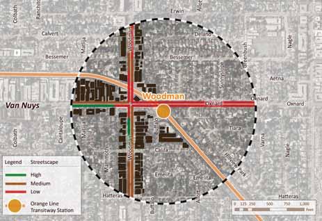
209 C-90 Orange Line BRT Sustainable Corridor Implementation Plan


210 Appendix C: Station Area Profiles - Woodman C - 91


211 C - 92 Orange Line BRT Sustainable Corridor Implementation Plan


212 Appendix C: Station Area Profiles - Woodman C-93

213 C - 94 Orange Line BRT Sustainable Corridor Implementation Plan


214 Appendix C: Station Area Profiles - Valley College C - 95

215 C-96 Orange Line BRT Sustainable Corridor Implementation Plan


216 Appendix C: Station Area Profiles - Valley College C-97


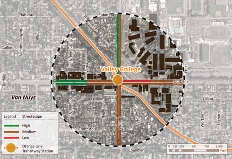
217 C-98 Orange Line BRT Sustainable Corridor Implementation Plan

218 Appendix C: Station Area Profiles - Valley College C - 99

219 C Orange Line BRT Sustainable Corridor Implementation Plan


220 Appendix C: Station Area Profiles - Valley College C - 101

221 C Orange Line BRT Sustainable Corridor Implementation Plan

222 Appendix C: Station Area Profiles - Laurel Canyon C - 103


223 C Orange Line BRT Sustainable Corridor Implementation Plan

224 Appendix C: Station Area Profiles - Laurel Canyon C - 105


225 C Orange Line BRT Sustainable Corridor Implementation Plan

226 Appendix C: Station Area Profiles - Laurel Canyon C - 107


227 C Orange Line BRT Sustainable Corridor Implementation Plan


228 Appendix C: Station Area Profiles - Laurel Canyon C - 109


229 C Orange Line BRT Sustainable Corridor Implementation Plan

230 Appendix C: Station Area Profiles - North Hollywood C - 111

231 C Orange Line BRT Sustainable Corridor Implementation Plan


232 Appendix C: Station Area Profiles - North Hollywood C - 113


233 C Orange Line BRT Sustainable Corridor Implementation Plan


234 Appendix C: Station Area Profiles - North Hollywood C - 115


235 C Orange Line BRT Sustainable Corridor Implementation Plan


236 Appendix C: Station Area Profiles - North Hollywood C - 117


237 C Orange Line BRT Sustainable Corridor Implementation Plan
238 Appendix C: Station Profiles C - 119
239 C Orange Line BRT Sustainable Corridor Implementation Plan
240 Appendix D: Summary of Orange Line Public Workshops D - 1
241 AppendixD:ResultsfromPublicWorkshopsD1 APPENDIXD:RESULTSFROMPUBLICWORKSHOPS InNovember2011,theRaimi+Associatesconsultantteam(Nelson\NygaardandtheCenterforTransit OrientedDevelopment)workedwiththeLosAngelesCountyMetropolitanTransportationAuthority (Metro)toconducttwocommunitymeetingsinordertogatherideasaboutthefutureoftheOrange LineCorridor.Throughaseriesofworkshopexercises,communitymembersofferedvaluableinsightinto theprogressoftheproject,makingspecificrecommendationsaboutcorridorwideandstationarea improvements.belowisasummaryofthenotesfromthetwomeetings. CORRIDORWIDECOMMENTS TRANSITSERVICEANDFACILITIES Considerredesigning/reengineeringthebuslightsignalsystem,astheyareinefficient. Changesignaltiming. MaketransfersfromtheOrangeLinetootherbusroutessmootherandmoreefficient, especiallyatsepulvedastation. ImprovetransfersatSepulvedastation,asthestationissofarfromthestreet. RerouteMetroLine183toavoidbeingdiscontinued,likeLine902thatlostridership. Useparkandridefacilitiesmoreefficiently,redesigningforanalternativeuse. Improvestationarealightingtocreateamoreinvitingandsafeenvironment. MakebetteruseofthewalkingpathatValleyCollegestation.Itisunderutilized,whichis unfortunatebecauseit'sanicewalkingpath. Amendthebusvehiclecode/lawtoaccommodatelongerbuses. Establishairportconnections. Reducebuswaittimeatsignals. InstalllightingatnorthboundtransferpointatVanNuys. RepealRobinsLawandCountylaw. Changethevehiclecodetoallowoperationoflongerbuses. Maintaintransitstationstoensurecleanliness. IncorporateNextBusandotherrealtimeschedules. Ontimeperformanceissatisfactory,asmostofthetimethebusesrunonschedule. Signageisworking(timeandscheduleofMetrolines)toallonpassengertoplantheirtrip. DiscontinueVictoryBoulevardbusesthatrunparalleltotheOrangeLine. LANDUSEANDDEVELOPMENT Providemoregreeneryatallstations. Incorporatenativeplantspecieswhenconsideringstationgreenery. ConsiderdenserdevelopmentintheSepulvedastationarea.
242 D2OrangeLineBRTSustainableCorridorImplementationPlan Valleycollegestationiswellutilized. Takeadvantageoftripsgeneratedfromcollegeinstitutions.Encourageandhelpstudentsand facultyconverttheirautomobiletripstotransittripstoensuremoreridership. Createdestinationpointsalongthecorridor. Designdestinationpointsnearstations. Locatebanksneartransitstops. Investigatedevelopingdensertransitorienteddevelopment(25stories)inNordhoff. Providemoreaffordablehousingalongthecorridor. Provideusesmostappealingtosurroundingpopulationbydevelopingmixeduse(25stories)of retail,markets,andneighborhoodservices. ConsidermixeduseneighborhoodretailintheTampastationarea. PEDESTRIANENVIRONMENTANDACCESS Requirebetterlightingofexistingfacilities.Forinstance,lightingalongthewalkingandbikepath goesoutandareabecomesscarywhendark. Addlightingtothe2.5milestripofbikepaththathasnolighting.Providemoreseatingoptions attransitstations. Provideseatingalongbikepath(primarilyineasternhalfoftheOrangeLine). Providerestroomsattransitstations. Peoplearenotwillingtowalkmorethanablockfortransit. Maintainthecleanlinessofstationarea(i.e.,lotsoftrashatLaurelCanyon). Installsignagetohelpwithcrossingstreet(walking)atValleyCollege. ImprovestreetlightingatTampa,Woodley,Balboa,Reseda,andNorth/SouthCanoga. InstallthreecrosswalksatOwensmouth. Requiremorestreetlightingatcrosswalks. BICYCLEENVIRONMENTANDACCESS Provideaclearseparationbetweenpedestrianandcyclistspace.Peopleareusingthebikepath asaplacetosit,andthey'reintrudingoncyclistactivities. Createbikeplanningareaasa3mileradiussurroundingeachstationandintegratebicyclelanes withinplanningarea. Modifybikeplanprioritytoinclude3milebuffersurroundingstations. Adjustsignalsresponsetopushbuttonstoreducewaitsatlightsforbikesandpedestrians. Redesign/relocatepushbuttonandingroundsensorforlightsignals. Requirebettermaintenanceoflightingalongbikepath. InstalllightingfromSepulvedatoWhiteOak. Integratebicycleplanningwithin3mileradiusoftransitstation.
243 AppendixD:ResultsfromPublicWorkshopsD3 Priorityseemstoexistinsocioeconomiccharacteristics. o Therearemoregapsinthenetwork. o Bikepathsignallightscancausealongertripbikelanesensorscouldimprove performance. DevelopbikeboulevardsthroughouttheValley. CreateabikestationatWarnerCenter. Installbikelockersasneededatstations. Establishbikestationsattransitstations. Designbettersignagearoundstations. InstalltrafficsignalatthecrossingofchaseandDeSoto. InstalltrafficsignalatVanaldenandVictory. Implementbicyclistactivatedcrossingsignals. STATIONAREACOMMENTS NORTHHOLLYWOODSTATION TransitServiceandFacilities Increaseavailabilityofgeneralparking. Designthehistoricaltraindepotasadestinationthatprovidesavarietyofuses,likefoodvenue, visitorcenter,historicstatictraindisplay,restrooms,artpark,andmtastore. ProvideatrolleyliketransitoptiontotransportpeoplealongLankershimBlvd. ConsideratrolleycarwithashortrouteonLankershim(electrictrolley)sopeoplecanjump easilyonandoff. EstablishabetterconnectionfromOrangeLinetoRedLine. ConsideratrolleycartobringpeopletoNorthHollywoodstationonLankershimBlvd. Providerestrooms(portable)atNorthHollywoodandWarnerCenter,andatotherstationsin between. PedestrianAccessandSafety InstallflashingpedestrianlightsonMagnoliaatBakeandonLankershimbetweenMagnoliaand Weddington. EnsureaccessatNorthHollywoodstationelevators.Elevatoraccessisobstructedanddifficult forpersonswithwheelchairs.handicappedadaandolderamericansact(federalmandate). BicycleAccessandSafety Establishaprogramthatpromotesandenforcesbicyclingandcarpooling(i.e.,parkingpolice). Providemoresecurebikestorageoptionatstations.Bicyclesarestolenfromtheracksand busesbecausesecurityguardsarelessvigilantatthemetroproperty.
244 D4OrangeLineBRTSustainableCorridorImplementationPlan CommunityCharacterandNeighborhoodDestinations EstablishmoregreeneryatNorthHollywoodstationandconsidertheMillionTreesProgram. DesignthehistorictrainnearnorthHollywoodasadestinationwithretail,food,andtransit store. CreateamorefluidtransferforOrangeLineriderstransferringtotheRedLinetogoDowntown. RevisitparkingpolicyatNorthHollywoodstation. VANNUYSSTATION TransitServiceandFacilities RepealRobbinsbillandconsiderlightrailtransit(LRT). Accommodatebikesontransitasridersusebicyclesfor"lastmile"commute. PedestrianAccessandSafety OrganizebetterLADOT/ATSACsignalcoordination. Installlightedsignsprohibiting(otherthanbuswarning)turnswhenbusespassthrough. CommunityCharacterandNeighborhoodDestinations Establishmoredensedevelopment. CreatemoreexcitementaroundOrangeLinelikeExpoandGoldLRTlines. Redevelopunderutilizedparkingasmixedusedevelopment. SEPULVEDASTATION TransitServiceandAccess Establishmoreefficienttransitconnections/transfers,becausetransfersaredifficultduetothe stationdistancefromthestreet. CommunityCharacterandNeighborhoodDestinations Investigateconvertingtheemptyfurniturestoreandtheunderutilizedparkandrideasasitefor alarge,higherdensity,mixedusedevelopment. Usestationforparkinglotforbigevents. MaintainSepulvedaforparking. Considerthisstationasanideallocationtofocusonparkingandtransfersfromfreeway.
245 AppendixD:ResultsfromPublicWorkshopsD5 TAMPASTATION TransitServiceandAccess Lovethestationfacilities. AddturnstilesatOrangeLinestations,sothatwhentheridersboardonthebus,theytaptheir MDPcardsonthetargetsandclimbon. PedestrianAccessandSafety Takemeasurestopreventmorecollisions. Noproblemsapproachingthestationdepotatall. Installstreetlightsthroughouttheeastwestrailroadrightofwaysline,sothatasthenight doesapproach,thebus/carscheckthevisageofthebusway. CommunityCharacterandNeighborhoodDestinations Considerestablishingnewdevelopmentinthearea. TheOrangelineisanattractivenohassletransportationoptioninmyarea. TheupcomingChatsworthMetrolinkStationthatisnorthofDevonshiteStreetbetweenCanoga andowensmouthneedstohaveitsbuswaypavementexpandedtoapproachtheculdesac deadendafewinchesmoresothatitcanreachit'sterminaldepotstationevenbeforeitopens thenorthsouthcorridorthatisnexttocanogastreetstatinginthesummerof2012forthe nextyear. Therearenonewdevelopmentopportunitiesformixeduse,higherintensity,and/orhousing developmentinthestationareaatthistime. Maintainthecurrentcharacterandaestheticsofthestation. ResistadditionalshoppingaroundTampaStation. RESEDASTATION TransitServiceandAccess Promotetheindividualbenefitsoftransitandthecommunitybenefitsoftransit. Educateandencouragecommunitymemberstoexplorealternativetransportationoptionsin thearea. PedestrianAccessandSafety Maintainpedestrianandbicyclesafety. It'sgettingbetter,butweneedtothink"BlueSky". BicycleAccessandSafety Establishbetterbicycleinfrastructure.
246 CommunityCharacterandNeighborhoodDestinations Considernewdevelopment. Increaseaccessonstreetstoaccommodateallmodes. Redesignstreettoenhanceaestheticappealandincreasestreetdesirable. WOODMAN TransitServiceandAccess RelocatestationclosertoWoodman. VALLEYCOLLEGE PedestrianAccessandSafety Enhancesignagearoundstationespeciallyforbikeandpedestrianaccess. WARNERCENTERSTATION BicycleAccessandSafety Integratebicycleandpedestrianaccesstostations. Installsignageforcyclists. D6OrangeLineBRTSustainableCorridorImplementationPlan
247 Appendix E: Results from Online Survey E - 1
248 E - 2 Orange Line BRT Sustainable Corridor Implementation Plan
249 Appendix E: Results from Online Survey E - 3
250 Orange Line Station Area Community Survey 1. Please select that station that you would like to provide comments on in this survey. (If you would like to comment on multiple stations you can return to the survey and review as many stations as you would like.) Response Percent Response Count Warner Center 5.7% 12 Canoga 7.2% 15 De Soto 3.8% 8 Pierce College 4.3% 9 Tampa 1.4% 3 Reseda 8.1% 17 Balboa 6.2% 13 Woodley 1.9% 4 Sepulveda 4.8% 10 Van Nuys 6.7% 14 Woodman 8.6% 18 Valley College 9.6% 20 Laurel Canyon 9.6% 20 North Hollywood 22.0% 46 1 of 63
251 answered question 209 skipped question 0 2. How often do you use the Orange Line? Response Percent Response Count Daily 18.3% 20 Several times per week 23.9% 26 Several times per month 45.0% 49 Never 13.8% 15 answered question 109 skipped question of 63
252 3. Why do you ride the Orange Line? Response Percent Response Count For work 46.2% 49 To shop 27.4% 29 To school 15.1% 16 Other (please specify) 45.3% 48 answered question 106 skipped question of 63
253 4. What improvements are needed to the Orange Line station? Response Percent Response Count Better connecting transit service 42.9% 45 More lighting 21.0% 22 More and better seating 26.7% 28 Addition transit system information 27.6% 29 More bicycle facilities (e.g., bike parking) 28.6% 30 What other suggestions do you have for the Orange Line station? 44.8% 47 answered question 105 skipped question For the Orange Line station you've selected, how could transit service be improved? Response Count 58 answered question 58 skipped question of 63
254 6. For the area within ½ mile of the station that you have selected, what pedestrian safety and access improvements are needed? Response Percent Response Count More frequent crosswalks 23.6% 21 More street trees 39.3% 35 Additional lighting 36.0% 32 Signs providing information about the area 42.7% 38 Wider or additional sidewalks 25.8% 23 New benches and trash cans 38.2% 34 In addition to the above, what improvements are needed? 28.1% 25 answered question 89 skipped question of 63
255 7. Please provide any additional issues, comments or suggestions to improve pedestrian access and safety to and around the Orange Line station Response Count 27 answered question 27 skipped question Where are new bicycle facilities and amenities needed in and around the station you've selected? Response Percent Response Count Bike racks 39.7% 27 Bike lockers 35.3% 24 Bike lanes and trails 39.7% 27 Lighting 42.6% 29 Other (please specify additional improvements) 23.5% 16 answered question 68 skipped question of 63
256 9. Please provide any additional issues, comments or suggestions to improve bicycle access and safety to and around the Orange Line station Response Count 21 answered question 21 skipped question of 63
257 10. What new uses are needed in the station area (within 1/2 mile of the Orange Line station)? Response Percent Response Count Grocery stores 46.9% 38 Pharmacy/drug store 25.9% 21 Cafes and restaurants 60.5% 49 Dry cleaners 6.2% 5 Affordable housing 34.6% 28 Entertainment uses 37.0% 30 Office buildings 13.6% 11 Other (please specify) 23.5% 19 answered question 81 skipped question of 63
258 11. Do you like the mix of uses, the scale of development and the quality of development in the Orange Line station area? Response Percent Response Count Yes 54.4% 49 No 7.8% 7 Like some areas but not others 38.9% 35 Please explain in detail what you like and do not like about the station area. 15 answered question 90 skipped question Are there opportunities for new development in the station area? Response Percent Response Count Yes 66.7% 54 No 34.6% 28 Where could new development be located? (Please be as specific as possible) 23 answered question 81 skipped question of 63
259 13. What type of improvement is the most important for the station area? Response Percent Response Count Enhancing transit service and amenities 34.3% 34 Improving pedestrian safety and access 23.2% 23 improving bicycle safety and access 11.1% 11 Enhancing community character and and adding new uses 31.3% 31 answered question 99 skipped question of 63
260 14. Single-Family Home Response Percent Response Count 1 - Not preferable 34.9% % Somewhat preferable 25.6% % Most preferable 16.3% 14 answered question 86 skipped question of 63
261 15. Townhouse or Rowhouse Response Percent Response Count 1 - Not preferable 22.1% % Somewhat preferable 39.5% % Most preferable 10.5% 9 answered question 86 skipped question of 63
262 16. Apartment Building Response Percent Response Count 1 - Not preferable 29.5% % Somewhat preferable 22.7% % Most preferable 18.2% 16 answered question 88 skipped question of 63
263 17. Mixed-Use (2-5 stories) Response Percent Response Count 1 - Not preferable 16.5% % Somewhat preferable 21.2% % Most preferable 34.1% 29 answered question 85 skipped question of 63
264 18. Mixed-Use (6-10 stories) Response Percent Response Count 1 - Not preferable 39.5% % Somewhat preferable 10.5% % Most preferable 26.7% 23 answered question 86 skipped question of 63
265 19. Employment (2-5 stories) Response Percent Response Count 1 - Not preferable 17.9% % Somewhat preferable 31.0% % Most preferable 25.0% 21 answered question 84 skipped question of 63
266 20. Employment ( 6+ stories) Response Percent Response Count 1 - Not preferable 38.8% % Somewhat preferable 14.1% % Most preferable 29.4% 25 answered question 85 skipped question of 63
267 21. Main Street Retail Response Percent Response Count 1 - Not preferable 13.6% % Somewhat preferable 15.9% % Most preferable 45.5% 40 answered question 88 skipped question of 63
268 22. Urban Retail Response Percent Response Count 1 - Not preferable 16.1% % Somewhat preferable 21.8% % Most preferable 39.1% 34 answered question 87 skipped question of 63
269 23. Plaza or Park Response Percent Response Count 1 - Not preferable 11.1% % Somewhat preferable 16.7% % Most preferable 54.4% 49 answered question 90 skipped question of 63
270 24. What corridor-wide transit improvments are needed to improve the overall performance of the Orange Line? Response Percent Response Count Additional service on weeknights and weekends 54.2% 45 More frequent Orange Line service 54.2% 45 Better transit information 42.2% 35 More and frequent connecting transit routes 43.4% 36 Better transit facilities 30.1% 25 Expansion of the Orange Line to reach more destinations 53.0% 44 More frequent stops along the Orange Line (between existing stations) 10.8% 9 Other (please specify) 25 answered question 83 skipped question of 63
271 25. Please provide any additional comments or ideas about how Orange Line service or the Orange Line corridor could be improved. Response Count 26 answered question 26 skipped question of 63
272 23 of 63
273 Page 2, Q3. Why do you ride the Orange Line? 1 To run errands Mar 10, :07 PM 2 Visiting family Mar 8, :44 AM 3 Pasadena Gold Line /I would like to see a Train Station in Altadena CA because I live in Altadena and theres no Train Station in Altadena. Feb 27, :09 PM 4 Recreation [recreation] Feb 27, :45 PM 5 To take my preschool age son on outings [recreation] Feb 24, :55 PM 6 work, school, recreation etc... [recreation] Feb 22, :05 AM 7 CSUN Feb 20, :22 PM 8 recreational, site seeing [recreation] Feb 20, :13 PM 9 I use the Orange Line for all aspects of my life, as I do not drive. Feb 17, :17 PM 10 I regularly ride the commuter express 574 which drops off at Orange line Balboa stop. I take the Orange line occasionally to go downtown from Balboa stop. Feb 16, :33 PM 11 Everything!... personal business, shopping, visit family,... shortcut across the valley.. Feb 15, :26 AM 12 For weekend recreation [recreation] Feb 7, :22 PM 13 soon i would love to if i get a chance. Feb 4, :38 PM 14 For fun and to head to NoHo and DTLA using the Red Line [recreation] Feb 3, :12 PM 15 Attend meetings, attend sporting events, meet friends [recreation] Jan 30, :53 PM 16 To visit family [recreation] Jan 29, :14 PM 17 random trips when the line goes to a place i need to go Jan 26, :21 PM 18 To go around the greater Los Angeles Jan 26, :07 AM 24 of 63
274 Page 2, Q3. Why do you ride the Orange Line? 19 to go places is the greater Los Angeles area Jan 25, :57 PM 20 Run with my dog, and bike down the lane. [recreation] Jan 25, :59 AM 21 To visit Downtown LA and other Downtown Districts. Jan 22, :02 PM 22 To visit Downtown LA and other Downtown Districts. Jan 22, :33 AM 23 To visit Downtown LA and other Downtown District. Jan 22, :08 AM 24 jury duty Jan 19, :35 PM 25 To explore other neighborhoods I'm not familiar with Jan 19, :05 PM 26 Rode once out of curiosity Jan 19, :03 PM 27 To the Red Line to go downtown for dinner and/or theatre. Jan 18, :33 PM 28 to go downtown and avoid the parking hassles Jan 17, :47 PM 29 i dont use it Jan 17, :02 PM 30 Loved ones Jan 17, :32 PM 31 recreation Jan 17, :25 PM 32 Recreation...I ride out to Warner Center on my bike and quite often use the O-line to return to the neighborhood (Sherman Oaks) Jan 17, :06 PM 33 Jury duty or cultural events downtown Jan 17, :03 PM 34 Sports events at Staples Center Jan 17, :33 PM 35 Errands Jan 17, :47 AM 36 dinner and social Jan 11, :24 PM 37 I used the orange line once right after the line opened to see how it operated. Jan 11, :07 PM 25 of 63
275 Page 2, Q3. Why do you ride the Orange Line? 38 To and from subway. Jan 10, :42 PM 39 Go Downtown Jan 10, :44 AM 40 Appointments, entertainment, convenience Jan 10, :00 AM 41 This would be negative as to why I don't. The line is very limited as to where it goes. It also reminds me of how Valley residents, who paid as much if not more in taxes for "rapid transit/rail" only got this one bus that services one narrow corridor. 42 For events Downtown, or elsewhere, where there is no parking. Gallery walks, MOCA, The Geffen Contemp. Chinatown,Day of the Dead, Halloween celebrations. Olvera street, etc Jan 10, :27 AM Jan 9, :46 PM 43 Used to visit friends in the west valley, sightseeing downtown, jury duty, dine/watch movies at Universal, etc. Jan 9, :34 PM 44 various reasons including work related seminars downtown near a metro subway... Jan 9, :24 PM 45 Go downtown. Jan 9, :27 PM 46 Night time social activities - clubs, restaurants Jan 9, :10 PM 47 For doctor appointments Jan 5, :44 AM 48 Recreation Dec 22, :47 AM 26 of 63
276 27 of 63
277 Page 2, Q4. What improvements are needed to the Orange Line station? 1 Install bus benches or shelters on the eastern side of Sepulveda Blvd. Mar 10, :32 PM 2 make entrance to both ends of the station. Feb 28, :13 PM 3 Coming from Metro 'I would like to see more bike paths where a person could ride a bike all over California 'I really think that's what needed because i'm thinking about getting a bike. Feb 27, :09 PM 4 Set up railing or portable lanes to enter the busses so people have to orderlt enter the busses. Feb 27, :56 PM 5 Riding out bike to the station is hazardous due to the condition of the bike path. Feb 24, :55 PM 6 none Feb 24, :32 PM 7 More information in map about environment. Feb 22, :30 AM 8 water stations, mile and yardage marking, local transit info, bathrooms, less wait time, fitness stations. Feb 22, :05 AM 9 The section of the station where you transfer to North-bound Rapid/Local buses needs a canopy, a tree cover, or something to block the sun. This station gets VERY hot in the summer and wind-swept in the winter. There is NO "shelter" 10 it would be great if the orange line was marked by the mile or yardage, provided water fountains, bathrooms and streching fitness stations for those running, biking or walking along the route Feb 20, :22 PM Feb 20, :13 PM 11 There needs to be at least a bike lane that has a north/south connection to the North Hollywood Orange Line station. Feb 20, :40 PM 12 Hate having to park and cross street. I always miss the bus because of it. Feb 15, :36 PM 13 more buses, they are always too crowded to get on Feb 13, :39 AM 14 Some type of security personel. There is a lot of marijuana smoking in the parking lot once the high school students arrive in the afternoon. Also I have seen numerous people dealing drugs out of cars in the parking lot. Feb 12, :52 PM 15 Maintenance of trash cans and clearer station. Feb 4, :08 AM 16 Go faster, it takes a while to go from the Canoga Station to the NoHo station. Feb 3, :12 PM 17 Intersection upgrade/decoration highlighting the Orange Line station Feb 2, :19 PM 28 of 63
278 Page 2, Q4. What improvements are needed to the Orange Line station? 18 Make better use of adjacent land. Surface parking lots should be converted to something more useful, like housing, shopping...or both! Jan 29, :25 PM 19 Convert to Light Rail. Jan 28, :04 PM 20 the pedestrian tunnel needs to be built to the lobby of the red line station across the street. Jan 26, :21 PM 21 A map of shops and restaurants near the station, because they are great shops and restaurant at the NoHo district Jan 25, :57 PM 22 Trash cans! Trash cans need to be put all down the bike path. There's so much trash accumulating now, I don't understand why there are no trash cans. As a pet owner, it is also necessary to dispose of my bags. Jan 25, :59 AM 23 Have an underground connection underneath Lankershim for faster connection to the Red Line station. Jan 24, :30 PM 24 recycling cans for newspaper, bottles and cans Jan 24, :12 AM 25 clean platforms they have coffee stains at times. Jan 23, :32 PM 26 Better Landscaping at this station. The landscaping at the station was never planted or left to die at this station. Jan 22, :02 PM 27 Fix the electronic timetable screens. They are not functioning or they are out. Jan 22, :08 AM 28 parking Jan 21, :26 PM 29 I would like to see a better connection between the subway and busway portions of the stations. Pedestrians should not have to wait for auto traffic to transfer between subway and busway platforms. A ramp that passes over or under the street would be good. 30 The bicycle trail running parallel to Victory between Balboa and White Oak is in dire need of repair -- in spots the concrete is so broken up it is getting to be a serious safety hazard. Add lights to the bike path to facilitate night travel. Jan 19, :05 PM Jan 19, :04 PM 31 Need more interesting destinations immediately adjacent to stations. Jan 19, :03 PM 32 An underground passage linking the Orange line with the Red Line. It would be safer (I see a lot of people jay walking to get to either lines). 33 The bus driver should let one get out and catch the Reseda bus if they see that the light is red because by the time the light turns green and one crosses the street back, the reseda bus takes off. Jan 19, :42 AM Jan 18, :23 PM 29 of 63
279 Page 2, Q4. What improvements are needed to the Orange Line station? 34 More frequent buses when crowded. Too often the number of passengers boarding at NoHo is way too many!! Do you know what "crush" loading is? Too many people for one bus. Often too many for even two buses. Jan 18, :33 PM 35 Open a stop at Coldwater Canyon Jan 17, :14 PM 36 make sure there is security, it seems very open for anyone who wants to cause problems Jan 17, :47 PM 37 Connect in a meaningful way (design crosswalks, public art) to the Metro Red Line Jan 17, :02 PM 38 grade separated crossing for the Orange to Red Line transfers... Jan 17, :32 PM 39 Move the 244 bus stops on Desotto and Victory closer to the orange line stops Jan 17, :57 PM 40 The noise level and make it more beautiful in our community (Sherman Oaks & North Hollywood) Jan 17, :33 PM 41 a system on your cell phone tell you if the bike rack is full or not. Plus install all orange line buses 3 or more bike rack system. Make a bike rack easy put your bike on it without the bicycles pegs blocking or interference with others people brake calbes. Jan 16, :49 PM 42 more trash cans Jan 11, :24 PM 43 Trash containers at beginning and end of all pathways leading to the station. Way too much trash around. Jan 10, :42 PM 44 Housing Jan 10, :44 AM 45 More housing, high density Jan 10, :22 AM 46 Have more frequent trash pick up. Jan 9, :34 PM 47 It would be a help to man, especially to women, to have poratpotties such as the one at Van Nuys Blvd. Jan 5, :44 AM 30 of 63
280 31 of 63
281 Page 2, Q5. For the Orange Line station you've selected, how could transit service be improved? 1 Post the Metro Red Line Departure times along with the Orange Line's. Mar 10, :07 PM 2 Operate Metro Rapid 734 on the weekends. Mar 10, :32 PM 3 The bus needs another bike space (4 bike racks) or allow us to take bikes on board. Guarantee green lights for buses (buses should not have to stop so frequently at intersections.) 4 The City where i live is Altadena CA and I am riding the Pasadena Goldline everyday, when i don't have any money i have to walk from Altadena CA into Pasadena CA to ride the Pasadena Goldline so therefore i would like to see a Train Station in Altadena CA. I'm thinking about getting a 10-speed bike, i would like to see more bike paths running all over California this is what i would like to see 'Safe bike paths builded with lights along the bike paths and Security Officer's watching biker along the bike paths just to make sure that everything okay when a person is riding along the bike path and Security Officer's should be on duty at all times 24/7 around the clock day and night that will help create jobs for unemployed people. I'm talking about creating jobs for American Citizens that have a clean back ground check and drug test should have no problems in finding a job. Sincerely RoseZell Sherrard. 5 See above, set up some lanes or corridors where people can wait thier turn to get on to the busses. There is too much pushing and shoving by people who simply do not know how top wait thier turns to get into the busses. Do something similar to how you have wait in line like at the Universal Station bus lines. this alone has slowly turned me off to riding the Orange Line and if you ask many riders they tolerate it because those disrectful riders feel they are enttiled to do anything. And check they have paid thier fares before they get on the bus, one line two cops amazing how things will move smoothly. 6 Why do the buses at the Warner Center station have to wait at a staging area before moving forward to pick up riders?... this is quite annoying, especially on hot or rainy days... it seems to me the buses could move forward and allow riders to enter and wait in the bus until it's scheduled departure time. Mar 8, :18 AM Feb 27, :09 PM Feb 27, :56 PM Feb 25, :46 PM 7 Uprooted concrete on the bike path needs to be repaired. Feb 24, :55 PM 8 more Feb 24, :32 PM 9 You need better bike infrastructure (bike station like in long beach) and connecting serrvices to metro buses and other transit agencies. Feb 24, :35 PM 10 In Canoga station information about how to go to the city of Canoga Park. Feb 22, :30 AM 11 More accurate times to when bus is arriving Feb 21, :16 PM 32 of 63
282 Page 2, Q5. For the Orange Line station you've selected, how could transit service be improved? 12 Please institute a Timed Transfer policy for Rapid buses connecting with the orangeline at REseda. It is frustrating to see a empty 741 bus leave the orange line while dozens of people just disembarked from the ORange Line waiting to cross the street and board it... This causes significant over-crowding on the next bus (240/741) that comes. Also frequently makes me late to class. There also needs to be a Transit center ON California State University Northridge Campus. 13 trash cans, bathrooms, mile and meter markers, water fountains and fitness stations all along the orange line route. plus local transit info at each station. this would increase the use of the orange line greatly and make it more convienient. 14 At peak hours, there is an overflow of passengers waiting to board the Orange Line bus from the Red Line subway. There should be two buses loading at the same time. The first one would skip the next three stations, so its first stop would be Van Nuys Blvd. This would create a headway between the two buses. To keep the drivers scheduled so that two buses can start at North Hollywood at the same time, the bus driver that is scheduled four-five minutes behind its lead, starting from Warner Center,should quickly be able to catch and pass the bus scheduled just ahead of it. This will help equilize the two schedules at the final destination of North Hollywood. Another scenerio is to have the bus driver that starts from the Chatsworth extension scheduled to complete the route at the same time as the driver starting from the Warner Center. That way two buses can start from North Hollywood at the same time. Feb 20, :22 PM Feb 20, :13 PM Feb 20, :40 PM 15 local streets need to be repaved Feb 14, :39 PM 16 traffic signal override/ controllers on bus. Early morning trips to North Hollywood are often delayed by long red traffice signals w/ no cars crossing in front of the bus. Feb 14, :52 PM 17 every 8 minutes during midday hours. Feb 14, :38 AM 18 It would be nice if the Orange Line buses actually followed the timetable. If the Orange Line claims to be part of Metro Rail, it should be on time much more often. 19 more buses, they are always too crowded to get on. more buses, they are always too crowded to get on. more buses, they are always too crowded to get on. more more more please. and noho redline station cant even handle the amount of people exiting without backing up and causing delay. Feb 13, :38 PM Feb 13, :39 AM 20 Just some type of security personel between the hours of 3 and 7. Feb 12, :52 PM 21 more newer buses Feb 11, :13 AM 22 I am not a heavy user but I feel it has been adequately designed. Well lighted, ample parking, bus always available, and easily accessible from where I live. Feb 7, :22 PM 33 of 63
283 Page 2, Q5. For the Orange Line station you've selected, how could transit service be improved? 23 I attend UCLA and often come home late due to the time I spend on campus. I take the orange line from the Van Nuys Station to Reseda Station. There are times where I miss the my next bus (line 240) and have to wait a great amount of time. Transit service could be improve if the orange line bus arrived a couple minutes before the 240 line therefore giving me an opportunity to aboard. This happens often and not just to me. Feb 7, :07 PM 24 none. Feb 4, :38 PM 25 Maintenance of trash cans and clearer station. Feb 4, :08 AM 26 1) Walkway from the Orange Line bus discharge to the crosswalk is too narrow. You're not supposed to walk in the busway, but people do. One slow person (or wheelchair, etc.) backs everyone up - and everyone is rushing to get to the crosswalk. 2) Who decides what vendors are allowed on Metro property? You come up from Red Line underground and get hit in the face with the overpowering smell of greasy sausages. It is disguisting. 3) For all escalators (on Red Line system), post signs to "stand right, walk left." This is standard practice, and "common etiquette" (altho not so common). If ONE person stands on left, then so is everyone on the entire escalator. This is excessive weight on the escalator and may be one reason it breaks down so often. Jan 30, :53 PM 27 Make end to end travel times faster. Jan 29, :25 PM 28 Havee three connections, North Hollywood-Warner Center, North Hollywood-Chatsworth, and limited service to Bob Hope Airport Via Hollywood Way. 29 When a Red Line train pulls into the North Hollywood station, there is often only ONE orange line bus waiting across the street. All too often, you have to squeeze onto the bus like a sardine. If you use the Laurel Canyon station to travel to the Red Line, it is next to impossible to squeeze onto the bus. 30 North Hollywood is the end point for the Orange Line. I think that the station needs to be redone. It is very crowded when you try to board going to Warner Center, perhaps having a bigger boarding area. I also think it would be great if there was a bridge that connect the Orange Line to the Red Line. The light at Lankershim takes forever and drivers don't always stop. 31 orange line needs to continue to the west and split- one line to Burbank Airport and another to the Downtown Burbank Metrolink station with a possible loop around downtown Burbank. - This way you could run one set of buses from Warner Center to Burbank Airport and the other set fro Downtown Burbank to Chatsworth, creating the overlapping service from No Ho to Canoga Park. - Also, lines down Van Nuys Blvd and maybe Balboa need to turn east and continue on the busway to North Hollywood.. Transfer are difficult, through buses like through trains are always better - One of these days, whether you want to accept it or not, this line will need to be light rail Jan 28, :04 PM Jan 28, :02 PM Jan 27, :44 PM Jan 26, :21 PM 34 of 63
284 Page 2, Q5. For the Orange Line station you've selected, how could transit service be improved? 32 The local bus around the orange line should work more at night time since you have students an people getting out of work late. 33 It would be awesome to create some barrier between the person sitting next to another person. Sometimes I feel squished so it would be cool to create a metal barrier between every seat. Also make buses come more often in the noon (like in the morning) it becomes to packed and sometimes I have to skip it for the next bus which I have to wait 15 more minutes again. But then it gets more overpopulated because so many people get off in the red line station and goes to the orange line station. Jan 23, :32 PM Jan 23, :56 PM 34 Need more improvements to connecting to a 234 or 734 bus. The wait time for waiting for these buses is long. Jan 22, :33 AM 35 cell phone service - because once in a while there is a serious delay and you can't contact anyone to tell them where you are. 36 I would like to see a better connection between the subway and busway portions of the stations. Pedestrians should not have to wait for auto traffic to transfer between subway and busway platforms. A ramp that passes over or under the street would be good. Also, I would like to see more use of solar panels on the station canopies. That way, some of the station's energy could be generated on site in a sustainable fashion. I'd also like to see clean, neat, clearly marked recycling bins attached to the station's trash-only bins. That way travelers can recycle just as easily as they can throw trash away. Alternately, if Metro already sorts all of its trash to remove recyclables, some obvious signage should be posted on each trash bin informing users of this sustainability measure. 37 Remove the pedestrian push buttons and reprogram walk signals at Victory & Balboa so that pedestrians get a walk signal during each cycle. Add right turn green arrows (with no corresponding red arrow) to synch with left turn arrows. Jan 19, :35 PM Jan 19, :05 PM Jan 19, :04 PM 38 good bus i like Jan 18, :45 PM 39 More frequent buses between North Hollywood and Van Nuys. Jan 18, :33 PM 40 see above Jan 17, :47 PM 41 better land use and pedestrian crossings Jan 17, :32 PM 42 Service is good overall. Suggestion - use of station is poorly described in the survey. There should be an 'occasionally' Option between the other options. Jan 17, :03 PM 43 Do not use Chandler Blvd. when the line is not working on the path. Use Burbank Blvd. Jan 17, :33 PM 35 of 63
285 Page 2, Q5. For the Orange Line station you've selected, how could transit service be improved? 44 Closer walk to Sepulveda from station. Jan 17, :47 AM 45 I take the red line from downtown every day after work, and transfer from north hollywood onto the orange line, typically around 6:30-9:00pm at night. Every night about one minute before everyone arrives at the bus station, the orange line bus leaves. This typically means everyone has to wait the entire cycle until the next bus arrives. It is getting colder outside, and everyone ends up standing the entire time to ensure they get a seat on the bus. If the bus schedule could be changed to a few minutes after their current schedule, everyone who would be transferring from the red line to the orange line would have a bus waiting for them or leaving soon as opposed to always just missing the bus. Thanks! Jan 17, :14 AM 46 more available bike racks. Jan 16, :49 PM 47 Better accuracy in the timing boards Jan 15, :37 PM 48 Nice station. Needs more trash cans Jan 11, :24 PM 49 More often, safety, grafitti/trash removal Jan 10, :44 AM 50 Provide local information map, like the ones at the Red Line subway stations. The local info map should include map of streets, nearby bus stops - with bus numbers. Also, show on map the location of nearby amenities, even if they are visible from the stop. Jan 10, :00 AM 51 More often in morning and afternoon rush hour, and work with LAVC for evening classes students. Jan 10, :22 AM 52 Give Valley residents the rapid transit connections that they paid for and that are available on the other side of the hill. Instead, City Hall is bent on "expanding" transit for the Westside and leaves the Valley out cold. The Orange Line only serves those who happen to work or live very close to that ONE line. 53 Perhaps another bus could be added during peak hours. Sometimes there is barely any standing room on the bus. More frequent trash pick up would be appreciated. Also, Metro could recoup more revenue if there were more frequent ticket inspections. I believe many people ride free. Jan 10, :27 AM Jan 9, :34 PM 54 more seats designated for disabled or aged only...ie those for some reason who cannot stand while the bus moves. Jan 9, :24 PM 55 What happened to "next train arrives in X minutes"? Jan 9, :10 PM 56 To provide additional seating for the elderly and handicapped, and that the driver insist that those provisions be implemented, since many people refuse to give up their seats to those of us physically challenged. Jan 5, :44 AM 36 of 63
286 Page 2, Q5. For the Orange Line station you've selected, how could transit service be improved? 57 This is a test run to see if the survey is working correctly. Please disregard the answers. Dec 30, :50 PM 58 everything. Dec 6, :38 PM 37 of 63
287 38 of 63
288 Page 3, Q6. For the area within ½ mile of the station that you have selected, what pedestrian safety and access improvements are needed? 1 Better synchronize the timing of the streetlights with pedestrian traffic patterns. Mar 10, :10 PM 2 I would like to see a Train Station in Altadena CA, running from Altadena in to Los Angeles CA or running in to another City or State or what ever and more save bike paths. I'm going to always add bike paths because that what i would like to see more of. Feb 27, :26 PM 3 More police Feb 27, :56 PM 4 none Feb 24, :32 PM 5 "NextBus digital display" More seeting at the station. PLEASE ADD A SUN CANOPY TO THE TRANSFER AREA- - so hot and/or windswept (no shelter) 6 People will run across the street on a red light if they see a Orange Line bus pulling up to pick-up passengers. There needs to be coordination between the two lines to reduce the chances of this happening. 7 Bicycle lockers on west side of Balboa for riders of commuter express 573 and 574. Many other riders of the commuter express either use lockers or park cars at the Orange line Balboa station. The lockers and parking is on the opposite side of Balboa from almost all of the departing commuter express buses. Putting lockers on the west side of Balboa would reduce the number of pedestrians that need to cross Balboa to catch a commuter express bus. Feb 20, :23 PM Feb 20, :44 PM Feb 16, :37 PM 8 more buses, they are always too crowded to get on Feb 13, :40 AM 9 Maybe cameras in the parking lot to deter drug dealing out of cars. Feb 12, :56 PM 10 The sidewalks along the southern portion of Chandler, moving west from the Laurel Canyon station, are cracked and in poor condition. The lighting on this side is very poor. The lighting on the north side of Chandler is nice. Planting trees that grow tall when mature (along Chandler) would be beneficial to the neighborhood west of Laurel Canyon. Feb 2, :21 PM 11 More control over the vendors who set up shop on Metro property. Jan 30, :54 PM 12 Add a bride that connect the Orange Line to the Red Line. Jan 27, :44 PM 13 There's no trash cans in the path way! Jan 25, :59 AM 14 I know this is a radical notion, but how about some drinking fountains and public restrooms? Jan 19, :08 PM 15 Need more interesting destinations with sidewalk oriented entrances. Not just a big field of asphalt and parked cars with Jan 19, :04 PM 39 of 63
289 Page 3, Q6. For the area within ½ mile of the station that you have selected, what pedestrian safety and access improvements are needed? buildings located in the distance. 16 Build an entrance from the west side of Lankershim directly down into the Red Line station. Jan 18, :37 PM 17 More security especially at night... Jan 17, :33 PM 18 THe Woodman Crossing is very confusing for motorists who may or may not see the bicyclists who use the bike lane of the busway. WHen cyclists are crossing the Burbank/Woodman intersection, it can be very dicey as to whether you are going to get hit or not...some kind of signage to watch out for the cyclists is definitely needed. 19 More warnings for pedestrians ie:ethel & Chandler.Pedestrians & bikers cross without paying attention to car traffic.they consider a pedesrian crossing for the train only Jan 17, :08 PM Jan 17, :56 PM 20 Make bike path on Balboa Blvd north past Victory blvd. and dozen driver don't give space to bike on the streets Jan 16, :52 PM 21 Housing Jan 10, :44 AM 22 More high-density housing, encouraging folks to use public transportation. Jan 10, :24 AM 23 There are NO sidewalks on parts of Fulton, which is the station's crossstreet. And the ones that do exist in the area are incredicly broken & dangerous for even walking. One takes their life in their hands to attempt them on a bicycle. Jan 9, :51 PM 24 Pick up trash from planted areas beside the busway. Jan 9, :38 PM 25 More trash pickup on the streets; more drain system cleaning...of leaves and debris to prevent flooding. Valley college is a blight on the environment and is not a good steward of its resources. A community agency should overtake their "stewardship" of plant and animal life on that campus. Also "Help Group" drivers are a menace. and that site should not be used as a ballot location due to overcrowding and parking constraints. Jan 9, :27 PM 40 of 63
290 41 of 63
291 Page 3, Q7. Please provide any additional issues, comments or suggestions to improve pedestrian access and safety to and around the Orange Line station 1 Have verbal safety announcements anboard Metroliners similar to those used at the Van Nuys Metro Orange Line stations. Mar 10, :10 PM 2 Synchronize bus lane signals with traffic-flowe patterns. Mar 10, :36 PM 3 Security that's always needed, Days, Swing, Grave yard, and the reason why I am saying that is because it some crazy people out here everywhere that will (F) with a person just for the (HELL) of it for No Good Reason, because i am living across the street from a guy that i had to call the Police on becasue he watches me everyday and that's not normal. Feb 27, :26 PM 4 Other than the bike path, I am pretty happy with this station. Feb 24, :56 PM 5 hello Feb 24, :32 PM 6 The Warner Center station should be a flag ship station. I realize it was put in after cars dominated the landscape but slowly additional infrastructure can be added. 7 When you want improve safety think about passengers. They want easy and quickly catch another bus. Lets make them easy possible. They get off from Orange and do not want missing another connection bus. Feb 24, :37 PM Feb 22, :33 AM 8 less wait time between pick ups would be great! Feb 20, :15 PM 9 I think it's pretty good already. Feb 14, :38 AM 10 more buses, they are always too crowded to get on Feb 13, :40 AM 11 That is all. Everything else seems great. The buses are clean and the drivers friendly. It would be great if the orange and red lines ran later on fridays and saturdays to make it easier to get home from bars and clubs, more like Chicago or New York. Feb 12, :56 PM 12 Again, an underground crossing to the Red Line Station would make it safer for all pedestrians. Jan 24, :31 PM 13 I seen the street light does not last long when people are crossing to get to the North Hollywood platform at Winnetka Station an some of the seniors take a bit longer to cross the light. Can this light be fix for seniors can make it to the end without the light going red on them. Jan 23, :36 PM 14 (see earlier remarks regarding grade separating the pedestrian walkway between the subway and busway platforms) Jan 19, :06 PM 42 of 63
292 Page 3, Q7. Please provide any additional issues, comments or suggestions to improve pedestrian access and safety to and around the Orange Line station 15 come take bus north holly wood Jan 18, :46 PM 16 Safety would increase if pedestrians could enter the Red Line station directly from the Orange Line platform on the west side of Lankershim Blvd. Most pedestrians would not have to use the cross walk on Lankershim. 17 At Corteen and Chandler, the lights need to be re-set to accommodate the Orthodox Jewish population who need to cross the street on the Sabbath without using the signal controls. There are many families who live in the area and are unable to cross the street safely in order to go to their synagogue of choice or to friends and family. Jan 18, :37 PM Jan 18, :38 AM 18 maybe a call box in case of problems linked to the LAPD or whoever services the metro Jan 17, :48 PM 19 For Sabbath observers: The lights need to change more quickly on Friday evening at Sundown and Saturday all day until one hour after sundown. We are a walking community and many people feel frustrated when having to wait for a green light for many minutes when they are late for Temple or something else. Jan 17, :45 PM 20 No comments - I'm pleased with the facilities Jan 15, :38 PM 21 I see many people running across the street to catch the buses. Lights should last longer so that elderly citizens or people with small children in tow should not be at risk trying to get a cross to public transportation. Trash containers should be set at intervals along the pathway between Woodman and Valley College. There are many fast food places and the litter is a quite ugly. Most people will use a trash container if they can find one within in a reasonable distance. Jan 10, :46 PM 22 Housing Jan 10, :44 AM 23 Continued maintenance (grafitti removal, crime monitoring, etc.) Jan 10, :24 AM 24 Definitely more street lighting`. Jan 9, :51 PM 25 Existing sidewalks, lighting and access are fine. Please pick up trash and remove graffiti promptly. Jan 9, :38 PM 26 Bigger signs on intersections like Fulton and Burbank to prevent right hand turns across metro designated lanes... bigger signage and blinking lights The brush and foliage along some sections of the busway, especially near Van Nuys Blvd. need regular pruning to discourage homeless encampments. Jan 9, :27 PM Jan 5, :45 AM 43 of 63
293 44 of 63
294 Page 4, Q8. Where are new bicycle facilities and amenities needed in and around the station you've selected? 1 When a person is riding a bike Security is always needed in every case. Feb 27, :30 PM 2 non Feb 24, :33 PM 3 Somehow add a bike station like in long beach. Feb 24, :39 PM 4 Larger Street Curbs for bikes / pedeseterians. Feb 20, :25 PM 5 A north/south lane or path is needed to connect to the Orange Line. There is more bike parking at the Red Line North Hollywood station than any other subway stop and so there is obviously a great need for a safer way of traveling by bicycle to the Orange Line/Red Line stations. Feb 20, :48 PM 6 more buses, they are always too crowded to get on Feb 13, :40 AM 7 Bike lockers would be beneficial, as the Laurel Canyon intersection contains bike lines that reach from all sides. Feb 2, :22 PM 8 I think you should put cameras by the bike lockers. Jan 23, :39 PM 9 No addtional bike amenities are needed for this station. Jan 22, :04 PM 10 No additional bike amenities. Jan 22, :11 AM 11 As stated above, the bike trail to the west of the Balboa station paralleling Victory needs pavement repair and lighting. The trees planted to the bike trail are the perfectly wrong trees to have next to a bike trail -- they drop round balls full of thorns that have caused me many flat tires -- it would be nice to replace them with Japanese Fern Pines, for example. Jan 19, :13 PM 12 Bike wayfinding signs. Jan 19, :05 PM 13 Don't use a bike. Jan 18, :38 PM 14 We don't bike so I don't know Jan 17, :45 PM 15 Garages for the new housing. Jan 10, :44 AM 16 If I have my bicycle, I am taking it on the bus. The newer bus racks allow 3 bikes; older ones only 2. During non-peak, with ample standing room, Metro should allow drivers the discretion of allowing cyclists to bring their bike on the bus (back door only) if the bike racks on the front of the bus are full. Jan 10, :04 AM 45 of 63
295 46 of 63
296 Page 4, Q9. Please provide any additional issues, comments or suggestions to improve bicycle access and safety to and around the Orange Line station 1 Create bike paths around station. Mar 10, :11 PM 2 Safety is always needed for people that's beginning at riding a bike. Feb 27, :30 PM 3 See previous comments Feb 24, :56 PM 4 hello Feb 24, :33 PM 5 Provide a commuter kiosk. Sell stuff there maybe at the bike station. We need to make the commuter feel like they are being treated well. Maybe we can close part of owensmouth to cars and only allow bikes and buses. Feb 24, :39 PM 6 Please use that new "Green stripping" for the REseda Avenue Bike path! Feb 20, :25 PM 7 Have two buses start at the same time during peak hours will double the amount of bike rack space available for that scheduled time for a bus ride. The bike user will be less likely to have to wait for the next scheduled bus. 8 The Balboa station is served by a great network of bike lanes. Riders of the commuter express buses 573 and 574 use the bike lockers at the Balboa station. Putting some bike lockers on the west side of Balboa - the side where almost of the buses depart - would make biking to the commuter express more convenient. Feb 20, :48 PM Feb 16, :40 PM 9 more buses, they are always too crowded to get on Feb 13, :40 AM 10 Maybe better directions on how to rack your bike on the front of the bus. While not a bike rider myself, it seems that a lot of riders can not properly rack their bike on the bus, resulting in the bike starting to fall of while the bus is in motion. 11 All along the Orange Line bicycle trail the wait time to get a green signal is too long. These should at least be reprogrammed for the weekends. Feb 12, :00 PM Jan 19, :13 PM 12 plase bicycle good Jan 18, :47 PM 13? Jan 18, :38 PM 14 more bike racks and every bus have 3 or more bikes on the bike rack system. Jan 16, :54 PM 15 Bike lanes merge into pedestrian lanes at the end of the pathway. There should be clearly delineated bike lanes all the way to the streets. Jan 10, :47 PM 16 Lights and cameras Jan 10, :44 AM 47 of 63
297 Page 4, Q9. Please provide any additional issues, comments or suggestions to improve bicycle access and safety to and around the Orange Line station 17 For all stations, work with local service station (76 at Oxnard & Woodman for this station) to provide free air / water if they show a Metro pass. Jan 10, :04 AM 18 The high-density housing should have space in the parking garage for bicycles. Jan 10, :24 AM 19 More bike lanes are needed throughout the valley. Jan 9, :38 PM 20 Unsafe numbers of riders standing up. Jan 9, :28 PM 21 During non-peak hours it would be great to be able to bring bikes on the bus (as on subway) rather than be limited by how many bicycles fit on the front. By the time the bus gets to Woodman on way to NoHo station, they are inevitably filled. Jan 9, :12 PM 48 of 63
298 49 of 63
299 Page 5, Q10. What new uses are needed in the station area (within 1/2 mile of the Orange Line station)? 1 I'm seeking employment for my self and i would like to see more Office building. Feb 27, :37 PM 2 hello Feb 24, :33 PM 3 Please add a bike station and a commuter kiosk Feb 24, :43 PM 4 There needs to be a grocery store or CVS, restaurants, and preferably Starbucks ;) Feb 20, :27 PM 5 Have some bicycle amenities such as tube patches or tubes available through a automated dispenser. There should also be a bicycle tire pump. Feb 20, :51 PM 6 Nothing I have noticed. I live close by and nothing seems to be lacking. Feb 12, :01 PM 7 bathrooms Jan 19, :37 PM 8 I've often thought that the vacant lot just to the East of the Armory (at Victory & Louise) would make a nice spot for a mini development by Caruso! Give him some tax breaks to develop a nice little complex with a coffee house, bike shop, used book store, etc. Jan 19, :19 PM 9 Market rate housing. Jan 19, :06 PM 10 bathrooms :) Jan 18, :17 PM 11 Parks Jan 18, :26 AM 12 no more commercial buildings or restaurants or anything else, this is/was a nice residential area and should be able to stay that way! Jan 17, :51 PM 13 Would like to see more greenway - less development...except for better signage for everyone. Jan 17, :09 PM 14 We are a wonderful, higher end, residential community. Jan 17, :47 PM 15 a system that bike rider could that the bike rack are full or not on the next bus. Jan 16, :59 PM 16 Work with LAVC to have housing and facilities for students. Jan 10, :27 AM 17 parking Jan 10, :29 AM 50 of 63
300 Page 5, Q10. What new uses are needed in the station area (within 1/2 mile of the Orange Line station)? 18 We do NOT want additional liquor outlets, pawn shops, adult businesses, recycling centers, tattoo parlors, massage parlors, fast food establishments, etc. There are too many of these in our neighborhood. I would love to see a Trader Joe's nearby. Jan 9, :46 PM 19 none. It is already over crowded...the streets in this part of Van Nuys/Sherman Oaks are always full of cars and traffic. Jan 9, :29 PM 51 of 63
301 52 of 63
302 Page 5, Q11. Do you like the mix of uses, the scale of development and the quality of development in the Orange Line station area? 1 East Los Angeles needs more development needed and Altadena CA needs development right now. Feb 27, :37 PM 2 The station is a little transit island in a vast ocean of parking lots. Those poor people driving all alone wasting their money on their addiction. Maybe we can have more events for the commuters more incentives...free coffee here and there or maybe free hot chocolate on cold mornings. How about lemonade on hot summer afternoons. I have seen pictures in copenhagen the city hands out hot chocolate on cold cold mornings at key locations as a way to say thank you to the commuters on bikes. Feb 24, :43 PM 3 not enough entertainment shopping and restraunts etc.. Feb 22, :10 AM 4 Very auto oriented--- do not feel safe as a bicyclist in the area. ARea is run down and needs some rehabilitation Feb 20, :27 PM 5 more trees, green tech solar etc.. Feb 20, :19 PM 6 Larger lots, charming storefronts along Laurel Canyon, are beneficial Feb 2, :24 PM 7 I like the amount of parking available but I do not like where the station is located. Its not right on Sepulveda Blvd. This makes it hard to catch a 234 or 734 bus ontime. Jan 22, :38 AM 8 A good coffeehouse would be great. Jan 19, :19 PM 9 It is currently not mixed, unless you consider parking and office mixed uses. Jan 19, :06 PM 10 it brings in people who don't belong in the area Jan 17, :51 PM 11 No housing. No Emplyment opportunities. Jan 10, :45 AM 12 This is the way to go. Folks are livign in the past, protecting their space but not allowing fols to have housing near transportation. Burbank (LAVC station) should have mixed use housing and commercial along Burbank and Fulton. Jan 10, :27 AM 13 There's not much there. I don't see many people using it ever. Jan 10, :29 AM 14 I do not want more development. However, I would like to see older businesses replaced with businesses such as cafes, book stores, art galleries, etc. Jan 9, :46 PM 15 There is very little mixed use. It is largely commercial and industrial, with a smattering of single family homes Jan 5, :47 AM 53 of 63
303 54 of 63
304 Page 5, Q12. Are there opportunities for new development in the station area? 1 Altadena CA needs development a new Station is needed. Feb 27, :37 PM 2 A bicycle store for service and or a bicycle station that provides secure, indoor parking. Feb 20, :51 PM 3 Baseball field takes up a lot of room. great area for parking lot and/or cafe/restaurant Feb 15, :38 PM 4 on east side of bus line opposite canoga ave. fed ex mov for shopping center/movie theater Feb 14, :42 PM 5 They just knocked down a the old Wicks building next to the orange line. Also, they parking lot is too big, they should have sold off some for food places. Feb 13, :05 PM 6 sherman way and van nuys connecting to westwood and weyburn Feb 4, :39 PM 7 There is an opportunity to upgrade the area by building mixed-use development on the 7-11 lot, as well as the parking lot/mini mall at the northeast corner of Laurel Canyon and Chandler. Feb 2, :24 PM 8 At the parking lot. Jan 29, :27 PM 9 I think perhaps extending it out to Burbank. Jan 27, :45 PM 10 1/2 mile north of Van nuys blvd. It can be another melrose or sunset strip. Jan 26, :09 AM 11 The current surface parking lots should be replaced with LEED-rated, mixed-use buildings that house ground-floor retail, parking on the 2nd-??? floor, and office and residential uses above that. This would be a far more efficient use of space than surface parking lots (which appear to already be full frequently) and would allow for even more parking capacity, further encouraging park-and-ride commuting. Jan 19, :12 PM 12 See my answer to No. 10 above. Jan 19, :19 PM 13 Between Fulton and Woodman, in particular at Fulton & Oxnard, the area there could be built up nicely with nice restaurants and entertainment usage. Jan 18, :40 AM 14 nowhere, I hope, don't overdevelop!!!! Jan 17, :51 PM 15 Corner of Lankershim across from Metro Red Line, Orange Line in north Hollywood. next to Federal Bar. Grocery store! Jan 17, :03 PM 16 all empty lots or above current parking lots Jan 17, :33 PM 55 of 63
305 Page 5, Q12. Are there opportunities for new development in the station area? 17 Radio station on Bellair & Burbank needs redeveloping Jan 17, :57 PM 18 crosswalk from the orange line. Jan 16, :59 PM 19 On corner of Fulton and Burbank there are empty stores. Should be developed into outdoor communal spaces for sitting and waiting for buses. Look at cities like Zurich where there is no car traffic allowed in the inner cities, or other communities focusing on pedestrian-public transportation mixes. Jan 10, :50 PM 20 Anywhere along Oxnard and Woodman. Jan 10, :45 AM 21 All along Burbank and Fulton. Re-zone the area for high-denasity/mixed use. Jan 10, :27 AM 22 Older businesses could be "revamped" at the southeast corner of Woodman and Oxnard, and on either side of the 76 station on Oxnard. Jan 9, :46 PM 23 The parking lot at the Sepulveda Station is enormous and could be put to much better use. Jan 5, :47 AM 56 of 63
306 57 of 63
307 Page 8, Q24. What corridor-wide transit improvments are needed to improve the overall performance of the Orange Line? 1 More bike racks on buses and no stopping at red lights (buses should always have priority for faster transit time.) Mar 8, :24 AM 2 Altadena CA needs a Train Station. Feb 27, :42 PM 3 We ride at about 10am, and the trains are so crowded, its difficult to find standing room, let alone anywhere to sit with my child and a stroller. Feb 24, :59 PM 4 Improve at grade crossing to speed trips Feb 23, :09 AM 5 A lindley avenue station would be excellent in routing a new Rapid busline up to CSUN. Feb 20, :30 PM 6 nothing connects the valley to santa monica through sepulvida or burbank to north hollywood and nothing goes from the west valley to sylmar and along foothill to pasadena goldline this should be considered! 7 Have other bus lines utilize the Orange Line busway to increase the amount of passengers that the busway can handle per hour. Have these additional bus lines make stops only at some of the Orange Line busway stops and then turn off of the busway when they need to head in another direction such as north along Van Nuys Blvd. 8 The Orange line should always have priority at traffic crossings. This would reduce the transit time for riders and make the service more attractive relative to car travel. I have stopped riding the Orange line at off-peak hours because the transit time is too long relative to car travel. Feb 20, :59 PM Feb 20, :01 PM Feb 16, :47 PM 9 NEEDS to be replaced by LRT Feb 15, :40 PM 10 It takes a long time to get from Canoga to North Hollywood. The bus needs to go faster. Feb 3, :17 PM 11 Install crossing gates and decrease end to end travel times. Institute an express skip-stop service. Jan 29, :30 PM 12 24/7 hour service on fridays and saturday. Jan 28, :07 PM 13 I think more people would take this line if it were light rail. Jan 27, :47 PM 14 Extend the orange line to burbank. After midnight services!!!! Jan 26, :06 AM 15 For additional service on weeknights and weekends bus get pack/full on weekends that you are always standing up. That's why I think the orange line should be more frequent. On the announcement it should show how long till the next bus is coming. I seen graffiti at the stations I been to for months I seen the a truck that has on the side graffiti control just drive up an down each day. I'm heading to work an the same graffiti has been at the station. This does not look right at Jan 23, :50 PM 58 of 63
308 Page 8, Q24. What corridor-wide transit improvments are needed to improve the overall performance of the Orange Line? the station an watching him drive up an down s neither it just shows me an other at the station that he's not doing what he's their to do. 16 need stop at Whitsett or Coldwater Canyon!! Please. Jan 19, :39 PM 17 I would like to see more use of solar panels on the station canopies. That way, some of the station's energy could be generated on site in a sustainable fashion. I'd also like to see clean, neat, clearly marked recycling bins attached to the station's trash-only bins. That way travelers can recycle just as easily as they can throw trash away. Alternately, if Metro already sorts all of its trash to remove recyclables, some obvious signage should be posted on each trash bin informing users of this sustainability measure. Jan 19, :16 PM 18 Better transit facilities = restrooms, drinking fountains Jan 19, :24 PM 19 Improve the speed of buses... Improve the safety of some crossings and sections of the busway so that higher speeds can be attained Jan 17, :37 PM 20 More bathrooms. Jan 17, :50 AM 21 more bike racks. Jan 16, :01 PM 22 More housing, employment (offices) and retail. Jan 10, :47 AM 23 Would vote strongly AGAINST more frequent stops along Orange Line (between existing stations). The major draw for taking this transit option is its speed, and LACK of stops. There are already multiple other options for local buses that traverse similar routes. Jan 10, :14 AM 24 Work with LAVC to match transit schedule with class schedule. Jan 10, :30 AM 25 It would be beneficial if the Orange Line could be a dedicated busway the entire route. Currently, the bus must use streets with other vehicles near the Warner terminus. Jan 9, :53 PM 59 of 63
309 60 of 63
310 Page 8, Q25. Please provide any additional comments or ideas about how Orange Line service or the Orange Line corridor could be improved. 1 When Chatsworth Station is opened, operate buses on a frequent basis(every 15 minutes or less) as to provide reliable service to that area. Mar 10, :18 PM 2 Altadena CA needs a Train Station. Feb 27, :42 PM 3 make the boarding process better and keep those who do not pay off the busses Feb 27, :59 PM 4 You are doing a good job...now we have to take it to the next level Feb 24, :44 PM 5 It is necessary to make pedestrian tunnel between Metro red line and Orange line. Underground connection is really necessary. Feb 22, :38 AM 6 Please make more standing room on the buses, or bigger buses. Feb 20, :30 PM 7 nothing connects the valley to santa monica through sepulvida or burbank to north hollywood and nothing goes from the west valley to sylmar and along foothill to pasadena goldline this should be considered! 8 On opening day the Orange Line handled 83,000 passengers by having the buses go off of the busway at ends of the line. Continue this by having other bus lines utilize the busway for part of the trip and then turn off the busway to head in another direction. This will increase the capacity of the Orange Line busway and increase the service for the passengers. Feb 20, :59 PM Feb 20, :01 PM 9 more buses, they are always too crowded to get on Feb 13, :43 AM 10 I am looking forward to the orange line expansion opening. Also friday and saturday service extended until bars and clubs close at 2am. It would be great to be able to go with friends downtown or to Hollywood on the weekend evenings, with worrying about missing the last connecting red line train at midnight. I feel that people having a late night public transportation option would cut down on drunk drivers and increase public safety. Los Angeles is one of the only major cities in the world where we do not have this late night public option. If there is one, please advertise it better because neither myself or anyone I know can tell me about it. On a positive note, the buses are very clean and I feel very safe once I am on the bus. Feb 12, :13 PM 11 Maybe an express bus that skips certain stops along the route. Feb 3, :17 PM 12 Expanding into North Hollywood and Burbank would be ideal. Feb 2, :26 PM 13 Allow bikes in the bus IF the racks are full, and if there is ample room inside the back door. Jan 30, :56 PM 14 Attention should be paid to how quickly Orange Line busses fill up with passengers. If a Warner Center bus is full by the Jan 28, :06 PM 61 of 63
311 Page 8, Q25. Please provide any additional comments or ideas about how Orange Line service or the Orange Line corridor could be improved. time it reaches the Reseda station, not enough busses are running. 15 Expand the Orange Line to the City of Burbank. This will make commuting to the East San Fernando Valley very easy. Jan 22, :11 PM 16 Expand the Orange Line to the City of Burbank. This. Would make commuting to the East San Fernando Valley easy. Jan 22, :46 AM 17 The Orange Line should expand to the City of Burbank. Jan 22, :21 AM 18 I would like to see more use of solar panels on the station canopies. That way, some of the station's energy could be generated on site in a sustainable fashion. I'd also like to see clean, neat, clearly marked recycling bins attached to the station's trash-only bins. That way travelers can recycle just as easily as they can throw trash away. Alternately, if Metro already sorts all of its trash to remove recyclables, some obvious signage should be posted on each trash bin informing users of this sustainability measure. Jan 19, :16 PM 19 good palce i like cuity Jan 18, :49 PM 20 leave our neighborhood be, we need space and a safe environment for our children, and less traffic on the sabbath and holidays. 21 upgrade to light rail already... the ridership is high and it would be even higher if it were a train... also expand it east along the Chandler Bikepath and provide a connection to the Burbank Metrolink Station or Downtown Burbank... Jan 17, :54 PM Jan 17, :37 PM 22 Need mixed-use, more housing, encourage folks to take transportation. As new housing is added, increase service. Jan 10, :47 AM 23 At North Hollywood end, boarding and deboarding is a free-for-all. There are too few seats for those who are unable/ tired of standing. Those who come to the waiting area last are often closest to the buses when they pull up, and rush onto the bus first, leaving less-able people to be the last ones on - and forced to stand! Consider some type of "Disneyland-style" array of rails to make a zig-zag line. Not 1-person wide, with 20 turnbacks between entry & the bus, but maybe ~4' wide, with 5 or 6 turnbacks. The deboarding is a free-for-all, too. The sidewalk between the bus and the crosswalk at Lankershim is too narrow. People walk with all different speeds (and the slow ones always wind up in the middle, taking JUST enough room so NOBODY can pass). Despite all the warnings to stay out of the driveway, people go into the driveway (besides, who's coming? The only bus there is the one we just got off of!). Debottleneck the boarding/ deboarding process at North Hollywood. It's overwhelming to people who haven't done it before - and it has scared MORE than one newbie away from coming back. Jan 10, :14 AM 24 Make it a lot more than just a very short, glorified hyped up bus line. Jan 10, :32 AM 25 Please consider "finishing" the Orange Line near Warner Center. Also, please promptly remove any graffiti from the Jan 9, :53 PM 62 of 63
312 Page 8, Q25. Please provide any additional comments or ideas about how Orange Line service or the Orange Line corridor could be improved. buses. 26 buses listed as regular sometimes do not come at all!!! they cannot be depended on as Orange Line adjacent services...the orange line is great. Jan 9, :32 PM 63 of 63
313 Appendix F: Corridor Working Group Outreach List F - 1
314 F - 2 Orange Line BRT Sustainable Corridor Implementation Plan
315 Appendix F: Corridor Working Group Outreach List F - 3
316 F - 4 Orange Line BRT Sustainable Corridor Implementation Plan
317 Appendix F: Corridor Working Group Outreach List F - 5
318 Appendix G: GHG and Health Analysis G - 1
319 SCENARIO ANALYSIS: TECHNICAL MEMORANDUM This memorandum summarizes the methodology and results of the scenario analysis conducted as part of the Orange Line Bus Rapid Transit Sustainable Corridor Implementation Plan. Using the Southern California Association of Government s (SCAG) GIS based Sustainability Tool 2.0, land use scenarios were developed for each station area along the Orange Line corridor to evaluate the effects of different land use configurations on a variety of quality of life indicators related to transportation, environment, and public health. The scenarios are representations of the station area intent section of each station area identified in Chapter 4 of this report. The station area intent s were developed based on the project s public participation efforts, including meetings with various neighborhood council s along the corridor. This evaluation compared two scenarios an existing conditions scenario and then the TOD scenario based on the results of this project. The analysis showed that increasing development around the transit districts would result in a number of positive transportation, environmental, and health outcomes. In addition to accommodating new housing units and employment, a targeted TOD scenario resulted in lower rates of vehicle ownership, vehicle miles traveled, and greenhouse gas emissions, while increasing transit ridership and walking and biking. As a result of these changes in travel, the TOD scenario improved health outcomes. BACKGROUND Transit oriented districts (TOD) are areas designed to maximize access and use of public transportation to both reduce auto dependence for residents and workers and increase transit ridership. TODs accomplish these goals by integrating transit planning, development, urban design, streetscape improvement, and reinvestment to create compact, walkable, mixed use neighborhoods that link jobs and housing and are within an easy walk of transit stations. TODs offer people more trip choices, provide additional transit stops and transit lines, and make multiple modes of transportation including walking, cycling, taxis, and car sharing more convenient and connected. Successful TODs exhibit a mutually reinforcing land use and transportation pattern. This evaluation compared the differences between the existing land use development patterns along the Orange Line corridor with a targeted, TOD scenario. The Existing Conditions Scenario assumed that current land uses would not change in the future, and as a result, travel behavior would not change. For the TOD Scenario, it was assumed that land uses and travel behavior would remain the same for the majority of stations, but small to large changes would occur at specific locations within specific station areas. These areas correspond with the Station Area Intent and Recommendations described in the Orange Line BRT Sustainable CIP. The TOD Scenario assumed that the majority of stations areas along the Orange Line corridor will receive little or no new development. These stations included: Valley College Appendix G: Scenario Analysis G 1
320 Woodman Woodley Balboa Tampa Pierce College DeSoto (in areas outside of the Warner Center Specific Plan area) The station area where a limited amount of development could occur in the future were: Laurel Canyon, where mixed use and multifamily residential development may occur primarily along Laurel Canyon Boulevard based on current zoning Station areas where there is the potential for new, transit supportive development. The stations in this category are: North Hollywood, where development may occur along major corridors and expand the existing arts, entertainment, office and multi family housing development pattern based on zoning Reseda, where development may occur in adjacent to the station Sepulveda, where development may occur along Sepulveda Boulevard and in the existing industrial areas that may convert to higher intensity job uses Van Nuys, where development may occur along Van Nuys Boulevard north of the station DeSoto, in areas covered by the Warner Center Specific Plan Canoga, in areas covered by the Warner Center Specific Plan Warner Center, in areas covered by the Warner Center Specific Plan METHODOLOGY The Southern California Association of Governments Sustainability Tool 2.0 was used to evaluate land use scenarios around Orange Line stations. The Sustainability Tool is a GIS sketch planning tool that illustrates how land use changes affect vehicle ownership, vehicle miles traveled (VMT), and travel mode, enabling local jurisdictions to visualize land use strategies. The Sustainability Tool includes a series of pre defined styles of development typical in the Los Angeles region. These development types range from low intensity rural development to mixed use, high intensity development. The Sustainability Tool standardizes these development types and allows the user to paint each development type into a user defined scenario, which can be utilized to test the implications of different land use patterns or policies. Table 1 shows the density and mix of land uses for each type. After creating a scenario, the Sustainability Tool reports detailed information about housing and employment types, travel mode, vehicle miles traveled, and greenhouse gas emissions. The following section describes the results of the scenario development of the Orange Line. G 2 Orange Line BRT Sustainable Corridor Implementation Plan

321 Table 1: Development Type Density and Land Use Mix Appendix G: Scenario Analysis G 3
322 SCENARIO RESULTS The targeted TOD scenario accommodated 29,000 additional housing units and 68,000 new jobs as compared to the existing conditions. 1 Under the TOD scenario, vehicle ownership fell from 1.5 vehicles per household to 1.3 vehicles per household, while annual VMT per household declined from 12,000 to 10,000. Daily transit trips increased by approximately 10,000 and non auto trips (walk and bicycle) increased by 30,000. As a result of these changes in VMT and travel mode, greenhouse gas emissions decreased from 1.8 metric tons of carbon dioxide equivalent (MTCO 2 e) per person per year from automobile travel to 1.5 MTCO 2 e, a 16% reduction. Reducing VMT and increasing non auto trips also resulted in a number of positive health benefits. 1 Approximately, 21,000 of additional housing units 55,000 of the new jobs were added to the Warner Center Specific Plan area, as proposed in the Draft Warner Center Specific Plan Environment Impact Report. G 4 Orange Line BRT Sustainable Corridor Implementation Plan
323 Table 2 shows the results of the scenario analysis. Appendix G: Scenario Analysis G 5
324 Table 2: Orange Line Scenario Indicator Analysis Indicator Existing Conditions Scenario Targeted TOD Scenario Housing Single Family 10,801 28% 12,037 18% Multifamily 27,972 72% 55,399 82% Total 38,773 67,436 Employment Retail 15,973 24% 22,780 17% Office 41,635 63% 109,618 81% Industrial 8,592 13% 2,220 2% Total 66, ,618 Auto Ownership and Vehicle Miles Traveled Vehicle Ownership per Household Daily Vehicle Miles Traveled 1,353,551 1,968,698 Annual Vehicle Miles Traveled 468,328, ,169,634 Annual VMT per Household 12,079 10,001 Travel Mode Split (Daily) Drive Alone Trip 146,475 54% 225,736 54% Auto Passenger Trip 69,302 26% 99,064 24% Transit Trip 16,821 6% 27,090 6% Non Auto Trip 39,536 14% 69,738 17% Total Trips 421, ,135 Greenhouse Gas Emissions Annual Greenhouse Gas Emissions (MTCO 2 e) 207, ,558 GHG Per Capita (MTCO 2 e) GREENHOUSE GAS EMISSIONS During the last several decades, an overwhelming body of scientific evidence has demonstrated that human activity is altering the Earth s climate by increasing the concentration of greenhouse gases in the atmosphere. Climate change poses significant risks for, and may already be affecting, human and natural systems, including coastal infrastructure, human health, energy sources, agriculture, and freshwater resources. 2 Although the targeted TOD scenario increased total greenhouse gas emissions from VMT for the corridor, the mixed use, higher density scenario reduced the greenhouse gas emissions on a per capita basis. GHG emissions fell from 1.8 MTCO 2 e to 1.5 MTCO 2 e as a result of more non automobile trips, transit trips, and shorter auto trips. These reductions in per capita emissions will help move the region closer to meeting the per capita greenhouse gas reduction targets established for SCAG. 2 National Research Council, Advancing the Science of Climate Change. Washington, DC: The National Academies Press. G 6 Orange Line BRT Sustainable Corridor Implementation Plan

325 HEALTH OUTCOMES Many land use and transportation strategies aimed at reducing greenhouse gas emissions also have the added benefit of reducing air pollution and increasing physical activity levels. The targeted TOD Scenario reduced VMT per household by approximately 2,000 miles per year. At the same time, the TOD Scenario increased non motorized trips by 30,000 per day. By shifting vehicle trips to walking and biking, the risk associated with chronic diseases, such as heart disease, diabetes, stroke, dementia, depression, and some forms of cancer, is expected to decline. The reduction in disability adjusted life years (DALYs) was estimated to evaluate how the targeted TOD Scenario affects health outcomes. DALYs combine the impact of mortality (death) and morbidity (illness) into a single measure of disease burden. DALYs are useful in understanding conditions with low or moderate mortality rates that may be a major source of chronic disability, reducing quality of life, economic productivity, and health care costs. Figure 1: Disability Adjusted Life YearFigure 1 provides a graphic representation of DALY. Figure 1: Disability Adjusted Life Year 3 To estimate changes in the DALYs for the half mile walkshed around the Orange Line stations, the change in the relative risk of heart disease, diabetes, stroke, depression, and dementia were gathered for different scenarios of active transportation. 4 The analysis found that an increase in walking and bicycling and a reduction in VMT resulted in significant, measurable changes in the burden of disease. The attributable fractions of diseases were compiled and used to estimate the change in the regionspecific DALYs for the planning area. This analysis focused on the half mile walkshed around the Orange Line stations, but it would likely have additional benefits for the area surrounding the station. Table 3 shows the rate of DALYs per 1,000 people, the DALYs for the planning area under existing conditions, and an estimation of the reduction in DALYs for the TOD Scenario as compared to existing conditions. 3 By Planemad (Own work) [CC BY SA 3.0 ( sa/3.0)], via Wikimedia Commons 4 Maizlish, Neil, et. al., Health Co Benefits and Transportation Related Reductions in Greenhouse Gas Emissions in the Bay Area. Appendix G: Scenario Analysis G 7
326 Table 3: Estimated Reduction in the Disability Adjusted Life Years for the TOD Scenario Compared to Existing Conditions Disease Disability Adjusted Life Years Estimated Reduction in DALYs for the Rate per 1,000 5 Total TOD Scenario Heart Disease , Diabetes Stroke Depression < 25 Dementia < 25 By reducing DALYs and improving the health of the planning area residents, the direct and indirect costs to treat disease will decline. For example, in 2007, the total estimated cost of diabetes in the United States was $174 billion. Individuals with diabetes incur average expenses of $6,650 annually, and their health care expenses were 2.3 times higher than individuals without diabetes. 6 By avoiding 25 to 100 DALYs, direct diabetes expenditures would be expected to decline in the range of $175,000 to $650, The Los Angeles County Department of Health Services and UCLA Center for Health Policy Research The Burden of Disease in Los Angeles County. 6 American Diabetes Association Economic Costs of Diabetes in the U.S. in G 8 Orange Line BRT Sustainable Corridor Implementation Plan

327 Figure 2: Orange Line Existing Conditions Scenario Appendix G: Scenario Analysis G 9

328 Figure 3: Orange Line TOD Scenario G 10 Orange Line BRT Sustainable Corridor Implementation Plan
Transportation Master Plan Advisory Task Force
 Transportation Master Plan Advisory Task Force Network Alternatives & Phasing Strategy February 2016 BACKGROUND Table of Contents BACKGROUND Purpose & Introduction 2 Linking the TMP to Key Council Approved
Purpose and Need. Chapter Introduction. 2.2 Project Purpose and Need Project Purpose Project Need
 Chapter 2 Purpose and Need 2.1 Introduction The El Camino Real Bus Rapid Transit (BRT) Project (Project) would make transit and other transportation improvements along a 17.6-mile segment of the El Camino
Bicycle Master Plan Goals, Strategies, and Policies
 Bicycle Master Plan Goals, Strategies, and Policies Mobilizing 5 This chapter outlines the overarching goals, action statements, and action items Long Beach will take in order to achieve its vision of
CHAPTER 7.0 IMPLEMENTATION
 CHAPTER 7.0 IMPLEMENTATION Achieving the vision of the Better Streets Plan will rely on the ability to effectively fund, build and maintain improvements, and to sustain improvements over time. CHAPTER
Chapter 7. Transportation. Transportation Road Network Plan Transit Cyclists Pedestrians Multi-Use and Equestrian Trails
 Chapter 7 Transportation Transportation Road Network Plan Transit Cyclists Pedestrians Multi-Use and Equestrian Trails 7.1 TRANSPORTATION BACKGROUND The District of Maple Ridge faces a number of unique
PEDESTRIAN ACTION PLAN
 ATTACHMENT 2 CITY OF SANTA MONICA PEDESTRIAN ACTION PLAN CITY OF SANTA MONICA PEDESTRIAN ACTION PLAN This page intentionally left blank EXECUTIVE SUMMARY CHAPTER 1 EXECUTIVE SUMMARY Setting the Stage
How To Encourage More Efficient Transportation in Brazilian Cities
 How To Encourage More Efficient Transportation in Brazilian Cities Todd Litman Victoria Transport Policy Institute Presented Seminar on Discouraging The Use Of Cars São Paulo, Brazil 3 September 2013 Creating
4. ENVIRONMENTAL IMPACT ANALYSIS 9. TRANSPORTATION AND TRAFFIC
 4. ENVIRONMENTAL IMPACT ANALYSIS 9. TRANSPORTATION AND TRAFFIC 4.9.1 INTRODUCTION The following section addresses the Proposed Project s impact on transportation and traffic based on the Traffic Study
Solana Beach Comprehensive Active Transportation Strategy (CATS)
") Solana Beach Comprehensive Active Transportation Strategy (CATS) 3.0 Goals & Policies The Solana Beach CATS goals and objectives outlined below were largely drawn from the Solana Beach Circulation Element
Solana Beach Comprehensive Active Transportation Strategy (CATS) 3.0 Goals & Policies The Solana Beach CATS goals and objectives outlined below were largely drawn from the Solana Beach Circulation Element
CONNECTING PEOPLE TO PLACES
 CONNECTING PEOPLE TO PLACES 82 EAST BENCH MASTER PLAN 07 Introduction The East Bench transportation system is a collection of slow moving, treelined residential streets and major arteries that are the
Living Streets Policy
 Living Streets Policy Introduction Living streets balance the needs of motorists, bicyclists, pedestrians and transit riders in ways that promote safety and convenience, enhance community identity, create
Executive Summary Route 30 Corridor Master Plan
 Route Corridor Master Plan Project Overview The Route Corridor Master Plan is a coordinated multimodal transportation and land use plan for the entire stretch of Route through East Whiteland Township,
City of Novi Non-Motorized Master Plan 2011 Executive Summary
 City of Novi Non-Motorized Master Plan 2011 Executive Summary Prepared by: February 28, 2011 Why Plan? Encouraging healthy, active lifestyles through pathway and sidewalk connectivity has been a focus
In station areas, new pedestrian links can increase network connectivity and provide direct access to stations.
 The Last Mile Planning for Pedestrians Planning around stations will put pedestrians first. Making walking to stations safe and easy is important; walking will be a part of every rapid transit Accessible
Proposed. City of Grand Junction Complete Streets Policy. Exhibit 10
 Proposed City of Grand Junction Complete Streets Policy Exhibit 10 1 City of Grand Junction Complete Streets Policy Vision: The Complete Streets Vision is to develop a safe, efficient, and reliable travel
Bus Rapid Transit Plans
 Twin Cities Region Bus Rapid Transit Plans ULI Minnesota Workshop Connecting Bus Rapid Transit to the Community December 15, 2009 John Levin Director of Service Development Metro Transit Metropolitan Area
Chapter 2. Bellingham Bicycle Master Plan Chapter 2: Policies and Actions
 Chapter 2 Bellingham Bicycle Master Plan Chapter 2: Policies and Actions Chapter 2: Policies and Actions The Bicycle Master Plan provides a road map for making bicycling in Bellingham a viable transportation
Berkeley Strategic Transportation Plan A-76
 Berkeley Strategic Transportation Plan A-76 Appendices 1. A Team Effort 2. Where We ve Been A-11 Berkeley Strategic Transportation Plan Alameda County Transportation Plan Alameda County will be served
Roadways. Roadways III.
 Introduction 97 Roadway Design Principles 98 Safe Speeds 99 Optimizing of Street Space 00 Minimum Lane Widths in the City of Boston 02 Design Features that Reduce Operating Speeds 05 Travel Lanes Transit
Corpus Christi Metropolitan Transportation Plan Fiscal Year Introduction:
 Introduction: The Safe, Accountable, Flexible, Efficient Transportation Equity Act: A Legacy for Users (SAFETEA-LU) has continued the efforts started through the Intermodal Surface Transportation Efficiency
North Coast Corridor:
 North Coast Corridor: Connecting People, Transportation & Environment Legislative Hearing: 11.8.10 1 North Coast Corridor Region s Lifeline A Regional Strategy Mobility, Economy & Environment North Coast
Perryville TOD and Greenway Plan
 Perryville TOD and Greenway Plan Greenway Glossary Pathway: A bicycle and pedestrian path separated from motorized vehicular traffic by an open space, barrier or curb. Multi-use paths may be within the
Community Task Force July 25, 2017
 Community Task Force July 25, 2017 Welcome and Introductions Project Partners Regional Transportation District (RTD) Colorado Department of Transportation (CDOT) Denver Regional Council of Governments
A CHANGING CITY. of Edmonton, it is essential that it reflects the long-term vision of the City.
 A CHANGING CITY By the year 2040, Edmonton will be home to more than 1 million people. To accommodate growth and support a healthy and compact city, we need a new approach to development/redevelopment
2. Context. Existing framework. The context. The challenge. Transport Strategy
 Transport Strategy Providing quality connections Contents 1. Introduction 2. Context 3. Long-term direction 4. Three-year priorities 5. Strategy tree Wellington City Council July 2006 1. Introduction Wellington
NM-POLICY 1: Improve service levels, participation, and options for non-motorized transportation modes throughout the County.
 Transportation PRINCE WILLIAM COUNTY 2008 COMPREHENSIVE PLAN NON-MOTORIZED PLAN CONTENTS Goals, Policies, and Action Strategies Table 4 (Bike Facility Classifications and Descriptions) Table 5 (Bike Facility
CITY OF COCOA BEACH 2025 COMPREHENSIVE PLAN. Section VIII Mobility Element Goals, Objectives, and Policies
 CITY OF COCOA BEACH 2025 COMPREHENSIVE PLAN Section VIII Mobility Element Goals, Objectives, and Policies Adopted August 6, 2015 by Ordinance No. 1591 VIII MOBILITY ELEMENT Table of Contents Page Number
Capital and Strategic Planning Committee. Item III - B. April 12, WMATA s Transit-Oriented Development Objectives
 Capital and Strategic Planning Committee Item III - B April 12, 2018 WMATA s Transit-Oriented Development Objectives Page 24 of 76 Washington Metropolitan Area Transit Authority Board Action/Information
ACTIVE TRANSPORTATION
 ACTIVE TRANSPORTATION Mobility 2040 Supported Goals Improve the availability of transportation options for people and goods. Support travel efficiency measures and system enhancements targeted at congestion
Exhibit 1 PLANNING COMMISSION AGENDA ITEM
 Exhibit 1 PLANNING COMMISSION AGENDA ITEM Project Name: Grand Junction Circulation Plan Grand Junction Complete Streets Policy Applicant: City of Grand Junction Representative: David Thornton Address:
Appendix A-2: Screen 1 Alternatives Report
 Appendix A-2: Screen 1 Alternatives Report SCREEN 1 ALTERNATIVES REPORT Western & Ashland Corridors Bus Rapid Transit (BRT) Project Prepared for Chicago Transit Authority 567 West Lake Street Chicago,
City of Davenport CitiBus Public Transportation Study. April 2015
 City of Davenport CitiBus Public Transportation Study April 2015 Overview Project Background Key Findings CitiBus Service Allocation Policy Discussion 2 Project Background 3 About CitiBus Operates 17 routes
1.0 INTRODUCTION 1.1 PURPOSE OF THIS REPORT
 1.0 INTRODUCTION This chapter provides an overview of the purpose, authorization and focus of this Recirculated Draft Environmental Impact Report (EIR), an identification of the Lead Agency, an outline
TRANSIT & NON-MOTORIZED PLAN DRAFT FINAL REPORT Butte County Association of Governments
 1 INTRODUCTION Maintaining a high quality of life is the essence of this plan for transit and non-motorized transportation in Butte County. Curbing greenhouse gas emissions (GHG) by reducing congestion,
A Selection Approach for BRT Parking Lots Nicolls Road Corridor Parking Study
 A Selection Approach for BRT Parking Lots Nicolls Road Corridor Parking Study Chirantan Kansara, P.E. Engineering Construction Design Planning 2018 ITE Northeastern District Annual Meeting Lake George,
ALTERNATIVES ANALYSIS EXECUTIVE SUMMARY
 West Valley Connector Corridor ALTERNATIVES ANALYSIS EXECUTIVE SUMMARY FINAL September 2014 Ontario International Airport Ontario Mills Rancho Cucamonga Metrolink Station Kaiser Permanente PARSONS EXECUTIVE
EXECUTIVE SUMMARY. Vision
 Vision Walking and bicycling in Salt Lake City will be safe, convenient, comfortable, and viable transportation options that connect people to places, foster recreational and economic development opportunities,
Regional Transportation Needs Within Southeastern Wisconsin
 Regional Transportation Needs Within Southeastern Wisconsin #118274 May 24, 2006 1 Introduction The Southeastern Wisconsin Regional Planning Commission (SEWRPC) is the official areawide planning agency
Southwest Bus Rapid Transit (SW BRT) Functional Planning Study - Executive Summary January 19 LPT ATTACHMENT 2.
 Functional Planning Study - Executive Summary January 19 LPT ATTACHMENT 2.") Southwest Bus Rapid Transit (SW BRT) Functional Planning Study - Executive Summary 2011 January 19 1 of 19 Introduction This executive summary presents the results of the Southwest Bus Rapid Transit (SW
Southwest Bus Rapid Transit (SW BRT) Functional Planning Study - Executive Summary 2011 January 19 1 of 19 Introduction This executive summary presents the results of the Southwest Bus Rapid Transit (SW
Pocatello Regional Transit Master Transit Plan Draft Recommendations
 Pocatello Regional Transit Master Transit Plan Draft Recommendations Presentation Outline 1. 2. 3. 4. What is the Master Transit Plan? An overview of the study Where Are We Today? Key take-aways from existing
Welcome. Background. Goals. Vision
 Welcome The formal Public Information Centre (PIC) for the Transportation Master Plan How We GO will be held in early 2017. At that time we will present the recommended transportation system for Niagara
Appendix C 3. Bicycle / Pedestrian Planning
 Appendix C 3. Bicycle / Pedestrian Planning BICYCLE/PEDESTRIAN PLANNING 2005 Master Plan GOAL: Provide for safe and convenient bicycle and pedestrian circulation throughout the City. Develop a city-wide
Arterial Transitway Corridors Study. Ave
 Arterial Transitway Corridors Study Ave January 2012 Arterial Transitway Corridors Study Overview Corridor Features and Demographics 11 study corridors, 95 route miles 86,000 daily rides and half of existing
ROUTES 55 / 42 / 676 BUS RAPID TRANSIT LOCALLY PREFERRED ALTERNATIVE
 ROUTES 55 / 42 / 676 BUS RAPID TRANSIT LOCALLY PREFERRED ALTERNATIVE April, 2012 1 INTRODUCTION The need for transit service improvements in the Routes 42/55/676 corridor was identified during the Southern
Circulation in Elk Grove includes: Motor vehicles, including cars and trucks
 Circulation, as it is used in this General Plan, refers to the many ways people and goods move from place to place in Elk Grove and the region. Circulation in Elk Grove includes: Motor vehicles, including
SANTA MONICA BOULEVARD CORRIDOR
 CIRCULATION ELEMENT WHITE PAPER NO. 3 SANTA MONICA BOULEVARD CORRIDOR INTRODUCTION From the 1930s to the beginning of Los Angeles freeway era, Santa Monica Boulevard, (previously Route 66, the Beverly
Main-McVay Transit Study: Phase 2 Options Definition and High Level Constraints Evaluation
 Main-McVay Transit Study: Phase 2 Options Definition and High Level Constraints Evaluation APRIL 2016 A collaborative study between: For Additional Information or to Comment If you would like additional
ATTACHMENT 4 - TDM Checklist. TDM Checklist Overview
 ATTACHMENT 4 - TDM Checklist TDM Checklist Overview The proposed checklist rates developments on the degree to which they are TDM and transit supportive. Points are assigned based on the level of transit
Providence Downtown Transit Connector STAKEHOLDER MEETING #2. Stakeholder Meeting #1 October 24, 2016
 Providence Downtown Transit Connector STAKEHOLDER MEETING #2 Stakeholder Meeting #1 October 24, 2016 February 2017 1 AGENDA 1 DTC Goals and Expectations 2 Street Design Concepts 3 Potential Benefits and
TRAVEL PLAN: CENTRAL EUROPEAN UNIVERSITY CAMPUS REDEVELOPMENT PROJECT TRAVEL PLAN. Central European University Campus Redevelopment Project.
 TRAVEL PLAN Central European University Campus Redevelopment Project Page 1 Table of Contents Introduction... 3 Background... 7 Building Users... 7 Transportation in Community Consultation... 7 Summary
WELCOME. Purpose of the Open House. Update you on the project. Present a draft recommended plan. Receive your input
 WELCOME Purpose of the Open House The Town of Smiths Falls has initiated the Beckwith Street Redevelopment Plan that includes the preparation of a streetscape functional design for the renewal of Beckwith
South King County High-Capacity Transit Corridor Study
 HIGH-CAPACITY TRANSIT CORRIDOR STUDY South King County Corridor South King County High-Capacity Transit Corridor Study Corridor Report August 2014 South King County High Capacity Transit Corridor Report
21.07 TRANSPORT CONNECTIVITY AND INFRASTRUCTURE
 21.07 TRANSPORT CONNECTIVITY AND INFRASTRUCTURE 21.07-1 Connectivity and Choice Transport connectivity and mode choice are critical to achieving productive, sustainable and socially just cities. Travel
Develop a Multi-Modal Transportation Strategy (Theme 6)
") DEVELOP A MULTI-MODAL TRANSPORTATION STRATEGY (THEME 6) WHY IS THIS THEME ADDRESSED? Develop a Multi-Modal Transportation Strategy (Theme 6) Statement of Ideal Reduce resident and visitor reliance on single
DEVELOP A MULTI-MODAL TRANSPORTATION STRATEGY (THEME 6) WHY IS THIS THEME ADDRESSED? Develop a Multi-Modal Transportation Strategy (Theme 6) Statement of Ideal Reduce resident and visitor reliance on single
Westside Transportation Access Needs Assessment - Short and Long Term Improvements
 ABSTRACT The Los Angeles County Metropolitan Transportation Authority (MTA) adopted the 2001 Long Range Transportation Plan (LRTP), which sets out the County s transportation investments for the next 20-25
4 Ridership Growth Study
 Clause 4 in Report No. 15 of Committee of the Whole was adopted, without amendment, by the Council of The Regional Municipality of York at its meeting held on November 16, 2017. 4 Ridership Growth Study
Appendix A-K Public Information Centre 2 Materials
 Appendix A-K Public Information Centre 2 Materials Our Rapid Transit Initiative Make an impact on the future of transit Join the discussion on Rapid Transit in London You re invited to a Public Information
1 PROJECT DESCRIPTION PROBLEM STATEMENT PROJECT PURPOSE AND NEED Study Purpose Study Need... 4
 January 2014 Table of Contents 1 PROJECT DESCRIPTION... 1 2 PROBLEM STATEMENT... 2 3 PROJECT PURPOSE AND NEED... 3 3.1 Study Purpose... 3 3.2 Study Need... 4 4 GOALS AND OBJECTIVES... 9 4.1 Short-term
PURPOSE AND NEED SUMMARY 54% Corridor Need 1. Corridor Need 2. Corridor Need 3. Corridor Need 4. Corridor Need 5
 SUMMARY PURPOSE AND NEED Chapel Hill Transit ridership has increased Buses operate every 4 minutes and have standing room only Exceeding seated capacity by 12% Corridor Need 1 by more than 20 percent between
MEETING Agenda. Introductions. Project Overview. Key Study Components. Alternative Station Concepts. Preferred Station Concept. Next Steps.
 City GARLAND Council ROADVISION Briefing STUDY VISION STUDY Dallas, TX April 8, 2010 1 1 MEETING Agenda Introductions Project Overview Key Study Components Alternative Station Concepts Preferred Station
Access BART: TOD and Improved Connections. October 29, 2008
 Access BART: TOD and Improved Connections October 29, 2008 1 Access BART Study Goals Evaluate at the system-level land use and access scenarios to optimize ridership Identify station clusters that provide
RESOLUTION NO ?? A RESOLUTION OF THE CITY OF NEPTUNE BEACH ADOPTING A COMPLETE STREETS POLICY
 RESOLUTION NO. 2018-?? A RESOLUTION OF THE CITY OF NEPTUNE BEACH ADOPTING A COMPLETE STREETS POLICY WHEREAS, safe, convenient, and accessible transportation for all users is a priority of the City of Neptune
T1-A - Service Reduction (Re-sizing)
") Key T1-A Choice A Key T1-B Choice B Key T1-C Choice C Key T1-D Choice D Key T1-E Choice E Key T1-F Choice F Key Choice G T2 T1-A - Service Reduction (Re-sizing) Description This key choice would represent
Key T1-A Choice A Key T1-B Choice B Key T1-C Choice C Key T1-D Choice D Key T1-E Choice E Key T1-F Choice F Key Choice G T2 T1-A - Service Reduction (Re-sizing) Description This key choice would represent
Appendix A-1: Purpose and Need Statement
 Appendix A-1: Purpose and Need Statement PURPOSE AND NEED STATEMENT Western & Ashland Corridors Bus Rapid Transit (BRT) Project Prepared for Chicago Transit Authority 567 West Lake Street Chicago, IL 60661
Spring Lake Park Mounds View North Oaks. Arden Hills. Shoreview. Roseville. Little Canada. Falcon Heights SNELLING. Lilydale. West Saint Paul 35E
 Coon Rapids Blaine Spring Lake Park Mounds View rth Oaks In 2011, Metro Transit embarked on the Arterial 494 Minnetonka Maple Grove Plymouth Hopkins Brooklyn Park New Hope Golden Valley Louis Park Edina
I-105 Corridor Sustainability Study (CSS)
") I-105 Corridor Sustainability Study (CSS) Metro Streets and Freeways Subcommittee March 21, 2019 Gary Hamrick Cambridge Systematics, Inc. I-105 CSS Project History & Background Funded by Caltrans Sustainable
I-105 Corridor Sustainability Study (CSS) Metro Streets and Freeways Subcommittee March 21, 2019 Gary Hamrick Cambridge Systematics, Inc. I-105 CSS Project History & Background Funded by Caltrans Sustainable
Short-Term Enhancements Improvements to keep Austin moving. MetroRapid
 Short-Term Enhancements Improvements to keep Austin moving Long-Term Investments Projects to support our future Mobility Hubs MetroRapid MetroRail MetroExpress Commuters Connectors Circulators Project
Chapter 5. Complete Streets and Walkable Communities.
 Chapter 5. Complete Streets and Walkable Communities. 5.1 Description of Complete Streets. Cities throughout the world, and specifically the United States, are coming to embrace a new transportation and
CHAPTER 1 INTRODUCTION
 CHAPTER 1 INTRODUCTION Chapter Table of Contents THE 2017 HOUSTON BIKE PLAN 1-1 HOUSTON BIKEWAYS PROGRAM 1-2 HISTORY OF BICYCLE PLANNING IN HOUSTON 1-3 BICYCLE LEVEL OF COMFORT 1-3 EXISTING PLANS, PROGRAMS
EXECUTIVE SUMMARY: TRANSIT-ORIENTED DEVELOPMENT IN SMITHS FALLS, ONTARIO; A COMPARISON BETWEEN TWO SITES
 EECUTIVE SUMMARY: TRANSIT-ORIENTED DEVELOPMENT IN SMITHS FALLS, ONTARIO; A COMPARISON BETWEEN TWO SITES Topic and Purpose In 2007, the Mayor of Ottawa s Task Force on Transportation suggested adding a
4 MOBILITY PLAN. Mobility Plan Objectives. Mobility Context. 1. Integrate with Local and Regional Transit Improvements
 Harbor Mixed Use CHAPTER Transit Corridor 4: Mobility Plan 4 MOBILITY PLAN Mobility Plan Objectives The Harbor Corridor Plan seeks to expand and improve the ways that people move along and through the
CITY OF BLOOMINGTON COMPLETE STREETS POLICY
 CITY OF BLOOMINGTON COMPLETE STREETS POLICY POLICY OBJECTIVE: The City of Bloomington will enhance safety, mobility, accessibility and convenience for transportation network users of all ages and abilities,
SANTA CLARA COUNTYWIDE BICYCLE PLAN August 2008
 SANTA CLARA COUNTYWIDE BICYCLE PLAN August 2008 To assist VTA and Member Agencies in the planning, development and programming of bicycle improvements in Santa Clara County. Vision Statement To establish,
 MEMORANDUM - CITY OF PASADENA Department Of Transportation DATE: OCTOBER 21, 2008 TO: ENVIRONMENTAL ADVISORY COMMISSION FROM: ~ FRED C. DOCK, DIRECTOR OF TRANSPORTATION SUBJECT: UPDATE ON DEPT. OF TRANSPORTATION
Ann Arbor Downtown Street Plan
 1 Ann Arbor Downtown Street Plan Public Workshop #1 We know that. 2 Public right-of-way (streets, sidewalks, and alleys) make up 30% of the total District area of downtown. Streets need to provide mobility
North Hollywood to Pasadena BRT Corridor Technical Study. Eco-Rapid Transit/Orange Line Development Authority March 8, 2017
 North Hollywood to Pasadena BRT Corridor Technical Study Eco-Rapid Transit/Orange Line Development Authority March 8, 2017 Agenda 1. Background 2. Corridor Review 3. Key Challenge 4. Preliminary BRT Alignments
AMATS Complete Streets Policy
 AMATS Complete Streets Policy Table of Contents: Section 1. Definition of Complete Streets Section 2. Principles of Complete Streets Section 3. Complete Streets Policy Section 4. Consistency Section 5.
Eliminate on-street parking where it will allow for a dedicated bus only lane %
 Traffic Dashboard Priorities Survey Responses Introduction 1) Are you familiar with bus rapid transit (BRT)? a. No, BRT is new to me. 597 23.5% b. I ve heard of BRT, but I don t know much about it. 1,136
o n - m o t o r i z e d transportation is an overlooked element that can greatly enhance the overall quality of life for the community s residents.
 N o n - m o t o r i z e d transportation is an overlooked element that can greatly enhance the overall quality of life for the community s residents. 84 Transportation CHAPTER 11 INTRODUCTION Transportation
EXECUTIVE DIRECTIVE NO. 20. Issue Date: July 1, 2011
 ANTONIO R. VILLARAIGOSA MAYOR EXECUTIVE DIRECTIVE NO. 20 Issue Date: July 1, 2011 SUBJECT: Implementation of the 2010 Bicycle Plan It is no secret that the quality of life in Los Angeles is directly influenced
WELCOME. City of Greater Sudbury. Transportation Demand Management Plan
 WELCOME City of Greater Sudbury Transportation Demand Management Plan Public Consultation Session St. Andrew s Place, Activity Hall 111 Larch Street Wednesday September 13, 2017 6:00 to 8:00 pm Welcome
WALK- AND bike-friendly TURLOCK
 WALK- AND bike-friendly TURLOCK Ideas to Encourage Walking and Biking Benefits to the COMMUNITY Get Connected People who walk and bike have many more opportunities for casual interactions with friends
STONY PLAIN ROAD STREETSCAPE
 Jasper Place Revitalization Strategy: Vision The people involved in the Jasper Place Revitalization Strategy envision: Goal 1: Feeling safe in our community Create a community where feeling safe is common--where
TRANSPORTATION NEEDS ASSESSMENT
 TRANSPORTATION NEEDS ASSESSMENT A travel demand analysis was carried out to determine the operational issues and the potential benefit that adding traffic capacity would have on the road network. All the
EXECUTIVE SUMMARY... vii 1 STUDY OVERVIEW Study Scope Study Area Study Objectives
 Contents EXECUTIVE SUMMARY... vii 1 STUDY OVERVIEW... 1-1 1.1 Study Scope... 1-1 1.2 Study Area... 1-1 1.3 Study Objectives... 1-3 2 EXISTING CONDITIONS... 2-1 2.1 Existing Freeway Conditions... 2-4 2.1.1
MASTER BICYCLE AND PEDESTRIAN PLAN
 VILLAGE OF NORTHBROOK MASTER BICYCLE AND PEDESTRIAN PLAN DRAFT PLAN OPEN HOUSE May 2, 2018 AGENDA 1. Community Engagement 2. Vision and Goals 3. General Structure of Plan 4. Recommendations Overview 5.
Vision: Traditional hamlet with an attractive business/pedestrian friendly main street connected to adjacent walkable neighborhoods
 N D. Focus Area II Vision: Traditional hamlet with an attractive business/pedestrian friendly main street connected to adjacent walkable neighborhoods Transit Road Focus Area II is located in the Hamlet
City of Jacksonville Mobility Fee Update
 City of Jacksonville Mobility Fee Update 2017 Preliminary Analysis May 3, 2017 Carnival Cruise lines photo credit Presentation Overview Public Outreach Process Pedestrian and Bicycle Master Plan Study
University of Victoria Campus Cycling Plan Terms of Reference. 1.0 Project Description
 University of Victoria Campus Cycling Plan Terms of Reference 1.0 Project Description The Campus Cycling Plan, a first for the University, will provide a comprehensive and coordinated approach to support
Prepared For: Shieldbay Developments Inc. c/o Matson, McConnell Ltd. 2430A Bloor Street West Toronto, Ontario M6S 1P9.
 Prepared For: Shieldbay Developments Inc. c/o Matson, McConnell Ltd. 2430A Bloor Street West Toronto, Ontario M6S 1P9 Prepared By: URS Canada Inc. 4 th Floor, 30 Leek Crescent Richmond Hill, Ontario L4B
Sixth Line Development - Transit Facilities Plan
 Memorandum Date: November 13, 2012 To: From: c.c. Subject: Rob Freeman (Freeman Planning) Kevin Phillips Sixth Line Development - Transit Facilities Plan 33016631 This memo was prepared to review the transit
2.2 TRANSIT VISION 2040 FROM VISION TO ACTION. Emphasize transit priority solutions STRATEGIC DIRECTION
 TRANSIT VISION 2040 FROM VISION TO ACTION TRANSIT VISION 2040 defines a future in which public transit maximizes its contribution to quality of life with benefits that support a vibrant and equitable society,
Stakeholder Meeting Handouts. January 2013
 January 2013 Stakeholder Meeting Handouts The Case FOR Parking Minimum Requirements Reduce street congestion around the development site Avoid parking spillover Create orderly development patterns Anticipate
Town of Babylon Sustainable Complete Streets Policy
 Town of Babylon Sustainable Complete Streets Policy Steve Bellone, Supervisor Adopted July 14, 2010 1 Table of Contents Vision... 3 Policy Statement... 3 Definition... 3 Road Users... 4 Network... 4 Roads...
Active Transportation Facility Glossary
 Active Transportation Facility Glossary This document defines different active transportation facilities and suggests appropriate corridor types. Click on a facility type to jump to its definition. Bike
IMPLEMENTATION CHAPTER Identifying Priorities 7.2 Maintenance 7.3 Funding 7.4 Education and Enforcement IMPLEMENTATION
 CHAPTER 7.0 IMPLEMENTATION 7.1 Identifying Priorities 7.2 Maintenance 7.3 Funding 7.4 Education and Enforcement IMPLEMENTATION Achieving the vision of the Better Streets Plan will rely on the ability to
MCTC 2018 RTP SCS and Madera County RIFP Multi-Modal Project Eval Criteria GV13.xlsx
 MCTC 8 RTP SCS and Madera County RIFP Multi-Modal Project Eval Criteria GV.xlsx Madera County Transportation Commission Regional Transportation Plan / Sustainable Communities Strategy Multi-Modal Project
Dear City Council Members,
 From: Bob Kenyon [mailto: ] Sent: Monday, February 08, 2016 10:20 AM To: City Clerk Subject: Please prioritize Caltrain and a complete transit network Thank you for prioritizing bringing BART to San Jose
Chapter 9: Pedestrians and Bicyclists
 Chapter 9: Pedestrians and Bicyclists Walking and bicycling are essential modes of transportation. These modes allow people to travel without contributing to congestion and air pollution, to access other
Cherry Creek Transportation and Land Use Forum September 25, 2013 Meeting Summary
 Cherry Creek Transportation and Land Use Forum September 25, 2013 Meeting Summary I. LEAD-IN TO SMALL GROUP DISCUSSION, POLLING AND STEERING COMMITTEE/TECHNICAL TASK FORCE DISCUSSION The meeting began