Supplemental No. 16 AGENDA ITEM #6.E Distributed 1/26/16
|
|
|
- Stella Stevenson
- 5 years ago
- Views:
Transcription
1 From: To: Cc: Subject: Date: Attachments: Supplemental No. 16 AGENDA ITEM #6.E Distributed 1/26/16 Gary C. Waldeck; Roger Spreen; John Radford; Courtenay Corrigan Deborah Padovan Proposed Ordinance Banning Bicycles in Byrne Preserve Tuesday, January 26, :17:52 PM CalTransHDMChapter1000.pdf Dear Los Altos Hills City Council Members, Although I do not live in Los Altos Hills, I have enjoyed riding a bicycle in Byrne Preserve, and I write to you to express my opposition to the proposed ordinance banning riding bicycles there. SAFETY I understand the concern with safety that those who support the ban have, both with regards to interactions between bicyclists and hikers and between bicyclists and horseback riders. I do not think that the solution should be a total ban on riding bicycles in Byrne Preserve. Rather, the solution should be to educate all on how to safely and courteously use multi-use trails. My practice, when riding on any multi-use trail, is to come to a complete stop when approaching any hiker or horseback rider. I do not pass until I have gained the hiker or horseback rider s attention and they have approved of me passing. I.e., I yield to both hikers and horseback riders, both because it is typically required and because it is courteous to others. When riding with other bicyclists and teaching other bicyclists how to ride on multi-use trails, I emphasize this practice. Education of bicyclists in this fashion can go a long way toward avoiding between trail users in the Byrne Preserve. I am willing to facilitate and/or engage in future educational efforts, and to encourage others to participate as well. HORSES AND BICYCLES ON TRAILS I also wish to address the argument made in 6.E-Attachment 2 of the Agenda to the January 27 Town Council meeting in an from the Los Altos Hills Open Space Committee to Richard Chiu on July 9, 2015 (hereinafter LAH OSP July 9 , available at The LAH OSP July 9 states in part: Safety is the primary rationale. The Caltrans Highway Design Manual regarding design for mixed-use trails (Chapter Bicycle Transportation Design) states that trails not meeting Class 1 standards should not be signed as bicycle trails and warns - for safety reasons - against allowing bicycles and horses to share the same pathway. The Caltrans Design Manual also explains horse behavior on trails ( Trails, see attached), underscoring that horses have a flight response that can lead to serious injury to both horse and rider. While you can get a horse "trail ready," you can never train the flight response out of a horse. (LAH OSP July 9 , paragraphs 3 and 4.) These paragraphs misstate the guidance the Caltrans Highway Design Manual (hereinafter Caltrans HDM ) provides regarding the possibility
2 of cyclists and equestrians using a bike path. Chapter 1000 of the Caltrans HDM states in the introduction that [d]design guidance for Class I bikeways (bike paths), Class III bikeways (bike routes) and Trails are provided in this chapter. (Caltrans HDM at p , 6th Edition HDM Change 12/30/15, available at Chapter 1000 attached) Bike paths are Class I bikeways that are facilities with exclusive right of way, with cross flows by vehicles minimized. Motor vehicles are prohibited from bike paths per the CVC, which can be reinforced by signing. Class I bikeways, unless adjacent to an adequate pedestrian facility, (see Index (n)) are for the exclusive use of bicycles and pedestrians. (Id at p ) Bike paths are preferably paved and 8-10 wide to allow for two-way traffic, and have other requirements. (See generally Subtopic , id at pp to and Figure A at p , describing the requirements for bike paths.) In other words, a Class I bikeway is a specific type of bike path that is exclusively for bicyclists and pedestrians and meets certain Caltrans HDM standards. A bike path that is a Class I bikeway is not intended for equestrians. Subtopic of the Caltrans HDM addresses trails. The first sentence of this subtopic states that trails are generally, unpaved multipurpose facilities suitable for recreational use by hikers, pedestrians, equestrians, and off-road bicyclists. (Id. at p ) The LAH OSP July 9 states that the Caltrans HDM states that trails not meeting Class 1 standards should not be signed as bicycle trails. This is not correct. The Caltrans HDM actually states that trails as defined here do not meet Class I bikeways standards and should not be signed as bicycle paths. (Id., underlining added.) In other words, because a trail can be used by equestrians and does not meet the standards laid out in Subtopic , it should not be signed as a bike path, which, as noted above, has a very specific definition. The LAH OSP July 9 further states that the Caltrans HDM warns - for safety reasons - against allowing bicycles and horses to share the same pathway. This is generally correct, but the LAH OSP July 9 does not give the full explanation as to why the Caltrans HDM provides this caution. The actual reason is that bike paths, as previously noted, are intended exclusively for bicyclists and pedestrians. Bike paths thus should not be used by equestrians, both because paved surfaces are not suitable for horses and because horses may bolt when surprised by bicyclists. (See id. at p ) Subtopic goes on to state that [w]here equestrians are expected, a separate equestrian trail should be provided. (Id.) In other words, if a travel corridor expects to accommodate both bicyclists on a bike path and equestrians, it should provide both the bike path and a separate equestrian trail. Contrary to what the LAH OSP July 9 would have you believe, the Caltrans HDM cannot be read to mean that cyclists and equestrians should never share trails. It can only be read to mean that equestrians should not use bike paths. The Caltrans HDM expressly recognizes that cyclists and equestrians can share trails in the first sentence of Subtopic The arguments made in the LAH OSP July 9 misconstrue the Caltrans HDM guidance regarding bicycle paths and trails, and therefore should not be relied upon by the Council in setting policy for Byrne Preserve. USAGE OF BYRNE PRESERVE BY CYCLISTS Lastly, I wish to point out that Byrne Preserve appears to have vastly lower bicyclist usage than a
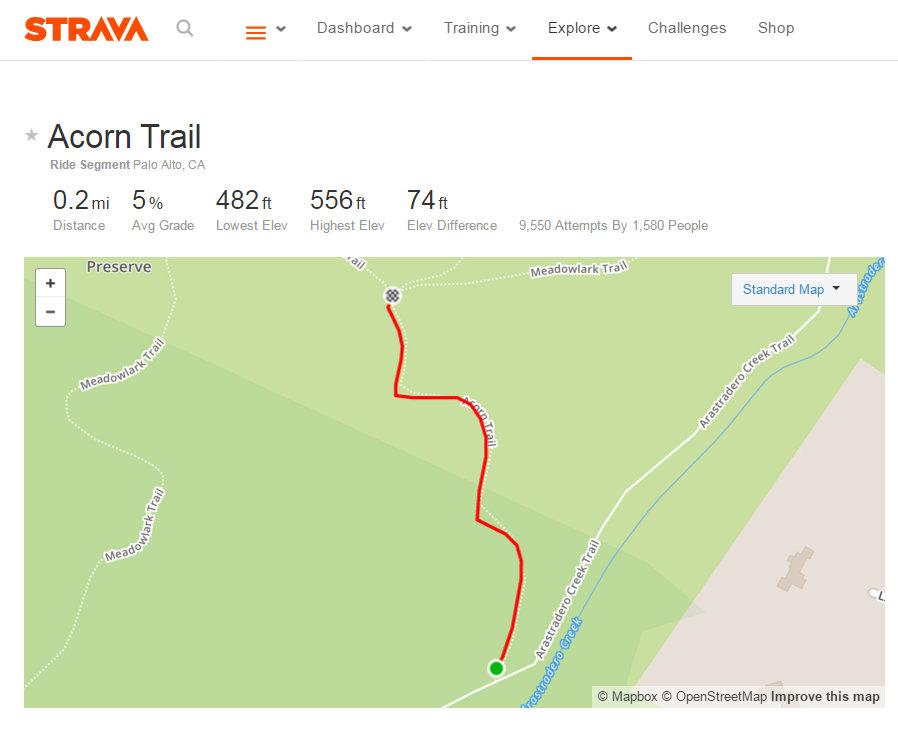
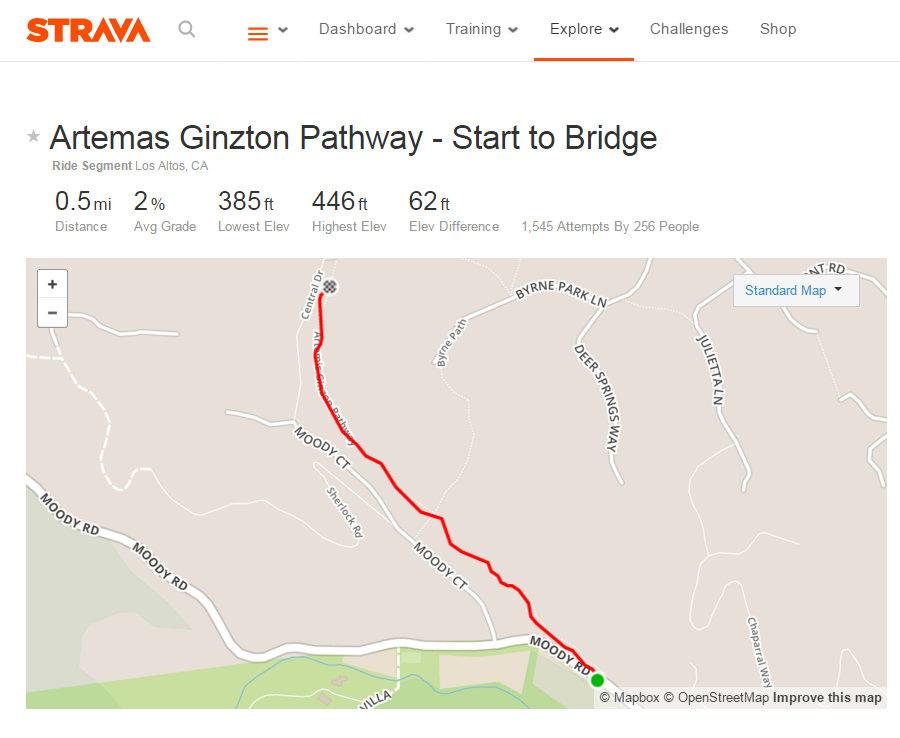
3 comparable open space, Arastradero Preserve. The website Strava, which is used by many bicyclists, records, as of January 24, 2016, that 256 people have ridden 1,545 times on the section of the Artemis Ginzton Pathway between Moody Road and Central Drive. (See ArtemisGinztonTrail.jpg, attached, see also ) In contrast, the Acorn Trail, a single-track trail in Arastradero Preserve, has been ridden by 1,580 persons 9,550 times, which is more than five times as much usage (See AcornTrail.jpg, attached, see also The trails in Arastradero Preserve are open to hikers, cyclists, and equestrians, and all appear to coexist peaceably, notwithstanding the higher usage by cyclists, and presumably higher usage by hikers and equestrians as well. In closing, I again wish to reiterate my opposition to a ban on riding bicycles in the Byrne Preserve. Thank you for your consideration of my . Sincerely, Joe Brennan
4 HIGHWAY DESIGN MANUAL CHAPTER 1000 BICYCLE TRANSPORTATION DESIGN Topic Introduction Index Bicycle Transportation The needs of nonmotorized transportation are an essential part of all highway projects. Mobility for all travel modes is recognized as an integral element of the transportation system. Therefore, the guidance provided in this manual complies with Deputy Directive 64-R2: Complete Streets - Integrating the Transportation System. See AASHTO, Guide For The Development Of Bicycle Facilities. Design guidance for Class I bikeways (bike paths), Class III bikeways (bike routes) and Trails are provided in this chapter. Design guidance that addresses the mobility needs of bicyclists on all roads as well as on Class II bikeways (bike lanes) is distributed throughout this manual where appropriate. Design guidance for Class IV bikeways (separated bikeways) is provided in DIB 89. The AASHTO Guide for the Development of Bicycle Facilities also provides additional bikeway guidance not included in this chapter. In addition, bikeway publications and manuals developed by organizations other than FHWA and AASHTO also provide guidance not covered in this manual. See Topic 116 for guidance regarding bikes on freeways Streets and Highways Code References The Streets and Highways Code Section defines a bikeway as a facility that is provided primarily for bicycle travel. Following are other related definitions, found in Chapter 8 Nonmotorized Transportation, from the Streets and Highway Code: (a) Section Definition of nonmotorized facility. (b) Section Agreements with local agencies to construct and maintain nonmotorized facilities. (c) Section Payment for construction and maintenance of nonmotorized facilities approximately paralleling State highways. (d) Section Severance of existing major nonmotorized route by freeway construction. (e) Section Incorporation of nonmotorized facilities in the design of freeways. (f) Section Requires Caltrans to budget not less than $360,000 annually for nonmotorized facilities used in conjunction with the State highway system. (g) Section Class I, II, III, and cycle tracks or separated bikeway definitions. (h) Section Caltrans and local agencies to develop design criteria and symbols for signs, markers, and traffic control devices for bikeways and roadways where bicycle travel is permitted. (i) Section Local agencies must comply with design criteria and uniform symbols. (j) Section Use of abandoned right-of-way as a nonmotorized facility Vehicle Code References (a) Section Bicyclist's rights and responsibilities for traveling on highways. (b) Section Bicyclist's position on roadways when traveling slower than the normal traffic speed. (c) Section Allows local agencies to regulate operation of bicycles on pedestrian or bicycle facilities. (d) Section Allows local agencies to establish bike lanes on non-state highways. (e) Section Prohibits motorized bicycles on bike paths or bike lanes. (f) Section Specifies permitted movements by bicyclists from bike lanes. (g) Section Specifies permitted movements by vehicles in bike lanes. (h) Section Prohibits bicycle parking on sidewalks unless pedestrians have an adequate path.
5 HIGHWAY DESIGN MANUAL (i) Section Prohibits impeding or obstruction of bicyclists on bike paths. (j) Section Adopt rules and regulations for signs, markings, and traffic control devices for roadways user. (k) Section Only those official traffic control devices that conform to the uniform standards and specifications promulgated by the Department of Transportation shall be placed upon a street or highway. (l) Section Requires a motorist to drive in a bike lane prior to making a turn. (m) Section Use of freeways by bicyclists. (n) Section No pedestrian shall proceed along a bicycle path or lane where there is an adjacent adequate pedestrian facility Bikeways (1) Role of Bikeways Bikeways are one element of an effort to improve bicycling safety and convenience - either to help accommodate motor vehicle and bicycle traffic on the roadway system, or as a complement to the road system to meet the needs of the bicyclist. Off-street bikeways in exclusive corridors can be effective in providing new recreational opportunities, and desirable transportation/commuter routes. Off-street bikeways can also provide access with bridges and tunnels which cross barriers to bicycle travel (e.g., freeway or river crossing). Likewise, on-street bikeways can serve to enhance safety and convenience, especially if other commitments are made in conjunction with establishment of bikeways, such as: elimination of parking or increased roadway width, elimination of surface irregularities and roadway obstacles, frequent street sweeping, established intersection priority on the bike route street as compared with the majority of cross streets, and installation of bicyclesensitive loop detectors at signalized intersections. (2) Decision to Develop Bikeways Providing an interconnected network of bikeways will improve safety for all users and access for bicycles. The development of well conceived bikeways can have a positive effect on bicyclist and motorist behavior. In addition, providing an interconnected network of bikeways along with education and enforcement can improve safety and access for bicyclists. The decision to develop bikeways should be made in coordination with the local agencies. Topic Bikeway Facilities Selection of the Type of Facility The type of facility to select in meeting the bicyclist s need is dependent on many factors, but the following applications are the most common for each type. (1) Shared Roadway (No Bikeway Designation). Most bicycle travel in the State now occurs on streets and highways without bikeway designations and this may continue to be true in the future as well. In some instances, entire street systems may be fully adequate for safe and efficient bicycle travel, where signing and pavement marking for bicycle use may be unnecessary. In other cases, prior to designation as a bikeway, routes may need improvements for bicycle travel. Many rural highways are used by touring bicyclists for intercity and recreational travel. It might be inappropriate to designate the highways as bikeways because of the limited use and the lack of continuity with other bike routes. However, the development and maintenance of 4-foot paved roadway shoulders with a standard 4 inch edge line can significantly improve the safety and convenience for bicyclists and motorists along such routes. (2) Class I Bikeway (Bike Path). Generally, bike paths should be used to serve corridors not served by streets and highways or where wide right of way exists, permitting such facilities to be constructed away from the influence of parallel streets. Bike paths should offer opportunities not provided by the road system.
6 HIGHWAY DESIGN MANUAL They can either provide a recreational opportunity, or in some instances, can serve as direct high-speed commute routes if cross flow by motor vehicles and pedestrian conflicts can be minimized. The most common applications are along rivers, ocean fronts, canals, utility right of way, abandoned railroad right of way, within school campuses, or within and between parks. There may also be situations where such facilities can be provided as part of planned developments. Another common application of Class I facilities is to close gaps to bicycle travel caused by construction of freeways or because of the existence of natural barriers (rivers, mountains, etc.). (3) Class II Bikeway (Bike Lane). Bike lanes are established along streets in corridors where there is significant bicycle demand, and where there are distinct needs that can be served by them. The purpose should be to improve conditions for bicyclists in the corridors. Bike lanes are intended to delineate the right of way assigned to bicyclists and motorists and to provide for more predictable movements by each. But a more important reason for constructing bike lanes is to better accommodate bicyclists through corridors where insufficient room exists for side-by-side sharing of existing streets by motorists and bicyclists. This can be accomplished by reducing the number of lanes, reducing lane width, or prohibiting or reconfiguring parking on given streets in order to delineate bike lanes. In addition, other things can be done on bike lane streets to improve the situation for bicyclists that might not be possible on all streets (e.g., improvements to the surface, augmented sweeping programs, special signal facilities, etc.). Generally, pavement markings alone will not measurably enhance bicycling. If bicycle travel is to be provided by delineation, attention should be made to assure that high levels of service are provided with these lanes. It is important to meet bicyclist expectations and increase bicyclist perception of service quality, where capacity analysis demonstrates service quality measures are improved from the bicyclist s point of view. Design guidance that addresses the mobility needs of bicyclists on Class II bikeways (bike lanes) is also distributed throughout this manual where appropriate. (4) Class III Bikeway (Bike Route). Bike routes are shared facilities which serve either to: (a) Provide continuity to other bicycle facilities (usually Class II bikeways); or (b) Designate preferred routes through high demand corridors. As with bike lanes, designation of bike routes should indicate to bicyclists that there are particular advantages to using these routes as compared with alternative routes. This means that responsible agencies have taken actions to assure that these routes are suitable as shared routes and will be maintained in a manner consistent with the needs of bicyclists. Normally, bike routes are shared with motor vehicles. The use of sidewalks as Class III bikeways is strongly discouraged. (5) Class IV Bikeways (Separated Bikeways). See DIB 89 for guidance. A Class IV bikeway (separated bikeway) is a bikeway for the exclusive use of bicycles and includes a separation required between the separated bikeway and the through vehicular traffic. The separation may include, but is not limited to, grade separation, flexible posts, inflexible posts, inflexible barriers, or on-street parking. See DIB 89 for further Class IV guidance. It is emphasized that the designation of bikeways as Class I, II,III, and IV should not be construed as a hierarchy of bikeways; that one is better than the other. Each class of bikeway has its appropriate application. In selecting the proper facility, an overriding concern is to assure that the proposed facility will not encourage or require bicyclists or motorists to operate in a manner that is inconsistent with the rules of the road. An important consideration in selecting the type of facility is continuity. Alternating segments of Class I to Class II (or Class III) bikeways along a route are generally incompatible, as street crossings by
7 HIGHWAY DESIGN MANUAL bicyclists is required when the route changes character. Also, wrong-way bicycle travel will occur on the street beyond the ends of bike paths because of the inconvenience of having to cross the street. However, alternating from Class IV to Class II may be appropriate due to the presence of many driveways or turning movements. The highway context or community setting may also influence the need to alternate bikeway classifications. Topic Bikeway Design Criteria Class I Bikeways (Bike Paths) Class I bikeways (bike paths) are facilities with exclusive right of way, with cross flows by vehicles minimized. Motor vehicles are prohibited from bike paths per the CVC, which can be reinforced by signing. Class I bikeways, unless adjacent to an adequate pedestrian facility,(see Index (n)) are for the exclusive use of bicycles and pedestrians, therefore any facility serving pedestrians must meet accessibility requirements, see DIB 82. However, experience has shown that if regular pedestrian use is anticipated, separate facilities for pedestrians maybe beneficial to minimize conflicts. Please note, sidewalks are not Class I bikeways because they are primarily intended to serve pedestrians, generally cannot meet the design standards for Class I bikeways, and do not minimize vehicle cross flows. See Index for discussion of the issues associated with sidewalk bikeways. (1) Widths and Cross Slopes. See Figure A for two-way Class I bikeway (bike path) width, cross slope, and side slope details. The term shoulder as used in the context of a bike path is an unobstructed all weather surface on each side of a bike path with similar functionality as shoulders on roadways with the exception that motor vehicle parking and use is not allowed. The shoulder area is not considered part of the bike path traveled way. Experience has shown that paved paths less than 12 feet wide can break up along the edge as a result of loads from maintenance vehicles. (a) Traveled Way. The minimum paved width of travel way for a two-way bike path shall be 8 feet, 10-foot preferred. The minimum paved width for a oneway bike path shall be 5 feet. It should be assumed that bike paths will be used for two-way travel. Development of a one-way bike path should be undertaken only in rare situations where there is a need for only one-direction of travel. Two-way use of bike paths designed for one-way travel increases the risk of headon collisions, as it is difficult to enforce one-way operation. This is not meant to apply to two one-way bike paths that are parallel and adjacent to each other within a wide right of way. Where heavy bicycle volumes are anticipated and/or significant pedestrian traffic is expected, the paved width of a two-way bike path should be greater than 10 feet, preferably 12 feet or more. Another important factor to consider in determining the appropriate width is that bicyclists will tend to ride side by side on bike paths, and bicyclists may need adequate passing clearance next to pedestrians and slower moving bicyclists. See Index (16) Drainage, for cross slope information. (b) Shoulder. A minimum 2-foot wide shoulder, composed of the same pavement material as the bike path or all weather surface material that is free of vegetation, shall be provided adjacent to the traveled way of the bike path when not on a structure; see Figure A. A shoulder width of 3 feet should be provided where feasible. A wider shoulder can reduce bicycle conflicts with pedestrians. Where the paved bike path width is wider than the minimum required, the unpaved shoulder area may be reduced proportionately. If all or part of the shoulder is paved with the same material as the bike path, it is to be delineated from the traveled way of the bike path with an edgeline. See Index (16), Drainage, for cross slope information. (2) Bike Path Separation from a Pedestrian Walkway. If there is an adjacent pedestrian
8 HIGHWAY DESIGN MANUAL walkway, the edge of the traveled way of the bike path is to be separated from the pedestrian walkway by a minimum width of 5 feet of unpaved material. The 5-foot area of unpaved material may include landscaping or other features that provide a continuous obstacle to deter bike path and walkway users from using both paths as a single facility. These obstacles may be fences, railings, solid walls, or dense shrubbery. Flexible delineators, poles, curbs, or pavement markers are not to be used because they will not deter users from using both paths as a single facility. These obstacles between the pedestrian walkways and bike paths are not to obstruct stopping sight distance along curves or corner sight distance at intersections with roadways or other paths. (3) Clearance to Obstructions. A minimum 2-foot horizontal clearance from the paved edge of a bike path to obstructions shall be provided. See Figure A. 3 feet should be provided. Adequate clearance from fixed objects is needed regardless of the paved width. If a path is paved contiguous with a continuous fixed object (e.g., fence, wall, and building), a 4-inch white edge line, 2 feet from the fixed object, is recommended to minimize the likelihood of a bicyclist hitting it. The clear width of a bicycle path on structures between railings shall be not less than 10 feet. It is desirable that the clear width of structures be equal to the minimum clear width of the path plus shoulders (i.e., 14 feet). The vertical clearance to obstructions across the width of a bike path shall be a minimum of 8 feet and 7 feet over shoulder. Where practical, a vertical clearance of 10 feet is desirable. (4) Signing and Delineation. For application and placement of signs, see the California MUTCD, Section 9B. For pavement marking guidance, see the California MUTCD, Section 9C. (5) Intersections with Highways. Intersections are an important consideration in bike path design. Bicycle path intersection design should address both cross-traffic and turning movements. If alternate locations for a bike path are available, the one with the most beneficial intersection characteristics should be selected. Where motor vehicle cross traffic and bicycle traffic is heavy, grade separations are desirable to eliminate intersection conflicts. Where grade separations are not feasible, assignment of right of way by traffic signals should be considered. Where traffic is not heavy, STOP or YIELD signs for either the path or the cross street (depending on volumes) may suffice. Bicycle path intersections and their approaches should be on relatively flat grades. Stopping sight distances at intersections should be checked and adequate warning should be given to permit bicyclists to stop before reaching the intersection, especially on downgrades. When contemplating the placement of signs the designer is to discuss the proposed sign details with their Traffic Liaison so that conflicts may be minimized. Bicycle versus motor vehicle collisions may occur more often at intersections, where bicyclists misuse pedestrian crosswalks; thus, this should be avoided. When crossing an arterial street, the crossing should either occur at the pedestrian crossing, where vehicles can be expected to stop, or at a location completely out of the influence of any intersection to permit adequate opportunity for bicyclists to see turning vehicles. When crossing at midblock locations, right of way should be assigned by devices such as YIELD signs, STOP signs, or traffic signals which can be activated by bicyclists. Even when crossing within or adjacent to the pedestrian crossing, STOP or YIELD signs for bicyclists should be placed to minimize potential for conflict resulting from turning autos. Where bike path STOP or YIELD signs are visible to approaching motor vehicle traffic, they should be shielded to avoid confusion. In some cases, Bike Xing signs may be placed in advance of the crossing to alert motorists. Ramps should be installed in the curbs, to preserve the utility of the bike path. Ramps should be the same width as the bicycle paths. Curb cuts and ramps should
 For sign clearances, see California MUTCD, Figure 9B-1.")
9 HIGHWAY DESIGN MANUAL Figure A Two-Way Class I Bikeway (Bike Path) NOTES: (1) See Index (13) for pavement structure guidance of bike path. (2) For sign clearances, see California MUTCD, Figure 9B-1. (3) The AASHTO Guide for the Development of Bicycle Facilities provides detailed guidance for creating a forgiving Class I bikeway environment. * 1% cross-slope minimum.
10 HIGHWAY DESIGN MANUAL July 1, 2015 Figure B Typical Cross Section of Class I Bikeway (Bike Path) Parallel to Highway NOTE: (1) See Index (6) for guidance on separation between bike paths and highways. * One-Way: 5 Minimum Width Two-Way: 8 Minimum Width
11 HIGHWAY DESIGN MANUAL provide a smooth transition between the bicycle paths and the roadway. Assignment of rights of way is necessary where bicycle paths intersect roadways or other bicycle paths. See the California MUTCD, Section 9B.03 and Figure 9B-7 for guidance on signals and signs for rights of way assignment at bicycle path intersections. (6) Paving at Crossings. At unpaved roadway or driveway crossings, including bike paths or pedestrian walkways, the crossing roadway or driveway shall be paved a minimum of 15 feet to minimize or eliminate gravel intrusion on the path. The pavement structure at the crossing should be adequate to sustain the expected loading at that location (7) Bike Paths Parallel and Adjacent to Streets and Highways. A wide separation is recommended between bike paths and adjacent highways (see Figure B). The minimum separation between the edge of pavement of a one-way or a two-way bicycle path and the edge of traveled way of a parallel road or street shall be 5 feet plus the standard shoulder widths. Bike paths within the clear recovery zone of freeways shall include a physical barrier separation. The separation is unpaved and does not include curbs or sidewalks. Separations less than 10 feet from the edge of the shoulder are to include landscaping or other features that provide a continuous barrier to prevent bicyclists from encroaching onto the highway. Suitable barriers may include fences or dense shrubs if design speeds are less than or equal to 45 miles per hour. Obstacles low to the ground or intermittent obstacles (e.g., curbs, dikes, raised traffic bars, posts connected by cable or wire, flexible channelizers, etc.) are not to be used because bicyclists could fall over these obstacles and into the roadway. Bike paths immediately adjacent to streets and highways are not recommended. While they can provide separation between vehicles and nonmotorized traffic, they typically introduce significant conflicts at intersections. In addition, they can create conflicts with passengers at public transit facilities, and with vehicle occupants crossing the path. They are not a substitute for designing the road to meet bicyclist s mobility needs. Use of bicycle paths adjacent to roads is not mandatory in California, and many bicyclists will perceive these paths as offering a lower level of mobility compared with traveling on the road, particularly for utility trips. Careful consideration regarding how to address the above points needs to be weighed against the perceived benefits of providing a bike path adjacent to a street or highway. Factors such as urban density, the number of conflict points, the presence or absence of a sidewalk, speed and volume should be considered. (8) Bike Paths in the Median of Highway or Roadway. Bike paths should not be placed in the median of a State highway or local road, and shall not be in the median of a freeway or expressway. Bike paths in the median are generally not recommended because they may require movements contrary to normal rules of the road. Specific problems with such facilities may include: (a) Right-turns by bicyclists from the median of roadways are unexpected by motorists. (b) Devoting separate phases to bicyclist movements to and from a median path at signalized intersections increases intersection delay. (c) Left-turning motorists must cross one direction of motor vehicle traffic and two directions of bicycle traffic, which may increase conflicts. (d) Where intersections are infrequent, bicyclists may choose to enter or exit bike paths at midblock. (e) Where medians are landscaped, visibility between bicyclists on the path and motorists at intersections may be diminished. See Chapter 900 for planting guidance. (9) Bicycle Path Design Speed. The design speed of bicycle paths is established using the same principles as those applied to highway design speeds. The design speed given in Table shall be the minimum.
12 HIGHWAY DESIGN MANUAL Table Bike Path Design Speeds Type of Facility Bike Paths with Mopeds Prohibited Bike Paths with Mopeds Permitted Bike Paths on Long Downgrades (steeper than 4%, and longer than 500') NOTE: Design Speed (mph) (1) (1) On bike paths with mopeds prohibited, a lower design speed can be used for the crest vertical curve, equivalent to 1 mile per hour per percent grade for grades exceeding a vertical rise of 10 feet, when at a crest in path. Installation of "speed bumps", gates, obstacles, posts, fences or other similar features intended to cause bicyclists to slow down are not to be used. (10) Horizontal Alignment and Superelevation. The minimum radius of curvature negotiable by a bicycle is a function of the superelevation of the bicycle path surface, the coefficient of friction between the bicycle tires and the bicycle path surface, and the speed of the bicycle. For all bicycle path applications the maximum superelevation rate is 2 percent. The minimum radius of curvature should be 90 feet for 20 miles per hour, 160 feet for 25 mile per hour and 260 feet for 30 miles per hour. No superelevation is needed for radius of curvature meeting or exceeding 100 feet for 20 miles per hour, 180 feet for 25 miles per hour, and 320 feet for 30 miles per hour. When curve radii smaller than those given because of right of way, topographical or other considerations, standard curve warning signs and supplemental pavement markings should be installed. The negative effects of nonstandard curves can also be partially offset by widening the pavement through the curves. (11) Stopping Sight Distance. To provide bicyclists with an opportunity to see and react to the unexpected, a bicycle path should be designed with adequate stopping sight distances. The minimum stopping sight distance based on design speed shall be 125 feet for 20 miles per hour, 175 feet for 25 miles per hour and 230 feet for 30 miles per hour. The distance required to bring a bicycle to a full controlled stop is a function of the bicyclist s perception and brake reaction time, the initial speed of the bicycle, the coefficient of friction between the tires and the pavement, and the braking ability of the bicycle. Stopping sight distance is measured from a bicyclist s eyes, which are assumed to be 4 ½ feet above the pavement surface to an object ½-foot high on the pavement surface. (12) Length of Crest Vertical Curves. Figure C indicates the minimum lengths of crest vertical curves for varying design speeds. (13) Lateral Clearance on Horizontal Curves. Figure D indicates the minimum clearances to line of sight obstructions, m, for horizontal curves. It is assumed that the bicyclist s eyes are 4 ½ feet above the pavement surface to an object ½-foot high on the pavement surface. Bicyclists frequently ride abreast of each other on bicycle paths, and on narrow bicycle paths, bicyclists have a tendency to ride near the middle of the path. For these reasons, lateral clearances on horizontal curves should be calculated based on the sum of the stopping sight distances for bicyclists traveling in opposite directions around the curve. Where this is not possible or feasible, the following or combination thereof should be provided: (a) the path through the curve should be widened to a minimum paved width of 14 feet; and(b) a yellow center line curve warning sign and advisory speed limit signs should be installed. (14) Grades. Bike path grades must meet DIB 82. The maximum grade rate recommended for bike paths should be 5 percent. Sustained grades should be limited to 2 percent.
13 HIGHWAY DESIGN MANUAL (15) Pavement Structure. The pavement material and structure of a bike path should be designed in the same manner as a highway, with a recommendation from the District Materials Branch. It is important to construct and maintain a smooth, well drained, all-weather riding surface with skid resistant qualities, free of vegetation growth. Principal loads will normally be from maintenance and emergency vehicles. (16) Drainage. For proper drainage, the surface of a bike path should have a minimum cross slope of 1 percent to reduce ponding and a maximum of 2 percent per DIB 82. Sloping of the traveled way in one direction usually simplifies longitudinal drainage design and surface construction, and accordingly is the preferred practice. The bike path shoulder shall slope away from the traveled way at 2 percent to 5 percent to reduce ponding and minimize debris from flowing onto the bike path. Ordinarily, surface drainage from the path will be adequately dissipated as it flows down the gently sloping shoulder. However, when a bike path is constructed on the side of a hill, a drainage ditch of suitable dimensions may be necessary on the uphill side to intercept the hillside drainage. Where necessary, catch basins with drains should be provided to carry intercepted water under the path. Such ditches should be designed in such a way that no undue obstacle is presented to bicyclists. Culverts or bridges are necessary where a bike path crosses a drainage channel. (17) Entry Control for Bicycle Paths. Obstacle posts and gates are fixed objects and placement within the bicycle path traveled way can cause them to be an obstruction to bicyclists. Obstacles such as posts or gates may be considered only when other measures have failed to stop unauthorized motor vehicle entry. Also, these obstacles may be considered only where safety and other issues posed by actual unauthorized vehicle entry are more serious than the safety and access issues posed to bicyclists, pedestrians and other authorized path users by the obstacles. The 3-step approach to prevent unauthorized vehicle entry is: (a) Post signs identifying the entry as a bicycle path with regulatory signs prohibiting motor vehicle entry where roads and bicycle paths cross and at other path entry points. (b) Design the path entry so it does not look like a vehicle access and makes intentional access by unauthorized users more difficult. Dividing a path into two one-way paths prior to the intersection, separated by low plantings or other features not conducive to motor vehicle use, can discourage motorists from entering and reduce driver error. (c) Assess whether signing and path entry design prevents or minimizes unauthorized entry to tolerable levels. If there are documented issues caused by unauthorized motor vehicle entry, and other methods have proven ineffective, assess whether the issues posed by unauthorized vehicle entry exceed the crash risks and access issues posed by obstacles. If the decision is made to add bollards, plantings or similar obstacles, they should be: Yielding to minimize injury to bicyclists and pedestrians who may strike them. Removable or moveable (such as gates) for emergency and maintenance access must leave a flush surface when removed. Reflectorized for nighttime visibility and painted, coated, or manufactured of material in a bright color to enhanced daytime visibility. Illuminated when necessary. Spaced to leave a minimum of 5 feet of clearance of paved area between obstacles (measured from face of obstacle to face of adjacent obstacle). Symmetrically about the center line of the path. Positioned so an even number of bicycle travel lanes are created, with a minimum of two paths of travel. An odd number of openings increase the risk of head-on collisions if traffic in both directions tries to use the same opening.
14 HIGHWAY DESIGN MANUAL July 1, 2015 Figure C Minimum Length of Bicycle Path Crest Vertical Curve (L) Based on Stopping Sight Distance (S) 1600 L = 2S - when S > L A Double line represents S = L L = Minimum length of vertical curve feet A = Algebraic grade difference - % 2 AS L = when S < L S = Stopping sight distance feet 1600 Refer to Index (11) to determine S, for a given design speed V Height of cyclist eye = 4½ feet Height of object = ½ foot A S = Stopping Sight Distance (ft) (%) S > L S <L
15 HIGHWAY DESIGN MANUAL Figure D Minimum Lateral Clearance (m) on Bicycle Path Horizontal Curves S = Sight distance in feet. R = Radius of of lane in feet. m = Distance from of lane in feet. Refer to Index (11) to determine S for a given design speed V. Angle is expressed in degrees mm = R 1- cos 28.65S R S= R cos-1 R-m R Formula applies only when S is equal to or less than length of curve. Line of sight is 28 above inside lane at point of obstruction. Height of bicyclist s eye is 4 ½ feet. R (ft) S = Stopping Sight Distance (ft)
16 HIGHWAY DESIGN MANUAL Placed so additional, non-centerline/lane line posts are located a minimum of 2 feet from the edge of pavement. Delineated as shown in California MUTCD Figure 9C-2. Provide special advance warning signs or painted pavement markings if sight distance is limited. Placed 10 to 30 feet back from an intersection, and 5 to 10 feet from a bridge, so bicyclists approach the obstacle straighton and maintenance vehicles can pull off the road. Placed beyond the clear zone on the crossing highway, otherwise breakaway. When physical obstacles are needed to control unauthorized vehicle access, a single nonremovable, flexible, post on the path centerline with a separate gate for emergency/maintenance vehicle access next to the path, is preferred. The gate should swinging away from the path, Fold-down obstacle posts or bollards shall not be used within the paved area of bicycle paths. They are often left in the folded down position, which presents a crash hazard to bicyclists and pedestrians. When vehicles drive across fold-down obstacles, they can be broken from their hinges, leaving twisted and jagged obstructions that project a few inches from the path surface. Obstacle posts or gates must not be used to force bicyclists to slow down, stop or dismount. Treatments used to reduce vehicle speeds may be used where it is desirable to reduce bicycle speeds. For obstacle post visibility marking, and pavement markings, see the California MUTCD, Section 9C.101(CA). (18) Lighting. Fixed-source lighting raises awareness of conflicts along paths and at intersections. In addition, lighting allows the bicyclist to see the bicycle path direction, surface conditions, and obstacles. Lighting for bicycle paths is important and should be considered where nighttime use is not prohibited, in sag curves (see Index 201.5), at intersections, at locations where nighttime security could be a problem, and where obstacles deter unauthorized vehicle entry to bicycle paths. See Index (17). Daytime lighting should also be considered through underpasses or tunnels. Depending on the location, average maintained horizontal illumination levels of 5 lux to 22 lux should be considered. Where special security problems exist, higher illumination levels may be considered. Light standards (poles) should meet the recommended horizontal and vertical clearances. Luminaires and standards should be at a scale appropriate for a pedestrian or bicycle path. For additional guidance on lighting, consult with the District Traffic Electrical Unit Class II Bikeways (Bike Lanes) Design guidance that address the safety and mobility needs of bicyclists on Class II bikeways (bike lanes) is distributed throughout this manual where appropriate. For Class II bikeway signing and lane markings, see the California MUTCD, Section 9C Class III Bikeways (Bike Routes) Class III bikeways (bike routes) are intended to provide continuity to the bikeway system. Bike routes are established along through routes not served by Class I or II bikeways, or to connect discontinuous segments of bikeway (normally bike lanes). Class III facilities are facilities shared with motor vehicles on the street, which are established by placing bike route signs along roadways. Additional enhancement of Class III facilities can be provided by adding shared roadway markings along the route. For application and placement of signs and pavement markings, see the California MUTCD Section 9C. Minimum widths for Class III bikeways are represented, in the minimum standards for highway lanes and shoulder. Since bicyclists are permitted on all highways (except prohibited freeways), the decision to designate the route as a bikeway should be based on the advisability of encouraging bicycle travel on the route and other factors listed below.
17 HIGHWAY DESIGN MANUAL (1) On-street Bike Route Criteria. To be of benefit to bicyclists, bike routes should offer a higher degree of service than alternative streets. Routes should be signed only if some of the following apply: (a) They provide for through and direct travel in bicycle-demand corridors. (b) Connect discontinuous segments of bike lanes. (c) They provide traffic actuated signals for bicycles and appropriate assignment of right of way at intersections to give greater priority to bicyclists, as compared with alternative streets. (d) Street parking has been removed or restricted in areas of critical width to provide improved safety. (e) Surface imperfections or irregularities have been corrected (e.g., utility covers adjusted to grade, potholes filled, etc.). (f) Maintenance of the route will be at a higher standard than that of other comparable streets (e.g., more frequent street sweeping). (2) Sidewalk as Bikeway. Sidewalks are not to be designated for bicycle travel. Wide sidewalks that do not meet design standards for bicycle paths or bicycle routes also may not meet the safety and mobility needs of bicyclists. Wide sidewalks can encourage higher speed bicycle use and can increase the potential for conflicts with turning traffic at intersections as well as with pedestrians and fixed objects. In residential areas, sidewalk riding by young children too inexperienced to ride in the street is common. It is inappropriate to sign these facilities as bikeways because it may lead bicyclists to think it is designed to meet their safety and mobility needs. Bicyclists should not be encouraged (through signing) to ride their bicycles on facilities that are not designed to accommodate bicycle travel. (3) Shared Transit and Bikeways. Transit lanes and bicycles are generally not compatible, and present risks to bicyclists. Therefore sharing exclusive use transit lanes for buses with bicycles is discouraged. Bus and bicycle lane sharing should be considered only under special circumstances to provide bikeway continuity, such as: (a) If bus operating speed is 25 miles per hour or below. (b) If the grade of the facility is 5 percent or less Trails Trails are generally, unpaved multipurpose facilities suitable for recreational use by hikers, pedestrians, equestrians, and off-road bicyclists. While many Class I facilities are named as trails (e.g. Iron Horse Regional Trail, San Gabriel River Trail), trails as defined here do not meet Class I bikeways standards and should not be signed as bicycle paths. Where equestrians are expected, a separate equestrian trail should be provided. See DIB 82 for trail requirements for ADA. See Index for equestrian undercrossing guidance. Pavement requirements for bicycle travel are not suitable for horses. Horses require softer surfaces to avoid leg injuries. Bicyclists may not be aware of the need to go slow or of the separation need when approaching or passing a horse. Horses reacting to perceived danger from predators may behave unpredictably; thus, if a bicyclist appears suddenly within their visual field, especially from behind they may bolt. To help horses not be surprised by a bicyclist, good visibility should be provided at all points on equestrian paths. When a corridor includes equestrian paths and Class I bikeways, the widest possible lateral separation should be provided between the two. A physical obstacle, such as an open rail fence, adjacent to the equestrian trail may be beneficial to induce horses to shy away from the bikeway, as long as the obstacle does not block visibility between the equestrian trail and bicycle path. See FHWA-EP , Designing Sidewalks and Trails for Access and DIB 82 for additional design guidance.
18 HIGHWAY DESIGN MANUAL Miscellaneous Criteria The following are miscellaneous bicycle treatment criteria. Specific application to Class I, and III bikeways are noted. Criteria that are not noted as applying only to bikeways apply to any highway, roadways and shoulders, except freeways where bicycles are prohibited), without regard to whether or not bikeways are established. Bicycle Paths on Bridges See Topic 208. (1) Pavement Surface Quality. The surface to be used by bicyclists should be smooth, free of potholes, and with uniform pavement edges. (2) Drainage Grates, Manhole Covers, and Driveways. Drainage inlet grates, manhole covers, etc., should be located out of the travel path of bicyclists whenever possible. When such items are in an area that may be used for bicycle travel, they shall be designed and installed in a manner that meets bicycle surface requirements. See Standard Plans. They shall be maintained flush with the surface when resurfacing. If grate inlets are to be located in roadway or shoulder areas (except freeways where bicycles are prohibited) the inlet design guidance of Index 837.2(2) applies. Future driveway construction should avoid construction of a vertical lip from the driveway to the gutter, as the lip may create a problem for bicyclists when entering from the edge of the roadway at a flat angle. If a lip is deemed necessary, the height should be limited to ½ inch. (3) At-grade Railroad Crossings and Cattle Guards. Whenever it is necessary for a Class I bikeway, highway or roadway to cross railroad tracks, special care must be taken to ensure that the safety of users is protected. The crossing must be at least as wide as the traveled way of the facility. Wherever possible, the crossing should be straight and at right angles to the rails. For bikeways or highways that cross tracks and where a skew is unavoidable, the shoulder or bikeway should be widened, to permit bicyclists to cross at right angles (see Figure ). If this is not possible, special construction and materials should be considered to keep the flangeway depth and width to a minimum. Pavement should be maintained so ridge buildup does not occur next to the rails. In some cases, timber plank crossings can be justified and can provide for a smoother crossing. All railroad crossings are regulated by the California Public Utilities Commission (CPUC). All new bicycle path railroad crossings must be approved by the CPUC. Necessary railroad protection will be determined based on a joint field review involving the applicant, the railroad company, and the CPUC. NOTE: Cattle guards across any roadway are to be clearly marked with adequate advance warning. Cattle guards are only to be used where there is no other alternative to manage livestock. The California MUTCD has specific guidance on Rail and Light Rail crossings. See Part 8 of the California MUTCD. Figure Railroad Crossing Class I Bikeway See Index Angle of Intersection for Class II and Class III facilities.
19
20
City of Roseville Section 13 Design Standards. _Bikeways January 2016 SECTION 13 BIKEWAYS
 SECTION 13 BIKEWAYS 13-1 GENERAL The City of Roseville bikeway standards are designed to insure that transportation and recreational bikeways are constructed in a manner that would provide a safe and comfortable
Appendix B HDM CH 1000 BIKEWAY PLAN & DESIGN
 Appendix B HDM CH 1000 BIKEWAY PLAN & DESIGN HIGHWAY DESIGN MANUAL 1000-1 CHAPTER 1000 BIKEWAY PLANNING AND DESIGN Topic 1001 - General Criteria Index 1001.1 - Introduction The needs of non-motorized transportation
Appendix T CCMP TRAIL TRAFFIC & TRANSPORTATION DESIGN STANDARD
 Appendix T CCMP 3.3.4 TRAIL TRAFFIC & TRANSPORTATION DESIGN STANDARD 3.3.4 Trail Traffic and Transportation Design Multi-use trails have certain design standards, which vary depending on the agency that
Off-road Trails. Guidance
 Off-road Trails Off-road trails are shared use paths located on an independent alignment that provide two-way travel for people walking, bicycling, and other non-motorized users. Trails specifically along
Shared Use Path Design
 12B-2 Design Manual Chapter 12 - Sidewalks and Bicycle Facilities 12B - Bicycle Facilities Shared Use Path Design A. Accessible Shared Use Path Design 1. General: Applicable portions from the following
Appendix 3 Roadway and Bike/Ped Design Standards
 Appendix 3 Roadway and Bike/Ped Design Standards OTO Transportation Plan 2040 4/20/2017 Page A3-1 Adopted Standards The adopted OTO Design Standards and Major Thoroughfare Plan are contained herein.
700 Multi-Modal Considerations
 700 Multi-Modal Considerations Table of Contents 701 Railroads... 7-1 701.1 Background... 7-1 701.2 Crossing At-Grade... 7-1 701.2.1 General... 7-1 701.2.2 Railroad Parallel to Highway... 7-1 701.3 Lateral
CHAPTER 1 STANDARD PRACTICES
 CHAPTER 1 STANDARD PRACTICES OBJECTIVES 1) Functions and Limitations 2) Standardization of Application 3) Materials 4) Colors 5) Widths and Patterns of Longitudinal Pavement Marking Lines 6) General Principles
Off-Road Facilities Part 1: Shared Use Path Design
 Off-Road Facilities Part 1: Shared Use Path Design Presentation by: Eric Mongelli, P.E. Tom Huber October 9, 2012 FOLLOW THE CONVERSATION ON TWITTER Toole Design Group is live tweeting this webinar @tooledesign
General Design Factors
 Chapter 3: 3-1.0 Introduction General Design Factors Mn/DOT s goals include encouraging and accommodating safe bicycling. From a design perspective, these goals are achieved by first having an understanding
INDEX. Geometric Design Guide for Canadian Roads INDEX
 Acceleration lane, see Lanes, Acceleration Access, 8.1 Access Management and Functional Classification 8.2 Access Management by Design Classification 8.3 Access Configuration 8.4 Building Set-Back Guidelines
John Harpootlian; Gary C. Waldeck; J Radford; Courtenay C. Corrigan; Roger Spreen; Deborah Padovan
 Supplemental No. 5 AGENDA ITEM #6.E Distributed 1/22/16 From: To: Cc: Subject: Date: Attachments: John Harpootlian; Gary C. Waldeck; J Radford; Courtenay C. Corrigan; Roger Spreen; Deborah Padovan Draft
10.0 CURB EXTENSIONS GUIDELINE
 10.0 CURB EXTENSIONS GUIDELINE Road Engineering Design Guidelines Version 1.0 March 2017 City of Toronto, Transportation Services City of Toronto Page 0 Background In early 2014, Transportation Services
CURBSIDE ACTIVITY DESIGN
 5 CURBSIDE ACTIVITY DESIGN This chapter provides design guidance for separated bike lanes adjacent to curbside activities including parking, loading and bus stops. Typical configurations are presented
October 2004 REVISIONS (2) SUPERELEVATION DEVELOPMENT 11.3(2)
 SUPERELEVATION DEVELOPMENT 11.3(2)") October 2004 REVISIONS (2) Chapter 11 HORIZONTAL ALIGNMENT SUPERELEVATION DEVELOPMENT 11.3(2) Chapter 12 VERTICAL ALIGNMENT VERTICAL CURVES PASSING SIGHT DISTANCE 12.5(2) VERTICAL CURVES STOPPING SIGHT
October 2004 REVISIONS (2) Chapter 11 HORIZONTAL ALIGNMENT SUPERELEVATION DEVELOPMENT 11.3(2) Chapter 12 VERTICAL ALIGNMENT VERTICAL CURVES PASSING SIGHT DISTANCE 12.5(2) VERTICAL CURVES STOPPING SIGHT
Driveway Design Criteria
 Design Manual Chapter 5 - Roadway Design 5L - Access Management 5L-4 Driveway Design Criteria A. General For efficient and safe operations, access drives and minor public street intersections can be improved
4. TRAIL DESIGN GUIDELINES
 Trail Design Guidelines 4. TRAIL DESIGN GUIDELINES This chapter provides specific design guidelines for the Humboldt Bay Trail that are consistent with the guidelines currently observed in California and
Active Transportation Facility Glossary
 Active Transportation Facility Glossary This document defines different active transportation facilities and suggests appropriate corridor types. Click on a facility type to jump to its definition. Bike
On-Street Bicycle Facilities
 On-Street Bicycle Facilities A. General 12B-3 Design Manual Chapter 12 - Sidewalks and Bicycle Facilities 12B - Bicycle Facilities Cyclists have similar access and mobility needs as other transportation
Geometric Design Tables
 Design Manual Chapter 5 - Roadway Design 5C - Geometric Design Criteria 5C-1 Geometric Design Tables A. General The following sections present two sets of design criteria tables - Preferred Roadway Elements
CHAPTER 16 PEDESTRIAN FACILITIES DESIGN AND TECHNICAL CRITERIA TABLE OF CONTENTS
 CHAPTER 16 PEDESTRIAN FACILITIES DESIGN AND TECHNICAL CRITERIA TABLE OF CONTENTS Section Title Page 16.1 General... 16-1 16.1.1 AASHTO Reference... 16-1 16.1.2 ADA Requirements... 16-1 16.2 Sidewalks...
Section 9A.07 Meaning of Standard, Guidance, Option, and Support
 2012 Edition Page 895 PART 9. TRAFFIC CONTROLS FOR BICYCLE FACILITIES CHAPTER 9A. GENERAL Section 9A.01 Requirements for Bicyclist Traffic Control Devices 01 General information and definitions concerning
Chapter 2: Standards for Access, Non-Motorized, and Transit
 Standards for Access, Non-Motorized, and Transit Chapter 2: Standards for Access, Non-Motorized, and Transit The Washtenaw County Access Management Plan was developed based on the analysis of existing
Chapter 5 Shared-Use Paths
 Chapter 5: 5-1.0 Introduction Shared-Use Paths This chapter provides guidelines for design of bicycle transportation facilities that are separated from the roadway. In most cases, a path separated from
Accommodating Pedestrians in the Work Zone
 Accommodating Pedestrians in the Work Zone Guidance for Section C Plan Preparers Some impacts cannot be avoided and those impacts apply to residents, businesses, motorists, and pedestrians alike. However,
ADA on Construction. Guidance for Section C Plan Preparers
 ADA on Construction Guidance for Section C Plan Preparers Some impacts cannot be avoided and those impacts apply to residents, businesses, motorists, and pedestrians alike. However, good planning can minimize
Memorandum. Exhibit 60 SSDP To: Jenny Bailey, Senior Planner. From: Bill Schultheiss, P.E. (WA. P.E. #46108) Date: June 20, 2017
 Date: June 20, 2017") Memorandum To: Jenny Bailey, Senior Planner From: Bill Schultheiss, P.E. (WA. P.E. #46108) Date: June 20, 2017 Re: East Lake Sammamish Trail, Segment 2B Review King County has asked Toole Design Group
Memorandum To: Jenny Bailey, Senior Planner From: Bill Schultheiss, P.E. (WA. P.E. #46108) Date: June 20, 2017 Re: East Lake Sammamish Trail, Segment 2B Review King County has asked Toole Design Group
Access Management Standards
 Access Management Standards Section 1: Application of Access Standards This chapter describes the Department's access management standards for access connections on the county roadway system. The standards
MUTCD Part 6G: Type of Temporary Traffic Control Zone Activities
 MUTCD Part 6G: Type of Temporary Traffic Control Zone Activities 6G.01 Typical Applications Each temporary traffic control (TTC) zone is different. Many variables, such as location of work, highway type,
Developed by: The American Traffic Safety Services Association (ATSSA) 15 Riverside Parkway, Suite 100 Fredericksburg, VA
 15 Riverside Parkway, Suite 100 Fredericksburg, VA") Addendum Developed by: The American Traffic Safety Services Association (ATSSA) 15 Riverside Parkway, Suite 100 Fredericksburg, VA 22406-1022 800-272-8772 This material is based upon work supported by
Addendum Developed by: The American Traffic Safety Services Association (ATSSA) 15 Riverside Parkway, Suite 100 Fredericksburg, VA 22406-1022 800-272-8772 This material is based upon work supported by
(This page left intentionally blank)
") (This page left intentionally blank) 2011 Edition - Revision 1 Page 553 Section 5A.01 Function CHAPTER 5A. GENERAL 01 A low-volume road shall be defined for this Part of the Manual as follows: A. A low-volume
(This page left intentionally blank) 2011 Edition - Revision 1 Page 553 Section 5A.01 Function CHAPTER 5A. GENERAL 01 A low-volume road shall be defined for this Part of the Manual as follows: A. A low-volume
Table of Contents. Introduction. Prompt List Arterials and Streets. Prompt List Interchange. Prompt List Intersections. Prompt List Limited Access
 Table of Contents Introduction Prompt List Arterials and Streets Prompt List Interchange Prompt List Intersections Prompt List Limited Access Prompt List MOT Prompt List Pedestrian Bicyclist Prompt List
TRAFFIC CALMING GUIDE FOR TORONTO CITY OF TORONTO TRANSPORTATION SERVICES DIVISION
 TRAFFIC CALMING GUIDE FOR TORONTO CITY OF TORONTO TRANSPORTATION SERVICES DIVISION CITY OF TORONTO TRANSPORTATION SERVICES DIVISION 2016 TRAFFIC CALMING GUIDE FOR TORONTO TABLE OF CONTENTS Introduction
CHAPTER 6H. TYPICAL APPLICATIONS
 2006 Edition Page 6H-1 CHAPTER 6H. TYPICAL APPLICATIONS Section 6H.01 Typical Applications Support: Whenever the acronym TTC is used in this Chapter, it refers to temporary traffic control. Standard: The
On Road Bikeways Part 1: Bicycle Lane Design
 On Road Bikeways Part 1: Bicycle Lane Design Presentation by: Nick Jackson Bill Schultheiss, P.E. September 04, 2012 FOLLOW THE CONVERSATION ON TWITTER Toole Design Group is live tweeting this webinar
CHAPTER 6H. TYPICAL APPLICATIONS
 Section 6H.01 Typical Applications Support: CHAPTER 6H. TYPICAL APPLICATIONS Chapter 6G contains discussions of typical temporary traffic control activities. Chapter 6H presents typical applications for
(This page left intentionally blank)
") (This page left intentionally blank) 2011 Edition- Revision 2 Page 813 CHAPTER 9A. GENERAL Section 9A.01 Requirements for Bicyclist Traffic Control Devices 01 General information and definitions concerning
(This page left intentionally blank) 2011 Edition- Revision 2 Page 813 CHAPTER 9A. GENERAL Section 9A.01 Requirements for Bicyclist Traffic Control Devices 01 General information and definitions concerning
REGIONAL BICYCLE AND PEDESTRIAN DESIGN GUIDELINES
 REGIONAL BICYCLE AND PEDESTRIAN DESIGN GUIDELINES November 16, 2011 Deb Humphreys North Central Texas Council of Governments Bicycle and Pedestrian Advisory Committee Snapshot of the Guide 1. Introduction
CHAPTER 3A. GENERAL PAGE CHAPTER 3B. PAVEMENT AND CURB MARKINGS PAGE
 Virginia Supplement to the 2009 MUTCD Revision 1 Page TC-3-1 PART 3. MARKINGS CHAPTER 3A. GENERAL PAGE Section 3A.01 Functions and Limitations Section 3A.02 Standardization of Application Section 3A.03
Alberta Infrastructure HIGHWAY GEOMETRIC DESIGN GUIDE AUGUST 1999
 Alberta Infrastructure HIGHWAY GEOMETRIC DESIGN GUIDE AUGUST 1999,1'(; A ACCELERATION Data on acceleration from stop D-29 Effects of grade D-35 Intersections D-97, D-99 Lanes D-97, F-5, F-7, F-15, F-21,
Who is Toole Design Group?
 2018 AASHTO Bike Guide Status Update NCHRP 15 60 Amalia Leighton Cody, PE, AICP & Kenneth Loen, PE Washington APWA October 4, 2018 Who is Toole Design Group? TDG is a full service engineering, planning
PART 9. TRAFFIC CONTROLS FOR BICYCLE FACILITIES TABLE OF CONTENTS
 2006 Edition Page TC9-1 PART 9. TRAFFIC CONTROLS FOR BICYCLE FACILITIES TABLE OF CONTENTS SECTIONS CHAPTER 9A. Section 9A.01 Section 9A.02 Section 9A.03 Section 9A.04 Section 9A.05 Section 9A.06 Section
Road Markings. Lecture Notes in Transportation Systems Engineering. Prof. Tom V. Mathew
 Road Markings Lecture Notes in Transportation Systems Engineering Prof. Tom V. Mathew 1 Overview The essential purpose of road markings is to guide and control traffic on a highway. They supplement the
Roadway Design Manual
 Roadway Design Manual Manual Notice Archive by Texas Department of Transportation (512) 302-2453 all rights reserved Manual Notice 2009-1 From: Manual: Mark A. Marek, P.E Roadway Design Manual Effective
INTERSECTIONS AT GRADE INTERSECTIONS
 INTERSECTIONS 1 AT GRADE INTERSECTIONS INTERSECTIONS INTERSECTIONS = INTERRUPTED FACILITIES Definitions and key elements An intersection is defined as an area where two or more roadways join or cross.
Chapter 4 On-Road Bikeways
 Chapter 4: 4-1.0 Introduction On-Road Bikeways This chapter provides guidelines to help select and design safe on-road bikeways. On-road bikeways include bicycle lanes, shared lanes, shoulders, and wide
Designing On Road Bikeways
 Module B Learning Outcomes: Describe features of on road bikeways Select design criteria for on road bikeways in various contexts Bicycle Characteristics Height Handlebar 36 44 in Eye 60 in Operating 100
Broad Street Bicycle Boulevard Design Guidelines
 Broad Street Bicycle Boulevard Design Guidelines Building from the strategies introduced in the 2013 Bicycle Transportation Plan and community input received thus far, City Transportation Staff have identified
Considerations in the Review and Approval of a Driveway in Your Jurisdiction
 Considerations in the Review and Approval of a Driveway in Your Jurisdiction So, are you the person at your agency who reviews and approves new driveways? Or, perhaps you are part of the TEAM of people
ACTIVE TRANSPORTATION
 ACTIVE TRANSPORTATION Mobility 2040 Supported Goals Improve the availability of transportation options for people and goods. Support travel efficiency measures and system enhancements targeted at congestion
Recommended Roadway Plan Section 2 - Land Development and Roadway Access
 Recommended Roadway Plan Section 2 - Land Development and Roadway Access SECTION 2 Land Development and Roadway Access 2.1 Land Use and Access Management The Federal Highway Administration (FHWA) defines
5. RUNNINGWAY GUIDELINES
 5. RUNNINGWAY GUIDELINES These guidelines should be considered collectively when making runningway decisions. A runningway is the linear component of the transit system that forms the right-of-way reserved
WYDOT DESIGN GUIDES. Guide for. Non-NHS State Highways
 WYDOT DESIGN GUIDES Guide for Non-NHS State Highways 2014 GUIDE FOR Non-NATIONAL HIGHWAY SYSTEM (Non-NHS) STATE HIGHWAYS PRESERVATION REHABILITATION RECONSTRUCTION INTRODUCTION This Guide is directed to
CHAPTER 2G. PREFERENTIAL AND MANAGED LANE SIGNS
 2011 Edition - Revision 2 Page 275 Section 2G.01 Scope CHAPTER 2G. PREFERENTIAL AND MANAGED LANE SIGNS 01 Preferential lanes are lanes designated for special traffic uses such as high-occupancy vehicles
MEMORANDUM. Date: 9/13/2016. Citywide Crosswalk Policy
 MEMORANDUM Date: 9/13/2016 Re: Citywide Crosswalk Policy Foreword Through the s Circulation Element and Complete Streets Policy, it is the City s goal to promote walking trips and provide safe facilities
TRAFFIC CONTROL DEVICES FOR LOW VOLUME ROADS
 PART 5. TRAFFIC CONTROL DEVICES FOR LOW VOLUME ROADS TABLE OF CONTENTS Chapter 5A. GENERAL Page Section 5A.1 Function............................................................... 5A-1 5A.2 Application............................................................
Figure 3B-1. Examples of Two-Lane, Two-Way Marking Applications
 Figure 3B-1. Examples of Two-Lane, Two-Way Marking Applications A - Typical two-lane, two-way marking with passing permitted in both directions B - Typical two-lane, two-way marking with no-passing zones
Appendix C. TRAFFIC CALMING PROGRAM TOOLBOX
 Appendix C. TRAFFIC CALMING PROGRAM TOOLBOX PHASE I...2 Do Not Enter Sign...3 One-Way Sign...4 Turn Prohibition...5 Pavement Markings...6 Speed Monitoring Trailer...7 Neighborhood Speed Watch...8 Police
Overview. Illinois Bike Summit IDOT Complete Streets Policy Presentation. What is a Complete Street? And why build them? And why build them?
 Overview Illinois Bike Summit IDOT Complete Streets Policy Presentation Aren Kriks, P.E. District One Bicycle Coordinator and Bureau of Programming Project Engineer History of Complete Streets IDOT Policy
TRAFFIC CONTROLS FOR BICYCLE FACILITIES
 PART IX. TRAFFIC CONTROLS FOR BICYCLE FACILITIES A. GENERAL 9A-1 Requirements for Bicyclist Traffic Control Devices Traffic control devices, whether they are intended for motorists or bicyclists, must
South Carolina Department of Transportation. Engineering Directive
 South Carolina Department of Transportation Engineering Directive Directive Number: ED-22 Effective: December 16, 2009 Subject: References: Purpose: This Directive Applies to: Considerations for Bicycle
Access Location, Spacing, Turn Lanes, and Medians
 Design Manual Chapter 5 - Roadway Design 5L - Access Management 5L-3 Access Location, Spacing, Turn Lanes, and Medians This section addresses access location, spacing, turn lane and median needs, including
2.0 LANE WIDTHS GUIDELINE
 2.0 LANE WIDTHS GUIDELINE Road Engineering Design Guidelines Version 2.0.1 May 2018 City of Toronto, Transportation Services City of Toronto Page 0 Background In early 2014, Transportation Services initiated
Cycle Track Design Best Practices Cycle Track Sections
 Design Best Practices Sections It is along street segments where the separation and protection methods of cycle tracks offer more comfort than conventional bicycle lanes, and are more attractive to a wide
City of Albert Lea Policy and Procedure Manual 4.10 ALBERT LEA CROSSWALK POLICY
 4.10 ALBERT LEA CROSSWALK POLICY PURPOSE: Pedestrian crosswalks are an integral part of our transportation infrastructure. To be effective and promote safety, marked crosswalks must be installed after
DISTRIBUTION: Electronic Recipients List TRANSMITTAL LETTER NO. (17-01) MINNESOTA DEPARTMENT OF TRANSPORTATION. MANUAL: Road Design English Manual
 MINNESOTA DEPARTMENT OF TRANSPORTATION. MANUAL: Road Design English Manual") DISTRIBUTION: Electronic Recipients List MINNESOTA DEPARTMENT OF TRANSPORTATION DEVELOPED BY: Design Standards Unit ISSUED BY: Office of Project Management and Technical Support TRANSMITTAL LETTER NO.
DISTRIBUTION: Electronic Recipients List MINNESOTA DEPARTMENT OF TRANSPORTATION DEVELOPED BY: Design Standards Unit ISSUED BY: Office of Project Management and Technical Support TRANSMITTAL LETTER NO.
WYDOT DESIGN GUIDES. Guide for. NHS Arterial (Non-Interstate)
") WYDOT DESIGN GUIDES Guide for NHS Arterial (Non-Interstate) 2014 GUIDE FOR NATIONAL HIGHWAY SYSTEM (NHS) HIGHWAYS (NHS ARTERIALS, Non-Interstate) PRESERVATION REHABILITATION RECONSTRUCTION INTRODUCTION
WYDOT DESIGN GUIDES Guide for NHS Arterial (Non-Interstate) 2014 GUIDE FOR NATIONAL HIGHWAY SYSTEM (NHS) HIGHWAYS (NHS ARTERIALS, Non-Interstate) PRESERVATION REHABILITATION RECONSTRUCTION INTRODUCTION
ATTACHMENT NO. 11. RRLRT No. 2. Railroad / Light Rail Transit Technical Committee TECHNICAL COMMITTEE: Busway Grade Crossings STATUS/DATE OF ACTION
 ATTACHMENT NO. 11 RRLRT No. 2 TECHNICAL COMMITTEE: TOPIC: Railroad / Light Rail Transit Technical Committee Busway Grade Crossings STATUS/DATE OF ACTION RRLRT TC Draft: 06/23/2011 RRLRT TC Approval: 06/27/2014
TRAFFIC CONTROLS FOR BICYCLE FACILITIES
 Part 9. TRAFFIC CONTROLS FOR BICYCLE FACILITIES TABLE OF CONTENTS Chapter 9A. GENERAL Page Section 9A.1 Requirements for Bicyclist Traffic Control Devices............................. 9A-1 9A.2 Scope.................................................................
PLACEMENT OF SIGNS RECOMMENDED PRACTICES SUB-SECTION
 Page 1 of 6 RECOMMENDED PRACTICES PART SECTION SUB-SECTION HIGHWAY SIGNS GENERAL General Proper positioning of signs is an important element in the overall control of traffic within a roadway network.
APPENDIX A: Complete Streets Checklist DRAFT NOVEMBER 2016
 APPENDIX A: Complete Streets Checklist DRAFT NOVEMBER 2016 Complete Streets Checklist MetroPlan Orlando s Complete Streets Checklist is an internal planning tool for staff to further implementation of
ADDENDUM NUMBER ONE (1) For
 For") ADDENDUM NUMBER ONE (1) For OCCOQUAN REGIONAL PARK MULTIPURPOSE TRAIL Recreation Trails Program (RTP) Federal Highway Administration (FHWA) CFDA Number: 20.219 State Project Number: VRT-301 In Lorton,
ADDENDUM NUMBER ONE (1) For OCCOQUAN REGIONAL PARK MULTIPURPOSE TRAIL Recreation Trails Program (RTP) Federal Highway Administration (FHWA) CFDA Number: 20.219 State Project Number: VRT-301 In Lorton,
City of Vallejo Traffic Calming Toolbox
 City of Vallejo Traffic Calming Toolbox June 1, 2013 Final Table of Contents Introduction... 1 Non-Physical Devices... 3 High-Visibility Crosswalk... 3 In Pavement Lighted Crosswalk... 4 Rapid Flashing
SECTION 3 STREET DESIGN
 3.01 GENERAL SECTION 3 STREET DESIGN For purposes of geometric and structural design, streets shall be classified according to the following table. The City Engineer will determine the class of all proposed
3-13 UFC - GENERAL PROVISIONS AND GEOMETRIC DESIGN FOR ROADS, STREETS, WALKS, AND OPEN
 maintenance, and erosion. Stability is required to maintain the integrity of the pavement structure, and a slope stability analysis should be conducted for cuts and fills greater than 15 feet. For lower
Gordon Proctor Director Policy on Accommodating Bicycle and Pedestrian Travel on ODOT Owned or Maintained Facilities
 Approved: Policy: 20-004(P) Responsible Office: Planning Gordon Proctor Director Policy on Accommodating Bicycle and Pedestrian Travel on ODOT Owned or Maintained Facilities I. POLICY STATEMENT: This policy
Figure 1: Graphical definitions of superelevation in terms for a two lane roadway.
 Iowa Department of Transportation Office of Design Superelevation 2A-2 Design Manual Chapter 2 Alignments Originally Issued: 12-31-97 Revised: 12-10-10 Superelevation is the banking of the roadway along
DEFINITIONS Activity Area - Advance Warning Area Advance Warning Sign Spacing Advisory Speed Approach Sight Distance Attended Work Space
 DEFINITIONS Activity Area - that part of a TTC zone activity area where the work actually takes place. It consists of the work space, traffic space and one or more buffer spaces. Advance Warning Area -
Multimodal Through Corridors and Placemaking Corridors
 68 Multimodal Through Corridors and Placemaking Corridors Corridors have different functions in a region. Some corridors are used to get smoothly and rapidly through a region or to get quickly to major
March 2008 FINAL DRAFT. Supplemental Bikeway Design Guidelines
 March 2008 FINAL DRAFT Supplemental Bikeway Design Guidelines Prepared for: Marin County Department of Public Works Marin County Unincorporated Area Bicycle and Pedestrian Master Plan Prepared by: Alta
Small Town & Rural Multimodal Networks
 Small Town & Rural Multimodal Networks Fred Young, PLA Andrea Clinkscales, AICP, PMP Alta Planning + Design Funding Partners Project Team Existing Design Guidance AASHTO Flexibility Guide 2004 AASHTO Bike
Section 3A.04 Colors. Section 3B.10 Approach Markings for Obstructions
 Section 3A.04 Colors Markings shall be yellow, white, red, or blue, or purple. The colors for markings shall conform to the standard highway colors. Black in conjunction with one of the above colors shall
Road Markings. Lecture Notes in Transportation Systems Engineering. Prof. Tom V. Mathew. 1 Overview 1. 2 Classification 2
 Road Markings Lecture Notes in Transportation Systems Engineering Prof. Tom V. Mathew Contents 1 Overview 1 2 Classification 2 3 Longitudinal markings 2 3.1 Center line.....................................
4.1 CONTEXT. The existing terrain and sight conditions will affect available sight lines and approach speeds of bicyclists and motorists.
 4 INTERSECTION DESIGN This chapter provides key principles that should be used to develop and evaluate design approaches and treatments that will result in intersections that support all ages and abilities
PART 10. TRAFFIC CONTROLS FOR HIGHWAY-LIGHT RAIL TRANSIT GRADE CROSSINGS TABLE OF CONTENTS
 Part 10. Traffic Controls for Highway-Light Rail Transit Grade Crossings Page 10TC-1 PART 10. TRAFFIC CONTROLS FOR HIGHWAY-LIGHT RAIL TRANSIT GRADE CROSSINGS TABLE OF CONTENTS CHAPTER 10A. GENERAL..........................................
Planning Guidance in the 2012 AASHTO Bike Guide
 Planning Guidance in the 2012 AASHTO Bike Guide Presentation by: RJ Eldridge Peter Lagerwey August 22, 2012 WEBINAR 2: PLANNING GUIDANCE IN THE 2012 AASHTO BIKE GUIDE Today s Webinar Significant Updates
OBJECTIVE: Improve safety by designing all bicycle facilities to the latest AASHTO bicycle guidelines and 2009 MUTCD Standards.
 DESIGN AND APPLICATION OF GUIDELINES AND STANDARDS The Citizen Advisory and Technical Advisory Committees identified improving safety by providing consistent bicycle facilities throughout the region as
Town of Mooresville, North Carolina Neighborhood Traffic Calming and Control Device Policy
 Town of Mooresville, North Carolina Neighborhood Traffic Calming and Control Device Policy Adopted January 6, 2014 Town of Mooresville Development Services Department TOWN OF MOORESVILLE NEIGHBORHOOD TRAFFIC
2012 by the American Association of State Highway and Transportation Officials. All rights reserved. Duplication is a violation of applicable law.
 Table of Contents Chapter 1: Introduction... 1-1 1.1 Design Imperative... 1-1 1.2 Purpose... 1-1 1.3 Scope... 1-2 1.4 Definitions... 1-2 Chapter 2: Bicycle Planning... 2-1 2.1 Background... 2-1 2.2 Why
Design Overview. Section 4 Standard Plans for Design. Pedestrian Access Routes. Pedestrian Access Routes. Overview. Cross Slope
 Design Overview Section 4 Standard Plans for Design Fall, 2017 Ann Johnson, PE Services Brady Rutman, SRF Consulting Group Overview Design Basics Recommendations: The Zone System Driveway Crossings Pedestrian
T R A F F I C S K IL L S 101
 page 1/5 GENERAL INSTRUCTIONS Mark your answers on the answer sheet provided. DO NOT make any marks on the test. Please read the following definitions and assumptions carefully before answering the test
MUTCD Part 6: Temporary Traffic Control
 MUTCD Part 6: Temporary Traffic Control OMUTCD English units are preferred. OHIO MANUAL OF UNIFORM TRAFFIC CONTROL DEVICES TABLE OF CONTENTS PREFACE INTRODUCTION TABLE OF CONTENTS PART 1. GENERAL Chapter
Access Management in the Vicinity of Intersections
 Access Management in the Vicinity of Intersections FHWA-SA-10-002 Technical Summary Photo: Ralph Bentley (used with permission) 0 Access Management is: The design, implementation and management of entry
This Chapter sets forth the minimum design, technical criteria and specifications to be used in the preparation of all roadway plans.
 4.1 GENERAL This Chapter sets forth the minimum design, technical criteria and specifications to be used in the preparation of all roadway plans. These Roadway Standards are for new construction and modification
Appendix A: Crosswalk Policy
 Appendix A: Crosswalk Policy Appendix A: Crosswalk Policy Introduction This citywide Crosswalk Policy is aimed at improving pedestrian safety and enhancing pedestrian mobility by providing a framework
City of Wayzata Comprehensive Plan 2030 Transportation Chapter: Appendix A
 A1. Functional Classification Table A-1 illustrates the Metropolitan Council s detailed criteria established for the functional classification of roadways within the Twin Cities Metropolitan Area. Table
Chapter V TRAFFIC CONTROLS. Tewodros N.
 Chapter V TRAFFIC CONTROLS www.tnigatu.wordpress.com tedynihe@gmail.com Lecture Overview Traffic markings Longitudinal markings Transverse markings Object markers and delineator Traffic signs Regulatory
Fundamentals of Traffic Control Devices
 Fundamentals of Traffic Control Devices Traffic Engineering & Operations October 8, 2014 Raj Ponnaluri, Angela Wilhelm, and Christopher Lewis Agenda Agenda Signs Pavement Markings Signals Traffic Operations
Field guide for Accessible Public Rights-of-Way Edition
 Field guide for Accessible Public Rights-of-Way 2015 Edition BRIEFING MEMO SUBJECT: Department of Justice/Department of Transportation Joint Technical Assistance on Title II of the Americans with Disabilities
Access requests to County streets and roadways are processed through one of the following methods:
 13.1 GENERAL APPLICATION PROCESS Access requests to County streets and roadways are processed through one of the following methods: A. Planned Developments may set general locations for access points.