St. Helens Transportation System Plan Update
|
|
|
- David Hicks
- 5 years ago
- Views:
Transcription


1 St. Helens Transportation System Plan Update ORDINANCE 3150 City of St. Helens, Oregon August 2011
2
3 Transportation System Plan St. Helens Transportation System Plan Ordinance 3150 Prepared For: City of St. Helens, Oregon Prepared By: Kittelson & Associates, Inc. 610 SW Alder, Suite 700 Portland, OR (503) In Association with: Angelo Planning Group 921 SW Washington, Suite 468 Portland, OR (503) August 2011 This project was partially funded by a grant from the Transportation and Growth Management (TGM) Program, a joint program of the Oregon Department of Transportation and the Oregon Department of Land Conservation and Development. This TGM grant is financed, in part, by federal Safe, Accountable, Flexible, Efficient Transportation Equity Act: A Legacy for Users (SAFETEA-LU), local government, and the State of Oregon funds. The contents of this document do not necessarily reflect views or policies of the State of Oregon.
4 St. Helens Transportation System Plan August 2011 Section 1 Introduction... 1 Section 2 Goals and Policies... 8 Section 3 Transportation System Inventory Section 4 Current Intersection Operations Section 5 Year 2031 Forecast Transportation Conditions Section 6 Transportation Options Analysis Section 7 Transportation System Plan Section 8 Transportation Funding Plan Section 9 Implementation Ordinances Section 10 References Page ii
5 August 2011 St. Helens Transportation System Plan Figure 1-1: Plan Area... 4 Figure 3-1: Roadway Jurisdiction Figure 3-2: Existing Roadway Functional Classifications Figure 3-3: Existing Truck Routes Figure 3-4: Existing St. Helens Street Standards Figure 3-5: Existing Pedestrian Facilities and Known Deficiencies Figure 3-6: Existing Bicycle Facilities and Known Deficiencies Figure 3-7: Existing Public Trails System Figure 4-1: Existing Lane Configurations and Traffic Control Devices Figure 4-2: Existing Traffic Conditions Figure 5-1: Forecast Traffic Conditions Figure 6-1: Proposed Pedestrian Improvement Projects Figure 6-2: Proposed Bicycle Improvement Projects Figure 6-3: Proposed Trail Improvement Projects Figure 6-4: Bus Stop and Transit Center Locations Figure 6-5: Proposed Functional Classification Plan Figure 6-6: Proposed Street Cross Sections Figure 6-7: Proposed Street Cross Section (Continued) Figure 6-8: Proposed Improvement Projects TSP Option Figure 6-9: Future Traffic Conditions 1997 TSP Option Figure 6-10: Proposed Improvement Projects - Rail Corridor Option Figure 6-11: Future Traffic Conditions Rail Corridor Option Figure 6-12: Future Traffic Conditions Rail Corridor Option - Overpass Figure 6-13: Southern Overpass Conceptual Design Figure 6-14: Future Traffic Conditions Southern Overpass Figure 7-1: Functional Classification Plan Figure 7-2: Standard Cross Section Figure 7-3: Standard Cross Section Figure 7-4: Cross Over Easement Figure 7-5: Pedestrian System Plan Figure 7-6: Bicycle System Plan Figure 7-7: Roadway Plan Page iii
6 St. Helens Transportation System Plan August 2011 Table 3-1: Existing Street Section Standards Table 3-2: Development Code Required Minimum Right-Of-Way and Street Widths Table 3-3: Current US 30 Access Spacing Standards for Private and Public Approaches Table 4-1: Recommended Performance Standards for City Intersections Table 4-2: Summary of ODOT Intersection Performance Standards Table 5-1: Intersection Operations Analysis, 2031 No Build, Weekday PM Peak Hour Table 6-1: Proposed Functional Classification Changes Table 6-2: Pedestrian Improvement Projects Table 6-3: Pedestrian Facility Improvement Projects at Intersections Table 6-4: Bicycle Lane Improvement Projects Table 6-5: Bicycle Crossing Improvement ProjEcts Table 6-6: Street Improvement Projects (New Roadways) Table 6-7: Intersection Improvement Projects Table 6-8: Intersection Improvement Projects Table 7-1: US 30 Access Spacing Standards Table 7-2: City Street Access Spacing StanDards Table 7-3: Private Driveway Width Standards Table 7-4: Example of Crossover Easement/Indenture/Consolidation Table 7-5: Near-Term (2011 to 2016) Transportation Improvement Program Table 7-6 Mid-Term (2017 to 2021) Transportation Improvement Program Table 7-7 Long-Term (2022 to 2031) Transportation Improvement Program Table 8-1: Existing Transportation SDC Table 8-2: REvenue Source History Table 8-3: Expenditure History Table 8-4: Future Transportation Funding Table 8-5: Estimated Transportation Improvement Costs Page iv
7 August 2011 St. Helens Transportation System Plan Appendices, Volume 1 Appendix 1A... Public Involvement Process Technical Appendices, Volume 2 (Separate Document) Appendix 2A... Technical Memorandum #1: Background Document Review Appendix 2B... Technical Memorandum #2: Existing Traffic Conditions Appendix 2C... Technical Memorandum #3: Future Traffic Conditions Appendix 2D... Technical Memorandum #4: Transportation Solutions Page v
8 St. Helens Transportation System Plan August 2011 The progress of this plan was guided by the Project Management Team (PMT), the Technical Advisory Committee (TAC), and the Citizen Advisory Committee (CAC). The PMT, TAC, and CAC members are identified below, along with members of the consultant team. The TAC and CAC members devoted a substantial amount of time and effort to the development of the St. Helens Transportation System Plan (TSP) Update, and their participation was instrumental in the development of this document. The Consultant Team and PMT believe that the city s future transportation system will be better because of their commitment. Project Management Team (PMT) Jacob Graichen City of St. Helens Seth Brumley Oregon Department of Transportation Chris Brehmer, PE Kittelson & Associates, Inc. Matt Hastie Angelo Planning Group, Inc. Technical Advisory Committee (TAC) Dale Goodman City of St. Helens Public Works Swede Hays ODOT Rail Sue Nelson-Mullett City of St. Helens Engineering Jay Tappan Columbia River Fire & Rescue Janet Wright Columbia County Transit Lonny Welter Columbia County Roads Department Neal Sheppeard City of St. Helens Public Works Citizen Advisory Committee Paul Barlow Sarah Martin K. Bruce Hall Hazel Vagt Consultant Team Kittelson & Associates, Inc. Julia Kuhn, P.E. Chris Brehmer, P.E. Angelo Planning Group, Inc. Matt Hastie Darci Rudzinski, AICP Matthew Bell Page vi
9 Section 1 Introduction
10
11 August 2011 St. Helens Transportation System Plan 1 Overview The City of St. Helens, in conjunction with the Oregon Department of Transportation (ODOT), initiated an update of the City s Transportation System Plan (TSP) in The TSP update will guide the management and implementation of the transportation facilities, policies, and programs, within St. Helens over the next 20 years. This plan is reflective of the community s vision, while remaining consistent with state and other local plans and policies. The plan also provides the necessary elements for adoption as the transportation element of the City s Comprehensive Plan. In addition, the plan provides ODOT and Columbia County with recommendations that can be incorporated into their respective planning efforts. State of Oregon planning rules require that the TSP be based on the current comprehensive plan land use map and must provide a transportation system that accommodates the expected 20-year growth in population and employment that will result from implementation of the land use plan. The contents of this TSP update are guided by Oregon Revised Statute (ORS) and the Department of Land Conservation and Development (DLCD) administrative rule known as the Transportation Planning Rule (TPR). These laws and rules require that jurisdictions develop the following: a road plan for a network of arterial and collector streets; a bicycle and pedestrian plan; an air, rail, water, and pipeline plan; a transportation financing plan; and policies and ordinances for implementing the TSP. The TPR requires that the transportation system plan incorporates the needs of all users and abilities. In addition, the TPR requires that local jurisdictions adopt land use and subdivision ordinance amendments to protect transportation facilities and to provide bicycle and pedestrian facilities between residential, commercial, and employment/institutional areas. It is further required that local communities coordinate their respective plans with the applicable county, regional, and state transportation plans. Page 1
12 St. Helens Transportation System Plan August 2011 TSP Process The St. Helens TSP was updated through a process that identified transportation needs, analyzed potential options for addressing those needs over the next 20 years, and provided an implementation plan and financing plan. The following steps were involved in this process: Review of state, regional, and local transportation plans and policies that the St. Helens TSP must either comply with or be consistent with. Gathering community input through public workshops at key points in the project. Working with technical and citizen advisory committees to establish goals and objectives, identify and assess alternatives, and prioritize future needs. Using a detailed inventory of existing transportation facilities and services as a foundation to establish needs near and long-term. Identifying and evaluating future transportation needs to support the land use vision and economic vitality of the city. Prioritizing improvements and strategies that are reflective of the community s vision and fiscal realities. Preparing for review and adoption by the St. Helens Planning Commission and City Council and subsequently by Columbia County as appropriate. Public involvement The TSP planning process provided the citizens of St. Helens with the opportunity to identify their vision and priorities for the future transportation system within the city. Expressing this vision into TSP goals and policies was a central element of the public involvement process. These goals and policies were used as a guide in identifying future system needs and priorities. The planning process was guided by a Technical Advisory Committee (TAC) and a Citizen Advisory Committee (CAC). The TAC was comprised of key stakeholder agencies, including the St. Helens Planning, Public Works, and Engineering Departments, the Columbia County Transit and Roads departments, Columbia River Fire & Rescue, and the Oregon Department of Transportation Planning and Rail Divisions. The CAC was comprised of community leaders, local business owners and residents. Page 2
13 August 2011 St. Helens Transportation System Plan Members of the TAC and CAC reviewed the technical aspects of the TSP. They held four joint meetings that focused on all aspects of the TSP development, including the evaluation of existing deficiencies and forecast needs; the selection of transportation options; the presentation of the draft TSP and funding plan; and, the presentation of recommended ordinance amendments. In addition to the established advisory committees, two community workshops were held at key junctures in the process to gather public input regarding transportation needs and priorities. This input was incorporated in the options analysis and final plan development. Finally, the draft plans were discussed with the Planning Commission and City Council at work sessions and at public hearings. Details of the public involvement process are provided in Volume 1, Appendix A. Plan Area This TSP covers publicly owned facilities within the existing urban growth boundary (UGB) as reflected in Figure 1-1. Based on TPR, the plan focuses on arterial and collector streets and their intersections, pedestrian and bicycle facilities along the arterial and collector streets and at other offstreet locations, public transportation, and other transport facilities and services, including rail service, air service, pipelines and water service. Page 3
14 S 4TH STREET St. Helens Transportation System Plan August 2011 FRONTAGE ROAD Dalton Lake N HANKEY ROAD PITTSBURG ROAD N VERNONIA ROAD SUNSET BOULEVARD WYETH ST OREGON STREET N 16TH STREET DEER ISLAND ROAD WEST STREET N 11TH STREET N 6TH STREET WYETH STREET S 7TH STREET S 1ST STREET Columbia River Sand Island PITTSBURG ROAD ST. HELENS STREET COLUMBIA BLVD N 15TH STREET S 8TH STREET SYKES ROAD FIRLOCK BOULEVARD MATZEN STREET COLUMBIA BOULEVARD GABLE ROAD MILTON WAY PORT AVENUE S 15TH STREET S 18TH STREET OLD PORTLAND ROAD S 12TH STREET KASTER ROAD BACHELOR FLAT ROAD H:\projfile\ St Helens TSP Update\gis\draft tsp\fig1-1.mxd LEGEND Street Network Creeks City Parks Major Rivers City Limits City UGB ROSS CO. ROAD MORSE CO. ROAD MORSE CO. ROAD MILLARD ROAD 30 OLD PORTLAND ROAD McNULTY WAY INDUSTRIAL WAY GABLE ROAD RAILROAD AVENUE FIGURE PLAN AREA ST. HELENS, OREGON 1-1
15 August 2011 St. Helens Transportation System Plan TSP Organization and Methodology Development of the TSP began with a review of the city s goals and policies that guide land use and transportation planning in the city. This review is presented in Section 2 of this plan. Section 3 summarizes an inventory of the existing transportation system within the UGB. The transportation system inventory allowed for an objective assessment of the current system s operational performance, safety, and general function, which is summarized in Section 4. Development of long-term (year 2031) transportation system forecasts relied heavily on the Columbia County s population and employment growth projections. Based on these projections, and with input from the TAC, the potential for and location of future development activities was identified. Section 5 of this report details the development of anticipated long-term future transportation needs within the UGB. Section 6 documents the development and prioritization of transportation options identified to meet the multimodal needs of the community. The impact of each of the identified options was considered relative to the goals and policies, potential costs and benefits, and conformance with and potential for conflicts within the land use, environmental and regulatory environment. Ultimately, based on comments received from the TAC and CAC, elected officials, and community, a long range implementation plan was developed that reflected a consensus on which elements should be incorporated into the city s long-term transportation system. The recommendations identified in Section 7, Transportation System Plan, include a Street Plan and a Pedestrian and Bicycle System Plan, as well as plans for other transportation modes serving St. Helens. Section 8, Transportation Funding Plan, provides an analysis and summary of funding sources to finance the identified transportation system improvements. The recommended Ordinance Modifications presented in Section 9 include specific changes in local zoning policies to implement the TSP and to achieve compliance with the Oregon TPR (OAR 660 Division 12). Sections 1 through 10, in combination with Appendices A through F, comprise Volume 1 of the TSP and provide the main substance of the plan. These are supplemented by Technical Appendices in Volume 2 that contain the technical memoranda documenting the existing conditions analysis, forecast needs, and alternatives analysis. Page 5
16
17 Section 2 Goals and Policies
18
19 St. Helens Transportation System Plan August The St. Helens Transportation System Plan (TSP) comprises the transportation element of the City s comprehensive plan. The goals and policies presented in this section are based on the content and format of Title 19 of the Municipal Code (the City s Comprehensive Plan). Upon adoption of the TSP, Title 19 will also be updated (it was last updated in February 2011). Ultimately, policies in both the TSP and the overall comprehensive plan document should be consistent. The goals and objectives from the 1997 TSP were also considered in developing the update, but were not used as a basis for the updated policy language, primarily because they predate the more current transportation policies in the Comprehensive Plan. The labels used for each type of transportation goal in the 1997 TSP (e.g., transportation, community, economic development, etc.) provide a helpful organizational feature. A similar organization has been used in the TSP Update to help distinguish between different types of policies that support general transportation goals. In addition to relevant existing City policy language, the goals and policies presented in this section reflect recent policy direction related to Columbia County transit planning, the City s Bicycle Friendly Community designation (Resolution 1446), the City s Safe Passages (Safe Routes to Schools) goals, the Lower Columbia River Rail Corridor Rail Safety Study, and the Draft Waterfront Development Plan Transportation Goals and Policies (1) PREFACE The transportation goals and policies presented in this section are intended to guide development of the city s transportation system and provide a policy framework that ensures that the transportation system can support planned land uses and meet the needs of those that use the system. Policies for each goal are provided to identify and clarify the course of action necessary to achieve each goal. Detailed information on the goals and policies outlined below, including a brief description of goals and policies that have been revised as a result of this TSP update, is provided in Technical Appendix, Volume 2. (2) TRANSPORTATION GOALS a) To develop and maintain transportation facilities for moving people and goods that are: 1 Only Top and High Priority Waterfront Improvements from the Waterfront Development Plan were modified and included in the TSP as proposed policies. Page 8
20 August 2011 St. Helens Transportation System Plan I. Responsive to the needs and preferences of citizens, business and industry; II. III. Suitably integrated into the fabric of the urban community; and Safe, economical and convenient to use. b) To reduce existing congestion and prevent future congestion so that both crashes and travel time will be reduced. c) To address cut through traffic traveling within residential areas. d) To develop, maintain, and support a multi-modal transportation network that supports economic viability. e) To ensure that streets can accommodate the future needs of cyclists, pedestrians, transit users, emergency response vehicles, and motorists. f) To ensure future arterial rights-of-way are not encroached upon. g) To encourage energy-conserving modes of transit. h) To increase appropriate walking and bicycling opportunities. i) To ensure adequate maintenance of transportation facilities. j) To coordinate transportation and other improvements to roadways such as utilities, water and sewer lines and other infrastructure to minimize impacts on road users. (3) TRANSPORTATION POLICIES The transportation policies outlined in this section are divided into six categories based on the nature of the individual policies. Safety and Efficiency Policies It is the policy of the City of St. Helens to: a) Require that all newly established streets are of proper width, alignment, design and construction to facilitate future multimodal needs and are in conformance with the development standards adopted by the City of St. Helens. b) Review diligently all subdivision plats and road dedications to ensure the establishment of a safe and efficient street system that accommodates all modes of transportation appropriate for the surrounding land uses. Page 9
21 St. Helens Transportation System Plan August 2011 c) Support connectivity in the transportation network by permitting cul-de-sacs only when environmental or topographical constraints or exiting development patterns preclude local street connectivity. Where cul-de-sacs are proposed and built, there shall be pedestrian and bicyclist connections and pathways provided to the surrounding street system. d) Support and adopt by reference street projects listed in the Six-Year Statewide Transportation Improvement Program (STIP); specifically, consider new left turn lanes, traffic signals and/or interchanges on US 30, where feasible and consistent with state planning guidelines, standards and policies. e) Control or eliminate potential traffic hazards along the roadsides through building setbacks, dedications or regulation of access at the time of subdivision, zone change or construction. f) Regulate signs and sign lighting to avoid distractions for motorists. g) Work with the railroad owners and operators to improve the safety at railroad crossings. h) Support the eventual closure of the St. Helens Yard and the interim efforts of the Portland & Western Railroad to place fencing between the rail yard and US 30. i) Support an eventual extension of Pittsburg Road/West Road between Wyeth Street and Deer Island Road over or under both US 30 and the railroad to improve safety and mobility and reduce conflict between rail and road users. j) Continue to work with Portland & Western Railroad, ODOT and other interested parties in identifying and preserving possible locations for future grade separated crossings and/or interchanges, consistent with long-term growth projections and associated increased needs for emergency access. k) Continue to work with Portland & Western Railroad and interested parties in identifying unsignalized active rail crossings where local roadways can be terminated or rerouted to eliminate conflict points. l) Plan and develop local street routes to alleviate US 30 s traffic load. m) Regulate or prevent development within areas required for future arterials or widening of rights-of-way. n) Follow good access management techniques on all roadway systems within the city. o) Continue to coordinate with Columbia County regarding development, land uses, and transportation planning in areas of future urban growth, outside of the current city limits, Page 10
22 August 2011 St. Helens Transportation System Plan in order to ensure that transportation policies and practice result in an efficient, sound, and sustainable transportation system. Non-motorized and Transit Modes Policies It is the policy of the City of St. Helens to: p) Develop a plan for walking trails. q) Maintain, implement, and update the City s bikeway plan. r) Provide safe and convenient bicycle access to all parts of the community through a signed network of on- and off-street facilities, low-speed streets, and secured bicycle parking. s) Promote safe, convenient, and fun opportunities for children to bicycle and walk to and from schools. t) Improve and expand walkways to existing and planned schools, parks, senior residential areas, and commercial areas. u) Work with Columbia County and other agencies in their efforts to meet the needs of the transportation disadvantaged in the community. v) Encourage increased opportunities for local and regional public transit facilities. w) Support public transit planning in Columbia County. Transit improvements within city limits shall be guided by the findings and recommendations of the County Communitywide Transit Plan, as adopted by Columbia County. x) Work in partnership with the County in planning for public transit facilities located within city limits and, when feasible, facilitate the citing and operation of such facilities. Economic Development Policies It is the policy of the City of St. Helens to: y) Improve rail and water connections to enhance and provide economic opportunity. z) Maintain a road network that contributes to the viability of existing commercial areas. aa) Acknowledge and support future expansion of both freight and potential commuter rail operations along the Lower Columbia River and continue to work with ODOT and Portland & Western Railroad and Columbia County Rider to take advantage of this growth and to mitigate potential conflicts. Page 11
23 St. Helens Transportation System Plan August 2011 bb) Continue to explore the viability of waterfront shuttle service as an alternative to private vessel/vehicle use along the city s waterfront and to enhance connectivity to waterfront amenities and recreational venues. Natural Resources and Recreation Policies It is the policy of the City of St. Helens to: cc) Develop a multi-modal transportation system that avoids reliance upon one form of transportation as well as minimizes energy consumption and air quality impacts. dd) Encourage development patterns that decrease reliance on single occupancy vehicles. ee) Minimize and mitigate the adverse impacts that transportation-related construction has on the natural environment, including impacts to wetlands, estuaries, and other wildlife habitat. ff) Maintain and enhance access to parks and recreational and scenic resources. Look for opportunities to connect these community resources through pedestrian and bicycle trails. gg) Create a nature trail around portions of Dalton Lake that provides recreational (e.g. walking, hiking and biking) opportunities for city residents and visitors. hh) Create a trail system along the waterfront that will provide access to the river, and connect existing and potential waterfront parks and amenities. Community Policies It is the policy of the City of St. Helens to: ii) Design, enhance, and maintain safe and secure access between residential neighborhoods and community gathering areas such as, parks, schools, natural areas. jj) Provide transportation improvements that protect the area s historical character and neighborhood identity. kk) Require new development to include pedestrian, bicycle, and transit-supportive improvements within the right-of-way in accordance with adopted city policies and standards. Page 12
24 August 2011 St. Helens Transportation System Plan Planning and Funding Policies It is the policy of the City of St. Helens to: ll) Coordinate and cooperate with neighboring cities, Columbia County, ODOT, and other transportation agencies to develop and fund transportation projects that benefit the city, region, and the State. mm) Plan for an economically viable and cost-effective transportation system. nn) Evaluate new innovative funding sources for transportation improvements. oo) Ensure that the existing transportation network is conserved through maintenance and preservation. pp) Build a transportation network that can be adequately maintained; ensure continued maintenance consistent with City of St. Helens standards and policies. qq) Minimize impacts of road improvements on travelers and adjacent residents and business owners by effectively coordinating transportation, utility and other infrastructure improvements. Page 13
25 Section 3 Transportation System Inventory
26
27 St. Helens Transportation System Plan August This section summarizes the existing transportation system inventory within the St. Helens Urban Growth Boundary (UGB). An inventory of existing multimodal facilities along with rail, air, pipeline, and water service is presented herein. Details of the transportation system inventory are included in Technical Memorandum 2: Existing Conditions, which is provided in the Volume 2 Technical Appendix. Policy and Code Review This update needs to ensure that the City s TSP is consistent with local and state transportation policies and standards and that it is coordinated with the transportation plans of Columbia County. To meet these objectives, a review and evaluation of existing plans, policies, standards, and laws that are relevant to the TSP update was conducted. Detailed information from this review, including a complete list of the documents reviewed, can be found in Technical Memorandum #1: Background Document Review, which is provided in the Volume 2 Technical Appendix. The summary of federal, state, regional, and local documents, as they relate to transportation planning in the St. Helens, provided the policy framework for the TSP planning process. State documents and requirements were summarized as they applied to the St. Helens TSP, as were Columbia County policies and regulations that had potential impacts on the St. Helens transportation system. A number of local documents were also reviewed for policies that could impact the TSP. Documents reviewed include the St. Helens Comprehensive Plan (2006), the St. Helens Transportation System Plan (1997), the St. Helens Bikeway Master Plan (1988), the City of St. Helens Public Facilities Plan (1999), the City of St. Helens Waterfront Development Plan (2010) and the City of St. Helens Economic Opportunity Analysis (2008). Locally adopted policy documents were also reviewed (such as the St. Helens Development Code and the St. Helens SDC Water, Wastewater, Stormwater, Transportation, and Parks System Development Charge Study Final Report (2008)) to ensure consistency between adopted policy and the TSP. The regulatory review includes an assessment of City Ordinances and how well they comply with the requirements of the State s TPR. The review summarizes the requirements of TPR Section (Implementation of the Transportation System Plan), lists the applicable implementation elements of the TPR, and demonstrates where the adopted City regulations comply, or where amendments to code language are needed to comply, with the TPR. The recommendations were executed by the development of draft code language (see Section 9, Ordinance Modifications). Page 16
28 August 2011 St. Helens Transportation System Plan Street System Highways and streets are the primary means of mobility for St. Helens citizens, serving the majority of trips over multiple modes. Pedestrians, bicyclists, public transportation, and motorists all utilize public roads for the majority of their trips. JURISDICTION Public roads within the UGB are operated and maintained by three separate jurisdictions: the City of St. Helens, Columbia County, and the Oregon Department of Transportation (ODOT). Each jurisdiction is responsible for the following: Determining the road s functional classification; Defining the roadway s major design and multimodal features; Maintenance and operations; and, Approving construction and access permits. Coordination is required among the three jurisdictions to ensure that the transportation system is planned, operated, maintained, and improved to safely meet public needs. Figure 3-1 illustrates the existing street system and which agency is responsible for each street within the UGB. FUNCTIONAL CLASSIFICATION A street s functional classification reflects its role in the transportation system and defines desired operational and design characteristics such as pavement width, right-of-way requirements, driveway (access) spacing requirements, and the appropriate type of pedestrian and bicycle facilities. The City s 1997 TSP defines the functional classification hierarchy outlined below. Major Arterials: These facilities carry the highest volumes of through traffic and primarily function to provide mobility within the community. Major arterials also provide continuity for intercity traffic through the urban area. The only major arterial in St. Helens is the Lower Columbia River Highway (US 30). Minor Arterials: These facilities interconnect and augment the major arterial system and accommodate intracity and intercity trips. Minor arterials provide connections between residential, shopping, employment, and recreational activities within the community. Page 17
29 S 4TH STREET St. Helens Transportation System Plan August 2011 FRONTAGE ROAD Dalton Lake N HANKEY ROAD PITTSBURG ROAD N VERNONIA ROAD SUNSET BOULEVARD WYETH ST OREGON STREET N 16TH STREET DEER ISLAND ROAD WEST STREET N 11TH STREET N 6TH STREET WYETH STREET S 7TH STREET S 1ST STREET Columbia River Sand Island PITTSBURG ROAD ST. HELENS STREET COLUMBIA BLVD N 15TH STREET S 8TH STREET SYKES ROAD FIRLOCK BOULEVARD MATZEN STREET COLUMBIA BOULEVARD GABLE ROAD MILTON WAY PORT AVENUE S 15TH STREET S 18TH STREET OLD PORTLAND ROAD S 12TH STREET KASTER ROAD BACHELOR FLAT ROAD H:\projfile\ St Helens TSP Update\gis\draft tsp\fig3-1.mxd LEGEND Jurisdiction ODOT Road City Road County Road City Limits City UGB ROSS CO. ROAD MORSE CO. ROAD MORSE CO. ROAD MILLARD ROAD 30 OLD PORTLAND ROAD McNULTY WAY RAILROAD AVENUE FIGURE ROADWAY JURISDICTION ST. HELENS, OREGON 3-1 INDUSTRIAL WAY GABLE ROAD
30 August 2011 St. Helens Transportation System Plan Collector: These streets provide both access and mobility within neighborhoods, and commercial and industrial areas. Collectors gather traffic from local streets and serve as connectors to arterials. Local Streets: The primary function of these streets is to provide access to residential and other properties within neighborhoods. Ideally local streets should not intersect arterials; however, there are several locations where they do in St. Helens. Figure 3-2 illustrates the current functional classification of the streets within the UGB. As shown, many of the roadways designated as minor arterials on the west side of US 30 have direct access from local streets. Further review indicates that many also provide direct access to residential driveways and are posted with comparatively low travel speeds. There are relatively few north-south roadways designated as collectors or minor arterials. Recommended changes to the functional classification system are presented in Section 7. ODOT has a separate classification system to guide the planning, management, and investment for state highways. The Oregon Highway Plan (OHP Reference 1), designates US 30 as a Statewide Freight Route within the UGB. This designation reflects the roadway s function, providing the primary route linking communities such as Astoria, Clatskanie, Rainer, Prescott, and Columbia City to the north with St. Helens, Scappoose, and the greater Portland metropolitan area to the south. Page 19
31 S 4TH STREET St. Helens Transportation System Plan August 2011 FRONTAGE ROAD Dalton Lake N HANKEY ROAD PITTSBURG ROAD N VERNONIA ROAD SUNSET BOULEVARD WYETH ST OREGON STREET N 16TH STREET DEER ISLAND ROAD WEST STREET N 11TH STREET N 6TH STREET WYETH STREET S 7TH STREET S 1ST STREET Columbia River Sand Island PITTSBURG ROAD ST. HELENS STREET COLUMBIA BLVD N 15TH STREET S 8TH STREET SYKES ROAD FIRLOCK BOULEVARD MATZEN STREET COLUMBIA BOULEVARD GABLE ROAD MILTON WAY PORT AVENUE S 15TH STREET S 18TH STREET OLD PORTLAND ROAD S 12TH STREET KASTER ROAD BACHELOR FLAT ROAD H:\projfile\ St Helens TSP Update\gis\chapter3\Fig3-2.mxd LEGEND Jurisdiction ODOT Road City Road County Road City Limits City UGB ROSS CO. ROAD MORSE CO. ROAD MORSE CO. ROAD MILLARD ROAD 30 OLD PORTLAND ROAD McNULTY WAY INDUSTRIAL WAY GABLE ROAD RAILROAD AVENUE FIGURE ROADWAY JURISDICTION ST. HELENS, OREGON 3-2
32 August 2011 St. Helens Transportation System Plan TRUCK ROUTES The existing designated truck routes were established to limit heavy truck traffic on local streets while connecting the industrial areas within St. Helens to US 30. Figure 3-3 illustrates the existing designated truck routes through St. Helens. Each of the truck routes were qualitatively evaluated to determine if there is sufficient width along the roadways and at intersections to accommodate wide turning movements associated with large trucks. West of US 30, both Sykes Road and Pittsburg Road are relatively narrow streets through predominantly residential areas; however, the routes are relatively straight and do not require significant turning movements. East of US 30, relatively few of the truck routes have curbs or sidewalks provided at the intersections, therefore, large trucks can utilize the extra shoulder space to turn. Where curbs do exist, such as at the Old Portland Road/Kaster Road intersection, the turning radii is sufficient to accommodate wide turning movements. Currently, many of the truck trips to and from the industrial areas east of US 30 access US 30 at Gable Road because it is signalized. This routing pattern results in a relatively heavy volume of truck traffic on Gable Road that would otherwise use Old Portland Road to travel further south to US 30. Some of the longer trucks (such as power pole delivery trailers) have a difficult time completing turning movements at the Gable Road/US 30 intersection. Consequently, alternate routes are utilized. This has caused problems where such trucks reportedly have been struck by other vehicles as they attempt to negotiate a turn at the Bennett Road/US 30 intersection. Pilot vehicles are now being used to accompany power pole trucks through the intersection to alert other drivers of the wide turning movement. While large vehicles can generally navigate the designated truck routes, many of the routes have incomplete pedestrian and/or bicycle facilities. Old Portland Road, for example, is a designated truck and bicycle route; however, the roadway has no sidewalks or bicycle lanes south of Gable Road and offers relatively narrow travel lanes. The future pedestrian and bicycle plans documented in Section 7 recommend provision of a separate multi-use path along the east side of the roadway in part to reduce interaction with truck traffic. Page 21
33 S 4TH STREET St. Helens Transportation System Plan August 2011 FRONTAGE ROAD Dalton Lake N HANKEY ROAD PITTSBURG ROAD N VERNONIA ROAD SUNSET BOULEVARD WYETH ST OREGON STREET N 16TH STREET DEER ISLAND ROAD WEST STREET N 11TH STREET N 6TH STREET WYETH STREET S 7TH STREET S 1ST STREET Columbia River Sand Island PITTSBURG ROAD ST. HELENS STREET COLUMBIA BLVD N 15TH STREET S 8TH STREET SYKES ROAD FIRLOCK BOULEVARD MATZEN STREET COLUMBIA BOULEVARD GABLE ROAD MILTON WAY PORT AVENUE S 15TH STREET S 18TH STREET OLD PORTLAND ROAD S 12TH STREET KASTER ROAD BACHELOR FLAT ROAD H:\projfile\ St Helens TSP Update\gis\draft tsp\fig3-3.mxd LEGEND Designated Truck Route Other Roadway City Limits City UGB ROSS CO. ROAD MORSE CO. ROAD MORSE CO. ROAD MILLARD ROAD 30 OLD PORTLAND ROAD McNULTY WAY INDUSTRIAL WAY GABLE ROAD RAILROAD AVENUE FIGURE EXISTING TRUCK ROUTES ST. HELENS, OREGON 3-3
34 August 2011 St. Helens Transportation System Plan STREET SECTION STANDARDS The 1997 TSP provided standard street cross sections for each of the functional classifications within the city. Per the TSP, these cross sections were intended to be implemented with some flexibility recognizing unique and special situations as appropriate. The cross section design standards from the 1997 TSP are summarized in Table 3-1 and illustrated in Figure 3-4. TABLE 3-1: EXISTING STREET SECTION STANDARDS Functional Classification Sidewalk Landscaping Bicycle Lanes On-Street Parking Travel Lanes Right-of-Way (feet) Major Arterial None (5) Minor Arterial 6 None 8 Parking or Bicycle Lanes (2) Collector Street 5 None None 8 (2) Local Street 5 None None 7 (1) While individual local streets are not reviewed as part of the TSP update, the Oregon TPR requires that local governments offer skinny street standards for local streets in order to minimize pavement width and right-of-way. The Department of Land Conservation and Development s Neighborhood Street Design Guidelines (DLCD - Reference 2), indicates a street with a paved section wider than 28 feet is by definition not a narrow street. The DLCD guidelines cite benefits of streets with reduced pavement widths including improved livability, improved safety, slower vehicle speeds, and reduced environmental impacts. The guidelines further indicate that narrow streets must meet the operational needs, including pedestrian and bicycle circulation and emergency vehicle access. As shown in Figure 3-4, the cross sections provided in the TSP currently include two options that comply with the skinny street standard, showing the narrowest paved cross-section to be 20 feet wide 2. While the curb-to-curb road section is relatively narrow, the 50-foot right-of-way shown for the two skinny streets is relatively wide. Recommended changes to the City s street cross sections are provided in Section 7. In addition to the TSP, the City of St. Helens also published roadway standards in the City s Community Development Code. City staff indicate the Development Code standards have been used to guide transportation improvements constructed in conjunction with new developments, not the TSP. Table 3-2 displays the Road Standards shown in the City s Community Development Code. 2 Sidewalks are not considered part of the paved section. Page 23

35
36 August 2011 St. Helens Transportation System Plan Figure 3-4 and Table 3-2 show that the cross sections provided in the 1997 TSP are not consistent with the cross section standards shown in the City s Community Development Code. Recommended cross sections are provided in Section 7. TABLE 3-2: DEVELOPMENT CODE REQUIRED MINIMUM RIGHT-OF-WAY AND STREET WIDTHS Type of Street Right-of-way Width Roadway Width Moving Lanes Bicycle Lanes Minor Arterial Collector Local Commercial, Industrial Local Residential Residential Access through street with less than 500 ADT Residential Access cul-de-sac dead-ends (not more than 400 feet long and serving more than 20 dwelling units) Turnarounds for dead-ends in industrial and commercial zones only Turnarounds for cul-de-sac dead-ends in residential zones only radius 42 radius 42 radius 35 radius Alley Residential Business or Industrial Source: City of St. Helens Community Development Code, Section Street ACCESS MANAGEMENT Spacing requirements for public roadways and private driveways can have a profound impact on transportation system operations as well as land development. Access management strategies and implementation require careful consideration to balance the needs for access to developed land with the need to ensure movement of traffic in a safe and efficient manner. Access management generally becomes more stringent as the functional classification level of roadways increases and the corresponding importance of mobility increases. Exhibit 3-1 illustrates the general relationship between access and mobility. Page 25
37 St. Helens Transportation System Plan August 2011 Exhibit 3-1: Relationship Between Access, Mobility, And Functional Classification ODOT Access Spacing Standards Access spacing requirements for US 30 are implemented by Oregon Administrative Rule (OAR) 734, Division 51 3 and relate directly to the functional classification of US 30 as both a Statewide Highway and Freight Route. Table 3-3 illustrates the current access spacing standards for public and private approaches along US 30 within St. Helens. TABLE 3-3: CURRENT US 30 ACCESS SPACING STANDARDS FOR PRIVATE AND PUBLIC APPROACHES 1 Posted Speed (miles per hour) Minimum Space Required *(feet) 30 and and , ,320 1 These access management spacing standards do not apply to approaches in existence prior to April 1, 2000 except as provided in OAR (1)(c) and (1)(c). * Measurement of the approach road spacing is from center to center on the same side of the roadway. OAR identifies a desired minimum spacing of ½ mile (2,640 feet) for signalized intersections on statewide highways such as US Oregon Revised Statute (OAR) 734, Division 51, was amended in September 2005 to be consistent with August 2005 OHP revisions to Policy 1B. Specifically, the spacing standards in OAR were amended to be consistent with the OHP tables in Appendix C, Access Management Standards. Page 26
38 August 2011 St. Helens Transportation System Plan US 30 has access points serving small commercial properties throughout the city that do not meet ODOT s access spacing standards for new construction. As private properties redevelop in the future, ODOT will review driveway spacing with respect to US 30 access spacing requirements and may determine that changes in land use require the consolidation or reconfiguration of existing accesses. ODOT retains the legal authority to close or restrict driveways on an as-needed basis if safety or other conditions warrant. In the interim, many of the existing driveways that do not conform with the access spacing standards may continue to operate acceptably due to: 1) relatively slow travel speeds, 2) separation of left and right-turn movements at many of the major intersections, and 3) the presence of a two-way left-turn lane (TWLTL) along US 30. CURB AND GUTTER The City requires curb and gutter be constructed along its street network in conjunction with adjacent development. Streets constructed in recent development areas generally provide curb, gutter, and sidewalks; however, many older roadways have not been improved with curb and gutter, which can limit the functionality of the roadway, particularly for pedestrians and bicycles. OTHER STREET SYSTEM DEFICIENCIES The following deficiencies were identified through review of the transportation network as well as through feedback from agency staff and the general public: Substandard pavement conditions were identified along a number of city roadways, including segments of Bachelor Flat Road, Ross Road, and Millard Road; Roadways within the city limits are generally not constructed to current city roadway standards; The traffic signal at the 18 th Street/Old Portland Road intersection does not meet current Manual on Uniform Traffic Control Devices (MUTCD-Reference 3) standards. To correct existing deficiencies, the City of St. Helens should consider either of the following: augment the existing intersection signal displays with a second signal head on each approach (this could be post-mounted in each quadrant) and consider adding pedestrian signal displays or, Complete a traffic study per the requirements of the MUTCD and, based on the study findings, operate the intersection as either a two-way or all-way stop as appropriate, including provision of MUTCD-compliant signing and striping. If Page 27
39 St. Helens Transportation System Plan August 2011 two-way or all-way stop control is implemented, then the existing signal should either be turned off and removed or operated as a supplemental warning beacon in support of the new stop control per the engineering study recommendations. Significant queuing occurs during the morning and afternoon school peaks near the main entrance to Lewis and Clark Elementary School located near the 9th Street/Columbia Boulevard and 11th Street/Columbia Boulevard intersections and near the main entrance of McBride Elementary near the Columbia Boulevard/Sykes Road intersection. Although morning and afternoon peak hour operations are not analyzed in the TSP Update, the City of St. Helens should consider how schools can be better served by the future transportation system. Turn lane vehicle storage deficiencies were identified by ODOT at the following intersections along US 30: The southbound left-turn lane at Deer Island Road does not have enough left turn lane striping to meet minimum storage requirements. The southbound right-turn lanes on US 30 at Deer Island Road, Pittsburg Road, Wyeth Street, and Achilles Road are substandard in length based on ODOT s current minimum storage and deceleration design requirements. Sight distance limitations were identified at the following intersections: The eastbound approach to the US 30/Millard Road intersection has limited sight distance facing south along US 30 due to the placement of local advertising signs and the grading of the roadside. The southbound approach to the 6 th Street/Columbia Boulevard intersection has limited sight distance facing east due to the grade of 6 th Street as well as onstreet parking along Columbia Boulevard east of the intersection. The current Ross Road/Bachelor Flat Road intersection configuration confuses motorists. Pedestrian System Pedestrian facilities serve a variety of needs, including: Relatively short trips (generally considered to be under a mile) to major pedestrian attractors, such as schools, parks, and public facilities; Page 28
40 August 2011 St. Helens Transportation System Plan Recreational trips (e.g., jogging or hiking) and circulation within parks; Access to transit (generally trips under 1/2-mile to bus stops); and, Commute trips, where mixed-use development is provided and/or people have chosen to live near where they work. Pedestrian facilities should be integrated with transit stops and effectively separate pedestrians from conflicts with vehicular traffic. Furthermore, pedestrian facilities should provide continuous connections among neighborhoods, employment areas, and nearby pedestrian attractors. Pedestrian facilities usually refer to sidewalks or paths, but also include pedestrian crossing treatments for high volume roadways. The existing pedestrian network serving St. Helens is shown in Figure 3-5 along with major pedestrian attractors such as public schools and transit stop locations. As shown in Figure 3-5, relatively few of the arterial and collector roadways in St. Helens currently have sidewalks on both sides of the street. The following street segments have been identified as having key gaps in the pedestrian system: Sykes Road between Summit View Drive and Columbia Boulevard; Gable/Bachelor Flat Road between Summit View Drive and US 30, and; Columbia Boulevard between Sykes Road and Gable/Bachelor Flat Road. Each of these three streets serves as a major connectors between the residential areas east of US 30 and the St. Helens High School, McBride Elementary, and retail uses along US 30. Despite their prominent function, each street has incomplete sidewalks, bike lanes, curbs, and gutters as well as locations with constrained right-of-way. Page 29
41 PITTSBURG ROAD S 4TH STREET St. Helens Transportation System Plan August 2011 FRONTAGE ROAD Dalton Lake N HANKEY ROAD PITTSBURG ROAD N VERNONIA ROAD SUNSET BOULEVARD WYETH ST OREGON STREET N 16TH STREET DEER ISLAND ROAD WEST STREET N 11TH STREET N 6TH STREET WYETH STREET S 7TH STREET S 1ST STREET Columbia River Sand Island COLUMBIA BLVD N 15TH STREET S 8TH STREET SYKES ROAD FIRLOCK BOULEVARD MATZEN STREET COLUMBIA BOULEVARD GABLE ROAD MILTON WAY PORT AVENUE S 15TH STREET S 18TH STREET OLD PORTLAND ROAD S 12TH STREET KASTER ROAD BACHELOR FLAT ROAD H:\projfile\ St Helens TSP Update\gis\draft tsp\fig3-5.mxd LEGEND Sidewalks on Both Sides Sidewalks on One Side No Sidewalks Existing Shared-Use Path Pedestrian Crossing Deficiency Transit Stop Schools City UGB City Limits ROSS CO. ROAD MORSE CO. ROAD MORSE CO. ROAD MILLARD ROAD ACHILLES ROAD 30 OLD PORTLAND ROAD McNULTY WAY INDUSTRIAL WAY GABLE ROAD RAILROAD AVENUE EXISTING PEDESTRIAN FACILITIES AND KNOWN DEFICIENCIES ST. HELENS, OREGON FIGURE 3-5
42 August 2011 St. Helens Transportation System Plan PEDESTRIAN CROSSINGS AT INTERSECTIONS All unsignalized intersections in Oregon are considered legal crosswalks and motor vehicles are required to yield the right of way to allow pedestrians to cross. However, compliance is not consistent statewide and pedestrians may have difficulty crossing high volume roadways. The city has several marked and unmarked crosswalks at unsignalized intersections along key roadway facilities such as Columbia Boulevard and St. Helens Street that rely on drivers to yield the right-of-way. These and other locations throughout the downtown area tend to have wide roadway cross sections that require pedestrians to cross not only the travel lanes, but also on-street parking lanes provided on one or both sides of a given roadway. The pedestrian environment at these locations could be enhanced and is further discussed in Section 6. The City of St. Helens has been working to enhance pedestrian safety. For example, the North 6 th Street/West Street intersection was converted to an all-way stop control intersection and a curb extension was added to the southwest corner in June 2010 to facilitate safe pedestrian movements at the intersection. In addition, all of the signalized intersections on US 30 in St. Helens as well as the 18 th Street/Columbia Boulevard intersection have pedestrian crossing signals. Figure 3-5 also illustrates the location of known pedestrian crossings deficiencies based on input from City staff and the general public through an internet-based interactive map. Recommended improvements at each of these intersections are provided in Section 7. Bicycle System Similar to pedestrian facilities, bicycle facilities (including dedicated bicycle lanes in the paved roadway, multi-use paths shared with pedestrians, etc.) serve a variety of trips. These include: Trips to major attractors, such as schools, parks and open spaces, retail centers, and public facilities; Commute trips; Recreational trips; and Access to transit, where bicycle storage facilities are available at the stop, or where space is available on bus mounted bicycle racks. Figure 3-6 summarizes the existing bicycle facilities in St. Helens. As shown, several roadways east of US 30 currently have complete bicycle facilities, while west of US 30 the only completed bicycle facilities are located on Sykes Road between US 30 and Columbia Boulevard. Similar to the previously Page 31
43 PITTSBURG ROAD S 4TH STREET St. Helens Transportation System Plan August 2011 FRONTAGE ROAD Dalton Lake N HANKEY ROAD PITTSBURG ROAD N VERNONIA ROAD SUNSET BOULEVARD WYETH ST OREGON STREET N 16TH STREET DEER ISLAND ROAD WEST STREET N 11TH STREET N 6TH STREET WYETH STREET S 7TH STREET S 1ST STREET Columbia River Sand Island COLUMBIA BLVD N 15TH STREET S 8TH STREET SYKES ROAD FIRLOCK BOULEVARD MATZEN STREET COLUMBIA BOULEVARD GABLE ROAD MILTON WAY PORT AVENUE S 15TH STREET S 18TH STREET OLD PORTLAND ROAD S 12TH STREET KASTER ROAD BACHELOR FLAT ROAD H:\projfile\ St Helens TSP Update\gis\draft tsp\fig3-6.mxd LEGEND Existing Bike Lanes Existing Shared-Use Path No Bike Lanes Bicycle Crossing Deficiency Transit Stops Schools City UGB City Limits ROSS CO. ROAD MORSE CO. ROAD MORSE CO. ROAD MILLARD ROAD ACHILLES ROAD 30 OLD PORTLAND ROAD McNULTY WAY INDUSTRIAL WAY GABLE ROAD RAILROAD AVENUE EXISTING BICYCLE FACILITIES AND KNOWN DEFICIENCIES ST. HELENS, OREGON FIGURE 3-6
44 August 2011 St. Helens Transportation System Plan identified pedestrian issues, improvements are needed along Gable/Bachelor Flat Road and Columbia Boulevard to provide better access to schools and retail areas. Figure 3-6 also shows the location of known bicycle crossing deficiencies based on input received from City Staff and the St. Helens Pedestrian and Bicycle Committee. Recommended improvements at each of these intersections are provided in Section 7. OREGON BICYCLE AND PEDESTRIAN PLAN The following general guidelines were derived from the Oregon Bicycle and Pedestrian Plan (Reference 4). Dedicated bicycle facilities should be provided along major streets where automobile traffic speeds are significantly higher than bicycle speeds. Bicycle facilities should connect residential neighborhoods to schools, retail centers, and employment areas. Allowing bicycle traffic to mix with automobile traffic in shared lanes is acceptable where the average daily traffic (ADT) on a roadway is less than 3,000 vehicles per day. Lower volume roadways should be considered for bike shoulders or lanes if anticipated to be used by children as part of a Safe Routes to School program. In areas where no street connection currently exists or where substantial out-of-direction travel would otherwise be required, a multi-use path may be appropriate to provide adequate facilities for bicyclists. BICYCLE FACILITIES The 1997 TSP implemented the 1988 St. Helens Bikeway Master Plan (Reference 5). The plan identified several facilities that were complete as of 1988, including US 30, Sykes Road between Columbia Boulevard and Matzen Street, Oregon Street north of West Street, West Street east of Oregon Street, 16 th to 15 th Street, and parts of 6 th Street, 4 th Street, and Old Portland Road. The plan also identified several proposed facilities, including along Pittsburg Road east of Vernonia Road, Vernonia Road, Columbia Boulevard, Gable Road, a connection between Millard Road and Old Portland Road, and others. As of 2011, the following facilities identified as needed in the 1988 plan have been completed: Columbia Boulevard east of US 30 Page 33
45 St. Helens Transportation System Plan August 2011 Gable Road east of US 30 Old Portland Road north of Gable Road Public Trail System Figure 3-7 illustrates the public trail system located within the city, including facilities within the Dalton Lake Recreational Area. The Draft Conceptual Dalton Lake Recreational Plan, developed in July 2010, identifies several opportunities and constraints associated with each trail within the system, including the potential development of observation and picnic areas. In addition to several side trails and footpaths, the following major trails are located within the Dalton Lake Recreational Area: Rutherford Parkway: an existing 8-foot wide paved multi-use path that extends north of Oregon Street connecting St. Helens with Columbia City to the north. Dalton Lake West Path: a dirt road along existing electrical transmission lines that connects Rutherford Parkway to the trail system within the Dalton Lake recreational area. Dalton Lake East Path: a gated gravel road path that extends east of Rutherford Parkway and south along the edge of the Columbia River. Madrona Court Trail: a narrow trail that extends north from the Crestwood Mobile Home Court to Dalton Lake West Path. Safe Routes to School In Oregon, elementary-age children living within a mile of school and middle school-age children living within 1.5 miles of school typically are not eligible to receive bus service. An exception to this general rule is found in St. Helens where pedestrian routes that require crossing railroad tracks (such as the Portland & Western Railroad) are provided with bus service. Safe Routes to School (SRTS) seek to encourage and enhance walking and bicycling by students. SRTS program efforts are typically administered by the local school district directed to these students and are built around 5'E's: Education, Encouragement, Enforcement, Engineering, and Evaluation. The goals of the Oregon SRTS program are to increase the ability and opportunity for children to walk and bicycle to school; promote walking and bicycling to school and encourage a healthy and active lifestyle at an early age; and facilitate the planning, development and implementation of projects and activities that will improve safety and reduce traffic, fuel consumption and air pollution within two miles of a given school (Reference 6). Page 34
46 PITTSBURG ROAD S 4TH STREET St. Helens Transportation System Plan August 2011 FRONTAGE ROAD Dalton Lake Trails N Dalton Lake Botanical Garden Trails HANKEY ROAD PITTSBURG ROAD N VERNONIA ROAD SUNSET BOULEVARD WYETH ST OREGON STREET N 16TH STREET DEER ISLAND ROAD WEST STREET N 11TH STREET N 6TH STREET WYETH STREET S 7TH STREET S 1ST STREET Columbia River Sand Island SYKES ROAD MATZEN STREET COLUMBIA BOULEVARD GABLE ROAD MILTON WAY PORT AVENUE COLUMBIA BLVD S 18TH STREET N 15TH STREET S 15TH STREET OLD PORTLAND ROAD KASTER ROAD S 12TH STREET S 8TH STREET Nob Hill Park Trails FIRLOCK BOULEVARD BACHELOR FLAT ROAD McCormick Park Trails H:\projfile\ St Helens TSP Update\gis\draft tsp\fig3-7.mxd LEGEND Existing Trails Rutherford Parkway City UGB City Limits ROSS CO. ROAD MORSE CO. ROAD MORSE CO. ROAD MILLARD ROAD ACHILLES ROAD 30 OLD PORTLAND ROAD McNULTY WAY INDUSTRIAL WAY GABLE ROAD RAILROAD AVENUE EXISTING PUBLIC TRAILS SYSTEM ST. HELENS, OREGON FIGURE 3-7
47 St. Helens Transportation System Plan August 2011 The St. Helens School District does not currently have a formal SRTS Program. While development of a SRTS program was not part of this TSP Update, identification of deficiencies within the pedestrian and bicycle network near the four major public schools in St. Helens was considered. In addition, an internet-based reporting mechanism was used to solicit specific information from students and the general public regarding inadequacies along key travel routes between neighborhoods and schools. Though not a comprehensive inventory, the following deficiencies were derived from the information collected, and could be used in part for a future SRTS program. There are virtually no sidewalks and no transit pullouts or shelters to serve several residential neighborhoods along Pittsburg Road. There are incomplete sidewalks along Gable Road from Columbia Boulevard to the St. Helens High School. There are no sidewalks or bike lanes between the Firlock Park development and the St. Helens High School, which serves as a transfer location for other schools in St. Helens. There are also no sidewalks or bike lanes between the Sherwood Estates area with either the St. Helens High School or McBride Elementary. Public Transportation System Public transportation within Columbia County includes fixed-route, flex-route, and dial-a-ride services provided by the Columbia County Transit Division. In addition, limited specialized dial-a-ride services are offered by various providers for special-needs populations, such as senior citizens. Each of these services is described below. COLUMBIA COUNTY RIDER The Columbia County Transit Division is the largest transit service provider in Columbia County, operating under the name Columbia County Rider (CCR). The types of services offered by CCR consist of the following: Fixed routes that operate on a fixed schedule along a specified route and stop only in designated locations; A flex route that operates on a fixed schedule and stops at certain designated locations on each trip, but is also allowed to make a limited number of deviations off-route each trip to pick up and drop off passengers at other locations; and Page 36
48 August 2011 St. Helens Transportation System Plan Dial-a-ride service throughout the County that operates on an advance-reservation basis, picking up and dropping off passengers at locations of their choosing. Rides can be scheduled up to one week in advance, and depending on space availability, riders may be able to reserve on the day of their desired trip. CCR provides fixed-route service through the County along US 30 and within the cities of St. Helens and Scappoose, as well as Dial-A-Ride service throughout the entire County. FIXED-ROUTE SERVICE CCR currently operates two fixed routes with the city: St. Helens Portland; and St. Helens PCC Rock Creek and Willow Creek Transit Center The St. Helens Portland route currently operates 10 times per weekday, with five morning and five afternoon departures. The first trip of the day leaves St. Helens Medical Mall at 5:50 a.m. and is scheduled to arrive in downtown Portland at 7:00 a.m., with intermediate stops in Warren and Scappoose. The last trip departs St. Helens Medical Mall at 5:00 p.m., arrives in downtown Portland at 6:00 p.m., and returns to St. Helens between approximately 7:00 and 7:10 p.m. Adult fares are currently $3.30 one-way for local trips between St. Helens and Scappoose and $4.80 one-way for trips between Columbia County and Portland. Reduced fares of $2.05 and $3.80, respectively are available for riders under 10 years old, students, riders 55 and over, and persons with disabilities. Monthly passes are available for $ (adult) and $91.80 (reduced fare) and are valid on all Columbia County fixed-route services. The St. Helens Portland Community College (PCC) Rock Creek operates six times per weekday, with three morning and three afternoon departures. The routing is the same as the St. Helens Portland route while in Columbia County; however, this route travels via Cornelius Pass Road to PCC Rock Creek, Tanasbourne Shopping Center, and TriMet s Willow Creek Transit Center in Washington County. The scheduled travel time for this route is approximately minutes end-to-end. Departures are scheduled every two hours from St. Helens, between 6:30 a.m. and 4:30 p.m. Return trips from Willow Creek operate between 7:25 a.m. and 5:25 p.m., with departures from PCC occurring approximately 11 minutes later on each trip. Connections are available to several TriMet bus lines and the MAX Blue line, providing Columbia County residents the ability to reach other destinations in Washington County and beyond. Fares are the same as the downtown Portland route. Page 37
49 St. Helens Transportation System Plan August 2011 FLEX-ROUTE SERVICE Columbia County recently started Flex-Route service between St. Helens and Scappoose in an effort to reduce the number of dial-a-ride trips between the two cities. The route operates with 90-minute headways. Its first run begins at 9:00 a.m. and the last run begins at 4:30 p.m., for a total of 7.5 hours of service. The Flex-Route operates differently than the fixed routes in that it will make a certain number of deviations from its standard route, upon request. Deviations are limited to a maximum of 10 minutes per trip. Flag-down stops are also allowed where safe within St. Helens (but not on US 30). The fare is $1.50 for all trips and riders. Because the Flex-Route can deviate off-route to pick up passengers who are not able to travel to one of the standard stop locations, ADA complementary paratransit service is not required for this route. DIAL-A-RIDE SERVICE Dial-A-Ride service is available to all Columbia County residents. The service is available to operate from 6:30 a.m. to 6:30 p.m., Monday through Friday. The contractor is required to provide a minimum of 8 hours of service each weekday during this time period. Passengers may call ahead or submit an online request form to schedule a ride, from one day up to one week in advance. This service will transport the individual from the requested pick-up location to the requested drop-off location. Fares for travelers vary by distance, ranging from $1.80 for trips within the same city, up to $25.00 for the longest trips currently programmed. Rail Service PASSENGER RAIL St. Helens currently has no passenger rail service. The closest passenger rail service is located approximately 26 miles north of St. Helens in Kelso, Washington where Amtrak provides service via the Kelso Station. Additional service is provided by Amtrak via the Union Station located approximately 35 miles south of St. Helens in Portland, Oregon. FREIGHT RAIL Freight rail service is provided through and within St. Helens by the Portland & Western Railroad. The Portland-Astoria Line connects the cities of Astoria, Clatskanie, Rainier, Columbia City, St. Helens, Page 38
50 August 2011 St. Helens Transportation System Plan and Scappoose with Portland & Western s facilities and the Burlington Northern Santa Fe Railroad (BNSF) in Portland. Two rail studies have been recently completed that considered freight rail needs in St. Helens: the Lower Columbia River Rail Corridor Study/US 30 Intersection Study and the Lower Columbia River Rail Corridor/Rail Safety Study (References 7 and 8). The Lower Columbia River Rail Corridor/Rail Safety Study reports between four and six trains per day currently travel through St. Helens. TRACK CONDITIONS The Portland & Western Railroad, working with the ODOT Rail Division, recently completed an upgrade of its track between the junction with BNSF in Portland and Port Westward (north of St. Helens). All but five miles of the 54-mile connection to Port Westward have been upgraded with heavy rail to allow for safe and efficient movement of heavy-haul unit trains along the corridor. The maximum authorized speed for freight trains in St. Helens is 25 miles per hour, reflecting a designation as Class 2 track under Federal Rail Administration rating criteria. RAIL YARD The Portland & Western Railroad operates a rail yard in St. Helens east of US 30 that is generally situated north of Gable Road and south of Columbia Boulevard. The rail yard supports local customers served by the railroad, offering a location to stage and switch rail equipment. Trespassing is prohibited, though the yard area is not currently fenced. IMPROVEMENT NEEDS The two rail studies examined existing and future rail needs and impacts to the US 30 corridor. Key existing conditions needs identified through the studies included: Fencing the St. Helens rail yard, particularly along US 30; Alternative roadway travel routes parallel to US 30; Removal of abandoned tracks near the former Stimson Lumber mill site adjacent to Deer Island Road 4 ; Lack of pedestrian attention to the rail crossing at Gable Road, especially related to students walking to St. Helens High School and unaware of approaching trains; and 4 Note: the abandoned railroad tracks will be removed in conjunction with a planned transit center at the former mill site. Page 39
51 St. Helens Transportation System Plan August 2011 Lack of eastbound storage for vehicles leaving US 30 and queued awaiting passage of a train; this was noted as a particular concern for southbound left-turns from US 30 who can be stopped by passing trains and trapped in their turn maneuver. Air Service There are three airports within close proximity to St. Helens, including: The Portland International Airport, located approximately 35 miles south of St. Helens, is a public airport that provides worldwide passenger and freight service. Scappoose Industrial Airpark, located approximately 7 miles south of St. Helens, is a public airport owned and operated by the Port of St. Helens that provides general aviation services to the St. Helens area. The Southwest Washington Regional Airport, located approximately 18 miles north of St. Helens in Kelso, Washington, is a public airport that provides general aviation services to southwest Washington and the St. Helens area. Pipeline Service A high pressure gas transmission line, owned and operated by Northwest Natural Gas, runs along the Rutherford Parkway at the northern end of the city, US 30, and along Old Portland Road. Surface Water Transportation The Columbia River provides an opportunity for surface water transportation for the City of St. Helens. The city currently has one public and five private marinas and boat docks. The Port of St. Helens is a deep draft 5 port with rail and highway connections. 5 Deep draft ports provide sufficient clearance for large oceangoing vessels to come alongside a pier to offload cargo directly onto the dock. Page 40
52
53 Section 4 Current Intersection Operations
54
55 August 2011 St. Helens Transportation System Plan 4 This section of the existing conditions assessment documents the current performance of the 15 study intersections selected for the TSP update. Additional information related to current intersection operations, including details of the operations analyses performed at the study intersections is included in Technical Memorandum 2: Existing Conditions, which is provided in the Volume 2 Technical Appendix. Performance Standards All operational analyses were performed in accordance with the procedures stated in the 2000 Highway Capacity Manual (Reference 9). In addition, all intersection operational evaluations were conducted based on the peak 15-minute flow rate observed during the weekday p.m. peak hour. The operational analysis results were compared with mobility standards used by the local agencies to assess performance and potential areas for improvement. CITY INTERSECTIONS Traffic operations at City intersections are generally described using a measure known as level of service (LOS). Level of service represents ranges in the average amount of delay that motorists experience when passing through the intersection. LOS is measured on an A (best) to F (worst) scale. At signalized and all-way stop-controlled intersections, LOS is based on the average delay experienced by all vehicles entering the intersection. At two-way stop-controlled intersections, LOS is based on the average delay experienced by the critical movement at the intersection, typically a leftturn from a stop-controlled street. The City of St. Helens has not adopted level-of-service (LOS) or volume-to-capacity (V/C) ratio standards for signalized or unsignalized intersections. Therefore, the following minimum operating standards were applied to City intersections: LOS D is considered acceptable at signalized and all-way stop controlled intersections if the V/C ratio is not higher than 1.0 for the sum of critical movements. LOS E is considered acceptable for the poorest operating approach at two-way stop intersections. LOS F is allowed in situations where a traffic signal is not warranted. Page 43
56 St. Helens Transportation System Plan August 2011 A summary of the recommended performance standards at each of the study intersections under City jurisdiction is included in Table 4-1. These standards are recommended for incorporation into the City Ordinances, as described in Section 9. TABLE 4-1: RECOMMENDED PERFORMANCE STANDARDS FOR CITY INTERSECTIONS Intersection Traffic Control 1 Limit (mph) Posted Speed Performance Standard Columbia Boulevard/ N.-S. 6 th Street Columbia Boulevard/ N.-S. 12 th Street Columbia Boulevard/ N.-S. Vernonia Road Columbia Boulevard/ Sykes Road Columbia Boulevard/ Gable Road Deer Island Road/ West Street West Street/ N. 6 th Street TWSC 25 LOS E TWSC 25 LOS E AWSC 25 LOS D AWSC 25 LOS D TWSC 25 LOS E TWSC 25 LOS E AWSC 25 LOS D 1 TWSC: Two-way stop-controlled (unsignalized); AWSC = All-way stop-controlled ODOT INTERSECTIONS ODOT uses volume-to-capacity ratio standards to assess intersections operations. Table 6 of the Oregon Highway Plan (OHP) provides maximum volume-to-capacity ratios for all signalized and unsignalized intersections outside the Portland Metro area. The ODOT controlled intersections within the UGB are located along US 30, which is a designated freight route on a Statewide Highway, and inside the urban growth boundary of a non-metropolitan planning organization (MPO). The minimum required performance standards are shown in Table 4-2 and reflect the posted speed limit and traffic control at the intersection. In reviewing Table 4-2, it should be noted that two-way stop-controlled (TWSC) intersections operated and maintained by ODOT are evaluated using two performance standards: one for the major street highway approaches and one for the minor street approaches. Given that operations at one of the minor street approaches represent the critical V/C ratio for the intersection, only the mobility standards for the minor street approaches were shown in Table 4-2. Page 44
57 August 2011 St. Helens Transportation System Plan TABLE 4-2: SUMMARY OF ODOT INTERSECTION PERFORMANCE STANDARDS Intersection Traffic Control 1 Limit (mph) Posted Speed OHP Mobility Standard ODOT HDM Mobility Standard 2 US 30/Deer Island Road Signal 50 V/C 0.70 V/C 0.70 US 30/Pittsburg Road TWSC 40 V/C V/C 0.70 US 30/Wyeth Street TWSC 40 V/C V/C 0.70 US 30/St. Helens Street Signal 35 V/C 0.80 V/C 0.70 US 30/Columbia Boulevard Signal 35 V/C 0.80 V/C 0.70 US 30/South Vernonia Road TWSC 35 V/C V/C 0.70 US 30/Gable Road Signal 35 V/C 0.80 V/C 0.70 US 30/Millard Road TWSC 45 V/C V/C TWSC: Two-way stop-controlled (unsignalized) 2 HDM:ODOT Highway Design Manual 3 V/C ratio reflects minor street approach Figure 4-1 illustrates the existing lane configurations and traffic control devices at each of the study intersections. Traffic Volumes Manual turning-movement counts were obtained at most of the study intersections in May The peak hour of intersections along the US 30 corridor was found to occur between 4:20 and 5:20 p.m., while the individual peak hours of the remaining study intersections were found to occur at different times throughout the p.m. peak period. Figure 4-2 provides a summary of the seasonally adjusted year 2010 turning movement counts, which are rounded to the nearest five vehicles per hour for the weekday p.m. peak hour. Figure 4-2 also reflects the existing operations at the intersections. As shown all study intersections currently meet the applicable mobility and level-of-service standards during the weekday p.m. peak hour. 6 Traffic counts and analysis prepared for the Lower Columbia River Rail Corridor Study were used to represent the existing conditions analysis at the intersections of: US 30/Millard Road, US 30/Gable Road, US 30/Columbia Boulevard, US 30/St. Helens Street, and US 30/Deer Island Road. The 2008 data was judged to remain reflective of current peak seasonal conditions to the economic downturn that has occurred since Page 45
58
59
60

61
62
63 St. Helens Transportation System Plan August 2011 TURN LANE NEEDS All of the study intersections along US 30 currently have separate left- and right-turn lanes provided where northbound and southbound turn movements are allowed. Review of unsignalized and signalized intersection queuing analyses found that 95th percentile queues at the US 30/Gable Road intersection extend beyond the available storage and into the adjacent travel lanes in the east and westbound directions. Safety Analysis Intersection and roadway segment safety were assessed based on the ODOT Safety Priority Index System and review of crash data provided by ODOT. The Statewide Priority Index System (SPIS) is a method developed by ODOT for identifying hazardous locations on state highways through consideration of crash frequency, crash rate, and crash severity. Within St. Helens, the US 30/Sykes Road and US 30/Gable Road intersections were listed in the top ten percent of ODOT s SPIS ranking program for A description of the crash experience and potential mitigation measures identified by the SPIS program is presented below. US 30/SYKES ROAD Sykes Road is a signalized T-intersection at a location where US 30 has a posted speed limit of 35 miles per hour (mph) and a number of nearby accesses. Eleven crashes were reported at the intersection during the four-year period, of which 64 percent resulted in an injury and 36 percent resulted in property damage only. Further, 64 percent were rear-end crashes, 27 percent were turning crashes and 9 percent were sideswipe crashes. The SPIS program identifies a potential safety improvement involving installation of a traffic separator, median islands, and implementation of access management measures that would cost on the order of $1,250,000. US 30/GABLE ROAD Gable Road intersects US 30 as a four-way intersection at a location where the posted speed limit is 35 mph on the highway. It is the first signalized intersection drivers reach traveling north on US 30 as they enter the city of St. Helens. Separate northbound and southbound right-turn lanes are provided at the intersection. A total of 24 crashes were reported at the intersection during the four-year period, of which 40 percent resulted in an injury and 60 percent resulted in property damage only. Fifty percent 7 It is important to note that the SPIS data reported for 2008 is based on crash data whereas all other crash data analysis presented reflects the reporting period from January 2006 to December Page 48
64 August 2011 St. Helens Transportation System Plan of the crashes were rear-end and 25 percent were turning movement-related. The SPIS program identified a potential safety improvement that includes the provision of a dual left-turn lane from US 30 onto Gable Road in conjunction with installation of raised median and lane realignment treatments. The estimated cost of the improvements is $5,400,000. CRASH DATA ANALYSIS ODOT provided detailed crash data covering all crashes that occurred in the city of St. Helens for the three-year period from January 1, 2006 to December 31, These data were analyzed to determine crash rates for the study intersections and roadway segments. Review of the crash data found that the segment of US 30 between Gable Road and St. Helens Street exceeds the statewide average for similar facilities. Close inspection of the crash data revealed that a majority of the crashes occurred at intersections, which is to be expected given the frequent and relatively closely spaced access points and street intersections along US 30. The highest incidence of crashes occurred at the US 30/Gable Road intersection, with 19 reported crashes in the three-year period. At the time the TSP Update was prepared, ODOT was in the process of conducting a safety study of US 30 between Scappoose and St. Helens. Part of the review will include a Road Safety Audit (RSA) that will extend from Berg Road in Scappoose to Millard Road. The RSA is expected to offer specific findings and recommendations that will supersede the crash data review in the TSP update for this segment of roadway. Page 49
65 Section 5 Year 2031 Forecast Transportation Conditions
66
67 St. Helens Transportation System Plan August This section presents the year 2031 forecast transportation conditions for the St. Helens Area. Included in this section is a summary of the future no-build traffic conditions analysis conducted for St. Helens to identify transportation system deficiencies that may exist by the year 2031 if no additional improvements to the system are made in the next twenty years. This analysis was used to inform the identification and evaluation of transportation system options as summarized in Section 6. Additional information related to year 2031 forecast transportation conditions, including details on the operations analyses performed at the study intersections, is included in Technical Memorandum 4: Future Needs, which is provided in the Volume 2 Technical Appendix Traffic Volume Forecast Oregon s Transportation Planning Rule (TPR) requires communities to develop a 20-year transportation plan to support future land use and economic development. For St. Helens TSP Update, the year 2031 is an appropriate forecast horizon year. The year 2031 traffic volumes were developed according to the Cumulative Analysis methodology described in the ODOT Analysis Procedures Manual (APM Reference 10). This type of analysis combines growth in regional traffic volumes along US 30 with growth in local traffic volumes associated with the projected development of available land within the city 8. A summary of the traffic volume projection process is presented below. There are several steps required to prepare a cumulative analysis, including: Developing a growth rate projection for highway traffic volumes; Identifying where household and employment growth is likely to occur in the community; Developing estimates of the number of vehicle trips associated with household and employment growth, and; Allocating those trips across the city to various growth areas. 8 A detailed technical explanation of this methodology and additional information on the forecasts are contained the methodology memorandum included in the Volume 2 Technical Appendix. Page 52
68 August 2011 St. Helens Transportation System Plan Key growth trends identified through the forecasting process include: Through traffic on US 30 is projected to increase by 41 percent over the 20-year planning period based on ODOT s Future Volume Tables. Anticipated housing growth tends to be focused in the north and central portions of the city both to the east and west of US 30. Modest housing growth is also anticipated in the downtown area. Commercial (office) development is expected in nearly all areas of the city but will be largely focused east of US 30 and south of the downtown core. Industrial growth is expected east of US 30, primarily in the areas south of downtown. Institutional uses (churches, schools, government offices, parks, etc.) will likely be spread throughout the city and particularly focused in the north and central areas on both sides of US 30. In total, 695,000 square feet of new institutional uses could be developed in the city during the next twenty years based on existing zoning designations and developable lands. Retail growth is largely anticipated to follow the residential growth areas, with the majority of the growth west of US 30. The amount of new retail building space within the core retail area along the west side of US 30 and in the downtown area is smaller than that anticipated in the northwestern portion of the city Traffic Conditions Forecast 2031 traffic volumes reflect new local and through trips derived by the cumulative analysis process and the seasonally adjusted existing traffic volumes. The 2031 forecast traffic volumes are shown in Figure 5-1, which also shows the results of an operations analysis performed at each of the study intersections. Table 5-1 summarizes the operational information provided in Figure 5-1 for the intersections that are forecast to fail to meet mobility standards in the year The table also compares the results to the individual performance standard for ODOT and City intersections. Page 53
69
70
71 August 2011 St. Helens Transportation System Plan TABLE 5-1: INTERSECTION OPERATIONS ANALYSIS, 2031 NO BUILD, WEEKDAY PM PEAK HOUR Intersection Existing Traffic Control 1 Performance Standard Forecast Intersection Operations Meets Standard? ODOT Intersections US 30/Deer Island Road Signal V/C No US 30/ Pittsburg Road US 30/ Wyeth Street US 30/ Gable Road US 30/ Millard Road TWSC V/C >1.00 No TWSC V/C >1.00 No Signal V/C 0.80 >1.00 No TWSC V/C >1.00 No City Intersections Columbia Boulevard/ 12 th Street TWSC LOS E LOS F No 1 TWSC=Two-way stop control 2 V/C ratio reflects minor street approach As shown in Table 5-1, six of the study intersections are projected to not meet ODOT or City performance standards under 2031 no-build traffic conditions. This is primarily due to growth in local and regional traffic volumes, but also to a general lack of connectivity within the city and a heavy reliance on US 30 for making local trips. The alternatives analyses presented in Section 6 considers the relationship/interaction between the study intersections and explores opportunities to provide greater connectivity through alternative routes to each of the areas served by these intersections. Additional issues identified through the future conditions analysis include: Limited north-south connectivity between major roadways along US 30; Limited connectivity between areas east and west of US 30 and the Portland & Western Rail Line. As a result each of the major intersections along US 30, such as Deer Island, Gable and Millard Road are overloaded under future conditions (as indicated above); A lack of north-south collector or arterial level routes on city streets parallel to US 30. As a result, local circulation tends to rely on US 30. For example, to get from the northeast part of the city to any area west of US 30, motorists must use US 30 or travel a significant distance out of direction on local streets; Page 55
72 St. Helens Transportation System Plan August 2011 A lack of sufficient spacing between US 30 and the parallel roads that do exist east of the highway. For example, the close spacing between US 30 and Oregon Street along Deer Island Road and between US 30 and Milton Way along Columbia Boulevard can make use of the parallel facilities difficult. Conclusions The results of the future no-build traffic conditions analysis indicate that many of the intersections along US 30 will not meet minimum performance standards by 2031 without significant improvements to the transportation system. It is unlikely the city and ODOT would allow development to occur without incremental improvements. Readers should understand the results shown in Figure 5-1 are an illustration of what would happen if growth occurred without corresponding improvements. This analysis offers insights as to probable hot spots where planning now can help avoid future congestion and capacity failures. Section 6 outlines potential improvement alternatives to address the forecast traffic growth. Page 56
73 Section 6 Transportation Options Analysis
74
75 August 2011 St. Helens Transportation System Plan 6 This section presents multimodal improvement options available to the City of St. Helens to address existing and future transportation system deficiencies. The options presented in this section include strategies to improve system operations, manage travel demand, and to provide multimodal facilities to improve capacity and connectivity. The options are grouped into three packages. The first package ( Complete Streets Options ) is limited to connectivity and street improvements that do not require major capital investments. The second package includes a majority of the recommendations from the 1997 Transportation System Plan (TSP). The third package includes elements identified in the 2009 Lower Columbia River Rail Corridor Plan. The transportation options included in each package are later evaluated as potential improvement projects for the City. It is important to recognize that none of the packages evaluated in this section fully address the community s long-term transportation system needs on their own. As such, the final TSP documented in Section 7 was developed based on a combination of improvement projects based on community feedback and guidance received during the options analysis. Additional information related to the options analysis, including details on the operations analyses performed for each solutions package, is included in Technical Memorandum 5: Transportation Solutions, which is provided in the Volume 2 Technical Appendix. Complete Streets Option The Complete Streets Option seeks to improve the future transportation system through completion of existing facilities. No new intersection capacity-based improvements are included with this option. As a result, the intersections identified in Section 5 as operating unacceptably under the No Build Option will continue to operate unacceptably under the Complete Streets Option. The Complete Streets option is organized as follows: Pedestrian System Improvements Bicycle System Improvements Multi-use Path System Improvements Transit System Improvements Page 59
 strategies recommended in the 1997 TSP, including many of the recommended pedestrian and bicycle facility improvements.")
76 St. Helens Transportation System Plan August 2011 Potential Roadway Functional Classification Plan Revisions Potential Roadway Cross Section Standard Revisions The Complete Streets Option includes many of the Transportation Demand Management (TDM) strategies recommended in the 1997 TSP, including many of the recommended pedestrian and bicycle facility improvements. Many new pedestrian and bicycle projects identified throughout the current TSP update process are included as well. Pedestrian System Improvements The pedestrian system within St. Helens includes sidewalks, multi-use paths, and trails as well as marked and unmarked, signalized and unsignalized pedestrian crossings. TYPES OF PEDESTRIAN IMPROVEMENTS The potential pedestrian improvement projects identified for St. Helens have been separated into two categories: sidewalks and pedestrian crossings. The sidewalk improvement projects include installing sidewalks on one or both sides of an existing roadway to improve connections between residential areas and schools, transit stops, or employment areas as well as to fill in gaps in the pedestrian system. Some sidewalk projects require additional right-of-way acquisition and thus additional cost. The pedestrian crossing improvement projects include a variety of potential treatments that could be implemented at key intersections and along corridors in St. Helens. A summary of these treatments, including advantages, challenges, and location considerations are presented below. Leading Pedestrian Interval Leading Pedestrian Intervals at signalized intersection allow pedestrians to begin crossing at a crosswalk before conflicting vehicles start moving. For example, left or right-turning vehicles may have a red light for five to seven seconds while pedestrians and through vehicles are allowed to begin moving through the intersection. Page 60

 requires all new pedestrian signals, and any retrofitted signals to include pedestrian countdown signals.")
77 August 2011 St. Helens Transportation System Plan Pedestrian Countdown Signals Pedestrian Countdown Signals inform pedestrians of the time remaining to cross the street with a countdown timer at the signalized crossing. The countdown should include enough time for a pedestrian to cross the full length of the street, or in rare cases, reach a refuge island. The 2009 Manual on Uniform Traffic Control Devices (MUTCD) requires all new pedestrian signals, and any retrofitted signals to include pedestrian countdown signals. Curb Extensions Curb extensions create additional space for pedestrians and allow pedestrians and vehicles to better see each other at crosswalks. Curb extensions are typically installed at intersections along roadways with on-street parking and help reduce crossing distances and the amount of exposure pedestrians have to vehicle traffic. Curb extensions can narrow the vehicle path, slow down traffic, and prohibit fast turns. Page 61


78 St. Helens Transportation System Plan August 2011 Raised Median Islands Raised median islands provide a protected area in the middle of a crosswalk for pedestrians to stop while crossing the street. The raised median island allows pedestrians to complete a two-stage crossing if needed. The ODOT Traffic Manual states that for state highways a raised median, in combination with a marked crosswalk, is desired when average daily traffic (ADT) volumes are greater than 10,000 vehicles per day, such as on US 30. Rectangular Rapid Flashing Beacon Rectangular Rapid Flashing Beacons, or RRFBs, are user-actuated amber lights that have an irregular flash pattern similar to emergency flashers on police vehicles. These supplemental warning lights are used at unsignalized intersections or mid-block crosswalks to improve safety for pedestrians using a crosswalk. Page 62

79 August 2011 St. Helens Transportation System Plan Pedestrian Hybrid Signal A pedestrian-actuated hybrid signal stops traffic on the mainline to provide a protected crossing for pedestrians at an unsignalized location. Warrants for the installation of pedestrian-actuated hybrid signal are based on the number of pedestrian crossings per hour (PPH), vehicles per hour on the roadway, and the length of the crosswalk. Thresholds are available for two types of roadways: locations where prevailing speeds are above 35 miles per hour (mph) and locations where prevailing speeds are below 35 mph. PROPOSED PEDESTRIAN SYSTEM IMPROVEMENTS Figure 6-1 illustrates the location of the pedestrian improvement projects proposed as part of the Complete Streets Option. The roadway segments shown as solid lines involve the addition of a sidewalk to one side of the street (completing the pedestrian facilities as a sidewalk is already present on the other side of the road), while the roadway segments shown as dashed lines involve the addition of sidewalks on both sides of the street. The segments shown in red represent locations with a higher priority for pedestrian facilities based on City staff and community feedback. Many of the proposed sidewalk improvement projects identified in Figure 6-1 require widening the roadway (and, in some cases, additional right-of-way) to accommodate the new facilities. Additional right-of-way requirements were not evaluated as part of the options analysis and are not reflected in the cost estimates for each project. Page 63
80 PITTSBURG ROAD S 4TH STREET St. Helens Transportation System Plan August 2011 FRONTAGE ROAD Dalton Lake N HANKEY ROAD PITTSBURG ROAD N VERNONIA ROAD SUNSET BOULEVARD WYETH ST OREGON STREET N 16TH STREET DEER ISLAND ROAD WEST STREET N 11TH STREET N 6TH STREET WYETH STREET S 7TH STREET S 1ST STREET Columbia River Sand Island COLUMBIA BLVD N 15TH STREET S 8TH STREET LEGEND Critical Needs Add Sidewalks to One Side BACHELOR FLAT ROAD SYKES ROAD MATZEN STREET COLUMBIA BOULEVARD GABLE ROAD MILTON WAY PORT AVENUE S 18TH STREET S 12TH STREET S 15TH STREET OLD PORTLAND ROAD KASTER ROAD H:\projfile\ St Helens TSP Update\gis\draft tsp\fig6-1.mxd Add Sidewalks to Both Sides Additional Needs Add Sidewalks to One Side Add Sidewalks to Both Sides Existing Sidewalks Existing Shared-Use Paths Improve Pedestrian Crossing Transit Stop Schools City UGB City Limits ROSS CO. ROAD MORSE CO. ROAD MORSE CO. ROAD MILLARD ROAD ACHILLES ROAD FIRLOCK BOULEVARD 30 OLD PORTLAND ROAD McNULTY WAY INDUSTRIAL WAY GABLE ROAD RAILROAD AVENUE PROPOSED PEDESTRIAN IMPROVEMENT PROJECTS ST. HELENS, OREGON FIGURE 6-1

81 August 2011 St. Helens Transportation System Plan Bicycle System Improvements The bicycle system within St. Helens includes bicycle lanes, shared roadways, and multi use paths. Multi use path improvements are discussed in a subsequent section because of their utility for both pedestrians and bicyclists. TYPES OF BICYCLE IMPROVEMENTS The bicycle improvement projects identified for St. Helens have been separated into three categories: bicycle lanes, bicycle crossings, and off-road facilities. Shared Roadways Any roadway without a dedicated bicycle facility is generally considered a shared roadway. Where traffic volumes are low, shared roadways are generally safe and comfortable facilities for cyclists. However, the ODOT Bicycle and Pedestrian Plan does not recommend shared roadways where automobile volumes or vehicle speeds are high. Thresholds for where shared lanes are appropriate are based on several factors, including land-use and grade. Generally, bike lanes are preferred on most roadways with greater than 3,000 average daily trips or with a speed limit greater than 25 miles per hour. For these roadways, dedicated bicycle facilities, typically bicycle lanes, are recommended. Shared-lane Pavement Marking Shared lane pavement markings (often called sharrows ) are a tool designed to help accommodate bicyclists on roadways where bicycle lanes are desirable but infeasible to construct. The sharrow marking indicates a shared roadway space, and are typically centered approximately four feet from the edge of the travelway to encourage cyclists to ride further away from parked and parking cars and/or the curb. Typically, sharrows are suitable on roadways with fewer than 3,000 average daily trips. For reference, Millard Road carries this level of traffic today. Page 65
.")
82 St. Helens Transportation System Plan August 2011 Bicycle lanes Bicycle lanes are striped lanes on the roadway dedicated for the exclusive use of bicycles. Typically, bicycle lanes are placed at the outer edge of pavement (but to the inside of right turn lanes and/or onstreet parking). Bicycle lanes improve bicycle safety, improve cyclist security, and (if comprehensive) can provide direct connection between origins and destinations. However, inexperienced cyclists often feel uncomfortable riding on busy streets, even when they include bicycle lanes. City of St. Helens street standards currently include bicycle lanes on all arterial and collector streets. Bicycle Detection Many traffic signals in St. Helens are actuated, meaning that green indications are only given to a movement when the signal detects the presence of a vehicle. However, actuating a signal as a cyclist is difficult if there is no information about the location of detection equipment. Pavement markings should be used, including actuated left turn lanes, to show cyclists where to stand to actuate a signal. Additionally, the sensitivity of all loop detectors should be set to allow for bicycle activation. OFF-STREET FACILITIES Bicycle Parking Bicyclists also benefit from several other types of bicycle support facilities, such as secure bicycle parking, either open or covered U-shaped racks, and storage lockers for clothing and gear. Areas that typically provide secured bicycle parking are often located at areas of high bicycle and pedestrian traffic such as transit stations, shopping centers, schools, and multi-use trails. The City currently requires bicycle parking included in all new commercial development as a condition of approval. Columbia County Rider buses are outfitted with bicycle racks that allow cyclists to bring their bikes with them on transit. Allowing bicycles on transit vehicles increases the range of trips possible by both transit and bicycling, and reduces cyclists fears of being stranded in the event of a mechanical or physical breakdown. Page 66


83 August 2011 St. Helens Transportation System Plan Wayfinding Signs Wayfinding signs direct pedestrians and bicyclists towards destinations in the area. They typically include distances and average walk/cycle times. PROPOSED BICYCLE SYSTEM IMPROVEMENTS Figure 6-2 illustrates the location of the bicycle improvement projects proposed as part of the Complete Streets Option. The roadway segments shown as thick red and blue lines involve the installation of bicycle lanes, while the roadway segments shown as thick green lines involve the installation of sharrows along the roadway. The roadway segments shown in red were identified as locations with a higher priority for bicycle facilities by City staff, the St. Helens Pedestrian and Bicycle Committee, and by the general public. The blue dots shown on the map represent areas where bicycle parking is recommended based on recommendations in the 1997 TSP as well as the location of Columbia County Rider park and ride and transit facilities. Many of the proposed bicycle improvement projects identified in Figure 6-2 require widening the roadway and potentially additional right-of-way to accommodate the new facilities. Additional rightof-way requirements were not evaluated as part of the options analysis and are not reflected in the cost estimates for each project. Page 67
84 PITTSBURG ROAD S 4TH STREET St. Helens Transportation System Plan August 2011 FRONTAGE ROAD Dalton Lake N HANKEY ROAD PITTSBURG ROAD N VERNONIA ROAD PITTSBURG ROAD SUNSET BOULEVARD WYETH ST OREGON STREET N 16TH STREET DEER ISLAND ROAD WEST STREET N 11TH STREET N 6TH STREET WYETH STREET S 7TH STREET S 1ST STREET Columbia River Sand Island COLUMBIA BLVD N 15TH STREET H:\projfile\ St Helens TSP Update\gis\draft tsp\fig6-2.mxd LEGEND Critical Needs Add Bike Lanes Additional Needs Add Bike Lanes Add Sharrows Existing Bike Lanes Add Bicycle Parking Improve Bicycle Crossing Transit Stops Schools City Limits City UGB BACHELOR FLAT ROAD SYKES ROAD ROSS CO. ROAD MORSE CO. ROAD MORSE CO. ROAD MILLARD ROAD ACHILLES ROAD GABLE ROAD FIRLOCK BOULEVARD 30 MATZEN STREET COLUMBIA BOULEVARD OLD PORTLAND ROAD GABLE ROAD McNULTY WAY INDUSTRIAL WAY MILTON WAY PORT AVENUE GABLE ROAD S 18TH STREET RAILROAD AVENUE S 15TH STREET OLD PORTLAND ROAD S 12TH STREET KASTER ROAD PROPOSED BICYCLE IMPROVEMENT PROJECTS ST. HELENS, OREGON S 8TH STREET FIGURE 6-2

85 August 2011 St. Helens Transportation System Plan Multi-Use Paths and Trails There are several multi-use paths and trails in St. Helens dedicated to pedestrians and bicyclists. These paths and trails have an integral role in recreation, commuting, and accessibility for residents. Rutherford Parkway is among the many paths and trails located within the City. It offers a paved, multi-use path extending north from Oregon Street to Columbia City. Rutherford Parkway also connects into the Dalton Lake Recreational Area, which includes a system of trails around Dalton Lake. There are several other multi-use paths and trails throughout the city as well as new trail systems in various stages of planning and construction that can and will help provide short, local connections. Multi-use paths and trails can provide numerous benefits including: providing children and seniors with a safe, off-street alternatives to substandard roadways with no bike lanes, shoulders, or sidewalks; providing a safe, traffic-free path for walkers, joggers, cyclists, and others to exercise and enjoy the outdoors; supporting downtown economic development by providing an off-street transportation route to downtown businesses; and providing direct, non-motorized access to bus stops. Figure 6-3 illustrates the connectivity sought through a variety of potential trail improvement projects suggested as part of the Complete Streets Option. The trail improvement projects involve the installation of trails that connect the Dalton Lake trail system to the local street system and the downtown waterfront area per recommendations in the Conceptual Draft Dalton Lake Recreational Plan and the City s Waterfront Development Plan. Both plans include provisions for pedestrian access to waterfront areas through the development of a continuous trails system. The alignment of, and right-of-way required for, such trails would need to be further refined and may incorporate use of existing sidewalks as well as integration with roadway and intersection improvements. Page 69
86 PITTSBURG ROAD S 4TH STREET St. Helens Transportation System Plan August 2011 FRONTAGE ROAD Dalton Lake N HANKEY ROAD PITTSBURG ROAD N VERNONIA ROAD SUNSET BOULEVARD WYETH ST OREGON STREET N 16TH STREET DEER ISLAND ROAD WEST STREET N 11TH STREET N 6TH STREET WYETH STREET S 7TH STREET S 1ST STREET Columbia River Sand Island COLUMBIA BLVD N 15TH STREET S 8TH STREET SYKES ROAD FIRLOCK BOULEVARD MATZEN STREET COLUMBIA BOULEVARD GABLE ROAD MILTON WAY PORT AVENUE S 15TH STREET S 18TH STREET OLD PORTLAND ROAD S 12TH STREET KASTER ROAD BACHELOR FLAT ROAD H:\projfile\ St Helens TSP Update\gis\draft tsp\fig6-3.mxd LEGEND Add Trail Existing Trails City UGB City Limits ROSS CO. ROAD MORSE CO. ROAD MORSE CO. ROAD MILLARD ROAD ACHILLES ROAD 30 OLD PORTLAND ROAD McNULTY WAY NOTE: NEW TRAIL SHOWN ILLUSTRATES DESIRED CONNECTIVITY, NOT A SPECIFIC ALIGNMENT INDUSTRIAL WAY GABLE ROAD RAILROAD AVENUE PROPOSED TRAIL IMPROVEMENT PROJECTS ST. HELENS, OREGON FIGURE 6-3
87 August 2011 St. Helens Transportation System Plan In addition to enhancing trails, the City continues to explore potential future river access to Sand Island. The possibility of some form of boat shuttle service has been considered, but no plans for implementation are currently underway. Transit System Improvements Columbia County completed a Transit Access Plan in 2009 that included the identification of specific transit improvements within St. Helens. The transit system improvements include the location and design of future transit stops and an evaluation of existing and future conditions at each stop. The recommendations were previously vetted through a community outreach process and are adopted by the County. As such, the City of St. Helens agreed to formally incorporate the recommendations into the TSP update. Figure 6-4 illustrates park and ride lots and a proposed transit center location within St. Helens. Further details about the individual adopted projects are included in Section 7. Potential Functional Classification Plan Revisions The City of St. Helens classifies roadways as major arterials, minor arterials, collectors, or local streets. Most of the City s functional classification designations are maintained as part of this update. However, it was observed that some streets designated as minor arterials have a considerable number of residential properties fronting the street where high traffic speeds and volumes may be undesirable and arterial access spacing standards are inappropriate. While these roadways should maintain an ability to distribute traffic between major arterials, collectors, and local streets, a lower functional classification may be more appropriate based on existing conditions. Other roadways have too low of a designation based on the form and function of the roadway. Table 6-1 summarizes proposed functional classification revisions and Figure 6-5 illustrates the proposed Functional Classification Plan. Page 71
88 PITTSBURG ROAD S 4TH STREET St. Helens Transportation System Plan August 2011 FRONTAGE ROAD Dalton Lake N HANKEY ROAD PITTSBURG ROAD N VERNONIA ROAD SUNSET BOULEVARD WYETH ST OREGON STREET N 16TH STREET DEER ISLAND ROAD WEST STREET N 11TH STREET N 6TH STREET WYETH STREET S 7TH STREET S 1ST STREET Columbia River Sand Island COLUMBIA BLVD N 15TH STREET S 8TH STREET SYKES ROAD FIRLOCK BOULEVARD MATZEN STREET COLUMBIA BOULEVARD GABLE ROAD MILTON WAY PORT AVENUE S 15TH STREET S 18TH STREET OLD PORTLAND ROAD S 12TH STREET KASTER ROAD BACHELOR FLAT ROAD H:\projfile\ St Helens TSP Update\gis\draft tsp\fig6-4.mxd LEGEND Existing Park and Ride Future Transit Center City Limits City UGB ROSS CO. ROAD MORSE CO. ROAD MORSE CO. ROAD MILLARD ROAD ACHILLES ROAD 30 OLD PORTLAND ROAD McNULTY WAY INDUSTRIAL WAY GABLE ROAD RAILROAD AVENUE EXISTING BUS STOP AND PROPOSED TRANSIT CENTER LOCATIONS ST. HELENS, OREGON FIGURE 6-4
89 PITTSBURG ROAD S 4TH STREET St. Helens Transportation System Plan August 2011 FRONTAGE ROAD Dalton Lake N HANKEY ROAD PITTSBURG ROAD N VERNONIA ROAD SUNSET BOULEVARD WYETH ST OREGON STREET N 16TH STREET DEER ISLAND ROAD WEST STREET N 11TH STREET N 6TH STREET WYETH STREET S 7TH STREET S 1ST STREET Columbia River Sand Island COLUMBIA BLVD N 15TH STREET S 8TH STREET SYKES ROAD FIRLOCK BOULEVARD MATZEN STREET COLUMBIA BOULEVARD GABLE ROAD MILTON WAY PORT AVENUE S 15TH STREET S 18TH STREET OLD PORTLAND ROAD S 12TH STREET KASTER ROAD BACHELOR FLAT ROAD H:\projfile\ St Helens TSP Update\gis\draft tsp\fig6-5.mxd LEGEND Proposed Collector Existing Major Arterial Existing Minor Arterial Existing Collector Existing Local Street Schools City UGB City Limits ROSS CO. ROAD MORSE CO. ROAD MORSE CO. ROAD MILLARD ROAD ACHILLES ROAD 30 OLD PORTLAND ROAD McNULTY WAY INDUSTRIAL WAY GABLE ROAD RAILROAD AVENUE PROPOSED FUNCTIONAL CLASSIFICATION PLAN ST. HELENS, OREGON FIGURE 6-5
90 St. Helens Transportation System Plan August 2011 TABLE 6-1: PROPOSED FUNCTIONAL CLASSIFICATION CHANGES Roadway 1997 TSP Proposed Change Columbia Blvd. (West of US 30) Minor Arterial Collector Vernonia Road (South of Columbia Blvd.) Minor Arterial Collector Gable Road (West of US 30) Minor Arterial Collector Bachelor Flat Road (Saulser to Columbia Blvd.) Minor Arterial Collector Summit View Drive (north of Bachelor Flat Road) Minor Arterial Collector Ross Road (Millard to Bachelor Flat Road) Minor Arterial Collector Achilles Road (Morse Road to US 30) Minor Arterial Collector S 1 st Street (Columbia Blvd. to St. Helens Street Minor Arterial Collector Saulser Road (Bachelor Flat to Sykes Road) Local Street Collector N 6 th Street (North of West Street) Local Street Collector S 4 th Street (south of St. Helens Street) Local Street Collector S 1 st Street (South of St. Helens Street) Local Street Collector The proposed roadway changes are consistent with Columbia County s roadway network plans as presented in the Columbia County Transportation System Plan (Reference 11). For example, Columbia County currently classifies Bachelor Flat Road as a Minor Collector roadway. In considering potential functional classification plan changes, it should be noted that Federal funding of roadway improvement projects through grants and other funding packages is generally targeted to roadways that have an arterial or higher classification. While collector facilities are less likely to receive external federal funding for improvements, there are state grants available for collector street improvements. Potential Roadway Cross Section Standard Revisions As documented in the Section 3, the roadway cross sections shown in the 1997 TSP are inconsistent with the street cross section information included in the City s Community Development Code. Therefore, new cross sections were developed for each of the functional classifications with assistance from City staff. Figures 6-6 and 6-7 illustrate the proposed street cross sections included in the Complete Streets Options. As shown in the figures, standard cross sections are provided for US 30 as well as St. Helens Street and Columbia Boulevard. Landscape strips and the potential for streets trees were incorporated into the standard cross sections based on community feedback and direction provided by the City. The addition Page 74
91
92
93 August 2011 St. Helens Transportation System Plan of street trees was approved and adopted by the City on December 1, Incorporating street trees and landscaping offers benefits including reduced travel speeds, an enhanced pedestrian experience, and beautification of the roadway. Complete Streets Options Recommended for Inclusion in the Updated TSP While the Complete Streets projects do not provide intersection vehicular capacity mitigation per se, they provide critical pedestrian and vehicular improvements and are recommended for inclusion in the TSP Update. Tables 6-2 through 6-5 summarize the pedestrian and bicycle improvement projects included in the complete streets option that are part of the TSP Update. SIDEWALK IMPROVEMENT PROJECTS The estimated project costs shown in Table 6-2 reflect the planning level costs associated with the installation of sidewalks and/or curbs on one or two sides of a given roadway in accordance with the proposed street cross sections. The costs also include estimates for mobilization, landscaping, traffic control, architectural/ engineering, and construction management. The costs do not include the purchase of additional right-of-way or widening the road (road widening is accounted for in the bicycle improvement projects). Page 77
94 St. Helens Transportation System Plan August 2011 TABLE 6-2: PEDESTRIAN IMPROVEMENT PROJECTS Project No. Project Location Project Description Estimated Cost P01 Sunset Blvd. (Pittsburg Road to Columbia Blvd.) Add curbs and sidewalks $668,000 P02 Columbia Blvd. (Sykes Road to US 30) Add curbs and sidewalks $1,353,000 P03 Sykes Road (Summit View Drive to Columbia Blvd.) Add curbs and sidewalks $805,000 P04 Sykes Road (Columbia Blvd. to US 30) Add curbs and sidewalks $190,000 P05 Bachelor Flat Road (Ross Road to Columbia Blvd.) Add curbs and sidewalks $804,000 P06 Columbia Blvd. (Gable Road to Sykes Road) Add curbs and sidewalks $400,000 P07 Gable Road (Bachelor Flat to US 30) Add curbs and sidewalks $995,000 P08 Vernonia Road (Pittsburg Road to US 30) Add curbs and sidewalks $1,319,000 P09 McNulty Way (Millard Road to Gable Road) Add curbs and sidewalks $749,000 P10 16 th Street (West Street to Middle School Driveway Add curbs and sidewalks $266,000 P11 Firlock Park Road (Gable Road to US 30) Add curbs and sidewalks $1,103,000 P12 18 th Street (Columbia Blvd. to Old Portland Road) Add curbs and sidewalks $638,000 P13 12 th Street (Columbia Blvd. to Old Portland Road) Add curbs and sidewalks $580,000 P14 Matzen Street (Columbia Blvd. to Sykes Road) Add curbs and sidewalks $94,000 P15 Old Portland Road (Gable Road to St. Helens Street) Widen roadway and add bike lanes $2,199,000 P16 Pittsburg Road (Barr Road to Vernonia Road) Add curbs and sidewalks $680,000 P17 Pittsburg Road (Vernonia Road to Sunset Blvd.) Add curbs and sidewalks $402,000 P18 Port Avenue (Milton Way to Old Portland Road) Add curbs and sidewalks $453,000 P19 Milton Way (Port Avenue to Columbia Blvd.) Add curbs and sidewalks $756,000 P20 Oregon Street (West Street to Rutherford Parkway) Add curbs and sidewalks $841,000 P21 Deer Island Road (US 30 to West Street) Add curbs and sidewalks $591,000 Page 78
95 August 2011 St. Helens Transportation System Plan INTERSECTION IMPROVEMENT PROJECTS Table 6-3 summarizes pedestrian facility improvement projects at key intersections throughout the City, along with the corresponding planning level cost estimate. TABLE 6-3: PEDESTRIAN FACILITY IMPROVEMENT PROJECTS AT INTERSECTIONS Project No. Project Location Project Description Estimated Cost P22 Columbia Blvd./Sykes Road Install 2 striped crosswalks and 6 new ADA ramps $19,000 P23 18 th Street/Old Portland Road Install 2 striped crosswalks and new 6 ADA ramps $19,000 P24 Columbia Blvd./St. Helens Couplet Install curb extensions (4 locations) $106,000 P25 Columbia Blvd. Couplet to 2 nd Street Install curb extensions and island refuges (8 locations) $200,000 P26 Columbia Blvd./1 st Street Install 1 striped crosswalk and 3 new ADA ramps $10,000 P27 St. Helens Street Install curb extensions (4 locations) $106,000 P28 US 30 Corridor Install Pedestrian Countdown Heads (5 Locations) $15,000 BICYCLE IMPROVEMENT PROJECTS The estimated project costs shown in Table 6-4 reflect the total planning level costs associated with widening on one or two sides of a given roadway to accommodate bicycle lanes if needed and installing bicycle pavement markings. The costs also include estimates for relocating storm drains, signing and striping, mobilization, traffic control, architectural/ engineering, and construction management. The costs do not include the purchase of additional right-of-way. Page 79
96 St. Helens Transportation System Plan August 2011 TABLE 6-4: BICYCLE LANE IMPROVEMENT PROJECTS Project No. Project Location Project Description Estimated Cost B01 Cherrywood Drive (Vernonia Road to Columbia Blvd.) Add sharrows $4,500 B02 Barr Avenue (Pittsburg Road to Sykes Road) Add sharrows $5,500 B03 Sunset Blvd. (Pittsburg Road to Columbia Blvd.) Add bike lanes $15,000 B04 Columbia Boulevard (Sykes Road to US 30) Add bike lanes 30,000 B05 Sykes Road (Summit View Drive to Columbia Blvd.) Widen roadway and add bike lanes $643,000 B06 Bachelor Flat Road (Ross Road to Columbia Blvd.) Widen roadway and add bike lanes $461,000 B07 Columbia Blvd. (Gable Road to Sykes Road) Widen roadway and add bike lanes $304,000 B08 Gable Road (Bachelor Flat to US 30) Widen roadway and add bike lanes $502,000 B09 Vernonia Road (Pittsburg Road to US 30) Widen roadway and add bike lanes $482,000 B10 McNulty Way (Millard Road to Gable Road) Widen roadway and add bike lanes $337,000 B11 Firlock Park Road (Gable Road to US 30) Widen roadway and add bike lanes $891,000 B12 18 th Street (Columbia Blvd. to Old Portland Road) Widen roadway and add bike lanes $242,000 B13 12 th Street (Columbia Blvd. to Old Portland Road) Widen roadway and add bike lanes $364,000 B14 Matzen Street (Columbia Blvd. to Sykes Road) Widen roadway and add bike lanes $51,000 B15 Old Portland Road (Gable Road to St. Helens Street) Widen roadway and add bike lanes $1,048,000 B16 Old Portland Road (Millard Road to Gable Road) Add 10-foot Multi-Use Path on east side of roadway $872,000 B17 Old Portland Road (City Limits to Millard Road) Add 10-foot Multi-Use Path on east side of roadway $517,000 B18 Pittsburg Road (Barr Road to Vernonia Road) Widen roadway and add bike lanes $562,000 B19 Pittsburg Road (Vernonia Road to Sunset Blvd.) Widen roadway and add bike lanes $242,000 B20 Port Avenue (Milton Way to Old Portland Road) Widen roadway and add bike lanes $340,000 B21 Milton Way (Port Avenue to Columbia Blvd.) Widen roadway and add bike lanes $709,000 BICYCLE CROSSING IMPROVEMENT PROJECTS Table 6-5 summarizes bicycle crossing improvement projects at key intersections on US 30, along with the corresponding planning level cost estimate. TABLE 6-5: BICYCLE CROSSING IMPROVEMENT PROJECTS Project No. Project Location Project Description Estimated Cost B22 US 30/St. Helens Street Reconfigure bike lane striping across right turn lane $5,000 B23 US 30/Gable Road Enhance existing bicycle facilities with pavement markings and signage $5,000 Page 80
97 August 2011 St. Helens Transportation System Plan 1997 TSP OPTION The 1997 TSP Option includes many of the capacity improvements recommended in the currently adopted TSP unless otherwise noted. This option incorporates the Transportation System Management (TSM) strategies identified in the 1997 TSP, including the addition of several new roadway facilities and the installation of several new traffic signals at key study intersections. ROADWAY IMPROVEMENTS Several of the new roadway facilities recommended in the 1997 TSP have been completed or are in various stages of completion, while several others are no longer considered viable. This option includes many of the same new roadway facilities recommended in the 1997 TSP that have not yet been completed as well as new roadway facilities identified throughout the TSP update process. Figure 6-8 illustrates the location of the new roadway facilities and the potential alignment of two future facilities included in the 1997 TSP Option. All of the new roadway facilities shown in Figure 6-8 would include the addition of sidewalks, bicycle lanes, travel lanes, and on-street parking based on the functional classification of the individual roadway. Each facility is intended to improve circulation throughout the city while reducing reliance on US 30. Roadway Improvement Projects Proposed For Removal from 1997 TSP Based a review of existing development patterns and feedback from City staff, the following roadway projects recommended in the 1997 TSP now appear impractical: St. Helens Street Extension (US 30 to Columbia Boulevard): this project no longer appears viable given its significant impact on existing developments west of US 30, the challenges associated with connecting St. Helens Street and Columbia Boulevard at a new intersection west of US 30, and the minimal operational improvement gained. US 30 Frontage Roads: a system of frontage roads west of, and parallel to, US 30 was identified in the 1997 TSP but has proven nearly impossible to implement since the TSP was adopted. The project is now considered infeasible given significant impacts on existing developments west of US 30 and the amount of right-of-way required for each segment of new roadway. Milton Way Extension (Port Avenue to Gable Road): the alignment shown in the 1997 TSP would require an at-grade railroad crossing at a skewed angle that may not be feasible. The new alignment shown in Figure 6-8 is intended to provide the same level of connectivity without the skew, improving the potential for obtaining a new at-grade railroad crossing. Page 81
98 PITTSBURG ROAD S 4TH STREET St. Helens Transportation System Plan August 2011 FRONTAGE ROAD Dalton Lake N HANKEY ROAD PITTSBURG ROAD N VERNONIA ROAD SUNSET BOULEVARD WYETH ST OREGON STREET N 16TH STREET DEER ISLAND ROAD WEST STREET N 11TH STREET N 6TH STREET WYETH STREET S 7TH STREET S 1ST STREET Columbia River Sand Island COLUMBIA BLVD N 15TH STREET S 8TH STREET SYKES ROAD FIRLOCK BOULEVARD MATZEN STREET COLUMBIA BOULEVARD GABLE ROAD MILTON WAY PORT AVENUE S 15TH STREET S 18TH STREET OLD PORTLAND ROAD S 12TH STREET KASTER ROAD BACHELOR FLAT ROAD H:\projfile\ St Helens TSP Update\gis\draft tsp\fig6-8.mxd LEGEND Proposed Collectors Add Traffic Signal Add Right-Turn Lane Add Left-Turn Lanes Reconfigure Intersection City Limits City UGB ROSS CO. ROAD MORSE CO. ROAD MORSE CO. ROAD MILLARD ROAD ACHILLES ROAD 30 OLD PORTLAND ROAD McNULTY WAY INDUSTRIAL WAY GABLE ROAD NOTE: NEW ROADWAYS SHOWN ILLUSTRATE DESIRED CONNECTIVITY, NOT A SPECIFIC ALIGNMENT RAILROAD AVENUE PROPOSED IMPROVEMENT PROJECTS TSP OPTION ST. HELENS, OREGON FIGURE 6-8
99 August 2011 St. Helens Transportation System Plan INTERSECTION IMPROVEMENTS This option includes several of the intersection capacity improvement projects identified in the 1997 TSP as well as several new improvement projects identified through the TSP update process, including: the addition of a right-turn lane at US 30/Gable Road intersection, the reconstruction of the Old Portland Road/Gable Road intersection to emphasize through movements on Old Portland Road, the reconstruction of the Columbia Boulevard/Sykes Road intersection to provide left-turn lanes on Columbia Boulevard, the reconstruction of the Ross Road/Bachelor Flat Road intersection to provide left-turn lanes, and, the provision of traffic signals at four locations, including: US 30/Millard Road US 30/Vernonia Road US 30/Pittsburg Road Columbia Boulevard/12 th Street The need to coordinate the new traffic signals along US 30 with the existing traffic signals and to retime and optimize the entire signal system was also identified as a priority under this option. It should be noted that the US 30/Vernonia Road and US 30/Pittsburg Road intersections may require approval of a deviation to the access spacing standards to accommodate signalization. Figure 6-8 illustrates the location and type of intersection improvement projects included in the 1997 TSP Option. In addition to the capacity improvements identified above, regrading of the southwest corner of the US 30/Millard Road intersection is recommended to provide clear sight distance for eastbound drivers looking in the southern direction. Further, available sight lines for eastbound drivers facing south at the intersection can be enhanced by removing temporary and permanent signs located on the intersection corner that limit drivers view. If the intersection is signalized, the sight distance improvements will be less important. Intersection Improvement Projects Proposed For Removal from 1997 TSP Based on the intersection operations assessment and community feedback, some of the intersection improvements included in the 1997 TSP are either no longer considered viable and/or other Page 83
100 St. Helens Transportation System Plan August 2011 alternative mitigation measures have been identified. Improvement projects contained in the current TSP that are no longer recommended for implementation are discussed below. The 1997 TSP recommended the installation of traffic signals at two additional intersections when warranted. However, based on the 2031 traffic volume projections, signalization of these intersections is not anticipated to be warranted within the 20-year planning horizon and the intersections are forecast to continue to operate acceptably from a capacity perspective. The two locations are: Columbia Boulevard/Vernonia Road Columbia Boulevard/6 th Street Other types of traffic control, such as all-way stop control, could be considered at the Columbia Boulevard/6 th Street intersection for safety or capacity reasons as traffic volumes increase. Roundabouts could also be considered at several locations throughout the city as a way of mitigating safety concerns at unsignalized intersections or operational issues at intersections that do not meet mobility standards, but do not meet signal warrants. The following intersections have been identified as potential roundabout locations: Columbia Boulevard/12 th Street: Although the 1997 TSP recommended a traffic signal at this location, a traffic signal is not expected to be warranted based on evaluation of preliminary signal warrants. A roundabout in this location, however, could improve traffic operations and serve as a gateway treatment into the commercial areas along Columbia Boulevard and St. Helens Street as well as into the downtown. In addition to serving a traffic control function, roundabouts present opportunities to create community focal points, landscaping, and other gateway features within an intersection form that is safe and efficient. Columbia Boulevard/Sykes Road: Both this intersection and the Columbia Boulevard/12 th Street intersection are near schools. A primary benefit of a roundabout is enhanced safety and the reduction of vehicle speeds in and around the roundabout. Roundabouts improve pedestrian crossing opportunities, providing mid-block refuge and the ability for pedestrians to focus on one traffic stream at a time while crossing with or without crossing guards. 1 st Street/Cowlitz Street: A roundabout at this intersection, or perhaps further to the south, could serve as another gateway treatment into the downtown area when the Plymouth Street extension is complete. A roundabout could also enhance the U-turn movement that has occurred at this location for some time. Page 84
101 August 2011 St. Helens Transportation System Plan Additional information related to roundabouts, including general characteristics, user and location considerations, and potential benefits are well documented and can be found in the FHWA s Technical Summary on Roundabouts (Reference 12) and NCHRP Report 672, Roundabouts: An Informational Guide, Second Edition (Reference 13). The 1997 TSP also recommended installation of a second westbound left-turn lane at the US 30/Gable Road intersection. For reasons explained further later in this section, installation of a second westbound left-turn lane on Gable Road is no longer recommended. Study Intersection Operations Impact Figure 6-9 summarizes those intersections that operate acceptably, unacceptably, and near capacity assuming the improvements identified in the 1997 TSP Option. As shown in the figure, the US 30/Millard Road, US 30/Gable Road, and US 30/Deer Island Road intersections would operate unacceptably under the TSP Option. Additional and/or alternative mitigation measures at these intersections are provided below. Also shown in Figure 6-9, operations at the Bachelor Flat/Gable Road intersection improve as compared to the no-build as east-westbound vehicles re-route toward the south with the provision of a traffic signal at the US 30/Millard Road intersection TSP Options Recommended for Inclusion in the Updated TSP While the TSP Option projects do not mitigate all of the forecast transportation system needs, many of the individual improvement projects are applicable for inclusion in the TSP Update. Tables 6-6 and 6-7 summarize the roadway and intersection improvement projects included in the 1997 TSP Option that are recommended to become part of the final TSP update based on feedback from the community and City, County, and ODOT staff 9. 9 Before a signal can be installed on the State system, OAR requires a traffic engineering investigation that shows how traffic signal warrants and highway design and spacing standards are met with the proposed signal and how the proposed signal would improve the overall safety and operation of the intersection. A progression analysis would be required as per OAR for signals that will not meet the one half mile minimum spacing standard for traffic signals on State highways. Signals may not be installed until signal warrants are satisfied and the installation request and design has been approved by the State Traffic Engineer (OAR ). Page 85
102 PITTSBURG ROAD S 4TH STREET St. Helens Transportation System Plan August 2011 FRONTAGE ROAD Dalton Lake N HANKEY ROAD PITTSBURG ROAD N VERNONIA ROAD SUNSET BOULEVARD WYETH ST OREGON STREET N 16TH STREET DEER ISLAND ROAD WEST STREET N 11TH STREET N 6TH STREET WYETH STREET S 7TH STREET S 1ST STREET Columbia River Sand Island COLUMBIA BLVD N 15TH STREET S 8TH STREET SYKES ROAD FIRLOCK BOULEVARD MATZEN STREET COLUMBIA BOULEVARD GABLE ROAD MILTON WAY PORT AVENUE S 15TH STREET S 18TH STREET OLD PORTLAND ROAD S 12TH STREET KASTER ROAD BACHELOR FLAT ROAD H:\projfile\ St Helens TSP Update\gis\draft tsp\fig6-9.mxd LEGEND Exceeds Performance Standard Approaches Performance Standard Meets Performance Standard City Limits City UGB ROSS CO. ROAD MORSE CO. ROAD MORSE CO. ROAD MILLARD ROAD ACHILLES ROAD 30 OLD PORTLAND ROAD McNULTY WAY INDUSTRIAL WAY GABLE ROAD RAILROAD AVENUE FUTURE TRAFFIC CONDITIONS TSP OPTION ST. HELENS, OREGON FIGURE 6-9
103 August 2011 St. Helens Transportation System Plan TABLE 6-6: STREET IMPROVEMENT PROJECTS (NEW ROADWAYS) Project No. Project Roadway From/To Order-of-Magnitude Project Cost S01 Summit View Drive Extension Install roadway, curbs, and sidewalks $1,656,000 S02 Achilles Road Extension Install roadway, curbs, and sidewalks $2,952,000 S03 Industrial Way Extension Install roadway, curbs, and sidewalks $1,000,000 S04 Plymouth to 1 st Street Extension Install roadway, curbs, and sidewalks $1,505,000 S05 Firlock Park Extension Install roadway, curbs, and sidewalks $2,260,000 S06 1 Milton Way Extension Install roadway, curbs, and sidewalks $1,767,000 S07 Millard Road Reconstruct roadway to City street standards $2,892,000 S08 Ross Road Reconstruct roadway to City street standards $1,617,000 1 Project will require coordination/approval by ODOT Rail Division. In addition to the estimated roadway construction costs, the order-of-magnitude cost includes the provision of left-turn lanes along Gable Road, detection along the spur track, and crossing gates with warning lights and bells at the rail crossing. TABLE 6-7: INTERSECTION IMPROVEMENT PROJECTS Project No. Project Roadway Project Description Order-of-Magnitude Project Cost S09 Ross Road/Bachelor Flat Road Conduct a study and implement AWSC if warranted $12,000 S10 US 30/Millard Road Regrade southwest corner to provide adequate sight distance $20,000 S11 18 th Street/Old Portland Road Reconfigure intersection to stop control or upgrade signal to current standard $100,000 S12 1 US 30/Deer Island Road Install westbound right-turn lane $485,000 S13 1,2 US 30/Millard Road Intersection Install traffic signal and reconfigure the McNulty Way/Millard Road intersection to accommodate heavy truck turning movements $1,000,000 S14 Columbia Boulevard/Sykes Road Install left-turn lanes on Columbia Boulevard $368,000 S15 Ross Road/Bachelor Flat Road Reconfigure intersection to emphasize the northbound-through movement $769,000 S16 Old Portland Road/Millard Road Widen intersection to accommodate heavy truck turning movements $60,000 S17 1 US 30/Gable Road Install westbound right-turn lane $485,000 S18 2 US 30/Pittsburg Road Install traffic signal $400,000 S19 2 US 30/Vernonia Road Install traffic signal $400,000 S th Street/Columbia Blvd. Install traffic signal or roundabout $250,000 S21 Old Portland Road/Gable Road Realign intersection to emphasize northbound movement $2,785,000 1 Project will require coordination/approval by ODOT and ODOT Rail Division. Engineering studies, traffic analysis, and conformance with ODOT standards will be evaluated as projects are developed. 2 Project must meet traffic signal warrants and receive approval from State Traffic Engineer. Engineering studies, signal warrant and traffic analysis, and conformance with ODOT standards will be evaluated as projects are developed. Page 87
104 St. Helens Transportation System Plan August 2011 RAIL CORRIDOR OPTION The primary focus of the Rail Corridor Option is the development of an ultimate highway/rail grade crossing plan along the Portland and Western Railroad (PNWR)/US 30 corridor. This option includes improvements to key study intersections, rail crossings, and other related facilities identified in the Lower Columbia River Rail Corridor Plan (LCRRC). RAIL CORRIDOR IMPROVEMENTS Grade Crossings Grade crossings are classified by the type of protection provided and are considered either active or passive. Active crossing systems generally have an electronic train detection system with flashing lights that warn the motorist when a train is approaching or at the crossing. Although an active crossing system is relatively expensive to install and maintain, it provides a safer grade crossing as compared to a passive system. A passive system simply denotes the location of the crossing (typically through signing or pavement markings) and depends on the motorist to detect and yield the right-ofway to the train. Depending on the available sight distance and train speeds, passive crossings require a comparatively high level of awareness on the part of the motorist. All of the PNWR railroad crossings adjacent to US 30 in St. Helens have active crossing systems. Preemption and Interconnect Requirements For safety reasons, traffic signals on US 30 in St. Helens adjacent to the PNWR grade crossings are able to communicate with each other using interconnect between the traffic signal equipment and the railroad equipment. The interconnect link allows the railroad equipment to communicate the approach and presence of a train to the traffic signal equipment. Interconnect is currently provided at the grade crossings of Gable Road, Columbia Boulevard, St. Helens Road, and Deer Island Road. When a train approaches each of these crossings, the adjacent traffic signal s normal operations are pre-empted and the traffic signal shifts focus to moving vehicles off of the roadway approach with the grade crossing. Signs are also illuminated on the highway to prevent highway traffic from turning onto the grade crossing. Potential Railroad Grade Crossing Closures Within St. Helens, the LCRRC study recommends studying the potential closure of the Wyeth Street railroad grade crossing, which would require westbound vehicles currently using the intersection to reroute either toward the south via St. Helens Street or toward the north via Deer Island Road. Page 88
105 August 2011 St. Helens Transportation System Plan Pedestrians and bicyclists would also have to reroute and access US 30 from either the grade crossing at Deer Island Road or St. Helens Street. The LCRRC study provides context for closing grade crossings as follows: Eliminating redundant or unnecessary roadway/railroad at-grade crossings is an important part of improving safety of rail corridors. Yet, closing a road is a serious, and possibly contentious, undertaking. Property owners must be provided access to the transportation network, and even with alternative access, there is often resistance to changing long-standing travel patterns. Thus, the goals of safety, public necessity, convenience, economics and the right to access property along a railroad alignment must be balanced, when considering closing roads. The ODOT (Rail Division) has the authority, within Oregon, to eliminate highway/rail at grade crossings (ORS Section (1998)). Closure requests can be initiated by ODOT, the railroad or the local jurisdiction. In an effort to make closures more attractive to local communities, ODOT Rail offers assistance in improving intersections at locations near those which can be closed. Because at-grade crossing safety upgrades are expensive ODOT Rail s approach to closures enables more frequently used crossings to receive the needed safety upgrades. ROADWAY-FOCUSED SOLUTIONS US 30 Turn Lane Capacity Near Railroad Crossings Traffic, especially during the evening peak period, can begin to queue to make right turns onto streets with at-grade highway/rail crossings along US 30. Without adequate storage, these queues can block through traffic on US 30, and create the potential for rear-end collisions or other crashes. The LCRRC study recommends extending the right-turn lane storage at the US 30/Columbia Boulevard intersection by 65-feet and will also require a standard ODOT taper length. Similarly, southbound motorists wishing to make left hand turns onto cross streets with highway/rail grade crossings can be blocked by trains. Queues at signalized US 30 intersections can back up significantly during peak periods (notably morning peaks). This situation adds to congestion, and poses a safety concern as motorists encounter a long queue and/or try to go around it. Additional storage and/or signalization is recommended at several locations on the corridor as part of the Rail Corridor Option. Page 89
106 St. Helens Transportation System Plan August 2011 Figure 6-10 illustrates the changes to affected study intersection lane configurations and traffic control devices under the Rail Corridor Option as per the LCRRC Plan. Other non-intersection improvements are summarized below. Relocated St. Helens Switching Operations St. Helens Yard is a rail yard that supports local rail-served customers. It also creates a mobility barrier within the community for motor vehicle and pedestrian traffic. As indicated in the existing conditions analysis, both the community and the railroad are concerned about trespassing, as it represents a potential safety risk and liability issue. The LCRRC Plan noted the potential option of relocating the rail yard outside City limits. The Plan further notes that PNWR will continue to serve customers in the St. Helens area and that it may be impossible for the railroad to completely vacate the yard. With an estimated $3.67 million relocation cost (without land acquisition costs) and no currently identified suitable replacement site, the timeline for any potential relocation is unknown. Fencing or Landscape Barriers The LCRRC Plan recommended installation of fencing along St. Helens yard as a partial solution to trespassers. The plan estimated an order-of-magnitude chain-link fencing cost of $84,000 not including maintenance and further noted that more visually appropriate fencing solutions (such as incorporating sight-obscuring slats or landscape elements) would involve additional costs. Study Intersection Operations Impact Figure 6-11 summarizes those intersections that operate acceptably, unacceptably, and near capacity assuming the improvements identified in the Rail Corridor Option. As shown in the figure, a majority of the intersections continue to operate in failure under the Rail Corridor Option. As in the previous option, operations at the Bachelor Flat/Gable Road intersection improve as east-westbound vehicles re-route toward the south with the provision of a traffic signal at the US 30/Millard Road intersection. Page 90
107 PITTSBURG ROAD S 4TH STREET St. Helens Transportation System Plan August 2011 FRONTAGE ROAD Dalton Lake N HANKEY ROAD PITTSBURG ROAD N VERNONIA ROAD SUNSET BOULEVARD WYETH ST OREGON STREET N 16TH STREET DEER ISLAND ROAD WEST STREET N 11TH STREET N 6TH STREET WYETH STREET S 7TH STREET S 1ST STREET Columbia River Sand Island COLUMBIA BLVD N 15TH STREET S 8TH STREET SYKES ROAD FIRLOCK BOULEVARD MATZEN STREET COLUMBIA BOULEVARD GABLE ROAD MILTON WAY PORT AVENUE S 15TH STREET S 18TH STREET OLD PORTLAND ROAD S 12TH STREET KASTER ROAD BACHELOR FLAT ROAD H:\projfile\ St Helens TSP Update\gis\draft tsp\fig6-10.mxd LEGEND New Traffic Signal Close Rail Crossing Add Left-Turn Storage Add Left/Right-Turn Storage City UGB City Limits ROSS CO. ROAD MORSE CO. ROAD MORSE CO. ROAD MILLARD ROAD ACHILLES ROAD 30 OLD PORTLAND ROAD McNULTY WAY INDUSTRIAL WAY GABLE ROAD RAILROAD AVENUE PROPOSED IMPROVEMENT PROJECTS - RAIL CORRIDOR OPTION ST. HELENS, OREGON FIGURE 6-10
108 PITTSBURG ROAD S 4TH STREET St. Helens Transportation System Plan August 2011 FRONTAGE ROAD Dalton Lake N HANKEY ROAD PITTSBURG ROAD N VERNONIA ROAD SUNSET BOULEVARD WYETH ST OREGON STREET N 16TH STREET DEER ISLAND ROAD WEST STREET N 11TH STREET N 6TH STREET WYETH STREET S 7TH STREET S 1ST STREET Columbia River Sand Island COLUMBIA BLVD N 15TH STREET S 8TH STREET SYKES ROAD FIRLOCK BOULEVARD MATZEN STREET COLUMBIA BOULEVARD GABLE ROAD MILTON WAY PORT AVENUE S 15TH STREET S 18TH STREET OLD PORTLAND ROAD S 12TH STREET KASTER ROAD BACHELOR FLAT ROAD H:\projfile\ St Helens TSP Update\gis\draft tsp\fig6-11.mxd LEGEND Exceeds Performance Standard Approaches Performance Standard Meets Performance Standard City Limits City UGB ROSS CO. ROAD MORSE CO. ROAD MORSE CO. ROAD MILLARD ROAD ACHILLES ROAD 30 OLD PORTLAND ROAD McNULTY WAY INDUSTRIAL WAY GABLE ROAD RAILROAD AVENUE FUTURE TRAFFIC CONDITIONS - RAIL CORRIDOR OPTION ST. HELENS, OREGON FIGURE 6-11
109 August 2011 St. Helens Transportation System Plan Rail Corridor Options Recommended for Inclusion in the Updated TSP The LCRRC study was conducted as a joint effort involving Columbia County, ODOT, ODOT Rail, and cities along the corridor including St. Helens. The recommendations in the Rail Corridor Option are generally all applicable to the TSP Update, though there is no expectation that they will all be funded by the City. For example, the LCRRC plan identifies the potential future signalization of the US 30/Millard Road intersection and notes several improvements along Deer Island Road that will be provided in conjunction with the new transit center now under construction. Table 6-8 summarizes the intersection and roadway improvement projects included in the Rail Corridor Option that are recommended for inclusion in the TSP Update. The order-of-magnitude costs shown were obtained from the LCRRC report. TABLE 6-8: INTERSECTION IMPROVEMENT PROJECTS Project No. Intersection Project Description Order-of-Magnitude Project Cost R01 US 30/Wyeth Road Study potential closure TBD R02 1 US 30/Columbia Blvd. Close pedestrian access or adjust signal timing to provide sufficient crossing time for pedestrians $0 R03 US 30/Columbia Blvd. Add 215 feet southbound left turn queue storage $56,800 R04 US 30/Columbia Blvd. Add 65 feet to existing northbound right-turn storage $17,200 R05 1 US 30/Millard Road Install traffic signal inter-tied with existing railroad crossing protection (8-phase signal) $250,000 (per LCRRC study) R06 US 30/Millard Road Install at-grade pedestrian sidewalk across the crossing $45,000 R07 US 30/Deer Island Road Remove abandoned rail line and restripe the intersection of Deer Island Road/Oregon Road $25,000 R08 US 30/Deer Island Road Relocate gate, design for future transit center $25,000 R09 US 30/Deer Island Road Install at-grade pedestrian sidewalk across the crossing $45,000 R10 US 30/Deer Island Road Add 150 feet southbound left turn queue storage $62,265 R11 US 30/St. Helens Street Install at-grade pedestrian sidewalk across the crossing $45,000 R12 US 30/St. Helens Street Replace obsolete gate $90,000 R13 US 30/Gable Road Add 210 southbound left-turn queue storage $55,400 R14 US 30/Gable Road Install ADA compliant pedestrian/bicycle overpass over railroad and US 30 $6,100,000 1 Project will require coordination/approval by ODOT and ODOT Rail Division and requires State Traffic Engineer approval. Engineering studies, traffic analysis, and conformance with ODOT standards will be evaluated as projects are developed. Page 93
110 St. Helens Transportation System Plan August 2011 Potential Additional Mitigation Measures As previously indicated, none of the three options packages fully mitigated all of the study intersections. Potential additional mitigation measures were reviewed at the intersections that are forecast to operate unacceptably, as summarized below. US 30/DEER ISLAND The US 30/Deer Island Road intersection is forecast to operate over capacity under all three options and the No Build. In addition, queuing at the US 30/Deer Island Road intersection is shown to exceed 550-feet in the westbound direction and would block access to/from Oregon Street and the site of the future St. Helens Transit Center. Installation of a separate westbound left-turn lane would improve the intersection operations to a v/c ratio of 0.75 and would reduce westbound queuing. The addition of the left-turn lane would require widening and reconstruction of the adjacent PNWR grade crossing as well as part of the traffic signal and may involve right-of-way acquisition. The cost associated with this mitigation would be substantial yet queuing at the intersection will likely continue to extend past Oregon Street, effectively rendering Oregon Street to a right-in/right-out only. As such, additional outlets or a re-alignment of Oregon Street further east should be considered in the future. US 30/PITTSBURG ROAD-WEST STREET OVERPASS The LCRRC study highlighted the potential need for an overpass in St. Helens near the US 30/Pittsburg Road intersection, although the project was not included in the final study recommendations. Based on the study, the future overpass would extend over both US 30 and the railroad and cost between $5.6 and $9 million dollars and would likely have to be funded as a State Transportation Improvement Program (STIP) project. Figure 6-12 illustrates the results of an operations analysis at the study intersections with the overpass assumed to be in place and the Wyeth Street access to US 30 assumed to be closed. As shown in the figure, operations at the US 30/Deer Island intersection improve with the overpass assuming a majority of the westbound left-turn movements would reroute toward the overpass. Constructed in isolation without other US 30 intersection improvements, a northern overpass would not mitigate the US 30/Gable Road and US 30/Millard Road intersection. Page 94
111 PITTSBURG ROAD S 4TH STREET St. Helens Transportation System Plan August 2011 FRONTAGE ROAD Dalton Lake N HANKEY ROAD PITTSBURG ROAD N VERNONIA ROAD SUNSET BOULEVARD WYETH ST OREGON STREET N 16TH STREET DEER ISLAND ROAD WEST STREET N 11TH STREET N 6TH STREET WYETH STREET S 7TH STREET S 1ST STREET Columbia River Sand Island COLUMBIA BLVD N 15TH STREET S 8TH STREET SYKES ROAD FIRLOCK BOULEVARD MATZEN STREET COLUMBIA BOULEVARD GABLE ROAD MILTON WAY PORT AVENUE S 15TH STREET S 18TH STREET OLD PORTLAND ROAD S 12TH STREET KASTER ROAD BACHELOR FLAT ROAD H:\projfile\ St Helens TSP Update\gis\draft tsp\fig6-12.mxd LEGEND Exceeds Performance Standard Approaches Performance Standard Meets Performance Standard City Limits City UGB ROSS CO. ROAD MORSE CO. ROAD MORSE CO. ROAD MILLARD ROAD ACHILLES ROAD 30 OLD PORTLAND ROAD McNULTY WAY INDUSTRIAL WAY GABLE ROAD RAILROAD AVENUE FUTURE TRAFFIC CONDITIONS - RAIL CORRIDOR OPTION - NORTHERN OVERPASS ST. HELENS, OREGON FIGURE 6-12
112 St. Helens Transportation System Plan August 2011 The grade separation project would improve emergency services dispatch options during the passage of trains through the City and/or in the event that a train blocked crossings for an extended period due to a derailment. School buses crossing US 30 and the railroad tracks could also be directed to the new overpass to reduce their delay in crossing the PNWR rail line. US 30/GABLE ROAD The US 30/Gable Road intersection also operates over-capacity under all of the options considered. Viewed as a stand-alone intersection, installation of dual left-turn lanes and separate right-turn lanes on all four intersection approaches would be necessary. This mitigation would require widening the Gable Road approaches to seven lanes (for example, on the south approach there would be two southbound through lanes, two northbound left-turn lanes, two northbound through lanes, and one northbound right-turn lane). Widening to accommodate the additional lanes would increase pedestrian exposure, increase the rail crossing width (likely requiring median channelization for a center railroad crossing gate), and necessitate significant right-of-way acquisition. Further, the US 30/Gable Road intersection would likely become the most heavily traveled intersection on the corridor, complicating the ability to implement coordinated signal timing along the highway corridor through St. Helens. Even with these improvements, unless additional left turns can be diverted to other intersections such as Millard Road and Bennett Road to the south, the resulting v/c ratio (0.87) does not meet the applicable mobility standard. As such, additional alternative mitigation options were examined as described below. US 30/MILLARD ROAD Installation of a traffic signal at the US 30/Millard Road intersection was assumed under both the 1997 TSP Option and the Rail Corridor Option. With the anticipated rerouting of truck traffic to the newly signalized intersection, the nearby intersection of Millard Road/Old Portland Road will require reconstruction to facilitate truck turns. Currently, the skew of the Millard Road approach to Old Portland Road complicates truck turn movements at the intersection. Signalization of the US 30/Millard Road intersection would significantly benefit the intersection in the near-term; however, a signal at this location is forecast to operate with a v/c ratio of 0.94 in the year The following additional improvements could be considered to mitigate the intersection to meet ODOT standards: Page 96
113 August 2011 St. Helens Transportation System Plan Install separate right-turn lanes on the east and westbound approaches to the intersection. Note the additional right-turn lane at the westbound approach would require widening and reconstruction of the adjacent PNWR grade crossing. The cost associated with this mitigation would be substantial yet, similar to Gable Road, the resulting v/c ratio (0.87) still does not meet the applicable mobility standard. Install dual left-turn lanes, a separate through lane, and a separate right-turn lane on the east-west intersection approaches. Widening to accommodate the additional lanes will increase the rail crossing width (likely requiring median channelization for a center railroad crossing gate), and necessitate right-of-way acquisition. Given that Gable Road and Millard Road still do not fully meet ODOT operating standards even with significant widening, additional alternative mitigation options were examined as described below. SOUTHERN OVERPASS The construction of an overpass at the southern portion of St. Helens would enhance operations at the US 30/Millard Road intersection and the US 30/Gable Road intersection by 1) shifting westbound leftturns (trips headed south out of St. Helens) and truck traffic further south, 2) creating alternative eastwest connectivity across US 30 and the railroad tracks, and 3) providing a higher-capacity intersection treatment at US 30/Millard Road. Ideally, the overpass would be situated to create a loop connection linking Old Portland Road on the east side of the City with Millard Road and the future north-south collector network on the west side of the City. Compared to an overpass at Pittsburg Road, this improvement would likely have a more dramatic impact on operations all along US 30, including: Improved vehicular access and circulation to the residential areas east and west of US 30. Improved truck circulation to the industrial area east of US 30 assuming trucks would access US 30 at the overpass (reducing the potential for rail/truck interaction). Improved access and circulation for emergency response vehicles to areas both east and west of US 30. In addition, as a majority of the traffic in St. Helens occurs near the southern end of the city, a southern overpass would improve operations through the City on the US 30 corridor (including the US 30/Gable Road intersection) by shifting a greater portion of local traffic circulation from US 30 onto the City roadway network before it reaches the more congested areas. A preliminary concept was developed for the US 30/Millard Road intersection that includes provision of an overpass that spans both the highway and the rail line, but continues to rely on the existing Page 97
114 St. Helens Transportation System Plan August 2011 intersection for right-in/right-out turning movements. Based on information provided by ODOT, complete intersection grade separation is not practical at this location given the close proximity of the rail line to the highway and the need to get vehicles, including large trucks, up and an over the rail line. Figure 6-13 illustrates a conceptual sketch of the overpass. Figure 6-14 summarizes the results of intersection operations analysis with the overpass concept in place. As shown in the figure, operations at the US 30/Millard Road intersection improve with the overpass because all of the left-turn movements are converted to right turn movements and all of the east-west through movements are completed on the overpass. Also shown in the figure, operations at the US 30/Gable Road intersection improve. The improvement at Gable Road reflects trips shifting to the higher-capacity overpass. Similar assumptions were made all along the US 30 corridor as a majority of the previously forecast northbound left-turn movements, including those at US 30/Pittsburg Road, were assumed to occur at the overpass. This redistribution of trips is predicated on the assumption that the adjacent roadway network is improved prior to, or along with the development of the overpass. The reduction in the northbound left-turns does not fully mitigate all of the capacity needs along US 30. As with the northern overpass option, some of the remaining unsignalized study intersections on US 30 would continue to fail. Locating a southern overpass further to the south near Achilles Road was also considered; however, the PNWR rail corridor elevation is above the highway elevation south of Millard Road. As a result of the elevation difference and the rail line s proximity to US 30, ODOT s preliminary engineering team indicated that building a structure over both US 30 and the PNWR line would be difficult and potentially cost prohibitive. Page 98
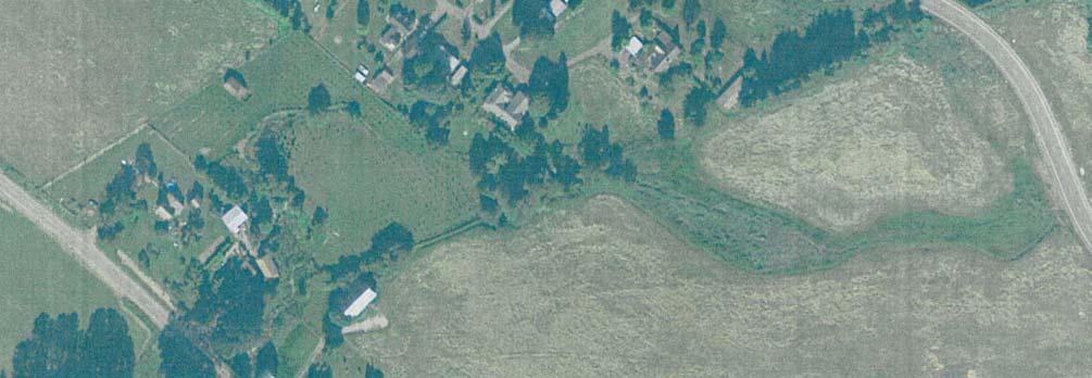

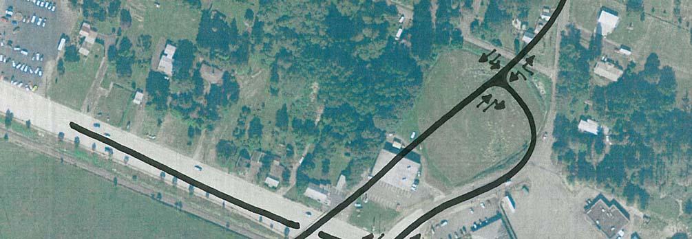

115
116 PITTSBURG ROAD S 4TH STREET St. Helens Transportation System Plan August 2011 FRONTAGE ROAD Dalton Lake N HANKEY ROAD PITTSBURG ROAD N VERNONIA ROAD SUNSET BOULEVARD WYETH ST OREGON STREET N 16TH STREET DEER ISLAND ROAD WEST STREET N 11TH STREET N 6TH STREET WYETH STREET S 7TH STREET S 1ST STREET Columbia River Sand Island COLUMBIA BLVD N 15TH STREET S 8TH STREET SYKES ROAD FIRLOCK BOULEVARD MATZEN STREET COLUMBIA BOULEVARD GABLE ROAD MILTON WAY PORT AVENUE S 15TH STREET S 18TH STREET OLD PORTLAND ROAD S 12TH STREET KASTER ROAD BACHELOR FLAT ROAD H:\projfile\ St Helens TSP Update\gis\draft tsp\fig6-14.mxd LEGEND Exceeds Performance Standard Approaches Performance Standard Meets Performance Standard City Limits City UGB ROSS CO. ROAD MORSE CO. ROAD MORSE CO. ROAD MILLARD ROAD ACHILLES ROAD 30 OLD PORTLAND ROAD McNULTY WAY INDUSTRIAL WAY GABLE ROAD RAILROAD AVENUE FUTURE TRAFFIC CONDITIONS - SOUTHERN OVERPASS ST. HELENS, OREGON FIGURE 6-14
117 August 2011 St. Helens Transportation System Plan US 30/BENNETT ROAD SIGNAL While outside of the City of St. Helens UGB and the TSP study area, the US 30/Bennett Road intersection has the potential to significantly impact the City s transportation system. For example, signalizing the US 30/Bennett Road intersection could improve operations at the US 30/Millard Road and US 30/Gable Road intersections by diverting a large number of vehicles (particularly northbound right and westbound left-turns) off of US 30 at the new signal. This route offers vehicles (and particularly trucks) traveling south of St. Helens a relatively straight path to US 30 that would avoid impacting the US 30/Millard Road and US 30/Gable Road intersections. Both Gable Road and Millard Road are expected to carry substantial east-west through traffic in the future as they link employment areas on the east side of US 30 with the residential areas on the west as well as the commercial area along Gable Road. Given the potential for relatively heavy eastbound through movements at Gable Road and Millard Road, shifting the truck traffic and a substantial number of westbound left-turns south to Bennett Road would benefit US 30 by minimizing conflicting east-west turn movement demand (and green time) at Gable Road and Millard Road. ODOT traffic and preliminary engineering staff have expressed concern about signalizing the US 30/Bennett Road intersection, citing safety concerns involving the relatively rural and high speed nature of US 30 at the intersection, the potential to increase rear-end crashes, the current low Bennett Road traffic volumes and a general desire to avoid rural traffic signals. ODOT s Road Safety Audit (RSA) project to be completed in 2011 is expected to focus in part on potential intersection treatments at Bennett Road. GABLE/SYKES ROAD COUPLET The conversion of Gable Road to a one-way westbound roadway between US 30 and Columbia Boulevard and Sykes Road to a one-way eastbound roadway between Columbia Boulevard and US 30 was considered as a potential solution to address the capacity needs identified at the US 30/Gable Road intersection. A preliminary review of the existing roadway network suggests that a one-way couplet system would severely limit access to the residential and commercial properties adjacent to Gable Road as well the St. Helens High School. This is primarily due to the lack of north/south roadways between Gable and Sykes Roads between Columbia Boulevard and St. Helens Street. Based on these observations it was determined that a one-way couplet system at this location is not feasible at this time. Page 101
118 St. Helens Transportation System Plan August 2011 Intersection and Roadway Recommendations for the Updated TSP Based on review of the forecast intersection failures, the alternatives discussed above, and the desire to avoid substantial widening of Gable Road, the following mitigation measures are recommended for inclusion in the Updated TSP 10. Installation of a separate westbound left-turn lane at the US 30/Deer Island Road intersection. Signalize the US 30/Millard Road intersection, including installation of separate right-turn lanes on the east and westbound approaches to the intersection. Install a separate westbound right-turn lane at the US 30/Gable Road intersection, including related rail crossing widening. Provide an overpass near the US 30/Millard Road intersection in the long-term. The need for, and timing, of such an improvement will depend in part on the outcome of the future operations of the US 30/Bennett Road intersection (for example, if signalization is provided, Gable Road and Millard Road will benefit from trips re-routing to Bennett Road) Although implementation is likely well beyond the planning horizon of the current TSP, the concept of a potential future overpass near the US 30/Pittsburg Road intersection should be preserved for future consideration. 10 Before a signal can be installed on the State system, OAR requires a traffic engineering investigation that shows how traffic signal warrants and highway design and spacing standards are met with the proposed signal and how the proposed signal would improve the overall safety and operation of the intersection. A progression analysis would be required as per OAR for signals that will not meet the one half mile minimum spacing standard for traffic signals on State highways. Signals may not be installed until signal warrants are satisfied and the installation request and design has been approved by the State Traffic Engineer (OAR ). Page 102
119 Section 7 Transportation System Plan
120
121 August 2011 St. Helens Transportation System Plan 7 This section presents the individual elements of the St. Helens Transportation System Plan (TSP). The TSP addresses those components necessary for the development of the future transportation network including: Roadway System Plan Functional Classification Plan Street Design Standards Access Management Plan Pedestrian Plan Bicycle Plan Transit Plan Rail Plan Marine/Air/Water/Pipeline System Plan Implementation Plan The transportation elements presented in this section were developed in accordance with the requirements of Oregon s Transportation Planning Rule (TPR). These elements reflect the existing and future forecast conditions analysis findings, the options analysis, and a balance sought amongst the interests of multiple stakeholders, including citizens, business owners, and governmental agencies within the City of St. Helens. The final TSP elements were selected and prioritized based on feedback obtained from the Technical Advisory Committee (TAC), Citizens Advisory Committee (CAC), Planning Commission, City Council, and citizen input during the plan s development. The decision process was guided in part by the goals and policies enumerated in Section 2. Roadway System Plan The roadway system plan provides guidance on how to best facilitate vehicular travel over the next twenty years, as well as identifying key elements of a future vision of transportation facilities serving the city. This plan seeks to address the identified existing and anticipated future operational and circulation needs. Page 105
122 St. Helens Transportation System Plan August 2011 FUNCTIONAL CLASSIFICATION PLAN The purpose of the functional classification plan is to create a mechanism through which a balanced transportation system can be developed that facilitates mobility for all modes of transportation as well as access to adjacent land uses. A roadway s functional classification determines its intended purpose, the amount and character of traffic it is expected to carry, the degree to which non-auto travel is emphasized, and the roadway s design standards and overall management approach. It is imperative that a roadway s classification consider the adjacent land uses and the transportation modes that should be accommodated. The public right-of-way must also provide sufficient space for utilities to serve adjacent land uses. The functional classification plan for the City of St. Helens is shown in Figure 7-1. The new roadway alignments shown on the plan should be considered as conceptual. The end points of the streets are generally fixed where they make essential connections to other roadways while the alignments between intersections may vary depending on design requirements and right-of-way available at the time a given facility is constructed. The functional classification plan incorporates three functional categories: arterials (major and minor), collectors, and local streets. Arterials Arterials are roadways that are primarily intended to serve traffic entering and leaving the urban area. While arterials may provide access to adjacent land, that function is subordinate to the mobility service provided to major traffic movements. Major Arterials Major arterials are typically longest-distance, highest-volume roadways within the urban growth boundary (UGB). Although the streets focus on serving longer distance trips, they also serve local pedestrian and/or bicycle activities, which should be accommodated in the arterial streetscape. The only major arterial serving St. Helens is the Columbia River Highway (US 30). US 30 is a Statewide Highway and designated Freight Route. US 30 runs north-south through the city, connecting St. Helens to Columbia City, Rainier, and the Oregon Coast to the north and Scappoose and the Portland to the south. The current cross-section of US 30 is four to five lanes within the city s UGB. The TSP has been developed with the intention of maintaining a maximum five-lane cross-section through the city not withstanding right-turn deceleration lanes at key intersections. This can be accomplished by developing a more efficient network of local roadways that serve city traffic off the highway. Page 106
123 August 2011 St. Helens Transportation System Plan The TSP identifies the need for several improvement projects along US 30, such as new traffic signals at several key intersections. All projects along US 30 are subject to ODOT plans, policies, and standards and all changes and/or improvements must conform with the ODOT approval and permitting process 11. At the time of this writing, ODOT is conducting a study along US 30 between Scappoose and St. Helens that will evaluate alternatives to improve the safety of the corridor. A detailed Road Safety Audit will be completed between Bere Road in Scappoose and Millard Road in St. Helens. The audit could result in recommendations for improvements at Bennett Road and Millard Road that directly impact the recommendations contained in this TSP. ODOT will work with the City of St. Helens in developing the safety corridor and the St. Helens City Council may be asked to adopt the plan and amend the TSP, if necessary. Minor Arterials Minor arterials provide a higher degree of access than major arterials. The primary function of minor arterials is to serve local and through traffic between neighborhoods and to community and regional facilities. Collectors Collector streets generally facilitate the movement of traffic within the city s UGB. Collectors provide for circulation and mobility for all users of the system. Collectors carry lower volumes than arterials and typically have two-lane cross-sections with on-street parking. They serve as the primary routes into residential neighborhoods. Although they carry higher volumes than local streets, they are intended to provide direct access to adjacent land rather than serving through traffic. Local Streets Local streets are primarily intended to provide access to abutting land uses. Local street facilities offer the lowest level of mobility and consequently tend to be short, low-speed facilities. As such, local streets should primarily serve passenger cars, pedestrians, and bicyclists; heavy truck traffic is discouraged. On-street parking is common. Sidewalks are typically present, though the relatively low travel speeds and traffic volumes allow bicycles to share the vehicle travel lanes. 11 Before a signal can be installed on the State system, OAR requires a traffic engineering investigation that shows how traffic signal warrants and highway design and spacing standards are met with the proposed signal and how the proposed signal would improve the overall safety and operation of the intersection. A progression analysis would be required as per OAR for signals that will not meet the one half mile minimum spacing standard for traffic signals on State highways. Signals may not be installed until signal warrants are satisfied and the installation request and design has been approved by the State Traffic Engineer (OAR ). Page 107
124 PITTSBURG ROAD S 4TH STREET St. Helens Transportation System Plan August 2011 FRONTAGE ROAD Dalton Lake N HANKEY ROAD PITTSBURG ROAD N VERNONIA ROAD SUNSET BOULEVARD WYETH ST OREGON STREET N 16TH STREET DEER ISLAND ROAD WEST STREET N 11TH STREET N 6TH STREET WYETH STREET S 7TH STREET S 1ST STREET Columbia River Sand Island COLUMBIA BLVD N 15TH STREET S 8TH STREET SYKES ROAD FIRLOCK BOULEVARD MATZEN STREET COLUMBIA BOULEVARD GABLE ROAD MILTON WAY PORT AVENUE S 15TH STREET S 18TH STREET OLD PORTLAND ROAD S 12TH STREET KASTER ROAD BACHELOR FLAT ROAD H:\projfile\ St Helens TSP Update\gis\draft tsp\fig7-1.mxd LEGEND Schools Major Arterials Minor Arterials Collector Streets Local Streets City Limits City UGB ROSS CO. ROAD MORSE CO. ROAD MORSE CO. ROAD MILLARD ROAD ACHILLES ROAD 30 OLD PORTLAND ROAD McNULTY WAY INDUSTRIAL WAY GABLE ROAD RAILROAD AVENUE FUNCTIONAL CLASSIFICATION PLAN ST. HELENS, OREGON FIGURE 7-1
125 August 2011 St. Helens Transportation System Plan STREET DESIGN STANDARDS Street design standards support the functional and operational needs of the community s roadway network. The standards provide guidance on the operations, appearance and function of a roadway by defining factors such as the type of pedestrian and bicycle facilities, the number of travel lanes, capacity, operating speed, and safety. The standards are necessary to ensure that the system of streets, as it develops, will be capable of safely and efficiently serving the traveling public while also accommodating the orderly development of adjacent lands. The street design standards are shown as cross sections in Figures 7-2 and 7-3. The cross sections are intended to be used for planning purposes for new road construction, as well as for those locations where it is physically and economically feasible to improve existing streets. Detailed design elements, such as cross-slopes, are not shown in the figures, but should be added when the City of St. Helens updates its standard engineering drawings. On-street parking has been identified as an optional element in some of the street sections where right-of-way is limited or a left-turn lane is needed. Also, additional width for turn lanes may be needed at specific intersections based on an engineering investigation; these are not shown in the street design standards. The standards shown are intended to define typical cross-sections of streets between intersections. Many of the city s existing streets are wider than the proposed cross sections. As a result, retrofitting streets to add bike lanes, sidewalks, landscaping strips or different travel lane widths/turn lanes may be possible at a number of locations without requiring right-of-way acquisition. Finally, it should be noted that many agencies are developing green street programs that incorporate stormwater management features involving natural absorption and treatment. While green street treatments are independent of functional class, they may require modification of the landscape area or other street design standards to accommodate this evolving practice. The street design standards shown are not intended to preclude green street treatments. As shown in Figure 7-3, there are three cross sections provided for minor arterial streets; including one typical cross section, one cross section specific to the one-way - St. Helens Street/Columbia Boulevard couplet between US 30 and 13 th Street, and a cross section for the two-way downtown area. The cross section for the segment of Columbia Boulevard east of 13 th Street provides for an optional center left-turn lane in lieu of on-street parking. The presence of a center left-turn lane near the 12 th Street/Columbia Boulevard intersection could help to improve operations near the Lewis Clark Elementary School during school peak hours as vehicles turning into the school will not be blocking the through travel lane in the southbound direction. Page 109
126
127
128 St. Helens Transportation System Plan August 2011 LOCAL STREET OPTIONS The standard cross-section for local streets includes a total paved width of 30 feet, which is intended to accommodate parking on one or both sides of the street. Two skinny street options are identified for application in local street settings where low traffic volumes and narrow roadway elements are desired. Skinny streets typically result in slower vehicle speeds, making them attractive in residential areas. Other benefits include reduced impervious surface area (reduced stormwater and environmental impact) and improved pedestrian and bicycle safety related to the lower vehicle speeds. On-street parking along skinny streets can pose challenges for emergency vehicles as well as other service providers such as refuse/recycling trucks, school busses, and other delivery vehicles. The City of St. Helens can permit construction of 20 to 26 feet wide streets that accommodate parking on only one side of the street. These options are most appropriate for lower volume streets (typically less than 400 vehicles per day). LANDSCAPING Landscaping Area Each of the City s street design standards includes a landscape strip separating the roadway curb from the sidewalk. This landscaping strip serves to better separate motorized vehicle and pedestrian traffic and creates an opportunity for landscaping in the form of street trees or other elements. The City of St. Helens seeks to incorporate street trees in all street landscaping areas where possible. In situations where street trees are not feasible (basalt below, etc.), the City of St. Helens may require fee-in-lieu contributions/payments. Design Variations The street design standards are intended to provide uniformity for city streets. It may be necessary to deviate from the design standards in situations where: Existing right-of-way constraints, structures, topographic features, environmentally sensitive areas, or other constraints preclude designing to the standards; or An alternative design that is functionally equal or superior to the standard design is proposed; or Green Streets design elements are incorporated in a way that preserving the function and integrity of the roadway; or Page 112
129 August 2011 St. Helens Transportation System Plan The City Engineer otherwise determines that a deviation is in the public interest. GUIDELINES FOR ARTERIAL/COLLECTOR INTERSECTION IMPROVEMENTS In addition to roadway cross-section standards, the City of St. Helens should adopt standards for intersection improvements (note that improvements on state highways must meet ODOT operating and design criteria). As intersection improvements are made at arterial/collector intersections in the city, the following general guidelines should be considered: maintain adequate signing of side-streets (stop signs and visible street signs); restrict parking and potential sight obstructions in the intersection vicinity; provide intersection illumination to increase visibility; provide proper channelization (striping, raised medians, etc.) of movements; provide a paved apron on unpaved side-street approaches to create a smooth transition to and from the major street; install right-turn transition tapers or lanes at high-speed unsignalized intersections and right-turn lanes at signalized intersections on US 30 approaches when warranted; install left-turn lanes when warranted to reduce interruptions in the flow of through traffic; and, locate traffic signals or roundabouts with consideration of appropriate spacing requirements and impacts on side-street traffic patterns. ACCESS MANAGEMENT PLAN As the city continues to grow, its street system will become more heavily traveled. Consequently, it will become increasingly important to manage access on the arterial and collector street system as new development occurs. This will preserve those streets function for carrying through traffic. ODOT has legal authority to regulate access points along US 30 within the city s urban growth boundary. The City of St. Helens and Columbia County jointly manage several roadways within the city s UGB to ensure the efficient movement of traffic and enhance safety. The City of St. Helens independently manages access on all other collector and local streets within its jurisdiction. The Oregon Transportation Planning Rule defines access management as a set of measures regulating access to streets, roads, and highways, from public roads and private driveways. The TPR requires that new connections to arterials and state highways be consistent with designated access management Page 113
130 St. Helens Transportation System Plan August 2011 categories. This TSP includes an access management policy that maintains and enhances the integrity (capacity, safety, and level of service) of the city s streets. Access management standards vary depending on the functional classification and purpose of a given roadway. Roadways on the higher end of the functional classification system (i.e., arterials and collectors) tend to have higher spacing standards, while local streets allow more closely spaced access points. These standards apply to new development or redevelopment. Existing accesses are allowed to remain as long as the land use does not change and no safety problem is posed. As a result, access management is a long-term process in which the desired access spacing to a street slowly evolves over time as redevelopment occurs. In implementing access management standards, parcels cannot be land-locked; they must have some way of accessing the public street system. This may mean allowing closer access spacing than would otherwise be allowed or implementation of shared access with a neighboring parcel, where possible. Where a property has frontage on two roadways, access on the roadway of lower classification is preferred, all other things being equal. The following discussion presents the hierarchical access management system for roadways in the St. Helens UGB. ODOT ACCESS MANAGEMENT STANDARDS The OHP specifies an access management classification system for state facilities based on its highway classification system. As indicated in the existing conditions analysis, the OHP classifies US 30 as a Statewide Highway and a Freight Route. Future developments along US 30 (new development, redevelopment, zone changes, and/or comprehensive plan amendments) will be required to meet the OHP Access Management policies and standards. Table 7-1 summarizes ODOT s current access management standards for US 30 per the 1999 OHP. TABLE 7-1: US 30 ACCESS SPACING STANDARDS Posted Speed (MPH) Spacing Standards (Feet) and and , ,320 1 These access management spacing standards do not apply to approaches in existence prior to April 1, 2000 except as provided in OAR (1)(c) and (1)(c). Page 114
131 August 2011 St. Helens Transportation System Plan CITY ROADWAY ACCESS STANDARDS Table 7-2 identifies the minimum public street intersection and private access spacing standards for the city s roadway network as they relate to new development and redevelopment. Minimum and maximum standard widths for private driveways are summarized in Table 7-3. County facilities within the city s UGB should also be planned and constructed in accordance with these street design standards. TABLE 7-2: CITY STREET ACCESS SPACING STANDARDS Functional Classification Public Street (feet) Private Access Drive (feet) Local Street Collector Minor Arterial 350 or block length 200 or mid-block TABLE 7-3: PRIVATE DRIVEWAY WIDTH STANDARDS Land Use Minimum (Feet) Maximum (Feet) Single Family Residential Multi-Family Residential Commercial Industrial Access spacing variances may be provided to parcels whose highway/street frontage, topography, or location would otherwise preclude issuance of a conforming permit and would either have no reasonable access or cannot obtain reasonable alternate access to the public road system. In such a situation, a conditional access permit may be issued by ODOT or the City of St. Helens, as appropriate, for a connection to a property that cannot be accessed in a manner that is consistent with the spacing standards. The permit can carry a condition that the access may be closed at such time that reasonable access becomes available to a local public street. The approval condition might also require a given land owner to work in cooperation with adjacent land owners to provide either joint access points, front and rear cross-over easements, or a rear access upon future redevelopment. The requirements for obtaining a deviation from ODOT s minimum spacing standards are documented in OAR For streets under the City s jurisdiction, the City may reduce the access spacing standards, at the discretion of the City Engineer, if the following conditions exist: Page 115
132 St. Helens Transportation System Plan August 2011 Joint access driveways and cross access easements are provided in accordance with the standards; The site plan incorporates a unified access and circulation system in accordance with the standards; The property owner enters into a written agreement with the City of St. Helens that preexisting connections on the site will be closed and eliminated after construction of each side of the joint use driveway; and/or, The proposed access plan for redevelopment properties moves in the direction of the spacing standards. The City Engineer may modify or waive the access spacing standards for streets under the City s jurisdiction where the physical site characteristics or layout of abutting properties would make development of a unified or shared access and circulation system impractical, subject to the following considerations: Unless modified, application of the access standard will result in the degradation of operational and safety integrity of the transportation system. The granting of the variance shall meet the purpose and intent of these standards and shall not be considered until every feasible option for meeting access standards is explored. Applicants for variance from these standards must provide proof of unique or special conditions that make strict application of the standards impractical. Applicants shall include proof that: Indirect or restricted access cannot be obtained; and No engineering or construction solutions can be applied to mitigate the condition; and, No alternative access is available from a road with a lower functional classification than the primary roadway. No variance shall be granted where such hardship is self-created. ACCESS MANAGEMENT MEASURES From an operational perspective, access management measures limit the number of redundant access points along roadways. This enhances roadway capacity and benefits circulation. Enforcement of the access spacing standards should be complemented with provision of alternative access points. Page 116
133 August 2011 St. Helens Transportation System Plan Purchasing right-of-way and closing driveways without a parallel road system and/or other local access could seriously affect the viability of the impacted properties. Thus, if an access management approach is taken, alternative access should be developed to avoid land-locking a given property. As part of every land use action, the City of St. Helens will evaluate the potential need for conditioning a given development proposal with the following items in order to maintain and/or improve traffic operations and safety along the arterial and collector roadways. Provision of crossover easements on all compatible parcels (considering topography, access, and land use) to facilitate future access between adjoining parcels. Issuance of conditional access permits to developments having proposed access points that do not meet the designated access spacing policy and/or have the ability to align with opposing driveways. Right-of-way dedications to facilitate the future planned roadway system in the vicinity of proposed developments. Half-street improvements (sidewalks, curb and gutter, bike lanes/paths, and/or travel lanes) along site frontages that do not have full build-out improvements in place at the time of development. Figure 7-4 illustrates the application of cross-over easements and conditional access permits over time to achieve access management objectives. The individual steps are described in Table 7-4. As illustrated in the figure and supporting table, using these guidelines, all driveways along the highways can eventually move in the overall direction of the access spacing standards as development and redevelopment occur along a given street. Page 117
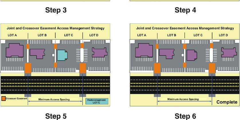
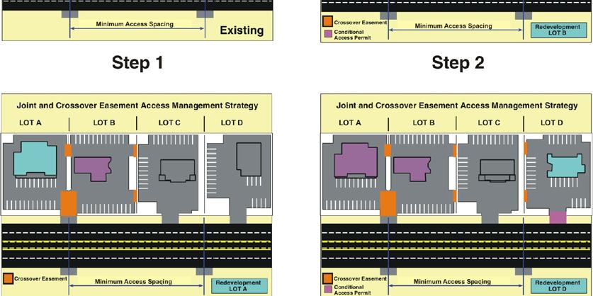
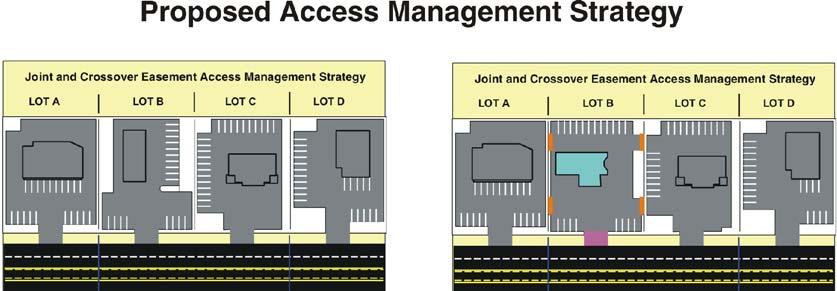
134
135 August 2011 St. Helens Transportation System Plan TABLE 7-4: EXAMPLE OF CROSSOVER EASEMENT/INDENTURE/CONSOLIDATION Step Process EXISTING Currently Lots A, B, C, and D have site-access driveways that neither meet the access spacing criteria of 500 feet nor align with driveways or access points on the opposite side of the highway. Under these conditions motorists are into situations of potential conflict (conflicting left turns) with opposing traffic. Additionally, the number of side-street (or site-access driveway) intersections decreases the operation and safety of the highway REDEVELOPMENT OF LOT B At the time that Lot B redevelops, the City would review the proposed site plan and make recommendations to ensure that the site could promote future crossover or consolidated access. Next, the City would issue conditional permits for the development to provide crossover easements with Lots A and C, and ODOT/City would grant a conditional access permit to the lot. After evaluating the land use action, ODOT/City would determine that LOT B does not have either alternative access, nor can an access point be aligned with an opposing access point, nor can the available lot frontage provide an access point that meets the access spacing criteria set forth for segment of highway. REDEVELOPMENT OF LOT A At the time Lot A redevelops, the City/ODOT would undertake the same review process as with the redevelopment of LOT B (see Step 2); however, under this scenario ODOT and the City would use the previously obtained cross-over easement at Lot B consolidate the access points of Lots A and B. ODOT/City would then relocate the conditional access of Lot B to align with the opposing access point and provide and efficient access to both Lots A and B. The consolidation of site-access driveways for Lots A and B will not only reduce the number of driveways accessing the highway, but will also eliminate the conflicting left-turn movements the highway by the alignment with the opposing access point. 4 REDEVELOPMENT OF LOT D The redevelopment of Lot D will be handled in same manner as the redevelopment of Lot B (see Step 2) 5 6 REDEVELOPMENT OF LOT C The redevelopment of Lot C will be reviewed once again to ensure that the site will accommodate crossover and/or consolidated access. Using the crossover agreements with Lots B and D, Lot C would share a consolidated access point with Lot D and will also have alternative frontage access the shared site-access driveway of Lots A and B. By using the crossover agreement and conditional access permit process, the City and ODOT will be able to eliminate another access point and provide the alignment with the opposing access points. COMPLETE After Lots A, B, C, and D redevelop over time, the number of access points will be reduced and aligned, and the remaining access points will meet the access spacing standard. Pedestrian and Bicycle System Plan Providing connections between major activity centers is a key objective of the pedestrian and bicycle system plans. Major activity centers are defined as locations that typically attract high levels of pedestrian and bicycle activity on a regular basis. Within St. Helens, these activity centers include the commercial areas along US 30, Columbia Boulevard, and St. Helens Street, as well as the downtown core, city parks, and city schools. This section identifies specific pedestrian and bicycle priorities for local connectivity and access. PEDESTRIAN SYSTEM COMPONENTS The recommended pedestrian improvement projects include the provision of sidewalks and off road trails to facilitate pedestrian travel throughout the transportation system, as well as treatments to aid pedestrians crossing traffic. The street design standards presented in this TSP can help ensure that pedestrian facilities are provided in conjunction with all new or substantially reconstructed public streets. For existing roadways without sidewalks, the inclusion of sidewalks should be required with any redevelopment of adjacent properties or with significant improvements in the roadways. Page 119
136 St. Helens Transportation System Plan August 2011 The sidewalk improvement projects prioritized in the TSP represent specific improvements that have been identified to improve pedestrian conditions in a number of areas throughout the city. Many of the priority areas surround existing school sites and could benefit from completion of a Safe Routes to School (SRTS) assessment by the St. Helens school district. As discussed in Section 9, preparation of a SRTS program could also enhance the community s ability to secure grant funding for pedestrian facility improvements. Figure 7-5 and the project summary tables (7-5 through 7-7) at the end of this section present the recommended pedestrian facilities. In addition to sidewalk improvements, several pedestrian crossing improvement projects are also recommended for prioritization. Examples of the types of crossing improvements needed are discussed below. Pedestrian Countdown Signals Pedestrian Countdown Signals are recommended at each of the signalized intersections along US 30, including Deer Island Road, St. Helens Street, Columbia Boulevard, and Gable Road. Future traffic signals at Pittsburg Road, Vernonia Road, and Millard Road should also be equipped with pedestrian countdown signals per the MUTCD. The countdown signals will help inform pedestrians of the time remaining to cross the street. Curb Extensions Curb extensions are recommended at 16 locations along Columbia Boulevard and St. Helens Street to provide shorter crossing distances for pedestrians at intersections as well as to encourage reduced travel speeds by motorists. The curb extensions will occupy the portion of the roadway in close proximity to the intersection that is currently used for on-street parking. Raised Median Islands Raised median islands are included in the recommended street design standards for US 30 and Columbia Boulevard. Raised median islands can provide pedestrians with a refuge area within the crosswalk to stop while crossing the street and complete a two-stage crossing if needed. Other Pedestrian Crossing Treatments Several additional pedestrians crossing treatments are presented in Section 6 that can also be applied on future projects, such as: leading pedestrian intervals which allow pedestrians to begin crossing before conflicting motorists are given a green light, and Page 120
137 PITTSBURG ROAD S 4TH STREET St. Helens Transportation System Plan August 2011 FRONTAGE ROAD Dalton Lake N HANKEY ROAD PITTSBURG ROAD N VERNONIA ROAD SUNSET BOULEVARD WYETH ST OREGON STREET N 16TH STREET DEER ISLAND ROAD WEST STREET N 11TH STREET N 6TH STREET WYETH STREET S 7TH STREET S 1ST STREET Columbia River Sand Island COLUMBIA BLVD N 15TH STREET S 8TH STREET SYKES ROAD FIRLOCK BOULEVARD MATZEN STREET COLUMBIA BOULEVARD GABLE ROAD MILTON WAY PORT AVENUE S 15TH STREET S 18TH STREET OLD PORTLAND ROAD S 12TH STREET KASTER ROAD BACHELOR FLAT ROAD H:\projfile\ St Helens TSP Update\gis\draft tsp\fig7-5.mxd LEGEND Near-Term Improvements Mid-Term Improvements Long-Term Improvements Improve Pedestrian Crossing Transit Stop City UGB City Limits ROSS CO. ROAD MORSE CO. ROAD MORSE CO. ROAD MILLARD ROAD ACHILLES ROAD 30 OLD PORTLAND ROAD McNULTY WAY INDUSTRIAL WAY GABLE ROAD RAILROAD AVENUE PEDESTRIAN SYSTEM PLAN ST. HELENS, OREGON FIGURE 7-5
138 St. Helens Transportation System Plan August 2011 other enhanced pedestrian crossing treatments such as the Rectangular Rapid Flash Beacons and the Pedestrian Hybrid Signals. As part of all street and intersection improvement projects in the future, the City should consider application of treatments to further enhance the comfort, convenience and safety of pedestrian crossings at intersections throughout the City. BICYCLE SYSTEM COMPONENTS The bicycle plan is intended to establish a network of bicycle lanes and routes that connect the city s bicycle generators and provide a safe and effective system. Although bicycle lanes should be provided along all arterials and collectors per City code, many of the arterial and collector roadways in St. Helens do not have sufficient width to accommodate bicycle lanes. Therefore, the projects recommended in the TSP represent a prioritization of the most important bicycle facility needs (some roadways will require widening, while other will only require striping). These designated facilities will provide essential connections between many of the residential neighborhoods, commercial areas, schools, and various recreational areas within the city. The recommended bicycle improvement projects are shown in Figure 7-6 and are included in the project summary tables (7-5 through 7-7). The various types of bicycle facilities included in the bicycle system plan are described below. Shared Roadways and Shared-Lane Pavement Markings Although any roadway without a dedicated bicycle facility is generally considered a shared roadway, Barr Avenue and Cherrywood Drive would benefit from shared-lane pavement markings (sharrows) to help communicate to bicyclists as well as motorists that the roadways are priority bicycle routes. Both roadways are currently designated by the City as Local streets, without any accommodations for striped bike lanes. Sharrows on these roadways can help better facilitate bicycle travel without requiring additional right-of-way. To enhance the bicycling environment, the City should consider installing sharrows on other collector and arterial facilities commonly used by cyclists where right-of-way constraints limit the ability to add bike lanes in the future. This is a low cost solution with benefits to both motorists and cyclists. Bicycle Lanes A majority of the bicycle improvement projects prioritized in the TSP update involve widening City and County roadways to accommodate striped bicycle lanes. Striped bicycle lanes can improve bicycle Page 122
139 PITTSBURG ROAD S 4TH STREET St. Helens Transportation System Plan August 2011 FRONTAGE ROAD Dalton Lake N HANKEY ROAD PITTSBURG ROAD N VERNONIA ROAD SUNSET BOULEVARD WYETH ST OREGON STREET N 16TH STREET DEER ISLAND ROAD WEST STREET N 11TH STREET N 6TH STREET WYETH STREET S 7TH STREET S 1ST STREET Columbia River Sand Island COLUMBIA BLVD N 15TH STREET S 8TH STREET SYKES ROAD FIRLOCK BOULEVARD MATZEN STREET COLUMBIA BOULEVARD GABLE ROAD MILTON WAY PORT AVENUE S 15TH STREET S 18TH STREET OLD PORTLAND ROAD S 12TH STREET KASTER ROAD BACHELOR FLAT ROAD H:\projfile\ St Helens TSP Update\gis\draft tsp\fig7-6.mxd LEGEND Near-Term Improvements Mid-Term Improvements Long-Term Improvements Add Bicycle Parking Improve Bicycle Crossing Transit Stops City UGB City Limits ROSS CO. ROAD MORSE CO. ROAD MORSE CO. ROAD MILLARD ROAD ACHILLES ROAD 30 OLD PORTLAND ROAD McNULTY WAY INDUSTRIAL WAY GABLE ROAD RAILROAD AVENUE BICYCLE SYSTEM PLAN ST. HELENS, OREGON FIGURE 7-6
140 St. Helens Transportation System Plan August 2011 safety along high speed and higher volume roadways, by separating slower moving bicyclists from faster moving motorists. A comprehensive system of bicycle lanes can provide direct connections between neighborhoods, the downtown, retail and employment areas, bus stops along US 30, and the future transit center. Sunset Boulevard and Columbia Boulevard currently have sufficient width to accommodate bicycle lanes and were therefore included in the short-term recommendations. Due to limitation of future financial resources, the recommended TSP project list for mid-term and long-term includes the addition of bike lanes on only those roadways that are anticipated to facilitate the predominance of bicycle demand in the future. Any arterial or collector improvement project should include bike lanes, even if that roadway is not listed as a priority in the TSP list. Bike Parking Additional bicycle parking facilities are recommended in several areas throughout the city, including the commercial areas along US 30, Columbia Boulevard, and St. Helens Street, as well as the Old Town, Downtown, and Riverfront areas, and the Columbia County Fairgrounds. Bicycle Crossings The need for bicycle crossing improvements was identified in the existing conditions analysis at the US 30/St. Helens Street and US 30/Gable Road intersections. The recommended improvements at the US 30/St. Helens Street intersection include restriping the westbound approach to accommodate a bicycle lane between the left- and right-turn lanes. The recommended improvements at the US 30/Gable Road intersection include enhancing the existing bicycle facilities in the near-term to include pavement markings and signage that directs bicyclist s through the intersection. The existing curb ramp in the northeast corner of the intersection could also be maintained in the near-term to accommodate bicyclists who choose to dismount their bikes and use the crosswalk as a pedestrian. Long-term roadway improvements at the US 30/Gable Road intersection include provision of a separate westbound right-turn lane when needed. At that time, the westbound approach should be restriped to accommodate a bicycle lane between the thru and right-turn lanes, similar to the near-term improvements at the US 30/St. Helens Street intersection. The city should periodically review other key intersections throughout the city to determine whether additional bicycle treatment improvements are needed to ensure the comfort and safety of cyclists. Multi-Use Paths and Trails The continued use of the existing multi-use paths and trails as well as the future development of new paths is recommended as part of the prioritized TSP project list. It is recommended though to replace the existing multi-use path along Old Portland Road north of Gable Road with bicycle lanes, curbs, and Page 124
141 August 2011 St. Helens Transportation System Plan sidewalks given its significant role in the pedestrian system. Further, the section of Old Portland Road south of Gable Road should be considered for a new multi-use path. Both projects would help to provide a continuous network of pedestrian facilities that connect the entire east side of the city (and all areas west of US 30 that connect to Old Portland Road) with the down town area. Public Transportation Plan The City of St. Helens (along with Columbia County and other impacted communities) adopted the Columbia County Community-Wide Transit System Plan (Reference 14) in The adopted plan includes transit related improvements along the US 30 corridor needed within a 10-year period. Recommended improvements to the transit stops located in St. Helens are described below. Safeway/Rite Aid at Gable Road: Install an information display case on the existing shelter Install a new shelter, bus stop sign and information display case Install a sidewalk into the Safeway/Rite Aid site with five curb ramps Install two park-and-ride signs Ace Hardware at Columbia Boulevard: Install a new bus stop sign and information display Install a new sidewalk on the south side of Columbia Boulevard across the railroad tracks between US 30 and Milton Way along with 12 new/reconstructed curb ramps Columbia Commons at Pittsburg Road: Install information display on existing bus shelter Install three bollards between the bus shelter and the parking lot Install three new park-and-ride signs Simpson Site at Deer Island Road (funded and under construction): Redevelop site to accommodate transit center including new buildings, park-and-ride lot, and frontage improvements Install four park-and-ride signs Restripe southbound left-turn lane on US 30 Install transit signal priority along US 30 Page 125
142 St. Helens Transportation System Plan August 2011 Air Service Passenger and/or commercial air service is beyond the scale of what St. Helens can pursue independently. However, the city should remain aware of changes or opportunities to bring other air travel options to the community and should support those efforts, as they are able. In the interim, air service will continue to be accessible at the Portland International Airport, the Scappoose Industrial Airpark, and the Southwest Regional Airport in Kelso Washington. Marine System Plan The Columbia River provides an opportunity for surface water transportation for the City of St. Helens. The City should continue to pursue opportunities to utilize the Columbia River for both recreational and commercial activities, including provision of access to Sand Island through some form of boat shuttle service. Rail Service Columbia County (in conjunction with Clatsop County) conducted a study of the Lower Columbia River Rail Corridor which included several recommendations for improvements to key study intersections/rail crossings along US 30. The following summarizes the recommended improvements in St. Helens. Study the potential closure of the US 30/Wyeth Street intersection As indicated later in this section, this should be considered in conjunction with the provision of a westbound left-turn lane at the US 30/Deer Island Road intersection and a traffic signal at the US 30/Pittsburg Road intersection. Close pedestrian access or adjust signal timing to provide sufficient crossing time for pedestrians at the US 30/Columbia Boulevard intersection. Add 215 feet of southbound left-turn storage and 65 feet of northbound right-turn storage to the US 30/Columbia Boulevard intersection. Install a traffic signal inter-tied with the existing railroad crossing and add an at-grade pedestrian sidewalk across the railroad tracks to the US 30/Millard Road intersection. Install an at-grade pedestrian sidewalk across the railroad tracks and add 150 feet of southbound left-turn storage to the US 30/Deer Island Road intersection. Page 126
143 August 2011 St. Helens Transportation System Plan Install an at-grade pedestrian sidewalk across the railroad tracks and replace the obsolete gates at the US 30/St. Helens Street intersection. Add 210 feet of southbound left-turn storage and an ADA compliant pedestrian/bicycle overpass at the US 30/Gable Road intersection. Future consideration should be given to the potential for long-term passenger rail service in St. Helens. The addition of passenger rail service would increase activity along the Portland and Western Railroad which would impact operations at each of the existing rail crossings and would likely require additional pedestrian facilities for access to the service. Pipeline and Transmission Systems Plan The existing high pressure natural gas transmission line that runs along the Rutherford Parkway at the northern end of the city, US 30, and along Old Portland Road should be maintained and enhanced as necessary by its owner/operator (Northwest Natural Gas) to ensure adequate 20-year capacity is provided. Implementation Plan This section outlines specific transportation system improvement projects as well as a recommended timeline for implementation. The sequencing plan presented is not detailed to the point of a schedule identifying specific years when infrastructure should be constructed, but rather prioritizes projects to be developed within near-term (2011 to 2016), mid-term (2017 to 2021), and long-term (2022 to 2031) horizons. In this manner, implementation of identified system improvements has been staged to spread investment in the city s transportation infrastructure over the life of the plan. The City of St. Helens will need to periodically update its TSP and will review the need and timing for longer-term improvements as conditions evolve. In addition, several potential projects have been identified for the long-range vision. Such projects may not be feasible within the twenty-year planning horizon, for reasons of both need and resources. However, they represent a vision for an efficient transportation system in the future and they have been identified to support the preservation of improvement opportunities as future conditions may warrant them. The City of St. Helens, Columbia County, and ODOT should take the appropriate steps to prevent actions and/or development that would preclude these projects in the future. Page 127
144 St. Helens Transportation System Plan August 2011 The construction of roads, water, sewer, and electrical facilities in conjunction with local development activity should be coordinated to ensure the city develops in an orderly and efficient way. Consequently, the planned improvements identified in the TSP should be considered in light of evolving infrastructure sequencing plans, and may need to be modified accordingly. PLANNED IMPROVEMENTS The planned improvement projects enhance rail, motor vehicle, bicycle, and pedestrian travel within and through the city. While site specific projects such as traffic signals and turn lanes have been included to improve conditions at particular locations, the plan also seeks to develop an efficient transportation network that will reduce reliance on US 30 through development of parallel facilities. New roadways or roadway extensions are planned to serve all modes. These include road segments to fill gaps in the existing street system, new roads to serve development on adjacent properties, and new arterials and collectors to create an efficient grid system of future roadways. A prioritization of transportation improvements in the city for the near-term, mid-term, and long-term as well as for the future vision of the city are listed in Tables 7-5 through 7-7, respectively. The tables include pedestrian and bicycle improvement projects, which are depicted in Figures 7-5 and 7-6, as well as roadway improvement projects shown in Figure 7-7. The implementation plan recognizes that only a certain amount of money will be available to fund projects. As a result, a number of lower-cost improvements with immediate benefit are shown in the near-term (2011 to 2015) time frame. The longer project timelines reflect a combination of anticipated future needs and the reality that it will take time to accumulate the required funds. It should be recognized that the inclusion of proposed projects and actions in this plan does not obligate or imply obligations of funds by any jurisdiction for project-level planning or construction. Instead, the inclusion of proposed projects and actions serves as an opportunity for the, to be included, if appropriate, in the State Transportation Improvement Program (STIP) and the City of St. Helens Capital Improvement Program. Such inclusion is not automatic, but it is incumbent on the State, City of St. Helens, Columbia County, and the general public to take action to encourage and support inclusion of projects in the STIP or the CIP at the appropriate time. Because a project must have identified funding to be included in the STIP or CIP, the ultimate number of projects that can be included in these documents is constrained by available funding. Page 128
145 PITTSBURG ROAD S 4TH STREET St. Helens Transportation System Plan August 2011 FRONTAGE ROAD Dalton Lake N HANKEY ROAD PITTSBURG ROAD N VERNONIA ROAD SUNSET BOULEVARD WYETH ST OREGON STREET N 16TH STREET DEER ISLAND ROAD WEST STREET N 11TH STREET N 6TH STREET WYETH STREET S 7TH STREET S 1ST STREET Columbia River Sand Island COLUMBIA BLVD N 15TH STREET S 8TH STREET SYKES ROAD FIRLOCK BOULEVARD MATZEN STREET COLUMBIA BOULEVARD GABLE ROAD MILTON WAY PORT AVENUE S 15TH STREET S 18TH STREET OLD PORTLAND ROAD S 12TH STREET KASTER ROAD BACHELOR FLAT ROAD H:\projfile\ St Helens TSP Update\gis\draft tsp\fig7-7.mxd LEGEND Proposed Collectors Add Traffic Signal Add Right-Turn Lane Add Left-Turn Lanes Reconfigure Intersection City Limits City UGB ROSS CO. ROAD MORSE CO. ROAD MORSE CO. ROAD MILLARD ROAD ACHILLES ROAD 30 OLD PORTLAND ROAD McNULTY WAY INDUSTRIAL WAY GABLE ROAD NOTE: NEW ROADWAYS SHOWN ILLUSTRATE DESIRED CONNECTIVITY, NOT A SPECIFIC ALIGNMENT RAILROAD AVENUE ROADWAY PLAN ST. HELENS, OREGON FIGURE 7-7
146 St. Helens Transportation System Plan August 2011 NEAR-TERM IMPROVEMENTS Table 7-5 summarizes the near-term transportation improvement program for the St. Helens TSP update. This program is intended to address deficiencies in the existing transportation system that were identified as priorities during the TSP update process. As shown, the near-term improvements primarily focus on increasing the comfort, convenience, and safety of pedestrian and bicycle travel within the city. Per the existing conditions analysis, the prevalence of bicycle and pedestrian improvement projects included in the near-term program reflect the significant gaps identified in the existing networks and the opportunity to fill those gaps before significant increases in traffic volumes require vehicular capacity improvements. The projects shown in Table 7-5 are divided into roadway, bicycle, and pedestrian improvement projects and are in order by their estimated costs (least to highest). The projects shown in grey are along roadways operated and maintained by Columbia County. Page 130
147 August 2011 St. Helens Transportation System Plan TABLE 7-5: NEAR-TERM (2011 TO 2016) TRANSPORTATION IMPROVEMENT PROGRAM Project No. Project Location Project Description Roadway Improvement Projects Estimated Cost N01 Ross Road/Bachelor Flat Road Study and implement all-way stop control, if warranted 1 $12,000 N02 US 30/Millard Road Regrade southwest corner to provide adequate sight distance $20,000 N03 18 th Street/Old Portland Road Reconfigure intersection to stop control or upgrade signal to current standard $100,000 Bicycle Improvement Projects N04 Firlock Park Road (Gable Road to US 30) Widen roadway and add bike lanes $891,000 N05 12 th Street (Columbia Blvd. to Old Portland Road) Widen roadway and add bike lanes $364,000 N06 Cherrywood Drive (Vernonia Road to Columbia Blvd.) Add sharrows $4,500 N07 Barr Avenue (Pittsburg Road to Sykes Road) Add sharrows $5,500 N08 Sunset Blvd. (Pittsburg Road to Columbia Blvd.) Add bike lanes $15,000 N09 Columbia Boulevard (Sykes Road to US 30) Add bike lanes 30,000 N10 Sykes Road (Summit View Drive to Columbia Blvd.) Widen roadway and add bike lanes $643,000 N11 Bachelor Flat Road (Ross Road to Columbia Blvd.) Widen roadway and add bike lanes $461,000 N12 Columbia Blvd. (Gable Road to Sykes Road) Widen roadway and add bike lanes $304,000 N13 Gable Road (Bachelor Flat to US 30) Widen roadway and add bike lanes $502,000 N14 Vernonia Road (Pittsburg Road to US 30) Widen roadway and add bike lanes $482,000 N15 McNulty Way (Millard Road to Gable Road) Widen roadway and add bike lanes $337,000 N16 US 30/St. Helens Street Reconfigure bike lane striping across right turn lane $5,000 N17 US 30/Gable Road Enhance existing bicycle facilities with pavement markings and signage $5,000 Pedestrian Improvement Projects N18 Firlock Park Road (Gable Road to US 30) Add curbs and sidewalks $1,103,000 N19 12 th Street (Columbia Blvd. to Old Portland Road) Add curbs and sidewalks $580,000 N20 16 th Street (West Street to Middle School Driveway Add curbs and sidewalks $266,000 N21 Sunset Blvd. (Pittsburg Road to Columbia Blvd.) Add curbs and sidewalks $668,000 N22 Columbia Blvd. (Sykes Road to US 30) Add curbs and sidewalks $1,353,000 N23 Sykes Road (Summit View Drive to Columbia Blvd.) Add curbs and sidewalks $805,000 N24 Sykes Road (Columbia Blvd. to US 30) Add curbs and sidewalks $190,000 N25 Bachelor Flat Road (Ross Road to Columbia Blvd.) Add curbs and sidewalks $804,000 N26 Columbia Blvd. (Gable Road to Sykes Road) Add curbs and sidewalks $400,000 N27 Gable Road (Bachelor Flat to US 30) Add curbs and sidewalks $995,000 N28 Vernonia Road (Pittsburg Road to US 30) Add curbs and sidewalks $1,319,000 N29 McNulty Way (Millard Road to Gable Road) Add curbs and sidewalks $749,000 N30 Columbia Blvd./Sykes Road Install 2 striped crosswalks and 6 new ADA ramps $19,000 N31 18 th Street/Old Portland Road Install 2 striped crosswalks and new 6 ADA ramps $19,000 -Continued on the next page - Page 131
148 St. Helens Transportation System Plan August 2011 Project No. Project Location Project Description Estimated Cost -Continued from the previous page - N32 Columbia Blvd./St. Helens Couplet Install curb extensions (4 locations) $106,000 N33 Columbia Blvd. Couplet to 2 nd Street Install curb extensions and island refuges (8 locations) $200,000 N34 Columbia Blvd./1 st Street Install 1 striped crosswalk and 3 new ADA ramps $10,000 N35 St. Helens Street Install curb extensions (4 locations) $106,000 N36 US 30 Corridor Install Pedestrian Countdown Heads (5 Locations) $15,000 Total Near-Term Estimated Costs $13,888,000 1 The study should evaluate the potential to reopen the Nobel Street connection to Bachelor Flat Road. In addition to the projects shown in Table 7-5, the City/ODOT should complete a corridor master plan for US 30 through St. Helens. The master plan should consider streetscape options and gateway treatments that incorporate the St. Helens Arts & Cultural commission recommendations to make city more inviting and attractive by creating Gateways. The City should also complete a corridor master plan for Columbia Boulevard/St. Helens Street (east of US 30) that examines in more detail lane widths, sidewalks, landscaping, lighting, pedestrian and bicycle amenities, street furniture, guide/way finding signs, etc. Many of these types of treatments are addressed in Creating Livable Streets: Street Design Guidelines for 2040 (Reference 15) and Green Street: Innovative Solutions for Stormwater & Stream Crossing (Reference 16). Mid-Term Improvements Table 7-6 summarizes the mid-term transportation improvement program for the St. Helens TSP update. This program includes a mixture of connectivity improvements for pedestrians, cyclists and motorists as well as capacity-based projects along US 30 and on the city s arterial and collector street network. The projects shown in grey are along roadways operated and maintained by Columbia County (only a portion of Old Portland Road from Millard Road to Gable Road is under the County s jurisdiction). The timing of construction of the capacity-based projects shown in Table 7-6 is an important consideration given that changes made in one location may result in a change in traffic volumes, patterns and/or operations at another. For example, the installation of a traffic signal at the US 30/Millard Road intersection should be accompanied by improvements along Millard Road and Ross Road as well as the reconfiguration of the Ross Road/Bachelor Flat road intersection (to accommodate Page 132
149 August 2011 St. Helens Transportation System Plan the anticipated increase in traffic volumes along those roadways) and the Millard Road/Old Portland Road (to better accommodate truck turns) 12. TABLE 7-6 MID-TERM (2017 TO 2021) TRANSPORTATION IMPROVEMENT PROGRAM Project No. Project Location Project Description Estimated Cost Roadway Improvement Projects M01 1 US 30/Deer Island Road Install westbound right-turn lane $485,000 M02 1,2 US 30/Millard Road Intersection Install traffic signal and reconfigure the McNulty Way/Millard Road intersection to accommodate heavy truck turning movements $1,000,000 M03 Columbia Boulevard/Sykes Road Install left-turn lanes on Columbia Boulevard $368,000 M04 Ross Road/Bachelor Flat Road Reconfigure intersection to emphasize the northboundthrough movement $769,000 M05 Old Portland Road/Millard Road Widen intersection to accommodate heavy truck turning movements $60,000 M06 Millard Road Reconstruct roadway to City street standards $2,892,000 M07 Ross Road Reconstruct roadway to City street standards $1,617,000 Bicycle Improvement Projects M08 18 th Street (Columbia Blvd. to Old Portland Road) Widen roadway and add bike lanes $242,000 M09 Matzen Street (Columbia Blvd. to Sykes Road) Widen roadway and add bike lanes $51,000 M10 Old Portland Road (Gable Road to St. Helens Street) Widen roadway and add bike lanes $1,048,000 M11 Old Portland Road (Millard Road to Gable Road) Add 10-foot Multi-Use Path on east side of roadway $872,000 M12 Old Portland Road (City Limits to Millard Road) Add 10-foot Multi-Use Path on east side of roadway $517,000 Pedestrian Improvement Projects M13 18 th Street (Columbia Blvd. to Old Portland Road) Add curbs and sidewalks $638,000 M14 Matzen Street (Columbia Blvd. to Sykes Road) Add curbs and sidewalks $94,000 M15 Old Portland Road (Gable Road to St. Helens Street) Widen roadway and add bike lanes $2,199,000 Total Mid-Term Estimated Costs $12,852,000 1 Project will require coordination/approval by ODOT and ODOT Rail Division. Engineering studies, traffic analysis, and conformance with ODOT standards will be evaluated as projects are developed. 2 Project must meet traffic signal warrants and receive approval from State Traffic Engineer. Engineering studies, signal warrant and traffic analysis, and conformance with ODOT standards will be evaluated as projects are developed. In addition to the projects shown in Table 7-6, the eastbound and westbound left-turn movements at the US 30/Wyeth Street intersection will likely need to be restricted as traffic volumes along US Before a signal can be installed on the State system, OAR requires a traffic engineering investigation that shows how traffic signal warrants and highway design and spacing standards are met with the proposed signal and how the proposed signal would improve the overall safety and operation of the intersection. A progression analysis would be required as per OAR for signals that will not meet the one half mile minimum spacing standard for traffic signals on State highways. Signals may not be installed until signal warrants are satisfied and the installation request and design has been approved by the State Traffic Engineer (OAR ). Page 133
150 St. Helens Transportation System Plan August 2011 increase. The provision of a westbound right-turn lane at the US 30/Deer Island Road intersection and the long-term provision of a traffic signal at the US 30/Pittsburg road intersection should accommodate the impact of these restrictions as well as the long-term goal of complete closure as described below. Long-Term Improvements Table 7-7 summarizes the long-term transportation improvement program. This program is intended to address anticipated multimodal deficiencies in the transportation system that are unlikely to be funded in the next ten years. This program also includes improvements that may be constructed with future developments. The projects shown in grey are along roadways operated and maintained by Columbia County. In addition to the projects included in Table 7-7, the US 30/Wyeth Street intersection should be closed per recommendations in the Lower Columbia River Rail Corridor study (LCRRC). As shown in Table 7-7, provision of a southern overpass was included as part of the long-term transportation improvement program despite its significant impact to the total long-term estimated costs. Additional information related to the southern overpass is included in Section 6 of the TSP as well as below. Page 134
151 August 2011 St. Helens Transportation System Plan TABLE 7-7 LONG-TERM (2022 TO 2031) TRANSPORTATION IMPROVEMENT PROGRAM Project No. Project Location Project Description Estimated Cost Roadway Improvement Projects L01 1 US 30/Gable Road Install westbound right-turn lane $485,000 L02 2 US 30/Pittsburg Road Install traffic signal $400,000 L03 2 US 30/Vernonia Road Install traffic signal $400,000 L04 12 th Street/Columbia Blvd. Install traffic signal or roundabout $250,000 L05 Old Portland Road/Gable Road Realign intersection to emphasize northbound movement $2,785,000 L06 Summit View Drive Extension Install roadway, curbs, and sidewalks $1,656,000 L07 Achilles Road Extension Install roadway, curbs, and sidewalks $2,952,000 L08 Industrial Way Extension Install roadway, curbs, and sidewalks $1,000,000 L09 Plymouth to 1 st Street Extension Install roadway, curbs, and sidewalks $1,505,000 L10 Firlock Park Extension Install roadway, curbs, and sidewalks $2,260,000 L11 Milton Way Extension Install roadway, curbs, and sidewalks 1,767,000 L12 US 30/Millard Road Install partial interchange $15,000,000 Bicycle Improvement Projects L13 Pittsburg Road (Barr Road to Vernonia Road) Widen roadway and add bike lanes $562,000 L14 Pittsburg Road (Vernonia Road to Sunset Blvd.) Widen roadway and add bike lanes $242,000 L15 Port Avenue (Milton Way to Old Portland Road) Widen roadway and add bike lanes $340,000 L16 Milton Way (Port Avenue to Columbia Blvd.) Widen roadway and add bike lanes $709,000 Pedestrian Improvement Projects L17 Pittsburg Road (Barr Road to Vernonia Road) Add curbs and sidewalks $680,000 L18 Pittsburg Road (Vernonia Road to Sunset Blvd.) Add curbs and sidewalks $402,000 L19 Port Avenue (Milton Way to Old Portland Road) Add curbs and sidewalks $453,000 L20 Milton Way (Port Avenue to Columbia Blvd.) Add curbs and sidewalks $756,000 L21 Oregon Street (West Street to Rutherford Parkway) Add curbs and sidewalks $841,000 L22 Deer Island Road (US 30 to West Street) Add curbs and sidewalks $591,000 Total Long-Term Estimated Costs $36,036,000 1 Project will require coordination/approval by ODOT and ODOT Rail Division. Engineering studies, traffic analysis, and conformance with ODOT standards will be evaluated as projects are developed. 2 Project must meet traffic signal warrants and receive approval from State Traffic Engineer. Engineering studies, signal warrant and traffic analysis, and conformance with ODOT standards will be evaluated as projects are developed. Projects may also require approval for a deviation to the access spacing standards for a traffic signal along US 30. Long-Term Vision The long-term vision for the City s transportation system involves completion of a safe and efficient multimodal transportation system that can accommodate all travel modes along all major roadways. Page 135
152 St. Helens Transportation System Plan August 2011 The plan also anticipates an off-street multi-use path and trail system that is integrated with the existing trail and street system throughout the city. The projects shown in Table 7-5, 7-6, and 7-7 make significant progress toward providing a balanced multimodal transportation system within the city, and also provide for much of the vehicular capacity that will likely be needed within the 20-year planning horizon. Notwithstanding these improvements, it is recommended that the completion of at least one overpass of US 30 within the city limits be included in the city s long-term vision. As indicated in Section 6, provision of an overpass at the northern end of the city near the US 30/Pittsburg Road intersection or at the southern end of the city near the US 30/Millard Road intersection can be considered. The concept of a northern overpass was included in the previous TSP effort as well as other City and regional planning documents. Conceptually the facility is attractive because it could connect Pittsburg Road west of US 30 and West Road east of US 30 while crossing over both US 30 and the PNWR rail line. The northern overpass would provide significant improvements in traffic operations near the north end of the city while providing access to local school and commercial activities for local residents. While the northern overpass concept is attractive, more traffic, including heavy truck traffic, enters and exits the city from the south. Provision of the southern overpass, and the resultant re-routing of local traffic off of US 30 as it enters the city, improves operations all along the US 30 corridor. Ultimately, the concept of a southern overpass near the US 30/Millard Road intersection was identified as a higher-priority alternative and included in the long-term transportation improvement program based on the benefits provided, including: Improved vehicular access and circulation to the residential areas east and west of US 30. Improved truck circulation to the industrial area east of US 30 assuming trucks would access US 30 at the overpass (reducing the potential for rail/truck interaction). Improved access and circulation for emergency response vehicles to areas both east and west of US 30. While it is unlikely that an overpass will be constructed in the next 20 years, the City of St. Helens and ODOT should take appropriate steps to further conceptual planning for a southern overpass. Page 136
153 Section 8 Transportation Funding Plan
154
155 August 2011 St. Helens Transportation System Plan 8 Financing the improvement needs identified in Section 7 will be a formidable challenge; however, there are a variety of options available to fund transportation improvements within St. Helens. This section identifies funding sources that have contributed to projects within St. Helens over the past five years and forecasts potential future revenue the City may generate. Because the existing funding sources will not meet the projected transportation needs, potential additional funding sources are also highlighted. It should be recognized that the inclusion of proposed projects and actions in this plan does not obligate or imply obligations of funds by any jurisdiction for project-level planning or construction. Instead, the inclusion of proposed projects and actions serves as an opportunity for the, to be included, if appropriate, in the State Transportation Improvement Program (STIP) and the City of St. Helens Capital Improvement Program. Such inclusion is not automatic, but it is incumbent on the State, City of St. Helens, Columbia County, and the general public to take action to encourage and support inclusion of projects in the STIP or the CIP at the appropriate time. Because a project must have identified funding to be included in the STIP or CIP, the ultimate number of projects that can be included in these documents is constrained by available funding. Historical Transportation Funding Key funding sources that have contributed to transportation projects within the city over the past five years are summarized below. TRANSPORTATION SYSTEM DEVELOPMENT CHARGES A transportation system development charge (SDC) is a one-time fee imposed on new development (and some types of re-development) at the time of building permit issuance. The fee is intended to recover a fair share of the costs of existing and planned facilities that provide capacity to serve new growth. The City s existing transportation SDCs are based on projected trip generation by land use. More specifically, new development is charged by adjusted daily trip ends (daily trip-ends adjusted for diverted linked trips) at a rate of $402 per trip. The existing residential transportation SDCs are shown in Table 8-1 (commercial development SDC assessments vary by land use type). Page 139
156 St. Helens Transportation System Plan August 2011 TABLE 8-1: EXISTING TRANSPORTATION SDC Building Type Average Daily Trips Pass-By Trip Factor SDC Assessment Single Family $3,847 Apartment $2,701 Revenue generated from SDCs is required to be spent on qualified projects identified in the City s Capital Improvement Plan, which relies heavily on the implementation plan outlined in the City s Transportation System Plan. While the total costs associated with some projects qualify for SDC revenue, others are only partially covered by the program. The remainder of those project costs are financed with other revenue sources. The City should update the current SDC program to reflect the projects identified in Section 7 and a new six-year capital plan. COLUMBIA COUNTY SDC PROGRAM Columbia County also has a SDC Ordinance based on the "Feasibility and Implementation of System Development Charges: Parks & Transportation" report. Section IV - SDC Application in the Urban Growth Areas (UGA) of the County report states, "The identified "service provider" would be the recipient of related system development charges collected on its behalf in the UGA." The City of St. Helens and Columbia County are in the process of clarifying, through urban services agreements, who is the "service provider" of transportation and park facilities in the UGA. The service provider of the facility would be the recipient of the SDC's. Accordingly, either the County or the City would be the recipient of the SDC's for both Parks and Transportation, and those SDC's would only be spent in the UGB. It is recommended that the County and City collaborate on an updated SDC program to meet the local transportation needs. The two agencies may want to consider developing and adopting a joint-area transportation SDC that addresses SDC assessments within the City UGB. Funds collected could then be allocated to projects within the joint SDC area. Clackamas County and the City of Happy Valley have a joint transportation SDC program that may serve as a model for Columbia County and St. Helens to consider. FEE IN LIEU FUNDS Fee in Lieu of Construction funds could be collected from developers when required frontage improvements cannot be provided for reasons deemed acceptable by the City Engineer. For example, street trees, sidewalks or other features may not be possible in some locations due to topographic or Page 140
157 August 2011 St. Helens Transportation System Plan geologic constraints and a fee in lieu could be assessed. The collected fees could be aggregated and used by the City of St. Helens to construct transportation infrastructure improvements that benefit the community. STATEWIDE TRANSPORTATION IMPROVEMENT PROGRAM The Oregon Statewide Transportation Improvement Program (STIP - Reference 17) is the state s fouryear transportation improvement program for state and regional transportation systems, including federal land and Indian reservation road systems, interstate, state, and regional highways, bridges, and public transportation. It covers all state and federally-funded system improvements for which funding is approved and that are expected to be undertaken during a four-year period. The current STIP identifies projects funded during the period throughout the state of Oregon, including one project in St. Helens. The project involves improvements to Columbia Boulevard between US 30 and North 1 st Street that are already underway, including: grinding and resurfacing the roadway, removal and reconstruction of sidewalks, and installation of new curb and gutter. The draft STIP identifies a $264,000 design/construction cost and commencement in OTHER REVENUE SOURCES Table 8-2 displays the total revenue by source used to fund transportation projects within the city over the past five years. TABLE 8-2: REVENUE SOURCE HISTORY Revenue Source FY 2006 FY 2007 FY 2008 FY 2009 FY 2010 Average Motor Vehicle Tax $560,000 $555,700 $525,200 $470,900 $510,400 $524,400 State Grants $47,400 $0 $0 $537,700 $105,900 $138,200 System Development Charges $376,400 $160,200 $229,900 $55,500 $88,000 $182,000 Other 1 $14,300 $17,600 $11,200 $4,100 $14,200 $12,300 Total Revenue $998,100 $733,500 $766,300 $1,068,200 $718,500 $856,900 FY=Fiscal year 1 Other revenue sources generally include miscellaneous revenue, donations, and interest. Based on the information shown in Table 8-2, St. Helens has generated an average of approximately $856,900 per year in total revenue for transportation related projects. Also shown, the largest revenue sources for the city have traditionally been the motor vehicle tax and the SDC, representing Page 141
158 St. Helens Transportation System Plan August 2011 approximately 90 percent of total revenue over the last five-year period. SDCs will likely increase again following the economic recovery and continue to be a viable source for city revenue. EXPENDITURE HISTORY Table 8-3 displays the total expenditures on transportation related projects within St. Helens over the last five years. TABLE 8-3: EXPENDITURE HISTORY Revenue Source FY 2006 FY 2007 FY 2008 FY 2009 FY 2010 Average Street Lighting $106,600 $102,000 $103,800 $95,300 $60,800 $93,700 Street Signs $6,400 $5,000 $6,900 $6,400 $12,800 $7,500 Road Paving 244,000 $0 $592,300 $491,500 $5,700 $266,700 Sidewalk Projects $0 $0 $0 $0 $163,700 $32,700 Bicycle Path Construction $0 $0 $16,300 $155,400 $193,700 $73,100 Consulting Services $11,400 $31,000 $26,500 $39,300 $88,100 $39,300 Construction Expenses $73,100 $4,700 $313,000 $0 $19,800 $82,100 Equipment Purchases $0 $31,900 $284,100 $96,900 $159,600 $114,500 Total Capital Expenditures $441,500 $174,600 $1,342,900 $884,800 $704,200 $709,600 Total Other Expenditures 1 $287,000 $299,700 $292,200 $306,300 $346,100 $306,300 Total Expenditures $728,400 $474,200 $1,635,100 $1,191,100 $1,050,200 $1,015,800 1 Other expenditures include general maintenance and overhead costs. Based on the information shown in Table 8-3, the City of St. Helens has spent an average of $709,600 per year on capital improvement projects (or approximately 70 percent of available resources) and $306,300 on maintenance and overhead (or approximately 30 percent of available resources). The information shown in Tables 8-2 and 8-3 were used to project the availability of future funding for transportation improvement projects as described below. PROJECTED TRANSPORTATION FUNDING Table 8-4 provides a summary of the potential future project funding (in year 2010 dollars) over the next five, ten, and twenty years based on an assumed average funding level of approximately $857,000 per year. Page 142
159 August 2011 St. Helens Transportation System Plan TABLE 8-4: FUTURE TRANSPORTATION FUNDING Revenue Source Average Annual 5-Year Forecast 10-Year Forecast 20-Year Forecast Total Revenue $857,000 $4,286,600 $8,569,300 $17,138,600 Revenue For Capital Improvements (70%) $598,600 $2,992,800 $5,985,700 $11,971,400 Revenue for Operations and Maintenance (30%) $258,400 $1,291,800 $2,583,600 $5,167,200 As shown in Table 8-4, it is anticipated that approximately $17.1 million will be available for transportation project funding over the next 20 years using existing funding sources. Approximately $12.0 million of the 17.1 million can reasonably be assumed to be available for funding the transportation plan while the remaining $5.1 million will be needed for operations and maintenance. TABLE 8-5: ESTIMATED TRANSPORTATION IMPROVEMENT COSTS Type Short-Term Mid-Term Long-Term Total Roadway $132,000 $7,191,000 $28,693,000 $36,016,000 Bicycle $4,049,000 $2,730,000 $1,853,000 $8,632,000 Pedestrian $9,707,000 $2,931,000 $3,723,000 $16,361,000 Total $13,888,000 $12,852,000 $36,036,000 $62,776,000 Available $2,992,800 $2,992,800 $5,985,600 $11,971,200 Funding Shortfall $10,895,200 $9,859,200 $30,050,400 $50,804,800 Based on the estimated projected funding available and the estimated costs of the transportation improvement projects included in Section 7, the City will need to identify additional funding sources to pay for transportation improvements over the next 20 years. Potential Funding Sources The remainder of this section provides an overview of funding and financing options that are available for consideration and may be of interest to the City of St. Helens. Funding describes methods that generate revenue for transportation projects, while financing refers to how projects are paid for over time. For each of the funding options listed below, there is a brief description and a short discussion. No effort has been made to screen funding options according to their political or legal feasibility. The funding environment is dynamic so the list shown should not be considered exhaustive. Page 143
160 St. Helens Transportation System Plan August 2011 FEDERAL RESOURCES SAFETEA-LU 13 The current federal transportation funding bill is the Safe, Accountable, Flexible, and Efficient Transportation Equity Act: A Legacy for Users (commonly known by its acronym, SAFETEA-LU), which authorizes funding for the nation s surface transportation programs. It was signed into law in August 2005 and replaced the expired Transportation Equity Act for the 21st Century (TEA-21). The law establishes funding levels and policies for the federal government s highway, highway safety, transit, motor carrier, and some rail programs administered by the U.S. Department of Transportation (DOT). Funds to local agencies within the State of Oregon are primarily allocated by the Oregon Department of Transportation (ODOT) unless dedicated to a local agency through a specific project earmark. SAFETEA-LU expired on September 30, 2009 and has since been operating on congressionally authorized extensions. Congress is currently debating development of a new transportation funding bill to replace SAFETEA-LU; however the timing for approval of a new six-year funding package is unknown. Potential: The potential for St. Helens to take advantage of the next bill will likely be through lobbying to get their projects on the next ODOT STIP and applying for funds dedicated to specific types of projects, such as pedestrian and bicycle projects or downtown revitalization, for local agencies. No specifics are available at this time to what the future bill may include or how much funding will be available for local agencies. Community Development Block Grants (CDBG) Community Development Block Grants (CDBG) are offered through the Federal Department of Housing and Urban Development. To receive CDBG funds, cities must compete for grants based upon a formula that includes factors such as rural/urban status, demographics, local funding match, and potential benefits to low-to-moderate income residents, including new job creation. CDBG funds can also be used for emerging public work needs. Potential: In small rural communities this program has limited application but may be a source of street funds for roads serving new developments supporting job creation or multifamily housing. CDBG funding requests should be coordinated through Columbia County. 13 Source: Page 144
161 August 2011 St. Helens Transportation System Plan Federal Economic Development Administration (EDA) The Federal Economic Development Administration provides annual grant funding on a competitive basis for public works improvements that directly generate or retain jobs in local communities. These funds can be used for local utilities and transportation facilities that serve new development sites. Potential: EDA funds are difficult to obtain but could be considered for targeted improvements for local industry expansion. Funding requests for EDA grants should be coordinated with Columbia County and the Oregon Economic and Community Development Department (OECDD). STATE FUNDING OPTIONS State Motor Vehicle Tax Fund The State of Oregon currently collects the following fuel and vehicles fees for the State Motor Vehicle Fund: State Gas Tax $0.30 per gallon 14 Regular Vehicle Registration Fees 15 Light Trailer $86.00 two-year fee Low-Speed Vehicle $86.00 two-year fee Motorcycles/Mopeds $43.00 two-year fee Passenger Vehicles $86.00 two-year fee Snowmobiles $10.00 two-year fee In addition, a weight-mile tax is assessed on freight carriers to reflect their use of state highways. The revenue from the fund is used by ODOT and distributed to cities and counties throughout the state with each city s distribution based on a city s share of statewide population, and the county distribution based on a county s share of statewide vehicle registration. Existing Application: ODOT Region 1, Columbia County, and the City of St. Helens each receive funds from the state Motor Vehicle Fund. ODOT uses their allocation from the State Motor Vehicle Fund for maintenance and capital purposes. Columbia County and the City of St. Helens typically use their 14 Source: 15 Source: Several additional registration fees are identified on ODOT s webpage, including fees for registering vehicles for disabled veterans, as well as for campers, charitable non-profit vehicles, etc. Page 145
162 St. Helens Transportation System Plan August 2011 funding allocation for street maintenance; however it could be used for other types of projects such as pedestrian and bicycle projects. The state currently distributes approximately 16 percent of the State Motor Vehicle Fund to cities and 24 percent to counties based on a per capita rate (cities) and vehicle registration (counties) 16. The remaining amount in the State Motor Vehicle Fund is used to maintain and enhance the state highway system. The state operates a grant program available to cities for bicycle-related transportation system improvements and one percent of the fuel tax returned to cities and counties is designated for bike paths and lanes. Potential: With an increase in population, number of registered vehicles, and fuel sales, the total revenue from the State Motor Vehicle Fund will rise but if the fees (tax per gallon) remain at current levels, there will be a reduction in buying power due to inflation. The gas tax will however continue to be a source of funds for the City of St. Helens through ODOT for highway and pedestrian and bicycle projects. Special Public Works Funds (SPWF) and Immediate Opportunity Funds (IOF) Lottery Program Description: The State of Oregon, through the Economic and Community Development Department (OECDD), provides grants and loans to local governments to construct, improve, and repair public infrastructure in order to support local economic development and create new jobs. Existing Application: SPWF and IOF funds have been used in a number of cities for the construction of water, sewer, and limited street improvements. Potential: These funds are limited to situations where it can be documented that a project will contribute to economic development and family-wage job creation. An example of the application of these funds in St. Helens may be for street improvements along Columbia Boulevard and St. Helens Street such as medians, landscape strips, curb extensions, and sidewalks to better facilitate access to businesses located on both sides of the streets and facilitate walking trips for customers accessing downtown retail businesses. Funding applications should be coordinated with Columbia County, OECDD, and ODOT. State Bicycle-Pedestrian Grants Description: ODOT s Bicycle and Pedestrian Program administers two grant programs to assist in the development of walking and bicycling improvements: local grants and Small-Scale Urban Highway Pedestrian Improvement (SUPI) programs. For both these grants, cities that have adopted plans with 16 Source: Page 146
163 August 2011 St. Helens Transportation System Plan identified projects will be in the best position to secure grant funds. Cities and counties can apply for local grants for bicycle and pedestrian projects within the right-of-way of local streets. Local grants up to $100,000 are shared 80 percent State and 20 percent local. Projects that consider the needs of children, elderly, disabled, and transit users are given special consideration. To apply, there must be support for the project from local elected officials. Applications for the Local Grant program are mailed out to all Oregon jurisdictions every other year. In the SUPI process, cities and counties help ODOT identify sections of urban highways where improvements are needed. Examples of eligible projects include: completing short missing sections of sidewalks; ADA upgrades; crossing improvements (e.g., curb extensions, refuges, crosswalks); and, intersection improvements (e.g., islands and realignment). SUPI projects are located on highways that have no modernization projects scheduled for the foreseeable future. Projects that have a local funding match are typically viewed the most favorably because this indicates strong local support. Projects on highways that cost more than $100,000, require right-of-way, or have environmental impacts need to be submitted to ODOT for inclusion in the STIP. Cities and counties can apply annually for bike path or sidewalk grants of projects they have selected. Grants for projects on local street systems have a match of 20 percent and projects next to state highways have a lower match requirement. Bicycle-pedestrian grants are generally below $125,000 per project. Project evaluation and selection is made annually statewide by the Statewide Bicycle/Pedestrian Committee. Potential: Communities throughout Oregon have successfully received these grants for bicycle and sidewalk improvements. St. Helens may be able to do the same. ODOT Enhancement Program 17 Description: The Transportation Enhancement program provides federal highway funds for projects that strengthen the cultural, aesthetic, or environmental value of the transportation system. The funds are available for twelve transportation enhancement activities, that are categorized as: Pedestrian and bicycle projects; Historic preservation related to surface transportation; 17 Source: oregon.gov/odot/hwy/lgs/enhancement.shtml Page 147
164 St. Helens Transportation System Plan August 2011 Landscaping and scenic beautification; and Environmental mitigation. Existing Application: The Enhancement Program funds special or additional activities not normally required on a highway or transportation project. So far, Oregon has funded more than 190 projects for a total of $97 million. Potential: The City of St. Helens could seek Enhancement Program funds for bicycle and sidewalk projects including the recommended multi-use path along Old Portland Road. State Parks Funds 18 Description: Recreational Trails Grants are national grants administered by the Oregon Parks and Recreation Department (OPRD) for recreational trail-related projects, such as hiking, running, bicycling, off-road motorcycling and all-terrain vehicle riding. Existing Application: OPRD distributes more than $4 million annually to Oregon communities for outdoor recreation project, and has awarded more than $40 million in grants across the state since Grants can be awarded to non-profits, cities, counties, and state and federal agencies. Potential: Funding is primarily intended for recreational trail projects, so the City of St. Helens could seek funding for the completion of the Dalton Park or Waterfront Trail systems. LOCAL FUNDING OPTIONS The following local funding programs are commonly used by cities in the funding of transportation improvements. General Obligation Bonds (G.O. Bonds) Description: Bonds are often sold by a municipal government to fund transportation (or other types) of improvements, and are repaid with property tax revenue generated by that local government. Under Oregon Measure 50, voters must approve G.O. Bond sales with at least a 50 percent voter turnout. Existing Application: Cities all over the state use this method to finance the construction of transportation improvements. For smaller jurisdictions, the cost of issuing bonds vs. the amount that they can reasonably issue creates a problem. Underwriting costs can become a high percentage of the total cost for smaller issues. According to a representative of the League of Oregon Cities, the state is 18 Source: Page 148
165 August 2011 St. Helens Transportation System Plan considering developing a Bond Pool for smaller jurisdictions. By pooling together several small bond issues, they will be able to achieve an economy of scale and lower costs. Potential: Within the limitations outlined above, G.O. bonding can be a viable alternative for funding transportation improvements when focused on specific projects. Serial Levy/Property Taxes within the Limits of Ballot Measure 50 Description: Local property tax revenue (city or county) could be used to fund transportation improvements through a serial bond levy. Existing Application: Revenue from property taxes ends up in the local government general fund where it is used for a variety of purposes. Precedents for the use of property taxes as a source of funding for transportation capital improvements can be found throughout the state. However, with the limitations resulting from Measure 50, use of property taxes for transportation capital improvements will continue to compete with other general government services under the three percent assessed value increase allowed by Measure 50 and the local tax limits of $15 per $1,000 of assessed value established under Measure 5. Under Measure 50, however, there is no limit on assessed value generated by new construction. Potential: Because the potential for increased funding from property tax revenue is limited by Ballot Measures 5 and 50 and by competition from other users who draw funds from the general fund, serial levies and/or property taxes are not practical sources for financing major local street improvements but could finance a package of minor improvement projects. Local Street Utility/User Fee Description: This maintenance fee is premised on viewing public streets as utilities used by citizens and businesses similar to a public water or sewer system. Fees are typically assessed by usage (e.g., average number of vehicle trips per property). Existing Application: Many Oregon cities assess street user fees through a monthly fee charged to local dwelling units and businesses. The assessment formulas range from a flat rate per dwelling unit and per business to fees tied to trip rates calculated for each property individually based on the Institute of Transportation Engineers Trip Generation. For example, the City of Hillsboro charges a flat fee of $3.10 per residential unit, while businesses government agencies, schools, and non-profits are assessed based on the number of trips generated by their employees, vendors and customers. By comparison, the City of Oregon City charges single-family residential properties $4.50 per month the Page 149
166 St. Helens Transportation System Plan August 2011 first year and gradually increases the fee over the next five years to $11 per month. The revenues generated by these fees are used for operations and maintenance (as opposed to capital projects). Potential: In St. Helens, a $5.00 monthly fee charged to the estimated 5,299 households would generate approximately $317,940 per year in revenue from residential uses alone. As households grow to an estimated 7,089 in 2031, revenues would grow to $425,340 annually. The ability to use these fees for capital projects, including pedestrian and bicycle projects should be explored. Local Improvement District (LID) Description: Under a local improvement district (LID), a street or other transportation improvement is built and the adjacent properties that benefit are assessed a fee to pay for the improvement. Existing Application: LID programs have wide application for funding new or reconstructed streets, sidewalks, water/sewer or other public works projects. The LID method is used primarily for local or collector roads, though arterials have been built using LID funds in certain jurisdictions. Potential: LIDs continue to offer a good mechanism for funding projects such as new sidewalks and street surface upgrades. The City of St. Helens may be able to fund the cost of sidewalks on collector streets to provide a connected pedestrian system for current and future residents in the previously developed areas of the city lacking sidewalks. Similarly, an LID could be used to enhance the Old Portland Road corridor or upgrades to the Columbia Boulevard/St. Helens Street couplet. Urban Renewal District Description: An Urban Renewal District is an area that is designated by a community as a blighted area to assist in revitalization. Funding for the revitalization is provided by urban renewal taxes that are generated by the increase in total assessed values in the district from the time it was first established. Existing Application: Urban Renewal Districts have been formed in over 50 cities in Oregon, generally focused on revitalizing downtowns. Potential: Urban Renewal dollars can be used to fund infrastructure projects such as roadway, sidewalk, or transit improvements. Because funding relies on taxes from future increases in property value, the City of St. Helens may seek to create a District where such improvements will likely result in such an increase (for example, along the riverfront). Page 150
167 August 2011 St. Helens Transportation System Plan Developer Dedications of Right-of-Way and Local Street Improvements Description: New local streets required to serve new development areas are provided at the developer s expense in accordance with the tentative and final plan approvals granted by the City Council. Existing Application: Current City ordinance requires local streets and utilities to be provided in accordance with the adopted Land Use Plan, and the zoning ordinance and subdivision ordinance. This includes dedication of street/utility right-of-way and construction of streets, pedestrian/bicycle facilities, and utilities to City design standards. Potential: Private developer street dedications are an excellent means of funding new local street/utility extensions, and are most effective if guided by a local roadway network plan. This funding mechanism could apply to all new local street extensions in St. Helens within the 20-year planning period. SAFE ROUTES TO SCHOOL PROGRAMS 19 Description: The Oregon Safe Routes to School (SRTS) Program administers federal funds received from the 2005 SAFETEA-LU transportation bill. The Oregon program received over $5 million in federal funds through the initial period for projects at schools serving grades K-8. The national Safe Routes to School Program has not been reauthorized but is operating on a continuing resolution. $2.2 million infrastructure funds are available for construction for The call for applications opened October 1, The goals of the program are to increase the ability and opportunity for children to walk and bicycle to school, promote walking and bicycling to school and encourage a healthy and active lifestyle at an early age, and facilitate the planning, development and implementation of projects and activities that will improve safety and reduce traffic, fuel consumption and air pollution within two miles of a given school. Potential: The two types of project that can receive funding through the SRTS program include infrastructure projects within two miles of a school, and non-infrastructure activities such as education, encouragement, and traffic enforcement activities within two miles of a school. 19 Source: Page 151
168 St. Helens Transportation System Plan August 2011 Infrastructure projects chosen for funding are selected through a statewide competitive process based on written applications and field review. Local matching funds are not required to receive SRTS funds. For St. Helens to pursue SRTS funding, the local school district will first have to complete a survey of its parents and students as part of a SRTS needs assessment. Infrastructure applications and information are available online. TRANSPORTATION FINANCING SUMMARY Approximately $17.1 million is projected to be available for transportation funding over the next twenty years using existing funding sources. Approximately $12.0 million can reasonably be assumed to be available for funding the transportation plan while $5.1 million will be needed for operations and maintenance. Existing funding sources are not sufficient to pay for the improvement projects identified in the TSP; therefore, additional funding sources should be identified. The potential funding sources that appear to have the most potential include the following: Special Public Works Funds (SPWF) and Immediate Opportunity Funds (IOF) Lottery Program State Bicycle-Pedestrian Grants ODOT Enhancement Grants Local Street Utility/User Fee Local Improvement District (LID) Urban Renewal District Safe Routes to School Program (SRTS) Page 152
169 Section 9 Implementation Ordinances
170
171 August 2011 St. Helens Transportation System Plan 9 The TPR requires that local jurisdictions amend land use regulations to reflect and implement the TSP. To that end, proposed regulatory language was developed in order to comply with the TPR and to ensure that local ordinances are consistent with the updated TSP. Proposed implementation language can be found in the Volume 2 Technical Appendix, Recommended Ordinance Amendments. Proposed implementation language is based on the recommendations found in the amendment tables, which identify revisions needed to City ordinances in order to comply with the TPR. The memorandum provides specific text amendments to City Ordinances that meet TPR requirements. Suggested language can be considered best practices and, in some instances, the Model Development Code & Users Guide for Small Jurisdictions was used as a reference document for recommended code revisions. To the extent possible, proposed amendments to City Ordinances were developed and formatted to be consistent with the existing structure of the regulatory document in order to expedite a code amendment process. In addition to those recommended in the memorandum, further amendments to City Ordinances may be necessary in order to ensure consistency within the document and to more seamlessly integrate new criteria with existing requirements. For this reason, the memorandum includes proposed amendments to the adopted land use ordinance but final recommended changes to the St. Helens municipal code will be part of a separate local adoption action. Page 155
172
173 Section 10 References
174
175 St. Helens Transportation System Plan August The Oregon Department of Transportation. Oregon Highway Plan Department of Land Conservation and Development (DLCD). Neighborhood Street Design Guidelines. 3. Federal Highway Administration. Manual on Uniform Traffic Control Devices The Oregon Department of Transportation. Oregon Bicycle and Pedestrian Plan City of St. Helens. St. Helens Bikeway Master Plan Oregon Safe Routes to School Kittelson & Associates, Lower Columbia River Rail Corridor Study/US 30 Intersection Study HDR Engineering. Inc. Lower Columbia River Rail Corridor/Rail Safety Study Transportation Research Board. Highway Capacity Manual The Oregon Department of Transportation. Analysis Procedures Manual Columbia County Road Department. Columbia County Rural Transportation System Plan Federal Highway Administration. Technical Summary on Roundabouts Transportation Research Board. Roundabouts: An informational Guide, 2 nd Edition Kittelson & Associates, Inc. Columbia County Community-Wide Transit System Plan Metro. Creating Livable Streets: Street Design Guidelines for Metro. Green Street: Innovative Solutions for Stormwater and Stream Crossings The Oregon Department of Transportation. Statewide Transportation Improvement Program Page 158
176 St. Helens Transportation System Plan August 2011 Appendix 1A... Public Involvement Process Kittelson & Associates, Inc. 1
177 Appendix 1A Public Involvement Process
178

179 City of St. Helens Transportation Systems Plan Update Public Involvement Plan May 28, 2010 Background The City s Transportation Systems Plan (TSP) was last updated in Given the growth and change that has occurred since then, the TSP s effectiveness has decreased. As such, the City applied for and was awarded a Transportation & Growth Management (TGM) Grant from the Oregon Department of Transportation (ODOT) as financed by Federal SAFETEA-LU funds. This plan update is a land use planning process and public input is critical in developing a good plan that works for all interests of the community. City of St. Helens citizens and stakeholders will be able to participate in this process by attending public meetings and public hearings, through online means, and via direct communication with staff. Their thoughts, feedback and ideas will be able to be conveyed by direct methods (in person, or by letter, phone or ) and indirect methods (e.g. social networking internet sites, and the City s website). By using multiple methods of communication, information will be available to the widest audience possible. Public involvement is essential because it: Leads to better, more informed plans and decisions. Provides opportunity for citizens who may not be involved otherwise. Engages citizens with the issues that concern them most. Provides opportunity for focused, in-depth, and pertinent discussion of key issues. Furthers democratic values by ensuring the interests of the majority of citizens are considered in decision-making. Achieves planning that is more attuned to the needs of different groups by recognizing diversity within the local community. Oregon s Statewide Planning Goal #1 mandates the following: Provide widespread citizen involvement, including the establishment of a citizen advisory committee (CAC) broadly representative of geographic areas and interests. City of St. Helens TSP Public Involvement Plan Task 1.3 Page 1
Clackamas County Comprehensive Plan
 ROADWAYS The County s road system permits the movement of goods and people between communities and regions, using any of a variety of modes of travel. Roads provide access to virtually all property. They
Corpus Christi Metropolitan Transportation Plan Fiscal Year Introduction:
 Introduction: The Safe, Accountable, Flexible, Efficient Transportation Equity Act: A Legacy for Users (SAFETEA-LU) has continued the efforts started through the Intermodal Surface Transportation Efficiency
CITY OF BLOOMINGTON COMPLETE STREETS POLICY
 CITY OF BLOOMINGTON COMPLETE STREETS POLICY POLICY OBJECTIVE: The City of Bloomington will enhance safety, mobility, accessibility and convenience for transportation network users of all ages and abilities,
CITY OF COCOA BEACH 2025 COMPREHENSIVE PLAN. Section VIII Mobility Element Goals, Objectives, and Policies
 CITY OF COCOA BEACH 2025 COMPREHENSIVE PLAN Section VIII Mobility Element Goals, Objectives, and Policies Adopted August 6, 2015 by Ordinance No. 1591 VIII MOBILITY ELEMENT Table of Contents Page Number
ACTIVE TRANSPORTATION
 ACTIVE TRANSPORTATION Mobility 2040 Supported Goals Improve the availability of transportation options for people and goods. Support travel efficiency measures and system enhancements targeted at congestion
Solana Beach Comprehensive Active Transportation Strategy (CATS)
") Solana Beach Comprehensive Active Transportation Strategy (CATS) 3.0 Goals & Policies The Solana Beach CATS goals and objectives outlined below were largely drawn from the Solana Beach Circulation Element
Solana Beach Comprehensive Active Transportation Strategy (CATS) 3.0 Goals & Policies The Solana Beach CATS goals and objectives outlined below were largely drawn from the Solana Beach Circulation Element
Basalt Creek Transportation Refinement Plan Recommendations
 Basalt Creek Transportation Refinement Plan Recommendations Introduction The Basalt Creek transportation planning effort analyzed future transportation conditions and evaluated alternative strategies for
Meeting Summary. St. Helens US 30 & Columbia Blvd./St. Helens St. Corridor Master Plan Technical Advisory Committee Meeting #2
 Meeting Summary St. Helens US 30 & Columbia Blvd./St. Helens St. Corridor Master Plan Technical Advisory Committee Meeting #2 March 17, 2014 1:15 3:15 pm St. Helens City Hall 1. Introductions and Meeting
CONNECTING PEOPLE TO PLACES
 CONNECTING PEOPLE TO PLACES 82 EAST BENCH MASTER PLAN 07 Introduction The East Bench transportation system is a collection of slow moving, treelined residential streets and major arteries that are the
Exhibit 1 PLANNING COMMISSION AGENDA ITEM
 Exhibit 1 PLANNING COMMISSION AGENDA ITEM Project Name: Grand Junction Circulation Plan Grand Junction Complete Streets Policy Applicant: City of Grand Junction Representative: David Thornton Address:
Roadway Classification Design Standards and Policies. Pueblo, Colorado November, 2004
 Roadway Classification Design Standards and Policies Pueblo, Colorado November, 2004 Table of Contents Page Chapter 1. General Provisions 1.1 Jurisdiction 3 1.2 Purpose and Intent 3 1.3 Modification 3
West Dimond Blvd Upgrade Jodhpur Street to Sand Lake Road
 West Dimond Blvd Jodhpur St to Sand Lake CSS Transportation Project Summary Municipality of Anchorage Project # 05 005 Project Manager: John Smith, P.E. (MOA PM&E) Project Administrator: Julie Makela,
City of Wayzata Comprehensive Plan 2030 Transportation Chapter: Appendix A
 A1. Functional Classification Table A-1 illustrates the Metropolitan Council s detailed criteria established for the functional classification of roadways within the Twin Cities Metropolitan Area. Table
SECTION 1 - TRAFFIC PLANNING
 SECTION 1 - TRAFFIC PLANNING 1.1 TRAFFIC OPERATIONS 1.1.1 Roadway Functional Classification The Multnomah County Comprehensive Framework Plan s Policy 34: Trafficways and the Functional Classification
4. ENVIRONMENTAL IMPACT ANALYSIS 9. TRANSPORTATION AND TRAFFIC
 4. ENVIRONMENTAL IMPACT ANALYSIS 9. TRANSPORTATION AND TRAFFIC 4.9.1 INTRODUCTION The following section addresses the Proposed Project s impact on transportation and traffic based on the Traffic Study
Chapter 2: Standards for Access, Non-Motorized, and Transit
 Standards for Access, Non-Motorized, and Transit Chapter 2: Standards for Access, Non-Motorized, and Transit The Washtenaw County Access Management Plan was developed based on the analysis of existing
Living Streets Policy
 Living Streets Policy Introduction Living streets balance the needs of motorists, bicyclists, pedestrians and transit riders in ways that promote safety and convenience, enhance community identity, create
5.0 Roadway System Plan
 Southwest Boise Transportation Study Page 16 5.0 Roadway System Plan The Roadway System Plan outlines roadway improvements in the Initial Study Area. It forecasts future deficiencies on the arterial system,
Chapter 5 Future Transportation
 Chapter 5 Future Transportation The Future Land Use Plan identifies the desired land use designations. The land uses desired for Crozet depend, in large part, on the success of the transportation system,
DRAFT - CITY OF MEDFORD TRANSPORTATION SYSTEM PLAN Roadway Cross-Sections
 Roadway Cross-Sections Medford s roadway cross-section standards apply to new and reconstructed roads. The crosssections take into consideration roadway function and operational characteristics, including
Bicycle Master Plan Goals, Strategies, and Policies
 Bicycle Master Plan Goals, Strategies, and Policies Mobilizing 5 This chapter outlines the overarching goals, action statements, and action items Long Beach will take in order to achieve its vision of
Chapter 7. Transportation. Transportation Road Network Plan Transit Cyclists Pedestrians Multi-Use and Equestrian Trails
 Chapter 7 Transportation Transportation Road Network Plan Transit Cyclists Pedestrians Multi-Use and Equestrian Trails 7.1 TRANSPORTATION BACKGROUND The District of Maple Ridge faces a number of unique
Circulation in Elk Grove includes: Motor vehicles, including cars and trucks
 Circulation, as it is used in this General Plan, refers to the many ways people and goods move from place to place in Elk Grove and the region. Circulation in Elk Grove includes: Motor vehicles, including
City of Novi Non-Motorized Master Plan 2011 Executive Summary
 City of Novi Non-Motorized Master Plan 2011 Executive Summary Prepared by: February 28, 2011 Why Plan? Encouraging healthy, active lifestyles through pathway and sidewalk connectivity has been a focus
Proposed. City of Grand Junction Complete Streets Policy. Exhibit 10
 Proposed City of Grand Junction Complete Streets Policy Exhibit 10 1 City of Grand Junction Complete Streets Policy Vision: The Complete Streets Vision is to develop a safe, efficient, and reliable travel
APPENDIX G: INTERSECTION NEEDS AT OKEECHOBEE BOULEVARD
 APPENDIX G: INTERSECTION NEEDS AT OKEECHOBEE BOULEVARD INTERSECTION NEEDS AT SR 7 and OKEECHOBEE BOULEVARD SR 7 Extension Project Development and Environment (PD&E) Study From Okeechobee Boulevard (SR
Anne Arundel County BICYCLE, PEDESTRIAN, TRANSIT ASSESSMENT GUIDELINES
 Anne Arundel County BICYCLE, PEDESTRIAN, TRANSIT ASSESSMENT GUIDELINES December 2018 TABLE OF CONTENTS I. Executive Summary 3 II. When Is A Bicycle Pedestrian Transit Assessment (BPTA) Required? 4 III.
WHEREAS, the New Jersey Department of Transportation' s Complete Streets
 WHEREAS, the State Department of Transportation adopted a Complete Streets Policy ( Policy No. 703), effective December 3, 2009, for all projects funded through the Department' s Capital Program and strongly
BEFORE THE BOARD OF COMMISSIONERS OF LANE COUNTY, OREGON
 BEFORE THE BOARD OF COMMISSIONERS OF LANE COUNTY, OREGON ORDINANCE NO. PA 1314 IN THE MATTER OF CO-ADOPTING THE COBURG TRANSPORTATION SYSTEM PLAN FOR APPLICATION WITHIN THE URBANIZABLE AREA OUTSIDE THE
Goal 3: Foster an environment of partnerships and collaboration to connect our communities and regions to one another.
 Non-Motorized Transportation Plan (NMTP) Draft Vision, Goal and,, Tri-County Regional Planning Commission (TCRPC) Purpose The purpose of the Tri-County Regional Planning Commission (TCRPC) Non-Motorized
City of Gainesville Transportation/Roadway Needs PROJECT SUMMARY
 A1 Roadway Resurfacing $23,846,000 TYPE: Preservation of existing system Roadway resurfacing A2 Signal Replacement $6,000,000 TYPE: Preservation of existing system Replace traffic signals. B1 W 6th St
City of Homewood Transportation Plan
 City of Homewood Transportation Plan Prepared for: City of Homewood, Alabama Prepared by: Skipper Consulting, Inc. May 2007 TABLE OF CONTENTS INTRODUCTION... 1 BACKGROUND INFORMATION... 1 EXISTING TRANSPORTATION
Appendix 3 Roadway and Bike/Ped Design Standards
 Appendix 3 Roadway and Bike/Ped Design Standards OTO Transportation Plan 2040 4/20/2017 Page A3-1 Adopted Standards The adopted OTO Design Standards and Major Thoroughfare Plan are contained herein.
TOWN OF CHAPEL HILL POLICY AND PROCEDURES FOR TRAFFIC CALMING MEASURES
 TOWN OF CHAPEL HILL POLICY AND PROCEDURES FOR TRAFFIC CALMING MEASURES (Adopted by the Town Council on June 30, 2004) (Revised December 6, 2010) (Revised February 8, 2016) POLICY AND PROCEDURES FOR TRAFFIC
ACTIVE TRANSPORTATION/NONMOTORIZED TRANSPORTATION
 ACTIVE TRANSPORTATION/NONMOTORIZED TRANSPORTATION BACKGROUND Active transportation, also known as nonmotorized transportation, is increasingly recognized as an important consideration when planning and
Route 7 Corridor Study
 Route 7 Corridor Study Executive Summary Study Area The following report analyzes a segment of the Virginia State Route 7 corridor. The corridor study area, spanning over 5 miles in length, is a multi
Non-Motorized Transportation 7-1
 Non-Motorized Transportation 7-1 Transportation facilities no longer mean just accommodating a vehicle powered by a combustion engine. Pedestrian and non-motorized facilities are important modes of travel
JONESBORO HIGHWAY 63 HIGHWAY 18 CONNECTOR STUDY
 JONESBORO HIGHWAY 63 HIGHWAY 18 CONNECTOR STUDY Craighead County May 2007 JONESBORO HIGHWAY 63 HIGHWAY 18 CONNECTOR STUDY Craighead County May 2007 Prepared by Planning and Research Division Arkansas State
5. Pedestrian System. Accomplishments Over the Past Five Years
 5. Pedestrian System Accomplishments Over the Past Five Years The Alamo Area Metropolitan Planning Organization (MPO) and its partner agencies recognize the importance of improving pedestrian mobility.
Executive Summary Route 30 Corridor Master Plan
 Route Corridor Master Plan Project Overview The Route Corridor Master Plan is a coordinated multimodal transportation and land use plan for the entire stretch of Route through East Whiteland Township,
TOWN OF PORTLAND, CONNECTICUT COMPLETE STREETS POLICY
 TOWN OF PORTLAND, CONNECTICUT COMPLETE STREETS POLICY I. VISION, GOALS & PRINCIPLES VISION To improve the streets of Portland making them safer and more accessible for all users including pedestrians,
Street Paving and Sidewalk Policy
 City Commission Policy 600 Street Paving and Sidewalk Policy DEPARTMENT: Public Works DATE ADOPTED: June 7, 1995 DATE OF LAST REVISION: December 10, 2014 Policy No. 600.01 AUTHORITY: PASS City of Tallahassee-Leon
Recommended Roadway Plan Section 2 - Land Development and Roadway Access
 Recommended Roadway Plan Section 2 - Land Development and Roadway Access SECTION 2 Land Development and Roadway Access 2.1 Land Use and Access Management The Federal Highway Administration (FHWA) defines
INTRODUCTION THOROUGHFARE SYSTEM CLASSIFICATIONS
 INTRODUCTION The thoroughfare plan will assist public officials in the development of a specialized system for efficient and safe movement of vehicular traffic while minimizing potential conflicts with
RZC Appendix 8A Marymoor Subarea Street Requirements
 RZC Appendix 8A Marymoor Subarea Street Requirements For additional design details for Marymoor Subarea infrastructure, refer to the 2017 Marymoor Subarea Infrastructure Planning Report. STREET REQUIREMENTS
University of Victoria Campus Cycling Plan Terms of Reference. 1.0 Project Description
 University of Victoria Campus Cycling Plan Terms of Reference 1.0 Project Description The Campus Cycling Plan, a first for the University, will provide a comprehensive and coordinated approach to support
RESOLUTION NO ?? A RESOLUTION OF THE CITY OF NEPTUNE BEACH ADOPTING A COMPLETE STREETS POLICY
 RESOLUTION NO. 2018-?? A RESOLUTION OF THE CITY OF NEPTUNE BEACH ADOPTING A COMPLETE STREETS POLICY WHEREAS, safe, convenient, and accessible transportation for all users is a priority of the City of Neptune
Sandy Transportation System Plan. Prepared for
 Sandy Transportation System Plan Prepared for City of Sandy Transportation System Plan Prepared for: City of Sandy Oregon Department of Transportation This project is partially funded by a grant from the
5. RUNNINGWAY GUIDELINES
 5. RUNNINGWAY GUIDELINES These guidelines should be considered collectively when making runningway decisions. A runningway is the linear component of the transit system that forms the right-of-way reserved
Classification Criteria
 SCHEDULE D TO RECOMMENDED OFFICIAL PLAN AMENDMENT NO. 40 SCHEDULE C-4 Road Criteria Criteria Traffic Service Objective Land Service/Access Typical Daily Traffic Volume Flow characteristics Travel Speed
Transportation Master Plan Advisory Task Force
 Transportation Master Plan Advisory Task Force Network Alternatives & Phasing Strategy February 2016 BACKGROUND Table of Contents BACKGROUND Purpose & Introduction 2 Linking the TMP to Key Council Approved
City of Elizabeth City Neighborhood Traffic Calming Policy and Guidelines
 City of Elizabeth City Neighborhood Traffic Calming Policy and Guidelines I. Purpose: The City of Elizabeth City is committed to ensure the overall safety and livability of residential neighborhoods. One
REGIONAL BICYCLE AND PEDESTRIAN DESIGN GUIDELINES
 REGIONAL BICYCLE AND PEDESTRIAN DESIGN GUIDELINES November 16, 2011 Deb Humphreys North Central Texas Council of Governments Bicycle and Pedestrian Advisory Committee Snapshot of the Guide 1. Introduction
Portland International Airport Bicycle and Pedestrian Plan (October 2003) Staff Acknowledgements
 Staff Acknowledgements") Portland International Airport Bicycle and Pedestrian Plan (October 2003) Staff Acknowledgements Scott King, Senior Aviation Planner Jason Gately, Senior Aviation Planner Preston Beck, Associate Planner
Portland International Airport Bicycle and Pedestrian Plan (October 2003) Staff Acknowledgements Scott King, Senior Aviation Planner Jason Gately, Senior Aviation Planner Preston Beck, Associate Planner
Off-road Trails. Guidance
 Off-road Trails Off-road trails are shared use paths located on an independent alignment that provide two-way travel for people walking, bicycling, and other non-motorized users. Trails specifically along
TRAFFIC IMPACT STUDY CRITERIA
 Chapter 6 - TRAFFIC IMPACT STUDY CRITERIA 6.1 GENERAL PROVISIONS 6.1.1. Purpose: The purpose of this document is to outline a standard format for preparing a traffic impact study in the City of Steamboat
BIKE PLAN CONTENTS GATEWAY
 CONTENTS Acknowledgments...vii Great Rivers Greenway District Board of Directors... vii Great Rivers Greenway District Staff... vii Project Consultants... vii Committees... viii Citizens Advisory Committee
Chapter 6: Transportation
 Chapter 6: Transportation I. INTRODUCTION The purpose of the Transportation Plan element of the Comprehensive Plan is to provide guidance to the City of North Mankato, as well as existing and future landowners
Develop a Multi-Modal Transportation Strategy (Theme 6)
") DEVELOP A MULTI-MODAL TRANSPORTATION STRATEGY (THEME 6) WHY IS THIS THEME ADDRESSED? Develop a Multi-Modal Transportation Strategy (Theme 6) Statement of Ideal Reduce resident and visitor reliance on single
DEVELOP A MULTI-MODAL TRANSPORTATION STRATEGY (THEME 6) WHY IS THIS THEME ADDRESSED? Develop a Multi-Modal Transportation Strategy (Theme 6) Statement of Ideal Reduce resident and visitor reliance on single
Land Use Bicycle Spaces Required Type Residential
 SAMPLE ORDINANCES AND RESOLUTIONS APPENDIX B SAMPLE BICYCLE PARKING ORDINANCE Land Use Bicycle Spaces Required Type Residential Single Family/Two Family N/A N/A Apartment/Townhome 1 per unit plus 6 space
Agenda. Overview PRINCE GEORGE S PLAZA METRO AREA PEDESTRIAN PLAN
 PRINCE GEORGE S PLAZA METRO AREA PEDESTRIAN PLAN May 28, 2008 Agenda Welcome and introductions Project overview and issue identification Planning context and strengths Design challenges and initial recommendations
FEDERAL HIGHWAY ADMINISTRATION APPLICATION
 FEDERAL HIGHWAY ADMINISTRATION APPLICATION REQUEST FOR PERMISSION TO EXPERIMENT WITH A BICYCLE BOX INTERSECTION TREATMENT Submitted by: City of Columbus Department of Public Service Date: June 26, 2009
HARRISON STREET/OAKLAND AVENUE COMMUNITY TRANSPORTATION PLAN
 HARRISON STREET/OAKLAND AVENUE Community Workshop #4: Draft Plan Review December 3, 2009 D E S I G N, C O M M U N I T Y & E N V I R O N M E N T INTRODUCTIONS Key Project Staff: Alisa Shen, Project Manager,
C C C
 C-012-001 Thank you for your support for the creation of new public space and nonmotorized access between downtown and the waterfront through the Overlook Walk, the East-West Connections, and the Promenade.
Highway 49, Highway 351 and Highway 91 Improvements Feasibility Study Craighead County
 Highway 49, Highway 351 and Highway 91 Improvements Feasibility Study Craighead County Executive Summary March 2015 Highway 49, Highway 351 and Highway 91 Improvements Feasibility Study Craighead County
Double the amount of bicycle ridership while at the same time reducing the number of bicycle crashes by one-third.
 CHAPTER 6 Recommended Policies and Action Items To achieve the goals stated in Chapter 1 and guide implementation of the Bicycle Plan, policies and action items have been identified. They are presented
City of Wilsonville 5 th Street to Kinsman Road Extension Project
 City of Wilsonville 5 th Street to Kinsman Road Walking Tour & Neighborhood Workshop Summary Report Public Outreach Overview On July 18 th, 2017, the City of Wilsonville hosted a neighborhood walking tour
M-58 HIGHWAY ACCESS MANAGEMENT STUDY Mullen Road to Bel-Ray Boulevard. Prepared for CITY OF BELTON. May 2016
 M-58 HIGHWAY ACCESS MANAGEMENT STUDY Prepared for CITY OF BELTON By May 2016 Introduction Missouri State Highway 58 (M-58 Highway) is a major commercial corridor in the City of Belton. As development has
AMATS Complete Streets Policy
 AMATS Complete Streets Policy Table of Contents: Section 1. Definition of Complete Streets Section 2. Principles of Complete Streets Section 3. Complete Streets Policy Section 4. Consistency Section 5.
Chapter VISION, MISSION, AND GOALS AND OBJECTIVES. Vision. Mission. Goals and Objectives CONNECTING COMMUNITIES ACROSS THE ST.
 VISION, MISSION, AND GOALS AND OBJECTIVES Chapter 3 The Plan s vision, mission, and goals and objectives were developed through a series of interactive exercises with the Citizens Advisory Committee (CAC)
Perryville TOD and Greenway Plan
 Perryville TOD and Greenway Plan Greenway Glossary Pathway: A bicycle and pedestrian path separated from motorized vehicular traffic by an open space, barrier or curb. Multi-use paths may be within the
Broad Street Bicycle Boulevard Design Guidelines
 Broad Street Bicycle Boulevard Design Guidelines Building from the strategies introduced in the 2013 Bicycle Transportation Plan and community input received thus far, City Transportation Staff have identified
Madison Urban Area and Dane County. Bicycle Transportation Plan Summary. September Introduction. Bicycle Plan Scope and Planning Process
 Bicycle Transportation Plan Summary Madison Urban Area and Dane County Introduction September 2000 Bicycling is an important mode of transportation in the Madison urban area and countywide that is available
CITY OF ELKO BICYCLE AND PATHWAY PLAN
 CITY OF ELKO BICYCLE AND PATHWAY PLAN INTRODUCTION: The City of Elko is intended to provide the basic framework for the development of a functional bicycle and pathway system for the community with connections
Goodlettsville Bicycle and Pedestrian Plan Executive Summary
 Goodlettsville Bicycle and Pedestrian Plan July 2010 In Cooperation with the Nashville Area Metropolitan Planning Executive Organization Summary Introduction Progressive and forward thinking communities
10.0 CURB EXTENSIONS GUIDELINE
 10.0 CURB EXTENSIONS GUIDELINE Road Engineering Design Guidelines Version 1.0 March 2017 City of Toronto, Transportation Services City of Toronto Page 0 Background In early 2014, Transportation Services
General Plan Circulation Element Update Scoping Meeting April 16, 2014 Santa Ana Senior Center, 424 W. 3rd Street, Santa Ana, CA 92701
 General Plan Circulation Element Update Scoping Meeting April 16, 2014 Santa Ana Senior Center, 424 W. 3rd Street, Santa Ana, CA 92701 Meeting Agenda 1. Purpose of Scoping Meeting 2. Project Overview 3.
Rochester Downtown Bicycle Study 2009
 Rochester Downtown Bicycle Study 2009 Relationship of ROCOG Long Range Transportation Plan to Rochester Comprehensive Plan Regional Long Range Transportation Plan (LRTP) is prepared under the auspices
MCTC 2018 RTP SCS and Madera County RIFP Multi-Modal Project Eval Criteria GV13.xlsx
 MCTC 8 RTP SCS and Madera County RIFP Multi-Modal Project Eval Criteria GV.xlsx Madera County Transportation Commission Regional Transportation Plan / Sustainable Communities Strategy Multi-Modal Project
o n - m o t o r i z e d transportation is an overlooked element that can greatly enhance the overall quality of life for the community s residents.
 N o n - m o t o r i z e d transportation is an overlooked element that can greatly enhance the overall quality of life for the community s residents. 84 Transportation CHAPTER 11 INTRODUCTION Transportation
Chapter 2. Bellingham Bicycle Master Plan Chapter 2: Policies and Actions
 Chapter 2 Bellingham Bicycle Master Plan Chapter 2: Policies and Actions Chapter 2: Policies and Actions The Bicycle Master Plan provides a road map for making bicycling in Bellingham a viable transportation
Scope of Services BICYCLE/PEDESTRIAN PLAN FOR THE INDIAN RIVER COUNTY MPO
 I. INTRODUCTION Scope of Services BICYCLE/PEDESTRIAN PLAN FOR THE INDIAN RIVER COUNTY MPO The Indian River County Metropolitan Planning Organization (MPO) Bicycle and Pedestrian Plan was completed in 1997.
This chapter describes the proposed circulation system and transportation alternatives associated with
 5.0 Circulation 5.1 OVERVIEW This chapter describes the proposed circulation system and transportation alternatives associated with West Landing, and summarize the information contained in the Existing
NOTICE OF ADOPTED CHANGE TO A COMPREHENSIVE PLAN OR LAND USE REGULATION
 NOTICE OF ADOPTED CHANGE TO A COMPREHENSIVE PLAN OR LAND USE REGULATION Date: Jurisdiction: Local file no.: DLCD file no.: May 26, 2015 City of Sisters CP 15-01 003-15 The Department of Land Conservation
4. Mobility and Transportation Element. Page Bikes and Pedestrians
 Below are the specific General Plan text changes proposed for A-16-015 and the proposed changes to Figure MT-2 Paths and Trails. In general changes consist of removing references to the Bicycle, Pedestrian
City of Memphis On-Street Parking Modification Guidelines
 City of Memphis Effective Date: December 1, 2013 Bicycle/Pedestrian Program 125 N. Main Street Memphis, TN 38103 (901) 576-6710 www.bikepedmemphis.com City of Memphis Executive Summary It is current practice
Section 9. Implementation
 Section 9. Implementation The transportation system is just one of many aspects that must be carefully planned to maintain and enhance the quality of living in Cecil County. The Cecil County Bicycle Plan
Third Street Bridge & Corridor Project
 Third Street Bridge & Corridor Project Preparation for the FY2018 budget to commence October 1, 2017, includes funding to address a project that has been considered since 1994. The Third Street bridge
TRAFFIC STUDY GUIDELINES Clarksville Street Department
 TRAFFIC STUDY GUIDELINES Clarksville Street Department 9/1/2009 Introduction Traffic studies are used to help the city determine potential impacts to the operation of the surrounding roadway network. Two
Regional Transportation Needs Within Southeastern Wisconsin
 Regional Transportation Needs Within Southeastern Wisconsin #118274 May 24, 2006 1 Introduction The Southeastern Wisconsin Regional Planning Commission (SEWRPC) is the official areawide planning agency
Hidden Oaks Elementary School
 Hidden Oaks Elementary School SCHOOL ROUTE PLAN For HIDDEN OAKS ELEMENTARY SCHOOL LOCATION 13 ORANGE COUNTY Prepared for: ORANGE COUNTY SCHOOL ASSESSMENT PROGRAM ORANGE COUNTY PUBLIC WORKS Traffic Engineering
Lee s Summit Road Improvement Study Public Open House June 7, 2007 Summary of Comment Card Responses
 Lee s Summit Road Improvement Study Public Open House June 7, 2007 Summary of Comment Card Responses Introduction At the Lee s Summit Road Improvement Study Public Open House held Thursday, June 7, 2007
APPENDIX 2 LAKESHORE ROAD TRANSPORTATION REVIEW STUDY EXECUTIVE SUMMARY
 APPENDIX 2 LAKESHORE ROAD TRANSPORTATION REVIEW STUDY EXECUTIVE SUMMARY Appendix 2 City of Mississauga Lakeshore Road FINAL REPORT Transportation Review Study December 2010 EXECUTIVE SUMMARY Study Purpose
APPENDIX A: Complete Streets Checklist DRAFT NOVEMBER 2016
 APPENDIX A: Complete Streets Checklist DRAFT NOVEMBER 2016 Complete Streets Checklist MetroPlan Orlando s Complete Streets Checklist is an internal planning tool for staff to further implementation of
NM-POLICY 1: Improve service levels, participation, and options for non-motorized transportation modes throughout the County.
 Transportation PRINCE WILLIAM COUNTY 2008 COMPREHENSIVE PLAN NON-MOTORIZED PLAN CONTENTS Goals, Policies, and Action Strategies Table 4 (Bike Facility Classifications and Descriptions) Table 5 (Bike Facility
Coquitlam Cross-town Bike Route Improving Bicycle Facilities in a Mature Suburban Environment
 Coquitlam Cross-town Bike Route Improving Bicycle Facilities in a Mature Suburban Environment Sarah Rocchi, Vice-President, Projects, Opus International Consultants (Main Presenter) Catherine Mohoruk,
East Burke Transportation, Safety and Capacity Improvements
 East Burke Transportation, Safety and Capacity Improvements The purpose of this project is to increase mobility and improve safety for pedestrians, cyclists, and motor vehicles along VT Route 114 in the
APPROVE A RESOLUTION ADOPTING A COMPLETE STREETS POLICY
 STAFF REPORT MEETING DATE: September 13, 2016 TO: FROM: City Council Bob Brown, Community Development Director Russ Thompson, Public Works Director Patrick Filipelli, Management Analyst 922 Machin Avenue
Planning Guidance in the 2012 AASHTO Bike Guide
 Planning Guidance in the 2012 AASHTO Bike Guide Presentation by: RJ Eldridge Peter Lagerwey August 22, 2012 WEBINAR 2: PLANNING GUIDANCE IN THE 2012 AASHTO BIKE GUIDE Today s Webinar Significant Updates
TRANSPORTATION NEEDS ASSESSMENT
 TRANSPORTATION NEEDS ASSESSMENT A travel demand analysis was carried out to determine the operational issues and the potential benefit that adding traffic capacity would have on the road network. All the