Route 12 Companion Map East Cavalry Field 5.2 miles
|
|
|
- Austen Allison
- 5 years ago
- Views:
Transcription


1 Bicycling Gettysburg National Military Park Route 12 Companion Map East Cavalry Field 5.2 miles For expert road bicyclists only. NOT FOR CHILDREN. Sue Thibodeau

 1.")
2 Bicycling Gettysburg National Military Park: The Civil War Cyclist s Travel Guide Route 12 Companion Map East Cavalry Field Copyright Sue Thibodeau All Rights Reserved. No part of this publication may be reproduced, stored in an archival or retrieval system, distributed, or transmitted, in any form or by any means, including electronic or mechanical means, except in the case of brief quotations embodied in critical reviews and certain other non-commercial uses permitted by copyright law, without the prior written permission of the author. Map Rendering Copyright Sue Thibodeau Map Data Copyright OpenStreetMap contributors Liberation Sans Font Family, SIL Open Font License (OFL) 1.1 Published by Civil War Cycling ( ) inquiries@civilwarcycling.com 154 Cobblestone Court Drive #110 Victor, New York No Warranty. This document is distributed in the hope that it will be useful, but without any warranty; without even the implied warranty of merchantability or fitness for a particular purpose. In all cases and circumstances, your health and safety are your responsibility. Consult your doctor before any form of exercise, including bicycling. The bicycling directions and maps are for planning purposes only. Actual conditions (road, traffic, weather, or other events) may require you to adjust your route or actions, especially as required to obey all laws, signs, alerts, and notices. If there are mistakes in this document, or if the park road network or policies have changed since this writing, it remains your responsibility always to act in ways that are safe, healthy, and legal. The author and publisher disclaim any and all liability. Please visit for official and up-to-date information about park roads, amenities, and policies. September 1, 2018 ISBN Pub. Date: March, full-color pages 23.8-mile bicycle route 34 maps with bicycling tips 35 labeled landscape photos 100+ monument photos


3 A personal note from the author: For more than thirty years, and over many dozens of visits, I toured Gettysburg National Military Park by bus, car, and foot. In 2012, I toured the battlefield on a bicycle for the first time. The experience of learning American history while exploring park land on a bicycle is hard to describe, but if I had to pick one word, it would be exhilarating. And yet it took four years to work out the kinks in my self-directed, solo tours. I was frustrated by one-way roads, incomplete or inaccurate maps, and not knowing how best to avoid town traffic. Eventually, I learned what equipment to pack, what clothes to wear, and where to find convenient access to water, portable toilets, and shade for picnics. It was also challenging to know how best to sequence my visitation of which monuments and within what general timeframe. I created my own maps (and guidebook) because I could not find any maps that met the needs of a bicycling historian. I hope that these maps help you to avoid the mistakes that I had made and that you can enjoy every minute of your battlefield tour. ~Sue Thibodeau
 is one of fourteen Gettysburg bicycling routes published by Civil War Cycling. This 5.2-mile loop is disconnected from the main battlefield.")

4 Introductory Details For expert adult bicyclists only. Follow Routes 1 11 before trying this tour. Route 12 (East Cavalry Field Loop) is one of fourteen Gettysburg bicycling routes published by Civil War Cycling. This 5.2-mile loop is disconnected from the main battlefield. It includes blind curves, sun glare, commercial traffic, and very narrow non-park roads without bicycle lanes. The route features battlefield cavalry action on July 3, 1863, and is included only for historical completeness. Route 12 is for safety-conscious bicyclists who have mastered the main battlefield on a bicycle. Start: Route 12 begins and ends in the East Cavalry Field, located on the east side of US 15 (east of downtown Gettysburg) on PA 116. Since half of the route is on non-park roads, and since the park does not offer a parking lot, the best place to park your car is one the side of Gregg Avenue, near the star on the route map. Your car will partially block the lane, but cars can still pass. Notably, this is not a one-way road, and yet it is not wide enough for two-way traffic. Mileage: Odometer readings are accurate to +/ mile but can vary based on your riding style and equipment. Detailed directions in the form of cue tables can help confirm one s location on the battlefield. Policy Notes: Bicyclists may ride against the flow of park traffic (Section 36, CFR 4.30, Superintendent's Compendium, 2016). Unless posted otherwise, bicyclists may ride on town sidewalks, but must yield to pedestrians (Code 3-106). At the Visitor Center, "riders should walk their bikes while on pedestrian walks and trails." In the park, off-road riding is prohibited ( planyourvisit). Before your ride, check the "Alerts & Conditions" page at the GNMP website: planyourvisit/conditions.htm.

 on Gregg Avenue,")


, no")


5 Route 12 East Cavalry Field Loop 12 From Gregg Avenue near Custer Walkway: seg total 0.0 STRAIGHT (west) on Gregg Avenue, narrow road RIGHT on Confederate Cavalry Avenue as the road bends LEFT on Confederate Cavalry Avenue to stop sign LEFT on Hoffman Road, no shoulder, to T RIGHT on Hanover Road (PA 116), no bicycle lane, uphill LEFT on East Cavalry Avenue, to T LEFT on Low Dutch Road LEFT on Gregg Avenue, unmarked STRAIGHT on Gregg Avenue Arrive Custer Avenue (walkway) at Gregg Avenue 5.2


6 East Cavalry Field Monument Highlights [1] Michigan Cavalry Brigade ( The Wolverines ) Dedicated: 1889 The Michigan Cavalry Brigade Monument marks the site where twentythree-year-old Brig. Gen. George A. Custer signaled the charge that would break the back of Confederate Maj. Gen. J. E. B. Stuart s larger cavalry force. Stuart s attempt to drive into the Union rear on July 3, 1863 failed. According to the monument's inscrip- [3] 1st Maryland Cavalry Dedicated: 1888 The 1st Maryland Cavalry regiment was part of Brig. Gen. David M. Gregg s 2nd division of Pleasonton s Cavalry Corps, Army of the Potomac. Like the Michigan Cavalry Brigade Monument, it is located on Gregg Avenue. The monument is dedicated to Maryland s Loyal Sons, especially cavalrymen who fought J. E. B. Stuart in these fields on July 3. [2] 1st New Jersey Cavalry Dedicated: 1888 [4] Purnell Legion Maryland Cavalry, Co. A Dedicated: 1890
7 Gettysburg Area Map On July 3, 1863, Confederate Maj. Gen. J. E. B. Stuart and his cavalry fought Union cavalry under the commands of Brig. Gen. David M. Gregg and Brig. Gen. George A Custer. The clash occurred in East Cavalry Field, a disconnected part of Gettysburg National Military Park, about three miles east of downtown Gettysburg. Stuart was unable to break into the Union rear or influence the result of Pickett s Charge, which was occurring at about the same time. There are more than 1,300 monuments spread across Gettysburg National Military Park s 6,000+ acres. Clearly, that number is unmanageable for inclusion in these companion maps or even for any single bicycle route. The Route 12 map was designed for bicyclists who want to visit a representative sampling of monuments in East Cavalry Field. For more details, please see Bicycling Gettysburg National Military Park (Victor, New York: Civil War Cycling, 2019).
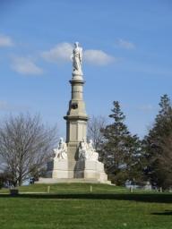

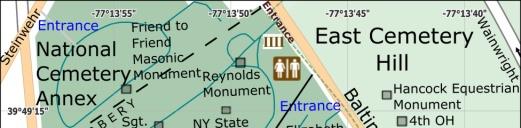
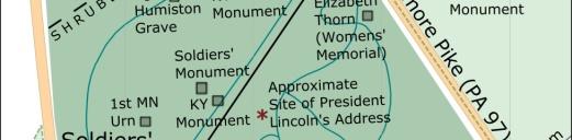
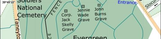
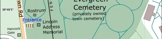
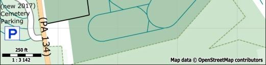
8 Gettysburg Museum & Visitor Center Soldiers National Cemetery Soldiers National Monument Lincoln Address Memorial
9 Downtown Gettysburg Although pedestrians will enjoy walking in downtown Gettysburg, road bicyclists may want to avoid the motor vehicle traffic. For Gettysburg-specific bicycle touring tips on the topics of transportation, lodging, contingency planning, and other health and safety considerations, look for the guidebook, Bicycling Gettysburg National Military Park: The Civil War Cyclist s Travel Guide (ISBN ), or visit
10 Bicycling Gettysburg National Military Park: By Sue Thibodeau (ISBN ) This is the one-and-only book that you need to bicycle the Gettysburg battlefield -- the site of the greatest loss of life in the history of the western hemisphere. The book's 284 full-color pages are packed with 34 maps, hundreds of monument and landscape photos, GPS points, and bicycling tips for your own self-directed, 23.8-mile tour. The guidebook includes: The Cyclist's Civil War Travel Guide 34 highly detailed, color bicycling maps over 6,000 acres of park land Turn-by-turn directions for a 23.8-mile circuit, mostly on park roads Tips on bicycling gear, restrooms, water, picnic areas, racks, etc monument photos and GPS points, most marked on maps Map-to-text and text-to-map cross references for learning on the road Monument histories tied to all 3 days of battle events (July 1-3, 1863) 35 labeled landscape photos Orienteering tips to connect the battle story to Gettysburg geography Concise summary of the Battle of Gettysburg 6-page glossary of basic Civil War terms 10-page annotated bibliography 138 endnotes that document sources For the history buff... The book's maps: Identify the location of all state monuments Identify the location of all equestrian monuments Identify the location of all bronze statues of individuals Identify a sampling of regimental monuments for all states Identify the location of farm buildings, towers, and more For the bicyclist... The book's maps: Label all roads, especially park roads and one-way roads Label significant ridges, hills, fields, woodlots, and more Identify natural and physical landmarks for orienteering Identify restrooms, portable toilets, and water sources Identify picnic areas, bicycle racks, and parking lots Identify town roads that have sidewalks or bicycle lanes The book covers these Gettysburg-specific bicycle touring topics: Bicycle selection, transportation, and rental options Lodging considerations and parking Contingency planning (in case of rain) Pointers to bicycle laws and park policies Take a ride back in time!
11 Bicycling Gettysburg National Military Park: The Cyclist's Civil War Travel Guide Companion Maps For your riding convenience, you can purchase one or more (optional) companion maps for bicycling fourteen different routes through the Gettysburg battlefield. The bicycle routes vary in length, difficulty, and historical focus. You can combine routes into multi-day tours. Since the maps are multi-page PDF files, you can print them to carry with you on your ride and/or you can read the maps on your mobile device during a battlefield stop. (In the following table, routes that have a "b" their route number identify a shortened variation of another route). # Route Name Miles 1 Full Day Loop b Full Day Short Loop Battle Day 1 Loop Battle Days 2 and 3 Loop b Battle Days 2 and 3 Short Loop Battle Days 2 and 3 Short Loop 9.0 Estimated Hours The Ridges Extended Loop Culp's Hill Lower Loop min. 7 Culp's Hill Upper Loop Culp s Hill Double Loop Devil's Den and Wheatfield Loop Little Round Top Loop min. 11 Little Round Top Area Double Loop East Cavalry Field Loop Most routes begin and end at 945 Baltimore Pike, currently near a hotel, and 0.5 miles north of the Gettysburg National Military Park Museum and Visitor Center. This location simplifies the design of safe, convenient, and circular routes that are composed of reusable segments. It is also close to the GNMP Bus/RV parking, where there are restrooms and water, and to Spangler s Spring parking. Your on ramp to the park is Baltimore Pike at Slocum Avenue. Although the guidebook, Bicycling Gettysburg National Military Park, provides detailed directions for Route 1 in the form of a 6 x 9 paperback book, the Route 1 Companion Map is an optional convenience for bicyclists who want to tuck paper maps into a jersey pocket or bicycle bag. Also, with a little extra planning, you can use the book to figure out how to complete Routes 1b 12, or you could purchase Civil War Cycling s companion maps to enjoy a ready-made tour. In any case, Bicycling Gettysburg National Military Park is the central reference for historical details including monument histories and Gettysburg-specific bicycling tips and planning recommendations. 2 3 Get your maps at
Kennesaw Mountain National Battlefield Park Mountain Road Alternatives
 Kennesaw Mountain National Battlefield Park Mountain Road Alternatives Management Issue Kennesaw Mountain National Battlefield Park was established by Congress in 1935 to preserve and commemorate the site
SAFETY GUIDE FOR SCHOOL CHILDREN & PARENTS. toronto.ca/visionzeroto #VisionZeroTO
 SAFETY GUIDE FOR SCHOOL CHILDREN & PARENTS toronto.ca/visionzeroto #VisionZeroTO VISION ZERO ROAD SAFETY PLAN Toronto s Vision Zero Road Safety Plan is a five-year strategy for eliminating traffic-related
Traffic Calming & Cyclists
 Traffic Calming & Cyclists In the planning, design, and operation of transportation facilities bicyclists and pedestrians should be included as a matter of routine and the decision not to accommodate them
Corpus Christi Metropolitan Transportation Plan Fiscal Year Introduction:
 Introduction: The Safe, Accountable, Flexible, Efficient Transportation Equity Act: A Legacy for Users (SAFETEA-LU) has continued the efforts started through the Intermodal Surface Transportation Efficiency
Shawnee Prairie Loop. Lufkin & Angelina County Bicycle Route. Total Miles: 38.
 Lufkin & Angelina County Bicycle Route Total Miles: 38 www.visitlufkin.com Route Directions: Segment Distance (miles) Direction of Turn Road Traveled Total Distance (miles) Start Lufkin High School (309
Obey Creek PEDESTRIAN CIRCULATION EAST WEST PARTNERS PEDESTRIAN CIRCULATION CREEK SIDE LANE SLIP STREET SCOTT MURRAY MAIN STREETS EAST/WEST
 THE VILLAGE AT PEDESTRIAN CIRCULATION MAIN STREETS NORTH/SOUTH MAIN STREETS EAST/WEST SLIP STREET CREEK SIDE LANE PEDESTRIAN CIRCULATION DESCRIPTION: Circulation through the downtown of is organized by
City of Coronado Bicycle Map, Schools, Traffic Signals and Crossing Guard Locations
 City of Coronado Bicycle Map, Schools, Traffic Signals and Crossing Guard Locations Early Childhood Development Center Crossing Guard - AM Crossing Guard - PM Coronado Middle Village Elementary Coronado
Broaddus Loop. Lufkin & Angelina County Bicycle Route. Total Miles:
 Lufkin & Angelina County Bicycle Route Total Miles: 72.6 www.visitlufkin.com Route Directions: Segment Distance Direction of Total Distance Road Traveled (miles) Turn (miles) Start Lufkin High School
Emergency Response Support Signage on Multi-Use Trails Plan
 DRAFT ( ) Emergency Response Support Signage on Multi-Use Trails Plan Prepared for: SATS Multi-Use Trails Jurisdictions Committee Table of Contents Introduction... 3 Mileage Markers... 4 Rest Stop Identifiers...
Southside Pilot Proposal
 To improve bicycle access and mobility to UC Berkeley, Downtown Berkeley, and the Southside area, a pilot project could include a two-way parking-protected cycle track. Turn pockets and island bus stops
PRE-RIDE LOGISTICS. Summary of Key Rider Information SCHEDULED REST/WATER STOP
 Summary of Key Rider Information - Be on time and follow the schedule - Mandatory must wear the bib number on the back of your jersey (attached to the back pocket) at all times, and bike frame number on
-Lexington Mayor, Jim Gray
 DWIN Ride on over to Lexington, and enjoy some of the most beautiful countryside anywhere. Our trails and major roadway bike lanes have helped achieve bronze-level status from the League of American Bicyclists,
TRAVEL PLAN: CENTRAL EUROPEAN UNIVERSITY CAMPUS REDEVELOPMENT PROJECT TRAVEL PLAN. Central European University Campus Redevelopment Project.
 TRAVEL PLAN Central European University Campus Redevelopment Project Page 1 Table of Contents Introduction... 3 Background... 7 Building Users... 7 Transportation in Community Consultation... 7 Summary
Tour de Wyoming 2015 Route Overview:
 Tour de Wyoming 2015 Route Overview: Route Overview: Gather in Sundance on July 11 Day 1 (July 12): Sundance to Newcastle via Upton Day 2 (July 13): Newcastle to Custer via Wind Cave NP Day 3 (July 14):
EXECUTIVE SUMMARY: TRANSIT-ORIENTED DEVELOPMENT IN SMITHS FALLS, ONTARIO; A COMPARISON BETWEEN TWO SITES
 EECUTIVE SUMMARY: TRANSIT-ORIENTED DEVELOPMENT IN SMITHS FALLS, ONTARIO; A COMPARISON BETWEEN TWO SITES Topic and Purpose In 2007, the Mayor of Ottawa s Task Force on Transportation suggested adding a
What Is a Complete Street?
 Session 5 Charleen Zimmer, AICP, Zan Associates May 5-7, 2010 What Is a Complete Street? May 2010 5-1 Not a Complete Street More of a Complete Street May 2010 5-2 Benefits of Complete Streets Safety for
MAG Town of Cave Creek Bike Study Task 6 Executive Summary and Regional Significance Report
 Page 1 MAG Town of Cave Creek Bike Study Task 6 Executive Summary and Regional Significance Report August 1, 2012 MAG Project #481 Page 2 Task 6 Executive Summary and Regional Significance Report Introduction
THE OFFICIAL GUIDE TO CYCLING SAFELY IN PHILADELPHIA
 B IKE NICE THE OFFICIAL GUIDE TO CYCLING SAFELY IN PHILADELPHIA A partnership of the City of Philadelphia and the Bicycle Coalition of Greater Philadelphia ABOUT VISION ZERO & BIKE NICE It s a great day
TxDOT Bicycle Tourism Trails Study Update. April 2017 BAC Meeting April 10, 2017
 AGENDA ITEM 6 TxDOT Bicycle Tourism Trails Study Update April 2017 BAC Meeting April 10, 2017 Agenda Approval of interim products o Present study vision statement, goals, and study objectives o Present
Board-Approved Funding Awards for Cycle 4 Active Transportation Grant Program Projects (in Order of Project Rankings) Approved on
 Approved on") CAPITAL Large Category Projects Board-Approved Funding Awards for Cycle 4 Active Transportation Grant Program Projects (in Order of Project Rankings) Approved on 07-27-18 1 La Mesa University Ave Pedestrian
CAPITAL Large Category Projects Board-Approved Funding Awards for Cycle 4 Active Transportation Grant Program Projects (in Order of Project Rankings) Approved on 07-27-18 1 La Mesa University Ave Pedestrian
NJDOT Complete Streets Checklist
 Background The New Jersey Department of Transportation s Complete Streets Policy promotes a comprehensive, integrated, connected multi-modal network by providing connections to bicycling and walking trip
JULY 21, RIDE GUIDE
 JULY 21, 2018 2018 RIDE GUIDE HOSTED BY: WITH OUR PARTNERS: Dear Epic Rider, Thank you for registering for the 10th annual EPIC RIDE! Very shortly you will be embarking on a 25 or 40-mile ride along the
b. APGR 385-4, APG Safety and Occupational Health (SOP) Program, 15 Feb 07.
 Program, 15 Feb 07.") DEPARTMENT OF THE ARMY U.S. ARMY INSTALLATION MANAGEMENT COMMAND U.S. ARMY GARRISON ABERDEEN PROVING GROUND 4510 BOOTHBY HILL AVENUE ABERDEEN PROVING GROUND MARYLAND 21005-5001 I MAP-SO REPLY TO ATTENTION
DEPARTMENT OF THE ARMY U.S. ARMY INSTALLATION MANAGEMENT COMMAND U.S. ARMY GARRISON ABERDEEN PROVING GROUND 4510 BOOTHBY HILL AVENUE ABERDEEN PROVING GROUND MARYLAND 21005-5001 I MAP-SO REPLY TO ATTENTION
Arlington County Police Department Law Enforcement Guide. Enforcing Bicycle Traffic Laws
 Arlington County Police Department Law Enforcement Guide Enforcing Bicycle Traffic Laws Arlington County Police Department Safe Bicycling Initiative 2016 About the Arlington Safe Bicycling Initiative The
Broad Street Bicycle Boulevard Design Guidelines
 Broad Street Bicycle Boulevard Design Guidelines Building from the strategies introduced in the 2013 Bicycle Transportation Plan and community input received thus far, City Transportation Staff have identified
8 Bicycle and Pedestrian Facilities
 8 Bicycle and Pedestrian Facilities 8.1 Existing Facilities The facilities available to walkers and bikers are diverse in the rural ACOG area. Walking and biking are, by their nature, localized modes of
MEET IN THE STREET MOVING TO ZERO
 WE MEET IN THE STREET MOVING TO ZERO Tips for sharing the street Traffic deaths are preventable. We need your help getting the message out. 2 A NEW PLAN A NEW PLAN Philadelphia is proud to adopt Vision
Traffic Signs and Signals
 CHAPTER FOUR Traffic Signs and Signals Traffic signs control traffic flow, making streets and highways safer for drivers, bicyclists and pedestrians. These signs, which are posted by the Indiana Department
Homework Module 7.01 Drivers Manual Study Questions
 Homework Module 7.01 Drivers Manual Study Questions Name: Date: Directions: Use the Oregon Driver Manual to answer each of the following questions. It is suggested that you underline or highlight each
THE BATTLE OF TURNER'S GAP SEPTEMBER 14, 1862
 THE BATTLE OF TURNER'S GAP SEPTEMBER 14, 1862 MARYLAND PARK SERVICE DRIVING TOUR Welcome to South Mountain State Battlefield! You have an opportunity to explore several sites upon which approximately thirty
Encouragement. Chapter 4. Education Encouragement Enforcement Engineering & Facilities Evaluation & Planning. Encouragement Chapter 4
 Encouragement Education Encouragement Enforcement Engineering & Facilities Evaluation & Planning Photo above: Children show off their ribbons at the Tour de Virginia Beach. Virginia Beach Bikeways and
Parental Responsibilities
 Bicycle riding is a fun way to exercise and enjoy the outdoors. To remain safe on Illinois roads, bicyclists must obey the same traffic safety laws that govern vehicle drivers. No amount of bicycle safety
The U.S. Cavalry Horse By Gen. William H. Carter
 The U.S. Cavalry Horse By Gen. William H. Carter If searching for the book The U.S. Cavalry Horse by Gen. William H. Carter in pdf form, then you have come on to the correct website. We present the full
ADVISORY BICYCLE LANES REALITY VERSUS DESIGN GUIDANCE
 Michael Williams 0 ADVISORY BICYCLE LANES REALITY VERSUS DESIGN GUIDANCE Michael Williams (Corresponding author) Alta Planning + Design SE Grand Avenue Portland, OR Email: michaelwilliams@altaplanning.com
The Civil War Review Game
 The Civil War Review Game People of the War Misc. 1 Vocab Which state where? Misc. 2 100 100 100 100 100 200 200 200 200 200 300 300 300 300 300 400 400 400 400 400 500 500 500 500 500 People of the War
APPENDIX 1 CITY OF CALGARY SHARE THE PATHWAY PROGRAM
 APPENDICES APPENDIX 1 CITY OF CALGARY SHARE THE PATHWAY PROGRAM Share the Pathway Share the pathway and share the responsibilities. Those who use the pathway get along better when they show courtesy and
Complete Streets. Designing Streets for Everyone. Sarnia
 Complete Streets Designing Streets for Everyone Sarnia Complete Streets ~ Sarnia ~ 2018 Introduction Our City is made up of a network of streets that we use to go for a walk, cycle to work, drive to the
Headquarters, National Regiment
 Headquarters, National Regiment April 11, 186_4 General Orders, Supplemental For: All NR Personnel The following is from the General commanding Army, Maj. Gen. Darrell Markijohn. I forward it for your
CITY OF ARVADA BICYCLE FACILITY NEEDS
 CITY OF ARVADA BICYCLE FACILITY NEEDS The City of Arvada is interested in your ideas and needs as a bicyclist. Your input will help ensure a high level of service for all bicyclists. Did you notice an
D55 D56 D57 D58 D59 D60 D61. Q# Notes. Introduction
 D55 D56 D57 D58 D59 D60 D61 Amenities -continued Are there picnic table(s)? Are there pavilions or shelters? Are there bike racks? Are there benches? Is there security lighting? Is there a pay telephone?
Parks, Open Space, Trails and Recreation Master Plan
 5.3 DEFINITIONS AND VOCABULARY In order to fully understand the range of trails that have been developed, and should be developed, throughout the community, a vocabulary needs to be established for the
Active Transportation Facility Glossary
 Active Transportation Facility Glossary This document defines different active transportation facilities and suggests appropriate corridor types. Click on a facility type to jump to its definition. Bike
MUNICIPALITY OF ANCHORAGE TRAFFIC CODE UPDATE MASTER RECOMMENDATION REPORT: 9.20, 9.38
 MUNICIPALITY OF ANCHORAGE TRAFFIC CODE UPDATE MASTER RECOMMENDATION REPORT: 9.20, 9.38 Report Date: Please send all recommendations for update to Shane Locke (343-8413, lockesr@muni.org) 20-May-09 Code
DISTRIBUTION: Electronic Recipients List TRANSMITTAL LETTER NO. (17-01) MINNESOTA DEPARTMENT OF TRANSPORTATION. MANUAL: Road Design English Manual
 MINNESOTA DEPARTMENT OF TRANSPORTATION. MANUAL: Road Design English Manual") DISTRIBUTION: Electronic Recipients List MINNESOTA DEPARTMENT OF TRANSPORTATION DEVELOPED BY: Design Standards Unit ISSUED BY: Office of Project Management and Technical Support TRANSMITTAL LETTER NO.
DISTRIBUTION: Electronic Recipients List MINNESOTA DEPARTMENT OF TRANSPORTATION DEVELOPED BY: Design Standards Unit ISSUED BY: Office of Project Management and Technical Support TRANSMITTAL LETTER NO.
School Travel Survey for Principals. 1. How do most of your students get to school in the morning? (Please select only one box)
") School Travel Survey for Principals 1. How do most of your students get to school in the morning? (Please select only one box) by school bus by public transportation (e.g., city bus) by other motor vehicle
School Travel Survey for Principals 1. How do most of your students get to school in the morning? (Please select only one box) by school bus by public transportation (e.g., city bus) by other motor vehicle
APPENDIX A: Complete Streets Checklist DRAFT NOVEMBER 2016
 APPENDIX A: Complete Streets Checklist DRAFT NOVEMBER 2016 Complete Streets Checklist MetroPlan Orlando s Complete Streets Checklist is an internal planning tool for staff to further implementation of
Bicycle Safety Education. A Parent s Guide to Safe Practices
 Bicycle Safety Education A Parent s Guide to Safe Practices CONTENTS Introduction Program Components Basics of Bike Safety & Fitting Helmets Fitting Bikes & Gaining Confidence Intersections & Right-of-Way
distance Easy/Moderate
 Experience Rating Easy/Moderate distance 40km (25m) Cycling route: 40km (25 miles) Cycling in: The Great Waterway, Prince Edward County Number of days cycling: 1 Recommended number of nights stay: 2 Experience
Neighborhood Walking, Biking, and Transit Tours Summary BACKGROUND
 Neighborhood Walking, Biking, and Transit Tours Summary BACKGROUND Six tours were scheduled during the week of May 11, 2015. The intent of the tours was for City Staff to experience the corridor with locals
CURBSIDE ACTIVITY DESIGN
 5 CURBSIDE ACTIVITY DESIGN This chapter provides design guidance for separated bike lanes adjacent to curbside activities including parking, loading and bus stops. Typical configurations are presented
Los Altos Hills Town Council - June 18, 2015 Palo Alto City Council June 22, AGENDA ITEM #2.B Presentation
 Los Altos Hills Town Council - June 18, 2015 Palo Alto City Council June 22, 2015 AGENDA ITEM #2.B Presentation Previous Presentations Los Altos Hills Town Council in May 2014 and February 2015 Palo Alto
Hamilton Transportation Master Plan Public Consultation. Public Information Centre One Summary
 Hamilton Transportation Master Plan Public Consultation Public Information Centre One Summary Table of Contents Introduction 1 Purpose 2 What Was Presented 2 Who Came to the Meeting 2 The Breakout Sessions
Bicycle - Motor Vehicle Collisions on Controlled Access Highways in Arizona
 Bicycle - Motor Vehicle Collisions on Controlled Access Highways in Arizona Analysis from January 1, 1991 to June 30, 2002 Richard C. Moeur, PE Traffic Design Manager, Northern Region Michelle N. Bina
Bikeway action plan. Bicycle Friendly Community Workshop March 5, 2007 Rochester, MN
 Bikeway action plan Summary The was held on March 5, 2007 at the Rochester Mayo Civic Center. The workshop was hosted by Rochester-Olmsted County Planning Department in collaboration with the League of
RAINSTORM Welcome to our 12th year! Host hotel. Indiana State Park Inns. Laundry service
 RAINSTORM 2019 Host hotel Hampton Inn Richmond, 455 Commerce Road, Richmond, Indiana, 47374. Phone: 765-966-5200. The option to reserve a room at the host hotel was available when you registered. You may
Calaveras Big Trees State Park--South Grove Loop
 Copyright 1999 by Jeff Robinson. You are free to use and reproduce this description for personal, not-for-profit, and not-forbusiness use. Any reproduction other than for personal use, including businesses,
Aditi Misra Dr. Kari E. Watkins Dr. Christopher A. Le Dantec
 Cycle Atlanta Aditi Misra School of Civil and Environmental Engineering Dr. Kari E. Watkins School of Civil and Environmental Engineering Dr. Christopher A. Le Dantec School Literature, Media, and Communication
SAFE ROUTES TO SCHOOL
 SAFE ROUTES TO SCHOOL Forest Ridge Elementary School Existing Conditions and ACTION PLAN > Oak Creek - Franklin Joint School District Table of Contents CONTEXT Enrollment Boundaries
Table of Contents Introduction. 2 Purpose of the Plan...2 The Benefits of Walking and Bicycling...3 Vision and Goals of the Plan...
 BICYCLE AND This plan was created through a grant from the Healthy Communities Program with the cooperation of the City of Cynthiana, Cynthiana Main Street, Cynthiana-Harrison County-Berry Joint Planning
Duwamish Way-finding and CTR Report
 V. North Tukwila When the North Tukwila Manufacturing and Industrial Center was designated in 1992 as part of the region s land use and transportation plan, the plan called for the area to set a light-rail
5 CIRCULATION AND STREET DESIGN
 5 CIRCULATION AND STREET DESIGN This chapter describes circulation and streetscape improvements proposed for the Northwest Chico Specific Plan Area. It includes detailed design specifications for existing
Mountain Bike Guide To Oregon
 Mountain Bike Guide To Oregon If searching for a ebook Mountain Bike Guide To Oregon in pdf form, in that case you come on to faithful site. We furnish full release of this book in txt, PDF, epub, DjVu,
Bicycle Safety Skills
 Bicycle Safety Skills Presented by: MassBike Cape and Islands Chapter MassBike John Fallender December 20, 2010 Cape & Islands Chapter 1 Welcome to Cape Cod 2 Bikes are vehicles? What does that mean? That
School Travel Survey for District Superintendents/Board Chairs
 School Travel Survey for District Superintendents/Board Chairs 1. How do most of the elementary and middle school students in your district get to school in the morning? (Please select only one box) by
Copyright by Home by School.com (Third Conversion, LLC). All rights reserved. Published by Third Conversion, LLC
. All rights reserved. Published by Third Conversion, LLC") Copyright 2010-2012 by Home by School.com (Third Conversion, LLC). All rights reserved. Published by Third Conversion, LLC No part of this publication may be reproduced or transmitted in any form or by
Copyright 2010-2012 by Home by School.com (Third Conversion, LLC). All rights reserved. Published by Third Conversion, LLC No part of this publication may be reproduced or transmitted in any form or by
City Birmingham Multi-Modal Transportation Plan Visioning Workshop Results Meeting
 City Birmingham Multi-Modal Transportation Plan Visioning Workshop Results Meeting Monday, January 28, 2013 7:30 PM, City Hall Norman Cox, PLA, ASLA. Ann Arbor, Michigan. www.greenwaycollab.com Community
Minor Amendments to the Street and Traffic By-law 2849 and Skateboards in Protected Bike Lanes
 ADMINISTRATIVE REPORT Report Date: October 31, 2017 Contact: Lon LaClaire Contact No.: 604.873.7336 RTS No.: 12241 VanRIMS No.: 08-2000-20 Meeting Date: November 15, 2017 TO: FROM: SUBJECT: Standing Committee
Bicycles and Pedestrians on ISU Campus. Indiana State University Police
 Bicycles and Pedestrians on ISU Campus Indiana State University Police FASTEST Transportation On Campus There has been an increase in cyclists and pedestrians on campus as student enrollment continues
Prince George s County plans, policies, and projects
 Prince George s County plans, policies, and projects Over 250 projects for trails, bikeways, designated bike lanes and sidewalk construction Trail projects that improve access to Metro Sidewalk and trail
Fortress Rosecrans and Battle Of Stones River Civil War Trail
 General Information: This should be considered a moderate hike. It is approximately 11.7 miles. The Cost of this Hike is free and the Memories are Priceless. Enjoy! Requirements: - It is good to read every
Bicycle Pedestrian Master Plan Pre Bid Meeting Portsmouth, NH August 15, 2013
 Bicycle Pedestrian Master Plan Pre Bid Meeting Portsmouth, NH August 15, 2013 2005 Master Plan GOAL: Provide for safe and convenient bicycle and pedestrian circulation throughout the City. Develop a city
FEEDBACK SURVEY #2: WHO PARTICIPATED
 Attachment 2 - Summary of Public Opinion Survey Results Attachment 2 FEEDBACK SURVEY #2: WHO PARTICIPATED Online for public input from December 13, 2016 to May 4, 2017 Promoted through 30,000 flyers, sharing
Northeast 65 th Street Vision Zero Project Proposals From A Roosevelt High School Student Joe Mangan
 Northeast 65 th Street Vision Zero Project Proposals From A Roosevelt High School Student Joe Mangan PROPOSALS: 1. Extend raised cycle tracks down 65 th Street Northeast. Please do not consider any other
2014/2015 BIKE ROUTE PLAN 83 AVENUE PROTECTED BIKE LANE
 About the Project The City of Edmonton is planning a major bike route on the southside of Edmonton. The Strathcona Bike Route will connect the communities of Strathcona, Garneau and the University area,
Group Riding Techniques
 Group Riding Techniques Revised: 2017 01 26 A. Group Riding Terminology Thanks to the Ottawa Bicycle Club for allowing us to use content from their website! A.1 Groups and Packs A group is several cyclists
Creating walkable, bikeable and transit-supportive communities in Halton
 Creating walkable, bikeable and transit-supportive communities in Halton By presenting current research and best practices, the information in this paper is meant to support and broaden discussion on how
RZC Appendix 8A Marymoor Subarea Street Requirements
 RZC Appendix 8A Marymoor Subarea Street Requirements For additional design details for Marymoor Subarea infrastructure, refer to the 2017 Marymoor Subarea Infrastructure Planning Report. STREET REQUIREMENTS
DRAFT. System Components. Greenway Trails. Introduction. Trail Types. Zebulon Greenway Master Plan
 5 System Components Wakefield Street Photo Simulation showing Sharrows Introduction The Master Plan identifies various system components that, together, create a comprehensive greenway system. These components
City of Lima Bicycle Parking Guide
 City of Lima Bicycle Parking Guide The Allen County Bike and Pedestrian Task Force is a community organization that is Allen County s voice for safe places to walk, bike and be active in Allen County Keeping
North Carolina Bicycle and Pedestrian Laws
 STATE OF NORTH CAROLINA A Guide to North Carolina Bicycle and Pedestrian Laws Guidebook on General Statutes, Ordinances, and Resources DEPARTMENT OF TRANSPORTATION North Carolina Department of Transportation
GAES CATALUNYA BIKE RACE PRESENTED BY SHIMANO REGULATIONS 2017
 GAES CATALUNYA BIKE RACE PRESENTED BY SHIMANO REGULATIONS 2017 1. Introduction 1.1. GAES CATALUNYA BIKE RACE presented by SHIMANO is a mountain bike stage race (XCS), split into three (3) marathon stages
Welcome. If you have any questions or comments on the project, please contact:
 Welcome This drop-in public open house is intended to provide information about the Bay Street bike lanes project. This project proposes a dedicated cycling facility along Bay Street between Aberdeen Avenue
City of Novi Non-Motorized Master Plan 2011 Executive Summary
 City of Novi Non-Motorized Master Plan 2011 Executive Summary Prepared by: February 28, 2011 Why Plan? Encouraging healthy, active lifestyles through pathway and sidewalk connectivity has been a focus
Eliminate on-street parking where it will allow for a dedicated bus only lane %
 Traffic Dashboard Priorities Survey Responses Introduction 1) Are you familiar with bus rapid transit (BRT)? a. No, BRT is new to me. 597 23.5% b. I ve heard of BRT, but I don t know much about it. 1,136
Gravel Bike Guide Haywood County
 Gravel Bike Guide Haywood County Haywood County is an ideal place for bicycling on gravel roads, because 37% or 129,994 acres of Haywood County is federal property, including portions of the Pisgah National
o n - m o t o r i z e d transportation is an overlooked element that can greatly enhance the overall quality of life for the community s residents.
 N o n - m o t o r i z e d transportation is an overlooked element that can greatly enhance the overall quality of life for the community s residents. 84 Transportation CHAPTER 11 INTRODUCTION Transportation
GIS Based Data Collection / Network Planning On a City Scale. Healthy Communities Active Transportation Workshop, Cleveland, Ohio May 10, 2011
 The Purpose of GIS Based Network Planning GIS Based Data Collection / Network Planning Healthy Communities Active Transportation Conference Tuesday, May 10, 2011 10:00 AM Norman Cox, LLA, ASLA. Ann Arbor,
Pedestrian & Bicycle Safety Innovations & Applications
 Pedestrian & Bicycle Safety Innovations & Applications County Engineers Association of Maryland Spring, 2017 Conference May 25, 2017 George Branyan Pedestrian Program Coordinator District Department of
Introduction. North 12 th Complete Street Project Overview
 Introduction On Wednesday, March 1, 2017, the City of Sacramento, in partnership with Sacramento Regional Transit District and the Sacramento Housing and Redevelopment Agency, hosted a community outreach
BICYCLE SAFETY: A PARENT S GUIDE
 BICYCLE SAFETY: A PARENT S GUIDE Thank you for partnering with the Newport Beach Police Department to help make your child a safer bicyclist. BE A ROLL MODEL LEARN. As a parent, it is important that you
6.4 RECOMMENDED IMPROVEMENTS
 6.4 RECOMMENDED IMPROVEMENTS 6.4.1 Williston Road Recommendations While all alternatives would be an improvement over existing conditions, Alternative 3B is recommended over the others because it provides
Commerce Street Complete Street Project from Good Latimer Expressway to Exposition Avenue
 Commerce Street Complete Street Project from Good Latimer Expressway to Exposition Avenue T A N Y A B R O O K S A S S I S T A N T D I R E C T O R M O B I L I T Y P L A N N I N G M O B I L I T Y A N D S
May 14-15, 2016 Race Bible
 May 14-15, 2016 Race Bible Ron Berry Insurance Agency Rockwood Events Center Racers, On behalf of KnoxVelo, Southern Cycling Operations, the race committee, and our sponsors, it is my pleasure to welcome
AGENDA ITEM SUMMARY March 5, 2019 City Council
 Agenda Item 20 AGENDA ITEM SUMMARY March 5, 2019 City Council STAFF Amanda Mansfield, Transportation Planner Paul Sizemore, FC Moves Senior Manager Chris Van Hall, Legal SUBJECT Items Relating to Regulating
Safe Routes to School Action Plan Aberdeen, Idaho
 Background Aberdeen, Idaho is a largely agricultural community of nearly 2,000 people and is located in the southeast portion of the state on the western edge of American Falls Reservoir. The community
Contents. Bicyclist Pocket Guide. Quick Reference. 2nd Edition. GeorgiaBikes.org. 1. Legal Status of Bicyclists Rules of the Road 7
 Bicyclist Pocket Guide 2nd Edition 2013 GeorgiaBikes.org 2 Contents 1. Legal Status of Bicyclists 6 2. Rules of the Road 7 3. Safe Cycling 17 4. Crashes 24 Quick Reference Bicycles are vehicles and have
October 30 th, 2012 Committee of the Whole Meeting Cycling Task Force Recommendations BIKE RACKS
 BIKE RACKS 1. Replace existing bike racks with functionally designed bike racks that promote year round cycling as well as increase the number of bike racks in town. Existing bike racks are poorly designed
Chapter 2: Standards for Access, Non-Motorized, and Transit
 Standards for Access, Non-Motorized, and Transit Chapter 2: Standards for Access, Non-Motorized, and Transit The Washtenaw County Access Management Plan was developed based on the analysis of existing
Amador County Pedestrian and Bicycle Plan Survey Results
 Survey Methodology Amador County Pedestrian and Bicycle Plan From September 23th to December 31st, 2016 a walking and biking survey was available for public input. It was advertised through the walkbikeamador.com
WALK- AND bike-friendly TURLOCK
 WALK- AND bike-friendly TURLOCK Ideas to Encourage Walking and Biking Benefits to the COMMUNITY Get Connected People who walk and bike have many more opportunities for casual interactions with friends