COUNCIL COMMITTEE OF THE WHOLE SAFETY ADVISORY AND TRANSPORTATION COMMITTEE
|
|
|
- Berniece Snow
- 5 years ago
- Views:
Transcription
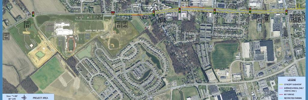
1 COUNCIL COMMITTEE OF THE WHOLE The Council Committee of the Whole Meeting was held on June 28, 2016 at 6:00 p.m., with Council President Slavin presiding. Members of Council present were Mr. Anderson (arrived at 6:05 p.m. and departed at 7:27 p.m.), Mr. Sudler, Mr. Neil, Mr. Cole, Mr. Hosfelt, Mr. Hare, and Mr. Hutchison (departed at 7:21 p.m. and returned at 7:28 p.m.). Mr. Lewis was absent. Mayor Christiansen was also present. Civilian members present for their Committee meetings were Mr. Keller and Mr. Shelton (Safety Advisory and Transportation), and Ms. Stewart (Legislative, Finance, and Administration). Mr. Shevock was absent. SAFETY ADVISORY AND TRANSPORTATION COMMITTEE The Safety Advisory and Transportation Committee met with Councilman Hosfelt presiding. AGENDA ADDITIONS/DELETIONS Mr. Hutchison moved for approval of the agenda, seconded by Mr. Neil and unanimously carried. Presentations Speed Control Measures - North State Street Mr. Mike Somers, Senior Transportation Planner, Delaware Department of Transportation (DelDOT), and Mr. Glenn (Guy) Pusey III, Engineering Designer, RK&K, introduced themselves. Mr. Somers advised members that they were asked to address speeding concerns on North State Street and had worked with a committee and Representative Sean Lynn, 31 st District, to come up with some ideas. Mr. Somers stated that they had a difficult time trying to find something the community would accept because many of the measures considered would take away a lot of the parking in the area due to the way State Street is laid out. Mr. Somers reviewed a presentation entitled North State Street Proposed Median Island Chicane. Referring to the overhead rendering of the chicane, he explained that their last effort resulted in a proposed median for the section of North State Street between Pennsylvania Avenue and Columbia Avenue. Mr. Somers stated that the idea was to slow drivers as they come into the corridor. He felt this would be effective in this specific area; however, it would not extend all the way down the street, noting that nothing done in one (1) place would change the nature of all the traffic. Mr. Somers noted that State Representative Sean Lynn had worked with the homeowners in the immediate area and they did not oppose the concept. Mr. Somers explained that the idea was to slow traffic as it enters, noting that there were two (2) general ways to do this: 1) vertical measures, like speed humps, which no one had wanted on State Street; and 2) horizontal measures, such as the median. He noted that a chicane would accommodate trucks and all other vehicles. There would be no need for traffic to stop, but it would slow as it passes through.
2 COUNCIL COMMITTEE OF THE WHOLE MEETING OF JUNE 28, 2016 PAGE 2 Mr. Hutchison questioned if one-way streets were considered. Responding, Mr. Somers indicated that this had been discussed; however, the City did not want to go in this direction just yet. He noted that State Street and Governors Avenue could possibly be paired for one-way traffic; however, the down side to that concept would be that one-way streets tend to increase traffic speed since drivers are all traveling in the same direction. On the positive side, Mr. Somers stated that this measure would provide extra space on the outside of the road that could be pinched in to slow traffic if everyone was traveling in one (1) direction. Mr. Hutchison indicated that he liked the idea of traffic continuing to travel north and south and slowing down approaching traffic. Mr. Slavin stated that another solution that involved taking out one (1) of the inlets to the cemetery in the area had been conceptually proposed. Mr. Somers pointed out the small access road into the graveyard opposite Columbia Avenue. He explained that they had asked the church that maintains the graveyard about the possibility of realigning this intersection, which would create a semi-circular island that would cover that access and a three-way stop. Mr. Somers advised there had been potential to modify this area to allow traffic to exit; however, enough modification could not be made to let traffic enter as well. The church was against this concept; therefore, it was not pursued. Mr. Slavin commented that a solution was needed in this neighborhood, noting that he lives in this area and is very aware of the concerns. He stated that there was a high frequency of vehicles speeding in both directions. Mr. Slavin thought that part of the issue was that the road becomes wider for cars traveling northbound because no one parks in front of the cemetery. The downtown area is choked, causing drivers to slow down, and the sudden crest that leads to the causeway across Silver Lake naturally causes people to accelerate. Mr. Slavin advised that he had seen solutions similar to the median in place and believed that they help to calm traffic. Referring to the depiction of the chicane from a driver s view, Mr. Somers advised that brickwork had been assumed since this was the most common material used; however, he noted that there could be concrete, a pebble look, or other potential measures. Mr. Slavin stated that, in his experience, anything that disrupts the view of an unimpeded road causes drivers naturally to not accelerate. Mr. Somers advised that the chicane would contain the field of vision. In addition, he stated that the 25 m.p.h. zone stops just north of Pennsylvania Avenue and suggested this be extended to the corner of Columbia Avenue. Mr. Cole moved to recommend moving forward with the proposed median, seconded by Mr. Neil. Ms. Laura Chupp, 315 North State Street, explained that she lives at the corner of Hazel Road and State Street and she has two (2) young children who play outside and safety is a very important aspect of the community for her and her family. Ms. Chupp stated that she agreed with the proposal; however, she wondered if a second median was needed further toward Division Street. She advised that she lives close to Wesley College and traffic in front of her house in the middle of the night is
3 COUNCIL COMMITTEE OF THE WHOLE MEETING OF JUNE 28, 2016 PAGE 3 very fast. Ms. Chupp indicated that a lot of families with kids live in this area and questioned if a second median could be proposed at a later time, or if a secondary measure could be in the works closer to the downtown area. In response, Mr. Somers stated that they had tried to look at the entire length of the road; however, they could not go much further than Columbia Avenue or perhaps the next street because this would be closer to the stoplight. He indicated that there would be problems because a measure like the median would take all of the frontage, so there would be no parking from approximately 50 feet before the median to 50 feet after it. Mr. Somers stated that if it were put further down, parking would be eliminated for two (2) or three (3) houses on each side of the road. He explained that he was not saying that this was not possible; however, he felt there would be a community fight and the City would have to decide whether they would do this. It was not included in the proposal because of this issue. Mr. Slavin stated that most, if not all, of the houses along North State Street from Hazel Road north have off-street parking, including driveways or garages, so the impact may not be as much as believed. Responding, Mr. Somers stated this was correct, noting that there is a service road on the west side that goes back behind most of the houses, if not all of them. However, he explained that when dealing with the public on such matters, he typically finds that many people are not thinking about the practicality and feasibility of the project but about selling their houses eventually, which causes resistance. Mr. Cole stated that this issue came up during some of the meetings that were held related to this project. Some people had expressed concern about what would happen if this measure was located in front of their houses when they want to sell them. Ms. Sara Herbert, 223 North Bradford Street, stated that one (1) of the things that the old Dover Neighborhood Watch had noted was that there was already a speed monitor at that end of the street and they wanted it to be moved up the street and turned so that it would face south. People driving by Wesley College would go through the crosswalk that was marked for children and would then be able to see their speed when they pass Hazel Road. She stated that Representative Lynn was aware of this suggestion. Mrs. Herbert felt that the speed monitor would help stop traffic heading north on State Street and the median would stop people heading south. Responding, Mr. Hosfelt stated that this could be looked at with City staff, noting that the City has the ability to change the location of these signs. Ms. Herbert advised that one (1) gentleman had volunteered to have the monitor placed in front of his house. Mr. John Caldora informed members that he represented Wesley College at 120 North State Street. He indicated that Wesley College supported the speed control measures because they thought they were necessary to protect their community. Mr. Caldora informed members that one (1) of their freshman students, Brittany Paige, was killed last year at the cross section of Walker Road and North State Street near where the measures were proposed. He advised that Ms. Paige was an education and special education major from Maryland and a bright and warm person who was greatly missed. Mr. Caldora felt that the proposed measures would encourage motorists to pay attention and slow
4 COUNCIL COMMITTEE OF THE WHOLE MEETING OF JUNE 28, 2016 PAGE 4 down in the area. He thanked Councilmen Neil and Cole, the Old Dover Neighborhood Watch, and DelDOT for their efforts on this project. Mr. Keller questioned where the speed limit increases on State Street. In response, Mr. Somers advised that it currently increases just to the south of the measure, which would be slightly to the north of Pennsylvania Avenue. Mr. Keller asked if it would be feasible for the 25 m.p.h. speed limit to continue through that section. Responding, Mr. Somers suggested extending the 25 m.p.h. speed limit to the corner to encompass this measure, stating that if they had to design for 35 m.p.h., the project would be bigger than proposed. He stated that the size and shape of the project would be dependent upon the speed since the faster the speed, the more open it would have to be, and the less it would slow people down. In response to Mr. Keller, he confirmed that they had already taken a 25 m.p.h. speed limit into consideration. Mr. Cole moved to amend the motion to include a 25 m.p.h. speed limit throughout the measure. The amendment was seconded by Mr. Neil. Mr. Slavin questioned if the 25 m.p.h. speed limit would extend through the entire length of North State Street. Responding, Mr. Somers indicated that the speed limit would apply through the measure. Mr. Slavin asked what the impact would be if the 25 m.p.h. speed limit was extended all the way to Walker Road. In response, Mr. Somers stated his belief that this had been requested previously; however, warrants were not met. He indicated that there was a history on that request and apologized that he had not brought the data with him. Mr. Somers advised that warrants could be met with the addition of the proposed phase, but carrying it all the way down to Walker Road would be a different issue. Mr. Slavin stated that members could recommend that the City deal with DelDOT on this idea, noting his preference for a 25 m.p.h. speed limit all the way down to Walker Road. From his experience, if drivers are given a moment to accelerate, they will accelerate. He indicated that Mr. Cole could clarify his motion to state that he had intended to recommend a 25 m.p.h. speed limit all the way down to Walker Road. Mr. Cole stated his belief that this was what most of the residents had been hoping for and questioned if this could be done. Responding, Mr. Slavin advised that this was a State road and the City would be making a recommendation. Mr. Cole clarified that the motion was intended to include a 25 m.p.h. speed limit to the intersection on Walker Road, and Mr. Neil stated that he agreed. The motion to recommend moving forward with the proposed median and that the 25 m.p.h. speed limit be extended to the intersection on Walker Road was unanimously carried.
5 COUNCIL COMMITTEE OF THE WHOLE MEETING OF JUNE 28, 2016 PAGE 5 Proposed Service Road Behind the Mall Mr. John Paradee of Baird, Mandalas, Brockstedt, 6 South State Street, reviewed a presentation entitled, June 28, 2016 Presentation to City of Dover Transportation Committee Collector- Distributor Road Modification to the Scarborough Road Interchange. He advised members that this presentation grew out of the Delaware Department of Transportation (DelDOT) 2007 U.S. Route 13 Corridor Study. Mr. Paradee indicated that he would not be asking the City for money but for moral support through the Dover/Kent County Metropolitan Planning Organization (MPO) prioritization process. Mr. Paradee referred to the executive summary of the 2007 U.S. Route 13 Circulation Study, which identified the Collector Distributor Road Modification to the Scarborough Road Interchange. He explained that this would be a service road extension off the Scarborough Road interchange running parallel and just west of State Route 1 and would ultimately result in an eastwest connector road running between the Dover Mall and Dover Downs to Route 13. Mr. Paradee noted that, since the 2007 Route 13 corridor study was performed, continuing growth and development had strained the existing roadway infrastructure. He informed members that there were a number of significant users in the area, including a few institutions of higher learning, a NASCAR track, a huge retail mall, and recent special events to the west, such as the Firefly Music Festival. Mr. Paradee indicated that he represented Western Development, the owners of the Dover Mall. He stated that discussions had started with DelDOT and the General Assembly two (2) years ago about how to move forward with this project, and in last year s Bond Bill, the General Assembly authorized DelDOT to conduct three (3) studies, including a feasibility study, a toll study, and a wetlands delineation to determine whether or not the project could move forward. Mr. Paradee advised that a feasibility study was recently completed and a copy was provided to the City electronically. He noted that after spending a lot of money and studying this with many experts, the conclusion was that the road modification being discussed was feasible and would relieve congestion, improve circulation, and enhance traffic safety. Mr. Paradee stated that it would also foster and accommodate continued economic growth and development in the corridor. He advised that this was important due to the strained infrastructure system and many users who were trying to grow but could not, noting that this was a chicken and egg problem. Mr. Paradee indicated that the Dover Mall owns approximately 88 acres to the east, behind them and they were proposing to expand to triple the current size of the mall; however, they cannot without the traffic infrastructure. He stated that current users were having trouble, noting that Sears was thinking about leaving and, in all likelihood, would do so in the near term. Mr. Paradee felt that other users in the area would continue to suffer severe stress if efforts are not made to improve the infrastructure system. Mr. Paradee informed members that the next steps would be to conduct a toll study. DelDOT had already picked a consultant to perform the study, which would be concluded sometime this year. He stated that wetlands delineation was also underway and would hopefully be concluded early next year. Mr. Paradee indicated that the owners of the Dover Mall were paying all of the costs of the studies, so there would be no cost to State citizens. He advised that once the project is completed through the design stage, construction costs were estimated at approximately $15M, which he felt was reasonable, noting that the project would involve a service road and ramps and would not include a lot of overpass work. Mr. Paradee estimated the cost at a little more than half the cost of two (2) interchanges that were recently constructed in north Frederica and another under construction in south Frederica. He felt that this was a good value for the money and a low cost investment in terms of what would be received in economic development and traffic safety, noting that the project
6 COUNCIL COMMITTEE OF THE WHOLE MEETING OF JUNE 28, 2016 PAGE 6 would all be funded by additional toll revenue. Mr. Paradee indicated that tolls would be placed on the north and south side so that those who use the road for access and convenience would pay for this privilege. He stated the expectation that the additional toll would be approximately $0.50, which would pay for the entire design and construction of the improvements. Mr. Paradee was hopeful that they would reach the design phase sometime in the next year and, if the project moves forward, he believed it could be completed within four (4) years. Mr. Paradee indicated that the City s support was vital. He stated that they were performing study and analysis work currently but would not commit to moving forward with the project unless and until the Dover/Kent County MPO escalates the project s priority. Mr. Paradee explained that the project was already in the MPO priority list but was presently approximately two-thirds down the list. He requested that the City support elevating the priority of this project before the Dover/Kent County MPO due to its value compared to the funds required. Mr. Paradee indicated that this area is important to the City, Kent County, and the State of Delaware to improve traffic safety and circulation, and at the same time encourage continuing economic development in the Route 13 corridor. He felt that these goals could not be accomplished without alleviating a lot of the pressure in this area. Mr. Neil questioned if the City Manager had any concerns about this request. Responding, Mr. Scott Koenig, City Manager, stated that there were no negatives to this proposal from the City s standpoint, especially if construction costs could be recovered through a new user-based toll. He advised that the City met with different developers approximately a dozen time in the last decade to talk about the expansion of the Dover Mall. Mr. Koenig informed members that there had been a general complaint regarding the direction that the mall seemed to be going, and if this would ignite the next round of investment in the mall, as well as the potential for spin-off business or additional development, he felt it was feasible and worthwhile. He indicated that several concepts had been discussed, and he was unsure which were being currently pursued. Generally, Mr. Koenig thought it would be an improvement to this area, would spur additional development on U. S. Route 13, and may encourage additional annexation into the City on the north side of the mall over the long run. It would also be helpful for commercial development on the highway. Mr. Koenig had no objections to the proposal, feeling that it was a great idea to try and recover the cost through the toll revenue because he was unsure that there was any other way to get this done at this point. Mayor Christiansen advised members that he serves as the Vice Chairman of the Dover/Kent County MPO. He felt that this was a very admirable idea and that Mr. Paradee had made a great point that it would be an economic development tool. Mayor Christiansen expressed the need to move forward as rapidly as possible. He asked, since this was a Council Committee of the Whole meeting, that members authorize him by consensus to send or carry a letter to the July 6, 2016 meeting of the MPO requesting that this project be moved up in priority. Mayor Christiansen reminded members that, over the last year-and-a-half, Secretary of Transportation Jennifer Cohan had been very receptive to the needs of Kent County. He felt that the sooner that the City submits this letter, the sooner this could happen.
7 COUNCIL COMMITTEE OF THE WHOLE MEETING OF JUNE 28, 2016 PAGE 7 Mr. Neil moved to recommend authorizing the Mayor to provide a letter at the July 6, 2016 meeting of the Dover/Kent County MPO requesting that the proposed Dover Mall Service Road be elevated on the MPO transportation prioritization list. The motion was seconded by Mr. Hutchison. Mr. Hare felt that this project was long overdue. He reminded members that Christiana Mall ran into this same situation years ago because the mall wanted to expand and it was difficult to exit Route 1 into the mall and a lot of changes were made in that area. Mr. Hare advised that he had suggested to those coming north from the beach that they stop at the Dover Mall; however, they felt it was easier to go on to Christiana. He felt that easy access to the mall and that area would spur business and that the City should pursue moving this project to the top five (5) or top of the list. Mr. Paradee indicated that they had done marketing studies that demonstrated that a number of users traveling north and south through the State of Delaware simply bypass Dover because it is too congested. Mayor Christiansen requested that Mr. Paradee provide the verbiage on exactly what he was requesting and indicated that, if it pleased Council, he would initiate that letter, copy members of Council, and personally carry it to the meeting on July 6, The motion to recommend authorizing the Mayor to provide a letter at the July 6, 2016 meeting of the Dover/Kent County MPO requesting that the proposed Dover Mall Service Road be elevated on the MPO s transportation prioritization list was unanimously carried. Review of Bicycle/Pedestrian Subcommittee Recommendations - Senator Bikeway Design Concept Mr. Scott Koenig, City Manager, advised members that City staff, including the Planning Department, Parks and Recreation Department, City Manager s Office, and Public Works Department, had been working with the Delaware Department of Transportation (DelDOT) and their consultants on expanding the transportation network using bicycle and pedestrian improvements throughout the City. He noted that a lot of hard work and thought had gone into the presentation and expressed his hope that Council would endorse the concept. Mr. Koenig felt this would be a major improvement to the capital city for bicycling and pedestrian transportation, especially through the downtown area. Mr. Anthony Aglio, Planning Supervisor, Delaware Department of Transportation (DelDOT), explained that he is not a formal member of the Bicycle/Pedestrian Subcommittee; however, he attends almost every meeting and works with its members. He stated that the City had adopted a bicycle plan earlier this year, and the first recommendation of the plan was the Senator Bikeway design concept. Mr. Aglio advised that this is an east/west bicycle route that would include off-road and a few on-road areas and would connect West Dover, from Dover High School, to East Dover extending across Route 13. Since the route would connect an elementary school, middle school, and the high school, it was named the Senator Bikeway. Mr. Aglio noted that DelDOT had hired a consultant to develop this concept and allocated approximately $720,000 for the first phase. He explained that, in working with the Subcommittee, due to time constraints, a first phase was developed that they believed would be digestible. This would include developing a plan set and
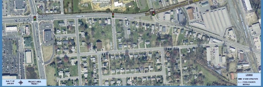
8 COUNCIL COMMITTEE OF THE WHOLE MEETING OF JUNE 28, 2016 PAGE 8 moving the project forward to construction in FY 18, noting that they would like to start construction at approximately this time next year. Mr. John Hermes, Century Engineering, informed members that his firm had been hired by DelDOT to work on the Senator Bikeway and that it was hoped to obtain City Council s support. He reviewed a presentation entitled Senator Bikeway Trail (Attachment #1). Mr. Hermes advised that the western limit of the project would be Route 8 at Dover High School. The goal would be to provide a separated facility so cyclists would not have to ride in the roadway. Mr. Hermes noted that there are currently sidewalks and a multi-use trail on one (1) side of the route; however, this passage is small and not Americans with Disabilities Act (ADA) compliant. He noted that it is ultimately planned to widen the route to feet on both sides of the road from Mifflin Road to Saulsbury Road. Mr. Hermes indicated that the next section of the bikeway would be a hot mix surface extending from Saulsbury Road to the railroad tracks that would include a 10-foot wide facility on the north side of the route. After crossing the railroad tracks, the trail would take the first left onto West Street and north to Fulton Street. It would extend down through Wesley College and continue on Delaware Avenue through the Central Middle School property and connect to Silver Lake Park, where there is an existing pedestrian bridge. Mr. Hermes explained that this route was being considered because there was no good opportunity to cross the river on Division Street using existing facilities. The proposed trail would tie well into the park and would also save the money that would have been needed to construct a new bridge. Mr. Hermes indicated that the trail would continue out to White Oak Road from Silver Lake Park and cross Route 13 at the Dunkin Donuts location, which is an area of high usage. He stated that DelDOT had considered having the trail extend straight on Division Street; however, there were not as many cyclists or pedestrians crossing at that location. Mr. Hermes felt that the proposed route also included more locations that people on the west side go to or come from. Mr. Hermes explained that Capital School District was supportive of the project, as were planning organizations such as the Dover/Kent County Metropolitan Planning Organization (MPO). He indicated that the project was too large to complete all at once and must be broken into phases, noting that multiple meetings would be needed due to the many concerns involved. Referring to page 5 of the presentation, Senator Bikeway Trail - Phase 1, he explained that Phase 1 had been identified as a portion of the route where construction could begin within the next year and also addressed an immediate need in the cycling community. Phase 1 would extend from Saulsbury Road in front of the elementary school and down to West Street, where it would terminate. Mr. Hermes explained that this area was a priority because there are no good pedestrian or bicycle facilities there now, noting that cars drive up to the parking area on this route and the sidewalk is narrow. A 10-foot wide pathway was proposed on the north side of the road from Saulsbury Road to Weston Drive, where there is a new signal. Mr. Hermes advised that they planned to look into landscaping and adding trees north of the pathway to provide shade and greenery where the sidewalk exists today. He stated that the Capital School District was very supportive and loved the idea of better access for those walking to the school.
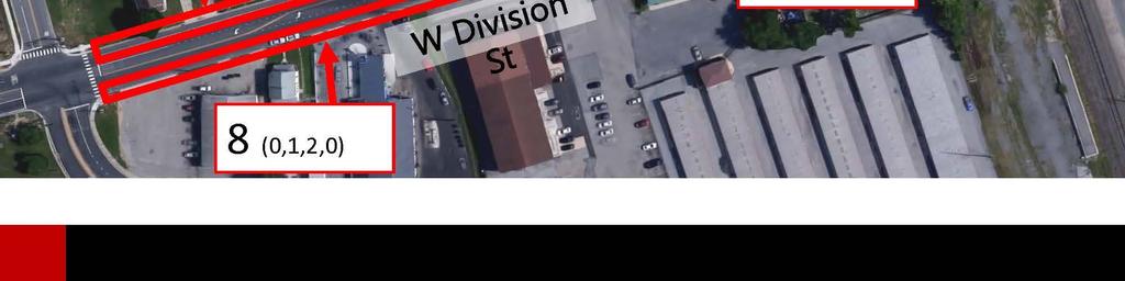
9 COUNCIL COMMITTEE OF THE WHOLE MEETING OF JUNE 28, 2016 PAGE 9 In reference to page 6 of the presentation, Proposed Cross Section - Division Street between Weston Drive and Railroad Avenue, Mr. Hermes informed members that this section of the trail would be key. Referring to pages 7-12, he explained that a parking study was done for the area from Weston Drive to the railroad tracks in conjunction with MPO. It was determined that the parking on the north side of the route is not heavily used, and a multi-use trail was proposed in place of that parking. Mr. Hermes stated this 10-foot-wide, multi-use pathway would use the existing parking on only the north side. This would allow for a three (3) to four (4) foot buffered area with painted striping on the ground and delineators to provide separation between vehicles and bicyclists, while still maintaining sidewalks so that people can walk. Mr. Aglio noted that parking would remain on the south side of the roadway. Mr. Hermes stated that removal of parking is typically a sensitive issue, explaining that a parking study had been done for this area, which contains on-street parking, as well as a substantial amount of off-street parking. He advised that the section from Weston Drive to Railroad Avenue has 22 existing spaces on the north side and 20 on the south. Mr. Hermes stated that they observed the number of spaces being used at different times throughout the day, which were indicated on page 8. For example, between 6:00 a.m. and 7:00 a.m., only five (5) of the 22 spaces on the north side were being used. During the busiest times, less than 50% of the parking was being utilized at any one (1) time. Referring to the pictures taken at various times of the day on pages 9-12, Mr. Hermes pointed out a cyclist in a photo taken between 6:00 p.m. and 7:00 p.m., noting that the cyclist was riding right next to cars and stating the desire to provide protection in this area. In regard to maintenance of the trail, Mr. Hermes stated that there would be additional striping and plastic delineators, noting that DelDOT would maintain the delineators and restore them if hit. He stated that, because this would be a 10-foot wide area plus an additional buffer, a streetsweeper could maintain and navigate this roadway and meet any regulations or requirements. Mr. Hermes indicated that snow removal would be an issue and DelDOT would be responsible for the road in this area. In terms of getting to the extra small 10-foot wide pathway, he stated that they would continue to talk to Mr. Brian Urbanek, Assistant Director, Statewide Support, DelDOT, and DelDOT maintenance in this regard, and there may be a need to use special equipment. Mr. Hermes noted that the idea is that the roadway would remain open and at some time DelDOT would have to get to the cycle track in that area. He indicated that they were looking for support regarding removal of parking on the north side of the trail, reiterating that parking would remain on the south. He stated that they were planning a meeting with property owners on both the north and south sides this month to review the individual locations. Mr. Aglio noted that they met with the funeral home in this area. Mr. Hermes stated that, as part of the MPO s Capital Gateway project, they had reached out to some of the property owners and there had been a positive reaction in general. Property owners had indicated that they like the parking, but were willing for it to be removed and supportive of the project. Mr. Hermes noted that Mr. Aglio had stated that approximately $720,000 had been committed to the project, although Mr. Hermes presentation had indicated $740,000. He reiterated that DelDOT had committed funding to the project, the design was paid for, construction had been set up for next year, and the City of Dover would not have to spend money this year to implement the project. Mr. Hermes advised that this was the first of many phases, the concept would be continuous, and as soon as this phase is complete they hoped to move right into the next phase. He
10 COUNCIL COMMITTEE OF THE WHOLE MEETING OF JUNE 28, 2016 PAGE 10 indicated that the next phase had not yet been determined; however, it would also be within this corridor, noting that this was dependent upon various factors, such as right-of-way, permitting, and approval from these committees. Mr. Slavin thanked Mr. Aglio, Mr. Hermes, and members of the Bicycle and Pedestrian Subcommittee for their continued work on this project. He believed it was a nice vision and he was glad to see it coming together. Mr. Slavin questioned the location of the existing pedestrian bridge where the trail would cross the St. Jones River. Responding, Mr. Aglio explained that the crossing of the river at the bridge in Silver Lake Park would be used. He noted that the crossing may need to be upgraded or widened; however, the permitting would be much less significant than creating a new bridge. Mr. Aglio advised that the trail would be brought around the back of the middle school and cross one (1) private property. Mr. Hermes explained that there are two (2) utility crossings that pedestrians walk over along Division Street that are encased in concrete. They had considered trying to make use of these crossings or putting a new structure next to them, but the cost was substantial. Mr. Hermes indicated that the existing utility concrete walkways could not be used for bridges. Mr. Slavin stated that he had been concerned that the crossing next to the Division Street bridge was being discussed. Responding, Mr. Hermes stated that, in the long term, they would like to see a bridge there; however, this would have to be a separate structure, and there is a utility and a lot of other concerns there. This had not been ruled out; however, currently they felt that connecting the school to the park and having easier access to White Oak Road would be beneficial. Mr. Aglio noted that the school has an outdoor classroom next to the river that they access and they thought the trail would help students get to and from this location. In response to Mr. Hosfelt, Mr. Hermes stated that members would like a recommendation that this initiative move forward to Council. Mr. Scott Koenig, City Manager, recommended that the Committee and Council endorse the concepts of the Senator Bikeway Trail. He noted that there would be public hearings and the plan would be refined so that construction could hopefully begin next summer. Mr. Koenig stated the desire to continue the momentum of funding going into the capital city from DelDOT. He indicated that there had been a lot of road investment, and now off-road investment was occurring. Mr. Koenig noted that there are a lot of other investments that the City would like DelDOT and the State to make in the City. He expressed his understanding that there would be maintenance obligations for the City at some point because some of the off-road alignment would be on City streets, and the City would likely take on maintenance responsibilities in City parks. Mr. Koenig advised that there had been in-depth discussion about the crossing of the St. Jones River and the concerns with attaching any type of bridge structure to the utility crossings. While this sounded like a good idea at first, in the end none of the engineering staff supported this concept because of the potential for failure and having to take the structure down for maintenance. Mr. Koenig stated that the proposed alignment, while it creates a bend back through the park, is ultimately a better design than going along the road right-of-way. DelDOT had confirmed that the correct crossing of
11 COUNCIL COMMITTEE OF THE WHOLE MEETING OF JUNE 28, 2016 PAGE 11 Route 13, based on current traffic, would be at White Oak Road versus Route 8, which supported using the school property, going through the City park, coming back out onto King s Highway, and ultimately crossing at White Oak Road. Mr. Koenig stated that the numbers were starting to indicate that the proposed concept would benefit the City in many ways. Mr. Cole moved to recommend acceptance of the Bicycle Pedestrian Subcommittee recommendations and moving forward with the Senator Bikeway design concept. The motion was seconded by Mr. Hutchison. Mr. Keller questioned how many bicycles were anticipated on the trail. Responding, Mr. Aglio estimated a few hundred per day. The motion to recommend acceptance of the Bicycle Pedestrian Subcommittee recommendations and moving forward with the Senator Bikeway design concept was carried with Mr. Anderson abstaining. Quarterly Update - Bicycle/Pedestrian Subcommittee Mr. Hosfelt referred members to the Bicycle/Pedestrian Subcommittee Quarterly Update - June Re-Evaluation of the Need for the Blue Light Phones in City Parks Mr. Scott Koenig, City Manager, advised members that over Memorial Day Weekend, the City experienced problems with one (1) of the blue light phones in Silver Lake Park, which was repeatedly dialing the 911 Center for the Dover Police Department and could not be reset. The Electric Department used on-call staff to cut the power to the phone to prevent it from dialing 911. Mr. Koenig indicated that software and systems that support the phones had not been updated since the phones were installed, and he felt that the manufacturer would recommend investing additional funds if the phones were kept in place. Mr. Koenig stated that the Police Department had provided information regarding the total calls for service from the five (5) blue light phones, including hang-ups, and the history revealed that there were not many calls. Since 2007, there had been a total of five (5) legitimate calls through Memorial Day Weekend All of the legitimate calls were from Silver Lake Park, three (3) from the beach area and two (2) from the boat ramp area. Those five (5) calls represented distress requests within a City park. Mr. Koenig stated it was important to note that Silver Lake Park was the only park that had received any type of calls and no other park had received any legitimate calls in the time frame. Based on the history and the evolution and availability of cellular phones, staff requested that Council consider that this program be discontinued. Mr. Koenig indicated that if Council would like to discontinue this program in phases, staff recommended removing the phones that had no legitimate calls over the time frame, which would potentially provide parts to repair the existing phones. He advised that Ms. Kay Dietz-Sass, Emergency Management Coordinator, had found literature indicating that the institutions that initiated this type of safety measure, predominantly on college campuses, were starting to gravitate away from these systems. They were being discontinued due to the availability of cell phones, GPS applications, and apps that direct dial to 911 services, as well as the fact that long-term maintenance of these facilities is expensive. Although the City was
12 COUNCIL COMMITTEE OF THE WHOLE MEETING OF JUNE 28, 2016 PAGE 12 only paying approximately $1,000 per year, if there was a need for maintenance upgrades, hardware upgrades, or repairs, these costs could be fairly substantial. Mr. Koenig indicated that the actual cost for installation had been several thousand dollars for each device. He reiterated that this issue arose due to failure of components in the existing system that created discomfort in the 911 Center. After looking at legitimate calls versus costs and potential cost on the horizon to maintain the system, staff recommended eliminating the program over time or removing the system in its entirety within a 90-day window. Mr. Sudler questioned if a study had been done regarding how many people had used their cell phones in emergency situations at the parks versus the blue light phones. Responding, Mr. Koenig stated that he did not have that information available. He assumed that the 911 Center could provide the information; however, it had not been requested. Mr. Sudler expressed concern regarding how homeless individuals or those who do not own cell phones could make emergency calls. Mr. Anderson noted there were approximately 18 calls in the Silver Lake area and no calls from anywhere else. He questioned if Mr. Koenig would be amenable to phasing out the phones at Silver Lake Park at the end of the calendar year because summer is a busy time. This would also provide notice that the City was eliminating the phones. Responding, Mr. Koenig stated that the two (2) phones in White Oak Park were not being used and he would like them removed first if a regression in the use of the phones was desired. He indicated that the phones at Silver Lake Park could stay in use until there are real problems and the parts cannot be replaced. Mr. Anderson noted that the cost of the phones was approximately $50 per call, stating that he personally would not mind phasing them out at the end of the year. He advised that he would like people to have some notice and for the phones to remain in place during the busy season for calls. In response to Mr. Koenig, Mr. Anderson stated that he was discussing only the phones at Silver Lake Park. Mr. Koenig stated that they could be phased out over the next six (6) months and some type of notice, such as Facebook or Twitter, could be provided. Responding to Mr. Anderson regarding any concerns the Police Department may have, Captain David Spicer stated that the Police Department had researched this matter and determined that they had received very few legitimate calls. Even though there were 18 calls in 2015, many of those were hang-ups or malfunctions from emergency phones. Captain Spicer noted that there were only five (5) legitimate calls in the last 10 years, some of which were related to subjects in distress lying on the ground and possibly not breathing, etc. He noted that three (3) of the phones had no usage at all. Captain Spicer advised that the phones had become a nuisance and a hindrance that tied up a lot of personnel at the 911 Center. Mr. Slavin recalled that former Councilman Ken Hogan had sponsored the blue phone effort, which was implemented during a spike in the availability of cell phones. Mr. Slavin questioned if calls were transmitted through hard wiring or cellular calls, and Mr. Koenig stated his understanding that calls are cellular.
13 COUNCIL COMMITTEE OF THE WHOLE MEETING OF JUNE 28, 2016 PAGE 13 Responding to Mr. Slavin, Mr. Koenig indicated that the calls are transmitted using cellular technology. He also responded that the infrastructure could potentially be used for cameras at the sites. Mr. Koenig advised that if there are legitimate camera locations, they would be considered whether the phones are removed or not. Mr. Slavin stated that while the infrastructure may not be used for phones, they provide a sense of security and access, and he felt that these lights allow people to feel a little safer when they are in a park. Rather than obliterating what the City has there as a safety presence, he suggested giving thought to reverse engineering the infrastructure and replacing it with something else. Mr. Shelton indicted that 92% of the population have cell phones; therefore, 8% of the population do not have cell phones. He expressed concern that there would be no avenue for them to contact someone if they did encounter a problem. Mr. Shelton felt that phasing the phones out would be a good idea; however, he felt there should be another method in place for people to feel comfortable and secure. Mr. Sudler asked Captain Spicer if they had data regarding the total number of calls over the last 10 years. Captain Spicer reiterated that 18 calls were logged; however, there may have been 20 to 30 malfunction calls with that particular unit which were not logged. Although five (5) calls were listed for 2016, Ms. Christina Kober, 911 Supervisor, Dover Police Department, advised him that she had documented 20 to 30 malfunctions along with those five (5) calls. Mr. Sudler stated that there was nothing in place to protect those who do not own cell phones and might be in an emergency situation. He noted that many homeless individuals sleep in these parks and need an avenue to call for help. Mr. Sudler felt that until there was some method to protect them, he was not confident in phasing out blue phone access for emergencies. Mr. Sudler moved to refer this matter to the Parks, Recreation, and Community Enhancement Committee with a comparison and analysis of data regarding blue phone usage versus the number of emergency cell phone calls received over the last five (5) years. The motion was seconded by Mr. Anderson. Responding to Mr. Hare s request for clarification, Mr. Anderson stated that the cost of $50 per call was arrived at by dividing the maintenance cost by the number of calls received. In response to Mr. Hare regarding the actual cost of the phones, Mr. Koenig indicated that the total cost of the phone lines was between $950 and $1,050 per year, noting that this did not include repairs, since no repairs had been done. He indicated that the City was spending approximately $1,000 per year on the phone line access for the five (5) phones, or approximately $200 per phone. Mr. Slavin indicated that if this matter were referred to the Parks, Recreation, and Community Enhancement Committee, consideration might be given to leaving one (1) phone in place in one of the more high profile areas. This might ameliorate some of members concerns, and repairs could be made utilizing parts from the items taken out of circulation.
14 COUNCIL COMMITTEE OF THE WHOLE MEETING OF JUNE 28, 2016 PAGE 14 The motion to refer this matter to the Parks, Recreation, and Community Enhancement Committee with a comparison and analysis of data regarding blue phone usage versus the number of emergency cell phone calls received over the last five (5) years was unanimously carried. Updates Hamlet Shopping Center Mr. Sudler stated that the majority of the business owners/managers in the Hamlet Shopping Center had not had any major concerns and, according to them, crime, loitering, and panhandling had decreased. He indicated that they preferred the police presence in the parking area and appreciated the City s efforts to provide additional security in that area. Captain David Spicer, Dover Police Department, indicated that he had asked the crime analyst, Mr. Robert Scott, to pull the numbers for the Hamlet and areas surrounding the shopping center. Captain Spicer indicated that in 2014 there were 41 reported crimes in that area, including assault, criminal mischief, disorderly conduct, local fugitives who were wanted, firearm possession, robberies, and trespassing. In 2015 there was an increase to 88 reported crimes, including criminal mischief, local fugitives, 17 thefts, assaults, burglaries, a reported carjacking, and disorderly conduct. In 2016, there were 29 reported crimes. Captain Spicer stated that this trend would result in approximately 70 crimes by the end of this year, which would be slightly lower than last year s numbers. The crimes being experienced included an assault, three (3) burglaries, and three (3) juveniles apprehended for daytime burglaries. He noted that there are continual incidences of disorderly conduct and shoplifting. Responding to Mr. Hosfelt, Captain Spicer explained that these statistics also included the Hamlet residential area located behind the shopping center. He stated that he had been advised by Mr. Scott that patrols had been increased due to issues with crime in the area and as a result of Joint Finance Committee funding received by the Dover Police Department. Captain Spicer noted that Lieutenant Christopher Hermance indicated that there had been 256 additional man-hours spent patrolling in this area, which is considered the 860 district. He noted that the Police Department had taken a proactive approach to try to reduce crime in the shopping center and surrounding area. Mr. Sudler asked if there had been a decrease in crime from 2015 to 2016 in the Hamlet Shopping Center. Responding, Captain Spicer indicated that crime had decreased. Mayor Christiansen stated that he had spoken to a number of business owners and shoppers in this area. He commented that the parking lot was in atrocious condition and needed re-striping and the handicapped signs needed to be redone. Mayor Christiansen advised that a number of those who live in the Hamlet area had indicated that tractor-trailers were parking overnight or for days at a time. He questioned if there was an ordinance in place that could address that issue. Responding, Captain Spicer stated his belief that there was an ordinance that prohibits tractor-trailers from parking on a City street; however, he believed that they do have a right to park on private property as long as the business owners do not disagree with them.
15 COUNCIL COMMITTEE OF THE WHOLE MEETING OF JUNE 28, 2016 PAGE 15 Mayor Christiansen indicated his belief that there was a concern among the shoppers, business owners, and landlords. Captain Spicer stated that staff could contact the businesses, noting that if the issues are brought to the attention of the Police Department, the Department can take appropriate action or advise them on what to do. If they want vehicles to be towed, those affected would have to tow the vehicles, and this would not be the Police Department s obligation. Mr. Hare stated, from his experience, that this would be the responsibility of the property owner. The businesses may not like the tractor-trailers parked there; however, the owner may have granted them permission to park their trucks on the outskirts. The Elks Lodge North Kirkwood Street Mr. Sudler informed members that residents of the Kirkwood community continue to deal with loitering, loud noise, and patrons from the Elks Club having sex in their yards, often leaving condoms, bottles, and debris. He had continued to assure them that the Safety Advisory and Transportation Committee and the Parks, Recreation, and Community Enhancement Committee had heard their concerns and were working with staff regarding amendments to the current ordinance relating to properties with non-conforming uses. Mr. Sudler advised that the Kirkwood Neighborhood Watch Committee continued to meet regularly. In their last meeting, Senator Brian Bushweller, Representative Sean Lynn, City Council President Tim Slavin; Mrs. Ann Marie Townshend, Director of Planning and Community Development; and Councilman Anderson, were all present to hear the intensity of Kirkwood residents cries for relief from the Elks Lodge, especially on Sunday evenings into early Monday mornings. Mr. Sudler stated that the Kirkwood community and surrounding areas had confidence that the City would provide relief within a reasonable time frame. Captain David Spicer, Police Department, stated that Mr. Robert Scott ran complaints for 2014, 2015, and 2016, and there were 18 complaints associated with the Elks Lodge on North Kirkwood Street. There were burglary alarms in 2014, disorderly conduct, resisting arrest, trespassing, and a weapon violation. In 2015, there were 26 reported crimes, including an accident, criminal mischief, disorderly conduct, a couple of fights, eight (8) loitering complaints, and two (2) shots fired. In 2016, there had been three (3) criminal complaints, including two (2) disorderly conduct and one (1) loitering complaint. Captain Spicer indicated that the only explanation he could offer was that, because of funding received from the Joint Finance Committee, much of the Police Department s attention had been focused in the 820 district due to the loitering and problems in the North New Street and Fulton Street areas. So far this year, approximately 800 additional man-hours had been spent on Fulton Street, Kirkwood Street, and the surrounding area. Captain Spicer felt that the police presence there had dramatically decreased crime. He believed that these three (3) complaints would probably coincide with the three (3) complaints documented so far at the Elks Club. Mr. Hare stated his understanding that the police officers had been working two (2) hour shifts in front of the Fulton Deli, noting that the street now looked deserted. He stated his understanding that a rental permit could be revoked for criminal violations and asked if a business license be revoked for continual criminal violations. Mr. Koenig stated that he was unsure if a business license could be revoked for that reason.
16 COUNCIL COMMITTEE OF THE WHOLE MEETING OF JUNE 28, 2016 PAGE 16 Noting that Captain Spicer had mentioned that there were only three (3) complaints in this area, Mr. Sudler stated that he had called at least three (3) times himself this year in regard to the Elks Lodge and residents and members of the Kirkwood Community Neighborhood Watch had also made calls. Mr. Sudler asked how complaints were defined and if they include calls received or incidents where an officer stops individuals and finds something wrong. Responding, Captain Spicer explained that if someone calls, the dispatcher may record the call as the address that the call comes from rather than the Elks Lodge and this could explain why complaints might not be shown for the actual business. If an officer rides by and sees people loitering outside the Elks Lodge, takes appropriate enforcement action, finds there is a crime, and takes someone into custody, the business address would be logged as the location of the arrest and associated with the crime. Mr. Sudler advised that the Police Department is short staffed and may have 11 officers each night for 38,000 people, stating that he advocates more officers. He questioned if live data, including the time, is provided to the Police Department. Mr. Sudler indicated this would show that managers of the club were present, seeing those loitering, and not doing anything proactively to get them to come into the club. He noted that the management had argued that once individuals are on the sidewalk, they are the Dover Police Department s responsibility; however, according to the Department of Justice, it was management s responsibility as well because they are the magnet bringing patrons there. Mr. Sudler felt that if managers were not being proactive, the City needed to put something in place to hold them accountable. He believed this was unfair to the residents and the Police Department. Captain Spicer indicated that Police Chief Paul Bernat had made adjustments in personnel and expended the Department s Street Crimes Unit, which is a very busy and aggressive unit. Captain Spicer advised that this area has a lot of loitering and drug activity. He stated that, year-todate for the City, there had been 56 burglaries and 41 had been solved, which was a 78% clearance rate. Captain Spicer advised that there had been 33 robberies this year and 27 had been cleared, for an 82% clearance rate. There had been 17 separate shootings, including10 in the downtown area, and 35% of those had been cleared. Captain Spicer noted that these incidents are sometimes very difficult to figure out and officers do not receive a lot of cooperation from some of those injured or the witnesses. In addition, 43 firearms had been seized in the City so far this year, including handguns and other types of weapons. Captain Spicer informed members that the men and women of the Dover Police Department were working extremely hard to make the City safer. Viability of the ShotSpotter Gunshot Detection and Location Service This item was deferred due to time constraints. Mr. Neil moved for adjournment of the Safety Advisory and Transportation Committee meeting, seconded by Mr. Keller and unanimously carried. Meeting adjourned at 7:22 p.m.
17 COUNCIL COMMITTEE OF THE WHOLE MEETING OF JUNE 28, 2016 PAGE 17 LEGISLATIVE, FINANCE AND ADMINISTRATION COMMITTEE The Legislative, Finance, and Administration Committee meeting was held with Chairman Hare presiding. AGENDA ADDITIONS/DELETIONS Mr. Sudler moved for approval of the agenda, seconded by Mr. Cole and unanimously carried. Fiscal Year Edward Byrne Justice Assistance Grant Program - Joint Grant with Smyrna Police Department and Kent County The Dover Police Department recently received its annual allocation from the Office of Justice Programs (OJP) for the 2016 Justice Assistance Grant (JAG). Similar to previous years, Dover Police Department was identified as a disparate funding agency along with Smyrna Police Department and Kent County. This disparate condition requires the submission of a joint grant application for the three agencies. Although no funds were designated for Kent County in the allocation document, a Memorandum of Understanding will be completed and signed by all three agencies and will state that Kent County will waive any claim to funding on the grant. The Dover Police Department will serve as the fiscal and administrative agent for the grant. Responding to Ms. Stewart regarding the cost of maintenance for the system, Mr. Koenig stated that the costs would be relatively small for the added infrastructure; however, he cautioned that these numbers add up over time. He explained that these grants usually provide an opportunity to expand technology, but there is also an associated maintenance cost, just as when streets are added. Mr. Koenig advised that the police infrastructure was growing, so there would be expenses that would impact the City budget at some point. Mayor Christiansen noted that there would also be an opportunity to reapply for the grant funds, noting that this is an ongoing grant. Mr. Koenig stated that the grant program was important to expanding the technology and service infrastructure; however, there is a cost to the City budget at some point. Mr. Anderson questioned if the City would want to acquire this particular technology if the grants were not available. Responding, Mr. Koenig stated that it would; however, the question was whether the City should have to spend $100 of City money versus $10 of City money to get the same net effect. He advised that the City of Dover had been very good about applying for grants, obtaining the technology, closing out the grants, and accounting for all of the money, noting that additional procedures are required when grant funds are obtained. Mr. Koenig indicated that, because of the size of the Police Department and the dedication and ability of staff, the City is able to fill out grant applications, advocate for grants, and receive them. He felt there was no question that, of all the City departments, the Police Department was probably the highest priority when it comes to getting grants. Mr. Koenig stated that there are many grants available to law enforcement, so this is part of the funding technique for that type of service.
18 COUNCIL COMMITTEE OF THE WHOLE MEETING OF JUNE 28, 2016 PAGE 18 Mr. Neil moved to approve the grant project as requested, seconded by Mr. Anderson and unanimously carried. Discussion - Fiscal Year Audit Program Mrs. Donna Mitchell, Controller/Treasurer, reviewed a presentation entitled Auditor s Responsibility for Communicating with Audit Committee. Referring to page 3, Mrs. Mitchell reviewed the three (3) primary purposes of the auditors and the significant findings from the audit on page 6. She noted that the audit calendar was provided so that members would be aware of the tentative schedule for completing the audit this year. Actuary Services Contract - Pension and Other Post-Employment Benefits (OPEB) Members were advised that the Finance Department requested proposals for Actuarial Services on May 5, 2016 (RFP # FN). In order to continue efficiencies in preparing the data and cost savings, the RFP requested that each actuary perform valuation services for both the Civilian and Police Pension Plans and the Other Post Employment Benefits (OPEB). Mrs. Mitchell advised members that the RFP resulted in a proposed change from the City s current actuary, Milliman, Inc., due to the significant difference in prices submitted. She explained that Milliman, Inc. provides investment advisory services to the City through another arm of their company, and this investment service would stay intact. Mrs. Mitchell explained that Nyhart Actuary & Employee Benefits had provided actuary services for the City when the OPEB trust began and prior to the City s contract with Milliman, Inc. Staff recommended awarding a five (5) year contract, to begin in FY17 and end in FY21, to Nyhart for valuation services totaling $96,700 and hourly rates for benefits consulting as quoted in their response to the City of Dover RFP # FN Pension & Other Post Employment Benefits Actuarial Services and Benefits Consulting. Mr. Neil moved to recommend approval of staff s recommendation, seconded by Mr. Hosfelt and unanimously carried. Mr. Neil moved for adjournment of the Legislative, Finance, and Administration Committee meeting. The motion was seconded by Mr. Cole and unanimously carried. Meeting adjourned at 7:29 p.m. By unanimous consent, the Council Committee of the Whole meeting adjourned at 7:29 p.m. Timothy A. Slavin Council President TAS/TM/js/dd/tm S:\AGENDAS-MINUTES-PACKETS-PRESENTATIONS-ATT&EXH\Committee-Minutes\2016\ CCW.wpd Attachments Attachment #1 - Presentation - Senator Bikeway Trail


19 ATTACHMENT #1 Council Committee of the Whole Meeting of 06/28/2016 Senator Bikeway Trail Welcome

20 Senator Bikeway Trail Agenda Project Overview Phase 1 Key Elements


21 Senator Bikeway Trail

22 Senator Bikeway Trail /


23 Senator Bikeway Trail Phase 1 /


24 Senator Bikeway Trail

25 Senator Bikeway Trail


26 Senator Bikeway Trail


27 Senator Bikeway Trail


28 Senator Bikeway Trail


29 Senator Bikeway Trail


30 Senator Bikeway Trail

 DelDOT has Construction Funding ($740")
31 Senator Bikeway Trail Project Highlights Maintenance Proposed Removal of North Side Parking Future Meeting with Properties (July 2016) DelDOT has Construction Funding ($740 K) for 2017
SAFETY ADVISORY AND TRANSPORTATION COMMITTEE A G E N D A
 SAFETY ADVISORY AND TRANSPORTATION COMMITTEE A G E N D A October 13, 2004-7:00 P.M. Public Assembly Room - 400 S. Queen Street - Dover Public comments are welcomed on any item and will be permitted at
SAFETY ADVISORY AND TRANSPORTATION COMMITTEE
 SAFETY ADVISORY AND TRANSPORTATION COMMITTEE The Safety Advisory and Transportation Committee Meeting was held on June 26, 2013, at 5:07 p.m. with Chairman Hutchison presiding. Members present were Mr.
NORTH HIGHLAND LAKE ROAD PROJECT
 NORTH HIGHLAND LAKE ROAD PROJECT The purpose of this special newsletter is to inform the residents of Flat Rock about the facts concerning the proposed N. Highland Lake Road Project and clarify some misconceptions.
Lee s Summit Road Improvement Study Public Open House June 7, 2007 Summary of Comment Card Responses
 Lee s Summit Road Improvement Study Public Open House June 7, 2007 Summary of Comment Card Responses Introduction At the Lee s Summit Road Improvement Study Public Open House held Thursday, June 7, 2007
Town of Mooresville, North Carolina Neighborhood Traffic Calming and Control Device Policy
 Town of Mooresville, North Carolina Neighborhood Traffic Calming and Control Device Policy Adopted January 6, 2014 Town of Mooresville Development Services Department TOWN OF MOORESVILLE NEIGHBORHOOD TRAFFIC
AGENDA REPORT. Issue: Discussion of potential improvements on Barnwell Road at Niblick Drive
 AGENDA REPORT To: From: By: Honorable Mayor and City Council Members Warren Hutmacher, City Manager Tom Black, Public Works Director Date: March 23, 2016 Agenda: March 28, 2016 WORK SESSION AGENDA: Barnwell
CONNECTING PEOPLE TO PLACES
 CONNECTING PEOPLE TO PLACES 82 EAST BENCH MASTER PLAN 07 Introduction The East Bench transportation system is a collection of slow moving, treelined residential streets and major arteries that are the
Pennsylvania Avenue (CR 484) Design Alternatives Study
 Design Alternatives Study") MEMORANDUM Pennsylvania Avenue (CR 484) Design Alternatives Study Prepared for: APRIL 2016 Prepared By TABLE OF CONTENTS Project Background... 2 Previous Concept... 2 Existing Conditions... 4 New Alternatives...
MEMORANDUM Pennsylvania Avenue (CR 484) Design Alternatives Study Prepared for: APRIL 2016 Prepared By TABLE OF CONTENTS Project Background... 2 Previous Concept... 2 Existing Conditions... 4 New Alternatives...
Appendix C. TRAFFIC CALMING PROGRAM TOOLBOX
 Appendix C. TRAFFIC CALMING PROGRAM TOOLBOX PHASE I...2 Do Not Enter Sign...3 One-Way Sign...4 Turn Prohibition...5 Pavement Markings...6 Speed Monitoring Trailer...7 Neighborhood Speed Watch...8 Police
Corpus Christi Metropolitan Transportation Plan Fiscal Year Introduction:
 Introduction: The Safe, Accountable, Flexible, Efficient Transportation Equity Act: A Legacy for Users (SAFETEA-LU) has continued the efforts started through the Intermodal Surface Transportation Efficiency
Agenda. Overview PRINCE GEORGE S PLAZA METRO AREA PEDESTRIAN PLAN
 PRINCE GEORGE S PLAZA METRO AREA PEDESTRIAN PLAN May 28, 2008 Agenda Welcome and introductions Project overview and issue identification Planning context and strengths Design challenges and initial recommendations
CITY OF SAINT JOHN TRAFFIC CALMING POLICY
 CITY OF SAINT JOHN TRAFFIC CALMING POLICY VERSION: 1.0 April 10, 2012 Pedestrians, Cyclists and Motorists Sharing Street Spaces CONTENTS INTRODUCTION... 3 POLICY GOAL... 3 POLICY OBJECTIVES... 3 GUIDING
Bicycle/Pedestrian Subcommittee
 Bicycle/Pedestrian Subcommittee Tuesday, September 5, 2017 5:00 pm 6:00 pm Large Conference Room, City Hall Dover, DE DRAFT AGENDA Agenda Meeting Minutes of June 2017 Old Items 1. PeopleforBikes Potential
CITY OF VISTA TRAFFIC CALMING PROGRAM
 CITY OF VISTA TRAFFIC CALMING PROGRAM The purpose of the Vista Traffic Calming Program is to reduce speeds of motorists driving through residential neighborhoods. The program does not apply to nonresidential
City of Novi Non-Motorized Master Plan 2011 Executive Summary
 City of Novi Non-Motorized Master Plan 2011 Executive Summary Prepared by: February 28, 2011 Why Plan? Encouraging healthy, active lifestyles through pathway and sidewalk connectivity has been a focus
AGENDA ITEM SUMMARY SPECIAL AGENDA ITEM NO. _1A_
 AGENDA ITEM SUMMARY AGENCY: City Council MEETING DATE: June 25, 2012 DEPARTMENT: Community Dev PREPARED BY: T Spade DEPT. DIR. APPROVAL: MJ CITY MGR. APPROVAL: LR PRESENTED BY: T Spade TITLE: RECEIVE REPORT
Bikeway action plan. Bicycle Friendly Community Workshop March 5, 2007 Rochester, MN
 Bikeway action plan Summary The was held on March 5, 2007 at the Rochester Mayo Civic Center. The workshop was hosted by Rochester-Olmsted County Planning Department in collaboration with the League of
Item No. 14 Town of Atherton
 Item No. 14 Town of Atherton CITY COUNCIL STAFF REPORT CONSENT AGENDA TO: THROUGH: FROM: HONORABLE MAYOR AND CITY COUNCIL GEORGE RODERICKS, CITY MANAGER MICHAEL KASHIWAGI, COMMUNITY SERVICES DIRECTOR MARTY
MAG Town of Cave Creek Bike Study Task 6 Executive Summary and Regional Significance Report
 Page 1 MAG Town of Cave Creek Bike Study Task 6 Executive Summary and Regional Significance Report August 1, 2012 MAG Project #481 Page 2 Task 6 Executive Summary and Regional Significance Report Introduction
Gordon Proctor Director Policy on Accommodating Bicycle and Pedestrian Travel on ODOT Owned or Maintained Facilities
 Approved: Policy: 20-004(P) Responsible Office: Planning Gordon Proctor Director Policy on Accommodating Bicycle and Pedestrian Travel on ODOT Owned or Maintained Facilities I. POLICY STATEMENT: This policy
DRAFT. Table of Contents. Background
 Douglas County Table of Contents Existing Infrastructure 86 Funding 89 Policy and Program Recommendations 90 Infrastructure Recommendations 92 Conclusion 95 Background Home to 4,500 residents and Baker
Living Streets Policy
 Living Streets Policy Introduction Living streets balance the needs of motorists, bicyclists, pedestrians and transit riders in ways that promote safety and convenience, enhance community identity, create
Tonight is for you. Learn everything you can. Share all your ideas.
 Strathcona Neighbourhood Renewal Draft Concept Design Tonight is for you. Learn everything you can. Share all your ideas. What is Neighbourhood Renewal? Creating a design with you for your neighbourhood.
Summary of Comments Public Meeting: Marietta Street Resurfacing Project Atlanta Contemporary August 29, 2017 / 6:00 pm to 8:00 pm
 Renew Atlanta hosted a public meeting to discuss the Marietta Street Resurfacing project at. Councilmember Cleta Winslow attended the public meeting, where over seventy (70) citizens to include representatives
Broad Street Bicycle Boulevard Design Guidelines
 Broad Street Bicycle Boulevard Design Guidelines Building from the strategies introduced in the 2013 Bicycle Transportation Plan and community input received thus far, City Transportation Staff have identified
COUNCIL COMMITTEE OF THE WHOLE SAFETY ADVISORY AND TRANSPORTATION COMMITTEE
 COUNCIL COMMITTEE OF THE WHOLE The Council Committee of the Whole Meeting was held on February 28, 2017 at 6:00 p.m., with Mr. Hare presiding in the absence of Council President Slavin. Members of Council
PEDESTRIAN ACTION PLAN
 ATTACHMENT 2 CITY OF SANTA MONICA PEDESTRIAN ACTION PLAN CITY OF SANTA MONICA PEDESTRIAN ACTION PLAN This page intentionally left blank EXECUTIVE SUMMARY CHAPTER 1 EXECUTIVE SUMMARY Setting the Stage
AGENDA ITEM NO. 5b HCAOG TAC meeting of May 8, 2014
 Humboldt County Association of Governments Eureka, CA, 95501 AGENDA ITEM NO. 5b HCAOG TAC meeting of May 8, 2014 DATE: May 1, 2014 TO: HCAOG Technical Advisory Committee (TAC) FROM:, SUBJECT: Letters of
Bicycle/Pedestrian Subcommittee. Tuesday, February 7, :00 pm 6:00 pm Large Conference Room, City Hall Dover, DE AGENDA
 Bicycle/Pedestrian Subcommittee Tuesday, February 7, 2017 5:00 pm 6:00 pm Large Conference Room, City Hall Dover, DE AGENDA Welcome Approval of Agenda Approval of Meeting Minutes Old Business Items: o
Governance and Priorities Committee Report For the July 2, 2015 Meeting
 CITY OF VICTORIA For the July 2, 2015 Meeting To: Governance and Priorities Committee Date: From: Subject: Brad Dellebuur, A/Assistant Director, Transportation and Parking Services Executive Summary The
Pattullo Bridge Replacement Project Community Connections Phase 2 Consultation. Appendix 3: Open House Display Boards
 Replacement Project Community Connections Phase 2 Consultation Appendix 3: Open House Display Boards November 2016 Welcome! Welcome to the Replacement Project Public Open House We Want to Hear from You
Welcome. Thank you for your interest in the Lewis & Clark Viaduct Concept Study
 Welcome Thank you for your interest in the Lewis & Clark Viaduct Concept Study Please use the arrows in the upper left hand corner to navigate through the presentation. Use the envelope icon to ask a question
Draft North Industrial Area-Wide Traffic Plan
 Summary of North Industrial and Hudson Bay Industrial Recommended Improvements Table 1. Summary of s Item Location 1 2 3 4 5 6 7 8 9 10 11 12 Millar Ave north of 51st St Super 8 Motel back lane 400 Block
Improve the livability of our streets by
 Pedestrian and Traffic Calming Policy March 2018 2 of 6 Neighborhood Traffic Calming Policy The City of Aspen continually strives to protect multimodal function while maintaining a high standard of safety.
Chapter 5. Complete Streets and Walkable Communities.
 Chapter 5. Complete Streets and Walkable Communities. 5.1 Description of Complete Streets. Cities throughout the world, and specifically the United States, are coming to embrace a new transportation and
Bicycle/Pedestrian Subcommittee
 Bicycle/Pedestrian Subcommittee Tuesday, August 2, 2016 5:00 pm 6:00 pm Large Conference Room, City Hall Dover, DE Welcome Approval of Agenda Revised Agenda Approval of Meeting Minutes (May & June) Discussion
Introduction. Who is WILMAPCO. Why are walkable communities important
 Walkable Community Workshops Round 1 April 2005 SPONSORED BY WILMAPCO AND CCOBH CITY OF NEW CASTLE EDGEMOOR GARDENS CIVIC ASSOCIATION WITH FUNDING BY DELAWARE DEPARTMENT OF TRANSPORTATION AND THE DELAWARE
APPENDIX G: INTERSECTION NEEDS AT OKEECHOBEE BOULEVARD
 APPENDIX G: INTERSECTION NEEDS AT OKEECHOBEE BOULEVARD INTERSECTION NEEDS AT SR 7 and OKEECHOBEE BOULEVARD SR 7 Extension Project Development and Environment (PD&E) Study From Okeechobee Boulevard (SR
PRINCE GEORGE S PLAZA METRO AREA PEDESTRIAN PLAN
 PRINCE GEORGE S PLAZA METRO AREA PEDESTRIAN PLAN May 28, 2008 Agenda Welcome and introductions Project overview and issue identification Planning context and strengths Design challenges and initial recommendations
Community Transportation Plan
 Community Transportation Plan Appendix A: Traffic Calming CITY OF DECATUR COMMUNITY TRANSPORTATION PLAN Appendix A: City of Decatur City-wide Residential Traffic Calming Program Process & Procedures The
NEIGHBORHOOD TRAFFIC CALMING POLICY
 NEIGHBORHOOD TRAFFIC CALMING POLICY I. PURPOSE The City of Kent continually strives to strengthen and protect its neighborhoods by improving the quality of life in residential areas. Traffic conditions
Walking & Bicycling Questionnaire for Candidates
 Walking & Bicycling Questionnaire for Candidates This Walking & Biking Questionnaire for State Candidates was developed by Hawaii Bicycling League, Kauai Path, Maui Bicycling League, and PATH - Peoples
CITY OF BLOOMINGTON COMPLETE STREETS POLICY
 CITY OF BLOOMINGTON COMPLETE STREETS POLICY POLICY OBJECTIVE: The City of Bloomington will enhance safety, mobility, accessibility and convenience for transportation network users of all ages and abilities,
City of Elizabeth City Neighborhood Traffic Calming Policy and Guidelines
 City of Elizabeth City Neighborhood Traffic Calming Policy and Guidelines I. Purpose: The City of Elizabeth City is committed to ensure the overall safety and livability of residential neighborhoods. One
EXECUTIVE SUMMARY. Vision
 Vision Walking and bicycling in Salt Lake City will be safe, convenient, comfortable, and viable transportation options that connect people to places, foster recreational and economic development opportunities,
Madison Urban Area and Dane County. Bicycle Transportation Plan Summary. September Introduction. Bicycle Plan Scope and Planning Process
 Bicycle Transportation Plan Summary Madison Urban Area and Dane County Introduction September 2000 Bicycling is an important mode of transportation in the Madison urban area and countywide that is available
Non-Motorized Transportation 7-1
 Non-Motorized Transportation 7-1 Transportation facilities no longer mean just accommodating a vehicle powered by a combustion engine. Pedestrian and non-motorized facilities are important modes of travel
M-58 HIGHWAY ACCESS MANAGEMENT STUDY Mullen Road to Bel-Ray Boulevard. Prepared for CITY OF BELTON. May 2016
 M-58 HIGHWAY ACCESS MANAGEMENT STUDY Prepared for CITY OF BELTON By May 2016 Introduction Missouri State Highway 58 (M-58 Highway) is a major commercial corridor in the City of Belton. As development has
Active Transportation Facility Glossary
 Active Transportation Facility Glossary This document defines different active transportation facilities and suggests appropriate corridor types. Click on a facility type to jump to its definition. Bike
Bay to Bay Boulevard Complete Streets Project
 Bay to Bay Boulevard Complete Streets Project Dale Mabry Highway to Bayshore Boulevard February 08, 2018 Photo Source: Tampa Bay Times Alessandra Da Pra Meeting Format Introduction Resurfacing Information
Portland International Airport Bicycle and Pedestrian Plan (October 2003) Staff Acknowledgements
 Staff Acknowledgements") Portland International Airport Bicycle and Pedestrian Plan (October 2003) Staff Acknowledgements Scott King, Senior Aviation Planner Jason Gately, Senior Aviation Planner Preston Beck, Associate Planner
Portland International Airport Bicycle and Pedestrian Plan (October 2003) Staff Acknowledgements Scott King, Senior Aviation Planner Jason Gately, Senior Aviation Planner Preston Beck, Associate Planner
/ Comment Sheet. . Comment Sheet ( ed in)
") Summary of Content / Comment Sheet Response 1 A) Suggested the following streets be included in review for cut through restrictions: Holyrood Dr and Lawton St. B) In favor of red light camera at Balls
Summary of Content / Comment Sheet Response 1 A) Suggested the following streets be included in review for cut through restrictions: Holyrood Dr and Lawton St. B) In favor of red light camera at Balls
Solana Beach Comprehensive Active Transportation Strategy (CATS)
") Solana Beach Comprehensive Active Transportation Strategy (CATS) 3.0 Goals & Policies The Solana Beach CATS goals and objectives outlined below were largely drawn from the Solana Beach Circulation Element
Solana Beach Comprehensive Active Transportation Strategy (CATS) 3.0 Goals & Policies The Solana Beach CATS goals and objectives outlined below were largely drawn from the Solana Beach Circulation Element
The five potential solutions and some of their benefits and costs are listed in the following table: Ferry Patron Bike Parking Alternatives
 STAFF REPORT City Council of the City of Sausalito AGENDA TITLE: Ferry Patron Bicycle Parking Plan - Summer 2014 RECOMMENDED MOTION: Note and file informational item, no action necessary SUMMARY In April
Bicycle Master Plan Goals, Strategies, and Policies
 Bicycle Master Plan Goals, Strategies, and Policies Mobilizing 5 This chapter outlines the overarching goals, action statements, and action items Long Beach will take in order to achieve its vision of
Executive Summary Route 30 Corridor Master Plan
 Route Corridor Master Plan Project Overview The Route Corridor Master Plan is a coordinated multimodal transportation and land use plan for the entire stretch of Route through East Whiteland Township,
3/10/2016 VIA th Street, Suite 203 Sacramento, CA
 3/10/2016 VIA EMAIL Arwen Wacht, Associate Planner City of Sacramento Community Development Department 300 Richards Boulevard, 3 rd Floor Sacramento, CA 95811 RE: Natomas Fountains (P16-012) Dear Ms. Wacht:
COUNCIL POLICY NAME: COUNCIL REFERENCE: 06/119 06/377 09/1C 10llC 12/1C INDEX REFERENCE: POLICY BACKGROUND
 COUNCIL POLICY NAME: COUNCIL ADVISORY COMMITTEES - TERMS OF REFERENCE ISSUED: APRIL 3, 2006 AMENDED: NOVEMBER 27, 2006 NOVEMBER 23, 2009 JANUARY 11, 2010 DECEMBER 17, 2012 POLICY COUNCIL REFERENCE: 06/119
ACTIVE TRANSPORTATION/NONMOTORIZED TRANSPORTATION
 ACTIVE TRANSPORTATION/NONMOTORIZED TRANSPORTATION BACKGROUND Active transportation, also known as nonmotorized transportation, is increasingly recognized as an important consideration when planning and
Frequently Asked Questions
 Frequently Asked Questions Business US 190 in Copperas Cove From Avenue D to Constitution Drive What is access management? A. Access Management is a growing effort by government agencies to improve how
5.0 Roadway System Plan
 Southwest Boise Transportation Study Page 16 5.0 Roadway System Plan The Roadway System Plan outlines roadway improvements in the Initial Study Area. It forecasts future deficiencies on the arterial system,
PRESS RELEASE San Joaquin Council of Governments
 PRESS RELEASE San Joaquin Council of Governments For Immediate Release February 23, 2018 Contact: Nicole Gorham, 235-0582 gorham@sjcog.org SJCOG Board Awards $19.63 Million in Measure K Bicycle, Pedestrian,
Perryville TOD and Greenway Plan
 Perryville TOD and Greenway Plan Greenway Glossary Pathway: A bicycle and pedestrian path separated from motorized vehicular traffic by an open space, barrier or curb. Multi-use paths may be within the
7/23/2017 VIA . Michael Hanebutt City of Sacramento Community Development Department 300 Richards Boulevard, 3 rd Floor Sacramento, CA 95811
 7/23/2017 VIA EMAIL Michael Hanebutt City of Sacramento Community Development Department 300 Richards Boulevard, 3 rd Floor Sacramento, CA 95811 RE: 65 th Street Apartments (DR17-220) Dear Mr. Hanebutt:
May 12, 2016 Metro Potential Ballot Measure Issue Brief: Local Return
 Summary: Local return is an important revenue source for cities to maintain their local transportation infrastructure. Most cities use their local return to operate small bus systems and repave streets,
5/7/2013 VIA . RE: University Village Safeway Expansion (P13-019)
") 5/7/2013 VIA EMAIL David Hung, Associate Planner Community Development Department, Current Planning Division City of Sacramento 300 Richards Boulevard, 3 rd Floor Sacramento, CA 95811 RE: University Village
5/7/2013 VIA EMAIL David Hung, Associate Planner Community Development Department, Current Planning Division City of Sacramento 300 Richards Boulevard, 3 rd Floor Sacramento, CA 95811 RE: University Village
CITY OF ALBANY TRAFFIC AND SAFETY COMMISSION
 CITY OF ALBANY TRAFFIC AND SAFETY COMMISSION City Hall - Council Chambers 1000 San Pablo Avenue, Albany, CA 94706 Wednesday, November 30, 2016, 7:00 PM 1. CALL TO ORDER The meeting was called to order
TOWN OF PORTLAND, CONNECTICUT COMPLETE STREETS POLICY
 TOWN OF PORTLAND, CONNECTICUT COMPLETE STREETS POLICY I. VISION, GOALS & PRINCIPLES VISION To improve the streets of Portland making them safer and more accessible for all users including pedestrians,
CITY OF COCOA BEACH 2025 COMPREHENSIVE PLAN. Section VIII Mobility Element Goals, Objectives, and Policies
 CITY OF COCOA BEACH 2025 COMPREHENSIVE PLAN Section VIII Mobility Element Goals, Objectives, and Policies Adopted August 6, 2015 by Ordinance No. 1591 VIII MOBILITY ELEMENT Table of Contents Page Number
PROPOSED BICYCLE AND PEDESTRIAN FACILITY Vicinity of Route 123/I-495 Interchange Tysons, Fairfax County, Virginia
 PROPOSED BICYCLE AND PEDESTRIAN FACILITY Vicinity of Route 123/I-495 Interchange Tysons, Fairfax County, Virginia PRELIMINARY ENGINEERING REPORT Prepared for: Prepared by: July 2017 Table of Contents 1
Frequently Asked Questions
 Why is this roadway needed? Can't SR 50, University Boulevard and Aloma Avenue be widened instead of building this road? The need for this roadway was identified and determined through the East Orange
5. Pedestrian System. Accomplishments Over the Past Five Years
 5. Pedestrian System Accomplishments Over the Past Five Years The Alamo Area Metropolitan Planning Organization (MPO) and its partner agencies recognize the importance of improving pedestrian mobility.
CONNECTIVITY PLAN. Adopted December 5, 2017 City of Virginia Beach
 CONNECTIVITY PLAN Adopted December 5, 2017 City of Virginia Beach CONTENTS 1.0 Background & Purpose... 2 2.0 Existing Inventory & Analysis... 3 ViBe District Existing Walking Conditions... 4 3.0 ViBe District
ADA Transition Plan. City of Gainesville FY19-FY28. Date: November 5, Prepared by: City Of Gainesville Department of Mobility
 ADA Transition Plan FY19-FY28 Date: November 5, 2018 Prepared by: City Of Gainesville Department of Mobility 1.0 INTRODUCTION 1.1 BACKGROUND The federal statute known as the Americans with Disabilities
Transportation Policy Manual
 March 4, 2013 EXHIBIT 2 Metropolitan Transportation Planning Organization for the Gainesville Urbanized Area A Comprehensive Guide to Adopted Metropolitan Transportation Planning Organization for the
DRAFT BUENA VISTA 2020 TRANSPORTATION PLAN
 DRAFT BUENA VISTA 2020 TRANSPORTATION PLAN DEVELOPED BY THE TRANSPORTATION PLANNING DIVISION OF THE VIRGINIA DEPARTMENT OF TRANSPORTATION IN COOPERATION WITH THE U.S. DEPARTMENT OF TRANSPORTATION, FEDERAL
TRAFFIC CALMING GUIDE FOR TORONTO CITY OF TORONTO TRANSPORTATION SERVICES DIVISION
 TRAFFIC CALMING GUIDE FOR TORONTO CITY OF TORONTO TRANSPORTATION SERVICES DIVISION CITY OF TORONTO TRANSPORTATION SERVICES DIVISION 2016 TRAFFIC CALMING GUIDE FOR TORONTO TABLE OF CONTENTS Introduction
Paoli Road Improvement Feasibility Study
 Paoli Road Improvement Feasibility Study & Public Participation Project March 24, 2015 Prepared for: Tredyffrin Township Prepared by: McMahon Associates, Inc. with Town Planning Partnership, LLC Glackin
BICYCLE PEDESTRIAN ADVISORY COMMITTEE (BPAC)
") BICYCLE PEDESTRIAN ADVISORY COMMITTEE (BPAC) Position: BPAC Committee Member Purpose and Duties of BPAC Committee Member: The City of Rolla is in the process of forming a Bicycle Pedestrian Advisory Committee
BICYCLE PEDESTRIAN ADVISORY COMMITTEE (BPAC) Position: BPAC Committee Member Purpose and Duties of BPAC Committee Member: The City of Rolla is in the process of forming a Bicycle Pedestrian Advisory Committee
Creating walkable, bikeable and transit-supportive communities in Halton
 Creating walkable, bikeable and transit-supportive communities in Halton By presenting current research and best practices, the information in this paper is meant to support and broaden discussion on how
Final Sidewalk Feasibility Study
 Garfield Drive From Anastasia Drive to Elizabeth Place City of South Daytona July 23, 2009 Final Sidewalk Feasibility Study Prepared for: Prepared by: Final Sidewalk Feasibility Study Garfield Drive 2
David Hung, Associate Planner City of Sacramento Community Development Department 300 Richards Boulevard, 3 rd Floor Sacramento, CA
 June 13, 2016 VIA EMAIL David Hung, Associate Planner City of Sacramento Community Development Department 300 Richards Boulevard, 3 rd Floor Sacramento, CA 959811 RE: Fire Station 14 (DR16-128) Dear Mr.
Bicycle/Pedestrian Subcommittee
 Bicycle/Pedestrian Subcommittee Tuesday, January 12, 2016 5:00 pm 6:00 pm Large Conference Room, City Hall Dover, DE Welcome Approval of Agenda Agenda Approval of December Meeting Minutes Educational Facility
Houma-Thibodaux Metropolitan Planning Organization STP<200K Funding Application APPLICATION
 APPLICATION HOUMA-THIBODAUX METROPOLITAN PLANNING ORGANIZATION (HTMPO) FOR SURFACE TRANSPORTATION PROGRAM (STP
A Residential Guide to Neighborhood Speed Enforcement
 A Residential Guide to Neighborhood Speed Enforcement City of Delaware, Ohio A Residential Guide to Neighborhood Speed Enforcement Introduction: The perception of speeding on local streets is probably
Dec 2, Dear Tri Ong, Sam Woods, and Scott Kubly,
 Dec 2, 2014 Dear Tri Ong, Sam Woods, and Scott Kubly, Thank you for providing us with the 2015 Arterial Asphalt and Concrete (AAC) repaving project 60% plan for Roosevelt Way NE. It's exciting to see the
General Design Factors
 Chapter 3: 3-1.0 Introduction General Design Factors Mn/DOT s goals include encouraging and accommodating safe bicycling. From a design perspective, these goals are achieved by first having an understanding
CITY OF LOS ANGELES INTER-DEPARTMENTAL MEMORANDUM
 CITY OF LOS ANGELES INTER-DEPARTMENTAL MEMORANDUM Date: April 1, 219 To: Honorable City Council c/o City Clerk, Room 395, City Hall Attention: Honorable Mike Bonin, Chair, Transportation Committee From:
II. EXISTING NEIGHBORHOODS
 TABLE OF CONTENTS Page I. INTRODUCTION Purpose... 1-1 How To Use This Document... 1-1 Goals and Objectives....... 1-2 History of the Policy.... 1-3 For Further Assistance... 1-6 Policy Revisions......
Prepared By: Town of Waxhaw Traffic Calming Policy
 Policy For Resolutions for Town Meetings Prepared By: Town Manager Michael McLaurin Director Greg Mahar CPD Waxhaw N.C. Community Planning &Development Administrative Department Department: Date Approved
2. NORTEL CARLING CAMPUS EXPANSION - PROPOSED MODIFICATIONS TO MOODIE DRIVE (REGIONAL ROAD 59) AND HIGHWAY 417 INTERCHANGE
 AND HIGHWAY 417 INTERCHANGE") 2. NORTEL CARLING CAMPUS EXPANSION - PROPOSED MODIFICATIONS TO MOODIE DRIVE (REGIONAL ROAD 59) AND HIGHWAY 417 INTERCHANGE COMMITTEE RECOMMENDATIONS AS AMENDED That Council approve: 1. The endorsement
2. NORTEL CARLING CAMPUS EXPANSION - PROPOSED MODIFICATIONS TO MOODIE DRIVE (REGIONAL ROAD 59) AND HIGHWAY 417 INTERCHANGE COMMITTEE RECOMMENDATIONS AS AMENDED That Council approve: 1. The endorsement
City of Birmingham Draft Multi-modal Transportation Plan
 City of Birmingham Draft Multi-modal Transportation Plan City Commission Public Hearing Monday, November 25, 2013 7:30 pm Norman Cox, PLA, ASLA The Greenway Collaborative, Inc. Ann Arbor, Michigan The
Classification Criteria
 SCHEDULE D TO RECOMMENDED OFFICIAL PLAN AMENDMENT NO. 40 SCHEDULE C-4 Road Criteria Criteria Traffic Service Objective Land Service/Access Typical Daily Traffic Volume Flow characteristics Travel Speed
Report. Typical Sections. City of Middleton, WI
 Report Typical Sections City of Middleton, WI December 2006 Report for City of Middleton, Wisconsin Typical Sections repared by: Traffic Associates LLC and STRAND ASSOCIATES, INC. 910 West Wingra Drive
Appendix 3 Roadway and Bike/Ped Design Standards
 Appendix 3 Roadway and Bike/Ped Design Standards OTO Transportation Plan 2040 4/20/2017 Page A3-1 Adopted Standards The adopted OTO Design Standards and Major Thoroughfare Plan are contained herein.
Broad Street Bicycle Boulevard City Council Study Session Summary
 Broad Street Bicycle Boulevard City Council Study Session Summary Overview: On August 15 th, 2017, a City Council Study Session was held to invite community input and request City Council guidance on a
Traffic Calming Policy
 City of Friendswood Traffic Calming Policy May 2012 Community Development Department Table of Contents Title Page Table of contents... 1 Background and History... 2 Purpose and Goals... 2 City Procedure
TRAFFIC CALMING TOOLBOX. For the residents of the City of Decatur, Georgia
 TRAFFIC CALMING TOOLBOX For the residents of the City of Decatur, Georgia 2 City of Decatur Traffic Calming Toolbox Public Works Department 2635 Talley Street Decatur, GA 30030 404.377.5571 3 Welcome to
Complete Streets. Designing Streets for Everyone. Sarnia
 Complete Streets Designing Streets for Everyone Sarnia Complete Streets ~ Sarnia ~ 2018 Introduction Our City is made up of a network of streets that we use to go for a walk, cycle to work, drive to the
COWETA HIGH SCHOOL AND EAST HIGHWAY 51
 COWETA HIGH SCHOOL AND EAST HIGHWAY 51 Lack of sidewalks along Ben Lumpkin Rd. Lack of crosswalks and ramps at intersection. Hwy 51 is wide to cross as a pedestrian. No ADA compliance or connection to