Community Workshop #3 and On Line Feedback Summary Dry Creek Greenway Multi Use Trail Project
|
|
|
- Lydia Carter
- 5 years ago
- Views:
Transcription
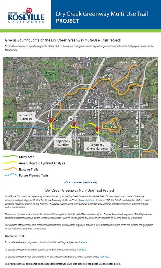
 Available: March 8, 2013 thru April 1, 2013 Introduction The City of Roseville has started the next phase of planning for the Dry Creek Greenway Multi Use Trail Project.")

1 Community Workshop #3 and On Line Feedback Summary Community Workshop #3 Date: March 21, 2013 Time: 6 p.m. Location: Maidu Community Center, 1550 Maidu Drive, Roseville Project Website Feedback tool (copy attached) Available: March 8, 2013 thru April 1, 2013 Introduction The City of Roseville has started the next phase of planning for the Dry Creek Greenway Multi Use Trail Project. The project is a proposed Class I multi use trail along Dry, Cirby, and Linda Creeks that would begin near Darling Way/Riverside Avenue and continue east to the City limits past the Old Auburn Road/South Cirby Way intersection, a distance of about 4.25 miles. In 2010 the City conducted the Dry Creek Greenway Planning & Feasibility Study to assess the feasibility of building a trail along a 4.24 mile corridor of open space in south Roseville. The study included an inventory of existing conditions and development of trail alignment alternatives. A comprehensive public engagement program allowed stakeholders and the public to provide feedback on the study and assisted in the effort to develop a locally preferred alternative for trail routing and road crossings that fit within the context of the neighborhoods. The City Council accepted the feasibility study in March 2010 and directed City staff to proceed with the current phase. The current phase of work includes additional feasibility analysis for two trail segments and preliminary engineering and environmental review of the trail alignment. Community Workshop Purpose The purpose of the workshop was to provide an overview of the project and to solicit input from the community. The workshop included information stations that were set up for each of the trail segments


2 and included renderings, maps, and other project information materials. Representatives from the City and the project consultant team were available to discuss the project with attendees and answer questions. Publicity & Noticing Community workshop notification flyers were sent via e mail to local jurisdictions, interested agencies, vicinity organizations/businesses, and interested individuals. In addition, over 500 notification postcards were mailed to residents who lived within 200 feet of the proposed trail segments between Riverside Avenue and Rocky Ridge Drive. Additional notifications were provided to the Meadow Oaks and Maidu neighborhoods through their respective neighborhood associations. The workshop notice was also posted to City of Roseville s web site (http// and the project web site ( An advertisement for the community workshop placed in the A section of the Roseville & Granite Bay Press Tribune was published on March Further, press releases regarding the community workshop were sent via e mail to the following publications: KCRA NBC Channel 3 KOVR CBS Channel 13 KXPR Capital Public Radio KXTL Fox 40 Channel 40 KXTV ABC Channel 10 (News 10) Roseville Chamber of Commerce Roseville Press Tribune Roseville Patch Sacramento Business Journal Sacramento News & Review Sacramento Press The Sacramento Bee Community Workshop Format Sixty members of the public attended the workshop which was organized as an open house with a series of information stations. Attendees were encouraged to visit the stations where the project team was available to Page 2 of 8

3 answer questions. Attendees were given an informational flyer describing the goals and schedule for the project as well as a feedback form to provide input on the alternatives. Feedback forms could be turned in at the workshop, or returned via , fax, or mail. Information stations included: Station #1: Project overview and History Station #2: Hillcrest Segment Station #3: Sunrise Avenue Segment Station #4: Sierra Gardens/Meadow Oaks Segment Station #5: Rocky Ridge to Old Auburn Station #6: Public Safety Station #7: Flood Prevention Station #8: Open Space Station #9: Environmental Station #10: Online Feedback Station Community Input In addition to providing feedback at the workshop, community members were also encouraged to provide their input online through an interactive project website. The website remained live from March 8, 2013 through April 1, A summary of feedback received from the community workshop and the project website is included below: Hillcrest Segment: We both are cyclists and love the bike trail and look forward to the extensions. We are concerned with the height of the bridges above the flood plain and the amount of approach fill that will require. Can we get a waiver from the flood board? This is a great project. I need some time with proposed alignments before commenting. I hope details will be available soon. I would like to see many more paved bike trails/walking paths through nature areas rather than close to busy streets. I whole heartedly endorse this. Option 1B seems like the least imperfect. It keeps the people in Hillcrest less mad. Page 3 of 8
4 I am very excited to see the trail planning progress. I support the trail project and so do many of my friends. Thanks! Option 1C, being the most direct route, is preferable. I have been waiting, patiently, since 1978 for this route to connect me and my neighbors to downtown. I live near Eastwood Park. I prefer Option 1C. The Darling crossing would be very inconvenient for the "1A" and "1B" options. Bridge 2 would not only provide parking access but also to the Dry Creek west connection to the Sacramento Northern Trail. Segment 1 Daring Way to Machado Lane I recommend that the proposed trailhead located on Riverside Avenue include the following amenities in addition to motor vehicle parking: Trailhead kiosk with map of parkway Convenient and secure bike parking (bike racks to lock bikes) located between the parking lot and trailhead (as an alternative to driving to the trailhead to walk/run/skate on the trail then make the return trip by bike) (Bike racks should be provided anywhere the city provides motor vehicle parking, including at all city parks and facilities) Security lighting Permanent or portable restrooms Water fountain Shade trees and benches/picnic tables Direct paved pedestrian connection from street/sidewalk to trailhead (around parking lot) Trash receptacles A paved connection to the proposed Option A or B should be provided to/from Hernandez/Machado Lane as proposed in Sheet 1. Paved connections to the proposed trail should be provided from east and westbound Darling Way Thanks Sunrise Avenue Segment: The "5A" option provides better access to/from Sunrise. The "5B" access to SB Sunrise is not intuitive from the trail to the road given the branch is so far from the road. I'd expect it to trigger more mid block crossings as trail users go between NB Sunrise and the trail entrance. There is no nearby legal crossing. Trail users will do what is convenient, not necessarily what is safe. The south side (Option 5A) offers better connections at Sunrise Blvd. I would like to see many more paved bike trails/walking paths through nature areas rather than close to busy streets. I whole heartedly endorse this. Option A seems dryer. This will give more Eich students and teachers off street access to the school which is great for promoting a healthier lifestyle that includes more walking and bicycling (and skating, etc.). Good to see Rocky Ridge crossing is under the road while still providing good access to/from Rocky Ridge. Segment 5 Sunrise Ave to Meadow Gate Drive: Lighting should be provided under the Sunrise Bridge, at the trail connections to Sunrise Blvd and at any neighborhood connection to the trail. Option 5A looks to have more room and better connections to both sides of Sunrise. No access to Option 5B from northbound Sunrise. Sierra Gardens/Meadow Oaks Segment: Page 4 of 8
5 I think the proposed trail should follow the existing gravel road to split the distance between the Sierra Gardens and the Meadow Oaks subdivision. The city drain pipe at 1536 (mid property) should be extended out and beyond the proposed bike path or we will have more water backed up to the existing homes on Meadowlark way. Water pools up now and makes the properties pretty much useless. The Meadow Oaks people act as though the path will be on their side of the creek and will devastate them as it does the owners on Meadowlark Way. They should not be sweating at all like the people on Meadowlark way. Please extend the drain 1536 Meadowlark Way, first fix the existing problem, so you don't have to deal with it later. I would like to see many more paved bike trails/walking paths through nature areas rather than close to busy streets. I whole heartedly endorse this. Whichever option is chosen, let's get on with some construction of more rideable, safe bikeways. Seems easy, since there is already a trail (dirt). Build it! Woodlake Lane Bridge goes east past soccer fields to other trail heads. Needs to be double wide or separated for multi use, strollers, dogs, kids, bicycles. Perhaps a roundabout or trail circle could work as an alternative to the Y intersection (near Meadowland Way) to slow traffic in a low visibility intersection. Speed should not take precedent over safety. There doesn t look to be a connection either paved or unpaved to/ from the preferred alternative and the Meadow Oaks neighborhood to the south except for at the ends of this segment. General: Roseville's vision and community planning sets our city apart. The natural creek ways and bike trail system are one example of this. I am fully supportive of this project and the many opportunities it will provide our residents and commuters using bikeways to run errands and go to and from work. The difficult short term decisions to change the status quo will give way to a long term investment that will be amazing for our future. We need this project for connectivity, to implement our community sustainability plan, to contribute to Roseville's responsibilities to increase accessibility for transportation options, to reduce greenhouse gas emissions, and to show future generations that we care. Yes, more bike and multi use paths should be constructed to provide bicycle routes to work and recreation that are safer than competing on the roadways with automobiles. More bicycle/multi use trail would benefit the community for both work and/or recreation. I see more and more people utilizing the existing paths every time I am on them. Whatever happens just make them all connect. Too many short bike paths in Roseville that go nowhere. Folsom is way ahead of Roseville in this area I look forward to the expansion of the Roseville trail system, and the Dry Creek Greenway in particular. I enjoy the Antelope, Miners Ravine and Secret Ravine trails now immensely. Such trails contribute positively to the desirability of the neighborhoods they are in and the city as a whole. Page 5 of 8
6 I support the newly proposed Dry Creek Greenway Bike/Multi use trail system. More trails like this one provide alternatives to pedestrians and cyclists. I would certainly use this new trail for some of my commutes to work, which would mean one less car (and bicyclist) on busy commuter streets. Expanding the American River Bike Trail to include this northern section to Roseville would be a great and welcome addition as well. At the workshop last night I was really impressed with the progress on this exciting project. It will provide a wonderful opportunity for residents of the city to get out in nature and get some exercise. Also, more opportunities for business and increased property values. It makes the city a better place. I'm looking forward to everyone working together on it to make it as good as it can be. I am fully in favor of the proposed bike trail expansions. They will make Roseville a much more desirable place to live. I do think however, that we are misleading ourselves in promoting them as practical routes that will promote bike commuting. For a very few, that might be true. Really, they are primarily recreational. There's nothing wrong with that, but let's not kid ourselves. For most people, if they were going to use bikes to get to work, school and wherever else, most of their journey will be on surface streets. I think that in the very long term, we need to think about putting bicycle lanes on streets separated from car traffic by barriers so that transportation by bicycle can truly become a viable means of getting around a city like Roseville that has sold its soul to urban sprawl. Unless nuclear fusion or something like it comes through, one day the cost of energy is going to make people powered vehicles a much more important means of transport than it is now. One concern I have about projects like these is that it often seems that money can be found to build new amenities, but as years go by, the money to maintain them properly sometimes is not available. I would not like to see Roseville build more trails than it can maintain. I recommend that the City consider providing at least some lighting (solar, motion detect/efficient, etc.) along the trail at strategic locations such as at trailheads, trail and trail street crossings, bridge crossings and underpasses and other key locations where lighting has the most potential to increase visibility and security and/or where electrical infrastructure exists. Lighting would encourage increased utilization of the facility past sundown and before sun up by increasing the comfort and safety level of potential commuters, utilitarian and recreational users alike, or for those who simply want a place to walk in the evening. The need to provide for these activities does not end after dark or before sunrise. Any lighting provided will help discourage undesirable activity along the trail during these hours as well. For example, if a group of friends and I wanted to ride to one of the parks or to Downtown to the farmers market, concert at the new plaza or dinner early evening, we could be confident we could return on the trail later that evening knowing that the trail is open and safe after dark due in part to lighting at key locations in combination with our own bike lights to get home safely. Whether lighting is provided or not, the trail should remain open 24/7 as are the streets and roads that surround it. Closing the facility after dark to legitimate users increases the chances of undesirable activity and vandalism. The city also gets a better return on investment since the trail can be more fully utilized. Having said this, investments in trails should not be a reason to neglect making existing and future surface streets more bike and pedestrian friendly (fewer lanes with slower motor vehicle speeds) since surface streets usually provide the most direct connections to the majority of destinations. The City also needs to provide convenient and secure bike parking everywhere it provides motor vehicle parking including at all existing and future city parks, plazas and other public facilities. Thank you! Page 6 of 8
7 As a resident of the City and frequent trail user (walking & biking), I whole heartedly support Roseville's efforts to extend the existing trail system. Ensuring continuity between existing trail sections is paramount to capitalizing on existing resources, and this plan provides a great link between existing sections. Further, research and post occupancy studies of similar trails invariably demonstrate that crime, and vagrancy in nearby areas are reduced when positive uses are encouraged by providing safe, well designed amenities. Page 7 of 8
8 Project Website Feedback Tool The following pages include images from the project website feedback tool which was open to community comments from March 8, 2013 through April 1, Page 8 of 8
9

10

11

12
4.13 TRANSPORTATION AND CIRCULATION
 Ascent Environmental 4.13 TRANSPORTATION AND CIRCULATION 4.13.1 Introduction This section describes the existing transportation setting in the project area, including current levels of service, bicycle
City of Davis East Covell Corridor Plan
 Community Open House #2 January 22, 2014 6:00 8:00 p.m. Veterans Memorial Center, Club Room City of Davis Introduction The (ECCP) is a taking a comprehensive look at the existing transportation systems
EXECUTIVE SUMMARY. Vision
 Vision Walking and bicycling in Salt Lake City will be safe, convenient, comfortable, and viable transportation options that connect people to places, foster recreational and economic development opportunities,
Lake to Lake LAKE YORK. CYCLING ROUTE and WALKING TRAIL FEASIBILITY and DESIGN STUDY LAKE. CITY of REGION ONTARIO SIMCOE TORONTO
 LAKE SIMCOE Lake to Lake CYCLING ROUTE and WALKING TRAIL FEASIBILITY and DESIGN STUDY YORK REGION Overview Report JUNE 2013 CITY of TORONTO LAKE ONTARIO Table of Contents Study background 2 Study Background............................
City of Novi Non-Motorized Master Plan 2011 Executive Summary
 City of Novi Non-Motorized Master Plan 2011 Executive Summary Prepared by: February 28, 2011 Why Plan? Encouraging healthy, active lifestyles through pathway and sidewalk connectivity has been a focus
Tuesday, September 25 th Mount Holly Municipal Complex 400 East Central Avenue 5:30pm to 7:30pm. Activity Stations o Where do you Live?
 Meeting Information Overview The public workshop for the Mount Holly Comprehensive Bicycle Plan occurred on September 25, 2018. The drop-in workshop allowed attendees to participate in a series of interactive
Introduction. North 12 th Complete Street Project Overview
 Introduction On Wednesday, March 1, 2017, the City of Sacramento, in partnership with Sacramento Regional Transit District and the Sacramento Housing and Redevelopment Agency, hosted a community outreach
Hennepin County Bicycle and Pedestrian Planning
 Hennepin County Bicycle and Pedestrian Planning 1 Value of bicycle and sidewalk systems Safety Livability Mobility Health Personal Finances Economic Sustainability Clean Air Recreation Parking and congestion
Kelowna On the Move. Pedestrian and Bicycle Master Plan
 Kelowna On the Move Pedestrian and Bicycle Master Plan Executive Summary April 2016 Purpose of the Plan The Pedestrian and Bicycle Master Plan identifies infrastructure, planning, and policy requirements
MASTER BICYCLE AND PEDESTRIAN PLAN
 VILLAGE OF NORTHBROOK MASTER BICYCLE AND PEDESTRIAN PLAN DRAFT PLAN OPEN HOUSE May 2, 2018 AGENDA 1. Community Engagement 2. Vision and Goals 3. General Structure of Plan 4. Recommendations Overview 5.
Living Streets Policy
 Living Streets Policy Introduction Living streets balance the needs of motorists, bicyclists, pedestrians and transit riders in ways that promote safety and convenience, enhance community identity, create
Bicycle Master Plan Goals, Strategies, and Policies
 Bicycle Master Plan Goals, Strategies, and Policies Mobilizing 5 This chapter outlines the overarching goals, action statements, and action items Long Beach will take in order to achieve its vision of
Tonight is for you. Learn everything you can. Share all your ideas.
 Strathcona Neighbourhood Renewal Draft Concept Design Tonight is for you. Learn everything you can. Share all your ideas. What is Neighbourhood Renewal? Creating a design with you for your neighbourhood.
Lee s Summit Road Improvement Study Public Open House June 7, 2007 Summary of Comment Card Responses
 Lee s Summit Road Improvement Study Public Open House June 7, 2007 Summary of Comment Card Responses Introduction At the Lee s Summit Road Improvement Study Public Open House held Thursday, June 7, 2007
4 Goals, Objectives & Actions
 Chapter4 4 This chapter presents goals, objectives, and recommended actions to support the vision of making Overland Park a safer and easier place to ride a bicycle. 35 4.1 Recommendations Structure The
2014/2015 BIKE ROUTE PLAN 83 AVENUE PROTECTED BIKE LANE
 About the Project 2014/2015 BIKE ROUTE PLAN The City of Edmonton is planning a major bike route on the south side of Edmonton. This bike route is one part of a plan to provide citizens with transportation
Perryville TOD and Greenway Plan
 Perryville TOD and Greenway Plan Greenway Glossary Pathway: A bicycle and pedestrian path separated from motorized vehicular traffic by an open space, barrier or curb. Multi-use paths may be within the
General Plan Circulation Element Update Scoping Meeting April 16, 2014 Santa Ana Senior Center, 424 W. 3rd Street, Santa Ana, CA 92701
 General Plan Circulation Element Update Scoping Meeting April 16, 2014 Santa Ana Senior Center, 424 W. 3rd Street, Santa Ana, CA 92701 Meeting Agenda 1. Purpose of Scoping Meeting 2. Project Overview 3.
Corpus Christi Metropolitan Transportation Plan Fiscal Year Introduction:
 Introduction: The Safe, Accountable, Flexible, Efficient Transportation Equity Act: A Legacy for Users (SAFETEA-LU) has continued the efforts started through the Intermodal Surface Transportation Efficiency
Solana Beach Comprehensive Active Transportation Strategy (CATS)
") Solana Beach Comprehensive Active Transportation Strategy (CATS) 3.0 Goals & Policies The Solana Beach CATS goals and objectives outlined below were largely drawn from the Solana Beach Circulation Element
Solana Beach Comprehensive Active Transportation Strategy (CATS) 3.0 Goals & Policies The Solana Beach CATS goals and objectives outlined below were largely drawn from the Solana Beach Circulation Element
City of Birmingham Draft Multi-modal Transportation Plan
 City of Birmingham Draft Multi-modal Transportation Plan City Commission Public Hearing Monday, November 25, 2013 7:30 pm Norman Cox, PLA, ASLA The Greenway Collaborative, Inc. Ann Arbor, Michigan The
CHAPTER 3: Vision Statement and Goals
 Davidson Walks & Rolls: Active Transportation Master Plan CHAPTER 3 Contents: Overview Vision Statement Measurable Goals Public Outreach CHAPTER 3: Vision Statement and Goals Overview The vision statement
Proposed Bridge Street East Bicycle Lanes Public Open House Thursday, April 27, 2017
 WELCOME Proposed Bridge Street East Bicycle Lanes Public Open House Thursday, April 27, 2017 Purpose of the Open House The purpose of this Open House is to gain public input on the bicycle lanes proposed
City of Hamilton s Transportation Master Plan (TMP) Public Consultation 3 December 2015
 Public Consultation 3 December 2015") City of Hamilton s Transportation Master Plan (TMP) Public Consultation 3 December 2015 McPhail Transportation Planning Services Ltd. AGENDA 6:00 7:00 pm Viewing Boards / Q & A with the Team 7:00 7:50
City of Hamilton s Transportation Master Plan (TMP) Public Consultation 3 December 2015 McPhail Transportation Planning Services Ltd. AGENDA 6:00 7:00 pm Viewing Boards / Q & A with the Team 7:00 7:50
Duwamish Way-finding and CTR Report
 V. North Tukwila When the North Tukwila Manufacturing and Industrial Center was designated in 1992 as part of the region s land use and transportation plan, the plan called for the area to set a light-rail
CRESTON ROAD COMPLETE AND SUSTAINABLE STREETS CORRIDOR PLAN
 CRESTON ROAD COMPLETE AND SUSTAINABLE STREETS CORRIDOR PLAN Preferred Plan Community Presentation September 27, 2017 City of El Paso de Robles in partnership with: Local Government Commission, W-Trans,
50 Avenue S.W. Corridor Study Glenmore Aquatic Centre Drop-In Event
 Project overview The City of Calgary is conducting a transportation corridor study of 5 Avenue S.W., between Crowchild Trail and 4A Street S.W. In 29, it was reclassified as a Parkway under the Calgary
Proposed. City of Grand Junction Complete Streets Policy. Exhibit 10
 Proposed City of Grand Junction Complete Streets Policy Exhibit 10 1 City of Grand Junction Complete Streets Policy Vision: The Complete Streets Vision is to develop a safe, efficient, and reliable travel
Active Transportation Rail to River Corridor. Community Meeting - Segment A
 Active Transportation Rail to River Corridor Community Meeting - Segment A June 29, 2017 Tonight s Agenda > Open House (30 min) > Welcome / Project Overview > Presentation of 30% Design Refinements > Next
2016 Neighborhood Street Fund Application
 2016 Neighborhood Street Fund Application 2016-109 #146 COMPLETE Collector: Web Link 1 (Web Link) Started: Sunday, April 17, 2016 2:29:58 PM Last Modified: Sunday, April 17, 2016 2:36:28 PM Time Spent:
Moving Cambridge. City of Cambridge Transportation Master Plan Public Consultation Centre. March 7, :00 8:00 PM.
 City of Cambridge Transportation Master Plan Public Consultation Centre March 7, 2018 5:00 8:00 PM Region of Waterloo City of Cambridge Transportation Master Plan Public Consultation Centre March 7, 2018
COMMUNITY PARTICIPATION CHAPTER 8
 COMMUNITY PARTICIPATION CHAPTER 8 8.1 ROLE OF THE CITY S BICYCLE ADVISORY COMMISION 8.2 BICYCLE TRANSPORTATION PLAN STAKEHOLDERS 8.2.1 Stakeholders 8.2.2 Stakeholders Letters of Recommendations 8.3 CITY
City of Sammamish. Welcome. Issaquah-Fall City Road Improvements Project Phase I Design: 242nd Avenue SE to Klahanie Drive SE
 Welcome Welcome to the third community meeting for the Issaquah-Fall City Road Improvements Project. AGENDA 6:00 p.m. Welcome and sign-in 6:10 p.m. Presentation 6:50 p.m. Open house Learn about the roadway
Physical Implications of Complete Streets Policies
 Presentation Overview Physical Implications of Complete Norm Cox, ASLA, LLA Landscape Architect Ann Arbor, Michigan, 10:45 to Noon What Are Complete Streets? What Matters to Bicyclists and Pedestrians
Chapter 7. Transportation. Transportation Road Network Plan Transit Cyclists Pedestrians Multi-Use and Equestrian Trails
 Chapter 7 Transportation Transportation Road Network Plan Transit Cyclists Pedestrians Multi-Use and Equestrian Trails 7.1 TRANSPORTATION BACKGROUND The District of Maple Ridge faces a number of unique
Climate Change Action Plan: Transportation Sector Discussion Paper: Cycling
 Climate Change Action Plan: Transportation Sector Discussion Paper: Cycling ontario.ca/climatechange Contents 1. Minister of Transportation s message... 3 2. Introduction... 5 3. Sector Overview and Support
City of Jacksonville Mobility Fee Update
 City of Jacksonville Mobility Fee Update 2017 Preliminary Analysis May 3, 2017 Carnival Cruise lines photo credit Presentation Overview Public Outreach Process Pedestrian and Bicycle Master Plan Study
Pennsylvania Avenue (CR 484) Design Alternatives Study
 Design Alternatives Study") MEMORANDUM Pennsylvania Avenue (CR 484) Design Alternatives Study Prepared for: APRIL 2016 Prepared By TABLE OF CONTENTS Project Background... 2 Previous Concept... 2 Existing Conditions... 4 New Alternatives...
MEMORANDUM Pennsylvania Avenue (CR 484) Design Alternatives Study Prepared for: APRIL 2016 Prepared By TABLE OF CONTENTS Project Background... 2 Previous Concept... 2 Existing Conditions... 4 New Alternatives...
Bicycle Facilities Planning
 Bicycle Facilities Planning Overview Types of Cyclists Purpose for Riding Types of Facilities Bike Lanes Bicycle Boulevards Cycle Tracks Intersections Signals Signing and Marking Discussion Types of Bicyclists
CITY OF COCOA BEACH 2025 COMPREHENSIVE PLAN. Section VIII Mobility Element Goals, Objectives, and Policies
 CITY OF COCOA BEACH 2025 COMPREHENSIVE PLAN Section VIII Mobility Element Goals, Objectives, and Policies Adopted August 6, 2015 by Ordinance No. 1591 VIII MOBILITY ELEMENT Table of Contents Page Number
Major Bike Routes 102 Avenue Workshop April 21, 2015
 Major Bike Routes 102 Avenue Workshop April 21, 2015 Our Purpose Today Provide context on how Major Bike Routes fit into Edmonton s future Share information on what we heard in our last phase, and how
SUPPORTING DOCUMENTATION PROPOSED TRAILS DEVELOPMENT AND IMPLEMENTATION PLAN
 SUPPORTING DOCUMENTATION PROPOSED TRAILS DEVELOPMENT AND IMPLEMENTATION PLAN Prepared For: Prepared By: Town of Rocky Mountain House Recreation, Parks and Community Services 1 INTRODUCTION 1.1 Purpose
PRINCE GEORGE S PLAZA METRO AREA PEDESTRIAN PLAN
 PRINCE GEORGE S PLAZA METRO AREA PEDESTRIAN PLAN May 28, 2008 Agenda Welcome and introductions Project overview and issue identification Planning context and strengths Design challenges and initial recommendations
Pattullo Bridge Replacement Project Community Connections Phase 2 Consultation. Appendix 3: Open House Display Boards
 Replacement Project Community Connections Phase 2 Consultation Appendix 3: Open House Display Boards November 2016 Welcome! Welcome to the Replacement Project Public Open House We Want to Hear from You
West Capitol Avenue Road Rehabilitation and Safety Enhancement Project
 West Capitol Avenue Road Rehabilitation and Safety Enhancement Project Stakeholder Focus Group Meeting #2 Tuesday, August 28, 2018 7:00 8:00 a.m. West Sacramento City Hall 1110 West Capitol Avenue, West
2.0 Existing Conditions
 20 2.0 Existing Conditions 2.1 Land Use, Future Growth Patterns, Physical Barriers Geographic Overview Sutter County s land use pattern is characterized by extensive agricultural areas, significant natural
2014/2015 BIKE ROUTE PLAN 83 AVENUE PROTECTED BIKE LANE
 About the Project The City of Edmonton is planning a major bike route on the southside of Edmonton. The Strathcona Bike Route will connect the communities of Strathcona, Garneau and the University area,
What are the Qualities that make Newark a Bicycle Friendly Community? What are aspects that make Newark less Bicycle Friendly?
 What are the Qualities that make Newark a Bicycle Friendly Community? Many stores are within biking distance (1) Lots of bike lanes and new trail Existing bike routes (2) Designated bike lanes on Del ave.
Shifting Gears for a Healthier City
 Shifting Gears for a Healthier City Mississauga s Cycling Master Plan is an ambitious strategy that sets out to transform Mississauga into a city that is conducive to cycling for daily transportation needs.
WALKNBIKE DRAFT PLAN NASHVILLE, TENNESSEE EXECUTIVE SUMMARY NASHVILLE, TENNESSEE
 NASHVILLE, TENNESSEE EXECUTIVE SUMMARY Executive Summary A world-class multi-modal transportation system is essential to a vibrant city and better quality of life. -Mayor Barry The WalknBike plan aims
Summary: Mercer County Princeton Avenue & Spruce Street Study January 2009
 Summary: Several recent studies have assessed potential development and redevelopment opportunities in the Mercer Crossing area of Trenton, Ewing, and Lawrence. This Princeton Avenue and Spruce Street
Bobbie Walthall. Hi Bobby, please include these comments in tonight s CC packet. Thanks for your consideration, Phil Collison Lawrence Resident
 Bobbie Walthall From: Sent: To: Subject: Phil Collison Tuesday, October 16, 2018 9:44 AM Bobbie Walthall Comments for Agenda item 3 Bike Boulevard Hi Bobby, please include these comments
Chapter VISION, MISSION, AND GOALS AND OBJECTIVES. Vision. Mission. Goals and Objectives CONNECTING COMMUNITIES ACROSS THE ST.
 VISION, MISSION, AND GOALS AND OBJECTIVES Chapter 3 The Plan s vision, mission, and goals and objectives were developed through a series of interactive exercises with the Citizens Advisory Committee (CAC)
TOWN OF PORTLAND, CONNECTICUT COMPLETE STREETS POLICY
 TOWN OF PORTLAND, CONNECTICUT COMPLETE STREETS POLICY I. VISION, GOALS & PRINCIPLES VISION To improve the streets of Portland making them safer and more accessible for all users including pedestrians,
Agenda. Overview PRINCE GEORGE S PLAZA METRO AREA PEDESTRIAN PLAN
 PRINCE GEORGE S PLAZA METRO AREA PEDESTRIAN PLAN May 28, 2008 Agenda Welcome and introductions Project overview and issue identification Planning context and strengths Design challenges and initial recommendations
DRAFT. System Components. Greenway Trails. Introduction. Trail Types. Zebulon Greenway Master Plan
 5 System Components Wakefield Street Photo Simulation showing Sharrows Introduction The Master Plan identifies various system components that, together, create a comprehensive greenway system. These components
City Birmingham Multi-Modal Transportation Plan Visioning Workshop Results Meeting
 City Birmingham Multi-Modal Transportation Plan Visioning Workshop Results Meeting Monday, January 28, 2013 7:30 PM, City Hall Norman Cox, PLA, ASLA. Ann Arbor, Michigan. www.greenwaycollab.com Community
Multi Modal Transit Access Plan KIPDA ID # 239. Project Type: STUDY
 Multi Modal Transit Access Plan KIPDA ID # 239 Project Type: STUDY Description: In conjunction with the results from Project Gobility and the Transit LOS Analysis, TARC seeks to examine the possibilities
CONNECTING PEOPLE TO PLACES
 CONNECTING PEOPLE TO PLACES 82 EAST BENCH MASTER PLAN 07 Introduction The East Bench transportation system is a collection of slow moving, treelined residential streets and major arteries that are the
Transportation Master Plan Advisory Task Force
 Transportation Master Plan Advisory Task Force Network Alternatives & Phasing Strategy February 2016 BACKGROUND Table of Contents BACKGROUND Purpose & Introduction 2 Linking the TMP to Key Council Approved
Madison Urban Area and Dane County. Bicycle Transportation Plan Summary. September Introduction. Bicycle Plan Scope and Planning Process
 Bicycle Transportation Plan Summary Madison Urban Area and Dane County Introduction September 2000 Bicycling is an important mode of transportation in the Madison urban area and countywide that is available
MAG Town of Cave Creek Bike Study Task 6 Executive Summary and Regional Significance Report
 Page 1 MAG Town of Cave Creek Bike Study Task 6 Executive Summary and Regional Significance Report August 1, 2012 MAG Project #481 Page 2 Task 6 Executive Summary and Regional Significance Report Introduction
Shifting Gears for a Healthier City.
 Shifting Gears for a Healthier City. Mississauga s Cycling Master Plan is an ambitious strategy that sets out to transform Mississauga into a city that is conducive to cycling for daily transportation
Governance and Priorities Committee Report For the July 2, 2015 Meeting
 CITY OF VICTORIA For the July 2, 2015 Meeting To: Governance and Priorities Committee Date: From: Subject: Brad Dellebuur, A/Assistant Director, Transportation and Parking Services Executive Summary The
Winnipeg Walk Bike Projects Downtown Tire Talk - Summary
 Winnipeg Walk Bike Projects Downtown Tire Talk - Summary Downtown Projected Bike Lane System Connecting The Forks to the Exchange District (Fort Street, Garry Street & The Forks to Assiniboine Connection)
Moving Ahead. (Community Engagement) Chapter Three
 Chapter Three") 3 Community Chapter Three Moving Ahead (Community Engagement) engagement provided an exciting opportunity to engage Redwood City residents, workers, and business owners people who walk, bike, take transit,
3 Community Chapter Three Moving Ahead (Community Engagement) engagement provided an exciting opportunity to engage Redwood City residents, workers, and business owners people who walk, bike, take transit,
Sustainable Transportation Initiatives and Plans in Caledon
 Sustainable Transportation Initiatives and Plans in Caledon Arash Olia, P.Eng., PhD. Coordinator, Transportation Development Finance & Infrastructure Services Town of Caledon Eric Chan, P.Eng., PMP Manager,
Hamilton Transportation Master Plan Public Consultation. Public Information Centre One Summary
 Hamilton Transportation Master Plan Public Consultation Public Information Centre One Summary Table of Contents Introduction 1 Purpose 2 What Was Presented 2 Who Came to the Meeting 2 The Breakout Sessions
MASTER BICYCLE AND PEDESTRIAN PLAN
 WELCOME! PLEASE FEEL FREE TO REVIEW THE EXHIBITS THE PRESENTATION WILL BEGIN AT 6:00 PM VILLAGE OF NORTHBROOK MASTER BICYCLE AND PEDESTRIAN PLAN DRAFT EXISTING CONDITIONS REPORT AND PUBLIC MEETING WELCOME!
RESOLUTION NO ?? A RESOLUTION OF THE CITY OF NEPTUNE BEACH ADOPTING A COMPLETE STREETS POLICY
 RESOLUTION NO. 2018-?? A RESOLUTION OF THE CITY OF NEPTUNE BEACH ADOPTING A COMPLETE STREETS POLICY WHEREAS, safe, convenient, and accessible transportation for all users is a priority of the City of Neptune
Goodlettsville Bicycle and Pedestrian Plan Executive Summary
 Goodlettsville Bicycle and Pedestrian Plan July 2010 In Cooperation with the Nashville Area Metropolitan Planning Executive Organization Summary Introduction Progressive and forward thinking communities
COASTAL RAIL TRAIL ROSE CREEK BIKEWAY PROJECT COMMUNITY WORKSHOP #2 AUGUST 15, 2013
 COASTAL RAIL TRAIL ROSE CREEK BIKEWAY PROJECT COMMUNITY WORKSHOP #2 AUGUST 15, 2013 CHRIS CARTERETTE, AICP PROJECT MANAGER Chris.Carterette@sandag.org Direct: 619-699.7319 REGIONAL PLANNING BACKGROUND
Safe Streets. City of Lake Forest Park. March 21, 2017
 Safe Streets City of Lake Forest Park March 21, 2017 1 01 WELCOME 2 Agenda WELCOME WHAT IS THIS PROJECT? CONTEXT DRAFT CITYWIDE PROJECTS EXERCISE INTRODUCTION 3 02 WHAT IS THIS PROJECT? 4 WHAT IS THIS
PEDALING FORWARD. A Glance at the SFMTA s Bike Program for SFMTA.COM
 PEDALING FORWARD A Glance at the SFMTA s Bike Program for 2017-2021 SFMTA.COM INTRODUCTION About This Booklet More people from all walks of life see their bicycle as a more convenient way to get where
Plant City Walk-Bike Plan
 Plant City Walk-Bike Plan Plant City Commute Mode Share 2.2% 1.4% 2.9% Drove alone 10.2% Carpooled Public transportation (0.1%) Walked Used a Bike (0.4%) 82.9% Taxicab, motorcycle, or other means Worked
CLOSED. The draft concept design has been broken down into 5 categories for the purpose of this survey:
 Old Strathcona s neighbourhood renewal process is now at the draft concept design phase. Over the last several months, the city has been gathering local knowledge and resident input that has been used
CHAPTER 1 INTRODUCTION
 CHAPTER 1 INTRODUCTION Chapter Table of Contents THE 2017 HOUSTON BIKE PLAN 1-1 HOUSTON BIKEWAYS PROGRAM 1-2 HISTORY OF BICYCLE PLANNING IN HOUSTON 1-3 BICYCLE LEVEL OF COMFORT 1-3 EXISTING PLANS, PROGRAMS
City of Charlottesville Bicycle and Pedestrian Master Plan Update
 City of Charlottesville Bicycle and Pedestrian Master Plan Update September 17, 2014 I. Welcome and meeting overview II. Project status update III. Network overview IV. Break-out groups Pedestrian Network
8/31/2016 VIA . RE: Freeport Arco Fuel Station (P16-039)
") 8/31/2016 VIA EMAIL Garrett Norman, Assistant Planner City of Sacramento Community Development Department 300 Richards Boulevard, 3 rd Floor Sacramento, CA 95811 RE: Freeport Arco Fuel Station (P16-039)
8/31/2016 VIA EMAIL Garrett Norman, Assistant Planner City of Sacramento Community Development Department 300 Richards Boulevard, 3 rd Floor Sacramento, CA 95811 RE: Freeport Arco Fuel Station (P16-039)
Chapter 2. Bellingham Bicycle Master Plan Chapter 2: Policies and Actions
 Chapter 2 Bellingham Bicycle Master Plan Chapter 2: Policies and Actions Chapter 2: Policies and Actions The Bicycle Master Plan provides a road map for making bicycling in Bellingham a viable transportation
LOOP 360 IMPROVEMENT STUDY
 LOOP 360 IMPROVEMENT STUDY Overview and Preliminary Analysis August 2015 1 STUDY PROCESS 2 Study Background Loop 360 serves a wide range of users, including residents, businesses, bicyclists, and commuters
CONNECTIVITY PLAN. Adopted December 5, 2017 City of Virginia Beach
 CONNECTIVITY PLAN Adopted December 5, 2017 City of Virginia Beach CONTENTS 1.0 Background & Purpose... 2 2.0 Existing Inventory & Analysis... 3 ViBe District Existing Walking Conditions... 4 3.0 ViBe District
Broad Street Bicycle Boulevard Design Guidelines
 Broad Street Bicycle Boulevard Design Guidelines Building from the strategies introduced in the 2013 Bicycle Transportation Plan and community input received thus far, City Transportation Staff have identified
Final Report For The Phase 1 Trail Improvements on Southern California Edison (SCE) Corridor Project Silverado Trail Contract No.
 Corridor Project Silverado Trail Contract No.") Final Report For The Phase 1 Trail Improvements on Southern California Edison (SCE) Corridor Project Silverado Trail Contract No. ML16049 Prepared for the Mobile Source Air Pollution Review Committee (MSRC)
Final Report For The Phase 1 Trail Improvements on Southern California Edison (SCE) Corridor Project Silverado Trail Contract No. ML16049 Prepared for the Mobile Source Air Pollution Review Committee (MSRC)
10A. DATE: October 5, Pedestrian and Bicycle Advisory Committee. Kevin Colin, Deputy Planning Manager Curt Bates, City Engineer
 10A DATE: October 5, 2016 TO: PREPARED BY: SUBJECT: Pedestrian and Bicycle Advisory Committee Kevin Colin, Deputy Planning Manager Curt Bates, City Engineer Discussion and Provide Comments, Associated
ACTION TRANSMITTAL No
 Transportation Advisory Board of the Metropolitan Council of the Twin Cities ACTION TRANSMITTAL No. 2016-15 DATE: January 14, 2016 TO: TAC Planning Committee PREPARED BY: Steven Elmer (651) 602-1756 SUBJECT:
3.9 Recreational Trails and Natural Areas
 3.9 Recreational Trails and Natural Areas 3.9.1 Introduction Parks and other recreational facilities such as trails, bicycle routes, and open space are important community resources. This section discusses
WELCOME. Thank you for joining us at the Second Public Workshop for the Carlsbad Pedestrian Master Plan. We look forward to receiving your feedback.
 City of Carlsbad Pedestrian Master Plan: WELCOME WELCOME Please Sign In Provide Input at Flip Charts Review Boards Presentation of Draft Plan Thank you for joining us at the Second Public Workshop for
Southwest Bus Rapid Transit (SW BRT) Functional Planning Study - Executive Summary January 19 LPT ATTACHMENT 2.
 Functional Planning Study - Executive Summary January 19 LPT ATTACHMENT 2.") Southwest Bus Rapid Transit (SW BRT) Functional Planning Study - Executive Summary 2011 January 19 1 of 19 Introduction This executive summary presents the results of the Southwest Bus Rapid Transit (SW
Southwest Bus Rapid Transit (SW BRT) Functional Planning Study - Executive Summary 2011 January 19 1 of 19 Introduction This executive summary presents the results of the Southwest Bus Rapid Transit (SW
Afeasibility study to evaluate bus rapid transit service in the East-West Corridor connecting major employment and activity centers between downtown
 East-West Bus Rapid Transit Feasibility Study Update and Recommended Locally Preferred Alternative (LPA) Summary City of Wauwatosa, Transportation Affairs Committee June 2016 Afeasibility study to evaluate
Community Bicycle Planning
 Community Bicycle Planning City of Mentor s Bicycle Facility Plan Allen E. Pennington, P.E. Civil Engineer - Traffic Office of the Mentor City Engineer Why has Mentor participated in bicycle planning?
UPTOWN REGIONAL BIKE CORRIDORS PROJECT SAN DIEGO ASSOCIATION OF GOVERNMENTS
 UPTOWN REGIONAL BIKE CORRIDORS PROJECT SAN DIEGO ASSOCIATION OF GOVERNMENTS SUMMARY REPORT: COMMUNITY UPDATE MEETING February 6, 2014 6 8:30 p.m. Roosevelt Middle School Library 3366 Park Blvd, San Diego
Section 5: Bike and Pedestrian
 Section 5: Bike and Pedestrian Existing Conditions: One defining feature of Glynn County appreciated by both residents and visitors is the extensive sidewalk and bike path system. The City of Brunswick,
Los Altos Hills Town Council - June 18, 2015 Palo Alto City Council June 22, AGENDA ITEM #2.B Presentation
 Los Altos Hills Town Council - June 18, 2015 Palo Alto City Council June 22, 2015 AGENDA ITEM #2.B Presentation Previous Presentations Los Altos Hills Town Council in May 2014 and February 2015 Palo Alto
MEMORANDUM. Background. Event Outreach. Event Details. To: Jennifer Chu and David Stillman, City of Cupertino
 84 W Santa Clara Street, Suite 830 San José, CA 95113 (408) 564-8606 www.altaplanning.com MEMORANDUM To: Jennifer Chu and David Stillman, City of Cupertino From: Lola Torney and Jeff Knowles, Alta Planning
Cyclists and Bikeways: What s your match? A guide to bikeway options for a variety of cyclists
 Cyclists and Bikeways: What s your match? guide to bikeway options for a variety of cyclists The workshop and this resource were made possible by funding from the Province of Ontario via the Ministry of
Active Transportation Access to Transit
 Active Transportation Access to Transit Introduction COMO Connect customers access transit service in many ways, including walking, bicycling, riding in a car and being dropped off, and directly boarding
CHIEF PEGUIS TRAIL EXTENSION WEST
 1 PRELIMINARY DESIGN OF THE CHIEF PEGUIS TRAIL EXTENSION WEST Public Information Session June 6, 2017 Welcome 1 Thank you for attending today s public information session. The following boards provide
Downey Road. Transportation Improvement Study
 Downey Road Transportation Improvement Study Workshop 2 Participant Handbook Workshop 1 May 18 and 19, 2016 Workshop 2 June 23 and 28, 2016 Prepared By: City of Guelph Paradigm Transportation Solutions
Community Open House December 13, A project of the Green Infrastructure Center, supported by Skeo Solutions
 Community Open House December 13, 2011 A project of the Green Infrastructure Center, supported by Skeo Solutions Project Background The Green Infrastructure Center, Inc. (GIC) was formed in 2006 to help