Median Design. Course No: C Credit: 4 PDH. Debra Kennaugh, P.E.
|
|
|
- Alexander Cook
- 6 years ago
- Views:
Transcription
1 Median Design Course No: C Credit: 4 PDH Debra Kennaugh, P.E. Continuing Education and Development, Inc. 9 Greyridge Farm Court Stony Point, NY P: (877) F: (877) info@cedengineering.com
2 Median Design Debra Kennaugh, P.E.
3 I. Introduction II. Access Management Classification A. History B. Definition of Terms C. Access Classification and Standards for Controlled Access Facilities D. Types of Median Openings E. Measurements III. Medians A. Median Opening Conflict Points B. Recommended Queue Storage C. Flexibility D. Retrofit to Restrictive Median E. Access vs. Thru Movement IV. Roadway Design Elements A. Median Design B. Perception Reaction Time /Distance C. Taper D. Design speed E. Entry Speed F. Median Opening Design Example V. Median Design Elements A. Median End Treatments B. Median Opening Length C. Right Turns and Left Turns on Divided Roadway D. Two Step Maneuver VI. Sight Distance A. Sight Distance Concepts B. Sight Distance for U-Turns C. Sight distance for Left Turn into Side Street D. Left Turn Offset
4 VII. Median Width A. Anatomy of Median Width B. Minimum Traffic Separator Width at Intersections C. Pedestrian Considerations at Traffic Separators D. Seeing Traffic Separators at Intersections VIII. Median Signing IX. Signal Spacing X. Freeway Ramp Terminal XI. Special U-Turn Considerations A. AASHTO Guidance on Width and U-Turns B. U-Turns Using a Flare XII. Turning Vehicle Destination A. Placement of Driveways B. Throat Length XIII. Summary
5 I. Introduction Properly implemented median management will result in improvement to traffic operations, minimize adverse environmental impacts, and increase highway safety. As traffic flow is improved, delay and vehicle emissions are reduced. In addition, roadway capacity and fuel economy are increased and accidents are less numerous and less severe. The benefits to medians include: Safety Fewer/less severe accidents; less auto/pedestrian conflicts Efficiency Higher levels of services; less stop and go traffic Aesthetics More room for landscaping and pedestrians; more attractive corridors A. History The 1988 State Highway System Access Management Act (Florida Statute ) mandated that Florida s access management strategy be based on the following: Rule was adopted to implement the State Highway System Access Management Act for the regulation and control of vehicular access and connection points of ingress to, and egress from, the State Highway System. This rule chapter describes the connection permit application process and procedures, a voluntary pre-application process, and requirements for modification or closure of connections to the State Highway System. This rule chapter was also adopted to promote close cooperation with local governments in their site planning decisions that increase the safe traffic operations of the State Highway System. Rule adopted an access classification system and standards to implement the State Highway System Access Management Act of 1988 for the regulation and control of vehicular ingress to, and egress from, the State Highway System. The implementation of the classification system and standard is intended to protect public safety and general welfare, provide for the mobility of people and goods and preserve the functional integrity of the State Highway System. All segments of the State Highway System shall be assigned an access classification and standard. The standards shall be the basis for connection permitting and the planning and development of Department construction plans.
6 B. Definition of Terms Area Type means one of four specific land categories reflecting certain land use and intensity characteristics used in specifying the interchange spacing standards for limited access facilities. Connection means a driveway, street, turn out or other means of providing for the right of access to or from controlled access facilities on the State Highway System. Two one-way connections to a property may constitute a single connection. Controlled Access Facility means a transportation facility to which access is regulated through the use of a permitting process by the governmental entity having jurisdiction over the facility. Owners or occupants of abutting lands and other persons have a right of access to and from such facility at such points only and in such a manner as may be determined by the permitting authorities. Directional Median Opening means an opening in a restrictive median that provides to u-turn only, and/or left-turn in movements. Directional median openings to two opposing left or uturn movements along one segment of road are considered one directional median opening. Full Median Opening means an opening in a restrictive median designed to allow all turning movements to take place from both the state highway and the adjacent connection. Intersection means an at-grade connection or crossing of a local road or another state highway with a state highway. Limited Access Facility means a street or highway especially designed for through traffic and over, from, or to which owners or occupants or abutting land or other persons have no right or easement of access, light, air, or view by reason of the fact that their property abuts such limited access facility or for any other reason. Minimum Median Opening Spacing means the minimum allowable spacing between openings in a restrictive median to allow for crossing the opposing traffic lanes to access property or for crossing the median to travel in the opposite direct (u-turn). The minimum spacing or distance is a measure from centerline to centerline of the openings along the traveled way.
7 Minimum Signal Spacing means the minimum spacing or distance in miles between adjacent traffic signals on a controlled access facility measured from centerline to centerline of the signalized intersections along the traveled way. Non-Restrictive Median means a median or painted centerline that does not provide a physical barrier between center traffic turning lanes or traffic lanes traveling in opposite directions. This includes highways with continuous center turn lanes and undivided highways. Restrictive Median means the portion of a divided highway or divided driveway physically separating vehicular traffic traveling in opposite directions. Restrictive median include physical barriers that prohibit movement of traffic across the median such as a concrete barrier, a raised concrete curb and/or island, and a grassed or a swaled median. State Highway System (SHS) means the network of limited access and controlled access highways that have been functionally classified and which are under the jurisdiction of the state.
8 III. Access Management Classification The State Highway Access Management Act required the Department to assign an access classification to every segment of the State Highway System. In order to accomplish this task, the Department worked with local governments to classify the State Highway System into the six (6) Arterial classifications (Classes 2-7) described in Administrative Rule Freeways are all Classification 1. They are not going to be addressed in this document because they do not have median openings. A. Access Classification and Standards for Controlled Access Facilities Access Class Facility Design Features Minimum Connection Spacing Minimum Median Opening Spacing Minimum Signal Spacing Median Treatment >45mph/=45mph or Directional Full (miles) (miles) less (feet) (feet) 2 Restrictive with 1320/ Service roads 3 Restrictive 660/ Non-Restrictive 660/440 N/A N/A Restrictive 440/ / / Non-Restrictive 440/245 N/A N/A Both Median Types Note: Section and , FAC, contain supplementary and more detailed instructions for the use of these standards. These minimum spacings may not be adequate if auxiliary lanes and storage are required. Single properties with frontages exceeding the minimum spacing criteria may not receive permits for the maximum number of possible connections.
9 All controlled access facilities on the State Highway System shall be assigned to one of the Access Management Classes 2 through 7. The assignment of a classification to a specific segment of the State Highway System shall be the responsibility of the Department. The designation shall be made in cooperation with the appropriate governmental entities. This classification decision shall take into consideration the potential for the desired access management classification and standard to be achieved based on existing land use, probability of land use change, adopted future roadway improvements and on the ultimate cross section of the roadway identified in adopted plans. The assignment of a classification shall specifically take into to consideration the following factors: a. The current and potential functional classification of the road; b. Existing and projected future traffic volumes; c. Existing and projected state, local and Metropolitan Planning Organization transportation plans and needs (including a consideration of new or improve parallel facilities); d. Drainage requirements; e. The character of the lands adjoining the highway (existing and projected); f. Local land use plans, zoning and land development regulations as set forth in adopted comprehensive plans g. The type and volume of traffic requiring access; h. Other operational aspects of access, including corridor accident history; i. The availability of reasonable access to a state highway by way of county roads or city streets as an alternative to a connection to the state highway; j. The cumulative effect of existing and projected connections on the State Highway System s ability to provide for the safe and efficient movement of people and goods within the state.

10 B. Types of Medians Openings Roadway median openings can consist of no median opening, median crossover without left turn bay, median crossover with left turn bay, directional median crossover and two-way left turn lanes as shown in the following illustrations. No median opening is the most restrictive because it does not allow any turning movements to or from the adjacent driveways. Median crossover without left turn bay is one of the least restrictive because it allows all turning movements. Left turning movements to and from adjacent driveway connections are permitted. It is important to note that this type of median opening is dangerous because it does not allow a vehicle to store in a designated left turn lane for the movement. The left turn movement must

11 be made from the through lane. If opposing traffic does not allow the movement to be made, the left turning vehicle must remain stopped in the through lane. Median crossover with a left turn bay is a restrictive and non-restrictive opening since it allows all left turn movements to and from the adjacent driveways. It is safer because it does provide a lane to store the left turning vehicles into the adjacent driveways. Directional median opening crossover is more restrictive since it prohibits left turns out of the adjacent driveways. It only allows left turns into the adjacent driveways. Two-way left turn lane is one of the least restrictive because it allows all turning movements. Left turning movements to and from adjacent driveway connections are permitted. This type of design does provide a lane to store the left turning vehicle. However, it is possible for two opposing left turning vehicles to attempt to occupy this center lane. This poses a dangerous situation with a potential head-on collision. C. Measurements The distance between median openings is measured from the tip of one median opening to the tip of the next median opening along the traveled way. The following is an illustration of the distance between median openings.
12 III. Medians Restrictive medians and well designed median openings are some of the most important features in a safe and efficient highway system. The design and placement of these medians and openings are an integral part of the Access Management practice. Full median openings should only be placed at locations which are uniformly spaced along the highway to assure efficient traffic operation. If these locations are properly signalized, traffic can progress at an efficient and uniform operational speed. Restrictive medians help in both low and high traffic situations, but where traffic is high, the benefits are greater.
13 A. Median Opening Conflict Points Safety plays a major role in the installation of median openings. The more turning movements allowed at a median opening, the more major conflict points there will be. As seen in the illustrations below, a normal full median opening has 18 major conflict points while the restrictive median openings have 0 to 4 major conflicts. Restrictive median openings can reduce the number of crashes due to the reduction in the number of conflict points.
14 B. Recommended Queue Storage A critical measure for good median opening design is left turn queue storage. Projections of queues that are site specific should be used to determine storage length at all major intersections. Due to the variable nature of left turn demand, actual turn volumes should be reviewed in many cases. Designs should also be conservative enough to handle some of the uncertainty in demand. Where left turn volume is unknown and expected to be minor: Urban/suburban minimum = 4 cars or 100 feet (assuming a 25-foot vehicle and gap length) Rural minimum = 2 cars or 50 feet (assuming a 25-foot vehicle and gap length) C. Flexibility Meeting the median opening spacing standards of Rule can pose a practical problem. Therefore, the Department created a process to analyze deviations from the standards found in the rule. The process allows Project Managers a 10% deviation from the standards for directional median openings and gives complete flexibility to Project Manager on decisions involving connections as long as they meet minimum traffic engineering standards for storage, deceleration, sight distance and maneuverability. All deviations greater than this must go to a District Median Opening Review Committee for further study and recommendation. There are three essential principles that should be used when considering deviations from median opening and signal spacing standards: Traffic safety Traffic efficiency Functional integrity Safety of the total transportation system is paramount and should not be compromised. The traffic efficiency and highway function of each road on the State Highway System are also
15 important and will be given various levels of priority depending on the classification according to Chapter Deviations from the standards relating to median placement should show an overriding benefit in safety or traffic operations or be shown not to degrade traffic safety, traffic efficiency, or highway functional integrity. Deviation from the standards shall be made under the direct supervision of a Department Professional Engineer knowledgeable in access management and traffic operations. Requests for deviation from median opening standards must: provide documentation of unique or special conditions based upon established engineering principles that make strict application of the spacing standards impractical or unsafe; and provide documentation how the deviation would affect the traffic efficiency and safety of the transportation facility; and be signed and sealed by a Professional Engineer knowledgeable in traffic engineering; or be clearly beneficial or justifiable to the District Access Management Review Committee. Conditions that may be viewed favorably in evaluating a proposed median opening deviation include: opportunities to alleviate significant traffic congestion at existing or planned signalized intersections opportunities to accommodate a joint access serving two or more traffic generators. existence of un-relocatable control points such as bridges, waterways, parks, historic or archaeological areas, cemeteries and unique natural features where strict application of the median opening standards in (1) Figure 2, would result in a safety, maneuvering or traffic operational problem where directional opening would replace existing full service median opening Conditions that may be viewed unfavorably in evaluating a proposed median opening deviation include: Florida Intrastate Highway System facilities
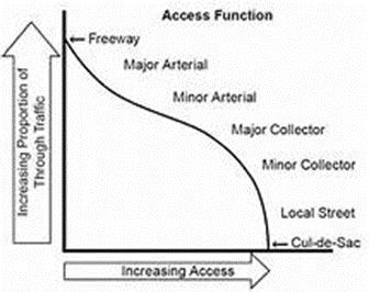
16 Access Class 2 or 3 Full median openings and signal spacings Median openings in a high accident corridor or location Situations where circulations can be provided through other alternatives A deviation shall not be considered under any of the following conditions: Sight distance for the proposed traffic movements would jeopardize safety Where the provision of the median opening would cause any safety hazard The hardship is self-created by the landowner or business Any other deviation that would negatively impact safety The deviation would degrade the efficiency of the system D. Retrofit to Restrictive Median Existing 5 lane sections on the Federal Interstate Highway System (FIHS) and all those over 28,000 daily traffic should be given the highest priority for retrofit. All 7 lane sections should be given a high priority for retrofit. E. Access vs. Thru Movement Highway functional classification means classifying highways with respect to the amount of access or movement they are to provide and then designing and managing each facility to perform that function. It should be noted that as the amount of through traffic increases, the access to property decreases (e.g., freeway). Also, as the amount of thru traffic decreases, the access to property increases (e.g., local street). Increasing access decreases the proportion of through traffic while decreasing access increases the proportion of through traffic.
17

18 IV. Roadway Design Elements A. Median Design Minimum standards for the distance needed to properly slow a vehicle down, and bring the vehicle to the storage portion of the median opening are found in FDOT Design Standard Index #301. This distance is measured from the beginning of the taper to the end of the queue storage portions. The unsignalized median opening is essentially an intersection. Properly designed it will have an auxiliary lane allowing the left turning vehicles to decelerate without interfering with the through movement of the leftmost through lane. Because the through lane is where the fastest traffic is, this means that the potential of high speed crashes is the greatest there. Before any design of this area can be done, it is important to know what speed, maneuvering distances and storage requirements you should design for.
19 Left Turn Break Prohibition A median opening within the physical length of a left-turn bay as illustrated below is potentially dangerous. Such an opening violates driver expectancy. A channelizing device should be placed at this median opening to prevent the left turn from the direction without the auxiliary lane.
20 Left Turn across Right Turn Lane or Intersection Queue Avoid openings across right turn lanes due to the danger of queues building up across the opening area. The problem here is that when these queues build, good Samaritans might allow the left turner through only to crash with a vehicle moving freely in the separate right turn lane.

21 Intersection Queue When the queue in the through traffic lane spills past the left-turn bay, turning vehicles are trapped in the queue. The left-turning vehicles are not able to move into the turn bay until the queue advances. Dual left turn lanes are more prone to this problem. Two-Way Left Turn Lanes (TWLTL) Two-way left turn lanes (TWLTL) have more conflict points than directional median openings. However, they provide unlimited access to driveway connections. The benefits and risks should be weighed carefully before choosing this option.

22 B. Perception Reaction Time/Distance The perceptions-reaction time required by the driver varies. For motorists who frequently use the street this may be as little as one second or less. However, unfamiliar drivers may not be in the proper lane to execute the desired maneuver and may require three or more seconds. Median openings should not be located in the perception-reaction area of a signalized intersection. The functional area consists of distance traveled during perception reaction time, plus deceleration distance, plus queue storage. Reaction Time and Distance Areas Sec. 35mph 45mph 55mph Rural feet 165 feet 200 feet Suburban feet 130 feet 160 feet Urban feet 100 feet 120 feet The following illustration shows the physical area and functional area of an intersection. The perception reaction time begins at the end of the functional area.
23 The following illustration shows where the perception reaction time begins and where deceleration occurs.
24 C. Taper The taper is the portion of the median opening that begins the transition to the turn lane. FDOT Design Standard Index #301 contains the standards for this feature. The preferred taper length for a single left/right turn lane is 50 feet. The preferred taper length for a dual left/right turn lane is 100 feet. The following table and illustrations show the turn lane requirements per the FDOT Design Standards Index 301. Turn Lanes Curbed and Uncurbed Medians Urban Conditions Rural Conditions Design Speed (MPH) Entry Speed (MPH) Clearance Distance L1 Brake to Stop Distance Total Decel Distance Clearance Distance L3 Brake to Stop Distance Total Decel Distance Clearance Distance L3 L2 L L2 L / The illustrations for the single left and dual left turn lanes are found in the FDOT Design Standards Index 301.
25 D. Design Speed The design speed is the speed used to make critical decisions on the roadway design feature. AASHTO s A Policy on Geometric Design of Highways and Streets 5 th Edition (Green Book) defines the design speed as: Design speed is the maximum safe speed that can be maintained over a specified section of highway when conditions are so favorable that the design features of the highway govern. The AASHTO Green Book also makes the following statements regarding the design speed. Once selected, all of the pertinent features of the highway should be related to the design speed to obtain a balanced design. Above-minimum design values should be used where feasible Design Speed (mph) Entry Speed (mph) Total Deceleration Distance L (feet) Urban Rural Rural
26 E. Entry Speed When considering medians and median openings, the greatest use of design speed is for determining the length of right and left turn lanes. A reading of the FDOT Design Standard Index #301 will show that design speed or the related entry speed are the basis for determining the minimum length of the turn lane for deceleration and stopping behind the turn lane queue. Total Deceleration Distance is important in the design of a turn lane. The turn bay should be designed so that a turning vehicle will develop a speed differential (through vehicle speed entry speed of turning vehicle) of 10 mph or less at the point it clears the through traffic lane. The length of the bay should allow the vehicle to come to a comfortable stop prior to reaching the end of the expected queue in the turn lane. If the turn lane is too short, or queued vehicles take up too much of the deceleration distance, there will be excessive deceleration in the through lane. This creates a high crash hazard as seen in research. F. Median Opening Design Example The spacing of median opening will be the sum of the following factors for both directions of the roadway. Note that the deceleration distance includes the taper length. Deceleration Queue Storage Turn Radius (usually 60 feet) Perception/Reaction distance or Full Width of Median (The length of the median that is not a part of the turn lanes or the taper. These sections provide for visibility, buffer and landscaping opportunity.)
27 Example: Design speed 45 mph suburban location Left turn queue storage: (Signalized) = 350 feet Deceleration = 185 feet Left Turn Queue Storage: (Unsignalized) = 100 feet Full Width Median = 130 feet Turn Radii = 60 feet
28 V. Median Design Elements A. Median End Treatments The median end design for an urban arterial should be designed for a passenger vehicle while assuring it can accommodate a larger deign vehicle. Different median ends can be used. Alternative designs are semicircular, symmetrical, bullet nose, asymmetrical bullet nose and half-bullet nose The only way in which left-turn vehicles can be removed from a through traffic lane is to install a left-turn bay. The lane should be of sufficient length to allow for adequate maneuver distance plus queue storage. The total length of the left-turn deceleration lane, including the taper, should be sufficient to allow the turning vehicle to decelerate from the speed of through traffic to a stop plus queue storage. The only openings that should be provided without turn lanes would be for official or emergency use only. B. Median Opening Length Median opening length is governed by: Turn radii Side street geometrics Median (traffic separator) width Intersection skews Intersection legs
29 C. Right Turns and Left Turns on Divided Roadways The FDOT Design Standard Index #546 specifies the sight distances for right and left turns at intersections on multi-lane roads with medians. These should be considered minimums. D. Two-Step Maneuver For divided highways with medians (the median is wider that the length of the design vehicle plus front and rear clearance), the maneuvers can be performed as two operations. The stopped vehicle must first have adequate sight distance to depart from a stopped position and cross traffic approaching from the left. The crossing vehicle may then stop in the median prior to performing the second operation. The second move requires the necessary sight distance for vehicles to depart from the median, to turn left into the cross road, and accelerate without being overtaken by vehicles approaching from the right.
30 VI. Sight Distance A. Sight Distance Concepts Highways must be designed to provide sufficient sight distance so that drivers can control and safely operate their vehicles. The following sight distances are of concern on median and median opening decisions, both urban and rural. Stopping sight distance: the distance necessary for the driver to safely bring a vehicle to a stop. Intersection sight distance: The distance necessary for drivers to safely approach and pass through and intersection. Height of eye: In determining sight distance, the height of the eye of the person who must stop or pass through the intersection is assumed to be 3.5 feet above the highway surface. This assumption has a significant bearing on such issues such as the placement of landscaping which might obstruct the view of the vehicle at the assumed height. Height of object: AASHTO assumes the height of an object for stopping sight distance to be 4.25 feet. A height of 2.0 feet above the pavement surface should be used as the height of an object for intersection sight distance. This will allow the driver to view the headlights of an oncoming passenger car at night.
31 B. Sight Distance for U-Turns U-Turns are more complicated than simple turning or crossing maneuvers. Sight distances for u- turns were calculated for automobiles with the following assumptions: P vehicle (Passenger vehicle) 2.0 seconds reaction time Extra time spent in the u-turn maneuver Begin acceleration from 0 mph only at the end of the u-turn movement Use of speed/distance/and acceleration figures from AASHTO Green Book 50 feet clearance factor Sight Distance for U-Turn at Unsignalized Median Opening Speed (mph) Sight Distance (feet) , , ,540 C. Sight Distance for Left Turn into Side Street After calculating the sight distances for this left turn in maneuver it becomes clear that in most cases the right turn sign distance from the side street would control the sight distance of this area. If the area has enough sight distance to allow a right turn vehicle from the side street, the sight distance should be sufficient for the left turn egress vehicle.
32 D. Left Turn Offset Vehicles turning left from opposing left turn lanes restrict each other s sight distance unless the lanes are sufficiently offset. Offset is defined as the lateral distance between the left edge of a left turn lane and the right edge of an opposing left turn. When the right edge of the opposing left turn is to the left of the left edge of the left turn lane, the offset is negative as shown in the illustration below. If it is to the right, it is a positive offset as indicated in the illustration below. Desirable offsets should all be positive with a recommended minimum 2 foot offset when the opposing left turn vehicle is a passenger car and a recommended minimum 4 foot offset when the opposing left turn vehicle is a truck.
33 VII. Median Width The appropriate median width is a function of the purpose that the median is to serve in a particular application. Applications on roadways having at-grade intersections that affect median width include the following: Separate opposing traffic streams Pedestrian refuge Left-turn to side street Left turn out of side street Crossing vehicles U-turns Aesthetics and maintenance A. Anatomy of Median Width Median width in most urban situations is made to accommodate turning lanes and a separator. The width of both the lane and the separator are critical to the operations of the median opening. Minimum and Recommended Widths are as follows: Summary of Standards and Recommendations Minimum Plans Preparation Manual (Reconstruction 15.5 feet Projects) = 40 mph and less Minimum Plans Preparation Manual (Reconstruction 19.5 feet Projects) 45 mph Minimum Plans Preparation Manual less than 55 mph 22 feet Guidance from Plans When Greater than 55 mph 40 feet Preparation Manual Recommended 4 lane highways with medians expecting significant u-turns and directional median openings with excellent positive guidance 30 feet for single left turns and 42 feet for dual lefts Recommended 6 lane highways with medians expecting significant u-turns and directional median openings with excellent positive guidance 22 feet for single left turns and 34 feet for dual lefts
34 A median width of 30 feet is the most desirable width due to the following: Greater flexibility in the choice of lane widths and separation width at double left-turn, full median openings. Additional width for landscaping the overlapping traffic separators at directional median openings. Permits separate vertical and/or horizontal alignment of the two roadways. For more information on turn lane width, see FDOT Plans Preparation Manual Table B. Minimum Traffic Separator Width at Intersections The minimum width of a median traffic separator nose has commonly been 4 feet. Where the right-of-way is limited, 2 feet and even as little as 18 inches has been used. The AASHTO Green Book indicates that the minimum narrow median width of 4 feet is recommended and is preferably 6 to 8 feet wide. C. Pedestrian Considerations at Traffic Separators Pedestrian refuge minimum for common practice is to use a minimum of 4-foot separator between the left-turn lane and the opposing traffic lane. The minimum width for pedestrian refuge is 6 feet. Where more than occasional pedestrians may be present, the median width should be at least 8.5 feet and preferable at 10 feet. D. Seeing Traffic Separators at Intersections Very narrow median noses are very difficult to see, especially at night and in inclement weather. Reflectorized paint is of little help as it rapidly becomes dirty and loses its reflectivity. Reflectorized traffic buttons and/or reflectorized pylons help but lack the bulk to provide good target value. Carefully selected, landscaping is the only effective way to provide excellent visibility of the median and median openings. A minimum traffic separator width of 6 feet and preferable 8.5
35 feet is needed for the median nose to be of sufficient width back-to-back with curbs to provide adequate area for vegetation. Landscaping of the median nose to provide visibility is especially important where long left-turn lanes are used. Obviously the choice of vegetation and the landscaping design must ensure that sight distance is not obstructed.

36 VIII. Median Signing The Manual on Uniform Traffic Control Devices (MUTCD) contains guidance on the type and placement of signs and traffic control devices at median opening areas. The following illustration (MUTCD, Figure 2B-16) is for signing on a median with a width narrower than 30 feet.

37 IX. Signal Spacing The access management classification system defines the spacing of signals to be ½ mile. The ½ mile spacing between signals is optimal because it provides space for: Safety Operations Flexibility Signal Progression Aesthetics. The distance also accommodates two sets of directional median openings. X. Freeway Ramp Terminal Careful design consideration should be given to the distance between the freeway ramp terminal to the first median opening. Observations indicate that drivers tend to make erratic maneuvers when there is a limited separation between the gore area of the off-ramp and the median opening. Desirable conditions would permit a driver to accelerate, merge into the outside traffic lane and select an acceptable gap in order to merge into the inside lane as illustrated.
 lane.")
38 XI. Special U-Turn Considerations A. AASHTO Guidance on Width and U-Turns The AASHTO Green Book contains some guidance on the relation between median width and u-turn movements. Unfortunately, the figure in the AASHTO Green Book shows the u-turn movements made from the inside (left) lane. This is contrary to the basic principle of having left turns made in auxiliary lanes rather than through lanes. In order to make the width sufficient for a Passenger Car (P) to make a u-turn from the turn lane to the outer lane, it would require 30 feet. If you cannot provide 30 feet, then the car will encroach on to the shoulder. This is acceptable as long as this encroachment has been built into the design. When designing for 6 lane highways, 20 feet of median width will usually provide sufficient space for the u-turn for the passenger car (P) vehicle. B. U-Turns Using a Flare The design P-vehicle can make a u-turn on an undivided roadway without a traffic separator by flaring the receiving roadway or where a far-side bus stop is used; the u-turn can be accommodated as shown in the following illustrations.

39 XII. Turing Vehicle Destination As a vehicle turns left from a median opening and crosses the highway, it enters the driveway and side street. The design of this entrance is critical to the safety and operation of the median opening. The three major areas of concern for access management issues are: Geometric Design of Driveways Placement of driveway in relation to the median opening and neighboring streets. Throat Length (the distance the driveway should extend before the first conflict). The geometric design of all access connections should allow drivers to complete the ingress maneuver (enter the abutting side street or property) with minimum effect on vehicles in the through traffic lane. Proximity to other access connections and median openings Curb return radius and throat width Throat length (distance before the first conflict) Queue storage Traffic control The combinations of curb return radius and throat width should allow drivers to enter and exit an access connection quickly and with minimal interference with through traffic. A narrower entry width can be used on connections that have larger radii. A. Placement of Driveways Access connections should be located directly opposite or downstream from a median opening as illustrated. Driveway access should be located more that 100 ft upstream from the median opening to prevent wrong way maneuvers as seen in the following illustration.


40 B. Throat Length The throat length must be of sufficient length to enable the intersection at the access connection and abutting highway, and the on-site circulation to function without interference with each other. Drivers entering the site should first clear the intersection of the highway and access connection before encountering the intersection of the access connection and on-site circulations. The following illustration shows inadequate throat length. The inbound vehicle conflicts with another vehicle on site. The following illustration shows adequate throat length. There is sufficient distance between the entrance of the driveway and the first potential crossing movement.
41 XIII. Summary Median design benefits were outlined including safety, efficiency and aesthetics. There was a definition of terms used in median design. Access Management Classifications were discussed as they relate to median design. The types of medians were shown from most restrictive to least restrictive. Conflict points associated with the various types of median openings were covered. Access vs. through movement was shown. Median design issues were outlined including approach taper, deceleration distance and storage length. Design speed and entry speed also play a factor in turn lanes. Perception-reaction time as it relates to turn lane design was discussed. Sight distance issues were discussed. Negative and positive left turn offsets were defined. A positive offset is preferred because it gives the left turning driver greater visibility of oncoming traffic. The placement of driveways as it relates to median openings was also covered. This course should equip an engineer with the necessary information to properly design median openings for roadway plans.
Access Location, Spacing, Turn Lanes, and Medians
 Design Manual Chapter 5 - Roadway Design 5L - Access Management 5L-3 Access Location, Spacing, Turn Lanes, and Medians This section addresses access location, spacing, turn lane and median needs, including
MUTCD Part 6G: Type of Temporary Traffic Control Zone Activities
 MUTCD Part 6G: Type of Temporary Traffic Control Zone Activities 6G.01 Typical Applications Each temporary traffic control (TTC) zone is different. Many variables, such as location of work, highway type,
Recommended Roadway Plan Section 2 - Land Development and Roadway Access
 Recommended Roadway Plan Section 2 - Land Development and Roadway Access SECTION 2 Land Development and Roadway Access 2.1 Land Use and Access Management The Federal Highway Administration (FHWA) defines
Driveway Design Criteria
 Design Manual Chapter 5 - Roadway Design 5L - Access Management 5L-4 Driveway Design Criteria A. General For efficient and safe operations, access drives and minor public street intersections can be improved
WYDOT DESIGN GUIDES. Guide for. Non-NHS State Highways
 WYDOT DESIGN GUIDES Guide for Non-NHS State Highways 2014 GUIDE FOR Non-NATIONAL HIGHWAY SYSTEM (Non-NHS) STATE HIGHWAYS PRESERVATION REHABILITATION RECONSTRUCTION INTRODUCTION This Guide is directed to
Chapter 2: Standards for Access, Non-Motorized, and Transit
 Standards for Access, Non-Motorized, and Transit Chapter 2: Standards for Access, Non-Motorized, and Transit The Washtenaw County Access Management Plan was developed based on the analysis of existing
Safety Impacts: Presentation Overview
 Safety Impacts: Presentation Overview The #1 Theme How Access Management Improves Safety Conflict Points The Science of Access Management By Treatment Studies Themes for Texas Access Management Improve
Alberta Infrastructure HIGHWAY GEOMETRIC DESIGN GUIDE AUGUST 1999
 Alberta Infrastructure HIGHWAY GEOMETRIC DESIGN GUIDE AUGUST 1999,1'(; A ACCELERATION Data on acceleration from stop D-29 Effects of grade D-35 Intersections D-97, D-99 Lanes D-97, F-5, F-7, F-15, F-21,
INDEX. Geometric Design Guide for Canadian Roads INDEX
 Acceleration lane, see Lanes, Acceleration Access, 8.1 Access Management and Functional Classification 8.2 Access Management by Design Classification 8.3 Access Configuration 8.4 Building Set-Back Guidelines
M-58 HIGHWAY ACCESS MANAGEMENT STUDY Mullen Road to Bel-Ray Boulevard. Prepared for CITY OF BELTON. May 2016
 M-58 HIGHWAY ACCESS MANAGEMENT STUDY Prepared for CITY OF BELTON By May 2016 Introduction Missouri State Highway 58 (M-58 Highway) is a major commercial corridor in the City of Belton. As development has
WYDOT DESIGN GUIDES. Guide for. NHS Arterial (Non-Interstate)
") WYDOT DESIGN GUIDES Guide for NHS Arterial (Non-Interstate) 2014 GUIDE FOR NATIONAL HIGHWAY SYSTEM (NHS) HIGHWAYS (NHS ARTERIALS, Non-Interstate) PRESERVATION REHABILITATION RECONSTRUCTION INTRODUCTION
WYDOT DESIGN GUIDES Guide for NHS Arterial (Non-Interstate) 2014 GUIDE FOR NATIONAL HIGHWAY SYSTEM (NHS) HIGHWAYS (NHS ARTERIALS, Non-Interstate) PRESERVATION REHABILITATION RECONSTRUCTION INTRODUCTION
1.3.4 CHARACTERISTICS OF CLASSIFICATIONS
 Geometric Design Guide for Canadian Roads 1.3.4 CHARACTERISTICS OF CLASSIFICATIONS The principal characteristics of each of the six groups of road classifications are described by the following figure
Access Management in the Vicinity of Intersections
 Access Management in the Vicinity of Intersections FHWA-SA-10-002 Technical Summary Photo: Ralph Bentley (used with permission) 0 Access Management is: The design, implementation and management of entry
Access Management Standards
 Access Management Standards Section 1: Application of Access Standards This chapter describes the Department's access management standards for access connections on the county roadway system. The standards
CHAPTER 1 STANDARD PRACTICES
 CHAPTER 1 STANDARD PRACTICES OBJECTIVES 1) Functions and Limitations 2) Standardization of Application 3) Materials 4) Colors 5) Widths and Patterns of Longitudinal Pavement Marking Lines 6) General Principles
American Fork City Access Management Manual
 American Fork City Access Management Manual American Fork, Utah April 2012 UT09-181 3315 West Mayflower Way, Ste. 4 Lehi, Utah 84043 p. 801/ 766.4343 www.halesengineering.com EXECUTIVE SUMMARY As traffic
Access requests to County streets and roadways are processed through one of the following methods:
 13.1 GENERAL APPLICATION PROCESS Access requests to County streets and roadways are processed through one of the following methods: A. Planned Developments may set general locations for access points.
Figure 3B-1. Examples of Two-Lane, Two-Way Marking Applications
 Figure 3B-1. Examples of Two-Lane, Two-Way Marking Applications A - Typical two-lane, two-way marking with passing permitted in both directions B - Typical two-lane, two-way marking with no-passing zones
ROUNDABOUTS/TRAFFIC CIRCLES
 GENERAL 1. Description This standard identifies minimum requirements that shall be met for Roundabouts and Neighborhood Traffic Circles in the design and construction of elements for Arlington County Horizontal
Chapter Twenty-eight SIGHT DISTANCE BUREAU OF LOCAL ROADS AND STREETS MANUAL
 Chapter Twenty-eight SIGHT DISTANCE BUREAU OF LOCAL ROADS AND STREETS MANUAL Jan 2006 SIGHT DISTANCE 28(i) Chapter Twenty-eight SIGHT DISTANCE Table of Contents Section Page 28-1 STOPPING SIGHT DISTANCE
Developed by: The American Traffic Safety Services Association (ATSSA) 15 Riverside Parkway, Suite 100 Fredericksburg, VA
 15 Riverside Parkway, Suite 100 Fredericksburg, VA") Addendum Developed by: The American Traffic Safety Services Association (ATSSA) 15 Riverside Parkway, Suite 100 Fredericksburg, VA 22406-1022 800-272-8772 This material is based upon work supported by
Addendum Developed by: The American Traffic Safety Services Association (ATSSA) 15 Riverside Parkway, Suite 100 Fredericksburg, VA 22406-1022 800-272-8772 This material is based upon work supported by
CITY OF SASKATOON COUNCIL POLICY
 ORIGIN/AUTHORITY Clause 1, Report No. 1-1980 and Clause 4, Report No. 22-1990 of the Works and Utilities Committee; Clause 6, Report No. 17-2004 of the Planning and Operations Committee; and Clause D5,
CHAPTER 2G. PREFERENTIAL AND MANAGED LANE SIGNS
 2011 Edition - Revision 2 Page 275 Section 2G.01 Scope CHAPTER 2G. PREFERENTIAL AND MANAGED LANE SIGNS 01 Preferential lanes are lanes designated for special traffic uses such as high-occupancy vehicles
DEFINITIONS Activity Area - Advance Warning Area Advance Warning Sign Spacing Advisory Speed Approach Sight Distance Attended Work Space
 DEFINITIONS Activity Area - that part of a TTC zone activity area where the work actually takes place. It consists of the work space, traffic space and one or more buffer spaces. Advance Warning Area -
Access Management Benefits & Techniques. Access Management Workshop June 2, 2006
 Access Management Benefits & Techniques Access Management Workshop June 2, 2006 1 Benefits of Access Management Safety As access density increases, crash rates increase Increasing the density of access
Defining Purpose and Need
 Advanced Design Flexibility Pilot Workshop Session 4 Jack Broz, PE, HR Green May 5-6, 2010 Defining Purpose and Need In your agency s project development process, when do design engineers typically get
10.0 CURB EXTENSIONS GUIDELINE
 10.0 CURB EXTENSIONS GUIDELINE Road Engineering Design Guidelines Version 1.0 March 2017 City of Toronto, Transportation Services City of Toronto Page 0 Background In early 2014, Transportation Services
Figure 1: Graphical definitions of superelevation in terms for a two lane roadway.
 Iowa Department of Transportation Office of Design Superelevation 2A-2 Design Manual Chapter 2 Alignments Originally Issued: 12-31-97 Revised: 12-10-10 Superelevation is the banking of the roadway along
Background on the Revisions to VDOT s Access Management Spacing Standards
 December 2011 Background on the Revisions to VDOT s Access Management Spacing Standards Spacing Standards for Commercial Entrances, Signals, Intersections, and Crossovers The spacing standards were located
THE FUTURE OF THE TxDOT ROADWAY DESIGN MANUAL
 THE FUTURE OF THE TXDOT ROADWAY DESIGN MANUAL Kenneth Mora, P.E. (Design Division) 10/10/2017 Table of contents 1 2 Reduction in FHWA design controlling criteria Innovative Intersection Guidance 3-7 8-42
Roadway Design Manual
 Roadway Design Manual Manual Notice Archive by Texas Department of Transportation (512) 302-2453 all rights reserved Manual Notice 2009-1 From: Manual: Mark A. Marek, P.E Roadway Design Manual Effective
TRAFFIC AND SAFETY NOTE 608A. Spacing for Commercial Drives and Streets. To Promote a Uniform Practice in Determining Access Spacing
 TRAFFIC AND SAFETY NOTE 608A SUBJECT: PURPOSE: Spacing for Commercial Drives and Streets To Promote a Uniform Practice in Determining Access Spacing COORDINATING UNIT: Geometric Design Unit INFORMATION:
Access Management Regulations and Standards for Minor Arterials, Collectors, Local Streets
 Access Management Regulations and Standards for Minor Arterials, Collectors, Local Streets September 2009 Paul Grasewicz Access Management Administrator Concept of Access Management The way to manage access
PennDOT Access Management Model Ordinances Training
 PennDOT Access s Training Trainers: Chad Dixson, AICP, TPD Angela Watson, PB Objective of Today Assist Pennsylvania s municipalities and transportation professionals in better understanding the benefits
TRAFFIC LINE MANUAL. June 2011 TRAFFIC-ROADWAY SECTION
 TRAFFIC LINE MANUAL TRAFFIC-ROADWAY SECTION TABLE OF CONTENTS Foreword...iv Section A: General Principles A-1 Functions and Limitations... 1 A-2 Colors... 1 A-3 Colored Pavements... 1 A-4 Functions, Widths,
CHAPTER 17 ACCESS MANAGEMENT
 CHAPTER 17 ACCESS MANAGEMENT General 17-2 Permit Procedures 17-4 SDDOT-Owned Access Rights 17-4 Access Management Rules 17-4 Figure 17-1 South Dakota Access Location Criteria Techniques 17-6 Consolidating
Access Management Regulations and Standards
 Access Management Regulations and Standards January 2014 Efficient highway operation Reasonable property access Concept of Access Management The way to manage access to land development while preserving
Access Management Guidelines for the Urbanized Area
 Access Management Guidelines for the Urbanized Area April 2013 Table of Contents EXECUTIVE SUMMARY... 6 SECTION 1: INTRODUCTION TO ACCESS MANAGEMENT... 7 1.1 What is Access Management?... 7 1.2 Relationships
JUNE, 2000 ROAD DESIGN MANUAL 5-0(1) CHAPTER 5 AT-GRADE INTERSECTIONS
 CHAPTER 5 AT-GRADE INTERSECTIONS") JUNE, 2000 ROAD DESIGN MANUAL 5-0(1) CHAPTER 5 AT-GRADE INTERSECTIONS 5-1.0 INTRODUCTION 5-1.01 Definition 5-1.02 Policy 5-1.03 Design Considerations 5-1.04 Vehicle Characteristics 5-1.04.01 Turning Radii
JUNE, 2000 ROAD DESIGN MANUAL 5-0(1) CHAPTER 5 AT-GRADE INTERSECTIONS 5-1.0 INTRODUCTION 5-1.01 Definition 5-1.02 Policy 5-1.03 Design Considerations 5-1.04 Vehicle Characteristics 5-1.04.01 Turning Radii
INTERSECTIONS AT GRADE INTERSECTIONS
 INTERSECTIONS 1 AT GRADE INTERSECTIONS INTERSECTIONS INTERSECTIONS = INTERRUPTED FACILITIES Definitions and key elements An intersection is defined as an area where two or more roadways join or cross.
JCE 4600 Transportation Engineering. Traffic Control
 JCE 4600 Transportation Engineering Traffic Control Human Factors Primary Driving Tasks NAVIGATION GUIDANCE CONTROL What makes a Traffic Control Device Effective? Fulfill a need Command Attention Convey
Issues Relating to the Geometric Design of Intersections Vergil G. Stover
 Introduction Issues Relating to the Geometric Design of Intersections Vergil G. Stover This paper presents five issues, or topics, that the author suggests be addressed in the design of intersections.
Road Markings. Lecture Notes in Transportation Systems Engineering. Prof. Tom V. Mathew
 Road Markings Lecture Notes in Transportation Systems Engineering Prof. Tom V. Mathew 1 Overview The essential purpose of road markings is to guide and control traffic on a highway. They supplement the
BI-DIRECTIONALS FREE-ACCESS
 BI-DIRECTIONALS FREE-ACCESS Dimensions may vary depending on design vehicle and turning movements. See GEO-650-Series for addtional details. SPECIAL Special situations, i.e., See Notes 4 & 5 wide streets,
Central Arkansas Regional Transportation Study Area ROADWAY DESIGN STANDARDS And Implementation Procedures
 Central Arkansas Regional Transportation Study Area ROADWAY DESIGN STANDARDS And Implementation Procedures These standards have been prepared for the use of all jurisdictions to incorporate into their
Intersection Safety 6/7/2015 INTERSECTIONS. Five basic elements should be considered in intersection design. Intersection Safety (continued)
") Intersection Safety S. M. SOHEL MAHMUD Assistant Professor Accident Research Institute (ARI), Bangladesh University of Engineering and Technology (BUET) Dhaka-1000, Bangladesh 1 Outline of the Presentation
Intersection Safety S. M. SOHEL MAHMUD Assistant Professor Accident Research Institute (ARI), Bangladesh University of Engineering and Technology (BUET) Dhaka-1000, Bangladesh 1 Outline of the Presentation
CHAPTER 3A. GENERAL PAGE CHAPTER 3B. PAVEMENT AND CURB MARKINGS PAGE
 Virginia Supplement to the 2009 MUTCD Revision 1 Page TC-3-1 PART 3. MARKINGS CHAPTER 3A. GENERAL PAGE Section 3A.01 Functions and Limitations Section 3A.02 Standardization of Application Section 3A.03
TABLE OF CONTENTS LIST OF FIGURES. Figure Title
 TABLE OF CONTENTS Table of Contents... 1 List of Figures... 1 Chapter Forty-two... 2 42-1.0 STOPPING SIGHT DISTANCE... 2 42-1.01 Theoretical Discussion...2 42-1.02 Passenger Car Stopping Sight Distance...
TRAFFIC LINE MANUAL Edition Revision 1 June 2012 TRAFFIC-ROADWAY SECTION
 TRAFFIC LINE MANUAL 2011 Edition Revision 1 June 2012 TRAFFIC-ROADWAY SECTION TABLE OF CONTENTS Foreword...iv Section A: General Principles A-1 Functions and Limitations... 1 A-2 Colors... 1 A-3 Colored
Access Management Design Standards for Entrances and Intersections
 Access Management Design Standards for Entrances and Intersections July 2012 APPENDIX F VDOT Road Design Manual PREFACE The access management regulations and standards do not apply in cities, towns of
Geometric designs for Safe Highways. Dr. Manoj M. Asst. Professor Department of Civil Engineering IIT Delhi
 Geometric designs for Safe Highways Dr. Manoj M. Asst. Professor Department of Civil Engineering IIT Delhi WORKSHOP-CUM-TRAINING PROGRAMME ON ROAD SAFETY 17th 21st September 2018 Outline Introduction Cross
Grade Separated Intersection
 Grade Separated Intersection Lecture Notes in Transportation Systems Engineering Prof. Tom V. Mathew Contents 1 Overview 1 2 Classification of Intersection 2 2.1 Grade Separated Intersection...........................
City of Columbia Access Management Ordinance
 City of Columbia Access Management Ordinance TABLE OF CONTENTS Contents Article 1. Introduction... 3 SECTION 1.01 PURPOSE... 3 SECTION 1.02 JURISDICTION OF THESE REGULATIONS... 3 SECTION 1.03 RELATIONSHIP
CHAPTER 6H. TYPICAL APPLICATIONS
 2006 Edition Page 6H-1 CHAPTER 6H. TYPICAL APPLICATIONS Section 6H.01 Typical Applications Support: Whenever the acronym TTC is used in this Chapter, it refers to temporary traffic control. Standard: The
Roadway Classification Design Standards and Policies. Pueblo, Colorado November, 2004
 Roadway Classification Design Standards and Policies Pueblo, Colorado November, 2004 Table of Contents Page Chapter 1. General Provisions 1.1 Jurisdiction 3 1.2 Purpose and Intent 3 1.3 Modification 3
APPENDIX B Boonville Code of Ordinances. BOONVILLE, MISSOURI Access Management Manual. March Revised April 2009 INDEX
 APPENDIX B Boonville Code of Ordinances BOONVILLE, MISSOURI Access Management Manual March 2002 Revised April 2009 INDEX Section Page 1.0 Introduction and Definitions. 2 2.0 Roadway Classification System.
Section 3A.04 Colors. Section 3B.10 Approach Markings for Obstructions
 Section 3A.04 Colors Markings shall be yellow, white, red, or blue, or purple. The colors for markings shall conform to the standard highway colors. Black in conjunction with one of the above colors shall
October 2004 REVISIONS (2) SUPERELEVATION DEVELOPMENT 11.3(2)
 SUPERELEVATION DEVELOPMENT 11.3(2)") October 2004 REVISIONS (2) Chapter 11 HORIZONTAL ALIGNMENT SUPERELEVATION DEVELOPMENT 11.3(2) Chapter 12 VERTICAL ALIGNMENT VERTICAL CURVES PASSING SIGHT DISTANCE 12.5(2) VERTICAL CURVES STOPPING SIGHT
October 2004 REVISIONS (2) Chapter 11 HORIZONTAL ALIGNMENT SUPERELEVATION DEVELOPMENT 11.3(2) Chapter 12 VERTICAL ALIGNMENT VERTICAL CURVES PASSING SIGHT DISTANCE 12.5(2) VERTICAL CURVES STOPPING SIGHT
Access Management Regulations and Standards
 Access Management Regulations and Standards Efficient highway operation Reasonable property access Concept of Access Management The way to manage access to land development while simultaneously preserving
FOR HISTORICAL REFERENCE ONLY
 To: From: Subject: Electronic Distribution Recipients MINNESOTA DEPARTMENT OF TRANSPORTATION Engineering Services Division Technical Memorandum No. 12-14-B-03 December 18, 2012 Jon M. Chiglo, P.E. Division
Frequently Asked Questions
 Frequently Asked Questions Business US 190 in Copperas Cove From Avenue D to Constitution Drive What is access management? A. Access Management is a growing effort by government agencies to improve how
1 VicRoads Access Management Policies May 2006 Ver VicRoads Access Management Policies May 2006 Version 1.02
 1 VicRoads Access Management Policies May 2006 Ver 1.02 VicRoads Access Management Policies May 2006 Version 1.02 2 VicRoads Access Management Policies May 2006 Ver 1.02 FOREWORD FOR ACCESS MANAGEMENT
Roadway Design Manual
 Roadway Design Manual Revised December 2013 2013 by Texas Department of Transportation (512) 302-2453 all rights reserved Manual Notice 2013-1 From: Manual: Mark A. Marek, P.E Roadway Design Manual Effective
Design of Turn Lane Guidelines
 Design of Turn Lane Guidelines CTS Transportation Research Conference May 24, 2012 Howard Preston, PE Minnesota Department of Transportation Research Services Office of Policy Analysis, Research & Innovation
Considerations in the Review and Approval of a Driveway in Your Jurisdiction
 Considerations in the Review and Approval of a Driveway in Your Jurisdiction So, are you the person at your agency who reviews and approves new driveways? Or, perhaps you are part of the TEAM of people
Traffic Engineering and Highway Safety Bulletin June Overview
 Traffic Engineering and Highway Safety Bulletin 18-03 June 2018 INTERSECTION GEOMETRIC DESIGN In This Issue Overview... 1 Intersection Types... 2 Traffic Control Selection... 3 Capacity Analysis... 6 Design
CHAPTER 6H. TYPICAL APPLICATIONS
 Section 6H.01 Typical Applications Support: CHAPTER 6H. TYPICAL APPLICATIONS Chapter 6G contains discussions of typical temporary traffic control activities. Chapter 6H presents typical applications for
City of Albert Lea Policy and Procedure Manual 4.10 ALBERT LEA CROSSWALK POLICY
 4.10 ALBERT LEA CROSSWALK POLICY PURPOSE: Pedestrian crosswalks are an integral part of our transportation infrastructure. To be effective and promote safety, marked crosswalks must be installed after
City of Wayzata Comprehensive Plan 2030 Transportation Chapter: Appendix A
 A1. Functional Classification Table A-1 illustrates the Metropolitan Council s detailed criteria established for the functional classification of roadways within the Twin Cities Metropolitan Area. Table
Best Practices for the Design and Operation of Reduced Conflict Intersections
 Best Practices for the Design and Operation of Reduced Conflict Intersections OCTOBER 2016 Prepared By: Table of Contents INTRODUCTION... 5 Purpose... 5 Definition... 5 Advantages... 6 Disadvantages...
This Chapter sets forth the minimum design, technical criteria and specifications to be used in the preparation of all roadway plans.
 4.1 GENERAL This Chapter sets forth the minimum design, technical criteria and specifications to be used in the preparation of all roadway plans. These Roadway Standards are for new construction and modification
400 Intersection Design. Table of Contents. 401 Intersections At-Grade Two Way Left Turn Lanes (TWLTL)... 9
... 9") 4 Intersection Design Table of Contents 41 Intersections At-Grade... 1 41.1 Intersection Locations... 1 41.2 Intersection Traffic Control and Operational Analysis... 1 41.2.1 Signals... 1 41.2.2 Stop Control...
4 Intersection Design Table of Contents 41 Intersections At-Grade... 1 41.1 Intersection Locations... 1 41.2 Intersection Traffic Control and Operational Analysis... 1 41.2.1 Signals... 1 41.2.2 Stop Control...
CHAPTER 7 ACCESS MANAGEMENT. Background. Principles of Access Management. Hennepin County Transportation Systems Plan (HC-TSP)
") CHAPTER 7 ACCESS MANAGEMENT Background Principles of Access Management Hennepin County Transportation Systems Plan (HC-TSP) Chapter 7 Access Management 7.1 Background Access management has become an important
CHAPTER 7 ACCESS MANAGEMENT Background Principles of Access Management Hennepin County Transportation Systems Plan (HC-TSP) Chapter 7 Access Management 7.1 Background Access management has become an important
Geometric Design Tables
 Design Manual Chapter 5 - Roadway Design 5C - Geometric Design Criteria 5C-1 Geometric Design Tables A. General The following sections present two sets of design criteria tables - Preferred Roadway Elements
Appendix B MoDOT Access Management Guidelines
 Appendix B MoDOT Access Management Guidelines Meramec Regional Transportation Plan Page B-1 MISSOURI DEPARTMENT OF TRANSPORTATION ACCESS MANAGEMENT GUIDELINES September 12, 2003 Meramec Regional Transportation
SECTION 1 - TRAFFIC PLANNING
 SECTION 1 - TRAFFIC PLANNING 1.1 TRAFFIC OPERATIONS 1.1.1 Roadway Functional Classification The Multnomah County Comprehensive Framework Plan s Policy 34: Trafficways and the Functional Classification
Subject: Use of Pull-off Areas in Work Zones Page: 1 of 13. Brief Description: Guidance for the use and placement of pull-off area in work zones.
 6 - G2 Subject: Use of Pull-off Areas in Work Zones Page: 1 of 13 MdMUTCD REF. NO. None Date Issued: 09/09 Effective Date: 09/09 Brief Description: Guidance for the use and placement of pull-off area in
City of Prince Albert Statement of POLICY and PROCEDURE. Department: Public Works Policy No. 66. Section: Transportation Issued: July 14, 2014
 Page: 1 of 8 1 POLICY 1.01 The City shall follow all of the specifications in the Manual of Uniform Traffic Control Devices for Canada, prepared by the National Committee of Uniform Traffic Control, and
Traffic Control Inspection Checklist Segment:
 Traffic Control Inspection Checklist Segment: Simon Contractors Simon Contractors Originator: Description Reviewed by: Initials Date Distribution: Traffic Quality Manager, Site Assistant Traffic Manager
WORK ZONE TRAFFIC CONTROL PROCEDURES
 WORK ZONE SETUP / REMOVAL WORK ZONE TRAFFIC CONTROL PROCEDURES When installing a work zone, install the advance warning signs on all approaches prior to installing the traffic control devices. Perform
Appendix T CCMP TRAIL TRAFFIC & TRANSPORTATION DESIGN STANDARD
 Appendix T CCMP 3.3.4 TRAIL TRAFFIC & TRANSPORTATION DESIGN STANDARD 3.3.4 Trail Traffic and Transportation Design Multi-use trails have certain design standards, which vary depending on the agency that
Figure 1: Vicinity Map of the Study Area
 ARIZONA TEXAS NEW MEXICO OKLAHOMA May 5, 2016 Mr. Anthony Beach, P.E. BSP Engineers 4800 Lakewood Drive, Suite 4 Waco, Texas 76710 Re: Intersection and Access Analysis along Business 190 in Copperas Cove
MUNICIPALITY OF ANCHORAGE Traffic Department MEMORANDUM
 MUNICIPALITY OF ANCHORAGE DATE: MEMORANDUM TO: FROM: SUBJECT: Anchorage Contractors, Builders, Designers, and Land Owners Robert E. Kniefel, P.E., Municipal Traffic Engineer Municipal Driveway Standards
APPENDIX F. Access Management Design Standards for Entrances and Intersections
 APPENDIX F Access Management Design Standards for Entrances and Intersections PREFACE The access management regulations and standards do not apply in cities, towns of more than 3,500 and in counties (Henrico
CURBSIDE ACTIVITY DESIGN
 5 CURBSIDE ACTIVITY DESIGN This chapter provides design guidance for separated bike lanes adjacent to curbside activities including parking, loading and bus stops. Typical configurations are presented
Chapter 3 - Local Urban Road System CHAPTER 3 LOCAL URBAN ROAD SYSTEM
 CHAPTER 3 LOCAL URBAN ROAD SYSTEM 3.0 INTRODUCTION As in Chapter 2 for the local rural road system, the local urban road system also utilizes the concepts of land use context, functional classification
INTRODUCTION THOROUGHFARE SYSTEM CLASSIFICATIONS
 INTRODUCTION The thoroughfare plan will assist public officials in the development of a specialized system for efficient and safe movement of vehicular traffic while minimizing potential conflicts with
MUTCD Part 6: Temporary Traffic Control
 MUTCD Part 6: Temporary Traffic Control OMUTCD English units are preferred. OHIO MANUAL OF UNIFORM TRAFFIC CONTROL DEVICES TABLE OF CONTENTS PREFACE INTRODUCTION TABLE OF CONTENTS PART 1. GENERAL Chapter
Chapter 33. Grade Separated Intersection Overview Classification of Intersection Grade Separated Intersection
 Chapter 33 Grade Separated Intersection 33.1 Overview An intersection is the area shared by the joining or crossing of two or more roads. Since the main function of an intersection is to enable the road
KDOT Access Management Policy (AMP)
") KDOT Access Management Policy (AMP) (January 2013 Edition) Errata KDOT intends to correct these errors during the next revision to the Policy. Corrections are denoted in red text with a solid line through
KDOT Access Management Policy (AMP) (January 2013 Edition) Errata KDOT intends to correct these errors during the next revision to the Policy. Corrections are denoted in red text with a solid line through
(This page left intentionally blank)
") (This page left intentionally blank) 2011 Edition - Revision 1 Page 553 Section 5A.01 Function CHAPTER 5A. GENERAL 01 A low-volume road shall be defined for this Part of the Manual as follows: A. A low-volume
(This page left intentionally blank) 2011 Edition - Revision 1 Page 553 Section 5A.01 Function CHAPTER 5A. GENERAL 01 A low-volume road shall be defined for this Part of the Manual as follows: A. A low-volume
BDC07MR-05. Section 6
 BDC07MR-05 Section 6 6.1 General Most highways intersect at grade. To minimize the resulting conflicts and to provide adequately for the anticipated crossings and turning movements, the geometric design
Technical Report Documentation Page 2. Government Accession No. 3. Recipient's Catalog No.
 1. Report No. FHWA/TX-05/0-4141-P3 4. Title and Subtitle ACCESS MANAGEMENT GUIDEBOOK FOR TEXAS Technical Report Documentation Page 2. Government Accession No. 3. Recipient's Catalog No. 5. Report Date
CIRCLE DRIVE TRAFFIC AND ACCESS MANAGEMENT POLICY GUIDE. Management Principles and Implementation Concepts
 CIRCLE DRIVE TRAFFIC AND ACCESS MANAGEMENT POLICY GUIDE A. PREFACE Management Principles and Implementation Concepts The intent of this policy guide is to provide interim guidance on the implementation
Road Markings. Lecture Notes in Transportation Systems Engineering. Prof. Tom V. Mathew. 1 Overview 1. 2 Classification 2
 Road Markings Lecture Notes in Transportation Systems Engineering Prof. Tom V. Mathew Contents 1 Overview 1 2 Classification 2 3 Longitudinal markings 2 3.1 Center line.....................................
General References Definitions. (1) Design Guidance. (2) Supporting Information
 Design Guidance. (2) Supporting Information") Chapter 1240 Turning Roadways 1240.01 General 1240.02 References 1240.03 Definitions 1240.04 Turning Roadway Widths 1240.05 Documentation 1240.01 General The roadway on a curve may need to be widened to
Chapter 1240 Turning Roadways 1240.01 General 1240.02 References 1240.03 Definitions 1240.04 Turning Roadway Widths 1240.05 Documentation 1240.01 General The roadway on a curve may need to be widened to
Roadways. Roadways III.
 Introduction 97 Roadway Design Principles 98 Safe Speeds 99 Optimizing of Street Space 00 Minimum Lane Widths in the City of Boston 02 Design Features that Reduce Operating Speeds 05 Travel Lanes Transit
Design of Suburban Highways
 Design of Suburban Highways by David L. Heavey, P.E. TABLE OF CONTENTS Introduction...3 Design Speed, Posted Speed and Operating Speed...4 Median Types...5 Raised Medians...9 Common Suburban Roadway Typical
Practical Application of Turn Lane Design Criteria in Developing Suburban & Urban Corridors
 Practical Application of Turn Lane Design Criteria in Developing Suburban & Urban Corridors Presented by Gilmer D. Gaston, P.E., PTOE October 14, 2014 San Antonio Austin Houston Fort Worth Dallas When
2.0 LANE WIDTHS GUIDELINE
 2.0 LANE WIDTHS GUIDELINE Road Engineering Design Guidelines Version 2.0.1 May 2018 City of Toronto, Transportation Services City of Toronto Page 0 Background In early 2014, Transportation Services initiated