Staff Report on Draft Chapters: Pedestrian Environments and Bicycle Network & Facilities
|
|
|
- Nicholas Charles
- 6 years ago
- Views:
Transcription

1 Downtown Streets & Open Space Improvement Plan Subcommittee Matthew Taecker, Secretary, 2120 Milvia Street, Berkeley, CA Telephone: Web: Staff Report on Draft Chapters: Pedestrian Environments and Bicycle Network & Facilities Downtown Streets & Open Space Improvement Plan Subcommittee Meeting #3 Requested Action Provide guidance on draft narrative and figures for SOSIP chapters on Pedestrian Environments, and Bicycle Network & Facilities, plus a section on Shared Streets that relates to both chapters. Review of these materials may result in refinements to subarea design concepts thatt have been previously discussed by the SOSIP Subcommittee. Include the input of the Transportation Commission s Subcommittees on Pedestrians and Bicycles, and the input of Transportation Division staff, so that the safety and convenience of pedestrians and bicyclists are adequately addressed. Overview of SOSIP The SOSIP meeting on April 29 will include the participation of Transportation Commissioners who may not have participated previously in the SOSIP process. SOSIP s schedule, draft outline, subarea design concept options, draft chapter on Street Trees & Landscaping, and other materials can be downloaded at: Note that the mission of the SOSIP Subcommittee is to address the full range of issues relating to Downtown streets and open space, such as: adequate access, safety, economic development, community character, recreation, construction, maintenance, stormwater quality, etc. Prior SOSIP meetings have identified preferred design options for the purpose of cost estimating so that recommendations for financing improvements can be reviewed in June. Most of these preferred options have been compiled within Figures for Pedestrian Environments Chapter, so that their relationship to Downtown s bicycle system can be considered. Refinements and revisions to preferred design concepts may be discussed as other materials are developed. Final SOSIP recommendations are anticipated in September, and final development of subarea concepts will begin in June. The SOSIP will be comprised of three principle components. Design concepts for subareas are only one component. The SOSIP will also include chapters with guidelines that will apply throughout the Downtown Area, and it will include a financing plan to address and prioritize capital and on-going costs. 1
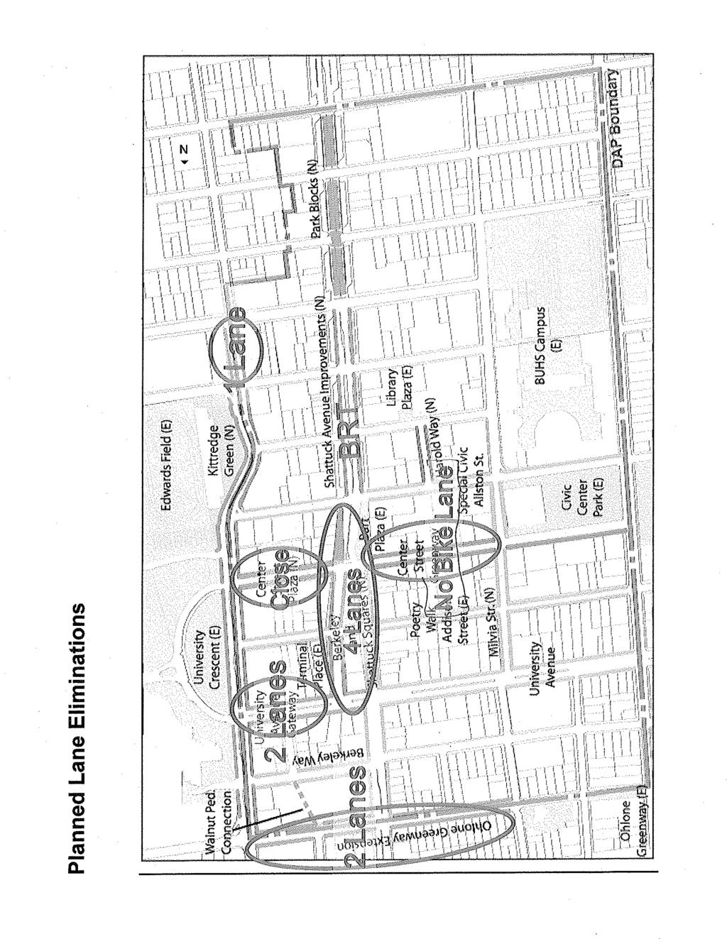
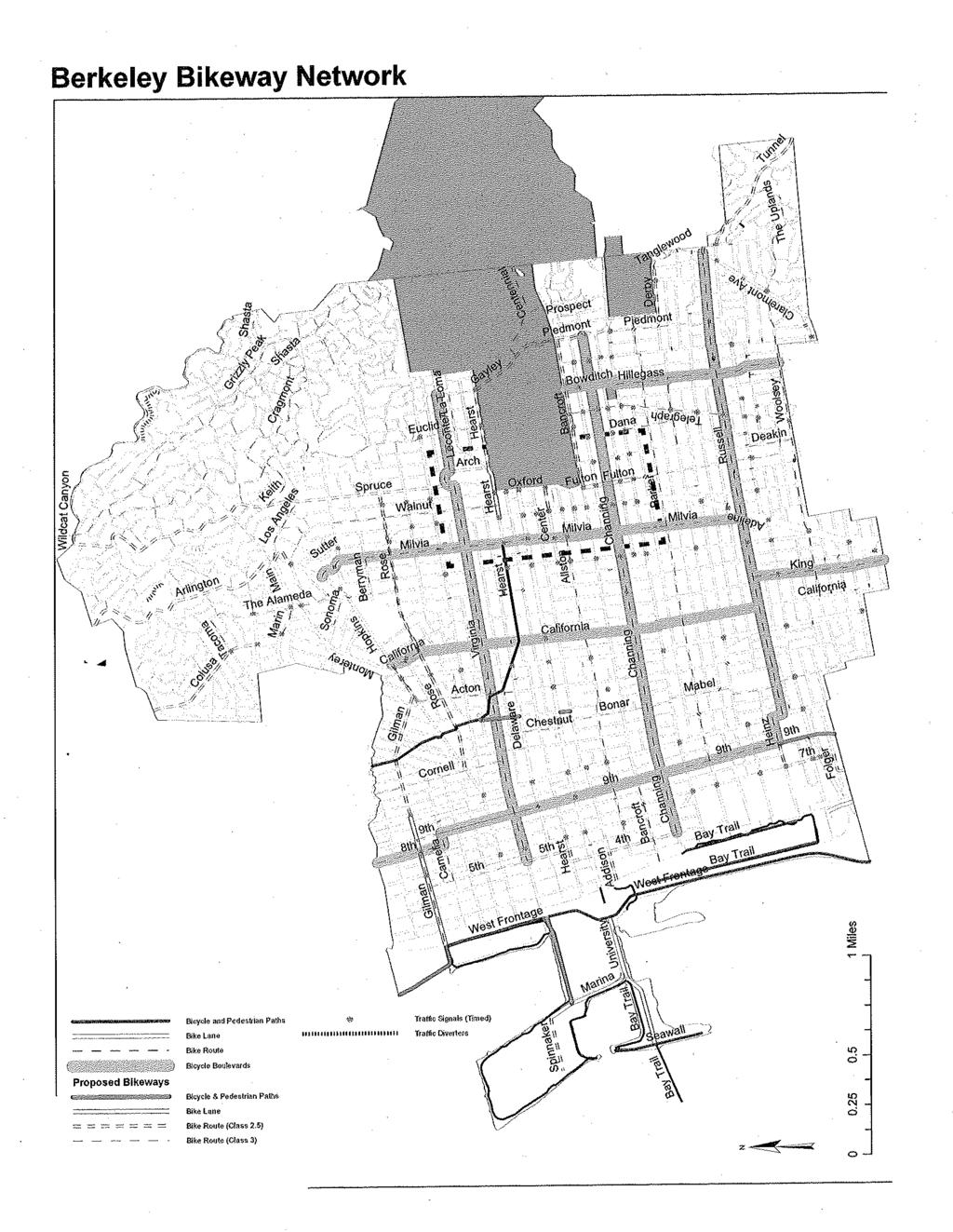
2 Pedestrian Environments The rescinded Downtown Area Plan (DAP) and the draft 2010 DAP now under consideration by Planning Commission At the same time, the draft DAP emphasizes pedestrians, bicycles, transit, reducing the use of cars, and mitigating negative impacts associated with motorized vehicles. The following draft DAP goal pertains specifically to pedestrians. GOAL AC-2: GIVE PEDESTRIANS PRIORITY IN DOWNTOWN, AND MAKE WALKING DOWNTOWN SAFE, ATTRACTIVE, EASY AND CONVENIENT FOR PEOPLE OF ALL AGES AND ABILITIES. The SOSIP draft chapter on Pedestrian Environments first addresses the extent of pedestrian spaces in Downtown, in the context of other modes. Curbs afford the greatest protection to pedestrians. Consequently, the placement and location of curbs is addressed and coordinated with safety and performance needs associated with bicycles and motorized vehicles. Devices for pedestrian safety and comfort are described, such as the use of curb extensions and corner curb radii. Amenities for pedestrians, such as street furniture, public art, and wayfinding signage will be addressed in separate chapters. Pedestrians will mix with other modes in some locations. Crosswalks are the obvious, but consideration is also given to utilizing shared streets in at least one key location. Shared streets are designed to slow vehicles to speeds that are little more than walking, and give pedestrians and bicyclists priority over cars and trucks. Bicycle Network & Facilities The SOSIP may include bicycle facilities that are not identified in the Bicycle Master Plan that is now in effect. Bicycle facilities under consideration include: bike lanes on Shattuck Avenue between Allston and Dwight (the southern boundary of the Downtown Area); bike lanes on Milvia between University Avenue and Allston Way, or alternatively bike lanes between University and Center with a shared street between Center and Allston in front of the Civic Center Building; bike lanes on Hearst for continuous lanes between the Ohlone Greenway and the UC campus; a northbound contraflow bike lane along Fulton where there is one-way traffic; and and emphasizing bicycle safety on Allston Way by designation it as a Class 2.5 Bike Route and adding a bike activated signal at Oxford. Draft policies and designs have not addressed whether bike lanes should continue on Shattuck, north of Allston. If so, the meeting may consider how bike lanes might be extended in light of Shattuck Square design concepts. 2
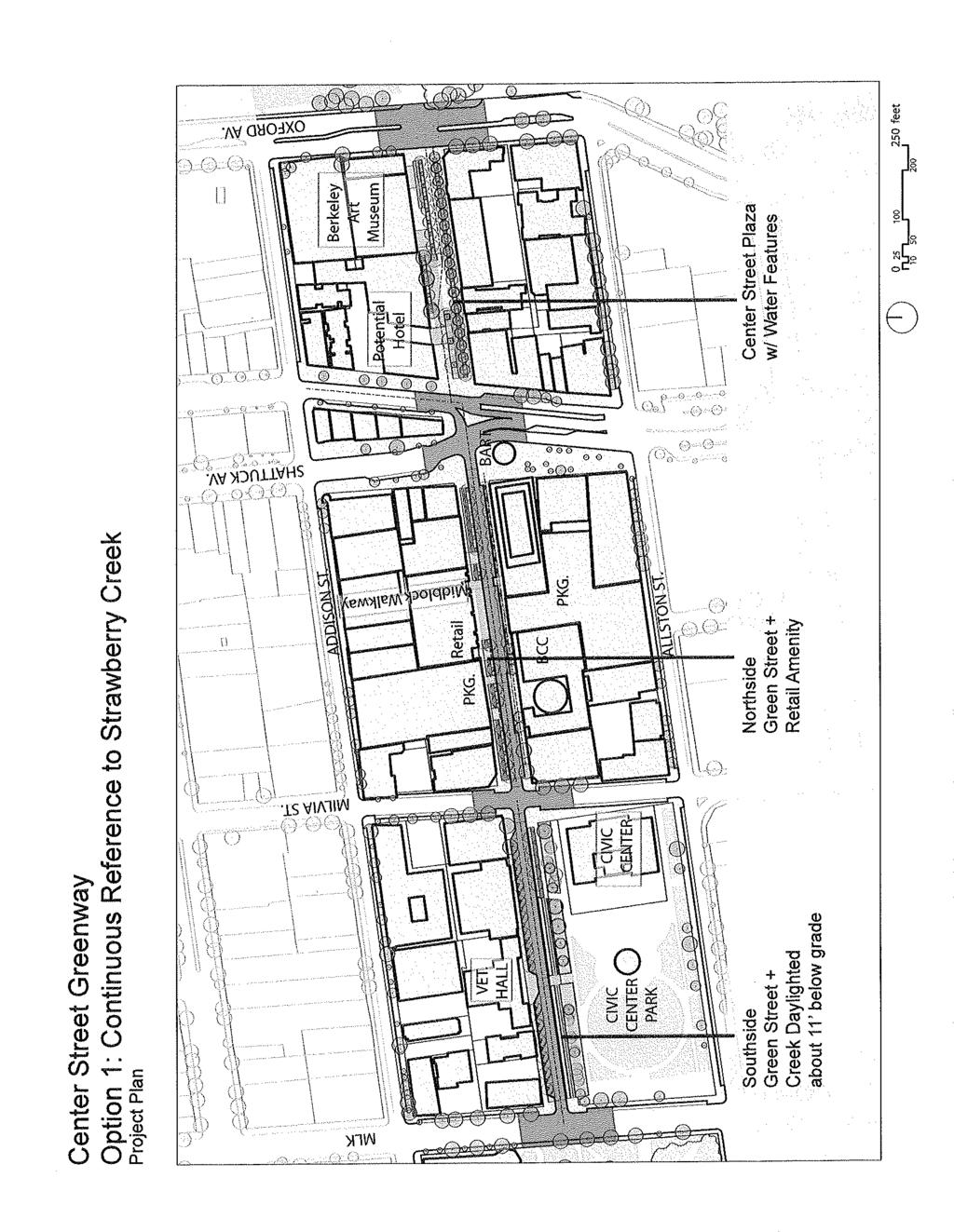
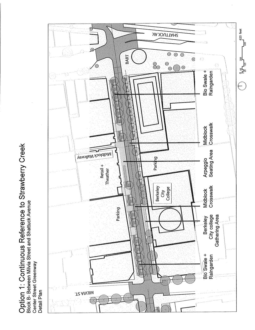
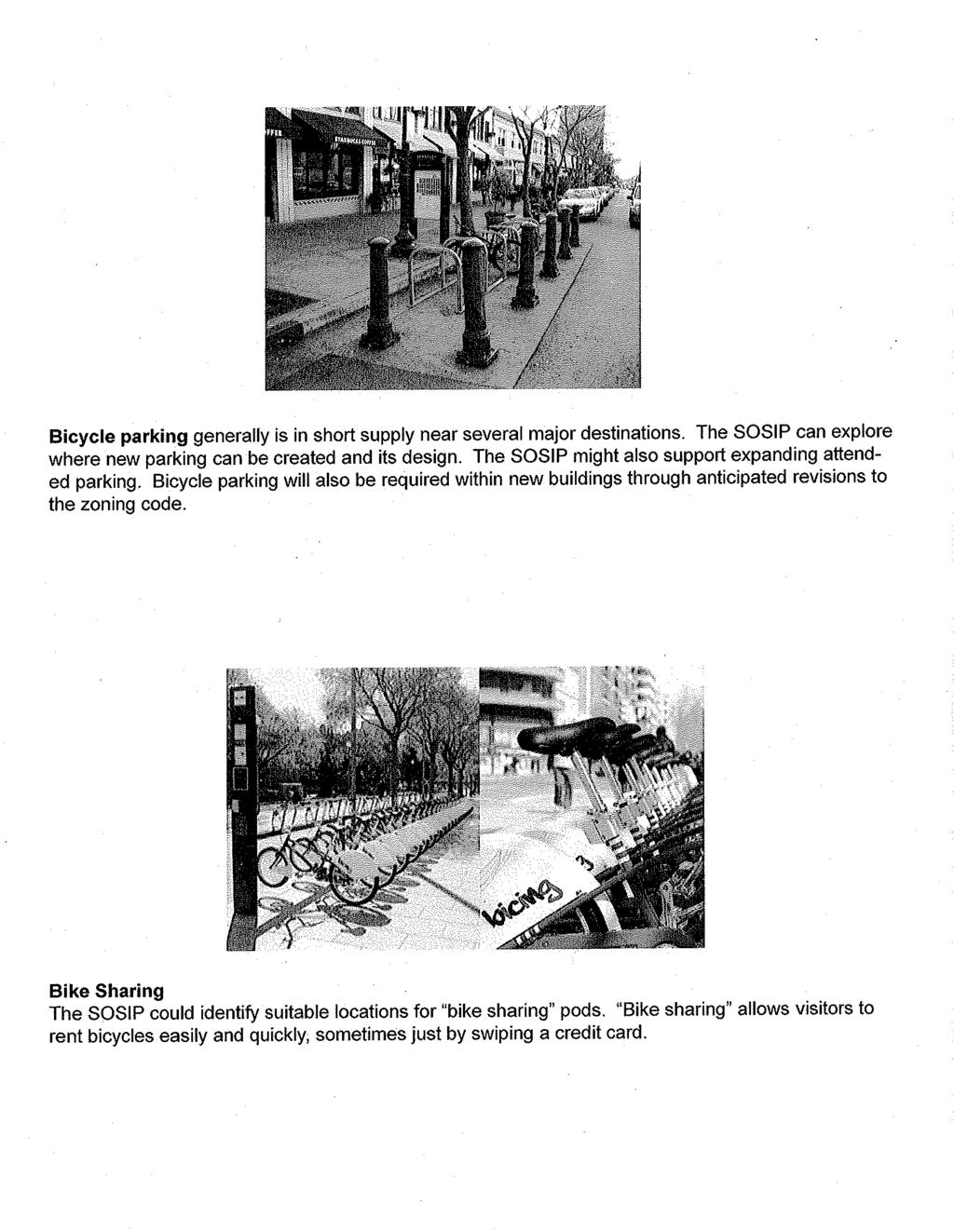
3 Two alternatives are put forth for Center Street between Milvia and Shattuck, where bike lanes now exist. This street segment provides an important link between the Milvia Bicycle Boulevard, Berkeley City College, BART, and the UC campus. One Center Street alternative removes the bike lanes and one side of parking so a signature greenway swale can have a width of 14 feet. In this alternative it is assumed that traffic speeds and bicycle speeds would be comparable, and mixed flow would be acceptable. Data also suggests that for some bicyclists, Allston Way may be an acceptable alternative route especially if a signal and other improvements are made between the end of Allston and the UC campus. The other Center Street alternative maintains bicycle lanes and removes one side of parking. Bike lanes are maintained in recognition of major bike destinations along Center Street and the additional safety that bike lanes would afford. This alternative would result in a swale that is a 8 to 10 feet, depending on whether traffic lane widths are 10 or 11 feet. The Center Street alternatives illustrate how streets must accommodate competing demands in a balanced way. Consequently, debate on the Center Street segment will inform staff s understanding of community priorities. The Bicycle Network & Facilities chapter also considers bicycle parking. A draft map of major bicycle parking facilities has been developed. A large version of this map will be hung on a wall so meeting participants can help identify locations where bicycle parking is in short supply. Policy language for bicycle sharing also appears. Bicycle sharing is a convenient almost-instantaneous way of renting bikes. It has been implemented in several cities and provides an effective alternative to cars for many trips. Attachments Draft Narrative for Chapters Figures for Pedestrian Environments Chapter (incl. subarea design concepts) Figures for Bicycle Network & Facilities Chapter 3
4
5 DRAFT CHAPTERS ON PEDESTRIAN ENVIRONMENTS AND BICYCLE NETWORK & FACILITIES Streets & Open Space Improvement Plan, Draft of April 23, 2010 Pedestrian Environments Delineating Pedestrian Places This chapter describes how to design those elements that delineate where pedestrians can walk safely and enjoy shared experiences. The chapter also describes features that make the pedestrian experience more attractive, and therefore help encourage not only walking but also use of transit. Attractive environments are foundational to Downtown s success economically and as a dense but livable urban neighborhood. Because Downtown s primary function is as a place to engage in social, cultural and commercial activity, priority should be given to pedestrians, and secondly to bicyclists. Automobiles need to be accommodated, but negative impacts from cars on pedestrians should be mitigated. In Downtown, the factors that generally define what is -- and what is not -- part of the pedestrian realm are curbs and buildings. Buildings define the outer edge of most sidewalks, and while active uses and pedestrian-friendly building design is extremely important, building attributes are controlled by the City's Zoning ordinance and the Downtown Design Guidelines. Within City-controlled rights-of-way, the location and shape of curbs strongly influence pedestrian safety and comfort -- and how public space can be used. Spaces that are behind curbs are the most protected spaces for pedestrians, and are where pedestrian amenities, urban runoff features, and landscaping may be placed. But while the SOSIP seeks to optimize pedestrian space, curbs must also be positioned to provide adequate dimension for the safe movement of motorized vehicles and bicycles. Beyond the curb, pedestrian activity is extended into roadways lanes and intersections through the use of crosswalks, medians, and special features. Jaywalking aside, these are the places where pedestrians and cars share the same space and injury to pedestrians is of greatest concern. The design and placement of crosswalks, medians, and special features must address pedestrian safety but also pedestrian convenience. Pedestrians often react to overly circuitous routes with frustration and jaywalking. There are also "mixed" plazas where pedestrians and vehicles share the same space continuously. In these settings, the comfort and safety of the pedestrian is emphasized through the use of materials, features and design. Vehicles move very slowly in these settings and pedestrians clearly have the right of way. Along building edges or other places where vehicles are not wanted, bollards can prevent vehicle access. Mixed plazas are common in Europe and are being seen increasingly in the United States. Landscaping and special features also limit where pedestrians move. In addition, landscaping is an integral part of the pedestrian environment because of its positive aesthetic and climatic effects and associated economic, social and environmental benefits. The design of street trees and landscaping is discussed in Chapter ##. It is important to note that the following recommendations highlight and augment Berkeley's Pedestrian Master Plan, Bicycle Master Plan, and Municipal Code. Users of this document should refer to these other documents for additional background and recommendations. There is/are only one/two recommendations made by the SOSIP that are inconsistent with these other documents because of Downtown's unique needs and setting; one would allow for tighter curb SOSIP Pedestrian & Bicycle Chapters, Draft of April 23, 2010 Page 1 of 7

6 radii at intersections to slow traffic and reduce pedestrian crossing distances; the other would eliminate bicycle lanes on Center Street (AN ALTERNATIVE TO BE DISCUSSED). Until adopted by Council as formal amendments to the Pedestrian and Bicycle Master Plans, these two recommendations should be considered as such. See Appendix ## for amendments to City documents that will be needed for consistency. Curbs, Vehicle Lanes & Crosswalks Because the width of rights-of-way are fixed, the width of sidewalks and landscaping is what remains after travel lanes for both bicycle and motor vehicles, and parking lanes, are accounted for. Traffic modeling for the Downtown Area Plan s EIR has demonstrated that the number of travel lanes can be reduced on some street segments without significantly increasing congestion. These street segment opportunities include: Shattuck Avenue and Shattuck Square between University Avenue and Allston; University Avenue between Shattuck Square and Oxford; Hearst Avenue between Shattuck and Oxford; and closing Center Street to regular traffic between Shattuck and Oxford. Design concepts have been developed for all of these street segments because lane eliminations offer exceptional opportunities for sidewalk widening, increased landscaping, and amenity (for subarea schematics see Chapter ##). Fulton Street might also provide an opportunity to reduce vehicle lanes as well, but should be considered in the context of a future comprehensive study of Oxford Street, to be conducted in partnership with UC Berkeley. To give priority to pedestrians, minimum lane widths for motor vehicles are allowed in the Downtown may be narrower than is generally allowed citywide. Doing so permits greater flexibility in widening sidewalks, increasing planting and adding amenity. When narrower lane widths are used, designated bicycle lanes are recommended to avoid creating serious safety issues resulting from conflicts between automobiles and bicycles. Narrower travel lanes make streets safer for pedestrians by slowing traffic and significantly reducing severe injuries. In fact, the likelihood of fatal or serious pedestrian injuries becomes very rare when vehicle travel speeds fall below 20 miles per hour (Source: Anderson, McLean, Farmer, Lee and Brooks, Accident Analysis & Prevention Study, 1997). At the same time, travel lanes should not be made so narrow that motorists cannot safely pass bicyclists, particularly when vehicles are traveling significantly faster. SOSIP Pedestrian & Bicycle Chapters, Draft of April 23, 2010 Page 2
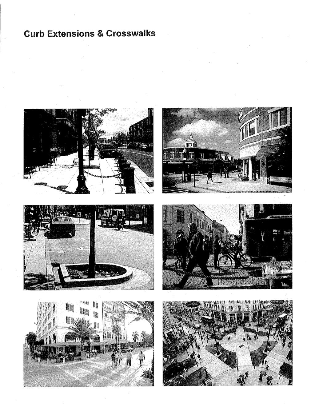
7 Travel Lanes. Travel lanes as narrow as 10 feet may be allowed in the Downtown Area, and should generally not exceed 11 feet on major through streets, such as Shattuck, University, Oxford-Fulton, Martin Luther King Jr. Way. An extra foot of width may be included where travel lanes immediately abut sidewalks, and transit designated lanes may be up to 13 feet in width if implemented. Where possible, designated bicycle lanes are recommended to avoid serious safety issues associated with narrower travel lanes resulting in conflicts between automobiles and bicycles. Parking Lanes. To maximize the area that can be devoted to pedestrians, parallel parking is generally preferred over diagonal parking not just because diagonal spaces take up right of way but also because they require wide back-up lanes. However, diagonal parking may be appropriate in locations where pedestrian activity is relatively low, such as on Durant Avenue, or as part of a short-term strategy for replacing parking that may be lost before off-street parking garages can be constructed. The SOSIP recommends that diagonal parking on Shattuck Avenue and Center Street be reconfigured, as is depicted in subarea schematics (Figure ## and Chapter #), but may be phased as part of a net-zero parking strategy. Parallel parking lanes may be between 7 to 8 feet in width, and should be 8 feet where the doors on parked vehicles are likely to conflict with bicycles. Parking lanes must always be 8 alongside Class II bicycle lanes. Context-Sensitive Design. Older urban settings often have narrow streets and high pedestrian volumes, conditions that are not fully recognized by modern street design manuals that were developed with suburban growth in mind. By allowing narrower lanes and tighter intersections, Berkeley has joined other cities like San Francisco, and Portland, Oregon, where similar pedestrian-oriented standards have been adopted, and balanced mixed-mode approaches are becoming accepted more broadly as evidenced by ITE's Context Sensitive Solutions in Designing Major Urban Thoroughfares. Corner Curb Radii. At the corners of intersections, the radii of curbs significantly influence operations and safety. Smaller or tighter curb radii extend further into intersections and therefore shorten pedestrian crossing distances and increase pedestrians' ability to see oncoming traffic. Tighter curb radii also prevent fast sweeping turns by vehicles and slow vehicles to speeds that make serious and fatal injuries unlikely. Tighter curb radii force long vehicles to make maneuvers that take them into other travel lanes or cause their rear wheel to drag across the corner curb. While wider turn radii reduce these conflicts the wider curb radii come at the expense of the pedestrian, so while wider curb radii may be called for in the rest of Berkeley, tighter curb radii are more appropriate to the pedestrian-oriented Downtown. Curb radii as tight as 10 feet should be allowed in the Downtown Area, but would require amending Berkeley Municipal Code Section , which calls for a minimum of 15 feet. Where vehicle turning remains a concern, the effective turning radius (and not solely the curb radius) should be considered, such as where parked cars are prohibited near intersections or where larger trucks can safely move into other lanes or mount curbs on an occasional basis. Where a larger curb radius must be used, use reflectors and/or special paving to describe an area similar to the 10-foot radius, so as to discourage high-speed turns by vehicles. Curb Extensions. Curb extensions extend the sidewalk into the parking lane to reduce pedestrian crossing distances, slow traffic, and improve pedestrians' ability to see oncoming motorists and vice versa. Curb extensions are also called bulb-outs and "bump-outs" to SOSIP Pedestrian & Bicycle Chapters, Draft of April 23, 2010 Page 3
8 describe their shape. In addition to enhancing pedestrian movement, curb extensions can contain street furnishings, amenities, landscaping, and features to treat urban runoff (see Chapter ##). Curb extensions are recommended in locations depicted in Figure ##, and are illustrated in subarea schematics (Chapter ##), with highest priority given to locations with high pedestrian traffic volumes or accidents, except where engineering costs are found to be prohibitive. Curb extensions should be accompanied by adequate drainage, should allow transit buses to complete turns and load passengers safely, should provide adequate emergency vehicle access, and should provide adequate access to preexisting fire hydrants that become more distant from the curb as a result of the curb extension. As indicated in the City s Pedestrian Master Plan and confirmed in that plan s CEQA IS/MND document, the City of Berkeley is required to construct bulbouts in ways that will not extend into travel lanes, including bicycle lanes. Figure ## depicts typical elements and geometries for curb extensions, which accommodate mechanical street sweepers and give adequate separation with travel lanes and bicycle lanes. Temporary curb extensions should be considered where a curb extension is desired but its impacts and benefits are unclear. Temporary curb extensions can be created through the use of striping, plastic bollards and raised reflectors. Neck Downs. "Neck downs" or "chokers" are created when a curb extension is paired with another curb extension across the street or with a median. Neck downs are accompanied by vertical landscaping, bollards, and other elements. The intent of these features is to clearly communicate pedestrian crossings to motorists, and to reduce the perceived width of the street and thereby slow traffic. As indicated in the City s Pedestrian Master Plan and confirmed in that plan s CEQA IS/MND document, the City of Berkeley is required to construct bulbouts in ways that will not extend into travel lanes, including bicycle lanes. Figure ## indicates the recommended location of neckdowns. Figure ## depicts typical elements and geometries for neckdowns. Medians and Places of Refuge. Medians should be provided on streets that have four or more travel lanes, to give pedestrians with a place of refuge and offer opportunities for landscaping and urban run-off features. Crosswalks should "pass through" medians (with a raised curb on both sides), to provide a clearly demarked place of refuge. Medians should generally be avoided on streets that have fewer than 4 travel lanes, except where they are expressly for slowing traffic at crosswalks. Generally, however, motorists go faster when they are separated from opposing traffic lanes, and medians limit emergency vehicle access and often necessitate wider and therefore faster -- travel lanes. Corner islands that provide right-turning "slip lanes" encourage higher vehicle speeds where pedestrians cross, and should not be used. Consider elimination of the slip lane at Bancroft and Fulton. Where existing slip lanes will remain, features should be added to reduce vehicle speeds or bring vehicles to a full stop before proceeding. SOSIP Pedestrian & Bicycle Chapters, Draft of April 23, 2010 Page 4
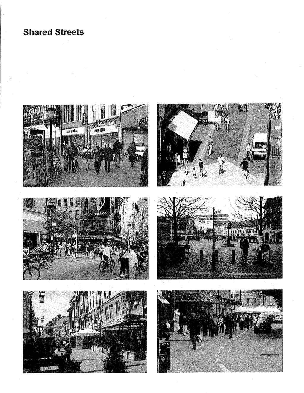
9 Curb Ramps. Perpendicular ramps allow pedestrians and people in wheelchairs to access the sidewalk perpendicular to stopped traffic, and to enter into the crosswalk directly in their line of travel. Perpendicular curb ramps are preferred over the use of a less-protected single ramp, and should be installed in locations identified in Figure ##. Pedestrian Crosswalks. Crosswalk improvements can increase motorists awareness of pedestrians and improve pedestrians safety and walking experience. At a minimum, crosswalks with high levels of pedestrian activity should have "ladder style" crosswalk markings. Midblock crosswalks are usually unaccompanied by signalized protection and should generally be avoided except where higher levels of use can be expected, such as where block lengths exceed 300 feet and where access to the "Park Blocks" park that is recommended for Shattuck between Durant and Haste (MAY BE EXPANDED). Flashing Beacons. At night, flashing crosswalk beacons can help promote pedestrian and bicyclist safety. Flashing beacons should accompany midblock crosswalks and unsignalized intersections with higher levels of pedestrian and/or bicycle traffic. Activated Signals. Pedestrian activated ("push-button") light signals should be used at intersections where priority should be given to pedestrians on a more occasional "on-demand" basis. All push-button activated flashing beacon locations should have Cross with Caution signs at every push button location. With both pedestrian and bicycle movement in mind, consideration should be given to activated signals in the following locations: TO BE DEVELOPED. Obstructions. Pedestrians and persons using wheelchairs shall have a clear uninterrupted path of travel. Transit shelters, newsracks, trash receptacles, and other obstructions to pedestrian movement should be positioned to maximize usable pedestrian-oriented space, generally by locating adjacent to building edges, preexisting railings and walls, or curbs, and/or by consolidating multiple features. Behind these obstructions, space may be needed for maintenance and other needs but should be minimized. Shared Streets Plaza Settings. Shared streets do not separate vehicles, pedestrians, and bicyclists. Instead they are designed to slow vehicles to speeds that are little more than a walk. Shared streets are appropriate where pedestrian use of the space has priority over vehicles, and where citywide impacts on vehicle through-traffic have been addressed. Figure ## shows locations of potential shared streets on the east side of Shattuck Square and on Milvia in front of the Civic Center Building. Design concepts for these subareas appear in Chapter ##. TO BE DEVELOPED. Shared streets should be designed to alert drivers, pedestrians, and bicyclists that they are leaving a conventional street environment and entering a pedestrian-priority space by using special paving, "table-top" ramping, and other sensor indicators. Bollards and concrete planters should be used, rather than curbs, to protect buildings, landscaping and street furnishings. Pedestrian and Bicycle Uses in Parking Lanes. The City should provide for the occasional use of parking lanes for other activities, when urban activity is especially high and when parking demand is adequately addressed. Uses that may be allowed conditionally with a permit include: bicycle parking, outdoor dining, street fairs, sidewalk sales, and art installations. Pedestrian and SOSIP Pedestrian & Bicycle Chapters, Draft of April 23, 2010 Page 5
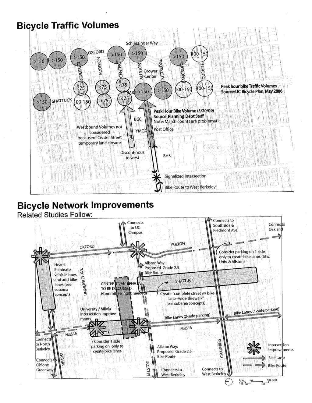
10 bicycle uses should be separated from travel lanes by movable planter boxes, railings, trellises, or other element to alert motorists and prevent pedestrians from stepping into travel lanes. Coordinate the loss of on-street parking with implementation of the Downtown Parking & Transportation Demand Management program. Bicycle Network & Facilities Improvements made by the Street & Open Space Improvement Plan (SOSIP) should enhance safety and convenience for bicyclists of all ages, and help promote bicycling as an alternative to the car. Improvements to Network Connectivity. Several improvements can be made to expand bike lanes and routes within Downtown and to other parts of the city. The following improvements should be considered. Some are associated with major projects described in Chapter ##. In some instances, on-street car parking would be reduced. Coordinate the potential loss of onstreet parking with implementation of the Downtown Parking & Transportation Demand Management program. Shattuck Avenue. Shattuck should be reconfigured to become a "complete street" by adding bicycle lanes along with other improvements (see ). These improvements should be given priority because of the high numbers of bicyclists who ride on the sidewalks on Shattuck, creating a serious safety hazard for pedestrians. Milvia Street. Bike lanes are discontinuous along Milvia, and lanes should be established between University Avenue and Allston Way. Coordinate the potential loss of on-street parking with implementation of the Downtown Parking & Transportation Demand Management program. Alternately, in conjunction with implementing the Milvia Civic Center Plaza Shared Street concepts (described below), install traffic calming between University and Allston Way to create a more robust Bicycle Boulevard environment. Milvia Civic Center Shared Street. Milvia is likely to see increasing amounts of vehicle traffic. Street improvements in front of the Civic Center building on Milvia would help divert some or all of this traffic (see ). DESIGN CONCEPT TO BE DEVELOPED. Hearst Avenue. On Hearst Avenue, bike lanes should be extended from west of Shattuck Avenue to the UC campus (see Hearst Street / Ohlone Greenway Extension). Fulton Street Contraflow Lane. Consider establishing a northbound contraflow lane on Fulton between Dwight Way and Durant Avenue. Fulton Street is an attractive bicycle boulevard/route south of Dwight Way, but bicyclists traveling north are presently diverted at Dwight because they encounter one-way southbound traffic. Allston Way. Extend Class 2.5 Bike Route to Oxford to recognize high bicycle volumes (see bicycle volume data at right). Consider ways to calm vehicle traffic and make more room available to bicyclists on Allston Way. Also make it easier to travel from Allston Way to on the UC Campus such as through reconfiguring/restriping the Allston/Oxford intersection and using a bike activated light signal at Oxford. SOSIP Pedestrian & Bicycle Chapters, Draft of April 23, 2010 Page 6
11 TWO CENTER STREET ALTERNATIVES PRESENTED HERE FOR DISCUSSION Center Street Greenway & Plaza. Remove bike lanes from where they exist on Center Street (between Milvia and Shattuck) to maximize pedestrian and landscape improvements. Design this segment of Center Street to slow traffic such that motorist and bicyclists can safely share the street. Coordinate elimination of these lanes with Allston Street improvements (above), in recognition of Allston s role in conveying a significant amount of east-west bicycle traffic. Center Street Greenway & Plaza. Preserve bicycle lanes on Center Street between Shattuck and Milvia to accommodate the high volume of local bicycle traffic accessing Berkeley City College and the Downtown BART station. Bicycle Parking. Increase the supply of convenient, secure and attractive short-term and longterm bicycle parking throughout the Downtown Area, but especially near major destinations (see Figure ##) and in locations where parking meter poles are removed. Bicycle racks should be positioned to avoid obstructing pedestrian flows and should conform with criteria contained in Berkeley's Bicycle Masterplan and approved Bicycle Parking Specifications (2008). In the Downtown Area, bike racks should be considered as opportunities for artistic expression (see Public Art chapter) so long as the City s functional requirements are met. Consider converting on-street car parking to bicycle parking in locations with high demand, since one 20-foot car stall can accommodate up to 12 bicycles without occupying sidewalk space. In these locations, bike racks should be placed such that parked bikes are perpendicular to the curb. Bollards should be used to delineate and protect bicycles from vehicle lanes. Mitigate the potential loss of on-street parking by implementing a zero-net policy that increases parking on some streets until adequate off-street parking garages can be constructed. Address on-street parking demand through the implementation of the Downtown Parking & Transportation Demand Management program. Provide adequate sheltered and attended parking options (such as in the BART mezzanine and in Shattuck Avenue storefronts), and support their on-going operations. Bike Sharing. Encourage the creation of "bike sharing" (i.e., convenient bike rental) programs Downtown, and their use by employees, residents, and visitors, especially near BART. Identify criteria for the design, program, and location of bike sharing facilities, by examining existing programs in North American and Europe. Solicit proposals from bike share providers for facilities consistent with these criteria. SOSIP Pedestrian & Bicycle Chapters, Draft of April 23, 2010 Page 7
12
13
14
15
16
17
18
19
20 Option 1: Continuous Reference to Strawberry Creek Block B: Milvia Street and Shattuck Avenue Center Street Greenway Street Section Types BLOCK A BLOCK B BLOCK C Sidewalk + Swale extends 14 BCC Gathering Area Bio Swale RainGarden Sidewalk + Swale extends 12 10' 7' 7' 11' 11' 7' 7' 10' 24' 22' CTC 24' 70' ROW Alternative- Berkeley City College Section 10' 8' 12' 12' 8' 12' 4' 4' 48' Existing Conditions 70' Sidewalk + Swale extends 14 Sidewalk extends 5 Bio Swale RainGarden Street Parking Temporary Farmer s Market 10' 7' 7' 11' 11' 7' 7' 10' 24' 22' 24' 70' Alternative- Section type
21
22
23
24
25
26
27
28
29
30
31
32
33
PEDESTRIAN ENVIRONMENTS & SHARED STREETS
 PEDESTRIAN ENVIRONMENTS & SHARED STREETS PEDESTRIAN ENVIRONMENTS & SHARED STREETS PRINCIPAL CONSIDERATIONS Pedestrian Priority. This chapter describes features that delineate where pedestrians can walk
BICYCLE PLAN APPENDICES
 CITY OF BERKELEY BICYCLE PLAN APPENDICES Approved May 2, 2017 by Berkeley City Council 1 CITY OF BERKELEY BIKE PLAN A-1 . Policy Review A.1 POLICY CONTEXT Five of the City s most prominent documents the
CURBSIDE ACTIVITY DESIGN
 5 CURBSIDE ACTIVITY DESIGN This chapter provides design guidance for separated bike lanes adjacent to curbside activities including parking, loading and bus stops. Typical configurations are presented
Exhibit 1 PLANNING COMMISSION AGENDA ITEM
 Exhibit 1 PLANNING COMMISSION AGENDA ITEM Project Name: Grand Junction Circulation Plan Grand Junction Complete Streets Policy Applicant: City of Grand Junction Representative: David Thornton Address:
Proposed. City of Grand Junction Complete Streets Policy. Exhibit 10
 Proposed City of Grand Junction Complete Streets Policy Exhibit 10 1 City of Grand Junction Complete Streets Policy Vision: The Complete Streets Vision is to develop a safe, efficient, and reliable travel
Broad Street Bicycle Boulevard Design Guidelines
 Broad Street Bicycle Boulevard Design Guidelines Building from the strategies introduced in the 2013 Bicycle Transportation Plan and community input received thus far, City Transportation Staff have identified
Omaha s Complete Streets Policy
 Omaha s Complete Streets Policy (Adopted August 2015) VISION To create great places and enhance our quality of life, the City of Omaha will provide safe, accessible streets for all users. Complete Streets
G AT E WAY PLAN. Community BRIEFING KIT GATEWAY BIKE
 G AT E WAY PLAN GATEWAY BIKE Community BRIEFING KIT PLAN August 2016 TABLE OF CONTENTS INTRODUCTION... 1 THE BENEFITS OF A BIKEABLE COMMUNITY... 2 ECONOMY...2 SAFETY...3 HEALTH...3 HOUSEHOLD SPENDING...3
EXECUTIVE SUMMARY. Vision
 Vision Walking and bicycling in Salt Lake City will be safe, convenient, comfortable, and viable transportation options that connect people to places, foster recreational and economic development opportunities,
Report. Typical Sections. City of Middleton, WI
 Report Typical Sections City of Middleton, WI December 2006 Report for City of Middleton, Wisconsin Typical Sections repared by: Traffic Associates LLC and STRAND ASSOCIATES, INC. 910 West Wingra Drive
Tonight is for you. Learn everything you can. Share all your ideas.
 Strathcona Neighbourhood Renewal Draft Concept Design Tonight is for you. Learn everything you can. Share all your ideas. What is Neighbourhood Renewal? Creating a design with you for your neighbourhood.
Environment and Public Works Committee Presentation
 Mixed Use Centers Complete Streets Guidelines Project Environment and Public Works Committee Presentation December 10, 2008 Project Objectives: Conduct an inter-departmental and agency process to study
APPENDIX A: Complete Streets Checklist DRAFT NOVEMBER 2016
 APPENDIX A: Complete Streets Checklist DRAFT NOVEMBER 2016 Complete Streets Checklist MetroPlan Orlando s Complete Streets Checklist is an internal planning tool for staff to further implementation of
Appendix C. TRAFFIC CALMING PROGRAM TOOLBOX
 Appendix C. TRAFFIC CALMING PROGRAM TOOLBOX PHASE I...2 Do Not Enter Sign...3 One-Way Sign...4 Turn Prohibition...5 Pavement Markings...6 Speed Monitoring Trailer...7 Neighborhood Speed Watch...8 Police
Active Transportation Facility Glossary
 Active Transportation Facility Glossary This document defines different active transportation facilities and suggests appropriate corridor types. Click on a facility type to jump to its definition. Bike
Chapter 2: Standards for Access, Non-Motorized, and Transit
 Standards for Access, Non-Motorized, and Transit Chapter 2: Standards for Access, Non-Motorized, and Transit The Washtenaw County Access Management Plan was developed based on the analysis of existing
Telegraph Avenue Complete Streets DRAFT Recommendations. Oakland Public Works Department September 11 and 13, 2014 Open Houses
 Telegraph Avenue Complete Streets DRAFT Recommendations Oakland Public Works Department September 11 and 13, 2014 Open Houses Presentation Overview What are complete streets? What problem are we trying
6.4 RECOMMENDED IMPROVEMENTS
 6.4 RECOMMENDED IMPROVEMENTS 6.4.1 Williston Road Recommendations While all alternatives would be an improvement over existing conditions, Alternative 3B is recommended over the others because it provides
Bicycle and Pedestrian Advisory Committee (BPAC) November 21, 2013
 November 21, 2013") Bicycle and Pedestrian Advisory Committee (BPAC) November 21, 2013 OVERALL LAND USE CONCEPT Overall Broadway Valdez District: 95.5 acres (35.1 acres right-of ways + 60.4 acres developable land) Plan Subareas:
Bicycle and Pedestrian Advisory Committee (BPAC) November 21, 2013 OVERALL LAND USE CONCEPT Overall Broadway Valdez District: 95.5 acres (35.1 acres right-of ways + 60.4 acres developable land) Plan Subareas:
Corpus Christi Metropolitan Transportation Plan Fiscal Year Introduction:
 Introduction: The Safe, Accountable, Flexible, Efficient Transportation Equity Act: A Legacy for Users (SAFETEA-LU) has continued the efforts started through the Intermodal Surface Transportation Efficiency
Item to be Addressed Checklist Consideration YES NO N/A Required Description Complete Streets Guidelines
 Passaic County Complete Streets Checklist - Concept Development Project Name Item to be Addressed Checklist Consideration YES NO N/A Required Description Complete Streets Guidelines Existing Plans Have
REGIONAL BICYCLE AND PEDESTRIAN DESIGN GUIDELINES
 REGIONAL BICYCLE AND PEDESTRIAN DESIGN GUIDELINES November 16, 2011 Deb Humphreys North Central Texas Council of Governments Bicycle and Pedestrian Advisory Committee Snapshot of the Guide 1. Introduction
Executive Summary Route 30 Corridor Master Plan
 Route Corridor Master Plan Project Overview The Route Corridor Master Plan is a coordinated multimodal transportation and land use plan for the entire stretch of Route through East Whiteland Township,
WHEREAS delivery trucks also pass through the Narrows, into the northern parking lot, to loading docks in the back of the building.
 CEDAR-ISLES-DEAN NEIGHBORHOOD ASSOCIATION ( CIDNA ) RESOLUTION OPPOSING A DRUG STORE DRIVE THRU, AND COMMENDING DORAN COMPANIES FOR PROPOSING MITIGATING AMENITIES INCLUDING NEW LANDSCAPING AND A DEDICATED
Chapter 3: Multi-Modal Circulation and Streetscapes
 CHAPTER 3: MULTI-MODAL CIRCULATION AND STREETSCAPES Chapter 3: Multi-Modal Circulation and Streetscapes Overview Streetscape improvements have already been completed for Depot Street between Main Avenue
CURB EXTENSIONS BULB OUTS DPS 201 NECKDOWNS
 CURB EXTENSIONS BULB OUTS DPS 201 NECKDOWNS WHY WHEN & WHERE When Limited Sight Distance Pedestrians & Vehicles Vehicles and Signs Want to put two curb ramps in Discourage High speed turning High number
complete streets design and construction standards public primer City of Edmonton
 complete streets design and construction standards public primer City of Edmonton introduction Complete Streets are streets for everyone: people who walk, wheel, bike, take transit, or drive. They are
Off-road Trails. Guidance
 Off-road Trails Off-road trails are shared use paths located on an independent alignment that provide two-way travel for people walking, bicycling, and other non-motorized users. Trails specifically along
RESOLUTION NO ?? A RESOLUTION OF THE CITY OF NEPTUNE BEACH ADOPTING A COMPLETE STREETS POLICY
 RESOLUTION NO. 2018-?? A RESOLUTION OF THE CITY OF NEPTUNE BEACH ADOPTING A COMPLETE STREETS POLICY WHEREAS, safe, convenient, and accessible transportation for all users is a priority of the City of Neptune
Southside Pilot Proposal
 To improve bicycle access and mobility to UC Berkeley, Downtown Berkeley, and the Southside area, a pilot project could include a two-way parking-protected cycle track. Turn pockets and island bus stops
Chapter 4 TOOLBOX AND SAMPLE BIKE BOULEVARD LAYOUT
 Chapter 4 TOOLBOX AND SAMPLE BIKE BOULEVARD LAYOUT OVERVIEW This chapter describes a cohesive set of strategies to create a bicycle boulevard, namely to make streets safer and more efficient for bicycle
NJDOT Complete Streets Checklist
 Background The New Jersey Department of Transportation s Complete Streets Policy promotes a comprehensive, integrated, connected multi-modal network by providing connections to bicycling and walking trip
Oakland Pedestrian Master Plan Oakland Pedestrian Plan Draft Recommendations Chapter Outline
 EISEN LETUNIC T R A N S P O R T A T I O N, ENVIRO N M E N TA L A N D URBAN PLANNIN G MEMORANDUM To Oakland Pedestrian Plan Technical Advisory Committee & Pedestrian Advisory Group From Victoria Eisen Date
Agenda. Overview PRINCE GEORGE S PLAZA METRO AREA PEDESTRIAN PLAN
 PRINCE GEORGE S PLAZA METRO AREA PEDESTRIAN PLAN May 28, 2008 Agenda Welcome and introductions Project overview and issue identification Planning context and strengths Design challenges and initial recommendations
A Guide to Great Streets: The Basics. September 25, 2009
 A Guide to Great Streets: The Basics September 25, 2009 Streets are more than connectors, they are the city 2 Streets are the glue that hold a city together 3 Streets are the means in which a city is perceived
2014/2015 BIKE ROUTE PLAN 83 AVENUE PROTECTED BIKE LANE
 About the Project The City of Edmonton is planning a major bike route on the southside of Edmonton. The Strathcona Bike Route will connect the communities of Strathcona, Garneau and the University area,
Footpath design. A guide to creating footpaths that are safe, comfortable, and easy to use
 Footpath design A guide to creating footpaths that are safe, comfortable, and easy to use November 2013 Contents Introduction / 1 Zoning system / 2 Width / 4 Height / 5 Surface / 5 Footpath elements /
City of Vallejo Traffic Calming Toolbox
 City of Vallejo Traffic Calming Toolbox June 1, 2013 Final Table of Contents Introduction... 1 Non-Physical Devices... 3 High-Visibility Crosswalk... 3 In Pavement Lighted Crosswalk... 4 Rapid Flashing
Caltrans Sloat Boulevard Pedestrian Safety Project Response to Community Questions, Comments & Concerns
 Caltrans Sloat Boulevard Pedestrian Safety Project Response to Community Questions, Comments & Concerns Revised: May 10, 2016 The California Department of Transportation (Caltrans) is planning various
In station areas, new pedestrian links can increase network connectivity and provide direct access to stations.
 The Last Mile Planning for Pedestrians Planning around stations will put pedestrians first. Making walking to stations safe and easy is important; walking will be a part of every rapid transit Accessible
COMPLETE STREETS PLANNER S PORTFOLIO
 COMPLETE STREETS PLANNER S PORTFOLIO ISSUE 3 APRIL 2016 PLANNER S PORTFOLIO COMPLETE STREETS 1 2 6 10 14 OVERVIEW MATURE NEIGHBORHOODS GROWING SUBURBS CENTRAL PLACES ACTIVITY CORRIDORS Planner s Portfolio
City of Novi Non-Motorized Master Plan 2011 Executive Summary
 City of Novi Non-Motorized Master Plan 2011 Executive Summary Prepared by: February 28, 2011 Why Plan? Encouraging healthy, active lifestyles through pathway and sidewalk connectivity has been a focus
Berkeley Strategic Transportation Plan A-76
 Berkeley Strategic Transportation Plan A-76 Appendices 1. A Team Effort 2. Where We ve Been A-11 Berkeley Strategic Transportation Plan Alameda County Transportation Plan Alameda County will be served
5 CIRCULATION AND STREET DESIGN
 5 CIRCULATION AND STREET DESIGN This chapter describes circulation and streetscape improvements proposed for the Northwest Chico Specific Plan Area. It includes detailed design specifications for existing
WELCOME. Purpose of the Open House. Update you on the project. Present a draft recommended plan. Receive your input
 WELCOME Purpose of the Open House The Town of Smiths Falls has initiated the Beckwith Street Redevelopment Plan that includes the preparation of a streetscape functional design for the renewal of Beckwith
SAN FRANCISCO MUNICIPAL TRANSPORTATION AGENCY
 THIS PRINT COVERS CALENDAR ITEM NO. : 10.2 DIVISION: Sustainable Streets BRIEF DESCRIPTION: SAN FRANCISCO MUNICIPAL TRANSPORTATION AGENCY Adopting Conceptual Proposal for Streetscape Improvements to Broadway,
SAN FRANCISCO MUNICIPAL TRANSPORTATION AGENCY
 THIS PRINT COVERS CALENDAR ITEM NO. : 12 DIVISION: Sustainable Streets BRIEF DESCRIPTION: SAN FRANCISCO MUNICIPAL TRANSPORTATION AGENCY Approving various bicycle improvements and traffic modifications
CONNECTING PEOPLE TO PLACES
 CONNECTING PEOPLE TO PLACES 82 EAST BENCH MASTER PLAN 07 Introduction The East Bench transportation system is a collection of slow moving, treelined residential streets and major arteries that are the
Roadway Classification Design Standards and Policies. Pueblo, Colorado November, 2004
 Roadway Classification Design Standards and Policies Pueblo, Colorado November, 2004 Table of Contents Page Chapter 1. General Provisions 1.1 Jurisdiction 3 1.2 Purpose and Intent 3 1.3 Modification 3
Community Meeting February 27, 2007 Dorchester Avenue Transportation & Streetscape Improvements Action Plan February 27, 2007
 Community Meeting Tonight s Agenda 6:00 Introductions South Boston/Dot Ave Improvement Study Background 6:15 Consultant Introductions Review of Scope and Schedule Review of Proposed Corridor Wide Guidelines
PRINCE GEORGE S PLAZA METRO AREA PEDESTRIAN PLAN
 PRINCE GEORGE S PLAZA METRO AREA PEDESTRIAN PLAN May 28, 2008 Agenda Welcome and introductions Project overview and issue identification Planning context and strengths Design challenges and initial recommendations
FOCUS AREA 1 - Alberta Avenue Pocket Park 3 (121 Ave and 92 St)
") FOCUS AREA 1 - Alberta Avenue Pocket Park 3 (121 Ave and 92 St) New benches Plant evergreen trees Widen existing sidewalk from 1.5m to 1.8m Marked crosswalk 1.8m wide sidewalk Add pedestrian oriented lights
FOCUS AREA 1 - Alberta Avenue Pocket Park 3 (121 Ave and 92 St) New benches Plant evergreen trees Widen existing sidewalk from 1.5m to 1.8m Marked crosswalk 1.8m wide sidewalk Add pedestrian oriented lights
Item Description: Presentation and Discussion: Berkeley Rapid Transit Locally Preferred Alternative
 Office of the City Manager Meeting Date: April 29, 2010 Item Number: 1 Item Description: Presentation and Discussion: Berkeley Rapid Transit Locally Preferred Alternative Staff report, resolution, and
East Burke Transportation, Safety and Capacity Improvements
 East Burke Transportation, Safety and Capacity Improvements The purpose of this project is to increase mobility and improve safety for pedestrians, cyclists, and motor vehicles along VT Route 114 in the
PEDESTRIAN ACTION PLAN
 ATTACHMENT 2 CITY OF SANTA MONICA PEDESTRIAN ACTION PLAN CITY OF SANTA MONICA PEDESTRIAN ACTION PLAN This page intentionally left blank EXECUTIVE SUMMARY CHAPTER 1 EXECUTIVE SUMMARY Setting the Stage
Safe Routes to School Action Plan Aberdeen, Idaho
 Background Aberdeen, Idaho is a largely agricultural community of nearly 2,000 people and is located in the southeast portion of the state on the western edge of American Falls Reservoir. The community
Figure 5-1 Complete Street Zones. Roadside. May include frontage, pedestrian throughway, furnishings and curbside areas.
 Design Guidelines 5 The design guidelines presented in this section provide descriptions related to the form and function of the four Complete Streets zones: roadside, parking, roadways and lanes, median,
UDC Street Cross Sections
 UDC Street Cross Sections Local Street - Downtown Local Street Mountable Curb Local Street Vertical Curb Alley Major Arterial Minor Arterial Residential Lane Residential Collector Residential Collector
CITY OF SAINT JOHN TRAFFIC CALMING POLICY
 CITY OF SAINT JOHN TRAFFIC CALMING POLICY VERSION: 1.0 April 10, 2012 Pedestrians, Cyclists and Motorists Sharing Street Spaces CONTENTS INTRODUCTION... 3 POLICY GOAL... 3 POLICY OBJECTIVES... 3 GUIDING
TRAFFIC CALMING GUIDE FOR TORONTO CITY OF TORONTO TRANSPORTATION SERVICES DIVISION
 TRAFFIC CALMING GUIDE FOR TORONTO CITY OF TORONTO TRANSPORTATION SERVICES DIVISION CITY OF TORONTO TRANSPORTATION SERVICES DIVISION 2016 TRAFFIC CALMING GUIDE FOR TORONTO TABLE OF CONTENTS Introduction
Safe Streets. City of Lake Forest Park. March 21, 2017
 Safe Streets City of Lake Forest Park March 21, 2017 1 01 WELCOME 2 Agenda WELCOME WHAT IS THIS PROJECT? CONTEXT DRAFT CITYWIDE PROJECTS EXERCISE INTRODUCTION 3 02 WHAT IS THIS PROJECT? 4 WHAT IS THIS
Living Streets Policy
 Living Streets Policy Introduction Living streets balance the needs of motorists, bicyclists, pedestrians and transit riders in ways that promote safety and convenience, enhance community identity, create
Designing Complete Streets: What you need to know
 Designing Complete Streets: What you need to know Getting from this to this. Continuous sidewalk Buffer w/trees Bicycle lane Raised median Buildings close to the street Flexibility in design Design and
MARTIN LUTHER KING JR. WAY
 OCTOBER 2011 40 Vision and Goals The Martin Luther King, Jr. Way Illustrative Master Plan that follows has been developed through a process of community involvement. It expresses a long term vision for
2014/2015 BIKE ROUTE PLAN 83 AVENUE PROTECTED BIKE LANE
 About the Project 2014/2015 BIKE ROUTE PLAN The City of Edmonton is planning a major bike route on the south side of Edmonton. This bike route is one part of a plan to provide citizens with transportation
S T A T I O N A R E A P L A N
 The Circulation and Access Plan describes vehicle, pedestrian, and transit improvements recommended within the Concept Plan. In order to create and sustain a vibrant business district that provides pedestrian-friendly
POLICY: TRAFFIC CALMING
 2006 MAY REFERENCE: COUNCIL APPROVED BY COUNCIL MAY 23, 2006 CITY OPERATIONS - NO. 608 POLICY: TRAFFIC CALMING A. All requests for traffic calming within the City shall be considered in accordance with
7/23/2017 VIA . Michael Hanebutt City of Sacramento Community Development Department 300 Richards Boulevard, 3 rd Floor Sacramento, CA 95811
 7/23/2017 VIA EMAIL Michael Hanebutt City of Sacramento Community Development Department 300 Richards Boulevard, 3 rd Floor Sacramento, CA 95811 RE: 65 th Street Apartments (DR17-220) Dear Mr. Hanebutt:
THE ALAMEDA CONCEPT DESIGN COMMUNITY MEETING 3. A Plan for The Beautiful Way JANUARY 28, 2010
 CONCEPT DESIGN COMMUNITY MEETING 3 JANUARY 28, 2010 AGENDA INTRODUCTION COMMUNITY INPUT ROADWAY STUDIES STREETSCAPE DESIGN STATIONS DISCUSSION SUMMARY AND DISCUSSION NEXT STEPS CLOSE INTRODUCTION SCHEDULE
10.0 CURB EXTENSIONS GUIDELINE
 10.0 CURB EXTENSIONS GUIDELINE Road Engineering Design Guidelines Version 1.0 March 2017 City of Toronto, Transportation Services City of Toronto Page 0 Background In early 2014, Transportation Services
Bicycle Facilities Planning
 Bicycle Facilities Planning Overview Types of Cyclists Purpose for Riding Types of Facilities Bike Lanes Bicycle Boulevards Cycle Tracks Intersections Signals Signing and Marking Discussion Types of Bicyclists
General Plan Circulation Element Update Scoping Meeting April 16, 2014 Santa Ana Senior Center, 424 W. 3rd Street, Santa Ana, CA 92701
 General Plan Circulation Element Update Scoping Meeting April 16, 2014 Santa Ana Senior Center, 424 W. 3rd Street, Santa Ana, CA 92701 Meeting Agenda 1. Purpose of Scoping Meeting 2. Project Overview 3.
City of Wayzata Comprehensive Plan 2030 Transportation Chapter: Appendix A
 A1. Functional Classification Table A-1 illustrates the Metropolitan Council s detailed criteria established for the functional classification of roadways within the Twin Cities Metropolitan Area. Table
What Is a Complete Street?
 Session 5 Charleen Zimmer, AICP, Zan Associates May 5-7, 2010 What Is a Complete Street? May 2010 5-1 Not a Complete Street More of a Complete Street May 2010 5-2 Benefits of Complete Streets Safety for
Mission-Geneva Transportation Study Community Workshop 2 July 8, 2006
 Community Workshop 2 July 8, 2006 Small Group Workbook 1 Basic Improvements on Mission Street Streetscape. Pedestrian-scale lighting; landscaping; community art on utility boxes; more (possibly unique)
City of Elizabeth City Neighborhood Traffic Calming Policy and Guidelines
 City of Elizabeth City Neighborhood Traffic Calming Policy and Guidelines I. Purpose: The City of Elizabeth City is committed to ensure the overall safety and livability of residential neighborhoods. One
Aurora Urban Street Standards For Transit Oriented Developments and Urban Centers
 Aurora Urban Street Standards For Transit Oriented Developments and Urban Centers I. Purpose These standards will be applied to create a safe, comfortable, pleasant and pedestrian-friendly multi-modal
5/7/2013 VIA . RE: University Village Safeway Expansion (P13-019)
") 5/7/2013 VIA EMAIL David Hung, Associate Planner Community Development Department, Current Planning Division City of Sacramento 300 Richards Boulevard, 3 rd Floor Sacramento, CA 95811 RE: University Village
5/7/2013 VIA EMAIL David Hung, Associate Planner Community Development Department, Current Planning Division City of Sacramento 300 Richards Boulevard, 3 rd Floor Sacramento, CA 95811 RE: University Village
Welcome! San Jose Avenue Open House August 25, 2015
 Welcome! San Jose Avenue Open House August 25, 2015 Vision Zero The City and County of San Francisco adopted Vision Zero San Francisco Vision Zero High Injury Network as a policy in 2014, committing an
County of Greenville South Carolina. Traffic Calming Program Neighborhood Traffic Education Program and Speed Hump Program
 County of Greenville South Carolina Traffic Calming Program Neighborhood Traffic Education Program and Speed Hump Program (rev) August 2008 I. PURPOSE The potential negative impacts from vehicular traffic
Appendix T CCMP TRAIL TRAFFIC & TRANSPORTATION DESIGN STANDARD
 Appendix T CCMP 3.3.4 TRAIL TRAFFIC & TRANSPORTATION DESIGN STANDARD 3.3.4 Trail Traffic and Transportation Design Multi-use trails have certain design standards, which vary depending on the agency that
Chapter 3 BUS IMPROVEMENT CONCEPTS
 Chapter 3 BUS IMPROVEMENT CONCEPTS The purpose of this chapter is to describe potential bus improvement strategies and potential impacts or implications associated with BRT implementation within the existing
MAG Town of Cave Creek Bike Study Task 6 Executive Summary and Regional Significance Report
 Page 1 MAG Town of Cave Creek Bike Study Task 6 Executive Summary and Regional Significance Report August 1, 2012 MAG Project #481 Page 2 Task 6 Executive Summary and Regional Significance Report Introduction
STEERING COMMITTEE MEETING June 17, Streetscape Overview Burlington Comprehensive Master Plan
 STEERING COMMITTEE MEETING June 17, 2015 Streetscape Overview Burlington Comprehensive Master Plan 1 Introduction Slide This slide show was presented to the Burlington Steering Committee on June 17, 2015
TRANSPORTATION STANDARDS
 INTRODUCTION LOCAL STREETS ON-STREET PARKING SIDEWALKS STREET LIGHTING STREET FURNISHINGS TRAFFIC CALMING STREET TREES MEDIAN PLANTING BOULEVARD LOCATIONS VILLAGE CENTER STREET LOCATIONS RESIDENTIAL STREET
Chapter 5: Crossing the Street
 Chapter 5: Crossing the Street Whether walking or bicycling, a student s journey to school will more than likely require crossing one or more streets. Per the Safe Routes to School Guide, maintained by
DRAFT Montgomery County Bicycle Master Plan Design Toolkit
 DRAFT Montgomery County Bicycle Master Plan Design Toolkit Fall 2016 Sidepaths Sidepaths are shared use paths located parallel to and within the road right-of-way providing twoway travel for walking, bicycling,
PEDESTRIAN CIRCULATION & STREETSCAPE DESIGN
 CHAPTER 4 Chapter 4 Pedestrian Circulation & Trails PEDESTRIAN CIRCULATION & STREETSCAPE DESIGN In recent years, the City has constructed new sidewalks and enhanced existing ones in the downtown with brick
On Road Bikeways Part 1: Bicycle Lane Design
 On Road Bikeways Part 1: Bicycle Lane Design Presentation by: Nick Jackson Bill Schultheiss, P.E. September 04, 2012 FOLLOW THE CONVERSATION ON TWITTER Toole Design Group is live tweeting this webinar
DEPARTMENT OF ENVIRONMENTAL SERVICES. North Harrison Street (Lee Highway to Little Falls Road) Comparative Analysis. Prepared for:
 Comparative Analysis. Prepared for:") DEPARTMENT OF ENVIRONMENTAL SERVICES North Harrison Street (Lee Highway to Little Falls Road) Comparative Analysis Prepared for: Arlington County Department of Environmental Services 2100 Clarendon Boulevard,
DEPARTMENT OF ENVIRONMENTAL SERVICES North Harrison Street (Lee Highway to Little Falls Road) Comparative Analysis Prepared for: Arlington County Department of Environmental Services 2100 Clarendon Boulevard,
Chapter 5. Complete Streets and Walkable Communities.
 Chapter 5. Complete Streets and Walkable Communities. 5.1 Description of Complete Streets. Cities throughout the world, and specifically the United States, are coming to embrace a new transportation and
Chapter 2. Bellingham Bicycle Master Plan Chapter 2: Policies and Actions
 Chapter 2 Bellingham Bicycle Master Plan Chapter 2: Policies and Actions Chapter 2: Policies and Actions The Bicycle Master Plan provides a road map for making bicycling in Bellingham a viable transportation
Bikeway action plan. Bicycle Friendly Community Workshop March 5, 2007 Rochester, MN
 Bikeway action plan Summary The was held on March 5, 2007 at the Rochester Mayo Civic Center. The workshop was hosted by Rochester-Olmsted County Planning Department in collaboration with the League of
Complete Streets. Designing Streets for Everyone. Sarnia
 Complete Streets Designing Streets for Everyone Sarnia Complete Streets ~ Sarnia ~ 2018 Introduction Our City is made up of a network of streets that we use to go for a walk, cycle to work, drive to the
Cycle Track Design Best Practices Cycle Track Sections
 Design Best Practices Sections It is along street segments where the separation and protection methods of cycle tracks offer more comfort than conventional bicycle lanes, and are more attractive to a wide
RZC Appendix 8A Marymoor Subarea Street Requirements
 RZC Appendix 8A Marymoor Subarea Street Requirements For additional design details for Marymoor Subarea infrastructure, refer to the 2017 Marymoor Subarea Infrastructure Planning Report. STREET REQUIREMENTS
Bicycle Master Plan Goals, Strategies, and Policies
 Bicycle Master Plan Goals, Strategies, and Policies Mobilizing 5 This chapter outlines the overarching goals, action statements, and action items Long Beach will take in order to achieve its vision of
San Jose Transportation Policy
 San Jose Transportation Policy Protected Intersections in LOS Policies to Support Smart Growth Presented by: Manuel Pineda City of San Jose Department of Transportation Bay Area Map San Francisco Oakland
York Boulevard Streetscape Master Plan
 York Boulevard Streetscape Master Plan October 24 th, 2008 The Story of York Boulevard Streetscape Master Plan Design. Chapter 126 Dealing with Engineers. 2 1 Today s Presentation Topics: 1. Show the streetscape
Lee s Summit Road Improvement Study Public Open House June 7, 2007 Summary of Comment Card Responses
 Lee s Summit Road Improvement Study Public Open House June 7, 2007 Summary of Comment Card Responses Introduction At the Lee s Summit Road Improvement Study Public Open House held Thursday, June 7, 2007