ACTION TRANSMITTAL No
|
|
|
- Rodger Todd
- 5 years ago
- Views:
Transcription
1 Transportation Advisory Board of the Metropolitan Council of the Twin Cities DATE: March 12, 2015 TO: ACTION TRANSMITTAL No TAC Funding and Programming Committee PREPARED BY: Joe Barbeau, Senior Planner ( ) Elaine Koutsoukos, TAB Coordinator ( ) SUBJECT: REQUESTED MOTION: RECOMMENDED MOTION: 2014 Regional Solicitation Scoring Appeals and Approval of Final Scores Nine applicants have appealed the scores they received on one or more measures and request scoring changes. Also, Metropolitan Council staff requests approval of final scores. Recommendations are shown in the attached for each of nine proposals. Staff recommends approval of final scores, incorporating any changes applied during the appeals process. BACKGROUND AND PURPOSE OF ACTION: Regional Solicitation applicants are afforded the opportunity to appeal their scores after the initial release of scores that occurred at the February 19 Funding & Planning Committee Meeting. Appeals were due on Friday, February 27. Metropolitan Council staff consulted with scorers and chairs, as needed, to generate the recommendations for each appeal in the subsequent attachment. New material is not to be considered in review of an appeal. Appeals are meant only to challenge scoring errors or misinterpretations of the scoring guidelines. 390 North Robert St., St. Paul, Minnesota (651) Fax (651)
2 Multiuse Trails and Bicycle Facilities 2
3 Scoring Guidelines for Criterion #1, Role within the Regional System and Economy Background: The Regional Bicycle Transportation Network map (as developed in the Twin Cities Regional Bicycle System Study) shows a series of regional bikeway corridors (with alignments undefined) and a set of defined Tier 1 and Tier 2 alignments. The scoring guidelines as specified in the multi-use trails and bicycle facilities project funding application addressed the Tier 1 and Tier 2 corridors as identified on the RBTN map, but did not specifically address scoring where designated alignments had been identified. These specific alignments were the result of the work of the Regional Bicycle System Study Project Advisory Committee as well as subsequent meetings with each of the counties to confirm and adjust the designated alignments based on local plans and other factors. The alignments represent actual roadways and existing trails as well as many planned road-specific bikeways and off-road trails. The guidelines below were used in scoring the funding applications for those areas of the region where RBTN alignments had been defined. Guidelines for scoring projects that improve RBTN Alignments: With respect to the RBTN, projects will receive points as indicated in the multi-use trails and bicycle facilities application for proposing improvements that are within and along a designated RBTN Tier 1 or Tier 2 corridor, along a designated Tier 1 or Tier 2 alignment, for providing a direct connection to an RBTN corridor or designated alignment, or for other projects if they are in an adopted county or city plan. For those areas that show a designated Tier 1 or Tier 2 alignment (as indicated on the RBTN map) the project must improve or connect to a specific alignment to receive the points identified on the application for Tier 1 or Tier 2 corridors. Specifically for projects that are proposed to improve, complete, or connect to a segment of a designated Tier 1 or Tier 2 alignment, to receive the available points associated with Tier 1 and Tier 2 corridors, the project must accomplish one of the following: Improve a segment of an existing Tier 1 (200 pts) or Tier 2 (160 pts) alignment beyond a simple resurfacing of the facility, OR Implement a currently non-existing segment of a Tier 1 (200 pts) or Tier 2 (160 pts) alignment, OR Connect directly to a specifically designated Tier 1 or Tier 2 alignment of the RBTN (120 pts). Guidelines for scoring projects that include both on-rbtn and off-rbtn improvements: Projects proposed that are comprised of segments that are both on and off a RBTN corridor or alignment will be scored based on the proportion of the project that is within and along a RBTN corridor or along a designated RBTN alignment as shown on the RBTN map. Specifically, scores will be assigned as follows: Tier 1 projects with 50% or more of the project s length within and along a Tier 1 corridor or along a Tier 1 alignment will receive the full Tier 1 allotment of 200 points. Tier 2 projects with 50% or more of the project s length within and along a Tier 2 corridor or along a Tier 2 alignment will receive the full Tier 2 allotment of 160 points. A project with less than 50% of its length within and along a Tier 1 or Tier 2 corridor or along a Tier 1 and Tier 2 alignment will be considered a direct connection and will receive the full allotment of 120 points for providing a direct connection. A project with less than 50% of its length within and along a Tier 1 or Tier 2 corridor or along a Tier 1 or Tier 2 alignment, but with 50% or more of its length within and along a combined Tier 1/Tier 2 corridor or alignment will receive the full allocation of points corresponding to the Tier level with the higher proportion of project length. 3
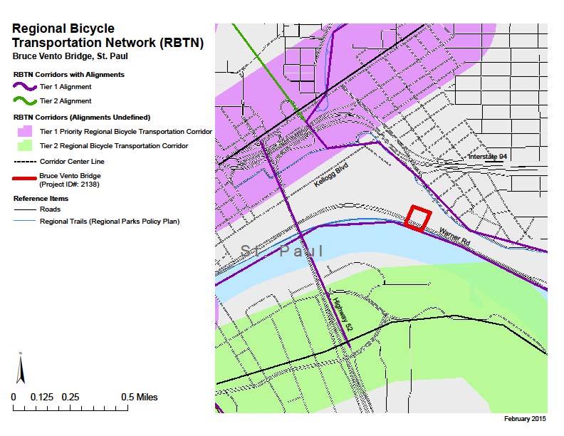
4 2138: Bruce Vento Bridge, City of St. Paul 4
5 5
6 6
7 Multiuse Trails and Bicycle Facilities 2138: Bruce Vento Bridge, City of St. Paul Project description: This project will create a bridge to span existing BNSF and CP Railroad tracks to connect the Sam Morgan and Bruce Vento regional trails and the Bruce Vento Nature Sanctuary. Request: Applicant requested re-evaluation of the 1: Role in the Regional Transportation System and Economy (200 points), 2: Usage (200 points), and 6: Risk Assessment (130 points). 1: Role in the Regional Transportation System and Economy. Applicant requested a re-evaluation of the score. Applicant s Response to the Criterion The response was provided according to the map generated in the online applicant. Scores were revised to reflect eh actual approved Regional Bicycle Transportation Network (RBTN) (See scoring guidelines on page 2) Scoring Methodology and Scorer s Re-evaluation Difference between Corridors vs. alignments On-line mapping tool showed broad corridors where specific alignments had been defined on the Regional Bicycle Transportation Network (RBTN) There are RBTN Corridors and designated Alignments: o Corridors are broad bandwidths a ½ or 1-mile wide where roadway or trail alignments have not been defined. o Alignments were specifically defined through the Regional Bicycle System Study (completed in early 2014) as indicated in the Study and on the RBTN map legend. o Alignments represent specific roadways or planned or existing off-road trail alignments, but do not represent a specific facility type (i.e., bike lane, wide shoulder, cycle track, etc.). Re-evaluation: Specific RBTN alignments had been designated as the Sam Morgan regional trail and the Bruce Vento regional trail; they are both Tier 1 alignments. Proposed project is a bridge spanning Warner Road and major rail corridor and will create a direct link between two Tier 1 alignments via the Bruce Vento Nature Sanctuary. Trails through the BVNS are not designated alignments on the Regional Bicycle Transportation Network and the project will not improve the existing Tier 1 alignments themselves; thus this project received the 120 points allotted for providing a direct connection to the RBTN. No additional points were given to projects for connecting to more than one RBTN corridor or alignment. Scoring Committee Chair Opinion (Craig Jenson) The Chair s recommendation is to accept the changes recommended in the response above and to change all scores accordingly. 7
8 8
9 2: Usage. The criterion quantifies the project s potential impact to existing population and employment within one mile of the project. The applicant asked for further consideration of the criteria, noting that the measure undercounts by half the potential visits, when counting only vicinity households. Applicant s Response to the Measure Existing population within one mile 23,213 Existing employment within one mile 33,950 Cost effectiveness for population - $ Cost effectiveness for employment - $ Scoring Methodology The scorer awarded the most points to the lowest cost per population and lowest cost per employment and pro-rated the points for the other responses. Scores were rated based on the responses provided in the application. Scoring Committee Chair Opinion The Chair s recommendation is to accept the response from the scorer and not change the scores in this measure. 6: Risk Assessment. The applicant stated that they will be receiving a letter of support for the Section 4f/6f Negative Declaration statement, and should therefore be credited with the next higher percent of 100%. The applicant s response to the criterion The applicant responded Yes to Section 4f resources present within the project area, but no known adverse effect The scorer s methodology The Review of Section 4f/6f Resources was scored as follows: No Section 4f/46 resources located in the project area 100% Project is an independent bikeway/walkway project covered by the bikeway/walkway Negative Declaration statement; letter of support received 100% Section 4f resources present within the project area, but no known adverse effect 80% Adverse effects (land conversion) to Section 4f/6f resources likely 30% Unknown impacts to Section 4f/6f resources in the project area 0% The scorer assigned 80% based on the application response. Scores can be appealed based on evaluation of the information provided in the submitted application. No additional information may be submitted with an appeal. Scoring Committee Chair Opinion The Chair agrees with the scorer s evaluation and recommends no change to the scoring for this criterion. 9
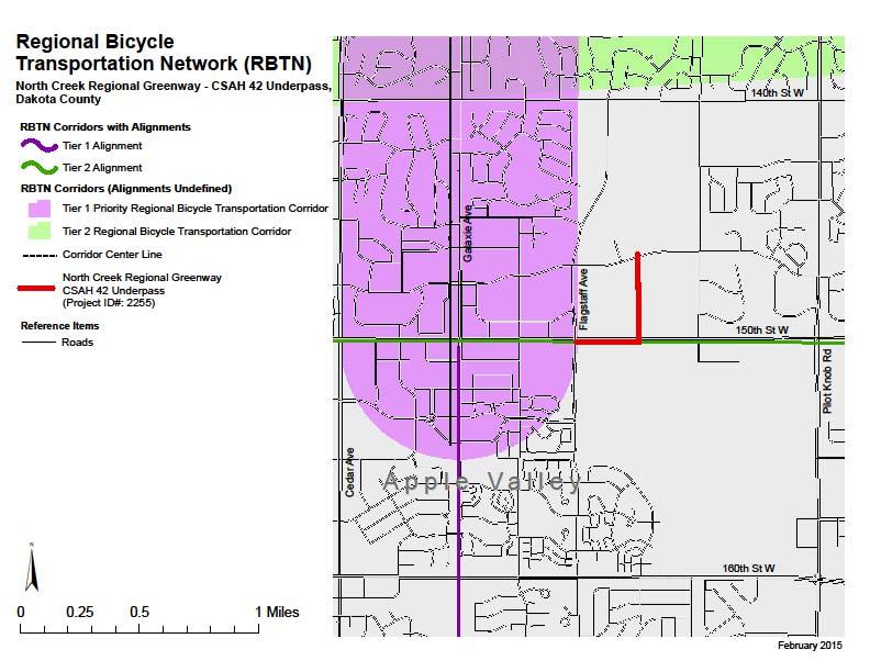
10 2255: North Creek Regional Greenway, Dakota County 10
11 11
12 12
13 13
14 14
15 15
16 Multiuse Trails and Bicycle Facilities 2255: North Creek Regional Greenway CSAH 42 Underpass, Dakota County Project Description This project is a 0.6 mile trail segment on the North Creek Greenway in Apple Valley The project includes a user-activated crossing signal, a pedestrian underpass, and signage including wayfinding and interpretative opportunities. Request Applicant requested the re-evaluation of 1: Role in the Regional Transportation System and Economy (200 points). 1: Role in the Regional Transportation System and Economy. Applicant Applicant s Response to the Criterion The response was provided according to the map generated in the online applicant. Scores were revised to reflect eh actual approved Regional Bicycle Transportation Network (RBTN) (See scoring guidelines on page 2) Scoring Methodology and Scorer s Re-evaluation Difference between Corridors vs. alignments On-line mapping tool showed broad corridors where specific alignments had been defined on the Regional Bicycle Transportation Network (RBTN) There are RBTN Corridors and designated Alignments: o Corridors are broad bandwidths a ½ or 1-mile wide where roadway or trail alignments have not been defined. o Alignments were specifically defined through the Regional Bicycle System Study (completed in early 2014) as indicated in the Study and on the RBTN map legend. o Alignments represent specific roadways or planned or existing off-road trail alignments, but do not represent a specific facility type (i.e., bike lane, wide shoulder, cycle track, etc.). Re-evaluation CSAH 42 is a defined alignment on the Regional Bicycle Transportation Network (Tier 2 denoted green). A portion of the proposed trail follows this Tier 2 alignment According to Scoring Guidelines for this criterion, for projects that include both on-rbtn and off-rbtn improvements, a project with less than 50% of its length.along a Tier 1 or Tier 2 alignment will be considered a direct connection and will receive the full allotment of 120 points for providing a direct connection. Scoring Committee Chair Opinion (Craig Jenson) The Chair s recommendation is to accept the response from the scorer and not change the scores in this measure. 16
17 17
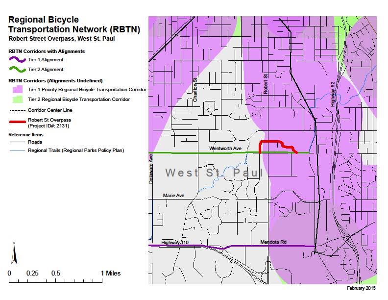
18 2131: River to River Greenway, West St. Paul 18
19 19
20 20
21 21
22 22
23 Multiuse Trails and Bicycle Facilities 2131: River to River Greenway, Robert St. Overpass & Connections, West St. Paul Project Description This project is the construction of a Robert Street Overpass of the River to River Regional Greenway. A key component of the improvement project is the construction of the Robert Street Bridge to support pedestrians, bicyclists, and transit in the corridor. In addition to roadway and sidewalk improvements, the project will include landscaping and streetscape elements to improve the corridors character. Request Applicant requested the re-evaluation of 1: Role in the Regional Transportation System and Economy (200 points), 4A: Critical Links (100 points), 5B: Pedestrian Connections (50 points), and 5C: Multimodal Facilities (50 points) 1: Role in the Regional Transportation System and Economy. Applicant Applicant s Response to the Criterion The response was provided according to the map generated in the online applicant. Scores were revised to reflect eh actual approved Regional Bicycle Transportation Network (RBTN) (See scoring guidelines on page 2) Scoring Methodology and Scorer s Re-evaluation Difference between Corridors vs. alignments On-line mapping tool showed broad corridors where specific alignments had been defined on the Regional Bicycle Transportation Network (RBTN) There are RBTN Corridors and designated Alignments: o Corridors are broad bandwidths a ½ or 1-mile wide where roadway or trail alignments have not been defined. o Alignments were specifically defined through the Regional Bicycle System Study (completed in early 2014) as indicated in the Study and on the RBTN map legend. o Alignments represent specific roadways or planned or existing off-road trail alignments, but do not represent a specific facility type (i.e., bike lane, wide shoulder, cycle track, etc.). Re-evaluation: Proposed overpass project is within a RBTN Tier 1 corridor; however, it runs perpendicular to the north-south orientation of the corridor. Overpass aligns with the east-west orientation of the designated Tier 2 (green) RBTN alignment Therefore, the project was scored as a Tier 2 alignment and was allotted 160 points. Scoring Committee Chair Opinion (Craig Jenson) The Chair s recommendation is to accept the response from the scorer and not change the scores in this measure. 23
24 4A: Critical Links. Applicant indicated that there were inconsistencies between the Scoring Guidelines that were used by West St. Paul in developing its applications and the scoring Methodology Used in its evaluation: Applicant s Response to the Criterion: The project provides a Critical Bicycle Transportation Link by closing the most significant gap on the River to River Greenway, an eight-mile corridor extending from South St. Paul through West St. Paul and Mendota Heights to Lilydale. In addition to connecting users to commercial, employment, and recreational destinations, the Greenway makes important regional transportation connections by linking the 26-mile Mississippi River Regional Trail to the 4.5 mile Big Rivers Regional Trail. The Metropolitan Council projects the River to River Greenway will have 34,000 users once it is completed. This project also addresses the barrier that circumventing Robert Street poses for regional and local non-motorized transportation. Robert St is a four-lane roadway with an ADT of 25,000 (2010) and posted speed limit of 35 mph. There are no other grade separated crossings between St. Paul to Highway 110. The federally funded Robert Street Improvement Project identified the bridge as a critical component that supports the functionality of the entire corridor and enhance its relationship to the surrounding neighborhood. In addition, with the bridge, users will be able to cross Robert Street without the hassle, delay, and potential safety issues of an at-grade crossing. The bridge design selected has a gradual slope without landings so it can work easily for both pedestrians and bicyclists. Scoring Methodology and Scorer s Re-evaluation The scorer did not award full points to a question if the applicant simply checked the box (otherwise this question would not have required a reviewer). The scorer awarded points (up to 45 points in each category plus up to 10 pts for jurisdictional connections) on how well they made their argument relative to the gap or barrier that was improved. By default, everyone answered both the gap and the barrier question because each applicant was required to show the nearby barriers (highways, rivers, railroad, etc.) relative to the project alignment in the mapping exercise. In addition, all applicants presented maps showing facility connections, which show how gaps are closed with their project. The quality of the response and how well the argument was made resulted in the spread of scores. The scorer did take into account with the scoring that certain projects are more gap oriented and others are more barrier oriented, however did not want to penalize a project for only checking one box and not getting credit for providing information in the response portion of the question that related to the other two check boxes. The primary reason why the West St. Paul application did not score as high as other projects is the fact that they have an existing signalized crossing at Robert Street/Wentworth. The scorer saw the bridge at Crawford Drive as redundant and out of the way for users (it was not a convenient alternative in the scorer s opinion). The scorer measured the distance between the proposed bridge at Crawford to be about 800 feet up and back from the Robert Street/Wentworth intersection. Many of the competing projects may have crossings of lower volumes streets than Robert Street, however they lack control or mitigate a confusing situation. Below are several comparisons that were used to make the case: 1) The Gateway trail crossing (#2090) at Jamaica has lower roadway volumes, but much higher speeds at an uncontrolled location. Given the proximity to numerous schools, that project mitigates a higher crash risk. By the way, the scorer is fine with reducing the score for project 2090, but it should get the full 45 points for barrier reduction for that because the road it crosses is a high speed uncontrolled crossing with a lot of trail users. It should also get another 10 points for agency coordination given that the improvements will significantly help mobility outside of jurisdictional limits. Given the proximity to so many schools that project mitigates a significant barrier for users, especially for kids. After re-reading the application, this project is clearly just a barrier project and does not include gap elements. The gap connections cited in the text are not part of the scope of this project as I originally interpreted. 2) The Gateway trail crossing (#2115) at Hadley has lower roadway volumes as well, but here we have lane transitions and peak hour stacking that blocks the existing trail crossing. Given the 24
25 proximity to the Highway 36 crossing, driver sightlines are focused on that intersection and not the trail crossing (there is heavy vegetation on both sides of the road). Streetview clearly shows the stacking and poor sightlines. Furthermore, the application mentions a documented serious bicycle/auto crash at this location. Here points were given in the gap category too because of the perpendicular trail connections the MnDOT interchange project makes. In the project description, it states that the Gateway Trail grade separation project at Hadley is tied to the MnDOT interchange project, stating that it was determined that the alternatives presented could not move forward without the interchange redevelopment occurring as well. The MnDOT project adds a perpendicular trail to the Gateway Trail on the eastern side of Hadley and provides a much safer non-motorized crossing of TH36. The new perpendicular trail on the east side makes it possible to bike to a movie theatre and a major retailer from the Gateway Trail. Scoring Committee Chair Opinion The Chair s recommendation is to accept the response from the scorer and not change the applicant s score for this measure. 5B: Pedestrian Connections. Applicant Applicant s Response to the Criterion Existing pedestrian facilities are limited within the project area. Robert St has sidewalks and there is the existing 8-mile River to River Greenway along Wentworth Avenue. The City has been planning for significant investment and redevelopment in this area since 2001 when it adopted the Robert Street Renaissance plan to guide the transformation of this existing automobile-oriented district into a sustainable, mixed-use district that supports all modes of transportation. The federally funded Robert Street project currently underway focuses on improving the functionality, safety, and aesthetics of the corridor. Improvements over the next few years will include landscaping, sidewalks, and boulevard work and will be guided by the corridors Pedestrian Connectivity Study and Grade Separated Trail Crossing Feasibility Study. This includes addressing existing sidewalk gaps along Wentworth and Thompson Avenues and securing funding to construct the Robert Street overpass, a high priority project. The Robert Street bridge is also a high priority for the River to River Regional Greenway as it is the major gap in the 8-mile corridor and the corridor is projected by the Metropolitan Council to have 34,000 users once it is completed. For efficiency, the City would like to plan for and construct the Robert Street overpass in concert with its other Robert Street improvements. Scoring Methodology and Scorer s Re-evaluation Project does one or more of the following: Provides direct connections or improvements to planned areas of high pedestrian or transit activity (i.e. future transit hub, planned mixed use center or major employment hub) Provides indirect connections along a highly used bikeway to significant destinations, employment centers, transit centers (i.e. improvement is along a bikeway but not within close proximity to major center/pedestrian area) Provides connection to multiple community destinations that are pedestrian and transit accessible The two Gateway Trail applications received 30 points in section 5B because each project Provides indirect connections along a highly used bikeway to significant destinations, employment centers, transit centers (i.e. improvement is along a bikeway but not within close proximity to major center/pedestrian area). Though the context of each immediate project is suburban (Hadley project) or rural (CSAH 9 crossing), the 30 point score recognizes that there are 25
26 very significant pedestrian destinations along the Gateway Trail, including St. Paul, Stillwater, and many communities in-between. Though these destinations are some distance away from the immediate crossing improvements, the extremely high use of this trail was taken into consideration in determining that people would likely use the improved trail to access pedestrian centers, employment, and transit along the corridor. The West St. Paul application was given 30 points because it Provides connection to multiple community destinations that are pedestrian and transit accessible. The score here recognizes that the project connects people to local businesses, transit routes, and local destinations along the Robert Street commercial corridor, but those destinations may not drive high levels of pedestrian and bicycle activity when compared to areas with high concentrations of employment and transit. Projects in Bloomington and Fridley were given the same 30 point score for this reason. Projects that scored higher in this category demonstrated connections to areas of significant pedestrian and transit activity. Scoring Committee Chair Opinion The Chair s recommendation is to accept the response from the scorer and not change the applicant s score for this measure. 5C: Multimodal Facilities. Applicant Applicant s Response to the Criterion The currently automobile-oriented design of Robert Street poses a challenge to pedestrians and users of transit. While Robert Street has sidewalks, there are many driveways that pedestrians must cross. In addition, sidewalk connections are incomplete in the surrounding neighborhoods. The federally funded Robert Street project seeks to transform the Robert Street into a corridor that supports all modes of transportation. Given limited right-of-way, Robert Street itself will be focused on serving pedestrians and motorists. Bicyclists are intended to be accommodated on nearby parallel streets. The construction of an overpass of Robert Street will enable the successful integration of all modes of transportation within the area. The bridge is being carefully designed with gradual slopes so it can accommodate both pedestrians and bicyclists. Greenway amenities, including benches, lighting, and signage are included as part of this project to improve the overall user experience. The location proposed for the overpass was selected as it directly connects to the 8-mile River to River Regional Greenway and is near the proposed mixed-use, pedestrian-oriented redevelopment area intended to be the Citys town center. In addition, the selected alignment has sufficient right-of- way to accommodate a transit stop immediately under the overpass. Scoring Methodology and Scorer s Re-evaluation 5C Multimodal Facilities 40-50: The project fully integrates needs of other modes to benefit multiple user groups : The project incorporates benefits to one or more modes of travel that will significantly improve other modal users in terms of safety, accessibility, comfort, or convenience (i.e. grade separation, addressing other significant barriers) 20-29: The project incorporates basic benefits for other modes (i.e. standard ADA improvements at intersections, moderate crossing improvements, gap filling) : The project provides minimal or indirect benefits to other travel modes. 0-9: The project provides little or no benefit to other travel modes. The Robert Street project scored the same as most grade separated pedestrian and bicycle crossings (30 points) recognizing that grade separation is a significant improvement to safety and comfort for pedestrian and bicycle users and can limit delays to other modes such as transit and automobiles that are using the roadway that is being crossed. The Gateway Trail crossing of Hadley was given a higher score (35) 26
27 because the circumstances of that particular grade separation stood out as having a higher level of benefit to relevant modes when compared to other grade separations: The Gateway Trail is a significantly used state trail that was identified in the application as the most highly used state trail with many pedestrians and bicyclists using the existing at-grade crossing of Hadley Hadley is a high speed multi-lane roadway that is difficult for pedestrians and bicyclists to cross safely, especially at an unsignalized location. The number of trail users plus the number of vehicles increases exposure to crashes, which increases the potential benefits (safety, comfort, convenience) that a grade separation can facilitate. The alignment of the Gateway Trail does not provide other alternatives for trail users to cross Hadley safely (i.e. at a signalized intersection) Vehicles using Hadley can have significant delay waiting for pedestrians and bicycles to cross given the number of users on the trail. This can create problems and backups near the intersection of TH 36 and Hadley (which is very close). Scoring Committee Chair Opinion The Chair s recommendation is to accept the response from the scorer and not change the applicant s score for this measure. 27
28 28
29 Pedestrian Facilities 2132: Oakdale and Marie Streetscaping, West St. Paul 29
30 30
31 31
32 Pedestrian Facilities 2132: Oakdale and Marie Streetscaping, West St. Paul Project Description The project will address the lack of off-street non-motorized facilities. The project will include streetscaping elements, such as pedestrian-scale lighting, benches, vegetation, and high-visibility crossings to provide safety and a pleasant user experience on nearly one mile on Oakdale Avenue from Mendota Road to Wentworth Avenue and 0.55 miles on Marie Avenue between Oakdale Avenue and Robert Street. Request Applicant requested the re-evaluation of 5B: Bikeway Connections (75 points) and 5C: Multimodal Facilities (75 points) 5B: Bikeway Connections. Applicant requested re-evaluation of this measure because their score of 45 points was substantially lower than the 60 points awarded to a similar project submitted CSAH 14. As stated in the appeal letter, CSAH 14 provides a direct connection to Marie Avenue, while the Oakdale and Marie does not have a similar connection because the project involves the bicycle route itself. Applicant s Response to the Criterion The project will provide a direct connection to the River to River Greenway, an 8 mile regional trail connecting West St. Paul to South St. Paul, Lilydale, and Mendota Heights. Users will be able to use the River to River Greenway to safely and easily reach a number of community destinations, including Wentworth Library, West St. Paul City Hall, Henry Sibley High School, Dodge Nature Center, Thompson County Park, the Mississippi River Regional Trail, and local community parks. The Oakdale Avenue component of this project is also important for bicycling as Oakdale Avenue has been identified by local, county, and regional planners as a primary north-south route for bicycling through West St. Paul since Robert Street does not have sufficient right-of-way to accommodate bicycles. There are few stop signs/traffic signals so users can ride from northern Dakota County to Cesar Chavez Street in St. Paul and only encounter 7 stop signs/traffic signals along the 3.3 mile route. This project is in a designated Tier 1 Bicycle Transport Corridor, making this project s connections to the local and regional non-motorized transportation system all the more crucial. Scoring Methodology and Scorer s Re-evaluation Identify modes present in study area. Evaluate quality of project based on modes that are present in study area. Multimodal Connections (Transit and bike) (75 Points) 75 - Significant connections based on direct repose in application 55 - Substantial connections based on direct response in application 35 - Likely connections based on direct response in application 15 - Likely connections but no direct response in application 0 - Connections not likely The scorer re-evaluated the response to the measure and noted that this measure looks at the connections of the project, while measure 5C considers the components of the project itself. As stated in the appeal letter, this project does not have the same connections. The applicant did not include a project scope and was scored based on likely connections for pedestrian connections and substantial connections for transit connection, a score of 45 points (between 35 and 55). Scoring Committee Chair Opinion (Michelle Beaulieu) 32
33 The Chair s recommendation is to accept the response from the scorer and not change the scores in this measure. 5C: Multimodal Facilities. Applicant requested a re-evaluation of this measure as the project provides significant, quality improvements to all modes of transportation, yet the score awarded of 35 points would seem to indicate that the improvements are minimal. Applicant s Response to the Criterion: Currently neither Oakdale nor Marie provides any non-motorized transportation facilities. As shown in the included proposed cross-sections prepared as part of a feasibility study currently underway, the project will include a trail as well as an on-road bicycle lane. In addition, facilities that will be constructed as part of this project to improve safety, security, and the experience for all modes of transportation include benches, street trees, pedestrian-scale lighting, and additional crosswalks. Improvements to both Marie and Oakdale Avenues were identified as a priority in the City's Pedestrian and Bicycle Master Plan as they are critical connector routes within the community in an area severely lacking off-street facilities. The proposed streetscape enhancements along Marie Avenue will complement the federally funded Robert Street Improvement Project that is currently underway. STP funding is being used to remake Robert Street into a pedestrian-friendly environment, and eventually it is slated to become a BRT Arterial. The proposed streetscape enhancements will help support increased transit usage at Marie and Oakdale s numerous existing transit stops (two of which have no off-road trails available), making it easier and safer for transit users to reach and wait for their buses. Scoring Methodology and Scorer s Re-evaluation Identify modes present in study area. Evaluate quality of project based on modes that are present in study area. Multimodal Facility Improvements (Transit & bike) & Integration (75 pts) 75 - Significant improvements based on direct response in application 55 - Substantial improvements based on direct response in application 35 - Likely improvements based on direct response in application 15 - Likely improvements but no direct response in application 0 - Improvements not likely The scorer re-evaluated the response to the measure and responded that the response received a lower score because there was no project scope included in the application. The application does not include specifics for the location and extent of the proposed improvements and states, The City has nearly completed a feasibility study for this project that will provide specific details about the location and extent of the proposed improvements needed along Marie and Oakdale Avenues. (p.1-2 of application). The response was given a score of 35 points on likely improvements based on the response. Scoring Committee Chair Opinion The Chair s recommendation is to accept the response from the scorer and not change the scores in this measure. 33
34 Safe Routes to Schools 2301: Safe Routes to School Infrastructure Project, Forest Lake 34
35 From: To: Cc: Subject: Date: Attachments: Aaron Parrish Koutsoukos, Elaine Ryan Goodman Score Reevaluation Request for the City of Forest Lake"s SRTS Application Tuesday, February 24, :27:25 PM image007.png image008.png image009.png Dear Ms. Koutsoukos, Thank you for the opportunity to challenge scoring on the funding applications. For the most part we understand and accept the scoring on our project but there is one low score that we do not agree with. The City would like to request a reevaluation of the score on criteria 2A Average share of student population that currently bikes or walks to school. Based on the low score, we feel we are being penalized for the existing conditions and policies in place to maximize our student s safety rather than looking forward to the many benefits, including adjustments to policies, this project will provide. Our existing biking and walking is low due to school policy that prohibits students to bike/walk to and from school without parental permission. This information on our school policy is stated in our response for criteria 4A Gaps, Barriers and Continuity/Connections; Although State requirements provide minimum busing distances for elementary and secondary education students, 100% of students in our schools qualify for busing based on the school board discretion of hazardous road crossings and lack of non-motorized connections. Walking and biking to school is currently only allowed with parental permission. Once this project is completed, biking and walking will be encouraged and promoted. We expect a drastic increase in the amount of biking and walking upon project completion. We feel these benefits should carry more weight than the existing conditions we are trying to improve. We appreciate the Transportation Advisory Board s time and effort in reviewing our application. Aaron Parrish, City Administrator City of Forest Lake 1408 Lake Street South Forest Lake, MN Ph: Fax: The City of Forest Lake's mission is dedicated to providing friendly and efficient city services that 35
36 Safe Routes to Schools 2301: Safe Routes to School Infrastructure Project, Forest Lake Project Description The primary focus of the proposed project is to fill gaps in our existing pedestrian network that surrounds Forest Lake Elementary (4-6), Forest View Elementary (K-3), Forest Lake Area Learning Center (6-12), Southwest Jr. High School (7-9), and North Lakes Academy High School (5-12). Request Applicant requested the re-evaluation of 2A: Average Share of student population that currently bikes and walks to school (120 points) 2A: Average Share of student population that currently bikes and walks to school. Applicant asked for a re-evaluation of the score. Based on the low score, they feel they are being penalized for the existing conditions and policies in place to maximize our student s safety rather than looking forward to the many benefits, including adjustments to policies, this project will provide. Applicant s Response to the Measure The applicant s response was 3.0 percent. Scoring Methodology and Scorer s Re-evaluation The project with the best raw score receives the full allotment of points (120 points). Each of the remaining projects then received a percentage of the total points based on their performance relative to the highest scoring project. Measure 2A is rating existing usage. Future usage potential is measured in Measure 2B. Both measures are included in the application, in order to not penalize a project. Forest Lake received the highest score for potential users (2B) and the gaps and barriers measure (4A). Scoring Committee Chair Opinion (Michelle Beaulieu) The Chair s recommendation is to accept the response from the scorer and not change the scores in this measure. 36
37 Transit Expansion 2242: Beltline LRT Station Park & Ride Structure, St. Louis Park 37
38 38
39 Transit Expansion 2242: Beltline LRT Station Park & Ride Structure, St. Louis Park Project Description The construction of a 541 space park-and-ride structure at the new Beltline Station, part of the Southwest LRT (METRO Green Line Extension) project. Currently the Southwest LRT Project includes a 541 space surface park-and-ride on a 7 acre site, of which approximately 3 acres are owned by the city. Request Applicant requested the re-evaluation of 1C: Role in the Regional Transportation System & Economy Transit Connectivity (34 points) and 3A: Equity and Housing Socio-Economic (130 points) 1C: Role in the Regional Transportation System & Economy Transit Connectivity. Applicant asked that the entire Green Line be considered as a transitway connection. Applicant s Response to the Criterion The applicant selected the Green Line Extension as a planned transitway connection. Metropolitan Council staff provided the annual ridership amount of 10,944,000. This amount is the projected ridership in the Green Line ridership projections. Scoring Methodology and Scorer s Re-evaluation The existing route ridership increment was determined by dividing the maximum score by the number of applications (24/12=2). The planned transitway route ridership increment was determined by dividing the maximum score by the number of applications (10/12=0.83). The final scores were determined by subtracting the increment from the score above. Measure 1B looked at existing ridership and measure 1C looked at planned transitway ridership, which was based on the ridership projections in the adopted plans. All applicants were given the same ridership amounts for the planned transitways. Including existing ridership in the planned transitway ridership would increase the numbers for all the applications. With the scores pro-rated, the resulting score would be similar. Scoring Committee Chair Opinion (Jan Lucke) The Chair s recommendation is to accept the response from the scorer and not change the scores in this measure. 3A: Equity and Housing Socio-Economic. Applicant requested a re-evaluation of the measure because some information was not factored in the scoring. The applicant requests that the criterion be reconsidered to include the entire Green Line b and be considered as a project that directly connects to Racially Concentrated Areas of Poverty. Applicant s Response to the Criterion Above regional average concentration of race/poverty. Scoring Methodology and Scorer s Re-evaluation Comparative analysis of responses; statements made regarding location of project, who benefits and how, adverse impacts/mitigation; plus for quantitative information and data and locations/types of institutions and services accessed comparative scale 0 to 10. Then project location percent times statement analysis score. 39
40 The scorer re-evaluated the response, including reviewing the map. The project is a park and ride in St. Louis Park that is in an area Above regional average concentration of race/poverty that entitles it to a 60% of its qualitative evaluation score (130 highest possible). The final score is 78 and should remain that way. If the park and ride provided clear, documented reverse commute service to riders (race/poverty) elsewhere along the line it would have scored higher. But the physical project and service provided are in an area Above regional average concentration of race/poverty. The application is not adding new transit service as part of the project. Scoring Committee Chair Opinion (Jan Lucke) The Chair s recommendation is to accept the response from the scorer and not change the scores in this measure. 40
41 Roadway Expansion 41
42 2286: East Bush Lake Road/I-494 Westbound On-Ramp, Bloomington 42
43 43
44 Roadway Expansion 2286: East Bush Lake Road/I-494 Westbound On-Ramp, Bloomington Project Description Pedestrian/Bicycle trail between Tracy Avenue and France Avenue/Edina Promenade in Edina. Request The applicant requested a re-evaluation of 2B: 2030 Forecasted ADT (65 points). 2B: 2030 ADT. The applicant requested that the measure be re-scored based on a discrepancy that it appears that the projects did not receive scores in a proportional share of the full points based on ADT. The applicant s response to the criterion 22,200 ADT Scoring Methodology and Scorer s Re-evaluation The scorer subtracted the existing AADT in measure 2A from the forecasted ADT volume to determine increased volumes as a benefit for the improvement. The scorer pro-rated the scores on the increased ADT. The scores are shown in the Original Score column in the table below. Additionally, when evaluating this challenge, staff found an errant transposed number in the original score and has provided a corrected score in the table below. Finally, the Alternate Score column shows how scoring would have been based on the pro-rated 2030 ADT forecast numbers. ID Original Score Corrected Score Forecasted ADT Alternate Score , , , , , , , , , , , , , , , , , , , , , , ,
45 Scoring Committee Chair Opinion (Joe Lux): The Chair s recommendation is to accept the response from the scorer and not change the scores in this measure. 45
46 2223: 77th Street Underpass, Richfield 46
47 47
48 48
49 49
50 50
51 51
52 52
53 2223: 77 th Street Underpass, Richfield Roadway Expansion Project Description Proposed 77 th Street underpass connects 77 th Street east and west of TH 77 (Cedar Avenue to eliminate a gap in the Minor Reliever network. The project will connect Bloomington and Longfellow Avenues. Request The applicant requested a re-evaluation of 1B: Daily Heavy Commercial traffic (90 points),), 2A: Usage (110 points), 3A: Socio/Economic (30 points), 4: Age (75 points), 7: Multi-modal (7A/7B 50 points, 7C 50 points). 1B: Daily Heavy Commercial traffic. The applicant requested that the measure be re-scored because it does not capture the benefits of the project for commercial vehicle traffic. The applicant s response to the criterion: Current daily heavy commercial traffic volume 1,300 Scoring Methodology and Scorer s Re-evaluation The applicant with the highest current daily heavy commercial traffic volume received the highest number of points and the other applicants received pro-rated scores. The measure looks at current volumes, not benefits. No change recommended. Scoring Committee Chair Opinion (Joe Lux): The Chair s recommendation is to accept the response from the scorer and not change the scores in this measure. 2A: Current Daily Throughput. The applicant requested that the measure be re-scored. The applicant s response to the criterion: 5,824 AADT Scoring Methodology and Scorer s Re-evaluation The applicant with the highest AADT received the highest number of points and the other applicants received pro-rated scores. The measure looks at current volumes, not benefits. Future volumes are accounted for in the 2030 Forecasted volumes in Measure 2B. No change recommended. Scoring Committee Chair Opinion (Joe Lux): The Chair s recommendation is to accept the response from the scorer and not change the scores in this measure. 3A: Socio/Economic. The applicant requested that the measure be re-scored because no projects received the full 30 points. The applicant s response to the criterion: Benefits: - Bicycle and pedestrian improvements: Bicycle/pedestrian underpass will provide safer and more convenient bicycle and pedestrian connections. Low-income populations who rely on bicycling/walking will benefit from improved connections across two major barriers: TH 77 and I-494. This connection will provide an alternative route and access to Airport and the South Loop and also a trail connection to the 53
54 Minnesota River Recreational Area. - Transit improvements: Improved transit routes and connections will improve convenience and safety for low-income and minority populations who rely on transit and will improve access to jobs and entertainment in the South Loop and the Airport. Negative impacts and mitigation: The project is not expected to negatively impact low-income populations, people of color, children, people with disabilities, and the elderly. The right-of-way acquisition for the project will be limited to the Motel 6 located north of 77th Street. The rating awarded for the response was 7.5 out of 10, which was multiplied by 100% for being a project in a Racially Concentrated Area of Poverty, multiplied by 30 points for a resulting score of 22.5 out of 30. Scoring Methodology and Scorer s Re-evaluation Comparative analysis of responses; statements made regarding location of project, who benefits and how, adverse impacts/mitigation; plus for quantitative information and data and locations/types of institutions and services accessed comparative scale 0 to 10. Then project location percent times statement analysis score. All applicants were score the using the same methodology. Per the design of the measure, no project was able to receive full points in this application. An additional adjustment of scores, would adjust all projects scores the same with no resulting difference in rating. Scoring Committee Chair Opinion (Joe Lux): The Chair s recommendation is to accept the response from the scorer and not change the scores in this measure. 4: Age. The applicant requested that the measure be re-scored based on incorrect guideance for completing the application and that the project application form did not provide information how to address new roadways. The applicant s response to the criterion: Construction/Reconstruction Date - 0 Scoring Methodology and Scorer s Re-evaluation The scorer used the 2014 as the current year, since that was the year the applications were submitted to determine the age of the roadway; 2014 minus the weighted year provided to get the age of the roadway. Any roadways that were at or past the 50 years useful received the maximum points of 75. All those less than 50 years received a proportion of the points by the following (age/50)*75 = score. The guidance provided to the applicants was that a roadway age of 0 be used for any new roadway. No other guidance was provided. All new roadways entered 0 and received 0 points. This project scored the same as other new projects, per the design of the measure. Scoring Committee Chair Opinion (Joe Lux): The Chair s recommendation is to accept the response from the scorer and not change the score in this measure. 7: Multi-modal. The applicant requested that Metropolitan Council staff review the application against the Measure 7 criteria and in comparison with the other applications to ensure that the score reflects the benefits associated with the project. Scoring Methodology Methodology for 7A/7B Existing Transit Routes on Corridor (10 pts) 54
55 Planned/Existing Transitways (10/15 pts) Connections Transit, Planned/Existing (10/15 pts) High Traffic Ped Areas, Planned/Existing (10/15 pts) Methodology for 7C Connection to Transit (10) Connection to Bikeway (10) Connection to High Traffic Ped. Areas (10) Quality of Improvements: (10-20) Metropolitan Council staff review The applicant received 40 out of 50 points for measures 7A/7B and 35 out of 50 points for measure 7C. Without specific information from the applicant indicating where they believed the measure was misscored relative to other applicants, staff accepts the scorer s comparison of the project responses relative to each other. Scoring Committee Chair Opinion (Joe Lux): The Chair s recommendation is to accept the response from the scorer and not change the score in this measure. 55
56 2294: CSAH 78 Expansion from 139th Lane to CSAH 18, Anoka County 56
57 From: To: Cc: Subject: Date: Jack Forslund Koutsoukos, Elaine Jack Forslund; Doug Fischer; Andrew Witter; Jason Orcutt; Matt Parent Anoka County Regional Solicitation Criterion Score Re-evaluation (Project No CSAH 78 Expansion from 139th Ln to CSAH 18) Friday, February 27, :09:22 PM Date: February 27, 2015 To: Elaine Koutsoukos Metropolitan Council 390 Robert Street North St. Paul, MN From: Jack Forslund, PTP Anoka County Highway Department 1440 Bunker Lake Boulevard, NW Andover, MN RE: Anoka County Regional Solicitation Criterion Score Re-evaluation (Project No CSAH 78 Expansion from 139th Ln to CSAH 18) Anoka County wishes to appeal their score for project no CSAH 78 Expansion from 139th Ln to CSAH 18, which is under the Regional Solicitation Category - Roadways Including Multimodal Elements. In our review of the scores for this project, we noted three criteria that we believe should be changed. These criteria are: No. 4 - Infrastructure Age No. 7b - Bicycle and Pedestrian Connections, and No. 8. Risk Assessment Provided below for each of these criterion is our score as well as an explanation on why think the score is too low. No. 4 - Infrastructure Age Score: 33 out of 75 points In reviewing our application, we noted that Measure A: Year of Roadway Construction notes 0.36 miles of the roadway was reconstructed in This is incorrect, the only segment of the road that has been reconstructed since 1983 is a 0.26 mile segment reconstructed in

58 We request that this is recalculated to reflect the correct age of the road. No. 7b - Bicycle and Pedestrian Connections Score: 10 out of 50 points In reviewing the measures for this criteria, we feel strongly that this project will provide strong pedestrian and bicycle connections. The measures for this criteria state: Our response for this criteria shows how this project will provide very strong bicycle and pedestrian connections to several facilities including regional trails, schools, parks, and many activity centers located adjacent to the project. We fail to see how we could possibly get only 10 out of 50 points for this criteria. Provided below is a print-screen from out application. To make it more clear, we have highlighted the text that is particularly important to show how well this project responds to the question of bicycle and pedestrian connections. 58

59 We request that the score for this criteria is significantly adjusted upward as the project will provide exceptional bicycle and pedestrian connections throughout this corridor that is laden with educational, park, and activity centers. No. 8. Risk Assessment Score: 61 out of 75 points The final score we are questioning pertains to Risk Assessment. In reviewing our score as 59
ACTION TRANSMITTAL No
 Transportation Advisory Board of the Metropolitan Council of the Twin Cities ACTION TRANSMITTAL No. 2016-15 DATE: January 14, 2016 TO: TAC Planning Committee PREPARED BY: Steven Elmer (651) 602-1756 SUBJECT:
ACTION TRANSMITTAL No
 Transportation Advisory Board of the Metropolitan Council of the Twin Cities ACTION TRANSMITTAL No. 2016-15 DATE: January 14, 2016 TO: FROM: TAC TAC Planning PREPARED BY: Steven Elmer (651) 602-1756 SUBJECT:
City of Novi Non-Motorized Master Plan 2011 Executive Summary
 City of Novi Non-Motorized Master Plan 2011 Executive Summary Prepared by: February 28, 2011 Why Plan? Encouraging healthy, active lifestyles through pathway and sidewalk connectivity has been a focus
Bicycle and Pedestrian Chapter TPP Update Overview. TAB September 20, 2017
 Bicycle and Pedestrian Chapter TPP Update Overview TAB September 20, 2017 Bicycling & Walking in the Twin Cities Where are we now? The Bike-Pedestrian system Current trends New developments Where are we
ACTION TRANSMITTAL No
 Transportation Advisory Board of the Metropolitan Council of the Twin Cities ACTION TRANSMITTAL No. 2016-15 DATE: February 5, 2016 TO: FROM: Transportation Advisory Board Technical Advisory Committee PREPARED
Chapter 7: Bicycle And Pedestrian Investment Direction
 7.1 Chapter 7: Bicycle And Pedestrian Investment Direction 2040 7.2 Chapter 7: Bicycle and Pedestrian Investment CONTENTS Overview 7.3 Regional Bicycle Transportation Network 7.6 Regional Bicycle System
ACTION TRANSMITTAL No
 Transportation Advisory Board of the Metropolitan Council of the Twin Cities DATE: January 12, 2018 TO: ACTION TRANSMITTAL No. 2018-12 TAC Funding and Programming Committee PREPARED BY: Joe Barbeau, Senior
5. RUNNINGWAY GUIDELINES
 5. RUNNINGWAY GUIDELINES These guidelines should be considered collectively when making runningway decisions. A runningway is the linear component of the transit system that forms the right-of-way reserved
ACTIVE TRANSPORTATION
 ACTIVE TRANSPORTATION Mobility 2040 Supported Goals Improve the availability of transportation options for people and goods. Support travel efficiency measures and system enhancements targeted at congestion
APPENDIX A: Complete Streets Checklist DRAFT NOVEMBER 2016
 APPENDIX A: Complete Streets Checklist DRAFT NOVEMBER 2016 Complete Streets Checklist MetroPlan Orlando s Complete Streets Checklist is an internal planning tool for staff to further implementation of
Solana Beach Comprehensive Active Transportation Strategy (CATS)
") Solana Beach Comprehensive Active Transportation Strategy (CATS) 3.0 Goals & Policies The Solana Beach CATS goals and objectives outlined below were largely drawn from the Solana Beach Circulation Element
Solana Beach Comprehensive Active Transportation Strategy (CATS) 3.0 Goals & Policies The Solana Beach CATS goals and objectives outlined below were largely drawn from the Solana Beach Circulation Element
ACTION TRANSMITTAL No
 Transportation Advisory Board of the Metropolitan Council of the Twin Cities DATE: August 25, 2016 TO: FROM: ACTION TRANSMITTAL No. 2016-47 Technical Advisory Committee TAC Funding and Programming Committee
Proposed. City of Grand Junction Complete Streets Policy. Exhibit 10
 Proposed City of Grand Junction Complete Streets Policy Exhibit 10 1 City of Grand Junction Complete Streets Policy Vision: The Complete Streets Vision is to develop a safe, efficient, and reliable travel
Regional Bicycle Barriers Study
 Regional Bicycle Barriers Study Executive Summary Background and Purpose The 2040 Transportation Policy Plan (TPP) sets policies for planning and investment direction in the transportation system in the
SANTA CLARA COUNTYWIDE BICYCLE PLAN August 2008
 SANTA CLARA COUNTYWIDE BICYCLE PLAN August 2008 To assist VTA and Member Agencies in the planning, development and programming of bicycle improvements in Santa Clara County. Vision Statement To establish,
Bus Rapid Transit Plans
 Twin Cities Region Bus Rapid Transit Plans ULI Minnesota Workshop Connecting Bus Rapid Transit to the Community December 15, 2009 John Levin Director of Service Development Metro Transit Metropolitan Area
Chapter 5 Future Transportation
 Chapter 5 Future Transportation The Future Land Use Plan identifies the desired land use designations. The land uses desired for Crozet depend, in large part, on the success of the transportation system,
Chapter 9: Pedestrians and Bicyclists
 Chapter 9: Pedestrians and Bicyclists Walking and bicycling are essential modes of transportation. These modes allow people to travel without contributing to congestion and air pollution, to access other
What Is a Complete Street?
 Session 5 Charleen Zimmer, AICP, Zan Associates May 5-7, 2010 What Is a Complete Street? May 2010 5-1 Not a Complete Street More of a Complete Street May 2010 5-2 Benefits of Complete Streets Safety for
Madison Urban Area and Dane County. Bicycle Transportation Plan Summary. September Introduction. Bicycle Plan Scope and Planning Process
 Bicycle Transportation Plan Summary Madison Urban Area and Dane County Introduction September 2000 Bicycling is an important mode of transportation in the Madison urban area and countywide that is available
Twin Cities Regional Bicycle System Study
 Twin Cities Regional Bicycle System Study Developing a Regional Bicycle Network Steven Elmer, Metropolitan Council Tony Hull, Toole Design Group LLC CTS Research Conference May 21, 2014 Introduction Study
General Design Factors
 Chapter 3: 3-1.0 Introduction General Design Factors Mn/DOT s goals include encouraging and accommodating safe bicycling. From a design perspective, these goals are achieved by first having an understanding
Executive Summary Route 30 Corridor Master Plan
 Route Corridor Master Plan Project Overview The Route Corridor Master Plan is a coordinated multimodal transportation and land use plan for the entire stretch of Route through East Whiteland Township,
CONNECTING PEOPLE TO PLACES
 CONNECTING PEOPLE TO PLACES 82 EAST BENCH MASTER PLAN 07 Introduction The East Bench transportation system is a collection of slow moving, treelined residential streets and major arteries that are the
Chapter VISION, MISSION, AND GOALS AND OBJECTIVES. Vision. Mission. Goals and Objectives CONNECTING COMMUNITIES ACROSS THE ST.
 VISION, MISSION, AND GOALS AND OBJECTIVES Chapter 3 The Plan s vision, mission, and goals and objectives were developed through a series of interactive exercises with the Citizens Advisory Committee (CAC)
Information Item. Transit and TDM Projects. Range of 22%-32% of Funds. Range of $31.58-$45.94 M
 Transportation Advisory Board of the Metropolitan Council of the Twin Cities DATE: April 9, 2015 Information Item TO: Transportation Advisory Board PREPARED BY: Steve Peterson, Planning Analyst 651-602-1819)
Goal 3: Foster an environment of partnerships and collaboration to connect our communities and regions to one another.
 Non-Motorized Transportation Plan (NMTP) Draft Vision, Goal and,, Tri-County Regional Planning Commission (TCRPC) Purpose The purpose of the Tri-County Regional Planning Commission (TCRPC) Non-Motorized
Transportation Master Plan Advisory Task Force
 Transportation Master Plan Advisory Task Force Network Alternatives & Phasing Strategy February 2016 BACKGROUND Table of Contents BACKGROUND Purpose & Introduction 2 Linking the TMP to Key Council Approved
Coquitlam Cross-town Bike Route Improving Bicycle Facilities in a Mature Suburban Environment
 Coquitlam Cross-town Bike Route Improving Bicycle Facilities in a Mature Suburban Environment Sarah Rocchi, Vice-President, Projects, Opus International Consultants (Main Presenter) Catherine Mohoruk,
CITY OF COCOA BEACH 2025 COMPREHENSIVE PLAN. Section VIII Mobility Element Goals, Objectives, and Policies
 CITY OF COCOA BEACH 2025 COMPREHENSIVE PLAN Section VIII Mobility Element Goals, Objectives, and Policies Adopted August 6, 2015 by Ordinance No. 1591 VIII MOBILITY ELEMENT Table of Contents Page Number
MCTC 2018 RTP SCS and Madera County RIFP Multi-Modal Project Eval Criteria GV13.xlsx
 MCTC 8 RTP SCS and Madera County RIFP Multi-Modal Project Eval Criteria GV.xlsx Madera County Transportation Commission Regional Transportation Plan / Sustainable Communities Strategy Multi-Modal Project
Clackamas County Comprehensive Plan
 ROADWAYS The County s road system permits the movement of goods and people between communities and regions, using any of a variety of modes of travel. Roads provide access to virtually all property. They
City of Wayzata Comprehensive Plan 2030 Transportation Chapter: Appendix A
 A1. Functional Classification Table A-1 illustrates the Metropolitan Council s detailed criteria established for the functional classification of roadways within the Twin Cities Metropolitan Area. Table
Pedestrian Project List and Prioritization
 To: Kyle Wagenschutz, City of Memphis CC: From: Anne Conlon and John Cock, Alta Planning + Design Date: December, 2014 Re: Project List Development (Task 3.1-3.2) and Project List Prioritization (Task
Bicycling & Walking in the Twin Cities TPP Bike/Ped Chapter Overview. Land Use Advisory Committee September 21, 2017
 Bicycling & Walking in the Twin Cities TPP Bike/Ped Chapter Overview Land Use Advisory Committee September 21, 2017 Presentation Outline Current TPP Purpose of bike/ped chapter New developments Bike/Ped
C C C
 C-012-001 Thank you for your support for the creation of new public space and nonmotorized access between downtown and the waterfront through the Overlook Walk, the East-West Connections, and the Promenade.
AMATS Complete Streets Policy
 AMATS Complete Streets Policy Table of Contents: Section 1. Definition of Complete Streets Section 2. Principles of Complete Streets Section 3. Complete Streets Policy Section 4. Consistency Section 5.
Welcome. Background. Goals. Vision
 Welcome The formal Public Information Centre (PIC) for the Transportation Master Plan How We GO will be held in early 2017. At that time we will present the recommended transportation system for Niagara
Living Streets Policy
 Living Streets Policy Introduction Living streets balance the needs of motorists, bicyclists, pedestrians and transit riders in ways that promote safety and convenience, enhance community identity, create
Overview. Illinois Bike Summit IDOT Complete Streets Policy Presentation. What is a Complete Street? And why build them? And why build them?
 Overview Illinois Bike Summit IDOT Complete Streets Policy Presentation Aren Kriks, P.E. District One Bicycle Coordinator and Bureau of Programming Project Engineer History of Complete Streets IDOT Policy
Physical Implications of Complete Streets Policies
 Presentation Overview Physical Implications of Complete Norm Cox, ASLA, LLA Landscape Architect Ann Arbor, Michigan, 10:45 to Noon What Are Complete Streets? What Matters to Bicyclists and Pedestrians
Exhibit 1 PLANNING COMMISSION AGENDA ITEM
 Exhibit 1 PLANNING COMMISSION AGENDA ITEM Project Name: Grand Junction Circulation Plan Grand Junction Complete Streets Policy Applicant: City of Grand Junction Representative: David Thornton Address:
Basalt Creek Transportation Refinement Plan Recommendations
 Basalt Creek Transportation Refinement Plan Recommendations Introduction The Basalt Creek transportation planning effort analyzed future transportation conditions and evaluated alternative strategies for
Gordon Proctor Director Policy on Accommodating Bicycle and Pedestrian Travel on ODOT Owned or Maintained Facilities
 Approved: Policy: 20-004(P) Responsible Office: Planning Gordon Proctor Director Policy on Accommodating Bicycle and Pedestrian Travel on ODOT Owned or Maintained Facilities I. POLICY STATEMENT: This policy
Chapter 2: Standards for Access, Non-Motorized, and Transit
 Standards for Access, Non-Motorized, and Transit Chapter 2: Standards for Access, Non-Motorized, and Transit The Washtenaw County Access Management Plan was developed based on the analysis of existing
BIKE PLAN CONTENTS GATEWAY
 CONTENTS Acknowledgments...vii Great Rivers Greenway District Board of Directors... vii Great Rivers Greenway District Staff... vii Project Consultants... vii Committees... viii Citizens Advisory Committee
RESOLUTION NO ?? A RESOLUTION OF THE CITY OF NEPTUNE BEACH ADOPTING A COMPLETE STREETS POLICY
 RESOLUTION NO. 2018-?? A RESOLUTION OF THE CITY OF NEPTUNE BEACH ADOPTING A COMPLETE STREETS POLICY WHEREAS, safe, convenient, and accessible transportation for all users is a priority of the City of Neptune
CITY OF BLOOMINGTON COMPLETE STREETS POLICY
 CITY OF BLOOMINGTON COMPLETE STREETS POLICY POLICY OBJECTIVE: The City of Bloomington will enhance safety, mobility, accessibility and convenience for transportation network users of all ages and abilities,
REGIONAL BICYCLE AND PEDESTRIAN DESIGN GUIDELINES
 REGIONAL BICYCLE AND PEDESTRIAN DESIGN GUIDELINES November 16, 2011 Deb Humphreys North Central Texas Council of Governments Bicycle and Pedestrian Advisory Committee Snapshot of the Guide 1. Introduction
Bikeway action plan. Bicycle Friendly Community Workshop March 5, 2007 Rochester, MN
 Bikeway action plan Summary The was held on March 5, 2007 at the Rochester Mayo Civic Center. The workshop was hosted by Rochester-Olmsted County Planning Department in collaboration with the League of
This page intentionally left blank.
 This page intentionally left blank. COMMUNITY Glenpool Community Overview Glenpool Glenpool is a city of nearly 12,000 residents located in Tulsa County southwest of Tulsa and Jenks. The city is growing
NJDOT Complete Streets Checklist
 Background The New Jersey Department of Transportation s Complete Streets Policy promotes a comprehensive, integrated, connected multi-modal network by providing connections to bicycling and walking trip
Dr. M.L. King, Jr. Street North Complete Streets Resurfacing Opportunities HOUSING, LAND USE, AND TRANSPORTATION COMMITTEE MARCH 22, 2018
 Dr. M.L. King, Jr. Street North Complete Streets Resurfacing Opportunities HOUSING, LAND USE, AND TRANSPORTATION COMMITTEE MARCH 22, 2018 What s Happening The City plans to mill and resurface Dr. M.L.
Agenda. Overview PRINCE GEORGE S PLAZA METRO AREA PEDESTRIAN PLAN
 PRINCE GEORGE S PLAZA METRO AREA PEDESTRIAN PLAN May 28, 2008 Agenda Welcome and introductions Project overview and issue identification Planning context and strengths Design challenges and initial recommendations
Chapter 7. Transportation. Transportation Road Network Plan Transit Cyclists Pedestrians Multi-Use and Equestrian Trails
 Chapter 7 Transportation Transportation Road Network Plan Transit Cyclists Pedestrians Multi-Use and Equestrian Trails 7.1 TRANSPORTATION BACKGROUND The District of Maple Ridge faces a number of unique
Multimodal Through Corridors and Placemaking Corridors
 68 Multimodal Through Corridors and Placemaking Corridors Corridors have different functions in a region. Some corridors are used to get smoothly and rapidly through a region or to get quickly to major
3.9 Recreational Trails and Natural Areas
 3.9 Recreational Trails and Natural Areas 3.9.1 Introduction Parks and other recreational facilities such as trails, bicycle routes, and open space are important community resources. This section discusses
NON-MOTORIZED TRANSPORTATION
 NON-MOTORIZED TRANSPORTATION This chapter discusses bicycle and pedestrian initiatives, non-motorized goals and objectives, safety, education, and regional enforcement efforts, key area infrastructure,
Appendix 3 Roadway and Bike/Ped Design Standards
 Appendix 3 Roadway and Bike/Ped Design Standards OTO Transportation Plan 2040 4/20/2017 Page A3-1 Adopted Standards The adopted OTO Design Standards and Major Thoroughfare Plan are contained herein.
Complete Street Analysis of a Road Diet: Orange Grove Boulevard, Pasadena, CA
 Complete Street Analysis of a Road Diet: Orange Grove Boulevard, Pasadena, CA Aaron Elias, Bill Cisco Abstract As part of evaluating the feasibility of a road diet on Orange Grove Boulevard in Pasadena,
Develop a Multi-Modal Transportation Strategy (Theme 6)
") DEVELOP A MULTI-MODAL TRANSPORTATION STRATEGY (THEME 6) WHY IS THIS THEME ADDRESSED? Develop a Multi-Modal Transportation Strategy (Theme 6) Statement of Ideal Reduce resident and visitor reliance on single
DEVELOP A MULTI-MODAL TRANSPORTATION STRATEGY (THEME 6) WHY IS THIS THEME ADDRESSED? Develop a Multi-Modal Transportation Strategy (Theme 6) Statement of Ideal Reduce resident and visitor reliance on single
4 Goals, Objectives & Actions
 Chapter4 4 This chapter presents goals, objectives, and recommended actions to support the vision of making Overland Park a safer and easier place to ride a bicycle. 35 4.1 Recommendations Structure The
Hennepin County Bicycle and Pedestrian Planning
 Hennepin County Bicycle and Pedestrian Planning 1 Value of bicycle and sidewalk systems Safety Livability Mobility Health Personal Finances Economic Sustainability Clean Air Recreation Parking and congestion
Perryville TOD and Greenway Plan
 Perryville TOD and Greenway Plan Greenway Glossary Pathway: A bicycle and pedestrian path separated from motorized vehicular traffic by an open space, barrier or curb. Multi-use paths may be within the
EXECUTIVE SUMMARY. Vision
 Vision Walking and bicycling in Salt Lake City will be safe, convenient, comfortable, and viable transportation options that connect people to places, foster recreational and economic development opportunities,
Thank you for this opportunity to discuss with you how we can work together to make our streets more complete.
 Thank you for this opportunity to discuss with you how we can work together to make our streets more complete. 1 2 3 Thank you for this opportunity to discuss with you how we can work together to make
A Matter of Fairness: ROCOG s Environmental Justice Protocol. What is Mobility Limitation?
 No Person Left Behind What is Mobility Limitation? What is the Access Limitation? Environmental Justice population should be provided adequate mobility & access to meet their needs; Identify acceptable
Route 7 Corridor Study
 Route 7 Corridor Study Executive Summary Study Area The following report analyzes a segment of the Virginia State Route 7 corridor. The corridor study area, spanning over 5 miles in length, is a multi
Midtown Corridor Alternatives Analysis
 Midtown Corridor Alternatives Analysis Ridership Forecast Methodology and Results December 2013 Prepared by the SRF Consulting Group Team for Table of Contents Introduction... 1 Methodology... 1 Assumptions...
Title. Metropolitan Council Transportation Committee December 12, Brad Larson Metro District MnDOT
 Title Metropolitan Council Transportation Committee December 12, 2016 Evaluating the potential for Bus Rapid Transit and MnPASS Express Lanes in the southwest Metro Brad Larson Metro District MnDOT Background
Southview Blvd & 3 rd Avenue Improvement Project. Public Open House December 4, to 7pm
 Southview Blvd & 3 rd Avenue Improvement Project Public Open House December 4, 2014 5 to 7pm Southview Blvd & 3 rd Avenue Public Information Meeting Agenda Presentation 5:30 to 6:15 pm Purpose of Project
Philip Schaffner Minnesota Department of Transportation October 22, 2013
 Philip Schaffner Minnesota Department of Transportation October 22, 2013 Going beyond performance measures & targets MnDOT has been using performance-based planning and programming for 10 years, but CIMS
Chapter 2. Bellingham Bicycle Master Plan Chapter 2: Policies and Actions
 Chapter 2 Bellingham Bicycle Master Plan Chapter 2: Policies and Actions Chapter 2: Policies and Actions The Bicycle Master Plan provides a road map for making bicycling in Bellingham a viable transportation
Corpus Christi Metropolitan Transportation Plan Fiscal Year Introduction:
 Introduction: The Safe, Accountable, Flexible, Efficient Transportation Equity Act: A Legacy for Users (SAFETEA-LU) has continued the efforts started through the Intermodal Surface Transportation Efficiency
Pedestrian Crossing Facilitation Guideline Development
 Pedestrian Crossing Facilitation Guideline Development TZD Conference Melissa Barnes October, 2017 Why? Minnesota Go: Minnesota s multimodal transportations system maximizes the health of people, the environment,
I-105 Corridor Sustainability Study (CSS)
") I-105 Corridor Sustainability Study (CSS) Metro Streets and Freeways Subcommittee March 21, 2019 Gary Hamrick Cambridge Systematics, Inc. I-105 CSS Project History & Background Funded by Caltrans Sustainable
I-105 Corridor Sustainability Study (CSS) Metro Streets and Freeways Subcommittee March 21, 2019 Gary Hamrick Cambridge Systematics, Inc. I-105 CSS Project History & Background Funded by Caltrans Sustainable
City of Moorhead Committee of the Whole Meeting
 City of Moorhead Committee of the Whole Meeting Corridor Study Limits Center Avenue (Red River to 8th Street) TH 10 (Red River to TH 336) TH 75 (20th Ave S to Main Avenue) 2 Study Need: Project Overview
Town of Superior. Superior Trails Plan
 Part 1 Base Information 1. Project Title US 36 Bikeway Extension 2. Project Start/End points or Geographic Area Provide a map with submittal, as appropriate 3. Project Sponsor (entity that will construct/
Southwest Bus Rapid Transit (SW BRT) Functional Planning Study - Executive Summary January 19 LPT ATTACHMENT 2.
 Functional Planning Study - Executive Summary January 19 LPT ATTACHMENT 2.") Southwest Bus Rapid Transit (SW BRT) Functional Planning Study - Executive Summary 2011 January 19 1 of 19 Introduction This executive summary presents the results of the Southwest Bus Rapid Transit (SW
Southwest Bus Rapid Transit (SW BRT) Functional Planning Study - Executive Summary 2011 January 19 1 of 19 Introduction This executive summary presents the results of the Southwest Bus Rapid Transit (SW
ADOT Statewide Bicycle and Pedestrian Program Summary of Phase IV Activities APPENDIX B PEDESTRIAN DEMAND INDEX
 ADOT Statewide Bicycle and Pedestrian Program Summary of Activities APPENDIX B PEDESTRIAN DEMAND INDEX May 24, 2009 Pedestrian Demand Index for State Highway Facilities Revised: May 29, 2007 Introduction
Regional Transportation Needs Within Southeastern Wisconsin
 Regional Transportation Needs Within Southeastern Wisconsin #118274 May 24, 2006 1 Introduction The Southeastern Wisconsin Regional Planning Commission (SEWRPC) is the official areawide planning agency
Transportation Corridor Studies: Summary of Recommendations
 Transportation Corridor Studies: Summary of Recommendations Route 4 Corridor Study: Route 10 Corridor Study: Route 44 Corridor Study: Route 175 Corridor Study: Route 5/15 Corridor Study: Rentschler Field
Preliminary Transportation Analysis
 Preliminary Transportation Analysis Goals of a Robust, Multimodal Transportation Network Safe Accessible/Connected Efficient Comfortable Context-Sensitive Motor Vehicle: Continue to analyze the data to
4. ENVIRONMENTAL IMPACT ANALYSIS 9. TRANSPORTATION AND TRAFFIC
 4. ENVIRONMENTAL IMPACT ANALYSIS 9. TRANSPORTATION AND TRAFFIC 4.9.1 INTRODUCTION The following section addresses the Proposed Project s impact on transportation and traffic based on the Traffic Study
COMPLETE STREETS POLICY Exhibit A to Ordinance
 CITY OF WENATCHEE COMPLETE STREETS POLICY Exhibit A to Ordinance 2016-24 Prepared and Reviewed By: City of Wenatchee Community & Economic Development Department City of Wenatchee Public Works Department
Walking & Bicycling Questionnaire for Candidates
 Walking & Bicycling Questionnaire for Candidates This Walking & Biking Questionnaire for State Candidates was developed by Hawaii Bicycling League, Kauai Path, Maui Bicycling League, and PATH - Peoples
Active Transportation Infrastructure Investment A Business Case
 Active Transportation Infrastructure Investment A Business Case In 2016, the Real Estate Foundation awarded the Capital Regional District a $50,000 grant for Shifting Gears: Land Use Change through Active
2018 Pedestrian and Bicycle and Safe Routes to School Application for Funding Page 1 of 31
 2018 Pedestrian and Bicycle and Safe Routes to School Application for Funding Page 1 of 31 2018 Pedestrian and Bicycle and Safe Routes to School Application for Funding Part 1: General Information Funding
APPENDIX D LEVEL OF TRAFFIC STRESS METHODOLOGY
 APPENDIX D LEVEL OF TRAFFIC STRESS METHODOLOGY 01 WHAT IS LEVEL OF TRAFFIC STRESS? When people bicycle on roadways, they encounter varying levels of stress from traffic. A quiet residential street with
NM-POLICY 1: Improve service levels, participation, and options for non-motorized transportation modes throughout the County.
 Transportation PRINCE WILLIAM COUNTY 2008 COMPREHENSIVE PLAN NON-MOTORIZED PLAN CONTENTS Goals, Policies, and Action Strategies Table 4 (Bike Facility Classifications and Descriptions) Table 5 (Bike Facility
Spring Lake Park Mounds View North Oaks. Arden Hills. Shoreview. Roseville. Little Canada. Falcon Heights SNELLING. Lilydale. West Saint Paul 35E
 Coon Rapids Blaine Spring Lake Park Mounds View rth Oaks In 2011, Metro Transit embarked on the Arterial 494 Minnetonka Maple Grove Plymouth Hopkins Brooklyn Park New Hope Golden Valley Louis Park Edina
SECTION 1 - TRAFFIC PLANNING
 SECTION 1 - TRAFFIC PLANNING 1.1 TRAFFIC OPERATIONS 1.1.1 Roadway Functional Classification The Multnomah County Comprehensive Framework Plan s Policy 34: Trafficways and the Functional Classification
This page intentionally left blank.
 This page intentionally left blank. COMMUNITY Coweta Community Overview Coweta Coweta, a residential community located in Wagoner County, is a suburb of Tulsa situated southeast of the metropolitan area
Purpose and Need. Chapter Introduction. 2.2 Project Purpose and Need Project Purpose Project Need
 Chapter 2 Purpose and Need 2.1 Introduction The El Camino Real Bus Rapid Transit (BRT) Project (Project) would make transit and other transportation improvements along a 17.6-mile segment of the El Camino
Broad Street Bicycle Boulevard Design Guidelines
 Broad Street Bicycle Boulevard Design Guidelines Building from the strategies introduced in the 2013 Bicycle Transportation Plan and community input received thus far, City Transportation Staff have identified
Tulsa Metropolitan Area LONG RANGE TRANSPORTATION PLAN
 Tulsa Metropolitan Area LONG RANGE TRANSPORTATION PLAN Indian Nations Council of Governments August 2005 CONTACTING INCOG In developing the Destination 2030 Long Range Transportation Plan, INCOG s Transportation
Michael Parmer, Management Aide, City Manager's Office
 P139 STAFF REPORT f CITY NL- NAGER' S OFFICE RANCHO Date: C;UCAMONGA To: From: Subject: Mayor and Members of the City Council John R. Gillison, City Manager Michael Parmer, Management Aide, City Manager's
We believe the following comments and suggestions can help the department meet those goals.
 The Honorable Secretary Anthony Foxx The Secretary of Transportation United States Department of Transportation 1200 New Jersey Avenue, SE Washington, DC 20590 August 30, 2013 Dear Secretary Foxx, Thank
Defining Purpose and Need
 Advanced Design Flexibility Pilot Workshop Session 4 Jack Broz, PE, HR Green May 5-6, 2010 Defining Purpose and Need In your agency s project development process, when do design engineers typically get
Chapter 7 Bicycle and Pedestrian Investment Direction
 Chapter 7 Bicycle and Pedestrian Investment Direction Overview Bicycling and walking have become increasingly important in the Twin Cities for commuting to work or school, running personal errands, and