BUS RAPID TRANSIT IN THE MILWAUKEE REGION. BRT Transportation Workshop Public Workshop Presentation December 12, 2016
|
|
|
- Aron Hodge
- 5 years ago
- Views:
Transcription

1 BUS RAPID TRANSIT IN THE MILWAUKEE REGION BRT Transportation Workshop Public Workshop Presentation December 12, 2016
2 OVERVIEW Background Existing Transit System BRT Case Studies BRT Alignment BRT Expansion BRT Time Savings BRT Development Infographics Recommendations

3 Milwaukee and Bus Rapid Transit Now is the right time for BRT in Milwaukee. BRT is moving forward. BRT builds needed connections. BRT helps solve an impending traffic problem. BRT can transform the East-West Corridor. BRT will drive Milwaukee into the 21st century. Source: Laura Prevost Flickr

4 Existing Conditions: Milwaukee County Transit System Source: Milwaukee County Transit System, 2016

5 Milwaukee County Transit System: Existing Ridership Four primary transit routes, as reviewed within Ridership portion of the East West Feasibility study, operate within the east-west corridor. 30, 30X, 31 & the Gold Line. Source: Milwaukee County Transit System, 2016 (mcts.org).

6 MIlwaukee County Transit System: Existing Challenges Some challenges to the MCTS that the BRT can overcome include (AECOM): 1. Service and stations overrun with a variety of bus routes. 2. Existing riders struggle to transfer or wait for connections. 3. Slow/Delayed schedules affect opinion of system and ridership. 4. No existing transit signal priority for current system. 5. Milwaukee has no competitive transit option. Source: Gary Porter
. Source: Carl A.")
7 East-West Corridor: Congestion and Lack of Connectivity Current traffic volumes: 5,000 to 22,000 (AECOM) Non-Motorized Traffic: Lack of connectivity throughout corridor Bicycle network is sporadic; not aligned well Zero Car Households: 21 percent of homes with no access to a car meaning 1 in 5 homes on the corridor need quality public transportation (AECOM). Source: Carl A. Swanson
8 East-West Corridor: Existing Population and Resident Income Population Trends: Significant growth in year olds (AECOM) 18 & over 65 years old categories decreased; years olds remained the same (AECOM). The population is growing more in Wauwatosa, (AECOM). Income of Residents on the Corridor: 23 percent of the population on the corridor lives below the poverty line (AECOM). Source: East-West Feasibility Study, Existing Conditions, Section 4.4 Age (2014), Figure 4-10: Population Growth by Age Group, 2000 to 2014

9 BRT Challenges: CORRIDOR CONCERNS Source: The Milwaukee Business Journal

10 RESIDENT CONCERNS Source: Oren Viri IMPACT ON TRAFFIC CONGESTION Source: Chris Hillard IMPACT ON PEDESTRIAN SAFETY


11 BUSINESS COMMUNITY CONCERNS Source: GoogleMaps Source: GoogleMaps Source: GoogleMaps IMPACT ON BUSINESS ACTIVITY IMPACT ON CUSTOMER PARKING IMPACT ON TRUCK DELIVERIES

12 BRT SYSTEM CASE STUDIES BRT spurs development BRT increases ridership Coordinating with stakeholders is crucial Ensuring community buy-in is essential Creative marketing and branding is key Source: Ken Blaze for The New York Times
 $5.")

13 HealthLine - Cleveland, Ohio Key Outcomes 60% increase in ridership (RTA,2014) 18% of new riders were former automobile commuters (More Development For Your Transit Dollar, 2013) $5.8 billion in development generated (More Development For Your Transit Dollar, 2013) Source: Steven Litt Major Challenges Gaining the public s acceptance Educating elected officials about BRT benefits Key Lessons Learned Value of political champion Branding of BRT as high-class rapid transit system Benefit of partnering with institutions Source: Joshua Gunter

14 ART- Albuquerque, New Mexico Key Outcomes Increase of current business traffic Increase of development around the corridor Major Challenges Trying to connect very separated parts of the city Historic corridor does not accommodate today s car traffic well Key Lessons Learned Source:ABQ Ride Accommodating BRT in a tight corridor can be done creatively Pre-opening events can bring interest to the project Well designed, attractive marketing material can explain a project well

15 VivaNext - York, Ontario, Canada Key Outcomes 10% ridership increase Decrease in travel time of 35% $1.8 Billion in land/corridor development Major Challenges Widening highway caused pedestrian crossing issues Difficulty with transferring Empty busses Key Lessons Learned Marketing is key Invest in transit hubs Source: York Region Rapid Transit Corporation
 Concerns about landscaping and parking removal (Crowley, 2016) Key Lessons Learned Consider ordinances and community (Crowley, 2016) Communication with stakeholders")
16 EmX- Eugene-Springfield, Oregon Key Outcomes System creates award-winning 'green' image (Tann, 2009) Ridership jumps 50% (Tann, 2009) Major Challenges Local advocacy concerns (Crowley, 2016) Business community hesitant (Crowley, 2016) Concerns about landscaping and parking removal (Crowley, 2016) Key Lessons Learned Consider ordinances and community (Crowley, 2016) Communication with stakeholders (Crowley, 2016) Invest in political advocates (Crowley, 2016) Source: United States Department of Transportation

17 Vision for BRT in Milwaukee NEAR-TERM East West Corridor LONG-TERM Expansion of BRT in Region Impacts on Time-Savings Equity Development Transit for America
18 Route Alignments Separating alignments by sections which exhibit similar street or context characteristics. Downtown- Eastside (Water St. to Van Buren St.) Downtown- Westside (Plankinton Ave to 8th St.) Marquette University (8 th St. to 16 th St.) Near West Side (16 th St. Hawley Rd.) Bluemound Road (Hawley Rd. to 95 th St.) Goal of achieving BRT basics by ITDP Silver rating- Maximize dedicated lanes Route receives score of 77 from standards calculator

19 Downtown East Current Conditions AADT: 7,500-8,300 2 lanes general traffic East/West Curb-to-curb width: 58 feet On-street parking: 33 spaces Courtesy Google Google Maps Maps
20 Downtown East New alignment Add dedicated curbside bus lanes Add cycling infrastructure Remove on street parking Courtesy of Streetmix.org Streetmix.org


21 Downtown East Recommended station improvements at Wisconsin Avenue and Jackson Street Street

22 Downtown West Current conditions AADT: 10,000 1 lane for general traffic East/West 90 on-street parking spaces 48 ft curb-to-curb


23 Downtown West New Alignment Add bus lanes Add cycling infrastructure Remove Eastbound through lane/parking lane Compliment movement on Wells Street Streetmix.org
24 Main Station Downtown West City of Milwaukee


25 Marquette University Current Conditions AADT: 14,000 2 lanes general traffic East/West 0 on-street parking spaces 76 ft curb-to-curb


26 Marquette University New Alignment Add bus lanes Add protected cycle lanes Prohibit left turns through campus Movement to go against general traffic Allows for center platforms to be used by right loading buses Streetmix.org

27 Conceptual Design Marquette University

28 Conceptual Design Marquette University

29 Near West Side Current conditions AADT:13,000-16,000 2 lanes general traffic East/West ~400 on-street parking spaces 76 ft. curb-to-curb Top: Current cross section Bottom right: Wisconsin Ave & 27 th St. Bottom left: Wisconsin Ave & 35 th St


30 Near West Side New alignment Dedicated center bus lanes Limit left turns to signalized intersections Add signals at select intersections Divert local routes to Wells Street Net 0 loss of parking


31 Near West Side 27th Street aerial and street level vision Streetmix.org Top: Mid block Bottom left: Station intersection Bottom right: Signalized intersection


32 Bluemound Road Current conditions Two distinct characters Hawley Road to Glenview Ave AADT: 10,000 2 lanes general traffic East/West ~400 on-street parking spaces 60 ft. curb-to-curb Local business oriented Glenview Ave to 95 th St AADT: 22,000 2 lanes general traffic East/West ~125 on-street parking spaces 94 ft. curb-to-curb Commuter oriented

33 Bluemound Road New alignment: East of Glenview Avenue Maintain parking East of Glenview Add dedicated center bus lane Limit left turns Add signaled intersections At select intersections Streetmix.org Above: Bluemound Hawley to Glenview Right: Bluemound Glenview to 95th


34 Bluemound Road New alignment: West of Glenview Eliminate parking Add dedicated center bus lane Limit left turns Streetmix.org Above: Bluemound Hawley to Glenview Right: Bluemound Glenview to 95th

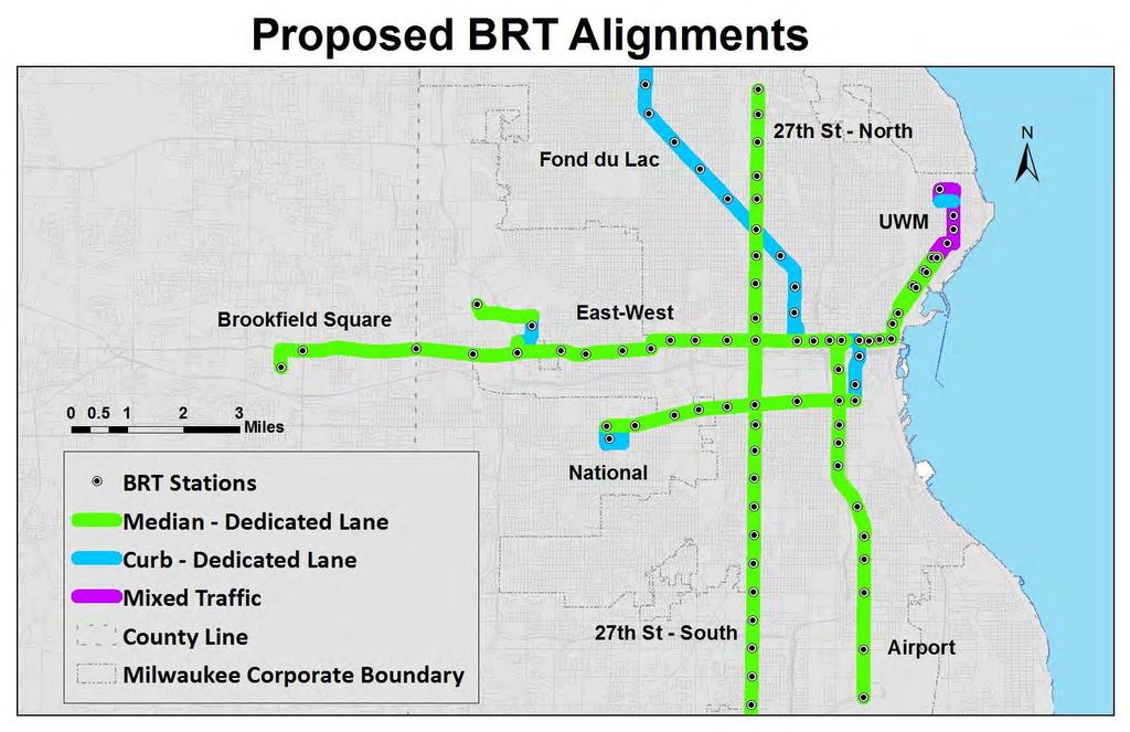
35 Fond du Lac Ave 27th St - North UWM Brookfield Square National Ave Airport 27th St - South

36 SEWRPC Comparison Very Similar Route Selection Key Differences Downtown Waukesha Capitol Drive Hwy 32 to South Milwaukee Source: SEWRPC, August 2015.
37 CRITERIA Ridership Population and Job Density Time Savings Equity Cost Development Potential

38 EXISTING RIDERSHIP
39 Travel Time Savings Source: Victoria Transport Policy Institute Travel time savings appears to be the greatest contributor to BRT ridership gains -Transportation Research Board, 2007
40

41 Travel Time Savings Source: Victoria Transport Policy Institute Kittleson & Associates - Transit Capacity and Quality of Service Manual (2013)

42 Travel Time Savings
43 Travel Time Savings

44 COST Projected from East-West Corridor Study

45 POPULATION DENSITY Measured within ¼ mile of each route
46 JOB DENSITY Measured within ¼ of each route 2010 SEWRPC Data

47 EQUITY 27th St - North is top priority Fond du Lac 27th St - South

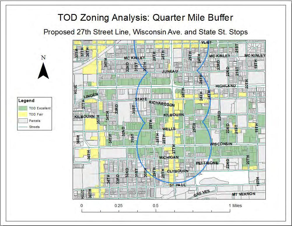
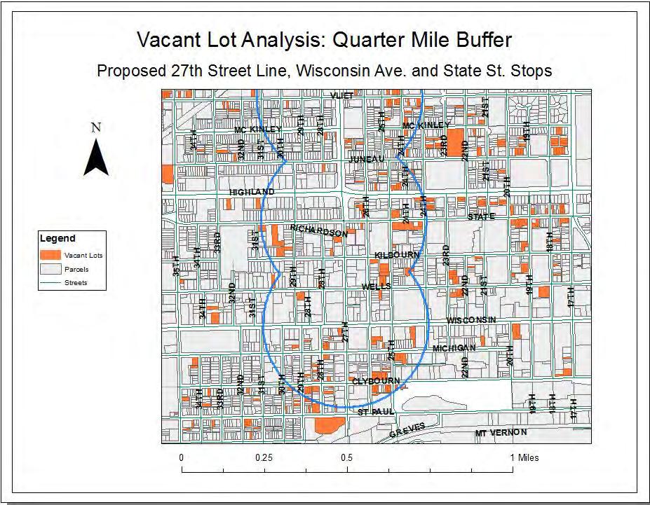
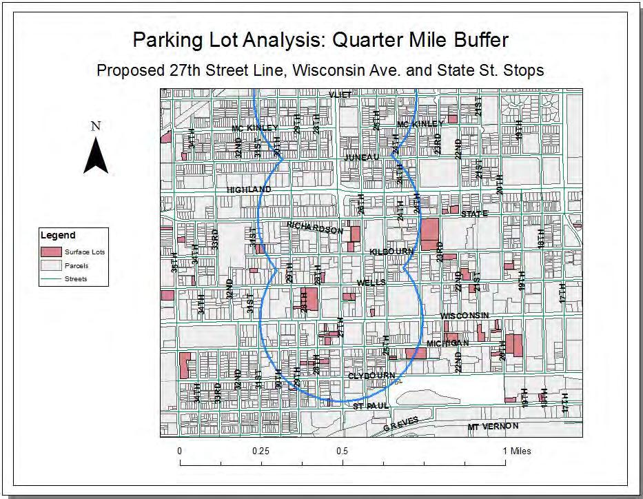
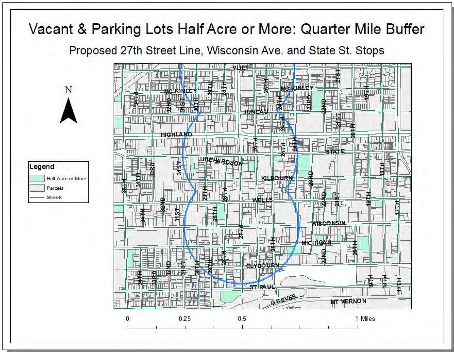
48 Development Potential: ZONING, VACANT LOTS, AND SURFACE PARKING Source: Milwaukee County Transit System, 2016
 Examined Total area with zoning amenable to Transit Oriented Development (TOD) Total vacant area Total surface parking area Development Value & New Tax Revenue Isolated vacant lots and parking")
49 Development Potential Analysis Analyzed each of the eight proposed routes 133 proposed stations within the City of Milwaukee Created quarter-mile buffers around each station (5 min. walk) Examined Total area with zoning amenable to Transit Oriented Development (TOD) Total vacant area Total surface parking area Development Value & New Tax Revenue Isolated vacant lots and parking lots over a half acre within a quarter-mile Created three tiers of values Created different development scenarios
50
51
52

53 TOD Land Table

54 TOD Land Table


55 Development Value and New Tax Revenue Development Assumption Identified min. half acre vacant lots and parking lots 24 units/quarter acre 5000 sq ft of commercial/acre Based on Fond Du Lac Center and Lisbon Terrace Tiers of Development One mile within Downtown, less than 35% poverty rate: $100,000/unit, $100/sq ft commercial Outside one mile of Downtown, less than 35% poverty rate: $70,000/unit, $70/sq ft commercial Greater than 35% poverty rate (low-income housing tax credit) $40,000/unit, $40/sq ft commercial Derived from DCD recommendations $ thousand/unit in Walker s Point, $100 per sq ft commercial $35-40 thousand/unit using low-income housing tax credits Google Maps Google Maps
56
57 Development Value Table
58 Development Value Table
59 New Tax Revenue Table

60 New Tax Revenue Table
61 EVALUATION Existing Ridership Cost Time Savings Development Potential Population / Job Density Equity 27th St - North th St - South Airport Brookfield Square Fond du Lac National UWM
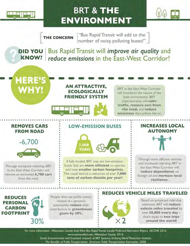
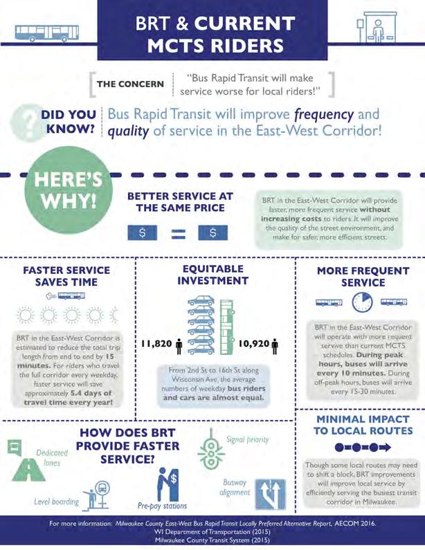
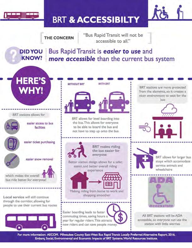
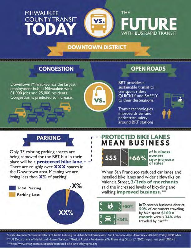
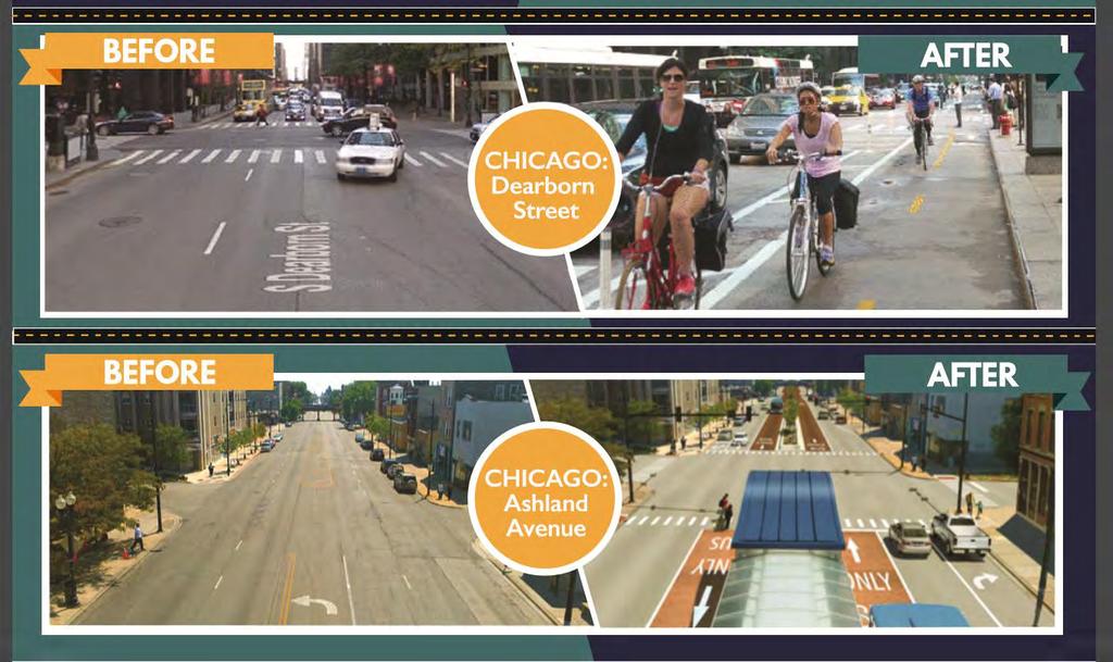
62 BRT Infographic Categories Economics BRT the Cost and Benefits BRT and Businesses Environment BRT and Safer Streets BRT and Environmental Benefits Equity BRT and Accessibility BRT and Current MCTS Riders Comparison Today versus the Future Before and After
63
64
65
66
67
68
69
70
71 Recommendations Move forward with BRT in the East-West Corridor to take advantage of existing momentum and public support. Invest in a high-quality BRT system with dedicated lanes and frequent service to maximize potential benefits and build support for future transit initiatives. Conduct an aggressive marketing campaign to advertise the benefits of BRT and counteract negative perceptions and misunderstandings. Expand BRT beyond the EW Corridor to develop a Regional Transit System that focuses on improving connectivity for transit-dependent residents.


72 Q&A Thank you for coming!
Afeasibility study to evaluate bus rapid transit service in the East-West Corridor connecting major employment and activity centers between downtown
 East-West Bus Rapid Transit Feasibility Study Update and Recommended Locally Preferred Alternative (LPA) Summary City of Wauwatosa, Transportation Affairs Committee June 2016 Afeasibility study to evaluate
Planning for Bus Rapid Transit in the Milwaukee Region
 Planning for Bus Rapid Transit in the Milwaukee Region Milwaukee County East-West BRT Study Preferred Route UWM Bus Rapid Transit Course, Fall 2015 Cleveland Health Line Bus Rapid Transit Panelists Kevin
WELCOME BUS RAPID TRANSIT PUBLIC MEETING. MEETING TIME: 5 p.m. - 8 p.m.
 WELCOME BUS RAPID TRANSIT PUBLIC MEETING MEETING TIME: 5 p.m. - 8 p.m. Milwaukee County in conjunction with the Federal Transit Administration is hosting today s meeting to give the public an opportunity
Sources: East-West Feasibility Study (AECOM), Milwaukee County Transit System (2015) and Wisconsin Department of Transportation (2015) Assumptions
, Milwaukee County Transit System (2015) and Wisconsin Department of Transportation (2015) Assumptions") Figure D.01. Time Savings Estimates Sources: East-West Feasibility Study (AECOM), Milwaukee County Transit System (2015) and Wisconsin Department of Transportation (2015) Assumptions total BRT distance:
Figure D.01. Time Savings Estimates Sources: East-West Feasibility Study (AECOM), Milwaukee County Transit System (2015) and Wisconsin Department of Transportation (2015) Assumptions total BRT distance:
Community Task Force July 25, 2017
 Community Task Force July 25, 2017 Welcome and Introductions Project Partners Regional Transportation District (RTD) Colorado Department of Transportation (CDOT) Denver Regional Council of Governments
Main-McVay Transit Study: Phase 2 Options Definition and High Level Constraints Evaluation
 Main-McVay Transit Study: Phase 2 Options Definition and High Level Constraints Evaluation APRIL 2016 A collaborative study between: For Additional Information or to Comment If you would like additional
SMART 1 Public Meeting #1. February 24, 2016
 SMART 1 Public Meeting #1 February 24, 2016 Agenda Who is the SMTC? SMART 1 project overview Syracuse Metropolitan Transportation Council An Introduction: Who we are & what we do What is an MPO? A Metropolitan
PURPOSE AND NEED SUMMARY 54% Corridor Need 1. Corridor Need 2. Corridor Need 3. Corridor Need 4. Corridor Need 5
 SUMMARY PURPOSE AND NEED Chapel Hill Transit ridership has increased Buses operate every 4 minutes and have standing room only Exceeding seated capacity by 12% Corridor Need 1 by more than 20 percent between
Corridor Vision Workshop Summary James Madison Elementary February 22,2018
 Corridor Vision Workshop Summary James Madison Elementary February 22,2018 WHY DEVELOP THIS STUDY? Ogden City is planning for better connectivity and access to jobs and housing. Working with area partners,
METRO RTA TRANSIT MASTER PLAN. May 25-26, 2011
 METRO RTA TRANSIT MASTER PLAN May 25-26, 2011 WHAT IS THE TRANSIT MASTER PLAN? A twenty-year plan for METRO RTA What will METRO look like in 2031? 1 TRANSIT TECHNOLOGIES 2 TRANSIT TECHNOLOGIES Transit
Transportation Master Plan Advisory Task Force
 Transportation Master Plan Advisory Task Force Network Alternatives & Phasing Strategy February 2016 BACKGROUND Table of Contents BACKGROUND Purpose & Introduction 2 Linking the TMP to Key Council Approved
Bus Rapid Transit Plans
 Twin Cities Region Bus Rapid Transit Plans ULI Minnesota Workshop Connecting Bus Rapid Transit to the Community December 15, 2009 John Levin Director of Service Development Metro Transit Metropolitan Area
Appendix A-K Public Information Centre 2 Materials
 Appendix A-K Public Information Centre 2 Materials Our Rapid Transit Initiative Make an impact on the future of transit Join the discussion on Rapid Transit in London You re invited to a Public Information
Evan Johnson, Tindale Oliver & Associates. Alan Danaher, P.E., PTOE, AICP, PTP
 To: Copies: From: Evan Johnson, Tindale Oliver & Associates Matt Muller, RTS Jesus Gomez, RTS Alan Danaher, P.E., PTOE, AICP, PTP Date: January 14, 2014 Subject: Ridership Projections Gainesville Streetcar
Appendix A (Case Studies)
") Appendix A (Case Studies) BRT System Case Studies This section includes four case studies highlighting other regions in North America that have implemented BRT projects. These regions are Cleveland, Ohio,
Appendix A (Case Studies) BRT System Case Studies This section includes four case studies highlighting other regions in North America that have implemented BRT projects. These regions are Cleveland, Ohio,
Project Narrative. Albuquerque, NM. July 31, 2015
 Project Narrative Albuquerque, NM July 31, 2015 1 Project Identification As the first bus rapid transit (BRT) project in New Mexico, the Albuquerque Rapid Transit (ART) line will run through the heart
Capital and Strategic Planning Committee. Item III - B. April 12, WMATA s Transit-Oriented Development Objectives
 Capital and Strategic Planning Committee Item III - B April 12, 2018 WMATA s Transit-Oriented Development Objectives Page 24 of 76 Washington Metropolitan Area Transit Authority Board Action/Information
MEETING Agenda. Introductions. Project Overview. Key Study Components. Alternative Station Concepts. Preferred Station Concept. Next Steps.
 City GARLAND Council ROADVISION Briefing STUDY VISION STUDY Dallas, TX April 8, 2010 1 1 MEETING Agenda Introductions Project Overview Key Study Components Alternative Station Concepts Preferred Station
BUILDING THE CASE FOR TRAVEL OPTIONS IN WASHING TON COUNTY. Image: Steve Morgan. Image: Steve Morgan
 BUILDING THE CASE FOR TRAVEL OPTIONS IN WASHING TON COUNTY Image: Steve Morgan Image: Steve Morgan Image: TriMet Image: TriMet WHAT ARE TRAVEL OPTIONS PROGRAMS? Travel options programs encourage residents,
A Selection Approach for BRT Parking Lots Nicolls Road Corridor Parking Study
 A Selection Approach for BRT Parking Lots Nicolls Road Corridor Parking Study Chirantan Kansara, P.E. Engineering Construction Design Planning 2018 ITE Northeastern District Annual Meeting Lake George,
Title. Metropolitan Council Transportation Committee December 12, Brad Larson Metro District MnDOT
 Title Metropolitan Council Transportation Committee December 12, 2016 Evaluating the potential for Bus Rapid Transit and MnPASS Express Lanes in the southwest Metro Brad Larson Metro District MnDOT Background
Transforming the. Michigan Avenue Corridor. a complete streets and transit-oriented development study Michigan State University Student Research Team
 Transforming the Michigan Avenue Corridor a complete streets and transit-oriented development study Michigan State University Student Research Team Dominic Adams Annie Fardell Jon Roberts Jeff Stivenson
Tier 1 Evaluation. REVISION # 1 DATE May 24, 2016 MILWAUKEE COUNTY EAST-WEST BUS RAPID TRANSIT
 MILWAUKEE COUNTY EAST-WEST BUS RAPID TRANSIT Tier 1 Evaluation REVISION # 1 DATE May 24, 2016 Prepared for: Milwaukee County 10320 W. Watertown Plank Rd. Wauwatosa, WI 53226 Prepared by: AECOM with HNTB
Regional Transportation Needs Within Southeastern Wisconsin
 Regional Transportation Needs Within Southeastern Wisconsin #118274 May 24, 2006 1 Introduction The Southeastern Wisconsin Regional Planning Commission (SEWRPC) is the official areawide planning agency
ROUTES 55 / 42 / 676 BUS RAPID TRANSIT LOCALLY PREFERRED ALTERNATIVE
 ROUTES 55 / 42 / 676 BUS RAPID TRANSIT LOCALLY PREFERRED ALTERNATIVE April, 2012 1 INTRODUCTION The need for transit service improvements in the Routes 42/55/676 corridor was identified during the Southern
TABLE OF CONTENTS FIGURES TABLES. Executive Summary Report: BLUE LINE
 TABLE OF CONTENTS 1.0 INTRODUCTION... 1 1.1 Blue Line Project Goals... 1 1.2 Corridor Travel Demand... 2 1.2.1 Market Analysis... 2 1.2.2 Existing Transit Operations... 2 2.0 RECOMMENDED ALTERNATIVE...
Downtown BRT Corridor Alternatives Review: 1 st, 2 nd, 3 rd and 4 th Avenue. Bus Rapid and Conventional Transit Planning and Design Services
 Downtown BRT Corridor Alternatives Review: 1 st, 2 nd, 3 rd and 4 th Avenue Bus Rapid and Conventional Transit Planning and Design Services City of Saskatoon February 2018 Project Team HDR Corporation
Providence Downtown Transit Connector STAKEHOLDER MEETING #2. Stakeholder Meeting #1 October 24, 2016
 Providence Downtown Transit Connector STAKEHOLDER MEETING #2 Stakeholder Meeting #1 October 24, 2016 February 2017 1 AGENDA 1 DTC Goals and Expectations 2 Street Design Concepts 3 Potential Benefits and
PEDESTRIAN ACTION PLAN
 ATTACHMENT 2 CITY OF SANTA MONICA PEDESTRIAN ACTION PLAN CITY OF SANTA MONICA PEDESTRIAN ACTION PLAN This page intentionally left blank EXECUTIVE SUMMARY CHAPTER 1 EXECUTIVE SUMMARY Setting the Stage
4 DISRUPTION MANAGEMENT PLAN HIGHWAY 7 RAPIDWAY CONSTRUCTION BETWEEN BAYVIEW AVENUE AND WARDEN AVENUE TOWNS OF MARKHAM AND RICHMOND HILL
 4 DISRUPTION MANAGEMENT PLAN HIGHWAY 7 RAPIDWAY CONSTRUCTION BETWEEN BAYVIEW AVENUE AND WARDEN AVENUE TOWNS OF MARKHAM AND RICHMOND HILL The Transportation Services Committee recommends the adoption of
New Seward and 36 th Avenue Intersection Conceptual Design
 University of Alaska Anchorage New Seward and 36 th Avenue Intersection Conceptual Design Prepared By: Zaid S. Hussein Dana Menendez Galen Jones Civil Engineering Department Prof. Osama Abaza CE A404 Highway
WELCOME! Please complete a comment sheet as we value your feedback. 4 pm to 8 pm. September 15, Hosted by: AECOM on behalf of City of Calgary
 WELCOME! Thank you for attending our open house. There will be no formal presentation today so please take the time to read the boards. If you have any questions, please do not hesitate to approach one
The New Orleans Downtown Transit Center Study
 Challenge to A Transit Agency: The New Orleans Downtown Transit Center Study Tim Reynolds Cincinnati, Ohio New Orleans RTA RTA s Response? Do a study! Study Purpose Enable safe, comfortable
Purpose and Need. Chapter Introduction. 2.2 Project Purpose and Need Project Purpose Project Need
 Chapter 2 Purpose and Need 2.1 Introduction The El Camino Real Bus Rapid Transit (BRT) Project (Project) would make transit and other transportation improvements along a 17.6-mile segment of the El Camino
In station areas, new pedestrian links can increase network connectivity and provide direct access to stations.
 The Last Mile Planning for Pedestrians Planning around stations will put pedestrians first. Making walking to stations safe and easy is important; walking will be a part of every rapid transit Accessible
Frequently Asked Questions (FAQ)
") Frequently Asked s (FAQ) Study Process... 2 Rapid Transit Service and Operations... 5 Public Consultation... 8 Business Impacts... 8 Design and Property Impacts... 9 Construction Impacts...12 Traffic,
Frequently Asked s (FAQ) Study Process... 2 Rapid Transit Service and Operations... 5 Public Consultation... 8 Business Impacts... 8 Design and Property Impacts... 9 Construction Impacts...12 Traffic,
Appendix A-1: Purpose and Need Statement
 Appendix A-1: Purpose and Need Statement PURPOSE AND NEED STATEMENT Western & Ashland Corridors Bus Rapid Transit (BRT) Project Prepared for Chicago Transit Authority 567 West Lake Street Chicago, IL 60661
Purpose and Need Statement
 MILWAUKEE COUNTY EAST-WEST BUS RAPID TRANSIT Purpose and Need Statement DATE April 6, 2016 Prepared for: Milwaukee County 10320 W. Watertown Plank Rd. Wauwatosa, WI 53226 Prepared by: AECOM with HNTB RECORD
North Coast Corridor:
 North Coast Corridor: Connecting People, Transportation & Environment Legislative Hearing: 11.8.10 1 North Coast Corridor Region s Lifeline A Regional Strategy Mobility, Economy & Environment North Coast
Public Event 1 Community Workshops
 Public Event 1 Community Workshops Nov. 24 & Dec. 3, 2016 Welcome Workshop Purpose We re looking to you for ideas and insights to help guide future transportation infrastructure planning in the Park Lawn
INNER LOOP EAST. AIA Rochester Annual Meeting November 13, 2013 TRANSFORMATION PROJECT. Bret Garwood, NBD Erik Frisch, DES
 INNER LOOP EAST TRANSFORMATION PROJECT AIA Rochester Annual Meeting November 13, 2013 Bret Garwood, NBD Erik Frisch, DES Why? We are building a city that encourages walking, biking and enjoying the outdoor
Community Task Force October 5, 2017
 Community Task Force October 5, 2017 Welcome and Introductions Project Partners Regional Transportation District (RTD) Colorado Department of Transportation (CDOT) Denver Regional Council of Governments
ALTERNATIVES ANALYSIS EXECUTIVE SUMMARY
 West Valley Connector Corridor ALTERNATIVES ANALYSIS EXECUTIVE SUMMARY FINAL September 2014 Ontario International Airport Ontario Mills Rancho Cucamonga Metrolink Station Kaiser Permanente PARSONS EXECUTIVE
ITS-NY ANNUAL MEETING Bus Rapid Transit in New York City: Bus Lane Operations on One-Way Arterial Streets
 ITS-NY ANNUAL MEETING Bus Rapid Transit in New York City: Bus Lane Operations on One-Way Arterial Streets June 9, 2011 Ted Orosz AICP, Director Long Range Bus Planning MTA New York City Transit 1 Overview
Eliminate on-street parking where it will allow for a dedicated bus only lane %
 Traffic Dashboard Priorities Survey Responses Introduction 1) Are you familiar with bus rapid transit (BRT)? a. No, BRT is new to me. 597 23.5% b. I ve heard of BRT, but I don t know much about it. 1,136
TRANSIT & NON-MOTORIZED PLAN DRAFT FINAL REPORT Butte County Association of Governments
 1 INTRODUCTION Maintaining a high quality of life is the essence of this plan for transit and non-motorized transportation in Butte County. Curbing greenhouse gas emissions (GHG) by reducing congestion,
. ' motion. APPLtlDK.L - L"iLC_t1GLR 201b APPENDIX 7 TECHNICAL MEMOS
 . ' motion APPLtlDK.L - L"iLC_t1GLR 201b APPENDIX 7 TECHNICAL MEMOS The nmotion program will provide a large number of benefits for Middle Tennessee. This document presents selected benefits and other
Lee s Summit Road Improvement Study Public Open House June 7, 2007 Summary of Comment Card Responses
 Lee s Summit Road Improvement Study Public Open House June 7, 2007 Summary of Comment Card Responses Introduction At the Lee s Summit Road Improvement Study Public Open House held Thursday, June 7, 2007
Gerald Ollivier Lead Transport Specialist World Bank, New Delhi. Transforming Cities through Integrated Planning Corridor Scale
 Gerald Ollivier Lead Transport Specialist World Bank, New Delhi Transforming Cities through Integrated Planning Corridor Scale JOB ACCESSIBILITY: ZHENGZHOU A: LINE 1, 2, AND 3 AND WALKING: 12% B. SCENARIO
Community Engagement Process
 Community Engagement Process PHASE ONE PURPOSE + NEED STATEMENT IDEAS DESTINATIONS TRAVEL PATTERNS PHASE TWO MODE SELECTION INPUT PHASE THREE LOCALLY PREFERRED ALTERNATIVE SELECTION OF PREFERRED ALTERNATIVE
2. Context. Existing framework. The context. The challenge. Transport Strategy
 Transport Strategy Providing quality connections Contents 1. Introduction 2. Context 3. Long-term direction 4. Three-year priorities 5. Strategy tree Wellington City Council July 2006 1. Introduction Wellington
Greater Cleveland Regional Transit Authority
 Greater Cleveland Regional Transit Authority Transit Priority Corridor Initiatives West 25 th Street /East 105 th /East 93 rd Streets June 20, 2017 Presented to: Planning & Development Committee Greater
Moving Cambridge. City of Cambridge Transportation Master Plan Public Consultation Centre. March 7, :00 8:00 PM.
 City of Cambridge Transportation Master Plan Public Consultation Centre March 7, 2018 5:00 8:00 PM Region of Waterloo City of Cambridge Transportation Master Plan Public Consultation Centre March 7, 2018
Regional Alternatives Analysis. Downtown Corridor Tier 2 Evaluation
 Regional Alternatives Analysis Downtown Corridor Tier 2 Evaluation September 19, 2011 EVALUATION PROCESS REVIEW OF EVALUATION PROCESS Tier 1: Screen Seven Alignment Options into a Short List Tier 2: Evaluate
Executive Summary Route 30 Corridor Master Plan
 Route Corridor Master Plan Project Overview The Route Corridor Master Plan is a coordinated multimodal transportation and land use plan for the entire stretch of Route through East Whiteland Township,
Chapter 7. Transportation. Transportation Road Network Plan Transit Cyclists Pedestrians Multi-Use and Equestrian Trails
 Chapter 7 Transportation Transportation Road Network Plan Transit Cyclists Pedestrians Multi-Use and Equestrian Trails 7.1 TRANSPORTATION BACKGROUND The District of Maple Ridge faces a number of unique
Presentation of Staff Draft March 18, 2013 COUNTYWIDE TRANSIT CORRIDORS FUNCTIONAL MASTER PLAN
 Presentation of Staff Draft March 18, 2013 COUNTYWIDE TRANSIT CORRIDORS FUNCTIONAL MASTER PLAN Public Outreach Fall 2011: Two community meetings/open houses Fall 2012: Three community meetings/open houses
Cherry Creek Transportation and Land Use Forum September 25, 2013 Meeting Summary
 Cherry Creek Transportation and Land Use Forum September 25, 2013 Meeting Summary I. LEAD-IN TO SMALL GROUP DISCUSSION, POLLING AND STEERING COMMITTEE/TECHNICAL TASK FORCE DISCUSSION The meeting began
Transportation Assessment
 Transportation Assessment Midtown Open House February 10, 2018 Overview Midtown in Focus Overview & Purpose of Today Transportation Assessment overview Summary of Transportation work to date Review & Analysis
# Southeastern Wisconsin Regional Freeway System Reconstruction Study and Preliminary Recommended Plan
 #70421 Southeastern Wisconsin Regional Freeway System Reconstruction Study and Preliminary Recommended Plan Public Information Meetings and Hearings May June 2002 1 Reason for Freeway System Study 270-mile
Welcome. If you have any questions or comments on the project, please contact:
 Welcome This drop-in public open house is intended to provide information about the Bay Street bike lanes project. This project proposes a dedicated cycling facility along Bay Street between Aberdeen Avenue
August NW Glisan St, Suite 401 Portland, OR (503)
") August 2017 618 NW Glisan St, Suite 401 Portland, OR 97209 (503) 226 0676 www.thestreettrust.org headlines New year, new name, broader mission In January, the Bicycle Transportation Alliance became The
August 2017 618 NW Glisan St, Suite 401 Portland, OR 97209 (503) 226 0676 www.thestreettrust.org headlines New year, new name, broader mission In January, the Bicycle Transportation Alliance became The
Designing Streets for Transit. Presentation to NACTO Designing Cities Kevin O Malley Managing Deputy Commissioner 10/24/2014
 Designing Streets for Transit Presentation to NACTO Designing Cities Kevin O Malley Managing Deputy Commissioner 10/24/2014 Chicago -- Streets for Transit TODAY Jeffery Jump Transit Signal Priority Central
MORE CONNECTIONS. Redesigning routes for the future of transit in Milwaukee County.
 What is MCTS NEXT? FASTER SERVICE MORE CONNECTIONS INCREASED ACCESSIBILITY Redesigning routes for the future of transit in Milwaukee County. MCTS NEXT is a new way of looking at transit. We re examining
Appendix A-2: Screen 1 Alternatives Report
 Appendix A-2: Screen 1 Alternatives Report SCREEN 1 ALTERNATIVES REPORT Western & Ashland Corridors Bus Rapid Transit (BRT) Project Prepared for Chicago Transit Authority 567 West Lake Street Chicago,
Bridgewater Complete Streets Prioritization Plan and Pedestrian Safety Assessment
 Bridgewater Complete Streets Prioritization Plan and Pedestrian Safety Assessment Presented by Luciano Rabito Manager of Complete Streets Presented to Bridgewater, MA Wednesday, April 26, 2017 6:30 P.M.
Agenda. US-1 Corridor Study and HIA Update. Pathway Diagram / Primary Indicators. Research Questions. Linking Multimodal Improvements to Indicators
 Icebreaker Agenda US-1 Corridor Study and HIA Update Pathway Diagram / Primary Indicators Research Questions Linking Multimodal Improvements to Indicators Vulnerable Populations US-1 Corridor Study Vision
Item B1 November 19, 2009
 November 19, 2009 Planning and Development Department Land Use Planning Division DATE: November 19, 2009 STAFF REPORT TO: FROM: SUBJECT: Members of the Transportation Commission Elizabeth Greene Senior
Public Consultation Centre
 Region of Waterloo Transportation Master Plan Update Public Consultation Centre See the Information Package on how to contact the Project Team and complete the Comment Sheet www.regionofwaterloo.ca/en/exploring-the-region/transportation-master-plan.aspx
EL CAMINO REAL BUS RAPID TRANSIT (BRT) PROJECT
 PROJECT") Agenda Item #4.2 EL CAMINO REAL BUS RAPID TRANSIT (BRT) PROJECT VTA BOARD WORKSHOP MAY 1, 2015 ABOUT THIS PRESENTATION CONTEXT Existing conditions and planning for growth WHAT IS THE PROJECT? Project alternatives
Agenda Item #4.2 EL CAMINO REAL BUS RAPID TRANSIT (BRT) PROJECT VTA BOARD WORKSHOP MAY 1, 2015 ABOUT THIS PRESENTATION CONTEXT Existing conditions and planning for growth WHAT IS THE PROJECT? Project alternatives
South King County High-Capacity Transit Corridor Study
 HIGH-CAPACITY TRANSIT CORRIDOR STUDY South King County Corridor South King County High-Capacity Transit Corridor Study Corridor Report August 2014 South King County High Capacity Transit Corridor Report
METHODOLOGY. Signalized Intersection Average Control Delay (sec/veh)
") Chapter 5 Traffic Analysis 5.1 SUMMARY US /West 6 th Street assumes a unique role in the Lawrence Douglas County transportation system. This principal arterial street currently conveys commuter traffic
Chapter 5 Traffic Analysis 5.1 SUMMARY US /West 6 th Street assumes a unique role in the Lawrence Douglas County transportation system. This principal arterial street currently conveys commuter traffic
Building a Toronto that Moves
 Building a Toronto that Moves Image courtesy of the City of Toronto Setting Election Priorities for Walking, Cycling & Public Transit Toronto is a fast-paced, dynamic city. It s a city that moves except
Station Plan: Penn & 43rd Avenue
 Station Plan: Penn & 43rd Avenue This station will serve the northern portion of the Penn Avenue corridor, including the commercial node at 44th Avenue. Ridership and roadway geometry support station siting
EVAN GLASS. Montgomery County Council District 5
 EVAN GLASS 1. Do you support funding and advancing the Purple Line to groundbreaking as described in the Locally Yes. As a member of the recently convened Purple Line Implementation Advisory Group, I will
CHAPTER 3: Vision Statement and Goals
 Davidson Walks & Rolls: Active Transportation Master Plan CHAPTER 3 Contents: Overview Vision Statement Measurable Goals Public Outreach CHAPTER 3: Vision Statement and Goals Overview The vision statement
Durham Region Long Term Transit Strategy
 Durham Region Long Term Transit Strategy An adaptive, safe, reliable, frequent, accessible and desirable transit system that shapes and connects Durham Region and beyond in an economically and environmentally
Bus Rapid Transit ALTERNATIVES ANALYSIS. Open House
 Bus Rapid Transit ALTERNATIVES ANALYSIS Open House June 23, 2015 Open House Meeting Agenda Agenda Introductions What is BRT? Project Goals Study Tasks Next steps Discussion PVTA Bus Rapid Transit Study
Albuquerque Rapid Transit
 Albuquerque Rapid Transit Congressional Staff Briefing City of Albuquerque, New Mexico Agenda Introductions Project Status Schedule Alignment and Station Renderings Public Outreach Financial Plan Transit
Improving Mobility Without Building More Lanes
 Improving Mobility Without Building More Lanes By Mike Salisbury and Will Toor July 2017 Copyright 2017 by Southwest Energy Efficiency Project. All rights reserved. Photo: Courtesy of the Denver Post Anyone
Having held a public hearing, that Council approve:
 3. MODIFICATIONS TO MERIVALE ROAD FROM FALLOWFIELD ROAD TO OLD HIGHWAY 16 TO ACCOMMODATE THE GROWTH WITHIN THE SOUTH MERIVALE BUSINESS PARK - PUBLIC HEARING COMMITTEE RECOMMENDATIONS Having held a public
Circulation in Elk Grove includes: Motor vehicles, including cars and trucks
 Circulation, as it is used in this General Plan, refers to the many ways people and goods move from place to place in Elk Grove and the region. Circulation in Elk Grove includes: Motor vehicles, including
Update June 2018 OUR 2017 PUBLIC ENGAGEMENT
 Update June 2018 Hi, Let s Get Wellington Moving (LGWM) is developing a Recommended Programme of Investment (RPI) that meets our programme objectives and supports the city s and region s growth. As part
Operational Comparison of Transit Signal Priority Strategies
 Operational Comparison of Transit Signal Priority Strategies Revision Submitted on: November, 0 Author: Adriana Rodriguez, E.I Assistant Engineer Parsons Brinckerhoff 0 South Orange Avenue, Suite 00 Orlando,
BRT for Berkeley A Proposal for Consideration
 BRT for Berkeley A Proposal for Consideration CITY OF BERKELEY STAFF PROPOSAL FOR A LOCALLY PREFERRED ALTERNATIVE OF THE EAST BAY BUS RAPID TRANSIT PROJECT SEPTEMBER 8, 2009 Table of Contents Executive
2.0 LANE WIDTHS GUIDELINE
 2.0 LANE WIDTHS GUIDELINE Road Engineering Design Guidelines Version 2.0.1 May 2018 City of Toronto, Transportation Services City of Toronto Page 0 Background In early 2014, Transportation Services initiated
2045 Long Range Transportation Plan. Summary of Draft
 2045 Long Range Transportation Plan Summary of Draft Fredericksburg Area Metropolitan Planning Organization The George Washington Region includes the City of Fredericksburg and the counties of Caroline,
Mumford Terminal Replacement Opportunities Neighbourhood Open House. we are here. PHASE 2 Identifying and Evaluating Candidate Sites
 Welcome Replacement Opportunities Neighbourhood Open House. AGENDA PURPOSE 1. REVIEW the information boards 2. DISCUSS aspects of the project with the project team 3. SHARE your thoughts on replacement
Feasibility Study for Intermodal Facility in Anchorage, Alaska
 Feasibility Study for Intermodal Facility in Anchorage, Alaska Jeanne Bowie, Randy Kinney Abstract The Dimond Transit Center, operated by People Mover, is located in south Anchorage at the Dimond Center,
M14A/D Select Bus Service
 M14A/D Select Bus Service Manhattan Community Board 6: April 1, 2019 New York City Transit 2 Background M14 Select Bus Service M14 was identified as a critical future SBS corridor in past BRT studies as
Complete Street Analysis of a Road Diet: Orange Grove Boulevard, Pasadena, CA
 Complete Street Analysis of a Road Diet: Orange Grove Boulevard, Pasadena, CA Aaron Elias, Bill Cisco Abstract As part of evaluating the feasibility of a road diet on Orange Grove Boulevard in Pasadena,
Scope of the Transit Priority Project
 Transit Planning Committee #1 March 19, 2015 Scope of the Transit Priority Project Review of the 2010 plan Analysis of Transit Priority Measures Preliminary plans for rapid transit Recommendations for
Perryville TOD and Greenway Plan
 Perryville TOD and Greenway Plan Greenway Glossary Pathway: A bicycle and pedestrian path separated from motorized vehicular traffic by an open space, barrier or curb. Multi-use paths may be within the
Transportation in 2025
 Transportation in 2025 DEPARTMENT OF TRANSPORTATION [Madison] is the smallest big city in America, and I mean that in the best possible way. It s a top 15 global city in access to venture capital per capita
NEWMARKET UPHAM S CORNER
 SOUTH STATION Planning Initiative NEWMARKET UPHAM S CORNER COLUMBIA ROAD (P) FOUR CORNERS/GENEVA Working Advisory Group (WAG) Meeting #5 TALBOT AVENUE MORTON STREET BLUE HILL AVE/CUMMINS HWY (P) RIVER
Ideas + Action for a Better City learn more at SPUR.org. tweet about this #RegionalMobility
 Ideas + Action for a Better City learn more at SPUR.org tweet about this event: @SPUR_Urbanist #RegionalMobility Excellent Cities Mobility planning for vital, attractive and healthy cities Bas Govers Program
El Paso County 2040 Major Transportation Corridors Plan
 El Paso County 2040 Major Transportation Corridors Plan Connect-our-County Online Transportation User Survey Preliminary Results June 24, 2010 Years of Residence 2. How many years have you LIVED HERE?
Develop a Multi-Modal Transportation Strategy (Theme 6)
") DEVELOP A MULTI-MODAL TRANSPORTATION STRATEGY (THEME 6) WHY IS THIS THEME ADDRESSED? Develop a Multi-Modal Transportation Strategy (Theme 6) Statement of Ideal Reduce resident and visitor reliance on single
DEVELOP A MULTI-MODAL TRANSPORTATION STRATEGY (THEME 6) WHY IS THIS THEME ADDRESSED? Develop a Multi-Modal Transportation Strategy (Theme 6) Statement of Ideal Reduce resident and visitor reliance on single
2014/2015 BIKE ROUTE PLAN 83 AVENUE PROTECTED BIKE LANE
 About the Project The City of Edmonton is planning a major bike route on the southside of Edmonton. The Strathcona Bike Route will connect the communities of Strathcona, Garneau and the University area,
Typical Rush Hour Commute. PennyforTransportation.com
 Typical Rush Hour Commute In the News Overview of the Plan Collaborative plan with projects in every community Prioritizing connectivity and congestion relief Dedicated transportation-specific funding;