TRAFFIC SURVEYING AND ANALYSIS
|
|
|
- Hillary Higgins
- 5 years ago
- Views:
Transcription
1 TRAFFIC SURVEYING AND ANALYSIS Mr. Udit Batra 1 Mr. Mandar V. Sarode 2 1 Assistant Professor, 2 Assistant Professor Civil Engineering Dept., Civil Engineering Dept., GNIEM, Nagpur GNIEM, Nagpur Maharashtra. Maharashtra, -uditbatra89@gmail.com mandarsarode@gmail.com Mobile no: Moblie no: ABSTRACT Rapid industrialization and the consequent urbanization has brought about an unprecedented revolution in the growth of motor vehicles all over the world and India is no exception. Such growing urbanization, combined with rising number of vehicle ownership, has led in recent years to an increased demand of traffic survey and analysis, for both long term and short term period. Traffic analysis is basically the process of intercepting and examining the number of vehicles on the road and deducing the pattern of traffic movement. A Traffic survey on specific road sections of Nagpur city has been carried out which included Calculation of present traffic density and comparison with previous year data, Average velocity of traffic. Manual method of counting was used with the help of video recording. Key Words:- Traffic density, Average velocity of traffic 1. INTRODUCTION Traffic is generally defined as the movement of people, goods or vehicles between spatially separated points, and thus includes pedestrians and all types of vehicles mechanized, motorized or non motorized. Today man and his transport vehicles occupy a large share of the urban space. Traffic congestions, air pollution and noise pollution and the resultant ill effects and frustration have become the order of the day. The demand for traffic survey and analysis is likely to increase for future development of Transport Network. Traffic analysis is fundamental to planning of roads and flyovers. It also provides the basis for determining the no of traffic lanes to be provided for different road sections having regards to volume, composition and other parameters of traffic. Alternatively, for an existing road network traffic analysis provides a means of assessing the traffic conditions. Traffic analysis can therefore help further in the evaluation of investment needed for the future road constructions and improvements. Such traffic surveys are a valuable source of data for planning of highways, flyovers, roads etc. As such, these should be a regular feature in all the traffic departments. Nagpur, being a developing metro, has got a traffic density which is growing at a rapid pace. The ever increasing no of two wheelers, four wheelers along with public transport and pedestrians poses a serious a serious question mark for a smooth and congestion free movement of traffic. As we have seen effective management of traffic has been carried out at the heavuily crowded areas like Sitabuldi, Wardha road, Sakkardhara, Mihan, Railway station etc. Flyovers of effective design of have been constructed keeping in view the density of the flow of the traffic and the roads underneath it. They have provided flexible options to the commuters and thereby redistributed the traffic efficiently. Traffic surveys are an integral component of a comprehensive traffic and transportation study. Appreciation of existing traffic and travel characteristics is extremely important for the development of comprehensive traffic and transportation plan. 1.1 Study Magnitude
2 Time of the day : The traffic flow was seen varying during the peak hours and the non peak hours. The peak hours (9:30 AM to 11:30 AM and 5:30 PM to 7:30 PM) were taken into consideration for the recording of the maximum traffic movements. The peak hours are defined by the buses, office going people, shopkeepers, school and college going people majorly. This is the time at which traffic movement is maximum and therefore the actual capacity of the road under consideration is measured Morning / Evening: The recordings at a single place were taken twice that is once in the morning and again in the evening respectively. The morning data was directly compared to the evening, giving better estimate for the study Inflow / Outflow : The inflow as well as the outflow of the same road was recorded so that the total no of vehicles on that road on that particular time were recorded accordingly Vehicle Type : The types of vehicles running during these hours were also observed. For example no of buses, cars, auto rickshaws, two wheelers and bicycles were head counted separately and compared accordingly. 1.2 Types of Traffic Survey The following traffic surveys can be conducted for appreciating the existing traffic and travel demand characteristics and to prepare the transport infrastructure improvement plans. 1. Road inventory survey 2. Classified traffic volume count survey 3. Origin and destination survey 4. Household interview survey 5. Speed and delay 6. Parking survey 7. Pedestrian survey 8. Intermediate public transport operator survey 9. Intermediate public transport user survey 1.3 Methods of Counting: Two methods are available for conducting traffic volume count i) Manual Method: These are mainly visual counts carried out by operator. It is time ii)automatic Method: There are various devices and software available, which enables easy and consuming accurate traffic count Manual counts are typically used to gather data for determination of vehicle classification, turning movements, direction of travel, pedestrian movements or vehicle occupancy. Automatic counts are typically used to gather data for determination of vehicle hourly patterns, daily or seasonal variation and growth trends or annual traffic estimates. The selection of study method should be determined using the count period. The count period should be representative of the time of day, day of month, month of year for the study area. For example counts at a summer resort would not be taken in January. The count period should avoid special event or compromising weather conditions. Count period may range from 5 minutes to 1 year 2. DATA COLLECTION 2.1. Site Selection Routes of Study Sadar Main Road 1. Anjuman College Square 2. Liberty Square The Sadar road is basically a narrow road which has got a heavy traffic flow due to prominent commercial establishment, Anjuman Polytechnic college and Mangalwari market. Apart from this the road is a connecting road of the city to North direction and has major establishment like government offices, schools and commercial markets. So this route is taken under the case study and the traffic flow was observed to estimate the traffic density. WHC Road
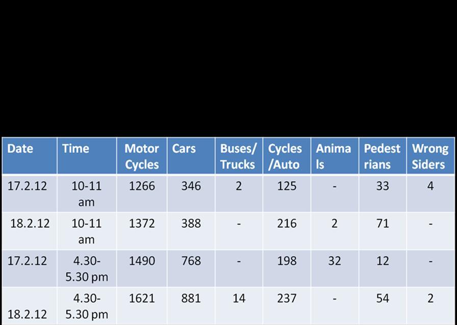
3 1. Law College Square 2. Shankar Nagar Square WHC road is one the busiest routes for pedestrians as well as vehicular movement. As there are numerous prime commercial establishments on this road, parking is another major concern apart from the heavy traffic flow. Many a times a wrong parking also disrupts the traffic movement along the way. Also, there are a few points on this route on which the road bottlenecks and thereby slowing down the traffic flow. This route also covers a major market, (Gokulpeth) and a school (Saraswati Vidyalaya) on the way where the traffic passes majorly. 2.2 EQUIPMENTS USED 1) Sony handycam (32x zoom) : A high definition Sony handycam was extensively used over various locations to record and demarcate the number of vehicles plying on that particular road over on a particular time of the day/night. The camera was placed on such an elevation and place that the whole square (and particularly one direction of inflow and outflow) of the traffic movement was recorded. The zoom was set in such a manner that all the vehicles were easily distinguished. 2) Sony tripod : A light and sturdy Sony tripod was used to fix the handycam at various angles and elevations. The height was adjusted in such a manner that the camera covered the whole movement of the traffic below. 3) Sony mini DV cassettes: These types of cassettes with recording length 1 hour were extensively used to record the traffic flow over different locations. Each cassette was marked separately according to their respective locations. 4) Picture motion browser software: This software was essentially required to convert the recorded video into computer playable format for a more convenient view and re-usage of the cassettes. 5) Measuring tape: A measuring tape was used to measure the road breadth over various locations. 2.3 ORIGIN AND DESTINATION STUDIES In order that traffic may flow as smoothly and safely as possible, it may become necessary to collect data as to where the traffic came from and where it is going. That is the purpose of origin and destination study. An origin-destination study is used to determine travel patterns of traffic on an installation during a typical day. They are useful in assisting long-range traffic planning, especially when there are substantial changes anticipated in the installation mission or strength. This is a study to determine and analyze trips. Trips are defined as one-way movement, from where a person starts (origin) to where the person is going (destination). Trips are further classified as follows: Internal-- From one point on post to another point on post. External-- From on-post to off-post or vice versa. Through-- From off-post to off-post, by going through the installation. The information gathered may be used to modify the circulation pattern or assist in other long range planning activities. These studies are time consuming and rather complex. They also require the cooperation and assistance of the public. There are five different methods of conducting origin destination studies. 1. Vehicle Occupancy Studies Vehicle occupancy studies are often used in conjunction with volume studies. The study is conducted by observing the number of people in each vehicle as it passes a given point. They can be used to determine the need for car pools. The data can also be used in public information programs to encourage the use of car pools and thus reduce traffic volume. They may also be used to determine the need for mass transit, as well as parking facilities. 2. Speed Delay Study A speed delay study is conducted by having an unmarked vehicle enter the flow of traffic during different time periods. It then follows a prescribed route and notes the time it takes to get from one landmark to another along the route. More than one vehicle can be used. The route is travelled repeatedly and at different times. The results of this type of study assists in determining speed variations along a route. From the data gathered, the number, location, cause, frequency, and duration of delays can be determined. The data also reflects the overall speed and travel time along a route at various times of the day. This locates points of congestion or insufficient road capacity. It may also indicate the need for traffic control device studies to be made to determine the adequacy of such devices. Priorities for traffic control and future construction programs can also be determined. 3. Motor Vehicle Volume Study.
4 This type of study is made to determine the number, direction, and variations in the volume of vehicles passing through an intersection or along a major route. 4. Roadway Capacity Study. These are studies to determine the practical capacity of roads and streets. They may also provide a basis for changing traffic regulations. They measure the traffic density and the traffic capacity. Traffic density is the number of vehicles per hour passing a given point. Traffic capacity is the maximum traffic density a given stretch of road can accommodate at a set speed without causing delay 5. Accident Record Studies. The purpose of studying traffic accident records is to find measures to Increase vehicle safety and reduce accidents. Traffic accident prevention programs are never finished. There must be a continuous study of accidents, violations, and the driver record program to update vehicle safety. The study of these records helps to identify high accident rate locations. It contributes to the evaluation of roadway design factors. These studies aid in planning remedial actions, and Selective and preventive enforcement programs. They may also be used to evaluate the effectiveness of changes through before and after comparisons. The studies are conducted by recording data from traffic accident investigations and violations. 3 DATA ANALYSIS:
5
6
7 4. CONCLUSIONS NAME OF SITE DIRECTION MORNING EVENING SADAR WHC ROAD ANJUMAN COLLEGE SQUARE TO LIBERTY SQUARE LIBERTY SQUARE TO ANJUMAN COLLEGE SQUARE LAW COLLEGE SQUARE TO SHANKAR NAGAR SQUARE SHANKAR NAGAR SQUARE TO LAW COLLEGE SQUARE Width of the Residency Road 7.4 meters Traffic density per hour for Residency Road is 5002 vehicles 2. Width of the WHC Road is 8.85 meters & Traffic density per hour for West High Court Road is 1697 vehicles 3. The traffic density from liberty square to Smruti Theatre square is 5000 vehicles per hour which is substantially more than Wardha Road where flyover has been constructed hence there is an urgent need to distribute heavy traffic density at Residency Road 4. The width of the Residency Road is 7.4 meters which is comparatively less than that of Wardha Road hence frequent traffic congestions are observed 5. There are schools on the Residency road & during school timing more traffic flow is observed. 6. Possibilities of restricting four wheelers during peak traffic hours need to be examined. 7. On street parking of vehicles should be prohibited. 8. Taking into account development taking place in western Nagpur, WHC road with limited width will not be able absorb increase in vehicular traffic. Hence, traffic distribution through alternative routes or construction of flyover may be envisaged. 9. Two wheelers, particularly motorcycles is the most preferred mode of transport. 10. Public transport system needs to be strengthened so that use of individual vehicles is restricted, thereby reducing traffic density. 5. REFERENCES IRC Traffic census of non-urban roads IRC Guidelines on re-population and control of mixed traffic in urban areas IRC Guidelines for design and installation of road traffic signals IRC Traffic studies for planning by-pass around town IRC Guidelines for capacity of urban roads in plain areas
8 IRC Guidelines for traffic prediction on rural highways IRC SP Tentative recommendation on the provision of parking spaces for urban areas IRC SP Guidelines on low cost traffic management technique for urban areas 1 Udit Batra: Recieved B.E Civil from Ramdeobaba College of Engineering & Management. Presently woking as a Asst. Professor in Guru Nanak College of Engg. & Management. 2 Mandar V. Sarode: Recieved B.E Civil From K.D.K College of Engineering, Pursuing M.tech (Structure), Presently working as a Asst. Professor in Guru Nanak College of Engg. & Management.
Analysis of Unsignalized Intersection
 International Journal of Constructive Research in Civil Engineering (IJCRCE) Volume 2, Issue 1, 2016, PP 30-36 ISSN 2454-8693 (Online) www.arcjournals.org Analysis of Unsignalized Intersection B.Ramkumar
Multimodal Interpretation and Analysis of Traffic Survey Data
 Multimodal Interpretation and Analysis of Traffic Survey Data Sitesh Kumar Singh 1, Ankit Bansal 2 M.Tech, Department of Transportation Engineering, Final Year, Lovely Professional University, Punjab,
1. Introduction. 2. Survey Method. Volume 6 Issue 5, May Licensed Under Creative Commons Attribution CC BY
 A Study on Performance of an Urban Arterial Corridor Guggilla Raju 1, Rontala Ashwini 2 1 Assistant Professor, Department of Civil Engineering, GCET 2 Assistant Professor, Department of Civil Engineering,
Planning and Design of Proposed ByPass Road connecting Kalawad Road to Gondal Road, Rajkot - Using Autodesk Civil 3D Software.
 Planning and Design of Proposed ByPass Road connecting Kalawad Road to Gondal Road, Rajkot - Using Autodesk Civil 3D Software. 1 Harshil S. Shah, 2 P.A.Shinkar 1 M.E. Student(Transportation Engineering),
Roadways. Roadways III.
 Introduction 97 Roadway Design Principles 98 Safe Speeds 99 Optimizing of Street Space 00 Minimum Lane Widths in the City of Boston 02 Design Features that Reduce Operating Speeds 05 Travel Lanes Transit
Assessing Level of Service for Highways in a New Metropolitan City
 Assessing Level of Service for Highways in a New Metropolitan City Ganesh Pawar Civil Engineering Department G. H. Raisoni College of Engineering Nagpur, India,4416 Dr. Bhalachandra Khode Civil Engineering
HENDERSON DEVELOPMENT 213, 217, 221, 221 ½, 223 HENDERSON AVENUE and 65 TEMPLETON STREET OTTAWA, ONTARIO TRANSPORTATION OVERVIEW.
 HENDERSON DEVELOPMENT 213, 217, 221, 221 ½, 223 HENDERSON AVENUE and 65 TEMPLETON STREET OTTAWA, ONTARIO TRANSPORTATION OVERVIEW Prepared for: 2294170 Ontario Inc. February 2, 2017 117-652 Report_1.doc
A STUDY ON GAP-ACCEPTANCE OF UNSIGNALIZED INTERSECTION UNDER MIXED TRAFFIC CONDITIONS
 A STUDY ON GAP-ACCEPTANCE OF UNSIGNALIZED INTERSECTION UNDER MIXED TRAFFIC CONDITIONS S.Siva Gowri Prasad 1, Ramesh Surisetty 2, Suresh Kumar ch 3 1 Assistant professor, Department, of Civil Engineering,
Copenhagen Cycling Map. Red Lines Cycling facilities
 Copenhagen Cycling Map Red Lines Cycling facilities Copenhagen Cycling Facilities Design Approaches Transportation without Pollution Copenhagen s Strategy Where Cycling is one of the top key activities
APPENDIX H EXISTING TRAFFIC CONDITIONS ANALYSIS
 APPENDIX H EXISTING TRAFFIC CONDITIONS ANALYSIS MEMO : Peter Steacy, P.Eng. Date: December 3, 2014 : Ian Borsuk, P.Eng. Job No.: 3414015-000 Subject: City of Ottawa O-Train Extension Planning & EA Study
SAFETY EVALUATION OF AN UNCONTROLLED
 SAFETY EVALUATION OF AN UNCONTROLLED INTERSECTION USING SURROGATE SAFETY MEASURES By S. Shekhar Babu Research scholar (Ext) IITB Asso Prof CME Pune Prof. P. Vedagiri Asst Prof Dept of civil Engg IIT Bombay
TRAFFIC STUDY AND DESIGN OF TRAFFIC SINGNAL AT IDENTIFIED INTERSECTIONS IN MANSAROVAR, JAIPUR
 TRAFFIC STUDY AND DESIGN OF TRAFFIC SINGNAL AT IDENTIFIED INTERSECTIONS IN MANSAROVAR, JAIPUR 1 Baldev Mathur, 2 Mr. Deepak Mathur 1, M.Tech. Scholar,department of civil engineering (Transportation Engineering),Kautilya
[Swetha*, 5(2): February, 2016] ISSN: (I2OR), Publication Impact Factor: 3.785
![[Swetha*, 5(2): February, 2016] ISSN: (I2OR), Publication Impact Factor: 3.785](/thumbs/74/69747294.jpg "[Swetha*, 5(2): February, 2016] ISSN: (I2OR), Publication Impact Factor: 3.785") IJESRT INTERNATIONAL JOURNAL OF ENGINEERING SCIENCES & RESEARCH TECHNOLOGY ESTIMATION OF PASSENGER CAR UNIT FOR HETROGENEOUS TRAFFIC IN VISAKHAPATNAM Dadi.Vasavi Swetha * * Civil Department, Diet College,
IJESRT INTERNATIONAL JOURNAL OF ENGINEERING SCIENCES & RESEARCH TECHNOLOGY ESTIMATION OF PASSENGER CAR UNIT FOR HETROGENEOUS TRAFFIC IN VISAKHAPATNAM Dadi.Vasavi Swetha * * Civil Department, Diet College,
MOBILITY CHALLENGES IN HILL CITIES
 MOBILITY CHALLENGES IN HILL CITIES Lalmuansanga Ralte, MCS Pvt Secretary to Minister & Under Secretary Urban Development & Poverty Alleviation Department Govt. of Mizoram DEMOGRAPHIC OVERVIEW INDIA MIZORAM
INTRODUCTION THOROUGHFARE SYSTEM CLASSIFICATIONS
 INTRODUCTION The thoroughfare plan will assist public officials in the development of a specialized system for efficient and safe movement of vehicular traffic while minimizing potential conflicts with
International Journal of Advance Research in Engineering, Science & Technology
 Impact Factor (SJIF): 4.542 International Journal of Advance Research in Engineering, Science & Technology e-issn: 2393-9877, p-issn: 2394-2444 Volume 4, Issue 4, April-2017 Planning & Design Of New By-pass
Planning Daily Work Trip under Congested Abuja Keffi Road Corridor
 ISBN 978-93-84468-19-4 Proceedings of International Conference on Transportation and Civil Engineering (ICTCE'15) London, March 21-22, 2015, pp. 43-47 Planning Daily Work Trip under Congested Abuja Keffi
Congestion Evaluation Best Practices
 Congestion Evaluation Best Practices Todd Litman Victoria Transport Policy Institute Presented International Transportation and Economic Development Conference 10 April 2014 Congestion Indicators Indicator
International Journal of Research (IJR) Vol-1, Issue-8, September *
 Vol-1, Issue-8, September *") Development towards Sustainable Transportation Planning in India through Management of Non-motorized Transport Akshay Patil 1 * & 2 * 1 3 rd year B. Tech Planning student at College of Engineering Pune,
Development towards Sustainable Transportation Planning in India through Management of Non-motorized Transport Akshay Patil 1 * & 2 * 1 3 rd year B. Tech Planning student at College of Engineering Pune,
City of Wayzata Comprehensive Plan 2030 Transportation Chapter: Appendix A
 A1. Functional Classification Table A-1 illustrates the Metropolitan Council s detailed criteria established for the functional classification of roadways within the Twin Cities Metropolitan Area. Table
EXECUTIVE SUMMARY OF CALEDON TRANSPORTATION NEEDS STUDY
 EXECUTIVE SUMMARY OF CALEDON TRANSPORTATION NEEDS STUDY The Caledon Transportation Needs Study has been undertaken as a joint project by the Town of Caledon and the Region of Peel to determine the existing
MUTCD Part 6G: Type of Temporary Traffic Control Zone Activities
 MUTCD Part 6G: Type of Temporary Traffic Control Zone Activities 6G.01 Typical Applications Each temporary traffic control (TTC) zone is different. Many variables, such as location of work, highway type,
Clackamas County Comprehensive Plan
 ROADWAYS The County s road system permits the movement of goods and people between communities and regions, using any of a variety of modes of travel. Roads provide access to virtually all property. They
IDENTIFICATION OF BLACKSPOT REGION ALONG ANANDAPURAM TO ANAKAPALLI STRECH VIA SH-38
 IDENTIFICATION OF BLACKSPOT REGION ALONG ANANDAPURAM TO ANAKAPALLI STRECH VIA SH-38 S.Naveen Kumar 1,O.Ganesh Kumar 2,K.Swetha 3 1,2,3 Assistant Professor,Department of Civil Engineering, Sai Ganapathi
Regional Transportation Needs Within Southeastern Wisconsin
 Regional Transportation Needs Within Southeastern Wisconsin #118274 May 24, 2006 1 Introduction The Southeastern Wisconsin Regional Planning Commission (SEWRPC) is the official areawide planning agency
Delay analysis due to Road side activities at Urban Arterial Road of Rajkot city
 Delay analysis due to Road side activities at Urban Arterial Road of Rajkot city Rita Bhanushali 1, Prashant Lakkad 2, Mayank Kanani 3 1Final year M.E Student, Civil Engineering Department, Atmiya Institute
ABERDEEN: CITY OF THE FUTURE
 ABERDEEN: CITY OF THE FUTURE A contribution towards discussions on a future transport strategy for Aberdeen and its Region Prepared by the Centre for Transport Research University of Aberdeen June 2010
City of Elizabeth City Neighborhood Traffic Calming Policy and Guidelines
 City of Elizabeth City Neighborhood Traffic Calming Policy and Guidelines I. Purpose: The City of Elizabeth City is committed to ensure the overall safety and livability of residential neighborhoods. One
2. Context. Existing framework. The context. The challenge. Transport Strategy
 Transport Strategy Providing quality connections Contents 1. Introduction 2. Context 3. Long-term direction 4. Three-year priorities 5. Strategy tree Wellington City Council July 2006 1. Introduction Wellington
Bikeway action plan. Bicycle Friendly Community Workshop March 5, 2007 Rochester, MN
 Bikeway action plan Summary The was held on March 5, 2007 at the Rochester Mayo Civic Center. The workshop was hosted by Rochester-Olmsted County Planning Department in collaboration with the League of
Conversation of at Grade Signalized Intersection in to Grade Separated Intersection
 IJIRST International Journal for Innovative Research in Science & Technology Volume 2 Issue 05 October 2015 ISSN (online): 2349-6010 Conversation of at Grade Signalized Intersection in to Grade Separated
Comments EXECUTIVE SUMMARY
 Comments 1. Under any Alternatives, MCDOT should provide better at-grade pedestrian crossing of Georgia Avenue and Forest Glen Road, including improved crosswalks with wider medians and adequate signal
UNIT V 1. What are the traffic management measures? [N/D-13] 2. What is Transportation System Management (TSM)? [N/D-14]
![UNIT V 1. What are the traffic management measures? [N/D-13] 2. What is Transportation System Management (TSM)? [N/D-14]](/thumbs/87/95571671.jpg "UNIT V 1. What are the traffic management measures? [N/D-13] 2. What is Transportation System Management (TSM)? [N/D-14]") UNIT V 1. What are the traffic management measures? [N/D-13] Some of the well-known traffic management measures are: a) Restrictions on turning movements b) One - way streets c) Tidal - flow operations
UNIT V 1. What are the traffic management measures? [N/D-13] Some of the well-known traffic management measures are: a) Restrictions on turning movements b) One - way streets c) Tidal - flow operations
Highway 111 Corridor Study
 Highway 111 Corridor Study June, 2009 LINCOLN CO. HWY 111 CORRIDOR STUDY Draft Study Tea, South Dakota Prepared for City of Tea Sioux Falls Metropolitan Planning Organization Prepared by HDR Engineering,
INTEGRATED MULTI-MODAL TRANSPORTATION IN INDIA
 INTEGRATED MULTI-MODAL TRANSPORTATION IN INDIA Tejas Rawal (Corresponding Author) Ph.D. Research Scholar, Dept. of Architecture & Planning, Indian Institute of Technology-Roorkee, Roorkee-247 667 Email:
4 DISRUPTION MANAGEMENT PLAN HIGHWAY 7 RAPIDWAY CONSTRUCTION BETWEEN BAYVIEW AVENUE AND WARDEN AVENUE TOWNS OF MARKHAM AND RICHMOND HILL
 4 DISRUPTION MANAGEMENT PLAN HIGHWAY 7 RAPIDWAY CONSTRUCTION BETWEEN BAYVIEW AVENUE AND WARDEN AVENUE TOWNS OF MARKHAM AND RICHMOND HILL The Transportation Services Committee recommends the adoption of
Evolution of urban transport policies: International comparisons
 Centre for Transport Studies Evolution of urban transport policies: International comparisons Prof Peter Jones Centre for Transport Studies, UCL Presentation to the IATSS GIFTS Workshop, November 2015
TRAFFIC IMPACT ANALYSIS
 TRAFFIC IMPACT ANALYSIS FOR THE CHAMPAIGN UNIT#4 SCHOOL DISTRICT PROPOSED HIGH SCHOOL (SPALDING PARK SITE) IN THE CITY OF CHAMPAIGN Final Report Champaign Urbana Urbanized Area Transportation Study 6/24/2014
Grade Separated Intersection
 Grade Separated Intersection Lecture Notes in Transportation Systems Engineering Prof. Tom V. Mathew Contents 1 Overview 1 2 Classification of Intersection 2 2.1 Grade Separated Intersection...........................
STUDY OF PEDESTRIAN LEVEL OF SERVICE BY MICRO- SIMULATION USING VISSIM
 STUDY OF PEDESTRIAN LEVEL OF SERVICE BY MICRO- SIMULATION USING VISSIM Tilak P Kurugod 1, Rahul L Kadam 2,B vinayaka 3 1,3 M.Tech, Dept. of civil engineering Reva Institute of Technology, Bangalore, India
The Limassol SUMP Planning for a better future. Apostolos Bizakis Limassol, May 16, th Cyprus Sustainable Mobility and ITS conference
 The Limassol SUMP Planning for a better future Apostolos Bizakis Limassol, May 16, 2017 5 th Cyprus Sustainable Mobility and ITS conference Αbout Limassol Αbout Limassol The second largest city in Cyprus
92% COMMUTING IN THE METRO. Congested Roadways Mode Share. Roadway Congestion & Mode Share
 COMMUTING IN THE METRO Roadway Congestion & Mode Share The majority of major roadways in Greater Des Moines are without congestion and have underutilized capacity. This surplus capacity could be used for
International Journal of Innovative Research in Science, Engineering and Technology. (A High Impact Factor, Monthly, Peer Reviewed Journal)
") A Preliminary Study on Possible Alternate Roadways to Reduce Traffic Hazards at Velachery Township in Chennai Traffic Flow Minimization- a Prelimary Study Deepak R, Gangha G Department of Civil Engineering,
A Preliminary Study on Possible Alternate Roadways to Reduce Traffic Hazards at Velachery Township in Chennai Traffic Flow Minimization- a Prelimary Study Deepak R, Gangha G Department of Civil Engineering,
Chapter 5 DATA COLLECTION FOR TRANSPORTATION SAFETY STUDIES
 Chapter 5 DATA COLLECTION FOR TRANSPORTATION SAFETY STUDIES 5.1 PURPOSE (1) The purpose of the Traffic Safety Studies chapter is to provide guidance on the data collection requirements for conducting a
Planning Guidance in the 2012 AASHTO Bike Guide
 Planning Guidance in the 2012 AASHTO Bike Guide Presentation by: RJ Eldridge Peter Lagerwey August 22, 2012 WEBINAR 2: PLANNING GUIDANCE IN THE 2012 AASHTO BIKE GUIDE Today s Webinar Significant Updates
Mobility and Congestion
 Technical Memorandum Mobility and Congestion Prepared for: Prepared by: September 25, 2013 1 Table of Contents 1. Introduction... 1 2. Congestion Forecasting Process... 1 2.1 Mobility and Congestion Terms...
Downtown BRT Corridor Alternatives Review: 1 st, 2 nd, 3 rd and 4 th Avenue. Bus Rapid and Conventional Transit Planning and Design Services
 Downtown BRT Corridor Alternatives Review: 1 st, 2 nd, 3 rd and 4 th Avenue Bus Rapid and Conventional Transit Planning and Design Services City of Saskatoon February 2018 Project Team HDR Corporation
Chapter 4 Traffic Analysis
 Chapter 4 Traffic Analysis PURPOSE The traffic analysis component of the K-68 Corridor Management Plan incorporates information on the existing transportation network, such as traffic volumes and intersection
Recommended Roadway Plan Section 2 - Land Development and Roadway Access
 Recommended Roadway Plan Section 2 - Land Development and Roadway Access SECTION 2 Land Development and Roadway Access 2.1 Land Use and Access Management The Federal Highway Administration (FHWA) defines
Chapter 7. Transportation. Transportation Road Network Plan Transit Cyclists Pedestrians Multi-Use and Equestrian Trails
 Chapter 7 Transportation Transportation Road Network Plan Transit Cyclists Pedestrians Multi-Use and Equestrian Trails 7.1 TRANSPORTATION BACKGROUND The District of Maple Ridge faces a number of unique
M-58 HIGHWAY ACCESS MANAGEMENT STUDY Mullen Road to Bel-Ray Boulevard. Prepared for CITY OF BELTON. May 2016
 M-58 HIGHWAY ACCESS MANAGEMENT STUDY Prepared for CITY OF BELTON By May 2016 Introduction Missouri State Highway 58 (M-58 Highway) is a major commercial corridor in the City of Belton. As development has
Traffic Improvement for Urban Road Intersection, Surat
 Traffic Improvement for Urban Road Intersection, Surat Sharukh Marfani 1, Dharmkumar Shihora 2, Chirag Kanthariya 3, Harshal Kansara 4 1Assistant Professor, Civil Engineering Department, F.E.T.R, Bardoli,
Application of Traffic Management Plan a Sustainable Solution of Traffic Congestions in Pabna City, Bangladesh
 Application of Traffic Management Plan a Sustainable Solution of Traffic Congestions in Pabna City, Bangladesh Ashish Kumer Saha 1, Md. Rashedul Haque 2, Tahmina Tasnim Nahar 3, Md. Motiur Rahman 4 1,
Classification Criteria
 SCHEDULE D TO RECOMMENDED OFFICIAL PLAN AMENDMENT NO. 40 SCHEDULE C-4 Road Criteria Criteria Traffic Service Objective Land Service/Access Typical Daily Traffic Volume Flow characteristics Travel Speed
The I-85 Express Lanes Project NASCIO Recognition Award Nomination
 The I-85 Express Lanes Project 2012 NASCIO Recognition Award Nomination Submitting Agency: State Road and Tollway Authority Nomination Category: Information Communications Technology Contact: Malika Reed
Guidelines for Providing Access to Public Transportation Stations APPENDIX C TRANSIT STATION ACCESS PLANNING TOOL INSTRUCTIONS
 APPENDIX C TRANSIT STATION ACCESS PLANNING TOOL INSTRUCTIONS Transit Station Access Planning Tool Instructions Page C-1 Revised Final Report September 2011 TRANSIT STATION ACCESS PLANNING TOOL INSTRUCTIONS
DEFINITIONS Activity Area - Advance Warning Area Advance Warning Sign Spacing Advisory Speed Approach Sight Distance Attended Work Space
 DEFINITIONS Activity Area - that part of a TTC zone activity area where the work actually takes place. It consists of the work space, traffic space and one or more buffer spaces. Advance Warning Area -
Southside Road. Prepared for: City of St. John s Police & Traffic Committee. Prepared by: City of St. John s Traffic Division
 Southside Road Prepared for: City of St. John s Police & Traffic Committee Prepared by: City of St. John s Traffic Division January 2007 Southside Road - Traffic Report Page 1 of 9 BACKGROUND: th At the
Improving Mobility Without Building More Lanes
 Improving Mobility Without Building More Lanes By Mike Salisbury and Will Toor July 2017 Copyright 2017 by Southwest Energy Efficiency Project. All rights reserved. Photo: Courtesy of the Denver Post Anyone
A STUDY ON TRAFFIC CHARACTERISTICS AT SIGNALIZED INTERSECTIONS IN BEIJING AND TOKYO
 A STUDY ON TRAFFIC CHARACTERISTICS AT SIGNALIZED INTERSECTIONS IN BEIJING AND TOKYO Huapu Lu Qixin Shi Iwasaki, Masato Associate Professor Professor Professor Dept. of Civil Engineering Dept. of Civil
Travel Patterns and Characteristics
 DRAFT 2006 Transportation Fact Book SECTION 4 Travel Patterns and Characteristics 43 2006 Transportation Fact Book DRAFT 44 DRAFT 2006 Transportation Fact Book Why do we conduct travel surveys? The main
Public Information Centre
 WELCOME Public Information Centre Father Tobin Road Lougheed Middle School - Library Wednesday November 7, 2012 7:00 p.m.to 9:00 p.m. Please sign in Neighbourhood Traffic Calming Guide Background The City
Urban Transport Policy-making changing perspectives and consequences
 Urban Transport Policy-making changing perspectives and consequences Peter Jones, UCL ITLS, University of Sydney, 28 th March 2018 Overview Changing urban transport policy perspectives From car-based to
Decongestion Strategies for Delhi Roads
 PWD, Delhi 1 Presented By: Sh.Manoj Kumar(CPM); Sh.Ravi Kant (S.E); Sh.A.K.Agrawal (S.E) Public Works Department - GNCTD Agendas Main Challenges in Delhi Population, Land, Multiplicity of Authorities,
CITY OF COCOA BEACH 2025 COMPREHENSIVE PLAN. Section VIII Mobility Element Goals, Objectives, and Policies
 CITY OF COCOA BEACH 2025 COMPREHENSIVE PLAN Section VIII Mobility Element Goals, Objectives, and Policies Adopted August 6, 2015 by Ordinance No. 1591 VIII MOBILITY ELEMENT Table of Contents Page Number
MOBILITY RESULTS AREA. Budgeting For Outcomes Council Presentation January 12, 2007
 MOBILITY RESULTS AREA Budgeting For Outcomes Council Presentation January 12, 2007 Mobility Results Team Members 2 Hammond Perot, OED, Co-Team Leader Bonnie Meeder, DEV (returning), Co-Team Leader Peer
AN OVERVIEW. Road Accidents in Delhi 2015
 1 AN OVERVIEW Road accident injuries claim more than 1.2 million lives each year and have a huge impact on health and development. In addition to deaths on the roads, up to 50 million people incur non-fatal
University Hill Transportation Study Technical Memorandum Alternatives Modeling and Analysis May 2007
 Technical Memorandum May 2007 Syracuse Metropolitan Transportation Council Edwards and Kelcey with Wallace Roberts and Todd Alta Planning and Design CONTENTS SECTION ONE- INTRODUCTION...1 SECTION TWO-
WALKABILITY SURVEY IN ASIAN CITIES
 WALKABILITY SURVEY IN ASIAN CITIES This section describes the methodology of the surveys for the benefit of the enumerators (surveyors) with some sample maps for illustration. The methodology for the survey
Measurement of Pedestrian Flow Parameters Case study of Dakor, Gujarat
 Measurement of Pedestrian Flow Parameters Case study of Dakor, Gujarat Chhaya Brahmbhatt 1, Dr. L. B. Zala 2, Dr. Mukti Advani 3 1 IInd Year M.Tech(TSE) Student, Civil Engineering Department, B V M Engineering
CITY OF ABBOTSFORD TRANSPORTATION AND TRANSIT MASTER PLAN
 CITY OF ABBOTSFORD TRANSPORTATION AND TRANSIT MASTER PLAN EXECUTIVE COMMITTEE MONDAY, OCTOBER 2, 2017 TRANSPORTATION & TRANSIT AGENDA 1. Plan Overview 2. Shaping Influences 3. Existing Conditions and What
Moving Cambridge. City of Cambridge Transportation Master Plan Public Consultation Centre. March 7, :00 8:00 PM.
 City of Cambridge Transportation Master Plan Public Consultation Centre March 7, 2018 5:00 8:00 PM Region of Waterloo City of Cambridge Transportation Master Plan Public Consultation Centre March 7, 2018
TRANSPORTATION NEEDS ASSESSMENT
 TRANSPORTATION NEEDS ASSESSMENT A travel demand analysis was carried out to determine the operational issues and the potential benefit that adding traffic capacity would have on the road network. All the
SELECTED ROADWAY CAPACITY ANALYSIS
 CHAPTERFOUR SELECTED ROADWAY CAPACITY ANALYSIS 4.1 SELECTED ROADWAY CAPACITY ANALYSIS Introduction Capacity analysis was performed on six selected roadways within the Dearborn County study area using the
How To Encourage More Efficient Transportation in Brazilian Cities
 How To Encourage More Efficient Transportation in Brazilian Cities Todd Litman Victoria Transport Policy Institute Presented Seminar on Discouraging The Use Of Cars São Paulo, Brazil 3 September 2013 Creating
3 TRAFFIC CONTROL SIGNAL TIMING AND SYNCHRONIZATION
 Report No. 8 of the Transportation Services Committee Regional Council Meeting of October 20, 2011 3 TRAFFIC CONTROL SIGNAL TIMING AND SYNCHRONIZATION The Transportation Services Committee recommends:
CITY OF OTTAWA ROADWAY MODIFICATION APPROVAL UNDER DELEGATED AUTHORITY
 RMA-2015-ATM-038 CITY OF OTTAWA ROADWAY MODIFICATION APPROVAL UNDER DELEGATED AUTHORITY DATE: April 22, 2015 SUBJECT Approval of Roadway Modifications Recommended through an Area Traffic Management Study
Chapter 2 Current and Future Conditions
 Chapter 2 Current and Future Conditions 2.1 An Overview of Ottawa s Transportation System The City of Ottawa is home to about 870,700 people. The city covers an area of 2,760 square kilometres of which
Better Market Street Project. Project Update January 15, 2015
 Better Market Street Project Project Update January 15, 2015 Better Market Street Project Area Limits Market Street 2.2 Miles Mission Street Better Market Street Schedule Market Street City s busiest transit
DON MILLS-EGLINTON Mobility Hub Profile
 Mobility Hub Profile Dundas Don Mills-Eglinton West-Bloor Anchor Hub Gateway Hub N MOBILITY HUBS: Places of connectivity between regional and rapid transit services, where different modes of transportation
Transportation Engineering
 Transportation Engineering For Civil Engineering By www.thegateacademy.com Syllabus Syllabus for Transportation Engineering Transportation Infrastructure: Highway Alignment and Engineering Surveys; Geometric
Analysis on Capacity of Unsignalized T-Intersections using Conflict Technique
 Analysis on of Unsignalized T-Intersections using Technique B.V. Suresh Kumar Assistant Professor Department of Civil Engineering Coastal Institute of Technology & Management Vizianagaram, INDIA Abstract
Evaluation of shared use of bicycles and pedestrians in Japan
 Urban Transport XIV 47 Evaluation of shared use of bicycles and pedestrians in Japan P. Zhe 1, H. Yamanaka 2 & K. Kakihara 1 1 Department of Civil and Environmental Engineering, Graduate School of Advanced
Exhibit 1 PLANNING COMMISSION AGENDA ITEM
 Exhibit 1 PLANNING COMMISSION AGENDA ITEM Project Name: Grand Junction Circulation Plan Grand Junction Complete Streets Policy Applicant: City of Grand Junction Representative: David Thornton Address:
Management of Multi-Lane Highways in Jordan (Case Study)
") Management of Multi-Lane Highways in Jordan (Case Study) Basim Jrew 1), Nidal Hussein 2) and Rami Al-Kouz 3) 1) Isra University, Jordan. E-Mail: basim.jrew@iu.edu.jo 2) Isra University, Jordan. E-Mail:
Management of Multi-Lane Highways in Jordan (Case Study) Basim Jrew 1), Nidal Hussein 2) and Rami Al-Kouz 3) 1) Isra University, Jordan. E-Mail: basim.jrew@iu.edu.jo 2) Isra University, Jordan. E-Mail:
A Traffic Operations Method for Assessing Automobile and Bicycle Shared Roadways
 A Traffic Operations Method for Assessing Automobile and Bicycle Shared Roadways A Thesis Proposal By James A. Robertson Submitted to the Office of Graduate Studies Texas A&M University in partial fulfillment
ANALYSIS OF ACCIDENT SURVEY ON PEDESTRIANS ON NATIONAL HIGHWAY 16 USING STATISTICAL METHODS
 ANALYSIS OF ACCIDENT SURVEY ON PEDESTRIANS ON NATIONAL HIGHWAY 16 USING STATISTICAL METHODS K.SWETHA Assistant Professor Civil Department, Sai Ganapati Engineering College, JNTUK, Visakhapatnam, India,
TRAFFIC CALMING TOOLBOX. For the residents of the City of Decatur, Georgia
 TRAFFIC CALMING TOOLBOX For the residents of the City of Decatur, Georgia 2 City of Decatur Traffic Calming Toolbox Public Works Department 2635 Talley Street Decatur, GA 30030 404.377.5571 3 Welcome to
(HIGHWAY GEOMETRIC DESIGN -1)
") LECTURE HOUR-19 TE-1(10CV56) UNIT-3 (HIGHWAY GEOMETRIC DESIGN -1) Width of carriage way: Width of the carriage way or the width of the pavement depends on the width of the traffic lane and number of lanes.
LECTURE HOUR-19 TE-1(10CV56) UNIT-3 (HIGHWAY GEOMETRIC DESIGN -1) Width of carriage way: Width of the carriage way or the width of the pavement depends on the width of the traffic lane and number of lanes.
Transportation Assessment
 Transportation Assessment Midtown Open House February 10, 2018 Overview Midtown in Focus Overview & Purpose of Today Transportation Assessment overview Summary of Transportation work to date Review & Analysis
PLANNING FOR SUSTAINABLE PEDESTRIAN INFRASTRUCTURE NALIN SINHA INITIATIVE FOR TRANSPORTATION & DEVELOPMENT PROG. (ITD), DELHI
, DELHI") PLANNING FOR SUSTAINABLE PEDESTRIAN INFRASTRUCTURE NALIN SINHA INITIATIVE FOR TRANSPORTATION & DEVELOPMENT PROG. (ITD), DELHI India s Road Network 5 million kms: Total road length 2.6 mn kms: Surfaced
PLANNING FOR SUSTAINABLE PEDESTRIAN INFRASTRUCTURE NALIN SINHA INITIATIVE FOR TRANSPORTATION & DEVELOPMENT PROG. (ITD), DELHI India s Road Network 5 million kms: Total road length 2.6 mn kms: Surfaced
CPC Parking Lot Riverside Drive. Transportation Rationale
 CPC Parking Lot Transportation Rationale Prepared By: NOVATECH Suite 200, 240 Michael Cowpland Drive Ottawa, Ontario K2M 1P6 September 2015 Novatech File: 114093 Ref: R-2015-153 Table of Contents 1.0 INTRODUCTION...
NEWMARKET CENTRE Mobility Hub Profile
 Mobility Hub Profile Dundas Newmarket West-Bloor Centre Anchor Hub Gateway Hub N MOBILITY HUBS: Places of connectivity between regional and rapid transit services, where different modes of transportation
Off-road Trails. Guidance
 Off-road Trails Off-road trails are shared use paths located on an independent alignment that provide two-way travel for people walking, bicycling, and other non-motorized users. Trails specifically along
Speed Limits Study and Proposal. Public Input Session: 8/14/13
 Speed Limits Study and Proposal Public Input Session: 8/14/13 Why is Decatur a unique place for this project? First Community Transportation Plan in the nation with a Health Impact Assessment. Strong sense
On street parking manoeuvres and their effects on design
 On street parking manoeuvres and their effects on design Purnawan, and Yousif, S Title Authors Type URL Published Date 1999 On street parking manoeuvres and their effects on design Purnawan, and Yousif,
EVAN GLASS. Montgomery County Council District 5
 EVAN GLASS 1. Do you support funding and advancing the Purple Line to groundbreaking as described in the Locally Yes. As a member of the recently convened Purple Line Implementation Advisory Group, I will
CHAPTER 4 TRANSPORTATION IMPACT STUDY TABLE OF CONTENTS
 CHAPTER 4 TRANSPORTATION IMPACT STUDY TABLE OF CONTENTS Section Title Page 4.1 Introduction... 4-1 4.1.1 General... 4-1 4.1.2 Applicant Responsibility... 4-1 4.1.3 Capacity and Safety Issues... 4-1 A.
Appendix E: Bike Crash Analysis ( )
") Appendix E: Bike Crash Analysis (2009-2012) Davis Bicycle Crashes Analysis 2009-2012 December 2013 Ride Walk Davis Active Transportation Program City of Davis December 2013 Prepared by: Jimmy Fong Active
Appendix E: Bike Crash Analysis (2009-2012) Davis Bicycle Crashes Analysis 2009-2012 December 2013 Ride Walk Davis Active Transportation Program City of Davis December 2013 Prepared by: Jimmy Fong Active
DRAFT BUENA VISTA 2020 TRANSPORTATION PLAN
 DRAFT BUENA VISTA 2020 TRANSPORTATION PLAN DEVELOPED BY THE TRANSPORTATION PLANNING DIVISION OF THE VIRGINIA DEPARTMENT OF TRANSPORTATION IN COOPERATION WITH THE U.S. DEPARTMENT OF TRANSPORTATION, FEDERAL