transportation element
|
|
|
- Julianna Cross
- 5 years ago
- Views:
Transcription
1 transportation element INTRODUCTION Automobiles are, and will continue to be, a fundamental part of Issaquah s transportation system due in part to Issaquah s location at the crossroads of I-90 and on the edge of the Urban Growth Boundary. As a result, the City is a pass-through city for residents in Sammamish, Maple Valley and North Bend headed to employment in Seattle, Bellevue and Redmond. Issaquah is also a regional commercial center which is a desirable component of the City s economy. The Central Issaquah Plan, the Urban Villages, Walk + Roll Issaquah and our anticipated growth tell us that we need to think beyond cars to multi-modal options to reduce the dependency on single occupancy vehicles and maintain and achieve the desired character of our neighborhoods. It is imperative, moving forward, that pedestrians, cyclists and transit riders are given equal, if not added, attention in the design of developments and Circulation Facilities in a way that supports the land use vision and creates and sustains a strong demand for multi-modal options and a Pedestrian Friendly environment, yet, does not diminish the functionality of the motorized system. Included in this element are several maps. Regarding Roads, Pedestrian and Bicycle (Nonmotorized) improvements, there are maps for 6-, 15- and 20- year planning cycles. The Transportation Improvement Program Map (Figure T-12) reflects those road and nonmotorized projects that are funded in that six year period and is updated annually. The Roadway (Traffic) Projects and Pedestrian and Bicycle Mitigation Projects maps reflect those projects eligible for impact and mitigation fees. These maps are updated every two to three years. Lastly, the Roadway Projects and Nonmotorized Improvements maps show all mobility projects the City would like to see constructed over the entire 20-year planning period. TRANSPORTATION VISION Provide a comprehensive, well-managed and connected Active Transportation system that provides a variety of mobility options, enables the safe and efficient movement of all people, contributes to the Public Realm, Pedestrian Friendliness, and accommodates multiple functions such as, recreation, passive use, informal gathering and appropriate stormwater infiltration. Ensure that environmental considerations including promoting energy conservation, minimizing impact on natural resources, and improving quality of life are part of the transportation planning process. GOALS AND POLICIES growth management act discussion The Growth Management Act requires that the adopted Transportation Element must implement, and be consistent with, the Land Use Element. In addition, the Transportation Element must include the following components. GMAT 1 Land use assumptions used in estimating travel; page T-1
2 GMAT 2 GMAT 3 GMAT 4 GMAT 5 GMAT 6 GMAT 7 Estimated traffic impacts to State-owned transportation facilities resulting from land use assumptions; Facilities and services needs, including: a. An inventory of State and local air, water, and ground transportation facilities and services, including transit alignments and general aviation airport facilities; b. Level of service standards for all locally owned arterials and transit routes; c. Level of service standards for highways for State-owned transportation facilities; d. Specific actions and requirements for bringing into compliance locally owned transportation facilities or services that are below an established level of service standard; e. Forecasts of traffic for at least ten years based on the adopted land use plan; and f. Identification of State and local system needs to meet current and future demands. Finance, including: a. An analysis of funding capability to judge needs against probable funding resources; b. A multiyear financing plan based on the needs identified in the comprehensive plan; and c. A discussion of how additional funding will be raised, or how land use assumptions will be reassessed to ensure that level of service standards will be met if probable funding falls short of meeting identified needs. Intergovernmental coordination efforts, including an assessment of the impacts of the transportation plan and land use assumptions on the transportation systems of adjacent jurisdictions; and Demand-management strategies; Local jurisdictions must adopt and enforce ordinances which prohibit development approval if the development causes the level of service on a locally owned transportation facility to decline below the standards adopted in the transportation element of the comprehensive plan, unless transportation improvements or strategies to accommodate the impacts of development are made concurrent with the development. These strategies may include increased public transportation service, ride sharing programs, demand management, and other transportation systems management strategies. Concurrent with the development means that improvements or strategies are in place at the time of development, or that a financial commitment is in place to complete the improvements or strategies within six years. transportation and land use Goal A. Coordinate land use with transportation. discussion Significant amounts of new residential and commercial development, with associated population and employment over the next 20+ years. (See Land Use Growth Targets, Goals and Development capacity) It is the City s responsibility to ensure that a transportation system is developed that serves current and future land use needs and that development accommodates the necessary modes of transportation. page T-2
3 T Policy A1 T Policy A2 T Policy A3 T Policy A4 Maintain the Comprehensive Plan s land use vision in the vicinity of transportation projects by remaining consistent with the land use designations shown in the Land Use Designation Map, Figure L-5, Land Use Element. Coordinate land use planning with public transportation service to provide opportunities that reduce transportation demand City-wide. Support multi-modal transportation solutions including general purpose lanes, High Capacity Transit, HOV lanes, transit and nonmotorized improvements that implement the Roadway, Transit and Nonmotorized 20-year plans (Figures T-2, T- 10 and T-4). Use the best available technologies when implementing these projects. Provide a seamless roadway and nonmotorized network through implementation of the Roadway, Transit and Nonmotorized 20-year plans (Figures T-2, T-10 and T-4). transportation and the environment Goal B. Prioritize the inclusion of nonmotorized and transit oriented mobility improvements and design elements recognizing their carbon reduction benefits. discussion Improved air quality ranks high among Issaquah s, the region s and the State s priorities. By reducing emissions by supporting alternatives fuels, alternative modes of vehicle travel, and increased pedestrian bicycle travel, and reducing vehicle miles traveled, the City can improve air quality and help protect the climate. T Policy B1 T Policy B2 T Policy B3 T Policy B4 T Policy B5 Support alternative fuel vehicles including low-/zero-emission vehicles as well as the infrastructure necessary to sustain these vehicles. Seek out innovative design and construction, such as Green Streets, to minimize environmental impacts. Foster a mobility system that reduces the negative effects of transportation infrastructure and operation on the climate and natural environment. Seek the development and implementation of transportation modes and technologies that are energy-efficient and improve system performance. Develop a mobility system that minimizes negative impacts to human health. page T-3
4 mobility management Goal C. Link development and transportation improvements by tying transportation cost estimates and potential funding to job and population growth estimates. discussion Concurrency and Level of Service. Transportation concurrency and Level of Service standards are key requirements of the Washington State Growth Management Act (GMA). By policy and regulation, the City of Issaquah is required to ensure that transportation programs, projects and services needed to serve growth are in place either when growth occurs or within six years. The City Council first adopted Issaquah s transportation concurrency system on May 4, 1998 (Ord. 2184) to meet the state requirements while addressing the problems of accelerating development, increasing regional traffic through Issaquah, and shortfalls in existing roadway capacity. The City Council approved changes to the concurrency system in 2010 (Ord. 2595) moving toward a simpler system. Moving toward a further simplified transportation concurrency system the City Council once again approved changes to the system in 2015 (Ord. 6876). The 2015 concurrency system measures concurrency on a system-wide basis rather than a projectspecific basis by allocating an additional capacity of 8,441 vehicle internal trip ends on the city-wide transportation system. The trip capacity is achieved through the City s commitment to construct Road and Non-Motorized Project improvements identified in the TIP and prioritized in the Capital Facilities Plan to meet concurrency and maintain adopted Levels of Service. Each applicant s concurrency review is simplified into a two-step process: 1) Confirm the proposed development generates less than the trip bank capacity (starting at 8,441 trips); 2) If so, applicant s payment of traffic impact fees and pedestrian and bicycle mitigation fees fulfills their concurrency requirements. This system continues SEPA review of project-specific operational and safety impacts and mitigations; however the focus is no longer a City-wide analysis; rather localized to the proposed development s location only. The intersection level of service (LOS) standard in Issaquah shall be LOS D, as defined by the latest edition of the Highway Capacity Manual. For Transportation Concurrency purposes, six concurrency intersections (identified in the Land Use Code) may operate at LOS E or F at any point in time; as long as the weighted average (by traffic volume) Citywide LOS standard for all concurrency intersections is maintained at LOS D. All other concurrency intersections must operate at LOS D or better. Impacts to State Owned Facilities GMA also requires that local jurisdictions provide an estimate of local transportation impacts to Stateowned transportation facilities and their level of service standards. Table T-1 provides a summary of traffic impacts to Interstate 90 and SR-900, the two State-owned facilities within Issaquah. Table T-1 provides existing and future average annual daily traffic (AADT) and calculates level of service standards for road segments on both facilities. Currently, I-90, a designated Highway of State Significance, has an adopted Urban Level of Service (LOS) D. SR900, a designated Highway of Regional Significance, has an adopted Tier 1 LOS E/ Mitigated. This means that congestion should be mitigated by the State (such as transit) when PM peak hour LOS falls below LOS E. page T-4
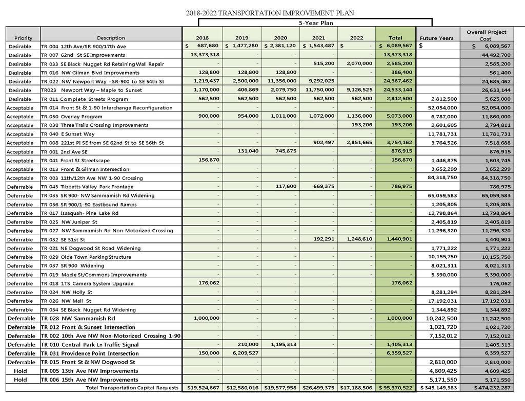
5 Table T-1 Estimated Local Traffic Impacts to State and Regional Transportation Facilities Interstate 90 Road Segment (mileage markers) Existing AADT* Future (2030) AADT Existing Level of Service (LOS) , ,423 D F ,112 80,244 D D ,017 67,451 B C ,743 45,622 B B SR-900 Road Segment (mileage markers) Existing AADT ,688 39, N/A 38, N/A 41, ,371 61,881 (Source: WSDOT, 2005) Future (2030) AADT Existing LOS (Am/PM Peaks) AM: D PM: C AM: A PM: B AM: B PM: E AM: D PM: F Future (2030) Level of Service (LOS) Future (2030) LOS (AM/PM Peaks) AM: E PM: E AM: D PM: D AM: C PM: E AM: E PM: E Transportation Improvement Program. Anticipated transportation projects and their estimated costs are identified in the Six Year Transportation Improvement Program (TIP) in Table T-3. Capacity projects for motorized travel and nonmotorized travel are identified in the six year transportation financing plan. The remaining projects are classified as non-capacity projects as they do not directly add capacity to the City s transportation system and therefore do not directly contribute to the City s level of service standards. Much of the revenue to fund both the capacity and non-capacity projects will come from grants or bonds and other potential revenue sources, with contributions, impact fees and money from the City s street improvement fund making up the remainder. A bicycle and pedestrian mitigation fee, collected through SEPA, was also adopted by the City Council in 2015 (Ord. 6876). Each year, the City reviews and prioritizes transportation projects and budgets money for those projects that are deemed most necessary. The list is prioritized each year and is linked to the concurrency traffic model to ensure improvements meet concurrency by maintaining the adopted LOS. T Policy C1 Use a system-based concurrency management system to fund growth s share of impacts to the City transportation system and support the City s preferred land use pattern and vision. * Average Annual Daily Traffic page T-5
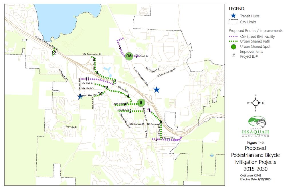
6 T Policy C2 T Policy C3 Development proposals that exceed the trip bank capacity shall do one or more of the following to achieve concurrency: a. Add the transportation system capacity necessary to meet the concurrency adopted level of service; and/or b. Phase or modify the project so that the trips do not exceed the trip bank capacity; and/or c. Implement demand-management strategies or other measures to reduce the number of peak hour trips generated by the project. d. Projects failing concurrency that do not provide adequate mitigation or transportation system capacity will be denied concurrency in accordance with state law. Maintain a Transportation Improvement Program (TIP) and Capital Facilities Plan (CFP) that improves existing substandard roadways to current standards, provides a balanced system of automobile, nonmotorized and HOV facilities, recognizes road improvements that are needed to improve traffic flow and High Accident Locations and meet transportation needs and concurrency requirements. In the event that the City is unable to fund the programs, projects and services identified in the TIP and CFP, one or more of the following actions shall be taken: a. Delay development until such time that programs, facilities or services can be funded; b. Amend the City s Comprehensive Plan to change the LOS or reduce the travel demand placed on the transportation system; or c. Obtain needed revenue or revise the TIP and CFP to reflect known financial resources. T Policy C4 T Policy C5 Increase the City's multi-modal usage by 2035 by supporting, expanding and implementing transportation choices including High Capacity Transit, HOV lanes, transit and nonmotorized improvements, and other Transportation Demand Management solutions. Use the best available technologies when implementing these projects. Provide a seamless multimodal system that maintains the City s adopted Level of Service as defined in the Land Use Code. Vehicular LOS: Maintain standards that promote growth where appropriate while preserving and maintaining the existing transportation system in accordance with the adopted Level of Service. Pedestrian LOS: Provide sidewalks, shared use routes and/or separated paths as identified in the Pedestrian and Bicycle Mitigation Projects Map (Figure T- 5). Bicycle LOS: Provide Bicycle Facilities as identified in the Pedestrian and Bicycle Mitigation Projects Map (Figure T-5). page T-6
7 Transit LOS: Partner with King County Metro, Sound Transit, and other transit operators to provide transit stop amenities and safe access to transit at major transit stops and park and ride facilities. Table T-2 below provides additional guidance on pedestrian, bicycle and transit facilities. Those corridors that meet the minimum requirements are green or yellow in the table below and are compliant with the LOS requirements. Those corridors that do not meet the LOS requirements shown in red. TABLE T-2 LOS REQUIREMENTS LOS LOS PEDESTRIAN LOS SIDEWALK REQUIREMENTS Pedestrian Network Pedestrian Facility provided in accordance with the Pedestrian and Bicycle Mitigation Projects map. Provides a lower-level Pedestrian Facility than recommended in the Pedestrian and Bicycle Mitigation Projects map, or a facility only on one side of the street. No Pedestrian Facility provided. BICYCLE LOS FACILITY REQUIREMENTS Bicycle Network Bicycle Facility provided in accordance with the Pedestrian and Bicycle Mitigation Projects map. Provides a lower-level Bicycle Facility than recommended in the Pedestrian and Bicycle Mitigation Projects map. No Bicycle Facility provided. LOS Transit Stop Amenities High level Some amenities Little or no amenities TRANSIT PRIORITY CORRIDOR LEVEL OF SERVICE Pedestrian Access Frequency of Service Sidewalks and marked crosswalks serving stops Sidewalks and marked crosswalks serving some stops General lack of sidewalks and marked crosswalks All day service. Peak service 15 minutes or less, midday 30 minutes or less All day service. Peak services 30 minutes or less, midday service 60 minutes or less Low level of service T Policy C6 Use transit service within the city boundaries to connect major commercial centers, neighborhoods and regional transportation facilities. active transportation network Goal D. Ensure and expand a seamless integration between all modes of transportation throughout the City. page T-7
8 discussion Part of creating a sustainable City is by managing mobility. Managing transportation demand, network completion and careful integration of land use with transportation infrastructure will increase overall mobility options and support needed shifts in mode share. T Policy D1 T Policy D2 T Policy D3 Develop and adopt a Transportation Master Plan that provides strategies to implement the City s multi-modal vision, goals and policies including pedestrian and bicycle facilities, streets, transit, high capacity transit, alternative modes of travel, as well as demand management, parking strategies, short-term strategy plans and funding mechanisms. Ensure mobility choices for people with special transportation needs, including persons with disabilities, the elderly, the young, and low-income populations. Provide access from every neighborhood to the adjacent City trail system, transit facilities and all City parks and recreation facilities. Goal E. Enable and encourage creative public gathering spaces along transportation corridors. discussion Informal public gathering spaces are designed to encourage pedestrian-oriented, small-scale social interaction. They vary in size and function depending on adjacent uses, and may include street furniture, focal points and human-scaled elements which emphasize its prime function as a place for people. T Policy E1 T Policy E2 Design streets to ensure a safe and comfortable pedestrian environment that includes pedestrian and bicycle facilities and gathering spaces. Make corridors and public gathering spaces rain friendly, where feasible, to encourage year-round use. transportation demand management Goal F. Use Transportation Demand Management techniques to achieve efficient use of transportation infrastructure, accommodate and facilitate future growth, and provide alternative modes of transportation that help to reduce dependency on single occupancy vehicles. discussion Transportation Demand Management (TDM) is the application of policies, strategies and actions to reduce travel demand (specifically that of single-occupancy vehicles (SOV)), or to redistribute this demand particularly in peak commute hours instead of increasing the roadway supply. TDM results in more efficient use of the current roadway system. In transportation, as in any network, managing demand can be a cost-effective alternative to increasing roadway capacity. A demand management approach to transportation also has the potential to deliver better environmental outcomes, improved public health, stronger communities, and more prosperous and livable cities. Travelers base their travel choices on a number of important motivators including the desire to save time and money, to reduce stress or to improve convenience. At least some of these motivations must be addressed to encourage a change in habits. Some of the most promising TDM programs emphasize page T-8
9 coordination with local employers on measures such as car or vanpooling programs, bus pass subsidies, alternative work schedules, telecommuting options and parking management. T Policy F1 T Policy F2 T Policy F3 T Policy F4 Expand employer and neighborhood programs that provide alternatives to SOVs, including Commute Trip Reduction, shared-vehicles (i.e. Zip Cars) transit and Bike Share. Incorporate transit supportive and multimodal/nonmotorized friendly design features in new and re-development through the development review process. Manage parking through plans and programs that support Issaquah s land use objectives. Develop, implement and continue to monitor Transportation Demand Management regulations and strategies. street network Goal G. Maintain and enhance a connected grid street system to provide alternative routes, reduce congestion, and contribute to the vitality of the neighborhoods in which each street is located. discussion Well-designed streets serve all modes of travel including automobiles, trucks, transit, bicycles, and pedestrians, they include safe routes, and help move people where they need and want to go. The appropriate number of streets means that people have more route options rather than sending people down the same path. Efficiently designed streets can also minimize and better manage the amount of stormwater runoff that directly impacts the natural environment by affecting water quality in surface streams and lakes. T Policy G1 T Policy G2 T Policy G3 T Policy G4 T Policy G5 Require that all streets be Complete Streets, built to accommodate all travel modes in compliance with the City s design standards and plans for streets, bicycles and pedestrian facilities. Establish and adopt criteria in the City s Street Standards to be used as a guide to prioritize required improvements when circulation facilities are not able to be built in accordance with the specifications due to extraordinary financial or physical barriers that require deviation from the Standards. Maintain continuity of the street pattern by avoiding dead-end and half-streets not having turn-around provisions. Avoid the creation of excessively large blocks and long local access residential streets making streets more appealing and useable for pedestrians and cyclists. Consider law enforcement and emergency services when designing corridors to provide adequate locations for police and other emergency vehicles to conduct enforcement and investigations, as well as emergency response to incidents. page T-9
10 T Policy G6 Adequately fund, design and build the roadway network in accordance with the 20- Year Roadway Plan shown in Figure T-2 in order to accommodate the City s anticipated future growth. T Policy G7 Inventory, identify and map major roadways and assign Functional Roadway Classifications to represent the desired functions of the roads. (Functional Roadway Classifications do not represent the design of the roads.) These can be found in Figure T-1 and are defined as follows. Principal Arterial. These roadways provide for traffic movements into, out of and through the City. Principal Arterials constitute a small percentage of the overall network, yet they carry the highest traffic volumes and longest trips. These arterials contain the regional and inter-city bus routes and transit centers. Service to abutting land use is subordinate to travel service provided by Principal Arterials. Minor Arterial. Minor Arterials accommodate trips of moderate length and lower travel mobility than Principal Arterials. They serve intra-city and some through traffic trips as well as serve local and intra-city bus routes. Unlike Principal Arterials, Minor Arterials provide access to abutting land uses such as retail and office centers. Collector Arterial. Collector Arterials carry moderate traffic volumes and shorter trips than Principal and Minor Arterials and have little through traffic. They may serve local bus routes. Collector Arterials provide movement within neighborhoods with direct neighborhood trips to Principal and Minor Arterials as well as land access to neighborhoods, commercial and industrial areas. Local Streets. Local Streets comprise all roadways and streets not otherwise classified. The primary function of Local Streets is the provision of access to abutting properties. The balance of roadways within the City are Local Streets. T Policy G8 T Policy G9 Facilitate the smooth flow of traffic on major arterials through signal coordination and other available technologies. Design transportation and storm water improvements to protect water resources including surface water, groundwater, and stormwater. transit network Goal H. Increase the percentage of trips made by transit, including High Capacity Transit. discussion Transit is a key element of Issaquah s multimodal network and plays an essential role in providing connections, mobility and access both regionally and locally. The City, developers, businesses and residents must be cognizant the role transit will and should play in our future when designing for new development and roads, in budgetary decisions, in regional relationships and in public awareness. Issaquah s Urban Core Urban Center designation warrants strategic attention to provide local and regional connections to achieve the City s vision for not only Central Issaquah, but for the entire City. page T-10
11 T Policy H1 T Policy H2 T Policy H3 T Policy H4 T Policy H5 T Policy H6 T Policy H7 T Policy H8 T Policy H9 T Policy H10 Design systems and establish programs that combine walking and cycling with other forms of transportation to facilitate the last mile for transit riders. Partner with agencies to identify opportunities to improve local and regional transportation options such as: a. Increased frequency and span of service b. Service routes, including access to residential neighborhoods c. Capital improvements; and d. Alternative transit options such as internal circulation bus service and routes, taxis and transit vans. Support regional and countywide growth management strategies to create Transit Activity Centers linking Urban Centers with a high-capacity transit system, busses and other transit modes. Work with King County Metro, Sound Transit and other transit providers to maintain and improve the speed and reliability of transit service in Issaquah through such actions as transit lanes, queue jumps and queue bypass lanes. Include transit facilities and improvements into the design of public spaces, public and private developments and street improvements that benefit transit operations. Support the extension of Sound Transit s I-90 Corridor light rail to Issaquah and the construction of a light rail station and a satellite operations maintenance center in Issaquah. Promote and encourage public participation in the light rail corridor study and the design of Issaquah s light rail system. Work with Sound Transit, Sammamish, Redmond and other agencies to analyze and implement a High Capacity Transit system, and necessary supporting services, connecting Issaquah Highlands to Overlake via Sammamish, Redmond. Ensure that regional transit system development occurs in accordance with Vision 2040, Transportation 2040, Sound Transit s Regional Transit Long Range Plan and METRO s Strategic Plan for Public Transportation by working with the regional transit providers. Remain open to alternative transit solutions managed and maintained by the City and partners. page T-11
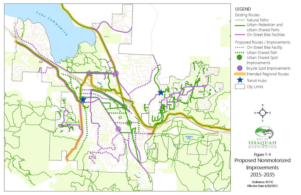
12 nonmotorized network Goal I. Integrate nonmotorized facilities as a part of all roadway projects. discussion A successful nonmotorized network is: comprehensive, connected, convenient, frequent, direct, integrated, safety-oriented, and Pedestrian Friendly. A successful nonmotorized network increases mobility choices, reduces reliance on single occupancy vehicles and ensures people can get to get to the places they want and need to go including schools, commercial centers, transit systems, parks and other recreation areas. It contributes to the Public Realm and encourages regular physical activity to enhance health and wellness. T Policy I1 T Policy I2 T Policy I3 T Policy I4 T Policy I5 T Policy I6 T Policy I7 Use the Nonmotorized Improvements Maps (Figures T-4 and T-5) to guide the design, construction and maintenance of pedestrian and bicycle facilities by public and private parties, including the preparation of design standards and elements that promote a pleasant and safe traveling environment. Direct nonmotorized resources towards those modes that have the least environmental impact and the greatest contribution to livability. Create a system of identifying nonmotorized routes that do not meet design guidelines and to inform route upgrades and new routes. Require and enforce safe, comfortable and convenient access in and around construction zones. All roadway projects shall be consistent with the Nonmotorized Corridor Map (Figure T-4) unless physical obstacles present significant difficulties or budget constraints are present. If either of the exceptions apply, attempts to design alternative routes must be considered in the project design. Use impact and mitigation fees, grants, and other revenue to construct and maintain nonmotorized projects identified on the Nonmotorized Map (Figure T-4) that are not otherwise included in roadway projects. Maintain a list of priority pedestrian and bicycle projects to be implemented through the Transportation Improvement Program to meet established nonmotorized goals. Goal J. Ensure all mobility facilities, including but not limited to, nonmotorized and motorized routes, transit, and transit facilities, are accessible to people of all ages, abilities and income levels. discussion The Americans with Disabilities Act (ADA) requires that all facilities, in this instance all mobility facilities, be accessible to people with disabilities. It is important, however, that not only are those facilities accessible, but they are complete, ensuring absolute routes to community destinations. T Policy J1 Establish and implement a comprehensive wayfinding plan. page T-12
13 T Policy J2 T Policy J3 T Policy J4 T Policy J5 Monitor and find ways to reduce the number of nonmotorized collisions. Educate walkers and cyclists of all ages and abilities of their rules, rights and responsibilities. Assure safe walking and cycling conditions for students who walk to and from school. Establish, adopt and implement an ADA Self-Evaluation and Transition Plan affirming the City s commitment to local, state and federal accessibility standards. Goal K. Achieve a walkable City for pedestrians by providing a safe, convenient and coordinated system of sidewalks, trails and pathways, including through routes, crossings and connections. discussion Walking is the oldest and most efficient, affordable, and environmentally-friendly form of transportation it s how transit riders eventually reach their destinations, how drivers get from the parking lot to the front door, and how cyclists get from the bike rack to the business. In addition to the transportation aspects, walking helps to build strong communities, is great exercise and is an easy way to improve your mental and physical health. Nearly everyone, for at least some portion of every day, is a pedestrian making the need for safe, accessible and inviting walking paths all the more apparent. T Policy K1 T Policy K2 T Policy K3 T Policy K4 T Policy K5 Provide sidewalks whenever new corridors are constructed and when properties are redeveloped. Separate pedestrians from traffic lanes by the use of street trees and landscaped strips unless physical obstacles present significant difficulties or budget constraints are present. Connect incomplete sidewalks through the Complete Streets Program. Continue the Issaquah Neighborhood Walk Series to involve the community, encourage walking in Issaquah and provide the City with information and recommendations for improving walkability in Issaquah. Continue to identify additional opportunities for walking paths, natural or paved, that link destinations such as neighborhoods with schools and parks and work closely with developers and City departments to implement them. Key areas of focus include but are not limited to North Issaquah, Squak Mountain and South Cove. Goal L. Provide a bicycle-friendly and supportive community, enabling healthy, inexpensive and environmentally friendly travel. discussion People have rediscovered cycling, for both recreation and transportation purposes, along with its numerous community benefits related to health, safety, the environmental and the quality of life it page T-13
14 provides. To promote and encourage this trend, the City must continue to explore what gets people cycling, and rely on innovation in bicycle design to provide a complete and comfortable cycling environment. T Policy L1 T Policy L2 T Policy L3 T Policy L4 T Policy L5 T Policy L6 T Policy L7 T Policy L8 Use innovative design such as Cycle Tracks and Star Paths to inspire a bicycle culture. Provide ample, safe bicycle parking at special events. Require bicycle amenities such as bicycle parking, lockers, and tool boxes at community destinations places that people want to connect to and from throughout the City. Work with transit agencies to integrate cycling amenities and routes with mass transit. Ensure the construction of nonmotorized facilities that connect the ends of cul-desacs to existing and/or proposed nonmotorized routes to achieve improved circulation to adjacent neighborhoods, parks and other destinations. Require new or redeveloping properties to design and build bicycle/ pedestrian corridors that maximize the use of nonmotorized transportation alternatives. Ensure changes to roads do not eliminate existing nonmotorized transportation facilities unless equivalent mitigation is provided. Ensure public safety by maintaining bicycle and pedestrian facilities through a formalized nonmotorized route maintenance plan and dedicated funding. finance Goal M. Invest strategically in transportation with cost savings and investment opportunities in mind. discussion In most cases, mobility projects motorized and nonmotorized are funded by a combination of funding sources, including grants, impact fees, general fund resources, voted bonds and sales taxes - reflecting the fact that transportation projects have multiple purposes and serve multiple beneficiaries. Leverage funds with other City departments, governmental and nonprofit agencies to pursue project and program implementation. Pursue public-private partnerships and innovative funding strategies such as impact fees and development agreements. T Policy M1 T Policy M2 Maintain a 20-year financing plan to provide predictability and assurance that transportation system improvements are accomplished when needed and in accordance with the six-year Transportation Improvement Program. Ensure sustainability of the existing transportation infrastructure by designing a system that meets the anticipated 20-year needs, is environmentally sound in page T-14
15 construction and materials and supports the fluid movement of people, goods and services. T Policy M3 T Policy M4 T Policy M5 T Policy M6 Design arterials to be consistent with their roadway and transitway classifications shown in the Roadway and Transitway Classification Maps. New roadways must be included in the 20-year transportation plan prior to design so that the design is consistent with its roadway and transitway classifications. Use mitigation and impact fees to complete nonmotorized and road projects that mitigate or accommodate growth required by the Growth Management Act. Increase dedicated funding for nonmotorized projects, programs and education. Establish a grant matching reserve fund for walking and cycling projects and programs. regional coordination Goal N. Collaborate with Issaquah s neighboring municipalities, King County, and other agencies to address regional impacts and issues. discussion It is important that the City establish and maintain good working relationships with jurisdictions and agencies throughout the Puget Sound region. Doing so will help ensure that state, county and local projects address the regional vision and local growth management planning goals and objectives. T Policy N1 T Policy N2 Partner with the State Department of Transportation, Puget Sound Regional Council, Sound Transit, King County and the cities of Sammamish and Bellevue to influence regional decision making processes that promote the transportation system in the Issaquah community. Enter into interlocal agreements with regional agencies and adjacent jurisdictions that mandate the shared financial responsibility of mitigating impacts of new developments and their associated transportation facilities as well as those that benefit the regional transportation system. implementation Goal O. Measure the effectiveness and success of the Comprehensive Plan in achieving community visions, goals and policies. discussion Achieving the visions of the Issaquah community for how our City should look, feel and function is dependent on implementation of the goals and policies adopted in this document. While there are not sufficient resources to accomplish all of the implementation strategies simultaneously, the City can make progress to carry out the Comprehensive Plan by identifying priorities and necessary resources. The City has established a list of Implementation Strategies (Appendix B) that are needed to accomplish the Community vision within the Comprehensive Plan, and although not complete, the list is intended to be used as a tool for prioritizing City resources, including budget and staff time. Additionally, the City cannot accomplish all the implementation strategies alone. As part of a much page T-15
16 larger and growing metropolitan area, issues such as growth rates, housing supply and demand, and transportation systems require cooperation and partnerships with the public and private sectors as well as local, state and federal agencies. T Policy O1 Ensure Comprehensive Plan goals and policies are accompanied by related and required implementing actions, including but not limited to those listed in the Implementation Strategy (Appendix B). page T-16
17 page T-17

18 page T-18

19 page T-19
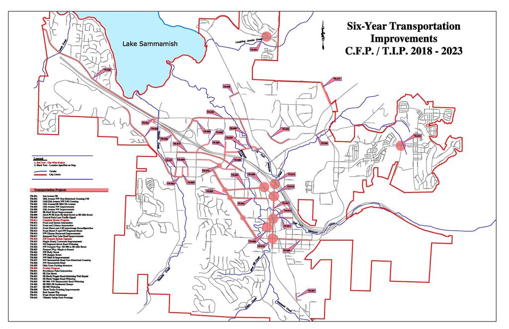
20 Proposed Roadway (Traffic) Projects Project Descriptions # Project Name Project Description N Iss Rdwy Impvmnts - SE 62nd St/Ext. Imprv. N Iss Rdwy Impvmnts - E Lake Sammamish Pkwy Widening Issaquah Pine-Lake Road Improvements N Iss Rdwy Impvmnts - 12th Ave/SR 900/17th Ave Imp NW Dogwood St Improvements Design and construction of a new roadway and other roadway network improvements in the North Issaquah area bounded approximately by East Lake Sammamish Parkway, SE 56th St/NW Sammamish Rd, 17th Ave NW, and I-90. The projects are: new roadway and bridge extending SE 62nd St into Pickering Shopping Center; widening SE 62nd Street from ELSP to 221st Ave SE; widen ELSP southbound from s/o SE 56th St to n/o Issaquah Fall City Rd; improve 221st Ave SE from SE 56th St to SE 62nd St with a new roundabout at SE 62nd and 221st; and widen 12th Ave NW approaching 17th and widen 17th approaching 12th. Design and construction of a roadway widening to provide for additional southbound through travel lane, curb, gutter, sidewalks, storm drainage system including pertinent stormwater filtration and storage, irrigation, and street trees. Requires modification of traffic signal at Black Nugget Rd and SE 62nd St to provide for additional southbound through lane. Restripes portion of roadway between Issaquah Fall City Rd and I-90 for additional southbound approach lane. Roadway widening, curb, gutter, sidewalks, bike lanes, and other multi modal elements, storm drainage, irrigation, street trees, and crosswalks between Issaquah Fall City Rd and SE 48th Street. Improvements to match the existing configuration at the intersection of Issaquah Fall City Rd, and the proposed roadway section to be constructed in the City of Sammamish, assumed to be 4 to 5 lanes. Widen 12th Ave NW at SR 900/NW Sammamish Rd to provide for an additional westbound approach land to provide exclusive dual left turn lanes. Right-of-way will be required and the cost and amount necessary is undetermined at this time. In addition, widen the northbound 17th Ave NW approach to provide for an exclusive right turn lane for traffic turning from 17th Ave NW to 12th Ave NW. Design and construction of street improvements, including restoration of road base for two travel lanes, asphalt surfacing, curbs and gutters, storm drainage, utility adjustments, street lights, traffic signal, and sidewalks. page T-20
21 # Project Name Project Description Include southbound right turn pocket on Front Street/Dogwood Intersection SR 900/NW Sammamish Rd Widening Maple St/Newport Way Intersection Improvements Newport Way Improvements, Maple to Sunset Front St and Sunset Way Intersection Improvements Providence Point - Intersection Realignment and Signalization NW Maple and 12th Ave NW Intersection Improvement Front St and I-90 Interchange Reconfiguration Construct an additional westbound general purpose lane approaching the I-90 Ramps from 11th Ave NW to the metered location on the westbound I-90 On-ramp. Provide an additional northbound lane on NW Newport Way approaching Maple St for an exclusive right turn lane and provide an additional westbound lane on NW Maple St approaching NW Newport Way for an exclusive right turn lane. Rebuild with roundabout intersection improvements at Juniper St, Holly St, and Dogwood, two travel lanes southbound from Maple St to 600 feet south of Holly St, transitioning to one travel lane southbound with one travel lane to Sunset Way, and one travel lane northbound. Includes two bike lanes, a sidewalk on the one side with an 8-foot wide walking trail on the other side, and related landscaping and lighting. Include storm water system for the roadway with detention and treatment facilities. Include a storm water bypass for existing drainage from adjacent properties. Design and construct left-turn lanes on Sunset Way. The existing roadway configuration from curb to curb width cannot be increased because of existing buildings. This requires removal of parking to provide for additional leftturn roadway capacity through the intersections and to improve traffic safety. Will allow for modification of the traffic signal to allow for an 8-phase signal operation and removal of the split phased operation on Sunset Way. Project consists of realigning the entrances of Providence Point and to Forest Village and includes the installation of a traffic signal, street lights, and pedestrian access. Intersection widening to provide exclusive eastbound right turn lane and northbound right turn lane. Reconfigure the Front Street/I-90 interchange to a tight diamond, provide additional capacity on Front Street North and coordinate with the improvement at Front and Gilman Boulevard. Project limits from Issaquah Fall City Road to Gilman Boulevard. page T-21
22 # Project Name Project Description 13 13th Ave NW Improvements New two-lane roadway with turn lanes at intersections including wide sidewalks, curb and gutter, landscaping, street lights, and on-street parking and traffic signal at NW Maple St th Ave NW Improvements New two-lane roadway with turn lanes at intersections including wide sidewalks, curb and gutter, landscaping, street lights, and on-street parking and traffic signal at NW Maple St and NW Newport Way. 15 New three-lane overpass with one lane in each direction. 11th/12th Ave NW The proposal includes turn lane capacity at each termini Overcrossing intersection, a five-foot bike lane, and a sidewalk th Ave NW Improvements New two lane roadway with turn lanes at intersections including wide sidewalks, curb and gutter, landscaping, street lights, and on-street parking. 17 2nd Ave/Sunset Way Signalize intersection, and restripe eastbound approach within existing pavement width. 18 SR 900 Widening Widen SR 900 to 3 lanes in each direction between Maple Street and Newport Way. Provide additional turn lane capacity at the Newport Way intersection NW Sammamish Road/SE 56th Street Widening SR 900/I-90 Eastbound Ramps SE Black Nugget Road Widening Widen NW Sammamish Road/SE 56th Street to 3 lanes in each direction between the I-90 westbound ramps and East Lake Sammamish Parkway. Provide additional turn lane capacity at various intersections along the corridor. Provide additional turn pocket improvements at the SR 900/I-90 Eastbound Ramps intersection, specifically a third eastbound right turn lane. Widen SE Black Nugget Road to provide 2 left turn lanes in the westbound direction approaching Issaquah Fall City Road. Widen the eastbound approach to include a second left turn pocket. 22 East Lake Sammamish Parkway/SE 51st Street 23 10th Ave NE/NE Park Dr. Signal phasing improvements. page T-22
23 page T-23
24 page T-24
25 Proposed Pedestrian and Bicycle Mitigation Projects for Project Descriptions ID # Project Name NE Gilman & Front Intersection Bike Lanes and Sidewalk Confluence Park/Holly Street Creek Crossing Shared Use Path East Sunset Way Cycle Track Pickering Trail along I-90 (Tributary 0170 Trail) 220th Avenue SE Bike Lanes Project Location: Extents Gilman Blvd: Just west of Front & Gilman intersection to Triple X Restaurant driveway east of Front Street Holly Street: Newport Way NW to Rainier Blvd N (Including New Bridge) East Sunset Way: Front Street to I-90 off-ramp (South side) Along north side of I-90: 12th Avenue/SR900 to Lake Drive 220th Ave & 51st SE: SE 56th St to East Lake Sammamish Parkway Project Description Extend the Gilman Blvd bike lanes to the east of Front Street N and provide continuous sidewalks. The specific bike facility (for example bike lanes, shared use route, cycle track, etc.) to be determined) Construct a 10- to 12-foot hard surface path along the south side of Holly Street between 5th Ave NW and Rainier Blvd N. A bridge would also be constructed over Issaquah Creek. The trail could connect just south and parallel with Holly Street through Cybil Madeline Park versus running along the roadway between 3rd Ave NW and Rainer Blvd N. Construct a 12-foot cycle track and rebuild the south side sidewalk along E Sunset Way between Front St N and the I-90 eastbound off-ramp (south side of I-90). This would likely result in the loss of on-street parking on the south side of E Sunset Way. Construct a 10- to 12-foot hard surface path between Lake Drive and 12 th Ave NW / 17 th Avenue NW. This facility would follow an approximately alignment along the north side of I-90. Construct 5-foot bike lanes along 220 th Ave SE and SE 51 st Street between SE 56 th Street and E Lake Sammamish Pkwy SE. It is assumed that this project can be accommodated through a restripe and a partial to full removal of the SE 51 st Street median. page T-25
26 ID # Project Name NE Gilman & 3rd Avenue Shared Use Path SE 56th Street Bike Lane Three Trails Crossing Improvements NW Juniper Street Improvements Newport Way NW Bike Lanes and Sidewalk Gilman Boulevard Bike Lanes and Sidewalk NW Sammamish Road Non-Motorized Crossing I-90 10th Ave NW Non- Motorized Crossing l-90 Project Location: Extents NE Gilman Blvd & 3rd Avenue NE: Triple X Restaurant driveway to E. Sunset Way 220th Ave SE to near former Albertson's driveway (South side) Intersection: NW Gilman Blvd & Rainier Blvd & Juniper Street NW Juniper St: Newport Way to Rainier Boulevard Newport Way NW: 12th Ave east to NW Maple Street NW Gilman Blvd: 17th Ave/SR900 to Maple Street. I-90 Crossing: NW Sammamish Road to south side of I-90, location to be determined. I-90 Crossing: Gilman Boulevard to 10th Avenue NW Project Description Construct a combination of bike lanes and a shared use path along NE Gilman Blvd and 3 rd Ave NE between approximately the Triple X Restaurant driveway and E Sunset Way. The bike lanes would be provided along the wider section of NE Gilman Blvd and the shared use path along 3 rd Ave NE. The specific bike facility (for example bike lanes, shared use route, cycle track, etc.) to be determined. Provide a bike lane on south side 56th Street by restriping SE 56 th Street between 220 th Ave SE and east of E Lake Sammamish Pkwy SE. Provide a signalized crossing of the NW Gilman Blvd / Rainier Blvd N / NW Juniper Street intersection. Design and construct two travel lanes, curbs and gutter, drainage and water quality treatment, lighting, and landscaping. Includes completion of partially existing 10' wide multi-purpose trail on one side and sidewalk on the other side. Construct bike lanes and a sidewalk between 12 th Ave NW and NW Maple Street along Newport Way NW. A section of this project will be constructed with developer improvements along the south side between 12 th Ave NW and 11 th Place NW. Construct bike lanes between 17 th Ave NW/SR 900 and Maple Street NW. This would require widening the roadway approximately 10 feet. It was assumed that widening would occur to one side; along the widened side the sidewalk would be rebuilt. Provide a 14' wide non-motorized crossing of l-90 west of the State Park. Provide a 14' wide non-motorized crossing of l-90. page T-26
27 ID # Project Name NW Mall Street 14 Pedestrian Corridor NW Mall Street Pedestrian Corridor Sammamish Trail Grade Separation at SE 56th Street Project Location: Extents 7th Avenue NW to Juniper NW Mall Street: 12th Avenue NW to 7th Avenue NW Intersection of East Lake Sammamish Parkway, SE 56th Street, and Sammamish Trail Project Description New urban pedestrian corridor New urban pedestrian corridor portion of new public street Construct pedestrian and bicycle crossing over or under SE 56th St for Sammamish Trail. The Sammamish multi-use trail intersects SE 56th St. page T-27

28 Figure T-6 page T-28

29 Figure T-7 page T-29
30 page T-30
31 page T-31

32 page T-32
33 page T-33
34 page T-34

35 page T-35
Proposed. City of Grand Junction Complete Streets Policy. Exhibit 10
 Proposed City of Grand Junction Complete Streets Policy Exhibit 10 1 City of Grand Junction Complete Streets Policy Vision: The Complete Streets Vision is to develop a safe, efficient, and reliable travel
Solana Beach Comprehensive Active Transportation Strategy (CATS)
") Solana Beach Comprehensive Active Transportation Strategy (CATS) 3.0 Goals & Policies The Solana Beach CATS goals and objectives outlined below were largely drawn from the Solana Beach Circulation Element
Solana Beach Comprehensive Active Transportation Strategy (CATS) 3.0 Goals & Policies The Solana Beach CATS goals and objectives outlined below were largely drawn from the Solana Beach Circulation Element
Exhibit 1 PLANNING COMMISSION AGENDA ITEM
 Exhibit 1 PLANNING COMMISSION AGENDA ITEM Project Name: Grand Junction Circulation Plan Grand Junction Complete Streets Policy Applicant: City of Grand Junction Representative: David Thornton Address:
CITY OF COCOA BEACH 2025 COMPREHENSIVE PLAN. Section VIII Mobility Element Goals, Objectives, and Policies
 CITY OF COCOA BEACH 2025 COMPREHENSIVE PLAN Section VIII Mobility Element Goals, Objectives, and Policies Adopted August 6, 2015 by Ordinance No. 1591 VIII MOBILITY ELEMENT Table of Contents Page Number
Clackamas County Comprehensive Plan
 ROADWAYS The County s road system permits the movement of goods and people between communities and regions, using any of a variety of modes of travel. Roads provide access to virtually all property. They
Perryville TOD and Greenway Plan
 Perryville TOD and Greenway Plan Greenway Glossary Pathway: A bicycle and pedestrian path separated from motorized vehicular traffic by an open space, barrier or curb. Multi-use paths may be within the
NM-POLICY 1: Improve service levels, participation, and options for non-motorized transportation modes throughout the County.
 Transportation PRINCE WILLIAM COUNTY 2008 COMPREHENSIVE PLAN NON-MOTORIZED PLAN CONTENTS Goals, Policies, and Action Strategies Table 4 (Bike Facility Classifications and Descriptions) Table 5 (Bike Facility
Corpus Christi Metropolitan Transportation Plan Fiscal Year Introduction:
 Introduction: The Safe, Accountable, Flexible, Efficient Transportation Equity Act: A Legacy for Users (SAFETEA-LU) has continued the efforts started through the Intermodal Surface Transportation Efficiency
CITY OF BLOOMINGTON COMPLETE STREETS POLICY
 CITY OF BLOOMINGTON COMPLETE STREETS POLICY POLICY OBJECTIVE: The City of Bloomington will enhance safety, mobility, accessibility and convenience for transportation network users of all ages and abilities,
Living Streets Policy
 Living Streets Policy Introduction Living streets balance the needs of motorists, bicyclists, pedestrians and transit riders in ways that promote safety and convenience, enhance community identity, create
CONNECTING PEOPLE TO PLACES
 CONNECTING PEOPLE TO PLACES 82 EAST BENCH MASTER PLAN 07 Introduction The East Bench transportation system is a collection of slow moving, treelined residential streets and major arteries that are the
Chapter 7. Transportation. Transportation Road Network Plan Transit Cyclists Pedestrians Multi-Use and Equestrian Trails
 Chapter 7 Transportation Transportation Road Network Plan Transit Cyclists Pedestrians Multi-Use and Equestrian Trails 7.1 TRANSPORTATION BACKGROUND The District of Maple Ridge faces a number of unique
Transportation Master Plan Advisory Task Force
 Transportation Master Plan Advisory Task Force Network Alternatives & Phasing Strategy February 2016 BACKGROUND Table of Contents BACKGROUND Purpose & Introduction 2 Linking the TMP to Key Council Approved
Bicycle Master Plan Goals, Strategies, and Policies
 Bicycle Master Plan Goals, Strategies, and Policies Mobilizing 5 This chapter outlines the overarching goals, action statements, and action items Long Beach will take in order to achieve its vision of
4. ENVIRONMENTAL IMPACT ANALYSIS 9. TRANSPORTATION AND TRAFFIC
 4. ENVIRONMENTAL IMPACT ANALYSIS 9. TRANSPORTATION AND TRAFFIC 4.9.1 INTRODUCTION The following section addresses the Proposed Project s impact on transportation and traffic based on the Traffic Study
Circulation in Elk Grove includes: Motor vehicles, including cars and trucks
 Circulation, as it is used in this General Plan, refers to the many ways people and goods move from place to place in Elk Grove and the region. Circulation in Elk Grove includes: Motor vehicles, including
PEDESTRIAN ACTION PLAN
 ATTACHMENT 2 CITY OF SANTA MONICA PEDESTRIAN ACTION PLAN CITY OF SANTA MONICA PEDESTRIAN ACTION PLAN This page intentionally left blank EXECUTIVE SUMMARY CHAPTER 1 EXECUTIVE SUMMARY Setting the Stage
RESOLUTION NO ?? A RESOLUTION OF THE CITY OF NEPTUNE BEACH ADOPTING A COMPLETE STREETS POLICY
 RESOLUTION NO. 2018-?? A RESOLUTION OF THE CITY OF NEPTUNE BEACH ADOPTING A COMPLETE STREETS POLICY WHEREAS, safe, convenient, and accessible transportation for all users is a priority of the City of Neptune
WELCOME TO OPEN HOUSE # 1 June 14, 2017
 Langstaff Road Weston Road to Highway 7 Class Environmental Assessment Study WELCOME TO OPEN HOUSE # 1 June 14, 2017 Please sign in and join our mailing list Purpose of Open House #1 & Study Area York
ACTIVE TRANSPORTATION
 ACTIVE TRANSPORTATION Mobility 2040 Supported Goals Improve the availability of transportation options for people and goods. Support travel efficiency measures and system enhancements targeted at congestion
ADA Transition Plan. City of Gainesville FY19-FY28. Date: November 5, Prepared by: City Of Gainesville Department of Mobility
 ADA Transition Plan FY19-FY28 Date: November 5, 2018 Prepared by: City Of Gainesville Department of Mobility 1.0 INTRODUCTION 1.1 BACKGROUND The federal statute known as the Americans with Disabilities
C C C
 C-012-001 Thank you for your support for the creation of new public space and nonmotorized access between downtown and the waterfront through the Overlook Walk, the East-West Connections, and the Promenade.
City of Gainesville Transportation/Roadway Needs PROJECT SUMMARY
 A1 Roadway Resurfacing $23,846,000 TYPE: Preservation of existing system Roadway resurfacing A2 Signal Replacement $6,000,000 TYPE: Preservation of existing system Replace traffic signals. B1 W 6th St
City of Novi Non-Motorized Master Plan 2011 Executive Summary
 City of Novi Non-Motorized Master Plan 2011 Executive Summary Prepared by: February 28, 2011 Why Plan? Encouraging healthy, active lifestyles through pathway and sidewalk connectivity has been a focus
Goal 3: Foster an environment of partnerships and collaboration to connect our communities and regions to one another.
 Non-Motorized Transportation Plan (NMTP) Draft Vision, Goal and,, Tri-County Regional Planning Commission (TCRPC) Purpose The purpose of the Tri-County Regional Planning Commission (TCRPC) Non-Motorized
Chapter 5 Future Transportation
 Chapter 5 Future Transportation The Future Land Use Plan identifies the desired land use designations. The land uses desired for Crozet depend, in large part, on the success of the transportation system,
CITY OF BURIEN, WASHINGTON MEMORANDUM
 DATE: November 2, 2011 CITY OF BURIEN, WASHINGTON MEMORANDUM TO: FROM: SUBJECT: Burien Planning Commission Charles W. Chip Davis, AICP, Senior Planner Recommendation on Revised Comprehensive Plan Transportation
ACTIVE TRANSPORTATION/NONMOTORIZED TRANSPORTATION
 ACTIVE TRANSPORTATION/NONMOTORIZED TRANSPORTATION BACKGROUND Active transportation, also known as nonmotorized transportation, is increasingly recognized as an important consideration when planning and
City of Wayzata Comprehensive Plan 2030 Transportation Chapter: Appendix A
 A1. Functional Classification Table A-1 illustrates the Metropolitan Council s detailed criteria established for the functional classification of roadways within the Twin Cities Metropolitan Area. Table
Recommended Roadway Plan Section 2 - Land Development and Roadway Access
 Recommended Roadway Plan Section 2 - Land Development and Roadway Access SECTION 2 Land Development and Roadway Access 2.1 Land Use and Access Management The Federal Highway Administration (FHWA) defines
MCTC 2018 RTP SCS and Madera County RIFP Multi-Modal Project Eval Criteria GV13.xlsx
 MCTC 8 RTP SCS and Madera County RIFP Multi-Modal Project Eval Criteria GV.xlsx Madera County Transportation Commission Regional Transportation Plan / Sustainable Communities Strategy Multi-Modal Project
TRANSPORTATION & MOBILITY
 TRANSPORTATION & MOBILITY ROADWAY SYSTEM There are approximately 40 miles of roadways in Manitou Springs. For planning purposes, roadways are typically assigned a functional classification which defines
Develop a Multi-Modal Transportation Strategy (Theme 6)
") DEVELOP A MULTI-MODAL TRANSPORTATION STRATEGY (THEME 6) WHY IS THIS THEME ADDRESSED? Develop a Multi-Modal Transportation Strategy (Theme 6) Statement of Ideal Reduce resident and visitor reliance on single
DEVELOP A MULTI-MODAL TRANSPORTATION STRATEGY (THEME 6) WHY IS THIS THEME ADDRESSED? Develop a Multi-Modal Transportation Strategy (Theme 6) Statement of Ideal Reduce resident and visitor reliance on single
5. RUNNINGWAY GUIDELINES
 5. RUNNINGWAY GUIDELINES These guidelines should be considered collectively when making runningway decisions. A runningway is the linear component of the transit system that forms the right-of-way reserved
Classification Criteria
 SCHEDULE D TO RECOMMENDED OFFICIAL PLAN AMENDMENT NO. 40 SCHEDULE C-4 Road Criteria Criteria Traffic Service Objective Land Service/Access Typical Daily Traffic Volume Flow characteristics Travel Speed
Performance Criteria for 2035 Long Range Transportation Plan
 Minimizing Impacts on Natural, Historic, Cultural or Archeological Resources 2035 LRTP Weighting Factor: 7% Objective 1.1: Use appropriate planning and design criteria to protect and enhance the built
Safe Streets. City of Lake Forest Park. March 21, 2017
 Safe Streets City of Lake Forest Park March 21, 2017 1 01 WELCOME 2 Agenda WELCOME WHAT IS THIS PROJECT? CONTEXT DRAFT CITYWIDE PROJECTS EXERCISE INTRODUCTION 3 02 WHAT IS THIS PROJECT? 4 WHAT IS THIS
The Bike Buzz in Richland. November 2017 Carl Berkowitz
 The Bike Buzz in Richland November 2017 Carl Berkowitz Richland has been growing by leaps and bounds with lots of new homes and roads throughout the community. Recognizing all the growth in the Queensgate
TOWN OF PORTLAND, CONNECTICUT COMPLETE STREETS POLICY
 TOWN OF PORTLAND, CONNECTICUT COMPLETE STREETS POLICY I. VISION, GOALS & PRINCIPLES VISION To improve the streets of Portland making them safer and more accessible for all users including pedestrians,
Broad Street Bicycle Boulevard Design Guidelines
 Broad Street Bicycle Boulevard Design Guidelines Building from the strategies introduced in the 2013 Bicycle Transportation Plan and community input received thus far, City Transportation Staff have identified
3.0 PROJECT DESCRIPTION
 The following section of the Draft EIR contains a description of the proposed Elk Grove Boulevard/SR 99 Interchange Modification project, consistent with the requirements of CEQA Guidelines Section 15124.
2. Context. Existing framework. The context. The challenge. Transport Strategy
 Transport Strategy Providing quality connections Contents 1. Introduction 2. Context 3. Long-term direction 4. Three-year priorities 5. Strategy tree Wellington City Council July 2006 1. Introduction Wellington
SANTA CLARA COUNTYWIDE BICYCLE PLAN August 2008
 SANTA CLARA COUNTYWIDE BICYCLE PLAN August 2008 To assist VTA and Member Agencies in the planning, development and programming of bicycle improvements in Santa Clara County. Vision Statement To establish,
RZC Appendix 8A Marymoor Subarea Street Requirements
 RZC Appendix 8A Marymoor Subarea Street Requirements For additional design details for Marymoor Subarea infrastructure, refer to the 2017 Marymoor Subarea Infrastructure Planning Report. STREET REQUIREMENTS
Chapter 5. Complete Streets and Walkable Communities.
 Chapter 5. Complete Streets and Walkable Communities. 5.1 Description of Complete Streets. Cities throughout the world, and specifically the United States, are coming to embrace a new transportation and
REGIONAL BICYCLE AND PEDESTRIAN DESIGN GUIDELINES
 REGIONAL BICYCLE AND PEDESTRIAN DESIGN GUIDELINES November 16, 2011 Deb Humphreys North Central Texas Council of Governments Bicycle and Pedestrian Advisory Committee Snapshot of the Guide 1. Introduction
INTRODUCTION THOROUGHFARE SYSTEM CLASSIFICATIONS
 INTRODUCTION The thoroughfare plan will assist public officials in the development of a specialized system for efficient and safe movement of vehicular traffic while minimizing potential conflicts with
Item to be Addressed Checklist Consideration YES NO N/A Required Description Complete Streets Guidelines
 Passaic County Complete Streets Checklist - Concept Development Project Name Item to be Addressed Checklist Consideration YES NO N/A Required Description Complete Streets Guidelines Existing Plans Have
CITY OF SEATTLE RESOLUTION. WHEREAS, the Washington State Department of Transportation (WSDOT) led the Seattle
 led the Seattle") SDOT SR0 Design Refinements RES August, 0 Version #D 0 CITY OF SEATTLE RESOLUTION..title A RESOLUTION relating to the State Route 0, Interstate to Medina Bridge Replacement and High Occupancy Vehicle Project;
SDOT SR0 Design Refinements RES August, 0 Version #D 0 CITY OF SEATTLE RESOLUTION..title A RESOLUTION relating to the State Route 0, Interstate to Medina Bridge Replacement and High Occupancy Vehicle Project;
AMATS Complete Streets Policy
 AMATS Complete Streets Policy Table of Contents: Section 1. Definition of Complete Streets Section 2. Principles of Complete Streets Section 3. Complete Streets Policy Section 4. Consistency Section 5.
City of Redmond Transportation Improvement Program Adopted: September 16, 2014 Table of Contents
 City of Redmond 2015-2012 Transportation Improvement Program Adopted: September 16, 2014 Table of Contents 1. What is the Six-Year Transportation Improvement Program (TIP)?... 1 2. What is included in
Moving Cambridge. City of Cambridge Transportation Master Plan Public Consultation Centre. March 7, :00 8:00 PM.
 City of Cambridge Transportation Master Plan Public Consultation Centre March 7, 2018 5:00 8:00 PM Region of Waterloo City of Cambridge Transportation Master Plan Public Consultation Centre March 7, 2018
Active Transportation Infrastructure Investment A Business Case
 Active Transportation Infrastructure Investment A Business Case In 2016, the Real Estate Foundation awarded the Capital Regional District a $50,000 grant for Shifting Gears: Land Use Change through Active
York Region Population and Employment Growth
 March 1, 2016 1 York Region Population and Employment Growth York Region needs to comply with The Provincial Growth Plan and new forecasts introduced to 2036 and 2041 2 Regional Official Plan Review York
Chapter 6 Transportation Plan
 Chapter 6 Transportation Plan Transportation Plan Introduction Chapter 6 Transportation Plan Transportation Plan Introduction This chapter describes the components of Arvada s transportation system, comprised
MOUNTAIN HOUSE SPECIFIC PLAN I 9.1 INTRODUCTION ASSUMPTIONS TRANSPORTATION FACILITIES TRANSPORTATION IMPROVEMENTS PHASING 9.
 CHAPTER NINE: TRANSPORTATION AND CIRCULATION 9.1 INTRODUCTION 9.1 9.2 ASSUMPTIONS 9.1 9.3 TRANSPORTATION FACILITIES 9.1 9.4 TRANSPORTATION IMPROVEMENTS PHASING 9.3 LIST OF FIGURES LIST OF TABLES Figure
North Shore Transportation Improvement Strategy
 North Shore Transportation Improvement Strategy Preliminary, Near-term Recommendation 2016 April Transportation Improvement Strategy (TIS) Comprehensive and Analytical A multi-modal transportation strategy
Roadway Classification Design Standards and Policies. Pueblo, Colorado November, 2004
 Roadway Classification Design Standards and Policies Pueblo, Colorado November, 2004 Table of Contents Page Chapter 1. General Provisions 1.1 Jurisdiction 3 1.2 Purpose and Intent 3 1.3 Modification 3
APPENDIX G: INTERSECTION NEEDS AT OKEECHOBEE BOULEVARD
 APPENDIX G: INTERSECTION NEEDS AT OKEECHOBEE BOULEVARD INTERSECTION NEEDS AT SR 7 and OKEECHOBEE BOULEVARD SR 7 Extension Project Development and Environment (PD&E) Study From Okeechobee Boulevard (SR
Welcome. Background. Goals. Vision
 Welcome The formal Public Information Centre (PIC) for the Transportation Master Plan How We GO will be held in early 2017. At that time we will present the recommended transportation system for Niagara
o n - m o t o r i z e d transportation is an overlooked element that can greatly enhance the overall quality of life for the community s residents.
 N o n - m o t o r i z e d transportation is an overlooked element that can greatly enhance the overall quality of life for the community s residents. 84 Transportation CHAPTER 11 INTRODUCTION Transportation
Regional Transportation Needs Within Southeastern Wisconsin
 Regional Transportation Needs Within Southeastern Wisconsin #118274 May 24, 2006 1 Introduction The Southeastern Wisconsin Regional Planning Commission (SEWRPC) is the official areawide planning agency
TRANSPORTATION TRAINING TOPICS. April 6, 2010
 TRANSPORTATION TRAINING TOPICS April 6, 2010 Roles of Transportation Providers Context and Policy Makers Division of Transportation and Traffic Other City Operations Other Transportation Operators CMA
SECTION 1 - TRAFFIC PLANNING
 SECTION 1 - TRAFFIC PLANNING 1.1 TRAFFIC OPERATIONS 1.1.1 Roadway Functional Classification The Multnomah County Comprehensive Framework Plan s Policy 34: Trafficways and the Functional Classification
Basalt Creek Transportation Refinement Plan Recommendations
 Basalt Creek Transportation Refinement Plan Recommendations Introduction The Basalt Creek transportation planning effort analyzed future transportation conditions and evaluated alternative strategies for
Chapter 2. Bellingham Bicycle Master Plan Chapter 2: Policies and Actions
 Chapter 2 Bellingham Bicycle Master Plan Chapter 2: Policies and Actions Chapter 2: Policies and Actions The Bicycle Master Plan provides a road map for making bicycling in Bellingham a viable transportation
Implementing Complete Streets in Ottawa. Project Delivery Process and Tools Complete Streets Forum 2015 October 1, 2015
 Implementing Complete Streets in Ottawa October 1, 2015 The Essentials Complete Streets Implementation Framework will become part of the routine delivery of City transportation projects Approach uses every
APPROVE A RESOLUTION ADOPTING A COMPLETE STREETS POLICY
 STAFF REPORT MEETING DATE: September 13, 2016 TO: FROM: City Council Bob Brown, Community Development Director Russ Thompson, Public Works Director Patrick Filipelli, Management Analyst 922 Machin Avenue
Appendix C 3. Bicycle / Pedestrian Planning
 Appendix C 3. Bicycle / Pedestrian Planning BICYCLE/PEDESTRIAN PLANNING 2005 Master Plan GOAL: Provide for safe and convenient bicycle and pedestrian circulation throughout the City. Develop a city-wide
May 12, 2016 Metro Potential Ballot Measure Issue Brief: Local Return
 Summary: Local return is an important revenue source for cities to maintain their local transportation infrastructure. Most cities use their local return to operate small bus systems and repave streets,
Appendix 3 Roadway and Bike/Ped Design Standards
 Appendix 3 Roadway and Bike/Ped Design Standards OTO Transportation Plan 2040 4/20/2017 Page A3-1 Adopted Standards The adopted OTO Design Standards and Major Thoroughfare Plan are contained herein.
In station areas, new pedestrian links can increase network connectivity and provide direct access to stations.
 The Last Mile Planning for Pedestrians Planning around stations will put pedestrians first. Making walking to stations safe and easy is important; walking will be a part of every rapid transit Accessible
Route 7 Corridor Study
 Route 7 Corridor Study Executive Summary Study Area The following report analyzes a segment of the Virginia State Route 7 corridor. The corridor study area, spanning over 5 miles in length, is a multi
Chapter 2: Standards for Access, Non-Motorized, and Transit
 Standards for Access, Non-Motorized, and Transit Chapter 2: Standards for Access, Non-Motorized, and Transit The Washtenaw County Access Management Plan was developed based on the analysis of existing
T1-A - Service Reduction (Re-sizing)
") Key T1-A Choice A Key T1-B Choice B Key T1-C Choice C Key T1-D Choice D Key T1-E Choice E Key T1-F Choice F Key Choice G T2 T1-A - Service Reduction (Re-sizing) Description This key choice would represent
Key T1-A Choice A Key T1-B Choice B Key T1-C Choice C Key T1-D Choice D Key T1-E Choice E Key T1-F Choice F Key Choice G T2 T1-A - Service Reduction (Re-sizing) Description This key choice would represent
Downey Road. Transportation Improvement Study
 Downey Road Transportation Improvement Study Workshop 2 Participant Handbook Workshop 1 May 18 and 19, 2016 Workshop 2 June 23 and 28, 2016 Prepared By: City of Guelph Paradigm Transportation Solutions
Bay to Bay Boulevard Complete Streets Project
 Bay to Bay Boulevard Complete Streets Project Dale Mabry Highway to Bayshore Boulevard February 08, 2018 Photo Source: Tampa Bay Times Alessandra Da Pra Meeting Format Introduction Resurfacing Information
WALKNBIKE DRAFT PLAN NASHVILLE, TENNESSEE EXECUTIVE SUMMARY NASHVILLE, TENNESSEE
 NASHVILLE, TENNESSEE EXECUTIVE SUMMARY Executive Summary A world-class multi-modal transportation system is essential to a vibrant city and better quality of life. -Mayor Barry The WalknBike plan aims
Omaha s Complete Streets Policy
 Omaha s Complete Streets Policy (Adopted August 2015) VISION To create great places and enhance our quality of life, the City of Omaha will provide safe, accessible streets for all users. Complete Streets
Executive Summary Route 30 Corridor Master Plan
 Route Corridor Master Plan Project Overview The Route Corridor Master Plan is a coordinated multimodal transportation and land use plan for the entire stretch of Route through East Whiteland Township,
North Coast Corridor:
 North Coast Corridor: Connecting People, Transportation & Environment Legislative Hearing: 11.8.10 1 North Coast Corridor Region s Lifeline A Regional Strategy Mobility, Economy & Environment North Coast
Highway 49, Highway 351 and Highway 91 Improvements Feasibility Study Craighead County
 Highway 49, Highway 351 and Highway 91 Improvements Feasibility Study Craighead County Executive Summary March 2015 Highway 49, Highway 351 and Highway 91 Improvements Feasibility Study Craighead County
Transportation Corridor Studies: Summary of Recommendations
 Transportation Corridor Studies: Summary of Recommendations Route 4 Corridor Study: Route 10 Corridor Study: Route 44 Corridor Study: Route 175 Corridor Study: Route 5/15 Corridor Study: Rentschler Field
CHAPTER 7.0 IMPLEMENTATION
 CHAPTER 7.0 IMPLEMENTATION Achieving the vision of the Better Streets Plan will rely on the ability to effectively fund, build and maintain improvements, and to sustain improvements over time. CHAPTER
CITY OF VAUGHAN EXTRACT FROM COUNCIL MEETING MINUTES OF OCTOBER 30, 2012
 CITY OF VAUGHAN EXTRACT FROM COUNCIL MEETING MINUTES OF OCTOBER 30, 2012 Item 31, Report No. 39, of the Committee of the Whole, which was adopted without amendment by the Council of the City of Vaughan
THIS PAGE LEFT BLANK INTENTIONALLY
 GA SR 25 Spur at Canal Road Transportation Impact Analysis PREPARED FOR GLYNN COUNTY, GEORGIA 1725 Reynolds Street, Suite 300 Brunswick, Georgia 31520 PREPARED BY 217 Arrowhead Boulevard Suite 26 Jonesboro,
M-58 HIGHWAY ACCESS MANAGEMENT STUDY Mullen Road to Bel-Ray Boulevard. Prepared for CITY OF BELTON. May 2016
 M-58 HIGHWAY ACCESS MANAGEMENT STUDY Prepared for CITY OF BELTON By May 2016 Introduction Missouri State Highway 58 (M-58 Highway) is a major commercial corridor in the City of Belton. As development has
5/7/2013 VIA . RE: University Village Safeway Expansion (P13-019)
") 5/7/2013 VIA EMAIL David Hung, Associate Planner Community Development Department, Current Planning Division City of Sacramento 300 Richards Boulevard, 3 rd Floor Sacramento, CA 95811 RE: University Village
5/7/2013 VIA EMAIL David Hung, Associate Planner Community Development Department, Current Planning Division City of Sacramento 300 Richards Boulevard, 3 rd Floor Sacramento, CA 95811 RE: University Village
Multimodal Through Corridors and Placemaking Corridors
 68 Multimodal Through Corridors and Placemaking Corridors Corridors have different functions in a region. Some corridors are used to get smoothly and rapidly through a region or to get quickly to major
BUSINESS OF THE CITY COUNCIL CITY OF MERCER ISLAND, WA
 BUSINESS OF THE CITY COUNCIL CITY OF MERCER ISLAND, WA AB 4087 May 1, 2006 Regular Business PEAK PROJECT UPDATE - CITY RELATED ISSUES Proposed Council Action: Receive update. No action required. DEPARTMENT
Americans with Disabilities Act Transition Plan for Public Right-of-Way Improvements
 Americans with Disabilities Act Transition Plan for Public Right-of-Way Improvements Prepared by: Public Works Department Engineering Division October 2015 Table of Contents Section I Introduction.. 3
New Measure A Expenditure Categories DEFINITIONS OF ELIGIBLE EXPENDITURES Adopted March 8, 2007
 New Measure A Expenditure Categories DEFINITIONS OF ELIGIBLE EXPENDITURES Adopted March 8, 2007 City Street and County Road Maintenance Program The preservation and keeping of public street and road rights-of-way
2.0 LANE WIDTHS GUIDELINE
 2.0 LANE WIDTHS GUIDELINE Road Engineering Design Guidelines Version 2.0.1 May 2018 City of Toronto, Transportation Services City of Toronto Page 0 Background In early 2014, Transportation Services initiated
12 RECOMMENDATIONS Road Improvements. Short Term (generally the next five years)
") 12 RECOMMENDATIONS Recommendations are based on the technical analysis of existing and future road and active transportation conditions, the results of the review of existing City policies and public feedback.
12 RECOMMENDATIONS Recommendations are based on the technical analysis of existing and future road and active transportation conditions, the results of the review of existing City policies and public feedback.
Non-Motorized Transportation 7-1
 Non-Motorized Transportation 7-1 Transportation facilities no longer mean just accommodating a vehicle powered by a combustion engine. Pedestrian and non-motorized facilities are important modes of travel
Project Description Form 6V
 Project Description Form 6V Basic Project Information Submitting Jurisdiction/Agency: Prince William County Project Title: Route 15 Widening: Route 55 to south of RR tracks & Construct RR Overpass Project
5.0 Roadway System Plan
 Southwest Boise Transportation Study Page 16 5.0 Roadway System Plan The Roadway System Plan outlines roadway improvements in the Initial Study Area. It forecasts future deficiencies on the arterial system,
GOAL 2A: ESTABLISH AND MAINTAIN A SAFE, CONVENIENT, AND EFFICIENT MULTI-MODAL TRANSPORTATION SYSTEM TO MOVE PEOPLE AND GOODS THROUGHOUT THE CITY.
 2. TRANSPORTATION ELEMENT The purpose of this element is to assist in establishing an adequate transportation system within the City and to plan for future motorized and non-motorized traffic circulation
CITY OF ELKO BICYCLE AND PATHWAY PLAN
 CITY OF ELKO BICYCLE AND PATHWAY PLAN INTRODUCTION: The City of Elko is intended to provide the basic framework for the development of a functional bicycle and pathway system for the community with connections
Section 9. Implementation
 Section 9. Implementation The transportation system is just one of many aspects that must be carefully planned to maintain and enhance the quality of living in Cecil County. The Cecil County Bicycle Plan