Kitsap County Department of Community Development
|
|
|
- Brittney Gregory
- 5 years ago
- Views:
Transcription
1 TAB 2

2 Kitsap County Department of Community Development Staff Report and Recommendation Annual Comprehensive Plan Amendment Process for 2018 Non-Motorized Facilities Plan Report Date 6/25/2018 Hearing Date 7/17/2018 and 7/31/2018 Amendment Type County-sponsored Amendment Description Geographic Area Affected SEPA Department Recommendation This amendment includes the following changes: Updates the 20-year Kitsap County Capital Facilities Plan to incorporate the 2018 updates to the Non-Motorized Facilities Plan; Strengthens policy for implementing the Non-Motorized Facilities Plan in the Kingston urban growth area; Updates the Regional Routes Maps, Bicycle Route Numbering Map, and Community Maps in the Non-Motorized Facilities Plan; and Clarifying edits in the Kitsap County Capital Facilities Plan and the Non-Motorized Facilities Plan. Unincorporated Kitsap County Determination of Non-Significance Adopt as Proposed This report and recommendation are based on information available at the time of publication. If new relevant and material facts are discovered, this staff report will be revised and the department recommendation may change. 1. Background The Kitsap County Comprehensive Plan describes the 20-year vision for unincorporated Kitsap County and how that vision will be achieved. The plan covers land use, economic development, environment, housing and human services, transportation, capital facilities and utilities as well as parks, recreation, and open space. The Comprehensive Plan is mandated by the Washington State Growth Management Act (GMA, RCW 36.70A). A. Authority The GMA mandates that Kitsap County s Comprehensive Plan and development regulations be reviewed and, if needed, revised at least every 8-years [RCW 1 of 10
3 90.70A.130(5)]. The most recent Kitsap County 8-year update concluded with the adoption of the 2016 Kitsap County Comprehensive Plan on June 27, 2016 by Ordinance The GMA also mandates that Kitsap County s Comprehensive Plan and development regulations be subject to continuing review and evaluation, allowing for annual amendments to the Comprehensive Plan and development regulations [RCW 36.70A.130(1)]. Kitsap County Code sets forth a process and criteria for making amendments to the Comprehensive Plan [KCC 21.08]. In making amendments, the County must consider: Whether the proposed amendments are consistent with and supports other plan elements and or development regulations, and if not, what additional amendments to the plan and/or development regulations will be required to maintain consistency; Whether the proposed amendment to the plan and/or regulation will more closely reflect the goals and policies of the Comprehensive Plan; Whether the proposed amendment is consistent with the Kitsap County-wide Planning Policies; and Whether the proposed amendment complies with the requirements of the GMA. The final docket adopted by the Board of County Commissioners on April 4, 2018 (Resolution No ) allows for consideration of this amendment during Kitsap County s annual Comprehensive Plan amendment process for B. Proposed Amendment The proposed amendment is provided in Attachment A and includes the following changes: 1. Incorporation by Reference (CFP); This proposed change adopts by reference the 2018 updates to the Kitsap County Non-Motorized Facilities Plan into the Kitsap County Capital Facilities Plan (CFP). 2. Non-Motorized Facilities Descriptions (CFP); This proposed change updates summary language about non-motorized facilities in the Kitsap County Capital Facilities Plan. This proposed change includes clarifications that removes an out-of-date map and corrects and out-of-date reference in the Kitsap County Capital Facilities Plan. 3. Kingston Subarea Plan Implementation Policy (Comp Plan); This proposed change strengthens the policy for implementation of the nonmotorized facilities plan in the Kingston urban growth area. 2 of 10 6/25/2018
4 4. Non-Motorized Routes Maps Update (NMFP Appendix E); This proposed change updates the maps in Appendix E of the Non-Motorized Facilities Plan (NMFP) as follows: o Consolidates the previous Regional Routes Maps and Bicycle Use Maps into a single Non-Motorized Routes Map (the map is also divided into North, Central, and South maps), which is the official designator map for non-motorized facilities; o Incorporates route changes recommended by the Non-Motorized Citizen Advisory Committee during a periodic review of the plan (route changes are shown in Attachment C1); and o Includes selected regional routes within cities as identified by each jurisdiction. 5. Bicycle Route Numbering System Map Update (NMFP Appendix F); This proposed change replaces Appendix F with a Non-Motorized Routes Numbering System Map. 6. Community Maps Update (NMFP Appendix I). This proposed change updates the maps in Appendix E of the Non-Motorized Facilities Plan as follows: o All maps were redesigned and updated to reflect the proposed Non- Motorized Routes in Amendment #4; o The Kingston and Indianola maps were combined and amended to include the Non-Motorized Citizen Advisory Committee recommendations for incorporation of the Kingston Trails Plan (changes are described and shown in Attachment C2, which contains Public Works staff recommendations that were adopted and recommended by the Kitsap County Non-Motorized Citizen Advisory Committee); o The Eglon map was incorporated into the Non-Motorized Routes Map and removed from Appendix I; o The Banner Forest and Southworth maps were combined; and o The Central Kitsap map was renamed Newberry Hill. 7. Internal References (NMFP); This change clarifies and updates internal references to the appendices revised in Amendments #4-6 above. This amendment was requested by the Kitsap County Department of Public Works, the Kitsap County Non-Motorized Citizen Advisory Group, and the Kingston Citizen Advisory Council. 3 of 10 6/25/2018
5 C. Geographic Description This amendment to the Kitsap County Comprehensive Plan affects unincorporated Kitsap County. Proposed non-motorized route changes are dispersed throughout unincorporated Kitsap County. Proposed community trail updates are concentrated in and around the Kingston Urban Growth Area. 2. Department Recommendation Having analyzed the proposed amendment and other alternatives, if applicable, the Department recommends: Adoption of the amendment: as proposed above as described in Alternative below with revisions described below with conditions described below Deferral of the amendment to a future docket Denial of the amendment A. Revisions None. B. Conditions None. C. Rational Generally, this amendment reflects a periodic update consistent with existing policies and includes several administrative changes. Specifically, Amendment #3 strengthens the implementation of the Kitsap County Non-Motorized Facilities Plan in advance of an anticipated increased pace of development in and around the Kingston urban growth area. The Non-Motorized Citizens Advisory Committee (NMCAC) conducted an extensive periodic review from January 2016 to March 2018 of the non-motorized routes identified in the Non-Motorized Facilities Plan (NMFP). The committee analyzed the routes based on existing policies and how the non-motorized network supports connections between communities as well as connections within communities. The proposed consolidation of Regional and Bicycle Use Routes simplifies and clarifies the designation of the non-motorized system within the County. 4 of 10 6/25/2018
6 The NMCAC reviewed the Kingston Community Trail Plan proposed by the Kingston Citizens Advisory Council and recommended amendments that are consistent with the NMFP. 3. Other Alternatives Considered No alternatives were proposed during the development of this amendment. 4. Analysis Amendments to the Comprehensive Plan must be consistent with the criteria outlined in Kitsap County Code (KCC) Chapter Applicable criteria are analyzed below. A. General Decision Criteria (KCC A) For each proposed amendment to the Comprehensive Plan, the Planning Commission in reaching its recommendation, and the Board of Commissioners in making its decision, shall develop findings and conclusions, which demonstrate: 1. How circumstances related to the proposed amendment and/or the area in which the property affected by the proposed amendment is located have substantially changed since the adoption of the Comprehensive Plan or applicable development regulations; Staff Analysis: Generally, this amendment reflects a periodic update consistent with existing policies and includes several administrative changes (Amendments #1, 2, 5, and 7). Specifically, circumstances have changed related to the following amendments: Amendment #3: The Kingston Citizen Advisory Council and the Kitsap County Non- Motorized Citizen Advisory Committee have identified specific updates to the nonmotorized routes and community trails in and around the Kingston urban growth area and have requested that implementation be strengthened. Amendment #4: The Kingston Citizen Advisory Council and the Kitsap County Non- Motorized Citizen Advisory Committee have identified specific updates to nonmotorized routes. Changes also include cross-references with the Kingston Complete Streets Plan (adopted May 2016). Amendment #6: A Kingston Community Trails Plan has historically been a part of the Kingston Subarea Plan, but was not carried forward during the 2016 Comprehensive Plan update and therefore lost its official status. This amendment corrects this situation by incorporating the portions of the Kingston Community Trails Plan 5 of 10 6/25/2018
7 recommended by the Non-Motorized Citizen Advisory Committee into the Kitsap County Non-Motorized Facilities Plan, where it is most appropriately located. Other changes to the Community Maps are administrative in nature. 2. How the assumptions upon which the Comprehensive Plan is based are no longer valid, or there is new information available which was not considered during the adoption of, or during the last annual amendment to, the Comprehensive Plan or development regulations; and Staff Analysis: Generally, this amendment reflects a periodic update consistent with existing policies and includes several administrative changes (Amendments #1, 2, 5, and 7). Specifically, assumptions have changed or new information is available as described for Amendments #3, 4, and 6 above. 3. How the requested redesignation is in the public interest and the proposal is consistent with the Kitsap County Comprehensive Plan. Staff Analysis: Not applicable this is not a redesignation request. B. Additional Decision Criteria (KCC B) In addition to the findings and conclusions above, for each proposed text amendment, the Planning Commission in reaching its recommendation, and the Board of Commissioners in making its decision, shall develop findings and conclusions which consider: 1. Whether the proposed amendment is consistent with and supports other plan elements and/or development regulations and, if not, what additional amendments to the plan and/or development regulations will be required to maintain consistency; Staff Analysis: The proposed amendments are consistent with and support other plan elements and development regulations. Generally, this amendment reflects a periodic update consistent with existing policies and includes several administrative changes. Future amendments to development regulations (and/or administrative changes) may be needed to further improve the implementation of the Kitsap County Non-Motorized Facilities Plan. 2. Whether the proposed amendment to the plan and/or regulation(s) will more closely reflect the goals, objectives and policies of the Comprehensive Plan and reflect the local circumstances of the county; Staff Analysis: The proposed amendments will more closely reflect the goals and policies of the Comprehensive Plan and reflect the local circumstances of the county. Generally, this amendment reflects a periodic update consistent with existing policies and includes several administrative changes. Amendment #3 strengthens 6 of 10 6/25/2018
8 implementation of the Non-Motorized Facilities Plan in the Kingston urban growth area, which will better achieve the overall goals and policies of the Kingston Subarea Plan. Amendments #4 and 6 reflect local circumstances. 3. Whether the proposed amendment is consistent with the Kitsap County-wide Planning Policy; Staff Analysis: The proposed amendments are consistent with the Kitsap Countywide Planning Policies (CPPs; adopted on 5/11/2015 by Kitsap County Ordinance ). The proposed amendments are consistent with and implement Element H (Transportation) of the CPPS, specifically including Policies H.2.a.i, H.2.f, H.3.b, H.4.c, and H.5.a. 4. Whether the proposed amendment complies with the requirements of GMA, state and local laws and other applicable inter-jurisdictional policies or agreements; and Staff Analysis: The proposed amendments are consistent with the requirements of GMA, state and local laws and other applicable inter-jurisdictional policies and agreements, which require the Comprehensive Plan to address non-motorized facilities. 5. An explanation of why language should be added to the Comprehensive Plan or why existing language should be modified or deleted. Staff Analysis: Generally, this amendment reflects a periodic update consistent with existing policies and includes several administrative changes. Specifically, Amendment #3 strengthens the implementation of the Kitsap County Non- Motorized Facilities Plan in advance of the anticipated increased pace of development in and around the Kingston urban growth area. C. State Environmental Policy Act (SEPA) The Kitsap County SEPA official issued a SEPA threshold determination of nonsignificance (DNS; Attachment B1) for this amendment after having reviewed the SEPA environmental checklists prepared for this amendment (Attachment B2) and all of the other proposed Comprehensive Plan amendments. The SEPA official s review found that this amendment is not related to or dependent on any of the other amendments and therefore an independent SEPA threshold determination was made regarding this amendment. Notice of this SEPA threshold determination was: Filed with the Washington State Department of Ecology SEPA Register; Published in the Kitsap Sun newspaper (6/29/2018); and Integrated with other public announcements described in Section 5 below. 7 of 10 6/25/2018
9 The SEPA threshold determination and environmental checklist was also distributed to agencies with jurisdiction, the Department of Ecology, affected tribes, and each local agency or political subdivision whose public services would be changed as a result of implementation of the proposal. The SEPA comment period will run concurrently with the public comment period for the proposed amendment as described in Section 5 below. 5. Public Involvement and Outreach Kitsap County s public involvement and outreach in support of this amendment has exceeded the requirements of the Growth Management Act (RCW 36.70A) and Kitsap County Code (KCC 21.08). Public involvement and outreach in support of this amendment has included the following: An Online Open House with information about previous, current, and upcoming phases of the 2018 amendment process. A public comment period (11/27/ /15/2017) and a public hearing by the Kitsap County Board of Commissioners (12/11/2017) while setting the initial docket of amendments. Based on public comments, the Board of Commissioners added a review of affordable housing policies (i.e. the subject of this amendment) to the docket of amendments. Notifications and announcements regarding this comment period and public hearing included the following: Legal notice published in the Kitsap Sun newspaper (11/27/2017); Broadcast announcements via , text message, Facebook.com, Twitter.com, and Nextdoor.com; and Formal letters to Tribes with usual and accustom area in Kitsap County. Legal notice announcing the docket of amendments was published in the Kitsap Sun newspaper (1/8/2018). Presentations to various Kitsap County advisory groups and community groups. The Kitsap County Non-Motorized Citizen Advisory Committee completed a periodic review of non-motorized routes in the Kitsap County Non-Motorized Facilities Plan during their regular public meetings from January 2016 to March On May 5, 2017, the Kingston Citizen Advisory Council proposed an updated Kingston Community Trails Plan for inclusion in the Kitsap County Comprehensive Plan. The Kitsap County Non-Motorized Citizen Advisory Committee reviewed a proposed Kingston Community Trails Plan during their regular public meetings from January 2018 to March of 10 6/25/2018
10 Comment Period and Public Hearing A new comment period regarding the proposed amendment (Attachment A), this staff report, and the SEPA determination (Attachment B1) will run through Tuesday, August 7, During this public comment period, the public may learn more about this and other amendments by: Visiting an Online Open House ( Attending one of the following Open Houses: July 10, 2018 (5:30-7:30 PM) at the Village Green Community Center (26159 Dulay Rd NE, Kingston) July 11, 2018 (5:30-7:30 PM) at the Givens Community Center (1026 Sidney Ave Rm # 115, Port Orchard) July 12, 2018 (5:30-7:30 PM) at the Silverdale Water District (5300 NW Newberry Hill Rd #100, Silverdale) Attending applicable Planning Commission meetings; or Contacting the staff listed in Section 6 below. To be included in the official record, written comments must be submitted to the Department of Community Development before 11:59 PM on Tuesday, August 7, 2018 using one of the following methods: Entered online via computer or mobile device; ed to CompPlan@co.kitsap.wa.us; Mailed to 614 Division St - MS36, Port Orchard, WA 98366; Dropped off at the Permit Center at 619 Division St, Port Orchard; or Dropped off at one of the open houses listed above. Oral and written testimony may also be made to the Kitsap County Planning Commission at the following public hearings in the Commissioner s Chambers on the 3 rd Floor of the Kitsap County Administration Building (619 Division St, Port Orchard): 7/17/2018 (5:30 PM); and 7/31/2018 (5:30 PM). Notifications and announcements regarding this comment period and public hearing include the following: Legal notice published in the Kitsap Sun newspaper; Broadcast announcements via , text message, Facebook.com, Twitter.com, and Nextdoor.com; Notice signs posted on site-specific amendment properties; Notices mailed to property owners near site-specific amendments and other geographically specific amendments; and Formal letters to Tribes with usual and accustomed area in Kitsap County. Additional public involvement and outreach will occur in October through December when the Kitsap County Board of Commissioners will be considering the amendments. 9 of 10 6/25/2018
11
12 Attachment A Amendment #1: Incorporation by Reference (CFP) The Kitsap County Capital Facilities Plan, Section 1.3 (Foundation Documents), page 1-3, adopted by Ordinance 534 (2016), is amended as follows: 1.3 Foundation Documents The documents used for preparation of the CFP are the capital facility and capital improvement plans prepared routinely by the Kitsap County, which are required for obtaining funding. The following documents are incorporated by reference: Budget including Capital Improvement Program, 2016 Capital Facilities Six-Year Plans (2016 through 2021) Six Year Transportation Improvements, Kitsap County Bicycle Facilities Plan, Kitsap County Public Works Department, 2014, Ordinance Surface & Stormwater Management, Solid Waste Facilities, Sewer Utility Capital Projects, Central Kitsap County Wastewater Facility Plan March 2011 Kitsap County Nonmotorized Non-Motorized Facility Plan, Waste Wise Communities: The Future of Solid and Hazardous Waste Management in Kitsap County, February 2011 Kitsap County Parks, Recreation & Open Space Plan 2012 In addition, functional plans for non-county service providers are also reviewed and incorporated by reference as appropriate in Chapter 4. Amendment #2: Non-Motorized Facilities Descriptions (CFP) The Kitsap County Capital Facilities Plan, Section 4.8 (Transportation), pages and 4-101, adopted by Ordinance 534 (2016), is amended as follows: Pedestrian Non-Motorized Facilities Pedestrian facilities are an integral part of the transportation system. For some citizens, particularly elderly residents and children, walking is the primary mode of travel. It is also a key link to transit service and between land uses in urban areas. In general, sidewalks are present in the urbanized areas of Silverdale and Kingston and along many urban arterials. Roadways in rural areas generally do not have sidewalks, but many have shoulders that can be used for nonmotorized non-motorized travel. The Draft Supplemental EIS, November 2015, includes Appendix H with a roadway inventory identifying sidewalks presence. That appendix is hereby incorporated by reference as a sidewalk inventory. Bicycle Facilities 1 of 4
13 Attachment A Exhibit 4-95 shows bicycle routes in Kitsap County. The Bicycle Kitsap County Non-Motorized Facilities Plan identifies the strives to provide non-motorized transportation facilities routes for bicycle and mixed bicycle/pedestrian user groups. The Non-Motorized Routes Map identifies the priority network of non-motorized routes within the County. For areas not identified on the Non-Motorized Routes Map, non-motorized facilities will be provided using a Context Sensitive Design and Complete Streets approach in accordance with County Road Standards, Non- Motorized Plan Community Maps, and sub-area plans. Recommended goals Goals and policies related to non-motorized transportation facilities are outlined provided in the Kitsap County Bicycle Non-Motorized Facilities Plan (Kitsap County Public Works Department, 2014). Multi-Use Trails For more than 20 years, the County has had planning programs for non-motorized modes, including several trail plans. Major trails within the county include the Clear Creek Trail in central Kitsap, the Hansville Greenway Trails in north Kitsap. The Kitsap County Capital Facilities Plan, Section 4.8 (Transportation), page 4-102, Exhibit 4-95 (Bicycle Routes & Mosquito Fleet Trail Route), adopted by Ordinance 534 (2016), is removed. The Kitsap County Capital Facilities Plan, Section 4.8 (Transportation), page 4-127, adopted by Ordinance 534 (2016), is amended as follows: The six-year transportation improvement program through the year 2021 identifies $76.2 million dollars of multimodal improvement projects. Over 40% of the investment would include projects with sidewalks, shoulder widenings, bicycle facilities, and multi-use trails. The estimated transportation costs under the Preferred Land Use Plan are estimated to be about $133.3 million. The County s road standards require inclusion of sidewalks in urban areas and widened shoulders in rural areas. The Kitsap County Bicycle Facilities Plan 2014 Non- Motorized Facilities Plan and the County s Non-Motorized Facilities Citizens Advisory Committee help prioritize non-motorized facilities for inclusion in the six-year transportation improvement program each year. Amendment #3: Kingston Subarea Plan Implementation Policy (Comp Plan) The Kingston Subarea Plan, page 8-102, of the Kitsap County Comprehensive Plan adopted by Ordinance is revised as follows: Kingston Policy 19. As feasible, support recommendations identified in Implement the Kitsap County Non-Motorized Facility Plan. Amendment #4: Non-Motorized Routes Maps Update (NMFP Appendix E) The Kitsap County Non-Motorized Facilities Plan, Appendix E, adopted by Ordinance 511 (2013) is replaced by the Non-Motorized Routes Maps in Exhibit A1. 2 of 4
14 Attachment A Amendment #5: Bicycle Route Numbering System Map Update (NMFP Appendix F) The Kitsap County Non-Motorized Facilities Plan, Appendix F, adopted by Ordinance 511 (2013) is replaced by the Bicycle Route Numbering System Map in Exhibit A2. Amendment #6: Community Maps Update (NMFP Appendix I) The Kitsap County Non-Motorized Facilities Plan, Appendix I, Community Maps, adopted by Ordinance 511 (2013) are replaced by the maps in Exhibit A3. Amendment #7: Internal References (NMFP) The Kitsap County Non-Motorized Facilities Plan, Non-Motorized Facility Locations chapter, pages 63-64, adopted by Ordinance 511 (2013) is amended as follows: ON-ROAD/BIKEWAY CORRIDORS The potential for on-road bikeways in Kitsap County was also explored and a number of possible routes were identified that would be of interest to those either touring or commuting by bicycle. Nearly all roads and highways in Washington State are open to cycling, with only a few exceptions such as through major urban centers along interstate highways where cycling is specifically prohibited. In Kitsap County (as with many other areas of the state), roads and highways are generally open to bicycling; however, conditions for such use are often marginal or inadequate for rider comfort and safety. Shoulders are frequently too narrow or rough to be of much value to cyclists traveling along busier roads. Where traffic is light and visibility is good, bicycles can often safely share the travel lanes used by motor vehicles. In rural areas with low to moderate traffic volumes, even two or three feet of smooth, paved shoulder, especially on the uphill side of the road, can be of significant benefit to cyclists. As traffic volumes increase, a wide, striped shoulder on both sides of the road is generally desirable, typically a minimum of four feet in width (five feet if a curb is present). The Non-Motorized Routes Map (Appendix E) identifies the priority network of non-motorized routes within the County. For areas not identified on the Non-Motorized Routes Map, nonmotorized facilities will be provided using a Context Sensitive Design and Complete Streets approach in accordance with County Road Standards, Non-Motorized Plan Community Maps, and sub-area plans. Many of these on-road bikeways (shown in the in regional route maps) combined with shared use paths are considered regional routes to focus future funding. All other bikeways (shown in on the bicycle use maps below) are secondary preferences where non-motorized improvements should be considered based on safety issues or when motorized vehicle improvements are planned. Full maps of Routes of Bicycle Use are included in Appendix F. 3 of 4
15 Attachment A Since bicycles travel in the same direction as adjacent motor vehicle traffic and are subject to the same traffic laws, two-way shoulder riding is strongly discouraged, thus adequate facilities should be provided on both sides of the road. Designated bike lanes (also on both sides of the road) are normally reserved for areas having greater motor vehicle and bicycle traffic volumes. By identifying which routes have the greatest value to bicycle touring and commuting, and which roads can be most readily improved with smooth, wide shoulders, potential routes can be identified that will contribute to a regional system of bikeways. Again, potential routes identified in this plan are based on criteria similar to that used for trail corridors: Public ownership or right-of-way Road shoulder and pavement conditions Traffic speeds and volumes Connectivity to regional growth centers, communities, bicycle trails, parks, schools or other public facilities Linkages to sites of natural, scenic or historic interest Regional connections to bike routes in surrounding counties Areas of Kitsap that are not well served currently Routes providing potential access to shorelines Varied settings and experiences that can be enjoyed by a diversity of users, including riders of all ages and abilities. Areas where the need for bikeways has been identified through other planning efforts (e.g. UGA Plans of Communities) A number of the local and state roads in Kitsap have generous shoulders as indicated earlier, but are used by a minority of cyclists due to the high volume and high speed of vehicular traffic on these routes. The regional routes shown are routes that many cyclists prefer to use because of several reasons. For most is that they have a lower volume of automobile traffic, although the speed of vehicles along most of these routes is which is still an impediment to many riders. The regional routes are also often scenic with flat terrain and/or grades which are better suited to cycling. The roadway characteristics of the Right of Way (ROW) along the identified regional routes are highly variable. Some sections of the routes have a very narrow road prism and ROW. Other segments currently have a standard shoulder and may need only maintenance. Still other segments may need facilities that can be implemented within the ROW and road prism. The Plan includes draft mapping of existing shoulder conditions for unincorporated Kitsap. These maps are a baseline but are in need of additional revisions and ground-truthing by road segment. Draft Shoulder Condition Maps are included in Appendix G. Features such as vehicle speed, topography (hills), visibility and shoulder quality are important aspects to determine specific safety focus areas in Kitsap s existing non-motorized system. The Plan includes and assessment shoulder conditions, vehicular speeds and other safety considerations to develop safety focus areas for unincorporated Kitsap. These do not include assessments within city boundaries and additional areas may exist within their jurisdictions. Full maps of safety focus areas are included in Appendix H. 4 of 4


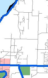
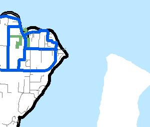


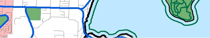
16 KITSAP COUNTY PUBLIC WORKS Non-Motorized Routes Roads Non-Motorized Route Concept Route Military Parks Reservation City Limits Urban Growth Areas Schools This map was created from existing map sources, not from field surveys. While great care was taken in using the most current map sources available, no warranties of any sort, including accuracy, fitness, or merchantability accompany this product. The user of this map assumes responsibility for determining its suitability for its intended use. * THIS MAP IS NOT A SUBSTITUTE FOR FIELD SURVEY * Routes through cities are limited to depict only those connecting to county routes. Miles 0 ½ June 6, 2018 µ Non-Motorized Facilities Plan - Exhibit A1


17 Trails Roads Route Concept Route Military Parks Reservation Schools City Limits Urban Growth Areas Kitsap Transit Ferry WSF C Ne Si Ka Bay n a l a Skunk Bay Port Gamble Port e r M a d i s o n Hansville EGLON RD µ P u g e t S o u n d H o o d Gamble Bay HANSVILLE RD HWY 3 HWY 104 MILLER BAY RD AppletreeCove Kingston a l BIG VALLEY RD GUNDERSON RD H o o d C a n Bangor CLEAR CREEK RD L i be rty B ay BOND RD Poulsbo LINCOLN RD TOTTEN RD M i l l B ay Indianola P ort M adison Bay HWY 308 VIKING WAY Dogfish Bay HWY 305 Agate Passage HWY 305 Bay NW ANDE SILVERDALE WAY Silverdale Non-Motorized Routes LLEY RD North Kitsap Keyport Bay nzanita Bainbridge Island This map was created from existing map sources, not from field surveys. While great care was taken in using the most current map sources available, no warranties of any sort, including accuracy, fitness, or merchantability accompany this product. The user of this map assumes responsibility for determining its suitability for its intended use. * THIS MAP IS NOT A SUBSTITUTE FOR FIELD SURVEY * Routes through cities are limited to depict only those connecting to county routes. Miles Rolling Bay Non-Motorized Facilities Plan - Exhibit A1


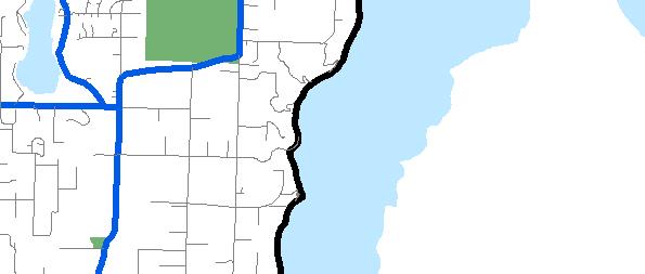
18 o n i s M d a Murden Stavis Bay r e e H l y Bay ANDERSON COVE Clam Bay TOTTEN RD e r t y B a y Passage Agate HWY 305 Ne Si Ka Bay VIKING WAY HWY 305 HWY 308 Dogfish Bay Bay SILVERDALE WAY Rolling Bay Manzanita Bay OGLE RD NE CENTRAL VALLEY RD Cove Burke Bay FAIRGROUNDS RD r d B a y r b o a H g l E a O r c h a ILLAHEE RD NE MCWILLIAMS RD y D e s I n l e t P o r t SYLVAN WAY a r b B l ak o r Passage Rich Port Phinney Bay B a y Washington Ostrich Bay Clam Bay P o r t O r c h a r d Narrows Oyster BEACH DR E Little HWY 3 I n l e t r c la i S i n MILE HILL DR H a r b o r k o n Y u LUND AVE Chico Bay NW ANDERSON HILL RD Big Beef Harbor B a y b e c k S e a NEWBERRY HILL RD SEABECK HWY SEABECK HOLLY RD STATE HWY 3 HOLLY RD GOLD CREEK RD W W BELFAIR VALLEY RD Trails Roads Route Concept Route Parks City Limits Urban Growth Areas Reservation Schools l C a n a Kitsap Transit Ferry WSF Gorst This map was created from existing map sources, not from field surveys. While great care was taken in using the most current map sources available, no warranties of any sort, including accuracy, fitness, or merchantability accompany this product. The user of this map assumes responsibility for determining its suitability for its intended use. * THIS MAP IS NOT A SUBSTITUTE FOR FIELD SURVEY * Routes through cities are limited to depict only those connecting to county routes. Silverdale Bainbridge Island Bremerton Miles µ Seabeck H o o d SEABECK HOLLY RD Holly Manchester Olalla Mason County Non-Motorized Routes Central Kitsap Port Orchard Non-Motorized Facilities Plan - Exhibit A1


19 Bay LittleClamBay Driftwood Cove SPRUCE RD Rich Passage Bay Clam Bay Port Orchard Narrows BEACH DR E MILE HILL DR Harbor kon Yu SE SEDGWICK RD BANNER RD LONG LAKE RD MULLENIX RD e sag OLALLA VALLEY RD olvos Pas C NELSON RD Port Phinney Bay Washington Ostrich Bay Oyster Bremerton HWY 3 Inlet r clai Sin GOLD CREEK RD W W BELFAIR VALLEY RD LUND AVE Gorst Port Orchard BETHEL RD OLD CLIFTON RD STATE HWY 3 SW Trails Roads LAKE FLORA RD BETHEL BURLEY RD GLENWOOD RD J M DICKENSON RD STATE HWY 16 LAKE HELENA RD Route Concept Route Military Parks City Limits Urban Growth Areas Reservation Schools Kitsap Transit Ferry WSF Pierce County This map was created from existing map sources, not from field surveys. While great care was taken in using the most current map sources available, no warranties of any sort, including accuracy, fitness, or merchantability accompany this product. The user of this map assumes responsibility for determining its suitability for its intended use. * THIS MAP IS NOT A SUBSTITUTE FOR FIELD SURVEY * Routes through cities are limited to depict only those connecting to county routes. Manchester Southworth Olalla Miles µ Mason County Non-Motorized Routes South Kitsap Non-Motorized Facilities Plan - Exhibit A1 Vashon Island HOLLY RD


20 KITSAP COUNTY PUBLIC WORKS Bike Route Numbering System «51 Bike Routes « «35 « «27 «64 «66 «35 «39 «31 «44 «33 «21 «39 «38 «29 «30 Roads Non-Motorized Route Concept Route Military Parks Reservation City Limits Urban Growth Areas Schools This map was created from existing map sources, not from field surveys. While great care was taken in using the most current map sources available, no warranties of any sort, including accuracy, fitness, or merchantability accompany this product. The user of this map assumes responsibility for determining its suitability for its intended use. * THIS MAP IS NOT A SUBSTITUTE FOR FIELD SURVEY * Routes through cities are limited to depict only those connecting to county routes. Miles 0 ½ June 6, 2018 «20 «43 «37 «47 «25 µ Non-Motorized Facilities Plan - Exhibit A2


21 - Exhibit A3 Trails Roads Route Concept Path Parks City Limits Urban Growth Areas Reservation Schools Kitsap Transit Ferry WSF H ood Gamble Bay STATE HWY 3 NE STATE HWY 104 Port µ STATE HWY 3 NE BIG VALLEY RD NE STATE HWY 104 BOND RD P o r t G a m b l e This map was created from existing map sources, not from field surveys. While great care was taken in using the most current map sources available, no warranties of any sort, including accuracy, fitness, or merchantability accompany this product. The user of this map assumes responsibility for determining its suitability for its intended use. * THIS MAP IS NOT A SUBSTITUTE FOR FIELD SURVEY * Routes through cities are limited to depict only those connecting to county routes. Miles


22 e r B Non-Motorized Facilities Plan - Exhibit A3 Trails Roads Route Concept Path Parks City Limits Urban Growth Areas Reservation STATE HWY 104 NE STATE HWY 104 PARCELLS RD LINDVOG RD Schools Kitsap Transit Ferry WSF MILLER BAY RD W. KINGSTON RD NORMAN RD AppletreeCove SOUTH KINGSTON RD Kingston µ INDIANOLA RD MILLER BAY RD S. KINGSTON RD Mi ll ay Indianola K i n g s t o n & I n d i a n o l a This map was created from existing map sources, not from field surveys. While great care was taken in using the most current map sources available, no warranties of any sort, including accuracy, fitness, or merchantability accompany this product. The user of this map assumes responsibility for determining its suitability for its intended use. * THIS MAP IS NOT A SUBSTITUTE FOR FIELD SURVEY * Routes through cities are limited to depict only those connecting to county routes. Miles


23 - Exhibit A3 OHIO AVE IOWA AVE LINDVOG RD WASHINGTON BLVD WEST KINGSTON RD 1ST ST Appletree STATE HWY 104 BARBER CUT OFF RD WEST KINGSTON RD NORMAN RD K i n g s t o n Trails Miles TE HWY 104 Roads Route Concept Path Parks City Limits Urban Growth Areas Reservation Schools Kitsap Transit Ferry WSF Kingston See Complete Streets Study µ This map was created from existing map sources, not from field surveys. While great care was taken in using the most current map sources available, no warranties of any sort, including accuracy, fitness, or merchantability accompany this product. The user of this map assumes responsibility for determining its suitability for its intended use. * THIS MAP IS NOT A SUBSTITUTE FOR FIELD SURVEY * Routes through cities are limited to depict only those connecting to county routes.


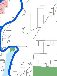
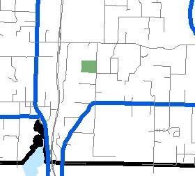
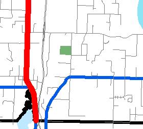
24 - Exhibit A3 Trails Roads Route Concept Path Parks City Limits Urban Growth Areas Reservation CLEAR CREEK RD µ Schools Kitsap Transit Ferry WSF SILVERDALE WAY RIDGETOP BLVD OLD FRONTIER RD GREAVES WAY STATE HWY 3 Silverdale PROVOST RD SILVERDALE WAY RIDGETOP BLVD BUCKLIN HILL RD WAAGA WAY C l e a r C r e e k T r a i l This map was created from existing map sources, not from field surveys. While great care was taken in using the most current map sources available, no warranties of any sort, including accuracy, fitness, or merchantability accompany this product. The user of this map assumes responsibility for determining its suitability for its intended use. * THIS MAP IS NOT A SUBSTITUTE FOR FIELD SURVEY * Routes through cities are limited to depict only those connecting to county routes. Miles


25 - Exhibit A3 Trails Roads Route Concept Path Parks City Limits Urban Growth Areas Reservation µ NEWBERRY HILL RD P Schools Kitsap Transit Ferry WSF PROVOST RD CHICO WAY SEABECK HWY HOLLY RD STATE HWY 3 Chico Ba Silverdale SEABECK HWY CHICO WAY NORTHLAKE WAY N e w b e r r y H i l l This map was created from existing map sources, not from field surveys. While great care was taken in using the most current map sources available, no warranties of any sort, including accuracy, fitness, or merchantability accompany this product. The user of this map assumes responsibility for determining its suitability for its intended use. * THIS MAP IS NOT A SUBSTITUTE FOR FIELD SURVEY * Routes through cities are limited to depict only those connecting to county routes. Miles


26 LittleClamBay Non-Motorized Facilities Plan - Exhibit A3 ge Trails Roads Route Concept Path Parks City Limits Urban Growth Areas Reservation Schools Kitsap Transit Ferry WSF Bay Port Orchard HILLDALE RD BEAVER CREEK RD BEACH DR Clam Bay D R BEACH CHESTER RD MADRONE AVE Manchester BABY DOLL RD MILE HILL DR COLLINS RD Silverdale WOODS RD CALIFORNIA AVE ALASKA AVE COLCHESTER DR µ M a n c h e s t e r This map was created from existing map sources, not from field surveys. While great care was taken in using the most current map sources available, no warranties of any sort, including accuracy, fitness, or merchantability accompany this product. The user of this map assumes responsibility for determining its suitability for its intended use. * THIS MAP IS NOT A SUBSTITUTE FOR FIELD SURVEY * Routes through cities are limited to depict only those connecting to county routes. Miles


27 BABY D Trails Roads Route Concept Path Parks MILE HILL DR City Limits Urban Growth Areas WOODS RD CALIFORNIA AVE ALASKA A COLCHESTER DR Non-Motorized Facilities Plan - Exhibit A3 Reservation Schools Yu kon Harbor Kitsap Transit Ferry WSF SOUTHWORTH DR SEDGWICK RD HARPER HILL RD Southworth LONG LAKE RD BANNER RD Driftwood Cove Silverdale MULLENIX RD OLALLA VALLEY RD e ag µ S o u t h w o r t h This map was created from existing map sources, not from field surveys. While great care was taken in using the most current map sources available, no warranties of any sort, including accuracy, fitness, or merchantability accompany this product. The user of this map assumes responsibility for determining its suitability for its intended use. * THIS MAP IS NOT A SUBSTITUTE FOR FIELD SURVEY * Routes through cities are limited to depict only those connecting to county routes. Miles
28 Placeholder For: SEPA Determination
29 Attachment B2
30 Attachment B2
31 Attachment B2
32 Attachment B2
33 Attachment B2
34 Attachment B2
35 Attachment B2
36 Attachment B2
37 Attachment B2
38 Attachment B2
39 Attachment B2
40 Attachment B2
41 Attachment B2
42 Attachment B2
43 Attachment B2
44 Attachment B2
45 Attachment B2
46 Non-motorized Map Proposed Changes Trails Roads Conceptual Route Add Route No Change in Route Remove Route Non-Motorized Facilities Plan - Exhibit C1
47 Attachment C2 Nancy Whitaker Chair Brian Watson Vice-Chair David Brumsickle Bert Cole Melissa Laird Ahmis Loving Ray Pardo Kathryn Thompson John Willett Background Kitsap County Non-Motorized Citizen Advisory Committee The Kitsap County Non-Motorized Facility Citizens Advisory Committee (Committee) has undertaken an extensive review of non-motorized routes, prioritization of routes, and prioritization of projects in The resulting proposed amendments to the Non- Motorized Facility Plan Route Map (NMP Route Map, attached) will be included in the County s Annual Comprehensive Plan Amendment Process for The prioritization process was used in project scoring during the 2017 Transportation Improvement Program (TIP) process. For the 2018 Annual Comprehensive Plan Amendment Process, the Board of County Commissioners have agreed to entertain Minor updates, administrative corrections, and the Kingston Community Trails amendment proposals to the Non-Motorized Facility Plan (NMP). The Kingston Citizens Advisory Committee (KCAC) has recommended inclusion of their Kingston Community Trails Plan (KCTP) into the NMP. The amendment process is limited to minor amendments, therefore; the Committee s review and recommendation will be limited to map amendments, no policy or substantive changes to the NMP will be eligible for this process. Committee review protocols: The KCTP basically presents a project list. Projects are evaluated as part of the Committee s Prioritization and TIP Process. For this review, each line item of the KCTP will be considered as a route or trail request. Review and recommendations of the KCTP are limited to inclusion (as a route or trail) on the NMP Route Map, NMP Kingston Map, NMP Indianola Map, and/or Elgon Trail Map. A route should Connect Communities or provide Connections Within Communities and be primarily a transportation facility (or planned facility) within a public right-of-way/easement or a Shared-Use-Path within a dedicated easement on private/public property. Routes are identified on the NMP Route Map. A trail is a fully or predominately recreational facility that can be formal or informal with varying designs. To be identified as a trial it must be open to the public for recreational purposes. If a trail does not have a secured alignment that is open to the public it can be shown as conceptual, depicting a general alignment between destinations. 1 P a g e
48 Attachment C2 Review of the KCTP will occur at the February meeting with a recommendation vote at the March meeting. The recommendation will advance to the Kitsap County Planning Commission and County Board of Commissions. The Planning Commission will be the public hearing of record. To organize and facilitate the review process Public Works staff has arranged and grouped the KCTP based on a staff action recommendation. The sections are color codes to assist in review. Table of Contents: No Action Recommendations The proposed route is identified on the NMP Route Map or appropriate location map. Kingston Map Change Recommendations Indianola Map Change Recommendations NMP Route Map & Elgon Trail Map Change Recommendations No Change Recommendations Kingston Community Trails Plan... 3 Kingston Community Trails Plan Map (North)... 4 Kingston Community Trails Plan Map (South)... 5 No Action Recommendations... 6 NMP Kingston Map Kingston Map Change Recommendations NMP Indianola Map Indianola Map Change Recommendations NMP Elgon Trail Map NMP Route Map & Elgon Trail Map Change Recommendations No Change Recommendations NMP Route Map... Sent separately & 23 2 P a g e

49 Attachment C2 Kingston Community Trails Plan 3 P a g e
50 Kingston Community Trails Plan Map (North) Non-Motorized Facilities Plan Attachment C2 4 P a g e
51 Kingston Community Trails Plan Map (South) Non-Motorized Facilities Plan Attachment C2 5 P a g e
 Sound to Olympics Trail (C13) West Kingston Road Sidewalk Staff Recommendation: No action. Routes are identified in the NMP Route Map and Road Design Standards.")
52 Attachment C2 No Action Recommendations #12 (C6) High School to Middle School Sidewalks along West Kingston Road #14 (C1) Miller Bay Rd Shoulders: West Kingston to Georges Corner Hwy 104 #20 (S6) Sound to Olympics Trail (C13) West Kingston Road Sidewalk Staff Recommendation: No action. Routes are identified in the NMP Route Map and Road Design Standards. 6 P a g e
 Carpenter Lake Reserve Access Trail, #17.")
 Nike Park Trails, Staff Recommendation: No action.")
53 Attachment C2 No Action Recommendations #10 (C3) Kingston Schools Community Trail System, #17 (C7) Carpenter Lake Reserve Access Trail, #17.1 (C4) Carpenter Lake Nature Trail, #18 (C9) Stillwaters & Salt Marsh trail system, (C2) Nike Park Trails, Staff Recommendation: No action. Recreational Trails are identified in NMP Kingston Map. 7 P a g e

54 Attachment C2 No Action Recommendations (N4) GPC/PUD Trail System (N6) Quite Place Park Trails Staff Recommendation: No action. Trails are identified in NMP Kingston Map. 8 P a g e

55 Attachment C2 No Action Recommendations #19 (C14) Norman Rd. Shoulders for access to Kingston-Indianola Non-Motorized Route (C15) Construct parking area along Norman Rd. for trail users Staff Recommendation: No action. Route is identified in NMP Route Map and Road Design Standards. Staff Recommendation: No action. Refer parking lot to Parks Department. 9 P a g e
56 Attachment C2 No Action Recommendations #21 (S2) Kingston-Indianola Trail and Connections #22 (S3) Miller Bay Estates Access into North Kitsap Heritage Park (S4) South Kingston Road Access to NK Heritage Park Staff Recommendation: No Action. Trials are identified on NMP Indianola Map Staff Recommendation: No Action. Refer park access to Parks Department. 10 P a g e

57 Attachment C2 11 P a g e
 NE 2nd Street sidewalks: Central Ave to")
 Washington Blvd Trail: North Beach/2nd St.")

")


58 Attachment C2 Kingston Map Change Recommendations #1 (C17) NE 2nd Street sidewalks: Central Ave to Washington Blvd. #4 (N10) Washington Blvd Trail: North Beach/2nd St. to 4th St #7 (N15) SR 104 Sidewalks from NE 2nd Street to Lindvog Staff Recommendation: No action. Facility type and improvements are identified in the Kingston Complete Streets Plan (1A-B, 15, 10, & 18) and Kingston Design Standards. Staff Recommendation: NMP Kingston Map change. Add reference to See Kingston Complete Streets to Kingston Map. Delete Washington Blvd and Bannister graphics. Both streets are addressed in Kingston Complete Streets. 12 P a g e


59 Attachment C2 Kingston Map Change Recommendations #6 (N3) Parcells Road to Lindvog Road Link Trail (N7) Shorty Campbell to 272 Street Connector Trail (N9) 272nd Street Lindvog Road NE to Ohio Avenue Staff Recommendation: NMP Kingston Map change. The western portion of the trail is within the Shorty Campbell Rd. ROW. The central portion would be an extension of 277 th St. and has no existing ROW or county road easements. The eastern portion is within the 277th St. ROW. Add Conceptual Recreation Trail linking Parcells Road and Ohio Ave. Alignment is not specified and may require agreements with private property owner for access. 13 P a g e
 Kingston Hills to Gordon Elementary Staff Recommendation: NMP Kingston Map change. The trail is partly identified on the NMP Kingston Map.")

60 Attachment C2 Kingston Map Change Recommendations #15 (C12) Village Green connectors and walking trails #16 (11) Kingston Hills to Lindvog Connector Trail: via Barrett Rd to Skate Park #16.1 (C10) Kingston Hills to Gordon Elementary Staff Recommendation: NMP Kingston Map change. The trail is partly identified on the NMP Kingston Map. However, the trail crosses developed private property and there is not consensus on the alignment. The intent is a recreational connection between the isolated subdivisions and connections to Barber Cutoff Road and Lindvog Road. NMP Kingston Map changes: Delete existing trail and Lindvog Rd. graphics. Add Conceptual Recreation Route linking Lindvog Rd. to Barret, Barret to Montana Loop and Simon Pl. Add Conceptual Recreation Trail linking Barber Cutoff Road, Lindvog Road, and Village Green. Alignment is not specified and may require agreements with private property owner for access. 14 P a g e
 4 th Street Trail from")


61 Attachment C2 Kingston Map Change Recommendations #2 (N8) 4 th Street Trail from Pennsylvania Ave to Washington Ave #2 (N5) 4 th Street Trail from Pennsylvania Ave to Washington Ave. Staff Recommendation: NMP Kingston Map change. The proposed route is a combination of improved and unimproved ROW and is predominantly identified on the NMP Kingston Map. NMP Kingston Map changes: Add the remaining identified trail within the unimproved ROW, including the addition of a portion of Ohio Ave. and extension to Pennsylvania Avenue. Identify trail as a Existing Open Trail Delete Washington Boulevard graphics. 15 P a g e

62 Attachment C2 16 P a g e

63 Attachment C2 Indianola Map Change Recommendations #23 (S5) Indianola Woodland Preserve connection to NKHP Staff Recommendation: NMP Indianola Map Change. Add Conceptual Recreation Trail linking Indianola Preserve and North Kitsap Heritage Park. Alignment is not specified and may require agreements with private property owner for access. 17 P a g e

64 Attachment C2 18 P a g e
, #9 (N1) Eglon to Little Boston Route, #9.")
 Parcel Road: construct sidewalk or paved walkway with fog lines Staff Recommendation: NMP")

65 Attachment C2 NMP Route Map & Elgon Trail Map Change Recommendations #8 (N2) Kingston to Eglon Trail (via Parcells Rd.), #9 (N1) Eglon to Little Boston Route, #9.1 (C16) Barber CutOff Road, North Shoulders, #11 (C5) Gordon Elementary School Sidewalks along Barber Cutoff Road #13 (C8) Hwy 104 Cross walk at Parcells Road / Barber Cutoff (N13) Parcel Road: construct sidewalk or paved walkway with fog lines Staff Recommendation: NMP Route Map and Eglon Trail map changes. The Elgon Trail is identified in the NMP Eglon trails to Kingston sub area map. The NMP map identifies a Conceptual Route representing the trail. NMP Route Map and Elgon Trial Map changes: Delete Conceptual Route graphics. Add Route linking: o Barber Cutoff o Parcells Rd. o DNR trails o Parts of Hoffman Rd. o Eglon Rd. o Parts of Little Boston 19 P a g e
 Seatter Road, Tulin Road & Klabo Road shoulders; Add Fog Line (New) South Kingston Road Shoulder, White Horse to West Kingston Rd. Staff Recommendation: No change.")
66 Attachment C2 No Change Recommendations #24 (S8) Jefferson Point Road: Extend shoulders to Jefferson Beach Estates #25 (S10) South Kingston Road Shoulders, Jeff Pt Rd. to West Kingston Rd (S9) Seatter Road, Tulin Road & Klabo Road shoulders; Add Fog Line (New) South Kingston Road Shoulder, White Horse to West Kingston Rd. Staff Recommendation: No change. The Committee has previously considered South Kingston and Jefferson Roads for inclusion in the NMP Routes Map. During the NM prioritization process, a Jefferson Road project to add shoulders to the road was reviewed and listed as a low priority. Facility standards are established for rural and urban areas in the Road Design Standards. Projects are identified through the Transportation Improvement Plan (TIP) process. 20 P a g e


67 Attachment C2 No Change Recommendations #3 (N12) Ohio Avenue sidewalks or walkways & paint fog lines, (N14) Lindvog Road Hwy 104 to Apple Tree Point: Construct sidewalks or paved walkway with fog line Staff Recommendation: No change. The Committee has previously reviewed routes for addition to the NMP Routes Map. Neither Ohio or Lindvog were considered for inclusion. Facility standards are established for rural and urban areas in the Road Design Standards. Projects are identified through the Transportation Improvement Plan (TIP) process. 21 P a g e


68 Attachment C2 No Change Recommendations #27 (N11) Gamblewood Connector Route: Sidewalks or trails 288th Staff Recommendation: No change. The Committee has previously reviewed 288 th for addition to the NMP Routes Map and it was not selected. Facility standards are established for rural and urban areas in the Road Design Standards. Projects are identified through the Transportation Improvement Plan (TIP) process. 22 P a g e
Kitsap County Non-Motorized Citizen Advisory Committee
 Nancy Whitaker Chair Brian Watson Vice-Chair David Brumsickle Bert Cole Melissa Laird Ahmis Loving Ray Pardo Kathryn Thompson John Willett Background Kitsap County Non-Motorized Citizen Advisory Committee
ACTIVE TRANSPORTATION/NONMOTORIZED TRANSPORTATION
 ACTIVE TRANSPORTATION/NONMOTORIZED TRANSPORTATION BACKGROUND Active transportation, also known as nonmotorized transportation, is increasingly recognized as an important consideration when planning and
Exhibit 1 PLANNING COMMISSION AGENDA ITEM
 Exhibit 1 PLANNING COMMISSION AGENDA ITEM Project Name: Grand Junction Circulation Plan Grand Junction Complete Streets Policy Applicant: City of Grand Junction Representative: David Thornton Address:
Chapter 5 Future Transportation
 Chapter 5 Future Transportation The Future Land Use Plan identifies the desired land use designations. The land uses desired for Crozet depend, in large part, on the success of the transportation system,
Perryville TOD and Greenway Plan
 Perryville TOD and Greenway Plan Greenway Glossary Pathway: A bicycle and pedestrian path separated from motorized vehicular traffic by an open space, barrier or curb. Multi-use paths may be within the
Section 9. Implementation
 Section 9. Implementation The transportation system is just one of many aspects that must be carefully planned to maintain and enhance the quality of living in Cecil County. The Cecil County Bicycle Plan
West Dimond Blvd Upgrade Jodhpur Street to Sand Lake Road
 West Dimond Blvd Jodhpur St to Sand Lake CSS Transportation Project Summary Municipality of Anchorage Project # 05 005 Project Manager: John Smith, P.E. (MOA PM&E) Project Administrator: Julie Makela,
APPROVE A RESOLUTION ADOPTING A COMPLETE STREETS POLICY
 STAFF REPORT MEETING DATE: September 13, 2016 TO: FROM: City Council Bob Brown, Community Development Director Russ Thompson, Public Works Director Patrick Filipelli, Management Analyst 922 Machin Avenue
BETHEL ROAD AND SEDGWICK ROAD CORRIDOR STUDY
 DRAFT PLAN City Council Meeting August 14, 2017 STUDY AREA Sedgwick Corridor State Route 160, principal arterial with Class 3 access management designation, commuter and freight route, connection to SR
Street Paving and Sidewalk Policy
 City Commission Policy 600 Street Paving and Sidewalk Policy DEPARTMENT: Public Works DATE ADOPTED: June 7, 1995 DATE OF LAST REVISION: December 10, 2014 Policy No. 600.01 AUTHORITY: PASS City of Tallahassee-Leon
Corpus Christi Metropolitan Transportation Plan Fiscal Year Introduction:
 Introduction: The Safe, Accountable, Flexible, Efficient Transportation Equity Act: A Legacy for Users (SAFETEA-LU) has continued the efforts started through the Intermodal Surface Transportation Efficiency
RZC Appendix 8A Marymoor Subarea Street Requirements
 RZC Appendix 8A Marymoor Subarea Street Requirements For additional design details for Marymoor Subarea infrastructure, refer to the 2017 Marymoor Subarea Infrastructure Planning Report. STREET REQUIREMENTS
ACTIVE TRANSPORTATION
 ACTIVE TRANSPORTATION Mobility 2040 Supported Goals Improve the availability of transportation options for people and goods. Support travel efficiency measures and system enhancements targeted at congestion
o n - m o t o r i z e d transportation is an overlooked element that can greatly enhance the overall quality of life for the community s residents.
 N o n - m o t o r i z e d transportation is an overlooked element that can greatly enhance the overall quality of life for the community s residents. 84 Transportation CHAPTER 11 INTRODUCTION Transportation
Clackamas County Comprehensive Plan
 ROADWAYS The County s road system permits the movement of goods and people between communities and regions, using any of a variety of modes of travel. Roads provide access to virtually all property. They
MAG Town of Cave Creek Bike Study Task 6 Executive Summary and Regional Significance Report
 Page 1 MAG Town of Cave Creek Bike Study Task 6 Executive Summary and Regional Significance Report August 1, 2012 MAG Project #481 Page 2 Task 6 Executive Summary and Regional Significance Report Introduction
Bicycle Master Plan Goals, Strategies, and Policies
 Bicycle Master Plan Goals, Strategies, and Policies Mobilizing 5 This chapter outlines the overarching goals, action statements, and action items Long Beach will take in order to achieve its vision of
NM-POLICY 1: Improve service levels, participation, and options for non-motorized transportation modes throughout the County.
 Transportation PRINCE WILLIAM COUNTY 2008 COMPREHENSIVE PLAN NON-MOTORIZED PLAN CONTENTS Goals, Policies, and Action Strategies Table 4 (Bike Facility Classifications and Descriptions) Table 5 (Bike Facility
Basalt Creek Transportation Refinement Plan Recommendations
 Basalt Creek Transportation Refinement Plan Recommendations Introduction The Basalt Creek transportation planning effort analyzed future transportation conditions and evaluated alternative strategies for
CITY OF COCOA BEACH 2025 COMPREHENSIVE PLAN. Section VIII Mobility Element Goals, Objectives, and Policies
 CITY OF COCOA BEACH 2025 COMPREHENSIVE PLAN Section VIII Mobility Element Goals, Objectives, and Policies Adopted August 6, 2015 by Ordinance No. 1591 VIII MOBILITY ELEMENT Table of Contents Page Number
2.0 Existing Conditions
 20 2.0 Existing Conditions 2.1 Land Use, Future Growth Patterns, Physical Barriers Geographic Overview Sutter County s land use pattern is characterized by extensive agricultural areas, significant natural
5 CIRCULATION AND STREET DESIGN
 5 CIRCULATION AND STREET DESIGN This chapter describes circulation and streetscape improvements proposed for the Northwest Chico Specific Plan Area. It includes detailed design specifications for existing
University of Victoria Campus Cycling Plan Terms of Reference. 1.0 Project Description
 University of Victoria Campus Cycling Plan Terms of Reference 1.0 Project Description The Campus Cycling Plan, a first for the University, will provide a comprehensive and coordinated approach to support
Executive Summary Route 30 Corridor Master Plan
 Route Corridor Master Plan Project Overview The Route Corridor Master Plan is a coordinated multimodal transportation and land use plan for the entire stretch of Route through East Whiteland Township,
TABLE OF CONTENTS. Executive Summary
 Executive Summary Background... ES-1 Pedestrian Network... ES-2 Bikeway Network... ES-2 Collision History... ES-2 Public Input... ES-4 Conclusions and Recommendations... ES-4 1. Introduction and Setting
CITY OF BLOOMINGTON COMPLETE STREETS POLICY
 CITY OF BLOOMINGTON COMPLETE STREETS POLICY POLICY OBJECTIVE: The City of Bloomington will enhance safety, mobility, accessibility and convenience for transportation network users of all ages and abilities,
Kelowna On the Move. Pedestrian and Bicycle Master Plan
 Kelowna On the Move Pedestrian and Bicycle Master Plan Executive Summary April 2016 Purpose of the Plan The Pedestrian and Bicycle Master Plan identifies infrastructure, planning, and policy requirements
TOWN OF PORTLAND, CONNECTICUT COMPLETE STREETS POLICY
 TOWN OF PORTLAND, CONNECTICUT COMPLETE STREETS POLICY I. VISION, GOALS & PRINCIPLES VISION To improve the streets of Portland making them safer and more accessible for all users including pedestrians,
May 12, 2016 Metro Potential Ballot Measure Issue Brief: Local Return
 Summary: Local return is an important revenue source for cities to maintain their local transportation infrastructure. Most cities use their local return to operate small bus systems and repave streets,
Living Streets Policy
 Living Streets Policy Introduction Living streets balance the needs of motorists, bicyclists, pedestrians and transit riders in ways that promote safety and convenience, enhance community identity, create
City of Novi Non-Motorized Master Plan 2011 Executive Summary
 City of Novi Non-Motorized Master Plan 2011 Executive Summary Prepared by: February 28, 2011 Why Plan? Encouraging healthy, active lifestyles through pathway and sidewalk connectivity has been a focus
Gordon Proctor Director Policy on Accommodating Bicycle and Pedestrian Travel on ODOT Owned or Maintained Facilities
 Approved: Policy: 20-004(P) Responsible Office: Planning Gordon Proctor Director Policy on Accommodating Bicycle and Pedestrian Travel on ODOT Owned or Maintained Facilities I. POLICY STATEMENT: This policy
RESOLUTION NO ?? A RESOLUTION OF THE CITY OF NEPTUNE BEACH ADOPTING A COMPLETE STREETS POLICY
 RESOLUTION NO. 2018-?? A RESOLUTION OF THE CITY OF NEPTUNE BEACH ADOPTING A COMPLETE STREETS POLICY WHEREAS, safe, convenient, and accessible transportation for all users is a priority of the City of Neptune
GOAL 2A: ESTABLISH AND MAINTAIN A SAFE, CONVENIENT, AND EFFICIENT MULTI-MODAL TRANSPORTATION SYSTEM TO MOVE PEOPLE AND GOODS THROUGHOUT THE CITY.
 2. TRANSPORTATION ELEMENT The purpose of this element is to assist in establishing an adequate transportation system within the City and to plan for future motorized and non-motorized traffic circulation
Complete Streets for Louisiana
 Complete Streets for Louisiana Louisiana Transportation Conference 2011 Ellen W. Soll, AICP Planner Burk-Kleinpeter, Inc esoll@bkiusa.com 504.486.5901 x143 What is a Complete Street? What are Complete
Circulation in Elk Grove includes: Motor vehicles, including cars and trucks
 Circulation, as it is used in this General Plan, refers to the many ways people and goods move from place to place in Elk Grove and the region. Circulation in Elk Grove includes: Motor vehicles, including
APPENDIX G: INTERSECTION NEEDS AT OKEECHOBEE BOULEVARD
 APPENDIX G: INTERSECTION NEEDS AT OKEECHOBEE BOULEVARD INTERSECTION NEEDS AT SR 7 and OKEECHOBEE BOULEVARD SR 7 Extension Project Development and Environment (PD&E) Study From Okeechobee Boulevard (SR
CONNECTING PEOPLE TO PLACES
 CONNECTING PEOPLE TO PLACES 82 EAST BENCH MASTER PLAN 07 Introduction The East Bench transportation system is a collection of slow moving, treelined residential streets and major arteries that are the
City of Charlottesville Bicycle and Pedestrian Master Plan Update
 City of Charlottesville Bicycle and Pedestrian Master Plan Update September 17, 2014 I. Welcome and meeting overview II. Project status update III. Network overview IV. Break-out groups Pedestrian Network
VDOT BICYCLE & PEDESTRIAN IMPLEMENTATION GUIDE FOR LOCALITY INVOLVEMENT April 2017
 VDOT BICYCLE & PEDESTRIAN IMPLEMENTATION GUIDE FOR LOCALITY INVOLVEMENT April 2017 1 TABLE OF CONTENTS Topic Page(s) About this Guide 3 Encouraging development of bicycle and pedestrian plans by localities
Chapter 14 PARLIER RELATIONSHIP TO CITY PLANS AND POLICIES. Recommendations to Improve Pedestrian Safety in the City of Parlier (2014)
") Chapter 14 PARLIER This chapter describes the current status and future plans for biking and walking in the City of Parlier. RELATIONSHIP TO CITY PLANS AND POLICIES The Parlier General Plan is the primary
Chapter 14 PARLIER This chapter describes the current status and future plans for biking and walking in the City of Parlier. RELATIONSHIP TO CITY PLANS AND POLICIES The Parlier General Plan is the primary
SANTA CLARA COUNTYWIDE BICYCLE PLAN August 2008
 SANTA CLARA COUNTYWIDE BICYCLE PLAN August 2008 To assist VTA and Member Agencies in the planning, development and programming of bicycle improvements in Santa Clara County. Vision Statement To establish,
C C C
 C-012-001 Thank you for your support for the creation of new public space and nonmotorized access between downtown and the waterfront through the Overlook Walk, the East-West Connections, and the Promenade.
Item No. 14 Town of Atherton
 Item No. 14 Town of Atherton CITY COUNCIL STAFF REPORT CONSENT AGENDA TO: THROUGH: FROM: HONORABLE MAYOR AND CITY COUNCIL GEORGE RODERICKS, CITY MANAGER MICHAEL KASHIWAGI, COMMUNITY SERVICES DIRECTOR MARTY
12 RECOMMENDATIONS Road Improvements. Short Term (generally the next five years)
") 12 RECOMMENDATIONS Recommendations are based on the technical analysis of existing and future road and active transportation conditions, the results of the review of existing City policies and public feedback.
12 RECOMMENDATIONS Recommendations are based on the technical analysis of existing and future road and active transportation conditions, the results of the review of existing City policies and public feedback.
Appendix A. Road Classification Review of Outstanding Issues and Proposed Classifications (All Wards) Staff Report Road Classification System
 Staff Report Road Classification System") Appendix A Road Classification Review of Outstanding Issues and Proposed Classifications (All Wards) Staff Report 2000 A.1 of A.10 A.2 of A.10 STAFF REPORT January 26, 2000 To: From: Works Committee Barry
Appendix A Road Classification Review of Outstanding Issues and Proposed Classifications (All Wards) Staff Report 2000 A.1 of A.10 A.2 of A.10 STAFF REPORT January 26, 2000 To: From: Works Committee Barry
Omaha s Complete Streets Policy
 Omaha s Complete Streets Policy (Adopted August 2015) VISION To create great places and enhance our quality of life, the City of Omaha will provide safe, accessible streets for all users. Complete Streets
2. TRANSPORTATION ELEMENT.
 2. TRANSPORTATION ELEMENT. The purpose of this element is to assist in establishing an adequate transportation system within the City and to plan for future motorized and non-motorized traffic circulation
This page intentionally left blank.
 This page intentionally left blank. COMMUNITY Glenpool Community Overview Glenpool Glenpool is a city of nearly 12,000 residents located in Tulsa County southwest of Tulsa and Jenks. The city is growing
This page intentionally left blank.
 This page intentionally left blank. COMMUNITY Coweta Community Overview Coweta Coweta, a residential community located in Wagoner County, is a suburb of Tulsa situated southeast of the metropolitan area
TxDOT Bicycle Tourism Trails Study Update. April 2017 BAC Meeting April 10, 2017
 AGENDA ITEM 6 TxDOT Bicycle Tourism Trails Study Update April 2017 BAC Meeting April 10, 2017 Agenda Approval of interim products o Present study vision statement, goals, and study objectives o Present
Safe Streets. City of Lake Forest Park. March 21, 2017
 Safe Streets City of Lake Forest Park March 21, 2017 1 01 WELCOME 2 Agenda WELCOME WHAT IS THIS PROJECT? CONTEXT DRAFT CITYWIDE PROJECTS EXERCISE INTRODUCTION 3 02 WHAT IS THIS PROJECT? 4 WHAT IS THIS
Madison Urban Area and Dane County. Bicycle Transportation Plan Summary. September Introduction. Bicycle Plan Scope and Planning Process
 Bicycle Transportation Plan Summary Madison Urban Area and Dane County Introduction September 2000 Bicycling is an important mode of transportation in the Madison urban area and countywide that is available
Proposed. City of Grand Junction Complete Streets Policy. Exhibit 10
 Proposed City of Grand Junction Complete Streets Policy Exhibit 10 1 City of Grand Junction Complete Streets Policy Vision: The Complete Streets Vision is to develop a safe, efficient, and reliable travel
Implementing Complete Streets in Ottawa. Project Delivery Process and Tools Complete Streets Forum 2015 October 1, 2015
 Implementing Complete Streets in Ottawa October 1, 2015 The Essentials Complete Streets Implementation Framework will become part of the routine delivery of City transportation projects Approach uses every
KITSAP COUNTY NON-MOTORIZED FACILITY PLAN
 KITSAP COUNTY NON-MOTORIZED FACILITY PLAN MAPS AMENDED DECEMBER 11, 2018 ADOPTED: DECEMBER 2, 2013 Kitsap County Board of County Commissioners Kitsap County Non-Motorized Facility Plan 1 ACKNOWLEDGEMENTS
AGENDA ITEM NO. 5b HCAOG TAC meeting of May 8, 2014
 Humboldt County Association of Governments Eureka, CA, 95501 AGENDA ITEM NO. 5b HCAOG TAC meeting of May 8, 2014 DATE: May 1, 2014 TO: HCAOG Technical Advisory Committee (TAC) FROM:, SUBJECT: Letters of
Improve the livability of our streets by
 Pedestrian and Traffic Calming Policy March 2018 2 of 6 Neighborhood Traffic Calming Policy The City of Aspen continually strives to protect multimodal function while maintaining a high standard of safety.
General Plan Circulation Element Update Scoping Meeting April 16, 2014 Santa Ana Senior Center, 424 W. 3rd Street, Santa Ana, CA 92701
 General Plan Circulation Element Update Scoping Meeting April 16, 2014 Santa Ana Senior Center, 424 W. 3rd Street, Santa Ana, CA 92701 Meeting Agenda 1. Purpose of Scoping Meeting 2. Project Overview 3.
4. Mobility and Transportation Element. Page Bikes and Pedestrians
 Below are the specific General Plan text changes proposed for A-16-015 and the proposed changes to Figure MT-2 Paths and Trails. In general changes consist of removing references to the Bicycle, Pedestrian
CHAPTER 1 INTRODUCTION
 CHAPTER 1 INTRODUCTION Chapter Table of Contents THE 2017 HOUSTON BIKE PLAN 1-1 HOUSTON BIKEWAYS PROGRAM 1-2 HISTORY OF BICYCLE PLANNING IN HOUSTON 1-3 BICYCLE LEVEL OF COMFORT 1-3 EXISTING PLANS, PROGRAMS
NOTICE OF AVAILABILITY/NOTICE OF COMMENT PERIOD OF A DRAFT EIR/EIS/EIS FOR PUBLIC REVIEW AND HEARINGS
 Tahoe Transportation District 128 Market Street, Suite 3F Stateline, NV 89449 Phone: (775) 589-5500 www.tahoetransportation.org Federal Highway Administration 650 Capitol Mall, Suite 4-100 Sacramento,
4. ENVIRONMENTAL IMPACT ANALYSIS 9. TRANSPORTATION AND TRAFFIC
 4. ENVIRONMENTAL IMPACT ANALYSIS 9. TRANSPORTATION AND TRAFFIC 4.9.1 INTRODUCTION The following section addresses the Proposed Project s impact on transportation and traffic based on the Traffic Study
WALKNBIKE DRAFT PLAN NASHVILLE, TENNESSEE EXECUTIVE SUMMARY NASHVILLE, TENNESSEE
 NASHVILLE, TENNESSEE EXECUTIVE SUMMARY Executive Summary A world-class multi-modal transportation system is essential to a vibrant city and better quality of life. -Mayor Barry The WalknBike plan aims
PROJECT KEY TYPICAL SECTION 1 =60
 6 WASHINGTON BLVD - BETWEEN NE 1ST ST AND NE 3RD ST Washington Boulevard is a low volume, low speed one-way road, signed for no street between NE 1st Street and NE 2nd Street, and closed to traffic between
Developing a Bike/Pedestrian Plan Using ArcInfo and Public Participation Rob Shumowsky, Madison County Council of Governments
 Developing a Bike/Pedestrian Plan Using ArcInfo and Public Participation Rob Shumowsky, Madison County Council of Governments Abstract: The Madison County Council of Governments is creating a bike/pedestrian
PRINCE GEORGE S PLAZA METRO AREA PEDESTRIAN PLAN
 PRINCE GEORGE S PLAZA METRO AREA PEDESTRIAN PLAN May 28, 2008 Agenda Welcome and introductions Project overview and issue identification Planning context and strengths Design challenges and initial recommendations
Portland International Airport Bicycle and Pedestrian Plan (October 2003) Staff Acknowledgements
 Staff Acknowledgements") Portland International Airport Bicycle and Pedestrian Plan (October 2003) Staff Acknowledgements Scott King, Senior Aviation Planner Jason Gately, Senior Aviation Planner Preston Beck, Associate Planner
Portland International Airport Bicycle and Pedestrian Plan (October 2003) Staff Acknowledgements Scott King, Senior Aviation Planner Jason Gately, Senior Aviation Planner Preston Beck, Associate Planner
SAN FRANCISCO MUNICIPAL TRANSPORTATION AGENCY
 THIS PRINT COVERS CALENDAR ITEM NO. : 10.3 DIVISION: Sustainable Streets Division BRIEF DESCRIPTION: SAN FRANCISCO MUNICIPAL TRANSPORTATION AGENCY Approving traffic and parking modifications to install
City of Hamilton s Transportation Master Plan (TMP) Public Consultation 3 December 2015
 Public Consultation 3 December 2015") City of Hamilton s Transportation Master Plan (TMP) Public Consultation 3 December 2015 McPhail Transportation Planning Services Ltd. AGENDA 6:00 7:00 pm Viewing Boards / Q & A with the Team 7:00 7:50
City of Hamilton s Transportation Master Plan (TMP) Public Consultation 3 December 2015 McPhail Transportation Planning Services Ltd. AGENDA 6:00 7:00 pm Viewing Boards / Q & A with the Team 7:00 7:50
This Chapter sets forth the minimum design, technical criteria and specifications to be used in the preparation of all roadway plans.
 4.1 GENERAL This Chapter sets forth the minimum design, technical criteria and specifications to be used in the preparation of all roadway plans. These Roadway Standards are for new construction and modification
5.0 Roadway System Plan
 Southwest Boise Transportation Study Page 16 5.0 Roadway System Plan The Roadway System Plan outlines roadway improvements in the Initial Study Area. It forecasts future deficiencies on the arterial system,
APPENDIX 2 LAKESHORE ROAD TRANSPORTATION REVIEW STUDY EXECUTIVE SUMMARY
 APPENDIX 2 LAKESHORE ROAD TRANSPORTATION REVIEW STUDY EXECUTIVE SUMMARY Appendix 2 City of Mississauga Lakeshore Road FINAL REPORT Transportation Review Study December 2010 EXECUTIVE SUMMARY Study Purpose
Zlatko Krstulich, P.Eng. City of O9awa
 Zlatko Krstulich, P.Eng. City of O9awa 1. Introduction to the Ontario Traffic Manual Series 2. What is OTM Book 18: Bicycle Facilities? 3. Study / Committee Team Members 4. Brief overview of the content
RESOLUTION NO A RESOLUTION OF THE CITY COUNCIL OF THE CITY OF MENLO PARK ADOPTING A COMPLETE STREETS POLICY
 RESOLUTION NO. 6123 A RESOLUTION OF THE CITY COUNCIL OF THE CITY OF MENLO PARK ADOPTING A COMPLETE STREETS POLICY WHEREAS, the term Complete Streets describes a comprehensive, integrated transportation
Environment and Public Works Committee Presentation
 Mixed Use Centers Complete Streets Guidelines Project Environment and Public Works Committee Presentation December 10, 2008 Project Objectives: Conduct an inter-departmental and agency process to study
APPENDIX A: Complete Streets Checklist DRAFT NOVEMBER 2016
 APPENDIX A: Complete Streets Checklist DRAFT NOVEMBER 2016 Complete Streets Checklist MetroPlan Orlando s Complete Streets Checklist is an internal planning tool for staff to further implementation of
I-90 ALLSTON INTERCHANGE A MULTIMODAL TRANSPORTATION PROJECT MEPA CONSULTATION MEETING NOVEMBER 20, 2014 BRIGHTON HIGH SCHOOL
 I-90 ALLSTON INTERCHANGE A MULTIMODAL TRANSPORTATION PROJECT MEPA CONSULTATION MEETING NOVEMBER 20, 2014 BRIGHTON HIGH SCHOOL Today s Agenda 1. 2. 3. 4. 5. Overview of the MEPA Process Project Overview
Solana Beach Comprehensive Active Transportation Strategy (CATS)
") Solana Beach Comprehensive Active Transportation Strategy (CATS) 3.0 Goals & Policies The Solana Beach CATS goals and objectives outlined below were largely drawn from the Solana Beach Circulation Element
Solana Beach Comprehensive Active Transportation Strategy (CATS) 3.0 Goals & Policies The Solana Beach CATS goals and objectives outlined below were largely drawn from the Solana Beach Circulation Element
CITY OF GRAND JUNCTION URBAN TRAILS COMMITTEE 2017 ANNUAL REPORT
 CITY OF GRAND JUNCTION URBAN TRAILS COMMITTEE 2017 ANNUAL REPORT INTRODUCTION INTRODUCTION Resolution No. 48 94 created the Grand Junction Trails Board in 1994 as a subcommittee of the Riverfront Commission
Chapter 7. Transportation. Transportation Road Network Plan Transit Cyclists Pedestrians Multi-Use and Equestrian Trails
 Chapter 7 Transportation Transportation Road Network Plan Transit Cyclists Pedestrians Multi-Use and Equestrian Trails 7.1 TRANSPORTATION BACKGROUND The District of Maple Ridge faces a number of unique
SAN FRANCISCO MUNICIPAL TRANSPORTATION AGENCY
 THIS PRINT COVERS CALENDAR ITEM NO. : 11 DIVISION: Sustainable Streets BRIEF DESCRIPTION: SAN FRANCISCO MUNICIPAL TRANSPORTATION AGENCY Approving traffic modifications on Twin Peaks Boulevard between Christmas
The Florida Bicycle and Pedestrian Partnership Council
 The Florida Bicycle and Pedestrian Partnership Council Input to the Update of the Florida Transportation Plan March 2015 This document presents input from the Florida Bicycle and Pedestrian Advisory Council
MEETING OF THE CITY OF CONCORD BICYCLE, PEDESTRIAN AND SAFE ROUTES TO TRANSIT PLAN ADVISORY COMMITTEE AGENDA
 MEETING OF THE CITY OF CONCORD BICYCLE, PEDESTRIAN AND SAFE ROUTES TO TRANSIT PLAN ADVISORY COMMITTEE Monday, April 25, 2016 5:30 p.m., Regular Meeting PERMIT CENTER CONFERENCE ROOM 1950 Parkside Drive,
Agenda. Overview PRINCE GEORGE S PLAZA METRO AREA PEDESTRIAN PLAN
 PRINCE GEORGE S PLAZA METRO AREA PEDESTRIAN PLAN May 28, 2008 Agenda Welcome and introductions Project overview and issue identification Planning context and strengths Design challenges and initial recommendations
BICYCLE AND TRAILS ADVISORY COMMISSION Meeting Minutes
 Minutes Approved as Submitted Date: 2/8/18 Initials: EC BICYCLE AND TRAILS ADVISORY COMMISSION Meeting Minutes December 14, 2017 The Bicycle and Trails Advisory Commission was called to order at 4:00 p.m.
TRANSPORTATION COMMISSION Agenda Staff Report
 TRANSPORTATION COMMISSION Agenda Staff Report Agenda Item No. 5.a DATE: JULY 31, 2014 TO: FROM: SUBJECT: TRANSPORTATION COMMISSION COMMUNITY DEVELOPMENT DEPARTMENT - PLANNING DRAFT OLYMPIC CORRIDOR PREFERRED
Transportation Policy Manual
 March 4, 2013 EXHIBIT 2 Metropolitan Transportation Planning Organization for the Gainesville Urbanized Area A Comprehensive Guide to Adopted Metropolitan Transportation Planning Organization for the
MnDOT Implementation of Complete Streets Policy. January 2014
 MnDOT Implementation of Complete Streets Policy January 2014 1 Prepared by Minnesota Department of Transportation 395 John Ireland Boulevard Saint Paul, Minnesota 55155-1899 Phone: 651-296-3000 Toll-Free:
Double the amount of bicycle ridership while at the same time reducing the number of bicycle crashes by one-third.
 CHAPTER 6 Recommended Policies and Action Items To achieve the goals stated in Chapter 1 and guide implementation of the Bicycle Plan, policies and action items have been identified. They are presented
City of Birmingham Draft Multi-modal Transportation Plan
 City of Birmingham Draft Multi-modal Transportation Plan City Commission Public Hearing Monday, November 25, 2013 7:30 pm Norman Cox, PLA, ASLA The Greenway Collaborative, Inc. Ann Arbor, Michigan The
Chapter 2. Bellingham Bicycle Master Plan Chapter 2: Policies and Actions
 Chapter 2 Bellingham Bicycle Master Plan Chapter 2: Policies and Actions Chapter 2: Policies and Actions The Bicycle Master Plan provides a road map for making bicycling in Bellingham a viable transportation
CONNECTIVITY PLAN. Adopted December 5, 2017 City of Virginia Beach
 CONNECTIVITY PLAN Adopted December 5, 2017 City of Virginia Beach CONTENTS 1.0 Background & Purpose... 2 2.0 Existing Inventory & Analysis... 3 ViBe District Existing Walking Conditions... 4 3.0 ViBe District
PROJECT BACKGROUND/DESCRIPTION
 SCOPE OF SERVICES St. Charles Parish Comprehensive Pedestrian and Bicycle Master Plan (CPBP) St. Charles Parish, Louisiana State Project No. H. 012462 RPC Project No. SCPBMP1 PROJECT BACKGROUND/DESCRIPTION
ACTION TRANSMITTAL No
 Transportation Advisory Board of the Metropolitan Council of the Twin Cities DATE: January 12, 2018 TO: ACTION TRANSMITTAL No. 2018-12 TAC Funding and Programming Committee PREPARED BY: Joe Barbeau, Senior
Best Southwest Transportation Committee. North Central Texas Council of Governments Transportation Department
 Best Southwest Transportation Committee North Central Texas Council of Governments Transportation Department The The Regional Regional Veloweb Veloweb Review Review NCTCOG Bicycle and Pedestrian Program
Michael Parmer, Management Aide, City Manager's Office
 P139 STAFF REPORT f CITY NL- NAGER' S OFFICE RANCHO Date: C;UCAMONGA To: From: Subject: Mayor and Members of the City Council John R. Gillison, City Manager Michael Parmer, Management Aide, City Manager's
THE CORPORATION OF THE DISTRICT OF CENTRAL SAANICH. COMMITTEES - 7:00 PM Monday, April 27, 2015 Council Chambers AGENDA
 THE CORPORATION OF THE DISTRICT OF CENTRAL SAANICH COMMITTEES - 7:00 PM Monday, April 27, 2015 Council Chambers AGENDA 1. CALL TO ORDER 2. ADOPTION OF AGENDA 3. ADOPTION OF MINUTES 4. PRESENTATIONS AND
City of Memphis On-Street Parking Modification Guidelines
 City of Memphis Effective Date: December 1, 2013 Bicycle/Pedestrian Program 125 N. Main Street Memphis, TN 38103 (901) 576-6710 www.bikepedmemphis.com City of Memphis Executive Summary It is current practice
WHEREAS, the New Jersey Department of Transportation' s Complete Streets
 WHEREAS, the State Department of Transportation adopted a Complete Streets Policy ( Policy No. 703), effective December 3, 2009, for all projects funded through the Department' s Capital Program and strongly