CHUGIAK-EAGLE RIVER LONG-RANGE TRANSPORTATION PLAN
|
|
|
- Leona Allison
- 5 years ago
- Views:
Transcription


1 CHUGIAK-EAGLE RIVER 2027 LONG-RANGE TRANSPORTATION PLAN AS APPROVED BY AMATS POLICY COMMITTEE JUNE 14, 2007 APPROVAL OF DRAFT OS&HP ELEMENTS PENDING [MAP 5, APPENDIX C, AND APPENDIX D] Traffic Department Municipality of Anchorage
2
3 Chugiak-Eagle River 2027 Long-Range Transportation Plan Prepared as a joint effort by: Municipality of Anchorage Traffic Department Transportation Planning Division in cooperation with the State of Alaska Department of Transportation and Public Facilities As approved by the AMATS Policy Committee on June 14, 2007 [APPROVAL OF DRAFT OS&HP ELEMENTS PENDING] As per the conformity determination approved by FHWA and FTA in letter dated June 14, 2007 As adopted by the Municipality of Anchorage Assembly through AO dated [PENDING] The preparation of this report was financed in part by funding provided by the United States Department of Transportation, Federal Highway Administration
4
5 (This page reserved for Anchorage Assembly Adopting Ordinance)
6 (This page intentionally left blank)
7 TABLE OF CONTENTS PREFACE i CHAPTER 1: HISTORY AND BACKGROUND 1 I. INTRODUCTION 1 II. ANCHORAGE METROPOLITAN AREA TRANSPORTATION SOLUTIONS 2 III. THE STUDY AREA 4 IV. PLANNING HORIZON 4 CHAPTER 2: GOALS, POLICIES, AND OBJECTIVES 7 I. GOAL 7 II. OBJECTIVES 7 II. POLICIES 7 CHAPTER 3: EXISTING TRANSPORTATION SYSTEM 13 I. THE EXISTING ROAD SYSTEM 13 II. PUBLIC TRANSPORTATION AND OTHER MODES 14 CHAPTER 4: IDENTIFICATION OF ROAD SYSTEM DEFICIENCIES: 17 TRANSPORTATION PLANNING MODEL I. INTRODUCTION 17 II. MODEL ASSUMPTIONS 17 III. TRAFFIC PROJECTIONS 21 CHAPTER 5: PUBLIC TRANSPORTATION AND OTHER MODES 31 AND POTENTIAL FOR EXPANSION I. PUBLIC TRANSPORTATION 31 II. PEDESTRIAN AND BICYCLE FACILITIES 35 CHAPTER 6: CONGESTION MANAGEMENT 39 I. CONGESTION MANAGEMENT SYSTEM - MUNICIPALITY OF 39 ANCHORAGE II. CONGESTION MANAGEMENT STRATEGIES AND ROADWAY 39 IMPROVEMENT NEEDS - CHUGIAK-EAGLE RIVER
8 CHAPTER 7: FREIGHT MOBILITY 49 CHAPTER 8: INTELLIGENT TRANSPORTATION SYSTEMS 51 CHAPTER 9: PUBLIC SAFETY AND SECURITY 53 I. CONNECTIVITY TO IMPROVE EMERGENCY RESPONSE 53 II. ITS SUPPORTING TECHNOLOGIES 53 III. SECURITY 54 CHAPTER 10: RECOMMENDATIONS 57 I. ROADWAY IMPROVEMENT RECOMMENDATIONS 57 II. PUBLIC TRANSPORTATION RECOMMENDATIONS 65 III. TRANSPORTATION ENHANCEMENTS RECOMMENDATIONS 66 IV. CONGESTION MANAGEMENT RECOMMENDATIONS 67 V. FREIGHT MOBILITY RECOMMENDATIONS 67 VI. INTELLIGENT TRANSPORTATION SYSTEM (ITS) RECOMMENDATIONS 68 VII. PUBLIC SAFETY AND SECURITY RECOMMENDATIONS 68 VIII. RECOMMENDATION FOR FURTHER STUDY: CBD CIRCULATION 69 IX. RECOMMENDATIONS FOR CONSULTATION AND ENVIRONMENTAL MITIGATION 69 CHAPTER 11: FINANCIAL PLAN 71 I. ROADWAY IMPROVEMENTS 71 II. PUBLIC TRANSPORTATION AND OTHER MODES 77 III. MAINTENANCE 78 IV. SUMMARY OF FINANCIALLY CONSTRAINED RECOMMENDATIONS 78 CHAPTER 12: AIR QUALITY 81 I. NATURE AND EXTENT OF THE AIR QUALITY PROBLEM 81 II. CONFORMITY WITH FEDERAL CLEAN AIR ACT REQUIREMENTS 82 CHAPTER 13: OFFICIAL STREETS AND HIGHWAYS PLAN 83 I. THE EXISTING STREET CLASSIFICATION SYSTEM 84 II. CLASSIFICATION CHANGES AND STUDY AREAS 89 III. OFFICIAL STREETS AND HIGHWAYS PLAN MAP 94
9 LIST OF MAPS Map 1: Chugiak-Eagle River Transportation Plan Study Area 5 Map 2: Year 2027 Projected Average Daily Traffic 23 Map 3: Future Overcapacity Intersections 27 Map 4 Major Roadway Improvement Needs 64 Map 5: Proposed 2007 Official Streets and Highways Map, Chugiak-Eagle River Area 94 [DRAFT APPROVAL PENDING] LIST OF TABLES Table 1: Year 2027 Projections 18 Table 2: Year 2027 Traffic Projections 22 Table 3: Level of Service Characteristics 24 Table 4: Level of Service Summary: Chugiak-Eagle River Arterials 25 Table 5: Share-A-Ride Program Background 34 Table 6 Percent Truck Traffic on Chugiak-Eagle River Roads 49 Table 7: Major Roadway Recommendations 58 Table 8: Comparison of Costs and Revenues Available to Implement National Highway 73 System LRTP Projects to 2025 (Anchorage Bowl and Chugiak-Eagle River Combined) Table 9: Non-NHS Funded Projects to 2027 for Chugiak-Eagle River 74 Table 10: Comparison of Costs and Revenues Available to Implement Non-National 75 Highway System LRTP Projects to 2025 (Anchorage Bowl and Chugiak-Eagle River Combined) Table 11: State Match Funds Surface Transportation Projects 76 Table 12: Short and Long Term Roadway Recommendations Horizon Phases 79 LIST OF FIGURES Figure 1: Transportation Planning & Implementation Process 3 Figure 2: Household Growth ( ) 20 Figure 3: Projected Commuters from Chugiak-Eagle River and the Mat-Su Valley to Anchorage Employment 28 Figure 4: Managing Demand and Available Capacity on the Glenn Highway, 2025 Morning Peak Hour 29 Figure 5 Transit Ridership in Chugiak-Eagle River 32 Figure 6 Easing the Glenn Highway Commute (Anchorage Bowl 2025 LRTP) 47 Figure 7 Average Annual PM 10 Concentrations in Eagle River APPENDICES Appendix A: Status of Chugiak-Eagle River Area Projects Included in 95 AMATS FFY Transportation Improvement Program (TIP) as of 2007 Appendix B: Related Study and Planning Efforts 99 Appendix C: Street Typology Additions to Functional Classifications 103 [DRAFT APPROVAL PENDING] Appendix D: 2007 Classification Listing of Roadways in Chugiak-Eagle River 113 [DRAFT APPROVAL PENDING] Appendix E: Public Outreach, Consultation and Environmental Justice 117
10 The AMATS Mission: To develop and implement a multi-modal transportation system.
11 PREFACE The Chugiak-Eagle River 2027 Long-Range Transportation Plan (LRTP) is a product of Anchorage Metropolitan Area Transportation Solutions (AMATS). Completion of the LRTP was accomplished through the cooperative effort of the Municipality of Anchorage (MOA) and the Alaska Department of Transportation and Public Facilities (ADOT&PF) staff. The Chugiak-Eagle River LRTP is an element of the Chugiak-Eagle River Comprehensive Plan and one of several elements of the AMATS Long-Range Transportation Plan. The objective of the LRTP is to create a balanced transportation system, based on community values as expressed through the Comprehensive Plan that meets future travel demands of the community through the support of multiple transportation modes while enhancing area safety, meeting environmental standards, and reducing impacts on residential neighborhoods. The LRTP recognizes the need for road, transit, trail and pedestrian, and freight improvements, and is intended to be general in nature. The Chugiak-Eagle River LRTP is used to guide development and implementation of needed transportation system improvements for the Chugiak-Eagle River area, and to program federal transportation funds. The plan addresses a longer-term planning horizon 20 years into the future, and is to be reviewed every 4 years. The Official Streets and Highways Plan (OS&HP) is based on the LRTP, and establishes the location, classification, and minimum rights-of-way for streets needed to accommodate future transportation needs. The 1996 Chugiak-Eagle River LRTP, which was titled Chugiak-Eagle River Transportation Plan, represented the first transportation planning effort to focus on the Chugiak-Eagle River area as a unique area within the MOA. The 1996 LRTP was based on the 1993 Chugiak-Eagle River Comprehensive Plan and included recommended changes to the Official Streets and Highways Plan as a key element. In preparing the 1996 Chugiak-Eagle River LRTP, extensive support was received from a Citizen Advisory Committee that was created to guide LRTP development. The Citizen Advisory Committee included members representing most of the major stakeholders concerned with future transportation system improvements. The first update to the 1996 LRTP, completed in 2003, was titled Chugiak-Eagle River Long-Range Transportation Plan. For the 2003 update, much valuable support was received from the Chugiak-Birchwood-Eagle River Rural Road Service Area (CBERRRSA) Board, as well as from area community council presidents and their representatives, the Planning and Zoning Commission, Eagle River/Chugiak Parks, Recreation, and Community Development, Chugiak Volunteer Fire Department, South Fork Volunteer Fire Department, Anchorage Fire and Police departments, and Eklutna, Inc. Several members of the original Citizen Advisory Committee asked to participate again as a group for development of this 2027 LRTP. The new committee was formed in 2005, and provided much appreciated support and insight. Following is a list of committee members and their affiliations: i
12 Bobbi Wells Birchwood Community Council Gail Dial Birchwood Community Council Ted Kinney Chugiak Community Council Linda Kovac Chugiak Community Council Judith Fetherolf Eagle River Community Council Dan Pace Eagle River Community Council Ron Goughnour Eagle River Valley Community Council Bob Reagan Eklutna Valley Community Council Mike Adams South Fork Community Council Susie Gorski Chugiak/Eagle River Chamber of Commerce Al Romaszewski Chugiak/Eagle River Chamber of Commerce Dave Sellie CBERRRSA Board of Supervisors Roger Van Ornum CBERRRSA Board of Supervisors John Rodda Eagle River/Chugiak Parks, Recreation and Community Development Jim Arneson Eklutna, Inc. Don Poulton Planning and Zoning Commission Art Isham Planning and Zoning Commission The Chugiak-Eagle River 2027 LRTP is based on the most recent land use, population, housing, and employment information made available through the concurrent update to the Chugiak-Eagle River Comprehensive Plan by the MOA Planning Department. In 2005, the major trends, assumptions, and projections of the 1993 Comprehensive Plan were reevaluated, and new projections were provided in 2006 through the Comprehensive Plan update. No major deviations from the 1993 Comprehensive Plan resulted from the reevaluation. With participation by a Citizen Advisory Committee, Comprehensive Plan Guidelines for Growth were reviewed and updated and a revised Land Use Plan Map was prepared. The Comprehensive Plan Update was adopted December 12, The new Comprehensive Plan projections and land use information were used to update the AMATS Travel Demand Model to generate new traffic projections, which similarly show no major changes from the previous Chugiak-Eagle River LRTP. With help from the LRTP Citizen Advisory Committee, the revised Comprehensive Plan Guidelines for Growth were reviewed for items to be considered for inclusion in the LRTP goals and objectives. This LRTP includes changes to the following: goals, policies, and objectives (based on the Comprehensive Plan review), the 2003 OS&HP Map for Chugiak-Eagle River, and the 2003 recommendations for roadway improvements to the roadway system that is not part of the National Highway System (non-nhs). This LRTP is consistent with recommendations for the Glenn Highway (NHS) and commuting traffic as adopted by the AMATS Policy Committee in the Anchorage Bowl 2025 Long-Range Transportation Plan prepared in ii
13 I. INTRODUCTION CHAPTER 1: HISTORY AND BACKGROUND The long-range transportation plan (LRTP) as a planning document is intended to guide development and implementation of needed transportation system improvements, and to program federal transportation funds. The LRTP is based on community values and must complement the land use plans and other public infrastructure improvement plans for the affected area, such as those for water and electrical transmission facilities. The Governor of Alaska designated the Municipality of Anchorage (MOA) a Metropolitan Planning Organization (MPO) on April 8, The entity overseeing the MOA s recognized urban transportation planning program is Anchorage Metropolitan Area Transportation Solutions (AMATS). AMATS operates as a cooperative effort among MOA, Alaska Department of Transportation and Public Facilities (ADOT&PF), and Alaska Department of Environmental Conservation (ADEC). AMATS was created so that the MOA area could receive federal highway funds and use those funds to improve the primary transportation network. The U.S. Environmental Protection Agency (EPA) has established standards for dust particles (particulate matter) smaller than 10 microns in diameter (PM-10). In 1985, the MOA began a PM-10 monitoring program. Levels exceeding the EPA standards were detected in Eagle River. As a result, the EPA required the MOA to develop a plan to control the level of dust in the air in Eagle River. The Eagle River PM-10 Control Plan was adopted by the Municipal Assembly on February 6, 1990, and amended on September 24, The 1991 Intermodal Surface Transportation Efficiency Act (ISTEA) provided funds for highways, highway safety, and mass transit through Federal Fiscal Year (FFY) The purpose of ISTEA was "to develop a National Intermodal Transportation System that is economically efficient, environmentally sound, provides the foundation for the Nation to compete in the global economy, and will move people and goods in an energy efficient manner." Under provisions of that Act, the U.S. Secretary of Transportation designated the Anchorage Metropolitan Area as a Transportation Management Area (TMA). TMAs are subject to special requirements for congestion management systems, project selection, and certification. ISTEA was reauthorized by the 1998 Transportation Equity Act for the 21st Century (TEA-21), which authorized highway, highway safety, transit, and other surface transportation programs for the 6-year period TEA-21 built on the initiatives established in ISTEA. TEA-21 combined the continuation and improvement of then current programs with new initiatives to meet the challenges of improving safety as traffic continues to increase, protecting and enhancing communities and the natural environment as transportation is provided, and advancing America s economic growth and competitiveness domestically and internationally through efficient and flexible transportation. Special emphasis is placed on deployment of Intelligent Transportation Systems to help improve Chugiak/Eagle River 2027 LRTP
14 operations and management. TEA-21 was recently reauthorized by the 2005 Safe, Accountable, Flexible and Efficient Transportation Equity Act: A Legacy for Users (SAFETEA-LU) for the 5-year period SAFETEA-LU carries forward many of the prior requirements for transportation plans, emphasizing security as a stand-alone planning factor, and adds new consultation requirements to be followed during development of transportation plans. The new requirements are effective in July This LRTP is consistent with the new planning requirements. SAFETEA-LU requires the transportation planning process for areas such as Chugiak-Eagle River to explicitly provide for consideration of projects and strategies that accomplish the following: 1. Support the economic vitality of the metropolitan area, especially by enabling global competitiveness, productivity, and efficiency 2. Increase the safety of the transportation system for motorized and non-motorized users 3. Increase the security of the transportation system for motorized and non-motorized users 4. Increase the accessibility and mobility options available to people and for freight 5. Protect and enhance the environment, promote energy conservation, and improve quality of life; and promote consistency between transportation improvements and state and local planned growth and economic development patterns 6. Enhance the integration and connectivity of the transportation system, across and between modes, for people and freight 7. Promote efficient system management and operation 8. Emphasize the preservation of the existing transportation system. II. ANCHORAGE METROPOLITAN AREA TRANSPORTATION SOLUTIONS The long-range transportation planning effort in the MOA is conducted under the auspices of AMATS. The AMATS planning process consists of two principal parts, the LRTP and the Transportation Improvement Program (TIP), and addresses improvements to roadways, transit, and trails. LRTPs are the key planning documents used by AMATS to plan the development and implementation of transportation system improvements 20 years into the future. The initial Chugiak-Eagle River LRTP, which serves this planning role for the Chugiak-Eagle River area, was adopted in 1996 and was presented in a document titled Chugiak-Eagle River Transportation Plan. The 1996 LRTP was updated in 2003 and again for this 2007 version. The TIP is the short-range implementation plan used by AMATS to program federal funding for transportation improvements. The TIP programs the recommendations contained in the 20-year LRTP into a short-term (4 year) timeframe. Figure 1 shows the phases of the transportation planning process and the related documents that are developed to present findings and recommendations
15 FIGURE 1: TRANSPORTATION PLANNING & IMPLEMENTATION PROCESS PHASES MOA DOCUMENTS AMATS DOCUMENTS Planning Phase Provides overall direction COMPREHENSIVE PLAN The Long-Range Transportation Plan uses the land use assumptions provided in the Comprehensive Plan. The LRTP is based on community values as expressed in these Comprehensive Plan elements: Vision Statement Goals, Policies, and Objectives Strategies LONG-RANGE TRANSPORTATION PLAN (LRTP) One of several implementation tools of the Comprehensive Plan. Includes both the Chugiak-Eagle River and Anchorage Bowl LRTPs, the Areawide Trails Plan and new Non-Motorized Transportation Plan, and the People Mover Blueprint. Programming Phase Directs resources Implementation Phase Results in design and construction CAPITAL IMPROVEMENT PROGRAM (CIP) The CIP schedules local, state and federal capital funds for roadways, public buildings, police, fire equipment, parks, and public transportation. It identifies federally-funded transportation projects contained in the TIP. OFFICIAL STREETS AND HIGHWAYS PLAN (OS&HP) Based on the LRTP, the OS&HP designates functional classifications for streets and highways. Often used in scoping roadway improvement projects. 3 TRANSPORTATION IMPROVEMENT PROGRAM (TIP) A 4- year AMATS document, based on community criteria and review, that is used to schedule federal highway funding. STATE TRANSPORTATION IMPROVEMENT PROGRAM (STIP) The 4- year statewide federal funding scheduling document. It includes the AMATS projects, which are contained in the TIP. PRELIMINARY DESIGN Finalizes the alternatives and alignments and produces a final environmental document. FINAL DESIGN Completes construction plans.
16 This cooperative planning process also fulfills a federal requirement that has enabled the MOA in recent years to receive approximately $48 million annually (based on the average net obligation from ) from the U.S. Department of Transportation for air quality improvement, safety, roadway, transit, and transportation enhancement projects. III. THE STUDY AREA The study area of the Chugiak-Eagle River LRTP (see Map 1) includes all of the territory within the MOA from the northern boundary of Fort Richardson northward to the MOA boundary near the Knik River, excluding Chugach State Park. The study area has experienced significant population growth during the past 20 years. During that time, Chugiak-Eagle River evolved into a major suburban community of Anchorage. The 2000 Census population of 29,917 for Chugiak-Eagle River was 11.percent of the total MOA population. A report published by the Alaska Star in 2005 calculated an area population of 34,100 for 2005 or 12.1 percent of the overall MOA population. Because the Chugiak-Eagle River area contains a large percentage of developable land, it is expected to capture a large share of the future population growth for the MOA. Despite rapid growth, the Chugiak-Eagle River area remains essentially a bedroom community, with most residents working outside of the local area, either at Fort Richardson or in the Anchorage Bowl. A small commercial and industrial economic base primarily serving the local area is centered in downtown Eagle River along the Old Glenn Highway and Business Boulevard. Chugiak-Eagle River is blessed with spectacular natural beauty, and residents value the area s small-town character. The need to accommodate future growth must be balanced with the community s desire to preserve the environment and natural beauty, and protect and enhance the area s unique character. IV. PLANNING HORIZON This LRTP looks 20 years toward the future to recommend improvements in the transportation system from today to
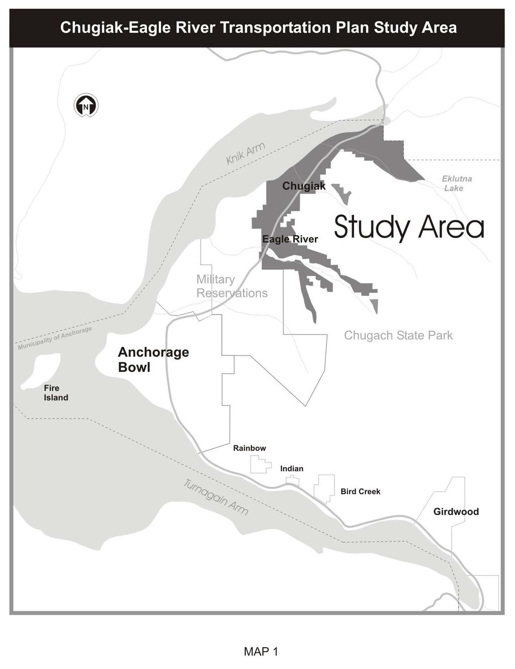
17 5
18 6
19 CHAPTER 2: GOALS, POLICIES, AND OBJECTIVES The formulation of goals, policies, and objectives is a fundamental step in the transportation planning process. Goals, policies, and objectives describe the desired end result of a transportation plan as well as directions on how to get there. More specifically, goals describe in broad, general terms a desired future condition that is consistent with community ideals; objectives are specific statements of particular ends, expressed in measurable terms that respond to the goals; and policies are statements that describe courses of action designed to achieve the goals and objectives. The goals, policies, and objectives of the Chugiak-Eagle River 2027 LRTP are primarily based on the 2003 LRTP, with modifications as proposed by a Citizen Advisory Committee. The committee s work included a review of of revised Comprehensive Plan Guidelines for Growth for items to be considered for inclusion in the LRTP goals, policies, and objectives. The refined goals, policies, and objectives which resulted from the committee s work attempt to create a balance between competing demands and values. For example, the goal of providing a high-quality transportation system was weighed against the goal of minimizing public expenditures. Similarly, the goal of quality transportation was balanced against the effects a particular project may have on the environment. Goals are presented in a single, inclusive goal statement. The goal statement, objectives, and policies of the Chugiak-Eagle River LRTP are presented in the sections below. I. GOAL Ensure development of a balanced transportation network for people, goods, and services that provides an acceptable level of service, maximizes safety, minimizes environmental impacts, provides alternative transportation types, and is compatible with planned land use patterns. II. OBJECTIVES 1. Decrease travel time through an increase in the transportation efficiency during peakhour periods. 2. Minimize cut-through traffic in residential neighborhoods. 3. Strike a balance between safety and economical design with all transportation projects. 4. Improve, as necessary, expressway, arterial, and collector roads to safely and efficiently handle projected traffic. III. POLICIES A. Coordination Policy Coordinate the Chugiak-Eagle River LRTP with the Anchorage Bowl LRTP, Chugiak-Eagle River Comprehensive Plan, People Mover Blueprint, Non-Motorized Transportation Plan, and other relevant plans and programs. The Chugiak-Eagle River LRTP and Official Streets and 7
20 Highways Plan (OS&HP) should be coordinated with MOA plans for emergency management, public safety, and areawide drainage as they are developed. B. Public Participation Policy Encourage public participation in all transportation-related decisions. It is the policy of AMATS to utilize citizen advisory committees to advise it on its periodic updates of transportation plans. For this LRTP, a Citizen Advisory Committee (CAC) was formed. Many participants on the committee have been active in transportation planning and project development for the past decade. The Citizen Advisory Committee for this LRTP is similar to that employed for the original 1996 LRTP. Work to ensure adequate public notice to affected property owners during project development. C. Funding Priority Policies Use the following priorities to make the best use of future transportation funding: 1. Bring existing facilities up to current standards. Capacity expansion projects will be considered at the same time as safety improvements if they are warranted. Projects that address both capacity and safety concerns should receive highest priority. 2. Maintain and rehabilitate the existing transportation system (roads, trails, and sidewalks) to prevent deterioration of facilities and avoid the need for major reconstruction. 3. Establish a basic bicycle and pedestrian circulation network that will provide access to schools, neighborhoods, commercial centers, and parks. a) Trails and pedestrian facilities for transportation should receive funding priority over trails that primarily serve a recreational purpose. b) Trails within high-density areas will be given priority over trails within lowdensity areas. 4. Add capacity to the existing roadway system or construct new roadways to alleviate existing capacity problems and accommodate traffic increases. D. Access Policy Limit and provide access to the street network in a manner consistent with the function and purpose of each roadway. Provide an adequate road network in a manner consistent with the function of land use as designated in the Chugiak-Eagle River Comprehensive Plan for current and future needs. To achieve this level of access control, the MOA shall encourage consolidation of access in developing commercial and high-density residential areas through shared use of driveways and local access streets. E. Level of Service Policy Adopt Level of Service (LOS) C for peak-hour traffic flow on the roadways within the Chugiak- Eagle River area. Exceptions may be made in areas where the cost of right-of-way acquisition is high because of intense urban development. (LOS C provides for traffic flow with speeds still at 8
21 or near the free flow speed of the roadway. Freedom to maneuver within the traffic stream is noticeably restricted at LOS C. See Chapter 4, Section III, for an explanation of Level of Service.) F. Transit Service Policies Support improvements in the frequency and convenience of transit service to high-density, transit-dependent areas of Chugiak-Eagle River. Consider and evaluate the feasibility of commuter rail as a travel choice. Investigate alternative methods of providing public transportation services to low-density developments to, from, and within the Chugiak-Eagle River area and expand alternatives that are proven to be efficient. Support the continued development of the park-and-ride system. Promote transit accessibility through pedestrian access to bus stops and bus shelters, consistent with the AMATS approved Transit Facilities Design Guidelines in Chapter 7, MOA Design Criteria Manual (DCM). G. Pedestrian and Bicycle Policies Encourage travel by means other than the automobile and provide for the safety of pedestrians and bicyclists throughout the Chugiak-Eagle River area. Future road improvement projects, which involve major reconstruction or construction of additional lanes, should include bicycle and pedestrian facilities where feasible and as funding allows. Incorporate internal pedestrian and bicycle networks in all new developments, as well as connections to external networks, which permit a real alternative to the automobile. H. Congestion Management Strategy Policies Encourage the management of congestion through strategies identified in the MOA Congestion Management Program. Strategies of particular relevance to Chugiak-Eagle River include the Transportation System Management (TSM) and Transportation Demand Management (TDM) approaches identified below: Transportation System Management Signal interconnect systems, signal coordination and synchronization, and other signal systems to ease traffic flow Turn lanes and pockets to allow turning vehicles to move out of through traffic lanes Access control for arterials and major collectors to minimize disruptions in traffic flow Transportation Demand Management Encouragement of the use of high-occupancy vehicles such as carpools and vanpools 9
22 Promotion of reduced employee travel during the daily peak-travel periods through flexible work schedules and programs, which allow employees to work part- or full-time at home or at an alternative work site closer to home I. General Environmental Protection and Conservation Policy Design transportation facilities within the Chugiak-Eagle River area that minimize adverse environmental impacts resulting from both their construction and operation, including but not limited to noise, air pollution, and negative impacts on wetlands, watersheds and scenic vistas. Preserve natural drainage ways and ensure that area drainage needs are integrated into development plans. J. Air Quality Policy Maintain PM-10 compliance. K. Neighborhood Policy Minimize residential and business relocations resulting from transportation projects. L. Ongoing Transportation Planning Policy Review and, if necessary, update the Chugiak-Eagle River LRTP every 4 years as required by federal SAFETEA-LU planning regulations. Monitor the existing infrastructure performance. M. Maintenance Policy Give full consideration to reducing maintenance and operating cost during the design and construction of all transportation improvements in the Chugiak-Eagle River area. N. Rural Lifestyle Policy Give full consideration to preserving the existing rural lifestyle in low-density areas of Chugiak- Eagle River in the design of transportation improvement projects. O. Connectivity Policy Provide an interconnected network of streets, where appropriate, (a) to facilitate emergency response, particularly for fire and medical services, (b) for evacuation in event of a disaster, and (c) for ease and variety of travel. Discourage high-speed and cut-through traffic. Connections between new and existing subdivisions should be required except in the following cases: excess slope, the presence of a wetland or other body of water which cannot be bridged or crossed, existing development on adjacent property prevents a street connection, or the presence of a freeway or railroad. Connections shall be reviewed, and comments provided, by the appropriate community council. Connectivity in the local street pattern in residential neighborhoods must meet the following criteria: a. The street pattern in residential neighborhoods shall be planned in a form that 10
23 discourages its use as corridors for traffic from outside the immediate area the street pattern is intended to serve. b. Vehicular traffic volumes in the residential streets must not exceed the minimum traffic volume associated with residential collector roads of 2,000 vehicles per day. c. Properly designed loop systems are an acceptable form of connectivity. P. Roadway Design Policy Design new subdivision roads in accordance with Anchorage Municipal Code and the Design Criteria Manual. The applicable MOA decision maker should carefully scrutinize any requests for variances to these roadway improvement requirements. It should be noted that a separate chapter in Title 21 is currently under development for the Chugiak-Eagle River area. When the new chapter is adopted, the Design Criteria Manual should be reviewed and updated, if necessary, to accommodate relevant changes in code. Q. Street Lighting Ensure that adequate street lighting is available where and when needed, and is adequately maintained, as specified by Title 21. R. Glenn Highway Capacity, Safety, and Screening Improve, as necessary, the Glenn Highway to provide the following: Appropriate capacity for the combined Matanuska-Susitna (Mat-Su) Borough and MOA vehicular traffic that utilizes the roadway Safe driving conditions according to the current American Association of State Highway and Transportation Officials (AASHTO) design standards Noise and visual screening along the highway from Eagle River to Eklutna Coordination of the the Anchorage Bowl LRTP and Chugiak-Eagle River LRTP recommendations for the Glenn Highway, keeping in mind that we are at a different level of development from the Bowl area and may have different needs or time lines than what would be recommended for the Bowl LRTP S. Transportation of Sand, Gravel, and Rock Ensure that resource extraction conditional use permits give full consideration to minimizing impacts from sand, gravel, and rock operations on surrounding neighborhoods, reducing impact to traffic on public roadways due to increased hauling, and minimizing damage to vehicles on public roadways caused by gravel and rocks falling from trucks. Ensure, where appropriate, that Title 21 includes specific strategies for achieving these goals. 11
24 12
25 CHAPTER 3: EXISTING TRANSPORTATION SYSTEM I. THE EXISTING ROAD SYSTEM The major road system in the Chugiak-Eagle River area originated with the Old Glenn Highway traversing the area from Anchorage to Palmer. The system substantially expanded with development in the area and now consists of state, local, and private routes. Major roadways in the Chugiak-Eagle River area are described below. The Glenn Highway is the major north-south freeway serving the study area. It is also the only route available to persons desiring to travel between the Anchorage Bowl and communities to the north, including Chugiak-Eagle River. The Glenn Highway is the busiest road in the study area, averaging 47,667 vehicles per day between the scale houses and the Hiland Road interchange in Much of this traffic is from the Mat-Su Valley. The permanent counter located on the Glenn Highway at Eklutna Flats recorded 26,249 vehicles in 2004, an increase of 17.6% over 2000 counts at this location. Most Chugiak-Eagle River residents also depend on the Glenn Highway to commute to work in Anchorage, and many also travel to the Mat-Su Valley for shopping. The number of lanes varies throughout the length of the Glenn Highway. The roadway is a sixlane, divided highway between Muldoon Road and the Hiland Road exit. From the Hiland Road exit, the Glenn Highway is a four-lane, divided highway that continues through the study area to the intersection with the Parks Highway in the Mat-Su Borough. An exception is the southbound portion of the highway between the Eagle River Bridge and Hiland Road, which is three lanes. The Old Glenn Highway served as the primary north-south arterial before construction of the Glenn Highway. It begins at the intersection of Artillery Road and Eagle River Road near downtown Eagle River. As the road travels north, portions meander from one side of the Glenn Highway to the other. Its length is discontinuous within the study area, and its width also varies. It is a four-lane, undivided arterial with a two-way, center, left-turn lane through downtown Eagle River to the intersection of the North Eagle River Access Road, where the highway narrows to two lanes. The portion of the Old Glenn Highway passing through downtown Eagle River between Eagle River Road and North Eagle River Access Road is the second-busiest segment of roadway in the area. Daily vehicle traffic in 2004 was recorded at approximately 20,600 vehicles at Artillery Road, 17,421 at Monte Road, and 18,541 at the northern end of Business Boulevard. The remainder of the Old Glenn Highway passes through more rural areas and is not nearly as busy, with daily traffic averaging 3,759 vehicles at Birchwood Loop Road in Eagle River Road is a two-lane arterial serving the largest population center (Eagle River Valley) in the study area. The road begins near downtown Eagle River at the intersection of Artillery Road and the Old Glenn Highway and ends inside Chugach State Park at Mile Point (MP) Eagle River Road also experiences wide variations in the amount of traffic it carries. The 2004 average daily vehicle traffic on the road was 8,140 vehicles at VFW Road, and 8,420 vehicles at the junction with Eagle River Loop Road, both on the western portion of the road, and only 513 vehicles on the eastern segment closer to the Eagle River Nature Center. 13
26 Eagle River Loop Road is an arterial primarily serving the central portion of Eagle River. It consists of two parts: the older section, which connects the Old Glenn Highway to Eagle River Road, and the newer section, which crosses Eagle River and provides a secondary access from the population center of Eagle River to the Glenn Highway. The older section is a two-lane facility (soon to be upgraded to three lanes), and the newer section is four lanes and divided. Daily traffic averaged 9,530 along the older portion and 11,700 along the newer portion in The completion of the Eagle River Loop Road extension in 1992 significantly changed the traffic patterns in the central part of Eagle River. During the first year of operation (1992), the new roadway attracted approximately 8,200 vehicles per day and greatly relieved pressure on other area roads. For example, after the new extension ws completed, traffic was reduced by 6,000 vehicles per day on the Old Glenn Highway between Eagle River Road and Eagle River Loop Road and 6,500 vehicles per day on Eagle River Road between Eagle River Loop Road and the Old Glenn Highway. The main intersection into Eagle River from the Glenn Highway at Artillery Road also experienced some relief afforded by the new road connection. One section of Artillery Road just off the northbound exit ramp from the Glenn Highway experienced a reduction of approximately 7,400 vehicles per day. The North Eagle River Access Road serves as a two-lane arterial connection between the Glenn Highway and Old Glenn Highway. Its location midway between the Artillery Road and South Birchwood interchanges provides convenient access to the Glenn Highway from subdivisions in northern Eagle River and southern Chugiak. The construction of the North Eagle River interchange in the early 1990s replaced the old at-grade intersection. This interchange greatly improved the functioning of the intersection and had a notable impact on traffic patterns in the area. Formerly, the majority of commuters gained access to the Glenn Highway at the Artillery Road Interchange because of the difficulty of merging at-grade with the heavy southbound Glenn Highway traffic during the morning peak period. Average daily traffic at the North Eagle River Access Road and the Old Glenn Highway was 12,400 vehicles in The remainder of the road system is composed of collector and local roads. Collector streets distribute traffic to and from the arterial system and local access roads. Among the more significant collector roads are Hiland Road, which is the primary collector serving residents living along the South Fork of Eagle River; Business Boulevard, which serves the business district within Eagle River; Birchwood Loop Road, which is the primary collector serving the Birchwood Community Council area; and Eklutna Lake Road, which connects the Glenn Highway with Chugach State Park facilities at Eklutna Lake. II. PUBLIC TRANSPORTATION AND OTHER MODES The MOA currently operates three bus routes in the Chugiak-Eagle River area that provided more than 150,000 rides in The MOA Public Transportation System is primarily oriented toward serving commuters traveling from their homes in the Chugiak-Eagle River area to places of work in the Anchorage Bowl (downtown, midtown and Muldoon areas), and offers some Saturday service to Muldoon with connecting service to downtown, south Anchorage and midtown. A new, local, fixed-route circulator bus was added in 2006, providing weekday service only. In addition to fixed-route service, many people carpool in their private vehicles and the Chugiak Senior Center provides curb-to-curb service for its residents. The Public 14
27 Transportation Department markets People Mover, carpooling, and vanpooling through advertisements in the Alaska Star, the local newspaper for the Chugiak-Eagle River area, and The Cache, the local advertisement mailer sent to all area residents. A State of Alaska 2001 Multi-Modal Transportation Survey revealed that of those persons surveyed in the study area, 4.1 percent rode the bus to work or school in the winter. The Chugiak-Eagle River area is also served by a bicycle path system consisting of two main bicycle trails. A bicycle trail paralleling most of the Glenn Highway from the Boniface Interchange in the Anchorage Bowl to North Birchwood forms the north-south backbone of the system. The Eagle River Road bicycle trail serves as the main east-west bicycle route and extends from the Old Glenn Highway to just east of Hillcrest Drive. 15
28 16
29 CHAPTER 4: IDENTIFICATION OF ROAD SYSTEM DEFICIENCIES: TRANSPORTATION PLANNING MODEL I. INTRODUCTION The transportation planning model is the primary tool used to predict future travel conditions. This tool is based on current and future land use types and density, characteristics that largely determine how and where people travel. With the information derived from the model, it is possible to identify which roadways are expected to experience unacceptable levels of congestion. Solutions to these congestion problems can then be developed. The MOA transportation planning model was most recently upgraded and refined in This improved model was used to forecast future (Year 2027) travel volumes in the Chugiak-Eagle River area. II. MODEL ASSUMPTIONS The number and distribution of population, households, and employment are the primary factors underpinning transportation demand (number of trips generated.) There are well-defined relationships between land use development and travel demand generation. The transportation planning model has been updated and refined for the Chugiak-Eagle River area based on the most current information available from the 2006 Chugiak-Eagle River Comprehensive Plan, which was being developed by the MOA Planning Department in parallel with the LRTP update. Detailed trip information for Chugiak-Eagle River, obtained through a 2002 MOA travel survey, was used to tailor trip generation assumptions for this area. Projections do not take into account the potential effects of a Knik Arm bridge. Population and employment changes that could result from a Knik Arm bridge will be assessed as part of the ongoing environmental impact statement for the project, and may be addressed through an amendment to this LRTP. Also, model assumptions used do not take into account the planned Alaska gas pipeline. The construction of potential spur lines to Southcentral Alaska are considered longer-term than the planning horizon for this LRTP update. The following section presents the major land use assumptions used in the model. A. Population, Household, and Employment Projections The purpose of this plan is to prepare for the future needs of a growing population for the Chugiak-Eagle River area based on reasonable assumptions and projections for future economic growth. This LRTP considers a 20-year planning horizon, to the year The most widely used source of population, household, and employment projections for Alaska is the Institute of Social and Economic Research (ISER) of the University of Alaska Anchorage. To be consistent with the 2006 Chugiak-Eagle River Comprehensive Plan, it was decided the same November 2004 ISER forecast (Economic Projections: Alaska and the Southern Railbelt ) used for development of the Comprehensive Plan would be used for the LRTP. 17
30 The population, household, and employment projections in the ISER report were based on an economic model utilizing a consistent set of assumptions about levels of future basic industry activity within the state, national variables, and state fiscal policy variables. Three separate projections were developed: Low Case, Base Case, and High Case. The Base Case projection (see Table 1), which is considered to be the most likely scenario, was selected for use in the Chugiak-Eagle River LRTP. According to the Base Case estimates, the population of the MOA is expected to grow by 25%, from 286,200 in 2006 to 359,200 in Households are expected to grow slightly faster than population, with an estimated growth of 30% during the 20- year planning period. Employment is expected to grow by about 18% from 146,800 in 2006 to 173,400 in Table 1 Year 2027 Projections Municipality of Anchorage Chugiak-Eagle River Population 359,200 53,880 Households 140,600 19,106 Number of Persons Employed 173,400 8,082 Source: Municipality of Anchorage Traffic Department After the MOA projections were established, the population projections for the Chugiak-Eagle River area could be determined. (ISER projections are provided for the entire MOA only, and not for sub-areas, including Chugiak-Eagle River.) For these projections, MOA staff used the assumptions in the 2006 Chugiak-Eagle River Comprehensive Plan, which used Year 2025 as the planning horizon year. Based on an historic population analysis, the Chugiak-Eagle River Comprehensive Plan Update estimated that Chugiak-Eagle River would account for 15% of the total MOA population by To adjust the Comprehensive Plan 2025 estimate to 2027 for this LRTP, MOA staff applied this percentage to the 2027 ISER population estimate for the MOA, which gives an estimate of 53,880 persons. This projection represents an annual average growth rate of about 2%. The number of future households in Chugiak-Eagle River was derived from the projected population. The 2006 Chugiak-Eagle River Comprehensive Plan Update reports that the average household size is expected to decrease to 2.82 persons per household in 2025, reflecting a downward statewide trend. Using this figure, staff calculated the estimated total number of Chugiak-Eagle River households to be 19,106 in 2027 (53,880 divided by 2.82). Estimates of future employment used in the traffic projection model also follow the assumptions of the 2006 Chugiak-Eagle River Comprehensive Plan Update. Historical trends show that local employment has increased; the percentage of local employment grew from 10% in 1980 to almost 13% in On the basis of these trends, the 2006 Chugiak-Eagle River Comprehensive Plan Update concludes that the year 2025 Chugiak-Eagle River employment will equal 15% of the population. Multiplying the projected 2027 population of Chugiak-Eagle River (53,880) by 15% yields an estimate of 8,082 locally based jobs. Because Chugiak-Eagle River is expected to remain a bedroom community of Anchorage during the next 20 years, most of this 18
31 increased employment will probably continue to be retail and services jobs supporting the local community. B. Location and Distribution of Dwelling Units To be useful in the transportation-planning model, the future population and household estimates for Chugiak-Eagle River must be distributed by traffic analysis zones (TAZs) the building blocks of the transportation planning model. Allocation of households to a TAZ is accomplished through the use of the MOA land use allocation methodology. The following five factors are used to allocate growth: Availability of the parcel for development (Is it vacant?) Suitability of the land for development (Is it located in a wetland or steep hillside?) Type and amount of development allowed under zoning ordinances and the land use plan map Accessibility of the parcel location (How close is the parcel to existing development?) Developments and improvements already in planning stages (Are there set plans to develop the property in the near future?) Figure 2 shows where the land use allocation model allocates future growth. The hot spots of residential growth are found primarily in five areas: (1) the Powder Reserve west of the Glenn Highway, (2) Eagle Crossing and adjacent parcels located south of Eagle River Road and east of Eagle River Loop Road, (3) the area south of Eagle River and bordered on the south and east by Eagle River Loop Road, (4) Eklutna 770 located in the area surrounded by the Glenn Highway and Old Glenn Highway and by Birchwood Loop Road and South Birchwood Loop Road and (5) the north Peters Creek area. All of these areas, except Eklutna 770 and the North Peters Creek area, contain active subdivisions that have sewer and water service and, consequently, can be developed at higher densities. Although no plans to develop Eklutna 770 have been proposed at this time, it is assumed that sewer and water will be extended within the next 20 years and development will take place during the timeframe of this LRTP. 19

32 Figure 2 Household Growth ( ) Source: Municipality of Anchorage Traffic Department 20
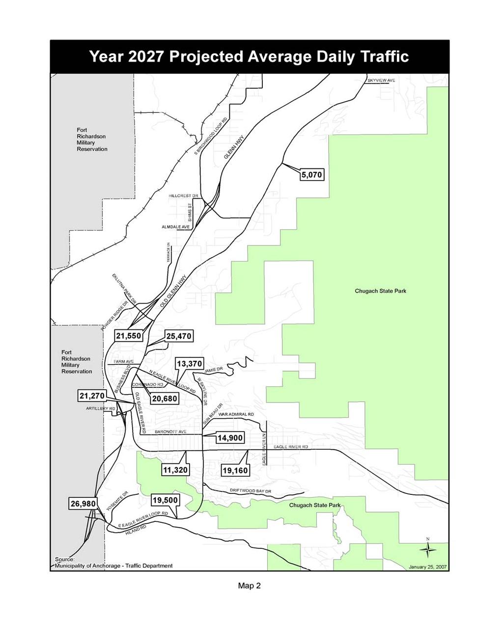
33 C. Location and Distribution of Future Employment The location of future employment also strongly influences the traffic volumes on area roads. Employment, especially retail employment, acts as a traffic attractor. Large concentrations of retail land uses create high traffic volumes on adjacent roads. The 2006 Chugiak-Eagle River Comprehensive Plan Update contains guidelines for the location of future commercial development. A Comprehensive Plan policy is retention of downtown Eagle River as the major commercial center for the Chugiak-Eagle River area. The planning document also recognizes that commercial development is likely at strategic locations such as Eklutna, Peters Creek, North Birchwood, the Old Glenn Highway in Chugiak, South Birchwood, the intersection of Eagle River Road and Eagle River Loop Road, and the intersection of the Old Glenn Highway and North Eagle River Access Road. The major areas designated for industrial land use are located around the Birchwood Airport, along the Old Glenn Highway in Chugiak, at Springbrook Drive in Eagle River, and at West Artillery Road in Eagle River. III. TRAFFIC PROJECTIONS The first two sections below, Sections A and B, summarize traffic projection analyses of major area streets (arterials.) Section C discusses the Glenn Highway (a regional freeway.) A. Roadway Segments The traffic projections for 2027 are presented in Table 2 below and on Map 2. Primarily because of the projected population growth in the next 20 years, traffic in Chugiak-Eagle River is expected to grow substantially. Traffic growth will not be evenly distributed. Some of the largest increases will be along Eagle River Loop Road between Eagle River Road and the Hiland Road Interchange of the Glenn Highway. This growth is primarily driven by commuter traffic from newly developing subdivisions in Eagle Crossing and the area south of Eagle River on the inside curve of Eagle River Loop Road. Traffic on Eagle River Road is also expected to grow substantially during the next 20 years as a result of expected residential growth in Eagle River Valley. It should be noted, however, that the traffic projections for Eagle River Road could vary substantially, depending on the pace of development of the relatively large tracts of vacant land located south of Eagle River Road and east of Eagle River Lane. The existing active subdivisions in the Powder Reserve (located west of the Glenn Highway), as well as the planned development of 1,000 additional housing units in Tract A of the Powder Reserve, will generate additional traffic demand on the North Eagle River Interchange of the Glenn Highway and North Eagle River Access Road. The Old Glenn Highway north of the North Eagle River Access Road is also subject to potentially significant increases in traffic, depending on future land use development in the Eklutna 770 area. Recently changing traffic patterns also affect anticipated future traffic volumes in the Chugiak- Eagle River area. Changes in the distribution of retail activity within Chugiak-Eagle River are the primary cause of these shifts in traffic patterns. Wal-Mart, on the southeast corner of Eagle 21
34 River Loop Road and Eagle River Road, and Fred Meyer, on the northeast corner of the Old Glenn Highway and North Eagle River Access Road, have the largest impact. Given their sizes, these two establishments generate a substantial amount of traffic. As a result, traffic in downtown Eagle River is growing slower than traffic on roads leading to these new stores. One area with increased traffic is Eagle River Loop Road between the Old Glenn Highway and Eagle River Road. This route is used by Eagle River Valley residents for access to the Fred Meyer store and by residents from the north part of Eagle River for access to the Wal-Mart store. Reconstruction of this section of Eagle River Loop Road (currently scheduled for 2008) will also cause more people to use this route. Another major traffic generator is the new Eagle River High School on Yosemite Drive in Eagle River, which was completed in Table 2 Year 2027 Traffic Projections (AADT = Annual Average Daily Traffic) Roadway Segment Actual 2004 AADT Projected 2027 AADT Change Percent Eagle River Road east of Eagle River Loop 8,420 19, % Road Eagle River Road west of Eagle River Loop 8,140 11, % Road Eagle River Loop Road between Old Glenn 10,170 13, % Highway and Skyline Drive Eagle River Loop Road between Skyline Drive 9,530 14, % and Eagle River Road Eagle River Loop Road between Eagle River 11,700 19, % Road and Hiland Road Eagle River Loop Road between Hiland Road 14,970 26, % and Glenn Highway Interchange Old Glenn Highway between Eagle River 16,060 21, % Road and Business Boulevard Old Glenn Highway between Business 15,060 20, % Boulevard and Business Boulevard Old Glenn Highway between Eagle River 18,540 25, % Loop Road and North Eagle River Access Road Old Glenn Highway between South Birchwood 2,890 5, % Loop Road and Birchwood Loop Road North Eagle River Access Road between Glenn 12,400 21, % Highway and Old Glenn Highway Source: Municipality of Anchorage Traffic Department in 22
35 23
36 The total volume of traffic on area roads is not very informative in and of itself. To be meaningful, traffic volumes must be converted to Level of Service (LOS). Level of Service is a useful way of defining how well a particular street or road is operating and whether its capacity is being exceeded and improvements might be needed. This performance measure is based on the ratio of traffic volume to roadway carrying capacity. Levels of Service range from A to F, with LOS A describing primarily free-flow operations and LOS F describing forced or disrupted flow. Table 3 provides a description of Levels of Service A through F. Table 3 Level of Service Characteristics Level of Service A B C D Description Free flow with low volumes and high speeds. Reasonably free flow, but speeds beginning to be restricted by traffic conditions. In stable flow zone, but most drivers are restricted in the freedom to select their own speeds. Approaching unstable flow; drivers have little freedom to select their own speeds. E Unstable flow; may be short stoppages F Unacceptable congestion; stop-and-go; forced flow. Source: Adapted from the AASHTO Green Book Highway Capacity Manual (Special Report 209), Transportation Research Board, Washington, DC, Third Edition, updated 1994 A policy of this LRTP, Policy E, is to adopt a Level of Service C for peak hour traffic flow on the roadways within the Chugiak-Eagle River area. For this area, therefore, any road segment with a Level of Service of D or worse (during the PM peak period) is considered to be overcapacity. The capacity of the arterial system appears to be adequate to meet the travel demand at the present time. Most roadways in the Chugiak-Eagle River area are expected to continue to operate at a satisfactory level; however, forecasts identify several roadway segments that are expected to carry volumes resulting in LOS D or worse by The following roadway segments are projected to operate at congested levels by 2027: Eagle River Road Eagle River Loop Road to Greenhouse Street Eagle River Road Old Glenn Highway to Chain of Rock Drive Eagle River Loop Road Old Glenn Highway to Eagle River Road Eagle River Loop Road Eagle River Road to Driftwood Bay Drive Eagle River Loop Road Hiland Road to the Hiland Road Interchange of the Glenn Highway Old Glenn Highway Artillery Road to Monte Road Old Glenn Highway North Eagle River Access Road to the Fire Lake Elementary School entrance North Eagle River Access Road Glenn Highway Interchange to Old Glenn Highway 24
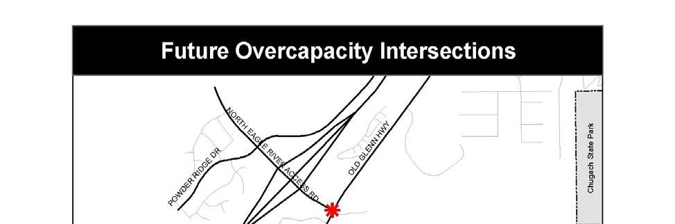
37 Table 4 Level of Service Summary: Chugiak-Eagle River Arterials (LOS = Level of Service, A to F) Roadway Segments 2004 LOS AADT 2027 LOS AADT 2027 LOS PM Peak Eagle River Road Old Glenn Highway to Chain of Rock Drive C D D Chain of Rock Drive to Eagle River Loop Road B C C Eagle River Loop Road to Crestview Lane C E E Crestview Lane to Greenhouse Street B/C* D/E* D/E* Eagle River Loop Road Old Glenn Highway to West Skyline Drive B/C* C D West Skyline Drive to Eagle River Road B/C* D E Eagle River Road to Driftwood Bay Drive B C D Driftwood Bay Drive to Hiland Road A B B Hiland Road to Glenn Highway Interchange B C E Old Glenn Highway Artillery Road to Monte Road C D E Business Boulevard to Eagle River Loop Road B C C Eagle River Loop Road to North Eagle River Access B C C Road North Eagle River Access Road to South Birchwood Loop Road B C B/D* North Eagle River Access Road Old Glenn Highway to Glenn Highway B C D Source: Municipality of Anchorage Traffic Department * Indicates LOS varies along roadway segment B. Intersections Measuring the Level of Service of roadway segments does not always tell the whole story. According to the MOA Congestion Management System Status of the System Report, published in September 2000, intersection delay is the primary cause of congestion on the roadway network. Currently no intersection in Chugiak-Eagle River is experiencing traffic above capacity, although the Old Glenn Highway/Eagle River Loop Road intersection currently experiences a poor Level of Service (LOS D) during the PM Peak hour. An analysis of intersections using 25
38 projected traffic volumes reveals that at least four intersections will be overcapacity within the next 20 years. As Map 3 shows, most of these problem intersections are located along the Old Glenn Highway, where it traverses the downtown core of Eagle River. As Chugiak-Eagle River grows, the number of trips from the residential growth areas (such as Powder Reserve and Eagle Crossing) to the downtown core will increase. Unfortunately, only two main routes provide access into and out of the core: Old Glenn Highway from the north and Eagle River Road from the south. The restricted access forces most of the traffic through a limited number of intersections. As a result, anticipated growth will soon overburden these intersections and increase delays. 26


39 27
40 C. The Glenn Highway Because of its regional significance, the Glenn Highway was analyzed as part of this LRTP and the recently adopted Anchorage Bowl LRTP. Some of the largest increases in traffic will be along the Glenn Highway between the Mat-Su Valley and the Anchorage Bowl. Daily traffic is expected to nearly double the current average daily traffic of more than 50,000 trips through the study area on the Glenn Highway toward the Anchorage Bowl in the next 20 years. Commuters living in the Mat-Su Valley and Chugiak-Eagle River who work in the Anchorage Bowl will generate most of this traffic. As a result, the Glenn Highway between the Anchorage Bowl and Mirror Lake is expected to be over capacity during commute hours (Anchorage Bowl 2025 LRTP, page 99.) Figure 3 shows projected commuters from Chugiak-Eagle River and the Mat- Su Valley to Anchorage. Figure 4 compares 2025 demand and available capacity on the Glenn Highway during the morning peak hour. Figure 3 Projected Commuters from Chugiak-Eagle River and the Mat-Su Valley to Anchorage Employment Number of Commuters 35,000 30,000 25,000 20,000 15,000 10,000 Chugiak-Eagle River Commuters Mat-Su Valley Commuters Total Glenn Highway Commuters 5, Source: 2000 U.S. Census and CH2M HILL Anchorage Bowl 2025 Long-Range Transportation Plan, 2005 Year 28
41 Figure 4 Managing Demand and Available Capacity on the Glenn Highway, 2025 Morning Peak Hour 8,000 7,000 Capacity Demand Westbound Peak Hour Traffic & Capacity 6,000 5,000 4,000 3,000 2,000 1,000 0 Knik River - Ekutna Rd Eklutna Rd - Mirror Lake Source: CH2M HILL Mirror Lake - Voyles B lvd Voyles Blvd - N Birchwood N Birchwood - S Birchwood S. Birchwood - N Eagle Rv I/C Anchorage Bowl 2025 Long-Range Transportation Plan, 2005 N Eagle Rv I/C - Artillery Rd Artillery Rd - Hiland Rd Hiland - Arctic Valley Rd Arctic Valley Rd - Muldoon Muldoon - Boniface 29
42 30
43 CHAPTER 5: PUBLIC TRANSPORTATION AND OTHER MODES I. PUBLIC TRANSPORTATION A. Transit Public transportation options in the Chugiak-Eagle River area include People Mover fixed-route buses, AnchorRIDES services for people with disabilities, service for senior citizens living at or visiting the Chugiak Senior Center, and the Anchorage School District pupil transportation service. There are no private taxicabs based in the area, and a one-way trip into Anchorage costs up to $35 by taxi. Unlike Anchorage residents, who have access to many social service agencies, Chugiak-Eagle River residents have limited options and most rely on the private automobile. People Mover service is primarily oriented toward serving commuters traveling from home to places of work in the Anchorage Bowl. The bus service and ridership level remained relatively unchanged from 1993 to In July 2004, bus service was reconfigured based on recommendations from The People Mover Blueprint: A Plan to Restructure the Anchorage Transit System. System changes included shifting local routes to dial-a-ride transit (DART) routes, and shifting a route terminus from downtown to the hub at Muldoon, while maintaining direct commuter service to downtown Anchorage. Operation of the park-and-ride route between Peters Creek and downtown Anchorage during peak hours was continued, and was extended to provide service between the downtown Transit Center and the University-Medical area. Annual ridership levels remained relatively flat at around 100,000 from 1991 to 2004, but rose in 2004 and continued to rise in 2005 to more than 150,000 (see Figure 5). After 2 years of operation demonstrating marginal success of the DART routes, the service was again reconfigured in July Changes included re-establishing fixed route service along Birchwood Loop Road and Old Glenn Highway and reducing the service operated along Eagle River Loop Road. The need for additional direct trips between Eagle River and the downtown Anchorage Transit Center as well as increased ridership on Route 102 prompted an expansion of that route. Timed transfers at the Eagle River Transit Center during commute times provide connections to buses headed to downtown Anchorage and to Muldoon. People Mover operates as far north as the North Peters Creek Interchange (near Mirror Lake Middle School) and as far east on Eagle River Road as Wren Lane (locally known as Yellow Rock ). Park-and-ride lots in the Chugiak-Eagle River area are intended to provide a transit-use incentive for time-sensitive commuters in suburban and lower density areas of the MOA. The Eagle River Transit Center, located on Business Boulevard in downtown Eagle River, serves as the primary park-and-ride lot. Other park-and-ride facilities include Joy Lutheran Church at Eagle River Road and Eagle River Loop Road, and interchanges at North Birchwood and South Birchwood. The three recently reconfigured routes operating in the Chugiak-Eagle River area are described below: Route 77 (includes 77-B, Birchwood, and 77-G, Old Glenn Highway): This route has been expanded to offer seamless transportation between Muldoon and Peters Creek, providing fixed- 31
44 route service along Birchwood Loop and the Old Glenn Highway. Route 77G uses the Old Glenn Highway northbound and the Birchwood Loop southbound. Route 77B uses Birchwood Loop northbound and the Old Glenn Highway southbound. Weekday and Saturday service is provided. Route 79: This new route is a fixed local route with regular service weekdays only from the Eagle River Transit Center to Eagle River Loop Road, extending service out from Wal-Mart on Eagle River Road to Wren Lane. Route 102: In response to significant growth on Route 102, additional service was added. Route 102 continues to serve the park-and-ride lots at North Birchwood and the Eagle River Transit Center; however, it now travels the Old Glenn Highway between North Birchwood and Eagle River, before continuing express bus service to downtown Anchorage and mid-town to the University Medical District. As Figure 5 indicates, there is a direct correlation between service hours provided and transit ridership. After Anchorage voters approved a tax cap for municipal services in 1983, public transportation services citywide were reduced about 35%. The Eagle River area experienced a reduction of close to 50%. A corresponding reduction in People Mover ridership resulted from the service reduction, despite increases in the population of the Chugiak-Eagle River service area. Additionally, major improvements to the roadway network, such as the Eagle River Loop extension and the North Eagle River interchange have substantially decreased travel time by car between Chugiak-Eagle River and Anchorage, increasing the relative attractiveness of automobile travel. Service changes made in 2004, which increased service hours, as well as rising gas prices, generated an increase in transit ridership, despite fare increases in 2004 and Figure 5 Transit Ridership in Chugiak-Eagle River Revenue Hours 30,000 25,000 20,000 15,000 10,000 5, , , , , , ,000 50,000 0 Ridership Revenue Hrs. Ridership 32

45 Although the low density of the Chugiak-Eagle River area poses difficulties in relying exclusively on conventional fixed-route service with 40-foot buses, opportunities to expand the bus system have been identified. More frequent, fixed-route service along Birchwood Loop and Old Glenn Highway provides connections between Eagle River and the Muldoon Town Center transit hub. The area could support a doubling of service, from service on roughly 2-hour schedules during mid-day and weekends to 1-hour service. Although current peak-period service is approximately every half hour, ridership trends indicate more frequent peak-period service will be warranted in the future. For senior citizens within the Chugiak-Eagle Eagle River Transit Center River area, the Chugiak Senior Citizens Center is responsible for social service transportation. The MOA is responsible for similar transportation for people with disabilities who are unable to use the People Mover system. AnchorRIDES is an umbrella organization designed to provide coordinated social service trips, specializing in curb-to-curb dial-a-ride (DART) service. Additional coordination has been identified as a means to increase the efficiency and availability of service. B. Carpooling and Vanpooling Anchorage s Share-A-Ride program is an employer-based TDM strategy that has been in place since In February 1995, the MOA Public Transportation Department initiated a vanpool component to the program, encouraging long-distance commuters to ride together in a passenger van. The Share-A-Ride program is identified as a transportation control measure in congestion mitigation and air quality plans for the MOA. The program promotes carpooling and vanpooling to commuters with at least one end of their trip within the MOA area. Program implementation by Share-A-Ride staff primarily targets area employers to educate employees and to generate interest in the program. Additional potential carpool and vanpool participants are identified through trade shows, local print and radio ads, and from roadside signs with the Share-A-Ride telephone number. The program uses a computer system based on geographic information system (GIS) data to match commuter origins, destinations, trip times, and personal preferences. The system can accept and geocode trip origins and destinations throughout the state, providing an option to expand carpooling and vanpooling statewide. In addition to reductions in commute costs, program incentives for Share-A-Ride participants may include reduced parking at the major downtown garages, reserved parking, and occasional 33
46 drawings and promotions. Two recent additions to the benefits include a reduced-cost bus pass for vanpoolers who may need to travel during the day, and tax incentive program. Called Commuters Choice this tax deduction is available to employers who choose to pay all or a portion of employee commute costs. A large hidden cost for employers is providing for employee parking. Benefits realized by the employer from paying for a bus pass or vanpool fare include significantly lower cost than providing parking, improved on-time arrivals of workers, and a tax deduction. Carpooling and vanpooling is an effective technique for reducing congestion between Chugiak- Eagle River and Anchorage. Chugiak-Eagle River residents have a higher than average carpool participation rate. The vanpool program expanded from 24 active vanpools in 2004 to 41 active vanpools in Of these, 38 vanpools originate in the Mat-Su area and 3 vanpools originate in Anchorage and travel to Girdwood. Currently no vanpools originate in the Chugiak-Eagle River area; however, some vanpools drive into Chugiak-Eagle River to pick up passengers on the commute between the Mat-Su Valley and Anchorage. Six new vanpools are expected to begin operation traveling from the Mat-Su area to Anchorage, and during the next few years, the vanpool program is anticipated to grow to vehicles. Recent vehicle occupancy counts averaging 2.0 at the Eklutna exit of the Glenn Highway, during the morning peak period indicate there may be more opportunity for expansion of shared-ride activities in the Mat-Su Valley. Table 5 Year Share-A-Ride Program Background Carpoolers Annual Reduction in and Vehicle Travel (Miles) Vanpoolers ,007, ,206, ,294 5,148, ,422 5,940, ,653 6,539, ,731 6,896, ,936 7,596, ,176 8,663, ,987 9,343, ,782 8,943, ,703 8,781, ,185 6,830, ,095 6,641, ,091 8,916, ,883, ,427, ,021, ,297 10,144, ,034 7,896,276 Ridesharing will continue to be a critical mode of alternative transportation in Chugiak-Eagle River, although participation levels are difficult to project based on historical trends. Nevertheless, the potential exists for expanding this important service. 34
47 II. PEDESTRIAN AND BICYCLE FACILITIES Eagle River has bicycle and pedestrian facilities that are enjoyed by many residents. According to a 2001 transportation survey of Eagle River residents on the bicycle and walking trails, 53.5% described them as important, 19.8 % indicated a neutral response, and 26.7 % described them as unimportant. Of those surveyed, daily trail use was indicated by 7.1% for summer, and 4.0% for winter. More residents (38.7% for summer and winter) indicated they use the trails system some of the time. Of those residents surveyed who use the trails system, 3.2% indicate that they bike or walk to work or school in summer, but never use the trails for these activities in winter. The community-wide network of pedestrian and bicycle facilities has deficiencies such as limited availability, lack of connections among segments, and surfaces requiring maintenance. According to the 2001 survey, most of the responding Eagle River (56.2%) agreed that there are not enough sidewalks. When asked if trails and sidewalks should be included in street work, 70.0% of Eagle River respondents agreed. During preparation of this LRTP, an informal survey was distributed to local organizations and to participants at several public meetings. Of comments from 94 respondents, twenty-four comments referred to trails and sidewalks. Several respondents commented about the general lack of trails, sidewalks, or bicycle lanes along roads. Several other comments specified that trails, sidewalks, or both are desired for safety reasons on Birchwood Loop Road and South Birchwood Loop Road, especially for wheelchair users; on Old Glenn Highway; and on Eagle River Road near Wren Lane on both sides of the road. Commenters also suggested a bicycle trail to the Eagle River Nature Center and a continuous trail from Palmer to Girdwood. Some residents did not want more trails, especially in rural areas, particularly if trail additions would result in increased lighting. For purposes of this LRTP, the 1997 Areawide Trails Plan serves as the official guide for the future development of pedestrian and other facilities within the MOA and is incorporated by reference in this report. Chapter 3 of the Trails Plan identifies issues and needs, and makes recommendations related to pedestrian, bicycle, and other trail uses, for the Chugiak-Eagle River area. The locations of trails and pedestrian accommodations on the Areawide Trails Plan maps are approximate, and are subject to available right-of-way, project budget, terrain, and other constraining factors. Recommendations will be analyzed for feasibility and suitability as projects are developed. The Areawide Trails Plan is scheduled to be updated as an element of the new Anchorage Non-Motorized Transportation Plan. The Anchorage Non-Motorized Transportation Plan will consist of three elements: Pedestrian Plan, Bicycle Plan, and Areawide Trails Plan update. Phase I, development of the Pedestrian Plan, is scheduled for completion in The Pedestrian Plan emphasizes sidewalks, walking routes, accessibility compliant with the Americans with Disabilities Act (ADA), and safe routes to schools. The completed plan will identify and establish priorities for pedestrian projects and improvements, and will develop pedestrian-related policies and pedestrian design guidelines. Phase II, development of the Bicycle Plan, is scheduled for The Bicycle Plan focuses on commuter routes and facilities. Phase III, the Areawide Trails Plan update, is scheduled for The goal of planning in the Anchorage Non-Motorized Transportation Plan is to make walking and biking around Anchorage easier. 35
48 Two public meetings conducted as community workshops were held in Chugiak and Eagle River in February 2006 to gain public input for the Pedestrian Plan. Aerial maps for each community council in the Chugiak-Eagle River area were presented as an interactive visual tool. Participants were asked to use markers and colored dots to show on the maps where they would like to be able to walk and to identify destinations, missing links, and hazards encountered. The public also was asked to provide additional comments. Information gathered at these and other meetings throughout Anchorage will be summarized and synthesized in the final Anchorage Pedestrian Plan. The new Pedestrian and Bicycle Plans are expected to revisit the Pedestrian and Bicycle Circulation Plan element of the 2003 Eagle River CBD Revitalization Plan. Prepared for the MOA in 2003, the Eagle River CBD Revitalization Plan was the product of community concerns and interest in creating better opportunities for pedestrians and bicyclists in Eagle River. It identifies gaps and deficiencies in the bicycle and pedestrian network and recommends improvements for the Eagle River CBD area. Specific locations and upgrades of sidewalks and paths are recommended for three districts of the CBD: the Town Core Old Glenn Highway and Business Boulevard between Monte Road and Eagle River Loop Road South Gateway Old Glenn Highway, Artillery Road to Monte Road North Eagle River Old Glenn Highway, Eagle River Loop Road to the North Interchange In addition to expressing interest in improving recreation opportunities and creating better links between areas of the community, Eagle River residents noted concern about safety, particularly along the Old Glenn Highway. On the basis of public input and a review of existing facilities and deficiencies, the Eagle River CBD Revitalization Plan recommends specific improvement projects. The goal is to achieve an interrelated walking and bicycling network that accomplishes the following: Improves safety and access Connects activity centers (for example, parks, schools, retail businesses, the Boys and Girls Clubs, and the library) Creates a more pedestrian friendly CBD environment that better supports commercial and community activities Enhances recreation and tourism Increases opportunities for bicycle commuters Improves access for community members without vehicles, especially the young A key focus of the Eagle River CBD Revitalization Plan is to examine the need for additional crossing points on the Old Glenn Highway as a means of improving pedestrian safety and encouraging people to walk. Eleven projects are identified for inclusion in the Pedestrian and Bicycle Circulation Plan. The recent 2007 effort to identify community pedestrian needs also produced recommendations to continue and include these pedestrian opportunties. Future project development for trails within the Circulation Plan s study area should reference and utilize the Plan s findings. 36
49 A. Pedestrian Facilities The rural character of much of Chugiak-Eagle River has resulted in development that is largely without pedestrian facilities. As a result, few neighborhoods have adequate sidewalk facilities. In response to requests by the community, the 2007 MOA Design Criteria Manual (DCM) includes a new Rural Collector standard that includes a separated path. This standard is intended for use in the rural and suburban areas of Chugiak-Eagle River. Safety trails have also been nominated for funding through legislative grants. Sidewalks and walkways have been and are being required in the urban areas through the subdivision process. The MOA Traffic Department designates walking routes for pedestrian safety for elementary schools, but these routes are not currently maintained. Many older portions of the Eagle River urban core do not have sidewalks. Where sidewalks exist, connections with sidewalks in other areas of the community are lacking. Recently completed and currently programmed improvements, including recent improvements to Business Boulevard, have addressed some of these needs. The Eagle River Loop Road reconstruction project, currently in design and scheduled for construction in , will widen Eagle River Loop Road, as well as provide pedestrian amenities from the Old Glenn Highway to Eagle River Road. Although the urban portion of Old Glenn Highway has sidewalks on both sides, better pedestrian crossings were requested by residents living on the east side. The Old Glenn Highway Rehabilitation project, constructed in summer 2003, addressed some pedestrian safety issues voice by the community. Lack of pedestrian crossings along the Old Glenn Highway and at key intersections such as Monte Road, remain concerns. Children continue to cross the road at all junctures. Ravenwood Elementary students living north of Eagle River Road and who walk or bike to school must cross Eagle River Road to get to school. Eagle River Road is designated as a hazardous route for school children and not considered safe for student travel. In response to concerns expressed by residents during this LRTP update, a new walking route evaluation has been initiated for the entire Ravenwood attendance area. Residents have also expressed the need for paths on both north and south sides of Eagle River Road near Wren Lane to improve safety for walkers and bikers to the CBD and to Wal-Mart. Rural areas of the community also lack pedestrian facilities. Most residents of rural areas are forced to walk on roadways or unimproved roadway shoulders to get to bus stops or other locations. According to the Areawide Trails Plan, the Old Glenn Highway from Eagle River to Peters Creek is a segment that particularly needs a separated pedestrian and bicycle trail. The Old Glenn Highway also needs safe pedestrian crossings at the intersection with Eagle River Loop Road, included in the current Eagle River Loop Road improvement project scope, and at Chugiak Elementary School. Other critical needs include a separated pedestrian and bicycle trail along Eagle River Loop Road from the Old Glenn Highway and Eagle River Road, and along Birchwood Loop Road and South Birchwood Loop Road. The roadways mentioned in this paragraph serve as transit routes; therefore, pedestrian facilities along these routes have the potential to increase bus ridership. The best opportunity to create a pedestrian oriented environment lies in the Eagle River CBD. According to the 2003 Eagle River CBD Revitalization Plan, the commercial development 37
50 concentrated along both sides of the Old Glenn Highway and extending to the west into the Regional Park Subdivision bordering Business Boulevard serves as the trade center for Chugiak- Eagle River. The areas adjacent to the commercial core also contain some of the highest residential densities of the area. Therefore, the potential for pedestrian-oriented shopping trips is very high. B. Bicycle Facilities The bicycle trail system should serve both practical and recreational purposes and should be designed to provide links to connect homes, parks, and schools. Needs of each type of bicyclist the generalist, the commuter, and the racer should be met to create an effective and usable bicycle trail system. In the Chugiak-Eagle River area, the north-south backbone of this trail system is a bicycle trail paralleling most of the Glenn Highway between North Birchwood and Anchorage. The main east-west bicycle route is the Eagle River Road trail, which extends between the Old Glenn Highway and a point just east of Hillcrest Drive, on the north side of Eagle River Road. An extension of this bicycle trail provides a connection from the residential neighborhoods north of Eagle River Road to Gruening Middle School, located south of Eagle River Road. Another private bicycle trail system is part of the Eaglewood Subdivision just west of Gruening Junior High School. However, this system does not connect to the Eagle River Road bicycle trail system. A public bicycle trail connects the Harry J. McDonald Memorial Center to the Old Glenn Highway and downtown Eagle River. The existing bicycle trail system does not meet the objectives of the Areawide Trails Plan. The bicycle trail system in Chugiak-Eagle River lacks directness, completeness, and convenience. With the exception of the bicycle route adjacent to the Glenn Highway, no recreational bicycle facilities of any substantial length are available in the Chugiak-Eagle River area. According to the Areawide Trails Plan, the following problems have been identified along the Glenn Highway trail: The section between the North Eagle River Access Road and North Birchwood contains numerous breaks in the pavement and is not up to current standards for grade and width Separation from the Glenn Highway is insufficient at points between South Birchwood and North Birchwood exits, conditions that cause maintenance, safety, and enjoyment problems Conflicts occur between bicyclists using the Glenn Highway trail and vehicles, both those attempting to exit the landfill facility and those turning left from Eagle River Loop Road onto the southbound ramp of the Glenn Highway. The Glenn Highway bike trail also lacks directness and continuity at the Artillery Road and Hiland Road Interchanges. Given the existing trail system, neither children nor adults can safely travel by bicycle from their homes to areas of commerce, transit, and education. The trail along the north side of Eagle River Road, which serves as a connection from the residential areas in the Eagle River Valley to local area schools and downtown Eagle River, lacks completeness and connectivity. This trail, which only extends to just east of Hillcrest Drive, crosses private driveways along its entire length. These crossings create potential conflicts for bicyclists when automobiles cross the bicycle trail. The bicycle trail on the east side of the Old Glenn Highway connecting Fire Lake Elementary School and Harry J. McDonald Memorial Center with northern Eagle River also lacks completeness and connectivity. 38
51 CHAPTER 6: CONGESTION MANAGEMENT I. CONGESTION MANAGEMENT PROGRAM MUNICIPALITY OF ANCHORAGE Congestion management refers to strategies and actions intended to improve existing crowded roadway conditions during peak periods, reduce the resulting delay, and alleviate future congestion. The overall objective is to increase efficiency of the existing transportation system and reduce travel demand, especially trips by solo drivers. The 2003 Status of the System Report analyzed some roadway segments on major roadways in the area, including the Glenn Highway from C Street to Artillery Road in Eagle River. This LRTP update recommends continuing monitoring of the roadway segments and intersections in the Chugiak-Eagle River area that are identified in Table 4 and Map 3 of Chapter 4 as currently overcapacity, or projected to be overcapacity by These efforts would be conducted as part of the ongoing data collection and monitoring effort in the Congestion Management Program. Recent efforts to refresh the Congestion Management Program resulted in some new strategies and priorities for implementation. Many strategies are relevant for commuters within Chugiak- Eagle River (see discussion of the Glenn Highway in Section C below.) II. CONGESTION MANAGEMENT STRATEGIES AND ROADWAY IMPROVEMENT NEEDS CHUGIAK-EAGLE RIVER According to Table 4 in Chapter 4, the following roadway segments within the Chugiak-Eagle River area projected to operate at congested levels during the PM peak period by 2027: Eagle River Road Eagle River Loop Road to Greenhouse Street Eagle River Road Old Glenn Highway to Chain of Rock Drive Eagle River Loop Road Old Glenn Highway to Eagle River Road Eagle River Loop Road Eagle River Road to Driftwood Bay Drive Eagle River Loop Road Hiland Road to the Hiland Road Interchange of the Glenn Highway Old Glenn Highway Artillery Road to Monte Road Old Glenn Highway North Eagle River Access Road to Fire Lake Elementary School entrance North Eagle River Access Road Glenn Highway Interchange to Old Glenn Highway Before making any recommendations about expansion of these congested roadways, potentially applicable strategies for congestion management were reviewed to determine whether the anticipated congestion could be reduced to acceptable levels without adding lanes. Each roadway segment projected to have congestion was analyzed to determine if congestion management strategies could effectively reduce traffic volumes. The overall effectiveness of the strategies as well as the effectiveness of the most important individual strategies were assessed and improvements were recommended. 39
52 For several roadways identified as congested and recommended for improvement in this LRTP (such as Eagle River Loop Road), funding of improvements has already been scheduled through the AMATS TIP (see Appendix A). The discussion below focuses on congested roadways not yet scheduled for funding. The Glenn Highway was analyzed as part of the recently adopted Anchorage Bowl 2025 LRTP. Section E, below, summarizes the recommendations adopted for this important regional facility as part of the Anchorage Bowl LRTP adopted in December A. The Old Glenn Highway Eagle River CBD and Residential Core Traffic along the Old Glenn Highway between Eagle River Road and Birchwood Loop Road is expected to increase substantially in the next 20 years. As shown in Table 4, Chapter 4, the roadway segments between Artillery Road and Monte Road are currently operating at LOS D and are expected to operate at a LOS E by Roadway capacity along the rest of the Old Glenn Highway corridor north of Monte Road is expected to be adequate to serve the projected 2027 demand, however. Although the roadway width appears to be adequate, the Old Glenn Highway corridor is not expected to be free of congestion. All four of the signalized intersections are projected to be operating over capacity by These intersections are as follows: Eagle River Road and Old Glenn Highway Business Boulevard and Old Glenn Highway Eagle River Loop Road and Old Glenn Highway North Eagle River Access Road and Old Glenn Highway In addition, two non-signalized intersections at Farm Avenue and Monte Road have been identified as problem intersections. Some improvements have been made to the urban portion of the Old Glenn Highway since the 2003 LRTP. The split-phase traffic signal at the southern intersection with Business Boulevard was eliminated by reconfiguring lanes. Similar improvements are planned for the northern intersection with Business Boulevard as part of the Eagle River Loop Road project. Eliminating split-phased signals allows the signals to be more efficient. A new dedicated left-turn lane southbound on the Old Glenn Highway to Eagle River Road has eliminated weaving. These improvements will not address all the congestion problems on the Old Glenn Highway, however. For example, LOS at Business Boulevard is expected to worsen. The community has identified specific intersections, such as the intersection of Eagle River Road and Monte Road with the Old Glenn Highway, as concerns. Left-turning movements from Monte Road onto Old Glenn Highway are extremely difficult and constricted during peak hours. Without a crosswalk, pedestrian movements are hazardous. Steady traffic on the Old Glenn Highway, particularly during peak travel times, causes long delays. Although new development is placing increasing pressure on this intersection, placing a signal at Monte Road is not an option at this time because of spacing constraints. 40
53 The congestion experienced on the section of the Old Glenn Highway between Artillery Road Interchange of the Glenn Highway and Monte Road is due in part to the new lane configuration along this segment. The roadway narrows from two lanes to one lane with a dedicated left-turn lane (westbound). Congestion during the evening peak period may also be related to traffic turning onto Eagle River Road that is constrained by the traffic signal. One possible solution may be to reconstruct the Glenn Highway off-ramp to connect directly to Eagle River Road. A general lack of crosswalks across the Old Glenn Highway in the Eagle River city center has been cited as a major issue for pedestrians and transit users. Crossing at all junctures by children has raised safety concerns in the community. Widening the Old Glenn Highway, which would reduce space for pedestrian amenities, does not appear easy to implement. Additional right-of-way could be required. Numerous encroachments into the existing right-of-way would also need to be addressed. As documented in the 2003 Eagle River CBD Revitalization Plan, the public does not generally support the road-widening solution. Several alternatives to the widening of the Old Glenn Highway through downtown Eagle River have been suggested by previous studies. Concepts that have been explored by residents and public agency staff include a four-way intersection connecting the Old Glenn Highway, Monte Road, and Eagle River Road, as well as a one-way couplet to the east and west of Old Glenn Highway. The kind of analysis needed to identify specific alignments is beyond the more general scope of the LRTP. However, an Eagle River CBD and Residential Core Circulation Study, scheduled for funding in 2007, will evaluate alternatives to Old Glenn Highway widening. The Eagle River CBD and Residential Core Circulation Study boundaries are anticipated to be the Glenn Highway to the west; Artillery Road to the southwest; Firehouse Lane to the southeast; North Eagle River Access Road to the north; and approximately one-half mile east of Old Glenn Highway for the eastern boundary line. The Circulation Study will assess pedestrian improvement needs, access management alternatives, the need for improved connectivity between the Old Glenn Highway and Business Boulevard, and traffic flow along the Old Glenn Highway, including the movement of freight vehicles. The CBD Study will be coordinated with the Traffic Impact Analysis for Monte Road, recently funded by the Alaska State Legislature. Connections that should be addressed include: Old Glenn Highway with Rachel Avenue and Snow Machine Drive Monte Road with Old Eagle River Road Firehouse Lane with Old Eagle River Road and Eagle River Road Farm Avenue with Old Glenn Highway Glenn Highway Artillery Road exit with Eagle River Road As part of the study, a rigorous alternatives analysis will also address the needs for improved connections between the Powder Reserve and the CBD, and for ways to address worsening congestion at the North Eagle River Access Road intersection. The study should include, but not be limited to, the analysis and evaluation of the following: 41
54 Pedestrian improvements Access management alternatives Signal timing and signal phasing adjustments Signal spacing and coordination Grid system improvements with additional road connections in the CBD, including better connection between the Old Glenn Highway and Business Boulevard Non-traversable medians Driveway consolidation Location and design of driveways Roundabout potential use Reconfiguration of the Artillery Road Interchange on the Glenn Highway The proposed study should reference and utilize the findings of the 2003 Eagle River CBD Revitalization Study, and include a public involvement plan. Public concern has been voiced about the intersection with South Birchwood Loop Road, farther north along the Old Glenn Highway, focusing on the narrow roadway and lack of space for pedestrians and cyclists. The scheduled improvement project from Fire Lake to Peters Creek will help, but meanwhile enhanced speed enforcement would be beneficial. B. Eagle River Road Traffic varies along the length of Eagle River Road. On the western portion of this road, between the junction with the Old Glenn Highway and VFW Road, the average daily traffic in 2004 was 8,140 vehicles, and 8,420 vehicles per day east of Eagle River Loop Road. More easterly segments closer to the Eagle River Nature Center handled only 513 vehicles per day in As shown in Table 2, Chapter 4, the transportation model projects that traffic will increase in 2027 by 127.5% to 19,160 vehicles east of Eagle River Loop Road (to LOS E from Crestview Lane to Greenhouse Street), and by 39.1% to 11,320 vehicles west of Eagle River Loop Road. These volumes will create unacceptable congestion levels along this section of Eagle River Road. The difference in traffic to the east and west of Eagle River Loop Road indicates that a significant number of trips is occurring on Eagle River Loop Road between downtown and the subdivisions to the east of Eagle River Loop Road. These trips are most likely shopping trips, or trips other than between home and work. Transportation demand measures designed to influence work trips would not likely be very effective in addressing congestion for those trips; Therefore, transportation system improvements should be considered to improve access and reduce congestion. The level of service problems on Eagle River Road between the Old Glenn Highway and Greenhouse Street are not severe enough to require additional through travel lanes. It appears that reconstruction, including the addition of right- and left-turn pockets, widened shoulders, and the expansion of the existing roadway to three lanes would provide sufficient congestion relief. 42
55 Improvements to the trail and sidewalk system along Eagle River Road should also be considered. Several major generators of pedestrian and bicycle travel exist along this roadway, including Lions Park, Gruening Middle School, Ravenwood Elementary School, and Wal-Mart. Although a separated bicycle path exists along the north side of Eagle River Road from the Old Glenn Highway to just east of Hillcrest Drive, parts of this facility may not meet present design standards. No pedestrian facilities exist on the south side of the road where the major travel generators are located. C. Glenn Highway The Glenn Highway is an important regional transportation facility. It is the only route available to vehicular travel between Chugiak-Eagle River and the Anchorage Bowl, and communities to the north. There is no alternative or back-up route in the event of crash, other incident, or overcrowding. A Knik Arm Crossing could relieve some traffic pressure on the Glenn Highway, but many unknowns still characterize the Knik Arm Crossing proposal. Development of the environmental impact statement is ongoing, and anticipated completion date of the final draft has been extended. A Knik Arm Crossing may not attract travelers already using the Glenn Highway who live near the highway. Ongoing environmental and engineering studies for the Knik Arm Crossing concept will produce information about the alignment, configuration, components, costs, and other features to support future decisions. Following completion of the required environmental documents, the crossing can be considered for inclusion in this LRTP by amendment. Other alternative routes to the Glenn Highway have been studied in the past. The Anchorage Bowl 2025 LRTP includes a recommendation to study a north-south coastal route as an alternative to the Glenn Highway for emergency access from the Port of Anchorage to the Knik River. Other alternate routes carrying traffic north from Anchorage have been suggested that would cross military land (Port of Anchorage Northern Access Corridor Reconnaissance Study Draft Report, November, 1998). Because of heightened security interests, and conflicts with certain use areas on military land, these proposals are not being actively pursued. If the situation should change, an alternate route from Port of Anchorage connecting to the Glenn Highway and the Birchwood Airport should be considered. Although population is projected to increase at a faster rate in outlying areas, the Anchorage Bowl will continue to be the major center for employment. Roads already congested within the Anchorage Bowl will be heavily affected. The recently adopted Anchorage Bowl 2025 LRTP included an analysis of the Glenn Highway and recommended facility improvements that address both Anchorage Bowl congestion and Chugiak-Eagle River community concerns. The adopted Glenn Highway recommendations are consistent with those for the Glenn Highway in previous Chugiak-Eagle River LRTPs, and with the updated goals and objectives in this LRTP. An analysis for the Anchorage Bowl 2025 LRTP revealed that travel on the Glenn Highway has been steadily increasing, and is projected to more than double current average daily traffic (50,000+) in the next 20 years, as suburban development flourishes in Chugiak-Eagle River and 43
56 the Mat-Su Valley. Although the Glenn Highway was found to be operating at capacity in 2002 (LOS D), it is expected to be operating over capacity (LOS E to LOS F) by 2025 from the Anchorage Bowl to Mirror Lake, with demand exceeding capacity of the existing facility by 1,600 vehicles in the peak hour. The result will be unacceptable congested conditions that severely stall traffic, unless remedies are implemented, including added capacity. Adding a third lane between Artillery Road and Hiland Road Interchanges is a high priority for the community. Travel delay has also increased. A comparison of travel times on the Glenn Highway conducted in 1998 and 2003 (MOA Status of the System Report, 2003) shows that travel time increased 21 percent between C Street in the Anchorage Bowl and Artillery Road in Eagle River. Policy R (see Chapter 2), that was recommended to be added to the this LRTP by the Citizen Advisory Committee, addresses Glenn Highway capacity, design standards, noise and visual screening, and coordination of Anchorage Bowl LRTP and Chugiak-Eagle River LRTP recommendations for the Glenn Highway: R. Glenn Highway Capacity, Safety and Screening Improve, as necessary, the Glenn Highway to - provide appropriate capacity for the combined Matanuska-Susitna Borough and Municipality of Anchorage vehicular traffic that utilizes the roadway - provide safe driving conditions per current American Association of State Highway and Transportation Officials (AASHTO) design standards - provide noise and visual screening provisions along the highway from Eagle River to Eklutna - coordinate the Anchorage Bowl LRTP and Chugiak-Eagle River LRTP recommendations for the Glenn Highway, keeping in mind that we are at a different level of development from the Bowl area and may have different needs or time lines than what would be recommended for the Bowl LRTP. The adopted Anchorage Bowl 2025 LRTP also calls for developing the Chugiak-Eagle River LRTP jointly with the Anchorage Bowl LRTP. Therefore, to be consistent with recommendations for the Glenn Highway already adopted by the AMATS Policy Committee in the Anchorage Bowl 2025 LRTP, this LRTP incorporates by reference those recommendations, shown in Table 7, Chapter 10 (NHS), and summarized below. Numbers on Table 7 identify specific roadway improvement projects listed in the Anchorage Bowl LRTP. Future updates to both LRTPs, including recommendations for the Glenn Highway, will be developed jointly. Although longer-term need ( ) is indicated for additional lanes on the Glenn Highway between Artillery Road and Peters Creek (Voyles Boulevard), the most pressing need, recommended for a project in the short term ( ), is the section between the Artillery Road and Hiland Road interchanges. This project calls for making necessary improvements at the Hiland Road and Artillery Road interchanges, adding a third lane northbound and southbound between these interchanges, and improving bridges and trails. For the Hiland Road Interchange vicinity, an alternatives analysis should reference the 1988 ADOT&PF Eagle River Loop Road to Hiland Road Connection Location and Design Study Report that proposed additional connections to the Glenn Highway, and evaluated possible relocation of the Glenn Highway weigh stations. 44
57 Additional through lanes between Peters Creek and the Anchorage Bowl (Boniface Parkway) would include phased implementation of High-Occupancy Vehicle (HOV) lanes at peak travel times (Projects 639 and 710 in Table 7). During the design phase, other congestion management alternatives, including reversible lanes, could be considered. In addition to roadway improvement projects, a new recommended project calls for performing in the near-term ( ) an operational and safety evaluation of all interchange facilities on the Glenn Highway from the Muldoon Road Interchange to Eklutna, including Thunderbird Falls and North Peters Creek exits. Adding capacity to the Glenn Highway cannot be the only approach to easing congestion, however. A multi-pronged strategy to meet mobility needs in the Glenn Highway corridor is recommended, and includes elements listed below, in priority order, notwithstanding funding: Road improvements that include a third highway lane in each direction between Hiland Road and Artillery Road, incorporating bridge widening, interchange and access improvements, ramp extensions, and related spot improvements to improve traffic capacity, flow, and safety Phased implementation of HOV lanes, express bus lanes, or both to reduce solo drive automobile use and make commute alternatives more attractive Traffic management system that monitors corridor traffic operation conditions and includes incident-response strategies (cameras, response coordination, public information dissemination, and traffic advisories) Commercial Vehicle Intelligent System Network (CVISN) that includes automated safety information exchange, electronic credentialing, and electronic screening upgrades to roadside weigh and inspection facilities. Such upgrades allow for in-compliance trucks and loads to quickly and legally by-pass the inspection stations, reducing slowdowns for other drivers Expanded vanpool and carpool programs working in collaboration with major employers to provide viable options to drive-alone commuting Express bus service, a new high-frequency commuter transit service from Chugiak- Eagle River and the Mat-Su Borough direct to Downtown, Midtown, and University- Medical District employment centers in Anchorage. This element includes new-design commute buses that run at 6- to 10-minute frequency during commute periods, park-andride lots and weather-protected shelters at outlying locations, a Third Street bus-only lane enabling faster bus travel in the Anchorage downtown area and express bus service on the Glenn Highway that targets 5 to 7 percent of the corridor s peak-period commuters. (Note: Responses to a recent informal survey distributed to local organizations and participants at public meetings in Chugiak-Eagle River suggest that for this type of service to be successful, important factors would be reliable schedules, frequency of 45
58 service, and assurance of getting to one s final destination quickly and easily once in the Anchorage Bowl. Top-of-the-line commuter service would be needed: often, fast, efficient, and convenient. Other important factors for success include comfort, enough service to give flexibility, sidewalk and bus stop maintenance, security at park-and-ride lots, more and better commuter service direct to and from downtown Anchorage, and guaranteed ride home in case of catastrophe. Bus travel times should be comparable to auto travel times.) Commute options incentive program, consisting of value rewards, commute shift incentives, and strong employer partnerships to foster flex work hours, telecommuting, and other employee incentives to lessen solo-driver commutes Facilitation of broad implementation of federal tax-benefit credits for vanpool and transit commuters to reinforce non-drive commuting Reconsideration of the Glenn Highway weigh station investments for the long term because relocation appears to be necessary to accommodate interchange improvements in the Hiland Road vicinity Consideration of commuter rail service between the Mat-Su Borough and the Anchorage Bowl as another travel option. The Anchorage Bowl 2025 LRTP endorses future studies of the feasibility and funding of commuter rail service between the Mat-Su Borough and Anchorage. In addition to these recommendations, a new element of the MOA congestion management program, the Traveler Options Program, will target specific problems, develop strategies, and identify actions to address those problems. Two specific problems have already been identified, one of which is changing solo driver commute demand on the Glenn Highway. Collaboration between the Mat-Su Borough and Anchorage on policy issues, regional planning, and funding is also recommended. 46
")
59 Figure 6 Easing the Glenn Highway Commute (Anchorage Bowl 2025 LRTP) 47
60 48
61 CHAPTER 7: FREIGHT MOBILITY Beginning in 1991, the MOA began to integrate freight into the overall transportation planning effort. Specific factors considered included access to ports, airports, intermodal transportation facilities, and major freight distribution routes. Supporting technical efforts provided an analysis of problem areas for goods and services movement, as determined in cooperation with appropriate private sector-involvement. Enhancement of efficient movement of freight was another factor explicitly considered. TEA- 21 and most recently SAFETEA-LU have continued the importance of freight movement. AMATS has recognized freight mobility as an important element of transportation planning, and has more fully incorporated the consideration of freight into the planning process. In 2006, a Freight Advisory Committee was formed to advise AMATS on freight-related matters. All freight routes considered as constrained by motor carriers are located within the Anchorage Bowl. Although little descriptive information has been gathered about freight movements in the Chugiak-Eagle River study area, carriers within the area have not identified problems. No major international airport, port facility, or intermodal transportation facilities are within the Chugiak-Eagle River study area. Therefore, no identified intermodal transportation problems were addressed for this LRTP. However, the Glenn Highway is a major freight distribution route connecting Anchorage with a large part of Alaska, Canada, and the lower 48. According to Table 6, both the Glenn Highway and Old Glenn Highway accommodate some truck traffic and the percentage of truck traffic has not increased significantly at the permanent traffic recorder stations since Although the Glenn Highway also connects Chugiak-Eagle River with the Ted Stevens Anchorage International Airport, the Port of Anchorage, and Alaska Railroad depot in the Anchorage Bowl, the problems affecting freight distribution along the Chugiak-Eagle River truck routes are the same as those that affect general traffic. The recommendations contained in this LRTP for the Old Glenn Highway (downtown Eagle River), and in the Anchorage Bowl 2025 LRTP for the Glenn Highway, which are primarily designed to solve automobile-related congestion problems, would also have the effect of enhancing freight movement. Table 6 Percentage of Truck Traffic on Chugiak-Eagle River Roads Roadway Single-Trailer Trucks (%) Multi-Trailer Trucks (%) Glenn Highway south of Birchwood Loop Road Glenn Highway at south end of Eklutna Flats Old Glenn Highway at Peters Creek Bridge Old Glenn Highway at Eagle River north of Jewel Street Eagle River Road near Caribou Street Birchwood Loop Road between Trudy Street and Adrian Avenue Source: Central Region Traffic Volume Report , prepared by Alaska Department of Transportation and Public Facilities. 49
62 Although carriers and drivers interviewed for the Freight Mobility Study (MOA, 2001) did not identify any problems for freight mobility in the Chugiak-Eagle River area, residents and companies have since expressed concerns for gravel and concrete trucks pulling onto the Old Glenn Highway. Companies have expressed the need for a truck-climbing lane addressing concentrated trucking near Klondike Concrete. A truck-climbing lane has been incorporated into the Old Glenn Highway improvement project. Concerns also have been expressed by residents over the narrow width of South Birchwood Loop Road to accommodate trucks safely and the geometrics of intersections of South Birchwood Loop Road with the Old Glenn Highway and Glenn Highway. The MOA should continue to monitor safety and reduce the impact on neighborhoods of gravel trucks by enforcing street cleaning requirements (for example, water washing and sweeping), approving hours of hauling operation that reduce impacts on the neighborhoods, and requiring the shortest viable routes between the gravel areas and the arterial system. A safety study is recommended to evaluate commercial vehicle traffic from the Glenn Highway to the gravel pits along the Old Glenn Highway. Improving the Artillery Road and Hiland Road Interchanges to address oversize freight movements has been identified as a need, as well as identifying possible deficiencies along the entire length of the Glenn Highway for overheight and oversize trucks. Truck traffic along Birchwood Loop Road is not expected to increase as a result of planned improvements to Birchwood Airport. However, the 2006 Chugiak-Eagle River Comprehensive Plan Update has expanded the industrial land use designation around the Birchwood Airport, for which Birchwood Loop Road probably would be used as access. The Alaska Railroad Birchwood terminal reserve will be used for traditional rail activity, including leasing operations, which could conceivably increase traffic on Birchwood Loop Road. Traffic should be monitored to determine whether future improvements are needed along Birchwood Loop Road. 50
63 CHAPTER 8: INTELLIGENT TRANSPORTATION SYSTEMS Intelligent Transportation Systems (ITS) is the integrated application of advanced sensor, computer, electronics, and communication technologies to transportation systems, facilities, and resources to provide a complementary means of maximizing the safety and efficiency of transportation infrastructure. The MOA has developed the Anchorage Regional ITS Architecture with the help of ADOT&PF. ITS projects needed in the future were identified through an extensive outreach process, and are included in the final Anchorage ITS Implementation Plan. The final ITS Implementation Plan, approved by the AMATS Policy Committee in 2004, is used as input to guide decisions for deploying ITS in the future for the MOA. The following are examples of ITS projects that have been scheduled for funding: High-Priority Transportation Corridor Prototype Plan (advanced ITS for transit may include transit signal priority testing and evaluation) ITS Automated Operating System (transit), includes automated ticketing, smart fareboxes, Web-based interfaces, and automated telephone system for the paratransit system Anchorage Integrated GIS Transportation Network ( Roadnet ) Transit Fleet Improvements and Support Equipment Traffic Signal System Upgrade 511 for Traveler Information Road Conditions Acquisitions and Reporting System (CARS) Automatic Vehicle Location (AVL) Systems Shared Traveler Information and Traffic Database Asset Management System (for example, GIS-based sign inventory) A related MOA effort is the review and, if necessary, retiming of all traffic signals within the MOA to get more efficiency from the existing system. In addition, the MOA is preparing to implement a traffic performance monitoring system that includes advanced signal control technology, in the next 5 years. The system would include updated control equipment, management software, and real-time communications and a traffic management center. Automatic collection of traffic volumes, surveillance (congestion detection and monitoring), and adequate staff resources also would be needed to enable MOA traffic engineers to continuously be aware of actual traffic patterns and quickly adapt to them. The ADOT&PF through cooperation with local, regional, and state agencies, initiated a statewide ITS implementation plan, known as the Alaska Iways Architecture (AIA). The AIA sets forth a collectively agreed upon, coordinated approach to improve transportation system efficiency and inter-agency communication through the effective deployment of ITS technologies in Alaska. The ADOT&PF goals for ITS (called Iways) are to make travel safer, more efficient, and more convenient. The AIA is broken into seven key areas in which Iways can help meet the transportation needs: 51
64 Snow and ice control Traveler communications Commercial vehicle operations Multi-modal information connections Internal operations Traveler safety and infrastructure security Transit operations (added in 2006) More information can be found by connecting to on the Internet. As part of the AIA efforts, ADOT&PF is creating an ITS Implementation Plan specifically for the Glenn Highway corridor between Anchorage and the Mat-Su Valley. The ITS Implementation Plan will help deploy ITS in a coordinated and cost-effective fashion that will best meet the needs of improving traveler safety in this corridor. Potential Iways applications include road weather stations, bridge deicing systems, fog warning sensors, traffic monitoring system, variable message signs, and variable speed limit signs. One example of Iways is the State of Alaska s system called 511 Travel in the Know, supported by phone and the Web, that makes information available to travelers to make informed tripplanning decisions. Travelers may obtain reports on urgent announcements, road construction and maintenance, road conditions, closures, and more, by dialing 511 or connecting to 511.alaska.gov on the Internet. The 511 Travel in the Know is a multi-agency effort for which ADOT&PF personnel, the Alaska State Trooper dispatch, and local police help enter travel advisories. 52
65 CHAPTER 9: PUBLIC SAFETY AND SECURITY I. CONNECTIVITY TO IMPROVE EMERGENCY RESPONSE The 2006 Chugiak-Eagle River Comprehensive Plan Update includes a new objective to provide connectivity to and between subdivisions, where appropriate, to accommodate daily as well as emergency traffic. The 2003 Chugiak-Eagle River LRTP strengthened the Connectivity Policy (Policy O in this LRTP) from the perspective of emergency response, principally fire and medical, and for purposes of evacuation routes in the event of a disaster. Connectivity between neighborhoods ensures a continuous network of streets, and eliminates circuitous vehicular trips. Of prime consideration is the need to provide adequate circulation for emergency and public service vehicles. However, the local street pattern in residential neighborhoods must discourage use by through traffic. Concerns expressed during development of the 2003 LRTP highlighted these needs: identification of problem locations for emergency responders, including gaps and missing links in existing routes; establishment of priorities for the needs identified; and development of recommendations for improving emergency response which could include temporary, locked access. In 2005, a Steering Committee was formed to begin work on identifying needed connections to improve emergency response. Members included representatives from the Anchorage Fire Department and its Eagle River Station 11; Anchorage Police Department and its Eagle River Substation; Chugiak Volunteer Fire Department; South Fork Volunteer Fire Department; CBERRRSA Board members; and MOA Traffic Department staff. A list of 44 possible road connections was developed by some of the members of the Steering Committee (representatives from Chugiak Community Council, Chugiak Volunteer Fire Department, Anchorage Police Department - Eagle River, and Anchorage Fire Department - Eagle River). The list was presented to the public for review and comment during two public meetings in 2006, and draft ranking criteria were developed. The CBERRRSA Board and local emergency service providers will meet to rank the connectivity nominations, and the results will be presented to Chugiak- Eagle River area Community Councils and the public for further review and comment. The connections that are found to be most important should be considered for inclusion in the Chugiak-Eagle River LRTP and OS&HP, where applicable. In planning for future needs, the consideration of neighborhood connectivity during the review of private development proposals, particularly subdivision and master plans for planned communities, is critical to serve the best interests of the community as a whole. II. ITS SUPPORTING TECHNOLOGIES Needs identified during stakeholder interviews for development of the 2004 Anchorage Regional ITS Architecture indicated strong support and perceived need for several activities that would directly enhance the ability of the MOA to respond to security threats, terrorism, and emergencies. 53
66 One need identified was the development of a single, integrated GIS transportation network. A common GIS roads network (consisting of data composing a layered map) used by all MOA departments would simplify data sharing among departments. Improved accuracy of identifying location information for incidents as well as for assigning response assets and resources is expected to reduce response times during an emergency or disaster. The ADOT&PF and the Federal Highway Administration (FHWA) granted federal ITS funding to the MOA for a project to create a municipal-wide integrated GIS transportation network, called Roadnet. The project is nearing completion. A similar project is under way at the ADOT&PF, providing a unique opportunity to ensure both systems are compatible. As a result of these simultaneous developments, information and data sharing between MOA and ADOT&PF will be enhanced. The integrated GIS transportation network (Roadnet) will support functions critical to emergency services and homeland security, including the following: Global Positioning Systems (GPS) dispatch for fire, police, street maintenance, and transit vehicles Signal priority for emergency and public transit vehicles Hazardous materials tracking Near real-time reporting of road condition and closure information critical for evacuation routing in the event of a disaster Coordinated incident management Roadnet will serve as an enabling technology for MOA participation in the ADOT&PF advanced traveler information system (including 511 and CARS). This information system is essentially a clearinghouse for information collection, multi-agency coordination through a secure intranet, and public dissemination of transportation-related information on public Web sites ( and III. SECURITY The MOA published the All-Hazard Mitigation Plan, which was adopted in March This plan describes various types and levels of potential hazards that could occur within the MOA and assigns a threat level to each. The All-Hazard Mitigation Plan acknowledges that many neighborhoods in the MOA have limited routes through which suppression apparatus can enter and residents can evacuate. The following goals and objectives in the plan are strongly related to transportation system planning: Goal 3, Emergency Management, is to create and maintain a community in which people and property are safe Objective 3-5 is to improve road connectivity for evacuation purposes Goal 4, Protection of Public/Critical Facilities, is to make MOA-owned facilities as disaster-resistant as feasible Objective 4-6 is to implement mitigation programs that protect critical MOA facilities and services (including transportation) to maintain operations. 54
67 The All-Hazard Mitigation Plan includes a specific action item that relates to the Chugiak-Eagle River LRTP: Action 12: Identify alternate connections between Eagle River and the Anchorage Bowl to provide additional access for response and evacuation. The 2003 Chugiak-Eagle River LRTP recommended that a Glenn Highway frontage roads analysis (Hiland Road to Muldoon Road) be conducted, because operation of this roadway segment is of concern to Chugiak-Eagle River residents, particularly in the event of major accidents. There has been no activity on this task, and the recommendation is retained for this LRTP, with a new recommendation to analyze possible northern frontage foads, or their equivalent (on the east side, from Settlers Drive to Old Glenn Highway at Thunderbird Drive, and on the west side, from Mirror Lake Middle School at Old Glenn Highway to the Eklutna Interchange.) Continuous frontage roads would provide an alternative route to the main lanes of the Glenn Highway, which is desirable particularly in the even of major accidents or disaster. The study would explore possible frontage roads, and consider other traffic management options, including re-routing traffic on the Glenn Highway, for emergency management purposes. In December 2005 the MOA published the Emergency Operations Plan, developed by the Office of Emergency Management. The Emergency Operations Plan identifies key and essential agencies. This LRTP recommends that the Emergency Operations Plan be amended to include the Traffic Operations Center (TOC) with other Municipal Agencies that have a role in Evacuation, Communications, Public Information and Warning, and possibly Resource Management. These sections in the Emergency Operations Plan could include incident notification and response coordination with the Traffic Operations Center, including signals and remote traffic monitoring, surveillance control, and resource requests. The plan could include basic information regarding traffic signal operation or traffic control in the event of signal outage. Inclusion of this information would notify the public about what to expect during a signal outage, and clarify how signals are controlled during an emergency. The Emergency Operations Plan could also include a contingency plan for providing emergency power to signals. Responsibility for coordinating with the 511 Alaska and CARS systems should be clearly designated as well. As an example for evacuation responsibilities, the Traffic Department has developed a planning tool for use by other departments that can help predict evacuation times based on road and lane availability, size, speed, and length. The tool, which is not based on the common GIS transportation network, may need to be updated in the future. The ADOT&PF Iways Architecture (AIA) includes a technical appendix on Alaska Homeland Security. The Anchorage Regional ITS Architecture addresses incident detection and notification, as well as emergency response, but should be amended to specifically include Homeland Security. The amended Anchorage Regional ITS Architecture then could be used as a planning tool to assist in updating the Emergency Operations Plan. 55
68 The 2006 Chugiak-Eagle River Comprehensive Plan Update contains expanded sections for Fire Protection and Emergency Response. The content focuses more heavily on wildfire mitigation, fire protection and emergency medical service, fire prevention, and emergency response, including an emergency operation center for the Chugiak-Eagle River community. 56
69 CHAPTER 10: RECOMMENDATIONS I. ROADWAY IMPROVEMENT RECOMMENDATIONS For this 2027 LRTP, a traffic model for Chugiak-Eagle River was used to help identify future deficiencies in the system. The result of that effort confirmed many of the previous road recommendations included in the 2003 LRTP. Table 7 includes a description of the scope and location of all major road improvement needs identified in the previous chapters (congestion-related as well as non-congestion-related). Improvement projects for Chugiak-Eagle River are shown under subheadings that identify the projects as one of the following: (1) already scheduled for funding through the AMATS TIP, (2) short-term needs ( ), and (3) long-term needs ( ) Map 4 also provides information on the location and scope of these road improvements. It should be noted that all of the projects could be modified, depending on the results of detailed engineering analysis. Trail and sidewalk improvements are recommended in conjunction with many of these roadway projects and are discussed in more detail in Chapter 6. Also included in Table 7 are are recommended NHS (Glenn Highway) improvements already adopted in 2005 as part of the Anchorage Bowl 2025 LRTP. As noted in Chapter 6, these projects are incorporated in this LRTP by reference. NHS Project #707, adding a third land from Hiland Road to Artillery Road, and construction of new pathway, with improvements to both interchanges, is a high priority for the community. One recommendation of the 2003 LRTP was to study the best location, spacing, and most cost-effective site for construction of a new interchange approximately midway between Birchwood Loop Road and South Birchwood Loop Road. This study is not included in the financially constrained recommendations adopted in 2005, but is retained in this LRTP for illustrative purposes, and is shown on Table 8. 57
70 TABLE 7 MAJOR ROADWAY RECOMMENDATIONS NON-NHS: PROJECTS SCHEDULED FOR FUNDING IN AMATS TIP (8/06) Chugiak-Eagle River TIP Rank (8/06) ** PROJECT DESCRIPTION G-4 Eagle River Road Rehabilitation (MP 5.3 to MP 12.6) - Upgrade the road with widened shoulders, improved visibility, and repavement. No landscaping improvements recommended. Purpose: improve safety. G-5 Eagle River Loop Road Rehabilitation (Old Glenn Highway to Eagle River Road) Reconstruct to arterial standards, including shoulders, turn lanes, pedestrian facilities, lighting, and landscaping. Landscaping at 5% of construction with cost to be determined. Recommended to be developed as a 3R project according to ADOT&PF Preconstruction Manual. Purpose: relieve congestion, improve circulation, improve safety for pedestrians and bicyclists. G-6 Old Glenn Highway Reconstruction Phase II (rural section, Fire Lake to Peters Creek) Add 4-foot shoulders and new pavement, construct a paved pathway, truck climbing lane, left-turn pockets at South Birchwood Loop Road, Birchwood Loop Road, and Ski Road, and replace bridge across Peters Creek. Construction in 2008 from Fire Lake to South Birchwood. Construction in 2010 from South Birchwood to Peters Creek. Rightof-way funding previously authorized in Purpose: improve circulation; improve safety for pedestrians, bicyclists, vehicles; freight movement. 11 Eagle River CBD Study Conduct a comprehensive circulation study for the entire road network within the downtown core of Eagle River. Study to assess pedestrian improvements needs, access management alternatives, the need for improved connectivity between the Old Glenn Highway and Business Boulevard, and traffic flow along the Old Glenn Highway, including the movement of freight vehicles. Purpose: relieve congestion; improve circulation for vehicles and pedestrians. 12 Eklutna River Bridge Rehabilitation/Replacement (at Old Glenn Highway) - Rehabilitate or replace the existing bridge. A new structure would have a design life of 50+ years and would include two travel lanes, shoulders, one pathway, and railing. Purpose: Improve safety, eliminate deficiency. PROJECT COST ESTIMATE* CUMULATIVE COST ESTIMATE* 12,700 12,700 9,000 21,700 20,750 42, ,600 6,000 48,600 Subtotal: Non-NHS Projects Scheduled for Funding, AMATS TIP ,600 48,600 * Cost estimate in $,000 **G=Grandfathered 58
71 TABLE 7 MAJOR ROADWAY RECOMMENDATIONS (CON D.) NON-NHS: SHORT TERM ( ) Chugiak-Eagle River (Projects not in priority order) PROJECT DESCRIPTION Hiland Road Improvements (MP 2.2 to Mile 3.4) Reconstruct 1.2 miles of the existing two-lane Hiland Road to current standards. Improvements may include widening roadway, adding shoulders, improving visibility, reducing grades, and possibly trails, where practical and feasible. Purpose: improve safety. Homestead Road Improvements (Oberg Road to Voyles Boulevard) Construct 0.66 mile of new collector roadway. The project may include construction of trail. Purpose: improve circulation and connectivity; reduce circuitousness. Eagle River Road Improvements (MP 0 to near Greenhouse Street) Reconstruct approximately 6 miles. Improvements may include turn lanes and pedestrian facilities. Purpose: improve access and reduce congestion; improve safety for pedestrians and bicyclists. PROJECT COST ESTIMATE* CUMULATIVE COST ESTIMATE* 6,000 6,000 3,000 9,000 17,210 26,210 Subtotal: Non-NHS Short-Term Projects 26,210 26,210 * Cost Estimate in $,000 59
72 TABLE 7 MAJOR ROADWAY RECOMMENDATIONS (CON D.) NON-NHS: LONG-TERM ( ) Chugiak-Eagle River (Projects not in priority order) PROJECT DESCRIPTION Birchwood Loop and Birchwood Spur Road Improvements (Old Glenn Highway to Birchwood Airport) Reconstruct 2.98 miles of roadway to current standards. Improvements may include widening roadway and adding shoulders, and possibly trails, where practical and feasible. Purpose: improve safety for vehicles, pedestrians, and bicyclists. Eklutna Lake Road Improvements (Old Glenn Highway to Eklutna Lake) Reconstruct 10 miles of roadway from the Old Glenn Highway to Eklutna Lake to current standards. Improvements may include paving, widening narrow roadway and shoulders, improving visibility, and possibly trails, where practical and feasible. Purpose: improve safety. South Birchwood Loop Road Improvements (Old Glenn Highway to Birchwood Loop Road) Rehabilitate 5.05 miles of roadway to address safety issues, and adding shoulders, and possibly trails, where practical and feasible. Purpose: improve safety for vehicles, pedestrians, and bicyclists. PROJECT COST ESTIMATE* CUMULATIVE COST ESTIMATE* 8,985 8,985 18,546 27,531 17,610 45,141 Hiland Road Improvements (Mile 1 to Mile 2.2 and Mile 3.4 to end of road)** 19,100 64,241 Reconstruct 6.12 miles of the existing two-lane road to current standards. Improvements may include widening roadway, adding shoulders, improving visibility, reducing grades, and possibly adding trails, where practical and feasible. A possible realignment of the existing roadbed between Riverview Estates Subdivision and Eagle River Loop Road may also be a part of the project, depending on the outcome of the proposed alternative route study. Purpose: improve safety. Subtotal: Non-NHS Long-Term Projects 64,241 64,241 * Cost Estimates in $,000 ** It is intended that appropriate projects meeting the greatest needs of the public shall be identified along the Hiland Road Corridor. South Fork Community Council has identified projects according to priority as follows: Realignment study should be completed prior to any upgrades of existing roadbed of Hiland Road. Project priorities are: Hiland Road Mile 1 to Mile 2.2; Hiland Road Mile 4.4 (Wild Mountain Road) to Mile 5.7 (Birdsong intersection); Hiland Road from Mile 5.7 to Mile 6.25 (Sun Valley Drive); Hiland Road Mile 6.25 to Mile 8.4. (Note: Mile 3.4, River View Drive, to Wild Mountain Road has already been improved to Municipal standards.) 60
73 TABLE 7 MAJOR ROADWAY RECOMMENDATIONS (CON D.) NHS: SHORT TERM ( ) Glenn Highway (Adopted with Anchorage Bowl LRTP, 2005) Project Number PROJECT DESCRIPTION 707 Glenn Highway at Eagle River (Hiland Road to Artillery Road, 4 miles) Make necessary improvements at Hiland Road and Artillery Road interchanges and add a third lane northbound and southbound between Hiland Road and Artillery Road; construct new pathway; bridge improvements at Eagle River interchange, Hiland Road interchange, and two Eagle River bridges. For the Hiland Road Interchange vicinity, an alternatives analysis should reference the 1988 ADOT&PF Eagle River Loop Road to Hiland /Road Connection Location and Design Study Report that proposed additional connections to the Glenn Highway, and evaluate possible relocation of the Glenn Highway weigh stations and intermediate fixes. Purpose: improve capacity, safety, circulation, access, and freight movement. 804 Glenn Highway Interchange Operational Analysis and Improvements (Muldoon Road Interchange to Eklutna) Perform an operational and safety evaluation of all interchange facilities on the Glenn Highway, including Thunderbird Falls exit and North Peters Creek. Purpose: improve safety and capacity. PROJECT COST ESTIMATE* CUMULATIVE COST ESTIMATE* 65,000 65,000 5,000 70,000 Subtotal: NHS Short-Term Projects 70,000 70,000 * Cost Estimates in $,000 s, 2005 dollars 61
74 TABLE 7 MAJOR ROADWAY RECOMMENDATIONS (CON D.) NHS: LONG TERM ( ) Glenn Highway (Adopted with Anchorage Bowl LRTP, 2005) Project Number PROJECT DESCRIPTION 639 Glenn Highway HOV Lane** (Boniface Parkway to Eagle River, Artillery Road Interchange) Widen with lanes to the inside with one lane each direction designated non-single-occupancy vehicles; includes Ship Creek Bridge improvements. Purpose: Improve capacity and freight movement. 710 Glenn Highway HOV Lane** ( Eagle River Road Interchange to Mile 21.5, South Peters Creek Interchange [Voyles Road]) Widen Glenn Highway to add an additional lane each direction designated non-single-occupancy vehicles;, includes interchange upgrades at Peters Creek bridge. Purpose: improve capacity and freight movement. PROJECT COST ESTIMATE* CUMULATIVE COST ESTIMATE* 38,300 38,300 61, ,100 Subtotal: NHS Long-Term Projects 100, ,100 * Cost Estimates in $,000s, 2005 **HOV Lanes recommended for phased implementation, beginning with peak commute hours 62
75 TABLE 7 MAJOR ROADWAY RECOMMENDATIONS (CON D.) OTHER CURRENT (NON-FEDERAL) FUNDED ROADWAY IMPROVEMENT PROJECTS: CHUGIAK-EAGLE RIVER AREA (Provided for information only - Not included in LRTP Financial Plan) Project Number PROJECT DESCRIPTION PROJECT COST ESTIMATE* CUMULATIVE COST ESTIMATE* - Glenn Highway Lighting ( MP 12 to MP 16.5, Eagle River to Knik Flats) Construct continuous highway lighting between Veterans Parkway Interchange and South Birchwood Loop Interchange. 2,700 2,700 - Veterans Memorial Highway (at Yosemite Drive): Construct right turn lane on Veterans Memorial Highway to improve access to Yosemite Drive ,350 - Monte Road Intersection Analysis: Develop an intersection safety analysis where Monte Road intersects with Old Glenn Highway and Eagle River Road. 25 3,375 - Camp Gorsuch / Carlquist Maintenance and Safety Improvements: Construct maintenance and safety improvements to an access road within municipal mark land. Reduce grades, improve ditches and culverts and chip seal surface as funding allows. Address safety needs including steep grades, narrow shoulders, and limited sight distance , Yosemite Drive Road and Drainage Improvements: Begin with developing the scope for a drainage study of the Yosemite Drive area near Eagle River High School. Analyze drainage patterns, infrastructure needs, infrastructure options, and project costs in an area east of the Glenn Highway, north of Veterans Memorial Highway, and west of Eagle River Loop Road ,307.5 Subtotal: Other Funded Projects 4, ,307.5 * Cost Estimates in $,000s 63
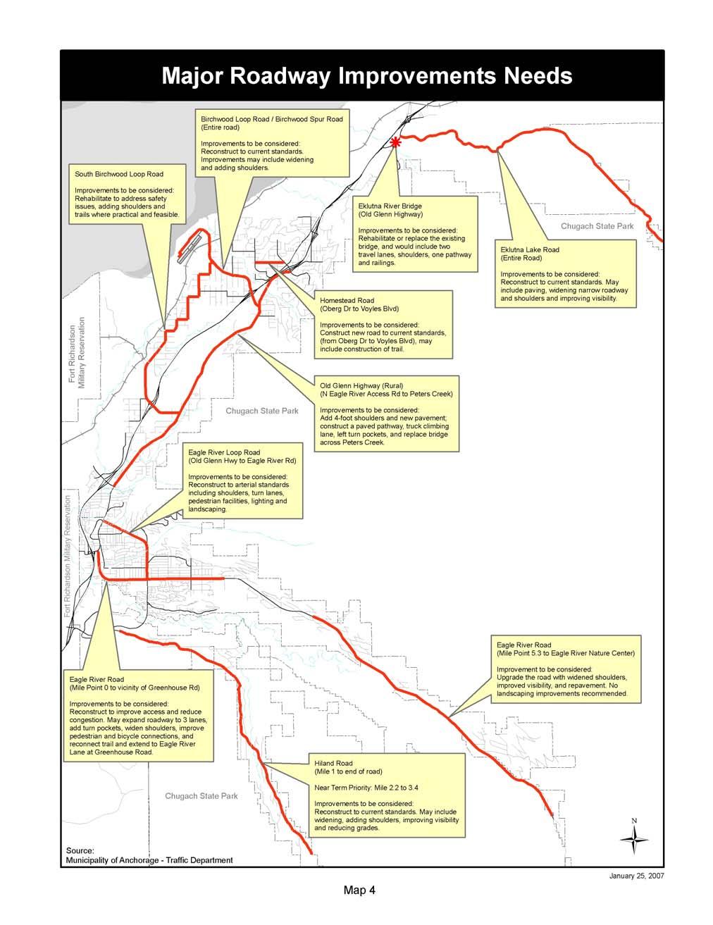
76 64
77 II. PUBLIC TRANSPORTATION RECOMMENDATIONS The transit system has shown recent significant improvements in terms of ridership and efficiency. Transit is expected to play an increasing role in meeting transportation demand as Chugiak-Eagle River matures. Four core challenges for public transit guide scoping of the LRTP transit element: Funding determines what level of transit service is possible Public policy and public perceptions of transit service value define the willingness to support public funding Improved transit service operations and service delivery can increase riders Attracting more riders and sustaining or improving service productivity are the key transit performance benchmarks The critical balance for transit service has three determinants: (1) the quantity of service operated, which defines cost; (2) the number of riders carried, which is the reason for providing transit; and (3) the revenue sources available to support service, some from riders and ancillary sources, but primarily from public funds. This balance is at the crux of policy about the minimum necessary transit service and how much more can be realistically provided. A core mission of public transit is to ensure that all segments of the community have available transportation and access to community opportunities. Transit services must be more frequent and travel time must be more competitive with private vehicle travel to attract travelers who can choose either private vehicles or transit. Chugiak-Eagle River has the additional challenges of low-density housing, distance of the community from Anchorage, and rural nature of the roadway configuration. The following recommendations for the Chugiak-Eagle River area are based on the Public Transportation Department Route Restructure Analysis (People Mover Blueprint), completed in 2002 and comments received through the public involvement process in preparation of this LRTP. The following recommendations are conceptual only: Provide express bus service in the Glenn Highway corridor direct to Downtown, Midtown and University-Medical employment centers in Anchorage. Travel in the Glenn Highway corridor between Chugiak-Eagle River and the Anchorage Bowl is projected to double during the next 20 years. Providing express, frequent commuter bus service with buses running at 10-minute intervals or less during commuter peak periods will be needed to forestall serious congestion. Federal tax-free benefits for commuter fares, employer-supported bus passes and other incentives, experimentation with cash incentives for non-solo driving and phased provision of express bus and HOV-only lanes will reinforce the express bus program. This concept also includes park-and-ride lots and weather-protected shelters at outlying locations where warranted. Maintain large-bus service to provide transportation for area residents into Anchorage, with some direct service into the downtown area 65
78 Provide connectivity between Chugiak-Eagle River and destinations in Anchorage other than downtown. Some areas to which residents have requested direct service are the Alaska Native Medical Center, Midtown Anchorage, and Ted Stevens Anchorage International Airport. Many of these connections can be facilitated through efficient transfers at the Muldoon transit facility Explore expanding local People Mover service in Chugiak-Eagle River, Birchwood, Peters Creek, and Eklutna Village as areas develop Explore additional Share-A-Ride program alternatives, particularly the vanpool program in the Chugiak-Eagle River area With the growth of the Mat-Su Valley, there is potential for Chugiak-Eagle River residents to travel to Palmer and Wasilla for shopping and employment, increasing the need for additional coordination efforts with MASCOT, the Mat-Su bus system Provide additional transportation coordination with the Chugiak Senior Center Explore the Guaranteed Ride Home program to make transit and carpool or vanpool more attractive. Getting commuters to share rides or use other means to travel to work is easier when they have backup ways to deal with return trips in emergencies or other unanticipated circumstances Explore improving service frequencies Monday through Saturday, enhancing evening service, and adding Sunday service III. TRANSPORTATION ENHANCEMENT RECOMMENDATIONS The 1997 Areawide Trails Plan lists the top 50 trail projects that are to be implemented within the next 20 years. Among the top 50 trail projects listed, 14 are located in the study area for the Chugiak-Eagle River LRTP. Several have already been completed. For purposes of this LRTP, recommendations for individual trails projects include those listed in the Trails Plan that have not yet been completed. These trails are as follows: Coastal Trail mouth of Peters Creek to Beach Lake Park and to Eklutna Eagle River Greenbelt connect to Hiland Road Eagle River Loop Road Eagle River Road to Old Glenn Highway Eklutna Waterline dedicate trail Fire Creek Trail Glenn Highway - Peters Creek to Mat-Su Valley Hillside Trail Chugach Rim Birchwood Loop Road and Old Glenn Highway North Birchwood interchange to Loretta French Park Old Glenn Highway Chugiak to Eagle River 66
79 For this LRTP, the short-range recommendations include committed trail projects that are expected to be constructed within the next 6 years through the TIP or some other support. Two stand-alone projects currently scheduled for inclusion in the AMATS TIP for Fiscal Year are included in Appendix A under Transportation Enhancements: the Eagle River Greenbelt Access and Pathway, and the Glenn Highway Trail Rehabilitation (Muldoon Road to Birchwood Loop Road). Improvements to trails are included in several roadway improvement projects listed, including Old Glenn Highway Reconstruction (Fire Lake to Peters Creek), Eagle River Loop Road Rehabilitation, and Eagle River Road Improvements (Mile 0 to near Greenhouse Street.) In addition to the specific projects listed above, trails and sidewalks along major roadways, as well as pedestrian access to schools, are and should continue to be a focus of transportation enhancements in Chugiak-Eagle River. Needs identified in the LRTP should serve as input for updates to the Areawide Trails Plan, and for developing the Pedestrian Plan and Bicycle Plan elements of the new Anchorage Non-Motorized Transportation Plan. The Areawide Trails Plan is a guide for pedestrian and bicycle facility planning and the recommendations of that plan serve as a source for trail and pedestrian improvements in the AMATS area. Future roadway improvements should reference the Areawide Trails Plan and amendments throughout all three elements of the new Non-Motorized Transportation Plan, when adopted. Projects developed in the Eagle River urban core should reference and use, where feasible, findings of the 2003 Eagle River CBD Revitalization Plan. The locations of trails and pedestrian accommodations on the Areawide Trails Plan maps are approximate, and are subject to available right-of-way, project budgets, terrain, and other constraining factors. Recommendations will be analyzed for feasibility and suitability as projects are developed. IV. CONGESTION MANAGEMENT RECOMMENDATIONS A recommendation of this LRTP is to continue to monitor the roadway segments and intersections in the Chugiak-Eagle River area that are identified in Table 4 and Map 3 of Chapter 4 as currently, or projected to be (by 2027), performing over capacity. This work should be performed as part of the ongoing data collection and monitoring effort for the Congestion Management Program. V. FREIGHT MOBILITY RECOMMENDATIONS The Artillery Road and Hiland Road Interchanges, as well as the entire length of the Glenn Highway, should be analyzed to address the capacity for oversize freight movements. The Alaska Railroad Birchwood terminal reserve will be used for traditional rail activity, including leasing operations, which could conceivably increase traffic on Birchwood Loop Road. Traffic volume should be monitored to determine whether future improvements are needed along Birchwood Loop Road. Eagle River should continue to be included in future data collection and monitoring efforts for movement of freight vehicles. The proposed comprehensive CBD circulation study should also address the movement of freight vehicles. A safety study is 67
80 recommended to evaluate commercial vehicle traffic from the Glenn Highway to the gravel pits along Old Glenn Highway. VI. INTELLIGENT TRANSPORTATION SYSTEMS (ITS) RECOMMENDATIONS Projects included in the MOA ITS Implementation Plan should be periodically reviewed and updated as the LRTP and TIP are developed, and should be included in improvement projects as appropriate. The MOA Regional ITS Architecture should be maintained and updated as needed. (See also Public Safety and Security Recommendations, below.) VII. PUBLIC SAFETY AND SECURITY RECOMMENDATIONS Concerns expressed during development of the 2003 LRTP highlighted these needs: identification of problem locations for emergency responders, including gaps and missing links in existing routes; establishment of priorities for the needs identified; and development of recommendations for improving emergency response. Results of current work by the Steering Committee to identify such connections should be presented when available to the public for review and comment, and should be considered for incorporation into the LRTP when complete. Recommendations for smaller road connections on existing roads could possibly be included together as a separate category to be funded. Where these connections affect streets designated collector and above, the Chugiak-Eagle River LRTP and OS&HP Map should be amended. In planning for future needs, the consideration of neighborhood connectivity during the review of private development proposals, particularly subdivision and master plans for planned communities, is critical to serve the best interests of the community as a whole. The 2003 LRTP recommended a Glenn Highway frontage roads analysis (Hiland Road to Muldoon Road), as operation of this roadway segment is of concern to Chugiak-Eagle River residents, particularly in the event of major accidents. There has been no activity on this task, and the recommendation is retained for this LRTP. This LRTP recommends adding to the frontage road analysis a study of possible northern frontage roads, or their equivalent (on the east side, from Settlers Drive to Old Glenn Highway, Thunderbird Drive, and on the west side, from Mirror Lake Middle School at Old Glenn Highway to Eklutna Interchange). Continuous frontage roads would provide an alternative route to the main lanes of the Glenn Highway, which is desirable particularly in the even of major accidents or disaster. The study would explore possible frontage roads, and consider other traffic management options, including re-routing traffic on the Glenn Highway, for emergency management purposes. The Emergency Operations Plan should be reviewed and updated to specifically reference traffic operation and control. The Traffic Department planning tool for estimating evacuation times should be reviewed and updated, as appropriate, to incorporate the most current MOA GIS maps available. The MOA Regional ITS Architecture should be amended to specifically include Homeland Security, and should be offered as a planning tool to assist in updating the Emergency Operations Plan. 68
81 VIII. RECOMMENDATIONS FOR FURTHER STUDY: CBD / RESIDENTIAL CORE This LRTP recommends that a comprehensive circulation study be conducted for the entire road network within the downtown core of Eagle River. The study should assess pedestrian improvement needs, access management alternatives, the need for improved connectivity between the Old Glenn Highway and Business Boulevard, and traffic flow along the Old Glenn Highway, including the movement of freight vehicles. A rigorous alternatives analysis conducted as part of this study would also address improved connections between the Powder Reserve and the CBD. The proposed study should reference and use, where feasible, the findings of the 2003 Eagle River CBD Revitalization Plan (See Chapter 13, Study Area I). IX. RECOMMENDATIONS FOR CONSULTATION AND ENVIRONMENTAL MITIGATION SAFETEA-LU includes new and expanded requirements for consultation with federal, state and tribal agencies responsible for land use management, natural resources, environmental protection, conservation, and historic preservation in developing the LRTP. These new requirements are effective July 2007, and efforts were made to be consistent with the new requirements in developing this LRTP. Appendix E describes the efforts made for public outreach, and for consultation for environmental and cultural resources, and for environmental justice. In developing this LRTP, staff consulted with the MOA Planning Department, MOA Department of Health and Human Services, MOA Heritage Land Bank, Chugiak-Eagle River Parks and Recreation Department, federal Bureau of Land Management, and Native Village of Eklutna, the local federally recognized tribe within the MOA. In addition, the Chugiak-Eagle River Historical Society; State Historic Preservation Office; Alaska Department of Fish and Game; Alaska Department of Natural Resources Habitat; U.S. Fish and Wildlife Service; U.S. Environmental Protection Agency; and U.S. Army Corps of Engineers were contacted. The MOA worked with the Native Village of Eklutna to develop an agreement for coordination on transportation planning issues. The agreement was signed April 25, Recommendations for consultation and potential mitigation activities are provided below. In consulting with the State Historic Preservation Office (SHPO) and Native Village of Eklutna (NVE), some culturally sensitive sites were identified that may potentially be affected by one or more projects recommended in this LRTP. Project managers should consult the SHPO inventory of reported sites and consult with Native Village of Eklutna Land and Environment Department to determine all potential impacts to cultural resources in a project area, and address potential mitigation measures in project documentation. The MOA Planning Department, Environmental Protection Agency, and U.S. Army Corps of Engineers recommend that the policies and maps of the Anchorage Wetlands Management Plan (AWMP) and the Anchorage Coastal Management Plan (ACMP), as well as other Municipal resource maps, including the new Coastal Resource Atlas maps and Municipal Watershed Management Services Stream and Drainage Mapping Standards (periodically updated database) be incorporated into the LRTP as resources to be consulted for potential project impacts. Work 69
82 on every specific project should include consulting, early in the planning stages, with the Municipal Watershed Management and Physical Planning Divisions to obtain the most up-todate information regarding these resources. Several proposed road improvements and potentially all proposed trails have the potential to impact wetlands, streams, or intertidal areas, either directly or indirectly. EPA recommends the following: plan and design the improvements in order to maximize avoidance of aquatic areas minimize direct, indirect and cumulative impacts through planning and design, where avoidance is impracticable implement measures to offset unavoidable adverse impact Such actions are required by Part (a) of the Clean Water Act s Section 404(b)(1) Guidelines, compliance with which is necessary in order to obtain Corps of Engineers authorization for aquatic fill. Projects affecting wetlands identified in the Anchorage Wetlands Management Plan should comply with the enforceable policies and management strategies of the plan, and all projects that would involve adverse impacts to aquatic areas should include, in their design and construction budgets, adequate funding to provide for avoidance, minimization and compensatory mitigation measures. Avoidance measures include, where practicable, the following: maximizing opportunities for forms of transportation other than automobiles alignment of routes through uplands or the edges or lower value portions of wetlands use of retaining walls and other features to minimize fill footprints incorporation of onsite storm water treatment measures Compensatory mitigation measures include the following: replacing or upgrading existing culverts or other structures that block or impede fish passage increasing the length of existing bridges restoring previously damaged reaches of streams or areas of wetlands providing for permanent protection of valuable aquatic areas 70
83 CHAPTER 11: FINANCIAL PLAN According to federal planning regulations, all transportation plans must include a financial plan that demonstrates the consistency of proposed transportation investments with already available and projected sources of revenue. The financial plan must compare the estimated revenue from existing and proposed funding sources that can reasonably be expected to be available for transportation uses, and the estimated costs of constructing, maintaining, and operating the total (existing plus planned) transportation system during the period of the LRTP. The Chugiak-Eagle River LRTP identifies roadway, alternative mode, and trail improvement needs for the next 20 years. The feasibility of funding the needs identified in this LRTP are discussed below. The financial plans for the Anchorage Bowl LRTP and the Chugiak-Eagle River LRTP must be consistent with each other. The discussion below, therefore, includes references to the Anchorage Bowl 2025 LRTP. I. ROADWAY IMPROVEMENTS The likelihood of an individual roadway project being funded in the next 20 years depends partly on which source of money it is eligible to receive. The largest pot of money comes from the federal government through SAFETEA-LU. SAFETEA-LU funding is generally divided into two parts: NHS and Non-NHS. Other major sources of funding for roadways are state and local funding. The requirements, limitations, and applicable uses of these funding sources is described below. Public-private partnerships are another means of financing road improvements. While these types of partnerships have not been pursued for Chugiak-Eagle River, they could be considered for the future. A. National Highway System (NHS) Funding The purpose of the NHS is to provide an interconnected system of principal arterial routes to serve major population centers, international border crossings, ports, airports, public transportation facilities, and other major travel destinations; meet national defense requirements; and serve interstate and interregional travel. The Glenn Highway is the only roadway within Chugiak-Eagle River currently designated as an NHS facility. All NHS projects shown in the Anchorage Bowl 2025 LRTP are listed below. (Chugiak-Eagle River area projects appear in bold): Glenn Highway Ingra Street and Gambell Street to McCarrey Street Minnesota Drive and C Street Interchange Bragaw Road and Glenn Highway Interchange International Airport Road Extension Old Seward Highway to Brayton Drive Seward Highway O Malley Road to 36 th Avenue Muldoon Road Improvements Tudor Road to Glenn Highway Glenn Highway and Seward Highway Connection Tudor Road Access Management Seward Highway to Arctic Boulevard Tudor Road Access Management Seward Highway to Patterson Street Glenn Highway at Eagle River Hiland Road to Artillery Road (includes trail) 71
84 Glenn Highway Interchange Operational Analysis and Improvements Muldoon Road Interchange to Eklutna Seward Highway and O Malley Road Interchange Seward Highway O Malley Road to Rabbit Creek Road Ingra Street and Gambell Street Extension 3 rd Avenue to Whitney Road Seward Highway Potter Weigh Station to Rabbit Creek Road Minnesota Drive (Northbound) 26 th Avenue to 16 th Avenue A/C Street Couplet Restripe Tudor Road to 9 th Avenue C Street/Ocean Dock Road Access Ramp C Street Viaduct to Ocean Dock Road Postmark Drive/International Airport Road Grade Separation Postmark Drive to International Airport Road Jewel Lake Road/International Airport Road Grade Separation Jewel Lake Road to Northwood Street Muldoon Road Interchange Glenn Highway at Muldoon Road Minnesota Drive Frontage Road Dimond Boulevard to Raspberry Road Minnesota Drive Corridor International Airport Road to Northern Lights Boulevard Minnesota Drive/Tudor Road Interchange Glenn Highway HOV Lane Boniface Parkway to Eagle River Artillery Road Interchange Glenn Highway HOV Lane Eagle River Artillery Road Interchange to Mile 21.5, South Peters Creek Interchange (Voyles Road) Lake Otis Parkway/Tudor Road Intersection Total cost of the NHS projects recommended in the Anchorage Bowl 2025 LRTP is approximately $1.3 billion. (The cost estimate for the Glenn Highway, Artillery Road to Peters Creek, did not include the new proposed interchange between Birchwood Loop Road and South Birchwood Loop Road.) Other NHS-related expenditures include pavement rehabilitation, rut repair, and pavement preservation; they are expected to cost an additional $76 million, for a total estimated cost of $1.4 billion for NHS projects. The Anchorage Bowl 2025 LRTP estimates federal revenues designated for the NHS, federal earmarks, and state bonding and capital program sources projected to be available to pay for NHS improvements are about $811 million. The balance of $606 million can be covered by a portion of available non-nhs revenues. (Estimated revenues are in millions of 2004 dollars.) Projections are based on historical trends. See Tables 8 and 10, below. 72
85 Table 8. Comparison of Costs and Revenues Available to Implement National Highway System LRTP Projects to 2025 (Anchorage Bowl and Chugiak- Eagle River combined) Item Roadway improvements (LRTP projects only) Cost ($) a 1,341 Roadway pavement preservation 76 Total Cost 1,417 NHS revenues available FHWA designated NHS funds State match funds Federal earmarks State capital program Non-NHS revenues available (see Table 10) Total Revenue $1,417 a All costs and revenues are in millions of 2004 dollars. Source: CH2M HILL, Anchorage 2025 Long-Range Transportation Plan B. Non-NHS Funding Federal non-nhs funding can be used more flexibly than NHS funding. In the past, this source of funding has been used primarily to fund arterial roadway improvements. There have been a few exceptions, in which non-nhs funds have been used for collector street improvements. The non-nhs funding may be the best source of funding for the arterial and collector street improvements needed in Chugiak-Eagle River. All major roadway projects listed in Chapter 10 are eligible for non-nhs funding. Table 9 shows the non-nhs roadway improvement projects to 2027 recommended in this LRTP, with cost estimates totaling $139,051,
86 Table 9 Non-NHS Funded Projects to 2027 for Chugiak-Eagle River Estimated Cumulative Roadway Project Project Cost Estimated Cost ($,000) ($,000) Eagle River Road Rehabilitation Mile 5.3 to Mile ,700,000 12,700,000 Eagle River Loop Road Rehabilitation 9,000,000 21,700,000 Old Glenn Highway Reconstruction Phase II Fire Lake 20,750,000 42,450,000 to Peters Creek Eagle River CBD Study 150,000 42,600,000 Eklutna River Bridge Rehabilitation/Replacement 6,000,000 48,600,000 Hiland Road Improvements Mile 2.2 to Mile 3.4 6,000,000 54,600,000 Homestead Road Improvements 3,000,000 57,600,000 Eagle River Road Improvements Mile 0 to 17,210,000 74,810,000 near Greenhouse Street Birchwood Loop Road and Birchwood Spur Road 8,985,000 83,795,000 Improvements Eklutna Lake Road Improvements 18,546, ,341,000 South Birchwood Loop Road Improvements 17,610, ,951,000 Hiland Road Improvements Mile 1 to Mile 2.2, and 19,100, ,051,000 Mile 3.4 to end of road* Source: MOA and ADOT&PF *It is intended that appropriate projects meeting the greatest needs of the public shall be identified along the Hiland Road corridor. See project description, page 55. The financial plan for the Anchorage Bowl 2025 LRTP estimated that if Anchorage maintained its historical funding levels, total funds available to implement non-nhs projects in both the Anchorage Bowl 2025 LRTP and the 2003 Chugiak-Eagle River LRTP would be approximately $1.6 billion, in 2004 dollars, leaving about $654 million available for NHS or other projects (see Table 10.) As shown in Table 8, of this available $654 million, the NHS will need about $606 million, leaving approximately $48 million for other projects to Beyond the Anchorage Bowl LRTP horizon year of 2025, an additional estimated $51 million per year in 2026 and 2027 is anticipated. While project cost estimates in this LRTP for Chugiak-Eagle River (see Table 9) total about $48 million more than the $91 million estimated earlier in the Anchorage Bowl 2025 LRTP, it appears there will be enough remaining non-nhs funding available to cover all the recommended projects in this LRTP to
87 Table 10 Comparison of Costs and Revenues Available to Implement Non-National Highway System LRTP Projects to 2025 (Anchorage Bowl and Chugiak-Eagle River combined) Item Roadway improvements (Anchorage Bowl LRTP) Roadway improvements (Chugiak- Eagle River LRTP) Cost ($) a Roadway pavement preservation 108 Roadway safety projects 35 Enhancements 87 CMAQ 79 Planning, studies, and coordination 6 Total Cost 960 Total FHWA revenues 1,029 Total state and local match revenues State capital program MOA road bonds MOA non-motorized capital Other federal programs Total Revenue 1,614 Non-NHS revenues available for NHS or other projects 654 a All costs and revenues are in millions of 2004 dollars. Source: CH2M HILL, Anchorage 2025 Long-Range Transportation Plan For federal-aid projects, there is a local match requirement. Table 11, below (Table 1 from the State Transportation Improvement Program, or STIP), shows state match funds for surface transportation projects by facility ownership. Where the state provides less than 100% in match funds, the remainder must be provided through other sources (for example, local funds or the Municipal Capital Project Matching Grant Program.) 75
. The Anchorage Bowl 2025 LRTP estimates approximately $9.")
88 Table 11 State Match Funds Surface Transportation Projects Source: Alaska State Transportation Improvement Program, Included in the Anchorage Bowl 2025 LRTP revenue estimate for non-nhs projects are funds made available through local match funds and the Municipal Capital Project Matching Grant Program (Alaksa Statute 37.06). The Anchorage Bowl 2025 LRTP estimates approximately $9.4 million per year will be available for non-nhs projects through the state capital program and about $5 million per year will be available from state and local match revenues (see Table 10). To secure a grant from the Municipal Capital Project Matching Grant Program, Chugiak-Eagle River roadways must not only compete with projects sponsored by other cities but also with other Anchorage needs. Historically, from one-third to one-half of the total Anchorage allocation has been spent on roadway improvements. The competitiveness of the state capital program makes it difficult to estimate the amount of money that might be available for Chugiak- Eagle River roadway projects in the future. Chugiak-Eagle River does have a source of funding for the 30% local match required by the Municipal Capital Project Matching Grant Program. Several years ago, Chugiak-Eagle River voters approved a 1.0-mil road/drainage capital improvement levy and a 1.1 mil winter/summer road and drainage maintenance levy. The money has been used for a variety of purposes, including the Recycled Asphalt Program (RAP) and minor roadway improvements. It was also 76
89 used to provide the local match requirement for the Baronoff Street upgrade project. That project was financed through a $1.330 million state grant and a $0.570 million local match from the Chugiak-Eagle River capital improvement mil levy. It is up to the CBERRRSA Board to recommend how to spend the capital mil levy. To obtain a share of this funding source, the major roadway projects identified in this LRTP will have to compete with an array of other pressing local needs. Many existing local roads under the Board s control have serious repair and reconstruction needs that must be addressed in a comprehensive manner. For example, several subdivisions that were accepted by the MOA over the years are not meeting their normal life expectancy of 20 to 40 years and are in need of major repairs. The service area has improved all gravel roads (approximately 115 miles) over the last 15 years with the Recycled Asphalt and Chip Seal surface with a normal average life expectancy of 10 to 15 years. A long-range capital improvement plan will need to include resurfacing up to 10 miles of chip seal each year in order to keep pace with the roads reaching their expected life. Drainage improvements are an ongoing need and will continue to consume between 10% and 15% of the Board s CIP mil levy well into the future. In addition, there will be ongoing pressure on the Board to provide additional improvements to their road system relating to safety problems and standard amenities. Approximately 173 miles of local roads are considered part of the CBERRRSA. Several roads listed in the LRTP as needing improvements are included in this total, for example Homestead Road and the upper part of Hiland Road. Although these roadways improvements could be funded by non-nhs federal money, they also possibly could be funded through a combination of state grants and local contributions. II. PUBLIC TRANSPORTATION AND OTHER MODES Many recommendations from Chapter 10 were included in the financial plan for the Anchorage Bowl 2025 LRTP, including express bus service along the Glenn Highway corridor and expanding carpool and vanpool programs. Funding for the expanded bus system operations would require increased MOA general fund allocations or revenue from new sources of at least $1.1 million per year to cover recommended service improvements in the Anchorage Bowl LRTP, and probably more for the additional recommendations in this LRTP. It will be up to transportation officials as well as transit advocates and users to convince decision makers that transit is an essential service and that operating revenues need to be increased to implement the recommended program expansions. Capital equipment and facilities receive funding from the FHWA and the Federal Transit Administration (FTA). Projects are scheduled in the AMATS TIP. Local match requirements (up to 20% for FTA programs) are met through general obligation bonds approved by the voters. Operating funds are allocated through the annual operating budget process. Operating funds are a combination of fares, advertising revenues, tax support, and FTA contributions to the preventative maintenance function. 77
90 The bicycle trail and sidewalk needs in Chugiak-Eagle River are greater than the funding available to construct them. The Anchorage Trails Plan and the updated version (Non-Motorized Transportation Plan), as well as the Eagle River CBD Revitalization Plan, should be used to set priorities for the projects. III. MAINTENANCE The roadway recommendations contained in this LRTP will not substantially increase the maintenance costs for either the State of Alaska or CBERRRSA. All but two of the roadway projects are upgrades of existing roads, which do not require additional lanes. In many cases, the projects will result in a net maintenance cost savings especially where improvements to the existing substandard roadbed and drainage reduce the need to repair the roadway surface. Implementation of the trails and sidewalk recommendations contained in this LRTP could result in a substantial increase in the length of the existing trail system. The ability and willingness to pay the additional cost of maintaining this expanded system should be resolved before a commitment to build them is made. Both the CBERRRSA Board and the Chugiak-Eagle River Parks and Recreation Commission continue to work to address this issue. IV. SUMMARY OF FINANCIALLY CONSTRAINED RECOMMENDATIONS As the above analysis demonstrates, sufficient federal funding will be available to finance all recommended major roadway improvement needs in the next 20 years. Federal regulations state that the LRTP will be used to develop the needs list for the TIP. To provide guidance to AMATS staff in assessing which Chugiak-Eagle River projects to include in the TIP, the financially constrained roadway projects have been categorized by the following horizon year phases: Fiscal Year (FY) , FY , and FY (see Table 12). 78
91 Table 12 Short- and Long-Term Roadway Recommendations Horizon Phases Projects FY AMATS TIP (Committed) Non-NHS Projects Eagle River Road Rehabilitation Mile 5.3 to Mile 12.6 Eagle River Loop Road Rehabilitation Old Glenn Highway Reconstruction Phase II Fire Lake to Peters Creek Eagle River CBD Study Eklutna River Bridge Rehabilitation/Replacement Hiland Road Improvements Mile 2.2 to Mile 3.4 Homestead Road Improvements Eagle River Road Improvements Mile 0 to near Greenhouse Street Birchwood Loop Road and Birchwood Spur Road Improvements Eklutna Lake Road Improvements South Birchwood Loop Road Improvements Hiland Road Improvements Mile 1 to Mile 2.2, and Mile 3.4 to end* NHS Projects (Illustrative Purposes Only) I I I I I I FY (Short-Term) I I I I I I I I I FY (Long-Term) I I I I I I I I Glenn Highway New Interchange I I between Birchwood Loop Road and South Birchwood Loop Road *It is intended that appropriate projects meeting the greatest needs of the public shall be identified along the Hiland Road corridor. See project description page
92 80
93 CHAPTER 12: AIR QUALITY I. NATURE AND EXTENT OF THE AIR QUALITY PROBLEM The EPA has set standards for each of six principal pollutants, which are called criteria pollutants. These include carbon monoxide, particulate matter, ozone, sulfur oxides, nitrogen dioxide, and lead. These standards set limits to protect public health, including the health of sensitive populations such as asthmatics, children, and the elderly. If a community fails to meet these standards, the EPA may designate it as a non-attainment area and require that community to develop and implement a plan to attain the standard. Eagle River generally enjoys good air quality and is designated as an attainment area for all pollutants except particulate matter. In 1987, the EPA designated a portion of Eagle River, encompassing the CBD, surrounding residential areas, and the upper portion of Eagle River as a nonattainment area for PM-10 (particulate matter less than 10 microns in diameter). At that time, many local roads in the area were unpaved. In spring and fall, dust from these roads would contribute to PM-10 concentrations that often exceeded the federal clean air standard. In the late 1980s, a PM-10 control plan was developed and implemented in Eagle River. As a consequence of this plan, by the early 1990s, nearly all the unpaved roads in the area were paved or surfaced with recycled asphalt. PM-10 air quality improved significantly, and there have been no violations in the federal standard for PM-10. Figure 7 shows average annual PM-10 concentrations in Eagle River from 1981 through Figure 7 Average Annual PM-10 Concentrations in Eagle River Before Paving micrograms per cubic meter
94 The EPA is currently considering revisions to the current standards for particulate matter. In particular, it is proposing to revoke the PM-10 standard altogether and substitute a new standard for coarse particles that will be called PM-10 c. If this change occurs, the EPA is expected to remove the current PM-10 nonattainment designation for Eagle River. II. CONFORMITY WITH FEDERAL CLEAN AIR ACT REQUIREMENTS Regulations for air quality conformity state that each new LRTP must be demonstrated to conform to the Clean Air Act requirements before the LRTP is approved by the MPO or is accepted by the U.S. DOT. An analysis of the recommendations in this LRTP was performed, and the final report was approved in. The report shows that projects included in the Chugiak-Eagle River 2027 LRTP will not contribute to new violations of the national ambient air quality standard (NAAQS) for PM-10, increase the frequency or severity of any existing violations in the problem zone, or delay timely attainment of the NAAQS. 82
95 CHAPTER 13: OFFICIAL STREETS & HIGHWAYS PLAN The Official Streets and Highways Plan (OS&HP) provide a means for the community to prepare for future development. It does this by establishing the location, classification and minimum right-of-ways of those streets and highways required to accommodate the transportation needs of the community in years to come. The OS&HP complements the Municipality of Anchorage's Comprehensive Plan by contributing to the achievement of the community goals expressed by that plan. Streets and highways are closely linked with community development. Planning for land use and the highway system should be integrated as much as is practicable. The Official Streets and Highways Plan (OS&HP) for the Municipality of Anchorage consists of two parts. The first establishes the policies and standards that will guide the community in creating the necessary highway transportation system. The second part consists of maps that graphically depict the hierarchy of streets and highways, both existing and planned, that will form the highway transportation system. The OS&HP maps are based on the policies and standards set forth in the document; however, where maps conflict with the policies and standards the maps shall govern. The OS&HP prescribes the location and classification of present and future primary roads within the Municipality of Anchorage. It governs decisions on right-of-way widths and major right-ofway alignments for proposed subdivisions reviewed by the Platting Board. In addition, the OS&HP guides the Planning and Zoning Commission in its review of conditional uses, site plans, and zoning actions. The OS&HP supplements Title 21 of the Municipal Code in regard to the major highway system serving Anchorage. In a developing community such as Anchorage, the location of major and minor arterials and collector streets must be established in advance of land subdivision activity, in order to avoid the need to acquire the necessary right-of-ways for planned highways and streets at a higher cost in later years. However, final alignments may vary somewhat from those shown on the OS&HP maps. Most freeway, expressway, and major and minor arterial alignments are finally determined after environmental impact review. Collector and local road alignments are often determined during the process of design and platting of new subdivisions. The development of the Official Streets and Highway Plan is closely related to the development of updated Long-Range Transportation Plans (for both the Anchorage Bowl and for Chugiak Eagle-River) for the Municipality by the Anchorage Metropolitan Area Transportation Solutions (AMATS) process. Information acquired during the update of the Long-Range Transportation Plans is relied upon heavily for the necessary data required in determining highway and street patterns and locations shown in the OS&HP. A considerable amount of analysis of new demographic and transportation data is completed before extensive computer modeling techniques are used to determine future highway transportation system needs. Although the AMATS Long-Range Transportation Plan is subject to annual review and possible revision, the major highway facilities that are identified are considered to be essential for the effective development of Anchorage's highway system. The Long-Range Transportation Plans, which focus on streets classified collector and above, form much of the basis for the 83
96 recommendations contained in the OS&HP. The OS&HP, in fact, becomes the implementing instrument for the Long Range Transportation Plan by officially identifying, by ordinance, the locations, classifications, and minimum right-of-way requirements of the street and highway system needed to meet long range transportation goals over the next 25-year period. Traffic projections prepared in conjunction with the Chugiak-Eagle River Long-Range Transportation Plan show that several area roads will be congested by the year 2027, primarily due to increases in population. There is more to traffic congestion than total number of cars, however. In order to ensure that the roadway system will work right, the functional classification of the primary roadway system (collectors, arterials, expressways, and freeways) needs to be accurately identified. At least some of the difficulty in moving people and goods in cities results from various elements of the circulation system being called upon to fulfill functions for which they were not designed. Misuse and failure of the transportation system is sometimes the result of misunderstanding the appropriate function of different streets. Street classification affects roadway capacity in two ways. First, the design of the roadway is largely based on its classification. Roadway characteristics such as width, design speed, right-ofway, and intersections vary depending on whether a road is classified as a freeway, arterial, collector, or local roadway. Traffic engineers look to these classifications to provide guidance regarding what standards to use. For example, freeways, which are intended to serve as conduits for large volume, long-distance traffic, will be designed with grade-separated interchanges and wide medium strips. Collector streets, which are intended to provide access into and out of neighborhoods, will be designed with lower speeds in mind and at-grade intersections. If roads are misclassified, the design may be inappropriate for the function it is intended to serve. The second way street classification affects roadway capacity is in the type of access, which is allowed to and from the street. Freeways are the most efficient means of moving people from one part of the city to another. One of the reasons freeways are so efficient is that they do not allow any access except at interchanges. In general, the more unlimited the access to a street, the fewer cars it can carry. Thus, if a street primarily serves to move traffic through an area, the number of access points should be restricted. On the other hand, if a street primarily is used to gain access to property abutting the street, then unlimited access is not a concern. The conflict between through traffic needs and access to homes and businesses is basically incompatible. When volumes of traffic are low and the abutting land is not used intensively, the conflict is minor, but when traffic volumes are high and the adjoining land is used intensively (such as on the Old Glenn Highway near downtown Eagle River) the conflict increases geometrically, and the capacity of the road is greatly reduced. I. THE EXISTING STREET CLASSIFICATION SYSTEM Streets can be divided into five basic categories: local roads, collectors, arterials, expressways, and freeways. Each higher classification acts as collector for a number of facilities of the next lower classification in a cumulative, hierarchical fashion. The following is a description of each of the functional street classifications. 84
97 A. Freeways Freeways are limited access corridors that are intended to provide safe movement of substantial volumes of traffic at high speeds. The freeway has only one function - to carry traffic. Because it is thus specialized, with controlled access, no parking, and no at-grade intersections, it is a highly efficient carrier of traffic and has a much higher capacity per lane than the typical arterial or other type of street. The only existing freeway designation in Chugiak-Eagle River is the Glenn Highway from the Scale house to the MOA Boundary. B. Expressways Expressways are basically high-class arterials. They are typically divided highways that are designed primarily for through traffic, with full-or partial-control of access. Intersections are either at-grade or grade-separated. Expressways move traffic efficiently, but less quickly than freeways, due to at-grade intersections. They are like freeways, however, in that they do not provide access to adjacent land uses. (Note: There are no expressway designations in the Chugiak-Eagle River study area.) C. Arterial Streets The primary function of arterial streets is to move large volumes of traffic over relatively long distances from one part of the city to another. As a result, arterial streets have a great deal more through trips than collector streets. There are also more restrictions on the number of direct access points than collectors. Land access is a secondary function of arterials. Access to the road is mostly restricted to adjacent major land uses. The reason for these restrictions is to ensure that the flow of traffic is relatively unimpeded. For the Chugiak-Eagle River area, Municipal ordinance designates arterials as Class III Arterials (minimum 100 right-of-way width.) D. Collector Streets A collector street collects traffic from local streets and then conducts it to arterials or to local traffic generators such as shopping centers, schools, community centers, or park and recreational facilities. It may supply abutting property with some degree of land service but this should be avoided as much as possible. Collector streets are designed to give priority over local streets in traffic control locations. In commercial areas, traffic volumes are often too high to permit the utilization of collectors. In these areas, local streets are designed to connect directly with an arterial. In large industrial areas where traffic volumes are lower, collector streets are more often needed. For the Chugiak-Eagle River area, Municipal ordinance designates collectors as Class 1B Collector (minimum 70 right-of-way width.) Existing streets designated as collector in the Chugiak-Eagle River area are not expected to change substantially in character. The main function of a residential collector street is to conduct traffic from local residential areas to arterials. Land access should be a secondary function of the residential collector, and both curb and driveway access should be discouraged except at those locations where traffic movement patterns may be effectively controlled. Title 21 requires that front lot lines of residential lots shall not abut a street designated as collector or greater on the OS&HP. A collector may also function as an easement for utilities. Collectors may also be designed to provide access functions for commercial and industrial development, interconnecting such areas 85
98 with adjoining residential districts. Such facilities should also be designed to minimize curb and driveway access except at those locations where traffic movement patterns may be effectively controlled. Parking along collectors should be discouraged. The location of residential collectors is influenced by their function as well as by the density of urban development and topography. The following guidelines should be followed in planning for new collector streets: Collector streets should serve to collect traffic from local streets of all types and transmit this traffic to the arterial street system or to important trip generating activities within small residential areas. The collector street system should be designed so that through traffic is discouraged between larger residential areas or between larger residential areas and major activity areas. In residential areas, collector streets should be planned to not exceed one-half mile in length if possible, and to discourage continuous links between arterials. Collector streets should be designed to provide priority to through traffic movement, as compared to the access function of local streets. They should provide some degree of access control, in order to maximize safety and minimize traffic maneuvering problems, and they should provide a limited land service function to abutting property. New subdivisions should be designed to not allow direct driveway access to collectors. In areas of low density residential development, limited direct driveway access to collectors may be allowed but only if the collector street will not become a major link in the future to more densely developed areas. Reverse lot design should be used in subdivisions, in order to minimize driveway access onto collector streets. Collector streets should provide access to local neighborhood schools and neighborhood recreation areas. Pedestrian facilities should be provided along collectors to allow for safe access between these activity centers. Residential collectors should be designed to provide only two travel lanes, with limited widths on shoulder areas for emergency parking. On-street parking is not appropriate on collector roads. Designs should be developed to discourage curb parking. E. Local Streets The principal purpose of a local street is to provide access to property abutting the public rightof-way. Moving traffic is a secondary function of the local street. Since land service is its primary purpose, the local street should not carry through traffic. Buses and heavy trucks should be excluded except where the local street is in a commercial or an industrial district of the city. All streets not designated as a collector, arterial, expressway, or freeways on the Official Streets & Highways Plan are considered local streets. 86
99 F. Country Lanes Country Lanes are a special type of street design having unique scenic attributes. Generally speaking, there are two basic types of Country Lanes: Narrow, gravel roads having very light traffic volumes. (Note: gravel roads have been eliminated in Chugiak-Eagle River. All new roads shall have a RAP surface at a minimum.) Two lane paved roads with relatively light traffic volumes. The Official Streets and Highways Plan Map does not contain any Country Lane designations for the Chugiak-Eagle River area. Instead, the determination as to what local roads and collectors will be considered for Country Lane design standards will be made on a case by case basis by the Chugiak, Birchwood, Eagle River Rural Road Service Area Board. This determination will be made prior to upgrades or improvements of local or collector roads and shall be based on the following guidelines: The character of the surrounding area should be aesthetically pleasing, containing natural settings or landscaping. In rural settings, the development along the road should be predominately residential and should include no industrial, commercial, or resource extraction land uses. In urban settings, the roadside development should be institutional or residential and should include vistas of natural features. Roadways should conform to the natural topography. Scenic vistas may be a very strong factor in designating a Country Lane where these conditions predominate. Easements may be acquired to protect areas crucial to the maintenance or enhancement of visual quality. Local roads or collectors, which have been determined by the CBERRRSA Board to fit the Country Lane criteria, shall be designed according to the following standards: 1. Utility Lines a. Every attempt shall be made to minimize conflicts and duplications of effort when installing water, natural gas, and electric lines. b. After underground installation of any utility lines, landscaping shall be used to restore the area as quickly as possible to a natural condition. 87
100 2. Lighting Streets designated as Country Lanes should be equipped (when lights are deemed necessary for safety) with low-profile, low-density illumination lamps of a design that is compatible with the surrounding natural environment. 3. Construction and Maintenance a. Clearing should be done within the right-of-way only as necessary to assure adequate snow storage and roadway associated drainage. Areas cleared for construction, but not needed for snow storage and roadway associated drainage, must be restored as quickly as possible to a natural appearing condition. Care shall be taken to retain scenic views and protect or enhance the visual quality of the roadway and sight distance for safety. b. Ditches, where necessary, shall be no wider or deeper than required for drainage of the roadway and adjacent development. c. Easements may be acquired to protect areas crucial to the maintenance or enhancements of visual quality. 4. Subdivision and Development Review a. Subdivision and development review shall take place to assure conformity of development street designs to Country Lane Standards. b. Consideration shall be given to preserving natural vegetation and enhancing visual qualities as part of the subdivision or development design when adjoining Country Lanes. 5. Duplicate Designation of Country Lanes Where a road carries a duplicate designation such as Collector and Country Lane, for the purposes of site plan review and construction design, extra attention should be given to enhancing the scenic quality of the road. Inclusions of necessary facilities, such as turn outs, are to be provided. This is not to preclude the construction of walkways, etc., but to address how they are constructed. G. Street Typology Additions to Functional Classifications The functional classification of a street broadly defines its design and operational characteristics related primarily to the movement of motor vehicles. A supplement to the OS&HP traditional functional classification system was recently adopted, along with the Anchorage Bowl 2005 LRTP. The supplement further defines street relationships with adjacent land use and pedestrian, bicyclist, and transit needs. The design of streets, intersections, sidewalks, and transit stops should be consistent with the type and intensity of the adjacent land use. The street typologies (Appendix C) strike a balance between functional classification, adjacent land use, and multimodal travel needs. Each street typology sets priorities for various design elements by 88
101 incorporating factors related to both the adjacent land uses and the functional classification. The intent is to tie street design to the functional classification of the road and adjacent land use, and user needs. The street typology is not intended to be prescriptive, however. Not all elements will apply to every situation. The typology should be tailored for the Chugiak-Eagle River area, with public input, on a case-by-case basis, as part of the project development process for roadways. II. CLASSIFICATION CHANGES AND STUDY AREAS The purpose of this section of the Transportation Plan is to update the street classification system and study areas for Chugiak-Eagle River, last updated in Study areas are indicated for those cases where not enough information is available to make a reasonable prediction of the future collector and arterial needs of an area. These areas will require additional study prior to identifying any functional designations. Map 5 at the end of this chapter shows roads classified as collector and above in Chugiak-Eagle River, and the location of Study Areas, with proposed changes discussed below. There are two types of collector designations: those that affect existing streets and those that affect future streets. Existing streets, which are designated as collectors in this plan, are not expected to change substantially in character. Improvements to these streets, if they occur, will generally be limited to sidewalk improvements and upgrades from strip paved and/or gravel roadways to Municipal standards. The right-of-way and speed limits will remain the same (generally 60 feet and 25 miles per hour respectively) and no attempt will be made to increase the capacity of the roadway by adding additional lanes. The exception to this rule may be collectors, which are included as major roadway improvements in this Plan: i.e., Hiland Road, South Birchwood Loop Road, Homestead Road and Eklutna Lake Road. Changes to the 2003 Official Streets & Highways Plan for Chugiak-Eagle River involve a few changes to the collector system as well as to designated study areas. Recent adopted changes to the OS&HP map for the Anchorage Bowl eliminated Study Areas A to D. As the only remaining Study Areas are within Chugiak-Eagle River, they have been redesignated here as A through J. CLASSIFICATION CHANGES During the public review period, suggestions to make the following changes to the OS&HP Classification Listing and Map were approved by the Planning and Zoning Commission: to extend Rankin Road from Knik Vista Street to Oak Knoll Drive and designate Rankin Road as a collector; to extend Knik Vista Street to Rankin Road (extended); to delete Helluva Street, and to show Starner Street as a collector from Aurora Borealis Road (not Chamber Lane) to Bernie Avenue. These changes are reflected on Map 5, and on the OS&HP Classification Listing, in Appendix D. 89
102 STUDY AREAS Powder Reserve / Eklutna 770 / Development Reserve: (Study Areas A, B, C, E) The 2006 Chugiak-Eagle River Comprehensive Plan Update provides new designations for two large undeveloped tracts owned by Eklutna: Eklutna 770 (Study Area A), the land between Old Glenn Highway and the Glenn Highway and between Birchwood Loop Road and South Birchwood Loop Road; and the Powder Reserve (Study Area B), located west of the Glenn Highway near the North Eagle River Access Road interchange. Both areas were formerly designated Mixed Use, a classification that has been deleted from the Land Use Plan Map. The Eklutna 770 lands are now classified as Residential, 1-2 dwellings per acre; with an overlay that indicates the 1-2 dwellings per acre density for this area is an overall average density. As a result, some areas may have a greater density than 2 dwelling units per acre. The Land Use Plan Map also classifies a portion of the 770 as Commercial and Industrial. The location and acreage of Commercial and Industrial uses within the Eklutna 770 are noted for conceptual planning purposes only. The exact size and location for these areas will be determined through an areaspecific master planning process for the Eklutna 770. Most of the Powder Reserve, northern undeveloped area, is classified on the Land Use Plan Map as Residential, 3-6 dwellings per acre, with an overlay indicating that the 3-6 dwelling units per acre density for this area in an overall density. As a result, some areas may have a greater density than 6 dwelling units per acre. A portion of the Powder Reserve northern area is classified on the Land Use Plan map as Commercial and Community Facility. The location and acreage of these uses are noted for conceptual planning purposes only; the exact size and location will be determined through an area-specific master planning process for the Powder Reserve. These area classifications allow for a wide range of uses, making it difficult to accurately predict future land use patterns and densities. The master planning process for both the Eklutna 770 and the Powder Reserve will need to include a planned circulation system to provide for a system of collectors and arterials. By avoiding piecemeal development, it is hoped that an integrated network of local, collector and arterial streets can be established for these undeveloped areas. Absent such planning, it is difficult to make specific recommendations regarding a system of collectors and arterials prior to the actual subdivision or zoning submittal. The Master Development Plan for Tract A of the Powder Reserve, approved May 2001, is undergoing revision by the developer. Currently it shows a total of 1,830 development units planned, at densities varying from 2.7 to 9.0 DU/acre, with an average of 3.4 DU/acre. The need exists to provide for future connectivity between the Powder Reserve north to Chugiak High School, and south to Artillery Road interchange. The latter connection is indicated on the OS&HP Map, with an arrow, indicating that alignment will be determined in the future. In the near-term, such a connection does not appear likely, but is retained on the OS&HP Map for longer-term needs. A future connection to the north is not indicated on the map at this time, pending outcome of unresolved issues pertaining to the NW ¼ Section 25 Land Use Study. A road corridor should be reserved through NW ¼ Section 25 in the final Section 25 Land Use 90
103 Study in the event a future study indicates the need for a collector road alignment through that area. The alignment of the connection to the north will depend in part on the future updated master plan for the expanded Powder Reserve area. Development of the Eklutna lands between the Glenn Highway and Knik Arm west of the Mirror Lake interchange (Study Area C), and farther north (Study Area E) will need to require a rigorous alternatives analysis for circulation, particularly taking into account the effect on the North Peters Creek area. The decision whether or not to extend Reese Road, and the resulting increased traffic that will be loaded onto Lake Hill Drive, must be addressed in an areawide study. Lake Hill Drive was originally constructed as a local residential street and was not intended to serve as a collector. There are several strategies which, when taken together, could help reduce the volume of traffic on Lake Hill Drive. One involves extending the Old Glenn Highway as an arterial into this area, that could connect with a new collector to the north of existing Reese Road, and which could serve the new subdivisions, including Glenn View Estates. Another strategy involves utilization of the Mirror Lake interchange of the Glenn Highway as the principal access to this undeveloped Eklutna land (see Study Area D, below.) In addition, it is recommended that for future development of lands located in Study Areas B, C and E, that lands be considered in those areas adjacent to the rail lines for an intermodal transit facility or other appropriate public purpose during the master planning process. Commuter rail service through the Chugiak-Eagle River area to the Anchorage Bowl and the Mat-Su Valley could be operational in the future. It is important to preserve the opportunity along the rail lines in these areas for future service. Mirror Lake Interchange (Study Area D) Thousands of acres of undeveloped land, owned by Eklutna, Inc., lie between the Glenn Highway and Knik Arm east of the Mirror Lake interchange. Formerly classified as Residential, this area was reclassified in the 2006 Chugiak-Eagle River Comprehensive Plan Update Land Use Plan as Development Reserve. This classification is applied to areas that are generally suitable for development but whose location and absence of public facilities and lack of projected demand make near-term and intermediate-term development uncertain. Large-lot, single family residential development is allowed by right. A public master planning process with proposed rezonings to active development districts will occur prior to other development, according to the Comprehensive Plan. Given appropriate access, this area could generate a substantial amount of traffic; most of this traffic would end up on the Glenn Highway. Thus, it is important that there is an adequate access to the Highway from the undeveloped land. Two existing interchanges exist which could serve this property: the Mirror Lake Interchange and the Eklutna Interchange. The Mirror Lake Interchange is probably best suited to serve the southern portion of the undeveloped lands to the south of Edmonds Creek, but should not be required to handle the full load. In order to reduce the distance to the freeway interchange and avoid overburdening existing residential roads, the Eklutna Interchange will need to be utilized as the freeway access to the undeveloped land between Edmonds Creek and Eklutna Village. Use of this interchange will require the construction of an access road (collector or greater) through Edmonds Lake Regional Park. 91
104 Prior to the subdivision of the undeveloped Eklutna land, a study should be conducted as a part of the Traffic Impact Analysis to determine the advisability of using the Mirror Lake Interchange as the primary access to the development and determine the best route through the park in order to minimize its impact. South Fork Access (Study Area F) Because of the potential for wildfire events, one area needing secondary access identified by Anchorage Fire Department-Eagle River (Station 11) is the South Fork Park area. Due to size and weight limitations of the only available access to this area via the Chugach State Park-owned bridge near Ken Logan Circle, AFD would like to explore other access options. Homesteaders and developers who own property in the area have also expressed a desire for better access. However, access has been a contentious issue, with some private property owners wanting to limit cut-through traffic by users of South Fork Park, and differences of opinion among residents regarding future development. Environmental issues are also a concern, and ongoing discussions regarding access points for the proposed Eagle River Greenbelt project affect available options. For now, the South Fork Community Council agrees there may be merit in a locked emergency access route, in cooperation with local property owners, but that will not address all access needs. However, there are too many outstanding issues to specify one solution in this LRTP. As this area develops in the future, more roads will be needed. Therefore, this area has been designated a Study Area. The Study could be funded by either AMATS or the State of Alaska, in conjunction with Alaska State Parks, and should examine the various alternatives and recommend the best options in consultation with South Fork Community Council. Eagle Pointe Subdivision Secondary Access (Study Area G) Future planned development adjacent to Eagle Pointe will increase the need for secondary access for both subdivisions, and should be provided for as development occurs. A local road connection with adjacent property has already been provided for by the developer of Eagle Pointe. As other land is developed north of Eagle River Loop Road closer to Yosemite Drive, the need for additional collectors serving the area should be addressed. No lines are shown on the OS&HP Map, as the exact location and alignment are to be determined with future development. Glenn Highway Emergency Management Operations (Study Area H) Chapter 9, Public Safety and Security, includes a recommendation carried forward from the 2003 LRTP for a Glenn Highway Frontage Roads Analysis (Hiland Road to Muldoon Road), as operation of this roadway segment is of concern to Chugiak-Eagle River residents, particularly in the event of major accidents. This LRTP adds to this study proposed northern Frontage Roads, or their equivalent (on the east side, from Settlers Drive to Old Glenn Highway, Thunderbird Drive, and on the west side, from Mirror Lake Middle School at Old Glenn Highway to Eklutna Interchange.) Continuous frontage roads would provide an alternative route to the main lanes of the Glenn Highway, which is desirable particularly in the even of major accidents or disaster. The study would explore possible frontage roads, and alternatively consider other traffic management options, including re-routing traffic on the Glenn Highway, for emergency management purposes. 92
105 Eagle River CBD / Residential Core (Study Area I) The area to the east of Old Glenn Highway and Old Eagle River Road between Eagle River Loop Road and Eagle River Road has seen increased development recently, intensifying already congested conditions, particularly at Monte Road and Old Glenn Highway. Left-turning movements from Monte Road onto Old Glenn Highway are difficult, especially during peak travel times, and pedestrian facilities are lacking. A CBD / Residential Core Circulation Study is recommended to address these and other core area problems. The Study Area boundaries will likely be the Glenn Highway to the west, Artillery Road to the southwest, Firehouse Lane to the southeast, North Eagle River Access Road to the north, and will extend east of Old Glenn Highway approximately 0.5 miles. The scope of the study will be defined when the Request for Proposal is developed. Chapter 6, Congestion Management, Section A, provides a more detailed discussion of elements to be included in this study. New Connection from Glenn Highway to Birchwood Airport (Study Area J) The proposed study will evaluate a possible new connection primarily for commercial vehicle traffic from the Glenn Highway to the Birchwood Airport, as an alternative to Birchwood Loop Road. Residents along Birchwood Loop Road have expressed concerns that improving Birchwood Loop Road could lead to increased speeds. A proposed new road would connect Birchwood Airport with the Glenn Highway at a proposed new interchange location midway between Birchwood Loop Road and South Birchwood Loop Road. III. OFFICIAL STREETS & HIGHWAYS PLAN MAP Map 5 represents the Official Streets and Highway Plan map for Chugiak-Eagle River and includes all of the above recommendations. When approved, the map will supersede the 2003 OS&HP map for the Chugiak-Eagle River area. Where street and highway alignments on the plan map correspond to existing streets, the planned alignment shall conform substantially to the existing alignment. Where street and highway alignments on the plan map do not correspond to existing streets, the alignment on the plan map is approximate. Such alignments are finally determined by the acceptance of right-of-way dedications on subdivision plats or during the redesign phase of a planned facility. The discussion contained in the preceding part of this section should be used to further refine the plan map. 93

106 DRAFT APPROVAL PENDING 94
107 APPENDIX A STATUS OF CHUGIAK-EAGLE RIVER AREA PROJECTS INCLUDED IN AMATS FFY TRANSPORTATION IMPROVEMENT PROGRAM (TIP) AS OF
108 APPENDIX A: STATUS OF PROJECTS INCLUDED IN AMATS FFY TIP CHUGIAK/EAGLE RIVER AREA (As amended through August 2006 / G = Grandfathered) Project Rank in TIP (8/06) Project Description Table 3 - ROADWAY IMPROVEMENTS Years and Phases identified in amended FFY TIP* Status of Projects as of 2007 Estimated Cost ($,000) G-4 Eagle River Road Rehabilitation (Mile 5.3 to Mile 12.6) Upgrade the road with widened shoulders, improved visibility, and repavement. No landscaping improvements recommended. G-5 Eagle River Loop Road Rehabilitation (Old Glenn Highway to Eagle River Road) Reconstruct to arterial standards, including shoulders, turn lanes, pedestrian facilities, lighting and landscaping. Landscaping at 5% of construction with cost to be determined. Recommended to be developed as a 3R project according to ADOT&PF Preconstruction Manual. G-6 Old Glenn Highway Reconstruction Phase II ( Fire Lake to Peters Creek) Add 4- foot shoulders and new pavement; construct a paved pathway, truck climbing lane, left-turn pockets at South Birchwood Loop Road, Birchwood Loop Road, and Ski Road, and replace bridge across Peters Creek. Construction in 2008 from Fire Lake to South Birchwood. Construction in 2010 from South Birchwood to Peters Creek. Right-of-way funding previously authorized in Eagle River CBD Study The project would conduct a comprehensive circulation study for the entire road network within the downtown core of Eagle River. The study will include an assessment of pedestrian improvement needs, access management alternatives, the need for improved connectivity between the Old Glenn Highway and Business Boulevard, and traffic flow along the Old Glenn Highway, including the movement of freight vehicles. 12 Eklutna River Bridge Rehabilitation/Replacement (at Old Glenn Highway) Rehabilitate or replace the existing bridge. A new structure would have a design life of 50+ years and would include two travel lanes, shoulders, one pathway, and railing ROW 2009 U/C 2010 U/C ROW ongoing. UTIL coordination ongoing U/C Design & Acquisition work scheduled for completion by Spring D 2008 U/C 2010 U/C Design, ROW, and UTIL coordination ongoing. 12,700 9,000 20, Implementation Project set up phase ROW U/C Environmental documentation. Project pending resolution of local match funding issue. 6,000 96
109 Project Rank in TIP, as amended (8/06) Project Description Years and Phases identified in amended FFY TIP Status of Projects as of 2007 Estimated Cost ($,000) Table 4 - TRANSPORTATION ENHANCEMENTS G-4 Glenn Highway Trail Rehabilitation (Muldoon Road to Birchwood Loop Road) Resurface existing trail, formalize a parking facility near the weigh station, and construct a memorial pull-out ROW 2009 U/C 2010 U/C Design ongoing. ROW base mapping complete. 2,787 2 Eagle River Greenbelt Access and Pathway Construct 12 miles of new trail in the Eagle River Greenbelt, connecting the Briggs Bridge with the Visitor Center, including new trails and interpretive displays on the trails and at the trailheads. Construction likely to be completed in phases D 2010 ROW C Environmental study evaluation. 22,250 97
110 98
111 APPENDIX B RELATED STUDY AND PLANNING EFFORTS 99
112 APPENDIX B RELATED STUDY AND PLANNING EFFORTS Many relevant plans and study efforts have been consulted or coordinated with during preparation of this LRTP, including the following: Alaska s National Highways, 1995, Alaska Department of Transportation and Public Facilities Anchorage Bowl Comprehensive Plan: Anchorage 2020, February 2001, Municipality of Anchorage Planning Department Anchorage Bowl 2025 Long-Range Transportation Plan, December 2005, CH2MHill for AMATS (ADOT&PF, MOA) Anchorage Coastal Management Plan (ACMP), 1979, Municipality of Anchorage Anchorage Coastal Resource Atlas Maps, Draft, 2006, Municipality of Anchorage Anchorage Regional ITS Architecture Final Report, Version 1.1, October 14, 2004 Areawide Trails Plan, 1997, Municipality of Anchorage Department of Community Planning and Development Anchorage Wetlands Management Plan (AWMP), 1995, Municipality of Anchorage Birchwood Airport Master Plan, Draft Office Study, 2002, HDR for Alaska Department Of Transportation and Public Facilities Chugiak-Eagle River Comprehensive Plan, 1993, Municipality of Anchorage Department of Community Planning and Development Chugiak-Eagle River Comprehensive Plan Update, December 2006 Congestion Management Program, October 1994, Municipality of Anchorage Department of Community Planning and Development, AMATS, and Alaska Department of Transportation and Public Facilities Eagle River Central Business District Revitalization Plan, October 2003, Land Design North for Municipality of Anchorage Eagle River PM 10 Control Plan (1991) and 1994 Milestone Report, Municipality of Anchorage Department of Health and Human Services Freight Mobility Study, June 2001, Municipality of Anchorage, Traffic Department Knik ARM (Alaska Regional Multimodal) Transportation Project: Access for Regional Economic Development Final Draft, July 2000, Northern Economics for Matanuska-Susitna Borough Master Development Plan for Tract A of the Powder Reserve, May 2001, Eklutna, Inc. Multi-Modal Transportation Survey, Craciun Research Group, Inc., for AMATS, March, NW ¼ Section 25 Land Use Study Draft, August 1, 2001, Municipality of Anchorage Planning Department 100
113 The People Mover Blueprint A Plan to Restructure the Anchorage Transit System Final Report, May 2002, RLS & Associates, Inc., for Municipality of Anchorage Public Transportation Department Port of Anchorage Northern Access Corridor Reconnaissance Study, November 1988, Tryck Nyman Hayes, Inc., for Port of Anchorage, Draft Report Southcentral Rail Network Commuter Study and Operation Plan, 2001, Alaska Railroad Corporation Stream and Drainage Mapping Standards (periodically updated data base), Municipality of Anchorage Watershed Management Services Title VI Assessment for Capital and Operating Assistance, September 2003, Municipality of Anchorage Public Transportation Department A. Alaska Railroad Corporation (ARRC) Commuter rail service to and from Anchorage is of particular interest to the Alaska Railroad Corporation (ARRC). A new rail station at Ted Stevens Anchorage International Airport has been completed. The station is anticipated to serve as a key link in developing and enhancing rail service from the Seward and Whittier ports, Anchorage, and the Mat-Su Valley. Additionally, ARRC will reduce rail trip times from Anchorage to Wasilla from the current 90 minutes to less than 55 minutes with an aggressive, ongoing program of track realignment, curve elimination, and double tracking, as well as acquisition of modern rail diesel cars. The Southcentral Rail Network Commuter Study and Operation Plan, funded by the Federal Transit Administration (FTA) and ARRC, was completed in This FTA funding program required a comprehensive study to determine cost-effectiveness and operating efficiencies. Service between Wasilla and Anchorage, with a stop proposed near Eagle River on Fort Richardson, was one alternative considered. More recently, ARRC worked with the MOA Planning Department to show on the 2006 Chugiak-Eagle River Comprehensive Plan Land Use Map an intermodal transit facility that has potential for a future commuter railway station near the Eklutna Powder Reserve. The Commuter Study analyzed projected ridership and capital and operating costs, and recommended minimal commuter service begin by However, ARRC is not planning to pursue commuter rail service independently. The study creates a blueprint for potential further actions by local and state officials to establish a viable and operational commuter rail system if they choose to do so, with participation by ARRC. B. Birchwood Airport The Birchwood Airport is a general aviation airport located approximately 20 miles north of Anchorage and west of the Glenn Highway along Knik Arm. During the past several years, the Alaska Department of Transportation and Public Facilities (ADOT&PF) and its consultant HDR Alaska, Inc., have studied ways to improve the Birchwood Airport and 101
114 develop a Master Plan that outlines short-term (5 years), intermediate-term (10 years), and long-term (20 years) airport improvements. The objectives of the Master Plan are to recommend actions to correct safety and capacity deficiencies; identify facilities required to serve existing and future air traffic demand; and develop a phased implementation plan to improve the airport to meet forecasted aviation needs for 20 years. The Master Plan will evaluate the need to maintain or improve existing facilities or to construct new facilities to enhance safety. Improved airport facilities, with possible service expansions in the future, are not expected to have a major effect on the road system. C. Regional Planning The Anchorage and Matanuska-Susitna Regional Transportation Planning Organization (RTPO) was formed in 2003 to coordinate planning efforts for the region. The RTPO grew from a need to develop a regional vision to ensure planning consistency with regional priorities and needs. The role of the RTPO was intended to supplement, not replace, planning efforts on behalf of all parties to address regionally significant projects that cross jurisdictional boundaries. The scope of work for an RTPO Long-Range Transportation Plan included a task to identify and analyze multimodal transportation alternatives to assess demand in the region, including roads, express transit, and commuter rail. Since 2004, however, there has been no further activity on the LRTP. 102
115 APPENDIX C STREET TYPOLOGY ADDITIONS TO FUNCTIONAL CLASSIFICATIONS DRAFT APPROVAL PENDING 103
116 APPENDIX C STREET TYPOLOGY ADDITIONS TO FUNCTIONAL CLASSIFICATION General Overview Functional street classifications encompass both the design characteristics of streets and the character of services that the streets are intended to provide. The functional street classifications in the Official Streets and Highways Plan of the Municipality of Anchorage (MOA) and the Coordinate Data System Log of the Alaska Department of Transportation and Public Facilities (DOT&PF) identify the primary function and use of the roadway for vehicular travel. Traditionally, functional classification forms hierarchies of streets ranging from those that are primarily for travel mobility (arterials) to those that are primarily for access to adjacent property (local or residential streets). The Long-Range Transportation Plan (LRTP) recognizes and retains most of the MOA existing classification system categories adopted by either the MOA or DOT&PF for freeways, expressways, arterials, collectors, and local streets, but recommends refining the designations of some streets. It has become clear since adoption of the Anchorage 2020: Anchorage Bowl Comprehensive Plan (Anchorage 2020) (prepared by the MOA in 2001) that the traditional functional classification system needs to be supplemented to reflect emphasis on a more balanced street function that considers land use and includes all users pedestrians, bicyclists, transit users, and motorists. The typology discussed in this report is intended to augment the traditional functional classification by expanding the street typology system to include the following designations: Residential street Main street Transit street Commercial street Industrial street Mixed use street Park land street Institutional district street Low-density residential street 104
117 As described, the functional classification of a street broadly defines its design and operational characteristics as they relate primarily to the movement of motor vehicles. By contrast, the street typologies further refine street designs by relating them to the adjacent land uses and their functions for other users pedestrians, bicyclists, and transit riders. Street design based solely on the traditional functional classification often neglects other modes of travel. The design of a street, its intersections, sidewalks, and transit stops should reflect the adjacent land uses because the type and intensity of the adjacent land use directly influences the level of use by other modes. Table 1 summarizes street typologies. The street typologies attempt to strike a balance among functional classification, adjacent land use, and the competing travel needs and uses. Each street typology prioritizes various design elements by looking at factors related to both the adjacent land uses and the functional classification. Where sufficient public right-of-way exists, all design elements may be accommodated. Within constrained public right-of-way, however, trade-offs between priority design elements are required to balance the function and needs of various travel modes. Designing streets to accommodate larger trucks will involve tradeoffs with streetscapes that are pedestrian-oriented, such as those within mixed-use areas. The tradeoffs will be resolved during the design public process by using context-sensitive design principles. 105
118 Table 1. Street Typology Summary Type of Street Functional Class Primary Elements Secondary Elements Traffic Management Elements Residential Collector, arterial Sidewalks Tree lawns On-street parking Landscaped medians Bike lanes on designated bicycle routes Commercial Arterial Number and width of travel lanes Medians Transit accommodations Industrial Collector, arterial Wider travel lanes Attached sidewalks Wider turning radius at intersections Main Streets Collector, arterial Wide sidewalks with transit access and pedestrian plazas Bicycle facilities Curb extensions Tree lawns On-street parking Number and width of travel lanes (especially collector and local streets) Pedestrian facilities Bicycle facilities Tree lawns Two-way center left-turn lanes On-street parking Medians Bicycle lanes On-street parking Number of lanes Tree lawns Medians Width and number of travel lanes (for collector and local streets) Medians On-street parking Street trees Narrower travel lanes Traffic circles and roundabouts Reduced pedestrian crossing distances at intersections, using curb extensions, traffic islands, and other measures Diverters Medians Consolidated driveways Synchronization of traffic signals Narrower travel lanes Parking restrictions Wider turn radius at intersections and access points Acceleration and deceleration lanes Narrower travel lanes Alternative paving material Tree planters in parking lane On-street parking Reduced pedestrians crossing distances at intersections, using curb extensions, traffic islands, and other measures Raised intersections High-visibility crosswalks 106
119 Table 1. Street Typology Summary Type of Street Functional Class Primary Elements Secondary Elements Traffic Management Elements Mixed-Use Streets Collector, arterial Wide sidewalks with transit access Bicycle lanes on designated bike routes Other bicycle facilities Tree lawns On-street parking Transit shelters and facilities Transit Arterial Bicycle lanes on designated bike routes Tree lawns Medians Transit shelters and facilities Sidewalks Park Land Collector, arterial Bicycle lanes on designated bike routes Retention of natural vegetation to the extent possible Separated bicycle paths where designated Institutional District Collector, arterial Bicycle lanes on designated bike routes Tree lawns Extensively landscaped medians Sidewalks Transit shelter and facilities Low-Density Residential Collector, arterial Bicycle lanes on designated bike routes Separated bike trails where designated Retention of natural vegetation Number and width of travel lanes (on collector and local streets Medians Number and width of travel lanes Width and number of travel lanes Design speed (horizontal and vertical curves do not need to be designed for higher speeds) Width of travel lanes Width and number of travel lanes Landscaped medians On-street parking Street trees Narrower travel lanes Reduced pedestrian crossing distances at intersections, using curb extensions, traffic islands, and other measures Landscape medians Street trees High visibility crosswalks Narrower travel lanes and shoulders Grade separated bike and pedestrian crossings Landscaped medians Street trees Narrower travel lanes Reduced pedestrian crossing distances at intersections, using curb extensions, traffic islands and other measures Narrower travel lanes 107
120 Functional Classification Descriptions The functional classification system is developed with recognition that individual streets do not act independently. Streets form a network that consists of streets that work together to serve travel needs that are local, citywide, and regional. Freeways The term freeway means a limited-access, high-speed road with grade-separated interchanges. The freeway has only one function: to carry traffic. These streets serve more than 40,000 trips a day. They should be built to freeway design standards with full-grade separations of intersecting streets. A freeway can be a major barrier separating land uses on one side from those on the other as well as dividing neighborhoods. Careful attention should be given to all details related to freeway design. Features might include depressing and covering the facility through intensely urbanized areas and providing noise barriers and landscaping to act as a buffer and improve aesthetics. Expressways An expressway is commonly defined as a divided arterial highway for through traffic with full or partial control of access and with intersections either at grade or grade separated. Expressways typically serve more than 20,000 trips per day and do not have the full control of access that characterizes freeways. Arterials Arterials are designed to provide a high degree of mobility and generally serve longer vehicle trips to, from, and within urban areas than are served by collectors or residential streets. The arterial system interconnects major urban elements such as the Central Business District, industrial facilities, large urban and suburban commercial centers, major residential areas, and other key activity centers. Movement of people and goods, also known as mobility, rather than access to adjacent land uses, is the primary function of an arterial street. Posted speed limits on arterial facilities generally range between 30 and 50 miles per hour (mph), varying according to the type of area being served. The lower end of the speed range is usually applied in higher-density employment and business areas, and higher speeds are found in outlying areas. Traffic volume and capacity of an arterial street depend, in part, on the number of through and turning lanes, signalization, the number of driveways and access points, and the volume of bus and truck traffic. The volumes and capacity of arterials can range from 10,000 vehicles per day on a two-lane arterial to 75,000 vehicles on a six-lane arterial. 108
121 With an emphasis on mobility, an arterial facility is generally designed to accommodate passenger cars, trucks, and buses. Bicycle facilities may be provided. Pedestrian facilities are always provided, but the width of these facilities varies depending on adjacent land use and the level of pedestrian activity. Spacing of arterials varies depending on the following area types: 1 mile apart in low-density residential areas, 1/2 mile apart in highdensity residential areas, 1/4 mile apart in commercial and industrial districts, and 1/8 mile apart in the Central Business District (Downtown). Collectors Collectors are designed to provide a greater balance between mobility and land access within residential, commercial, and industrial areas compared to that afforded by arterials. The composition of a collector facility depends largely on the density, size, and type of abutting development. Posted speed limits on collector facilities generally range between 25 and 35 mph. Traffic volume and capacity can range from 2,000 to 10,000 vehicles per day. Emphasizing balance between mobility and access, a collector facility is designed to better accommodate bicycle and pedestrian activity while still serving the needs of the motoring public. The spacing of collectors varies depending on the following area types: 1/2 mile apart in low-density residential areas, 1/4 mile apart in high-density residential areas, and 1/8-mile apart in commercial and industrial areas and the Central Business District. Street Typology Descriptions The following descriptions of the six street typologies identify the primary and secondary elements to include in the street cross section and examples of traffic management elements that may be applied. Residential Streets Residential streets serve two major purposes in Anchorage s neighborhoods. As arterials, residential streets balance multimodal mobility with land access. As collectors, residential streets are designed to emphasize walking, bicycling, and land access over mobility. In both cases, residential streets tend to be more pedestrian-oriented than commercial streets. Residential streets generally consist of two to four travel lanes, but place a higher priority on pedestrian- and bicycle-friendliness than on automobile mobility. Commercial Streets The most prevalent commercial streets are the strip commercial arterials. Strip commercial arterials typically serve commercial areas containing numerous retail centers with buildings that are set behind parking lots. Because of the nature of these areas, strip commercial arterials have many intersections and driveways to provide access to adjacent businesses. Historically, this type of street is 109
122 often highly automobile-oriented and tends to discourage walking and preclude bicycling. Mid-block crosswalks are rare, and ample on-street parking is infrequent because of the provision of off-street parking lots serving adjacent businesses. Commercial streets typically provide four to six lanes divided by a landscaped median. Under certain conditions, a commercial street may have a continuous two-way left-turn lane in the center. Commercial streets are designed to balance traffic mobility with land access. Because of the frequency of intersections and land access points on commercial streets, however, they often become congested. Industrial Streets Industrial streets are designed to accommodate significant volumes of large vehicles such as trucks, trailers, and other delivery vehicles. Because these areas are relatively low in density, bicycle and pedestrian travel is more infrequent than in other types of neighborhoods, but still should be accommodated. Industrial streets typically consist of two to four travel lanes, which are generally wider 15 to 20 feet wide to accommodate movement of larger vehicles. Bike lanes and on-street parking are rare on industrial streets. Sidewalks are provided, but are generally narrower than in other higher-density commercial and retail areas of Anchorage. Main Streets Main streets serve medium-intensity retail and mixed land uses as defined by the Town Center designations in Anchorage Unlike commercial streets, main streets are designated to promote walking, bicycling, and transit within attractive landscaped corridors. Generally, main street activities are concentrated along a two- to eight-block area, but may extend farther depending on the type of adjacent land uses and the area served. Main streets generally consist of two to four travel lanes. On-street parking is usually provided to serve adjacent land uses. Curb extensions within the parking lane can accommodate tree wells creating, in combination with a tree lawn, a double row of street trees. To further create a pedestrian-friendly atmosphere, main streets have wide sidewalks, 10 feet or greater, depending on the expected pedestrian traffic, street furniture, outdoor cafes, plazas, and other features. Transit Corridors Transit streets are located in medium- to high-intensity land uses as defined by the transit-supportive development corridor designation in Anchorage Alternative modes of travel are emphasized on transit streets with increased use of pedestrian, bicycle, and transit design elements. Transit streets typically consist of two to four travel lanes, and additional lanes along transit streets should be considered only as a last resort. Expansion of parallel routes should be first examined as a possible solution to congestion problems. If this alternative expansion to handle capacity is not possible, negative impacts on the pedestrian environment should be mitigated to the maximum extent feasible (see page 55 of Anchorage 2020). 110
123 Improvements such as landscaped medians and tree lawns are desirable to make transit streets more attractive to pedestrians and transit users. Most transit streets have limited commercial land uses and therefore do not require on-street parking or exceptionally wide sidewalks. Mixed-Use Streets Mixed-use streets are located in areas characterized by a mix of high-intensity commercial, retail, and residential areas with substantial pedestrian activity as defined by the employment and redevelopment designation in Anchorage Alternative modes of travel are emphasized on mixed-use streets with increased use of pedestrian, bicycle, and transit design elements. Mixed-use streets typically consist of two to four travel lanes. Improvements such as trees, lawns, and street furniture are desirable to make mixed-use streets more attractive for pedestrians. Mixeduse streets frequently provide on-street parking and wide sidewalks, depending on the type and intensity of adjacent commercial land uses. Park Land Street Park land streets are traffic corridors through or along park land or other natural open space. They are designed to minimize disturbance to the adjoining natural setting, through landscaping and alignments that reduce noise, air pollution, and visibility from those adjoining spaces. Park land streets generally carry low to moderate amounts of traffic and incorporate alignments to reveal scenic areas. Natural vegetation is typically retained where possible so that the park land street traveler will feel engaged with the natural setting. Grade-separated crossings are provided for recreationists, and measures are taken to prevent wildlife collisions. Institutional District Street Institutional district streets are expected to primarily serve the University/Medical District. The land use in this area is distinguished by medium- to high-density university and hospital campuses interspersed with large open spaces. Institutional district streets are designated to promote walking, bicycling, and transit within an attractive parkway type of landscaped corridor. Institutional district streets generally consist of two to four travel lanes with no on-street parking. Improvements such as trees, lawns, landscaped medians, and enhanced transit stops are desirable to make these streets more attractive and blend in with the campus environment. Sidewalks are provided, but are generally narrower than in other higher-density commercial and retail areas of Anchorage because an extensive sidewalk and trail system is available for use within the institutional campus setting. 111
124 Low-Density Residential Low-density residential streets are generally located in areas with less than one dwelling unit per acre. Because fewer residences occupy these areas, traffic volume is generally lower than on residential streets with more dwellings. Long distances between destinations also reduce the amount of walk trips compared to those in higher-density residential areas, although walking is a significant recreational activity. Low-density residential streets generally consist of two to four travel lanes. Historically, this type of street is often automobileoriented, but provisions need to be made for separated multi-use trails on one side of the road where feasible. Natural vegetation is typically retained where possible and supplemented with planted vegetation at strategic spots. 112
125 APPENDIX D 2007 CLASSIFICATION LISTING OF ROADWAYS IN CHUGIAK-EAGLE RIVER DRAFT APPROVAL PENDING 113
126 APPENDIX D 2007 CLASSIFICATION LISTING OF ROADWAYS IN CHUGIAK/EAGLE RIVER Roadway Name Beginning Point Terminus Facility Type Almdale Avenue Shims St Husky St Collector Artillery Road Glenn Hwy Interchange west terminus (includes Collector Mausel St) Artillery Road Glenn Hwy Interchange Eagle River Road Arterial Aurora Borealis Road Bernie Ave (extended) Birchwood Loop Road Collector Baronoff Avenue East Eagle River Loop Rd Old Eagle River Rd Collector Bernie Avenue (extended) Starner St Aurora Borealis Rd Collector Bill Stephens Drive Oberg Rd Voyles Blvd Collector Birchwood Loop Road / Birchwood Spur Road Old Glenn Hwy Birchwood Airport Arterial S Birchwood Loop Road Glenn Hwy Birchwood Loop Rd Collector /Birchwood Spur Road S Birchwood Loop Road Old Glenn Highway Glenn Highway Arterial Bowery Lane Birchwood Loop Rd Peters Creek Collector Business Boulevard Old Glenn Hwy Old Glenn Hwy Collector Chamber Lane [was Northshore Bill Stephens Dr [was Starner St Collector Dr] Glennway Dr] Coronado Road Old Glenn Hwy Eagle River Loop Spur Collector Driftwood Bay Drive East Eagle River Loop Rd east terminus Collector N Eagle River Access Road Old Glenn Hwy Powder Ridge Dr / Terrace Arterial Ln Eagle River Lane New England Dr south terminus (past Eagle Collector Riv Rd) N Eagle River Loop Road Old Glenn Hwy West Skyline Drive Arterial E Eagle River Loop Road West Skyline Drive Glenn Highway - Hiland Arterial Rd exit Eagle River Road Old Glenn Hwy Chugach State Park Visitor Arterial Center Eastside Drive Old Glenn Hwy Homestead Rd Collector Eklutna Lake Road Old Glenn Hwy Eklutna Lake Collector Eklutna Lake Road Old Glenn Hwy Glacier Loop Rd Collector Eklutna Park Drive N Eagle River Access Rd terminus Collector Farm Avenue Old Glenn Hwy Breckinridge Dr Collector Glacier Vista Road[was Glacier Knik Vista St Oberg Rd Collector Road] Glenn Highway Scale House MOA Boundary Freeway Helluva Street [DELETED] Aurora Borealis Rd Birchwood Loop Rd Collector Hiland Road East Eagle River Loop Rd terminus (includes Stewart Mt. Dr.) 114 Collector
127 Hillcrest Drive South Birchwood Loop Rd Shims St Collector Homestead Road Eastside Drive Monron St Collector Homestead Road Oberg Rd Voyles Blvd Collector Jayhawk Drive South Birchwood Loop Rd Sunset Blvd Collector Knik Vista Street Rankin Road (extended) Peters Creek Collector [REVISED] Lake Hill Drive Old Glenn Hwy north terminus Collector Loop Spur Road Coronado Rd N Eagle River Loop Rd Collector Oberg Road (extended) Bill Stephens Dr [was terminus past Reese Road Collector Glennway Dr] Old Eagle River Road Baronoff Ave Old Glenn Hwy Collector Old Glenn Highway Glenn Hwy Eklutna Lake Rd Collector Old Glenn Highway Eagle River Road terminus past Reese Rd Arterial Pilots Road Tarika Avenue Birchwood Loop Rd Collector Powder Ridge Drive Rankin Road (extended)[added] North Eagle River Access terminus Collector Road Knik Vista Street Oak Knoll Drive Collector Reese Road (extended) Lake Hill Dr Oberg Rd (extended) Collector Santa Maria Drive Old Glenn Hwy Spring Brook Dr Collector Settlers Drive Homestead Rd Mirror Lake Drive Collector Shims Street Hillcrest Dr Almdale Ave Collector Ski Road Eastside Dr Whaley Ave Collector W Skyline Drive N Eagle River Loop Rd / E Eagle River Loop Rd Canyon View Dr (includes Jamie Dr, McCrary Rd, Upper Skyline Dr) Collector Skyview Avenue Old Glenn Hwy Wildwood Drive Collector Starner Street Aurora Borealis Rd Bernie Ave Collector (REVISED) Sun Beau Drive War Admiral Dr E Eagle River Loop Rd Collector Sunset Boulevard Jayhawk Drive Tarika Avenue Collector Tarika Avenue Sunset Blvd Pilots Road Collector Terrace Lane James Way N Eagle River Access Rd Collector Thunderbird Drive Old Glenn Hwy South Terminus Collector Voyles Boulevard Old Glenn Hwy Sheltering Spruce Ave Collector War Admiral Drive Sun Beau Dr Eagle River Lane Collector Yosemite Drive {was Unnamed} East Eagle River Loop Rd Yellowstone Dr Collector [Editor s Note: Proposed roads in the Powder Reserve are unnamed. For a detailed description of the roadway classification system in Tract A, Powder Reserve, see the Assembly Ordinance approving the planned community (PC) district zoning.] 115
128 116
129 APPENDIX E PUBLIC OUTREACH, CONSULTATION, AND ENVIRONMENTAL JUSTICE 117
130 APPENDIX E PUBLIC OUTREACH, CONSULTATION, AND ENVIRONMENTAL JUSTICE The purpose of this appendix is to expand on the discussion of the public outreach effort for this LRTP and how the plan addresses meeting the needs of minorities and low income persons. The U.S. Department of Transportation (U.S. DOT) and the Federal Highway Administration (FHWA) have issued final orders pertaining to environmental justice. Metropolitan planning organizations, such as Anchorage Metropolitan Area Transportation Solutions (AMATS) are required to address environmental justice in plans, programs and policies. There are three fundamental environmental justice principles: To avoid, minimize, or mitigate disproportionately high and adverse human health and environmental effects, including social and economic effects, on minority populations and low-income populations To ensure the full and fair participation by all potentially affected communities in the transportation decision-making process To prevent the denial of, reduction in, or significant delay in the receipt of benefits by minority and low-income populations (For purposes of this Administrative Order, a minority person is defined as including the following: Black or African-American, Hispanic, Asian-American, or American Indian/Alaska Native. Low-income person is one whose median household income is at or below the Department of Health and Human Services poverty guidelines 80% or below the median income for Anchorage.) Environmental justice is not a new requirement. Recipients of federal aid have been required to certify, and the U.S. DOT must ensure, nondiscrimination under Title VI of the Civil Rights Act of 1964 and many other laws, regulations, and policies. In 1997, U.S. DOT issued its DOT Order to Address Environmental Justice in Minority Populations and Low-Income Populations, to summarize and expand on the requirements of Executive Order on Environmental Justice. The FHWA s Administrative Order followed soon after. In addition to the environmental justice requirements targeting minority and low-income groups, SAFETEA-LU has added new requirements for the planning process to provide opportunities for representatives of users of pedestrian walkways, bicycle transportation facilities, and disabled persons to participate in the planning process. SAFETEA-LU also includes new consultation requirements with federal, state, and tribal agencies addressing potential environmental mitigation activities, as well as with state and local agencies responsible for land use management, natural resources, environmental protection, conservation, and historic preservation concerning development of the LRTP. Although these new requirements are not effective until July 2007, efforts have been made to be consistent with new requirements in developing this LRTP. 118
131 Public Involvement, Outreach, and Consultation A Citizen Advisory Committee was formed in 2005 to advise the MOA Traffic Department staff in developing the draft Chugiak-Eagle River LRTP. Representatives from each area community council, the Chugiak-Eagle River Chamber of Commerce, Chugiak-Birchwood-Eagle River Rural Road Service Area (CBERRRSA) Board of Supervisors, Eagle River/Chugiak Parks, Recreation and Community Development, MOA Planning and Zoning Commission, and Eklutna, Inc., participated on the Citizen Advisory Committee. Each member of the committee was asked to serve as a liaison between the Citizen Advisory Committee and the group they represented. Five meetings with the committee were held. One important task of the CAC was to review the draft Chugiak-Eagle River Comprehensive Plan Guidelines for Growth for inclusion of relevant items into the Chugiak-Eagle River 2027 LRTP goals, policies, and objectives. Concurrently with development of this LRTP, the MOA Planning Department updated the Chugiak-Eagle River Comprehensive Plan. MOA Traffic and Planning Department staff worked closely together in reaching out to the public for both plan updates. Three joint public meetings were held in the spring of 2006 in the Chugiak-Eagle River area to obtain public comment on the Public Review Draft Chugiak-Eagle River Comprehensive Plan, and to obtain input in developing the LRTP. In addition, Alaska Department of Transportation and Public Facilities (ADOT&PF) sponsored a Plans and Projects Open House March 29, 2006, in Eagle River. Booths supported by multiple agencies showcased many important area roadway and parks projects and planning efforts, including the Chugiak-Eagle River LRTP and Comprehensive Plan updates. The open house was well attended, with more than 140 participants. Staff of the Planning and Traffic departments also gave presentations on both plan updates to the Chugiak- Eagle River Chamber of Commerce in June Also concurrently with development of this LRTP, work began on the Anchorage Pedestrian Plan element of the new Anchorage Non-Motorized Transportation Plan. Two public meeting workshops were held in Chugiak-Eagle River in February 2006, to obtain public input on desired new pedestrian connections, identification of existing obstacles, and walking destinations. Maps depicting public comments from these workshops were shared with the public during the three public meetings held by the Traffic and Planning departments in spring 2006, and additional public input was invited. The draft Pedestrian Plan is anticipated in 2007, and will emphasize sidewalks, walking routes, safe routes to school, and accessibility compliant with the Americans with Disabilities Act (ADA), and will identify missing links in the pedestrian transportation system. A new Bicycle Plan emphasizing commuting and bicycle transportation will be developed in An update to the 1997 MOA Areawide Trails Plan, emphasizing recreational trails, will follow in In April 2006, Traffic Department staff participated with MOA Public Transportation Department s public hearing for Chugiak-Eagle River area transit service changes. Traffic staff made a brief presentation on this LRTP update, and distributed transportation surveys to attendees. Staff also conducted an interview with a disabled member of the Public Transit Advisory Board and transit advocate. 119
132 To broaden outreach to minority and low-income persons during development of this LRTP update, the notification list was updated to include many of the minority organizations, churches, and businesses from resource lists of the ADOT&PF Office of Civil Rights. In addition, transportation planning surveys were distributed to many organizations serving youth, seniors, disabled and transit-dependent persons, and Alaska Natives, as well as to several area churches serving people in need. From all these outreach efforts, comments were received from 94 individuals. An effort has been made to weave comments received into this LRTP update to reflect as much as possible current views expressed by members of the community. In developing the draft LRTP, staff consulted with the MOA Planning Department, Department of Health and Human Services, Public Transportation Department, Heritage Land Bank, Chugiak-Eagle River Parks and Recreation Department, federal Bureau of Land Management, and Native Village of Eklutna, the local federally recognized tribe within the MOA. Staff also made efforts to consult with Chugiak-Eagle River Historical Society, Alaska Department of Fish and Game, Alaska Department of Natural Resources Habitat, U.S. Fish & Wildlife Service; State Historic Preservation Office and local and tribal cultural and historic resource agencies; U.S. Environmental Protection Agency, and U.S. Army Corps of Engineers. These efforts are addressed in Chapter 10, Recommendations. Environmental Justice The 2006 Chugiak-Eagle River Comprehensive Plan describes residents in Chugiak-Eagle River as having significantly higher income, on average, than the residents in the rest of the MOA. In 2000, the median household income for Chugiak-Eagle River was $68,652, compared to that for the MOA at $55,546. The percentage of impoverished citizens is also significantly less, with only 2.9% living below the poverty line in 2000, versus 7.3% of the overall MOA. Although the overall percentage of lower income persons is relatively low, an examination of Census data reveals there are some areas of higher concentration of lower income people (for example, 49.78% and 60.99% in two Census blocks near the downtown area) and other scattered areas with 26% to 50% lower-income residents. Minorities are also less represented in Chugiak-Eagle River than overall in the MOA. The average minority population for the MOA is 28%. Local residents are predominately white, although there appeared to be a slight increase in the percentage of minorities in In 1990, minorities made up less than 10% of the Chugiak-Eagle River population, but in 2000 the percentage was approximately 13%, with the largest groups being Alaska Native/Native American and Hispanic. The minority population appears to be fairly evenly dispersed throughout Chugiak-Eagle River. From a review of the 2000 U.S. Census and locally gathered survey information, it appears that low-income and minority populations are proportionately more dependent on the public transportation system. According to 2000 Census data, households that fall in the category of less than 80 percent of the median income ( low-income ) are twice as likely to own no vehicle. (Thirteen percent of these households do not own a vehicle, compared to 6.2 percent of the entire population.) The percentage of households without a vehicle is much higher among the very poor. (Twenty-eight percent of households that earn less than $20,000 per year own no vehicle.) 120
133 It is not surprising that as a result of the low vehicle ownership, low-income and minority populations constitute a higher percentage of bus riders. A 2001 telephone survey conducted by People Mover indicated a wide difference exists between the household income of People Mover riders and the general adult public. Although only 3 percent of the general adult public reported income of less than $10,000, 28 percent of People Mover riders reported incomes at that low level (see Figure 1). The ethnic composition of People Mover riders and the general adult public also differs substantially. Only 44 percent of People Mover riders self-identify as white while 79 percent of the adult public identifies itself as white. In addition, 28 percent of the riders surveyed identify themselves as Alaska Natives while only 5 percent of the general adult public population identifies itself as Alaska Native (see Figure 2). 121
134 Similarly, all other minority ethnic groups in the general population form a somewhat greater proportion of the People Mover ridership. The demonstration of a higher dependence on public transportation by low-income and minority populations should not be construed to mean that these groups do not benefit from highway improvements. After all, 68 percent of households with income less than $30,000 drive alone to work, compared to 76 percent of all Anchorage households (2000 U.S. Census). Nevertheless, it is apparent that low-income and minority populations will receive a substantially higher benefit from bus service improvements compared to other non-target populations. (Of households with incomes less than $30,000, 4.3 percent take the bus to work, compared to 1.6 percent of all households.) This LRTP contains many recommendations for transportation improvements, including roadway, transit, pedestrian, and bicycle. Recommendations that have the greatest impact on low-income and minority populations are found in the road and public transportation sections of Chapter 10. Public Transportation Chapter 10 makes recommendations for public transportation service for the Chugiak-Eagle River area. These recommendations pertain primarily to existing transit routes, and consider possible expansion of local service and ride-share opportunities. Provided that low-income and minority persons have access to the public transportation system, the recommendations in this LRTP should provide additional benefits, particularly those for new direct connections to destinations in the Anchorage Bowl, and for express bus service at frequent intervals on the Glenn Highway corridor to destinations in the Anchorage Bowl. The standard for transit access is considered relative to an area s population density. According to the September 2003 MOA Title VI Assessment for Capital and Operating Assistance, in medium- and high- density areas having 2,000 or more residents per square mile, a 5-minute 122
135 walk at 3 miles per hour (mph) is considered reasonable access. As defined, transit access should be provided to most dwelling units in medium- and high-density areas within ¼ mile of a bus route. In low- density areas of fewer than 2,000 persons per square mile, a 5-minute drive at 30 mph is considered reasonable access. This availability of transit should provide access to most dwelling units in low-density areas situated within 2-1/2 miles of a route. The MOA Public Transportation Department standard is to offer transit access to at least 90% of the population within the current service area. In 2003, 91% of all residents were provided access based on this definition. To determine the accessibility of the existing transit network in Chugiak-Eagle River to the target populations considered here, the existing fixed-route network was overlaid on maps of income and minority Census data. Map 1 shows the existing fixed-route transit network in Chugiak-Eagle River and the percentages of minority households. Map 2 shows the same fixedroute network with the percentages of households at or below 80% of the median Municipality of Anchorage income. The maps demonstrate that areas of low-income and minority populations are currently well served by the existing bus route network. Densities in the Eagle River urban zoned areas range from 43 to 6,305 persons per square mile. A more detailed analysis of 2000 Census data reveals that in the Eagle River urban zoned areas, pockets of higher-density low-income residents exist outside the ¼ mile access to a transit route. The areas of Chugiak, Birchwood and Peters Creek outside the Eagle River urban zone are considered low-density areas with 12 to 963 persons per square mile. Some low-density residential areas are not within 2-1/2 miles of a transit route, but the percentage of minority population in these areas is low to very low. These areas may eventually be considered for expansion of local service, in which case all residents, including the minority population, would benefit. A new strategy for providing transit service in new areas has been adopted. These key principles will guide decisions about transit service: Community service requests and socioeconomic and trip-making analyses Introduction of service on a trial basis for a limited time Establishment of specific service performance standards as the basis for continued operation Flexibly routed ride-by-request services are recommended for initial service offerings in new areas. Transition to fixed-route service may be warranted when operating productivity standards can be achieved. Other options recommended in this LRTP could include exploring expansion of local People Mover service as areas develop and exploring additional Share-A-Ride program alternatives, particularly the vanpool program in the Chugiak-Eagle River area. 123
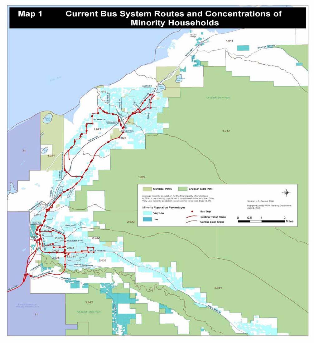
136 124
137 125
138 Roadway Improvements Maps 3 and 4 show the recommended Chugiak-Eagle River LRTP roadway improvements on maps that also depict low-income and minority areas. With the possible exception of Homestead Road and Birchwood Loop Road, most of these improvements would have minimal impact on adjacent neighborhoods because they are anticipated to be accommodated within the existing right-of-way. Improvements to Homestead Road, Birchwood Loop Road, and South Birchwood Loop Road have been included in the Chugiak-Eagle River LRTP since Homestead Road is in an area having between zero and 25% low-income households and a low percentage of minority population. Birchwood Loop Road and South Birchwood Loop Road, on the other hand, are in an area having low percentage of minority population, but 26% to 50% low-income residents. Public comments received during preparation of the LRTP were almost evenly divided between those who support improving the road, to include pedestrian amenities, and those who do not want the road improved, particularly if it would result in additional right-of-way acquisition. The recommendation to improve Birchwood Loop Road is retained in this LRTP because this road is an arterial serving the Birchwood Airport, and it accommodates commercial and freight vehicles. However, the recommendation for South Birchwood Loop Road has been changed from a reconstruction project to a rehabilitation project, which will lessen impacts to adjacent property owners, while improving the road surface and offering trails where practical and feasible. 126
139 127
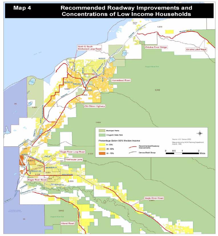
140 128
CHAPTER 4: IDENTIFICATION OF ROAD SYSTEM DEFICIENCIES: TRANSPORTATION PLANNING MODEL
 CHAPTER 4: IDENTIFICATION OF ROAD SYSTEM DEFICIENCIES: TRANSPORTATION PLANNING MODEL I. INTRODUCTION Transportation planning models are the primary tools used to predict future travel conditions. With
West Dimond Blvd Upgrade Jodhpur Street to Sand Lake Road
 West Dimond Blvd Jodhpur St to Sand Lake CSS Transportation Project Summary Municipality of Anchorage Project # 05 005 Project Manager: John Smith, P.E. (MOA PM&E) Project Administrator: Julie Makela,
Circulation in Elk Grove includes: Motor vehicles, including cars and trucks
 Circulation, as it is used in this General Plan, refers to the many ways people and goods move from place to place in Elk Grove and the region. Circulation in Elk Grove includes: Motor vehicles, including
Clackamas County Comprehensive Plan
 ROADWAYS The County s road system permits the movement of goods and people between communities and regions, using any of a variety of modes of travel. Roads provide access to virtually all property. They
Corpus Christi Metropolitan Transportation Plan Fiscal Year Introduction:
 Introduction: The Safe, Accountable, Flexible, Efficient Transportation Equity Act: A Legacy for Users (SAFETEA-LU) has continued the efforts started through the Intermodal Surface Transportation Efficiency
CHAPTER 5: PUBLIC TRANSPORTATION AND OTHER MODES AND POTENTIAL FOR EXPANSION
 CHAPTER 5: PUBLIC TRANSPORTATION AND OTHER MODES I. PUBLIC TRANSPORTATION A. Transit AND POTENTIAL FOR EXPANSION The primary mode of travel in the Chugiak-Eagle River area is the private automobile. Public
Exhibit 1 PLANNING COMMISSION AGENDA ITEM
 Exhibit 1 PLANNING COMMISSION AGENDA ITEM Project Name: Grand Junction Circulation Plan Grand Junction Complete Streets Policy Applicant: City of Grand Junction Representative: David Thornton Address:
City of Wayzata Comprehensive Plan 2030 Transportation Chapter: Appendix A
 A1. Functional Classification Table A-1 illustrates the Metropolitan Council s detailed criteria established for the functional classification of roadways within the Twin Cities Metropolitan Area. Table
Regional Transportation Needs Within Southeastern Wisconsin
 Regional Transportation Needs Within Southeastern Wisconsin #118274 May 24, 2006 1 Introduction The Southeastern Wisconsin Regional Planning Commission (SEWRPC) is the official areawide planning agency
City of Homewood Transportation Plan
 City of Homewood Transportation Plan Prepared for: City of Homewood, Alabama Prepared by: Skipper Consulting, Inc. May 2007 TABLE OF CONTENTS INTRODUCTION... 1 BACKGROUND INFORMATION... 1 EXISTING TRANSPORTATION
Solana Beach Comprehensive Active Transportation Strategy (CATS)
") Solana Beach Comprehensive Active Transportation Strategy (CATS) 3.0 Goals & Policies The Solana Beach CATS goals and objectives outlined below were largely drawn from the Solana Beach Circulation Element
Solana Beach Comprehensive Active Transportation Strategy (CATS) 3.0 Goals & Policies The Solana Beach CATS goals and objectives outlined below were largely drawn from the Solana Beach Circulation Element
CITY OF COCOA BEACH 2025 COMPREHENSIVE PLAN. Section VIII Mobility Element Goals, Objectives, and Policies
 CITY OF COCOA BEACH 2025 COMPREHENSIVE PLAN Section VIII Mobility Element Goals, Objectives, and Policies Adopted August 6, 2015 by Ordinance No. 1591 VIII MOBILITY ELEMENT Table of Contents Page Number
ROUTES 55 / 42 / 676 BUS RAPID TRANSIT LOCALLY PREFERRED ALTERNATIVE
 ROUTES 55 / 42 / 676 BUS RAPID TRANSIT LOCALLY PREFERRED ALTERNATIVE April, 2012 1 INTRODUCTION The need for transit service improvements in the Routes 42/55/676 corridor was identified during the Southern
Tulsa Metropolitan Area LONG RANGE TRANSPORTATION PLAN
 Tulsa Metropolitan Area LONG RANGE TRANSPORTATION PLAN Indian Nations Council of Governments August 2005 CONTACTING INCOG In developing the Destination 2030 Long Range Transportation Plan, INCOG s Transportation
JONESBORO HIGHWAY 63 HIGHWAY 18 CONNECTOR STUDY
 JONESBORO HIGHWAY 63 HIGHWAY 18 CONNECTOR STUDY Craighead County May 2007 JONESBORO HIGHWAY 63 HIGHWAY 18 CONNECTOR STUDY Craighead County May 2007 Prepared by Planning and Research Division Arkansas State
Basalt Creek Transportation Refinement Plan Recommendations
 Basalt Creek Transportation Refinement Plan Recommendations Introduction The Basalt Creek transportation planning effort analyzed future transportation conditions and evaluated alternative strategies for
AMATS Complete Streets Policy
 AMATS Complete Streets Policy Table of Contents: Section 1. Definition of Complete Streets Section 2. Principles of Complete Streets Section 3. Complete Streets Policy Section 4. Consistency Section 5.
City of Elizabeth City Neighborhood Traffic Calming Policy and Guidelines
 City of Elizabeth City Neighborhood Traffic Calming Policy and Guidelines I. Purpose: The City of Elizabeth City is committed to ensure the overall safety and livability of residential neighborhoods. One
Madison Urban Area and Dane County. Bicycle Transportation Plan Summary. September Introduction. Bicycle Plan Scope and Planning Process
 Bicycle Transportation Plan Summary Madison Urban Area and Dane County Introduction September 2000 Bicycling is an important mode of transportation in the Madison urban area and countywide that is available
Transportation Master Plan Advisory Task Force
 Transportation Master Plan Advisory Task Force Network Alternatives & Phasing Strategy February 2016 BACKGROUND Table of Contents BACKGROUND Purpose & Introduction 2 Linking the TMP to Key Council Approved
SANTA CLARA COUNTYWIDE BICYCLE PLAN August 2008
 SANTA CLARA COUNTYWIDE BICYCLE PLAN August 2008 To assist VTA and Member Agencies in the planning, development and programming of bicycle improvements in Santa Clara County. Vision Statement To establish,
Official Streets and Highways Plan
 Municipality of Anchorage Maps, Policies and Standards Prepared by Municipality of Anchorage Community Planning and Development Transportation Planning Division amended and adopted by the Municipal Assembly,
Magnolia Place. Traffic Impact Analysis. Prepared for: City of San Mateo. Prepared by: Hexagon Transportation Consultants, Inc.
 Magnolia Place Traffic Impact Analysis Prepared for: City of San Mateo Prepared by: Hexagon Transportation Consultants, Inc. Updated January 4, 2010 Table of Contents 1. Introduction...1 2. Existing Conditions...6
APPENDIX G: INTERSECTION NEEDS AT OKEECHOBEE BOULEVARD
 APPENDIX G: INTERSECTION NEEDS AT OKEECHOBEE BOULEVARD INTERSECTION NEEDS AT SR 7 and OKEECHOBEE BOULEVARD SR 7 Extension Project Development and Environment (PD&E) Study From Okeechobee Boulevard (SR
PRELIMINARY DRAFT FIRST AMENDMENT TO VISION 2050: A REGIONAL LAND USE AND TRANSPORTATION PLAN FOR SOUTHEASTERN WISCONSIN
 PRELIMINARY DRAFT FIRST AMENDMENT TO VISION 2050: A REGIONAL LAND USE AND TRANSPORTATION PLAN FOR SOUTHEASTERN WISCONSIN ESTABLISHING TARGETS FOR FEDERAL PERFORMANCE MEASURES: HIGHWAY SAFETY SOUTHEASTERN
4. ENVIRONMENTAL IMPACT ANALYSIS 9. TRANSPORTATION AND TRAFFIC
 4. ENVIRONMENTAL IMPACT ANALYSIS 9. TRANSPORTATION AND TRAFFIC 4.9.1 INTRODUCTION The following section addresses the Proposed Project s impact on transportation and traffic based on the Traffic Study
3.0 Future Conditions
 3.0 Future Conditions In order to be able to recommend appropriate improvements to the transportation system of the Town, it is important to first understand the nature and volume of traffic that is expected
ACTIVE TRANSPORTATION
 ACTIVE TRANSPORTATION Mobility 2040 Supported Goals Improve the availability of transportation options for people and goods. Support travel efficiency measures and system enhancements targeted at congestion
SECTION 1 - TRAFFIC PLANNING
 SECTION 1 - TRAFFIC PLANNING 1.1 TRAFFIC OPERATIONS 1.1.1 Roadway Functional Classification The Multnomah County Comprehensive Framework Plan s Policy 34: Trafficways and the Functional Classification
MCTC 2018 RTP SCS and Madera County RIFP Multi-Modal Project Eval Criteria GV13.xlsx
 MCTC 8 RTP SCS and Madera County RIFP Multi-Modal Project Eval Criteria GV.xlsx Madera County Transportation Commission Regional Transportation Plan / Sustainable Communities Strategy Multi-Modal Project
TRAFFIC IMPACT STUDY CRITERIA
 Chapter 6 - TRAFFIC IMPACT STUDY CRITERIA 6.1 GENERAL PROVISIONS 6.1.1. Purpose: The purpose of this document is to outline a standard format for preparing a traffic impact study in the City of Steamboat
2045 Long Range Transportation Plan. Summary of Draft
 2045 Long Range Transportation Plan Summary of Draft Fredericksburg Area Metropolitan Planning Organization The George Washington Region includes the City of Fredericksburg and the counties of Caroline,
Chapter 7. Transportation. Transportation Road Network Plan Transit Cyclists Pedestrians Multi-Use and Equestrian Trails
 Chapter 7 Transportation Transportation Road Network Plan Transit Cyclists Pedestrians Multi-Use and Equestrian Trails 7.1 TRANSPORTATION BACKGROUND The District of Maple Ridge faces a number of unique
Chapter 5 Future Transportation
 Chapter 5 Future Transportation The Future Land Use Plan identifies the desired land use designations. The land uses desired for Crozet depend, in large part, on the success of the transportation system,
TRAFFIC STUDY GUIDELINES Clarksville Street Department
 TRAFFIC STUDY GUIDELINES Clarksville Street Department 9/1/2009 Introduction Traffic studies are used to help the city determine potential impacts to the operation of the surrounding roadway network. Two
5.0 Roadway System Plan
 Southwest Boise Transportation Study Page 16 5.0 Roadway System Plan The Roadway System Plan outlines roadway improvements in the Initial Study Area. It forecasts future deficiencies on the arterial system,
METHODOLOGY. Signalized Intersection Average Control Delay (sec/veh)
") Chapter 5 Traffic Analysis 5.1 SUMMARY US /West 6 th Street assumes a unique role in the Lawrence Douglas County transportation system. This principal arterial street currently conveys commuter traffic
Chapter 5 Traffic Analysis 5.1 SUMMARY US /West 6 th Street assumes a unique role in the Lawrence Douglas County transportation system. This principal arterial street currently conveys commuter traffic
Gordon Proctor Director Policy on Accommodating Bicycle and Pedestrian Travel on ODOT Owned or Maintained Facilities
 Approved: Policy: 20-004(P) Responsible Office: Planning Gordon Proctor Director Policy on Accommodating Bicycle and Pedestrian Travel on ODOT Owned or Maintained Facilities I. POLICY STATEMENT: This policy
EXECUTIVE SUMMARY OF CALEDON TRANSPORTATION NEEDS STUDY
 EXECUTIVE SUMMARY OF CALEDON TRANSPORTATION NEEDS STUDY The Caledon Transportation Needs Study has been undertaken as a joint project by the Town of Caledon and the Region of Peel to determine the existing
Proposed. City of Grand Junction Complete Streets Policy. Exhibit 10
 Proposed City of Grand Junction Complete Streets Policy Exhibit 10 1 City of Grand Junction Complete Streets Policy Vision: The Complete Streets Vision is to develop a safe, efficient, and reliable travel
Performance Criteria for 2035 Long Range Transportation Plan
 Minimizing Impacts on Natural, Historic, Cultural or Archeological Resources 2035 LRTP Weighting Factor: 7% Objective 1.1: Use appropriate planning and design criteria to protect and enhance the built
Recommended Roadway Plan Section 2 - Land Development and Roadway Access
 Recommended Roadway Plan Section 2 - Land Development and Roadway Access SECTION 2 Land Development and Roadway Access 2.1 Land Use and Access Management The Federal Highway Administration (FHWA) defines
Develop a Multi-Modal Transportation Strategy (Theme 6)
") DEVELOP A MULTI-MODAL TRANSPORTATION STRATEGY (THEME 6) WHY IS THIS THEME ADDRESSED? Develop a Multi-Modal Transportation Strategy (Theme 6) Statement of Ideal Reduce resident and visitor reliance on single
DEVELOP A MULTI-MODAL TRANSPORTATION STRATEGY (THEME 6) WHY IS THIS THEME ADDRESSED? Develop a Multi-Modal Transportation Strategy (Theme 6) Statement of Ideal Reduce resident and visitor reliance on single
WELCOME TO OPEN HOUSE # 1 June 14, 2017
 Langstaff Road Weston Road to Highway 7 Class Environmental Assessment Study WELCOME TO OPEN HOUSE # 1 June 14, 2017 Please sign in and join our mailing list Purpose of Open House #1 & Study Area York
Double the amount of bicycle ridership while at the same time reducing the number of bicycle crashes by one-third.
 CHAPTER 6 Recommended Policies and Action Items To achieve the goals stated in Chapter 1 and guide implementation of the Bicycle Plan, policies and action items have been identified. They are presented
Chapter 4 Traffic Analysis
 Chapter 4 Traffic Analysis PURPOSE The traffic analysis component of the K-68 Corridor Management Plan incorporates information on the existing transportation network, such as traffic volumes and intersection
Route 7 Corridor Study
 Route 7 Corridor Study Executive Summary Study Area The following report analyzes a segment of the Virginia State Route 7 corridor. The corridor study area, spanning over 5 miles in length, is a multi
TRANSPORTATION & MOBILITY
 TRANSPORTATION & MOBILITY ROADWAY SYSTEM There are approximately 40 miles of roadways in Manitou Springs. For planning purposes, roadways are typically assigned a functional classification which defines
Parks Highway: MP Lucus Road to Big Lake Road
 2 Purpose and Need 2.1 Corridor History The Parks Highway is a 324-mile long Rural Interstate Highway that extends from its intersection with the Glenn Highway north to Fairbanks, Alaska. The Parks Highway
Bicycle Master Plan Goals, Strategies, and Policies
 Bicycle Master Plan Goals, Strategies, and Policies Mobilizing 5 This chapter outlines the overarching goals, action statements, and action items Long Beach will take in order to achieve its vision of
TOWN OF PORTLAND, CONNECTICUT COMPLETE STREETS POLICY
 TOWN OF PORTLAND, CONNECTICUT COMPLETE STREETS POLICY I. VISION, GOALS & PRINCIPLES VISION To improve the streets of Portland making them safer and more accessible for all users including pedestrians,
DRAFT BUENA VISTA 2020 TRANSPORTATION PLAN
 DRAFT BUENA VISTA 2020 TRANSPORTATION PLAN DEVELOPED BY THE TRANSPORTATION PLANNING DIVISION OF THE VIRGINIA DEPARTMENT OF TRANSPORTATION IN COOPERATION WITH THE U.S. DEPARTMENT OF TRANSPORTATION, FEDERAL
Perryville TOD and Greenway Plan
 Perryville TOD and Greenway Plan Greenway Glossary Pathway: A bicycle and pedestrian path separated from motorized vehicular traffic by an open space, barrier or curb. Multi-use paths may be within the
ADOT Statewide Bicycle and Pedestrian Program Summary of Phase IV Activities APPENDIX B PEDESTRIAN DEMAND INDEX
 ADOT Statewide Bicycle and Pedestrian Program Summary of Activities APPENDIX B PEDESTRIAN DEMAND INDEX May 24, 2009 Pedestrian Demand Index for State Highway Facilities Revised: May 29, 2007 Introduction
South King County High-Capacity Transit Corridor Study
 HIGH-CAPACITY TRANSIT CORRIDOR STUDY South King County Corridor South King County High-Capacity Transit Corridor Study Corridor Report August 2014 South King County High Capacity Transit Corridor Report
6.0 PEDESTRIAN AND BICYCLE FACILITIES 6.1 INTRODUCTION 6.2 BICYCLE DEMAND AND SUITABILITY Bicycle Demand
 6.0 PEDESTRIAN AND BICYCLE FACILITIES 6.1 INTRODUCTION Bicycle and pedestrian travel along and in the vicinity of the corridor is part of the vision of Somerset and Hunterdon counties and the integrated
Highway 49, Highway 351 and Highway 91 Improvements Feasibility Study Craighead County
 Highway 49, Highway 351 and Highway 91 Improvements Feasibility Study Craighead County Executive Summary March 2015 Highway 49, Highway 351 and Highway 91 Improvements Feasibility Study Craighead County
Chapter 6: Transportation
 Chapter 6: Transportation I. INTRODUCTION The purpose of the Transportation Plan element of the Comprehensive Plan is to provide guidance to the City of North Mankato, as well as existing and future landowners
Defining Purpose and Need
 Advanced Design Flexibility Pilot Workshop Session 4 Jack Broz, PE, HR Green May 5-6, 2010 Defining Purpose and Need In your agency s project development process, when do design engineers typically get
INTRODUCTION THOROUGHFARE SYSTEM CLASSIFICATIONS
 INTRODUCTION The thoroughfare plan will assist public officials in the development of a specialized system for efficient and safe movement of vehicular traffic while minimizing potential conflicts with
Rochester Downtown Bicycle Study 2009
 Rochester Downtown Bicycle Study 2009 Relationship of ROCOG Long Range Transportation Plan to Rochester Comprehensive Plan Regional Long Range Transportation Plan (LRTP) is prepared under the auspices
Corporate. Report COUNCIL DATE: June 26, 2006 NO: C012 COUNCIL-IN-COMMITTEE. TO: Mayor & Council DATE: June 22, 2006
 Corporate NO: C012 Report COUNCIL DATE: June 26, 2006 COUNCIL-IN-COMMITTEE TO: Mayor & Council DATE: June 22, 2006 FROM: General Manager, Engineering FILE: 0410-20(MoT/Gate) SUBJECT: Surrey Response on
Purpose and Need. Chapter Introduction. 2.2 Project Purpose and Need Project Purpose Project Need
 Chapter 2 Purpose and Need 2.1 Introduction The El Camino Real Bus Rapid Transit (BRT) Project (Project) would make transit and other transportation improvements along a 17.6-mile segment of the El Camino
Mobility and Congestion
 Technical Memorandum Mobility and Congestion Prepared for: Prepared by: September 25, 2013 1 Table of Contents 1. Introduction... 1 2. Congestion Forecasting Process... 1 2.1 Mobility and Congestion Terms...
IMPLEMENTATION STRATEGIES
 GEORGETOWN SIDEWALK MASTER PLAN 34% of funding is dedicated to Downtown Overlay District sidewalks 28% of funding is recommended within 1/4 mile of Southwestern University 26% of funding is recommended
Chapter 6 Transportation Plan
 Chapter 6 Transportation Plan Transportation Plan Introduction Chapter 6 Transportation Plan Transportation Plan Introduction This chapter describes the components of Arvada s transportation system, comprised
MOUNTAIN HOUSE SPECIFIC PLAN I 9.1 INTRODUCTION ASSUMPTIONS TRANSPORTATION FACILITIES TRANSPORTATION IMPROVEMENTS PHASING 9.
 CHAPTER NINE: TRANSPORTATION AND CIRCULATION 9.1 INTRODUCTION 9.1 9.2 ASSUMPTIONS 9.1 9.3 TRANSPORTATION FACILITIES 9.1 9.4 TRANSPORTATION IMPROVEMENTS PHASING 9.3 LIST OF FIGURES LIST OF TABLES Figure
CIRCULATION ELEMENT ADOPTED 1980 REPUBLISHED APRIL 2014 County of Santa Barbara Planning and Development 123 E. Anapamu Street Santa Barbara, CA 93101
 CIRCULATION ELEMENT ADOPTED 1980 REPUBLISHED APRIL 2014 County of Santa Barbara Planning and Development 123 E. Anapamu Street Santa Barbara, CA 93101 The electronic version of the Santa Barbara County
Third Street Bridge & Corridor Project
 Third Street Bridge & Corridor Project Preparation for the FY2018 budget to commence October 1, 2017, includes funding to address a project that has been considered since 1994. The Third Street bridge
Draft MOBILITY ELEMENET. Community Meeting May 22, 2013
 Draft MOBILITY ELEMENET Community Meeting May 22, 2013 Agenda Presentation Ira Brown New Mobility Paradigm Movement of People Implementation Q&A Ira Brown and Dave Roseman Small Group Discussion at Each
NM-POLICY 1: Improve service levels, participation, and options for non-motorized transportation modes throughout the County.
 Transportation PRINCE WILLIAM COUNTY 2008 COMPREHENSIVE PLAN NON-MOTORIZED PLAN CONTENTS Goals, Policies, and Action Strategies Table 4 (Bike Facility Classifications and Descriptions) Table 5 (Bike Facility
New Measure A Expenditure Categories DEFINITIONS OF ELIGIBLE EXPENDITURES Adopted March 8, 2007
 New Measure A Expenditure Categories DEFINITIONS OF ELIGIBLE EXPENDITURES Adopted March 8, 2007 City Street and County Road Maintenance Program The preservation and keeping of public street and road rights-of-way
Appendix 3 Roadway and Bike/Ped Design Standards
 Appendix 3 Roadway and Bike/Ped Design Standards OTO Transportation Plan 2040 4/20/2017 Page A3-1 Adopted Standards The adopted OTO Design Standards and Major Thoroughfare Plan are contained herein.
2025 Comprehensive Plan for the City of Temple Terrace Florida. Mobility Element. Adopted by City Council June 30, 2009
 2025 Comprehensive Plan for the City of Temple Terrace Florida Mobility Element Adopted by City Council June 30, 2009 Effective Date September 22, 2009 GOAL 2: To protect and promote the quality of life
Goal 3: Foster an environment of partnerships and collaboration to connect our communities and regions to one another.
 Non-Motorized Transportation Plan (NMTP) Draft Vision, Goal and,, Tri-County Regional Planning Commission (TCRPC) Purpose The purpose of the Tri-County Regional Planning Commission (TCRPC) Non-Motorized
Access Management Regulations and Standards for Minor Arterials, Collectors, Local Streets
 Access Management Regulations and Standards for Minor Arterials, Collectors, Local Streets September 2009 Paul Grasewicz Access Management Administrator Concept of Access Management The way to manage access
RESOLUTION NO ?? A RESOLUTION OF THE CITY OF NEPTUNE BEACH ADOPTING A COMPLETE STREETS POLICY
 RESOLUTION NO. 2018-?? A RESOLUTION OF THE CITY OF NEPTUNE BEACH ADOPTING A COMPLETE STREETS POLICY WHEREAS, safe, convenient, and accessible transportation for all users is a priority of the City of Neptune
CITY OF BLOOMINGTON COMPLETE STREETS POLICY
 CITY OF BLOOMINGTON COMPLETE STREETS POLICY POLICY OBJECTIVE: The City of Bloomington will enhance safety, mobility, accessibility and convenience for transportation network users of all ages and abilities,
APPENDIX 2 LAKESHORE ROAD TRANSPORTATION REVIEW STUDY EXECUTIVE SUMMARY
 APPENDIX 2 LAKESHORE ROAD TRANSPORTATION REVIEW STUDY EXECUTIVE SUMMARY Appendix 2 City of Mississauga Lakeshore Road FINAL REPORT Transportation Review Study December 2010 EXECUTIVE SUMMARY Study Purpose
STREET AND HIGHWAY PLAN
 STREET AND HIGHWAY PLAN Introduction The street and highway system in the Winston-Salem Urban Area consists of thousands of miles of traffic carrying facilities, ranging from short local residential streets
Access Management Regulations and Standards
 Access Management Regulations and Standards Efficient highway operation Reasonable property access Concept of Access Management The way to manage access to land development while simultaneously preserving
Appendix A-2: Screen 1 Alternatives Report
 Appendix A-2: Screen 1 Alternatives Report SCREEN 1 ALTERNATIVES REPORT Western & Ashland Corridors Bus Rapid Transit (BRT) Project Prepared for Chicago Transit Authority 567 West Lake Street Chicago,
o n - m o t o r i z e d transportation is an overlooked element that can greatly enhance the overall quality of life for the community s residents.
 N o n - m o t o r i z e d transportation is an overlooked element that can greatly enhance the overall quality of life for the community s residents. 84 Transportation CHAPTER 11 INTRODUCTION Transportation
APPROVE A RESOLUTION ADOPTING A COMPLETE STREETS POLICY
 STAFF REPORT MEETING DATE: September 13, 2016 TO: FROM: City Council Bob Brown, Community Development Director Russ Thompson, Public Works Director Patrick Filipelli, Management Analyst 922 Machin Avenue
M-58 HIGHWAY ACCESS MANAGEMENT STUDY Mullen Road to Bel-Ray Boulevard. Prepared for CITY OF BELTON. May 2016
 M-58 HIGHWAY ACCESS MANAGEMENT STUDY Prepared for CITY OF BELTON By May 2016 Introduction Missouri State Highway 58 (M-58 Highway) is a major commercial corridor in the City of Belton. As development has
New Seward and 36 th Avenue Intersection Conceptual Design
 University of Alaska Anchorage New Seward and 36 th Avenue Intersection Conceptual Design Prepared By: Zaid S. Hussein Dana Menendez Galen Jones Civil Engineering Department Prof. Osama Abaza CE A404 Highway
Chapter 2. Bellingham Bicycle Master Plan Chapter 2: Policies and Actions
 Chapter 2 Bellingham Bicycle Master Plan Chapter 2: Policies and Actions Chapter 2: Policies and Actions The Bicycle Master Plan provides a road map for making bicycling in Bellingham a viable transportation
Non-Motorized Transportation 7-1
 Non-Motorized Transportation 7-1 Transportation facilities no longer mean just accommodating a vehicle powered by a combustion engine. Pedestrian and non-motorized facilities are important modes of travel
University of Victoria Campus Cycling Plan Terms of Reference. 1.0 Project Description
 University of Victoria Campus Cycling Plan Terms of Reference 1.0 Project Description The Campus Cycling Plan, a first for the University, will provide a comprehensive and coordinated approach to support
Town of Bethlehem. Planning Assessment. Bethlehem Town Board
 Town of Bethlehem US 9W Corridor Transportation Planning Assessment Presented e to: Bethlehem Town Board June 2009 Overview Study Background Route 9W Corridor Conditions and Improvements Selkirk Bypass
WEST AND SOUTH WEST RING ROAD DOWNSTREAM TRAFFIC IMPACTS
 Page 1 of 9 EXECUTIVE SUMMARY Alberta Transportation ( AT ) is preparing to construct the final sections of the Calgary Ring Road. This includes the South West Ring Road ( SWRR ) (from Lott Creek Blvd
2011 Capital Projects University Area - Community Council Priority List Municipality of Anchorage
 2011 Capital Projects University Area - Community Council Priority List Municipality of Anchorage 2 Project Management and Engineering Projects on 40th Ave Extension - Lake Otis Pkwy to Dale St $18,103,000
Classification Criteria
 SCHEDULE D TO RECOMMENDED OFFICIAL PLAN AMENDMENT NO. 40 SCHEDULE C-4 Road Criteria Criteria Traffic Service Objective Land Service/Access Typical Daily Traffic Volume Flow characteristics Travel Speed
BETHEL ROAD AND SEDGWICK ROAD CORRIDOR STUDY
 DRAFT PLAN City Council Meeting August 14, 2017 STUDY AREA Sedgwick Corridor State Route 160, principal arterial with Class 3 access management designation, commuter and freight route, connection to SR
Exhibit B: Proposed amendments to the Transportation Element of the Oakland Comprehensive Plan
 Exhibit B: Proposed amendments to the Transportation Element of the Oakland Comprehensive Plan TRANSPORTATION Introduction An important aspect of any community is its transportation system, the means by
Planning Guidance in the 2012 AASHTO Bike Guide
 Planning Guidance in the 2012 AASHTO Bike Guide Presentation by: RJ Eldridge Peter Lagerwey August 22, 2012 WEBINAR 2: PLANNING GUIDANCE IN THE 2012 AASHTO BIKE GUIDE Today s Webinar Significant Updates
PEDESTRIAN ACTION PLAN
 ATTACHMENT 2 CITY OF SANTA MONICA PEDESTRIAN ACTION PLAN CITY OF SANTA MONICA PEDESTRIAN ACTION PLAN This page intentionally left blank EXECUTIVE SUMMARY CHAPTER 1 EXECUTIVE SUMMARY Setting the Stage
CITY OF ALPHARETTA DOWNTOWN MASTER PLAN TRAFFIC EVALUATION
 CITY OF ALPHARETTA DOWNTOWN MASTER PLAN TRAFFIC EVALUATION June 2015 CITY OF ALPHARETTA DOWNTOWN MASTER PLAN TRAFFIC EVALUATION Introduction The Alpharetta Downtown Master Plan was developed in the fall
The Route 29 Corridor Study was initiated at the request of Virginia s Commonwealth
 CHAPTER 2: Study Background and approach The Route 29 Corridor Study was initiated at the request of Virginia s Commonwealth Transportation Board in response to requests from members of the General Assembly
Guidelines for Providing Access to Public Transportation Stations APPENDIX C TRANSIT STATION ACCESS PLANNING TOOL INSTRUCTIONS
 APPENDIX C TRANSIT STATION ACCESS PLANNING TOOL INSTRUCTIONS Transit Station Access Planning Tool Instructions Page C-1 Revised Final Report September 2011 TRANSIT STATION ACCESS PLANNING TOOL INSTRUCTIONS