ENVIRONMENTAL STUDY REPORT
|
|
|
- Audrey Foster
- 5 years ago
- Views:
Transcription

1 City of Sault Ste. Marie Bay Street Corridor Improvements ENVIRONMENTAL STUDY REPORT October 2015 KEC Ref: Prepared by:
2 Bay Street Corridor Improvements Environmental Study Report TABLE OF CONTENTS 1. Introduction Background Previous Reports Class Environmental Assessment Process Study Organization Public Involvement Phase One Identification and Description of the Problem or Opportunity Problem/Opportunity Identification Problem/ Opportunity Statement Phase Two Identify and Evaluate Alternative Solutions Alternative 1: Maintain Existing Conditions ( Do Nothing ) Alternative 2: Reduction of Bay Street to Three Lanes with Incorporation of a Contra-flow Bike Lane Alternative 2A: Reduction of Bay Street to Three Lanes with Incorporation of a Multi-use Path Alternative 3: Reduction of Bay Street to Two Lane with Incorporation of a Multi-use Path Alternative 3A: Reduction of Bay Street to Two Lanes with the Addition of a Contra-flow Bike Lane Alternative 3B: Reduction of Bay Street to Two Lanes with the Addition of an Off-Road Contraflow Bike Path Inventory of Environmental Conditions Natural Environment Social Environment Solicit Input on Alternative Solution Evaluation of Alternative Solutions Evaluation Criteria Evaluation Summary Description of Preferred Solution Phase Three Alternative Design Concepts for the Preferred Solution Horizontal and Vertical Alignment Cross Section kresin engineering corporation i
3 Bay Street Corridor Improvements Environmental Study Report 4.3. Intersection Configurations Identification of Alternative Designs Recommended Design Solicit Input on Recommended Design Preferred Design, Schedule and Cost Phase Four Environmental Study Report APPENDICES Appendix 1 Appendix 2 Appendix 3 Appendix 3a Appendix 3b Appendix 3c Appendix 4 Appendix 5 Appendix 5a Appendix 5b Appendix 5c Appendix 6 Appendix 7 Municipal Class Environmental Assessment Process Environmental Study Report Consultation List December 9, 2014 Public Information Centre Information Presented Attendance List Comments Received Evaluation Matrix and Rationale April 23, 2015 Public Information Centre Information Presented Attendance List Comments Received Preferred Design Cost Estimates kresin engineering corporation ii
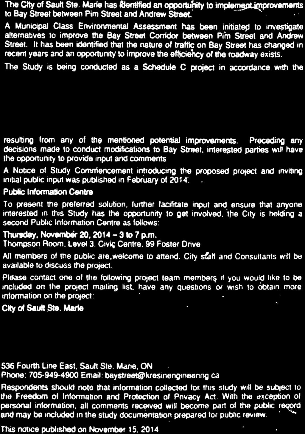
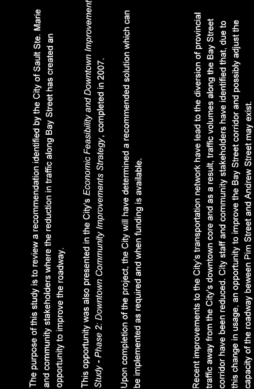
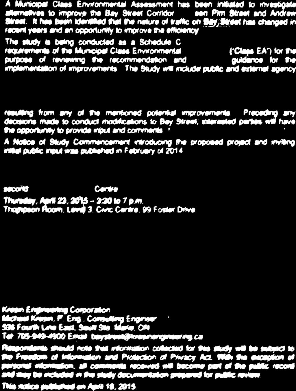
4 Bay Street Corridor Improvements Environmental Study Report 1. Introduction 1.1. Background Bay Street is an urban arterial road in the City of Sault Ste. Marie s (City) downtown core which currently extends from Huron Street at its west end to Pim Street at its east end. The entire length of Bay Street operates as a one-way street servicing eastbound traffic. The lane configuration west of Andrew Street is two lanes with auxiliary lanes for entrances and intersections. East of Andrew Street, Bay Street transitions to a four lane configuration with turn lanes at various entrances and intersections. The Bay Street corridor, in addition to being an important transportation route is a major commercial area and provides access to roadways and commercial properties throughout the City s downtown core. Following the construction of the Carmen s Way truck route in 2006 that allowed for easier access to several of the City s main roads as well as a more direct route to Highway 17, provincial traffic has been successfully diverted from the City s downtown core. As a result, traffic volumes on Bay Street appear to have been reduced and that the reduction in traffic has created an opportunity to improve the roadway Previous Reports i) In January 2006, IBI Group completed a Phase 1 Situational Report as part of an Economic Feasibility and Downtown Improvement Study for the City of Sault Ste. Marie. The purpose of the Phase 1 Report was to provide a situational analysis of social, physical, economic and market conditions in Downtown Sault Ste. Marie. The study sought to establish how and why Downtown Sault Ste. Marie has declined and what changes were required to promote private, public and institutional sector investment. The study identified potential opportunities involving the downtown road network, including possible lane conversions along the Bay Street corridor as well as significant aesthetic improvements. ii) In April of 2007, IBI Group completed a Phase 2 Downtown Community Improvement Strategy as part of the Economic Feasibility and Downtown Improvement Study for the City of Sault Ste. Marie. The purpose of the Phase 2 Report was to address the findings of the Phase 1 Situational Analysis and to provide the City with a policy framework and set of tools to address the needs of the building fabric in Downtown Sault Ste. Marie, rather than the particular health and vitality of individual businesses. The strategy included a Physical Development Plan and a Community Improvement Plan to help the City capture and retain residents and visitors in the Downtown and encourage spending in the core. The Development Plan provided guidance to protect and build the role of Downtown as a cultural and tourism center while the Community Improvement Plan was to act as a method for developing a range of programs and tools to facilitate economic development in Downtown Sault Ste. Marie. Recommended physical improvements to the Bay Street corridor that could be implemented over a period of 5 to 7 years included: Transforming Bay Street into a vibrant commercial corridor through a reduction of lanes and improvements to intersections and landscaping; Modifying the street edge design of Bay Street through improvements to pedestrianscale and aesthetic appearances of the corridor, using commercial development designs kresin engineering corporation Page 1 of 21
5 Bay Street Corridor Improvements Environmental Study Report that improve height and massing of buildings in proximity to the road corridor, and considering opportunities for the severance of parcels to enable infill development; Improving the corridor in a way that will prioritize public art and other opportunities, allow for cyclists to park on sidewalks in proximity to destinations accessed by Bay Street, and consider improvements to street furniture and pedestrian-scale lighting. iii) In January of 2015, an update to the City of Sault Ste. Marie s Transportation Master Plan was completed. The update was carried out to address the changing travel patterns in the City and to ensure road infrastructure continues to operate at a good level of service. The Plan identified a balanced approach alternative strategy as the preferred planning solution. This strategy is expected to benefit all transportation users in the City by investing in capital road improvements as well as active transportation and transit network improvements. The Plan included the consideration of road diets that involve reducing the number of lanes and pavement width of a road to improve roadway efficiency, mode share and safety as well as possible one-way to two-way conversions of one-way streets located in the City s downtown. The Bay Street corridor was identified in the Transportation Master Plan as a location that could possibly benefit from implementation of the road diet technique Class Environmental Assessment Process Ontario s Environmental Assessment Act (EA Act) was adopted in order to ensure that all reasonable alternative solutions, environmental impacts and community input are considered when public projects are undertaken. In order to streamline the EA process, the Act allows a group of similar projects to be undertaken following the process identified in a Class EA. Due to the similarity and frequency of municipal infrastructure projects, the Municipal Engineers Association (MEA) developed and received approval for the Municipal Class Environmental Assessment (Class EA). The Municipal Class EA is applicable to most municipal projects involving roads, water and wastewater which are commonly recurring, similar in nature, limited in scale, and have a predictable range of impacts. There are four schedules under the Municipal Class EA as follows: Schedule A: Schedule A + Schedule B: Projects that include normal or emergency operational and maintenance activities. These projects are limited in scale and have minimal adverse environmental effects which are predictable and easily mitigated. These projects are pre-approved and may proceed to implementation without following the full Class EA planning process. Projects that are pre-approved under the Municipal Class EA, but allow for some form of public consultation prior to project implementation. The purpose of Schedule A + is to ensure that the public is in some way informed of municipal infrastructure project(s) being constructed or implemented in their area, giving them the opportunity to comment to municipal council. Given that these projects are pre-approved, there is no appeal to the Ministry of the Environment (MOECC) on these projects. Projects generally including improvements to existing facilities with the potential for some adverse environmental effects. These projects must include completion of a screening process including consultation with stakeholders. kresin engineering corporation Page 2 of 21
6 Bay Street Corridor Improvements Environmental Study Report Schedule C: Projects generally including the construction of new facilities or significant modifications to existing facilities. The full process outlined by the Class EA document must be carried out. The Bay Street Corridor Improvements project meets the conditions which require that a Schedule C Municipal Class EA be carried out. The planning process outlined in the Municipal Class EA document is illustrated graphically in Appendix 1. A Schedule C Class EA requires that the following five Phases be completed: Phase 1: Phase 2: Phase 3: Phase 4: Phase 5: Identify the problem or opportunity for the project. Identify alternative solutions to the problem taking into consideration the existing environment and establish the preferred solution using input from review agencies and the public. Examine alternative methods of implementing the preferred solution which will minimize negative environmental effects and maximize positive effects. Document the planning process carried out in the previous Phases and make the documentation available for comment by the public and review agencies. Complete designs and proceed to construction of the project. This phase also includes the long term evaluation of any special mitigating measures which were required to be implemented. The Sault Ste. Marie Transportation Planning Study was developed based on the approaches conveyed in the Sustainable Planning Guidelines report (developed by Transport Canada and the Transportation Association of Canada) and was carried out in accordance with the requirements of the Master Plan under the Municipal Class EA process. As noted in the Class EA document, Master Plans address Phases 1 and 2 of the planning process for identified projects; however, due to public interest in this project, the City of Sault Ste. Marie has decided to re-visit Phase 2 (Identification of Alternative Solutions) for the purposes of this study Study Organization To satisfy the planning process outlined for Schedule C projects, the following phased approach to the project is presented in this Environmental Study Report. Phase 1: Identification and Description of the Problem a) Description of Existing Conditions b) Problem/Opportunity Identification c) Problem/Opportunity Statement Phase 2: Identify and Evaluate Alternative Solutions a) Identify Alternative Solutions b) Inventory of Environmental Conditions c) Solicit input on Alternative Solutions d) Evaluation of Alternative Solutions e) Description of Preferred Solution kresin engineering corporation Page 3 of 21
7 Bay Street Corridor Improvements Environmental Study Report Phase 3: Alternative Design Concepts for Preferred Alternative a) Horizontal and Vertical Alignment b) Road Cross-Section c) Intersection Configurations d) Identification of Alternative Designs e) Preferred Design f) Solicit Input on Preferred Alternative and Designs Phase 4: Environmental Study Report a) Complete Environmental Study Report (ESR) b) Place ESR on Public Record Following the placement of the ESR on public record, there will be a 30 day period during which members of the public can review the report and provide comments to the City of Sault Ste. Marie. If concerns raised by the public cannot be resolved through discussions with the City, a Part II Order request can be made to have the Minister of the Environment order an individual (full) EA for the project. The ESR will be available for review at the following locations: City of Sault Ste. Marie Engineering Department 5 th Floor, Civic Centre 99 Foster Drive Sault Ste. Marie, ON City of Sault Ste. Marie Clerk s Department 4 th Floor, Civic Centre 99 Foster Drive Sault Ste. Marie, ON Kresin Engineering Corporation 536 Fourth Line East Sault Ste. Marie, ON Persons wishing to request a Part II Order for this project must submit a written request to the Minister of the Environment, with a copy sent to the City of Sault Ste. Marie at the following addresses: The Honourable Glen Murray Minister of the Environment and Climate Change 77 Wellesley Street West 11th Floor, Ferguson Block Toronto ON M7A 2T5 Director, Environmental Approvals Branch Ministry of the Environment and Climate Change 1st Floor, 135 St. Clair Ave West Toronto, ON M4V 1P5 Director of Engineering Services City of Sault Ste. Marie 5 th Floor, Civic Centre 99 Foster Drive Sault Ste. Marie, ON P6A 5N1 Kresin Engineering Corporation was retained by the City of Sault Ste. Marie to satisfy the requirements of the Municipal Class Environmental Assessment and evaluate the opportunity to coordinate possible improvements to the Bay Street corridor. During the course of the study, input was sought from various City Departments, provincial and federal government agencies as well as First Nations groups, nearby landowners and the general public. kresin engineering corporation Page 4 of 21
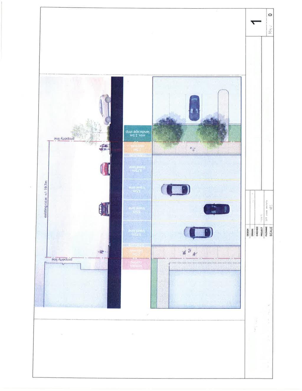
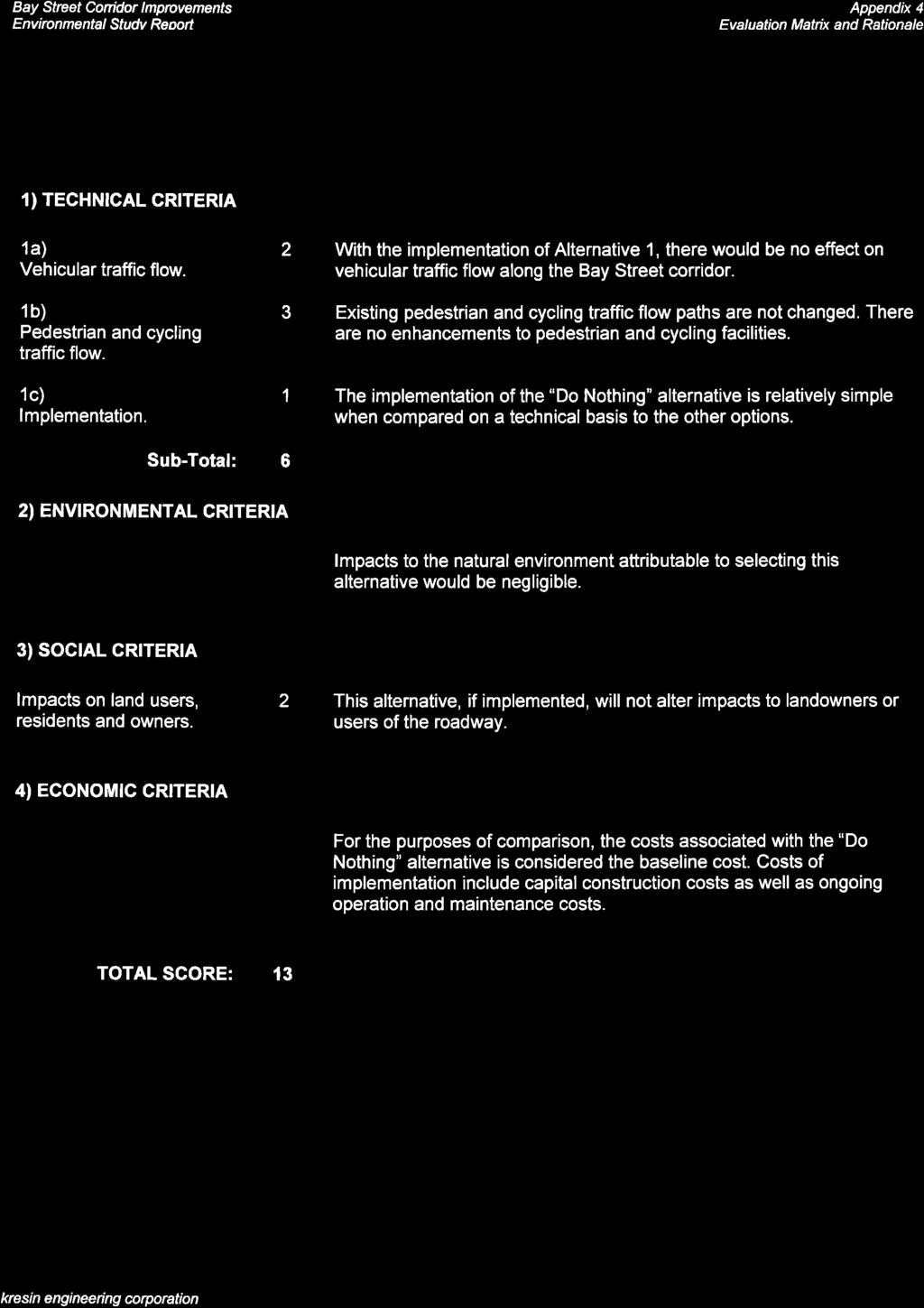
8 Bay Street Corridor Improvements Environmental Study Report 1.5. Public Involvement Public and agency consultation ensures that those interested in the Class EA process have the opportunity to provide input and comments. Throughout the study, the involvement of local residents, interest groups and government agencies (list provided in Appendix 2) was sought to provide input into the definition of problems/opportunities, identification and evaluation of alternative solutions and selection of the preferred solution. Through newspaper advertisements, letters, s, notifications of upcoming public meetings and two informal Public Information Centres (PICs), the public and agency contacts were given the opportunity to review and discuss the progress of the study as well as provide any suggestions and comments. Results of the PICs are described in detail in the relevant sections of this report with supporting documentation in the appendices. 2. Phase One Identification and Description of the Problem or Opportunity 2.1. Problem/Opportunity Identification Recent studies completed for the City of Sault Ste. Marie have identified the need for improvements to the City s downtown core, not only to improve the aesthetics of the area but also to improve roadway efficiency, mode share and safety. It has also been identified that following the construction of the Carmen s Way truck route in 2006, that provincial traffic appears to have been successfully diverted from the City s downtown core. As a result, traffic volumes including those on Bay Street appear to have been reduced, providing an opportunity to improve the roadway Problem/ Opportunity Statement Recent improvements to the City s transportation network have lead to the diversion of provincial traffic away from the City s downtown core and as a result, traffic volumes along the Bay Street corridor have been reduced. City Staff and community stakeholders have identified that, due to this change in usage, an opportunity to improve the Bay Street corridor and possibly adjust the capacity of the roadway between Andrew Street and Pim Street may exist. 3. Phase Two Identify and Evaluate Alternative Solutions 3.1. Identify Alternative Solutions The first task in Phase Two of the Municipal Class EA process is the identification of possible alternatives to the stated problem or opportunity. In consultation with City staff, the following alternatives were developed Alternative 1: Maintain Existing Conditions ( Do Nothing ) This alternative is a standard option required to be considered in the Class EA process. It provides a benchmark against which to measure other possibilities. In this study, the Do Nothing alternative would result in implementing no additional work to decrease the capacity of Bay Street. Alternative 1 is illustrated in Figure 1. kresin engineering corporation Page 5 of 21

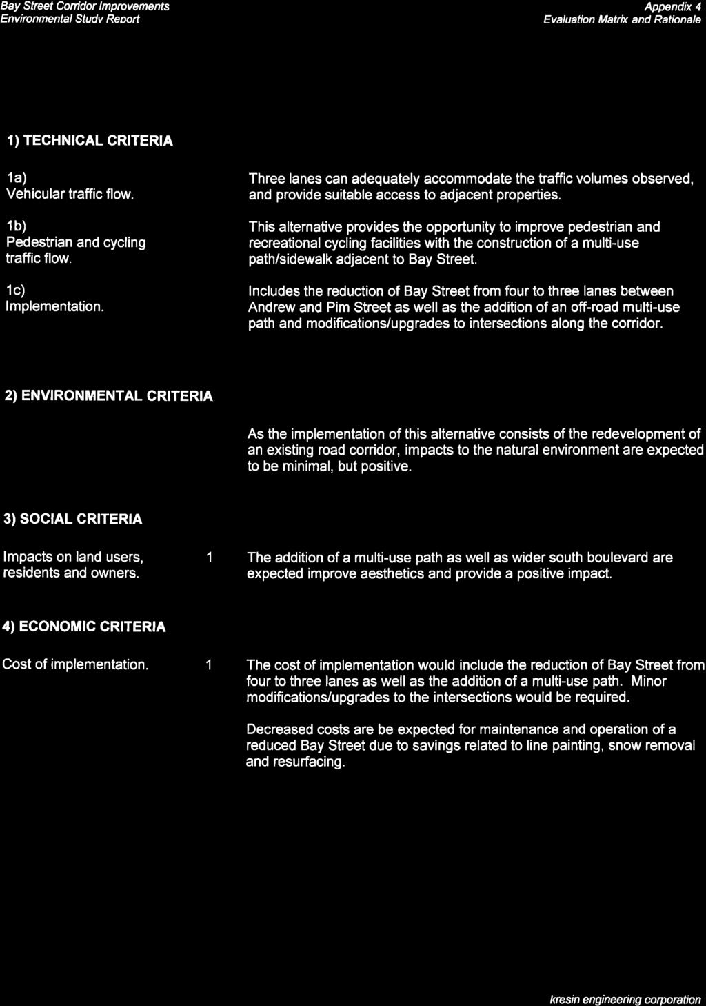
9 Bay Street Corridor Improvements Environmental Study Report Figure 1. Alternative 1 - Maintain Existing Conditions Alternative 2: Reduction of Bay Street to Three Lanes with Incorporation of a Contra-flow Bike Lane This alternative consists of reducing Bay Street to three through lanes from the existing four through lanes. Implementing Alternative 2 allows for the incorporation of a contra-flow (two-way) bike lane to be installed on the road from Andrew to Pim Street. This alternative also includes pedestrian sidewalks on both sides. A landscaped boulevard would also be included along the south side of Bay Street, between the road and the sidewalk. Alternative 2 is shown in Figure Alternative 2A: Reduction of Bay Street to Three Lanes with Incorporation of a Multi-use Path Similarly to Alternative 2, this alternative involves the reduction Bay Street from four through lanes to three through lanes, however this alternative includes a pedestrian sidewalk adjacent to the north side of the corridor and provides the space required for the incorporation of an off-road multiuse path running parallel from Andrew Street to East Street along the south side of Bay Street. A landscaped boulevard would separate the multi-use path from the roadway. Alternative 2A is illustrated in Figure 2a Alternative 3: Reduction of Bay Street to Two Lanes with Incorporation of a Multi-use Path Alternative 3 includes reducing Bay Street to two through lanes from the existing four through lanes. Implementing Alternative 3 allows improvements to the roadway to be made including the incorporation of a multi-use path from Andrew Street to East Street, parallel to the south side of the road. This alternative also includes a pedestrian sidewalk on the north side of Bay Street. Both the kresin engineering corporation Page 6 of 21
10 Bay Street Corridor Improvements Environmental Study Report multi-use path and sidewalk would be separated from the corridor with a landscaped boulevard. Alternative 3 is shown in Figure 3. Figure 2. Alternative 2 - Reduction of Bay Street to Three Lanes with Incorporation of a Contra-flow Bike Lane Figure 2a. Alternative 2A - Reduction of Bay Street to Three Lanes with Incorporation of a Multi-use Path kresin engineering corporation Page 7 of 21
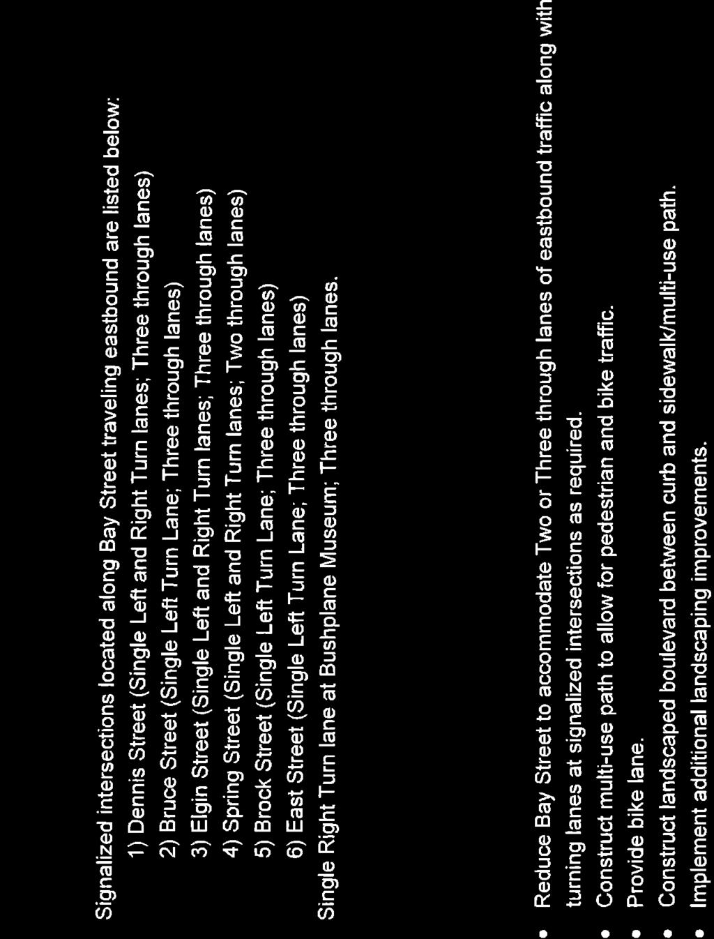
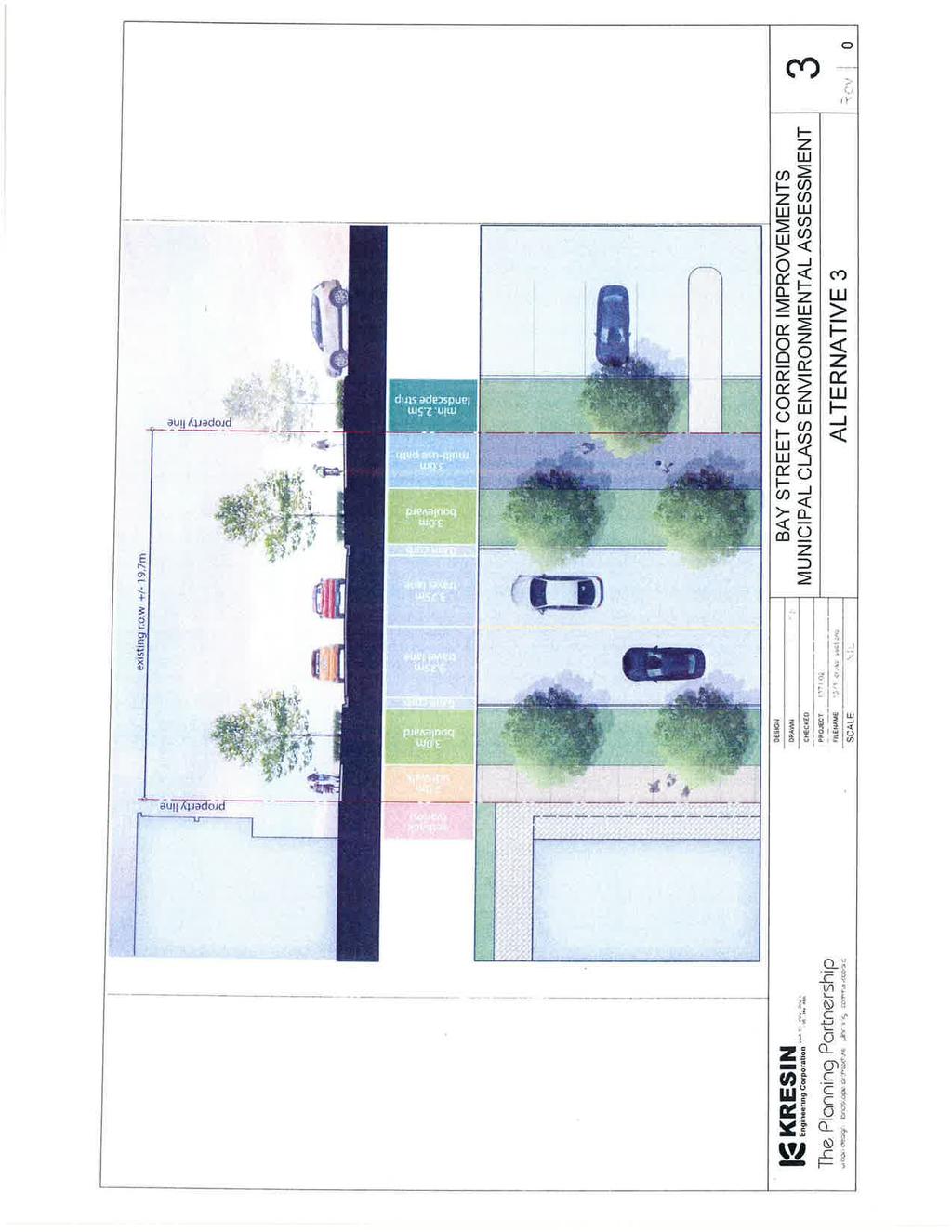
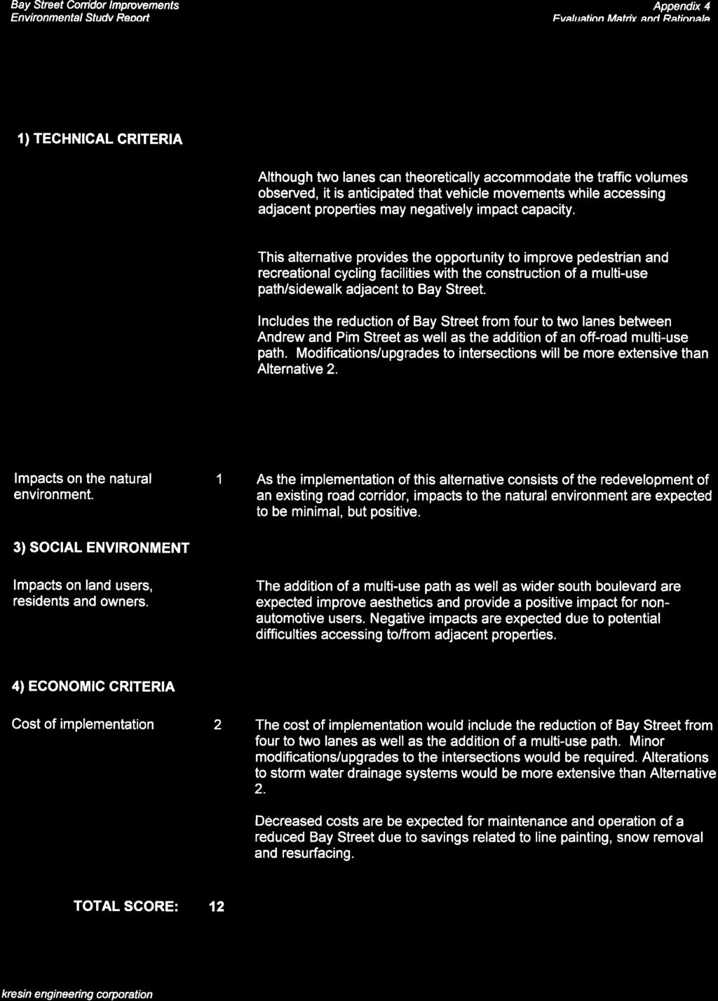
11 Bay Street Corridor Improvements Environmental Study Report Figure 3. Alternative 3 - Reduction of Bay Street to Two Lanes with Incorporation of a Multi-use Path Alternative 3A: Reduction of Bay Street to Two Lanes with the Addition of a Contra-flow Bike Lane This alternative involves reducing Bay Street to two through lanes from the existing four lanes for vehicular traffic. This alternative also includes a designated contra-flow bike lane, separated from the adjacent roadway with a concrete median. Boulevards and pedestrian sidewalks would run parallel to Bay Street on both the north and south sides. Alternative 3A is shown in Figure 3a Alternative 3B: Reduction of Bay Street to Two Lanes with the Addition of an Off-Road Contra-flow Bike Path This alternative consists of reducing Bay Street to two through lanes from the existing four through lanes and provides space required for an off-road contra-flow bike path to be incorporated into the corridor. This option would allow for the bike path to be separated from the roadway by a concrete median and also includes a pedestrian sidewalk on both sides of Bay Street. Landscaped boulevards would be included along both sides of the corridor, where possible. Alternative 3B is shown in Figure 3b Inventory of Environmental Conditions The second task in Phase 2 of the Class EA is the inventory of the natural, social and economic environment in the Study Area. For the purpose of this study, the Bay Street Study Area has been defined as the area bounded by Andrew Street, Pim Street and the commercial and parks/recreational properties located adjacent to the Bay Street right-of-way. The area of influence considered for the kresin engineering corporation Page 8 of 21
12 Bay Street Corridor Improvements Environmental Study Report socio-economic environment has been defined as the developed urban region of the City of Sault Ste. Marie. Figure 3a: Reduction of Bay Street to Two Lanes with the Addition of a Contra-flow Bike Lane Figure 3b. Reduction of Bay Street to Two Lanes with the Addition of an Off-Road Contra-flow Bike Path kresin engineering corporation Page 9 of 21
13 Bay Street Corridor Improvements Environmental Study Report Natural Environment The Study Area is entirely within the urban core of the City of Sault Ste. Marie and has been affected by extensive human development activity in the past. The area is surrounded by commercial developments, recreational/parklands and transportation corridors. The Study Area topography is very flat as the land is generally reclaimed riverbed/shore lands. Regional Geology The Ministry of Natural Resources and Forestry (MNRF) Aggregate Resources Inventory of the Sault Ste. Marie Area as well as the Sault Ste. Marie Region Conservation Authority s (SSMRCA) Sault Ste. Marie Region Source Protection Area Assessment Report were reviewed for the purpose of characterizing the physiography and geology of the Study Area. The Sault Ste. Marie area consists of bedrock of the Cambrian and Precambrian age. The Study Area is located generally within an area comprised of granite and migmatitic rocks overlain by Jacobsville sandstone. The geological formations of sandy glaciolacustrine deposits in the Sault Ste. Marie area are mainly the result of the repeated advance and retreat of extensive continental ice sheets during the Wisconsinan Stage of the Pleistocene Epoch. The area just north of the Study Area consists of a band of elevated rugged, knobby Precambrian bedrock ranging in elevation from 300 and 440 meters above sea level. South of this band is an area of undulating, rolling topography of manly low relief that rises occasionally as a result of small bedrock escarpments which extend to the St. Marys River. The surface drainage conditions in the area are considered to be dry. Groundwater Resources Groundwater flow within the City of Sault Ste. Marie generally runs from the northern Precambrian uplands to the St. Marys River in the south. The Study Area is located in a potential groundwater discharge area as its lower elevation allows for the water table to leave the aquifer and flow to the surface. East of the Study Area is also considered a groundwater discharge area while the areas west, north and northeast of the Study Area are considered potential groundwater recharge areas that allow for a percentage of total precipitation to infiltrate to the water table. Surface Water and Aquatic Habitat Fort Creek as well as an unnamed intermittent drainage course enters the St. Marys River just west of the Study Area. Originating in the northern portion of the City, the Fort Creek channel runs north to south, crossing Second Line and Conmee Avenue. Further downstream, Fort Creek is conveyed by a concrete aqueduct from Carmen s Way to Queen Street where it then flows along an open channel to the St. Marys River. The unnamed drainage course, which has been incorporated into the City s storm sewer system, originates approximately 1.7 kilometers northeast of the study area and connects to the Fort Creek channel approximately 150 meters prior to the outlet at St. Marys River. kresin engineering corporation Page 10 of 21
14 Bay Street Corridor Improvements Environmental Study Report As the Fort Creek is considered fish habitat, any proposal that may potentially impact the waterway or the area adjacent to the waterway (hazard area/flood plain) must have authorization from relevant agencies and must be carried out in accordance with applicable laws. Vegetation and Terrestrial Environment Majority of the land within and abutting the Study Area has been previously developed. Tree species including red maple, yellow birch, white pine and red oak are sparsely located along the corridor with the majority of those being located within the areas zoned as parks and recreation. As the Study Area is situated within the developed downtown area of the City, wildlife may consist of squirrels, chipmunks and bird species including the black-capped chickadee, white-throated sparrow, American crow and downy woodpecker. Migratory species including the Canada goose and mallard duck are commonly seen in the downtown park areas and along the City s waterfront. Heritage Resources The Study Area consists of previously disturbed land within the Bay Street right-of-way. A review of available historical aerial photographs indicates that properties adjacent to the Study Area have been previously disturbed as well. As the proposed improvements will be limited to surface works constructed within the limits of previously disturbed land and any modifications to existing underground infrastructure are expected to utilize current grades and alignment, the likelihood of encountering archaeological resources is felt to be low. Disruption to properties adjacent to the corridor is not expected and as the proposed road improvements do not involve the expansion of the traffic corridor, the completion of an archaeological assessment is not required. Should circumstances change during the course of the project, the requirements of the Ontario Heritage Act will be reviewed in order to ensure compliance. Alternative 1, Maintain Existing Conditions, is not anticipated to have negative impacts on the natural environment relating to construction as changes in the efficiency of the roadway would not be made. Alternatives that involve the reduction of Bay Street to three lanes as well as those alternatives that result in a two lane corridor are anticipated to have minimal impacts on the natural environment as they are located within the areas that have been previously developed or cleared. Any disturbances encountered during construction are expected to be mitigated through the use of standard environmental controls such as silt barriers and erosion protection Social Environment Land Use A large portion of the Study Area, between Andrew Street and Pim Street consists of commercial developments, recreational/parklands and transportation corridors. North of the Study Area consists mainly of central commercial zones along with an institutional zone found at the northwest corner of Bay and Pim Street. South of the Study Area is largely Riverfront zoning except for a kresin engineering corporation Page 11 of 21
15 Bay Street Corridor Improvements Environmental Study Report shopping centre (Station Mall) zone between Andrew and Elgin Street and a parks and recreational zone located at the southwest corner of Bay Street and East Street. Multi-residential buildings are also located east of Brock Street along the south side of the Bay Street corridor. Utilities The Study Area is serviced by both the municipal water distribution system and municipal sanitary/storm sewers. Electricity is provided via a combination of overhead and underground conductors from the distribution grid owned and operated by the Sault Ste. Marie Public Utilities Commission (PUC). All of the properties are within the boundaries of existing electrical and telecommunication services. The following authorities have infrastructure within the Study Area: 1. City of Sault Ste. Marie 2. Public Utilities Commission (PUC); 3. Bell Canada; 4. Shaw Cable; and 5. Union Gas. Recreation There are several recreational opportunities neighbouring the Study Area. The Essar Centre, a sports and entertainment venue which accommodates a wide range of events including concerts, sporting events, conventions and trade shows, is located along the north side of the corridor at Bruce Street. The John Roswell Hub Trail is located on the south side of Bay Street east of East Street and provides a pedestrian/cycling route along the City s downtown waterfront. Whitefish Island located west of the Study Area offers kilometers of trails as well as access to the river system for fishing. The Sault Ste. Marie Canal National Historic Site is located west of the Study Area, adjacent to Whitefish Island. Guided tours, displays and presentations are provided at the Visitor Centre onsite while the lock is open to recreational boats from May to October. The Roberta Bondar Park and Tent Pavilion is located southwest of the corridor, adjacent to the St. Marys River. The Park provides an outdoor venue that accommodates events including concerts, festivals and ceremonies. Clergue Park is located near the east end of the Study Area, adjacent to the south side of the corridor. The park provides the location for the City s annual Rotaryfest as well as a rest/picnic area on the downtown waterfront section of the hub trail. The Canadian Bushplane Heritage Centre is located at the east end of the Bay Street corridor, within an historic waterfront hanger adjacent to the St. Marys River. The Centre contains several aircraft kresin engineering corporation Page 12 of 21
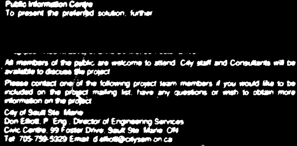
16 Bay Street Corridor Improvements Environmental Study Report exhibits, interactive activities and provides visitors with the history of bush flying and forest protection in Canada. The Ermatinger Clergue National Historic Site is located at the northwest corner of Bay Street and Pim Street. The Site consists of an interactive Heritage Discovery Centre as well as the Ermatinger Old Stone House and the Clergue Blockhouse, two of the oldest stone buildings located northwest of Toronto. Alternative 1 is not anticipated to have a negative impact on the socio-economic environment as the standard of service along Bay Street would remain the same. Alternatives involving the reduction of the Bay Street corridor to three through lanes are anticipated to decrease the traffic capacity along the corridor. However, with the recent reduction in traffic volumes along Bay Street, these alternatives are not expected to impact the level of service during peak usage periods. The addition of landscaped boulevards, a contra-flow bike lane or a multi-use path are expected to have positive socio-economic impacts as they improve the aesthetics of the corridor and are anticipated to be more inviting to pedestrians and cyclists traveling in the downtown area. Alternatives reducing the corridor to two through lanes may result in negative impacts to the level of service provided along the corridor as the ease of access to and from the adjacent properties may potentially be reduced. Similarly to the three-lane alternatives, positive socio-economic impacts are anticipated with the addition of landscaped boulevards, bike lane(s) or a multi-use path. These additions are expected to improve the aesthetics of the corridor and increase land-use along Bay Street Solicit Input on Alternative Solution A Public Information Centre was held on December 9, 2014 in the Thompson Room of the Sault Ste. Marie Civic Centre. Representatives from both Kresin Engineering Corporation (KEC) and the City were available to discuss the project. The focus of this first PIC was to present the opportunity statement and identified possible improvements to be considered as well as seek public input on the project. Ten residents attended the PIC in order to discuss the project. Copies of the presentation boards, attendance records and comments received at the PIC are attached in Appendix 3. Comment responses are also included as part of this appendix. Input received during this PIC, as well as comments forwarded to KEC afterwards did not identify any additional alternatives to be considered Evaluation of Alternative Solutions In order to compare the alternative solutions, each was examined to determine how it addressed a set of evaluation criteria. Following the application of the criteria, a preferred solution was identified as that which best addressed the criteria. kresin engineering corporation Page 13 of 21
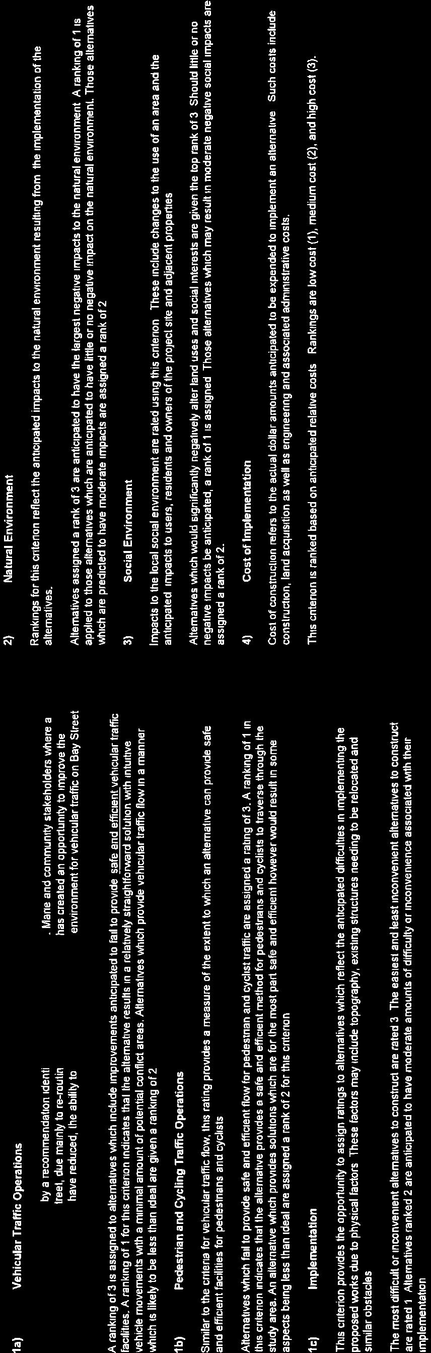
17 Bay Street Corridor Improvements Environmental Study Report Evaluation Criteria The following is a summary and description of the evaluation criteria. Each criterion was ranked for each alternative and given a subjective score of 1 (positive), 2 (neutral) or 3 (negative). The scores are based on the anticipated results of implementing the alternatives. 1) Technical Criteria 1a) Vehicular Traffic Flow This study has been prompted by an opportunity to improve the Bay Street corridor and possibly adjust the capacity of the roadway between Andrew Street and Pim Street. Accordingly, the ability for a potential solution to provide a safe and efficient environment for vehicular traffic is essential. A ranking of 3 is assigned to alternatives which are anticipated to fail to provide safe and efficient vehicular traffic facilities. A ranking of 1 for this criterion indicates that the alternative results in a relatively straightforward solution with intuitive vehicle movements with a minimal amount of potential conflict areas. Alternatives which provide vehicular traffic flow in a manner which is likely to be less than ideal are given a ranking of 2. 1b) Pedestrian and Cycling Traffic Flow Similar to the criteria for vehicular traffic flow, this criterion provides a measure of the extent to which an alternative can provide safe and efficient facilities for pedestrians and cyclists. Alternatives which fail to provide safe and efficient flow for pedestrian traffic are assigned a rating of 3. A ranking of 1 in this criterion indicates that the alternative provides a safe and efficient method for pedestrians and cyclists to traverse through the Study Area. An alternative which provides solutions which are for the most part safe and efficient however would result in some aspects being less than ideal are assigned a rank of 2 for this criterion. 1c) Implementation of the Alternatives This criterion provides the opportunity to assign ratings to alternatives which reflect the anticipated difficulties in implementing the proposed works due to physical factors. These factors may include topography, existing structures needing to be relocated and similar obstacles. kresin engineering corporation Page 14 of 21
18 Bay Street Corridor Improvements Environmental Study Report 2) Natural Environment 3) Social Environment The most difficult or inconvenient alternatives to construct are rated 3. The easiest and least inconvenient alternatives to construct are rated 1. Alternatives ranked 2 are anticipated to have moderate amounts of difficulty or inconvenience associated with their implementation. 3) Economic Environment Rankings for this criterion reflect the anticipated impacts to the natural environment associated with implementation of the alternatives. Alternatives assigned a rank of 3 are anticipated to have significant negative impacts to the natural environment. A ranking of 1 is applied to those alternatives which are anticipated to have little or no impact on the natural environment. Those alternatives which are predicted to have moderate impacts are assigned a rank of 2. Impacts to the local social environment are rated using this criterion. These include changes to the use of an area, impacts to nearby residents and other similar impacts. Alternatives which would significantly negatively alter land uses and social interests are given the rank of 3. Should little or no negative impacts be anticipated, a rank of 1 is assigned. Those alternatives which may result in moderate negative social impacts are assigned a rank of 2. Similar to social environment, this criterion reflects the potential impacts of a given alternatives on the economic attributes of the Study Area. Alternatives which have a significant negative impact on the local economic situation receive a rank of 3. Alternatives anticipated to have significant positive impact on the local economic environment receive a rank of 1. kresin engineering corporation Page 15 of 21
19 Bay Street Corridor Improvements Environmental Study Report Should the net economic impact of an alternative be neither negative nor positive, a rank of 2 is assigned. 4) Cost of Implementation Evaluation Summary Cost of implementation refers to the actual dollar amounts to be expended to implement an alternative. Such costs include construction, land acquisition as well as engineering and associated administrative costs. This criterion is ranked based on anticipated relative costs. Rankings are low cost (1), medium cost (2), and high cost (3). An evaluation of alternatives was carried out considering the evaluation criteria outlined above. A copy of the Evaluation Matrix along with a detailed description summarizing the application of the Evaluation Criteria is presented in Appendix 4. Alternative 1: Maintain Existing Conditions ( Do Nothing ) This option was found to be least preferred as it did not address the recommendation to improve the Bay Street corridor. Although this alternative would be considered the easiest to implement, it did not efficiently address vehicular flow along the corridor or provide any safe enhancements to pedestrian or cycling facilities. The effects of the Do Nothing approach on the natural environment were found to be negligible and impacts to land owners and users of the corridor would not be altered. Costs associated with Alternative 1, which for the purpose of this report are considered a baseline cost for comparison, were given a high cost ranking as they include capital construction costs as well as ongoing operation and maintenance costs of the four lane corridor. Alternative 2: Reduce Bay Street to Three Lanes Alternative 2 is felt to adequately address the recommendation to improve the Bay Street corridor as the reduction to three lanes is expected to efficiently accommodate traffic volumes while providing an opportunity to improve pedestrian and recreational cycling facilities within or adjacent to the road way. However, implementation of this alternative is anticipated to result in moderate inconveniences to land owners and users of the corridor during construction of modifications/upgrades to the road. As Alternative 2 consists of the redevelopment of the existing road corridor, minimal impacts on the natural environment are anticipated. Common mitigation procedures would be put in place to address typical impacts associated with construction. It is expected that the possible addition of a bike lane/multi-use path and boulevard along the corridor would improve the aesthetics of the area, making it more inviting for pedestrians and cyclists resulting in a positive social impact. Costs are expected to include those to reduce Bay Street from four to three lanes, the construction of a multi-use path or bike lane and alterations to the storm water drainage system. Decreased costs would be expected for the maintenance and operation of the Bay Street corridor due to the savings related to line painting, snow removal and future road resurfacing. kresin engineering corporation Page 16 of 21
20 Bay Street Corridor Improvements Environmental Study Report Alternative 3: Reduce Bay Street to Two Lanes Alternative 3 is expected to accommodate the traffic volumes observed along the Bay Street corridor, however, the efficiency of the corridor is expected to be negatively impacted as a result of a possible decrease in vehicle movement while accessing adjacent properties. Similarly to Alternative 2, this alternative provides an opportunity to improve pedestrian and recreational cycling facilities with the construction of a sidewalk and multi-use path or contra-flow bike lane adjacent to the corridor. Alternative 3 received a higher ranking than Alternative 2 with respect to its implementation as modifications and/or upgrades to intersections are expected to be more extensive. As the implementation of Alternative 3 consists of the redevelopment of the existing road, impacts to the natural environment are anticipated to be minimal. Although it is expected that the possible addition of a boulevard and multi-use path or designated bike lane along the corridor would improve the aesthetics of the area and would provide a positive impact for non-automotive users, negative impacts are expected due to potential difficulties accessing to and from adjacent properties. It is anticipated that the relative cost of implementation of Alternative 3 would exceed Alternative 2 and would include the cost to reduce Bay Street from four to two lanes, the construction of a multi-use path or bike lane and alterations to the storm water drainage system. Decreased costs would be expected for the maintenance and operation of the Bay Street corridor due to the savings related to line painting, snow removal and future road resurfacing Description of Preferred Solution Following the evaluation of alternatives, Alternative 2 was identified as the preferred solution. The reduction of Bay Street to three lanes in conjunction with improvements to pedestrian and recreational cycling facilities addresses the stated opportunity to improve the Bay Street corridor between Pim Street and Andrew Street. The design of the new road will include the construction of a three lane, urban arterial road that will incorporate modifications and/or upgrades to the existing intersections. 4. Phase Three Alternative Design Concepts for the Preferred Solution The preferred solution consists of the construction of approximately 1,850 meters of road between Andrew Street and Pim Street. Due to the limited scope of construction, predominantly straight horizontal alignment, etc, the alternative designs are also limited, and were developed considering the following: 1. Horizontal Alignment (curves in the road) 2. Vertical Alignment (road grades) 3. Road Cross Section (lanes, sidewalks, boulevards, etc.) 4. Intersection Configurations (traffic signals, turn lanes, islands, etc.) 4.1. Horizontal and Vertical Alignment Based on the existing topography and adjacent land uses, the road alignment is constrained by the existing property limits. The reduction of Bay Street from a four lane to a three lane road will closely match the horizontal alignment of the existing road as the proposed improvements are to be within the existing right-of-way. kresin engineering corporation Page 17 of 21
21 Bay Street Corridor Improvements Environmental Study Report The vertical alignment will closely follow the existing topography and will accommodate existing intersections, entrances to adjacent properties, etc Cross Section Existing conditions on Bay Street within the Study Area include: four eastbound lanes with curb and gutter; signalized intersections at Andrew Street/Gore Street, Dennis Street, Bruce Street, Elgin Street, Brock Street and East Street; and signed intersections at Tancred Street, March Street, Bingham Street and Bell Avenue. Exits onto Bay Street are also controlled with signage at businesses including the Station Mall shopping complex and the Sleep Inn Hotel. A bus bay is located just west of March Street, at the north entrance of the Roberta Bondar Place and an additional southbound turn lane is present at the Bay Street intersections with Dennis Street and Elgin Street. Pedestrian facilities on the existing Bay Street corridor consist of a sidewalk along the north side from Andrew Street to Pim Street; a sidewalk along the south side of the corridor from Dennis Street to East Street; and, a multi-use path along the south side from East Street to Pim Street. Alternative designs for the road cross section of a reduced Bay Street corridor are to address issues such as traffic movement (via the number of lanes) and facilities for pedestrians and other non-motorized users. Similar to the existing cross section, an urban arterial road with storm sewers, catch basins and concrete curb and gutter is recommended for the section of Bay Street between Andrew Street and Pim Street. This type of cross section will provide a more compact road width allowing the most possible space within the right-of-way for the construction of a pedestrian and/or cycling facilities along the southwest side of Bay Street Intersection Configurations It is expected that no new intersections will be required and that all signalized and signed intersections along the Bay Street corridor will be maintained following the implementation of Alternative 2. It is proposed that the existing south bound turn lanes at Dennis Street, Elgin Street and Pim Street continue to be provided. It is recommended that pedestrian facilities be included as part of the implementation of Alternative 2 to accommodate pedestrians and other non-motorized users wanting to access the downtown businesses and waterfront Identification of Alternative Designs As stated above, the relatively limited scope of the preferred solution does not support a great variation in alternative designs. Upon the review of the design considerations noted above, the following conclusions are drawn: 1. Existing features are conducive to a predominantly straight horizontal alignment. 2. Existing topography will allow for an essentially flat vertical alignment, similar to the existing Bay Street corridor. 3. Although a traffic impact study has not been completed, based on the traffic counts observed throughout the City and current average daily traffic counts along Bay Street kresin engineering corporation Page 18 of 21
22 Bay Street Corridor Improvements Environmental Study Report between Pim Street and Andrew Street, three lanes are expected to adequately accommodate future traffic volumes. 4. The existing sidewalk running parallel to the north side of the road should remain in place to accommodate pedestrian traffic. 5. It is recommended that storm sewers, catch basins and concrete curb and gutter continue to be used along the corridor to accommodate drainage and provide a more compact road width within the right-of-way. Based on the above conclusions, the alternative designs described in sections and were carried through for Alternative 2 (reduction of Bay Street to three lanes) and are as follows (schematics of the Alternatives are provided in Appendix 5). Alternative 2: Reduction of Bay Street to Three Lanes with Incorporation of a Bike Lane Implementation of this alternative would allow for the reduction of Bay Street to three through lanes from the existing four. Alternative 2 allows for the incorporation of a contra-flow bike lane to be installed from Andrew Street to Pim Street. A barrier would separate the bike lane from the eastbound traffic travelling along the corridor. The edge of pavement would match the existing conditions along Bay Street and pedestrian sidewalks would be present along both sides of the corridor. A landscaped boulevard would be constructed on the south side of Bay Street, separating the sidewalk from the proposed bike lane where possible. Alternative 2A: Reduction of Bay Street to Three Lanes with Incorporation of a Multi-use Path Similarly to Alternative 2, this alternative takes advantage of the reduced traffic volumes along the corridor and involves the reduction of Bay Street from four through lanes to three. It is proposed that the pedestrian sidewalk would remain adjacent to the north side of the corridor and a multi-use path will be constructed on the south side from Andrew Street to the existing path at East Street. A landscaped boulevard would separate the multi-use path from the traffic corridor Recommended Design Alternative 2A was chosen as the recommended design because it meets all of the currently anticipated requirements for traffic capacity and satisfactorily addresses all of the design criteria mentioned in the previous section. This alternative not only improves the efficiency of the corridor by making allowances for facilities for pedestrians and non-motorized users but the reduced corridor width allows for cost savings with respect to ongoing operation and maintenance. It is expected that the implementation of Alternative 2A will require that traffic control signals and signage located along the south side of the Bay Street corridor be either moved or extended north an appropriate distance to accommodate the reduced road width. Traffic sensor loops at the intersections of side roads on the south side may possibly need to be moved closer to the traffic corridor to sufficiently detect approaching vehicles. Existing sidewalk landings on the south side of the corridor will need to be expanded to accommodate the proposed multi-use path that is to run parallel to the Bay Street corridor, connecting to the existing multi-use path at East Street. The south concrete curb will be required to move inwards to be placed adjacent to the modified traffic corridor and the existing curb and sidewalk on the north side of the corridor will remain in place. kresin engineering corporation Page 19 of 21
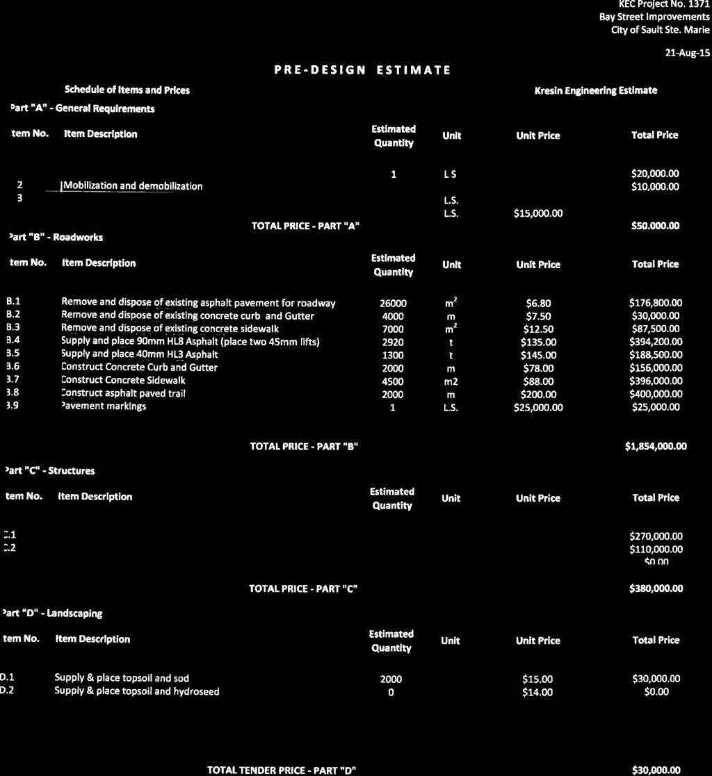
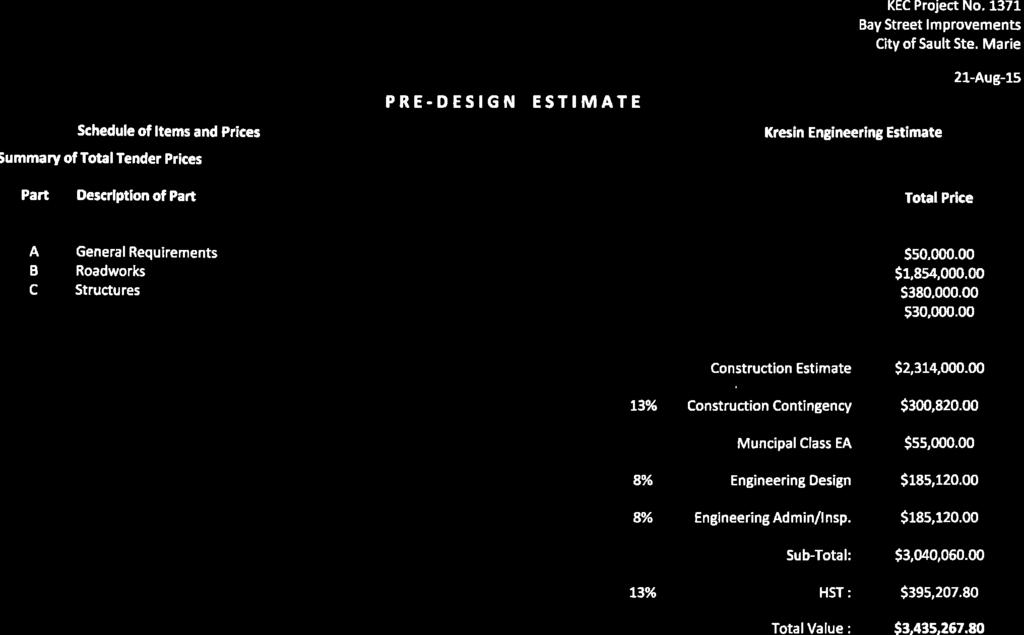
23 Bay Street Corridor Improvements Environmental Study Report Similar to the existing Bay Street corridor, it is likely that southbound turn lanes will remain at the Dennis Street and Elgin Street intersections, but will be modified to correspond with the narrower road section. It is also expected that the south turn lane onto lower Pim Street will remain. The south concrete curb and gutter would be required to move inward to accommodate drainage along the Bay Street corridor. It is expected that the north side of the corridor will not require any modifications during the implementation of the recommended design Solicit Input on Recommended Design A second PIC was conducted on April 23, 2015 to present the preliminary design options to the Public. The opportunity was provided and the Public was encouraged to discuss and provide comments on the presented information. Six residents were in attendance at the second PIC. Very little input was received regarding the alternatives presented; however, a general preference for Alternative 2A was noted. Copies of the presentation boards, attendance records and comments received at the PIC are attached in Appendix Preferred Design, Schedule and Cost Following the second PIC, the preferred design was confirmed as the construction of a three lane road with a multi-use path. The preferred design is shown in Appendix 6. It is intended to begin construction in 2016, however, a phased approach to the completion of project may be taken based on funding availability. Cost estimates have been developed for the proposed work and are included in Appendix Phase Four Environmental Study Report In accordance with the completion of this study as a Schedule C Project under the Municipal Class Environmental Assessment process, a Notice of Completion of this Environmental Study Report is to be issued and published by the City of Sault Ste. Marie. The ESR is to be made available for review by interested parties for a period of 30 days following the Notice of Completion. During this review period, concerns from the public are to be resolved by the City if possible. Failing resolution of issues, the concerned parties can request, during the review period, that the Minister of the Environment and Climate Change issue an order to comply with Part II of the EA Act. It is preferable to resolve issues with the City rather than requesting a Part II order, therefore negotiations or mediation with the City is encouraged. A request for a Part II order must be made in writing within 30 days of the Notice of Completion to the Minister of the Environment and Climate Change, with a copy to the City of Sault Ste. Marie at the addresses below: kresin engineering corporation Page 20 of 21
24 Bay Street Corridor Improvements Environmental Study Report The Honourable Glen Murray Minister of the Environment and Climate Change 77 Wellesley Street West 11th Floor, Ferguson Block Toronto ON M7A 2T5 Director, Environmental Approvals Branch Ministry of the Environment and Climate Change 1st Floor, 135 St. Clair Ave West Toronto, ON M4V 1P5 Director of Engineering Services City of Sault Ste. Marie 5 th Floor, Civic Centre 99 Foster Drive Sault Ste. Marie, ON P6A 5N1 kresin engineering corporation Page 21 of 21
25
26
27
28 BAY STREET CORRIDOR IMPROVEMENTS ENVIRONMENTAL STUDY REPORT KEC Project Ref. No Consultation List November 25, 2015 Ministry/Agency Contact Information Phone/Fax/ Algoma District School Board Ms. Lucia Reece T: Director of Education F: Albert Street East Sault Ste. Marie, ON P6A 2K7 Brookfield Renewable Power Inc. Jim Deluzio T: Sault Hydro Operations General Manager F: Industrial Park Crescent Sault Ste. Marie, ON P6B 5P3 City of Sault Ste. Marie Mr. Christian Provenzano T: Mayor F: Box 580, 99 Foster Drive Sault Ste. Marie, ON P6B 5P3 City of Sault Ste. Marie Mr. Lou Turco T: Ward Councillor F: Box 580, 99 Foster Drive Sault Ste. Marie, ON P6B 5P3 City of Sault Ste. Marie Mr. Rick Niro T: Ward Councillor F: Box 580, 99 Foster Drive Sault Ste. Marie, ON P6B 5P3 T: City of Sault Ste. Marie Ms. Susan Myers F: Ward Councillor Box 580, 99 Foster Drive Sault Ste. Marie, ON P6B 5P3 City of Sault Ste. Marie Mr. Terry Sheehan T: Ward Councillor F: Box 580, 99 Foster Drive Sault Ste. Marie, ON P6B 5P3 City of Sault Ste. Marie, Planning Department Mr. Don McConnell T: Planning Director F: P.O. Box 580, 99 Foster Drive Sault Ste. Marie, ON P6A 5N1 City of Sault Ste. Marie, Public Works and Transportation Mr. Larry Girardi T: Commissioner F: Sackville Road Sault Ste. Marie, ON P6B 4T6 Department of Fisheries and Oceans Ms. Sara Eddy T: Fish Habitat Biologist F: Fish Habitat Management, Ontario-Great Lakes Area 867 Lakeshore Road Burlington, ON L7R 4A6 Algoma Power Inc. Mr. Dan Richards T: Supervisor District Engineer F: A-2 Sackville Road Sault Ste. Marie, ON P6B 6J6 Great Lakes Power Transmission Mr. Bernie Mobach T: ext. 553 Consultant F: B-2 Sackville Road Sault Ste, Marie, ON P6B 6J6 Kresin Engineering Corporation 1 of 5
29 Ministry/Agency Contact Information Phone/Fax/ Huron Superior District Catholic School Board Mr. John Stadnyk T: Director of Education F: Ontario Avenue Sault Ste. Marie, ON P6B 6G7 Aboriginal Affairs and Northern Development Canada Ms. Cheyenne Loon T: Senior Environmental Advisor - Environment F: St. Clair Avenue East, 8th Floor Toronto, ON M4T 1M2 Ministry of Aboriginal Affairs, Ministry Partnership Unit Ms. Ashley Johnson T: Senior Advisor (Acting), Consultation Unit F: Aboriginal Relations and Ministry Partnerships Division ashley.johnson@ontario.ca 160 Bloor St. E., 9th Floor Toronto, ON M7A 2E6 T: Mr. Corwin Troje T: Manager (Acting), Ministry Partnerships Unit F: Aboriginal and Ministry Relations Branch corwin.troje@ontario.ca 160 Bloor St. E., 9th Floor Toronto, ON M7A 2E6 Ministry of Citizenship, Immigration and International Trade Ms. Patricia Ricard T: Regional Advisor F: Foster Drive, Suite 220 Patricia.Ricard@ontario.ca Sault Ste. Marie, ON P6A 6V8 Ministry of Tourism, Culture and Sport Mr. Patrick Morash T: Regional Manager (Acting) F: Regional Services Branch - North Region patrick.morash@ontario.ca 435 James Street South, Suite 334 P7E 6S7 Ms. Penny Young T: Heritage Planner, Culture Services Unit F: Programs and Services Branch penny.young@ontario.ca 401 Bay Street, Suite 1700 Toronto, ON M7A 0A7 Mr. Joseph Muller T: Heritage Planner, Culture Services Unit F: Programs and Services Branch joseph.muller@ontario.ca 401 Bay Street, Suite 1700 Toronto, ON M7A 0A7 Ministry of Municipal Affairs and Housing, Northeastern Municipal Ms. Bridget Schulte-Hostedde T: Services Office Manager (Acting), Community Planning and Development F: Cedar Street, Suite 401 bridget.schulte-hostedde@ontario.ca Sudbury, ON P3E 6A5 Ministry of Natural Resources and Forestry Ms. Erin Nixon T: Resources Operations Supervisor (Acting) F: Church Street erin.nixon@ontario.ca Sault Ste. Marie, ON P6A 3H3 Ministry of Northern Development and Mines Ms. Priya Tandon T: Director - Corporate Policy Secretariat F: th Floor, Room 5630, 99 Wellesley Street West priya.tandon@ontario.ca Toronto, ON M7A 1W3 Ministry of Economic Development, Employment and Infrastructure Mr. Matthew Routley T: Manager (Acting) - Infrastructure Analytics F: Mowat Block, 5th Floor, 900 Bay Street matthew.routley@ontario Toronto, ON M7A 1C2 Ministry of the Attorney General Ms. Rina Li T: Counsel, Crown Law Office - Civil F: McMurtry - Scott Building rina.li@ontario.ca 8th Floor, 720 Bay Street Toronto, ON M7A 2S9 Ministry of the Environment and Climate Change Mr. Ron Dorscht T: Supervisor - Sault Ste. Marie Area Office F: Foster Drive, Suite 110 ron.dorscht@ontario.ca Sault Ste. Marie, ON P6A 6V4 Kresin Engineering Corporation 2 of 5
30 Ministry/Agency Contact Information Phone/Fax/ Ms. Nathalie Osipenko T: Divisional Programs Specialist (Acting) F: Northern Region 435 James Street South, Suite 331 Thunder Bay, ON P7E 6S7 Ministry of Transportation Mr. Darren Stephenson T: Area Contracts Engineer - Sault Ste. Marie Area Office F: Ontario Government Building darren.stephenson@ontario.ca 447 McKeown Avenue, 1st Floor Mailroom North Bay, ON P1B 9S9 Blueforest Ventures Inc. Mr. Willem Galle T: Executive Director F: NA 620 Davenport Road, Unit 9 willemgalle@blueforestventures.com Waterloo, ON N2V 2C2 Canadian Bushplane Heritage Centre Mr. Mike Delfre T: ext. 201 Manager F: Pim Street mdelfre@bushplane.com Sault Ste. Marie, ON P6A 3G4 Downtown Association Mr. Duane Moleni T: Manager F: Queen Street East d.moleni@saultdowntown.com Sault Ste. Marie, ON P6A 1Z8 Ermatinger Clergue National Historic Site Mr. Nick Aspostle T: Commissioner Community Services F: Level 2, Civic Centre n.apostle@cityssm.on.ca 99 Foster Drive, P.O. Box 580 Sault Ste Marie, ON P6A 5N1 Ms. Kathryn Fisher T: Curator, Recreation and Culture Division F: Level 2, Civic Centre k.fisher@cityssm.on.ca 99 Foster Drive, P.O. Box 580 Sault Ste Marie, ON P6A 5N1 HDR Corporation Ms. Elizabeth Szymanski, C.E.T. T: Consultant F: Adelaide Street West elizabeth.szymanski@hdrinc.com Toronto, ON M5H 1X9 International Bridge Administration Mr. Phillip Becker, P.E. T: ext. 112 International Bridge Engineer/Manager F: Bridge Plaza beckerp@michigan.gov Sault Ste. Marie, MI Mr. Karl Hansen T: ext. 135 (US) Bridge Engineer T: ext. 135 (Canada) International Bridge Administration F: Bridge Plaza HansenK@michigan.gov Sault Ste. Marie, MI OLG Casino Sault Ste. Marie Mr. Jake Pastore T: Manager of Government and Municipal Relations F: Young Street, Suite 400 jpastore@olg.ca Toronto, ON M2P 2B8 Mr. Gary Mancuso T: Facilities Manager F: Bay Street West GMancuso@olg.ca Sault Ste. Marie, ON P6A 7A6 Ms. Valerie Braun T: Director Governance and Relationship Management for Charitable Gaming F: Bay Street West Vbraun@olg.ca Sault Ste. Marie, ON P6A 7A6 Parks and Recreation Advisory Committee Ms. Virginia McLeod T: Manager Recreation and Culture Division F: Level 2, Civic Centre v.mcleod@cityssm.on.ca 99 Foster Drive, P.O. Box 580 Sault Ste. Marie, ON P6A 5N1 Parks Canada Ms. Jeanette Cowen T: National Historic Site and Visitor Experience Manager, Sault Ste. Marie National Historic Site of Canada F: Canal Drive jeanette.cowen@pc.gc.ca Sault Ste. Marie, ON P6A 6W4 Kresin Engineering Corporation 3 of 5
31 Ministry/Agency Contact Information Phone/Fax/ PUC Services Inc. Mr. Dominic Parrella T: President and CEO/Secretary F: Second Line, P.O. Box 9000 Sault Ste. Marie, ON P6A 6P2 Mr. Rob Harten T: Manager of Engineering F: Second Line, P.O. Box 9000 Sault Ste. Marie, ON P6A 6P2 Mr. Darren Seabrook T: NA Electrical Distribution Engineer F: Second Line, P.O. Box 9000 Sault Ste. Marie, ON P6A 6P2 Mr. Andrew Hallett T: Water Distribution Engineer F: Second Line, P.O. Box 9000 Sault Ste. Marie, ON P6A 6P2 Purvis Marine Ltd. Ms. Sheila Purvis T: Pim Street F: Sault Ste. Marie, ON sheila.purvis@purvismarine.com P6A 3G3 Rivers Edge Developments Inc. Mr. Justus Veldman T: Huron Street F: Sault Ste. Marie, ON justusveldman@yahoo.ca P6A 5P4 Sault Cycling Club Mr. Jamie Capisciolto T: NA President F: c/o 235 McNabb Street james.capisciolto@rbc.com Sault Ste. Marie, ON P6B 1Y3 Sault Ste. Marie Fire Services Mr. Mike Figliola T: Fire Chief F: Tancred Street m.figliola@cityssm.on.ca Sault Ste. Marie, ON P6A 2W1 Sault Ste. Marie Public Library Ms. Roxanne Toth-Rissanen T: CEO/Director of Public Libraries (Acting) F: Centennial Library r.rissanen@cityssm.on.ca 50 East Street P6A 3C3 Sault Ste. Marie Police Services Mr. Robert Keetch T: ext. 324 Chief of Police F: Second Line East info@ssmps.org Sault Ste. Marie, ON P6B 4K1 Sault Ste. Marie Region Conservation Authority Ms. Rhonda Bateman T: ext. 205 General Manager F: Fifth Line East rbateman@ssmrca.ca Sault Ste. Marie, ON P6A 6J8 Sault Ste. Marie Association of Ratepayers David Poluck T: Volunteer Organizer, Communications F: NA 302 Boundary Road saultratepayers@hotmail.com Sault Ste. Marie, ON P6A 5C1 Sault Trailblazers Snowmobile Club Mr. John Breckenridge T: President F: Old Garden River Road saulttrailblazers@gmail.com Sault Ste. Marie, ON P6B 5A4 Sault Trails Advocacy Committee Ms. Donna Hilsinger T: Chair F: Sault Ste. Marie Economic Development Corporation dhilsinger@watertowerinn.com 99 Foster Drive - Level 3 Sault Ste. Marie, ON P6A 5X6 Transport Canada - Ontario Region Ms. Monique Mousseau T: Regional Manager, Environment and Engineering F: Yonge Street monique.mousseau@tc.gc.ca North York, ON M2N 6A5 Batchewana First Nation Chief Dean Sayers T: Frontenac Street F: Sault Ste. Marie, ON chiefdeansayers@batchewana.ca P6A 5K9 Kresin Engineering Corporation 4 of 5
32 Ministry/Agency Contact Information Phone/Fax/ Garden River First Nation Chief Paul Syrette T: Shingwauk Street, RR 4 F: Garden River, ON psyrette@gardenriver.org P6A 6Z8 Historic Sault Ste. Marie District Métis Community Council Ms. Kim Powley, President T: President F: Queen Street East kimmysue@shaw.ca Sault Ste. Marie, ON P6A 1Y3 Métis Nation of Ontario Mr. Alden Barty T: ext. 226 Consultation Assessment Coordinator F: Cranston Crescent Aldenb@metisnation.org Midland, ON L4R 4K6 Public Contact Mr. Steven Shoemaker Mr. Andre Riopel Mr. Mark Brown Mr. Robert Rattle Ms. Kathryn Yukich Mr. Paul McDonald Mr. Gary Mancuso Mr. Nilo Fabro Mr. Deane Greenwood Mr. Brent Krmpotich Mr. Mike Delfre Kresin Engineering Corporation 5 of 5
33
34

35
36
37
38

39
40
41
42
43
44
45
46
47

48
49 City of Sault Ste. Marie BAY STREET IMPROVEMENTS PUBLIC INFORMATION CENTRE SIGN-IN SHEET - (PLEASE PRINT CLEARLY) Name Address Phone Jerry Dolcetti Karl Hansen Mike Delfre Kathyrn Yukich Gary Mancuso Steve Turco Mason Merz Mark Brown Bill Jakomati Andre Riopel
50
51

52
53

54

55

56
57
58

59
60
61

62

63

64


65
66
67
68 City of Sault Ste. Marie BAY STREET IMPROVEMENTS PUBLIC INFORMATION CENTRE SIGN-IN SHEET - (PLEASE PRINT CLEARLY) Name Address Phone Gary Mancuso Mark Brown Andre Riopel Nilo Fabbro Deane Greenwood Brent Krmpotich
69
70
71
72
73

74
75
76
to the Public Information Centre for the Downtown Traffic Study
 to the Public Information Centre for the Downtown Traffic Study City of Sault Ste. Marie July 25, 2018 Purpose of Study Determine if changes to one-way corridors can enhance downtown s character and spaces
WELCOME TO OPEN HOUSE # 1 June 14, 2017
 Langstaff Road Weston Road to Highway 7 Class Environmental Assessment Study WELCOME TO OPEN HOUSE # 1 June 14, 2017 Please sign in and join our mailing list Purpose of Open House #1 & Study Area York
Welcome to the Open House
 Leslie Street Between 19 th Avenue and Stouffville Road Addendum to Class Environmental Assessment Study Welcome to the Open House Please sign in at the front desk. March 28, 2017 Richmond Green Sports
APPENDIX 2 LAKESHORE ROAD TRANSPORTATION REVIEW STUDY EXECUTIVE SUMMARY
 APPENDIX 2 LAKESHORE ROAD TRANSPORTATION REVIEW STUDY EXECUTIVE SUMMARY Appendix 2 City of Mississauga Lakeshore Road FINAL REPORT Transportation Review Study December 2010 EXECUTIVE SUMMARY Study Purpose
Chapter 3 DESIGN SPECIFICATIONS
 Brampton PathWays Planning and Design Guidelines 27 Chapter 3 DESIGN SPECIFICATIONS 3.1 CLASS 1 MULTI-USE PATH Off-road multi-use trails are the backbone of the Brampton PathWays Network. They are typically
TRAFFIC CALMING GUIDE FOR TORONTO CITY OF TORONTO TRANSPORTATION SERVICES DIVISION
 TRAFFIC CALMING GUIDE FOR TORONTO CITY OF TORONTO TRANSPORTATION SERVICES DIVISION CITY OF TORONTO TRANSPORTATION SERVICES DIVISION 2016 TRAFFIC CALMING GUIDE FOR TORONTO TABLE OF CONTENTS Introduction
Road Alterations - Wellington Street East, Church Street, and Front Street Intersection
 REPORT FOR ACTION Road Alterations - Wellington Street, Church Street, and Front Street Intersection Date: November 1, 2016 To: Toronto and York Community Council From: Director, Public Realm Section,
Tonight is an opportunity to learn about the Study and ask questions of the Study Team members.
 Exhibit 1 Welcome Second Open House Tonight is an opportunity to learn about the Study and ask questions of the Study Team members. A first Public Open House was held on September 18th, 2013 which presented
Municipal Class EA To Address Traffic Congestion On The Ontario Street Corridor (Grand Bend) Public Information Meeting June 4, 2018
 Public Information Meeting June 4, 2018") Municipal Class EA To Address Traffic Congestion On The Ontario Street Corridor (Grand Bend) Public Information Meeting June 4, 2018 Background Agenda Traffic Study Update Class EA Alternatives Bridge
Municipal Class EA To Address Traffic Congestion On The Ontario Street Corridor (Grand Bend) Public Information Meeting June 4, 2018 Background Agenda Traffic Study Update Class EA Alternatives Bridge
TRANSPORTATION NEEDS ASSESSMENT
 TRANSPORTATION NEEDS ASSESSMENT A travel demand analysis was carried out to determine the operational issues and the potential benefit that adding traffic capacity would have on the road network. All the
CONNECTIVITY PLAN. Adopted December 5, 2017 City of Virginia Beach
 CONNECTIVITY PLAN Adopted December 5, 2017 City of Virginia Beach CONTENTS 1.0 Background & Purpose... 2 2.0 Existing Inventory & Analysis... 3 ViBe District Existing Walking Conditions... 4 3.0 ViBe District
CITY OF VAUGHAN EXTRACT FROM COUNCIL MEETING MINUTES OF OCTOBER 30, 2012
 CITY OF VAUGHAN EXTRACT FROM COUNCIL MEETING MINUTES OF OCTOBER 30, 2012 Item 31, Report No. 39, of the Committee of the Whole, which was adopted without amendment by the Council of the City of Vaughan
AIRPORT ROAD ENVIRONMENTAL ASSESSMENT
 WELCOME TO PUBLIC INFORMATION CENTRE #1 AIRPORT ROAD ENVIRONMENTAL ASSESSMENT From Braydon Boulevard/Stonecrest Drive to Countryside Drive November 23, 2017 6:30 PM 8:30 PM Please sign in and fill out
HIGHBURY AVENUE/HAMILTON ROAD INTERSECTION IMPROVEMENTS PUBLIC INFORMATION CENTRE 1 MAY 14, 2015
 HIGHBURY AVENUE/HAMILTON ROAD INTERSECTION IMPROVEMENTS Municipal Class Environmental Assessment PUBLIC INFORMATION CENTRE 1 MAY 14, 2015 ACCESSIBILITY Under the Accessibility Standards 2015 for Customer
102 Avenue Corridor Review
 February 26, 2015 102 Avenue Corridor Review Transportation Association of Canada Road Safety Engineering Award Submission for the City of Edmonton Introduction Transportation Association of Canada Road
Exhibit 1 PLANNING COMMISSION AGENDA ITEM
 Exhibit 1 PLANNING COMMISSION AGENDA ITEM Project Name: Grand Junction Circulation Plan Grand Junction Complete Streets Policy Applicant: City of Grand Junction Representative: David Thornton Address:
Pennsylvania Avenue (CR 484) Design Alternatives Study
 Design Alternatives Study") MEMORANDUM Pennsylvania Avenue (CR 484) Design Alternatives Study Prepared for: APRIL 2016 Prepared By TABLE OF CONTENTS Project Background... 2 Previous Concept... 2 Existing Conditions... 4 New Alternatives...
MEMORANDUM Pennsylvania Avenue (CR 484) Design Alternatives Study Prepared for: APRIL 2016 Prepared By TABLE OF CONTENTS Project Background... 2 Previous Concept... 2 Existing Conditions... 4 New Alternatives...
Living Streets Policy
 Living Streets Policy Introduction Living streets balance the needs of motorists, bicyclists, pedestrians and transit riders in ways that promote safety and convenience, enhance community identity, create
East Burke Transportation, Safety and Capacity Improvements
 East Burke Transportation, Safety and Capacity Improvements The purpose of this project is to increase mobility and improve safety for pedestrians, cyclists, and motor vehicles along VT Route 114 in the
Proposed. City of Grand Junction Complete Streets Policy. Exhibit 10
 Proposed City of Grand Junction Complete Streets Policy Exhibit 10 1 City of Grand Junction Complete Streets Policy Vision: The Complete Streets Vision is to develop a safe, efficient, and reliable travel
Solana Beach Comprehensive Active Transportation Strategy (CATS)
") Solana Beach Comprehensive Active Transportation Strategy (CATS) 3.0 Goals & Policies The Solana Beach CATS goals and objectives outlined below were largely drawn from the Solana Beach Circulation Element
Solana Beach Comprehensive Active Transportation Strategy (CATS) 3.0 Goals & Policies The Solana Beach CATS goals and objectives outlined below were largely drawn from the Solana Beach Circulation Element
Moving Cambridge. City of Cambridge Transportation Master Plan Public Consultation Centre. March 7, :00 8:00 PM.
 City of Cambridge Transportation Master Plan Public Consultation Centre March 7, 2018 5:00 8:00 PM Region of Waterloo City of Cambridge Transportation Master Plan Public Consultation Centre March 7, 2018
Improving Cyclist Safety at the Dundas Street West and Sterling Road Intersection
 STAFF REPORT ACTION REQUIRED Improving Cyclist Safety at the Dundas Street West and Sterling Road Intersection Date: August 17, 2012 To: From: Wards: Reference Number: Public Works and Infrastructure Committee
122 Avenue: 107 Street to Fort Road
 : 107 Street to Fort Road November 24, 2015 4:30 8:00 p.m. Meeting Purpose Summarize project work completed to date Share results of public input from Phase 1 Share the draft concept plan and proposed
Pedestrian Crosswalk Audit
 1200, Scotia Place, Tower 1 10060 Jasper Avenue Edmonton, Alberta T5J 3R8 edmonton.ca/auditor Pedestrian Crosswalk Audit June 19, 2017 The conducted this project in accordance with the International Standards
Tonight is for you. Learn everything you can. Share all your ideas.
 Strathcona Neighbourhood Renewal Draft Concept Design Tonight is for you. Learn everything you can. Share all your ideas. What is Neighbourhood Renewal? Creating a design with you for your neighbourhood.
Harbord Street and Hoskin Avenue Bicycle Lane Upgrades
 STAFF REPORT ACTION REQUIRED and Bicycle Lane Upgrades Date: April 22, 2014 To: From: Wards: Reference Number: Public Works and Infrastructure Committee General Manager, Transportation Services 19 and
CITY OF COCOA BEACH 2025 COMPREHENSIVE PLAN. Section VIII Mobility Element Goals, Objectives, and Policies
 CITY OF COCOA BEACH 2025 COMPREHENSIVE PLAN Section VIII Mobility Element Goals, Objectives, and Policies Adopted August 6, 2015 by Ordinance No. 1591 VIII MOBILITY ELEMENT Table of Contents Page Number
Appendix O. Assessment of Bicycle Facility Alternatives
 Appendix O Assessment of Bicycle Facility Alternatives FINAL ASSESSMENT OF CROSS-SECTION ELEMENTS Lakeshore Road, from Mississaga Street to Dorval Drive Town of Oakville Submitted to: Town of Oakville
4. ENVIRONMENTAL IMPACT ANALYSIS 9. TRANSPORTATION AND TRAFFIC
 4. ENVIRONMENTAL IMPACT ANALYSIS 9. TRANSPORTATION AND TRAFFIC 4.9.1 INTRODUCTION The following section addresses the Proposed Project s impact on transportation and traffic based on the Traffic Study
MAG Town of Cave Creek Bike Study Task 6 Executive Summary and Regional Significance Report
 Page 1 MAG Town of Cave Creek Bike Study Task 6 Executive Summary and Regional Significance Report August 1, 2012 MAG Project #481 Page 2 Task 6 Executive Summary and Regional Significance Report Introduction
Welcome to the Public Meeting. Red Hill Business Park South Transportation Master Plan Addendum. December 4, :00 p.m. to 8:00 p.m.
 Welcome Welcome to the Transportation Master Plan Addendum December 4, 2012 6:00 p.m. to 8:00 p.m. Please sign-in Background PIC#1 Public Information Centre #1 (PIC#1) was held on June 25, 2012. Feedback
TOWN OF PORTLAND, CONNECTICUT COMPLETE STREETS POLICY
 TOWN OF PORTLAND, CONNECTICUT COMPLETE STREETS POLICY I. VISION, GOALS & PRINCIPLES VISION To improve the streets of Portland making them safer and more accessible for all users including pedestrians,
Governance and Priorities Committee Report For the July 2, 2015 Meeting
 CITY OF VICTORIA For the July 2, 2015 Meeting To: Governance and Priorities Committee Date: From: Subject: Brad Dellebuur, A/Assistant Director, Transportation and Parking Services Executive Summary The
PEDESTRIAN ACTION PLAN
 ATTACHMENT 2 CITY OF SANTA MONICA PEDESTRIAN ACTION PLAN CITY OF SANTA MONICA PEDESTRIAN ACTION PLAN This page intentionally left blank EXECUTIVE SUMMARY CHAPTER 1 EXECUTIVE SUMMARY Setting the Stage
EXECUTIVE SUMMARY: TRANSIT-ORIENTED DEVELOPMENT IN SMITHS FALLS, ONTARIO; A COMPARISON BETWEEN TWO SITES
 EECUTIVE SUMMARY: TRANSIT-ORIENTED DEVELOPMENT IN SMITHS FALLS, ONTARIO; A COMPARISON BETWEEN TWO SITES Topic and Purpose In 2007, the Mayor of Ottawa s Task Force on Transportation suggested adding a
The District Municipality of Muskoka 70 Pine Street Bracebridge ON P1L 1N3
 Public Information Centre Summary Report Muskoka Road 15 (Santa s Village Road) Transportation Improvements from the Beaver Creek Bridge to the Entrance of Santa s Village The District Municipality of
o n - m o t o r i z e d transportation is an overlooked element that can greatly enhance the overall quality of life for the community s residents.
 N o n - m o t o r i z e d transportation is an overlooked element that can greatly enhance the overall quality of life for the community s residents. 84 Transportation CHAPTER 11 INTRODUCTION Transportation
CITY OF HAMILTON PLANNING AND ECONOMIC DEVELOPMENT DEPARTMENT Transportation Planning and Parking Division
 CITY OF HAMILTON PLANNING AND ECONOMIC DEVELOPMENT DEPARTMENT Transportation Planning and Parking Division TO: Chair and Members Public Works Committee COMMITTEE DATE: June 18, 2018 SUBJECT/REPORT NO:
Proposed Bridge Street East Bicycle Lanes Public Open House Thursday, April 27, 2017
 WELCOME Proposed Bridge Street East Bicycle Lanes Public Open House Thursday, April 27, 2017 Purpose of the Open House The purpose of this Open House is to gain public input on the bicycle lanes proposed
Corpus Christi Metropolitan Transportation Plan Fiscal Year Introduction:
 Introduction: The Safe, Accountable, Flexible, Efficient Transportation Equity Act: A Legacy for Users (SAFETEA-LU) has continued the efforts started through the Intermodal Surface Transportation Efficiency
Active Transportation Facility Glossary
 Active Transportation Facility Glossary This document defines different active transportation facilities and suggests appropriate corridor types. Click on a facility type to jump to its definition. Bike
4 DISRUPTION MANAGEMENT PLAN HIGHWAY 7 RAPIDWAY CONSTRUCTION BETWEEN BAYVIEW AVENUE AND WARDEN AVENUE TOWNS OF MARKHAM AND RICHMOND HILL
 4 DISRUPTION MANAGEMENT PLAN HIGHWAY 7 RAPIDWAY CONSTRUCTION BETWEEN BAYVIEW AVENUE AND WARDEN AVENUE TOWNS OF MARKHAM AND RICHMOND HILL The Transportation Services Committee recommends the adoption of
Frequently Asked Questions (FAQ)
") Frequently Asked s (FAQ) Study Process... 2 Rapid Transit Service and Operations... 5 Public Consultation... 8 Business Impacts... 8 Design and Property Impacts... 9 Construction Impacts...12 Traffic,
Frequently Asked s (FAQ) Study Process... 2 Rapid Transit Service and Operations... 5 Public Consultation... 8 Business Impacts... 8 Design and Property Impacts... 9 Construction Impacts...12 Traffic,
REPORT. Engineering and Construction Department
 REPORT COMMUNITY SERVICES COMMITTEE MEETING DATE: JUNE 11, 2013 FROM: Engineering and Construction Department DATE: May 24, 2013 SUBJECT: Great Lakes Boulevard Mini Roundabout LOCATION: Great Lakes Boulevard
HENDERSON DEVELOPMENT 213, 217, 221, 221 ½, 223 HENDERSON AVENUE and 65 TEMPLETON STREET OTTAWA, ONTARIO TRANSPORTATION OVERVIEW.
 HENDERSON DEVELOPMENT 213, 217, 221, 221 ½, 223 HENDERSON AVENUE and 65 TEMPLETON STREET OTTAWA, ONTARIO TRANSPORTATION OVERVIEW Prepared for: 2294170 Ontario Inc. February 2, 2017 117-652 Report_1.doc
Sixth Line Development - Transit Facilities Plan
 Memorandum Date: November 13, 2012 To: From: c.c. Subject: Rob Freeman (Freeman Planning) Kevin Phillips Sixth Line Development - Transit Facilities Plan 33016631 This memo was prepared to review the transit
Coquitlam Cross-town Bike Route Improving Bicycle Facilities in a Mature Suburban Environment
 Coquitlam Cross-town Bike Route Improving Bicycle Facilities in a Mature Suburban Environment Sarah Rocchi, Vice-President, Projects, Opus International Consultants (Main Presenter) Catherine Mohoruk,
Climate Change Action Plan: Transportation Sector Discussion Paper: Cycling
 Climate Change Action Plan: Transportation Sector Discussion Paper: Cycling ontario.ca/climatechange Contents 1. Minister of Transportation s message... 3 2. Introduction... 5 3. Sector Overview and Support
CURBSIDE ACTIVITY DESIGN
 5 CURBSIDE ACTIVITY DESIGN This chapter provides design guidance for separated bike lanes adjacent to curbside activities including parking, loading and bus stops. Typical configurations are presented
CITY OF OTTAWA ROADWAY MODIFICATION APPROVAL UNDER DELEGATED AUTHORITY
 RMA-2015-ATM-038 CITY OF OTTAWA ROADWAY MODIFICATION APPROVAL UNDER DELEGATED AUTHORITY DATE: April 22, 2015 SUBJECT Approval of Roadway Modifications Recommended through an Area Traffic Management Study
List of Display Boards
 List of Display Boards Welcome Introduction Municipal Class Environmental Assessment (EA) Process Need and Justification for an Interchange Alternatives for Evaluation Vertical and Horizontal Alignments
Item No. 14 Town of Atherton
 Item No. 14 Town of Atherton CITY COUNCIL STAFF REPORT CONSENT AGENDA TO: THROUGH: FROM: HONORABLE MAYOR AND CITY COUNCIL GEORGE RODERICKS, CITY MANAGER MICHAEL KASHIWAGI, COMMUNITY SERVICES DIRECTOR MARTY
EXECUTIVE SUMMARY OF CALEDON TRANSPORTATION NEEDS STUDY
 EXECUTIVE SUMMARY OF CALEDON TRANSPORTATION NEEDS STUDY The Caledon Transportation Needs Study has been undertaken as a joint project by the Town of Caledon and the Region of Peel to determine the existing
Broad Street Bicycle Boulevard Design Guidelines
 Broad Street Bicycle Boulevard Design Guidelines Building from the strategies introduced in the 2013 Bicycle Transportation Plan and community input received thus far, City Transportation Staff have identified
Cyclists and Bikeways: What s your match? A guide to bikeway options for a variety of cyclists
 Cyclists and Bikeways: What s your match? guide to bikeway options for a variety of cyclists The workshop and this resource were made possible by funding from the Province of Ontario via the Ministry of
Vision: Traditional hamlet with an attractive business/pedestrian friendly main street connected to adjacent walkable neighborhoods
 N D. Focus Area II Vision: Traditional hamlet with an attractive business/pedestrian friendly main street connected to adjacent walkable neighborhoods Transit Road Focus Area II is located in the Hamlet
COUNTY ROAD 22 HORSESHOE VALLEY ROAD. Municipal Class Environmental Assessment. simcoe.ca
 OCTOBER 2014 Municipal Class Environmental Assessment COUNTY ROAD 22 HORSESHOE VALLEY ROAD Project A Truck Climbing Lanes Project B Intersection Improvements simcoe.ca CORPORATE COMMUNICATIONS DEPARTMENT
Building Great Neighbourhoods BELLEVUE AND VIRGINIA PARK
 Building Great Neighbourhoods BELLEVUE AND VIRGINIA PARK This is Meeting 2 Unfortunately, some residents in Bellevue and Virginia Park received the wrong information for this public open house (Meeting
Lake to Lake LAKE YORK. CYCLING ROUTE and WALKING TRAIL FEASIBILITY and DESIGN STUDY LAKE. CITY of REGION ONTARIO SIMCOE TORONTO
 LAKE SIMCOE Lake to Lake CYCLING ROUTE and WALKING TRAIL FEASIBILITY and DESIGN STUDY YORK REGION Overview Report JUNE 2013 CITY of TORONTO LAKE ONTARIO Table of Contents Study background 2 Study Background............................
Chapter 5 Future Transportation
 Chapter 5 Future Transportation The Future Land Use Plan identifies the desired land use designations. The land uses desired for Crozet depend, in large part, on the success of the transportation system,
Active Transportation Infrastructure Investment A Business Case
 Active Transportation Infrastructure Investment A Business Case In 2016, the Real Estate Foundation awarded the Capital Regional District a $50,000 grant for Shifting Gears: Land Use Change through Active
Item to be Addressed Checklist Consideration YES NO N/A Required Description Complete Streets Guidelines
 Passaic County Complete Streets Checklist - Concept Development Project Name Item to be Addressed Checklist Consideration YES NO N/A Required Description Complete Streets Guidelines Existing Plans Have
REGIONAL BICYCLE AND PEDESTRIAN DESIGN GUIDELINES
 REGIONAL BICYCLE AND PEDESTRIAN DESIGN GUIDELINES November 16, 2011 Deb Humphreys North Central Texas Council of Governments Bicycle and Pedestrian Advisory Committee Snapshot of the Guide 1. Introduction
Transportation Master Plan Advisory Task Force
 Transportation Master Plan Advisory Task Force Network Alternatives & Phasing Strategy February 2016 BACKGROUND Table of Contents BACKGROUND Purpose & Introduction 2 Linking the TMP to Key Council Approved
Hospital Link Project Project Update September 2017
 Hospital Link Project Project Update September 2017 General The project provides a link from Riverside Drive and the Transitway to the Hospital Link Road. Construction is well underway. Read on for important
2.0 Existing Conditions
 20 2.0 Existing Conditions 2.1 Land Use, Future Growth Patterns, Physical Barriers Geographic Overview Sutter County s land use pattern is characterized by extensive agricultural areas, significant natural
Chapter 2: Standards for Access, Non-Motorized, and Transit
 Standards for Access, Non-Motorized, and Transit Chapter 2: Standards for Access, Non-Motorized, and Transit The Washtenaw County Access Management Plan was developed based on the analysis of existing
A CHANGING CITY. of Edmonton, it is essential that it reflects the long-term vision of the City.
 A CHANGING CITY By the year 2040, Edmonton will be home to more than 1 million people. To accommodate growth and support a healthy and compact city, we need a new approach to development/redevelopment
City of Elizabeth City Neighborhood Traffic Calming Policy and Guidelines
 City of Elizabeth City Neighborhood Traffic Calming Policy and Guidelines I. Purpose: The City of Elizabeth City is committed to ensure the overall safety and livability of residential neighborhoods. One
City of Gainesville Transportation/Roadway Needs PROJECT SUMMARY
 A1 Roadway Resurfacing $23,846,000 TYPE: Preservation of existing system Roadway resurfacing A2 Signal Replacement $6,000,000 TYPE: Preservation of existing system Replace traffic signals. B1 W 6th St
83 AVENUE PRE-CONSTRUCTION MEETING
 83 AVENUE PRE-CONSTRUCTION MEETING April 6, 2017 5-8PM Please visit displays for project information Talk to staff, ask questions, visit website at: www.edmonton.ca/bike83avenue Pre-Construction Meeting
RESOLUTION NO ?? A RESOLUTION OF THE CITY OF NEPTUNE BEACH ADOPTING A COMPLETE STREETS POLICY
 RESOLUTION NO. 2018-?? A RESOLUTION OF THE CITY OF NEPTUNE BEACH ADOPTING A COMPLETE STREETS POLICY WHEREAS, safe, convenient, and accessible transportation for all users is a priority of the City of Neptune
Comments EXECUTIVE SUMMARY
 Comments 1. Under any Alternatives, MCDOT should provide better at-grade pedestrian crossing of Georgia Avenue and Forest Glen Road, including improved crosswalks with wider medians and adequate signal
WELCOME. Purpose of the Open House. Update you on the project. Present a draft recommended plan. Receive your input
 WELCOME Purpose of the Open House The Town of Smiths Falls has initiated the Beckwith Street Redevelopment Plan that includes the preparation of a streetscape functional design for the renewal of Beckwith
Report Purpose To seek Council s approval of the Wye Road Functional Planning Study (January 2015).
.") COUNCIL MEETING Meeting Date: March 10, 2015 Agenda Item #: 13.1 Wye Road Functional Planning Study (January 2015) Report Purpose To seek Council s approval of the Wye Road Functional Planning Study (January
COUNCIL MEETING Meeting Date: March 10, 2015 Agenda Item #: 13.1 Wye Road Functional Planning Study (January 2015) Report Purpose To seek Council s approval of the Wye Road Functional Planning Study (January
Welcome. If you have any questions or comments on the project, please contact:
 Welcome This drop-in public open house is intended to provide information about the Bay Street bike lanes project. This project proposes a dedicated cycling facility along Bay Street between Aberdeen Avenue
WEST AND SOUTH WEST RING ROAD DOWNSTREAM TRAFFIC IMPACTS
 Page 1 of 9 EXECUTIVE SUMMARY Alberta Transportation ( AT ) is preparing to construct the final sections of the Calgary Ring Road. This includes the South West Ring Road ( SWRR ) (from Lott Creek Blvd
Comments The Plan for Port Whitby
 Comments The Plan for Port Whitby April 24th, 2013 Community Meeting #2 Summary Report Prepared by GLPi April 29th, 2013 1 Introduction The purpose of the Port Whitby Secondary Plan Update, Community Improvement
Route 7 Corridor Study
 Route 7 Corridor Study Executive Summary Study Area The following report analyzes a segment of the Virginia State Route 7 corridor. The corridor study area, spanning over 5 miles in length, is a multi
Chapter 7. Transportation. Transportation Road Network Plan Transit Cyclists Pedestrians Multi-Use and Equestrian Trails
 Chapter 7 Transportation Transportation Road Network Plan Transit Cyclists Pedestrians Multi-Use and Equestrian Trails 7.1 TRANSPORTATION BACKGROUND The District of Maple Ridge faces a number of unique
DESIGN CODE. Enterprise West Harlow London Road North Design Code 21
 DESIGN CODE Enterprise West Essex @ Harlow London Road North Design Code 21 4 MAXIMUM BUILDING HEIGHTS 4.1 Table 4A sets out maximum building height standards for each character area within the LDO boundary.
Dowling/Beaty Cycling Route
 Public Meeting #2 Dowling/Beaty Cycling Route May 17, 2017 6:00 p.m. 8:00 p.m. Parkdale Public Library - Auditorium 1303 Queen Street West How to Participate Share your questions, ideas and concerns We
Southcote Road Improvements Class Environmental Assessment Study
 1 Southcote Road Improvements Class Environmental Assessment Study Public Information Centre #1 May 24, 2018 Study Area 2 3 Welcome The Ancaster Transportation Master Plan (2011) outlined a long range
POLICY: TRAFFIC CALMING
 2006 MAY REFERENCE: COUNCIL APPROVED BY COUNCIL MAY 23, 2006 CITY OPERATIONS - NO. 608 POLICY: TRAFFIC CALMING A. All requests for traffic calming within the City shall be considered in accordance with
CONNECTING PEOPLE TO PLACES
 CONNECTING PEOPLE TO PLACES 82 EAST BENCH MASTER PLAN 07 Introduction The East Bench transportation system is a collection of slow moving, treelined residential streets and major arteries that are the
2.0 LANE WIDTHS GUIDELINE
 2.0 LANE WIDTHS GUIDELINE Road Engineering Design Guidelines Version 2.0.1 May 2018 City of Toronto, Transportation Services City of Toronto Page 0 Background In early 2014, Transportation Services initiated
Downtown BRT Corridor Alternatives Review: 1 st, 2 nd, 3 rd and 4 th Avenue. Bus Rapid and Conventional Transit Planning and Design Services
 Downtown BRT Corridor Alternatives Review: 1 st, 2 nd, 3 rd and 4 th Avenue Bus Rapid and Conventional Transit Planning and Design Services City of Saskatoon February 2018 Project Team HDR Corporation
APPROVE A RESOLUTION ADOPTING A COMPLETE STREETS POLICY
 STAFF REPORT MEETING DATE: September 13, 2016 TO: FROM: City Council Bob Brown, Community Development Director Russ Thompson, Public Works Director Patrick Filipelli, Management Analyst 922 Machin Avenue
Classification Criteria
 SCHEDULE D TO RECOMMENDED OFFICIAL PLAN AMENDMENT NO. 40 SCHEDULE C-4 Road Criteria Criteria Traffic Service Objective Land Service/Access Typical Daily Traffic Volume Flow characteristics Travel Speed
Pre-Construction Meeting
 Pre-Construction Meeting Wednesday, March 21 Drop-in from 5 9pm Please visit displays for project information, talk to staff, and ask questions! Edmonton.ca/SouthsideBikeRoutes Objectives & Project Scope
8 PROPOSED ROUNDABOUT DUFFERIN STREET AND KING VAUGHAN ROAD INTERSECTION CITY OF VAUGHAN
 8 PROPOSED ROUNDABOUT DUFFERIN STREET AND KING VAUGHAN ROAD INTERSECTION CITY OF VAUGHAN The Transportation Services Committee recommends the adoption of the recommendation contained in the following report
STONY PLAIN ROAD STREETSCAPE
 Jasper Place Revitalization Strategy: Vision The people involved in the Jasper Place Revitalization Strategy envision: Goal 1: Feeling safe in our community Create a community where feeling safe is common--where
TRANSPORTATION COMMISSION Agenda Staff Report
 TRANSPORTATION COMMISSION Agenda Staff Report Agenda Item No. 5.a DATE: JULY 31, 2014 TO: FROM: SUBJECT: TRANSPORTATION COMMISSION COMMUNITY DEVELOPMENT DEPARTMENT - PLANNING DRAFT OLYMPIC CORRIDOR PREFERRED
INDEX. Geometric Design Guide for Canadian Roads INDEX
 Acceleration lane, see Lanes, Acceleration Access, 8.1 Access Management and Functional Classification 8.2 Access Management by Design Classification 8.3 Access Configuration 8.4 Building Set-Back Guidelines
BETHEL ROAD AND SEDGWICK ROAD CORRIDOR STUDY
 DRAFT PLAN City Council Meeting August 14, 2017 STUDY AREA Sedgwick Corridor State Route 160, principal arterial with Class 3 access management designation, commuter and freight route, connection to SR
SAN FRANCISCO MUNICIPAL TRANSPORTATION AGENCY
 THIS PRINT COVERS CALENDAR ITEM NO. : 11 DIVISION: Sustainable Streets BRIEF DESCRIPTION: SAN FRANCISCO MUNICIPAL TRANSPORTATION AGENCY Approving traffic modifications on Twin Peaks Boulevard between Christmas
City of Margate, Florida. Neighborhood Traffic Management Manual
 City of Margate, Florida Neighborhood Traffic Management Manual Table of Contents Page No. I. INTRODUCTION... 1 II. TRAFFIC CALMING REQUEST AND PROCESSING PROCEDURES... 2 1. COMPLETE AND SUBMIT PROJECT
ADA Transition Plan. City of Gainesville FY19-FY28. Date: November 5, Prepared by: City Of Gainesville Department of Mobility
 ADA Transition Plan FY19-FY28 Date: November 5, 2018 Prepared by: City Of Gainesville Department of Mobility 1.0 INTRODUCTION 1.1 BACKGROUND The federal statute known as the Americans with Disabilities
CHAIR AND MEMBERS CIVIC WORKS COMMITTEE MEETING ON JANUARY 10, 2017
 TO: FROM: SUBJECT: CHAIR AND MEMBERS CIVIC WORKS COMMITTEE MEETING ON JANUARY 10, 2017 KELLY SCHERR, P.ENG., MBA, FEC MANAGING DIRECTOR ENVIRONMENTAL & ENGINEERING SERVICES AND CITY ENGINEER QUEENS AVENUE