Revised Draft WRIA 20 Inventory and Characterization Report (ICR)
|
|
|
- Bartholomew Conley
- 5 years ago
- Views:
Transcription


1 Revised Draft WRIA 20 Inventory and Characterization Report (ICR) Prepared by Miranda Wecker and Rebekah Gentry UW Olympic Natural Resources Center June 30, P a g e
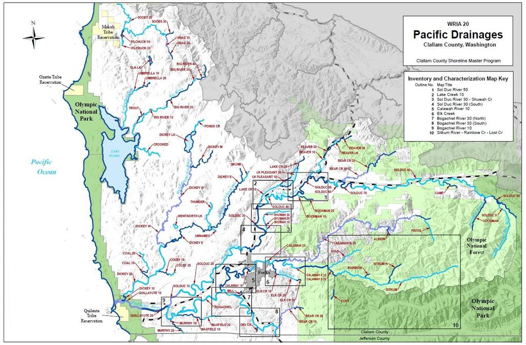
2 Table of Contents Introduction Introduction... 1 Background and Limitations... 2 Summary of Findings... 3 Systems with Limited Current Development... 4 Systems with Significant Current Development... 5 Key Findings... 7 WRIA 20 Reference Map... 9 Bogachiel River System Introduction Physical Environment Biological Resources Land Use and Altered Conditions ation and Utilities Shoreline Modifications Public Access Restoration Opportunities Protection Opportunities Reach Tables BOGACHIEL BEAR-BOGACHIEL DRY-BOGACHIEL MAXFIELD 10 & MILL MURPHY 10 & Calawah River System Introduction Physical Environment Biological Resources Land Use and Altered Conditions ation and Utilities Shoreline Modifications Public Access Restoration Opportunities Data Gaps Reach Tables CALAWAH CALAWAH CALAWAH CALAWAH S ELK P a g e
3 ELK ELK SITKUM, NF SITKUM & RAINBOW LOST CR Dickey System Introduction Physical Environment Biological Resources Land Use and Altered Conditions ation and Utilities Shoreline Modifications Public Access Restoration Opportunities Data Gaps Reach Tables COLBY Lake Pleasant and Lake Creek System Introduction Physical Environment Biological Resources Land Use and Altered Conditions ation and Utilities Shoreline Modifications Public Access Restoration Opportunities Data Gaps Reach Tables LAKE CR- SOL DUC LAKE CR- SOL DUC LAKE PLEASANT LAKE PLEASANT Ozette System Introduction Physical Environment Biological Resources Land Use and Altered Conditions ation and Utilities Shoreline Modifications Public Access Restoration Opportunities Data Gaps Reach Tables BIG BIG BIG BIG P a g e
4 Quillayute River System Introduction Physical Environment Biological Resources Land Use and Altered Conditions ation and Utilities Shoreline Modifications Public Access Restoration Opportunities Data Gaps Protection Opportunities Reach Tables QUILLAYUTE Sol Duc River System Introduction Physical Environment Biological Resources Land Use and Altered Conditions ation and Utilities Shoreline Modifications Public Access Restoration Opportunities Data Gaps Protection Opportunities Reach Tables SOL DUC SOL DUC SOL DUC SOL DUC SOL DUC SOL DUC SOL DUC SOL DUC SOL DUC SHUWAH SHUWAH SHUWAH BOCKMAN BOCKMAN BEAVER BEAVER BEAVER LK & BEAR SOL DUC BEAR SOL DUC P a g e
5 Sooes River System Introduction Physical Environment Biological Resources Land Use and Altered Conditions ation and Utilities Shoreline Modifications Public Access Restoration Opportunities Data Gaps WRIA 20 Ecosystem Analyses Ecosystem Wide Processes Shoreline Uses Human Alterations of Shorelines Critical Areas Map WRIA Shoreline Uses Map WRIA Habitat Map WRIA Finding: Vegetation Alteration Finding: Hydrologic Alteration Finding: Habitat Alteration WRIA 20 ICR Bibliography Bibliography P a g e
6 WRIA 20 Inventory and Characterization Report Key to Zoning Codes and Acronyms ZONING or LAND USE CODE CF CFM20 CT M NC P QR R20 R5 RW1 RW5 TC UC URH URL VLD WRC Acronym DNR FUGA LWD PUD RM SMP UGA WAC WDFW WRIA ZONING OR LAND USE DESCRIPTION Commercial Forest Commercial Forest/Residential Mixed Use Commercial Timber Industrial Rural Neigborhood Conservation Public Land Quillayute Residential Rural Very Low Rural Low Western Region Rural Western Region Rural Low Tourist Commercial Urban Center Urban Residential High Urban Resdiential Low Urban Very Low Density Rural Commercial-Western Region DEFINITION Department of Natural Resources Fork Urban Growth Area Large woody debris Clallam Public Utility District River mile Shoreline Master Program Urban Growth Area Washington Administrative Code Washington Department of Fish and Wildlife Water Resource Inventory Area 6 P a g e
, and its implementing guidelines (Washington Administrative Code [WAC] 173-26, Part III), which were adopted in 2003.")
7 Introduction Clallam County and the City of Forks are updating their respective existing Shoreline Master Programs (SMP) to comply with the Washington State Shoreline Management Act (SMA or the Act) requirements (Revised Code of Washington [RCW] 90.58), and its implementing guidelines (Washington Administrative Code [WAC] , Part III), which were adopted in The SMPs include policies and regulations for managing all fresh and saltwater shorelines of the state in Clallam County and within the boundaries of the Forks Urban Growth Area (FUGA). This report provides a foundation of empirical information on the rivers of WRIA 20 that will be used to formulate recommendations for updating the existing goals, policies, and regulations for shoreline management. This report is limited to evaluating shorelines of statewide significance in the portion of WRIA 20 that are located within Clallam County and within the FUGA. The purpose of the report is to describe current shoreline conditions and characterize the ecosystem processes that shape and impact shorelines of statewide significance. As outlined by the state shoreline guidelines, this inventory and characterization report is a step of the multi-step SMP update process. The County and City of Forks must also prepare a cumulative impact analysis and a shoreline restoration plan. The cumulative impacts analysis and restoration plan will be presented as separate documents. 1 P a g e
8 This report describes ecosystem conditions, as well as reach-level conditions in the shorelines of WRIA 20. The report presents key shoreline-influencing processes, indicators of their conditions, and functional assessments regarding how the alterations have affected the functions and values of the SMA-regulated shorelines. This report is intended to provide a basis for updating the policies and regulations contained in the County and City s SMPs and includes information on the current designation of each reach and suggestions regarding changes that may be considered. Background and Limitations This report is not intended to serve as a definitive statement on the health of all river segments in WRIA 20 and the FUGA. The funding for this project limited work to the assembly of existing information in previous reports. Compilation of this information made it clear that few studies have been conducted to comprehensively assess conditions in WRIA 20 and the FUGA. The absence of listed salmon runs may explain the limited attention the area has received. This report is based on published and unpublished literature describing shorelines in WRIA 20 and the FUGA. Much of this information was derived from assessments prepared in connection with multi-party planning efforts to address a range of natural resource issues other than shoreline uses. Several in-depth Watershed Analyses were conducted in the past 15 years to evaluate the impacts of forest practices on ecosystems and habitat. Water quality and quantity assessments were done to support watershed restoration and maintenance. A Limiting Factors Report was done to assess the problems that affect salmon habitat utilization. These processes stimulated evaluations from a variety of perspectives with a range of measuring sticks. All these prior planning and assessment efforts were found to be of relevance, but none provided the precise set of information needed to document the character and uses of WRIA 20 and FUGA shorelines for this report. Conflicting information on stream reaches was frequently encountered in various reports. The time and funding constraints of this project did not allow authors to gather additional information to resolve these inconsistencies. Instead, we used our best professional judgment in evaluating the credibility of conflicting statements. Finally, exact formulations of descriptive language found in one report reappeared in other later reports, suggesting that a substantial amount of the information is repeated over time in the reports of various planning processes. The accuracy of this information should not be assumed. Few published and peerreviewed analyses on a landscape and on reach scale are available for WRIA 20 and FUGA river systems. Funding constraints prevented authors from conducting original analyses or data collection. Instead, this report presents information available from GIS datasets provided by Clallam County, the City of Forks, personal communications, and in limited cases, field verification. Although the scope of this effort did not include extensive field verification of shoreline conditions, additional effort was put forth to assure accurate representation of key areas where protection of valuable habitat may give rise to controversy. This included soliciting information from numerous reliable sources and requesting peer review from local, state, and federal agency representatives, tribes, and non-governmental organizations with knowledge of the local shoreline conditions. 2 P a g e
9 Many of the shoreline characteristics described or mapped in this report have been assigned qualitative ratings during the course of past planning efforts. In many cases, the ratings were based on unspecified criteria. Local stakeholders and members of the technical staff of tribal and local government agencies questioned the reliability and validity of many of these qualitative assessments. There was also concern that the data layers provided by the County might be outdated. The authors, in large measure, based this ICR on the data provided by Clallam County s GIS Department and the assessments conducted during prior planning processes. If more recent and reliable analysis was available, it was used. Stakeholder and expert review of the finding in this Report will be an important and necessary step in assuring that an accurate portrayal of these shorelines is assembled. This ICR presents tables with extensive detail on certain, but not all reaches. This selective approach was adopted in order to focus the bulk of the attention and effort on reaches that are likely to be subject to development pressure and contain key ecological processes and habitat. In WRIA 20, many rivers flow through public and private forestlands and are unlikely to be developed for intensive human uses. These shorelines are described, but with less detail. In contrast, more concentrated attention was directed at the reaches along which residential or commercial development currently exists. Tables with an array of detailed information were generated to present relevant information in a concise and easy-to-read format. These reaches should be accorded the most careful consideration in terms of their environmental designation and treatment under the updated SMP. Summary of Findings The assessment found that in general WRIA 20 is lightly populated, continues to support healthy salmon runs, and compared with conditions in other parts of the state, represents one of the most productive and functional ecosystems in the state. In addition to the protected landscapes of the Olympic National Park, WRIA 20 contains a vast expanse of the Olympic National Forest that is no longer subject to logging under the Northwest Forest Plan. Many of the area s reaches are thus surrounded by forested riparian areas that are currently in or transitioning towards old growth conditions. In general, impacts are more evident in the lowland reaches of WRIA 20 rivers where it is more common to find narrow buffers along residential developments. Still shoreline uses in WRIA 20 have not caused significant impairment of ecological functions. The absence of water quality exceedances, the lack of armoring, the presence of active riverine functions, the healthy status of the area s wild salmon runs all attest to the overall quality of these shorelines. In contrast to this evidence of healthy conditions, many prior assessments reported that LWD level and riparian conditions were poor in many rivers throughout the WRIA. These assessments should be taken in context. They were done to bring to light the impacts of logging in order to develop prescriptions to improve forest practices. SMP-related shoreline characterization calls for a more multi-dimensional yardstick. In the various tables that are included in the ICR, information is assembled that taken together can provide the overall assessment of the ecological function in each reach. 3 P a g e
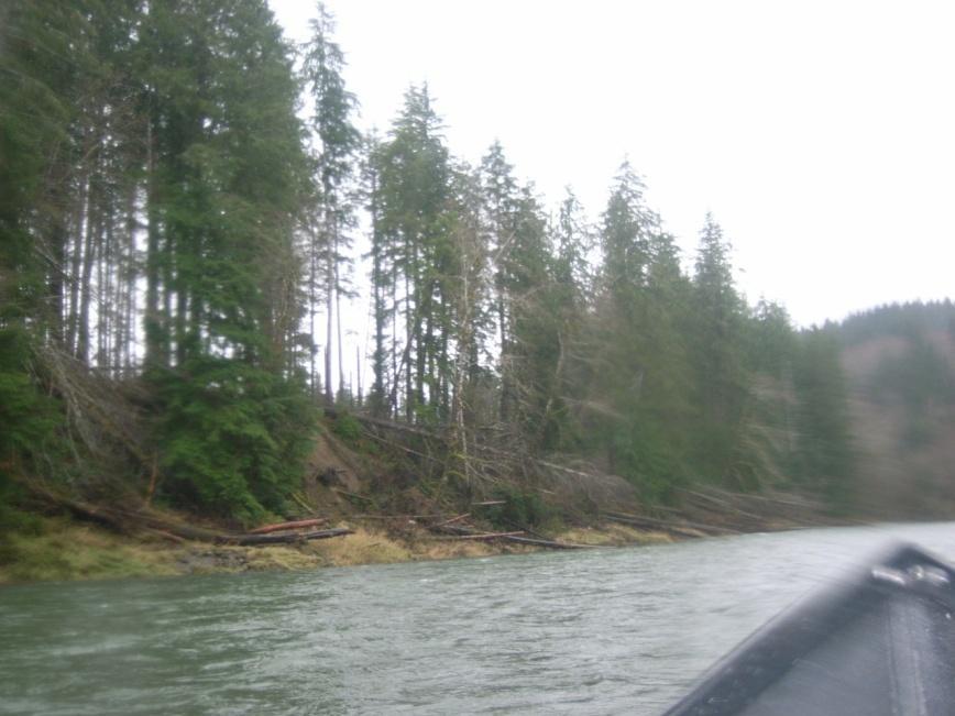
10 Many of the area s reaches are located on private lands dedicated to commercial timber production that are remote from utilities and roads. Previous watershed assessments of these reaches indicated that many are still affected by past or present logging practices. The practices of greatest concern include shoreline road construction, narrow riparian buffers, and harvest on steep or unstable slopes. Excessive sedimentation, bank instability and erosion, lack of shade caused by windthrow, and absence of large woody debris or other velocity altering structures were the major impacts cited. Forest practices are not subject to SMP regulations, so many of these factors will need to be addressed through other means. Restoration opportunities, however, have been identified in relation to these impacts and are presented in the Restoration Plan. Systems with Limited Current Development The Dickey System In general, the Dickey River system is a low gradient series of reaches that flow through privatelyowned lowlands close to the ocean. High levels of precipitation, strong winds and logging practices have diminished the extent of canopy cover in the riparian zone. Windthrow is a major problem in this system, as are poor levels of large woody debris and sedimentation. The Dickey system supports important habitat for coho, steelhead and Chinook. The Dickey system contains abundant wetlands and an important lake system. Restoration opportunities are primarily associated with the impacts of past logging practices. A large list of culverts in need of replacement has been generated. Public access is available at Dickey Lake, but elsewhere is very limited. The Ozette System With the exception of the Big River, the shoreline reaches of the Ozette system are relatively uninhabited and flow through privately-owned forestlands. Most of this system is made up of low gradient sinuous reaches with abundant wetlands and swamps. Landslide and erosion hazard zones occur throughout the area. Ozette system rivers contain the only threatened stock in the Clallam County portion of WRIA 20: sockeye salmon. Restoration projects in the Ozette system have garnered a great deal of attention and support due to the listing of these species under the Endangered Species List. Recent trends in all salmon and steelhead populations have led to poor ratings for the habitat. ation, channel incision, invasive knotweed, and temperature impairments were reported to be the key problems in the Ozette system. Public access is readily available. Sooes River System The Sooes River flows through commercial forestlands within the lowlands of the coast. A basalt feature called the Crescent Formation creates a steep landslide prone area to the east and north of the River. The area contains extensive wetlands, important side channel habitat and good quality spawning gravel. Few people live in this drainage and the prospects for development are limited. Information is lacking on the status of salmon stocks in this system. Human impacts are related to the past logging practices with high scour during peak flows, low LWD levels, sedimentation from high road density, and absence of riparian cover cited as the primary problems. 4 P a g e
11 Systems with Significant Current Development The reaches that were the subject of the greatest detail were the reaches that flow through private lands and are currently the location of significant human development. The upper reaches of the Sol Duc River and Calawah River Systems represent shorelines that flow through public and private commercial forestlands that are far from available utilities. They are therefore unlikely to develop. Tables were not generated to describe these distant reaches. The Lake Pleasant System Lake Creek is a tributary of the Sol Duc River. Due to the value of the habitat and challenging planning environment present in Lake Pleasant and Lake Creek, they are described in a separate section. Flowing through the thick glacial till of the middle Sol Duc Valley, the Creek and Lake contain unique biological resources and highly valuable habitat. Upper Lake Creek provides highly productive Fall coho spawning beds and flows into an extensive wetlands complex before reaching Lake Pleasant. Lake Pleasant supports an unusual stock of beach spawning sockeye salmon. Lower Lake Creek provides sockeye spawning habitat below the Lake outlet and outstanding Fall Chinook habitat throughout much its length. Residential density is, by rural standards, very high along the southern reach of the Lake and the adjacent portion of lower Lake Creek. Low cost housing and recreational cabins dominant development in this area. A mill is located on the southern end of the Lake. The northern segment of Lake Pleasant shoreline is largely commercial forestlands with only a portion zoned for low density residential development. Lake Pleasant is also a major recreational destination with a well maintained county park along its southern shoreline. Lake Creek habitat has been impacted by logging practices in its watershed, but is described as improving. ation from roads and bank erosion are the key impacts. In lower Lake Creek, the lack of large woody debris and dissolved oxygen depletion are reported to be the most significant problems. With regard to Lake Pleasant, temperature and dissolved oxygen impairments have been linked to failing septic systems. Water withdrawals are also considered a source of long-term concern. The Sol Duc and Tributaries System With over 60 mainstem river miles, the Sol Duc River system represents the longest river system in WRIA 20 with nine major tributaries that qualify as shorelines of statewide significance. The system supports all species of salmon and contains extensive spawning habitat. The upper reaches of the Sol Duc start high in the Olympic Mountains, flow down into its boulder-filled middle reaches in the Sol Duc Valley, and ultimately reaches the low gradient meandering segments downstream where it flows into the Quillayute River. The middle and downstream reaches are close to roads and utilities and have attracted primarily sparse human residential development since the area was settled. A number of subdivisions that are unusually dense by rural standards are located on the Sol Duc and its tributaries. These subdivisions were made up of low-cost housing for timber industry workers or seasonal cabins. The ecological importance of this system and its complexity necessitated the presentation of most of the descriptive information on each reach and tributary in the form of tables. The remote upper reaches and tributaries unlikely to develop are only described briefly in the text discussion. In general, ecological conditions and habitat quality on the Sol Duc mainstem are healthy. Some segments experience temperature impairments. A number of sites have extensive riparian buffer failure and mass wasting, but those problems are generally localized. Due 5 P a g e
12 to the geology of the area, wetlands are very limited in the Sol Duc system. It is notable that an extensive block of wetlands in the middle reaches exists. While the mainstem channel is confined through much of its middle reaches, one expansive floodway and floodplain is present in a section that includes substantial residential development and is likely to attract more development. The Calawah System For most of its 11 miles, the Calawah River system flows through the Olympic National Forest. The system supports all species of salmon and steelhead. Recent studies by the Wild Salmon Center have substantiated the value of the Calawah system for trout and salmon. Special significance was identified in relation to spawning and rearing habitat in Elk Creek and the upper forks and tributaries. While intensively logged in the past, under the Northwest Forest Plan, most of this landscape is now designated as Late Successional Reserve and will not be harvested. The upper portion of the watershed surrounding the Sitkum River retained intact old growth habitat. The north fork of the Calawah flows through highly porous glacial outwash and as a result a portion of it goes dry in the summer. Human impacts in this system are those common to areas that have been intensively logged: poor LWD levels, reductions in riparian canopy, sedimentation from mass wasting, roads, and channel instability. Still, the salmon runs of the Calawah are considered healthy and important to the recreational and tribal fisheries. One mile of the mainstem near its mouth passes through the Forks Urban Growth Area. A Department of Fish and Wildlife Department boat ramp near US 101 provides access to the river. Most of the fishing is done along the bank because the Calawah is recognized to be one of the most dangerous and challenging systems in WRIA 20 for boating. The Bogachiel System In this portion of WRIA 20, the Bogachiel River mainstem flows in a meandering fashion through beds of clay, sand and gravel ending at its confluence with the Sol Duc River where both join to form the Quillayute River. The Bogachiel is one of the most popular sport fishing rivers in the state due to its gentle grade, easy access points, and abundant fish runs. Healthy status ratings have been assigned to all Bogachiel stocks that have been assessed. Throughout almost its entire length, the mainstem flows through private lands. This landscape like much of the rest of WRIA 20 has long been dedicated to commercial timber production. Human impacts reported in this area include temperature exceedances, poor LWD levels and related channel incision problems. Erosion and mass wasting in the lower Bogachiel has threatened the stability of the La Push Road bridge and the Three Rivers bridge. Shoreline armoring was installed to protect these areas. An active channel migration zone that is important for salmon spawning is located in the lower mainstem. A second area characterized by a wide floodplain with an active meander occurs in the middle portion of the Bogachiel mainstem. An area identified as a flood plain and a critical aquifer recharge zone is located where the Bogachiel mainstem and its tributary, Mill Creek, flow through the Forks UGA. The tributaries of the Bogachiel flow through commercial forestlands and are not likely to develop. The mainstem is close to roads, utilities, and population centers, yet few residences currently exist along its shorelines. This is probably due to the wide floodplain characteristic of the Bogachiel. 6 P a g e
13 The Quillayute River The Quillayute River is the terminal mainstem of the largest and most productive river network on north Washington Coast. The waters of four major rivers the Sol Duc, the Bogachiel, the Calawah, and the Dickey ultimately flow to the Quillayute River. The Quillayute mainstem is relatively short and low gradient throughout its length. The floodplain is wide, consists of long gravel bars, and shows evidence of the tidal influence that can extend to five miles upstream. All ten runs of salmon found in the Quillayute System pass through the waters of the mainstem. The mainstem also provides spawning habitat for Winter Steelhead, Spring, Summer, and Fall Chinook. Within the area of SMP jurisdiction, the Quillayute flows through private and tribally-owned lands. Light density residential development is located along is shorelines. The Quileute Tribe conducts its salmon fisheries in the mainstem. The River presents safe and easy year-round access for popular non- Indian sport fisheries. Significant human impacts reported in the Quillayute River include low LWD levels, poor riparian conditions, and areas lacking natural levels of velocity-altering structures. Key Findings The report leads to a focus on a number of areas for serious and in-depth considerations. No priority ranking is implied by the order in which they are presented. These include: BEAR-BOGACHIEL 10: This reach is zoned for commercial forests and is located in a relatively remote area with no residences and no utilities. Over half of its length flows through public lands. The condition of the riparian area is characterized as good with 96% closed canopy and 3% other natural vegetation. BOGACHIEL: Under the current SMP, the Bogachiel River has no reach breaks. Two segments of the Bogachiel have active ecological features that make them suitable for consideration as separate reaches. The lower segment (RM 0-5) represents an active channel migration zone, important source for spawning gravel, and high value spawning grounds. The upstream portion of the river within WRIA 20 (RM ) contains a wide floodplain, a critical aquifer recharge area, and important salmon habitat values that would justify the creation of a separate stream segment. CALAWAH 20: This reach flows through the Forks UGA. A major oxbow and meander zone occurs at RM 8. A major oxbow and meander zone occurs within this reach that may require the protection of larger setbacks. A very straight portion of the Calawah occurs between this oxbow and CALAWAH 10, a conservancy environment. The straight portion of CALAWAH 20 is currently undeveloped, but its stability and lack of geohazard zones make it an appropriate location for development. COLBY 20: COLBY 20 is a reach of the Dickey System. Although zoned for residential uses and located in a relatively accessible area, there are few residences. The condition of the riparian area is good with 73.3% closed canopy, 20.2% other natural vegetation, and 6.4% non-forest. 7 P a g e
14 ELK 10: This reach flows through the Forks UGA. Recent work by the Wild Salmon Center showed that Elk Creek provides extremely valuable habitat for Calawah coho spawning and rearing, with 30% of the total coho production originating there. ELK 20: Recent studies have pointed to the extremely high habitat value of this area. Its forested shorelines have old growth characteristics and there are no residences along this segment. The area was acquired for conservation purposes by the North Olympic Land Trust. LAKE CR 10: This reach contains a long segment of uninhabited forestlands (RM 0-1.9) and a stretch of very dense residential development (RM ) along the south shoreline. The north shoreline is forest lands throughout. Lake Creek represents extremely productive Fall Chinook spawning habitat where some of the highest spawner counts per mile in the state have been observed. LOST Creek: Much of Lost Creek flows through undisturbed forested landscapes of the Olympic National Forest and Olympic National Park. Recent studies indicate that this creek provide critical low water rearing areas for coho. Development along this shoreline is highly unlikely due to its remote location in landscape that is owned by the federal government. MILL Creek: MILL reach contains a wide floodplain and potential wetlands near its confluence with the Bogachiel River. The riparian zone is in good condition with 91.8% closed canopy and 8.2% non-forest. The mouth of MILL lies within the Forks UGA. Between RM.1-.9, MILL flows outside of the FUGA. Between (RM.9 1.3) the reach is located within the Forks UGA. It is zoned for commercial timber use outside the UGA and is zoned for light residential development inside the FUGA. SHUWAH 20 & 30: On one side of Shuwah Creek is an area of farms and residential tracts; on the other side are commercial forestlands. SHUWAH 20 encompasses almost all of the residential parcels. SHUWAH 30 is almost entirely uninhabited. SITKUM, S F SITKUM, and RAINBOW: According to recent studies, this system represents the most untouched portion of the Olympic National Forest. The rivers flow through mature ecologically complex forests and contain high quality spawning and rearing habitat for trout and steelhead. SOL DUC 30: This reach is in an area of relatively dense rural residential development and potential for further development. The downstream segment of this reach (RM ) represents one of the largest floodways in WRIA 20 and an active channel migration zone. In addition, this segment contains a very large critical aquifer recharge area, provides an important source for spawning gravel recruitment, and offers highly valuable spawning grounds. SOL DUC 50: As a middle reach of the Sol Duc River that flows close to US 101, this segment contains a mix of relatively dense residential lots along the northern shoreline and uninhabited timberlands along the southern shoreline. One of the most extensive wetlands in the Sol Duc system is also located along the southern shoreline (RM ) in a large block of state lands. 8 P a g e
15 9 P a g e
 contains no reach breaks under the current SMP. The portion of the Bogachiel that flows through the Forks Urban Growth Area (FUGA) extends from approximately RM 8.9 to 10")
16 The Bogachiel River System Within the Bogachiel River system, a number of stream reaches qualify as shorelines of statewide significance. The mainstem BOGACHIEL (RM ) contains no reach breaks under the current SMP. The portion of the Bogachiel that flows through the Forks Urban Growth Area (FUGA) extends from approximately RM 8.9 to Tributary reaches include the following: BEAR-BOGACHIEL (RM 0-4.2); DRY-BOGACHIEL (RM 0-.5); MAXFIELD 10 (RM 0-2.7); MAXFIELD 20 (RM ); MILL (RM 0 1.3); MURPHY 10 (RM 0-1.7); MURPHY 20 (RM ); and DRY-BOGACHIEL (RM 0-.5). The portion of MILL CR that is within the FUGA extends from RM The creek flows outside of FUGA and then returns into FUGA boundaries (RM.1) upstream of its confluence with the Bogachiel. The portion of Mill Creek that is outside of FUGA extends from RM Physical Environment The headwaters of the Bogachiel River lie outside the current planning area in the steep terrain of the Olympic National Park. As it enters the planning unit, it flows in a northwesterly direction with several miles in close proximity to US 101. West of the Forks UGA, its largest tributary, the Calawah River, flows into the Bogachiel. Downstream of the confluence, the River widens and meanders in a westward direction through a broad alluvial valley. Beds of Pleistocene clay, sand, and gravel 10 P a g e
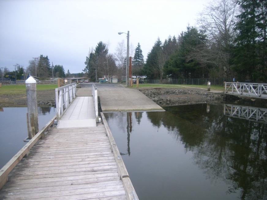
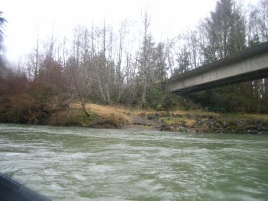
17 overlie the older rocks throughout most of this region. The Bogachiel ends at its confluence with the Sol Duc River as both meet and flow into the Quillayute River. The Bogachiel riparian area within SMP jurisdiction is composed of 80.3% closed canopy, 15.2% other natural vegetation, and 4.5% non-forest. Biological Resources The Bogachiel River provides spawning and rearing habitat for spring, summer, and fall Chinook, coho, and chum salmon as well as for winter steelhead. Small numbers of sockeye salmon were reported to spawn in a portion of the Bogachiel near the mouth of the Calawah River. Records also document limited numbers of pink salmon in the Bogachiel. The species reported in the tributaries are presented in the tables for each reach. Healthy status was assigned to the following salmon runs in the Bogachiel River system: fall and summer Chinook, fall coho, and winter steelhead. The status of summer steelhead is designated as unknown. Other Bogachiel stocks are not listed in the SaSI report. Land Use and Altered Conditions Throughout almost its entire length, the Bogachiel passes through private lands, much of which are dedicated to commercial forestry uses. Residences and farms occupy significant blocks of the north shoreline. The Bogachiel River attracts both bank and boat fishers due to abundant public access opportunities and the low gradient and alluvial (and therefore less hazardous) character of its reaches. Analyses report that the most significant concern with the lower Bogachiel system is channel incision which may be caused by the lack of LWD. Elevated levels of sediment have been detected and attributed to exposed unstable clay layers and resulting collapsing banks. The Limiting Factors TAG assigned a poor rating for floodplain condition in the lower mainstem. The mainstem s riparian condition was rated as poor along the downstream segment (RM 0-5.2) and rated fair throughout the rest of the planning unit (RM 5.2 to 17.6). LWD levels are reported to be poor throughout the Bogachiel except for a segment upstream of the Highway 101 Bridge (RM ). Upstream of that portion, the LWD levels are rated as poor. Thus, the riparian condition of the segment of the BOGACHIEL that passes through the FUGA has been rated as fair, but the LWD condition of that segment has been rated as poor. Riparian condition and levels of LWD in MAXFIELD 10 (RM 0-3) are reported to be fair. In BEAR BOGACHIEL 10 and 20, LWD and riparian conditions are fair from the mouth to RM 1. Above RM 1 both are considered to be good. Several portions of the mainstem are on the 303(d) list for temperature exceedances, including RM.9-2.9; ; and A section of MAXIFIELD 10 (RM.5-1.3) was also listed for temperature exceedances. ation and Utilities Numerous overhead and underground conductors located in the Bogachiel system are presented in the stream reach tables. The following roads cross the Bogachiel mainstem: La Push Road at RM.9; the Goodmain Mainline at RM 6.5; and US 101 at RM Undie Road crosses BEAR-BOGACHIEL 10 near its mouth. Shoreline Modifications Armoring associated with bridges is found in a number of Bogachiel segments. Erosion and mass wasting along the downstream end of the Bogachiel has required armoring to protect the La Push Road Bridge and WDFW boat ramp at Three Rivers. 11 P a g e
18 Public Access Opportunities The Bogachiel River is a highly-regarded destination river and one of the best coastal rivers for steelhead fishing. Boat ramps at the US 101 bridge, the Bogachiel Fish Hatchery and Three Rivers provide access to most of the river. These segments are less treacherous than the Calawah or Sol Duc Rivers and do not demand the technical expertise and experience needed to navigate more difficult rapids. In addition, walk-in access is available, because much of the river flows close to US 101 from RM 11 through RM 16. Additional access opportunities may be available through land in public ownership opposite Furhman Road at RM Other opportunities may be present along Maxfield Creek at the Goodman Mainline Bridge (RM 1.1) and at RM 1 of Murphy Creek. Restoration Opportunities Knotweed control throughout the Bogachiel drainage was designated a top priority in the Quileute Reach Assessment. In addition, two culverts along Dry Creek were reported to be potential projects in The Lead Entity Strategy and the Quileute assessment for the Bogachiel system listed a project that lies beyond the shorelines of Mill Creek covered by the SMP (replacement of the Russell Road Mill Creek Culvert). A Bear Creek culvert was also identified by the Quileute Reach Assessment, but its location was not specified. The Limiting Factors Assessment included general recommendations, such as improvement of riparian buffers to increase the supply of LWD; decrease inputs of coarse and fine sediments; expansion of channel complexity and roughness; and reduction of flow limitations to fish passage. Protection Opportunities As with most shorelines of WRIA 20, the proposals for new development along the Bogachiel have been limited in the past 20 years. However, three segments of the mainstem should be given careful consideration, if development permits are sought. One segment is the downstream portion that contains active channel meander zones. This portion includes active landslide and erosion zones and extremely valuable spawning beds. It is close to the population centers of La Push and Three Rivers and offers easy access to paved roads. Building pressure is likely in the future. The second segment of the mainstem includes a portion within the Forks UGA. This reach passes through a critical aquifer recharge area and may include associated wetlands at the mouth of Mill Creek. Though sparsely populated, this area is within the UGA and as such is expected to be developed in the future. The third segment requiring some focused attention is the mainstem portion that parallels US 101. The river s floodplain is wide with the river migrating over an expansive area. Associated wetlands may be present to the east of the mainstem and west of the highway. Almost all of the lands surrounding the river are privately owned and subject to RW5 zoning rules. 12 P a g e
19 BOGACHIEL Reach: RM 0 to 17.6 Forks UGA: RM Shoreline Processes & Functions Shoreline Uses Land Use & Zoning Public Access Utilities Hydrologic Water Quality Vegetative Temperature LWD Habitat Physical space and condition; Food Production and delivery Spawning; Overwintering Blockage Indicators of Conditions South (west) shore: Land use: all CT except R: RM 0-.9; RM ; RM ; Zoning: all CF except RW5: RM and RM and TC: RM (Bogachiel State Park) North shore: Land use: CF with blocks of R and Ag at RM.5-.8; RM ; RM (Goodman Mainline); RM ; RM 12; RM ; RM ; Zoning: NC RM 0-2; RW5 at following: RM ; RM & RM Forks UGA: RM ; Land use along north shore: R zoning URL WDFW boat ramp and steelhead hatchery at the RM 4.8 (edge of FUGA); WDFW Wilson Rd Boat Ramp RM 5.5; Bogachiel State Park RM 16; Boat ramp at 101 Bridge (RM 16.3) and at RM 17 (Kallman Rd);Access opportunity: Furhman Rd at public lands RM Overhead conductors at RM 1; 2; 15.3; 16; Underground at RM 11.8; 12.3;13.6; 14.5; 15.4; & 17; Underground in FUGA at RM 9.7 Temperature exceedances: RM.9-2.9; ; ; ; Very wide floodplain from RM 0-5; RM (all of FUGA); Critical aquifer recharge area (CARA) throughout main channel; Associated extensive CARA at RM 2.2; 3.2; ; ; ; Potential associated wetlands at RM 3.2; ; 13.3; Seismic soils RM.8-1; RM ; Landslide hazard zones: RM 1 1.7; RM ; RM ; RM 7-7.5; RM 9.5; RM ; RM ; RM Erosion hazard zone -- RM.8 (north of LaPush Rd bridge); RM ; RM Riparian cover in SMP zone: 86.2% closed canopy; 10.1% other natural vegetation; 3.6% non-forest Riparian condition previously rated poor RM 0-5.2; Rated fair RM 5.2 to 17.6; LWD rated poor throughout, except RM which is rated good All species of salmon present but sockeye only below RM 8.8 (Calawah); Winter steelhead, fall, spring and summer Chinook spawning throughout; Fall chum spawning RM ; Sockeye spawning RM ; Summer steelhead present but no spawning; No fish blockage Source WRIA 20 Shorelines of the State 2009 Zoning, Clallam County, WRIA 20 Shorelines of the State 2009 Preliminary Public Access and Public Lands, Clallam County, WRIA 20 Shorelines of the State Utility Corridors, Clallam County, WRIA 20 Shorelines of the State 303(d) Listed Streams, Clallam County, ; WRIA 20 Shorelines of the State Hydrology, Clallam County ; WRIA 20 Shorelines of the State Geologically Hazardous Areas, Clallam County, ; Riparian Cover, Point-No- Point Treaty Council, 2010; Salmon and Steelhead Habitat Limiting Factors, 2000 Personal communication from Quileute DNR staff 2/10/2011; WRIA 20 Fish Distribution Maps, Clallam County, September 2010; Salmon and Steelhead Habitat Limiting Factors, P a g e
20 BEAR-BOGACHIEL 10 Reach: RM 0-3 BEAR-BOGACHIEL 20 Reach: RM Shoreline Processes & Functions Shoreline Uses Land Use & Zoning Public Access Utilities Hydrologic Water Quality Vegetative Temperature LWD Habitat Physical space and condition Spawning Overwintering Blockage Land use all CT Zoning all CF None No utilities Indicators of Conditions Wide floodplain at mouth Potential associated wetlands at mouth No impairments Erosion hazard area: both sides at RM.8 Landslide: RM (no data upstream) Riparian cover in SMP zone: BEAR-BOGACHIEL10: 96% closed canopy; 1.6% other natural vegetation BEAR-BOGACHIEL20: 100% closed canopy Riparian and LWD condition rated fair RM 0-1; Rated good RM 1-3.1; Not rated RM Coho, fall Chinook spawning No summer steelhead, chum, sockeye, spring and summer Chinook Winter steelhead spawning RM 0-3.9; Rearing RM ; Present Source WRIA 20 Shorelines of the State 2009 Zoning, Clallam County, WRIA 20 Shorelines of the State 2009 Preliminary Public Access and Public Lands, Clallam County, WRIA 20 Shorelines of the State Utility Corridors, Clallam County, WRIA 20 Shorelines of the State 303(d) Listed Streams, Clallam County, ; WRIA 20 Shorelines of the State Hydrology, Clallam County ; WRIA 20 Shorelines of the State Geologically Hazardous Areas, Clallam County, Riparian Cover, Point-No-Point Treaty Council, 2010; Salmon and Steelhead Habitat Limiting Factors, Personal communication, Wild Salmon Center; WRIA 20 Fish Distribution Maps, Clallam County, September 2010; Salmon and Steelhead Habitat Limiting Factors, P a g e
21 DRY-BOGACHIEL Reach: RM 0-.5 Shoreline Processes & Functions Shoreline Uses Land Use & Zoning Indicators of Conditions Land use all CT Zoning all CF Source WRIA 20 Shorelines of the State 2009 Zoning, Clallam County, ; WRIA 20 Shorelines of the State Land Use, Public Access Utilities Hydrologic Water Quality Vegetative Temperature LWD Habitat Physical space and condition Food Production and delivery Spawning Overwintering Blockage No access No utilities No 303(d) listing Erosion hazard area RM.1 Landslide hazard RM.4 DRY-BOGACHIEL: 98.8% closed canopy; 1.2% other natural vegetation LWD and riparian conditions not rated Coho and winter steelhead spawning throughout No summer steelhead, chum, sockeye, spring and summer Chinook WRIA 20 Shorelines of the State 2009 Preliminary Public Access and Public Lands, Clallam County, WRIA 20 Shorelines of the State Utility Corridors, Clallam County, WRIA 20 Shorelines of the State 303(d) Listed Streams, Clallam County, ; WRIA 20 Shorelines of the State Hydrology, Clallam County ; WRIA 20 Shorelines of the State Geologically Hazardous Areas, Clallam County, Riparian Cover, Point-No-Point Treaty Council, 2010; Salmon and Steelhead Habitat Limiting Factors, WRIA 20 Fish Distribution Maps, Clallam County, September 2010; Salmon and Steelhead Habitat Limiting Factors, P a g e
22 MAXFIELD 10 Reach: RM MAXFIELD 20 Reach: RM Shoreline Processes & Functions Shoreline Uses Land Use & Zoning Public Access Utilities Hydrologic Water Quality Land use: all CT Zoning: all CF Indicators of Conditions No access established; access to public block at Goodman Mainline Bridge logging road No utilities Very wide floodplain at mouth Erosion and landslide hazard areas throughout both reaches Source WRIA 20 Shorelines of the State 2009 Zoning, Clallam County, ; WRIA 20 Shorelines of the State Land Use, WRIA 20 Shorelines of the State 2009 Preliminary Public Access and Public Lands, Clallam County, WRIA 20 Shorelines of the State Utility Corridors, Clallam County, WRIA 20 Shorelines of the State 303(d) Listed Streams, Clallam County, ; WRIA 20 Shorelines of the State Hydrology, Clallam County ; WRIA 20 Shorelines of the State Geologically Hazardous Areas, Clallam County Vegetative Temperature LWD Habitat Physical space and condition Food Production and delivery Spawning Overwintering Blockage MAXFIELD 10: 92.7% closed canopy; 7.3% other natural vegetation MAXFIELD 20: 91% closed canopy; 9% other natural vegetation Temperature exceedance RM Riparian condition rated fair RM 0-1; good RM 1-3 Not rated LWD rated fair RM 0-3 Coho spawning above RM.5; Fall Chinook spawning RM 0-2.8; Fall chum spawning RM 0-1.3; Winter steelhead spawning RM 0-4, but not present RM No sockeye, spring and summer Chinook, summer steelhead present Riparian Cover, Point-No-Point Treaty Council, 2010; Salmon and Steelhead Habitat Limiting Factors, WRIA 20 Fish Distribution Maps, Clallam County, September 2010; Salmon and Steelhead Habitat Limiting Factors, P a g e
23 MILL Reach: RM Shoreline Processes & Functions Shoreline Uses Land Use & Zoning Public Access Utilities Hydrologic Water Quality Vegetative Temperature LWD Habitat Physical space and condition Spawning Overwintering Blockage Indicators of Conditions Land use: CT (outside FUGA) and CT + R (inside FUGA) Zoning: RW5 (outside FUGA) and URL (inside FUGA) Private ownership throughout Overhead conductor at RM 1.3 Very wide floodplain at mouth Potential associated wetlands in FUGA (RM.9-1.2) and outside FUGA (RM.1-.2) MILL: 91.8% closed canopy; 8.2% Non forest. LWD and riparian condition not rated Coho, fall Chinook, fall chum spawning No sockeye, spring or summer Chinook Summer steelhead present but no spawning Winter steelhead spawning and rearing RM 0-.9; spawning Source WRIA 20 Shorelines of the State 2009 Zoning, Clallam County, ; WRIA 20 Shorelines of the State Land Use, WRIA 20 Shorelines of the State 2009 Preliminary Public Access and Public Lands, Clallam County, WRIA 20 Shorelines of the State Utility Corridors, Clallam County, WRIA 20 Shorelines of the State 303(d) Listed Streams, Clallam County, ; WRIA 20 Shorelines of the State Hydrology, Clallam County ; WRIA 20 Shorelines of the State Geologically Hazardous Areas, Clallam County, Riparian Cover, Point-No-Point Treaty Council, 2010; Salmon and Steelhead Habitat Limiting Factors, 2000 WRIA 20 Fish Distribution Maps, Clallam County, September 2010; Salmon and Steelhead Habitat Limiting Factors, P a g e
24 MURPHY 10 Reach: RM MURPHY 20 Reach: RM Shoreline Processes & Functions Shoreline Uses Land Use & Zoning Public Access Utilities Hydrologic Water Quality Vegetative Temperature LWD Habitat Physical space and condition Spawning Overwintering Blockage Indicators of Conditions Land use: all CT Zoning: all CF None No utilities Wide floodplain at mouth Erosion or landslide hazard zone throughout Seismic soils RM 1.5 to 2.1 MURPHY 10: 92.1% closed canopy; 7.9% other natural vegetation MURPHY 20: 92.7% closed canopy; 7.3% other natural vegetation LWD and riparian conditions not rated Coho spawning throughout reaches Fall chum spawning RM 0-1.4; Winter steelhead spawning RM and not present ; No sockeye, spring or summer Chinook, summer steelhead Source WRIA 20 Shorelines of the State 2009 Zoning, Clallam County, ; WRIA 20 Shorelines of the State Land Use, WRIA 20 Shorelines of the State 2009 Preliminary Public Access and Public Lands, Clallam County, WRIA 20 Shorelines of the State Utility Corridors, Clallam County, WRIA 20 Shorelines of the State 303(d) Listed Streams, Clallam County, ; WRIA 20 Shorelines of the State Hydrology, Clallam County ; WRIA 20 Shorelines of the State Geologically Hazardous Areas, Clallam County, Riparian Cover, Point-No-Point Treaty Council, 2010; Salmon and Steelhead Habitat Limiting Factors, 2000 WRIA 20 Fish Distribution Maps, Clallam County, September 2010; Salmon and Steelhead Habitat Limiting Factors, P a g e
 and CALAWAH S 10 (6 miles relevant to this report) originate in the Olympic Mountains.")
25 The Calawah River System The Calawah River is the largest tributary of the Bogachiel River and is formed by the confluence of the north and south forks of the Calawah. The two forks of the Calawah, CALAWAH N 10 and 20 (20 miles long) and CALAWAH S 10 (6 miles relevant to this report) originate in the Olympic Mountains. All but one mile of the South Fork Calawah within the SMP study area flows exclusively through federal and state commercial forest lands; a one mile stretch near the mouth serves as an eastern boundary of the Forks Urban Growth Area (FUGA) (RM 0-1). The Calawah s North Fork is 20 miles long and flows through a mix of private and public commercial forest lands before it empties into the mainstem at the FUGA boundary. Two relatively short tributaries ALBION (.9 miles) and PISTOL (2.2 miles), flow into the north fork. The Calawah s south fork is fed by more numerous and significant tributaries including HYAS (3.8 miles) Creek and the SITKUM system which in turn includes the mainstem river (12.7 miles), SITKUM N (2.3 miles) and RAINBOW (RM 0-.6). LOST (2.3 miles), also a tributary of the South Fork, flows in and out of the Olympic National Park. The segment from RM 1.5 to 2.3 is included in the study area. The mainstem reaches-- CALAWAH 10 (RM ), CALAWAH 20 (RM 6.9 to 10) and CALAWAH 30 (RM 10 to 10.9), and a segment of its tributary, Elk Creek-- pass alongside or through the (FUGA). 19 P a g e
26 With the exception of the stream reaches that flow through FUGA and the reach to the west of FUGA, the shoreline surrounding the Calawah system contain few residences and are far from utilities and paved roads. Physical Environment The Calawah River drainage basin covers 47.8 square miles as the river flows west in a wide arc from the northwestern Olympic Mountains. Elevations within the basin range from about 100 feet to 3,750 feet, with most of the highest ridge tops rising over 3,000 feet. Precipitation varies from 100 to 140 inches per year from north to south across the watershed; it occurs as rain in the lowlands and a mix of rain and snow in the higher elevations. The north fork reaches, CALAWAH N 10 and 20, are long, linear and very confined river channels, with a limited section of somewhat extended floodplain between RM 8 and The North Fork Calawah watershed has 220 miles of perennial streams. The valley has been shaped by continental glacial processes. The glacial outwash that fills the channel causes CALAWAH N 10 to go dry every summer from about RM 8 to 16. Because the outwash is wide, deep and extremely porous, dewatering in the lower few miles of this reach also may occur in the winter months. The dewatered portion reduces rearing habitat on CALAWAH N 10 by nearly 50% in the summer, but the sub-surface flow cools the lower reach. Where the flow re-emerges at the surface (roughly RM 7.5), CALAWAH N 10 temperatures are very low. Several tributaries to the drying reach flow year round and provide critical summer and winter rearing habitat. The south fork, CALAWAH S 10 is the larger of the two forks, with most of it lying outside SMP jurisdiction within the ONP. CALAWAH S 10 and SITKUM border the Olympic Mountains on the eastern edge of WRIA 20. Both rivers move in a westerly direction with a combined watershed area of about 72 square miles. The river channel is less confined than CALAWAH 10 and 20, with more channel migration areas and a wider floodplain through most of the reach. Historically, the watersheds were dominated by old-growth Sitka spruce, western hemlock and alder; the conditions have been altered to now be dominated by 37% alder in the riparian zones. The Calawah riparian area within SMP jurisdiction is composed of 83.4% closed canopy, 15.3% other natural vegetation, and 1.4% non-forest. Biological Resources The Calawah system s Chinook, coho and winter steelhead stocks have been rated as healthy. The conditions of the Calawah s sockeye, summer steelhead and chum stocks are unknown. The mainstem Calawah contains spawning habitat for fall, spring and summer Chinook, as well as winter steelhead. Coho, fall chum, sockeye and summer steelhead are present throughout the mainstem. One of the most productive areas for coho spawning and rearing is found in the Elk Creek reaches. It is reported that 30% of the coho in the entire Calawah system spawn in Elk Creek. ELK 10 provides fall Chinook rearing habitat (RM 0-.8 and RM ) and a short stretch of spawning habitat at RM 1. Winter steelhead spawn throughout ELK 10, 20 and 30. Summer steelhead are present throughout all ELK reaches. Spawning habitat is limited in the north fork reaches and its quality has been rated as fair throughout the drainage. The quantity of pool habitat rated poor to fair throughout CALAWAH N 10 and 20. ALBION and PISTOL were rated poor. Pool spacing was poor in CALAWAH N 10 and PISTOL, but fair in CALAWAH N 20 and ALBION. The north fork reaches CALAWAH N 10 and 20 are used extensively by Chinook, coho and steelhead. Fall Chinook spawn in the first 13.3 miles of 20 P a g e
27 CALAWAH N 10, but their presence has been documented up to RM 17. Spring Chinook spawn at the mouth of CALAWAH N 10; both spring and summer Chinook are present up to RM 4. Coho spawn throughout the entire north fork and in small tributaries. Spring and summer steelhead spawn throughout CALAWAH N 10 and 20. Winter steelhead are distributed throughout the north fork and its tributaries. Chum are documented in the first 11 miles of CALAWAH N 10. Resident cutthroat trout and mountain whitefish occur throughout the watershed as well as common sculpins and Pacific lampreys. Fish habitat is abundant in the south fork and the Sitkum River. The CALAWAH S 10 and SITKUM watersheds contain 50.6 miles of fish-bearing streams; anadromous species use 31.4 miles and resident species 19.2 miles. Steep gradients and waterfalls form natural barriers for anadromous fish use, but there are no records of non-natural barriers. In CALAWAH S 10 and SITKUM, the quantity of pool habitat rated fair to good, and good in HYAS. CALAWAH S 10 and SITKUM are also heavily utilized by Chinook, coho and steelhead. Fall Chinook spawn in CALAWAH S 10 well into the ONP and in lower HYAS, LOST and SITKUM, and are present in SITKUM from RM 2 to 3. Spring Chinook spawn in CALAWAH S 10 and lower SITKUM. Summer Chinook spawn in the first 6 miles of CALAWAH S 10 and in lower SITKUM and are present in SITKUM from RM 1.5 to 3. Coho spawn in lower SITKUM and LOST and in CALAWAH S 10. They are present in CALAWAH S 10, SITKUM and some small tributaries. Sockeye spawn and are present in parts of CALAWAH S 10 and SITKUM. Summer steelhead are present in CALAWAH S 10, lower SITKUM and LOST. Winter steelhead spawn in CALAWAH S 10, lower HYAS and LOST, and are documented in HYAS, SITKUM, upper LOST and a few small tributaries. Chum are distributed in the first 5 miles of CALAWAH S 10. Pacific lamprey and mountain whitefish are present in the lower mainstem of both watersheds but information on their location and populations is very limited. Resident and anadromous cutthroat trout and sculpins are also found throughout most of the watersheds. CALAWAH N 10 and 20 contain the same populations as those found in CALAWAH S 10 and SITKUM. There are three eagle s nests on CALAWAH S between RM 3 and 3.5, one on SITKUM at RM 1, two on CALAWAH 10 at RM 3.5 and RM 6, and one on CALAWAH 20 at RM 8. Land Use and Altered Conditions Almost all of the Calawah/Sitkum shorelines are designated for commercial timber uses. The shorelines dedicated to residential land uses include the reaches that border and pass through the Forks UGA: CALAWAH 10, most of CALAWAH 20 and 30, and the first 1.5 miles of CALAWAH S. These reaches include areas zoned as Industrial (M), Western Region Rural Low (RW5), Tourist Commercial (TC), Public (P) and Urban Residential Low Density zone (URL). Between RM 1.5 and 2.25, CALAWAH S is in state ownership. Aside from a segment of HYAS, which is in private timber production, the rest of the south fork and Sitkum watershed is owned by the U.S. Forest Service and assigned Late Successional Reserve status, in which only thinning is permitted. The north fork and its tributaries are in a combination of state, federal and private timber. All of the streams in the Calawah/Sitkum watersheds all rated Class AA (extraordinary) by the Department of Ecology. CALAWAH N 10 and 20: Recent studies have indicated that habitat conditions are improving with the reduction in timber harvests in the surrounding watershed. Previous evaluations report that this watershed has been impacted by a long history of logging and associated road density is high in the CALAWAH N 10 headwaters. Within the subbasin, channel instability has led to poor ratings for floodplain conditions. Road failures have triggered mass-wasting events during peak flows in CALAWAH N 10. In CALAWAH N 10 and 20, the steep upper tributaries contribute most of the 21 P a g e
28 sediment. Vegetation age is mature in contrast to other western Washington watersheds, resulting in a good rating for hydrologic maturity. CALAWAH N 20 has wide buffer zones and good LWD levels, LWD recruitment potential, and riparian conditions. CALAWAH N 10 and 20 and PISTOL have naturally low shade impact. ALBION maintains good stream temperatures, even during low flows. Although high water temperatures have been recorded throughout CALAWAH N 10 and 20, they are usually due to natural conditions (such as naturally unshaded areas) and not degraded habitat, resulting in a good water quality rating. Groundwater flows and upwellings also help to lower stream temperatures. For the most part, ph and dissolved oxygen (DO) levels are within state standards except for one site in lower CALAWAH N 10 that had small exceedances of both and a second site between RM 16.3 to 17.3, which also had some DO exceedances. CALAWAH S 10 and SITKUM: Recent studies have identified this area as in recovery from past timber harvests. Riparian conditions are overall good for SITKUM, and fair for HYAS. Most of the riparian zones in the south fork and Sitkum watersheds are hydrologically mature. Near-term LWD recruitment potential is high for CALAWAH S 10, LOST, and most of SITKUM and SITKUM N, but lower for RAINBOW. Naturally low shade exists throughout the majority of lower CALAWAH S 10 and lower SITKUM. Previous evaluations report that this watershed has been impacted by a long history of logging. Road density is high in SITKUM, RAINBOW and CALAWAH S 10 which rated poor for channel stability. The erosion from these riparian roads is believed to contribute to dewatering of HYAS, SITKUM N and RAINBOW. These tributaries previously rated poor for water quantity. Mass wasting was a major problem in SITKUM, which rated poor for channel stability and HYAS as well. These mass wasting events also caused debris flows, which end up acting as barriers for anadromous fish and causing channel aggradation. ation and surface erosion were further results of riparian roads and channel instability. The streams along CALAWAH S 10 rated poor for sediment quantity due to excessive sedimentation. There has been an increase in peak flow events in CALAWAH S 10 and SITKUM since 1990, leading to more landslides. The (d) list shows three impairments for the Calawah/Sitkum watershed: a temperature exceedance in SITKUM from RM 2.3 to 3.7, another along CALAWAH S 10 from just below RM 6 up into ONP and a third on CALAWAH 10 at the mouth of the Bogachiel. Seasonal water levels in the Calawah/Sitkum watershed can change dramatically. The subbasin has about 5% of the claimed and allocation water for WRIA 20. Most of the water withdrawals and diversions are in and around the Forks UGA. ation and Utilities A PUD primary underground conductor line serves the City of Forks at RM 6.9 on CALAWAH 10.There is a PUD ArcFM transmission line where Highway 101 crosses CALAWAH 20 and PUD primary underground conductor lines from RM 6.9 to 8.5 on the same reach. PUD primary underground conductor lines approach the riparian zone on ELK 10 between RM.5 and 1. An overhead conductor line crosses ELK 10 on Calawah Way at RM.9. PUD primary overhead and underground conductor lines run down Calawah Way along CALAWAH S 10 just below RM 1. These lines are part of the power supply for the Forks UGA. Forest Service Road 29 parallels the first 5 miles of CALAWAH S 10. Shoreline Modifications Armoring exists on CALAWAH 20 under the Highway 101 Bridge. Logging roads cross the Calawah and its tributary rivers in various places throughout the subbasin. Some armoring may exist at those sites. 22 P a g e
29 Public Access Within the FUGA, public access to the mainstem is available at the WDFW boat launch adjacent to the US 101 Bridge over CALAWAH 20. To the east of the bridge, private residences are located along the FUGA shoreline, limiting opportunities for public access. To the west, lies a block of private ownerships with few residences. Outside of FUGA, much of the south fork and its tributaries flow through the Olympic National Forest. The Forest Service maintains Klahanie Campground on CALAWAH S 10. Logging roads provide abundant access opportunities to many of the south fork and Sitkum reaches. An additional opportunity for public recreational access at RM 3 of CALAWAH 10 has been under discussion. This is the site of a dramatic oxbow that is close to La Push Road. A conservation organization is interested in acquisition of that site for dedication to conservation and recreational uses. Restoration Opportunities Forest Service logging roads were often constructed to follow closely alongside major rivers and streams. ation from these roads is considered among the highest priority problems in this subbasin. Restoration of adequate LWD levels has been identified as a restoration priority in the north fork drainage. Data Gaps Sockeye, fall chum and summer steelhead stock status is currently undocumented. Stray sockeye and chum are thought to be present, but their locations are unknown. Fine sediment levels in gravels and inter-gravel DO levels are undocumented. 23 P a g e
30 CALAWAH 10 Reach: RM FUGA: RM Shoreline Processes & Functions Shoreline Uses Land Use & Zoning Public Access Utilities Hydrologic Water Quality Vegetative Temperature LWD Habitat Physical space and condition Food Production and delivery Spawning Overwintering Blockage Indicators of Conditions Land use Mostly in commercial timber, low amount of residential Access lower river on foot trail near Bogachiel Hatchery; almost all private shorelines; small section of DNR land RM 4.5 and at the wastewater treatment site on Nottingham Way in Forks UGA (likely not compatible with public access ) PUD primary underground conductor line serving City of Forks at ~ RM 6.9 Critical aquifer recharge area RM 0-1.7, , 5-6, ; Wide floodplain RM.8-1, , , ; Wide Floodway RM.7-1, , Landslide hazard zone RM 0 to 6.9 Active channel migration and meander throughout reach CALAWAH 10: 90.6% closed canopy; 9.3% other natural vegetation; 0.1% Non-forest 303(d) temperature exceedance at mouth of Bogachiel. Cause may be naturally unshaded riparian conditions LWD not rated in mainstem Fall, spring and summer Chinook, and winter steelhead spawn throughout entire reach; Coho, fall chum, sockeye and summer steelhead are present throughout reach; All stock statuses healthy except fall chum and summer steelhead: unknown, and sockeye: undocumented Eagle s nests at RM 3.5 and RM 6 Source WRIA 20 Shorelines of the State 2009 Zoning, Clallam County, ; WRIA 20 Shorelines of the State Land Use, WRIA 20 Shorelines of the State 2009 Preliminary Public Access and Public Lands, Clallam County, WRIA 20 Shorelines of the State Utility Corridors, Clallam County, WRIA 20 Shorelines of the State 303(d) Listed Streams, Clallam County, ; WRIA 20 Shorelines of the State Hydrology, Clallam County ; WRIA 20 Shorelines of the State Geologically Hazardous Areas, Clallam County Riparian Cover, Point-No- Point Treaty Council, 2010; Salmon and Steelhead Habitat Limiting Factors, 2000 WRIA 20 Fish Distribution Maps, Clallam County, September, 2010; Salmon and Steelhead Habitat Limiting Factors, P a g e
31 CALAWAH 20 Reach: RM FUGA: Entire Reach South Shoreline Shoreline Processes & Functions Shoreline Uses Land Use & Zoning Public Access Utilities Hydrologic Water Quality Vegetative Temperature LWD Habitat Physical space and condition Food Production and delivery Spawning Overwintering Blockage Indicators of Conditions South Shoreline: Within FUGA: zoned as Industrial (M), Tourist Commercial (TC), Public (P) and Urban Residential Low Density zone (URL) North shoreline: outside FUGA: all CT FUGA: WDFW boat launch adjacent US 101 Bridge PUD ArcFM transmission line where HY 101 crosses CALAWAH 20; Underground conductor lines near riparian zone from RM 6.9 to 8.5 No 303(d) listings Armoring at HY 101 bridge Critical aquifer recharge area: RM (within FUGA); RM (on north side of river only) Floodway RM (within FUGA) 100-year Floodplain RM (within FUGA), (primarily outside FUGA) Meander around RM 8 Landslide hazard zone RM 6.9-Elk Creek (RM 9.5) CALAWAH 20: 76.7% closed canopy; 17% other natural vegetation; 6.3% Non-forest No riparian or LWD rating Fall Chinook spawn throughout the reach and rear at the Elk Creek confluence; Spring and summer Chinook and winter steelhead spawn throughout; Coho, fall chum, sockeye and summer steelhead documented as present throughout reach Fall, spring and summer Chinook, coho and winter steelhead all have healthy stock statuses; Fall chum and summer steelhead are unknown; Sockeye is undocumented (SASI, 2004 Eagle s nest at RM 8 Source WRIA 20 Shorelines of the State 2009 Zoning, Clallam County, ; WRIA 20 Shorelines of the State Land Use, WRIA 20 Shorelines of the State 2009 Preliminary Public Access and Public Lands, Clallam County, WRIA 20 Shorelines of the State Utility Corridors, Clallam County, WRIA 20 Shorelines of the State 303(d) Listed Streams, Clallam County, ; WRIA 20 Shorelines of the State Hydrology, Clallam County ; WRIA 20 Shorelines of the State Geologically Hazardous Areas, Clallam County Riparian Cover, Point-No- Point Treaty Council, 2010; Salmon and Steelhead Habitat Limiting Factors, WRIA 20 Fish Distribution Maps, Clallam County, September 2010; Salmon and Steelhead Habitat Limiting Factors, P a g e
32 CALAWAH 30 Reach: RM FUGA: RM Shoreline Processes & Functions Shoreline Uses Land Use & Zoning Public Access Utilities Hydrologic Water Quality Vegetative Temperature LWD Habitat Physical space and condition Food Production and delivery Spawning Overwintering Blockage Indicators of Conditions North shore all in private CT South shore zoned as Urban Residential Low Density (URL) No known public access No utilities No 303(d) listings No geohazard areas Critical aquifer recharge area: RM year Floodplain RM Meander between RM 10 and 10.9 CALAWAH 30: 90.1% closed canopy; 9.4% other natural vegetation; 0.5% Non-forest No previous ratings Fall, spring and summer Chinook and winter steelhead spawn throughout entire reach; Coho, fall chum, sockeye and summer steelhead are present throughout reach; Fall, spring and summer Chinook, coho and winter steelhead all have healthy stock statuses; fall chum and summer steelhead are unknown; sockeye is undocumented. Source WRIA 20 Shorelines of the State 2009 Zoning, Clallam County, ; WRIA 20 Shorelines of the State Land Use, WRIA 20 Shorelines of the State 2009 Preliminary Public Access and Public Lands, Clallam County, WRIA 20 Shorelines of the State Utility Corridors, Clallam County, WRIA 20 Shorelines of the State 303(d) Listed Streams, Clallam County, ; WRIA 20 Shorelines of the State Hydrology, Clallam County ; WRIA 20 Shorelines of the State Geologically Hazardous Areas, Clallam County Riparian Cover, Point-No-Point Treaty Council, 2010; Salmon and Steelhead Habitat Limiting Factors, 2000 WRIA 20 Fish Distribution Maps, Clallam County, September 2010; Salmon and Steelhead Habitat Limiting Factors, P a g e
33 CALAWAH S 10 Reach: RM 0-6 Forks UGA: RM 0-1 Shoreline Processes & Functions Shoreline Uses Land Use & Zoning Public Access Utilities Hydrologic Water Quality Vegetative Temperature LWD Habitat Physical space and condition Food Production and delivery Spawning Overwintering Blockage Indicators of Condition RM 0-1 zoned as Urban Residential Low Density zone (URL); RM commercial timber owned by the state; RM federal timber land Access available through state and federal land and by Forest Service Road 29, which parallels the first 5 miles of the reach A PUD primary underground conductor line approaches the reach at RM.7 Critical aquifer recharge area RM year floodplain RM (narrow floodplain) Erosion zone RM 1.5 High road density Erosion due to riparian roads No 303(d) listings Erosion due to riparian roads No known ratings Channel stability considered poor CALAWAH S 10: 96.2% closed canopy; 3.1% other natural vegetation; 0.7% Non-forest Key pieces of LWD poor Small LWD poor to good LWD recruitment potential good Fall, spring and summer Chinook spawn from RM 0-6; coho spawn from RM but are documented from RM 0-5.8; fall chum are documented from RM 0-5; sockeye spawn from RM but are documented throughout the rest of the reach; summer steelhead are documented from RM 0-6; winter steelhead spawn throughout entire reach. Fall, spring and summer Chinook, coho and winter steelhead all have healthy stock statuses. Fall chum and summer steelhead are unknown. Sockeye is undocumented. (SASI, 2004) Source WRIA 20 Shorelines of the State 2009 Zoning, Clallam County, ; WRIA 20 Shorelines of the State Land Use, WRIA 20 Shorelines of the State 2009 Preliminary Public Access and Public Lands, Clallam County, WRIA 20 Shorelines of the State Utility Corridors, Clallam County, WRIA 20 Shorelines of the State 303(d) Listed Streams, Clallam County, ; WRIA 20 Shorelines of the State Hydrology, Clallam County ; WRIA 20 Shorelines of the State Geologically Hazardous Areas, Clallam County, Riparian Cover, Point-No-Point Treaty Council, 2010; Salmon and Steelhead Habitat Limiting Factors, 2000 WRIA 20 Fish Distribution Maps, Clallam County, September 2010; Salmon and Steelhead Habitat Limiting Factors, P a g e
34 Shoreline Processes & Functions Shoreline Uses Land Use & Zoning Public Access Utilities Hydrologic Water Quality Vegetative Temperature LWD Habitat Physical space and condition Food Production and delivery Spawning Overwintering Blockage ELK 10 Reach: RM FUGA: RM Indicators of Conditions ELK 10 flows through the FUGA RM 0-1.4; RM of reach outside FUGA Land use: East shoreline CT; zoning URL West shoreline R; zoning URL, LD and P DNR lands borders east shoreline at RM 1.6 Most of the reach is in private land, but it can be accessed through the state owned timber (RM 1.6) Underground conductor lines approach the riparian zone between RM.5 and 1; overhead conductor line crosses ELK 10 on Calawah Way at RM.9 No (303)d listings Floodway: RM.3-.4,.5-.6, year Floodplain: RM.3, (on east side of ELK 10, on UGA boundary), Landslide hazard zone RM Erosion hazard zone around RM 1.5 No known ratings ELK 10: 88.5% closed canopy; 3.8% other natural vegetation; 7.7% Non-forest No known ratings Riparian roads impact ELK 10 between RM 1-1.6, affecting coho, steelhead and fall Chinook; Fall Chinook spawn around RM 1 and rear from RM 0-.8 and RM ; winter steelhead spawn throughout the reach; summer steelhead are documented throughout. Habitat rating is fair from RM due to riparian road impact, but fall Chinook, coho and winter steelhead all have healthy stock status ratings; summer steelhead status is unknown. WSC Study: reported extremely valuable coho habitat present (33% of Calawah coho redds); local residents question the accuracy of WSC studies Source WRIA 20 Shorelines of the State 2009 Zoning, Clallam County, ; WRIA 20 Shorelines of the State Land Use, WRIA 20 Shorelines of the State 2009 Preliminary Public Access and Public Lands, Clallam County, WRIA 20 Shorelines of the State Utility Corridors, Clallam County, WRIA 20 Shorelines of the State 303(d) Listed Streams, Clallam County, ; WRIA 20 Shorelines of the State Hydrology, Clallam County ; WRIA 20 Shorelines of the State Geologically Hazardous Areas, Clallam County, Riparian Cover, Point-No-Point Treaty Council, 2010; Salmon and Steelhead Habitat Limiting Factors, 2000 WRIA 20 Fish Distribution Maps, Clallam County, September 2010; Salmon and Steelhead Habitat Limiting Factors, P a g e
35 Shoreline Processes & Functions Shoreline Uses Land Use & Zoning Public Access Utilities Hydrologic Water Quality ELK 20 Reach: RM Indicators of Conditions Almost entirely in private commercial timber production; some state timber approaches the reach at RM 1.7 and 2.9 Water supply intake for City of Forks Conservation land acquisition project maintained by North Olympic Land Trust No utilities No 303(d) listings. Floodway: RM year floodplain: RM (south shore only) Erosion hazard from RM (south shore only) Landslide hazard from RM and at RM 2.5. WSC: Good condition w/ LWD, pools alternating with shallow gravel, w/ refugia, buried logs; cooled and fed by underground water Source WRIA 20 Shorelines of the State 2009 Zoning, Clallam County, ; WRIA 20 Shorelines of the State Land Use, WRIA 20 Shorelines of the State 2009 Preliminary Public Access and Public Lands, Clallam County, WRIA 20 Shorelines of the State Utility Corridors, Clallam County, WRIA 20 Shorelines of the State 303(d) Listed Streams, Clallam County, ; WRIA 20 Shorelines of the State Hydrology, Clallam County ; WRIA 20 Shorelines of the State Geologically Hazardous Areas, Clallam County Vegetative Temperature LWD Habitat Physical space and condition Food Production and delivery Spawning Overwintering Blockage ELK 20: 97.8% closed canopy; 2.2% other natural vegetation. Recent assessment by WSC highly productive; naturally reseeded multi-storied canopy with old snags resembling old growth on valley floor WSC: All attributes of excellent spawning and rearing habitat allows coho juvenile to thrive until fall water levels connect pools to main channel Riparian roads impact ELK 20 from RM , affecting coho and steelhead Coho and winter steelhead spawn throughout reach; summer steelhead are documented throughout; Coho and winter steelhead all have healthy stock status ratings; Summer steelhead status is unknown. WSC: Extremely important spawning habitat (for 30% of Calawah coho) in Elk Creek Habitat rating is fair from RM due to riparian road impact Riparian Cover, Point-No-Point Treaty Council, 2010; Salmon and Steelhead Habitat Limiting Factors, 2000 Personal communication, Wild Salmon Center; WRIA 20 Fish Distribution Maps, Clallam County, September 2010; Salmon and Steelhead Habitat Limiting Factors, P a g e
36 Shoreline Processes & Functions Shoreline Uses Land Use & Zoning Public Access Utilities Hydrologic Water Quality Vegetative Temperature LWD Habitat Physical space and condition Food Production and delivery Spawning Overwintering Blockage ELK 30 Reach: RM Indicators of Conditions ELK 30 is entirely within state and federal commercial timber lands The state and federal ownership allows access to entire reach There are no utilities in ELK 30 No 303(d) listings. Erosion hazard zone from RM No known ratings ELK 30: 100% closed canopy WSC analysis (see ELK 20) Coho and winter steelhead spawn throughout Summer steelhead present throughout Coho and winter steelhead have healthy stock status; Summer steelhead has unknown stock status WSC: Considered extremely important spawning habitat (for 30% of Calawah coho). Source WRIA 20 Shorelines of the State 2009 Zoning, Clallam County, ; WRIA 20 Shorelines of the State Land Use, WRIA 20 Shorelines of the State 2009 Preliminary Public Access and Public Lands, Clallam County, WRIA 20 Shorelines of the State Utility Corridors, Clallam County, WRIA 20 Shorelines of the State 303(d) Listed Streams, Clallam County, ; WRIA 20 Shorelines of the State Hydrology, Clallam County ; WRIA 20 Shorelines of the State Geologically Hazardous Areas, Clallam County, Riparian Cover, Point-No-Point Treaty Council, 2010; Salmon and Steelhead Habitat Limiting Factors, 2000 Personal communication, Wild Salmon Center; WRIA 20 Fish Distribution Maps, Clallam County, September 2010; Salmon and Steelhead Habitat Limiting Factors, P a g e
37 SITKUM Reach: RM N F SITKUM & RAINBOW CR Shoreline Processes & Functions Shoreline Uses Land Use & Zoning Public Access Utilities Hydrologic Water Quality Indicators of Conditions Land use: CT: RM 0-3.5; RM ; and P: RM Zoning: CF throughout Federal ownership allows access to entire reach Large portions dedicated to public use No utilities No 303(d) listings. Erosion hazard zone from RM WSC Study indicates high quality intact system Source WRIA 20 Shorelines of the State 2009 Zoning, Clallam County, ; WRIA 20 Shorelines of the State Land Use, WRIA 20 Shorelines of the State 2009 Preliminary Public Access and Public Lands, Clallam County, WRIA 20 Shorelines of the State Utility Corridors, Clallam County, WRIA 20 Shorelines of the State 303(d) Listed Streams, Clallam County, ; WRIA 20 Shorelines of the State Hydrology, Clallam County ; WRIA 20 Shorelines of the State Geologically Hazardous Areas, Clallam County Vegetative Temperature LWD SITKUM: 98.2% closed canopy; 1.8% other natural vegetation; SITKUM N: 98.6% closed canopy; 1.4% other natural vegetation; RAINBOW:100% closed canopy. Mature ecologically complex forests largely untouched Riparian Cover, Point-No- Point Treaty Council, 2010; Salmon and Steelhead Habitat Limiting Factors, 2000 Habitat Physical space and condition Food Production and delivery Spawning Overwintering Blockage Coho spawn up to RM 2; present RM 2-3; not present RM , NF Sitkum & Rainbow; Fall Chinook spawn RM 0-2; present to RM3; not present RM , NF Sitkum & Rainbow; Sockeye spawn RM 0-.9; present to RM 1.5; not present RM , NF Sitkum & Rainbow Spring Chinook spawn RM 0-1.5; not present RM , NF Sitkum & Rainbow; Summer Chinook spawn RM 0-1.3; present RM 1.3-3; not present , NF Sitkum & Rainbow; Winter steelhead spawn RM 0-1; present RM 1-9.8; not present , NF Sitkum & Rainbow Summer steelhead present RM 0-5.5; not present RM , NF Sitkum & Rainbow; No fall chum WSC studies indicate very high quality rearing habitat for trout and steelhead WRIA 20 Fish Distribution Maps, Clallam County, September 2010; Salmon and Steelhead Habitat Limiting Factors, P a g e
38 LOST CR Reach: RM Shoreline Processes & Functions Shoreline Uses Land Use & Zoning Public Access Utilities Hydrologic Water Quality Vegetative Temperature LWD Habitat Physical space and condition Food Production and delivery Spawning Overwintering Blockage Indicators of Conditions Landuse: CT; Zoning: CF throughout Federal ownership allows access to entire reach No utilities No 303(d) listings WSC Study indicates high quality intact system LOST: 100% closed canopy. Mature, ecologically complex forests largely untouched Critical low water rearing refugia for coho Coho and winter steelhead spawn throughout Summer steelhead present throughout No sockeye, fall, spring, summer Chinook, fall chum; Coho and winter steelhead have healthy stock statuses; Summer steelhead has unknown stock status. WSC: High quality rearing habitat Source WRIA 20 Shorelines of the State 2009 Zoning, Clallam County, ; WRIA 20 Shorelines of the State Land Use, WRIA 20 Shorelines of the State 2009 Preliminary Public Access and Public Lands, Clallam County, WRIA 20 Shorelines of the State Utility Corridors, Clallam County, WRIA 20 Shorelines of the State 303(d) Listed Streams, Clallam County, ; WRIA 20 Shorelines of the State Hydrology, Clallam County ; WRIA 20 Shorelines of the State Geologically Hazardous Areas, Clallam County, Riparian Cover, Point-No-Point Treaty Council, 2010; Salmon and Steelhead Habitat Limiting Factors, 2000 WRIA 20 Fish Distribution Maps, Clallam County, September 2010; Salmon and Steelhead Habitat Limiting Factors, P a g e

39 The Dickey River System The Dickey River is a major tributary that drains into the Quillayute River about 1.5 miles from the Pacific Ocean. The Dickey Watershed extends from the mouth near sea level to ridge tops reaching 1,200 to 1,400 feet in elevation. Most of the subbasin is low elevation, lying below 440 feet. The Dickey basin contains the mainstem segments DICKEY (8.7 miles long); three major tributaries: DICKEY E (16.5 miles), DICKEY W (14.9 miles) and DICKEY M (4 miles); several creeks: COAL 10 (1.4 miles), COAL 20 (2.5 miles), COLBY (1.2 miles), PONDS CR (2 miles), SKUNK (1.3 miles) and THUNDER (3.5 miles); and the two lakes: WENTWORTH LAKE and DICKEY LAKE (520 acres). An estimated 830 acres of wetland areas occur within the subbasin, most of which are concentrated in DICKEY W. An unnamed tributary that meets the definition of shoreline of statewide significance flows into DICKEY E. 33 P a g e
40 Physical Environment Originating in the southeast corner of Dickey Lake, DICKEY W is a uniform, low-gradient river that displays a high degree of sinuosity throughout its length as it flows through thick glacial deposits. DICKEY E is less uniform with its grade varying from 0 to 2 percent and its channel types including bedrock-controlled plane-bed, as well as pool-riffle. The gravel produced by bank erosion in DICKEY E creates the most abundant spawning habitat in the subbasin. DICKEY M is notable for its extensive pool-riffle channel composition that provides excellent spawning and rearing habitat. The Dickey system s proximity to the ocean results in high levels of precipitation, saturated soils, and exposure to strong wind events. Fog drip is considered a significant water source in this area. Widespread windthrow is evident as a result of these natural conditions. In the Dickey subbasin as a whole, riparian buffers have lost an average of 30% of their trees to windthrow. DICKEY W has the highest levels of riparian blowdown loss at 48%. Although moisture- tolerant conifer species thrive in the sub-basin s wet conditions, extensive logging activities in the past have left most riparian areas dominated by red alder. The Dickey riparian area within SMP jurisdiction is composed of 88.4% closed canopy, 10.8% other natural vegetation, and 0.8% non-forest. Biological Resources The Dickey is one of the most productive subbasins for fall coho in the Quillayute river system accounting for roughly 20% of the total. Its sinuosity, diversity of channel types, low gradient wetlands and abundant side channels provide excellent habitat conditions and plentiful rearing and over wintering habitat. Coho spawn in DICKEY M, DICKEY E, PONDS CR, SKUNK, THUNDER, COAL 10 & 20, COLBY, and many of the smaller tributaries. Coho rearing habitat is concentrated in most of DICKEY W and a few smaller tributaries. Winter steelhead and fall Chinook spawning occurs throughout the Dickey River system. Fall chum have been documented throughout the Dickey with the exception of a few segments: the upper sections of DICKEY M and DICKEY E, SKUNK, COAL 10 and COAL 20. Squawfish are present in DICKEY LAKE and may have expanded throughout DICKEY W. Land Use and Altered Conditions Aside from some residential and agricultural areas on COLBY 20 and a few small residential lots on the east side of DICKEY LK and at the confluence of the DICKEY E and W, the entire Dickey system runs through lands designated for commercial timber use. The majority of these lands are held in private ownership. DICKEY LAKE covers 520 acres, and greatly influences temperature and sediment regimes in DICKEY W. Warm water temperatures are a problem in DICKEY LAKE and WENTWORTH LAKE. The warm temperatures are natural because DICKEY LAKE averages only 25' in depth. Both of these lakes drain into the Dickey subbasin and contribute to warmer stream temperatures. The following stream segments in the Dickey system have been listed on the 303(d) list for temperature exceedances: the uppermost and lowermost sections of DICKEY W, the uppermost sections of DICKEY M and DICKEY E, as well as COAL 10 and upper COAL 20. In some of these areas, naturally unshaded wetlands account for high water temperatures. In many of these areas, it is the lack of riparian shade caused by windthrow that produces elevated temperatures. A fecal coliform exceedance of unknown origin led to the listing of an upper section of DICKEY 20 adjacent to Mina Smith road. Seasonal low flows typical of the DICKEY W system have limited downriver transport of LWD. A major flood event in 1999 caused most of the LWD in DICKEY E to flush downriver, leaving inadequate levels upriver. The flooding also destabilized the DICKEY E channel. Excessive amounts of sediment have accumulated downstream in the mainstem DICKEY 10 and 20, DICKEY E, and in SKUNK. Roads are a major source of sediment delivery in the Dickey subbasin. The mainline and 34 P a g e
41 secondary roads 2000, 5000, 5200 and 9000 deliver more than 80% of the road input sediment. Several roads adjacent to the streams function as dikes, blocking access to off-channel habitat. Clearcuts are another contributor through surface erosion events. ation and Utilities Mora Road (State Route 110) crosses the Dickey River near its mouth. Mina Smith Road runs along the eastside and provides access to DICKEY 20. The major logging road (5000 line) crosses DICKEY 20 upstream of the mouth of COLBY 10. A PUD primary overhead conductor follows Mina Smith Road and crosses COLBY 20. Shoreline Modifications No shorelines in the Dickey system have been armored with the exception of areas under bridge crossings such as those at Mora Road, Mina Smith Road, and the 5000 line. Public Access While most of the Dickey watershed is held in private ownership, blocks of state land exist along some of the shorelines of THUNDER, COAL 20 and DICKEY E, W and M. These blocks of state-owned forest lands are not easily accessible. More suitable opportunities to expand public access are present along DICKEY 20 and accessible from Mina Smith Road. State forest lands at the north end of DICKEY LAKE and the lower end of PONDS present additional opportunities. There is an established boat ramp on DICKEY 10 about.25 miles upstream of the mouth and another reported on WENTWORTH LAKE. Restoration Opportunities The Limiting Factors Analysis of 2000 listed nearly 40 culverts blocking fish passage. Most of the fish blockages are in tributaries off DICKEY E, W and M, with a few in PONDS tributaries. The impacts of natural forces and forestry operations in the riparian zone have generated numerous additional opportunities for restoration work, particularly in upper PONDS Creek and parts of DICKEY E and M. LWD replacement projects have been recommended in DICKEY E, where the LWD conditions are poorest. Riparian replanting and road decommissioning to reduce runoff have been called for in various sites throughout the subbasin. Channel stabilization is needed in the DICKEY E as a result of 1999 flood damage. The North Pacific Coast Lead Entity Strategy lists priority projects for the Dickey watershed, including the replacement of a culvert with a bridge on Coal Creek at the 5000 road crossing and a culvert replacement on Coal Creek at the 5602 road. Both culverts are blocking habitat for fall coho, winter steelhead and cutthroat trout. A culvert on SKUNK is blocking habitat for the same species and requires replacement. Continued control of Japanese Knotweed is also listed as a priority project. Data Gaps The effect of low summer flows on summer rearing habitat for coho throughout the Dickey subbasin is unknown. There is little data on chum utilization in the Dickey system. The effect of squawfish predation on coho salmon in DICKEY LAKE and DICKEY W is undocumented. 35 P a g e
42 COLBY 20 Reach: RM Shoreline Processes & Functions Shoreline Uses Land Use & Zoning Public Access Indicators of Conditions Landuse: CT throughout RW5 zoning throughout. Access available through Mina Smith, Duncan and Wentworth Roads Source WRIA 20 Shorelines of the State 2009 Zoning, Clallam County, ; WRIA 20 Shorelines of the State Land Use, WRIA 20 Shorelines of the State 2009 Preliminary Public Access and Public Lands, Clallam County, Utilities Hydrologic Water Quality Vegetative Temperature LWD Habitat Physical space and condition Food Production and delivery Spawning Overwintering Blockage A PUD primary overhead conductor line crosses COLBY 20 at RM 1.3 along Mina Smith Road. PUD primary overhead and underground conductor lines follow Mina Smith, Duncan and Wentworth Roads. Landslide zone: RM , , year floodplain RM No 303(d) listings 73.3% closed canopy, 20.2% other natural vegetation, and 6.4% non-forest Fall Chinook, coho and winter steelhead spawn from RM ; Fall chum are documented throughout the reach. Fall Chinook and fall chum have an unknown stock status. Spring and summer Chinook, sockeye and summer steelhead stock status is undocumented. Coho and winter steelhead have a healthy stock status. (SASI, 2004) WRIA 20 Shorelines of the State Utility Corridors, Clallam County, WRIA 20 Shorelines of the State 303(d) Listed Streams, Clallam County, ; WRIA 20 Shorelines of the State Hydrology, Clallam County ; WRIA 20 Shorelines of the State Geologically Hazardous Areas, Clallam County, Riparian Cover, Point-No-Point Treaty Council, 2010; Salmon and Steelhead Habitat Limiting Factors, 2000 WRIA 20 Fish Distribution Maps, Clallam County, September 2010; Salmon and Steelhead Habitat Limiting Factors, P a g e

43 Lake Pleasant and Lake Creek System Lake Pleasant covers approximately 505 acres and lies at an elevation of 390 between upper and lower segments of Lake Creek within the Sol Duc Watershed. The shoreline of Lake Pleasant is divided into two reaches LK PLEASANT 10 and LK PLEASANT 20. LK PLEASANT 10 s shoreline is 13,656 feet in length and encompasses the southern end of Lake Pleasant. LK PLEASANT 20 represents the northern shorelines of Lake Pleasant and is 13,468 feet in length. Lake Creek is divided into 2 reaches. LAKE CR-SOL DUC 10 is 3.1 miles in length and includes the portion of Lake Creek to the southwest and downstream of Lake Pleasant. LAKE CR-SOL DUC 20 is 1.6 miles in length and includes the portion of Lake Creek northeast and upstream of Lake Pleasant. 37 P a g e
44 Physical Environment The floodplain of the Lake Pleasant Lake Creek Valley extends from 50 to 350 wide and cuts through thick glacial till. Exhibiting a sinuous and meandering pattern, LAKE CR SOL DUC 20 channel has been categorized as having high scour and high transport potential during high flow events. The channel bed is made up of cobbles, gravels and sand. Bank materials are sand, silt soft toes and till. Seismic hazard soils are present along the full length of the reach. Bank erodibility is considered high, as is the sediment supply rate. Lake Pleasant and associated wetlands slow water flows and sediment transport, reducing the sinuosity and meander belt width of LAKE CR SOL DUC 10. An erosion hazard zone is present along its northern shoreline. Lake Creek watershed is estimated to contain 530 acres of wetlands. Above Lake Pleasant lies an extensive high-value, wetland complex associated with LAKE CR SOL DUC 20. In most years, LAKE CR SOL DUC 10 dries up in late spring. Low flow is also a concern for the LAKE CR SOL DUC 20. Analysis indicated that very limited areas of this watershed are subject to mass wasting events, while surface erosion from logging roads was singled out as one of the biggest problems in the upper drainage. LAKE CR SOL DUC 20 and Lake Pleasant are rated as having a high potential for adverse change. Lake Pleasant is thermally stratified and LAKE CR SOL DUC 20 provides 50% of water flowing into Lake Pleasant. The remaining volume is delivered from other tributaries, surface water run-o - C. These warm water temperatures contribute to high temperatures in LAKE CR SOL DUC 10 which drains Lake Pleasant. LAKE CR SOL DUC 20 has water temperatures well within current state standards. The Lake Pleasant and Lake Creek riparian area within SMP jurisdiction is composed of 81.2% closed canopy, 3.7% other natural vegetation, and 15.1% non-forest. Biological Resources All of Lake Pleasant meets the definition of both resident and anadromous fish habitat. Lake Pleasant provides rearing habitat for sockeye (one of only 9 sockeye stocks in WA) and kokanee. Lake Pleasant sockeye spawn in areas of upwelling along the beach in the eastern portion of LK PLEASANT 20. An unusual population of resident (non-anadromous) coho is reported to be present in the lake and spawn in inlet tributaries, although there is local skepticism. LAKE CR SOL DUC 10 s high flow volume and velocity combined with extensive areas of coarse gravels make it the site of the highest density of fall Chinook spawning in the entire Quillayute basin and among the most productive in the entire state. Sockeye spawn near the lake outlet of this reach. Winter steelhead and coho spawning are more limited due to low flow conditions during the spring. Chum and summer Chinook have been documented in this reach. A fish passage blockage was reported at RM 1.2, but has not been verified. LAKE CR SOL DUC 20, especially its lower 2 miles, represents the highest quality coho spawning habitat in the Quillayute basin. Its gravel quality, gradient, pool quantity, off-channel habitat, inchannel LWD levels, and LWD recruitment are all rated as good to excellent. Sockeye have been documented in the reach just upstream of the lake and steelhead are present throughout it. A number of beaver dams have been reported, but no fish passage barriers have been documented. Extensive wetlands are located in the lower portion of the reach. Conditions in the watershed are typical of landscapes dedicated to commercial forestry. While harvested timberlands are in many ways far more beneficial to wildlife than urbanized landscapes, 38 P a g e
45 there are a number of impacts. A high level of fragmentation is present and over 80% of watershed is snag deficient. Road density is high at 3.2 miles per square mile. Density above 2.5 miles per square mile is considered deleterious to wildlife habitat values. Land Use and Altered Conditions The Lake Pleasant and Lake Creek shorelines contain the widest mix of land uses in WRIA 20 outside of the Forks Urban Growth Area. In addition to expanses of commercial forest lands held in private ownership, the reaches also include density populated residential areas and an industrial site. LK PLEASANT 10 is the most densely populated reach and is zoned in four categories: Quillayute Residential (QR), Rural Neighborhood (NC), Western Region Rural Center (WRC), and Public (P). QR refers to an area in which maximum residential density is one dwelling unit per one-half acre. NC signifies a zone in which there is one dwelling unit per five acres. WRC zoning allows a mix of uses, including commercial, residential and industrial. P is used to identify properties used for public purposes such as public buildings, schools, cemeteries, parks, playgrounds and recreational areas. LK PLEASANT 20 contains large blocks of timberlands on the western shore and less densely populated residential areas on the eastern shoreline. It is zoned in two categories: NC and Commercial Forest (CF). Within CF zone, maximum density is one dwelling unit per eighty acres. The Quileute Tribe s Assessment of non-point pollution in WRIA 20 identified concerns with the effect of human development on Lake Pleasant sockeye runs. Water temperatures in the lake were reported as above state standards. Arsenic levels at the lake surface were low, but levels in the sediment exceeded a National Toxics Rule. Low dissolved oxygen (DO) levels in the lake were found at the Lake Pleasant outlet and were consistent with high levels of primary productivity possibly associated with housing septic systems. The difference in ph values in the upper watershed compared to Lake Pleasant and lower Lake Creek seems to coincide with small increases in nitrate. On the southwest side, historic wetlands associated with the lakeshore have been filled by residential construction and road building. LAKE CR SOL DUC 10 contains a mix of land use that is clearly divided at RM 1.9. The downstream portion is designated for commercial timber production. The upstream portion is assigned residential designations that call for higher densities in the area closest to the lake. Riparian conditions were described as poor in The upper end of this reach is influenced by Lake Pleasant conditions as well as by the lack of riparian shade. Elevated water temperatures in Lake Pleasant warm the waters of the upper reach in the spring and summer. High turbidity is reported and may reflect sediment transport from lakeshore wave chop. Reduced DO levels in the upper reach may also be associated with the influence of Lake Pleasant. Due to the highly-permeable valley fill material over which it flows, the reach experiences seasonal disruptions and creek aters infiltrate downwards. Water withdrawals by local residences may increase the effects of natural dewatering. Low summer flows result in loss of limited but important rearing habitat for juvenile coho, steelhead and sockeye in this reach. LWD conditions were reported as poor. Large LWD jams were reported to be common in this reach with some containing old shake bolts from historic mill operations. These jams rarely block fish passage, but are seen as causing channel changes. Extensive wind throw has been reported in riparian areas after timber harvest along this reach. Assessments done of sedimentation hazard indicate stability in sediment inputs and a low likelihood of impact from road erosion. Invasive knotweed is reported to be prevalent along this reach. 39 P a g e
46 In LAKE CR SOL DUC 20, conditions are reflective of the stable forested watershed that surrounds it. Characterized as having high lateral activity and low bank stability, the reach may be most affected by erosion, with estimated inputs 98% above natural conditions. In 2000, the riparian condition was assessed as fair. LWD conditions were rated as good. The wetland above Lake Pleasant acts as a sediment trap, limiting the downstream transport of sediments. ation and Utilities The Lake Pleasant shoreline is accessed by West Lake Pleasant Road and East Lake Pleasant Road. Small paved and unpaved residential streets and driveways are also present in the southwest corner of the lake. Unpaved driveways allow access to residences along the eastern shoreline. Road density at 3.2 miles per square mile within the surrounding watershed is high and consistent with intensive timber management. Within the Lake Pleasant area, utilities include primary overhead conductors along the southwestern and southern lake shorelines (LK PLEASANT 10) as well as along the northeastern shorelines. Primary underground conductors are located along the northwestern shoreline (LK PLEASANT 20) and throughout the southern lake shoreline (LK PLEASANT 10). In the LAKE CR SOL DUC 10 reach, a number of primary overhead conductors serve the residents of the residential area close to the lake. Three primary underground conductors are also located in this reach. One underground conductor crosses the creek at approximately river mile 2 and leads up towards Tyee Ridge. No utilities are located in the LAKE CR SOL DUC 20 reach. Shoreline Modifications No armoring was reported along the shorelines of Lake Pleasant, LAKE CR SOL DUC 10, or LAKE CR SOL DUC 20. In eastern portions of LK PLEASANT 20, landowners have supplemented the available stock of nearshore gravel. These additions have been seen as beneficial to sockeye that spawn along that shoreline. Public Access Clallam County maintains a public park at the southern end of Lake Pleasant that includes a dock and a boat ramp for access to fishing and water sports. The County also owns a very small parcel along the southwestern shoreline that is wooded, contains a culvert, and is unlikely to be suitable for creating additional public access to the lake. A block of county ownership is located to the east of LAKE CR SOL DUC 10 where the reach passes under US 101. The size and proximity to a major thoroughfare may make this site an opportunity for public access. The site was formerly a county waste dump and transfer station. Currently the site is being used as a fuel depot, maintenance shed, and storage facility. These uses would create conflicts with public recreational access that would need to be addressed. At the upper end of the LAKE CR SOL DUC 20 segment (RM 1.3), a block of state-owned forest land encompasses both sides of the shoreline. This parcel is only accessible by logging roads. Restoration Opportunities The 1995 USFS Watershed Analysis called for decreasing sedimentation problems in LAKE CR SOL DUC 10 and 20, by LWD additions or recruitment. In LAKE CR SOL DUC 10, low flows should be minimized by reducing water withdrawals. Throughout the watershed, riparian zones should be managed for older age class conifers. Knotweed eradication has been initiated along LAKE CR SOL DUC 10. The 2000 WRIA 20 Limited Factors Report mentions two culverts in tributaries to LAKE CR SOL DUC 10 that block coho habitat. That report also calls for restoration efforts aimed at failing 40 P a g e
47 septic systems, water withdrawals, and other human impacts. The Quileute Reach Assessment identified as a high priority a culvert (CL000729) on Lake Creek that blocks fish passage. Cleanout of a Lake Creek culvert (CL ) was ranked as a significant but non-prioritized project. The Quileute Tribe s concerns with the effect of human development on Lake Pleasant sockeye runs called for acquisition of conservation easements in the area. The Tribe has also called for repair of failing septic systems. Data Gaps No systematic evaluations have been done of in-channel LWD levels. More work is needed to study the effects of LWD on off-channel habitat throughout the basin. Information was lacking on allocations of water and water withdrawals. In relation to Lake Pleasant, data gaps were identified on water temperature, water quality as well as wetland mapping and delineation. In relation to LAKE CR SOL DUC 20, additional information was called for on fish distribution, in-stream fines, and redds. In relation to LAKE CR SOL DUC 10, the assessments called for additional habitat inventory and limiting factors analysis. 41 P a g e
48 LAKE CR-SOL DUC 10 Reach: RM Shoreline Processes & Functions Shoreline Uses Land Use & Zoning Public Access Utilities Hydrologic Water Quality Vegetative Temperature LWD Habitat Physical space and condition Food Production and delivery Spawning Overwintering Blockage Indicators of Conditions Land use both shores CT from RM 0 to 1.9; East shoreline: R from RM with CT block RM West shoreline: V & CT from RM 0-2.5; R from RM Zoning: East shoreline: All WRC & QR from RM West shoreline: All CF except WRC & QR from RM No current access sites and all private lands except near mouth where county waste transfer station and equipment storage site 4 primary overhead conductors from RM 1.9 serve the trailer park along 101 and residences southwest of the lake Underground conductors cross creek at RM 2 (towards Tyee Ridge) and RM 2.4 Dissolved Oxygen (DO) listed RM High flow volume and velocity during fall, low flows in spring/summer; sections dry up naturally; Extensive areas of coarse gravels Erosion hazard area to the west between RM 1-2 Problems may be related to natural low flows and human withdrawals LAKE-SOL DUC 10: 86.6% closed canopy; 0.9% other natural vegetation; Non-forest 12.5%. Riparian condition rated fair Poor LWD conditions/reported jams from historic mill operations; Higher temperatures in upper portion from lake effect and wetlands; LWD improvements needed Extremely high density fall Chinook spawning Sockeye spawn near the lake outlet Winter steelhead and coho spawning limited due to low flow conditions; chum and summer Chinook documented in this reach Source WRIA 20 Shorelines of the State 2009 Zoning, Clallam County, ; WRIA 20 Shorelines of the State Land Use, WRIA 20 Shorelines of the State 2009 Preliminary Public Access and Public Lands, Clallam County, WRIA 20 Shorelines of the State Utility Corridors, Clallam County, WRIA 20 Shorelines of the State 303(d) Listed Streams, Clallam County, ; WRIA 20 Shorelines of the State Hydrology, Clallam County ; WRIA 20 Shorelines of the State Geologically Hazardous Areas, Clallam County, Riparian Cover, Point-No-Point Treaty Council, 2010; Salmon and Steelhead Habitat Limiting Factors, 2000 Personal communication from Quileute DNR staff 2/10/2011; WRIA 20 Fish Distribution Maps, Clallam County, September 2010; Salmon and Steelhead Habitat Limiting Factors, P a g e
49 LAKE CR-SOL DUC 20 Reach: RM Shoreline Processes & Functions Shoreline Uses Land Use & Zoning Public Access Utilities Hydrologic Water Quality Vegetative Temperature LWD Habitat Physical space and condition Food Production and delivery Spawning Overwintering Blockage Indicators of Conditions Land use all CT Zoning All CF DNR lands both sides of the shoreline at RM 1.3 only access logging roads No utilities Riparian condition rated fair Elevated sediment inputs from logging roads Seismic hazard soils throughout reach Erosion hazard area on west side ~ RM.5 Extensive wetlands complex at lower end from RM 0 to RM 1 LAKE-SOL DUC 20: 91.9% closed canopy; 8.1% other natural vegetation. LWD rated good; riparian habitat rated fair Fair probably due to seral age Wetlands complex appears intact Extremely high density fall coho spawning Sockeye spawn near the lake outlet of this reach Good to excellent gravel, gradient, pool quantity, offchannel habitat, LWD Winter steelhead are present throughout No chum, summer steelhead, or fall Chinook Source WRIA 20 Shorelines of the State 2009 Zoning, Clallam County, ; WRIA 20 Shorelines of the State Land Use, WRIA 20 Shorelines of the State 2009 Preliminary Public Access and Public Lands, Clallam County, WRIA 20 Shorelines of the State Utility Corridors, Clallam County, WRIA 20 Shorelines of the State 303(d) Listed Streams, Clallam County, ; WRIA 20 Shorelines of the State Hydrology, Clallam County ; WRIA 20 Shorelines of the State Geologically Hazardous Areas, Clallam County, Riparian Cover, Point-No-Point Treaty Council, 2010; Salmon and Steelhead Habitat Limiting Factors, 2000 WRIA 20 Fish Distribution Maps, Clallam County, September 2010; Salmon and Steelhead Habitat Limiting Factors, P a g e
50 LK PLEASANT 10 Reach Shoreline Processes & Functions Shoreline Uses Land Use & Zoning Public Access Utilities Hydrologic Water Quality Indicators of Conditions Land Use: almost all residential Zoned in 4 categories of varying density: QR, NC, WRC, & P Log mill on south shoreline Boat ramp and county park at south end of lake Overhead conductors along the southwestern shoreline Underground conductors along southeastern portion No 303(d) listing, but reports that seasonal temperature exceedance & DO problems may be related to effluents Erosion hazard area to the west (below Tyee Ridge) Seismic soils area northeast portion Debris jams at Lake Creek outlet cause large water level fluctuations Source WRIA 20 Shorelines of the State 2009 Zoning, Clallam County, ; WRIA 20 Shorelines of the State Land Use, WRIA 20 Shorelines of the State 2009 Preliminary Public Access and Public Lands, Clallam County, WRIA 20 Shorelines of the State Utility Corridors, Clallam County, WRIA 20 Shorelines of the State 303(d) Listed Streams, Clallam County, ; WRIA 20 Shorelines of the State Hydrology, Clallam County ; WRIA 20 Shorelines of the State Geologically Hazardous Areas, Clallam County, Vegetative Temperature LWD Habitat Physical space and condition Food Production and delivery Spawning Overwintering Blockage LK-PLEASANT 10: 68.2% closed canopy; 1.3% other natural vegetation; Non-forest 30.5%. Riparian condition not rated, but dense residential shoreline present with dominance of treeless riparian zone; LWD not rated Lake serves as sediment trap Winter steelhead, coho, sockeye No summer or fall Chinook, steelhead, chum Rearing habitat for sockeye, kokanee, and coho salmon Sockeye spawn along the beach in the eastern portion High value sockeye spawning habitat appears functioning well; sockeye run healthy Riparian Cover, Point-No-Point Treaty Council, 2010; Salmon and Steelhead Habitat Limiting Factors, 2000 Personal communication from Quileute DNR staff 2/10/2011, WRIA 20 Fish Distribution Maps, Clallam County, September 2010; Salmon and Steelhead Habitat Limiting Factors, P a g e
51 LK PLEASANT 20 Reach Shoreline Processes & Functions Shoreline Uses Land Use & Zoning Public Access Indicators of Conditions Land use: Almost all on west side in CT; all of east side in residential Zoned: West shore in CT; east shore in NC No current public access or public lands Source WRIA 20 Shorelines of the State 2009 Zoning, Clallam County, ; WRIA 20 Shorelines of the State Land Use, WRIA 20 Shorelines of the State 2009 Preliminary Public Access and Public Lands, Clallam County, Utilities Hydrologic Water Quality Vegetative Temperature LWD Habitat Physical space and condition Food Production and delivery Spawning Overwintering Blockage Overhead conductor on east shoreline Underground conductors on east and west shorelines No 303(d) listing, but reports of seasonal temperature exceedance probably related to natural lack of shade Erosion hazard area along east portion; landslide hazard along west portion; seismic soils at north end Extensive wetlands complex at north end Lake acts as natural sediment trap LK-PLEASANT 20: 92.4% closed canopy; 1.7% other natural vegetation; 6% nonforest. No riparian condition rating Additional LWD projects may be helpful Winter steelhead, coho, sockeye present No summer or fall Chinook, steelhead, chum Important rearing habitat for sockeye, kokanee, and coho salmon Sockeye spawn along the beach in the eastern portion Pilings & boomsticks installed for habitat enhancement and restoration Extremely valuable sockeye spawning habitat on east side; sockeye run considered healthy WRIA 20 Shorelines of the State Utility Corridors, Clallam County, WRIA 20 Shorelines of the State 303(d) Listed Streams, Clallam County, ; WRIA 20 Shorelines of the State Hydrology, Clallam County ; WRIA 20 Shorelines of the State Geologically Hazardous Areas, Clallam County, Riparian Cover, Point-No-Point Treaty Council, 2010; Salmon and Steelhead Habitat Limiting Factors, 2000 Personal communication from Quileute DNR staff 2/10/2011, WRIA 20 Fish Distribution Maps, Clallam County, September 2010; Salmon and Steelhead Habitat Limiting Factors, P a g e

52 The Ozette System The Ozette watershed is made up of several lakes and large streams that combine to a total drainage area of 88.4 square miles. The most significant feature of the Ozette watershed is Lake Ozette, the third largest natural lake in Washington at 11.4 square miles. However, because the lake is entirely within the Olympic National Park (ONP), it is beyond the focus of this update. The lake is fed by Big River (12.4 miles long), Umbrella Creek (6.3 miles) and Crooked Creek (4 miles). The Ozette River (also within the ONP) flows out of Lake Ozette and into the Pacific Ocean. Seafield Lake is within the ONP and therefore not a part of this update. The mainstem reaches established in the existing SMP are BIG RIVER 10 (6 miles long), BIG RIVER 20 (3.7 miles), BIG RIVER 30 (.7 miles), and BIG RIVER 40 (2 miles). The tributary reaches include CROOKED UMBRELLA 10 (4.6 miles), UMBRELLA 20 (1.7 miles) and TROUT-BIG R (1.3 miles). ELK LK also represents a shoreline of statewide significance. With the exception of the Big River reaches, the shorelines in this subbasin are relatively uninhabited flowing through forested landscapes. 46 P a g e
53 Physical Environment The watershed was formed by glacial processes, which left deposits between low slopes, resulting in a combination of flat areas and rolling hills comprised of silt and sandstone. The landforms vary in size, from filling small depressions to covering several square miles. The highest peak in the watershed is 1900 feet in upper Big River, the steepest area of the subbasin, but most of the watershed has elevations between 200 and 800 feet. These lowlands provide low-gradient, extremely sinuous streams and are often replete with swamps and wetland areas. Extensive wetlands surround ELK LK and border TROUT-BIG R between RM on its north shore. BIG RIVER 10 is bounded by wetlands between RM 1.8 and 3.1 on the south shore and more are scattered along both sides of BIG RIVER 20 from RM CROOKED has wetland areas at RM.4 (north shore),.8-.9 (north shore), (south shore) and at 3.3 (south shore). 100-year floodplains exist throughout all of TROUT-BIG R, RM of CROOKED on its south shore, UMBRELLA 10, the first.4 mile of UMBRELLA 20, all of BIG RIVER 10, 20 and 30, and from RM of BIG RIVER 40. The only critical aquifer recharge area in the watershed is at RM 3.5 of UMBRELLA 10. Geohazards are present throughout the watershed as well. Landslide and erosion hazard zones are located along all of BIG RIVER 30. Erosion hazards occur along UMBRELLA 10 from RM and , UMBRELLA 20 between RM and through BIG RIVER 30 and 40. Landslide hazards are present in UMBRELLA 10 from RM 1.7, 2.6, 2.8 and , and UMBRELLA 20 from RM The entire reach of TROUT-BIG R is in a seismic hazard zone, as well as BIG RIVER 10 between RM 0-4, and in CROOKED from RM The Ozette riparian area within SMP jurisdiction is composed of 78.3% closed canopy, 17.7% other natural vegetation, and 4% non-forest. Biological Resources The Ozette watershed is home to the only fish species in the Clallam County portion of WRIA 20 currently listed under the Endangered Species Act (ESA): Lake Ozette sockeye. Lake Ozette sockeye are listed as threatened. There has been a roughly 75% decrease in run size from historical sockeye levels, largely caused by overfishing, predation and loss of spawning habitat. Sockeye are known to spawn throughout UMBRELLA 10, in the lower.7 miles of UMBRELLA 20, BIG RIVER 10, 20 and 30 from RM and in CROOKED between RM 0 and.7. Lakeshore spawning conditions have diminished from historical levels, so the stream spawning reaches are crucial habitat. Sockeye rear in the first mile of UMBRELLA 10, the first 1.5 miles of BIG RIVER 10, and in CROOKED between RM 0 and.7. They are documented as being present in UMBRELLA 20 from RM 5.3 up, BIG RIVER 10 from RM , BIG RIVER 30 and 40 from RM , CROOKED from and numerous tributaries. They are presumed present in tributaries off of Umbrella and CROOKED creeks and upper Umbrella below ELK LK. A Steering Committee was created to formulate a restoration plan. In 2009, the National Oceanic and Atmospheric Administration's (NOAA) National Marine Fisheries Service (NMFS) issued the Lake Ozette Sockeye Recovery Plan. The Umbrella Creek hatchery (at RM 4-5) is operated by the Makah Tribe and rears sockeye for release into Lake Ozette. Coho spawn in UMBRELLA 10 and 20 from RM.3-5, BIG RIVER 10, 20 and 30 from RM , CROOKED from RM 1.5 and up and tributaries off of Big River. Coho rear in several unnamed tributaries and are documented in ELK LK, UMBRELLA 20 from RM 5 and up, all of TROUT-BIG R, BIG RIVER 30 and 40 from RM 10.3 to 11.5, CROOKED between RM and numerous tributaries. Winter steelhead spawn in UMBRELLA 10 from RM 2-4.5, BIG RIVER 10, 20 and 30 from RM and rear in BIG RIVER 10 from RM They are present in UMBRELLA 10 and 20 from RM 4.5 and up, ELK LK, all of TROUT-BIG R, BIG RIVER 10 from RM 0-.5, all of CROOKED and numerous 47 P a g e
54 tributaries. Kokanee salmon and cutthroat trout are also present throughout the watershed. Chinook and chum were historically present, but their populations have been declining since the mid-1950s; their current stock status is unknown. Fall chum have been documented in UMBRELLA 10 up to RM 4.5 and only rare Chinook strays have been documented since The Ozette watershed still has a diverse array of freshwater fish species. Downward trends in all of the salmon and steelhead species in the Ozette watershed have resulted in a poor rating for biological processes and suggest low quantities of marine-derived nutrients. More thorough spawner surveys have been conducted since 1997 along the lakeshore and tributaries, but they are difficult to administer consistently because of seasonal surveying conditions. While many eagle s nests surround Lake Ozette, there are none recorded along the reaches relevant to this report. Land Use and Altered Conditions The Department of Ecology rated the entire Ozette system Class AA (extraordinary waters). Most of the land in the Ozette watershed that is outside ONP is in private commercial timber production, but there are low density residential zones along the Hoko-Ozette Road on Big River. BIG RIVER 10 and 20 have Rural Low (R5: one dwelling per 4.8 acres) and Rural Very Low (R 20: one dwelling per 20 acres) zones between RM Clallam County s Land Use map shows more residential and vacant lots around the junction of Hoko-Ozette Road and Swan Bay Road (RM 1.5 of BIG RIVER 10) and at the entrance of UMBRELLA 10 to Lake Ozette. Residential, vacant and commercial lots are at the north end of the lake on Hoko-Ozette Road. There is limited state timber land on BIG RIVER 10 and CROOKED. Part of the subbasin is under jurisdiction of the Makah Tribe as the Ozette Reservation. The Reservation is within the ONP on the edge of the lower reaches of the Ozette River and is managed for wilderness purposes. ation is a major problem in the Ozette watershed, caused by road density, mass wasting and logging practices. Fine sediments are carried downstream to the lake, where the silt can cause the spawning gravels to cement, resulting in a loss of spawning habitat. The lower and middle reaches of the major tributaries to the lake average almost 8% above the target level for fines in spawning gravels. Road density is highest on the north and east sides of the lake. Riparian roads end up acting as dikes, cutting off potential habitat and resulting in a poor floodplain impact rating for Big River and several Umbrella Creek tributaries. These rivers both have high fine sediment levels, rating them poor for fine sediments. Big River has the greatest impact, with about 6 miles of road along the mainstem and.2 miles along a tributary. An estimated 90% of the watershed has been logged since 1940, further contributing to sedimentation through slope runoff and instability. Channel incision is also a problem, particularly in lower Big River and Umbrella Creek. The high sinuousity of Big River provided abundant logjams until the 1950s, when they began to be removed from BIG RIVER 10. The large wood slowed the river and its removal caused an increase in flow energy, scour and channel incision. It is also a potential cause of the reduction in water level fluctuations in the lake. Current LWD levels are poor in lower Big River, but good in the middle reaches and in CROOKED. LWD recruitment potential is low because the old growth conifers that historically dominated the riparian zones have been largely replaced by red alder. Riparian conditions rated poor throughout most of CROOKED and UMBRELLA 10, and poor to fair throughout Big River. The incision and bank disturbance provides the right environment for the invasive species reed canary grass and Japanese and giant knotweed, especially in Big River and Umbrella Creek. The canary grass hardens banks and confines the stream channel; knotweed 48 P a g e
55 prevents native species from being established and contributes to unshaded stream banks. This degrades the condition of the floodplain and results in the poor rating in these rivers. Temperature is the main impairment for the Ozette watershed. The (d) list shows temperature exceedances on UMBRELLA 10 from RM and 2.3-4, CROOKED up to RM 2.2, TROUT-BIG R from RM 0-.8, BIG RIVER 10 between RM and 5-6, BIG RIVER 20 from RM and , and BIG RIVER 30 from RM BIG RIVER 10 has a ph exceedance from RM Dissolved oxygen ranges from poor to adequate in several of the streams during the summer. Turbidity levels are high in Big River and Umbrella Creek during high flows and contribute to visibility and turbidity problems in the lake. These impairments have resulted in Big River and Umbrella Creek rating poor for water quality. The watershed s logging history has resulted in poor hydrologic maturity in Umbrella Creek, where 80% of the vegetation is less than 20 years old. Big River (41%) is in better condition and CROOKED has a considerable amount of vegetation more than 80 years old. Umbrella Creek rated poor for water quantity. The Ozette subbasin, at 48 inches of total annual evapotranspiration (ET), has about 23 more inches than any other subbasin in WRIA 20 besides the Sooes. This is likely due to the large surface area of Lake Ozette, which contributes large amounts of evaporation to the watershed. ation and Utilities A PUD primary overhead conductor line follows the Hoko-Ozette Road and parallels Big River from RM 1.4-9, also servicing the residential roads Cranberry Road, Ozette Road and Nicholas Road. It leaves BIG RIVER 10 at RM 1.4 and continues along the Hoko-Ozette Road, crossing UMBRELLA 10 just below RM 1. The line turns into a PUD primary underground conductor when the Hoko-Ozette Road reaches the ONP boundary and parallels Lake Ozette up to the north tip of the lake. There is also an underground conductor line on part of Nicholas Road. The Hoko-Ozette Road parallels Big River from RM 1.4-9; it crosses TROUT-BIG R near its confluence with BIG RIVER 10 and crosses UMBRELLA 10 just below RM 1. The residential roads Cranberry Road, Ozette Road, Nicholas Road and Palmquest Road all fork off of the Hoko-Ozette Road along BIG RIVER 10 and 20. The logging roads 7000 and Ozette Mainline also separate from the Hoko-Ozette Road along BIG RIVER 10 and give access to different areas of the watershed. Swan Bay Road exits the Hoko-Ozette Road and crosses BIG River 10 at RM 1.5. Shoreline Modifications Armoring exists at each of the four bridges: where the Hoko-Ozette Road crosses BIG RIVER 20 at RM 7.8, where the Hoko-Ozette Road crosses TROUT-BIG R at RM.1, where the Hoko-Ozette Road crosses UMBRELLA 10 at RM.9 and where Swan Bay Road crosses BIG RIVER 10 at RM 1.5. Public Access Public access is readily available in the Ozette watershed. The Hoko-Ozette Road parallels Big River for more than 7.5 miles and connects with multiple logging roads that give access to the subbasin. Lake Ozette and the surrounding land are owned by the ONP and offer unlimited public access. The Lost Resort operates at the end of the Hoko-Ozette Road and provides a store, restaurant and accommodations. ELK LK can be accessed by the 7000 Road off of the Hoko-Ozette Road. The lake is open to the public for fishing, but is accessible only by foot, bike or horse as the 7000 is gated at the Hoko-Ozette Road junction. Sections of state owned timber intersect BIG RIVER 10 from RM and the tip of CROOKED at RM 3.9. There are small sections of public land on BIG RIVER 20 at RM 49 P a g e
56 7.5 and where the Hoko-Ozette Road crosses UMBRELLA 10 at RM.9. Boat launches are located at Swan Bay and the north end of Lake Ozette, all within the ONP. Restoration Opportunities Some Lake Ozette sockeye habitat restoration has been completed with funding from the North Pacific Coast Lead Entity. The Ozette watershed has a high priority for restoration because of the ESA listing for sockeye and bulltrout. In general, prescriptions include road maintenance and decommissioning, LWD placement, bank stabilization, riparian planting, invasive species removal and measures to ensure LWD recruitment potential are all of great importance. Data Gaps Stock trend information is needed for all salmon and steelhead species in the watershed. LWD and riparian data is lacking for Lake Ozette tributaries. 50 P a g e
57 BIG RIVER 10 REACH: RM 0-6 Shoreline Processes & Functions Shoreline Uses Land Use & Zoning Public Access Utilities Hydrologic Water Quality Vegetative Temperature LWD Habitat Physical space and condition Food Production and delivery Spawning Overwintering Blockage Indicators of Conditions Land use mostly in private timber production; low amounts of residential Hoko-Ozette Rd parallels reach from RM Cranberry Rd, 7000, Swan Bay and Ozette Mainline all fork off of Hoko-Ozette Rd along this reach State land from RM PUD Primary Overhead Conductor line from RM Wetlands RM on the south shore 100-year floodplains RM 0-6 Seismic hazard zone RM 0-4 Poor water quality; Turbidity; Poor fine sediment BIG RIVER 10: 80.1% closed canopy; 15.7% other natural vegetation; 4.2% non-forest. Temperature exceedance RM and 5-6 ph exceedance RM Removal of logjams and hydrologic immaturity Reed canary grass; knotweed invasive species, landslide and channel incision problems Riparian conditions poor to adequate Poor LWD levels and recruitment; Turbidity; Poor floodplain impact Coho spawn from RM.4-6; Winter steelhead spawn from RM.2-6 and rear from RM.5-.8 and are present from RM 0-.5; Sockeye spawn from RM 3.3-6, rear from RM and are documented as being present throughout the reach. Sockeye listed as threatened in Endangered Species Act Stock status unknown for all species Source WRIA 20 Shorelines of the State 2009 Zoning, Clallam County, ; WRIA 20 Shorelines of the State Land Use, WRIA 20 Shorelines of the State 2009 Preliminary Public Access and Public Lands, Clallam County, WRIA 20 Shorelines of the State Utility Corridors, Clallam County, WRIA 20 Shorelines of the State 303(d) Listed Streams, Clallam County, ; WRIA 20 Shorelines of the State Hydrology, Clallam County ; WRIA 20 Shorelines of the State Geologically Hazardous Areas, Clallam County, Riparian Cover, Point-No-Point Treaty Council, 2010; Salmon and Steelhead Habitat Limiting Factors, 2000 WRIA 20 Fish Distribution Maps, Clallam County, September P a g e
58 Shoreline Processes & Functions Shoreline Uses Land Use & Zoning Public Access Utilities Hydrologic Water Quality Vegetative Temperature LWD Habitat Physical space and condition Food Production and delivery Spawning Overwintering Blockage BIG RIVER 20 Reach: RM Indicators of Conditions Land Use Low residential and private commercial timber production Zoning: R5: Rural Low; one dwelling per 4.8 acres; R20: Rural Very Low; one dwelling per 20 acres Hoko-Ozette Rd parallels reach from RM 6-9 Palmquest, Nicholas and Ozette Rds all fork off of Hoko-Ozette Rd along this reach Small section of public land at RM 7.5 PUD primary overhead conductor line follows Hoko-Ozette Rd and parallels reach from RM 6-9, also servicing the residential roads Ozette Rd and Nicholas Rd PUD primary underground conductor line on Nicholas Rd Wetlands scattered along both sides of reach from RM year floodplain throughout reach Riparian roads and channel incision; Poor water quality; Poor fine sediment BIG RIVER 20: 73.8% closed canopy; 8.4% other natural vegetation; 17.8% non-forest Temperature exceedance RM and Reed canary grass; knotweed Good LWD levels; low LWD recruitment potential; Riparian conditions poor to adequate; Poor floodplain impact Sockeye, winter steelhead and coho spawn throughout; Sockeye listed as threatened in Endangered Species Act Stock status unknown for all species Source WRIA 20 Shorelines of the State 2009 Zoning, Clallam County, ; WRIA 20 Shorelines of the State Land Use, WRIA 20 Shorelines of the State 2009 Preliminary Public Access and Public Lands, Clallam County, WRIA 20 Shorelines of the State Utility Corridors, Clallam County, WRIA 20 Shorelines of the State 303(d) Listed Streams, Clallam County, ; WRIA 20 Shorelines of the State Hydrology, Clallam County ; WRIA 20 Shorelines of the State Geologically Hazardous Areas, Clallam County, Riparian Cover, Point-No- Point Treaty Council, 2010; Salmon and Steelhead Habitat Limiting Factors, 2000 WRIA 20 Fish Distribution Maps, Clallam County, September P a g e
59 BIG RIVER 30 Reach: RM Shoreline Processes & Functions Shoreline Uses Land Use & Zoning Public Access Utilities Hydrologic Water Quality Vegetative Temperature LWD Habitat Physical space and condition Food Production and delivery Spawning Overwintering Blockage Indicators of Conditions Land Use Private commercial timber production None None 100-year floodplain throughout reach; Erosion hazard throughout reach Temperature exceedance RM ; Poor floodplain impact; Poor water quality; Poor fine sediment BIG RIVER 30: 95.5% closed canopy; 3.5% other natural vegetation; 1% nonforest Reed canary grass and knotweed present; Riparian conditions poor to adequate Low LWD recruitment potential Sockeye and coho spawn from RM and are present from RM ; winter steelhead spawn throughout reach Sockeye listed as threatened in Endangered Species Act; Stock status unknown for all species Source WRIA 20 Shorelines of the State 2009 Zoning, Clallam County, ; WRIA 20 Shorelines of the State Land Use, WRIA 20 Shorelines of the State 2009 Preliminary Public Access and Public Lands, Clallam County, WRIA 20 Shorelines of the State Utility Corridors, Clallam County, WRIA 20 Shorelines of the State 303(d) Listed Streams, Clallam County, ; WRIA 20 Shorelines of the State Hydrology, Clallam County ; WRIA 20 Shorelines of the State Geologically Hazardous Areas, Clallam County, Riparian Cover, Point-No-Point Treaty Council, 2010; Salmon and Steelhead Habitat Limiting Factors, 2000 WRIA 20 Fish Distribution Maps, Clallam County, September P a g e
60 Shoreline Processes & Functions Shoreline Uses Land Use & Zoning Public Access Utilities Hydrologic Water Quality BIG RIVER 40 Reach: RM Indicators of Conditions Land Uses Private commercial timber production None None 100-year floodplain RM Erosion hazard throughout reach Poor water quality? Poor fine sediment Poor floodplain impact? Source WRIA 20 Shorelines of the State 2009 Zoning, Clallam County, ; WRIA 20 Shorelines of the State Land Use, WRIA 20 Shorelines of the State 2009 Preliminary Public Access and Public Lands, Clallam County, WRIA 20 Shorelines of the State Utility Corridors, Clallam County, WRIA 20 Shorelines of the State 303(d) Listed Streams, Clallam County, ; WRIA 20 Shorelines of the State Hydrology, Clallam County ; WRIA 20 Shorelines of the State Geologically Hazardous Areas, Clallam County, Vegetative Temperature LWD Habitat Physical space and condition Food Production and delivery Spawning Overwintering Blockage BIG RIVER 40: 93% closed canopy; 6% other natural vegetation; 1% non-forest Riparian conditions poor to adequate Low LWD recruitment potential Reed canary grass and knotweed present Sockeye are documented as present from RM Coho rear from RM Sockeye listed as threatened in Endangered Species Act Stock status unknown for all species Riparian Cover, Point-No- Point Treaty Council, 2010; Salmon and Steelhead Habitat Limiting Factors, 2000 WRIA 20 Fish Distribution Maps, Clallam County, September P a g e

61 The Quillayute River The Quillayute River is divided into two stream reaches. The downstream reach, QUILLAYUTE 10, flows entirely outside the planning unit from the Olympic National Park boundary to the river mouth within the Quileute Reservation. QUILLAYUTE 20 (RM ) is within the study area and extends from the Park Boundary at to the confluence of the Bogachiel and Sol Duc Rivers. Physical Environment The Quillayute River is the terminal mainstem of one of the largest and most productive river system networks on the Washington coast. The Quillayute River drainage encompasses over 800,000 acres and experiences some inches of rainfall per year. All of the contributing rivers have extensive tributary systems. The Quillayute mainstem is a low gradient and low velocity river, lacking in sinuosity and composed of long gravel bars. The flood plain for the mainstem is very wide throughout its length. Critical acquifer recharge areas occur throughout the mainstem channel, with one extensive recharge area located to the south of the channel between RM The mainstem channel is reported to flow over a landslide hazard area, portions of which extend out onto the north shoreline. Because the grade is gentle in this lowland portion of WRIA 20, tidal influence and measurable salinity can extend over five miles up to the confluence of the Sol Duc 55 P a g e
62 and Bogachiel Rivers at Three Rivers. This region is often exposed to high wind and heavy rainstorms resulting in peak flow events that cause sedimentation and velocity impacts in the Quillayute mainstem. The Quillayute River riparian area within SMP jurisdiction is composed of 84.9% closed canopy, 8.9% other natural vegetation, and 6.2% non-forest. Biological Resources Ten runs of salmon migrate through the Quillayute River mainstem into and out of its extensive watershed of some 850 square miles. None of these runs is currently listed as threatened or endangered. The evaluation of the health of these runs is presented in the individual river system analyses. The Quillayute River provides spawning habitat for Winter Steelhead, Spring, Summer, and Fall Chinook. Other species Sockeye, Fall Coho, Fall Chum, and Summer Steelhead-- are present in the river at various times. The status of these stocks is either healthy or unknown. Land Use and Altered Conditions Throughout almost its entire length, the Quillayute mainstem passes through private or tribal lands, the majority of which are dedicated to residential uses with a portion devoted to commercial forestry uses. The Quillayute River attracts both bank and boat fishers due to abundant public access opportunities and the low gradient and alluvial (and therefore less hazardous) character of its reaches. The extensive gravel bars along the river provide the base of operations for tribal fisheries throughout the reach. Analyses report that the most significant concerns in the Quillayute mainstem pertain to the lack of LWD and poor riparian conditions. ation and Utilities Underground conductors are described in the stream reach table. Mora Rd crosses the confluence of the Sol Duc and the Quillayute Rivers (RM 5.3). Shoreline Modifications Armoring associated with bridges is found at the Mora Rd. crossing. The resort property on the north shoreline has installed armoring to stabilize their waterfront. Public Access The entire Quillayute River is highly accessible for boat traffic and is an easy river to navigate throughout most of the year. Established boat ramps are located at the Mora Bridge (RM 5.3), at the mouth of the Dickey River (QUILLAYUTE RM.5) and in La Push harbor. Restoration Opportunities Knotweed control throughout the Quillayute mainstem was designated a priority by the NPC WRIA 20 strategy for 2010 and the Quileute Reach Assessment. The Limiting Factors Assessment mentioned a project to reduce water velocity and impacts from peak flows. General restoration recommendations included improvement of riparian buffers to increase the supply of LWD; sediment control projects, and efforts to increase channel complexity and roughness. Data Gaps Analyses of sediment impacts and bank protection measures are needed. 56 P a g e
63 Protection Proposals for new development along the Quillayute mainstem have been very limited in the past 20 years. The one stretch of the mainstem that may be considered for added protection is the landward extension of the critical aquifer recharge area on along the southern shoreline at RM P a g e
64 Shoreline Processes & Functions Shoreline Uses Land Use & Zoning Public Access Utilities Hydrologic Water Quality Vegetative Temperature LWD Habitat Physical space and condition Food Production and delivery Spawning Overwintering Blockage QUILLAYUTE 20 Reach: RM Indicators of Conditions Southshore: Land use all CT except Residential lots (some vacant) from RM and RM ; Zoning all CF except NC from RM 4-5.3; Northshore: Land use all residential except CR from RM and public at RM 3. Zoning: Largest block in NC, smaller block in RW5; very small block in QR (Richwine Rd development) Private and tribal lands along south shore and all private lands along north shore WDFW Boat ramps at RM 5.3 (Three Rivers) and Dickey River mouth RM.5; Tribal boat ramp at La Push Marina Quillayute River Park northshore RM 3 (???) Overhead conductors at northshore RM 3.5 (Richwine Rd) and south shore RM 5.2 at Hermison Rd Landslide hazard zones north shoreline: RM 2.9 & RM 3.5 Very wide floodplain throughout reach Critical aquifer recharge area throughout main channel Associated upland CARA at RM QUILLAYUTE 20: 84.9% closed canopy; 8.9% other natural vegetation; 6.2% non-forest Riparian condition rated poor throughout LWD rated poor throughout Fall and Summer Chinook, Winter Steelhead spawning throughout reach Spring Chinook rearing to RM 4.9 spawning Fall Coho, Fall Chum, Sockeye, Summer Steelhead present throughout; Healthy Status assigned Winter Steelhead, Fall and Summer Chinook; others unknown No fish blockage Source WRIA 20 Shorelines of the State 2009 Zoning, Clallam County, ; WRIA 20 Shorelines of the State Land Use, WRIA 20 Shorelines of the State 2009 Preliminary Public Access and Public Lands, Clallam County, WRIA 20 Shorelines of the State Utility Corridors, Clallam County, WRIA 20 Shorelines of the State 303(d) Listed Streams, Clallam County, ; WRIA 20 Shorelines of the State Hydrology, Clallam County ; WRIA 20 Shorelines of the State Geologically Hazardous Areas, Clallam County, Riparian Cover, Point-No- Point Treaty Council, 2010; Salmon and Steelhead Habitat Limiting Factors, 2000 WRIA 20 Fish Distribution Maps, Clallam County, September 2010; Salmon and Steelhead Habitat Limiting Factors, P a g e

65 The Sol Duc River System The Sol Duc River flows a total length of 64.9 miles in a westward direction from its source high in the north central Olympic Mountain range to its confluence with the Bogachiel and Quillayute Rivers roughly 5.5 miles from the Pacific Ocean. Its watershed is long and linear with elevations ranging from 5500 feet to 80 feet. For 5.3 miles, the Sol Duc forms the boundary between the Olympic National Park (ONP) and the Olympic National Forest (ONF). Outside of the National Park, 11.1 miles of the Sol Duc lies entirely within the ONF and an additional 34.6 miles flow through private lands (22.5 miles) and state owned lands (12.1 miles). For the purposes of this analysis, the shorelines of the Sol Duc River are divided into 9 reaches (SOL DUC 10 through SOL DUC 90). Important features of each segment are presented in the tables below. A number of major tributary systems flow into the Sol Duc mainstem including the following creeks: Shuwah, Lake, Bockman, Beaver, Bear, Camp, and Goodman. Lake Creek also flows into the Sol Duc, but it and Lake Pleasant are addressed in a separate section. Most of these tributary systems join the Sol Duc mainstem within its middle reaches. The tributaries of the upper Sol Duc include SOLDUC S and the two tributaries GOODMAN and CAMP. The upper reaches of the Sol Duc and its tributaries flow through lands dedicated to commercial timberland uses and are not suitable for development. 59 P a g e
66 From a shoreline planning perspective, the middle and lower reaches of the Sol Duc system represents the most complex challenge in WRIA 20. This portion of the Sol Duc supports highly attractive, extremely valuable fish and wildlife habitat and winds through a lowland valley ideal for human residential development. In the past 2 decades, limited development has taken place in WRIA 20, due to the limited local job market and its distance from urban centers. In the long term, residential development is likely to focus on the middle and lowland reaches. Physical Environment The headwaters portion of the Sol Duc lies within the Park (13.9 miles) and therefore outside the planning unit for the SMP Update. In its middle reaches, the mainstem flows into a flat valley bottom through low gradient channels containing numerous riffles and pools. Marine sediments underlie the watershed and during the last period of glaciations ending about 12,000 years ago, glacial debris filled the valleys with outwash deposits. The forested landscape is dominated by western hemlock, Sitka Spruce, Douglas fir and western red cedar. The meander zone of the mainstem Sol Duc Valley varies from 600 to 3500 wide. The upper reaches are narrow and bedrock-boulder controlled, characteristics that limit the river s capacity to collect sediment and LWD. The Sol Duc mainstem widens below Sol Duc Falls and eventually becomes a lower gradient channel configuration typical of flat valley bottoms. Most of the mainstem channel is naturally armored with large cobbles and small boulders and has been very stable since the 1930s. As it passes through a diversity of geomorphic types from moderate to very low gradient zones, the channel is moderately confined. In this area, the riparian hillslope gradients are generally steep, making riparian vegetation important for bank stability. In very low gradient areas, the channel meanders through thick alluvium. Mass wasting is common at river bends. Cobble and gravel bars are widespread and continuous in sinuous reaches. Overall, the Sol Duc River is not highly sinuous, allowing its transport power to deposit LWD onto its banks. Throughout much of the mainstem, large rocks provide the roughness to the streams equivalent to that provided by LWD. The Sol Duc watershed receives 90 to 120 inches of precipitation per year. The upper reaches are influenced by the rain on snow zone in the river s headwaters. The lower river system is rain dominated with seasonal low flow conditions common in many of the tributaries due to traverses over highly permeable glacial till. The Sol Duc riparian area within SMP jurisdiction is composed of 84.5% closed canopy, 10.7% other natural vegetation, and 4.8% non-forest. Biological Resources The Sol Duc River represents one of most highly valued river systems in the state. It provides quality habitat for most species of salmon and steelhead. Runs of native steelhead are healthy enough to support limited wild fish retention by non-tribal sportfishers. In the most recent Salmon Stock Inventory (SaSI) report, all of the salmon runs evaluated were rated as healthy. Healthy status was assigned to the following salmon runs in the Sol Duc River system: fall Chinook, fall and summer coho, and winter steelhead. The status of summer Chinook and summer steelhead are designated as unknown. The Sol Duc also provides important habitat for a unique stock of summer coho, as well as chum, sockeye salmon, and Dolly Varden. Small numbers of pink salmon have also been documented. Spawning by salmon species occurs in various river segments of the Sol Duc system. Winter and summer steelhead spawn throughout the mainstem and in many major tributaries. Fall coho spawn in the mainstem above RM 39.8 (SOL DUC 80), and many of the tributaries. Fall 60 P a g e
67 Chinook spawn downstream of RM 44.5 (Camp Creek) and in lower CAMP. A non-native hatchery run of spring Chinook spawns naturally in the mainstem, lower CAMP and lower GOODMAN. Sockeye are present in the mainstem up to RM 49.5 (Goodman Creek) and summer Chinook have been reported up to RM 52. Fall chum are found up to the Bear Creek confluence (RM 31). Salmon and steelhead habitat stops at Sol Duc Falls at RM Land Use and Altered Conditions The uppermost reaches lie within the Olympic National Park and as such are in pristine condition. In the middle reaches, extensive uninhabited tracts and wide blocks of continuous forested land create very good riparian conditions. General conditions in the riparian zone in the middle to lower reaches are rated as good but somewhat more compromised due to removal of canopy cover in residential developments. The Sol Duc system supports healthy salmon runs and includes many of the most productive spawning reaches remaining in the state. Previous analyses of the effects of logging activities have detailed their impacts in order to develop prescriptions to improve those practices. As part of that process, the 1995 Sol Duc Watershed Assessment assigned poor ratings for certain Sol Duc reaches based on tree height and age class representation within the riparian zone. This report is directed at a broader assessment of the degree of ecological alteration. In light of the relative health and productivity of the Sol Duc system, the functional ratings assigned in this report reflect the relative health of this river system from the statewide perspective. The human impacts on Sol Duc reaches include those related to residential and agricultural development and logging practices. ation from roads in the lowland reaches has been described as 128% above natural rates. In the middle reaches, inputs are 245% above natural rates. In the headwater reaches, inputs are 58% above natural rates. The historic riparian was dominated by Sitka spruce and western hemlock. Riparian buffers of the mainstem are now dominated by red alder, western hemlock and Douglas fir. Some reaches are narrow buffers that are prone to windthrow. A number of segments have been listed on the 303(d) list for high water temperature. Concerns have been raised that in the summer, naturally occurring low water may be aggravated by residential and agricultural water withdrawals. Under currently issued permits, roughly 70% of the mainstem flow during dry periods in August may be withdrawn. The Sol Duc drainage has very limited wetlands. Fill for road construction has eliminated at least 4 acres of these wetlands. In addition, many wetlands have vegetation changes due to logging, agriculture, and development. Upper Sol Duc Reaches The upper Sol Duc reaches flow through the Olympic National Forest or private commercial forest lands far from utilities and paved roads. In addition, more than half the Olympic National Forest is now designated as Late Successional Reserve (LSR), and is being managed to promote transition to old growth conditions. The rest of the Forest Service land is in Adaptive Management designation, which also calls for policies that improve ecological conditions. In light of these considerations, detailed tables of information were not generated on the upper reaches and tributaries. Instead, a narrative inventory will be presented in this section. In the upper reaches of the Sol Duc, the major impacts reported included sedimentation, poor LWD levels, off-channel habitat loss, detrimental peak flows, bank erosion, gravel bar movement and loss of spawning gravel in the river bed. These impacts are related to extensive clearcutting, wildfires and road density. The upper reaches, SOLDUC S and CAMP have lost off-channel habitat, resulting in a poor habitat rating for floodplain impacts. GOODMAN has been rated good for pool habitat, 61 P a g e
68 and SOLDUC S has been rated fair for pool habitat. SOLDUC S and most of GOODMAN are within CAMP flows through a combination of federal and private timber lands and has also gone through extensive logging since the 1940s. LWD levels and LWD recruitment levels are generally sufficient in the upper Sol Duc. GOODMAN has good LWD levels, CAMP rated fair, and SOLDUC S has adequate levels. Near-term LWD recruitment is good (60%) for the subbasin overall. Shade is another issue in the upper Sol Duc reaches. SOL DUC S and GOODMAN have naturally low levels of shade due to wide river channels. Although these reaches have temperature exceedances above 16 degrees Celsius, they take place for short periods of time. Shade levels vary greatly in CAMP, but the temperature levels are well within state standards. ation and Utilities Numerous overhead and underground conductors are located along the mainstem of the Sol Duc and noted in the reach tables. There are no utilities on SOLDUC S or the upper tributaries. Numerous highways and residential roads provide access to the mainstem in the valley and lowlands. Fewer paved roads are present in the upper reaches, but an extensive system of logging roads provides access to all the upper tributaries. Shoreline Modifications Armoring intended to stabilize the shoreline is present at the upstream end of the Whitcomb Dimmel residential area within SOL DUC 30. Armoring associated with bridges is found in a number of SOL DUC reaches. Armoring was installed to limit lateral movement at the mouth of SOL DUC 10 to protect the Mora Road Bridge and WDFW boat ramp at Three Rivers. Other bridges with associated armoring occur at Quillayute Rd and the 5000 Mainline logging road crossings. In SOL DUC 30, the mainstem is crossed by US 101 and Maxfield Road. US 101 crosses the Sol Duc twice in SOL DUC 50 and twice in SOL DUC 80. A spur of USFS Rd 2918 crosses SOL DUC 80 at RM In SOL DUC 90, USFS Rd 2918 crosses the river again at RM 50. Public Access The Sol Duc River is recognized throughout the state as one the last best places to fish for salmon and steelhead. Although much of the lower mainstem flows through private lands, a series of established boat ramps provide access to every segment of the river. In addition, footpaths have been created for walk-in access to fishing holes at the Shuwah, off Maxfield Road, and off US 101 south of Rainy Ranch Road. In the middle reaches of the mainstem, the river flows close to US 101 and passes through large blocks of state and federal lands. This area contains established boat ramps and presents abundant opportunities for walk-in access to the river. These middle reaches are difficult to navigate with large boulder fields strewn across the channel and a number of very challenging rapids. Technical expertise and experience are needed to safely float this area. The Olympic National Forest operates Klahowya Campground on the south side of the river between RM The DNR operates a campground at Beaver (RM 29). Rayonier maintains a small day-use park at RM 27. Restoration Opportunities No restoration priority projects have been identified in the Lead Entity Strategy for the Sol Duc shorelines. However, a variety of culvert replacement projects have been identified in streams that flow into shorelines covered by SMP Update. Knotweed control throughout the Sol Duc mainstem and drainage has been selected as a top priority of the Quileute Reach Assessment. The Limiting 62 P a g e
69 Factors Assessment made general recommendations, including improvement of riparian buffers to increase the supply of LWD; decrease inputs of coarse and fine sediments; increase channel complexity and roughness; reduce flow limitations to fish passage; and conserve and expand locally significant habitats. In the upper reaches, a priority project is to replace a culvert with a bridge on CAMP Creek at the 2929 road crossing. This culvert is blocking access to habitat for summer and fall coho, winter steelhead and cutthroat trout. Riparian zone replanting and road decommissioning in SOLDUC S, CAMP and GOODMAN were identified as restoration priorities. Data Gaps The information available on the Sol Duc mainstem is of varying quality. As noted above, much of the information assembled in the 1995 Sol Duc Pilot Watershed Assessment is oriented towards evaluation of the impacts of forestry. Most of those evaluations are now dated. More current information on and qualitative evaluation of fish distribution, fish utilization and riparian conditions are needed. The work of the Wild Salmon Center in the Calawah drainage is illustrative of the value of contemporary analysis. Critical area delineations are unavailable but needed in most places. They are most crucial in the places where development is most likely reaches of the Sol Duc and its lower tributaries, the Bogachiel, portions of the Calawah and within the FUGA. Protection Opportunities Proposals for new development along the shorelines in WRIA 20 have been limited in the past 20 years. Still, a number of segments of the Sol Duc stand out as areas within which to apply more careful consideration if permits are sought. These are principally areas with wide floodplains and active channel meander zones. The areas of greatest concern are in the downstream portions where active erosion, extremely valuable spawning beds, and a substantial channel migration zone are in close proximity to US 101 and established residential areas. These are shorelines of great beauty. Additional development in these areas is likely. The subbasin is naturally limited in wetlands and off-channel habitat; therefore the remaining wetlands should be protection and restoration priorities. 63 P a g e
70 SOL DUC 10 Reach: RM Shoreline Processes & Functions Shoreline Uses Land Use & Zoning Public Access Utilities Hydrologic Water Quality Vegetative Temperature LWD Habitat Physical space and condition Food Production and delivery Spawning Overwintering Blockage Indicators of Conditions Land use -- south shore in residential; north shore -- 2/3 in CT 1/3 residential Zoning All RW5 Numerous large lot residences along Three Rivers Rd WDFW Boat Ramp at Three Rivers PUD primary underground conductor off Mora Rd supplies north shoreline and primary overhead conductor off LaPush Rd supplies south shoreline properties No geohazard areas Armoring at Mora Rd Bridge; river migration occurring there SOL DUC 10: 91.3% closed canopy; 0.4% other natural vegetation; 8.3% non-forest Temperature exceedance -- RM (downstream of river bend with lengthy shallow section & wide floodway) Temperature exceedance appears related to natural conditions/ seasonal dewatering of channel. Riparian condition rated fair; LWD not rated (LWD deposited on high banks due to flow rate and velocity) Extensive cobble and gravel bars; All species of salmon present Winter steelhead, spring, summer and fall Chinook spawning throughout. Healthy Status assigned Winter Steelhead, Fall Chinook and Fall and Summer Coho; others unknown Source WRIA 20 Shorelines of the State 2009 Zoning, Clallam County, ; WRIA 20 Shorelines of the State Land Use, WRIA 20 Shorelines of the State 2009 Preliminary Public Access and Public Lands, Clallam County, WRIA 20 Shorelines of the State Utility Corridors, Clallam County, WRIA 20 Shorelines of the State 303(d) Listed Streams, Clallam County, ; WRIA 20 Shorelines of the State Hydrology, Clallam County ; WRIA 20 Shorelines of the State Geologically Hazardous Areas, Clallam County, Riparian Cover, Point-No-Point Treaty Council, 2010; Salmon and Steelhead Habitat Limiting Factors, 2000 Personal communication from Quileute DNR staff 2/10/2011; WRIA 20 Fish Distribution Maps, Clallam County, September 2010; Salmon and Steelhead Habitat Limiting Factors, P a g e
71 SOL DUC 20 Reach: RM Shoreline Processes & Functions Shoreline Uses Land Use & Zoning Public Access Utilities Hydrologic Water Quality Vegetative Temperature LWD Indicators of Conditions Almost all CT Zoning CF except south shoreline: RW5 in RM 3 to 7.5 north shoreline: RW5 in RM 6 to 7.5 Fishermen s Boat Ramp (at bridge off Quillayute Rd) Ramp at Rayonier log dump (gated; no access) Primary underground conductor off Quillayute Rd supplies north shoreline at RM 4 and RM 7.5 Critical aquifer recharge area-- RM RM 7 Erosion & landslide hazard zone -- RM Landslide zone RM Very Large floodplain RM Large flood plain at RM Actively eroding area at upstream end of reach SOL DUC 20: 85.9% closed canopy; 10.9% other natural vegetation; 3.1% non-forest Temperature exceedance RM 6 8: unclear source Riparian condition ratings: RM fair RM poor due to erosion/mass wasting Source WRIA 20 Shorelines of the State 2009 Zoning, Clallam County, ; WRIA 20 Shorelines of the State Land Use, WRIA 20 Shorelines of the State 2009 Preliminary Public Access and Public Lands, Clallam County, WRIA 20 Shorelines of the State Utility Corridors, Clallam County, WRIA 20 Shorelines of the State 303(d) Listed Streams, Clallam County, ; WRIA 20 Shorelines of the State Hydrology, Clallam County ; WRIA 20 Shorelines of the State Geologically Hazardous Areas, Clallam County Riparian Cover, Point-No-Point Treaty Council, 2010; Salmon and Steelhead Habitat Limiting Factors, 2000 Habitat Physical space and condition Spawning Overwintering Blockage Highly sinuous cobble, many shallow riffles All species of salmon present Winter steelhead, spring, summer and fall Chinook spawning throughout; Healthy Status assigned Winter Steelhead, Fall Chinook and Fall and Summer Coho; others stocks unknown. WRIA 20 Fish Distribution Maps, Clallam County, September 2010; Salmon and Steelhead Habitat Limiting Factors, P a g e
72 SOL DUC 30 Reach: RM Shoreline Processes & Functions Shoreline Uses Land Use & Zoning Public Access Utilities Hydrologic Water Quality Vegetative Temperature LWD Habitat Physical space and condition Food Production and delivery Spawning Overwintering Blockage Indicators of Conditions East shoreline: CT & R (zoning miles in CF & 4.4 miles in RW5 and TC) West shoreline: R dominates (Zoning: 6.7 miles in RW1, QR, NC, RW5; 1 mile is CF) WDFW Boat Ramps at Maxfield Rd and Whitcomb Diimmel Rd Bank fishing trail off Shuwah Rd Underground conductor off US 101 supplies south shoreline (Rainy Ranch properties) at RM 13; PUD primary overhead conductor off US 101 supplies Whitcomb Diimmel, Shuwah Rd, and Steelhead Ave; supplies residential developments Aquifer recharge zone from RM 12.9 to 15 Landslide hazard zones in this reach Very wide floodway (oxbow related) from RM 13.1 to 13.4 Wide floodway and plain at RM 13.4 to RM 16.3 Armoring present upstream end of Whitcomb Dimmel area Active channel and sediment transport important to spawning gravel SOL DUC 30: 92.8% closed canopy; 4% other natural vegetation; 3.2% non-forest Temp exceedance zones -- RM and due to shallow wide floodway Riparian condition ratings: RM (to Lake Creek confluence) poor RM good All species of salmon present Important meander zone rich with spawning gravel at lower end of reach Winter steelhead, spring, summer and fall Chinook spawning throughout; Healthy Status assigned Winter Steelhead, Fall Chinook and Fall and Summer Coho; others stocks unknown Source WRIA 20 Shorelines of the State 2009 Zoning, Clallam County, ; WRIA 20 Shorelines of the State Land Use, WRIA 20 Shorelines of the State 2009 Preliminary Public Access and Public Lands, Clallam County, WRIA 20 Shorelines of the State Utility Corridors, Clallam County, WRIA 20 Shorelines of the State 303(d) Listed Streams, Clallam County, ; WRIA 20 Shorelines of the State Hydrology, Clallam County ; WRIA 20 Shorelines of the State Geologically Hazardous Areas, Clallam County Riparian Cover, Point-No-Point Treaty Council, 2010; Salmon and Steelhead Habitat Limiting Factors, 2000 Personal communication from Quileute DNR staff 2/10/2011; WRIA 20 Fish Distribution Maps, Clallam County, September 2010; Salmon and Steelhead Habitat Limiting Factors, P a g e
73 SOL DUC 40 Reach: RM Shoreline Processes & Functions Shoreline Uses Land Use & Zoning Public Access Utilities Hydrologic Water Quality Vegetative Temperature LWD Habitat Physical space and condition Food Production and delivery Spawning Overwintering Blockage Land use all CT Zoning all CF Indicators of Conditions Block of state lands north shoreline RM also adjoins Hwy 101 PUD primary underground conductor off Conley Rd supplies north and west shorelines RM 22.5 to 23 Highly sinuous for mainstem Temperature exceedance RM (unknown cause) Erosion hazard area RM 22.2 Large floodplain at RM 22.3 to RM 23.6 SOL DUC 40: 95.2% closed canopy; 3.6% other natural vegetation; 1.2% non-forest LWD not rated Riparian condition ratings: RM 19.2 to 19.5 good RM poor Mix of pool, riffle and gravel bars All species of salmon present Winter steelhead, spring, summer and fall Chinook spawning throughout ; Healthy Status assigned Winter Steelhead, Fall Chinook and Fall and Summer Coho; others stocks unknown Source WRIA 20 Shorelines of the State 2009 Zoning, Clallam County, ; WRIA 20 Shorelines of the State Land Use, WRIA 20 Shorelines of the State 2009 Preliminary Public Access and Public Lands, Clallam County, WRIA 20 Shorelines of the State Utility Corridors, Clallam County, WRIA 20 Shorelines of the State 303(d) Listed Streams, Clallam County, ; WRIA 20 Shorelines of the State Hydrology, Clallam County ; WRIA 20 Shorelines of the State Geologically Hazardous Areas, Clallam County Riparian Cover, Point-No-Point Treaty Council, 2010; Salmon and Steelhead Habitat Limiting Factors, 2000 WRIA 20 Fish Distribution Maps, Clallam County, September 2010; Salmon and Steelhead Habitat Limiting Factors, P a g e
74 SOL DUC 50 Reach: RM Shoreline Processes & Functions Shoreline Uses Land Use & Zoning Public Access Utilities Hydrologic Water Quality Vegetative Temperature LWD Habitat Physical space and condition Spawning Overwintering Blockage Indicators of Conditions South shoreline: Most in CT, some Quasi-public (hatchery) and residential; Zoned all CF North shoreline: All R except some CT; Zoned NC in Stormin Norman and Conley Rd residences; RW5 and WRC at junction of Burnt Mt Rd (SR 113); very small parcels WDFW Boat Ramp at Pavel Rd (at Sol Duc Hatchery) Rayonier Park opposite Mary Clark Rd (RM ) RM large public blocks ACCESS OPPORTUNITY Adjacent HWY 101 & access to south shore from Mary Clark Rd Two US 101 bridges & associated armoring Underground conductors: Conley Rd supplies west and north shorelines RM 23-24; Stormin Norman Rd supplies west and north shorelines RM 24.2 (oxbow full of residences); Pavel Rd supplies south shoreline hatchery; off HWY 101 supplies north shoreline at RM 25.7; overhead conductor off HWY 101 supplies north shoreline at RM 27 Temperature exceedance RM (between Rixon Rd and 101 Bridge) below lengthy shallow stretch and confluence of Beaver Creek Large floodplain at RM 22.3 to RM 23.6 Large floodway & floodplain at oxbow at RM 24.2 to RM 25 (Stormin Norman Rd. residences) Large potential wetlands complex south shoreline at RM 27.5 to 29 SOL DUC 50: 90.9% closed canopy; 3.7% other natural vegetation; 5.4% non-forest LWD not rated; Riparian condition rating:rm 23.2 to 25.3 poor; RM fair; RM 26.6 to 27.5 poor; RM fair All species of salmon present Winter steelhead, spring, summer and fall Chinook spawning throughout; Healthy Status assigned Winter Steelhead, Fall Chinook and Fall and Summer Coho; others stocks unknown. Source WRIA 20 Shorelines of the State 2009 Zoning, Clallam County, ; WRIA 20 Shorelines of the State Land Use, WRIA 20 Shorelines of the State 2009 Preliminary Public Access and Public Lands, Clallam County, WRIA 20 Shorelines of the State Utility Corridors, Clallam County, WRIA 20 Shorelines of the State 303(d) Listed Streams, Clallam County, ; WRIA 20 Shorelines of the State Hydrology, Clallam County ; WRIA 20 Shorelines of the State Geologically Hazardous Areas, Clallam County, Riparian Cover, Point-No-Point Treaty Council, 2010; Salmon and Steelhead Habitat Limiting Factors, 2000 WRIA 20 Fish Distribution Maps, Clallam County, September 2010; Salmon and Steelhead Habitat Limiting Factors, P a g e
75 SOL DUC 60 Reach: RM Shoreline Processes & Functions Shoreline Uses Land Use & Zoning Public Access Utilities Hydrologic Water Quality Vegetative Temperature LWD Indicators of Conditions Land use: All CT and Public Zoning south shoreline: all CF; North shoreline: all CF except NC --RM 29.1 & TC RM 30.8 DNR camp ground -- RM State Park at 29.5; DNR owns Public Lands access by Mary Clark Rd at RM 29.3 TC zoned lands RM 30.8 Underground conductor Bear Springs Hatchery south shore RM 30.5 (tribal) No 303(d) listing SOL DUC 60: 93.5% closed canopy; 4.6% other natural vegetation; 1.9% non-forest Riparian condition rating: RM fair Source WRIA 20 Shorelines of the State 2009 Zoning, Clallam County, ; WRIA 20 Shorelines of the State Land Use, WRIA 20 Shorelines of the State 2009 Preliminary Public Access and Public Lands, Clallam County, WRIA 20 Shorelines of the State Utility Corridors, Clallam County, WRIA 20 Shorelines of the State 303(d) Listed Streams, Clallam County, ; WRIA 20 Shorelines of the State Hydrology, Clallam County ; WRIA 20 Shorelines of the State Geologically Hazardous Areas, Clallam County, Riparian Cover, Point-No-Point Treaty Council, 2010; Salmon and Steelhead Habitat Limiting Factors, 2000 Habitat Physical space and condition Spawning Overwintering Blockage All species of salmon present Fish passage blockage reported at RM 30.2???? Winter steelhead, spring, summer and fall Chinook spawning throughout; Healthy Status assigned Winter Steelhead, Fall Chinook and Fall and Summer Coho; others stocks unknown WRIA 20 Fish Distribution Maps, Clallam County, September 2010; Salmon and Steelhead Habitat Limiting Factors, P a g e
76 SOL DUC 70 Reach: RM Shoreline Processes & Functions Shoreline Uses Land Use & Zoning Public Access Utilities Hydrologic Water Quality Vegetative Temperature LWD Habitat Physical space and condition Spawning Overwintering Blockage Indicators of Conditions Land use-- South shore: all CT North shore: ~60% residential, ~40% CT Zoning: TC--north shore RM and RW5 north shore RM Hillstrom Road Boat Launch (Private land) (black diamond water downstream, i.e., hazardous) Underground conductor off 101 west of Hungry Bear Cafe crosses river & supplies south shoreline at RM 31; Underground conductor off Hillstrom Rd supplies north shoreline RM 31.2 to 32.2 No 303(d) listing Somewhat widened floodplain from RM 31.4 to RM 33.2 Cobble riffle gravel SOL DUC 70: 83.3% closed canopy; 5% other natural vegetation; 11.6% non-forest Riparian condition ratings RM 30.9 to 32.5 good RM poor All species of salmon present except sockeye Fall chum below RM 31. Winter steelhead, spring, summer and fall Chinook spawning throughout; Healthy Status assigned Winter Steelhead, Fall Chinook and Fall and Summer Coho; others stocks unknown. Source WRIA 20 Shorelines of the State 2009 Zoning, Clallam County, ; WRIA 20 Shorelines of the State Land Use, WRIA 20 Shorelines of the State 2009 Preliminary Public Access and Public Lands, Clallam County, WRIA 20 Shorelines of the State Utility Corridors, Clallam County, WRIA 20 Shorelines of the State 303(d) Listed Streams, Clallam County, ; WRIA 20 Shorelines of the State Hydrology, Clallam County ; WRIA 20 Shorelines of the State Geologically Hazardous Areas, Clallam County, Riparian Cover, Point-No-Point Treaty Council, 2010; Salmon and Steelhead Habitat Limiting Factors, 2000 WRIA 20 Fish Distribution Maps, Clallam County, September 2010; Salmon and Steelhead Habitat Limiting Factors, P a g e
77 Shoreline Processes & Functions Shoreline Uses Land Use & Zoning SOL DUC 80 Reach: RM Indicators of Conditions Land use-- South shore: all CT; North Shore: ~60% residential, ~40% CT Zoning: all CF except TC north shore RM & RW; north shore RM Source WRIA 20 Shorelines of the State 2009 Zoning, Clallam County, ; WRIA 20 Shorelines of the State Land Use, Public Access Utilities Hydrologic Water Quality Vegetative Temperature LWD Habitat Physical space and condition Spawning Overwintering Blockage USFS Klahowya Campground RM Rearing pond at Snider Creek Boat Ramp on south shore at RM 39 across from Snider Rd Underground conductors: off 101 supplies north shoreline RM 35 & RM 37.5; supplies east shoreline RM 41.7; south shoreline RM 40 to 41; supplies north shoreline RM 45.9 to 46.6; along Sol Duc Hot Springs Rd Overhead conductors off 101 supplies north shoreline RM 35.7; off Snider Road supplies north and primary Erosion zones RM 37.4; RM 40; RM ; RM Wide floodplain throughout much of the reach, but particularly at oxbow at RM ; RM ; and RM 40 through 47 SOL DUC 80: 85.4% closed canopy; 8.1% other natural vegetation; 2.5% non-forest Temperature exceedance RM ; Riparian condition: RM poor; RM good RM (mouth of Camp Creek) fair; RM poor RM fair; RM good All species present except chum; Sockeye present below RM 36.5; Fall Chinook spawning below RM 44.5 & present RM ; Spring and summer Chinook spawn below RM 49.5; Spring and summer Chinook present above RM 49.5; Coho spawning above RM 39.8; Winter steelhead spawning throughout; Healthy Status assigned Winter Steelhead, Fall Chinook and Fall and Summer Coho; others stocks unknown. WRIA 20 Shorelines of the State 2009 Preliminary Public Access and Public Lands, Clallam County, WRIA 20 Shorelines of the State Utility Corridors, Clallam County, WRIA 20 Shorelines of the State 303(d) Listed Streams, Clallam County, ; WRIA 20 Shorelines of the State Hydrology, Clallam County ; WRIA 20 Shorelines of the State Geologically Hazardous Areas, Clallam County, Riparian Cover, Point-No-Point Treaty Council, 2010; Salmon and Steelhead Habitat Limiting Factors, 2000 WRIA 20 Fish Distribution Maps, Clallam County, September 2010; Salmon and Steelhead Habitat Limiting Factors, P a g e
78 SOL DUC 90 Reach: RM Shoreline Processes & Functions Shoreline Uses Land Use & Zoning Public Access Utilities Hydrologic Water Quality Vegetative Temperature LWD Habitat Physical space and condition Spawning Overwintering Blockage Indicators of Conditions South shore: Land use all CT; Zoning all CF North Shore: Olympic National Park Adjacent lands are public Sol Duc Hot Springs Rd runs parallel to reach PUD primary underground conductor along Sol Duc Hot Springs Rd Wide floodplain between RM (confluence with SOL DUC S) No 303(d) listing SOL DUC 90: 96.1% closed canopy; 2.1% other natural vegetation; 1.8% non-forest Riparian condition rated good throughout reach Elevated sediment from logging reported All species present except sockeye and chum Coho and winter steelhead spawning throughout Spring, summer and fall Chinook present below RM 51.5; Healthy Status assigned Winter Steelhead, Fall Chinook and Fall and Summer Coho; others stocks unknown Source WRIA 20 Shorelines of the State 2009 Zoning, Clallam County, ; WRIA 20 Shorelines of the State Land Use, WRIA 20 Shorelines of the State 2009 Preliminary Public Access and Public Lands, Clallam County, WRIA 20 Shorelines of the State Utility Corridors, Clallam County, WRIA 20 Shorelines of the State 303(d) Listed Streams, Clallam County, ; WRIA 20 Shorelines of the State Hydrology, Clallam County ; WRIA 20 Shorelines of the State Geologically Hazardous Areas, Clallam County, Riparian Cover, Point-No-Point Treaty Council, 2010; Salmon and Steelhead Habitat Limiting Factors, 2000 WRIA 20 Fish Distribution Maps, Clallam County, September 2010; Salmon and Steelhead Habitat Limiting Factors, P a g e
79 SHUWAH 10 Reach: RM 0-.8 Shoreline Processes & Functions Shoreline Uses Land Use & Zoning Public Access Utilities Indicators of Conditions South (east) shore: Land use all CT; Zoning all CF Northwest Shore: Land use all CT; Zoning all CF All adjacent lands are private No primary conductors Source WRIA 20 Shorelines of the State 2009 Zoning, Clallam County, ; WRIA 20 Shorelines of the State Land Use, WRIA 20 Shorelines of the State 2009 Preliminary Public Access and Public Lands, Clallam County, WRIA 20 Shorelines of the State Utility Corridors, Clallam County, Hydrologic Water Quality Vegetative Temperature LWD Habitat Physical space and condition Spawning Overwintering Blockage Wide channel and floodplain throughout reach; channel stability rated poor; No 303(d) listing Erosion hazard area RM.3-.5; Landslide hazard area RM 0-.2 Pool habitat rated poor; Low flows in summer SHUWAH 10: 99.8% closed canopy; 0.2% other natural vegetation; Hydrologic maturity rated good Riparian condition rated poor throughout reach LWD rated poor throughout Elevated sediment from logging reported High value off-channel habitat All species present except summer steelhead spring and summer Chinook sockeye and chum Winter steelhead, fall coho, and fall Chinook spawning habitat throughout WRIA 20 Shorelines of the State 303(d) Listed Streams, Clallam County, ; WRIA 20 Shorelines of the State Hydrology, Clallam County ; WRIA 20 Shorelines of the State Geologically Hazardous Areas, Clallam County, Riparian Cover, Point-No-Point Treaty Council, 2010; Salmon and Steelhead Habitat Limiting Factors, 2000 WRIA 20 Fish Distribution Maps, Clallam County, September 2010; Salmon and Steelhead Habitat Limiting Factors, P a g e
80 Shoreline Processes & Functions Shoreline Uses Land Use & Zoning SHUWAH 20 Reach: RM Indicators of Conditions Southeast shore: Land use all R; Zoning all CF Northwest Shore: Land use all R; Zoning all CF Source WRIA 20 Shorelines of the State 2009 Zoning, Clallam County, ; WRIA 20 Shorelines of the State Land Use, Public Access Utilities Hydrologic Water Quality Vegetative Temperature LWD Habitat Physical space and condition Spawning Overwintering Blockage All adjacent lands are private PUD primary overhead conductor RM 1.1 southeast shore Wide channel and floodplain throughout reach; channel stability rated poor; No 303(d) listing Pool habitat rated poor Low flows in summer SHUWAH 20: 99.9% closed canopy; 0.1% non-forest; Hydrologic maturity rated good Riparian condition rated fair throughout reach LWD rated poor throughout Elevated sediment from logging reported High value off-channel habitat All species present except summer steelhead, spring and summer Chinook, sockeye and chum Winter steelhead, fall coho, and fall Chinook spawning habitat throughout WRIA 20 Shorelines of the State 2009 Preliminary Public Access and Public Lands, Clallam County, WRIA 20 Shorelines of the State Utility Corridors, Clallam County, WRIA 20 Shorelines of the State 303(d) Listed Streams, Clallam County, ; WRIA 20 Shorelines of the State Hydrology, Clallam County ; WRIA 20 Shorelines of the State Geologically Hazardous Areas, Clallam County, Riparian Cover, Point-No-Point Treaty Council, 2010; Salmon and Steelhead Habitat Limiting Factors, 2000 WRIA 20 Fish Distribution Maps, Clallam County, September 2010; Salmon and Steelhead Habitat Limiting Factors, P a g e
81 SHUWAH 30 Reach: RM Shoreline Processes & Functions Shoreline Uses Land Use & Zoning Public Access Utilities Hydrologic Water Quality Vegetative Temperature LWD Habitat Physical space and condition Spawning Overwintering Blockage Indicators of Conditions Land use and zoning: all CT/CF except R/RW5 blocks in RM Adjacent lands are private, but because most are commercial forest lands access is available Public lands (DNR blocks) at RM (near Maxfield Rd) and at RM PUD primary overhead conductor RM crosses from southeast shore to northwest shore PUD primary underground conductor RM 1.6 Channel widening reported; channel stability rated poor; Wide floodplain between RM No 303(d) listing Erosion hazard area RM (north shore) and RM (south shoreline); Landslide hazard area RM (south shoreline) Pool habitat rated poor Low flows in summer SHUWAH 30: 96.9% closed canopy; 2.4% other natural vegetation; 0.7% non-forest Hydrologic maturity rated good; riparian condition rated fair RM and poor RM 3-4.5; LWD rated poor throughout Elevated sediment from logging reported LWD assessment high priority in Quileute restoration plan & proposed in 2010 strategy; LWD supplementation project proposed in 2011 Strategy: need more information rated High value off-channel habitat Culvert replacement proposed 2010 under B2100 Rd All species present except summer steelhead, spring and summer Chinook, chum and sockeye Winter steelhead and fall coho spawning habitat throughout Fall Chinook spawning up to RM 4 Source WRIA 20 Shorelines of the State 2009 Zoning, Clallam County, ; WRIA 20 Shorelines of the State Land Use, WRIA 20 Shorelines of the State 2009 Preliminary Public Access and Public Lands, Clallam County, WRIA 20 Shorelines of the State Utility Corridors, Clallam County, WRIA 20 Shorelines of the State 303(d) Listed Streams, Clallam County, ; WRIA 20 Shorelines of the State Hydrology, Clallam County ; WRIA 20 Shorelines of the State Geologically Hazardous Areas, Clallam County, Riparian Cover, Point-No-Point Treaty Council, 2010; Salmon and Steelhead Habitat Limiting Factors, 2000 WRIA 20 Fish Distribution Maps, Clallam County, September 2010; Salmon and Steelhead Habitat Limiting Factors, P a g e
82 BOCKMAN 10 Reach: RM Shoreline Processes & Functions Shoreline Uses Land Use & Zoning Public Access Utilities Hydrologic Water Quality Vegetative Temperature LWD Habitat Physical space and condition Spawning Overwintering Blockage Indicators of Conditions Land use all CT; Zoning all CF Adjacent lands are DNR forestlands No utilities Channel widening and moderate floodplain throughout No 303(d) listing Pool habitat rated fair Low flows in summer BOCKMAN 10: 97.7% closed canopy; 2.3% other natural vegetation. Riparian and LWD condition rated poor throughout reach Re-vegetation and recovery underway Historic elevated sediment from logging reported Hydrologic maturity rated good No summer steelhead, spring and summer Chinook, sockeye, and chum Winter steelhead, fall Chinook, coho spawning habitat throughout Source WRIA 20 Shorelines of the State 2009 Zoning, Clallam County, ; WRIA 20 Shorelines of the State Land Use, WRIA 20 Shorelines of the State 2009 Preliminary Public Access and Public Lands, Clallam County, WRIA 20 Shorelines of the State Utility Corridors, Clallam County, WRIA 20 Shorelines of the State 303(d) Listed Streams, Clallam County, ; WRIA 20 Shorelines of the State Hydrology, Clallam County ; WRIA 20 Shorelines of the State Geologically Hazardous Areas, Clallam County, Riparian Cover, Point-No-Point Treaty Council, 2010; Salmon and Steelhead Habitat Limiting Factors, 2000 WRIA 20 Fish Distribution Maps, Clallam County, September 2010; Salmon and Steelhead Habitat Limiting Factors, P a g e
83 BOCKMAN 20 Reach: RM Shoreline Processes & Functions Shoreline Uses Land Use & Zoning Public Access Utilities Hydrologic Water Quality Vegetative Temperature LWD Habitat Physical space and condition Spawning Overwintering Blockage Indicators of Conditions Land use all CT; Zoning all CF All adjacent lands are federal forestlands No utilities Seismic soils zone RM Erosion Hazard Area RM Moderate floodplain throughout No 303(d) listing Pool habitat rated fair Low flows in summer BOCKMAN 20: 100% closed canopy. Riparian and LWD condition rated poor throughout reach Re-vegetation and recovery underway Historic elevated sediment from logging reported Hydrologic maturity rated good No summer steelhead, spring and summer Chinook, sockeye or chum Winter steelhead, fall Chinook and coho spawning habitat throughout Source WRIA 20 Shorelines of the State 2009 Zoning, Clallam County, ; WRIA 20 Shorelines of the State Land Use, WRIA 20 Shorelines of the State 2009 Preliminary Public Access and Public Lands, Clallam County, WRIA 20 Shorelines of the State Utility Corridors, Clallam County, WRIA 20 Shorelines of the State 303(d) Listed Streams, Clallam County, ; WRIA 20 Shorelines of the State Hydrology, Clallam County ; WRIA 20 Shorelines of the State Geologically Hazardous Areas, Clallam County, Riparian Cover, Point-No-Point Treaty Council, 2010; Salmon and Steelhead Habitat Limiting Factors, 2000 WRIA 20 Fish Distribution Maps, Clallam County, September 2010; Salmon and Steelhead Habitat Limiting Factors, P a g e
84 Shoreline Processes & Functions Shoreline Uses Land Use & Zoning BEAVER 10 Reach: RM Indicators of Conditions West shore: Land use all CT except one vacant parcel (RM 3); Zoning all CF except small WRC block (RM ) East shore: Land use all CT except R block (RM 0-.1): Zoning WRC from RM 0 1.6; CF from Source WRIA 20 Shorelines of the State 2009 Zoning, Clallam County, ; WRIA 20 Shorelines of the State Land Use, Public Access Utilities Hydrologic Water Quality Vegetative Temperature LWD Habitat Physical space and condition Spawning Overwintering Blockage Adjacent lands are private in lower half and public in upper half Burnt Mt Rd runs parallel to reach Underground conductor at RM 3.1 Very wide floodplain at lower end in which a historic channel forms an oxbow shaped lake; in upper half of reach channel widening and moderate flood plain occur 303(d) listing for temperature exceedances RM 0-1 Erosion hazard area RM 1 Pool habitat slowly filling in rated poor BEAVER 10: 91.6% closed canopy; 6.1% other natural vegetation; 2.3% non-forest Hydrologic maturity (age of vegetation) poor Riparian and LWD conditions rated poor throughout reach (McFarland) LFA rates road density/erosion as good Elevated sediment from logging reported but lands have been re-vegetated and are in recovery High value off-channel habitat All species except summer steelhead present throughout reach Coho, fall Chinook and winter steelhead spawning habitat throughout reach Spring Chinook spawning RM Summer Chinook spawning RM 0-2 WRIA 20 Shorelines of the State 2009 Preliminary Public Access and Public Lands, Clallam County, WRIA 20 Shorelines of the State Utility Corridors, Clallam County, WRIA 20 Shorelines of the State 303(d) Listed Streams, Clallam County, ; WRIA 20 Shorelines of the State Hydrology, Clallam County ; WRIA 20 Shorelines of the State Geologically Hazardous Areas, Clallam County, Riparian Cover, Point-No-Point Treaty Council, 2010; Salmon and Steelhead Habitat Limiting Factors, 2000 WRIA 20 Fish Distribution Maps, Clallam County, September 2010; Salmon and Steelhead Habitat Limiting Factors, P a g e
85 BEAVER 20 Reach: RM Shoreline Processes & Functions Shoreline Uses Land Use & Zoning Public Access Utilities Hydrologic Water Quality Vegetative Temperature LWD Habitat Physical space and condition Spawning Overwintering Blockage Indicators of Conditions Land use all CT except Public RM ; Zoning all CF Adjacent lands are all state lands except small parcel from RM Burnt Mt Rd crosses at RM 3.1 and runs parallel to reach No utilities Wide floodplain between RM No 303(d) listing Erosion hazard area: along east shoreline throughout reach and along west shoreline RM Seismic soils west shoreline RM BEAVER 20: 84.3% closed canopy; 11.5% other natural vegetation; 4.2% non-forest Riparian condition rated poor throughout reach LWD condition rated poor up to RM 3.5 Elevated sediment from logging reported Beaver Falls (RM 3.1) blocks fish passage; no salmon above the falls Source WRIA 20 Shorelines of the State 2009 Zoning, Clallam County, ; WRIA 20 Shorelines of the State Land Use, WRIA 20 Shorelines of the State 2009 Preliminary Public Access and Public Lands, Clallam County, WRIA 20 Shorelines of the State Utility Corridors, Clallam County, WRIA 20 Shorelines of the State 303(d) Listed Streams, Clallam County, ; WRIA 20 Shorelines of the State Hydrology, Clallam County ; WRIA 20 Shorelines of the State Geologically Hazardous Areas, Clallam County, Riparian Cover, Point-No-Point Treaty Council, 2010; Salmon and Steelhead Habitat Limiting Factors, 2000 WRIA 20 Fish Distribution Maps, Clallam County, September 2010; Salmon and Steelhead Habitat Limiting Factors, P a g e
86 BEAVER LK & BEAVER 30 Reach: RM Shoreline Processes & Functions Shoreline Uses Land Use & Zoning Public Access Utilities Hydrologic Water Quality Vegetative Temperature LWD Habitat Physical space and condition Spawning Overwintering Blockage Indicators of Conditions Land use all CT except Public designation for shorelines of Beaver Lake and BEAVER shoreline up to RM 5.1; Zoning all CF Lake and lower portion of the reach are public recreation site with boat ramp Adjacent lands are federal except private block at RM Burnt Mt Rd runs parallel to reach No utilities Very wide floodplain throughout reach and along east and west shorelines of Beaver Lake; also limited potential associated wetlands No 303(d) listing Seismic soils from RM and along west and east lake shorelines BEAVER 30: 86.7% closed canopy; 12.7% other natural vegetation; 0.6% non-forest BEAVER LK: 74.6% closed canopy; 24.3% other natural vegetation; 1.2% non-forest Riparian condition rated poor throughout reach LWD not rated Elevated sediment from logging reported Beaver Falls (RM 3.1) blocks fish passage; no salmon above the falls Source WRIA 20 Shorelines of the State 2009 Zoning, Clallam County, ; WRIA 20 Shorelines of the State Land Use, WRIA 20 Shorelines of the State 2009 Preliminary Public Access and Public Lands, Clallam County, WRIA 20 Shorelines of the State Utility Corridors, Clallam County, WRIA 20 Shorelines of the State 303(d) Listed Streams, Clallam County, ; WRIA 20 Shorelines of the State Hydrology, Clallam County ; WRIA 20 Shorelines of the State Geologically Hazardous Areas, Clallam County, Riparian Cover, Point-No-Point Treaty Council, 2010; Salmon and Steelhead Habitat Limiting Factors, 2000 WRIA 20 Fish Distribution Maps, Clallam County, September 2010; Salmon and Steelhead Habitat Limiting Factors, P a g e
87 BEAR SOL DUC 10 Reach: RM Shoreline Processes & Functions Shoreline Uses Land Use & Zoning Public Access Utilities Hydrologic Water Quality Indicators of Conditions South shore: Land use all CT R from RM ; Zoning all CF up to RW5 at RM 2.3 North Shore: R from RM 0-.8; CT from RM.8-2.8; R from Zoning: RW5 & NC from RM 0-.8; CT from RM.8-2.8; RW5 from RM (expanse of commercial forestlands in middle 3/4 of reach) Public lands corner at RM 2.4, all other adjacent lands are private PUD primary underground conductor at RM 3; overhead conductors at RM 0 and RM 3.1 Sinuous with moderate floodplain throughout No 303(d) listing Landslide hazard zone RM (north shoreline); erosion hazard area RM (south shoreline) Source WRIA 20 Shorelines of the State 2009 Zoning, Clallam County, ; WRIA 20 Shorelines of the State Land Use, WRIA 20 Shorelines of the State 2009 Preliminary Public Access and Public Lands, Clallam County, WRIA 20 Shorelines of the State Utility Corridors, Clallam County, WRIA 20 Shorelines of the State 303(d) Listed Streams, Clallam County, ; WRIA 20 Shorelines of the State Hydrology, Clallam County ; WRIA 20 Shorelines of the State Geologically Hazardous Areas, Clallam County, Vegetative Temperature LWD Habitat Physical space and condition Spawning Overwintering Blockage BEAR- SOL DUC 10: 84.7% closed canopy; 11.3% other natural vegetation; 4.1% non-forest LWD rated poor RM 0-1.9; fair RM Riparian condition rated poor throughout reach due to dominance of hardwoods or open ground with LWD recruitment potential poor; pool habitat rated poor Floodplain impacts from roads Poor hydrologic maturity Good rating for fine sediments due to revegetation LWD Assessment placement needed for RM 2 in 2011 draft strategy Loss of off-channel habitat concern Summer steelhead present throughout Winter steelhead, coho, spring, summer and fall Chinook spawning habitat throughout Fall chum present up to RM 1.8 Sockeye present up to RM 3.8 No blockages Riparian Cover, Point-No-Point Treaty Council, 2010; Salmon and Steelhead Habitat Limiting Factors, 2000; Salmon and Steelhead Habitat Limiting Factors, 2000 WRIA 20 Fish Distribution Maps, Clallam County, September P a g e
88 BEAR SOL DUC 20 Reach: RM Shoreline Processes & Functions Shoreline Uses Land Use & Zoning Public Access Utilities Hydrologic Water Quality Vegetative Temperature LWD Habitat Physical space and condition Spawning Overwintering Blockage Indicators of Conditions South shore: Land use all CT; Zoning all CF North Shore: Land use all CT; Zoning all CF All adjacent lands are public Road crosses at RM 6.9 and parallels reach to RM 8.1 BPA line: adjacent at RM ; crosses RM ; parallel south shore RM 6.1-7; crosses RM 7 Highly sinuous with confined floodplain 303(d) listing for DO between RM Erosion hazard area RM (both shorelines); RM (north shoreline); RM (south shoreline) BEAR- SOL DUC 20: 94.6% closed canopy; 5% other natural vegetation; 0.4% non-forest LWD rated fair RM ; poor RM Riparian condition rated poor throughout reach due to dominance of hardwoods or open ground with limited LWD recruitment potential; pool habitat rated good Elevated sediment from logging reported Poor hydrologic maturity Good rating for fine sediments due to re-vegetation High value off-channel habitat Highest spawners/mile in Sol Duc system; All species present except chum Winter steelhead, coho, fall Chinook spawning habitat throughout; Fall Chinook rearing habitat at mouth of S. Fork Bear (RM 6) Sockeye present up to RM 5.5; Spring Chinook spawn RM and present up to RM 7.9; Summer Chinook spawn RM and present RM 5-7 Summer steelhead present throughout No blockages Source WRIA 20 Shorelines of the State 2009 Zoning, Clallam County, ; WRIA 20 Shorelines of the State Land Use, WRIA 20 Shorelines of the State 2009 Preliminary Public Access and Public Lands, Clallam County, WRIA 20 Shorelines of the State Utility Corridors, Clallam County, WRIA 20 Shorelines of the State 303(d) Listed Streams, Clallam County, ; WRIA 20 Shorelines of the State Hydrology, Clallam County ; WRIA 20 Shorelines of the State Geologically Hazardous Areas, Clallam County, Riparian Cover, Point-No-Point Treaty Council, 2010; Salmon and Steelhead Habitat Limiting Factors, 2000 WRIA 20 Fish Distribution Maps, Clallam County, September 2010; Salmon and Steelhead Habitat Limiting Factors, P a g e
, SOOES 30 (.8 miles), PILCHUCK 10 (1.4 miles), PILCHUCK 20 (1.")
89 The Sooes River System The Sooes River is 16.2 miles long, heading in low foothills and draining into the Pacific at Mukkaw Bay in the Makah Reservation with 11.1 miles within the study area. The reaches of the Sooes that currently qualify as shorelines of statewide significance are the following: SOOES 20 (10.3 miles long), SOOES 30 (.8 miles), PILCHUCK 10 (1.4 miles), PILCHUCK 20 (1.2 miles), SNAG 10 (1.6 miles) and SNAG 20 (1 mile). This analysis indicated that, like the other WRIA 20 river reaches that flow through commercial timberlands, the potential for shoreline development is low and the habitat currently provides important values for fish and wildlife. 83 P a g e
90 Physical Environment The Sooes River originates in the Olympic foothills and is fed by 39 miles of tributaries that combine to form a watershed of approximately 26,700 acres. It flows through mostly Crown Pacific timberlands until it reaches the Makah Reservation, which holds the lower 5,000 acres of the watershed. Within the coastal lowland portion, tidal influence extends 6 miles upstream to RM.9 of SOOES 20. The river valley was formed by glacial processes, which left most of the watershed made up of rolling hills. Where the Sooes River leaves the Makah Reservation, it flows around a thick pile of basalt called the Crescent formation. While the terrain of the formation on the east and north sides of the river is steep and susceptible to landslides, the river itself is generally low gradient. The subbasin is rain-dominated, with an average of 100 inches of precipitation per year. The Sooes subbasin has an estimated 12 inches higher total evapotranspiration than any other subbasin in the WRIA, except Ozette. The reason for this is not completely understood, but may be due to climatic conditions specific to the lowlands in northern WRIA 20. All of PILCHUCK 10 and 20, RM 0-1.7, 2-2.7, , and of SOOES 20, and several smaller tributaries are bounded by potential associated wetlands. The lower river, SOOES 10, flows through an extensive floodplain. Upstream the floodplain narrows as the river become more confined and sinuous. The Sooes riparian area within SMP jurisdiction is composed of 73.8% closed canopy, 25.3% other natural vegetation, and 0.9% non-forest. Biological Resources Information is limited or conflicting on the condition of salmon stocks habitat health in the Sooes watershed. Fall chum are reported to be healthy. Fall Chinook, Coho, Winter Steelhead, and Fall Chum are listed as unknown. Hatchery fall Chinook, coho and fall chum from the US Fish and Wildlife Service hatchery in the Reservation may be affecting stock information. The Makah Indian Tribe monitors salmon and steelhead spawners. Fall Chinook are documented as present throughout SOOES 20 and in upper SNAG 20, from RM 2 to 2.5. Coho spawn throughout SOOES 20 and PILCHUCK 10 and 20; they are present in all tributaries off SOOES 20 and in SOOES 30, SNAG 10 and 20, and SNAG tributaries. Fall chum are documented throughout SOOES 20. Winter steelhead spawn in all of SOOES 20, SNAG 10, SNAG 20 to RM 2, PILCHUCK 10 and 20. They are documented as being present in SOOES 20 tributaries, all of SOOES 30, SNAG 20 from RM 2 to 2.6 and SOOES 20 from RM 5.5 to 5.9; they are presumed to be present in a tributary off of SNAG 20 also. Lower SOOES 20 and PILCHUCK provide the best spawning and rearing habitat in the subbasin because of their low gradients, numerous side channels and channel migration zones, and extensive wetlands. Washington Department of Fish and Wildlife has documented the presence of a natural barrier (a falls) at RM 8.7 (SOOES 20). This is supported by elevation data from Google Earth, but contradicts information from Washington Coast Sustainable Salmon Partnership (WCSSP) and Salmonid Stock Inventory (SASI), which show fish stocks as being present all the way up to SNAG 10 and 20. An eagle nest exists at RM 6.7 of SOOES 20. Land Use and Altered Conditions All of the Sooes reaches are in private commercial timber production. Riparian roads are a major problem in the subbasin, contributing to runoff and sediment delivery. Channel incision is also a common problem in the Sooes. LWD data is lacking in the Sooes subbasin. Log jam removal projects were conducted when that approach was used to improve fish habitat and reduce flooding. There has been little LWD in the Sooes mainstem and recruitment potential is poor due to historic logging practices that removed most of the conifers in the riparian zone. Riparian areas are 84 P a g e
91 dominated by small alder. The subbasin is prone to short-lived but frequent flood events due to the absence of large wood, high road density and hydrologic immaturity. SOOES 20 and 30 have dynamic stream beds, made up of coarse sand beneath a layer of gravel. This combination offers excellent spawning habitat, but is also at high scour risk during peak flows, especially with the lack of large wood present in the river to slow flows. High temperatures are a common problem in the Sooes subbasin, but the cause is unknown. The relative immaturity of the riparian stands is a potential cause. The (d) list shows a temperature exceedance in SOOES 20 from RM Low dissolved oxygen (DO) levels were a reported problem in These exceedances have rated SOOES 20 and 30 poor for water quality. ation and Utilities Utilities in the Sooes subbasin are restricted to the Makah Reservation and therefore do not apply to this update. Makah Passage and Sekiu River Road border SOOES 20 for about the first 8 miles. Shoreline Modifications There is no known armoring in the Sooes subbasin. Public Access There is no public access in the Sooes subbasin. Restoration Opportunities ation from riparian roads is a problem in this watershed. Remedial action is considered a priority. Restoration of adequate LWD and LWD recruitment levels has been identified as a restoration priority. Data Gaps More current, reliable, and complete salmon stock information is needed for all Sooes reaches. Information is also needed on whether the falls at RM 8.7 block fish passage. Quantities of LWD, habitat conditions and riparian conditions need to be analyzed. Information on potential flow impact, causes of temperature exceedances, and factors triggering high evapotranspiration is also lacking. 85 P a g e
92 WRIA 20 Ecosystem Analyses Ecosystem Wide Processes The watershed of WRIA 20 includes all rivers and streams that drain into the Pacific Ocean from Cape Flattery to Huelsdonk Ridge n the south side of the Hoh Valley. This report assesses only the northern portion that lies within Clallam County. A somewhat smaller segment is located within the boundaries of Jefferson County and has been included in that county s SMP Update process. In general, the rivers of WRIA 20 have their origins in the high elevations of the Olympic Mountains and flow through lowland valleys to ultimately drain into the Pacific Ocean. The largest river system is often referred to as the Quillayute System and is comprised of four major sub-basins: the Dickey, Calawah, Bogachiel, and Sol Duc. Also within Clallam County s section of WRIA 20 are the Ozette and Sooes River systems. The shorelines that qualify as of statewide significance include 292 river miles and the following 6 lakes: Lake Ozette, Dickey Lake, Beaver Lake, Wentworth Lake, Lake Pleasant, and Elk Lake. No marine shorelines are included under SMP jurisdiction in Clallam County s WRIA 20, because they are all within the Quileute Reservation or the Olympic National Park. Neither the tribe nor the ONP has opted in for this planning process. The landscape has been shaped by the active tectonic uplift of the core of the Olympic Mountains and the concurrent incision of the rivers. Geologists report that this area is underlain by Tertiary marine turbidites, with thin to thick-bedded sandstone, siltstone and shale. The bedrock throughout the WRIA is covered with sediments deposited by multiple advances and retreats of alpine glaciers from the Olympic Mountains. The Juan de Fuca lobe of the continental ice sheet deposited sediments across much of the north end of WRIA 20. The WRIA s primary drainages are controlled by northeast trending high-angle strike-slip faults that have been modified by repeated glaciations. The last glaciation retreated about 15,000 years ago in an eastern direction, leaving long u-shaped east-west valley bottoms along the western side of the Olympic Mountains. The valley bottoms today have several hundred feet of outwash above layers of glaciolacustrine silt deposits with ranging grainsize and stratigraphic characteristics. Many of the smaller streams and rivers are controlled by the northwest-trending thrust-fault systems and associated shear zones. The wet, moderate climate of the area, combined with the easily weathered bedrock and glacial deposits on steep slopes, have led to rapid soil development across the area. The area s weather patterns affect both the vegetation and hydrology of the WRIA. Fitting the definition of a temperate rainforest, rainfall in WRIA 20 is the highest found in Washington State with an average of 80 inches near the coast to 240 inches in the Olympic Mountains. Although almost all of the WRIA 20 area is described as rain-dominated, the higher reaches of the Calawah and Sol Duc systems flow through rain-on-snow dominated zones. The proximity of the Pacific Ocean results in frequent exposure to high winds and unusually heavy rainstorms, particularly in the winter. The disturbance patterns reported in previous assessments points to the dominance and frequency of wind rather than fire disturbance in this forested landscape. Nevertheless, fire is an important ecological process on the western portion of the Olympic Peninsula. The Forks Fire of 1951, for example burned 33,000 acres through the North Fork Calawah watershed and a portion of 86 P a g e
93 the South Fork Calawah- Sitkum River drainage. Timber salvage operations and associated road building in the wake of that fire led to increased mass wasting and surface erosion. Across the watershed, the largest trees are often found in protected draws and in lowland areas. Native vegetation is dominated by enormous Sitka spruce trees (Pincea sitchensis) in the lowlands and western hemlock (Tsuga heterophylla) with silver fir (Abies amabilis) at higher elevations. Riparian zones often include hardwood such as bigleaf maple (Acer macrophyllum) and red alder (Alnus rubra). In old growth stands, conifers can grow to 200 in height. Shoreline Uses In comparison with other parts of western Washington, WRIA 20 is remote and very lightly populated area. Fewer than 10,000 people live in this 735,000 acre watershed. Most live within the Forks Urban Growth Area boundaries or along the middle reaches of the rivers. Residential development along most shorelines is scattered, light and occurs along the side of the shoreline closest to major roads. Few bridges were built across the major rivers, because the dominance of forestry uses did not justify construction of these expensive structures. The light level of development that has occurred in WRIA 20 has also meant that very little bank armoring has taken place. Only one industrial facility the mill on Lake Pleasant-- is located with SMP jurisdiction. Agricultural operations are also very limited within WRIA 20. Only a few small-scale cattle operations are located along the shoreline. Thus, by far, residential uses represent the most significant use of the shoreline. Since settlement of the area, WRIA 20 s economy has been based on activities related to timber harvest, processing, transportation, and management. As the impacts of intensive logging were called into question, regulatory restrictions were imposed to protect fish and wildlife. Protective rules governing logging activities near critical areas such as riparian buffers are now central elements of contemporary forest practices. These rules are aimed at achieving sufficient shade and bank stability, allowing adequate large woody debris (LWD) recruitment, and limiting sedimentation impacts. Poorly-designed roads and culverts were also recognized to have major deleterious impacts on habitat conditions. In general, far greater care is now taken to minimize these alterations. Controlled under the Forest and Fish Agreement and the Forest Practices Act, logging activities are not subject to the SMP planning process. Tribal commercial fishing and non-indian sport fishing represent other significant economic activities that take place along the shorelines of WRIA 20. Until the 1980s, La Push served as a major landing and processing port for non-indian commercial fisheries conducted off the north coast. After tribal fishing rights were fully recognized, the coastal non-indian fisheries shifted southward. Currently, commercial fishing operations in WRIA 20 are entirely tribal and for the most part takes place within the Quillayute River as a terminal area net fishery. As co-managers of the stocks within their usual and accustomed (U&A) fishing grounds, the Quileute Tribe is actively engaged in monitoring conditions throughout the Clallam County portion of the WRIA 20 except in the northern area. In that portion, the Makah Tribe is recognized as the co-manager of fisheries. The Makah Tribe however conducts their fisheries outside WRIA P a g e
94 With shorelines of exquisite natural beauty, little human development, and many of the healthiest salmon and steelhead runs in the state, WRIA 20 s sport fishing activities have become a major economic driver in WRIA 20. Due to the continued health of the local wild steelhead runs, unlike anywhere else in the state, non-indian fishers are allowed to retain one wild steelhead per year. Because of fishing closures in the Puget Sound area, fishing effort that would have been directed at those rivers have been redirected towards WRIA 20 s rivers. In addition, the physical risks of Quillayute system rivers no longer deter many fishers. With the advent of light-weight river rafts designed for fishing, boaters without advanced skills or years of local experience are able to successfully navigate WRIA 20 s formerly intimidating stream reaches. As a result, in recent years there has been a rapid growth in fishing guide services and in fishing pressure in local rivers. Nature tourism also draws a significant influx of people into WRIA 20, although there are very few trails in the WRIA. Most of the tourists that stay overnight in the Forks area are destined for the marine and river shorelines of the ONP and therefore areas outside the scope of the SMP. Despite the presence of vast expanses of public land, only a few relatively primitive and seasonal shoreline campgrounds exist: US Forest Service campgrounds Klahowya (on the Sol Duc River) and Klahanie (on the Calawah River); and WDNR campground at Bear Creek (on the Sol Duc River). Foot access to WRIA 20 shorelines is available, but often associated with favorite fishing holes best known to local fishermen. No developed trails or signage for tourists exists. Overall, the principal recreational use of these rivers is connected with boat and bank fishing. A variety of restoration efforts have been carried out in WRIA 20 that have had beneficial effects within the SMP jurisdiction zone. A description of these projects and a list of priority projects that still need to be done are included in the WRIA 20 Restoration Plan. In general, the past restoration projects and priorities for the future are located in the smaller streams that feed into rivers that qualify as shorelines of statewide significance. The exceptions are activities related to invasive knotweed control, LWD placements, and stream bank stabilization. Human Alterations of Shorelines In general, this analysis found no evidence of substantial impacts to ecological processes. Instead, most of the assembled information pointed to the health and functionality of these systems. People have largely avoided building homes or businesses in critical areas such as wetlands, meander zones and flood plains. Very little armoring has been installed, so channel migration continues to occur and supply LWD and gravel supplies to downstream areas. The few water quality exceedances present in the WRIA were related to temperature exceedances in localized areas, most of which were not heavily developed. Natural causes including seasonal low flows and the lack of shade characteristic of wetlands and lakes provide the most likely explanation for most of these high temperatures. The literature reported very limited grounds for concerns related to human alterations other than past logging practices. The reported concerns were associated with water withdrawals and septic systems in Lake Pleasant. One of the best overall indicators of health are the wild salmon and steelhead runs that depend on functional habitat. With the exception of Lake Ozette sockeye, all the runs in the WRIA that have been evaluated are considered healthy. 88 P a g e

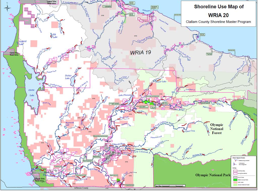
95 89 P a g e

96 FINDING: Vegetation Alteration The riparian areas of WRIA 20 are among the least impaired in western Washington with 82.5% of the riparian zone within SMP jurisdiction is closed canopy, 14.1% is other natural vegetation, and only 3.4% is non-forest. Throughout the WRIA 20, riparian zones are well stocked with trees. Recent analyses conducted for Clallam County by the Point-No Point Treaty Council showed that overall, 82.5% of the riparian zone within SMP jurisdiction is closed canopy, 14.1% is other natural vegetation, and only 3.4% is non-forest. Stream reach analyses revealed that in only one reach-- LK PLEASANT 10--was more than 30% of the riparian area categorized as non-forested. In every other reach, the forest canopy or other natural vegetation covers more than 80% of the zone. While the analysis indicated that the WRIA s shorelines are well stocked with trees, analysis was not done regarding the age and species composition of the riparian buffer. Riparian stands in some sections are less mature than is desirable. In a few places, windthrow has completely eliminated the buffer. The rules now in place are likely to lead to overall recovery and in the longterm increase instream LWD. FINDING: Hydrologic Alteration Little evidence was found of major disruptions of hydrologic functions in WIA 20 s shorelines. Currently a total of 34 sites are listed on the 2008 Department of Ecology s 303(d) list for temperature, fecal, dissolved oxygen, and ph exceedances. All but 7 are temperature exceedances. Only one of these sites is associated with fecal contamination; that site is in an area dedicated to commercial forest uses in the Dickey system. Dissolved oxygen levels are listed in 4 sites, and ph levels listed in 2 sites. Of these sites, 21 are associated with remote areas with very limited human 90 P a g e
WRIA 20 Inventory and Characterization Report (ICR)
") WRIA 20 Inventory and Characterization Report (ICR) Prepared by Miranda Wecker and Rebekah Gentry UW Olympic Natural Resources Center Revised June 6, 2011 Table of Contents Introduction Introduction...
WRIA 20 Inventory and Characterization Report (ICR) Prepared by Miranda Wecker and Rebekah Gentry UW Olympic Natural Resources Center Revised June 6, 2011 Table of Contents Introduction Introduction...
The Calawah River System
 The Calawah River System The Calawah River is the largest tributary of the Bogachiel River and is formed by the confluence of the north and south forks of the Calawah. The two forks of the Calawah, CALAWAH
10 is bounded by wetlands between RM 1.8 and 3.1 on the south shore and more are scattered
 The Ozette System The Ozette watershed is made up of several lakes and large streams that combine to a total drainage area of 88.4 square miles. The most significant feature of the Ozette watershed is
CHAPTER 4 DESIRED OUTCOMES: VISION, GOALS, AND OBJECTIVES
 CHAPTER 4 DESIRED OUTCOMES: VISION, GOALS, AND OBJECTIVES Vision One of the first steps in developing this Plan was articulating a vision - a clear statement of what the Plan strives to achieve and what
Sub-watershed Summaries
 Project Description The Salmon Drift Creek Watershed Council (SDCWC) has focused their efforts in the Salmon River estuary for the past few years. The multifaceted partnership effort is nearing completion
Clallam County Shoreline Master Program Update. Draft Public Land/Access Inventory Emphasis on Shoreline Public Access
 Clallam County Shoreline Master Program Update Draft Public Land/Access Inventory Emphasis on Shoreline Public Access Outline Public Lands Public Shoreline Access Inventory Marine Shoreline Freshwater
MCCAW REACH RESTORATION
 Final Report MCCAW REACH FISH RESTORATION PHASE B Jack McCaw Inland Empire Action Coalition http://www.wwccd.net/ Phone: 509-956-3777 Hours: 8:00-4:30 Walla Walla County Conservation District Snake River
FISH PASSAGE IMPROVEMENT in California s Watersheds. Assessments & Recommendations by the Fish Passage Forum
 FISH PASSAGE IMPROVEMENT in California s Watersheds Assessments & Recommendations by the Fish Passage Forum FISH PASSAGE IMPROVEMENT in California s Watersheds The mission of the Fish Passage Forum is
Klickitat County Shoreline Master Program Update. Open House March 15, 2017
 Klickitat County Shoreline Master Program Update Open House March 15, 2017 Agenda 6:00 6:10 Welcome 6:10 6:40 Presentation SMP Update Process Shoreline Analysis review 6:40 8:00 Open House Topics SMP Process
STEELHEAD SURVEYS IN OMAK CREEK
 STEELHEAD SURVEYS IN OMAK CREEK 2002 Annual Report Prepared by Chris Fisher John Arterburn Colville Confederated Tribes Fish and Wildlife Department P.O. Box 150 Nespelem, WA 99155 Prepared for Project
Trout Unlimited Comments on the Scope of Environmental Impact Statement for the Constitution Pipeline Project, Docket No. PF12-9
 October 9, 2012 Kimberly D. Bose, Secretary Federal Energy Regulatory Commission 888 First Street, NE, Room 1A Washington, DC 20426 RE: Trout Unlimited Comments on the Scope of Environmental Impact Statement
Ned Currence, Nooksack Indian Tribe
 Ned Currence, Nooksack Indian Tribe Problem Status Distribution Habitat Hatcheries Harvest 25000 20000 Natural-Origin Spawners 15000 10000 22500 5000 0 Historic catch Spawners (2011-2015) Problem Status
FISHERIES BLUE MOUNTAINS ADAPTATION PARTNERSHIP
 FISHERIES A warming climate, by itself, substantially affects the hydrology of watersheds in the Blue Mountains. Among the key hydrologic changes projected under all scenarios for the 2040s and beyond
Interim Guidance Fish Presence Absence
 Interim Guidance Fish Presence Absence Source: Forest Practices Act Guidance for Division 635 of the forest practices act dealing with stream classification when no fish surveys have been done (referenced
Chagrin River TMDL Appendices. Appendix F
 Appendix F The following are excerpts from the Eastern Brook Trout Joint Venture s Conservation Strategy (Working Draft v.6), Conserving the Eastern Brook Trout: Strategies for Action Found at: http://www.easternbrooktrout.org/constrategy.html
Abundance of Steelhead and Coho Salmon in the Lagunitas Creek Drainage, Marin County, California
 scanned for KRIS Abundance of Steelhead and Coho Salmon in the Lagunitas Creek Drainage, Marin County, California Prepared for: Marin Municipal Water District 220 Nellen Drive Corte Madera, California
Funding Habitat Restoration Projects for Salmon Recovery in the Snake River Region SRFB Grant Round Version: 2/19/16
 2016 SRFB Grant Round Version: 2/19/16 Funding Habitat Restoration Projects for Salmon Recovery in the Snake River Region The Project Funding Process Presented by the Snake River Salmon Recovery Lead Entity
STREAM SURVEY File form No..
 scanned for KRIS THE RESOURCES AGENCY OF CALIFORNIA California Department of Fish and Game STREAM SURVEY File form No.. Date: September 4, 1969. NAME: North Fork Schooner Gulch Creek COUNTY: Mendocino.
Executive Summary. Map 1. The Santa Clara River watershed with topography.
 Santa Clara River Steelhead Trout: Assessment and Recovery Opportunities December 2005 Prepared By: Matt Stoecker and Elise Kelley, Ph.D. University of California, Santa Barbara Prepared For: The Santa
OKANAGAN RIVER RESTORATION INITIATIVE - FAQ
 OKANAGAN RIVER RESTORATION INITIATIVE - FAQ Initiative background: The health of the q awsitk w (Okanagan River) has been severely impacted by the channelization works that occurred in the mid-1950 s.
Newaukum Watershed Culvert Assessment
 Newaukum Watershed Culvert Assessment Water Resource Inventory Area 23 Lewis County Conservation District Final Report By: Kelly Verd and Nikki Wilson July 2002 Funded by: Chehalis Fisheries Restoration
COA-F17-F-1343 YEAR END REPORT
 DAVE MARSHALL SALMON RESERVE RESTORATION, MAINTENANCE, AND UPGRADES YEAR END REPORT Prepared for: Fish and Wildlife Compensation Program Prepared by: Edith Tobe, RPBio, Executive Director Box 1791, Squamish,
Restoring the Kootenai: A Tribal Approach to Restoration of a Large River in Idaho
 Restoring the Kootenai: A Tribal Approach to Restoration of a Large River in Idaho Susan Ireland, Kootenai Tribe of Idaho Future of our Salmon Conference Technical Session August 2016 Healthy Floodplains,
MINISTRY OF ENVIRONMENT ENVIRONMENTAL STEWARDSHIP DIVISION FISH AND WILDLIFE BRANCH. Horsefly River Angling Management Plan
 MINISTRY OF ENVIRONMENT ENVIRONMENTAL STEWARDSHIP DIVISION FISH AND WILDLIFE BRANCH Horsefly River Angling Management Plan January 30 th, 2006 Area/Fishery Description The Horsefly River watershed provides
1.Mill Creek Watershed Summary Description and Land Use
 1.Mill Creek Watershed Summary Description and Land Use Table xxx: Mill Creek Watershed Overview Watershed Size 31,435 acres/49.1 sq miles/ 127.1 sq km Elevation Range 5,594 feet [4,967-10,561] Stream
Fish Habitat Restoration and Monitoring in Southeast Washington. Andy Hill Eco Logical Research, Inc.
 Fish Habitat Restoration and Monitoring in Southeast Washington Andy Hill Eco Logical Research, Inc. Fish Habitat Restoration and Monitoring in Southeast Washington Talk overview: Restoration projects
Union Pacific Railroad
 Input Questions: 404/401 Pre Application Meeting, December 18, 2013, Portland, Oregon 1. What is the project purpose and need? The purpose of the project is to improve the efficiency and average velocity
Minnesota Department of Natural Resources Division of Fish and Wildlife Section of Fisheries. Stream Survey Report. Luxemburg Creek.
 Minnesota F-29-R(P)-24 Area 315 Study 3 March 2016 Minnesota Department of Natural Resources Division of Fish and Wildlife Section of Fisheries Stream Survey Report Luxemburg Creek 2015 Mark Pelham Sauk
ELK RIVER WATERSHED ACTION PLAN
 ELK RIVER WATERSHED ACTION PLAN Prepared for The Elk River Watershed Council Prepared by Chris Massingill Mainstream Contracting South Coast Watershed Council September 2001 South Coast Watershed Council
San Lorenzo Valley Water District, Watershed Management Plan, Final Version Part I: Existing Conditions Report
 LIST OF FIGURES Figure 1-1. Map of the San Lorenzo River watershed Figure 2-1. The Santa Cruz Mountains Bioregion Figure 2-2. Protected areas within the San Lorenzo River watershed Figure 2-3. Primary
Okanagan Sockeye Reintroduction
 Okanagan Sockeye Reintroduction Backgrounder Elders accounts, and other forms of Traditional Ecological Knowledge (TEK) tell us that many species of salmon once came into the Okanagan Valley and tell us
East Kitsap Peninsula WRIA 15 Salmon Habitat Restoration Strategy Summary
 East Kitsap Peninsula WRIA 15 Salmon Habitat Restoration Strategy Summary I. Specificity and Focus of the Strategy Strategic Planning Area The planning area for the East Kitsap Peninsula Salmon Habitat
Annual Report for Fiscal Year and Future Plans for the Tillamook Bay Watershed Council
 Annual Report for Fiscal Year 2012-2013 and Future Plans for the Tillamook Bay Watershed Council A report prepared for the Tillamook County Board of Commissioners August 2013 Table of Contents: Recently
3. The qualification raised by the ISRP is addressed in #2 above and in the work area submittal and review by the ISRP as addressed in #1.
 Please find attached a response from The Confederated Tribes of the Warm Springs Reservation of Oregon (CTWSRO) for Project # 2008-301-00, Habitat Restoration Planning, Design and Implementation within
Five Counties Salmonid Conservation Program - Fish Passage Design Workshop. February 2013
 Program - Aquatic Organisms and Stream Crossings Ecological Connectivity A watershed is a network of channels that drain a common boundary. Channel characteristics formed by interaction of precipitation,
California Steelhead: Management, Monitoring and Recovery Efforts
 California Steelhead: Management, Monitoring and Recovery Efforts Jonathan Nelson Steelhead Management, Research and Restoration Program Oncorhynchus mykiss irideus California Steelhead - Hot Topics Implementation
California Steelhead: Management, Monitoring and Recovery Efforts
 California Steelhead: Management, Monitoring and Recovery Efforts Jonathan Nelson Steelhead Restoration & Management Program Oncorhynchus mykiss irideus California Steelhead Distinct Population Segments
Draft Central Valley Salmon and Steelhead Recovery Plan
 Draft Central Valley Salmon and Steelhead Recovery Plan for Sacramento River winter-run Chinook salmon Central Valley spring-run Chinook Salmon Central Valley Steelhead National Marine Fisheries Service
Southern Oregon Coastal Cutthroat Trout
 Species Management Unit Description Southern Oregon Coastal Cutthroat Trout The Southern Oregon Coastal Cutthroat Trout SMU includes all populations of cutthroat trout inhabiting ocean tributary streams
South Fork Chehalis Watershed Culvert Assessment
 South Fork Chehalis Watershed Culvert Assessment Water Resource Inventory Area 23 Lewis County Conservation District Final Report By: Kelly Verd and Nikki Wilson March 2003 Funded by: The Washington State
The Blue Heron Slough Conservation Bank
 1 The Blue Heron Slough Conservation Bank CONSERVATION BANKING July 19-23, 2010 CASE STUDY SERIES The Blue Heron Slough Conservation Bank (Washington) I. OVERVIEW & BACKGROUND: Location: Snohomish River
Climate Change Adaptation and Stream Restoration. Jack Williams;
 Climate Change Adaptation and Stream Restoration Jack Williams; jwilliams@tu.org 1 Goals for this presentation Develop strategies for adapting streams to climate impacts by Thinking like a watershed Understanding
6. FRESHWATER REACH SUMMARY
 6. FRESHWATER REACH SUMMARY This chapter describes the freshwater shorelines that are within the jurisdiction of the County s SMP (in WRIAs 18, 19, and a portion of 17, excluding incorporated areas) (see
FINAL REPORT. Yonkers Creek Migration Barrier Removal Project Wonderstump Road Del Norte County. Submitted By:
 FINAL REPORT Yonkers Creek Migration Barrier Removal Project Wonderstump Road Del Norte County Submitted By: Del Norte County Community Development Department Yonkers Creek Migration Barrier Removal Project
OVERVIEW OF MID-COLUMBIA FISHERIES ENHANCEMENT GROUP
 Mid-Columbia Fisheries Enhancement Group MISSION STATEMENT The Mid-Columbia Fisheries Enhancement Group is a non-profit organization dedicated to restoring selfsustaining salmon and steelhead populations
Searsville Dam Removal
 Searsville Dam Removal A unique opportunity for all Presented by the Beyond Searsville Dam Coalition San Francisquito Creek flows into the San Francisco Bay near the Palo Alto Airport and Golf Course seen
Identifying Areas with Potential to Contain High Value Fish Habitat (HVFH) June 2007
 June 2007") Identifying Areas with Potential to Contain High Value Fish Habitat (HVFH) June 2007 1 High Value Fish Habitat INTENT: To apply added precautionary protection to those special areas deemed of high value
Identifying Areas with Potential to Contain High Value Fish Habitat (HVFH) June 2007 1 High Value Fish Habitat INTENT: To apply added precautionary protection to those special areas deemed of high value
Blue Creek Chinook Outmigration Monitoring Technical Memorandum
 Blue Creek Chinook Outmigration Monitoring 2012 Technical Memorandum Prepared by: Andrew Antonetti and Erika Partee Yurok Tribe Fisheries Program PO Box 1027 Klamath, California 95548 In Partnership with:
Rivers Inlet Salmon Initiative
 Rivers Inlet Salmon Initiative 5-YEAR BUSINESS PLAN C AS E F O R S U P P O R T M AR C H 2 0 1 5 Dedication Rick Hansen had been inspired to go to Rivers Inlet in July 2010 by his good friend, and fellow
State of San Francisco Bay 2011 Appendix O Steelhead Trout Production as an Indicator of Watershed Health
 State of San Francisco Bay 2011 Appendix O Steelhead Trout Production as an Indicator of Watershed Health Gordon Becker and Katherine Smetak, Center for Ecosystem Management and Restoration 290 Introduction
Oregon Coast Coastal Cutthroat Trout
 Oregon Coast Coastal Cutthroat Trout Species Management Unit Description The Oregon Coast Coastal Cutthroat Trout Species Management Unit (SMU) includes all populations of cutthroat trout inhabiting ocean
NEVADA DEPARTMENT OF WILDLIFE STATEWIDE FISHERIES MANAGEMENT
 NEVADA DEPARTMENT OF WILDLIFE STATEWIDE FISHERIES MANAGEMENT FEDERAL AID JOB PROGRESS REPORTS F-20-52 2016 REDBAND TROUT EASTERN REGION NEVADA DEPARTMENT OF WILDLIFE, FISHERIES DIVISION ANNUAL JOB PROGRESS
Site Tour, August 24, Fish Science - Big Lake Coho Salmon Migration and Habitat Use
 Matanuska-Susitna Basin Salmon Habitat Partnership Site Tour, August 24, 2015 Part 1 of Tour Big Lake watershed Fish Science - Big Lake Coho Salmon Migration and Habitat Use Presenter: Jon Gerken (U.S.
The Salmonid Species. The Salmonid Species. Definitions of Salmonid Clans. The Salmonid Species
 The Salmonid Species The Salmonid Species N. American salmon (2 more Asian species) Chinook ( King ) Coho ( Silver ) Sockeye Chum ( Dog ) Pink ( Humpy ) Sea-run trout Steelhead, Cutthroat, Dolly Varden
Big Spring Creek Habitat Enhancement and Fishery Management Plans
 Big Spring Creek Habitat Enhancement and Fishery Management Plans November 5, 2012 Big Spring Events and Activities Center Newville, PA Charlie McGarrell Regional Habitat Biologist Pennsylvania Fish and
Lake Chelan Kokanee Spawning Ground Surveys 2012 Final Report
 Lake Chelan Kokanee Spawning Ground Surveys 2012 Final Report Spawning kokanee (Oncorhynchus nerka) in Company Creek Chelan County PUD, 2005. (Photo by Brad Buchsieb) Prepared by: Barry G. Keesee And Lance
Tuesday May, 20 th, :00 pm to 3:30 pm UW Olympic Natural Resources Center, 1455 S. Forks Ave., Forks, WA
 AGENDA Lead Entity Group Meeting Tuesday May, 20 th, 2014 1:00 pm to 3:30 pm UW Olympic Natural Resources Center, 1455 S. Forks Ave., Forks, WA NOTE: For those who are interested there will be a 09:00
Perspectives of a State Director Selective fisheries as a tool in fisheries management and salmon recovery
 Perspectives of a State Director Selective fisheries as a tool in fisheries management and salmon recovery Jeffrey P. Koenings, PhD. Washington Department of Fish and Wildlife American Fisheries Society
middle deschutes progress in restoration
 middle deschutes progress in restoration Acknowledgements prepared by: Upper Deschutes Watershed Council Deschutes River Conservancy Oregon Department of Fish and Wildlife DESIGN & PRODUCTION FUNDED by:
Steelhead Sport Fishing Regulations Proposals Vancouver Island Region for April 1, 2007
 Steelhead Sport Fishing Regulations Proposals Vancouver Island Region for April 1, 2007 Sport fishing regulations governing steelhead fishing have changed many times over the past 30 years. Generally the
Steelhead Society of BC. Thompson River Watershed Restoration and Enhancement Project #4 Nicola River Bank Stabilization and Enhancement Project
 Steelhead Society of BC Presents: Thompson River Watershed Restoration and Enhancement Project #4 Nicola River Bank Stabilization and Enhancement Project Application for Funding December 2013 1.0 BACKGROUND
Study Update Tailrace Slough Use by Anadromous Salmonids
 Study Update Tailrace Slough Use by Anadromous Salmonids Goals and Objectives Identify what anadromous salmonids use the tailrace slough by: Life Stage (Juvenile, migrating and spawning adults) Timing
Deschutes WRIA 13 Salmon Habitat Recovery Committee SRFB / PSAR Letter of Intent Form
 Deschutes WRIA 13 Salmon Habitat Recovery Committee SRFB / PSAR Letter of Intent Form Project Sponsor: Sponsor Contact lnfo: Project Name: Key Partners: Project Location: lnclude wotershed Project Description:
Attachment 1. Agenda Item Summary BACKGROUND
 Attachment 1 Agenda Item Summary BACKGROUND Spring Chinook Salmon: Prior to the late 1970s, non-treaty spring Chinook fisheries in the mainstem Columbia River occurred from February through May and harvested
Wild Virginia and Heartwood first raised this issue at the May 19, 2014 public meeting.
 June 13, 2014 Karen Stevens Pat Sheridan, District Ranger Warm Springs Ranger District 422 Forestry Road Hot Springs, VA 24445 karenlstevens@fs.fed.us psheridan@fs.fed.us re: Lower Cowpasture Restoration
Three point plan to addressing land use and habitat loss impacts on Chesapeake Bay tidal fish and shellfish
 Three point plan to addressing land use and habitat loss impacts on Chesapeake Bay tidal fish and shellfish 1. Establish Principles for Protection of Chesapeake Bay Fish and Shellfish The Fisheries GIT
Page 1. To: City of Durango - Parks and Recreation Advisory Board - Natural Lands Preservation Advisory Board Highland Avenue Durango, Colorado
 Page 1 To: City of Durango - Parks and Recreation Advisory Board - Natural Lands Preservation Advisory Board From: John Norton 2009 Highland Avenue Durango, Colorado Date: October 27, 2014 Regarding: Natural
Mid-Columbia Fisheries Enhancement Group Annual Report Fiscal Year 06: July 1, 2005 June 30, 2006
 Mid-Columbia Fisheries Enhancement Group Annual Report Fiscal Year 06: July 1, 2005 June 30, 2006 Mission Statement The mission of the Mid-Columbia Fisheries Enhancement Group is to restore self-sustaining
PROJECT TO INSTALL LARGE WOOD HABITAT STRUCTURES IN THE CARMEL RIVER USING CALIFORNIA DEPARTMENT OF FISH AND GAME GRANT FUNDS
 PROJECT TO INSTALL LARGE WOOD HABITAT STRUCTURES IN THE CARMEL RIVER USING CALIFORNIA DEPARTMENT OF FISH AND GAME GRANT FUNDS The Monterey Peninsula Water Management District (MPWMD), in cooperation with
Washington State Fish Passage Barrier Removal Projects. Casey Kramer, PE WSDOT State Hydraulics Engineer
 Washington State Fish Passage Barrier Removal Projects Casey Kramer, PE WSDOT State Hydraulics Engineer 2014 National Hydraulic Engineering Conference Iowa City, IA August 20 th, 2014 WSDOT Fish Passage
APPENDIX J HYDROLOGY AND WATER QUALITY
 APPENDIX J HYDROLOGY AND WATER QUALITY J-1 Technical Report on Airport Drainage, Northern Sector Airport and Ordinance Creek Watershed / Preliminary Creek Constructed Natural Channel Culvert J-2 Preliminary
MUCKLESHOOT INDIAN TRIBE Fisheries Division nd Avenue SE Auburn, Washington Phone: (253) Fax: (253)
 Fax: (253)") MUCKLESHOOT INDIAN TRIBE Fisheries Division 39015-172nd Avenue SE Auburn, Washington 98092-9763 Phone: (253) 939-3311 Fax: (253) 931-0752 U.S. Army Corps of Engineers Regulatory Branch Attn: Karen Urelius
MUCKLESHOOT INDIAN TRIBE Fisheries Division 39015-172nd Avenue SE Auburn, Washington 98092-9763 Phone: (253) 939-3311 Fax: (253) 931-0752 U.S. Army Corps of Engineers Regulatory Branch Attn: Karen Urelius
Project Completion Abstract Fish Passage Activity ( Engineering Activities)
") Project Completion Abstract Fish Passage Activity ( Engineering Activities) SUBMIT COMPLETED FORM TO DISTRICT MANAGER AND FIA ADMINISTRATOR AFTER PROJECT COMPLETION SECTION A GENERAL INFORMATION Recipient:
Project Completion Abstract Fish Passage Activity ( Engineering Activities) SUBMIT COMPLETED FORM TO DISTRICT MANAGER AND FIA ADMINISTRATOR AFTER PROJECT COMPLETION SECTION A GENERAL INFORMATION Recipient:
Strategies for mitigating ecological effects of hatchery programs
 Strategies for mitigating ecological effects of hatchery programs Some case studies from the Pacific Northwest Kathryn Kostow Oregon Department of Fish and Wildlife Ecological risks occur when the presence
Michigan Department of Natural Resources Status of the Fishery Resource Report Page 1
 Michigan Department of Natural Resources 2008-59 Status of the Fishery Resource Report Page 1 Bowens Manistee County, (T24N R16W Sec. 11, 12, 13, 14, 15, 24, and 30). Last surveyed 2008 Mark A. Tonello
APPENDIX D: North Fork Nooksack Sub-basin Report
 APPENDIX D: North Fork Nooksack Sub-basin Report WHATCOM COUNTY FISH PASSAGE ASSESSMENT SUBBASIN REPORT NORTH FORK NOOKSACK RIVER Description of Sub-basin The North Fork Nooksack River originates at an
NEVADA DEPARTMENT OF WILDLIFE STATEWIDE FISHERIES MANAGEMENT
 NEVADA DEPARTMENT OF WILDLIFE STATEWIDE FISHERIES MANAGEMENT FEDERAL AID JOB PROGRESS REPORTS F-20-52 2016 Lake Tahoe Rainbow Trout Study WESTERN REGION NEVADA DEPARTMENT OF WILDLIFE, FISHERIES DIVISION
Michigan Dept. of Natural Resources Status of the Fishery Resource Report Page 1. Weber Lake Cheboygan County, T34N, R3W, Sec.
 Michigan Dept. of Natural Resources 2012-143 Status of the Fishery Resource Report Page 1 Weber Lake Cheboygan County, T34N, R3W, Sec. 31 Neal Godby, Fisheries Biologist Environment Weber Lake is a 28.5-acre
Ecology of stream-rearing salmon and trout Part II
 Ecology of stream-rearing salmon and trout Part II Individual Feeding territory Habitat use Growth Movement Survival Population Population Abundance Density Variation Movement Individual Relationship between
LIFE HISTORY DIVERSITY AND RESILIENCE
 LIFE HISTORY DIVERSITY AND RESILIENCE SPRING CHINOOK IN THE WILLAMETTE RIVER BASIN Kirk Schroeder Brian Cannon Luke Whitman Paul Olmsted Oregon Department of Fish and Wildlife Corvallis Research Lab Thanks
Columbia River Fishery Notice
 Columbia River Fishery Notice Oregon Department of Fish and Wildlife January 29, 2014 Compact Action The Columbia River Compact agencies of Oregon and Washington met today and took the following actions:
Benchmark Statement Respecting the Fish, Fish Habitat and Fisheries of Fish and Little Fish Lake, within the Taseko River Watershed.
 Benchmark Statement Respecting the Fish, Fish Habitat and Fisheries of Fish and Little Fish Lake, within the Taseko River Watershed. Information Supporting the Environmental Assessment of the Prosperity
Lakelse Sockeye Recovery Program
 Lakelse Sockeye Recovery Program The Ninth Annual BC Interior Stewardship Workshop May 7 th and 8 th, 2013 DFO North Coast Resource Restoration Unit Presentation Overview History/background Stock and habitat
Warner Lakes Redband Trout
 Warner Lakes Redband Trout Existing Populations Warner Valley is an endorheic basin that contains a complex series of interconnected lakes, marshes, sloughs, and potholes, all of which are remnants of
11426 Moorage Way P.O. Box 368 LaConner, WA Phone: Fax:
 Skagit River System Cooperative 11426 Moorage Way P.O. Box 368 LaConner, WA 98257-368 Phone: 36-466-7228 Fax: 36-466-447 www.skagitcoop.org BULL TROUT USE OF SWINOMISH RESERVATION WATERS Eric Beamer, Rich
WFC 10 Wildlife Ecology & Conservation Nov. 29, Restoration Ecology: Rivers & Streams. Lisa Thompson. UC Cooperative Extension
 Restoration Ecology: Rivers and Streams WFC 10 29 Nov 2010 Restoration of ecosystems often involves creating new systems with only partial resemblance to the original ecosystems Lisa Thompson Fisheries
SALMON FACTS. Chinook Salmon. Oncorhynchus tshawytscha
 SALMON FACTS Chinook Salmon Oncorhynchus tshawytscha Other names: king, tyee, blackmouth (immature) Average size: 10-15 lbs, up to 135 lbs Fall spawner; fall, spring, and summer runs Chinook salmon are
Summary of HSRG Findings for Chum Populations in the Lower Columbia River and Gorge
 Summary of HSRG Findings for Chum Populations in the Lower Columbia River and Gorge The Congressionally-established Hatchery and Scientific Review Group (HSRG) developed a foundation of salmon hatchery
Don Pedro Project Relicensing
 Don Pedro Project Relicensing M ODESTO I RRIGATION D ISTRICT TURLOCK I RRIGATION D ISTRICT FERC PROJECT N O. 2299 Resident Fish in Don Pedro Reservoir Don Pedro Reservoir Fish Stocking (1971-Present) CDFG
X.B WETLANDS ROGUE RIVER ESTUARY
 X.B WETLANDS ROGUE RIVER ESTUARY The Rogue River has a drainage area of 5,100 square miles, yet the estuary of the Rogue River is one of the smallest in Oregon, measuring approximately 1,880 acres during
Eastern Brook Trout. Roadmap to
 Eastern Brook Trout Roadmap to CONSERVATION Our Brook Trout heritage he wild Brook Trout is an American symbol of persistence, adaptability, and the pristine wilderness that covered North America prior
Aquatic Organism Passage at Road-Stream Crossings CHUCK KEEPORTS FOREST HYDROLOGIST ALLEGHENY NATIONAL FOREST WARREN, PENNSYLVANIA
 Aquatic Organism Passage at Road-Stream Crossings CHUCK KEEPORTS FOREST HYDROLOGIST ALLEGHENY NATIONAL FOREST WARREN, PENNSYLVANIA TOPICS COVERED Aquatic Organism Passage (AOP) Benefits of AOP Crossings
COLUMBIA LAKE DAM REMOVAL PROJECT
 COLUMBIA LAKE DAM REMOVAL PROJECT Major Goals of the Columbia Lake Dam Removal: Reconnect 10 miles of the Paulins Kill River to the Delaware River, restoring natural flow regime and sediment transport.
Follow this and additional works at:
 University of Massachusetts - Amherst ScholarWorks@UMass Amherst International Conference on Engineering and Ecohydrology for Fish Passage International Conference on Engineering and Ecohydrology for Fish
5B. Management of invasive species in the Cosumnes and Mokelumne River Basins
 5B. Management of invasive species in the Cosumnes and Mokelumne River Basins Cosumnes River The Cosumnes River basin has a number of distinct habitat types that require different management strategies
Little Kern Golden Trout Status:
 Little Kern Golden Trout Status: The Little Kern Golden trout (LKGT) was proposed for federal listing as Threatened under the Endangered Species Act (ESA) on September 1, 1977 by the U. S. Fish and Wildlife
Kootenai River Habitat Restoration Program. Kootenai Tribe of Idaho - January 27, 2014 Presentation for Kootenai Valley Resource Initiative
 Kootenai River Habitat Restoration Program Kootenai Tribe of Idaho - January 27, 2014 Presentation for Kootenai Valley Resource Initiative Decline of native species Kootenai River White Sturgeon ENDANGERED
Maryland Chapter Trout Unlimited Brook Trout Conservation Effort
 Maryland Chapter Trout Unlimited Brook Trout Conservation Effort Photo by Matt Kline Portfolio of Recent Work MDTU Brook Trout Conservation Coordinator: Scott C. Scarfone, ASLA sscarfone@oasisdesigngroup.com
Drafted by JWN Approved by Steering Committee ( ) Technical description of basins is subject to change
 Technical description of basins is subject to change") Drafted by JWN Approved by Steering Committee (12-8-09) Technical description of basins is subject to change Stronghold Investment Partnerships Science and Policy Considerations Guiding NASSP Steering
Drafted by JWN Approved by Steering Committee (12-8-09) Technical description of basins is subject to change Stronghold Investment Partnerships Science and Policy Considerations Guiding NASSP Steering
Pre-Application Document Kaweah Project (FERC Project No. 298)
") TABLE OF CONTENTS Page 3.12 Aesthetic Resources... 3.12-1 3.12.1 Information Sources... 3.12-1 3.12.2 Setting... 3.12-1 3.12.3 Project Facilities... 3.12-2 3.12.4 Previous Visual Resources Assessment...
TABLE OF CONTENTS Page 3.12 Aesthetic Resources... 3.12-1 3.12.1 Information Sources... 3.12-1 3.12.2 Setting... 3.12-1 3.12.3 Project Facilities... 3.12-2 3.12.4 Previous Visual Resources Assessment...