in the Pend Oreille Watershed, Washington Water Resource Inventory Area 62
|
|
|
- Aron Simon
- 6 years ago
- Views:
Transcription


1 in the Pend Oreille Watershed, Washington Water Resource Inventory Area 62 September 2007 Pend Oreille Salmonid Recovery Team c/o Pend Oreille Conservation District P.O. Box 280 Newport, Washington (509) ; In cooperation with the Initiating Governments: Pend Oreille County, Kalispel Tribe, and City of Newport Funded by: Washington Department of Fish and Wildlife
2 This document should be cited as: Pend Oreille Salmonid Recovery Team Strategy for protection and improvement of native salmonid habitat in the Pend Oreille Watershed, Washington, Water Resource Inventory Area 62. pp. Cover photos courtesy of: U.S. Fish and Wildlife Service, Ernest Keeley, Pend Oreille Conservation District, and Wydoski and Whitney 2003.
3 I. ACKNOWLEDGMENTS II. III. IV. EXECUTIVE SUMMARY VISION AND GOALS TABLE OF CONTENTS INTRODUCTION A. BACKGROUND B. PEND OREILLE LEAD ENTITY C. PURPOSE OF STRATEGY D. COORDINATION WITH OTHER SALMONID RECOVERY EFFORTS/PLANS V. WRIA 62 DESCRIPTION VI. VII. VIII. IX. PRIORITY, STATUS AND DISTRIBUTION OF SALMONID SPECIES A. PRIORITY SALMONID SPECIES B. STATUS AND DISTRIBUTION OF PRIORITY SPECIES i. Bull Trout ii. Westslope Cutthroat Trout iii. Pygmy Whitefish C. STATUS AND DISTRIBUTION OF OTHER SALMONID SPECIES i. Mountain whitefish ii. Eastern brook trout iii. Rainbow trout iv. Brown trout v. Kokanee vi. Lake trout HABITAT LIMITING FACTORS AND WATERSHED PROCESSES PRIORITY AREAS AND ACTIONS A. PRIORITY AREAS B. PRIORITY ACTIONS PROJECT EVALUATION AND RANKING CRITERIA X. COMMUNITY ISSUES A. LANDOWNER SUPPORT B. ASSESSING COMMUNITY SUPPORT AND CONCERN C. BUILDING COMMUNITY SUPPORT D. PRIORITIES FOR COMMUNITY SUPPORT ACTIONS XI. XII. SUMMARY REFERENCES CITED APPENDICES A - F i
4 LIST OF APPENDICES Appendix A: SUMMARY OF SRFB FUNDED PROJECTS IN WRIA 62 Appendix B: RANKING CRITERIA FOR HIGH AND MEDIUM PRIORITY SUBBASINS Appendix C: TECHNICAL EVALUATION CRITERIA Appendix D: PROJECT RANKING CRITERIA Appendix E: PRIORITY CULVERT BARRIERS FOR REMOVAL Appendix F: BARRIER PRIORITIZATION MATRIX LIST OF TABLES Table 1: SALMONIDS PRESENT IN WRIA 62 SUBBSAINS Table 2: SUMMARY OF BULL TROUT HABITAT LIMITING FACTORS Table 3: RESULTS OF PRIORITY SUBBASIN RANKING Table 4: PRIORITY ACTIONS AND AREAS LIST OF FIGURES Figure A: LOCATION OF WATER RESOURCE INVENTORY AREA 62 Figure B: BULL TROUT DISTRIBUTION AND HABITAT STATUS Figure C: CUTTROAT TROUT DISTRIBUTION Figure D: PYGMY WHITEFISH DISTRIBUTION Figure E: WRIA 62 PRIORITY SUBBASINS Figure F: PEND OREILLE MAINSTEM PRIORITY ACTIONS Figure G: GRANITE SUBBASIN PRIORITY ACTIONS Figure H: HUGHES FORK SUBBASIN PRIORITY ACTIONS Figure I: CEDAR SUBBASIN PRIORITY ACTIONS Figure J: SLATE SUBBASIN PRIORITY ACTIONS Figure K: LECLERC SUBBASIN PRIORITY ACTIONS Figure L: SULLIVAN SUBBASIN PRIORITY ACTIONS Figure M: INDIAN SUBBASIN PRIORITY ACTIONS Figure N: UPPER WEST BRANCH PRIEST RIVER SUBBASIN PRIORITY ACTIONS Figure O: MILL SUBBASIN PRIORITY ACTIONS Figure P: KALISPELL SUBBASIN PRIORITY ACTIONS Figure Q: CEE CEE AH SUBBASIN PRIORITY ACTIONS Figure R: TACOMA SUBBASIN PRIORITY ACTIONS Figure S: CALISPELL SUBBASIN PRIORITY ACTIONS Figure T: RUBY SUBBASIN PRIORITY ACTIONS ii
5 I. ACKNOWLEDGMENTS Current membership of the Pend Oreille Salmonid Recovery Team that helped develop this strategy include: Technical Advisory Group Tom Shuhda, Colville National Forest Jill Cobb, Idaho Panhandle National Forest Joe Maroney, Kalispel Tribe Todd Andersen, Kalispel Tribe Scott Jungblom, Pend Oreille Public Utility District No. 1 Pat Buckley, Pend Oreille Public Utility District No. 1 Al Solonsky, Seattle City Light Juliet Barenti, U.S. Fish and Wildlife Service Curt Vail, Washington Department of Fish and Wildlife Jeff Lawlor, Washington Department of Fish and Wildlife Jaime Short, Washington Department of Ecology Terry Driver, Landowner Matt Fairchild, Idaho Panhandle National Forest Ted Carlson, Stimson Lumber Company Jason Olson, Kalispel Tribe Citizens Advisory Group Ken Oliver, Pend Oreille County Commissioner Koni Oliver, Landowner/citizen Ken Driver, Landowner/citizen Randall Leestma, Citizen Tom Petrie, Jr., Pend Oreille Sportsman s Club Ray Pierre, Kalispel Tribe Larry Brown, Landowner/citizen Barbara Williams, Citizen Christy Lafayette, Landowner/citizen Leonard Davaz, Landowner/citizen Jim Carney, Landowner/citizen Technical support and maps were provided by Sandy Dotts, Washington Department of Fish and Wildlife. iii
6 II. EXECUTIVE SUMMARY The Pend Oreille Salmonid Recovery Team (Recovery Team) was created under the Salmon Recovery Act (Act) in June 2000 for Water Resource Inventory Area (WRIA) 62 in northeastern Washington. The Recovery Team consists of a Technical Advisory Group (TAG) and a Citizens Advisory Group (CAG) and is coordinated by the Pend Oreille Conservation District (POCD) under contract with the Washington Department of Fish and Wildlife (WDFW). The Act provides an annual opportunity for the Recovery Team to submit a list of salmonid habitat protection and improvement projects to the Salmon Recovery Funding Board (SRFB) for funding consideration. The SRFB is authorized by the Washington State Legislature to fund projects that are targeted at salmonid recovery activities and projects statewide. This strategy addresses protection and improvement of native salmonid habitat in WRIA 62 and provides a framework for developing an annual project list for submittal to the SRFB. The Recovery Team s vision for salmonid recovery in WRIA 62 is: A healthy watershed that provides for the recovery of native salmonids, while also providing ecological, cultural, recreational, and socio-economic benefits. Several short- and long-term goals have been developed to help achieve the vision. WRIA 62 DESCRIPTION WRIA 62 is drained by the Pend Oreille River, which is the second largest river in Washington. The Pend Oreille River flows for 155 miles from its headwaters at Lake Pend Oreille, Idaho to the confluence with the Columbia River in Canada. Several large tributaries drain to the Pend Oreille River including Sullivan, Cedar, LeClerc, Tacoma, Ruby and Calispell creeks. WRIA 62 also includes a small portion of the South Fork Salmo River and the headwaters of several tributaries which drain to the Priest River system in Idaho. PRIORITY, STATUS, AND DISTRIBUTION OF SALMONID SPECIES Salmonids native to WRIA 62 include Chinook salmon, steelhead trout, bull trout, westslope cutthroat trout, mountain whitefish and pygmy whitefish. Of these, Chinook salmon and steelhead have been extirpated, bull trout is listed as threatened under the Endangered Species Act (ESA), westslope cutthroat trout is designated a species of concern by the U.S. Fish and Wildlife Service (USFWS), and pygmy whitefish is a Washington State sensitive species. The TAG and CAG have chosen bull trout, westslope cutthroat trout, and pygmy whitefish as priority species for recovery in WRIA 62. The primary focus of this strategy is on recovery of bull trout due to its ESA-listed status. HABITAT LIMITING FACTORS AND WATERSHED PROCESSES It is unknown which watershed processes and habitat attributes or combination of attributes are most limiting bull trout in WRIA 62 (WCC 2003). However, several habitat factors are known to be significant in the decline of bull trout populations in WRIA 62: habitat degradation on the mainstem and within tributaries; human-made fish passage barriers into tributaries of the Pend Oreille River; non-native species introduction and management; and the construction and operation of three hydroelectric facilities on the mainstream Pend Oreille River (i.e., Boundary, Box Canyon, and Albeni Falls dams), which were constructed without fish passage facilities 2
7 (WCC 2003). An assessment of watershed processes limiting native salmonid recovery has not been undertaken in WRIA 62. PRIORITY AREAS, LIMITING FACTORS AND ACTIONS The TAG used a two-step approach to prioritize and rank geographic areas within WRIA 62 for salmonid protection and habitat improvement actions. The prioritization process resulted in 11 of the 43 subbasins in WRIA 62 being designed as High priority subbasins, 4 as medium priority, and the remainder as low priority based on recent documentation of ESA-listed species, habitat suitability, and presence of natural barriers to fish passage. High and Medium priority subbasins were then ranked using seven additional criteria including habitat utilization, restoration potential, and amount of public land within subbasin (see Appendix B for details). Priority limiting factors and protection and improvement actions were determined by the TAG for each of the High and Medium priority subbasins using information contained in the Bull Trout Habitat Limiting Factors Report for WRIA 62 (WCC 2003) and professional judgment. In summary, major actions necessary to protect and improve bull trout and other native salmonid populations in WRIA 62 may include: Restoring fish passage at all major barriers (i.e., dams, dikes, weirs, etc.) and culverts crossings Removing non-native fish Restoring habitat complexity (instream and riparian) Relocating, obliterating, or reconstructing road segments out of riparian areas Restoring floodplain connectivity Identifying and prioritizing fish passage barriers for removal Identifying and addressing road maintenance problems COMMUNITY INTERESTS Community interests and support is assessed and promoted by the lead entity on two levels. The first and most important is project level landowner support, which is assessed on a project by project basis when sponsors are available and projects are a priority within the subbasin. The second is general community support of priority actions and areas. To assess this element, CAG members identified a level of community support present for each priority action within each subbasin recommended by the TAG. The level of community support was based on the effects each action may have on a number of socioeconomic concerns including but not limited to: Local industry and landowner ability to avoid undue economic hardship by sustaining adequate use of natural resources Continued outdoor recreation, hunting and fishing opportunities Continued resource-based economic activity (timber harvest, farming and mining) Retaining the rural character of the land Preservation of flood control Further restricting access to public lands 3
8 The minimum amount of community support required to successfully implement high priority projects is landowner support. The level of local community support was assessed for each priority action suggested for each high and medium priority subbasin. This level of support is shown in the Priority Actions and Areas Table and used by the CAG when the Habitat Project List is ranked each funding cycle. General community support for projects WRIA wide focuses on: Assessments Barrier/culvert replacement Bank stabilization projects Actions improving public lands Easements to compensate for agriculture lands lost to conservation practices Any priority project with landowner support as well as actions identified as having high or moderate community support are actively promoted to project sponsors. When sponsored these projects are prioritized by the CAG, both on their current level of community support and their ability to develop support for the salmonid recovery process in the future (see Appendix D). Priority actions and areas with a low level of community and landowner support include: Acquisition of private land if removed from the county tax base Removal of non-native fish species in subbasins supporting a sport fishery Actions proposed in the lower Calispell subbasin; benefits of these actions in a primarily agricultural area protected from flooding of the Pend Oreille River by a diking system are in question by many local community members and landowners Road removal, abandonment or obliteration reducing access to public land. The strategy for increasing the level of support for actions identified as having lower community support include: 1. Continuing adult and youth education for high priority activities in high priority areas. a. Actions with low community support will be prioritized for support building activities based on its subbasin priority, the rank of action within a priority subbasin, and the ability of the activity to achieve long and short term goals of the strategy. b. Actions with low level of community support will be promoted though continual educational events including guest speakers at local public and Lead Entity CAG meetings and field trips for project sponsors, landowners and citizens to past project sites of similar actions or subbasins. 2. The Lead Entity, when ever possible, will actively promote sponsorship of habitat improvement actions in areas enjoying higher levels of community support which are similar to those priority actions in areas with low community support including: a. Pilot studies and priority actions located in adjacent subbasins which have similar limiting factors 4
9 b. Priority actions on public lands (i.e. with landowner support) within low community support, high priority subbasins addressing limiting factors similar to those present on the privately owned reaches. As the first step to achieve a higher level of understanding of the community support and concerns regarding priority actions in priority areas, the CAG produced a survey for water front landowners with questions relating specifically to actions proposed in their subbasin. Results of this survey were used to refine the list of educational events and activities as well as identify additional areas of community support, at the subbasin level, for priority habitat improvement activities enhancing the knowledge of the current community representatives. The survey results were also used to clarify the current level of community support for each recovery action proposed in this strategy as seen in the Community Support column of the Priority Actions and Areas Table (Table 4). An additional survey was conducted of residents WRIA-wide to complete the picture of community support and concern for actions suggested in this strategy. OVERALL APPROACH TO GUIDE PROJECT PRIORITIES Priority subbasin ranking when combined with subbasin specific priority actions will focus the Recovery Team in developing and soliciting salmonid protection and improvement projects for submittal to the SRFB. Any priority action with landowner support will be accepted for submission to the SRFB. The final project ranking criteria ensures that actions with equal scientific benefit and certainty ratings will be ranked higher on the habitat project list if the project is highly visible, publicly supported or has the potential to increase public support for the recovery process. The success of this strategy in achieving native salmonid habitat recovery depends on the Recovery Team s ability to continually fund high quality projects shown, through project monitoring, to have a positive effect on fish habitat without negatively effecting property owners or public land use. This will lead to higher level of public support for both salmonid habitat recovery and the proposed actions within this strategy. 5
10 III. VISION AND GOALS VISION STATEMENT: We envision a healthy watershed that provides for the recovery of native salmonids, while also providing ecological, cultural, recreational, and socio-economic benefits. Short-term goals important to achieving the vision include: Stakeholders working together to identify all possible voluntary habitat improvement projects Through public outreach, educate the public and potential project stakeholders on the importance of salmonid recovery and watershed issues. Improve habitat and restore complete connectivity on a subbasin by subbasin level starting with those subbasin that will provide the most suitable habitat for recolonization of native salmonids for the least amount of money and without negatively impacting social or economic status of local citizens. Recommend adoption of public and private road building and maintenance standards by agencies that will, when implemented, help minimize negative impacts on fish habitat. Long-term goals important to achieving the vision include: Bring more stakeholders together to continue to identify voluntary habitat improvement projects. Use results from monitoring past projects to increase the effectiveness of future projects. Enforce public and private road-building and maintenance standards and practices to minimize negative impacts on fish habitat. Manage our National Forest lands so as to minimize negative impacts to fish habitat. Achieve de-listing of ESA listed species in selected tributaries of WRIA 62. Protect, enhance, and restore native salmonid populations to maintain stable, viable levels, to ensure long-term, self-sustaining persistence, and to provide ecological, cultural, economic, and sociological benefits. Restore, protect, and maintain spawning and rearing habitat in tributary streams to improve survival of native salmonids. Operate dams and reservoirs to minimize negative impacts to native salmonids. Conserve genetic diversity of native fish populations and provide opportunity for genetic exchange among local populations. Improve conditions for native salmonids by reducing competition with brook trout and other non-native fish. 6
11 IV. INTRODUCTION A. BACKGROUND Currently, 15 stocks of salmon, trout, and char (salmonids) are listed as threatened or endangered under the Endangered Species Act (ESA) in Washington State. To address this issue, in 1998 the state legislature passed the Salmon Recovery Act (Chapter RCW), which provides for the creation of Lead Entities (Chapter RCW) to coordinate salmonid recovery efforts at a local level. Lead Entities are jointly appointed by the counties, tribes, and municipalities within the Lead Entity area. The Washington Department of Fish and Wildlife (WDFW) administers funds for expenses associated with operation and maintenance of Lead Entities. With technical assistance from WDFW, the Lead Entities assemble, facilitate, and administer a local citizen committee of representative habitat interests; develop a strategy for habitat protection and improvement; solicit project applications for salmonid habitat improvement and protection projects; create a prioritized list of habitat improvement/protection projects; and, create a work schedule for project completion. The prioritized habitat project list is submitted to the state s Salmon Recovery Funding Board (SRFB). The SRFB supports local partnerships by funding habitat protection and improvement projects that are proposed by local groups through Lead Entities. The mission of the SRFB is to support salmonid recovery by funding habitat protection and restoration projects and related programs and activities that produce sustainable and measurable benefits to fish and their habitats. B. PEND OREILLE LEAD ENTITY As part of the major statewide effort to recover declining salmonid stocks, the Pend Oreille Salmonid Recovery Team (Recovery Team) was created in June 2000 under the Salmon Recovery Act. The Recovery Team is coordinated by the Pend Oreille Conservation District (POCD), which was appointed Lead Entity for Water Resource Inventory Area (WRIA) 62 through the joint support of the Kalispel Tribe, Pend Oreille County, and the City of Newport. The Recovery Team consists of a Technical Advisory Group (TAG) and a Citizens Advisory Group (CAG) and is administered by the POCD under contract with the WDFW. The Salmon Recovery Act provides an annual opportunity for the Recovery Team to submit a list of salmonid habitat protection and improvement projects to the SRFB for funding consideration. The SRFB is authorized by the Washington Legislature to fund projects that are targeted at salmonid recovery activities and projects statewide. Since 1999, the SRFB has funded sixteen projects in WRIA 62 with a value of over $3,513,000. Several additional priority projects have been funded by other entities contributing to habitat improvements which meet the goals of this strategy. For a summary of SRFB funded projects see Appendix A C. PURPOSE OF STRATEGY This strategy addresses protection and improvement of native salmonid habitat in WRIA 62 and provides a framework for developing an annual project list for submittal to the SRFB. This document was created to serve as a guiding strategy that utilizes the best available science, local citizen s knowledge and technical expertise to identify and prioritize actions necessary for improvement of native salmonid habitat and populations in WRIA 62. This document serves the following purposes: 7
12 1) Help potential project sponsors select projects that clearly fit into a collective, unified recovery strategy; 2) Aid in the project prioritization process; 3) Facilitate coordination and cooperation between local natural resource and fisheries managers concerning specific projects, efforts, and strategies; and, 4) Identify areas and topics of community concern and outlines actions to improve community acceptance of salmonid recovery activities in WRIA 62. This document is not intended to be an all encompassing, final strategy and implementation plan for salmonid recovery in WRIA 62. There are many factors that have and are contributing to the decline of native salmonids in the watershed which are beyond the scope of the Pend Oreille Salmonid Recovery Team and its mandate under the Salmon Recovery Act. This document will continually change as habitat protection and improvement projects are completed, new projects are developed, and knowledge of the fisheries resources and habitat improves in both quality and quantity. D. COORDINATION WITH OTHER SALMONID RECOVERY EFFORTS/PLANS The Northeast Washington Salmon Recovery Region, in which WRIA 62 is located, is not currently planning under Regional Salmon Recovery Planning because a federal recovery plan for bull trout, the only ESA-listed fish found in the region, has already been developed by the U.S. Fish and Wildlife Service (USFWS 2002). However, all actions recommended in this strategy meet or exceed recovery actions identified in the USFWS draft bull trout recovery plan and critical habitat designation (USFWS 2004). Actions identified in this strategy are designed to result in, not only population recovery and delisting as addressed in the USFWS plan, but a harvestable surplus of bull trout. This strategy also incorporates priority projects identified through other planning processes, such as Northwest Planning and Conservation Council subbasin planning for the Intermountain Province (GEI Consultants, Inc. 2004), watershed planning under the Watershed Planning Act (Chapter RCW; Golder Associates 2005), and westslope cutthroat trout status reviews (USFWS 1999, 2003). Several members of the TAG were actively involved in development of these documents insuring consistency between strategies for habitat improvement and protection. 8
.")
13 V. WRIA 62 DESCRIPTION This strategy addresses WRIA 62, which is located in the northeastern corner of Washington State, encompassing 794,546 acres of the Pend Oreille, Salmo, and Priest River drainages. WRIA 62 is bordered by Canada to the north, Idaho to the east, and the Chewelah Mountains to the west (Figure A). It encompasses the Pend Oreille River and its tributaries between the Canadian border and the Idaho border. The Pend Oreille River is the second largest river in Washington and flows 155 miles from its headwaters at Lake Pend Oreille to the confluence with the Columbia River in Canada. Many tributaries feed into the Pend Oreille River. The largest tributary drainage within WRIA 62 is Sullivan Creek, which drains an area of approximately 142 square miles (Dames and Moore 1995). Other significant tributaries include Cedar, LeClerc, Tacoma, Ruby, and Calispell creeks. WRIA 62 also includes a small portion of the South Fork Salmo River, where it dips down into Washington State. The South Fork Salmo River is a tributary to the Salmo River which flows into the Pend Oreille River in Canada. Some headwater portions of tributaries which drain to the Priest River system in Idaho are also captured in WRIA 62. The headwaters of tributaries contained within WRIA 62 that drain into Idaho include: Gold, Hughes Fork, Jackson, Bench, Granite, Kalispell, Lamb and Binarch creeks and the Upper and Lower West Branch of Priest River (WCC 2003). WRIA 62 is located within the Intermountain Province, a Northwest Power and Conservation Council designation for the area draining to the Columbia River upstream of Chief Joseph Dam. Under U.S. Fish and Wildlife Service (USFWS) bull trout recovery planning, WRIA 62 falls into two different recovery units : the Northeast Washington Recovery Unit and the Clark Fork Recovery Unit. Figure A Location of Water Resource Inventory Area (WRIA) 62 9
14 VI. PRIORITY, STATUS, AND DISTRIBUTION OF SALMONID SPECIES Salmonids native to WRIA 62 include Chinook salmon (Oncorhynchis tshawytscha), steelhead trout (O. mykiss), bull trout (Salvelinus confluentus), westslope cutthroat trout (O. clarki), mountain whitefish (Prosopium williamsoni), and pygmy whitefish (P. coulteri). Chinook salmon and steelhead trout utilized the lower reaches of the Pend Oreille River downstream of Z- Canyon/Metaline Falls (WCC 2003; GEI Consultants 2004). These species were extirpated from the WRIA upon completion of Grand Coulee Dam in 1941, which completely blocked migration of anadromous salmonids to the region. Kokanee salmon (O. nerka) also occur in the watershed. Genetic analysis has determined that kokanee from Sullivan Lake are genetically similar to the Whatcom Stock, and, therefore, are not native to the Pend Oreille watershed (T. Shuhda, USFS, pers. comm. 2007). Several introduced, non-native salmonids are also found in the watershed including eastern brook trout (Salvelinus fontinalis), brown trout (Salmo trutta), and rainbow trout (Oncorhynchis mykiss). Table 1 provides a list of native and non-native salmonids documented to occur in each WRIA 62 subbasin. A. PRIORITY SALMONID SPECIES Native salmonid species in decline in WRIA 62 include bull trout, westslope cutthroat trout, and pygmy whitefish. The TAG and CAG have chosen these three species as priority for recovery in WRIA 62 with bull trout as the top priority due to its ESA status as threatened. Westslope cutthroat trout, a USFWS species of concern, is the second priority species and pygmy whitefish, a Washington State Sensitive species, is the third priority species in WRIA 62. B. STATUS AND DISTRIBUTION OF PRIORITY SPECIES The status and population viability characteristics (PVC; i.e., abundance, productivity, genetic diversity, and spatial distribution) of each priority species are described below. i. Bull Trout were listed as Threatened under ESA on June 10, The Bull Trout and Dolly Varden Appendix to the Washington State Salmonid Stock Inventory (SaSI, WDFW 1998) identifies the Pend Oreille bull trout stock as a distinct stock due to their geographic distribution, but lists the status of the stock as Unknown. were historically abundant in the Pend Oreille River (Gilbert and Evermann 1895; WCC 2003). An adfluvial downstream migration pattern is believed to have occurred in the Pend Oreille/Priest River basin in Washington and Idaho. Adult bull trout would migrate out of Lake Pend Oreille, Idaho and then into tributary streams in WRIA 62 to spawn, with the progeny eventually returning to the lake (USFWS 2002). This migration pattern was, however, eliminated with the construction of Albeni Falls Dam in 1952 just upstream of the Idaho- Washington state-line (USFWS 2002). Currently, the abundance of bull trout is very low in the Pend Oreille watershed (USFWS 2002, WCC 2003). observations in WRIA 62 in the mainstem Pend Oreille River and its tributaries are infrequent and little life history information is known. productivity is 10
15 not well understood, but is also believed to be low. Reproducing bull trout populations still exist in those WRIA 62 tributaries which are part of the Priest River drainage and in the South Fork of the Salmo River (WCC 2003). However, documented bull trout reproduction has been declining in recent years in the Priest River drainage (M. Fairchild, USFS, pers. comm. 2004). reproduction has been documented in a few WRIA 62 tributaries including South Fork Salmo River (Baxter 2004; 2005), LeClerc Creek (T. Andersen, KNRD, pers. comm., 2002; Plum Creek 1993 field notes), Granite Creek, and Hughes Fork (Irving 1987). Diversity of bull trout in the Pend Oreille watershed is not well understood, but is believed to be low, consisting of only adfluvial stocks. It is not known if resident stocks are currently present in tributaries to the Pend Oreille River (C. Vail, WDFW, pers. comm. 2004), but they are known to be absent from the Priest River drainage (M. Fairchild, USFS, pers. comm. 2004). Current bull trout distribution within the Pend Oreille River drainage is limited, despite extensive sampling efforts since 1988 (Barber et al. 1990; Ashe et al. 1991; Bennet and Liter 1991, R2 Resource Consultants 1998; DE&S 2001; KNRD and WDFW 1998; KNRD 1999, 2000; Andersen 2001a, 2001b; Geist, et al. 2004; Baxter 2004, 2005). With the exception of known reproducing populations noted above, primarily only observations of individual fish have been documented in recent years (WCC 2003). However, in 2003, eleven bull trout were observed and/or captured in the tailrace of Albeni Falls Dam (Geist et al. 2004). Figure B shows the current known distribution of bull trout and bull trout habitat in WRIA 62 (based on WCC 2003 and updated information provided by the TAG). Several factors are significant to the decline of bull trout populations in the Pend Oreille River in WRIA 62: habitat degradation on the mainstem and within the tributaries; human-made fish passage barriers into tributaries to the Pend Oreille River; non-native fish species introductions and management (i.e., eastern brook trout, brown trout, rainbow trout); and, the construction and operation of three hydroelectric facilities (Boundary, Box Canyon, and Albeni Falls dams) on the mainstem Pend Oreille River (WCC 2003). Human-caused habitat degradation associated with forest management practices, fire, flood control, livestock grazing, road construction, and land use practices associated with agriculture and residential development have also impacted bull trout in the WRIA (WCC 2003). ii. Westslope Cutthroat Trout Westslope cutthroat trout is considered to be a Species of Concern by the USFWS. In 1997, the westslope cutthroat trout was petitioned for listing under ESA as a threatened species. In 1999 and 2003, the USFWS determined that listing was not warranted. The westslope cutthroat trout is considered to be a Sensitive Species by the Colville and Idaho Panhandle National Forests. Historically, westslope cutthroat trout were abundant in the Pend Oreille River basin (Wydoski and Whitney 2003) and both fluvial and resident forms were believed to be present (USFWS 1999). Currently, resident westslope cutthroat trout are found in numerous WRIA 62 tributary streams and adfluvial populations are found in the Sullivan subbasin (Sullivan Lake/Harvey Creek) and those subbasins which drain to Priest Lake (i.e. Hughes Fork, Kalispell, Granite). Abundance is 11
16 largely unknown (C. Vail, WDFW, pers comm. 2004), but appears to be dependent upon quality and quantity of habitat and competition from other species (T. Shuhda, USFS, pers. comm. 2004; M. Fairchild, USFS, pers. comm. 2004). In four WRIA 62 streams surveyed in 1995, westslope cutthroat trout abundance ranged from trout/100 m 2 (KNRD and WDFW 1998). Productivity is unknown (C. Vail, WDFW, pers. comm. 2004). Diversity has been reduced from historic levels due to the loss of the fluvial form of cutthroat trout from most subbasins in the watershed(c. Vail, WDFW, pers. comm. 2004). Fluvial stocks apparently could not adapt to a adfluvial life history upon construction of dams on the mainstem Pend Oreille River (Scholz 2000 in Wydoski and Whitney 2003). Genetic analysis of resident cutthroat trout populations in WRIA 62 has shown that several tributaries support genetically distinct populations of westslope cutthroat trout (Shaklee and Young 2000). However diversity is limited in some subbasins due to introgression with non-native rainbow trout (M. Fairchild, USFS, pers. comm. 2004). Figure C shows the current known general distribution of cutthroat trout in WRIA 62. This map is based on most recent WDFW, U.S. Forest Service (USFS), and Kalispel Natural Resource Department (KNRD) data, but may not reflect actual distribution as the entire watershed has not yet been surveyed. It is important to note that cutthroat trout are generally more abundant in the upper reaches of WRIA subbasins than the lower reaches due to competition with non-native eastern brook trout. Factors which have contributed to the decline of westslope cutthroat trout include conversion of the Pend Oreille River from a riverine to a reservoir environment (Wydoski and Whitney 2003) through the construction and operation of three hydroelectric facilities (T. Shuhda, USFS, pers. comm. 2004), displacement from streams by non-native salmonids (T. Andersen, KNRD, pers. comm. 2004), human-made fish passage barriers, and habitat degradation (Wydoski and Whitney 2003) associated with forest management practices, fire, flood control, livestock grazing, road construction, and agriculture (T. Shuhda, USFS, pers. comm. 2004). iii. Pygmy Whitefish Pygmy whitefish were classified as a Sensitive species in Washington State in Historically, pygmy whitefish were found in 15 lakes in Washington, including three in WRIA 62 - Bead, Marshall, and Sullivan (Hallock and Mongillo 1998). Currently, pygmy whitefish are found in just nine Washington lakes, including two in WRIA 62 (Sullivan and Bead). The abundance and productivity of pygmy whitefish in WRIA 62 lakes is unknown (Hallock and Mongillo 1998). During a recent study of of Sullivan Lake by Eastern Washington University (Nine and Scholz 2005) only one pygmy whitefish was collected. Additional asseessments should be conducted to determine abundance and productivity of pygmy whitefish in the Pend Oreille watershed (T. Shuhda, USFS, pers. comm. 2007). The diversity of WRIA 62 populations has been reduced as they are now found in only two of three lakes (i.e., Sullivan and Bead lakes) where they were historically present (Curt Vail, WDFW, pers. comm. 2004). The future of pygmy whitefish populations is dependent on maintenance of good water quality, spawning habitat, and prevention of predator introductions (Hallock and Mongillo 1998). Figure D shows the current known distribution of pygmy whitefish in WRIA 62 (based on Hallock and Mongillo 1998). 12
17 Bull Trout Cutthroat Trout Pygmy Whitefish Mountain Whitefish Kokanee Eastern Brook Trout Brown Trout Rainbow Trout Lake Trout Table 1 SALMONID PRESENT IN WRIA 62 SUBBASINS Native Species Non-Native Species SUBBASIN Cedar X X X X X Granite X X X Hughes Fork X X X Indian X X X X X X Kalispell X X X LeClerc X X X X X X Mill X X X X X X Pend Oreille River X X X X X X X Salmo, South Fork X X X Slate X X X Sullivan X X X X X X X X Upper West Branch Priest River X X X X X Calispell X X X Cee Cee Ah X X X X Ruby X X X X Tacoma X X X X X Bracket X Davis X X X X X Flume X X Kent X Lamb X X Lost X X X Lost, South Fork X X X X Lower West Branch Priest River X X X X Lunch X X X X X X Maitlen X X Marshall X McCloud X X Middle X X Pee Wee X X Pocahontas X X Russian X Sand X X X X Skookum X X X X X Slumber X X Trimble X X Big Muddy X X X X Cusick X X Bead X Renshaw X Gardinier X Lime Threemile X X 13
18 Russian Flume Pee Wee Slumber Lime Slate Threemile Salmo Figure B Bull Trout Distribution and Habitat Status Lunch Pocahontas Sullivan Hughes Fork Legend Cedar Sand Individual or Multiple Bull Trout Observation Bull Trout Habitat Status Big Muddy Maitlen Granite Occupied Recoverable Renshaw Suitable Lost LeClerc Unknown Pend Oreille River Lost SF Kalispell Subbasin Lamb Ruby Middle Mill Cusick Gardinier Pend Oreille R UWB Priest River Tacoma Cee Cee Ah Trimble Skookum LWB Priest River Bead Calispell Indian Marshall This map is based on the Bull Trout Habitat Limiting Factors Report for WRIA 62 (WCC 2003) and more recent data provided by TAG. Davis Bracket Kent McCloud Location of individual and/or multiple bull trout observations is estimated based on most recent data available. Additional individual observations of bull trout in the mainstem Pend Oreille River (Box Canyon Reservoir) have been documented, but are not mapped here due to lack of specific geographic reference. Prepared by S. Dotts/WDFW for Pend Oreille Lead Entity; inch equals 5.79 miles 14
19 Russian Slumber Lime Salmo Pee Wee Slate Figure C Flume Threemile Cutthroat Trout Distribution Lunch Pocahontas Sullivan Hughes Fork Cedar Sand Big Muddy Maitlen Granite Legend Cutthroat Trout Distribution Subbasin Renshaw Lost LeClerc Lost SF Kalispell Ruby Middle Lamb Cusick Gardinier Pend Oreille R Mill UWB Priest River Tacoma Cee Cee Ah Trimble LWB Priest River Skookum Bead Calispell Indian Marshall Davis Bracket Kent McCloud Map based WDFW Salmon and Steelhead Habitat Inventory and Assessment Program Prepared by S. DottsWDFW for Pend Oreille Lead Entity; inch equals 5.79 miles 15
20 Russian Slumber Lime Salmo Pee Wee Slate Flume Lunch Threemile Pocahontas Sullivan Hughes Fork Figure D Pygmy Whitefish Distribution Cedar Sand Legend Big Muddy Maitlen Granite Pygmy whitefish distribution Pend Oreille River Renshaw Subbasin Lost LeClerc Lost SF Kalispell Ruby Middle Lamb Cusick Gardinier Pend Oreille R Mill UWB Priest River Tacoma Cee Cee Ah Trimble Skookum LWB Priest River Bead Calispell Indian Marshall Davis Bracket McCloud Kent Map based on Hallock and Mongillo 1998 Prepared by S. Lembcke/WDFW for Pend Oreille Lead Entity; inch equals 5.66 miles 16
21 C. STATUS AND DISTRIBUTION OF OTHER SALMONID SPECIES The status and distribution of non-priority salmonids, both native and non-native, are described below. i. Mountain whitefish Mountain whitefish are classified as a game species by WDFW and are native to the Pend Oreille watershed. Mountain whitefish are plentiful in the Box Canyon Reach of the Pend Oreille River comprising 5.5 percent of nearly 50 thousand fish collected by electrofishing in (Wydoski and Whitney 2003). The species can be found throughout the mainstem Pend Oreille River and in the tributaries during spawning (WDFW internal communications). There is no information available regarding genetic diversity of this species. ii. Eastern brook trout Eastern brook trout are classified as a game species by WDFW and are not native to the Pend Oreille watershed. Eastern brook trout were introduced to the Pend Oreille River and its tributaries via hatchery planting. Intermittent stocking of hatchery brook trout continued into the 1990s (Bennett and Garret as cited in GEI Consultants 2004). Currently, brook trout are abundant and well distributed throughout the Pend Oreille watershed (WCC 2003). Their distribution overlaps throughout much of the historic range of bull trout and westslope cutthroat trout in the watershed, including portions of nearly all spawning and rearing streams (GEI Consultants 2004). iii. Rainbow trout Rainbow trout are classified as a game species by WDFW and are not native to the Pend Oreille watershed. Rainbow trout were first introduced to the Pend Oreille River and its tributaries via hatchery plantings in 1919 with over 226,000 rainbow trout planted in the Box Canyon Reach from 1935 to Catchable rainbow trout were also stocked in Granite Creek, but this practice was discontinued in 1982 (GEI Consultants 2004). Distribution of rainbow trout is extremely limited in the Pend Oreille River and tributaries. Today, only triploid (sterile) fish are stocked in the Pend Oreille River. This management strategy was established to minimize the possible negative effects of rainbow trout hybridization with native westslope cutthroat trout. Productivity and abundance of rainbow trout is unknown. Genetic analysis was conducted on rainbow trout populations by the USFS in Sullivan, Calispell, Sand, LeClerc, S.F. Lost, and Lost creeks between 1997 and The analysis detected allele characteristics in these populations from coastal rainbow trout (i.e., steelhead origin), interior redband trout, and westslope cutthroat trout. iv. Brown trout Brown trout are classified as a game species by WDFW and are not native to the Pend Oreille watershed. Brown trout were introduced to the Pend Oreille River via plantings in the 1890s from an original Scottish strain (Ashe and Scholz as cited in GEI Consultants 2004). Brown trout may be the most common adfluvial salmonid species present in the Pend Oreille River and its tributaries (GEI Consultants 2004). 17
22 v. Kokanee Kokanee are classified as a game species by WDFW. Distribution of kokanee is limited to Sullivan Lake, Harvey Creek, Bead Lake, Davis Lake, and the mainstem Pend Oreille River. Genetic analysis conducted by Eastern Washington University in 2004 has shown that kokanee are descendant of the Lake Whatcom stock (C. Vail, pers. comm. 2005). vi. Lake trout Lake trout are classified as a game species by WDFW and are not native to the Pend Oreille watershed. In 1925, the U.S. Fish Commission first introduced lake trout into Lake Pend Oreille and the Priest Lake system in Idaho (GEI Consultants 2004). Currently, distribution is mainly limited to lakes, but they are occasionally found in the mainstem Pend Oreille River and are believed to be fall-outs from Lake Pend Oreille and Priest Lake in Idaho. Abundance, productivity, and genetic diversity are unknown. 18
23 VII. HABITAT LIMITING FACTORS and WATERSHED PROCESSES It is unknown which watershed processes and habitat attributes or combination of attributes are most limiting bull trout in WRIA 62 (WCC 2003). However, several habitat factors are known to be significant in the decline of bull trout populations in WRIA 62: habitat degradation on the mainstem Pend Oreille River and within tributaries; human-made fish passage barriers into tributaries of the Pend Oreille River; non-native species introduction and management; and the construction and operation of three hydroelectric facilities on the mainstream Pend Oreille River (i.e., Boundary, Box Canyon, and Albeni Falls dams), which were constructed without fish passage facilities (WCC 2003). An assessment of watershed processes limiting native salmonid recovery has not been undertaken in WRIA 62. However, an assessment of watershed processes is identified as the #2 WRIA-wide priority action and will be undertaken in the future as funding allows. This action may also be taken on an individual subbasin-basis as appropriate. Table 1 provides a summary of prioritized habitat limiting factors, by subbasin, that affect priority salmonid species (i.e., bull trout, westslope cutthroat trout, pygmy whitefish) in WRIA 62 based on the Bull Trout Limiting Factors Report for WRIA 62 (WCC 2003), updated data provided by the TAG, as noted, and professional judgment of TAG members The table also includes the following: Subbasin Priority High or medium priority as described in Section VIII. Priority Areas and Actions. USFWS Critical Habitat Indicates if any part of the subbasin has been designated as critical habitat by the U.S. Fish and Wildlife Service. Limiting Factors (LF) Habitat Indicates if the subbasin contains bull trout habitat that was designated as occupied, suitable, or recoverable in the Bull Trout Habitat Limiting Factors Report for WRIA 62 (WCC 2003) as shone on Figure B. Occupied habitat is that in which bull trout are known to occur based on observation of reproduction from 1980 to present. Suitable habitat is that which is currently suitable for bull trout, but unoccupied. Recoverable habitat is that which is potentially suitable for bull trout, but restoration efforts are necessary to upgrade the habitat to a suitable condition. Subbasins may have more than one type of habitat present in different reaches or tributaries within each subbasin (See Figure B). For a more detailed description of current and historic habitat conditions and salmonid status and distribution refer to the Bull Trout Habitat Limiting Factors Report for WRIA 62 (WCC 2003). 19
24 Degraded riparian habitat Embedded substrate/sedimentation Channel complexity lacking Degraded pool habitat Altered channel morphology Stream channel instability Elevated stream temperature Other water quality problem Significant fish passage barriers Other fish passage barriers Non-native species competition Development pressure High road density Dewatering Undetermined Data Lacking Table 2 Summary of BULL TROUT HABITAT LIMITING FACTORS by Subbasin HABITAT LIMITING FACTORS and PRIORITY Numbered boxes indicate limiting factor presence and priority, with 1 being a higher priority limiting factor in that subbasin than 10. Unless otherwise indicated, all data is from the WRIA 62 Habitat Limiting Factors Report for Bull Trout (WCC 2003). Pink shaded boxes denote limiting factors which are undocumented but are suspected by the TAG. Subbasin POLE Priority USFWS Critical Habitat Cedar High Yes Granite High Yes LF Habitat Types See figure B Occupied Recoverable 3 4 a b Occupied Suitable Hughes Fork High Yes Occupied Suitable Indian High Yes Recoverable Kalispell High Yes Occupied LeClerc High Yes Occupied Recoverable Suitable c Mill High Yes Recoverable Pend Oreille River High Yes Occupied Salmo, South Fork High No Occupied Suitable Slate High No Suitable 2 d 1 Sullivan High Yes Recoverable Suitable Upper West Branch High No Recoverable Calispell Medium Yes Recoverable b Cee Cee Ah Medium No Suitable Ruby Medium Yes Recoverable Tacoma Medium Yes Recoverable e 1 8 a Ecology 1998; b KNRD and WDFW 1997; c Ecology 2004; d DNR internal data; e POCD unpublished data from barrier assessment 20
25 VIII. PRIORITY AREAS AND ACTIONS A. PRIORITY AREAS The TAG used a two-step approach to prioritize areas within WRIA 62 for salmonid protection and habitat improvement actions. Step One involved assigning a priority of High, Medium, or Low to each of the 43 subbasins within WRIA 62 using the following guidelines. High priority sub-basins are those that: 1. have recent documented occurrence (i.e., since 1980, per WCC 2003 or other more recent sources) of ESA-listed species during some portion of their life (spawning, rearing, over-wintering, summer cold-water refugia, etc.); 2. have the capability to provide suitable conditions for ESA-listed species during some portion of their life cycle if habitat improvement activities are successful; and, 3. have no natural barriers for migratory bull trout to access suitable habitat. Medium priority sub-basins are those that: 1. have historical documented occurrence (i.e., prior to 1980, per WCC 2003 or other more recent sources) of ESA-listed species during some portion of their life (spawning, rearing, over-wintering, summer cold-water refugia, etc.); 2. have the capability to provide suitable conditions for ESA-listed species during some portion of their life cycle if improvement activities are successful; and, 3. have no natural barriers for migratory bull trout to access suitable habitat. Low priority sub-basins are those that: 1. have no documented current or historic occurrence of ESA-listed species (per WCC 2003). Prioritization resulted in 11 of the 43 subbasins receiving a High priority, 4 of the 43 receiving a Medium priority, and the remaining receiving a Low priority (Figure E). 21
26 Russian Slumber Lime Salmo Pee Wee Slate Figure E Flume Threemile WRIA 62 Priority Subbasins Lunch Pocahontas Sullivan Hughes Fork Cedar Sand Big Muddy Renshaw Maitlen Granite LEGEND Bull Trout Habitat SUBBASIN PRIORITY Lost Lost SF LeClerc Kalispell HIGH MEDIUM LOW Ruby Middle Lamb Cusick Gardinier Pend Oreille R Mill UWB Priest River Tacoma Cee Cee Ah Trimble Skookum LWB Priest River Bead Calispell Indian Marshall Davis Bracket McCloud Kent Prepared by S.Dotts/WDFW for Pend Oreille Lead Entity; inch equals 5.94 miles 22
27 During Step Two of the prioritization, High and Medium priority subbasins were ranked using seven additional criteria (see Appendix B for a detailed description of ranking criteria): 1. Current or historic habitat utilization by bull trout 2. observations made within the last 10 years 3. Water temperature suitability 4. Amount of public versus private land 5. Current habitat condition 6. Presence of migration barriers 7. Restoration potential Each criteria was assigned a value of 0 to 5, with 0 being the worst and 5 the best. This resulted in ranking of the High and Medium priority subbasins as follows: Table 3 Results of priority subbasin Ranking HIGH PRIORITY SUBBASINS Subbasin Current or historic use Sightings last 10 yrs Water temp Public vs. Private Current habitat Migration barriers Restoration potential Total Score Granite South Fork Salmo Hughes Fork Cedar Slate LeClerc Sullivan Indian Upper West Branch Mill Kalispell The mainstem of the Pend Oreille River is also considered to be a High priority subbasin for salmonid recovery but was not included in this evaluation because many of the evaluation criteria were not applicable. Rank 1 There is no current barrier information available; a mid-value of 2 was assigned and will be reevaluated upon completion of a barrier inventory. 2 There are no restoration activities currently required in this subbasin so a value of 0 is assigned. 3 Current water temperature data is incomplete. Value will be reevaluated when new data becomes available. 23
28 Table 3 Results of priority subbasin Ranking (continued) MEDIUM PRIORITY SUBBASINS Subbasin Current or historic use Sightings last 10 yrs Water temp Public vs. Private Current habitat Migration barriers Restoration potential Total Score Cee Cee Ah Tacoma Calispell Ruby Rank B. PRIORITY ACTIONS Priority actions were determined for each of the High and Medium priority subbasins using information contained in the Bull Trout Limiting Factors Report for WRIA 62 (WCC 2003) and professional judgment of the TAG. Table 4 provides a description of each priority action by subbasin and reach. The table also provides the rationale behind the need for each priority action as well as the level of community support for each action as described in section VII. COMMUNITY ISSUES. Additionally, the table lists the species which will benefit from each action, the SRFB project type (i.e., assessment or restoration), and action priority. Action priority is a chronological ranking of the actions within each subbasin. It should not, however, be assumed that actions will occur in this order. A variety of factors including community support, landowner willingness, and funding will determine the order in which actions may be implemented. Figures F-T are maps of priority actions within each High and Medium priority subbasin. Priority subbasin ranking when combined with subbasin specific priority actions will focus the Salmonid Recovery Team project and sponsor solicitation efforts when developing the annual Pend Oreille Lead Entity habitat project list. Priority areas and actions will be updated as habitat and fish distribution assessments are completed, new data becomes available, and restoration actions are implemented. 24
29 Reach 4 Species Habitat Type Addressed WRIA-wide WRIA-wide WRIA-wide WRIA-wide PWF 9 MWF 10 MWF 11 Migration Migration Migration Table 4 - PRIORITY ACTIONS and AREAS Project Actions/Need Action LF 7 Type 5 Priority 6 Priority A A A Determine bull trout distribution, abundance, and diversity using approved bull trout survey protocol Identify and assess the watershed processes limiting salmonid habitat potential in WRIA 62. Evaluate instream flow needs for native salmonids in the mainstem Pend Oreille River and tributaries A Identify areas of high surface to groundwater interchange Rationale 1 NA Very little is known about bull trout distribution, abundance and diversity in the WRIA. Gaining a better understanding of these attributes will help the lead entity focus restoration actions. This is a critical data gap. 2 NA This assessment will help identify and prioritize watershed-scale restoration projects. 3 NA This assessment will help identify and prioritize streams for setting instream flow regulations in WAC. Sufficient water quantity is necessary all salmonid life stages. 4 NA This assessment will help identify for protection/restoration potential bull trout spawning/rearing reaches. Community Support 8 Low Project Status Unfunded Unfunded Partially funded through Watershed Planning Unfunded 4 River Miles are estimated. 5 A = Assessment Project; R = Restoration Project 6 A sequential prioritization of action/need within subbasin 7 LF = Limiting Factor (see Section VII for description) 8 Values for Community Support are defined in Section X page 56 9 PWF = pygmy whitefish 10 = Westslope cutthroat trout 11 MWF = Mountain whitefish 25
30 Reach 4 Species Habitat Type Addressed WRIA-wide WRIA-wide WRIA-wide Project Actions/Need Action LF 7 Type 5 Priority 6 Priority A A A Identify any pollution sources that threaten or have the potential to threaten water quality and aquatic health Review current USFS grazing allotment plans to determine means to reduce overutilization of riparian vegetation and stream habitat by livestock Identify lands for sale that lend themselves to conservation easement agreements or purchase PEND OREILLE MAINSTEM High Priority Area (Figure F) Pend Oreille River (RM 90) Pend Oreille River (RM 34) Migration R Restore fish passage at Albeni Falls Dam Migration R Restore fish passage at Box Canyon Dam 26 Rationale 5 NA This assessment will help identify and prioritize habitat restoration projects that will address water quality issues. 6 NA Overgrazing at isolated locations within riparian areas have destabilized streambanks (increasing sediment input), increased bankful width/depth ratios, eliminated or decreased riparian vegetation and shade. Changes to existing grazing operations would reduce grazing pressure and allow riparian vegetation to function properly. 7 NA This assessment will help identify and prioritize important salmonid habitat for protection under conservation agreement or purchase. 1 1,2,3 Albeni Falls Dam prevents migration of adfluvial bull trout from Lake Pend Oreille, Idaho to spawning and rearing habitat in Washington. It also blocks passage to all designated bull trout critical habitat in the upper Pend Oreille/Priest drainage. 2 1,2,3,5 Box Canyon Dam prevents migration of adfluvial bull trout from Lake Pend Oreille, Idaho Community Support 8 Low for easements; Low for acquisitions Project Status Unfunded Unfunded Unfunded Out of Scope Out of Scope
31 Reach 4 Species Habitat Type Addressed Pend Oreille River (RM 17) Pend Oreille River (all reaches) Pend Oreille River (all reaches) MWF MWF Project Actions/Need Action LF 7 Type 5 Priority 6 Priority Migration A Assess need and feasibility of restoring upstream fish passage at Boundary Dam Migration Overwintering Migration Overwintering A R Identify the causes of river bank erosion along the mainstem Pend Oreille River Minimize river bank erosion along the mainstem Pend Oreille River 27 Rationale to spawning and rearing habitat found from RM in the Pend Oreille River. It also blocks passage to all designated bull trout critical habitat in the lower Pend Oreille drainage upstream to Albeni Falls Dam. 3 1,2,3,5 Boundary Dam potentially prevents migration of adfluvial and fluvial bull trout from the Columbia and Salmo Rivers and Lake Pend Oreille. It also blocks passage to all designated bull trout critical habitat in the lower Pend Oreille drainage upstream to Box Canyon Dam.This is a critical data gap. 4 6,7 River bank erosion along the Pend Oreille River is resulting in degraded riparian habitat and water quality. The causes of erosion need to be confirmed and mitigated. This action has been identified as a high priority in the finalized Pend Oreille Watershed Management Plan. 5 6,7 River bank erosion along the Pend Oreille River is resulting in degraded riparian habitat and water quality. This action has been identified as a high priority in the finalized Pend Oreille Watershed Community Support 8 High High Project Status Out of Scope Unfunded Unfunded
32 Reach 4 Species Habitat Type Addressed GRANITE SUBBASIN High Priority Area #1 (Figure G) Granite Creek (subbasin-wide) Granite (subbasin-wide) Tillicum Ck (RM 0-2.4) NF Tillicum (RM 0-1.5) Tillicum Ck (RM 0.4) Granite (subbasin-wide) Project Actions/Need Action LF 7 Type 5 Priority 6 Priority Migration A Identify and prioritize barriers for restoration of fish passage A A R Conduct a subbasin-wide habitat assessment to identify and prioritize watershed problems limiting salmonids Identify and prioritize for improvements those specific road segments that are contributing sediment to streams Remove non-native fish species from above natural barriers to sustain isolated populations of native fish species Migration R Replace or remove culverts which have been identified as fish passage barriers Rationale Management Plan. 1 2 A complete barrier assessment has been completed in those subbasins which drain to the Priest River/Lake. The assessment was needed to identify and prioritize barriers for removal This assessment would help identify and prioritize habitat restoration projects throughout the subbasin. This is a critical data gap. 3 2,3,5 Several road segments are in close proximity to streams. Relocating some of these road segments is not a viable option, however reconditioning the existing road will reduce sediment deliver to the streams. This will result in tangible benefits to all aquatic species. This is a critical data gap. 4 1 Non-native brook trout hybridize with bull trout and complete for habitat and resources with both and bull trout. 5 2 These barriers prevent migration of adfluvial bull trout from Priest River/Lake into tributaries. Community Support 8 Low Project Status Completed (SRFB funded) See Appendix A Funded (SRFB) See Appendix A Funded (SRFB) See Appendix A Out of Scope See Appendix E 28
33 Reach 4 Species Habitat Type Addressed NF Granite (RM ) 12 SF Granite (subbasin-wide) NF Granite (RM ) Migration Migration Project Actions/Need Action LF 7 Type 5 Priority 6 Priority A R R R Explore possible relocation of encroaching portions of USFS Rd. 302 out of the riparian area (about 6 miles); stabilize cut and fill slopes Employ silvicultural methods to restore riparian forests through a combination of tree planting and non-commercial thinning To address alterned stream morphology, install large physical habitat structures in the low-gradient meadow reaches SALMO SUBBASIN High Priority Area #2 HUGHES FORK SUBBASIN High Priority Area #3 (Figure H) Huges Fork (subbasin-wide) Hughes Fork (subbasin-wide) Migration A Identify and prioritize barriers for restoration of fish passage A Conduct a subbasin-wide habitat assessment to identify and prioritize watershed problems limiting salmonids Rationale 6 2,4,5 This road, which runs immediately adjacent to the stream, is contributing sediment to the stream. Possible relocation or stabilization options should be explored. 7 3,7 Large portions of Sema Ck. And SF Granite Ck burned in the 1920s and much of the riparian area has not fully recovered. Providing non-invasive riparian treatments would help to improve the rate or riparian recovery. 8 6 Placing large materials in this reach would help to maintain channel sinuosity, while also improving channel complexity. 1 2 A complete barrier assessment has been completed in those subbasins which drain to the Priest River/Lake. The assessment was needed to identify and prioritize barriers for removal This effort will help identify and prioritize habitat restoration projects throughout the subbasin. This is a critical data gap. Community Support 8 High High Low Project Status Unfunded Unfunded Unfunded Completed (SRFB funded) See Appendix A Unfunded 12 RM are estimated from Idaho Washington border upstream. 29
34 Reach 4 Species Habitat Type Addressed Gold Creek drainage Muskegon Ck (RM ) 10 Migration NF Gold Creek Hughes Fork (subbasin-wide) Project Actions/Need Action LF 7 Type 5 Priority 6 Priority A R R Identify and prioritize for corrections road segments that are contributing sediment to streams in high priority subbasins Address road maintenance problems associated with USFS Rd Translocate native fish species to uninhabited areas above natural barriers to establish healthy resident populations of native fish species. Migration A Replace or remove culverts which have been identified as fish passage barriers CEDAR SUBBASIN High Priority Area #4 (Figure I) Cedar Creek (RM 1.8) Cedar Creek (RM 1.0, 4.5) Migration R Restore fish passage at the Cedar Creek Dam Migration R Replace or remove culverts which have been identified as fish passage barriers 30 Rationale 3 2,3 Several road segments are in close proximity to streams. Relocating some of these road segments is not a viable option, however reconditioning the existing road will reduce sediment deliver to the streams. This will result in tangible benefits to all aquatic species. This is a critical data gap. 4 2,3 This road is contribution sediment to the stream 5 1 NF Gold Creek has excellent habitat above the natural barrier at the Idaho/Washington border and enough habitat to support a viable population of. 6 2 Barriers identified in this drainage are all located above natural barrier. They should be removed to restore connectivity for westslope cutthroat trout and resident bull trout, if present. 1 1,4 Cedar Creek Dam blocks approx. 12 miles of salmonid habitat including several miles of designated bull trout critical habitat 2 5 These barriers prevent migration of adfluvial bull trout from the mainstem Community Support 8 MIR High Project Status Unfunded Unfunded Out of Scope See Appendix A Completed (SRFB; USFWS; Ecology) See Appendix A Partially funded (USFWS,
35 Reach 4 Species Habitat Type Addressed Cedar Creek (subbasin-wide) Cedar Creek (RM ) Cedar Creek (RM 0-1.5) SLATE SUBBASIN High Priority Area #5 (Figure J) Slate Creek (subbasin-wide) Project Actions/Need Action LF 7 Type 5 Priority 6 Priority R R Remove non-native fish species (brook, brown and rainbow trout) Repair and maintain Cedar Creek Road (county) to reduce sediment input 31 Rationale Pend Oreille River into the subbasin. 3 2 Non-native brook trout hybridize with bull trout and complete for habitat and resources; non-native rainbow trout hybridize with native trout and complete for habitat and resources with both and bull trout. Brown trout compete for habitat and resources with both and bull trout and are predators on these two species as well. 4 3 Excessive soil input into streams can limit winter rearing and spawning habitat through the filling of pools and interstitial spaces within gravels and cobbles. R Restore streambank stability 5 3 Manipulation by stream adjacent landowners has resulted in unstable streambanks and a general lack of habitat complexity through this reach. Headcutting has also been observed.. R Remove non-native fish species (brook, brown and rainbow trout) 1 1 Non-native brook trout hybridize with bull trout and complete for habitat and resources; non-native rainbow trout hybridize with native trout and complete for habitat Community Support 8 Low Low Project Status SRFB) See Appendix A Out of Scope Unfunded Unfunded Out of Scope
36 Reach 4 Species Habitat Type Addressed Slate Creek (subbasin-wide) Project Actions/Need Action LF 7 Type 5 Priority 6 Priority Migration R Replace or remove culverts which have been identified as fish passage barriers LECLERC SUBBASIN High Priority Area #6 (Figure K) Leclerc Creek (subbasin-wide) WB LeClerc (RM 0-2.0) MB LeClerc (RM 1.2-4) EB LeClerc (RM 0 4.2) R R R Remove non-native fish species (brook, brown and rainbow trout) Relocate, obliterate, and/or reconstruct road segments which are contributing sediment to streams Riparian fencing and planting (approx. 4 miles) 32 Rationale and resources with both and bull trout. Brown trout compete for habitat and resources with both and bull trout and are predators on these two species as well. 2 2 These barriers prevent migration of. 1 1 Non-native brook trout hybridize with bull trout and complete for habitat and resources; non-native rainbow trout hybridize with native trout and complete for habitat and resources with both and bull trout. Brown trout compete for habitat and resources with both and bull trout and are predators on these two species as well. 2 2,6 Excessive soil input into streams can limit winter rearing and spawning habitat through the filling of pools and interstitial spaces within gravels and cobbles. 3 3, 4,5 Riparian vegetation and stream channel are being over utilized by livestock. Riparian function to provide stream bank stability, shade, and in stream wood has been diminished R Install engineered log jams 4 4 Segments of the stream lack habitat complexity, Community Support 8 Low Project Status See Appendix E Out of Scope Partially Funded (SRFB) See Appendix A Partially Funded (SRFB) See Appendix A Unfunded
37 Reach 4 Species Habitat Type Addressed WB LeClerc (RM 0 8.2) LeClerc Creek (subbasin-wide) EB LeClerc (RM 0.02) WB LeClerc (RM 0.02) WB LeClerc (RM 7.3) WB LeClerc (RM 4.1) Leclerc Creek, West Branch (RM 7.3) Project Actions/Need Action LF 7 Type 5 Priority 6 Priority Migration R Replace or remove culverts which have been identified as fish passage barriers 33 Rationale particularly in the amount of instream wood needed for cover. 5 7 These barriers prevent migration of adfluvial bull trout from the mainstem Pend Oreille River into the subbasin. R Screen water diversions 6 1,7 These unscreened water diversions may be impacting juvenile fish by diverting them out of the stream channel. Migration A R A R Conduct a slope stabilization feasibility study at old Diamond Match Company mill site and implement actions necessary to restore habitat. Conduct an assessment to determine causes of dewatering and identify and prioritize projects for instream flow restoration Migration R Remove the old Diamond Match Company log crib dam and restore upstream channel to proper form and function SULLIVAN SUBBASIN High Priority Area #7 (Figure L) Sullivan Creek (RM 3.25) Outlet Creek (RM 0.5) Sullivan Creek (subbasin-wide) Migration R Remove Mill Pond Dam and restore upstream channel to proper form and function Migration R Restore fish passage at Sullivan Lake Dam R Remove non-native fish species (brook, brown and rainbow trout), except kokanee 7 2 This site is a constant source of fine sediment that degrades downstream spawning and rearing habitat. 8 7,8 This apparently natural seasonal barrier blocks access to 6 miles of salmonid habitat including designated bull trout critical habitat. 9 9 This barrier blocks access to 11 miles of salmonid habitat including several miles of designated bull trout critical habitat. 1 2,4 This barrier blocks access to 28 miles salmonid habitat. 2 2 This barrier blocks access to 16 miles and 1,251 acres (Sullivan Lake) of salmonid habitat. 3 1 Non-native brook trout hybridize with bull trout and complete for habitat and resources; non-native Community Support 8 High Low Project Status See Appendix E Unfunded Unfunded Unfunded Unfunded Unfunded Unfunded Out of Scope
38 Reach 4 Species Habitat Type Addressed Sullivan Creek (RM ) Pass Creek (RM ) Sullivan Creek (RM ) Sullivan Creek (RM ) Sullivan Lake (RM 0.5 of Outlet Creek) Migration Project Actions/Need Action LF 7 Type 5 Priority 6 Priority R R R A Relocate, obliterate, and/or reconstruct road segments which are contributing sediment to streams Install engineered log jams above Mill Pond Dam Stabilize slopes below Mill Pond Dam Determine the biological effects of current and alternative management of lake water levels on bull trout life histories above and below the dam Rationale rainbow trout hybridize with native trout and complete for habitat and resources with both and bull trout Brown trout compete for habitat and resources with both and bull trout and are predators on these two species as well.. Kokanee are an important recreational fish in Sullivan Lake, which do not negatively impact bull trout populations and provide forage. 4 6 Excessive soil input into streams can limit winter rearing and spawning habitat through the filling of pools and interstitial spaces within gravels and cobbles. 5 3,5 This section of Sulllivan Creek lacks habitat complexity, particularly in the amount of instream wood needed for cover. 6 3 Steep slopes with drainage problems are a periodic source of fine sediment that degrades downstream spawning and rearing habitat. 7 7 Existing unnatural flow regime in lower Sullivan Creek, lack of littoral area in Sullivan Lake and possibly aggradation of lower Harvey Creek are results of present hydroelectric project (i.e., Community Support 8 Project Status Unfunded Unfunded Unfunded Unfunded 34
39 Reach 4 Species Habitat Type Addressed Sullivan Lake Sullivan Creek (Subbasin-wide) Pygmy whitefish INDIAN SUBBASIN High Priority Area #8 (Figure M) Indian Creek (RM 0.1 and 0.8) Indian Creek (RM 0-1) Indian Creek (RM 0-0.5) Project Actions/Need Action LF 7 Type 5 Priority 6 Priority 35 Rationale Sullivan Lake Dam). This is a critical data gap. A Assess habitat factors 8 7 Pygmy whitefish are a limiting pygmy whitefish in state sensitive species lake and long term viability needs to be assured to keep it from being listed under ESA. This is a critical data gap. R Restore habitat complexity 9 3,5,6 Upper Sullivan Creek had extensive riparian harvest and wood pulled out of the steam in the s. Lower Sullivan Creek lacks spawning material and instream wood due to interception by Mill Pond Dam. Habitat complexity must be improved to provide appropriate spawning and rearing habitat for bull trout and other salmonids. Migration R Replace or remove culverts which have been identified as fish passage barriers Migration 1 2 These barriers prevent migration of adfluvial bull trout from the mainstem Pend Oreille River into the subbasin. R Screen water diversions 2 2 These unscreened water diversions may be impacting juvenile fish by diverting them out of the stream channel. Migration R Restore fish passage below first water diversion where landscaping is impacting fish migration 3 2 These barriers prevent migration of adfluvial bull trout from the mainstem Pend Oreille River into Indian Creek. Community Support 8 MIR High High Project Status Unfunded Partially Funded (PUD) Partially funded (SRFB, FFFPP) See Appendix E Completed (SRFB) See Appendix A Completed (SRFB) See Appendix
40 Reach 4 Species Habitat Type Addressed Indian Creek (RM 0-2.3) Indian Creek (subbasin-wide) Project Actions/Need Action LF 7 Type 5 Priority 6 Priority R R Conduct instream habitat enhancement to increase stream channel complexity and improve recruitment of spawning gravels Remove non-native fish species (brook,brown and rainbow trout) UPPER WEST BRANCH PRIEST RIVER SUBBASIN High Priority Area #9 (Figure N) Upper West Branch Priest River (subbasin-wide) Upper West Branch Priest River (subbasin-wide) UWB Priest River (subbasin-wide) Migration A Identify and prioritize barriers for restoration of fish passage R Remove non-native fish species (brook trout and rainbow trout) Migration R Replace or remove culvert which have been identified as fish passage barriers. 36 Rationale 4 3 Recent habitat surveys indicate low large woody debris, pool, and spawning gravel abundance. 5 1 Non-native brook trout hybridize with bull trout and complete for habitat and resources; non-native rainbow trout hybridize with native trout and complete for habitat and resources with both and bull trout. Brown trout compete for habitat and resources with both and bull trout and are predators on these two species as well. 1 A complete barrier assessment has been completed in those subbasins which drain to the Priest River/Lake. The assessment was needed to identify and prioritize barriers for removal. 2 1 Non-native brook trout hybridize with bull trout and complete for habitat and resources; non-native rainbow trout hybridize with native trout and complete for habitat and resources with both and bull trout. 3 2 These barriers prevent migration of adfluvial bull trout from Priest Community Support 8 High /Low Very Low Project Status A Partially Funded (SRFB) Out of Scope Completed (SRFB funded) See Appendix A Out of Scope See Appendix E
41 Reach 4 Species Habitat Type Addressed UWB Priest River (RM ) Goose Creek (RM ) UWB Priest River (subbasin-wide) UWB Priest River (RM ) 10 Consalus Ck (RM ) 10 Unnamed trib to Consalus (RM 0-0.8) Galenack (RM ) UWB Priest River (RM ) Migration Project Actions/Need Action LF 7 Type 5 Priority 6 Priority R R R R R Employ silvicultural methods to restore riparian forests through a combination of tree planting and non-commercial thinning To address the lack of channel complexity, install physical habitat structures that complement current geomorphic features, but employ a soft design approach Relocate, obliterate, and/or reconstruct road segments which are contributing sediment to streams Address road maintenance problems associated with USFS Rds. 312, 659, 1089, 333, 1137, 460, 1090, 1075 and abandoned road network in the headwaters To address elevated stream temperatures, plant 3-5 yearold native trees and shrubs along degraded portions of the abandoned grazing Rationale River/Lake and the mainstem Pend Oreille River into tributaries. 4 2,4,7,8 Many riparian areas along these streams, since being harvested and splashdammed in the 1920s have not yet recovered to fully-functioning riparian forests that provide inputs of large diameter, decayresistant LWD and adequate shading. 5 3,4,5,8 Segments of the stream lack habitat complexity, particularly in the amount of instream wood needed for cover. 6 6,9 Several road segments are in close proximity to streams. Relocating some of these road segments is not a viable option, however reconditioning the existing road will reduce sediment deliver to the streams. This will result in tangible benefits to all aquatic species. 7 5,6,9 Portions of these roads are contributing sediment to the streams within the subbasin. The increased sediment adversely impacts aquatic habitat. 8 2,5,7,8 Past and current grazing in this subbasin have contributed to poor thermal conditions and highly embedded Community Support 8 Low Low Low Project Status Unfunded Unfunded Unfunded Unfunded Unfunded 37
42 Reach 4 Species Habitat Type Addressed MILL SUBBASIN High Priority Area #10 (Figure O) Mill Creek (subbasin-wide) Mill Creek (subbasin-wide) Mill Creek (subbasin-wide) Mill Creek (RM ) Nola Creek (RM 0-0.9) Mill Creek (subbasin-wide) Project Actions/Need Action LF 7 Type 5 Priority 6 Priority A R allotment and employ lowcost, soft bioengineering techniques for bank stability Identify and prioritize for correction, road segments that are contributing sediment to streams Remove non-native fish species (brook, brown and rainbow trout) Migration R Replace culverts that are fish passage barriers R R Restore stream channel complexity especially pool habitat Restore degraded riparian habitat 38 substrate Rationale 1 3,6 High road density (active and abandoned), numerous stream crossings, and segments located within the riparian area have contributed to very high levels of instream sediment. This is a critical data gap. 2 1 Non-native brook trout hybridize with bull trout and complete for habitat and resources; non-native rainbow trout hybridize with native trout and complete for habitat and resources with both and bull trout. Brown trout compete for habitat and resources with both and bull trout and are predators on these two species as well. 3 2 These barriers prevent migration of adfluvial bull trout from the mainstem Pend Oreille River into the subbasin. 4 3,5 Lack of large woody debris due to historical harvest of riparian area timber has resulted in a deficiency in pool habitat. 5 4,7 Past and current land management/use practices in this subbasin have contributed to poor thermal condition Community Support 8 High Very Low High High High Project Status Unfunded Out of Scope Unfunded Unfunded Unfunded
43 Reach 4 Species Habitat Type Addressed KALISPELL SUBBASIN High Priority Area #11 (Figure P) Kalispell (subbasin-wide) Kalispell (subbasin-wide) Kalispell (subbasin-wide) Kalispell Cr (RM ) 10 Kalispell Cr (RM and ) 10 Hungry Ck (RM ) Diamond Cr Project Actions/Need Action LF 7 Type 5 Priority 6 Priority Migration A Identify and prioritize barriers for restoration of fish passage Migration R R R R Remove non-native fish species (brook, brown and rainbow trout) Replace or remove culverts which have been identified as fish passage barriers Re-establish riparian vegetation (esp. conifers) in riparian zones along stream between Pable and Hungry Creeks Relocate portions USFS Rds. 308, 657, and 2119 out of the riparian area 39 Rationale 1 2 A complete barrier assessment has not been completed in those subbasins which drain to the Priest River/Lake. An assessment is needed to identify and prioritize barriers for removal. This is a critical data gap. 2 1 Non-native brook trout hybridize with bull trout and complete for habitat and resources; non-native rainbow trout hybridize with native trout and complete for habitat and resources with both and bull trout. 3 2 These barriers prevent migration of adfluvial bull trout from the mainstem Pend Oreille River into the subbasin. 4 3,5,7,8, 9,10 Historical land use practices have altered the riparian zone. Reestablishing the riparian zones will jump start natural succession of these sites and will more quickly provide large woody debris and shading to streams. 5 3,4,6 These roads, which run immediately adjacent to the stream, are contributing sediment to the stream. Opportunities exist to relocate those portions of the roads which are most adversely Community Support 8 Low Project Status Completed (SRFB) See Appendix A Out of scope See Appendix E Partially Funded (SRFB) Partially Funded (Rd. 308 by BPA)
44 Reach 4 Species Habitat Type Addressed (RM and Project Actions/Need Action LF 7 Type 5 Priority 6 Priority 40 Rationale impacting aquatic 2-2.7) 10 resources. Kalispell R (subbasin-wide) Hungry Cr (RM 0-0.6) Deerhorn (RM ) Rearling Migration R To address the lack of channel complexity, install physical habitat structures that complement current geomorphic features, but employ a soft design approach. This would also improve pool habitat. Address road maintenance problems associated with USFS Rds. 308, 2119, 2120, and 2513 CEE CEE AH SUBBASIN Medium Priority Area #1 (Figure Q) CeeCeeAh (subbasin-wide) CeeCeeAh (subbasin-wide) A R Identify and prioritize for correction, road segments that are contributing sediment to streams Remove non-native fish species (brook, brown and rainbow trout) 6 3,5,8,9 Granitic geology of this subbasin produces a primarily sandy-bottomed stream. Past fires, salvage logging, railroad and road construction have altered channel complexity through the elimination of large-diameter, decayresistant wood. Until riparian forests are restored, artificial supplements will be required. 7 4,6 Portions of these roads are contributing sediment to the streams with the subbasin. The increased sediment adversely impacts aquatic habitat. 1 3,6 High road density (active and abandoned), numerous stream crossings, and segments located within the riparian area have contributed to very high levels of instream sediment. This is a critical data gap. 2 1 Non-native brook trout hybridize with bull trout and complete for habitat and resources; non-native rainbow trout hybridize with native trout and complete for habitat and resources with both and bull trout. Brown trout compete for Community Support 8 Low Project Status Partially Funded (SRFB) Partially Funded (Rd. 308 by BPA) Unfunded Out of Scope Partially Funded (BPA)
45 Reach 4 Species Habitat Type Addressed CeeCeeAh Ck (subbasin-wide) CeeCeeAh Ck (RM 0-9.4) Browns Ck (RM 0-3.7) CeeCeeAh Ck (RM 0-9.4) Browns Ck (RM 0-3.7) Project Actions/Need Action LF 7 Type 5 Priority 6 Priority Migration R Replace culverts that are fish passage barriers R R Restore habitat complexity esp. pool habitat Reestablish riparian vegetation along stream reaches; construct livestock exclusion fences TACOMA SUBBASIN Medium Priority Area #2 (Figure R) Tacoma Crk (RM and ) Little Tacoma (RM ) Tacoma Creek (subbasin-wide) R R Relocate, obliterate, and/or reconstruct road segments which are contributing sediment to streams Remove non-native fish species (brook, brown and rainbow trout) 41 Rationale habitat and resources with both and bull trout and are predators on these two species as well. 3 2 These barriers prevent migration of adfluvial bull trout from the mainstem Pend Oreille River into the subbasin or restrict movement of resident above natural barrier 4 4,6 Relatively recent habitat surveys indicate low large wood debris, pool, and spawning gravel abundance. Community Support 8 Project Status Partially Funded (SRFB) See Appendix E Unfunded 5 5 Unfunded 1 3,8 Excessive soil input into streams can limit winter rearing and spawning habitat through the filling of pools and interstitial spaces within gravels and cobbles. 2 1 Non-native brook trout hybridize with bull trout and complete for habitat and resources; non-native rainbow trout hybridize with native trout and complete for habitat and resources with both and bull trout. Brown trout compete for habitat and resources with both and bull trout Unfunded Out of Scope
46 Reach 4 Species Habitat Type Addressed Tacoma Crk (subbasin-wide) Tacoma Creek (subbasin-wide) Tacoma Creek (subbasin-wide) Project Actions/Need Action LF 7 Type 5 Priority 6 Priority Migration R Replace or remove culverts which have been identified as fish passage barriers R R Conduct instream habitat enhancement to increase stream channel complexity and stability and improve recruitment of spawning gravels Reestablish riparian vegetation along stream reaches; construct livestock exclusion fences CALISPELL SUBBASIN Medium Priority Area #3 (Figure S) Calispell Creek (RM 0) Calispell Creek (RM 6) Winchester Creek (RM 1.9) Migration R Restore fish passage at the Calispell Pumps Migration R Restore fish passage to Calispell Lake at the Duck Club Dam Migration R Restore fish passage (completed) and properly screen water diversion 42 Rationale and are predators on these two species as well. 3 2 These barriers prevent migration of adfluvial bull trout from the mainstem Pend Oreille River into the subbasin. 4 4,5,6 Excessive soil input into streams can limit winter rearing and spawning habitat through the filling of pools and interstitial spaces within gravels and cobbles. Limited instream wood also limits pool formation. 5 7 Riparian vegetation and stream channel are being overutilized by livestock. Riparian function to provide streambank stability, shade, and instream wood has been diminished. 1 1 This barrier, which is located at the mouth, blocks access to approx. 13 miles of salmonid habitat including several miles of designated bull trout critical habitat. 2 2 This barrier blocks access to 22 miles of salmonid habitat including several miles of designated bull trout critical habitat. 3 2 These barriers prevent migration of adfluvial/resident bull Community Support 8 High High High High Project Status Partially Funded (SRFB) See Appendix E Unfunded Unfunded Unfunded Unfunded Partially funded (LIP)
47 Reach 4 Species Habitat Type Addressed Calispell (subbasin-wide) Calispell Creek (subbasin-wide) Calispell Creek (subbasin-wide) Calispell Ck (RM and ) Winchester (RM ) Smalle Ck (RM 0-5.2) Project Actions/Need Action LF 7 Type 5 Priority 6 Priority R A structure at Duck Club Dam Remove non-native fish species (brook,brown and rainbow trout) Conduct assessment of road impacts to in stream habitat throughout subbasin Migration R Replace or remove culverts which have been identified as fish passage barriers Rationale trout into the Winchester Creek drainage. 4 3 Non-native brook trout hybridize with bull trout and complete for habitat and resources; non-native rainbow trout hybridize with native trout and complete for habitat and resources with both and bull trout. Brown trout compete for habitat and resources with both and bull trout and are predators on these two species as well. 5 4,8 High road density (active and abandoned), numerous stream crossings, and segments located within the riparian area have contributed to very high levels of instream sediment. 6 2 These barriers prevent migration of adfluvial bull trout from the mainstem Pend Oreille River into the subbasin. R Restore riparian habitat 7 3,6 Diking, urban/residential development, crop production, and grazing have impacted the lower reaches of these streams by reducing or eliminating riparian cover. Community Support 8 Low Project Status Out of Scope Unfunded Partially Funded (BPA) See Appendix E Unfunded EF Smalle (RM 0-1.6) NF Calispell R Restore riparian habitat in 8 3,6 Relatively recent habitat Unfunded 43
48 Reach 4 Species Habitat Type Addressed (RM and ) Tenmile Ck (RM 0-0.8) Project Actions/Need Action LF 7 Type 5 Priority 6 Priority upland areas where cattle grazing and timber harvest have altered density and composition Rationale surveys indicate extensive bank erosion and lack of riparian vegetation in upland meadow stystems. Community Support 8 High Project Status MF Calispell (RM ) Unnamed trib to MF Calispell (RM 0-0.8) Winchester Creek (RM ) Winchester (RM ) Smalle Ck (RM ) EF Smalle (RM 0-2.5) RUBY SUBBASIN Medium Priority Area #4 (Figure T) Ruby Creek (subbasin-wide) Ruby Creek (subbasin-wide) R R R Restore floodplain connectivity on lower reaches of stream. Conduct instream habitat enhancement to increase stream channel complexity and stability and improve recruitment of spawning gravels Remove non-native fish species (brook,brown and rainbow trout) Migration R Replace or remove culverts which have been identified as fish passage barriers Dikes constructed to decrease flooding have limited floodplain connectivity. 10 7,10 Relatively recent habitat surveys indicate low large wood debris, pool, and spawning gravel abundance. 1 1 Non-native brook trout hybridize with bull trout and complete for habitat and resources; non-native rainbow trout hybridize with native trout and complete for habitat and resources with both and bull trout. Brown trout compete for habitat and resources with both and bull trout and are predators on these two species as well. 2 2 These barriers prevent migration of adfluvial bull trout from the mainstem Pend Oreille River into High Very Low Unfunded Unfunded Out of Scope See Appendix E
49 Reach 4 Species Habitat Type Addressed Ruby Creek (RM ) Little Ruby (RM 0-0.6) Ruby Creek (RM ) Ruby Creek (subbasin-wide) Overwintering Project Actions/Need Action LF 7 Type 5 Priority 6 Priority R R R Relocate, obliterate, and/or reconstruct road segments which are contributing sediment to streams Fence riparian areas to exclude livestock Restore habitat complexity esp. pool habitat Rationale the subbasin. 3 3 Excessive soil input into streams can limit winter rearing and spawning habitat through the filling of pools and interstitial spaces within gravels and cobbles. 4 4,5 Riparian vegetation and stream channel are being overutilized by livestock. Riparian function to provide streambank stability, shade, and instream wood has been diminished. 5 5 Excessive soil input into streams can limit winter rearing and spawning habitat through the filling of pools and interstitial spaces within gravels and cobbles. Limited instream wood also limits pool formation. Community Support 8 Low Low Project Status Unfunded Unfunded Unfunded 45
50 Russian Flume Pee Wee Slumber Lime Slate Threemile Salmo Figure F Pend Oreille Mainstem PRIORITY ACTIONS Lunch Pocahontas Sullivan Hughes Fork Cedar Sand Maitlen Legend Priority, Action Big Muddy Granite 1, Restore fish passage at Albeni Falls Dam Renshaw 2, Restore fish passage at Box Canyon Dam 3, Assess feasibility to restore fish Boundary Dam Lost LeClerc 4, Identify causes of river bank erosion Lost SF Kalispell 5, Minimize river bank erosion Bull Trout Habitat Lamb WRIA 62 Subbasin - PRIORITY Ruby Middle HIGH Mill MEDIUM Cusick Gardinier Pend Oreille R UWB Priest River LOW Tacoma Cee Cee Ah Trimble LWB Priest River Skookum Calispell Davis Bracket Kent McCloud Indian Bead Marshall While the Pend Oreille mainstem was ranked as a high priority subbasin and has a list of priority actions, the scope of those actions are outside the range of SRFB funding, but are mapped here to acknowledge that the actions must be addressed before bull trout recovery can be reached in the Pend Oreille watershed. Prepared by S. Dotts/WDFW for Pend Oreille Lead Entity; inch equals 5.94 miles 46
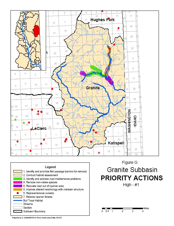
51 47
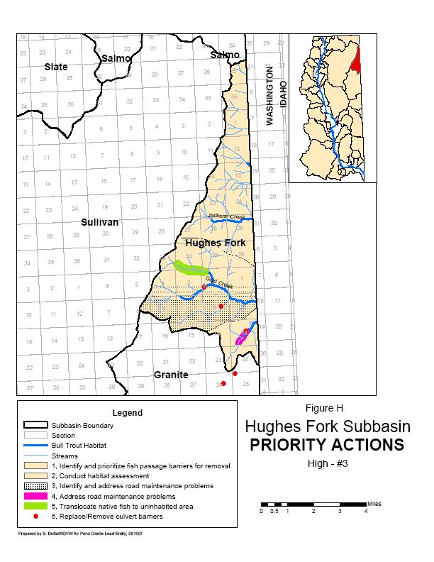
52 48
53 Cedar Creek Lunch 31 Pocahontas Pend Oreille R South Fork Jim Creek Cedar Jim Creek Sand Big Muddy Legend 1, Remove Cedar Creek Dam to restore fish passage 2, Replace/remove culvert barriers 3, Remove non-native fish 4, Repair and maintain Cedar Creek Rd (county) 5, Restore streambank stability Bull Trout Habitat Stream Pend Oreille River Subbasin Boundary Section Prepared by S. Dotts/WDFW for Pend Oreille Lead Entity; Figure I Cedar Subbasin PRIORITY ACTIONS High - #4 Miles
54 Styx Creek Slumber CANADA UNITED STATES Lime Salmo Slate Creek 18 Pend Oreille R Slumber Creek Slate 22 South Fork Slate Creek Uncas Gulch Threemile 6 5 Text 4 3 Sullivan Legend 1, Remove non-native fish 2, Replace culvert barriers Bull Trout Habitat Stream Pend Oreille River Subbasin Boundary Figure J Slate Subbasin PRIORITY ACTIONS High - #5 Section Prepared by S. Dotts/WDFW for Pend Oreille Lead Entity; Miles
55 West Branch LeClerc Creek Cedar Big Muddy Renshaw Lost East Branch LeClerc Creek Ruby 12 Lost SF Maitlen Sullivan Tioga Creek Pend Oreille R Mineral Creek LeClerc Granite White Man Creek Middle Mill Seco Creek Kalispell 2 Lamb 11 UWB Priest River Legend 1, Remove non-native fish 2, Relocate, obliterate, or reconstruct road segments 3, Riparian planting and fencing 4, Install engineered log jams 6, Conduct slope stabilization feasibility study 7, Determine causes of dewatering 5, Replace/remove culvert barriers 8, Remove log crib dam to restore fish passage Bull Trout Habitat Stream Pend Oreille River Subbasin Boundary Section Prepared by S. Dotts/WDFW for Pend Oreille Lead Entity; Figure K LeClerc Subbasin PRIORITY ACTIONS High - #6 Miles
56 Russian Lime Salmo Pee Wee Slate Threemile Flume Pend Oreille R Pend Oreille R Lunch Pocahontas Sullivan Hughes Fork Cedar Sand Maitlen Granite Big Muddy LeClerc Renshaw Lost Lookout Creek Harvey Creek Outlet Creek Hall Creek Noisy Creek Onota Creek Rocky Fork Pass Creek Stony Creek Harvey Creek Leola Creek Gypsy Creek Legend Priority, Action 1, Restore fish passage at Mill Pond Dam 2, Restore fish passage at Sullivan Lake Dam 3, Remove non-native fish 4, Relocate, obliterate, or reconstruct road segments 5, Install engineered log jams 6, Stablize slopes 7, Assess biological effects of lake management 8, Assess habitat limiting factors for Pygmy Whitefish 9, Restore habitat complexity Bull Trout Habitat Stream Pend Oreille River Section Subbasin Boundary Prepared by S. Dotts/WDFW for Pend Oreille Lead Entity; Figure L Sullivan Subbasin PRIORITY ACTIONS High - #7 Miles
57 Bead Skookum Indian Marshall Indian Creek Pend Oreille R Marshall Legend 1, Replace/remove culvert barriers 2, Screen water diversions 3, Restore fish passage at weirs 4, Instream habitat enhancement 5, Remove non-native fish Bull Trout Habitat Stream Pend Oreille River Subbasin Boundary Section Prepared by S. Dotts/WDFW for Pend Oreille Lead Entity; Figure M Indian Subbasin PRIORITY ACTIONS High - #8 Miles
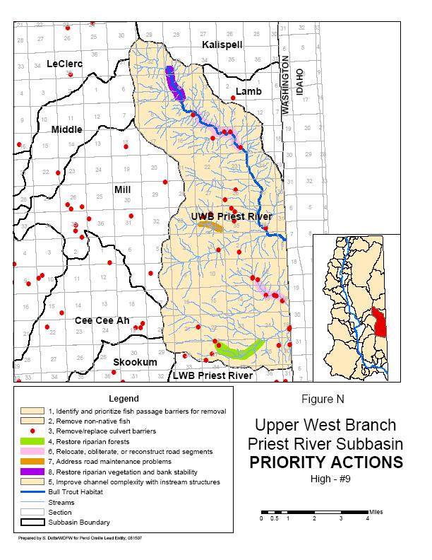
58 54
59 8 9 LeClerc Middle Wanless Creek Sylvis Creek UWB Priest River Pend Oreille R Mill 30 Nola Creek Mill Creek Cee Cee Ah 7 8 Mill Creek Legend 1, Conduct assessment of road impacts 2, Remove non-native fish 3, Replace/remove culvert barriers 4, Restore stream channel complexity 5, Restore degraded riparian habitat Bull Trout Habitat Stream Pend Oreille River Subbasin Boundary Section Figure O Mill Subbasin PRIORITY ACTIONS High - #10 Prepared by S. Dotts/WDFW for Pend Oreille Lead Entity; Miles
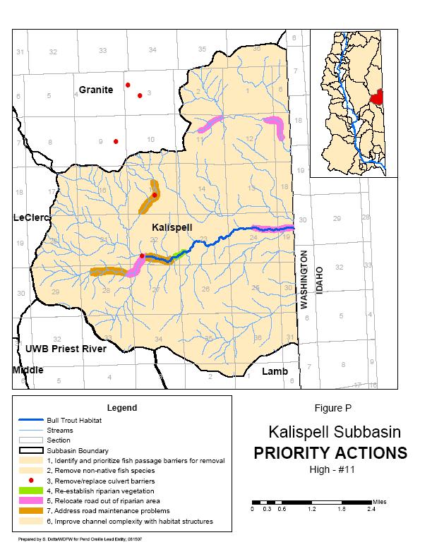
60 56
61 Mill Gardinier UWB Priest River Cusick 18 Pend Oreille R Cee Cee Ah Creek Browns Creek Cee Cee Ah Skookum Creek Tacoma Browns Creek Half Moon Creek LWB Priest River 32 Skookum Trimble Legend 1, Conduct assessment of road impacts 2, Remove non-native fish 3, Replace/remove culvert barriers 4, Restore habitat complexity 5, Reestablish riparian vegetation, fence livestock Bull Trout Habitat Stream Pend Oreille River Browns Lake Subbasin Boundary Section Prepared by S. Dotts/WDFW for Pend Oreille Lead Entity; Figure Q Cee Cee Ah Subbasin PRIORITY ACTIONS Medium - #1 Miles
62 Ruby Pend Oreille R Pend Oreille R Cusick Gardinier Tacoma 8 9 Calispell Peak Creek Tacoma Creek Pend Oreille R South Fork Tacoma Creek Calispell Trimble Legend 1, Relocate, obliterate, or reconstruct road segments 2, Non-native fish removal 3, Replace/remove culvert barriers 4, Conduct instream habitat enhancement 5, Reestablish riparian vegetation Bull Trout Habitat Stream Pend Oreille River Subbasin Boundary Section Prepared by S. Dotts/WDFW for Pend Oreille Lead Entity; Figure R Tacoma Subbasin PRIORITY ACTIONS Medium - #2 Miles
63 Calispell Tacoma Trimble ( ( Cee Cee Ah Davis Skookum Pend Oreille R Bracket Kent Legend Priority, Action 1, Restore fish passage at Calispell Pumps ( 2, Restore fish passage at Duck Club Dam ( 3, Restore fish passage at Dumb Duck Club Dam 4, Remove non-native fish 5, Conduct assessment of road impacts 6, Remove/replace culvert barriers 7, Riparian restoration 8, Restore upland riparian vegetation 9, Restore floodplain connectivity 10, Restore instream habitat Bull Trout Habitat Section Stream Calispell Lake Pend Oreille River Subbasin Boundary Figure S Calispell Subbasin PRIORITY ACTIONS Medium - #3 Miles Prepared by S. Dotts/WDFW for Pend Oreille Lead Entity;
64 Lost Lost SF North Fork Ruby Creek LeClerc Pend Oreille R Ruby Ruby Creek Tacoma Cusick Gardinier Legend 1, Non-native fish removal 2, Replace/remove culvert barriers 3, Relocate, obliterate, or reconstruct road segments 4, Fence riparian area 5, Restore habitat complexity and pool habitat Bull Trout Habitat Stream Pend Oreille River Subbasin Boundary Section Figure T Ruby Subbasin PRIORITY ACTIONS Medium - #4 Miles Prepared by S. Dotts/WDFW for Pend Oreille Lead Entity;
65 IX. PROJECT EVALUATION AND RANKING CRITERIA The Salmon Recovery Act provides an annual opportunity for the Pend Oreille Lead Entity to submit a list of salmonid habitat protection and improvement projects to the Salmon Recovery Funding Board (SRFB) for funding consideration. The SRFB is authorized by the Washington Legislature to fund projects that are targeted at salmonid recovery activities and projects statewide. Criteria were developed by the Pend Oreille Salmonid Recovery Team to evaluate and rank projects for submittal to the SRFB. The criteria strive to integrate science with community goals and objectives. The Pend Oreille Salmonid Recovery Team will use a two-step approach to evaluate and rank projects. For the first step, the TAG will use a consensus-based approach to evaluate individual projects for benefit to salmonids and certainty of success based how well the project meets the following criteria (see Appendix C for details). Project evaluations will be provided to the CAG to be considered during project ranking. Benefit to Salmonids Does the project addresses high priority habitat features and/or watershed processes? Is the project located in a high priority subbasin? Has the project been identified through a documented habitat assessment? Does the project address multiple species or unique populations of salmonids essential for recovery or ESA-listed species or non-listed species primarily supported by natural spawning? Does the project address an important life history stage or habitat types? Does the project have a low cost relative to the predicted benefits? Certainty of Success Is project scope appropriate to meet its goals and objectives? Is project consistent with proven scientific methods? Is project in correct sequence and independent of other actions being taken first? Does project address a high potential threat to salmonid habitat? Does the project clearly describe and fund stewardship of the area/facility for more than 10 years? Is the project landowner willing to have the project done on property? Can the project be successfully implemented or are there constraints which may limit project success? In the second step, the CAG will use a consensus-based approach to rank each project based on evaluation provided by the TAG and the following criteria (see Appendix D for details). 61
66 What is the projects current level of local community support? How well will the project help promote community support for the overall salmonid recovery effort in WRIA 62? How well does the project proposal address the socioeconomic concerns identified by the strategy? Is the project a justifiable use of public funds? The POSRT will submit the final prioritized project list to the SRFB for funding consideration. The SRFB will make its funding decision based on an evaluation of the quality of this strategy document and how well the project list addresses the priorities and actions identified in this strategy. A technical review of individual projects on the list will also be done by the SRFB to verify that the projects are technically sound. X. COMMUNITY ISSUES A. LANDOWNER SUPPORT The primary level of community support evaluation when considering any project or proposed action is landowner support. Each project must have full support of the landowner before being ranked by the CAG for submission to the SRFB in the Habitat Project list. A great deal of effort, by members of both Citizens and Technical advisory groups and Lead Entity staff, has and will continue to focus on acquiring this landowner commitment for priority actions during the development of each habitat project list in accordance with the technical guidance provided in this strategy. B. ASSESSING COMMUNITY SUPPORT AND CONCERN In addition to acquiring individual landowner support for specific projects, the level of community support and concern for the priority actions and areas was evaluated. Considering the level of community interest, issues and concerns about priority actions are often different depending on the subbasin for which those actions are proposed, CAG members surveyed landowners within each high and medium priority subbasin as well as WRIA-wide to identify the level community support for each action on the Priority Actions and Areas Table (Table 4). As well as identifying the current level of community support present for each action in each subbasin, a number of general socioeconomic issues and concerns were identified through the surveys and citizens group members. The identified issues and concerns include a recovery and or protection action s affect on the following: Local industry and landowner ability to avoid undue economic hardship by sustaining adequate use of natural resources Continued outdoor recreation, hunting and fishing opportunities Continued resource-based economic activity (logging, farming and mining) Retaining the rural character of the land Preservation of flood control Further restricting access to public lands 62
67 In the column labeled Community Support on the Priority Actions and Areas Table (Table 4) each action was given a value of: high, moderate, low or very low; or more information required (MIR). These values are defined as: High: action in the specified area has strong community support with little or no identified community concern : action in the specified area has support from the majority of the community with a minority of the community concerned Low: action in the specified area has support from the minority of the community Very Low: action in the specified area has little or no identified community support with a strong level of community concern. More Information Required: actions recently proposed which require future evaluation. The value given for level of Community Support does not include the portion of the public that is indifferent or oblivious to the process. This approach was taken by the CAG so a project sponsor would not over estimate the actual level community support for a given action or under estimate the possible need for education or promotion of that action. Actions identified as having high or moderate community support are actively promoted to project sponsors and when sponsored are prioritized, by the CAG, both on their current level of community support and their ability to develop support for the salmonid recovery process in the future (see Appendix D). C. BUILDING COMMUNITY SUPPORT The Citizens Advisory Group supports, develops and conducts public outreach through community education projects and partnerships designed to build community support for priority salmonid habitat protection and restoration projects in the Lead Entity Area. The CAG applied for and received funding to support these outreach efforts in 2005 and again in Since 2005, outreach efforts have included: Surveys: Two landowner surveys to assess understanding of citizens in the watershed about the need for recovery efforts and willingness of landowners to allow access for project implementation. The first survey focused on stream front landowners in specific subbasins, and the second focused on assessing the level of support and areas of concerns of randomly selected Pend Oreille County citizens. Survey results are being used to prioritize areas needing educational outreach as well as to assist the CAG in ranking future projects. Brochures: A program information brochure was produced to assist with CAG member recruitment and to enhance community awareness of recovery efforts. A project solicitation brochure was also produce describing types of eligible projects as well as testimony from landowners about successful projects. Logo Contest: A Pend Oreille Salmonid Recovery Team logo contest was conducted through area schools, and artwork by a local high school student was selected for the conceptual logo design. The logo was incorporated into a Fish Identification Card design to enhance visibility of the Recovery Team. 63
68 Fish Identification Cards: 2000 folding Fish ID cards were produced for distribution throughout the watershed through fishing license and supply vendors, as well as community and school education events. The cards include detailed information and descriptions of six varieties of trout found in the watershed, highlighting the current status of bull trout and westslope cutthroat trout, and are designed to fit in fish license holders or tackle boxes. The cards also include the POSRT logo and contact information. These products continue to be included in ongoing and future outreach efforts. The 2007 POSRT Citizen Fish Habitat Partnership outreach program places an emphasis on community partnerships to enhance outreach effectiveness and increase dissemination of recovery goals, objectives and specific project information. This program will provide forums for both adult and youth education, and will create enjoyable and entertaining opportunities for volunteer stewardship activities, bringing together citizens with diverse points of view to create common ground and incentives for habitat protection and community support of recovery efforts. Specific goals of the program are: Increase and maintain community awareness of successful past salmonid recovery and enhancement projects, as well as those in progress and proposed, through an annual community bus tour and picnic, inviting citizens, landowners, federal, state and local officials, tribal representatives and funders. Conduct public forums on the Recovery Team s habitat restoration strategy, current recovery efforts and specific projects. A special effort will be made to reach farmers, ranchers, small acreage landowners and timber harvesters with speakers from within these fields to share success stories, best practices, and bull trout recovery solutions from around the Northwest, including Idaho and Montana. Increase public awareness of the need for salmonid recovery through a series of artsscience events, such as fish recovery documentary movie showings, a photography contest and exhibit of fish habitat and recovery project sites, an artist-scientist collaboration resulting in artistic creations and an exhibit related to fish habitat restoration, and hands-on youth education projects. Provide education and recruit citizen participants to the CAG by participating as a primary partner in the Pend Oreille Rain Garden Challenge. This project brings together community partners and citizen volunteers to address non-point pollution sources of stormwater runoff and sediment in the Pend Oreille River Watershed, focusing on bull trout critical habitat areas, lake and streamside communities, and urban settings which deposit to the Pend Oreille River. The Rain Garden project will support habitat restoration through creation of bio-retention swales with native plants and riparian buffer plantings, involving three demonstration sites and numerous private landowner raingardens. Increase public response to annual project solicitation through the promotion of the above activities. D. PRIORITIES FOR COMMUNITY SUPPORT ACTIONS In general actions with low community support will be prioritized for support building activities based on subbasin priority, the rank of an action within a priority subbasin, and the ability of the 64
69 activity to achieve long and short term goals of the Strategy. Prioritized low support actions will be promoted though continual educational events including: guest speakers at local public and Recovery Team CAG meetings and field trips for project sponsors, landowners and citizens to past project sites of similar actions or in adjacent subbasins. The Lead Entity will actively promote sponsorship of habitat improvement actions in areas enjoying higher levels of community support which are similar to those priority actions in areas with low community support including: Pilot studies and priority actions located in adjacent subbasins which have similar limiting factors Priority actions on public lands (i.e. with landowner support) within a low community support, high priority subbasin addressing limiting factors similar to those present on the privately owned reaches. Projects currently believed to be able to promote public support will include or address one of the following: Project focuses on priority areas currently supporting known populations of bull trout Project increases or maintains access to public lands Project encompasses the last (final) recommended recovery action(s) in the subbasin As the first step to achieve a higher level of understanding of the community support and concerns regarding priority actions in priority areas, the CAG produced a survey for water front landowners with questions relating specifically to actions proposed in their subbasin. Results of that survey were used to: place a level of public and or landowner support on each action currently recommended in each priority area refine the list of educational events and activities identify additional areas of community support, at the subbasin level, for priority habitat improvement activities enhance the knowledge of the current community representatives as to public support for newly proposed projects. An additional survey was conducted of residents WRIA wide to complete the picture of community support and concern for actions suggested in this strategy. XI. SUMMARY This revision of the Pend Oreille Lead Entity Salmonid Recovery Team Strategy includes answers to the SRFB request for a unified vision of future salmonid habitat conditions, short and long-term goals needed to reach that vision. This strategy also includes a list of prioritized actions and areas for habitat improvement and protection of priority ESA listed species to guide future project sponsors, landowners and SRFB funding in reaching each goal. This Strategy 65
70 includes the most current scientific and community information available, describing the most efficient method of improving native salmonid habitat and will be implemented and updated continually to insure successful habitat restoration is achieved. XII. REFERENCES CITED Andersen, T Personal communication. Kalispel Tribe Natural Resource Department, Fish Program, Usk, Washington. Andersen, T Personal communication. Kalispel Tribe Natural Resource Department, Fish Program, Usk, Washington. Ashe, B.L., K.L. Lillengreen, J.J. Vella, L.O. Clark, S. Graves, M.R. Barber, G.J. Nenema Jr., A.T. Scholz Assessment of the fisheries improvement opportunities on the Pend Oreille River Annual Report. Prepared for the U.S. Department of Energy, Bonneville Power Administration, Division of Fish and Wildlife. Project No Upper Columbia United Tribes Fisheries Center, Department of Biology, Eastern Washington University, Cheney, WA. 350 pp. Barber, M.R., B.L. Renberg, J.J. Vella, A.T. Scholz, K.L. Woodwards, and S. Graves Assessment of the fishery improvement opportunities on the Pend Oreille River, Appendices for 1989 Annual Report. Prepared for the U.S. Department of Energy, Bonneville Power Administration, Division of Fish and Wildlife. Project No by the Upper Columbia United Tribes Fisheries Center, Department of Biology, Eastern Washington University, Cheney, WA. Baxter, J studies in the Salmo River watershed: Rpt prepared for B.C. Hydro. 14 pp. Baxter, J studies in the Salmo River watershed: Rpt. Prepared for B.C. Hydro by Mountain Water Research. 14pp. Bennett, D.H. and M. Liter Water quality, fish and wildlife characteristics of Box Canyon Reservoir, Washington. Completion Report Section 3: Fish. Department of Fish and Wildlife Resources, College of Forestry, Wildlife and Range Sciences, University of Idaho. 94 pp. Dames and Moore, and Cosmopolitan Engineering Group Draft Initial Watershed Assessment Water Resource Inventory Area 62 Pend Oreille River Watershed. Open file technical report Prepared in cooperation with Washington State Department of Ecology. DE&S Comment #8 (Re: Calispell Creek and its tributaries). Response to FERC s Additional Information Request (AIR); Box Canyon Hydroelectric Project. Pend Oreille Public Utility District No. One, Newport, WA. Ecology Clean Water Act Section 303(d) listed water quality segments. Olympia, Wa. 66
71 Ecology Washington s water quality assessment 303(d) and 305(b) report. Olympia, Wa. Fairchild, M Personal communication. Idaho Panhandle National Forest. Priest Lake Ranger District, Priest River, Idaho. Fandrich, B., L.M. Peterson, and S. Deaver A cultural history of the Kalispel Indians. Draft. Prepared by Ethnoscience, Inc., Billings, MT for Kalispel Tribe Department of Natural Resources. GEI Consultants, Inc Intermountain Province subbasin plan. Missoula, MT. Geist, D.R., R.S. Brown, A.T. Scholz, and B. Nine Movement and Survival of Radiotaged Bull Trout Near Albany Falls Dam. Prepared by Battelle Pacific Northwest Division, Seattle WA for the Department of Army, Seattle Dist. Core of Engineers. Project # pp. Gilbert, C.H. and B.W. Evermann A report upon investigations in the Columbia River Basin, with descriptions of four new species of fish. The Miscellaneous Documents of the Senate of the U.S. for the Second Session of the 53 rd Congress, Volume 8. Washington: Government Printing Office. Gunckel, S.L., A.R. Hemmingsen, and J.L. Li Effect of bull trout interactions on foraging habitat, feeding behavior, and growth. Transactions of the American Fisheries Society. 131: Hallock, M., and P.E. Mongillo Washington State status report for the pygmy whitefish. Wash. Dept. Fish and Wildl. Olympia. 20 pp. Irving, D.B Cutthroat abundance, potential yield, and interaction with brook trout in Priest Lake tributaries. M.S. thesis. University of Idaho, Moscow. 232 pp. KNRD and WDFW Kalipsel Resident Fish Project Annual Report Document No. DOE/BP Prepared for the Bonneville Power Administration, Portland, Oregon. KNRD Kalispel Resident Fish Project Annual Report Prepared for Bonneville Power Administration, Portland, Oregon. KNRD Kalispel Resident Fish Project Annual Report Prepared for Bonneville Power Administration, Portland, Oregon. R2 Resource Consultants, Inc Draft data report, Boundary Hydroelectric Project Bull Trout Field Investigations. Prepared by R2, Redmond, WA and submitted to Seattle City Light, Environmental and Safety Division, Seattle, WA. 67
72 Shaklee and Young A Microsattelite DNA-based analysis of Population Structure of Cutthroat Trout (Oncorhynchus clarki) in the Pend Oreille Basin in Washington. Washington Department of Fish and Wildlife. Shuhda, T Personal communication. Colville National Forest, Fish Program Manager, Colville, Washington. WCC Bull Trout habitat limiting factors: Water Resource Inventory Area 62, Pend Oreille Watershed. 477 pp. USFWS Status review for westslope cutthroat trout in the United States. Regions 1 and 6, Portland, Oregon and Denver, Colorado. 188 pp. USFWS Chapter 23, Northeast Washington Recovery Unit, Washington. 73 p. In USFWS. Bull Trout (Salvelinus confluentus) Draft Recovery Plan. Portland, Oregon. Vail, C Personal communication. Washington Department of Fish and Wildlife, Northeast Washington Fish Biologist, Colville, Washington. WDFW Washington salmonid stock inventory; Appendix: and Dolly Varden. WDFW Fish Program, Olympia, WA. 437 pp. Wydoski, R.S. and R.L. Whitney Inland Fishes of Washington. University of Washington Press. Seattle, WA. 322 pp. 68
73 APPENDIX A Summary of SRFB Funded Projects in WRIA 62 69


74 Slumber Russian Lime Pee Wee Slate Flume Threemile Lunch Pocahontas Sullivan Cedar Sand Salmo Hughes Fork Cee Cee Ah Creek Fish Passage Restoration FUNDING SOURCE AMOUNT Salmon Recovery Funding Board 76,589 Local Match 76,823 TOTAL PROJECT COST: $ 152,412 YEAR FUNDED: 1999 STATUS: Completed Big Muddy Maitlen Granite Renshaw Lost Lost SF Ruby LeClerc Middle Kalispell Lamb Mill CusickGardinier UWB Priest River Pend Oreille R Tacoma Cee Cee Ah BEFORE Trimble LWB Priest River Skookum Bead Calispell Indian Marshall Bracket Davis McCloud Kent AFTER This project was funded by the SRFB in 1999 to restore fish passage in Cee Cee Ah Creek at the LeClerc Road crossing. The existing double culvert was a velocity barrier for native fish migrating upstream at spring high flows. A 24 span, 32 wide, 6 high concrete modular arch was installed. Habitat enhancements in conjunction with the project included log and boulder placement for velocity refuge and cover. The project was a joint effort between the Pend Oreille County Public Works and Kalispel Tribe. 70


75 Russian Pee Wee Slumber Lime Slate Salmo East Branch LeClerc Road Abandonment Project Flume Threemile Lunch Pocahontas Cedar Sand Maitlen Big Muddy Renshaw Sullivan Hughes Fork Granite FUNDING SOURCE AMOUNT Salmon Recovery Funding Board 202,000 Federal Highway Administration 57,000 Pend Oreille County P.U.D. #1 120,295 Colville National Forest 280,000 Kalispel Tribe 2,000 TOTAL PROJECT COST: $ 661,295 YEAR FUNDED: 2001 STATUS: Active Lost Lost SF Ruby LeClerc Middle Kalispell Lamb Mill CusickGardinier UWB Priest River Pend Oreille R Tacoma Cee Cee Ah BEFORE Trimble LWB Priest River Skookum Bead Calispell Indian Marshall Bracket Davis McCloud Kent AFTER The LeClerc Creek drainage is a documented spawning and rearing stream for bull and cutthroat trout. It is one of the streams within WIRA 62 that has the potential for contributing to species recovery. In 1996, Stimson Lumber Co. completed a watershed assessment of this drainage and identified approximately two miles of cost share road on US Forest Service (USFS) land that contributed excessive sediment to the stream. In 1999, the USFS completed phase one of the project by constructing a new road on USFS land upslope of the riparian road to be abandoned. To date, the Kalispel Tribe and the USFS have successfully rehabilitated approximately 1.5 miles of the abandoned road, including stabilization of a large mass wasting site associated with the abandoned road. Original contours were reestablished eliminating the old roadbed and the area was re-vegetated. This included the restoration of aquatic and terrestrial habitat as well as improved hydrology. 71

76 Russian Slumber Lime Pee Wee Slate Flume Threemile Lunch Pocahontas Sullivan Cedar Sand Maitlen Big Muddy Renshaw Lost LeClerc Lost SF Salmo Hughes Fork Granite Kalispell Middle Branch LeClerc Creek Bull Trout Project FUNDING SOURCE AMOUNT Salmon Recovery Funding Board 39,993 Local Match 12,720 TOTAL PROJECT COST: $ 52,713 YEAR FUNDED: 2001 STATUS: Partially Completed Funds returned to SRFB Ruby Middle Lamb Mill CusickGardinier UWB Priest River Pend Oreille R Tacoma Cee Cee Ah Trimble LWB Priest River Skookum Bead Calispell Indian Marshall BracketMcCloud Davis Kent LeClerc Creek, a tributary to Box Canyon Reservoir on the Pend Oreille River, is one of only a few streams where successful bull trout reproduction has been documented in WRIA 62. Lack of spawning and over-wintering habitat, high summer water temperatures, and competition from non-native eastern brook are limiting factors to the persistence of the species in the LeClerc subbasin. This project has replanted and fenced overgrazed riparian areas along the Middle Branch of LeClerc Creek improving spawning and overwintering habitat and improving water temperatures. Proposed use of antimycin to remove non-native fish from the Middle Branch has been postponed and funds for this part of the project have been returned to the SRFB. 72

77 Russian Pee Wee Slumber Lime Slate Salmo Pend Oreille Barrier Survey Flume Threemile Lunch Pocahontas Sullivan Cedar Sand Big Muddy Maitlen Renshaw Hughes Fork Granite FUNDING SOURCE AMOUNT Salmon Recovery Funding Board 221,000 Local Match 39,000 TOTAL PROJECT COST: $ 260,000 YEAR FUNDED: 2002 STATUS: Completed Lost Lost SF Ruby LeClerc Middle Kalispell Lamb Mill CusickGardinier UWB Priest River Pend Oreille R Tacoma Cee Cee Ah Trimble LWB Priest River Skookum Bead Calispell Indian Marshall BracketMcCloud Davis Kent In 2003 and 2004, the Pend Oreille Conservation District surveyed over 50 miles of stream in WRIA 62 and identified 115 fish passage barriers. In 2004, the Kalispel Tribe, a project partner, determine fish species composition and densities above and below these barriers. The barriers will then be prioritized for correction and new potential SRFB projects will be generated to remove these barriers and restore fish passage for threatened bull trout and other species. This was the first comprehensive fish passage barrier survey to be completed on private lands in WRIA 62 and is an integral part of restoring bull trout to the Pend Oreille watershed. 73

78 Slumber Russian Lime Pee Wee Slate Flume Threemile Lunch Pocahontas Sullivan Cedar Sand Salmo Hughes Fork Willow Creek Aquatic Restoration FUNDING SOURCE AMOUNT Salmon Recovery Funding Board 189,772 Local Match 36,755 TOTAL PROJECT COST: $ 226,527 YEAR FUNDED: 2002 STATUS: Active Big Muddy Maitlen Granite Renshaw Lost Lost SF Ruby LeClerc Middle Kalispell Lamb Mill CusickGardinier UWB Priest River Pend Oreille R Tacoma Cee Cee Ah Trimble LWB Priest River Skookum Bead Calispell Indian Marshall Bracket Davis McCloud Kent This project will improve salmonid habitat in the N.F. Granite Creek and Willow Creek drainages through decommissioning 8.4 miles of unstable U.S. Forest Service roads. Road problems include: a chronic source of sediment to the streams from mass wasting, undersized and plugged relief culverts, nonfunctioning ditchlines, and culverts blocking fish passage. Budget reductions have prevented adequate road maintenance. The N.F. Granite Creek drainage supports adfluvial bull trout and resident westslope cutthroat trout. Direct benefits to native salmonids from this project will be protection and enhancement of existing spawning/rearing habitat. Fish habitat will be improved by restoring habitat connectivity and by removing the failing road system that is delivering sediment to the channel. 74
 880 WDFW match (in-kind) 3,000 POCD match (in-kind) 4,800 TOTAL PROJECT COST: $131,797 YEAR FUNDED: 2004 STATUS: Completed Big Muddy")

79 O'Donnell Fish Passage Restoration Slumber Russian Lime Pee Wee Slate Flume Threemile Lunch Pocahontas Sullivan Cedar Sand Salmo Hughes Fork FUNDING SOURCE AMOUNT Landowner Incentive Program 49,517 Partners for Fish and Wildlife 73,600 Landowner match (in-kind) 880 WDFW match (in-kind) 3,000 POCD match (in-kind) 4,800 TOTAL PROJECT COST: $131,797 YEAR FUNDED: 2004 STATUS: Completed Big Muddy Renshaw Maitlen Granite Lost Lost SF Ruby LeClerc Middle Kalispell Lamb Mill CusickGardinier UWB Priest River Pend Oreille R Tacoma Cee Cee Ah BEFORE Trimble LWB Priest River Skookum Bead Calispell Indian Marshall Bracket Davis McCloud Kent AFTER This project restored fish passage to about 1 mile of Cedar Creek, a tributary to the Pend Oreille River. Two significant partial passage barriers were removed, a culvert barrier (photo above) and an old log crib dam. The stream channel was reconstructed and instream channel complexity improved with the installation of an engineered log jam. Native riparian vegetation was planted to restore shade and cover to the stream channel. This project is part of a large watershed-scale effort to completely restore fish passage to Cedar Creek, a high priority subbasin in the Pend Oreille Lead Entity area and a stream recently designated by the USFWS as bull trout Critical Habitat. 75


80 Russian Slumber Lime Pee Wee Slate Flume Threemile Salmo Cedar Creek Fish Passage Restoration FUNDING SOURCE AMOUNT Salmon Recovery Funding Board 810,455 Local Match 174,538 TOTAL PROJECT COST: $ 984,993 YEAR FUNDED: 2004 STATUS: Completed Lunch Pocahontas Sullivan Hughes Fork Cedar Sand Big Muddy Maitlen Granite Renshaw Lost Lost SF Ruby LeClerc Middle Kalispell Lamb Mill CusickGardinier UWB Priest River Pend Oreille R Tacoma Cee Cee Ah Trimble LWB Priest River Skookum Bead Calispell Indian Marshall BracketMcCloud Davis Kent The Cedar Creek Fish Passage Restoration Project restored fish passage to approximately 12 miles of native salmonid habitat, including several miles of federally designated Critical Habitat for bull trout, a threatened species under the Endangered Species Act. The project restored stream channel form and function, including wood and sediment transport, substantially reduced and/or eliminated point-source water quality problems, restored riparian and floodplain cover, and eliminated risk to public health and safety from potential dam failure. 76

81 Russian Slumber Lime Pee Wee Slate Flume Threemile Salmo Indian Creek Fish Passage Restoration Lunch Pocahontas Cedar Sand Maitlen Big Muddy Renshaw Sullivan Hughes Fork Granite FUNDING SOURCE AMOUNT Family Forest Fish Passage Prog. 85,975 Landowner Incentive Program 13,886 Sponsor/Landowner Match 2,000 TOTAL PROJECT COST: $ 101,861 YEAR FUNDED: 2005 STATUS: Active Lost Lost SF LeClerc Kalispell Ruby Middle Lamb Mill CusickGardinier UWB Priest River Pend Oreille R Tacoma Cee Cee Ah Trimble LWB Priest River Skookum Bead Calispell Indian Marshall Bracket Davis McCloud Kent This project will restore fish passage for bull trout (ESA threatened) and westslope cutthroat trout to Indian Creek, a tributary to the Pend Oreille River. Three fish passage barriers will be removed and access to about two miles of habitat will be restored. 77

82 Slumber Russian Lime Pee Wee Slate Flume Threemile Lunch Pocahontas Sullivan Cedar Sand Maitlen Big Muddy Renshaw Salmo Hughes Fork Granite Indian Creek Diversion Screening FUNDING SOURCE AMOUNT Salmon Recovery Funding Board 113,735 Landowner Incentive Program 29,874 Local Match 1,160 TOTAL PROJECT COST: $ 144,769 YEAR FUNDED: 2005 STATUS: Active Lost Lost SF Ruby LeClerc Middle Kalispell Lamb Mill CusickGardinier UWB Priest River Pend Oreille R Tacoma Cee Cee Ah Trimble LWB Priest River Skookum Bead Calispell Indian Marshall Bracket Davis McCloud Kent This project will reduce mortality of fry, juvenile and adult salmonids, including ESA-listed bull trout, caused by water withdrawl and diversion from Indian Creek. Three insufficiently screened water diversions will be screened to meet WDFW and USFWS screening requirements. The project will also improve fish passage at one of the diversions, which currently functions as a partial fish passage barrier. Water quantity in Indian Creek will be increased by improving diversion efficiency. One of the diversions currently utilizes an inefficient open ditch conveyance which will be converted to a pipe conveyance. This project is identified in the Pend Oreille Lead Entity strategy as the #2 priority action in the Indian Creek subbasin, a hight priority area in WRIA 62. The project will occur in conjunction with other Indian Creek fish passage improvements currently underway through funding from the Family Forest Fish Passage and Landowner Incentive programs. 78

83 Russian Pee Wee Slumber Lime Slate Salmo Priest Basin Barrier Assessment Flume Threemile Lunch Cedar Big Muddy Pocahontas Sand Maitlen Sullivan Hughes Fork Granite FUNDING SOURCE AMOUNT Salmon Recovery Funding Board 85,563 Local Match 20,282 TOTAL PROJECT COST: $ 105,845 YEAR FUNDED: 2005 STATUS: Active Renshaw Lost Lost SF Ruby LeClerc Middle Kalispell Lamb Mill CusickGardinier UWB Priest River Pend Oreille R Tacoma Cee Cee Ah Trimble LWB Priest River Skookum Bead Calispell Indian Marshall Bracket Davis McCloud Kent This project will identify fish passage barriers, utilize priority habitat indexing (to quantify available habitat and its quality) and rank barriers for correction (using WDFW Priority Indexing). Conceptual design will be provided for the top five prioritized barriers. This is a cooperative project between the Pend Oreille Conservation District and the Idaho Panhandle National Forest that will assess 100+ miles of stream and well over an estimated 150 road-based stream crossings within the Priest River portion of the Pend Oreille watershed. The Forest Service has completed a culvert inventory within the portions of these subbasins that occur in Idaho. This coordinated effort will meet data needs for both WDFW and the Forest Service. The project will assess streams on public and private lands, from the state border upstream to the limits of fish distribution. 79

84 Russian Pee Wee Slumber Lime Slate Salmo Mineral Creek Passage Project Threemile Flume Lunch Pocahontas Sullivan Cedar Sand Maitlen Big Muddy Renshaw Hughes Fork Granite FUNDING SOURCE AMOUNT Salmon Recovery Funding Board 85,650 Local match 19,000 TOTAL PROJECT COST: $ 104,650 YEAR FUNDED: 2006 STATUS: Active Lost Lost SF Ruby LeClerc Middle Kalispell Lamb Mill CusickGardinier UWB Priest River Pend Oreille R Tacoma Cee Cee Ah Trimble LWB Priest River Skookum Bead Calispell Indian Marshall Bracket Davis McCloud Kent An impassable culvert will be replaced with a bottomless arch on Forest Service Rd on Mineral Creek in T37N, R44E, SW ¼, NW1/4, Sec 33. Replacing this culvert would create new access for bull trout, westslope cutthroat trout and other native species to approximately 2 miles of suitable spawning and rearing habitat. Another benefit of the project is the restoration of stream channel form and function to a 100+ foot section of Mineral Creek above the present culvert that is presently smaller than the bankful width of the stream. l Mineral Creek is a tributary to the West Branch Le Clerc Creek which is a tributary to Le Clerc Creek, a tributary to the Pend Oreille River in northeast Washington (WRIA 62). Historically, migratory bull trout from Lake Pend Oreille migrated down the Pend Oreille River and spawned and reared in tributaries to the river such as Le Clerc Creek. Le Clerc Creek is one of only two watersheds in the Washington portion of WRIA 62 that has recent successful spawning of bull trout. Historically, there were no barriers, in the watershed prior to historic log flume and relatively recent road construction. 80

85 Slumber Russian Lime Pee Wee Slate Threemile Flume Lunch Pocahontas Sullivan Cedar Sand Maitlen Big Muddy Salmo Hughes Fork Granite Whiteman Creek Passage Project FUNDING SOURCE AMOUNT Salmon Recovery Funding Board 82,275 Local match 14,575 TOTAL PROJECT COST: $ 96,850 YEAR FUNDED: 2006 STATUS: Active Renshaw Lost Lost SF Ruby LeClerc Middle Kalispell Lamb Mill CusickGardinier UWB Priest River Pend Oreille R Tacoma Cee Cee Ah Trimble LWB Priest River Skookum Bead Calispell Indian Marshall Bracket Davis McCloud Kent Impassable twin culverts will be replaced with a bottomless arch on Forest Service Rd on Whiteman Creek in T37N, R44E, SE ¼, SW1/4, Sec 29. Replacing these culverts would create new access for bull trout, westslope cutthroat trout and other native species to approximately 2 miles of suitable spawning and rearing habitat. Another benefit of the project is the restoration of stream channel form and function to a 150+ foot section of Whiteman Creek above the present culvert that is presently a depositional area for waters backed up by culverts of insuff-icient size for high flow periods. Whiteman Creek is a tributary to the West Branch Le Clerc Creek which is a tributary to Le Clerc Creek, a tributary to the Pend Oreille River in northeast Washington (WRIA 62). Historically, migratory bull trout from Lake Pend Oreille migrated down the Pend Oreille River and spawned and reared in tributaries to the river such as Le Clerc Creek. Le Clerc Creek is one of only two watersheds in the Washington portion of WRIA 62 that has recent successful spawning of bull trout. Historically, there were no barriers, in the watershed prior to historic log flume and recent road construction. 81

86 Slumber Russian Lime Pee Wee Slate Threemile Flume Salmo South ForkTacoma Creek Passage Project Lunch Cedar Big Muddy Pocahontas Sand Maitlen Sullivan Hughes Fork Granite FUNDING SOURCE AMOUNT Salmon Recovery Funding Board 145,647 Local match 25,703 TOTAL PROJECT COST: $ 171,350 YEAR FUNDED: 2005 STATUS: Active Renshaw Lost Lost SF Ruby LeClerc Middle Kalispell Lamb Mill CusickGardinier UWB Priest River Pend Oreille R Tacoma Cee Cee Ah Trimble LWB Priest River Skookum Bead Calispell Indian Marshall Bracket Davis McCloud Kent This project will replace a pipe arch culvert with a bottomless arch on a Forest Service road on the NF of the SF of Tacoma Creek in WRIA 62, restoring fish passage for bull trout, westslope cutthroat trout and other native species to approx. 3 miles of suitable spawning and rearing habitat. The project will also restore stream channel form and function to a 100' section of stream above the present fish passage barrier. The NF of the SF of Tacoma Creek is a tributary to Tacoma Creek, a tributary to the Pend Oreille River in northeastern Washington. Historically, bull trout from Lake Pend Oreille migrated down the Pend Oreille River and spawned and reared in tributaries to the Pend Oreille River such as Tacoma Creek. Historically there were no fish passage barriers in the Tacoma Creek subbasin except for an impassible falls on Calispel Peak Creek, another tributary to Tacoma Creek. The remainder of the subbasin, including the project area, was accessible to bull trout prior to road construction. 82

87 Slumber Russian Lime Pee Wee Slate Threemile Flume Salmo Hungry-Deer Watershed Restoration Lunch Cedar Big Muddy Pocahontas Sand Maitlen Sullivan Hughes Fork Granite FUNDING SOURCE AMOUNT Salmon Recovery Funding Board 161,547 Local match 34,056 TOTAL PROJECT COST: $ 195,603 YEAR FUNDED: 2006 STATUS: Active Renshaw Lost Lost SF Ruby LeClerc Middle Kalispell Lamb Mill CusickGardinier UWB Priest River Pend Oreille R Tacoma Cee Cee Ah Trimble LWB Priest River Skookum Bead Calispell Indian Marshall Bracket Davis McCloud Kent The Hungry-Deer Watershed Restoration project is part of a larger ecosystem-based aquatic restoration effort, which includes a concurrent project funded by BPA to restore adjacent bull trout habitat in the Kalispell subbasin. Jointly the projects will compliment and enhance the effectiveness of each other. Objectives of the project are to: 1) Remove 6.3 miles unstable, abandoned roads that ar chronically delivering sediment to streams within the Kalispell subbasin; 2) Stabilize all soils disturbed during construction with seeding, mulching, and fertilizing; 3) Chemically treat noxious weed infestations both pre- and post-project implementation, and 4) Improve in-stream habitat for salmonids by replacing large wood complexes and groupings at 21 locations throughout the project area. 83

88 Russian Pee Wee Slumber Lime Slate Salmo Tacoma Creek Passage Project Flume Threemile Lunch Cedar Big Muddy Pocahontas Sand Maitlen Sullivan Hughes Fork Granite FUNDING SOURCE AMOUNT Salmon Recovery Funding Board 343,102 Local match 60,548 TOTAL PROJECT COST: $ 403,650 YEAR FUNDED: 2005 STATUS: Active Renshaw Lost Lost SF Ruby LeClerc Middle Kalispell Lamb Mill CusickGardinier UWB Priest River Pend Oreille R Tacoma Cee Cee Ah Trimble LWB Priest River Skookum Bead Calispell Indian Marshall Bracket Davis McCloud Kent This project will replace an impassable culvert with a bridge or bottomless arch on a Pend Oreille County road on Tacoma Creek, restoring fish passage for bull trout, westslope cutthroat trout, and other native species to 14 miles of suitable spawning and rearing habitat in a subbasin which contains designated critical habitat for bull trout, a threatened species under ESA. The project will also restore stream channel form and function to a 300'+ section of Tacoma Creek in the project area. Tacoma Creek is a tributary to the Pend Oreille River in northeastern Washington (WRIA 62). Historically, bull trout from Lake Pend Oreille migrated down the Pend Oreille River and spawned and reared in tributaries to the river such as Tacoma Creek. Historically there were no barriers to bull trout migration except for an impassable falls on Calispell Peak Creek, a tributary to Tacoma Creek upstream of the project area. The remainder of the Tacoma Creek subbasin was accessible to bull trout prior to road construction. 84
Burns Paiute Tribe Fisheries Department. Evaluate The Life History Of Native Salmonids Within The Malheur Subbasin Project #
 Burns Paiute Tribe Fisheries Department Evaluate The Life History Of Native Salmonids Within The Malheur Subbasin Project # 199701900 Prior to 1990 Technical and/or scientific background Malheur population,
Funding Habitat Restoration Projects for Salmon Recovery in the Snake River Region SRFB Grant Round Version: 2/19/16
 2016 SRFB Grant Round Version: 2/19/16 Funding Habitat Restoration Projects for Salmon Recovery in the Snake River Region The Project Funding Process Presented by the Snake River Salmon Recovery Lead Entity
Chagrin River TMDL Appendices. Appendix F
 Appendix F The following are excerpts from the Eastern Brook Trout Joint Venture s Conservation Strategy (Working Draft v.6), Conserving the Eastern Brook Trout: Strategies for Action Found at: http://www.easternbrooktrout.org/constrategy.html
Klamath Lake Bull Trout
 Klamath Lake Bull Trout Existing Populations The Klamath Lake Bull Trout SMU is comprised of seven existing populations and four populations classified as extinct or functionally extinct (Table 189). Populations
Executive Summary. Map 1. The Santa Clara River watershed with topography.
 Santa Clara River Steelhead Trout: Assessment and Recovery Opportunities December 2005 Prepared By: Matt Stoecker and Elise Kelley, Ph.D. University of California, Santa Barbara Prepared For: The Santa
Restoring the Kootenai: A Tribal Approach to Restoration of a Large River in Idaho
 Restoring the Kootenai: A Tribal Approach to Restoration of a Large River in Idaho Susan Ireland, Kootenai Tribe of Idaho Future of our Salmon Conference Technical Session August 2016 Healthy Floodplains,
NEVADA DEPARTMENT OF WILDLIFE STATEWIDE FISHERIES MANAGEMENT FEDERAL AID JOB PROGRESS REPORTS F LAHONTAN CUTTHROAT TROUT EASTERN REGION
 NEVADA DEPARTMENT OF WILDLIFE STATEWIDE FISHERIES MANAGEMENT FEDERAL AID JOB PROGRESS REPORTS F-20-50 2014 LAHONTAN CUTTHROAT TROUT EASTERN REGION NEVADA DEPARTMENT OF WILDLIFE, FISHERIES DIVISION ANNUAL
Catlow Valley Redband Trout
 Catlow Valley Redband Trout Existing Populations The Catlow Valley Redband Trout SMU is comprised of five populations (Table 1). Three exist in Home, Threemile, and Skull creeks, located on the east side
Okanagan Sockeye Reintroduction
 Okanagan Sockeye Reintroduction Backgrounder Elders accounts, and other forms of Traditional Ecological Knowledge (TEK) tell us that many species of salmon once came into the Okanagan Valley and tell us
The Blue Heron Slough Conservation Bank
 1 The Blue Heron Slough Conservation Bank CONSERVATION BANKING July 19-23, 2010 CASE STUDY SERIES The Blue Heron Slough Conservation Bank (Washington) I. OVERVIEW & BACKGROUND: Location: Snohomish River
Warner Lakes Redband Trout
 Warner Lakes Redband Trout Existing Populations Warner Valley is an endorheic basin that contains a complex series of interconnected lakes, marshes, sloughs, and potholes, all of which are remnants of
NEVADA DEPARTMENT OF WILDLIFE STATEWIDE FISHERIES MANAGEMENT
 NEVADA DEPARTMENT OF WILDLIFE STATEWIDE FISHERIES MANAGEMENT FEDERAL AID JOB PROGRESS REPORT F-20-50 2014 LAHONTAN CUTTHROAT TROUT STUDY WESTERN REGION NEVADA DEPARTMENT OF WILDLIFE, FISHERIES DIVISION
David K. Hering and Mark W. Buktenica, Crater Lake National Park
 Eradication of Nonnative Trout and the Response of Threatened Bull Trout at Crater Lake National Park: Extending Conservation Across Park Boundaries to a Watershed Scale David K. Hering and Mark W. Buktenica,
Deschutes Bull Trout
 Deschutes Bull Trout Existing Populations The Deschutes Bull Trout SMU is comprised of eight populations, three of which are classified as extinct (Table 1). Populations are identified according to those
Western native Trout Status report
 Bull trout (Salvelinus confluentus) Data: Draft Recovery Plan, USFWS, 2002; FR Final Critical Habitat Rule - 2005 Partners: ID, MT, OR, WA, NV, FWS, FS, BLM, NPS, Tribes, AK, Canada Species Status review:
California Steelhead: Management, Monitoring and Recovery Efforts
 California Steelhead: Management, Monitoring and Recovery Efforts Jonathan Nelson Steelhead Restoration & Management Program Oncorhynchus mykiss irideus California Steelhead Distinct Population Segments
Eastern Brook Trout. Roadmap to
 Eastern Brook Trout Roadmap to CONSERVATION Our Brook Trout heritage he wild Brook Trout is an American symbol of persistence, adaptability, and the pristine wilderness that covered North America prior
Strategies for mitigating ecological effects of hatchery programs
 Strategies for mitigating ecological effects of hatchery programs Some case studies from the Pacific Northwest Kathryn Kostow Oregon Department of Fish and Wildlife Ecological risks occur when the presence
Southern Oregon Coastal Cutthroat Trout
 Species Management Unit Description Southern Oregon Coastal Cutthroat Trout The Southern Oregon Coastal Cutthroat Trout SMU includes all populations of cutthroat trout inhabiting ocean tributary streams
Alberta Conservation Association 2009/10 Project Summary Report. Project Name: Crowsnest Drainage Sport Fish Population Assessment Phase 1
 Alberta Conservation Association 2009/10 Project Summary Report Project : Crowsnest Drainage Sport Fish Population Assessment Phase 1 Fisheries Program Manager: Peter Aku Project Leader: Jason Blackburn
Annual Report for Fiscal Year and Future Plans for the Tillamook Bay Watershed Council
 Annual Report for Fiscal Year 2012-2013 and Future Plans for the Tillamook Bay Watershed Council A report prepared for the Tillamook County Board of Commissioners August 2013 Table of Contents: Recently
3. The qualification raised by the ISRP is addressed in #2 above and in the work area submittal and review by the ISRP as addressed in #1.
 Please find attached a response from The Confederated Tribes of the Warm Springs Reservation of Oregon (CTWSRO) for Project # 2008-301-00, Habitat Restoration Planning, Design and Implementation within
OVERVIEW OF MID-COLUMBIA FISHERIES ENHANCEMENT GROUP
 Mid-Columbia Fisheries Enhancement Group MISSION STATEMENT The Mid-Columbia Fisheries Enhancement Group is a non-profit organization dedicated to restoring selfsustaining salmon and steelhead populations
Backgrounder and Frequently Asked Questions
 Backgrounder and Frequently Asked Questions Who Sent the Letter? The 60-day Notice of Intent to File Suit was sent by Conservation Angler, Wild Fish Conservancy, Snake River Waterkeeper, Friends of the
Intermountain Province
 Rolling Provincial Review: Implementation 2001-2003 Province 159 Columbia Basin Fish & Wildlife Authority Province FY 2001-2003 Spending Summaries NPCC Recommendations and BPA Spending by Project Category,
Little Kern Golden Trout Status:
 Little Kern Golden Trout Status: The Little Kern Golden trout (LKGT) was proposed for federal listing as Threatened under the Endangered Species Act (ESA) on September 1, 1977 by the U. S. Fish and Wildlife
CHAPTER 4 DESIRED OUTCOMES: VISION, GOALS, AND OBJECTIVES
 CHAPTER 4 DESIRED OUTCOMES: VISION, GOALS, AND OBJECTIVES Vision One of the first steps in developing this Plan was articulating a vision - a clear statement of what the Plan strives to achieve and what
[FWS R1 ES 2015 N076; FXES FF01E00000] Endangered and Threatened Wildlife and Plants; Revised Draft Recovery Plan for
![[FWS R1 ES 2015 N076; FXES FF01E00000] Endangered and Threatened Wildlife and Plants; Revised Draft Recovery Plan for](/thumbs/87/96960993.jpg "[FWS R1 ES 2015 N076; FXES FF01E00000] Endangered and Threatened Wildlife and Plants; Revised Draft Recovery Plan for") This document is scheduled to be published in the Federal Register on 06/04/2015 and available online at http://federalregister.gov/a/2015-13624, and on FDsys.gov DEPARTMENT OF THE INTERIOR Fish and Wildlife
This document is scheduled to be published in the Federal Register on 06/04/2015 and available online at http://federalregister.gov/a/2015-13624, and on FDsys.gov DEPARTMENT OF THE INTERIOR Fish and Wildlife
NEVADA DEPARTMENT OF WILDLIFE STATEWIDE FISHERIES MANAGEMENT
 NEVADA DEPARTMENT OF WILDLIFE STATEWIDE FISHERIES MANAGEMENT FEDERAL AID JOB PROGRESS REPORTS F-20-52 2016 LAKE TAHOE WESTERN REGION NEVADA DEPARTMENT OF WILDLIFE, FISHERIES DIVISION ANNUAL PROGRESS REPORT
FISH PASSAGE IMPROVEMENT in California s Watersheds. Assessments & Recommendations by the Fish Passage Forum
 FISH PASSAGE IMPROVEMENT in California s Watersheds Assessments & Recommendations by the Fish Passage Forum FISH PASSAGE IMPROVEMENT in California s Watersheds The mission of the Fish Passage Forum is
Draft Central Valley Salmon and Steelhead Recovery Plan
 Draft Central Valley Salmon and Steelhead Recovery Plan for Sacramento River winter-run Chinook salmon Central Valley spring-run Chinook Salmon Central Valley Steelhead National Marine Fisheries Service
Hatchery Scientific Review Group Review and Recommendations
 Hatchery Scientific Review Group Review and Recommendations Lochsa River Spring Chinook Population and Related Hatchery Programs January 31, 2009 Lochsa River Spring Chinook Population Report Page - 1
Fisheries Management Plan Idaho Department of Fish and Game
 Fisheries Management Plan 2007-2012 2012 Idaho Department of Fish and Game Plan History 1981-1985 1985 Plan Separate anadromous plan Evolved from 5 to 6-year 6 plan Angler Opinion Survey The Process Public-Agency
1.Mill Creek Watershed Summary Description and Land Use
 1.Mill Creek Watershed Summary Description and Land Use Table xxx: Mill Creek Watershed Overview Watershed Size 31,435 acres/49.1 sq miles/ 127.1 sq km Elevation Range 5,594 feet [4,967-10,561] Stream
Potlatch River Drainage: Salmonid Presence: Largest lower Clearwater River tributary
 X Y Potlatch River Drainage: Largest lower Clearwater River tributary Area = 1500 km 2 Mouth ~ 13 km upstream of Snake/Clearwater confluence X Y Dominated by private land Salmonid Presence: Steelhead,
Pat DeHaan and Brice Adams. Sam Brenkman and Pat Crain
 Pat DeHaan and Brice Adams US Fish and Wildlife Service Abernathy Fish Technology Center Longview, WA Sam Brenkman and Pat Crain National Park Service Olympic National Park Port Angeles, WA One of the
Alberta Conservation Association 2017/18 Project Summary Report
 Alberta Conservation Association 2017/18 Project Summary Report Project Name: Abundance, Distribution, Spawning, and Thermal Habitat of Westslope Cutthroat Trout and Bull Trout in the Stimson Creek Watershed
September 4, Update on Columbia basin Salmon and Steelhead Recovery Planning
 Bill Bradbury Chair Oregon Henry Lorenzen Oregon W. Bill Booth Idaho James A. Yost Idaho Jennifer Anders Vice Chair Montana Pat Smith Montana Tom Karier Washington Phil Rockefeller Washington September
Union Pacific Railroad
 Input Questions: 404/401 Pre Application Meeting, December 18, 2013, Portland, Oregon 1. What is the project purpose and need? The purpose of the project is to improve the efficiency and average velocity
Upper Columbia Redband Trout: Conservation for the Future
 Upper Columbia Redband Trout: Conservation for the Future Bryan Jones and Holly McLellan Colville Confederated Tribes Fish and Wildlife Department Historic Notes Upper Columbia River Large runs of steelhead,
Black Sturgeon Regional Plan
 Black Sturgeon Regional Plan This is one of twenty Regional Plans that support implementation of the Lake Superior Biodiversity Conservation Strategy (Strategy). The Strategy, prepared and overseen by
DOWNLOAD OR READ : TROUT STREAMS OF WESTERN NEW YORK PDF EBOOK EPUB MOBI
 DOWNLOAD OR READ : TROUT STREAMS OF WESTERN NEW YORK PDF EBOOK EPUB MOBI Page 1 Page 2 trout streams of western new york trout streams of western pdf trout streams of western new york Interior Redband
Malheur Lakes Redband Trout
 Malheur Lakes Redband Trout Existing Populations The Malheur Lakes basin is the largest of the Oregon desert basins and contains the most diverse and greatest amount of trout habitat (Behnke 1992). Malheur
California Steelhead: Management, Monitoring and Recovery Efforts
 California Steelhead: Management, Monitoring and Recovery Efforts Jonathan Nelson Steelhead Management, Research and Restoration Program Oncorhynchus mykiss irideus California Steelhead - Hot Topics Implementation
THE WESTERN NATIVE TROUT INITIATIVE PLAN FOR STRATEGIC ACTIONS November GOALS, OBJECTIVES, and KEY STRATEGIC ACTIONS
 THE WESTERN NATIVE TROUT INITIATIVE PLAN FOR STRATEGIC ACTIONS November 2016 INTRODUCTION In January 2008, after an intensive scoping and development process, the Western Native Trout Initiative (WNTI)
COA-F17-F-1343 YEAR END REPORT
 DAVE MARSHALL SALMON RESERVE RESTORATION, MAINTENANCE, AND UPGRADES YEAR END REPORT Prepared for: Fish and Wildlife Compensation Program Prepared by: Edith Tobe, RPBio, Executive Director Box 1791, Squamish,
Oregon Administrative Rules Oregon Department of Fish and Wildlife
 DIVISION 500 Fish Management Plans 635-500-0002 Purpose The administrative rules contained in this division are the legally enforceable elements of fish management plans. Fish management plans are comprehensive
East Kitsap Peninsula WRIA 15 Salmon Habitat Restoration Strategy Summary
 East Kitsap Peninsula WRIA 15 Salmon Habitat Restoration Strategy Summary I. Specificity and Focus of the Strategy Strategic Planning Area The planning area for the East Kitsap Peninsula Salmon Habitat
Ecology and control of invasive Northern Pike in the Columbia River, Canada
 Ecology and control of invasive Northern Pike in the Columbia River, Canada Brian Heise, Daniel Doutaz, Matthias Herborg, Matt Neufeld, David Derosa, Jeremy Baxter 19 th International Conference on Aquatic
Salmon Recovery Planning in Washington
 Salmon Recovery Planning in Washington Chris Drivdahl Governor s Salmon Recovery Office January 17, 2006 Where Are We Going? State & State Agencies Water Legislation Policy Picture Independent Science
Ned Currence, Nooksack Indian Tribe
 Ned Currence, Nooksack Indian Tribe Problem Status Distribution Habitat Hatcheries Harvest 25000 20000 Natural-Origin Spawners 15000 10000 22500 5000 0 Historic catch Spawners (2011-2015) Problem Status
NEVADA DEPARTMENT OF WILDLIFE STATEWIDE FISHERIES MANAGEMENT
 NEVADA DEPARTMENT OF WILDLIFE STATEWIDE FISHERIES MANAGEMENT FEDERAL AID JOB PROGRESS REPORTS F-20-52 2016 REDBAND TROUT EASTERN REGION NEVADA DEPARTMENT OF WILDLIFE, FISHERIES DIVISION ANNUAL JOB PROGRESS
5B. Management of invasive species in the Cosumnes and Mokelumne River Basins
 5B. Management of invasive species in the Cosumnes and Mokelumne River Basins Cosumnes River The Cosumnes River basin has a number of distinct habitat types that require different management strategies
The Effects of Seasonal Stream Dewatering on Bull Trout, Salvelinus confluentus
 The Effects of Seasonal Stream Dewatering on Bull Trout, Salvelinus confluentus Thesis Presentation and Defense By William R. Meyer Central Washington University Introduction Bull trout life history The
STEELHEAD SURVEYS IN OMAK CREEK
 STEELHEAD SURVEYS IN OMAK CREEK 2002 Annual Report Prepared by Chris Fisher John Arterburn Colville Confederated Tribes Fish and Wildlife Department P.O. Box 150 Nespelem, WA 99155 Prepared for Project
ESCA. Endangered Species Conservation Act of 1969 Changed in 1973 to ESA Amended several times
 ESCA Endangered Species Conservation Act of 1969 Changed in 1973 to ESA Amended several times International Efforts http://www.cites.org/ Convention on International Trade in Endangered Species of Wild
Attachment 1. Agenda Item Summary BACKGROUND
 Attachment 1 Agenda Item Summary BACKGROUND Spring Chinook Salmon: Prior to the late 1970s, non-treaty spring Chinook fisheries in the mainstem Columbia River occurred from February through May and harvested
Sub-watershed Summaries
 Project Description The Salmon Drift Creek Watershed Council (SDCWC) has focused their efforts in the Salmon River estuary for the past few years. The multifaceted partnership effort is nearing completion
Amendment to a Biological Assessment/Evaluation completed for the Coon Creek Land Disposal completed December Grand Valley Ranger District
 Amendment to a Biological Assessment/Evaluation completed for the Coon Creek Land Disposal completed December 2007 Grand Valley Ranger District Grand Mesa, Uncompahgre, Gunnison National Forests Prepared
WFC 10 Wildlife Ecology & Conservation Nov. 29, Restoration Ecology: Rivers & Streams. Lisa Thompson. UC Cooperative Extension
 Restoration Ecology: Rivers and Streams WFC 10 29 Nov 2010 Restoration of ecosystems often involves creating new systems with only partial resemblance to the original ecosystems Lisa Thompson Fisheries
Endangered and Threatened Wildlife and Plants; Recovery Plan for the. SUMMARY: We, the U.S. Fish and Wildlife Service (Service), announce the
, announce the") This document is scheduled to be published in the Federal Register on 09/30/2015 and available online at http://federalregister.gov/a/2015-24670, and on FDsys.gov Billing Code 4310 55 DEPARTMENT OF THE
This document is scheduled to be published in the Federal Register on 09/30/2015 and available online at http://federalregister.gov/a/2015-24670, and on FDsys.gov Billing Code 4310 55 DEPARTMENT OF THE
Project Name: Distribution and Abundance of the Migratory Bull Trout Population in the Castle River Drainage (Year 4 of 4)
") Alberta Conservation Association (ACA) Date: 2014-2015 Project Name: Distribution and Abundance of the Migratory Bull Trout Population in the Castle River Drainage (Year 4 of 4) Fisheries Program Manager:
Alberta Conservation Association (ACA) Date: 2014-2015 Project Name: Distribution and Abundance of the Migratory Bull Trout Population in the Castle River Drainage (Year 4 of 4) Fisheries Program Manager:
Lake Chelan Kokanee Spawning Ground Surveys 2012 Final Report
 Lake Chelan Kokanee Spawning Ground Surveys 2012 Final Report Spawning kokanee (Oncorhynchus nerka) in Company Creek Chelan County PUD, 2005. (Photo by Brad Buchsieb) Prepared by: Barry G. Keesee And Lance
NEVADA DEPARTMENT OF WILDLIFE STATEWIDE FISHERIES MANAGEMENT
 NEVADA DEPARTMENT OF WILDLIFE STATEWIDE FISHERIES MANAGEMENT FEDERAL AID JOB PROGRESS REPORTS F-20-48 2012 LAKE TAHOE WESTERN REGION Contents NEVADA DEPARTMENT OF WILDLIFE, FISHERIES DIVISION ANNUAL PROGRESS
107 FERC 61,282 UNITED STATES OF AMERICA FEDERAL ENERGY REGULATORY COMMISSION
 107 FERC 61,282 UNITED STATES OF AMERICA FEDERAL ENERGY REGULATORY COMMISSION Before Commissioners: Pat Wood, III, Chairman; Nora Mead Brownell, and Joseph T. Kelliher. Public Utility District No. 1 of
Benchmark Statement Respecting the Fish, Fish Habitat and Fisheries of Fish and Little Fish Lake, within the Taseko River Watershed.
 Benchmark Statement Respecting the Fish, Fish Habitat and Fisheries of Fish and Little Fish Lake, within the Taseko River Watershed. Information Supporting the Environmental Assessment of the Prosperity
U.S. Fish and Wildlife Service Native American Crosscut Funding
 U.S. Fish and Wildlife Service Native American Crosscut Funding Tribal / Interior Budget Council National Budget Meeting L Enfant Plaza Hotel Washington, DC November 8, 2013 U.S. Fish and Wildlife Service
The Calawah River System
 The Calawah River System The Calawah River is the largest tributary of the Bogachiel River and is formed by the confluence of the north and south forks of the Calawah. The two forks of the Calawah, CALAWAH
Newaukum Watershed Culvert Assessment
 Newaukum Watershed Culvert Assessment Water Resource Inventory Area 23 Lewis County Conservation District Final Report By: Kelly Verd and Nikki Wilson July 2002 Funded by: Chehalis Fisheries Restoration
Hatchery Scientific Review Group Review and Recommendations
 Hatchery Scientific Review Group Review and Recommendations Walla Walla River Summer Steelhead Population and Related Hatchery Programs January 31, 2009 Note: Spawning reaches likely vary from those depicted.
NEVADA DEPARTMENT OF WILDLIFE STATEWIDE FISHERIES MANAGEMENT
 NEVADA DEPARTMENT OF WILDLIFE STATEWIDE FISHERIES MANAGEMENT FEDERAL AID JOB PROGRESS REPORTS F-20-52 2016 Lake Tahoe Rainbow Trout Study WESTERN REGION NEVADA DEPARTMENT OF WILDLIFE, FISHERIES DIVISION
Don Pedro Project Relicensing
 Don Pedro Project Relicensing M ODESTO I RRIGATION D ISTRICT TURLOCK I RRIGATION D ISTRICT FERC PROJECT N O. 2299 Resident Fish in Don Pedro Reservoir Don Pedro Reservoir Fish Stocking (1971-Present) CDFG
Past, Present and Future Activities Being Conducted in the Klamath River Basin Related to the Protection and Recovery of Fish and Their Habitat
 Past, Present and Future Activities Being Conducted in the Klamath River Basin Related to the Protection and Recovery of Fish and Their Habitat National Marine Fisheries Service March 2003 The Department
For next Thurs: Jackson et al Historical overfishing and the recent collapse of coastal ecosystems. Science 293:
 For next Thurs: Jackson et al. 2001. Historical overfishing and the recent collapse of coastal ecosystems. Science 293: 629-637. Resource: means of supplying a want or deficiency, from French resourdre
Mountain Columbia Province
 Rolling Provincial Review: Implementation 2001-2003 Province 229 Columbia Basin Fish & Wildlife Authority Province FY 2001-2003 Spending Summaries NPCC Recommendations and BPA Spending by Project Category,
Kootenai Tribe of Idaho
 Kootenai Tribe of Idaho Implementation of Conservation Aquaculture Restoration of Kootenai River White Sturgeon and Burbot William Barquin Attorney General, Kootenai Tribe of Idaho Kootenai Tribe of Idaho
Alberta Conservation Association 2018/19 Project Summary Report. Project Name: North Saskatchewan River Drainage Fish Sustainability Index Data Gaps
 Alberta Conservation Association 2018/19 Project Summary Report Project Name: North Saskatchewan River Drainage Fish Sustainability Index Data Gaps Fisheries Program Manager: Peter Aku Project Leader:
Appendix A Recommended EPA Temperature Thresholds for use in Establishing Thermal Potential and Species Life Stage Numeric Criteria
 Appendix A Recommended EPA Temperature Thresholds for use in Establishing Thermal Potential and Species Life Stage Numeric Criteria 1. Temperature Limits Recommended to Protect Salmonid Guilds In this
Ecology of Columbia River redband trout (Oncorhynchus mykiss gairdneri) in high desert streams
 in high desert streams") Ecology of Columbia River redband trout (Oncorhynchus mykiss gairdneri) in high desert streams Dry Creek October 2012 Chris A. Walser Ph.D., Professor of Biology Department of Biology and Environmental
Ecology of Columbia River redband trout (Oncorhynchus mykiss gairdneri) in high desert streams Dry Creek October 2012 Chris A. Walser Ph.D., Professor of Biology Department of Biology and Environmental
April 26, Chairman Rockefeller and members of the Fish and Wildlife Committee. Briefing from Mid-Columbia Regional Fish Enhancement Group (RFEG)
") Joan M. Dukes Chair Oregon Bruce A. Measure Montana James A. Yost Idaho W. Bill Booth Idaho Rhonda Whiting Vice-Chair Montana Bill Bradbury Oregon Tom Karier Washington Phil Rockefeller Washington April
Joan M. Dukes Chair Oregon Bruce A. Measure Montana James A. Yost Idaho W. Bill Booth Idaho Rhonda Whiting Vice-Chair Montana Bill Bradbury Oregon Tom Karier Washington Phil Rockefeller Washington April
Final Bull Trout Genetics Monitoring Plan for the Wallowa Falls Hydroelectric Project. (FERC No. P-308) June 2017
 June 2017") Final for the Wallowa Falls Hydroelectric Project (FERC No. P-308) June 2017 Prepared by: Jeremiah Doyle PacifiCorp 825 NE Multnomah Street Portland, OR 97232 June, 2017 Page 1 of 8 Table of Contents 1.0
Final for the Wallowa Falls Hydroelectric Project (FERC No. P-308) June 2017 Prepared by: Jeremiah Doyle PacifiCorp 825 NE Multnomah Street Portland, OR 97232 June, 2017 Page 1 of 8 Table of Contents 1.0
Fisheries Management Plan
 Fisheries Management Plan 2007-2012 2012 Idaho Department of Fish and Game Plan History 1981-1985 1985 Plan Separate anadromous & resident plans Evolved from 5 to 6-year 6 plan Angler Opinion Survey The
South Fork Chehalis Watershed Culvert Assessment
 South Fork Chehalis Watershed Culvert Assessment Water Resource Inventory Area 23 Lewis County Conservation District Final Report By: Kelly Verd and Nikki Wilson March 2003 Funded by: The Washington State
Maryland Chapter Trout Unlimited Brook Trout Conservation Effort
 Maryland Chapter Trout Unlimited Brook Trout Conservation Effort Photo by Matt Kline Portfolio of Recent Work MDTU Brook Trout Conservation Coordinator: Scott C. Scarfone, ASLA sscarfone@oasisdesigngroup.com
Tuesday May, 20 th, :00 pm to 3:30 pm UW Olympic Natural Resources Center, 1455 S. Forks Ave., Forks, WA
 AGENDA Lead Entity Group Meeting Tuesday May, 20 th, 2014 1:00 pm to 3:30 pm UW Olympic Natural Resources Center, 1455 S. Forks Ave., Forks, WA NOTE: For those who are interested there will be a 09:00
Mountain Snake Province
 Rolling Provincial Review: Implementation 2001-2003 Province 253 Columbia Basin Fish & Wildlife Authority Province FY 2001-2003 Spending Summaries NPCC Recommendations and BPA Spending by Project Category,
Oregon Department of Fish and Wildlife: Inland Fisheries - Hatchery Management
 Oregon Department of Fish and Wildlife: Inland Fisheries - Hatchery Management Primary Outcome Area: Economy & Jobs Secondary Outcome Area: Healthy Environments Program Contact: Ed Bowles, 503-947-6206
July 24, Kalispel Tribe of Indians Update on Efforts to Suppress Northern Pike and Policy Implications
 Joan M. Dukes Chair Oregon Bruce A. Measure Montana James A. Yost Idaho W. Bill Booth Idaho Rhonda Whiting Vice-Chair Montana Bill Bradbury Oregon Tom Karier Washington Phil Rockefeller Washington July
Oregon Coast Coastal Cutthroat Trout
 Oregon Coast Coastal Cutthroat Trout Species Management Unit Description The Oregon Coast Coastal Cutthroat Trout Species Management Unit (SMU) includes all populations of cutthroat trout inhabiting ocean
A Comparison of Western Watershed Councils. Presentation Prepared by Jeff Salt, Great Salt Lakekeeper
 A Comparison of Western Watershed Councils Presentation Prepared by Jeff Salt, Great Salt Lakekeeper Presentation Overview Introduction Jordan River Watershed Council Lower Boise Watershed Council Clackamas
Staff, Organizations Directly Affected (including but not limited to):
:") 3-2-02.01 Steelhead Stream Classification Effective Date: December 13, 2005 This Policy Replaces: None. Staff, Organizations Directly Affected (including but not limited to): Ministry of Water, Land and
3-2-02.01 Steelhead Stream Classification Effective Date: December 13, 2005 This Policy Replaces: None. Staff, Organizations Directly Affected (including but not limited to): Ministry of Water, Land and
NEVADA DEPARTMENT OF WILDLIFE STATEWIDE FISHERIES MANAGEMENT
 NEVADA DEPARTMENT OF WILDLIFE STATEWIDE FISHERIES MANAGEMENT FEDERAL AID JOB PROGRESS REPORTS F-20-49 2013 LAKE TAHOE WESTERN REGION NEVADA DEPARTMENT OF WILDLIFE, FISHERIES DIVISION ANNUAL PROGRESS REPORT
Final Bull Trout Redd Monitoring Report for the Wallowa Falls Hydroelectric Project
 Final for the Wallowa Falls Hydroelectric Project East Fork Wallowa River barrier to upstream fish migration, photo courtesy of Kendrick Moholt (FERC No. P-308) December 18, 2017 Prepared by: Jeremiah
SECTION 41 Table of Contents
 SECTION 41 Table of Contents 41 San Poil Subbasin Inventory of Existing Programs Terrestrial...2 41.1 Current Management Directions...2 41.2 Existing and Imminent Protections...3 41.3 Inventory of Recent
State of San Francisco Bay 2011 Appendix O Steelhead Trout Production as an Indicator of Watershed Health
 State of San Francisco Bay 2011 Appendix O Steelhead Trout Production as an Indicator of Watershed Health Gordon Becker and Katherine Smetak, Center for Ecosystem Management and Restoration 290 Introduction
Kalispel Resident Fish Project. Annual Report April 2004 DOE/BP
 Kalispel Resident Fish Project Annual Report 2003-2004 April 2004 DOE/BP-00004574-2 This Document should be cited as follows: Olson, Jason, Todd Andersen, "Kalispel Resident Fish Project", 2003-2004 Annual
Abundance of Steelhead and Coho Salmon in the Lagunitas Creek Drainage, Marin County, California
 scanned for KRIS Abundance of Steelhead and Coho Salmon in the Lagunitas Creek Drainage, Marin County, California Prepared for: Marin Municipal Water District 220 Nellen Drive Corte Madera, California
Mid-Columbia Fisheries Enhancement Group Annual Report Fiscal Year 06: July 1, 2005 June 30, 2006
 Mid-Columbia Fisheries Enhancement Group Annual Report Fiscal Year 06: July 1, 2005 June 30, 2006 Mission Statement The mission of the Mid-Columbia Fisheries Enhancement Group is to restore self-sustaining
1.Warm Springs Creek (Anaconda) Watershed Description and Land Use
 Watershed Description and Land Use") 1.Warm Springs (Anaconda) Watershed Description and Land Use Table xxx: Warm Springs Watershed Overview Watershed Size 92,288 acres/144.2 sq miles/373.6 sq km Elevation Range 5,781 feet [4,800-10,581]
1.Warm Springs (Anaconda) Watershed Description and Land Use Table xxx: Warm Springs Watershed Overview Watershed Size 92,288 acres/144.2 sq miles/373.6 sq km Elevation Range 5,781 feet [4,800-10,581]
 Informational Report 1 USFWS Mass Marking Update April 2005 Update on USFWS 2005 Mass Marking Initiative Background Under Section 138 of FY 2003 Omnibus Appropriations Act (PL 108-7), Congress directed