SITE C CLEAN ENERGY PROJECT FISHERIES STUDIES 2010 DINOSAUR RESERVOIR SAMPLING AND LITERATURE REVIEW
|
|
|
- Elfrieda Potter
- 6 years ago
- Views:
Transcription
1 SITE C CLEAN ENERGY PROJECT FISHERIES STUDIES 00 DINOSAUR RESERVOIR SAPLING AND LITERATURE REVIEW Prepared for: B.C. Hydro, Site C Project, Corporate Affairs Suite 00, Four Bentall Centre 0 Dunsmuir Street Vancouver, British Columbia V6X V Prepared by: Ted Euchner Diversified Environmental Services Box 66, Fort St. John, BC VJ H7 In association with ainstream Aquatics Ltd. 696 Roper Road Edmonton, Alberta T6B H9 December 0
2 NOTIFICATION This document is for the private information and benefit of the client for whom it was prepared and for the particular purpose for which it was developed. The contents of this document are not to be relied upon or used, in whole or in part, by or for the benefit of others without specific written authorization from Diversified Environmental Services and ainstream Aquatics Ltd. This document represents Diversified Environmental Services and ainstream Aquatics Ltd. professional judgment based on the information available at the time of its completion, and appropriate for the scope of work engaged. This report, all text, pictures, data, figures and drawings include herein, are copyright of Diversified Environmental Services and ainstream Aquatics Ltd. BC Hydro is permitted to reproduce materials for archiving purposes and distribution to third parties only as required to conduct business related to the parties. Any other use of these materials without the written permission of Diversified Environmental Services and ainstream Aquatics Ltd. is prohibited. Report prepared by: Report prepared by: original signed by original signed by Ted Euchner, B.Sc., R.P. Bio. Rick Pattenden,.Sc, P. Biol. ii
3 EXECUTIVE SUARY Reservoir was impounded by the Peace Canyon Dam in 979 and occupies the former Peace River Canyon immediately downstream of the WAC Bennett Dam. The 0. km long reservoir is a narrow, steep-sided waterbody with limited littoral habitat and little accessible tributary habitat. Productivity is extreme low and driven largely by inputs from Williston Reservoir. Twenty species of fish have been identified in Reservoir since its formation including rainbow trout (Oncorhynchus mykiss), bull trout (Salvelinus confluentus), lake trout (S. malma), Arctic grayling (Thymallus arcticus), kokanee (O. nerka) mountain whitefish (Prosopium williamsoni), pygmy whitefish (P. coulteri), lake whitefish (Coregonus clupeaformis), burbot (Lota lota), longnose sucker (Catostomus catostomus), white sucker (C. commersoni), largescale sucker (C. macrocheilus), northern pikeminnow (Ptychocheilus oregonensis), peamouth (ylocheilus caurinus), redside shiner (Richardsonius balteatus), slimy sculpin (Cottus cognatus), prickly sculpin (C. asper), spoonhead sculpin (C. ricei) and longnose dace (Rhinichthys cataractae). Fish species composition in the reservoir has changed in response to environmental and operational conditions and, to a lesser extent, fisheries management activities. The primary objectives of the current study were to:. Conduct a fish sampling program modelled after standard lake survey procedures for British Columbia with the intent of determining the current fish species composition of Reservoir, and. Conduct a review of available existing literature relevant to fish populations in Reservoir. Sampling of reservoir fish populations was conducted between August 9 and 7, 00. Sampling methods included gill netting, beach seining, minnow trapping, backpack electro-fishing,, and angling. A total of 6 fish representing species were sampled in the reservoir and its tributaries. Listed in order of abundance, sport-fish species included rainbow trout, mountain whitefish, kokanee, lake whitefish, lake trout and bull trout. Non-sport species included prickly sculpin, slimy sculpin, longnose sucker, white sucker, peamouth, and redside shiner. Existing historical information on fish populations in Reservoir were reviewed. These data originate from primary sources: the evaluation of the Peace Canyon Hatchery and rainbow trout stocking program, enhancement and monitoring activities conducted by the Peace-Williston Fish and Wildlife Compensation Program since its establishment in 989, and more recent sampling and habitat assessment conducted pursuant to the BC Hydro Water Use Planning Process. Comparison of historical and 00 sampling results suggest that kokanee and lake trout population levels have increased while Arctic grayling, lake whitefish and bull trout numbers have declined. iii
4 ACKNOWLEDGEENTS This project was conducted by Diversified Environmental Services (DES) for ainstream Aquatics Ltd., Edmonton, AB., with funding provided by BC Hydro. Field staff of ainstream Aquatics Ltd. assisted Diversified Environmental Services with all aspects of the field work completed for this project; their assistance is greatly appreciated. Rick Pattenden of ainstream Aquatics Ltd. and Bruce attock of BC Hydro reviewed the draft report and provided valuable comment. iv
5 TABLE OF CONTENTS NOTIFICATION... ii EXECUTIVE SUARY...iii ACKNOWLEDGEENTS... iv TABLE OF CONTENTS... v INTRODUCTION... PROJECT AREA... ETHODS.... Fish Sampling.... Literature Review... RESULTS... DIUSSION Physical Environment and Factors Influencing Fish Production Fish Resources RERENCES CITED... PERSONAL COUNICATIONS... 7 LIST OF TABLES Table Documented fish species in Williston Reservoir, Reservoir and major tributaries, and the Peace mainstem within British Columbia... 8 Table Summary of gill net catch and effort in Reservoir, August 8-7, Table Summary of minnow trap catch and effort in Reservoir, August 8-7, Table Summary of beach seine catch in Reservoir, August 8-7, Table Summary of backpack electro-fishing catch and fish density at tributary sites in Reservoir, August 8-7, Table 6 Summary of catch and effort in Reservoir, August 8-7, Table 7 Summary of angling catch in Reservoir, August 8-7, Table 8 inimum, maximum and mean fork length by age class of rainbow trout, bull trout, lake trout, kokanee, mountain whitefish and lake whitefish, sampled from Reservoir and tributaries, August 8-7, Table 9 History of fish stocking in the Reservoir drainage... LIST OF FIGURES Figure Location of Reservoir watershed in British Columbia (Scale :0,000) v
6 Figure Location of backpack electro-fishing, beach seining, gill net, and minnow trap sites (Scale :6,000) Figure Location of sites (Scale :6,000)... 8 Figure Length-weight relationship of sampled rainbow trout, Reservoir August 8-7, Figure Length-at-age ± S.E. of sampled rainbow trout, Reservoir August 8-7, Figure 6 Age class distribution of sampled rainbow trout from all sites, Reservoir, August 8-7, Figure 7 Age class distribution of sampled rainbow trout excluding tributary sites, Reservoir, August 8-7, Figure 8 Length-weight relationship of sampled mountain whitefish, Figure 9 Reservoir, August 8-7, Length-at-age ± S.E. of sampled mountain whitefish, Reservoir August 8-7, Figure 0 Length-weight relationship of sampled lake whitefish, Reservoir, August 8-7, Figure Length-at-age ± S.E. of sampled lake whitefish, Reservoir August 8-7, Figure Length-weight relationship of sampled kokanee, Reservoir, August 8-7, Figure Length-at-age ± S.E. of sampled kokanee, Reservoir August 8-7, Figure Length-weight relationship of sampled lake trout, Reservoir, August 8-7, Figure Length-at-age ± S.E. of sampled lake trout, Reservoir August 8-7, Figure 6 Length-at-age ± S.E. of sampled bull trout, Reservoir August 8-7, Figure 7 Length distribution of longnose sucker, Reservoir, August 8-7, Figure 8 Length distribution of prickly and slimy sculpin, Reservoir, August 8-7, Figure 9 Proportion of prickly and slimy sculpin captured at reservoir and tributary sites, Reservoir, August 8-7, Figure 0 Location of documented barriers in the Reservoir Watershed (Scale :80,000)... 7 Figure Location of PWFWCP littoral sampling sites (Scale :6,000)... 8 Figure Observed species composition for Reservoir sampling events occurring from 00 to Figure Distribution of rainbow trout in the upper Gething Creek and Johnson Creek watershed (Scale :00,000)... 0 Figure Distribution of bull trout in the upper Gething Creek watershed including translocation sites (Scale :00,000).... LIST OF APPENDICES Appendix I Gill net sampling dates and locations in Reservoir.... Appendix II innow trap sampling dates and locations in Reservoir... Appendix III Beach seine sampling dates and locations in Reservoir... 6 vi
7 Appendix IV Backpack electro-fishing sampling locations in Reservoir, August 9, Appendix V Boat electro-fishing sampling locations in the Reservoir, August, Appendix VI Angling sampling dates and locations in Reservoir... 6 Appendix VII Individual Fish Data... 6 vii
8 INTRODUCTION Two hydro-electric facilities currently exist on the British Columbian portion of the Peace River: the WAC Bennett Dam and the Peace Canyon Dam. Construction of the 8 m high WAC Bennett Dam was completed in 967 and the resulting impoundment, Williston Reservoir, reached full storage level (FSL) in 97 (Hirst 99). The smaller Peace Canyon Dam, located km downstream, was completed in 979. Reservoir, the impoundment created behind the Peace Canyon Dam, reached FSL the same year and now occupies the former Peace River Canyon, which formed the divide between the upper and lower Peace River watersheds. In the years since the creation of Reservoir, fish populations have undergone changes in response to a wide variety of factors, including conversion of the lower portion of the reservoir to a lentic environment, recruitment by entrainment from Williston Reservoir upstream, absence of recruitment from the Peace River downstream, entrainment losses through the Peace Canyon Dam, hatchery augmentation, other management and enhancement activities conducted by the Provincial fisheries management program and the Peace-Williston Fish and Wildlife Compensation Program, and the ongoing influences of the operational regimes at both hydroelectric facilities. Diversified Environmental Services (DES) was sub-contracted by ainstream Aquatics Ltd. (ainstream), who was under contract to BC Hydro (BCH), to conduct fish sampling in Reservoir in August and September 00 and undertake a review of historical information relevant to fish populations. The primary objectives of these activities were to:. Determine the current status of fish populations in Reservoir through a program of fish sampling modelled after standard lake inventory procedures for British Columbia,. Conduct a review of available literature pertaining to Reservoir fish populations for comparison to current fish species composition and relative abundance information. PROJECT AREA Reservoir lies approximately 6 km west of Hudson's Hope, British Columbia (Fig. ). This 0. km long, run-of-the-river reservoir occupies the former Peace River canyon between the Peace Canyon and WAC Bennett dams. Surface area of the reservoir is approximately 80 ha and the mean and maximum depths are. m and 00 m, respectively (Hammond 98). Operation of the Peace Canyon Dam is largely dictated by operations at the much larger WAC Bennett Dam located immediately upstream. As a run-of-the-river reservoir, the water level of Reservoir remains relatively constant. Although daily water levels may fluctuate up to m under normal operations, no seasonal fluctuations occur. The entire reservoir volume (.86 million m ) is exchanged in approximately days (Hammond 98). The bathymetry of the reservoir is extremely steep, owing to the geology of the original canyon, and littoral zones are largely absent. Productivity of the
9 reservoir is thought to be controlled by limnological conditions in the much larger Williston Reservoir (Hammond 98). A diverse assemblage of fish species has been documented in Reservoir since its creation (Table ). Sport-fish species include rainbow trout (Oncorhynchus mykiss), bull trout (Salvelinus confluentus), lake trout (S. malma), Arctic grayling (Thymallus arcticus), kokanee (O. nerka) mountain whitefish (Prosopium williamsoni), lake whitefish (Coregonus clupeaformis), and burbot (Lota lota) (Hammond, 98, 987). Non-sport species include longnose sucker (Catostomus catostomus), white sucker (C. commersoni), largescale sucker (C. macrocheilus), pygmy whitefish (P. coulteri), northern pikeminnow (Ptychocheilus oregonensis), peamouth (ylocheilus caurinus), redside shiner (Richardsonius balteatus), slimy sculpin (Cottus cognatus), prickly sculpin (C. asper), spoonhead sculpin (C. ricei) and longnose dace (Rhinichthys cataractae) (Hammond, 98, 987). Tributary stream habitat directly accessible to reservoir fish populations is extremely limited. The majority of tributaries are ephemeral and lack sufficient discharge to support fish throughout most of the year. Gradient barriers and impassable waterfalls are common in the watershed, which further limits the availability of fish habitat in streams with perennial discharge. Only tributaries are known to support fish, namely Gething, Johnson, ogul, oosebar and Starfish creeks. Access beyond the lowermost reach of all of these streams is precluded by impassable falls. The only public access to the reservoir is located at the downstream end, approximately km upstream of the Peace Canyon Dam. Ground access to the upper end of the reservoir via the WAC Bennett Dam tailrace is restricted to BC Hydro employees and maintenance contractors. Public water access and angling is not permitted in the Peace Canyon Dam forebay (downstream of the anti-vortex dike) or between the WAC Bennett Dam and a sport-fishing boundary established 00 m downstream of the Gething Creek confluence. ETHODS. Fish Sampling Fish sampling was conducted in accordance with methodologies outlined in Reconnaissance (:0,000) Fish and Fish Habitat Inventory: Standards and Procedures, Version. (RIC April 998, Errata arch 999); Reconnaissance (:0,000) Fish and Fish Habitat Inventory: Data Forms and User Notes, Version. (RIC April 998, Errata arch 999); and Fish Collection ethods and Standards, Version.0 (RIC Jan 997, Errata # arch 999). Sampling was distributed throughout the reservoir and accessible tributary reaches with the intent of sampling a full range of available habitats. Fish sampling was conducted in the reservoir using gill nets, beach seines, minnow traps, boat electro-fisher, and angling. Inlet tributaries having sufficient surface flow at the time of the survey were sampled using a backpack electro-fisher. The location of sample sites was recorded as Universal Transverse ercator (UT NAD8) coordinates obtained by a hand-held GPS unit. Sample sites were
10 photographed and notes regarding environmental conditions, including sampling depth, water clarity, temperature, substrate type, and presence of emergent or submergent aquatic vegetation were recorded. Two 9. m x. m, 6-panel experimental sinking and floating standard experimental gill nets (RIC 997) were used to sample a range of habitats within the reservoir and to maximize fish sample sizes. Gill nets were typically set perpendicular to shore in areas adjacent to deeper portions of the reservoir, as well as in infrequent shallow littoral habitats. Notes describing soak time, water depth at the distal end of the gill net, and the position of the lead line in relation to the reservoir bottom were recorded at each site. Beach seine sites were sampled by using a m long x. m high beach seine constructed of 6 mm knotless mesh. Three hauls were made at each site; fish from all hauls were combined in a pooled sample. Criteria used to select sites for beach seining included appropriate water depth, shelter from rough open water conditions, absence of debris capable of snagging the lead line, and the presence of aquatic vegetation assumed to provide higher suitability for cyprinids, cottids, suckers, and juvenile sportfish. A larger m x m seine with mm knotted mesh was used to capture adult sport-fish in Gething Creek. Six galvanized 6 mm wire mesh Gee-type minnow traps were used to sample littoral areas in an attempt to capture cyprinids, cottids, and juvenile suckers and sport-fish. Two traps, baited with canned sardines, were set overnight at each site. innow trapping sites were selected using the same general criteria as beach seine sites. All backpack electro-fishing was conducted using a Coffelt ark 0 gas-generator, backpack electro-fisher. Pulse frequency and output voltage were typically set at 60 hertz and 0-00 volts, with adjustments made for water depth, conductivity, and length of fish anticipated. All available habitats were sampled at each site. All backpack electro-fishing was conducted in a single pass with no enclosure nets. Sample sites typically ranged in length from 0 to 00 m. A boat electro-fisher was used to capture fish in nearshore habitats along segments of the reservoir shoreline and the margins of the WAC Bennett Dam tailrace. Boat electrofishing sampling protocol followed that described by ainstream and Gazey (00) with some minor exceptions. Electro-fisher settings were typically maintained at an amperage output of. to 6. amps, pulsed DC current of volts, and a frequency of 60 Hz in order to target any fish encountered. At sites where water current was present, as in the WAC Bennett Dam tailrace, the sampling procedure involved drifting downstream at idle along the channel margin, while outputting a continuous electrical field. Despite the limitations of electro-fishing in deeper water, could not be restricted to nearshore areas.0 m deep due to the steep shoreline topography of the reservoir at most sites. Where backwater areas roughly two boat-lengths or greater were encountered, the boat was manoeuvred into the backwater at its downstream end and the channel margin in the backwater area was sampled in an upstream direction. In large, shallow nearshore areas where little or no current was present, the boat was manoeuvred in a series of transects across the shallows in order to maximize the area sampled. Immobilized fish were retrieved by two netters positioned at the bow of the boat.
11 With the exception of the afternoon of August, 00 when angling was used to specifically target lake trout in the WAC Bennett Dam tailrace, angling effort was limited to short periods of free time associated with other capture methods. Individual fish data and capture location were collected for fish captured by angling, however, no sampling effort information was recorded. All fish captured were enumerated, identified to species, and measured for fork length (mm). Additional information collected included weight (g), and sex and maturity, if discernable. Aging structures were collected for most sport-fish captured and included scales from rainbow trout, mountain whitefish, lake whitefish, and kokanee, and pectoral fin-ray sections from bull trout and lake trout. Scales were collected from a sub-sample of the rainbow trout captured in tributary backpack electro-fishing sites. Scale and fin ray samples were stored in paper envelopes. Scales samples were processed and analyzed by DES staff while fin rays were processed and analyzed by ainstream staff. Individual scales were mounted between glass slides and viewed on a Bell & Howell SR-IV microfiche reader; each projected scale image was then photographed and stored digitally. Fin rays were fixed in epoxy, sectioned with a jeweller s saw, and mounted on a slide for viewing under a dissecting microscope. Fin rays were read by an experienced reader and checked randomly by a second reader. Samples are archived.. Literature Review Information relevant to the Reservoir and its tributaries was collected primarily from online sources including: Ecological Reports Catalogue (EcoCat), Fisheries Information Data Queries (FDIQ) search tool, HabitatWizard search tool, Peace/Williston Fish and Wildlife Compensation Program (PWFWCP) online reports, BC Hydro Water Use Planning Process online reports repository, and BC Hydro s Planning and Regulatory Section Site C reports online report repository. Additional sources included the reports library located at the Fort St. John inistry of Forests, Lands and Natural Resource Operations office. Information used for this review is contained primarily in reports produced after the creation of Reservoir. Between 98 and 987, the BC inistry of Environment conducted evaluations of the Peace Canyon hatchery program, which included fish population assessments (Hammond 98, 986a, 987a, 987b) and angler creel surveys (Hammond 98, 986a, 986b, 987a, 988). This information was reviewed and summarized in Pattenden and Ash (99a, 99b). Since the inception of the Peace/Williston Fish and Wildlife Compensation Program (PWFWCP) in 989, the PWFWCP has continued fish population assessments, angler creel surveys, and various enhancement projects in the Reservoir and Williston Reservoir watersheds. Activities carried out by the PWFWCP are summarized in detail within the PWFWCP report series accessible online at
12 A portion of the PWFWCP report series has been reviewed and summarized for other purposes. LeRuez (009), on behalf of BC Hydro s Peace Water Use Plan initiative, summarized reports pertaining to Reservoir as part of a project to develop recommendations for improving access and enhancing habitat on Reservoir tributaries. AEC (008) reviewed and summarized fisheries and aquatic literature for the Peace River on behalf of BC Hydro s proposed Site C Project. Although this review focused primarily on studies completed for the Site C project over the past 0 years, a portion of the documents reviewed related directly to Reservoir. RESULTS This section presents results of fish sampling conducted on Reservoir between August 9 and 7, 00. Sample site descriptions, locations, and catch and effort results are summarized in Appendices I to VI, Figures and and, Tables to 7, respectively, for all gill netting, minnow trapping, beach seining, backpack electro-fishing,, and angling. Individual fish data are found in Appendix VII. The important features of sampling results relative to the findings of the literature review are presented in Section. Floating and sinking experimental gill nets were set at locations throughout the reservoir (Fig. ) for a total of.98 net hours of effort. Gill net catch and effort are summarized in Table and Appendix I). A total of 7 fish representing 7 fish species were captured by gill net. ountain whitefish were most abundant and accounted for 0.7% of the catch. Rainbow trout, kokanee, and lake whitefish accounted for.0, 8.0 and.7%, respectively. Only one lake trout, one bull trout and one longnose sucker were captured during gill netting, with each accounting for 0.6% of the overall gill net catch. ean catch per unit effort (CPUE) for mountain whitefish in all sets combined was.06 fish/net hour (range 0-.8; Table ). Rainbow trout were the next most frequently captured species at.6 fish/net hour (range 0-.98), followed by kokanee and lake whitefish at 0.9 fish/net hour (range 0-.60) and 0.79 fish/hr/net (range ), respectively. ean CPUE for all species and sites combined was. fish/net hour. Pairs of minnow traps were fished at 9 sites along the length of the reservoir between August 8 and 0, 00 (Fig. ). innow trap catch and effort are summarized in Table and Appendix II). innow trap success was relatively poor with only 7 of the 8 traps catching 9 prickly sculpin, slimy sculpin and peamouth. ean CUE for minnow traps was 0.0 ± 0.0 fish/hr. Beach seining was used at only sites to sample relatively rare, shallow littoral habitats within the reservoir (Fig., Appendix III) and at two sites to collect adult bull trout in Gething Creek. The results of seining are summarized in Table. Beach seining along shallow reservoir shoreline habitats produced 9 prickly sculpin, slimy sculpin, juvenile longnose sucker, and a single redside shiner. All but one prickly sculpin and one slimy sculpin were collected at the beach seine site located at public boat launch (BS0). No fish were captured at the shallow alluvial delta at the mouth of Johnson Creek; however, large schools of longnose sucker young-of-the-year (YOY), approximately mm in length and a single adult bull trout approximately 60 mm in length, were observed at this location (BS0).
13 Seining in Gething Creek was conducted on August 0, and 7, 00. Three adult bull trout in spawning condition were captured in a pool immediately upstream of the reservoir on August 0 and ; although no seining or snorkel count was conducted further upstream at the Gething Falls plunge pool on August 0-, one -year old subadult bull trout was angled. On August 7, 8 mature bull trout were captured by seining at the Gething Falls plunge pool and additional adult bull trout were observed during a snorkel count for a total of spawning adults. Several hundred adult kokanee in spawning condition were observed in pools in Gething Creek between the confluence and the Gething Falls plunge pool on August 7. Approximately 00 kokanee were incidentally captured during bull trout seining efforts at the falls; a sub-sample of were measured. Backpack electro-fishing was conducted in the lower reach of tributaries, including Johnson Creek, oosebar Creek, and Gething Creek (Fig., Appendix IV). No other tributaries contained sufficient surface flow to support fish at the time of the survey (i.e., ogul Creek and Starfish Creek). Catch and density estimates for each tributary site are summarized in Table. YOY rainbow trout, YOY and juvenile longnose sucker, prickly sculpin, and slimy sculpin were collected in Johnson Creek (Appendix VII). In Gething Creek, YOY rainbow trout and high densities of prickly and slimy sculpin were captured. Four yearling rainbow trout and prickly sculpin were sampled in oosebar Creek. Juvenile rainbow trout catch rates in Johnson, Gething and oosebar creeks were 0.0, 0.0 and 0.08 fish/m, respectively. Boat electro-fishing was conducted at sites throughout the reservoir totalling 9,807 linear metres (Fig., Appendix V). Catch results are summarized in Table 6. Seven fish species were captured by. ountain whitefish were most commonly captured representing 9.% of the catch, followed by kokanee (8.%) and rainbow trout (.%). Only one bull trout, one lake whitefish, one longnose sucker, and one white sucker were captured by boat electro-fisher. ean CPUE for mountain whitefish was.8 fish/km, while CPUE for rainbow trout and kokanee was 0. fish/km) and. fish/km, respectively. ean CPUE for all species combined for all sites was.0 fish/km. Fish densities encountered during were generally higher in the lower half of the reservoir, with of the most productive sites (ES0, ES0, ES0, and ES) located between the Peace Canyon Dam and Johnson Creek Inlet (Fig. ). Angling was conducted at 6 sites throughout Reservoir (Appendix VI) with a total of 0 fish captured (Table 7). Lake trout and rainbow trout accounted for 0% (0) and 0% (6) of the angling catch, respectively, followed by bull trout and kokanee at % () each. All lake trout and the majority of rainbow trout were angled in the WAC Bennett Dam tailrace between the outflow manifolds and mouth of Gething Creek (ANG0 and ANG0). Both bull trout captured by angling were also caught in the upper portion of the study area, one in the WAC Bennett Dam tailrace and one in Gething Creek (Table 7). Angling effort was largely directed at the WAC Bennett Dam tailrace in order to maximize lake trout sample size; this species was previously known to concentrate in the area of the WAC Bennett Dam spillway plunge pool (Euchner 006). The number of sport-fish species capture within each age class, and their respective minimum, maximum, and mean fork lengths ± standard error (S.E.) is summarized in Table 8. The length-weight relationship and mean length at age ± S.E. for rainbow trout are plotted in Fig. and. Ages were determined for 9 rainbow trout (Table 8). Age 6
14 and rainbow trout were most frequently captured, each accounting for 8% of the sample (Fig. 6 and 7). YOY and yearling rainbow trout were captured exclusively in tributary habitats. Older rainbow trout (age and 6) were captured infrequently and accounted % of the aged sample. The length-weight relationship and mean length at age ± S.E. for mountain whitefish are plotted in Fig. 8 and 9. Ages were determined for 78 mountain whitefish and ranged from to years (Table 8). Age, and 6 mountain whitefish were most frequently captured, each accounting for 8, and 9% of the sampled fish, respectively (Table 8). Yearling mountain whitefish were captured by gill net and boat electro-fisher and accounted for % of the aged sample. The length-weight relationship and mean length at age ± S.E. for lake whitefish are plotted in Fig. 0 and. Ages were determined for 8 lake whitefish which ranged from to 9 years (Table 8). Yearling and -year-old lake whitefish were most frequently captured, each accounting for % of the sample (Table 8). The absence of the and -year-old age classes may be a result of low overall sample size. The length-weight relationship and mean length at age ± S.E. for kokanee captured by gill netting and in the reservoir and tailrace are plotted in Fig. and. Ages ranged from to years (Table 8); no YOY or kokanee exceeding years of age were captured. Age and kokanee dominated the sample, accounting for % and %, respectively (Table 8). Prior to August, 00, when boat electrofishing was conducted, schools of adult kokanee were observed in the WAC Bennett Dam tailrace. These fish were not visually observed in the tailrace on August, and on August 7, several hundred adult kokanee were present in nearby Gething Creek. A sub-sample of mature kokanee captured during bull trout seining in Gething Creek on August 7 were measured but not aged. The mean fork length of the Gething Creek sub-sample was mm, which corresponds to the mean fork length of mm calculated for the -year-old reservoir/tailrace sample. The length-weight relationship and mean length at age ± S.E. for lake trout are plotted in Fig. and. Aging structures were analyzed from 9 lake trout ranging in age from to 0 years (Table 8). Five-year-old lake trout were most frequently captured, accounting for % of the sample (Table 8), with the remainder of the relatively small sample scattered throughout the year and 6 to 0 year age classes. With the exception of one lake trout gill netted in the Johnson Creek bay (07), all were captured by angling in the WAC Bennett Dam tailrace (Appendix VII). A total of bull trout were captured, including from Gething Creek and from the reservoir ( each by angling, gill netting and ; Appendix VII). Sample size was too small to allow analysis of length-weight relationship; the mean length at age ± S.E. for bull trout for which age was determined appears in Fig. 6. Ages ranged from to 0 years with the oldest age class reaching 8 mm in length (Table 8). A total of longnose sucker were captured by all methods in the reservoir and tributaries; length distribution is plotted in Fig. 7. Twenty-eight of were captured by backpack electro-fishing in lower Johnson Creek; the majority of these were YOY and yearling juveniles. Of the suckers sampled in the reservoir, were juveniles captured by beach seine (), gill net () and boat electro-fisher (), and only one was an adult (00 mm) captured by boat-electro-fisher (Appendix VII). 7
15 The length distribution of 87 prickly sculpin and slimy sculpin captured in the reservoir and tributaries is plotted in Fig. 8. Prickly sculpin ranged in size from 0 mm to 0 mm with fish 0-70 mm being most common (Fig. 8, Appendix VII). Slimy sculpin ranged in size from mm to 96 mm. Although slimy sculpin were slightly less common, their mean length was slightly higher with most fish measuring mm. The proportion of slimy and prickly sculpin captured at stream sites versus reservoir sites is plotted in Fig. 9. While slimy and prickly sculpin are captured in roughly the same frequency in tributaries, sculpin captured at reservoir sites were almost exclusively prickly sculpin. DIUSSION. Physical Environment and Factors Influencing Fish Production and Distribution Understanding the dynamics of the physical environment within Reservoir and the limitations it places on fish production is essential to understanding fish population dynamics in the reservoir. This section summarizes these factors in a general sense and is followed by a detailed discussion of individual fish species. Limnological characteristics including temperature and dissolved oxygen have been described by Hammond (98) and more recently by Golder Associates Ltd. (Golder 009). In addition, as part of BC Hydro s Water Use Planning initiatives, water temperature in the WAC Bennett Dam tailrace and at the Peace Canyon Dam forebay (surface and 0 m depth) has been recorded since 009 (Euchner 00). Although some thermal stratification has been observed in Reservoir during seasonal peaks in ambient temperature, particularly during mid-summer, thermocline development appears limited by high exchange rates (DES 0). The temperature of water entering Reservoir from the WAC Bennett Dam also varies as a result of operational adjustments in penstock withdrawal elevation from Williston Reservoir, particularly during periods of seasonal temperature stratification (Hammond 98, Euchner 00, DES 0). Similar trends in dissolved oxygen have been noted, with measured levels near or at complete saturation throughout the water column (Hammond 98, Golder 009). Higher dissolved oxygen levels were documented in early summer with subsequent declines in July and August corresponding to seasonally higher water temperatures and reduced oxygen solubility (Golder 009). Total gas pressure (TGP) in the reservoir environment has been monitored on a number of occasions, usually in response to spill events from the WAC Bennett Dam. Under normal operating conditions TGP throughout the reservoir has been reported as normal and within acceptable ranges (i.e. 0%), with only slightly elevated levels recorded in the WAC Bennett Dam tailrace (Golder 009). Slightly elevated values appeared to dissipate relatively quickly with distance downstream under normal operating regimes. During spill events in 996 and 00, TGP levels well in excess of 0% were observed, with peak values of 9% measured at the WAC Bennett Dam tailrace in 996 (Wilby 997) and.% in 00 in the vicinity of the Johnson Creek forebay (AEC 008). During long-term, continuous spill events from the WAC Bennett Dam, elevated TGP was measured throughout the length of Reservoir (Wilby 997, AEC 008). 8
16 onitoring of nutrient parameters including total dissolved solids (TDS), total nitrogen, nitrate and nitrite, total phosphorous and phosphate, and Chlorophyll a has been conducted by Hammond (98) and Golder (009). In addition, between 999 and 000 the PWFWCP conducted intensive limnological studies of Williston Reservoir (Stockner et al 00). In general, the productive capacity of Reservoir, and Williston Reservoir from which it originates, is described as ultra-oligotrophic. Since Williston Reservoir reached FSL in 97 and Reservoir in 979, overall productivity has declined (Stockner et al 00). Barriers to fish movement documented within the Reservoir drainage area are plotted in Fig. 0. Impassable barriers were first documented during early investigations by Ash (978) prior to the advent of GPS and creation of the reservoir. Early descriptions make reference to a 6 m high falls located 600 m upstream on Gething Creek and a m falls located 00 m upstream on Johnson Creek. Although mapped, no coordinates were provided and location descriptions were qualitative and relative to confluences prior to impoundment. The Johnson Creek barrier described by Ash is assumed to have been inundated by impoundment. The lowermost impassable barrier on Gething Creek consists of a 6.0 m waterfall located approximately,000 m upstream of the confluence with the reservoir (UT ), while the current lowermost Johnson Creek barrier consists of a 6. m waterfall located approximately 90 m upstream of the reservoir (UT ). Additional multiple barriers occur further upstream on both tributaries. The accessible length of lotic habitat in each stream varies with fluctuations in the operational level of the reservoir. In addition, sediment deposition and streambed aggrading at stream mouths has resulted in the downstream migration of stream/reservoir interfaces since impoundment. This is particularly evident at Johnson Creek, where the reservoir confluence has migrated approximately 00 m downstream since 98 (B. Culling, pers. obs). The quality of available tributary habitat in Gething and Johnson Creeks was summarized by Pattenden and Ash (99b) and is generally considered moderate to low. Lower reaches of both tributaries are confined in canyon terrain. Stream substrates are comprised largely of angular colluvial material that has originated from slumping canyon walls. Spawning gravels are highly compacted and limited in availability, particularly in Gething Creek. Areas of bank slumping and erosion, that contribute to sediment load and turbidity exist in the upper Johnson Creek watershed (Pattenden and Ash 99b). Occasional periods of heavy rain or accelerated snow melt result in periodic debris torrents, particularly in Johnson Creek (Hammond 98, R. Pattenden Pers. Comm. 0). Extensive forestry development has occurred in the upper watersheds of both tributaries. Deep pool habitat is limited, with the most significant features being the plunge pools below each of the impassable falls. Beaver activity is common in lower Johnson Creek (Euchner 006). During the 00 field survey, a low beaver dam spanned the width of the channel of Johnson Creek approximately 00 m upstream of the reservoir. Tributary habitat limitations have also been examined recently by LeRuez (009) as part of BC Hydro s Water Use Planning initiative. In an inventory of tributary habitats and examination of the feasibility of improving access for fish or enhancing tributary habitat, LeRuez examined 8 mapped drainages; only 7 were determined to possess accessible fish habitat. The remainder were seasonal or ephemeral drainages, or possessed impassable barriers at their mouths (LeRuez 009). Enhancement opportunities considered included barrier removal, habitat complexing in stream channels, creating 9
17 new stream habitat, diverting non fish-bearing streams in order to augment flow to existing tributaries, habitat complexing in the reservoir and diverting non reservoir tributaries into the reservoir. In general, accessible stream habitats were determined to be already functioning as fish habitat and the potential benefits of enhancing existing conditions were considered to carry a high level of uncertainty. As determined in previous assessments (Pattenden and Ash 99a), the best option for enhancement was determined to be the diversion of Portage and Bullrun creeks into an artificial channel entering the reservoir; both streams presently enter the Peace River immediately downstream of the Peace Canyon Dam (LeRuez 009).. Fish Resources Fish species historically reported in the Reservoir and its tributaries are listed in Table. Species present in the reservoir between 98 and 987, shortly after its creation, are described by Hammond (98, 98, 986a, 987a, 987b, 988). This work consisted of a -year evaluation of the Reservoir stocking program, which involved the production and release of approximately 0,000 yearling rainbow trout annually from the Peace Canyon Hatchery located at the Peace Canyon Dam. Sampling for the evaluation program involved gill netting and angling in the reservoir, backpack electro-fishing and seining in tributaries, and angler creel surveys. During the evaluation, emphasis was placed primarily on the sampling of sport-fish species, particularly rainbow trout. Information recorded for non-sport species and nontarget sport-fish species was often limited to records of species collected, whether they occurred in the reservoir or in tributaries, and qualitative comments about relative densities encountered while sampling target sport-fish. Such comments were generally restricted to lake whitefish, mountain whitefish, kokanee and longnose sucker. Because of the extensive use of angling and the emphasis on target species during the evaluation, rainbow trout were the most frequently captured sport-fish, followed by bull trout. During Year of evaluation (98) rainbow trout accounted for 88% of sampled fish while bull trout accounted for most of the balance of sport-fish (Hammond 98). Similar proportions were observed in subsequent years of the evaluation (Hammond 986a, 987a). Gill netting results and general observation suggested that lake whitefish were the most common and widely distributed salmonid in the reservoir (Hammond 98), while mountain whitefish were considered uncommon and referred to as a remnant population believed to be distributed primarily in the WAC Bennett Dam tailrace and at the mouths of Gething and Johnson creeks. During Year of the evaluation, it was noted that lake whitefish and mountain whitefish were captured with decreased frequency, while kokanee appeared more common (Hammond 987a). Lake trout were captured very infrequently, with only recorded angling capture between 98 and 986. Arctic grayling, which were abundant prior to impoundment, became increasingly rare after 98 and by 986, were believed to be absent from the reservoir (Hammond 987a). Between 98 and 986, longnose sucker and northern pikeminnow were reported as common in the tailrace area and at the mouths of Gething and Johnson creeks (Hammond 98, 986a, 987a). No records of numbers of other species such as redside shiners or peamouth were documented other than a reference to a "large spawning run of peamouth" in Johnson Creek (Hammond 987a). "Sizeable populations" of slimy and spoonhead sculpin were reported in Johnson Creek in 98, while no sculpin were collected in Gething Creek (Hammond 98). After 98, only 0
18 slimy and prickly sculpin have been reported, suggesting that prickly sculpin may have been initially misidentified as spoonhead sculpin during Year of the evaluation. Hammond (986a) speculated that fish distribution in the reservoir was not homogenous and that most fish were concentrated in the WAC Bennett Dam tailrace possibly due to factors such as food availability, water temperatures and currents, spawning activities, and the fact that the WAC Bennett Dam poses a limit to upstream movement. Since its inception in 989, the PWFWCP has conducted additional fish sampling in the reservoir and tributaries in conjunction with periodic monitoring of fisheries enhancement projects. Between 00 and 006, the PWFWCP conducted sampling within shallow shoreline areas throughout the reservoir (Fig. ) in order to assess fish use in the vicinity of shoreline debris structures installed as rearing cover in 00 and 00 (Blackman et al 00, urphy and Blackman 00, urphy et al 00, Blackman 00, Blackman and Cowie 00, Blackman 006). With the exception of daytime boat electrofishing in 00 (urphy et al 00) and sampling by trap nets and angling in 00 (Blackman and Cowie 00), sampling was conducted by at night. The relative proportion of each species captured during each assessment year between 00 and 006 are plotted in Fig. and compared to 00 results. It should be noted that for comparability to 00 results, only data from the early July sampling session is included in years where multiple sampling events occurred (i.e. 00 and 00). The 00 data included in Fig. include all gill netting, minnow trapping, angling, and daytime conducted in the reservoir. Rainbow trout and mountain whitefish were encountered most frequently during all sampling events between 00 and 00 (Blackman et al 00, urphy and Blackman 00, urphy et al 00, Blackman 00, Blackman and Cowie 00, Blackman 006). Longnose sucker and peamouth appeared to be moderately abundant in the reservoir during the 00 to 006 sampling, although neither species was encountered in abundance in 00. Although inconsistencies in sampling methods and localized effort preclude a valid, direct comparison between data from 00 to 006 and the 00 data, an increase in kokanee numbers may be most notable. Hydroacoustic surveys were conducted in Reservoir by Sebastien et al (00) and Scholten et al (00) in June 00 and August 00 in an attempt to assess potential impacts from occasional spill events. In 00, 8 transects were surveyed longitudinally during complete darkness. Five transect were located between the Peace Canyon Dam and Johnson Creek and were located the "canyon" between the WAC Bennett Dam and the Johnson Creek forebay. In 00, an additional transect was added to the lower section in the vicinity of the Johnson Creek Forebay. Based on the lack of distinct echo traces or fish targets on all transects, fish densities in Reservoir were described as very low in both years (Sebastien et al 00, 00). In 00, the distribution of echo traces led researchers to speculate that distinct biological zones existed in the reservoir. The highest density of fish was estimated to be 90-0 fish/ha in the central portion of the reservoir, in the vicinity of the Johnson Creek forebay, while fish density in the upper or canyon section and in the lower section ranged from -7 fish/ha (Sebastian et al 00). Echo traces of fish located in the canyon and sections of the reservoir were found primarily close to the bottom, while fish in the central portion of the reservoir appeared to be distributed more widely through the water column. Based on this pattern, and an analysis of netting samples and hydroacoustic surveys of Williston Reservoir (Pillipow and Langston 00, Sebastian et al 00, Sebastian et al 00), it was suggested that a species composition dominated
19 by kokanee and lake whitefish may exist in the central portion of the reservoir (Sebastian et al 00). Approximately 9% of fish observed were estimated to be less than 0 cm in length (Sebastian et al 00). The remaining % were observed close to bottom along submerged shelves in the central section (former riparian flat adjacent to Johnson Creek) and in the canyon section. Similar patterns in fish density and distribution were observed during hydroacoustic surveys conducted in 00 (Scholten et al 00), with fish density in the central section estimated 0-00 fish/ha. Higher densities of fish were also detected in the vicinity of the anti-vortex dike and the upper portion of the canyon section near ogul Creek (Scholten et al 00). As in 00, approximately 9% of observed fish were less than 0 cm in length and the remaining % were believed to be larger fish associated with shelf habitat in the central section and the upper portion of the canyon section (Scholten et al 00). Estimated total population size was 6,000 (6,000 7,000) fish in 00 (Sebastien et al 00) and,00 (,000-9,000) in 00 (Scholten et al 00). Limited sample sizes and low densities of fish did not allow for more accurate estimates. Rainbow Trout Rainbow trout are the most frequently captured sport-fish in Reservoir and have also been the most intensively examined and managed species in the reservoir. Both rainbow trout and Arctic grayling were abundant throughout the Peace River Canyon prior to construction of the Peace Canyon Dam (B. Culling, pers.obs.). Since impoundment, the rainbow trout population has been augmented through the release of hatchery stock. A complete history of rainbow trout stocking in Reservoir is presented in Table 9. Stocking history of the reservoir has been reviewed and summarized in various forms including Pattenden and Ash (99b) and Langston and urphy (008). With the exception of 998, rainbow trout were stocked annually between 98 and 00. During the first 8 years, BC Environment and BC Hydro jointly operated the Peace Canyon Hatchery, located at the Peace Canyon Dam, as an interim measure to augment fish populations potentially impacted by dam construction and reservoir impoundment. Using brood stock from Johnson Creek and Blackwater Creek, on the Parsnip Reach of Williston Reservoir, the Peace Canyon Hatchery produced between 6,000 to 7,000 rainbow trout fingerlings annually. During this period rainbow trout were released in late April to early ay at various locations including the WAC Bennett Tailrace, Gething and Johnson creeks, and the public boat launch near the Peace Canyon Dam (Pattenden and Ash 99b). The Peace Canyon Hatchery was closed in 989 and fish stocked from 990 to 00 were produced elsewhere in the provincial hatchery system using brood from a variety of sources. The decision to close the pilot hatchery was made due to high unit cost relative to its success and the difficulty in obtaining sufficient local brood stock during the later years of operation (Hammond 987b, Pattenden and Ash 99b). Between 990 and 997, all rainbow trout released were domestic diploid. Beginning in 999, stocking densities were reduced and experimental releases were conducted, including approximately,00 to,60 fingerling triploid and triploid all-female rainbow trout in 999 and 000, and,000 catchable sized triploid and triploid all-female rainbow trout from 00 to 00 (Langston and urphy 008).
20 Stocking success in the reservoir has been monitored periodically either by direct sampling or through angler creel surveys. Survival of stocked rainbow trout has been very low despite attempts to establish fish throughout the reservoir and encourage longer residency. Fish released in the WAC Bennett tailrace traveled downstream through the reservoir quickly, with some taking up temporary residence in lower Gething, ogul, oosebar, Johnson and Starfish creeks (Hammond 98, 98, 986a, 987a). Limited tributary and shallow littoral refuge habitat are cited as the main factors limiting survival of juvenile rainbow trout in the reservoir. Significant entrainment of stocked fish through the Peace Canyon Dam has been documented and cited as a major factor limiting augmentation efforts (Hammond 98, 98, 986a, 986b, 987a). Between 98 and 986, rainbow trout sampled in Reservoir ranged from to 6 years of age, with ages,, and, dominating the age structure (Pattenden and Ash 99). Rainbow trout sampled during the hatchery evaluation rarely exceeded 70 mm fork length (99b). Rainbow trout sampled during the 999, 000, 00, and 00 sampling and summer creel surveys also ranged in age from to 6 years, with age classes,, and dominant (Joslin 00a, 00b, Cowie 00, Blackman 00, 006, Stiemer 006). While some rainbow trout exceed 00 mm fork length during this period, the majority ranged from 00-0 mm. The slightly higher occurrence of larger, older fish may be a result of more selective angler retention or an indication of an ageing population resulting from reduced stocking densities and decreased competition. In recent years, very large rainbow trout weighing several kilograms have been captured in Reservoir, however little is known about these fish. It has been speculated that they may be the progeny of Gerrard stock introduced into the Nation Lakes in the Parsnip Reach of Williston Reservoir in Rainbow trout in Reservoir spawn primarily in Johnson Creek and to a lesser extent in Gething Creek (Pattenden and Ash 99b). Fish fences operated in 98, 98 and 986, combined with electro-fishing, documented a small spawning run of rainbow trout using Johnson Creek. In 98 and 98, the estimated spawning run size was roughly fish (Hammond 98, 986a). Peak spawning in Johnson Creek occurred in late ay when water temperatures reached 7-0 C (Hammond 98). In 986, only four mature rainbow trout were captured in a fish fence operated between June and (Hammond 986a). Electro-fishing upstream of the fence failed to locate additional spawners. The reduced number of adult fish in Johnson Creek in 986 was attributed to a significant flood event in the summer of 98 (Hammond 986a). In 98, Gething Creek was electro-fished five times between ay and June 0, from its confluence to Gething Creek falls (Hammond 98). Approximately 0 mature rainbow trout were captured during this period. Peak spawning run timing for Gething Creek was estimated to occur during the first week of June, approximately one week later than Johnson Creek (Hammond 98). No subsequent evaluation of spawning run size is documented for Gething Creek. The capture of YOY and yearling rainbow trout in Gething Creek during backpack electro-fishing in August 00, suggests current spawning activity. In 006, the PWFWCP operated the Johnson Creek fish fence from June to 0. Results from 006 were similar to those of Hammond years earlier. During its operation, an estimated 0 rainbow trout ascended Johnson Creek of which 8 were classified as adult spawners (Newsholme and Euchner 006). A total of 0 rainbow trout were captured in the downstream trap, including 6 classified as adult spawners.
21 Rainbow trout movement into and out of Johnson Creek was ongoing when the fence was removed and the number of spawning rainbow trout was likely higher than that documented. The operation of the trap also coincided with spawning for a large number of longnose sucker and peamouth (Newsholme and Euchner 006). Attempts to diversify shoreline habitat and increase available rearing cover has had limited success. Brush piles established in the Johnson Creek forebay by the PWFWCP were submerged in lake sediments after only two years (Blackman 00). onitoring of shoreline debris structures installed in 00 and 00 indicate that use by rainbow trout has increased in enhanced areas versus control sites (Blackman and Cowie 00). Presumably this equates to a net gain in usable habitat and thus an increase in reservoir-resident rainbow trout. Shoreline enhancement in the form of aquatic vegetation transplants have been considered and a small test plot was established in the Johnson Creek forebay in 999 (AI 000). Frequent reservoir drawdown and exposure of the planted cuttings and sedimentation from Johnson Creek were identified as factors limiting the success of this project (AI 000). Some remnants of the original test plot were observed during the August 00. The release of fingerling rainbow trout into the WAC Bennett tailrace appeared to subject stocked fish to considerable predation by native bull trout and lake trout. During the release of hatchery stock in the tailrace it was common to observe large bull trout swirling at the surface as they pursued newly released rainbows (B. Culling, T. Euchner, pers. obs). Between 98 and 987, angler catch rates for rainbow trout were consistently low at less than 0. fish/hr (Hammond 98, 986a, 986b, 987a, 987b, 988, Pattenden and Ash 99a). Catches of hatchery versus wild rainbow trout fluctuated annually due to changes in stocking rate, recruitment from tributary spawning, entrainment from Williston Reservoir, and the skewing affect of rainbow trout size restrictions placed on anglers. In most years, hatchery and wild fish were captured in equal proportions (Pattenden and Ash 99a). In the first several years after the newly-impounded reservoir was opened to fishing, angler effort declined annually while catch rates remained roughly the same. Angler discontent with the quality of the fishery was cited as the primary reason for the decline in effort (Pattenden and Ash 99a). Rainbow trout accounted for approximately 9% of angler-caught sport-fish between 98 and 987. Bull trout, kokanee, lake whitefish and mountain whitefish made up the remainder. Arctic grayling, which were frequently caught by anglers prior to impoundment of the canyon, disappeared from the creel sample by 987. Lake trout were caught very infrequently during the same period. Similar observations of rainbow trout catch, effort and angler satisfaction were reported during subsequent creel surveys conducted by the PWFWCP in 999, 000, 00, and 00 (Joslin 00a, 00b, Cowie 00, Stiemer 006). Rainbow trout accounted for the majority of fish caught, ranging from to 88% of the catch. Catch rates in 999, 000 and 00 were estimated at 0., 0. and 0.6 fish/hr, respectively (Joslin 00a, 00b, Stiemer 006). The remainder of the catch was comprised of lake trout, bull trout and whitefish. As in earlier surveys, the hatchery contribution to the harvest was relatively low.
22 Between 98 and 98, fingerling rainbow trout produced at the Peace Canyon Hatchery were also released upstream of the impassable falls on Gething Creek and Johnson Creek. Recipient waters in these upper drainages included Gething, Dowling Gaylard, Johnson and Burnt Trail creeks (Table 9) (Langston and urphy 008). Rainbow trout stocking has also been conducted in Wright Lake, which forms the headwaters of Gething Creek and in Pete Lake located at the headwaters of Burnt Trail Creek. Prior to stocking, Wright Lake supported a native, resident, dwarf population longnose suckers (clean and Jesson 990). The potential for escapement downstream from both waterbodies has been confirmed (Zemlak 999, 00, Zemlak and Cowie 00, 006, Langston 008). Through a combination of ongoing escapement and naturalization, upstream-resident rainbow trout are now widely distributed throughout the upper Gething Creek and Johnson Creek watersheds (Fig. ). No assessments of these resident rainbow trout populations, other than reconnaissance inventories conducted by Canfor in the Johnson and Gaylard Creek drainages (ARL 999a, 999b) and PWFWCP sampling for bull trout in Gething and Gaylard creeks (Harvey 99, Langston and Zemlak 998a, Langston 008) have occurred since their introduction. Bull Trout Bull trout in Reservoir are members of a remnant fluvial population trapped between the WAC Bennett and Peace Canyon dams (Hammond 987a, Langston 008). The extent to which the population may be supplemented by entrainment from Williston Reservoir or reduced by entrainment through the Peace Canyon Dam is unknown. With the exception of the Gething Creek spawning component of the population, the life history of this species within Reservoir is not well understood. Adult and sub-adult bull trout are captured throughout the reservoir in very low densities. Sampling during the Peace Canyon Hatchery evaluation, indicated that the highest densities of bull trout occurred in the tailrace upstream of Gething Creek and that these fish tended to be large adults ranging in size from -770 mm fork length (Hammond 98, 986a, 987a). Smaller sub-adult bull trout have been captured, in low densities, along shallow shoreline areas of the reservoir (Blackman et al 00, urphy and Blackman 00, urphy et al 00, Blackman 00, Blackman and Cowie 00, Blackman 006). ean size of bull trout captured in nearshore areas excluding the tailrace, range from 77- mm fork length (Blackman et al 00, urphy and Blackman 00, urphy et al 00). During the same sampling events, the proportion of bull trout in the catch ranged from.8-0%. Bull trout appear to contribute minimally to the Reservoir sport fishery. During creel surveys conducted between 98 and 987, and 999 to 00, anglers reported catching few bull trout. In most survey years, only one to two bull trout were reportedly captured by anglers in total (Hammond 98, 986a, 987a, 987a, 988, Joslin 00a&b, Cowie 00, Stiemer 006). The WAC Bennett Dam tailrace, where adult bull trout densities appears highest, is closed to recreational angling. Spawning habitat for this population is limited to the lower several hundred metres of Gething Creek. Between the Peace Canyon Hatchery evaluation, portions of lower Gething Creek, including the plunge pool below Gething Falls, were electrofished and seined periodically in late August to mid-september in order to assess the spawning run size of this population. Sampling was conducted between August 7 and September 0. Between 8 and 0 mature, adult bull trout were captured during these sampling events (Hammond 98, 986a, 987a). Fork lengths of the fish collected ranged from
23 to 767 mm (Hammond 98, 986a). Up to 0% of the fish captured were recaptures from the previous year (Hammond 986a). Actual redd building has been observed infrequently and the exact timing of spawning is uncertain. Seven pairs of adult spawners were observed downstream of the falls pool on September 7, 98 (Hammond 986a). Annual recruitment of bull trout from lower Gething Creek is assumed to be low due to the low spawner numbers and limited availability of high quality spawning and juvenile rearing habitat. Repeated sampling of Gething Creek in ay to July 98 to 986 resulted in the capture of very few YOY or yearling bull trout (Hammond 98, 986a, 987a). The only notable occurrence of juvenile bull trout was in 986 when higher than usual densities on yearlings were encountered in the main reservoir (Hammond 987a). onitoring of the Gething Creek bull trout spawning population has been conducted periodically by the PWFWCP since 987. Between 99 and 00 the PWFWCP embarked on a project intended to establish an upstream-resident bull trout population in upper Gething and Gaylard creeks and augment reservoir recruitment. Adult bull trout in spawning condition were captured below the Gething Creek falls and translocated by helicopter above impassable barriers to selected reaches of upper Gething Creek in 99, 997 and 999 and Gaylard Creek in 99 (Langston and Zemlak 998a, Newsholme 999, Langston 008). After spawning, spent bull trout were recaptured in a downstream trap and moved by truck back to Reservoir. A total of 6 bull trout were translocated, including in 99, 6 in 99, in 997, and in 999 (Langston 008). During the 999 operation, adult bull trout were captured in a fish fence while ascending lower Gething Creek between August 7 and September. An inspection of the Gething Creek falls pool prior to fence installation on August 6, 999, revealed that 7 bull trout had already entered Gething Creek (Newsholme 999). Bull trout sampled during the translocation efforts ranged in age from to years based on analysis of fin ray sections. ean fork length and weight were 6 mm and,800 g respectively (Langston 008). The capture of juvenile bull trout in the upper Gething Creek drainage, including Wright Lake, between 99 and 00 indicated successful spawning by the translocated adults, however, subsequent sampling in 00 and 008 suggests that a viable self-sustaining population may not have established itself (Langston 008). The distribution of bull trout occurrences, including translocation sites, is plotted in Fig.. Bull trout do not appear to spawn in Johnson Creek. Repeated sampling of Johnson Creek between 98 and 986 failed to locate either YOY or adult bull trout (Hammond 98, 986a, 987a). Occasional feeding forays by yearling to three-year-old sub-adults into Johnson Creek were noted. Kokanee Kokanee in Williston and reservoirs originate from two possible sources: native populations in headwater lakes in both the Finlay and Parsnip drainages (Langston and Zemlak 998b) and introduction of fry to tributaries of Williston Reservoir by PWFWCP. 6
24 Very low numbers of kokanee were reported in the Peace River prior to the construction of the Peace Canyon Dam in 979 and in Reservoir in the years immediately following impoundment (Hammond 98, 986a, 987a). Between 990 and 998, more than. million kokanee fry were planted in tributaries to Williston Reservoir, including Dunlevy Creek, Carbon Creek, anson River, and Davis River in an attempt to establish self-sustaining spawning populations (Langston and Zemlak 998b, BC Environment 0). Subsequent aerial surveys conducted by the PWFWCP have confirmed significant spawning runs of kokanee in several Williston Reservoir tributaries and reservoir sampling between 99 and 000 indicates that kokanee abundance in the Williston Reservoir has increased dramatically (Langston 998b, Pillipow and Langston 00, Sebastian et al 00). It is assumed that entrainment of kokanee through the WAC Bennett Dam into Reservoir has increased with the expanded Williston population. During the Peace Canyon Hatchery evaluation, kokanee comprised less than 0.% of the Reservoir fish sample and were not reported in tributaries to the reservoir (Hammond 986a). In 999, a fish fence installed on Gething Creek from August to September 0 intercepted small numbers of ripe kokanee ascending the stream. During kokanee spawner surveys conducted by PWFWCP on October and, 007, schools of mature kokanee and redds were observed in both Gething and Johnson creeks (A. Langston Pers. Comm. 0). ost recently, several hundred mature kokanee were observed in Gething Creek on August 7, 00. Hydroacoustic surveys of the Reservoir conducted in 00 and 00 identified significant numbers of fish suspected to be kokanee occupying pelagic habitat in the central section of the reservoir (Sebastian et al 00, Scholten et al 00). During the August 00 sampling, kokanee accounted for approximately % of the overall catch. Kokanee in the Reservoir appear to have undergone a size shift since becoming common. Average fork length of -year-old kokanee sampled between 98 and 987 ranged from 8 to mm while -year-old kokanee, which were less common, ranged from 9 to 0 mm fork length (Hammond 986a, 987a, 988). ean fork length of -year-old kokanee sampled in 00 was mm and -year-old fish were not encountered. This is likely a consequence of the Williston kokanee stocking program undertaken from 990 to 998, which may have resulted in the prevalence of the smaller introduced Hill Creek strain as opposed to the larger native Finlay and Parsnip strain (Langston and Zemlak 998b). Lake Trout Lake trout were recorded rarely in the Peace River mainstem prior to construction of the Peace Canyon Dam and creation of the Reservoir (Hammond 98). Until the late 990 s, their increasing presence in the reservoir had gone relatively undetected. Lake trout were infrequently encountered during sampling for the Peace Canyon hatchery evaluation, with only fish captured between 98 and 986 (Hammond 98, 986a, 987a). None were reported by anglers participating in creel surveys conducted from 98 to 988 (Pattenden and Ash 99a). ore recent inventory work and creel surveys and numerous anecdotal reports indicate that lake trout have increased in abundance in Reservoir. In creel surveys 7
25 conducted by the PWFWCP in 999, 000, and 00, lake trout accounted for.%,.%, and 8.0% of the angler catch, respectively (Joslin 00a, 00b, Cowie 00, Stiemer 006). In addition to increasing abundance, several other factors may have contributed to the dramatic increase in angler harvest between 000 and 00. These include preference of anglers for larger fish species, a growing knowledge that large lake trout were available in Reservoir, and the use of angling techniques that specifically target lake trout. Although lake trout are now distributed throughout the reservoir, they appear concentrated upstream of the Johnson Creek forebay and in particular, in the tailrace of the WAC Bennett Dam. YOY and yearling lake trout ranging in length from 80 to 8 mm were captured by boatelectro-fishing in 00 and 00 suggesting lake trout may spawn in the reservoir (Blackman et al 00; urphy et al 00). In 00, the PWFWCP initiated a lake trout telemetry project to determine if lake trout spawning occurred in Reservoir and if so, identify potential spawning sites. From ay to October 00 and 00, nine lake trout implanted with ultra-sonic radio transmitters were tracked in the reservoir (Euchner 006). All but one lake trout, which travelled downstream as far as Starfish Creek, stayed in the upper nine kilometres of the reservoir, spending the majority of their time in the WAC Bennett Dam tailrace and canyon section above oosebar Creek. Increased movement was noted during September-October, which was believed to coincide with spawning activity. Fall activity appeared to focus on sites, including the Gething Creek delta, the scour hole below the WAC Bennett Dam spillway, and a submerged rock ledge near the outlet of the decommissioned diversion tunnels. No spawning activity was confirmed although night monitoring in early October 00 confirmed the presence of groups of lake trout in the vicinity of radio-tagged individuals at these sites (Euchner 006). During the course of transmitter implanting activities, 77 lake trout, ranging in length from 0 to 7 mm and aged from 6 to 6 years, were captured by angling. All were captured upstream of the sport-fishing boundary located near the mouth of Gething Creek. odal size of the angled sample was 8 mm and the most commonly encountered age class was 7 years (Euchner 006). During the period in which lake trout have become common in Reservoir, anglers in Williston Reservoir have also seen increased success rates for this species, with some fish reportedly reaching kg (~0 lb) (G. Gieger pers. comm.). It is unknown to what degree entrainment through the WAC Bennett Dam accounts for Reservoir recruitment. Whitefish Relatively little information is available for lake or mountain whitefish in Reservoir. During the Peace Canyon Hatchery evaluation both fish were regarded as non-target species and not sampled or enumerated as part of the fishery assessment program. It was noted in 98 and 98 however, that lake whitefish were considered the most abundant salmonid in the reservoir, especially in the WAC Bennett Dam tailrace (Hammond 98, 986a) and by 986, the species was observed with less frequency (Hammond 987a). Lake whitefish have not contributed significantly to the sport fishery in Reservoir. During creel surveys conducted between 98 and 988, catches of lake 8
26 whitefish were reported infrequently (Hammond 98, 98a, 986a, 987a, 988, Pattenden and Ash 99a). The majority of lake whitefish reported by anglers were observed floating on the surface of the reservoir during the operation of the WAC Bennett Dam spillway (Hammond 98). No lake whitefish have been reported in creel surveys conducted by the PWFWCP (Joslin 00a&b, Cowie 00, Steiner 00). During PWFWCP assessments of enhancement structures from 00 to 006, lake whitefish accounted for less than % of the catch at most sites (Blackman et al 00, urphy and Blackman 00, urphy et al 00, Blackman 00, Blackman and Cowie 00, Blackman 006). No direct evidence of lake whitefish spawning has been documented in Reservoir, although Blackman observed high densities of lake whitefish in the tailrace in mid-october 00 and speculated that this may have been a spawning aggregation (urphy et al 00). It is likely that the population is partially maintained by recruitment from Williston Reservoir, as this species appears particularly susceptible to entrainment. During the 996 spill, lake whitefish made up 9% of approximately,00 dead or injured fish enumerated during spillway mortality surveys conducted on Reservoir over a 9 day period Reservoir (BC Environment 996). Even less is known of mountain whitefish populations in Reservoir. During the Peace Canyon Hatchery evaluation they were believed to be less abundant than lake whitefish (Hammond 98, 986a, 987a). During creel surveys between 98 and 988, mountain whitefish have accounted for less than 0% of the catch (Hammond 98, 986a, 987a, 988, Pattenden and Ash 99a). In more recent creel surveys conducted by PWFWCP, mountain whitefish were reported with less frequency (< fish sampled per survey; Blackman et al 00, urphy and Blackman 00, urphy et al 00, Blackman 00, Blackman and Cowie 00, Blackman 006). ore recently, mountain whitefish appeared to be the second most abundant species, after rainbow trout, during sampling of near-shore reservoir habitats for PWFWCP enhancement structure monitoring between 00 to 006 (Blackman et al 00, urphy and Blackman 00, urphy et al 00, Blackman 00, Blackman and Cowie 00, Blackman 006). ountain whitefish were the most numerous species captured during gill netting and in 00. Non-sport and Other Species Longnose sucker appear to be the most abundant non-sport species in Reservoir. During early assessments, Hammond ( a, 987a) noted that longnose sucker were commonly captured in the WAC Bennett Dam tailrace area and in the vicinity of Gething and Johnson creeks using a variety of capture methods including gill nets, electrofishing and fish fences. Large numbers of mature longnose sucker were observed ascending Johnson Creek during operation of the 986 Johnson Creek fish fence (Hammond 987a). In 006, more than,000 adult longnose sucker passed through the Johnson Creek fish fence (Newsholme and Euchner 006) and while some longnose sucker were known to have ascended Johnson Creek before installation of the fence, several thousands more were still staged below the fence when it was removed. The mean fork length of longnose sucker processed Johnson Creek fish fence in 006 was 9 mm (Newsholme and Euchner 006). The unusually low occurrence of adult longnose sucker in the 00 sample could not be explained. 9
27 The distribution and relative density of largescale and white sucker in Reservoir is unknown. Both species were sampled by Hammond (98, 986a, 987a) between 98 and 986 and both were recorded infrequently during monitoring activities conducted by the PWFWCP (Blackman et al 00, urphy and Blackman 00, urphy et al 00, Blackman 00, Blackman and Cowie 00, Blackman 006). Only 6 adult largescale suckers passed through the Johnson Creek fish fence in 006 (Newsholme and Euchner 006). The presence of Peamouth was noted throughout the reservoir during the Peace Canyon Hatchery evaluation and Hammond (987a) makes reference to a large spawning run peamouth that ascended Johnson creek to spawn during the operation of the Johnson Creek fish fence in 986. Peamouth were commonly captured in the reservoir during PWFWCP sampling between 00 and 006 (Fig. ) (Blackman et al 00, urphy and Blackman 00, urphy et al 00, Blackman 00, Blackman and Cowie 00, Blackman 006). ore than 9,800 peamouth passed though the Johnson Creek fish fence between June and 0, 006 and schools numbering in the thousands were observed staging on the mud flats located downstream of the fence (Newsholme and Euchner 006). The relative abundance of peamouth in the reservoir, based on the results of the 00 sampling, may be under-estimated. Redside shiners were recorded during the Peace Canyon Hatchery evaluation (Hammond 98, 986a, 987a) and during subsequent monitoring by the PWFWCP (Blackman et al 00, urphy and Blackman 00, urphy et al 00, Blackman 00, Blackman and Cowie 00, Blackman 006). Adult and juvenile redside shiner were recorded ascending and descending Johnson Creek during the operation of the 006 Johnson Creek fish fence (Newsholme and Euchner 006). No evidence linking this moving to spawning activity was noted. Only a single redside shiner was sampled in 00 suggesting that their density in Reservoir may be relatively low. Additional species documented infrequently include burbot, northern pikeminnow, longnose dace, lake chub, and pygmy whitefish. Burbot, northern pikeminnow and longnose dace were sampled during the Peace Canyon Hatchery evaluation (Hammond 98, 986a, 987a) and have been encountered infrequently since. Their rare appearance suggests they may be present in very low densities and that their presence in Reservoir may be largely dependent on entrainment from Williston Reservoir. Lake chub and pygmy whitefish, which are known to occur in Williston Reservoir, are sampled least frequently in Reservoir. Records for these species appear limited to mortalities recovered during the 996 spill event (BC Environment 996). Both species are encountered downstream in the Peace River (P&E 00) indicating a continuous distribution throughout the mainstem Peace River. Neither species however, appears to have become established in the Reservoir. 0
28 RERENCES CITED AI Ecological Consultants Ltd Lake aquatic plant enhancement potential. Peace/Williston Fish and Wildlife Compensation Program Report No. 9. 6pp plus appendices. AEC Earth and Environmental Peace River fisheries and aquatic resources literature summary. Prepared for BC Hydro, Vancouver, BC. AEC File No. VE67. 7pp. ARL (Aquatic Resources Ltd.). 999a. 998 Reconnaissance (:0,000) fish and fish habitat inventory of Stott and upper Gaylard creeks, Gething Landscape Unit. Prepared for Canadian Forest Products Ltd. (Chetwynd Division). ARL (Aquatic Resources Ltd.). 999b. 998 Reconnaissance (:0,000) fish and fish habitat inventory of Johnson and other tributaries to Reservoir, Johnson Landscape Unit. Prepared for Canadian Forest Products Ltd. (Chetwynd Division). Ash, G Site One development fisheries study: Phase III. Renewable Resources Consulting Services Ltd. Prepared for BC Hydro and Power Authority, Vancouver, BC. Peace Fisheries Report No. PFI-00C, FISS Ref. NO Ballard, S., and J.. Shrimpton Summary report of Arctic grayling management and conservation 009: A synopsis of the information available on Arctic grayling in the Omineca region of northern British Columbia and identification of additional information needs. Prepared for Peace/Williston Fish and Wildlife Compensation Program. PWFWCP Report No pp. BC Environment inistry of Environment, Lands and Parks 996 spill monitoring file data. Fisheries Section office, Fort St. John, BC. BC Environment. 0. inistry of Environment release records database accessed January 7, 0. Blackman, B. G. 00. Peace Williston Fish and Wildlife Compensation Program summary of fisheries activities Peace/Williston Fish and Wildlife Compensation Program Report No pp plus appendices. Blackman, B. G. 00. Reservoir fish abundance assessment. Unpublished report of 00 field season - fish data for BC inistry of Environment fish collection permit no. FJ0-8. Blackman, B. G Reservoir fish abundance assessment. Unpublished report of 006 field season - fish data for BC inistry of Environment fish collection permit no. PG/FJ Blackman, B. G., and D.. Cowie assessment of habitat improvements in Reservoir. Peace/Williston Fish and Wildlife Compensation Program Report No pp.
29 Blackman, B. G., E. B urphy, and D. Cowie Reservoir littoral fish population and habitat enhancement assessments. Peace/Williston Fish and Wildlife Compensation Program Report No. 98. pp plus appendices. Conservation Data Centre (CDC). 0. BC Species and Ecosystems Explorer. Accessed December, Cowie, D Reservoir and Peace River volunteer creel summary 00. Peace/Williston Fish and Wildlife Compensation Program Report No. 9. 8pp. DES (Diversified Environmental Services). 0. Peace River Water Use Plan Peace River baseline TGP/temperature - Year monitoring program - interim report December 009 to December 00. Prepared for BC Hydro, Hudson's Hope, BC. Euchner, T Identification of potential lake trout spawning areas in the Reservoir, Prepared for Peace/Williston Fish and Wildlife Compensation Program, Prince George, BC by Diversified Environmental Services, Fort St. John, BC. PWFWCP Report No. 0. pp plus appendices. Euchner, T. 00. Peace River Water Use Plan Implementation Program Peace River Baseline TGP/Temp GSWorks- Year monitoring program interim report. April 00. Prepared for BC Hydro, Hudson Hope, BC. 6pp. Golder Associates Ltd Baseline data collection: Peace River watershed water quality and Lake limnology sampling 008. Prepared for BC Hydro, Vancouver, BC. 87pp. Hammond, R. J. 98. Evaluation of Lake stocking program (98 Year ). Prepared for inistry of Environment, Fort St. John, BC. 0pp plus appendices. PFI 00I, FISS Ref. No Hammond, R. J. 98. Lake summer creel census, 98. Prepared for inistry of Environment, Fort St. John, BC. PFI 00J, FISS. Ref. No pp. Hammond, R. J. 986a. Evaluation of Lake stocking program (98 Year ). Prepared for inistry of Environment, Fort St. John, BC. PFI 00K, FISS Ref. No pp. Hammond, R. J. 986b. Peace River summer creel census, 98: Report No. PCE 0. Prepared for inistry of Environment, Fort St. John, BC. PFI 08A, FISS. Ref. No pp. Hammond, R. J. 987a. Evaluation of Lake stocking program (986- Year ): Report No. PCE.. Prepared for inistry of Environment, Fort St. John, BC. PFI 00L, FISS Ref. No pp.
30 Hammond, R. J. 987b. Evaluation of Lake stocking program summary report. Report No. PCE.. Prepared for inistry of Environment, Fort St. John, BC. PFI 00, FISS Ref. No pp. Hammond, R. J Lake summer creel survey, 987. Report No. PCE. 7. Prepared for inistry of Environment, Fort St. John, BC. PFI 00N, FISS Ref. No pp. Harvey, K. 99. Peace Fisheries field report Gething and Gaylard creeks. Unpublished field report. Fort St. John Fisheries Section stream files. FISS Ref. No. HQ0. Hirst, S Impacts of the operation of existing hydroelectric developments on fishery resources in British Columbia. Volume II. Inland Fisheries. Can. anuscr. Rep. Fish. Aquat. Sci. 09: pp. Joslin, J. 00a. 999 Reservoir creel survey report. Peace/Williston Fish and Wildlife Compensation Program Report No. 8. 9pp plus appendices. Joslin, J. 00b. 000 Reservoir creel survey report. Peace/Williston Fish and Wildlife Compensation Program Report No. 7. pp plus appendices. Langston, A. R Gething Creek bull trout translocation project, 99 to 00. Peace/Williston Fish and Wildlife Compensation Program Report No.. pp. plus appendices. Langston, A. R., and E. B. urphy The history of fish introductions (to 00) in the Peace/Williston Fish and Wildlife Compensation Program Area. Peace/ Williston Fish and Wildlife Compensation Program Report No.. 9pp. Langston, A. R., and R. J. Zemlak. 998a. A reconnaissance survey of Gaylard Creek and bull trout habitat suitability, 99. Peace/Williston Fish and Wildlife Compensation Program Report No. 0. 6pp plus appendices. PFI-. Langston, A. R., and R. J. Zemlak. 998b. Williston Reservoir stocked kokanee spawning assessment, 99. Peace/Williston Fish and Wildlife Compensation Program Report No. 76. PFI-. pp plus appendices. Langston, A. R. 00. Williston Reservoir tributaries aerial kokanee counts. Unpublished report of 009 aerial survey data - fish data submission for BC inistry of Environment fish collection permit no. PG09-8. LeRuez, Peace Project Water Use Plan: Tributary Inventory and Feasibility GSWORKS #9. Recommendations for improving access or enhancing habitat on Reservoir tributaries study period: June 009 to November 009. Prepared by Triton Environmental Consultants Ltd., Prince George, BC for BC Hydro, Hudson Hope, BC. pp plus appendices. ainstream Aquatics Ltd., and W. J. Gazey Research. 00. Peace River community indexing program 009 studies. Prepared for B.C. Hydro, Hudson Hope, BC. Report No. 080F. 9pp plus appendices.
31 clean, A. R., and D. A. Jesson A reconnaissance survey of Wright Lake, 990. Peace/Williston Fish and Wildlife Compensation Program Report No. 0. FISS Ref. No pp. cphail, J. D The freshwater fishes of British Columbia. University of Alberta Press. Edmonton, AB. 60pp. urphy, E. B., and B. G. Blackman. 00. Reservoir fish collection summary 00. Peace/Williston Fish and Wildlife Compensation Program Report No.87. pp. urphy, E. B., B. G. Blackman, D.. Cowie, and N. Baccante. 00. Reservoir 00 fish collection summary. Peace/Williston Fish and Wildlife Compensation Program Report No.97. 9pp plus appendices. Newsholme, K Gething Creek bull trout transplant 999. Prepared by Diversified Environmental Services for Peace/Williston Fish and Wildlife Compensation Program. 7pp. Newsholme, K., and T. Euchner Fish counting fence operation on Johnson Creek, 006. Prepared for Peace/Williston Fish and Wildlife Compensation Program, Prince George, BC by Diversified Environmental Services, Fort St. John, BC. Peace/Williston Fish and Wildlife Compensation Program Report No. 08. pp plus appendices. P & E Environmental Consultants Ltd. 00. Peace River community indexing program Phase I studies. Prepared for B.C. Hydro Power Supply Environmental Services. FISS Ref. No. HQ6. 0pp. including appendices. Pattenden, R., and G. Ash. 99a. Lake summer creel surveys: results of the 988 program and a five year review (98 988). Peace/Williston Fish and Wildlife Compensation Program Report No. 7. 6pp plus appendices. Pattenden, R., and G. Ash. 99b. Fisheries enhancement options for Lake, a review. Peace/Williston Fish and Wildlife Compensation Program. PWFWCP Report No. 7. 8pp plus appendices. Pillipow, R. A., and A. R. Langston. 00. Williston Reservoir fish assessments 000, pelagic netting summary. Peace/Williston Fish and Wildlife Compensation Program Report No. 6. pp plus appendices. RIC (Resources Inventory Committee) Fish collection methods and standards, version.0 (Jan 997). B.C. inistry of Fisheries, Fisheries Inventory Section, Victoria, BC. RIC (Resources Inventory Committee) Fish collection methods and standards, version.0 (Errata # arch 999). B.C. inistry of Fisheries, Fisheries Inventory Section, Victoria, BC.
32 RIC (Resources Inventory Committee) Reconnaissance (:0,000) fish and fish habitat inventory: data forms and user notes, version. (April 998). B.C. inistry of Fisheries, Fisheries Inventory Section, Victoria, BC. 8p. RIC (Resources Inventory Committee) Reconnaissance (:0,000) fish and fish habitat inventory: standards and procedures, version. (April 998). B.C. inistry of Fisheries, Fisheries Inventory Section, Victoria, BC. RIC (Resources Inventory Committee) Reconnaissance (:0,000) fish and fish habitat inventory: data forms and user notes, version. (Errata arch 999). B.C. inistry of Fisheries, Fisheries Inventory Section, Victoria, BC. RIC (Resources Inventory Committee) Reconnaissance (:0,000) fish and fish habitat inventory: standards and procedures, Version. (Errata arch 999). B.C. inistry of Fisheries, Fisheries Inventory Section, Victoria, BC. Scholten, G., D. Sebastian, and P. Woodruff. 00. Reservoir baseline hydroacoustic survey August 00. Prepared by BC inistry of Water, Land and Air Protection for BC Hydro, Hudson Hope, BC. Stock anagement Report No. 8. 6pp. Sebastian, D.C., G.H. Scholten, and P.E. Woodruff. 00. Williston Reservoir fish assessment: results of hydroacoustic, trawl and gill net surveys in August 000. Peace/ Williston Fish and Wildlife Compensation Program Report No. 7. pp plus appendices. Sebastian, D., G. Scholten, and P. Woodruff. 00. Reservoir baseline hydroacoustic survey June 00. Prepared by BC inistry of Water, Land and Air Protection for BC Hydro, Hudson Hope, BC. Stock anagement Report No.. pp. Stiemer, R Reservoir creel survey report. Peace/Williston Fish and Wildlife Compensation Program Report No. 06. pp plus appendices. Stockner, J. G., A. R. Langston, and G. A. Wilson. 00. The limnology of Williston Reservoir. Peace/Williston Fish and Wildlife Compensation Program Report No.. pp plus appendices. Wilby, K Spillway discharge environmental monitoring overview Peace River Generating Facilities - Final Report. Strategic Fisheries Report No. SFP96- PR-0. Peace Fisheries Report No. PFI-9. 6pp plus appendices. Zemlak, R. J Fish stocking assessment of Wright Lake, 998. Peace/Williston Fish and Wildlife Compensation Program Report No pp. Zemlak, R. J., and D.. Cowie. 00. Recreational fishery stock assessment of Pete Lake, 00. Peace/Williston Fish and Wildlife Compensation Program Report No. 0. pp.
33 Zemlak, R. J., and D.. Cowie Recreational fishery stock assessment of Wright Lake, 00. Peace/Williston Fish and Wildlife Compensation Program Report No.. pp. Zemlak, R. J. 00. Recreational fishery stock assessment of Wright Lake, 008. Peace/Williston Fish and Wildlife Compensation Program Report No. 8. pp. 6
34 PERSONAL COUNICATIONS Culling, Brad. 0. Diversified Environmental Services, Fort St. John, BC - fisheries consultant with prior involvement with 98 to 986 Peace Canyon hatchery evaluation. Gieger, Gerry. 0. Fort St. John, BC resident and Williston Reservoir lake trout angling enthusiast. Langston, Arne. 0. Peace-Williston Fish and Wildlife Compensation Program - program fisheries biologist. Pattenden, Rick. 0. ainstream Aquatics, Edmonton Alberta fisheries consultant. 7
35 Table. Documented fish species in Williston Reservoir, Reservoir and major tributaries, and the Peace River mainstem within British Columbia. Common and Scientific Fish Names Species Code Williston Upper Peace (documented in reservoir) Reservoir Reservoir Tributaries Gething Gaylard ogul oosebar Johnson Starfish Lake whitefish Coregonus clupeaformis LW ountain whitefish Prosopium williamsoni Pygmy whitefish P. coulteri PW Arctic grayling Thymallus arcticus GR Lake trout Salvelinus namaycush LT Bull trout S. confluentus BT 7 7 Brook trout S. fontinalis EB I- Rainbow trout Oncorhynchus mykiss Kokanee O. nerka Northern pike Esox lucius NP Redside shiner Richardsonius balteatus R Northern pikeminnow Ptychocheilus oregonensis N Yellow perch Perca flavescens YP I Walleye Sander vitreus WP Goldeye Hiodon alosoides GE Burbot Lota lota BB Peamouth ylocheilus caurinus PC Flathead chub Platygobio gracilus FHC Lake chub Couesius plumbeus LKC? Longnose dace Rhinichthys cataractae LNC Finescale dace Phoxinus neogaeus FDC Northern redbelly P. eos RDC Peace River (confirmed presence in Peace mainstem) dace Spottail shiner Notropis hudsonius STC I Largescale sucker Catostomus macrocheilus CSU White sucker C. commersoni WSU Longnose sucker C. catostomus LSU Trout-perch Percopsis omiscomaycus TP Brook stickleback Culaea inconstans BSB Prickly sculpin Cottus asper Slimy sculpin C. cognatus Spoonhead sculpin C. ricei CRI 6 6 Classified by CDC of BC as GQS, critically imperilled within the Williston Reservoir (Ballard and Shrimpton 009). Rating has been subsequently downgraded to GS not at risk. (CDC 0). A single brook trout was captured km downstream of the Halfway River in the Peace River mainstem in 00 (P&E 00). Functionally extinct from Reservoir, last documented record from 988 Creel (Pattenden and Ash 99a) Not sampled in reservoir with exception of recovered mortalities during 996 spill. Present upstream (cphail 007). Not sampled since 986? (Hammond 987) 6 Johnson Creek in 98 (Hammond 98) - possible misidentification; sculpin collected in subsequent years identified as prickly and slimy sculpin (Hammond 987a). 7 Present above and below impassable barriers due to introductions and transplants (Langston and Zemlak 998a) I Introduced (cphail 007) 8
36 Table. Summary of gillnet catch and effort in Reservoir, August 8-7, 00. CATCH SITE LW LT LSU BT Total Fish Total Species Proportion of Catch (%) CATCH PER HOUR SITE LW LT LSU BT Total Fish Ave. Sp./Hr SD Total Sp Total Sp/Hr
37 Table. Summary of minnow trap catch and effort in Reservoir, August 8-7, 00. Site Name Fishing Time (hr) Catch Catch/Hr T. 0.0 T. 0.0 T. 0 T. 0 T. 0 T6. 0 T7.0, PCC 0.08 T8.0 0 T9.0, 0.7 T0.0 0 T T T. 0.0 T. 0 T 6. 0 T T T Average Fish/Hr ± S.E. 0.0 ± 0.0 Table. Summary of beach seine catch in Reservoir, August 8-7, 00. Site Name Date Catch Comments BS0 -Aug-0 8,, LSU, R at boat launch BS0 -Aug-0, at Pipeline bay BS0 -Aug-0 No fish captured GethingBT Gething Falls 0,-Aug- 0 7-Aug-0 BT adults 8 BT adults captured, counted by snorkelling, 00+, subsample of 0 measured at Johnson Creek delta, mm sucker fry and 6 cm BT observed first pool upstream from reservoir plunge pool at base of 6m falls 0
38 Table. Summary of backpack electro-fishing catch and fish density at tributary sites in Reservoir, August 8-7, 00. Number Captured Site Name Area (m²) LSU Total Johnson oosebar 0 8 Gething 80 8 Catch Rate (Fish/m²) Site Name LSU Total Johnson oosebar Gething Table 6. Summary of catch and effort. Number Sampled SITE BT LW LSU WSU All Species ES0 ES0 9 ES0 0 ES0 ES0 ES06 ES07 ES08 ES09 ES0 6 7 ES 7 Total Proportion (%) Fish Per Km SITE BT LW LSU WSU All Species ES ES ES0 0 ES0.. ES ES ES07.. ES ES09.. ES ES Ave/SP/km All Species combined/km.00
39 Table 7. Summary of angling catch in Reservoir, August 8-7, 00. Site LT BT Total ANG0 ANG0 ANG0 6 7 ANG0 7 ANG0 Gething Falls Total Proportion (%) 0 0
40 Table 8. inimum, maximum and mean fork length by age class of rainbow trout, bull trout, lake trout, kokanee, mountain whitefish and lake whitefish, sampled from Reservoir and tributaries, August 8-7, 00. Species Age (Yr) n Proportion (%) in. Fork Length ax. Fork Length ean Fork Length S.E BT LT LW
41 Table 9. History of fish stocking in the Reservoir drainage. Name Year Species Number Stock Comments Burnt Trail Creek reared and stocked by Peace Canyon Hatchery Reservoir produced by Peace Canyon Hatchery WBID 07UPCE Williston Reservoir produced by Peace Canyon Hatchery Williston Reservoir produced by Peace Canyon Hatchery /Williston produced by Peace Canyon Hatchery Williston Reservoir produced by Peace Canyon Hatchery Williston Reservoir produced by Peace Canyon Hatchery /Williston produced by Peace Canyon Hatchery Tunkwa reared in Peace Canyon Hatchery NRT Premier NRT Premier NRT Premier Tunkwa-Dragon Tunkwa NRT Genier Beaver Badger-Tunkwa 999 Fraser Valley N Fraser Valley AFN Fraser Valley AFN Fraser Valley N Fraser Valley N Dowling Creek Gaylard Creek BT 0 Gething Creek reared and stocked by Peace Canyon Hatchery 98 0 odeste reared and stocked by Peace Canyon Hatchery 99 BT 6 Gething Creek bull trout translocation project 99-00, Langston 008 Gething Creek odeste reared and stocked by Peace Canyon Hatchery 99 BT 997 BT 999 BT Gething Creek bull trout translocation project 99-00, Langston 008 Gething Creek bull trout translocation project 99-00, Langston 008 Gething Creek bull trout translocation project 99-00, Langston 008
42 Table 9 cont d. History of fish stocking in the Reservoir drainage. Name Year Species Number Stock Comments Wright Lake NRT Premier WBID 009UPCE NRT Premier Located at Tunkwa-Dragon headwaters Tunkwa of Gething Creek Beaver Badger-Tunkwa Pennask-Beaver Pennask AFN Pennask AFN Pennask AFN Blackwater R N - Dragon Blackwater R N - Dragon Blackwater R N Blackwater R N Blackwater R N - Dragon Blackwater R N - Dragon Blackwater R AFN - Dragon Blackwater R AFN - Dragon Johnson Creek reared and stocked by Peace Canyon Hatchery reared and stocked by Peace Canyon Hatchery Pete Lake WBID 0UPCE Tunkwa Located at headwaters Tunkwa-Genier of Burnt Trail Ck in 99 0 Blackwater R N - Dragon the Blackwater R N - Dragon watershed Blackwater R AFN - Dragon Blackwater R AFN - Dragon Blackwater R AFN - Dragon Blackwater R AFN - Dragon Blackwater R N - Dragon Blackwater R AFN - Dragon Blackwater R N - Dragon Pennask AFN Pennask AFN Pennask AFN Pennask-Beaver AFN Pennask-Beaver AFN Pennask-Beaver AFN Pennask-Beaver AFN
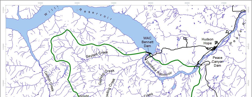
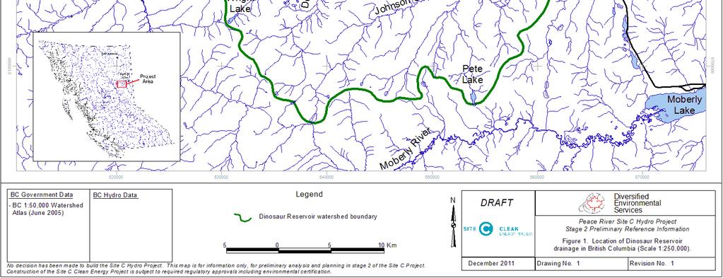
43 6
44 7
45 8
46 00 00 L = 9.76 x W0.6 R² = 0.9 n= Weight (g) Figure. Length-weight relationship of sampled rainbow trout, Reservoir, August 8-7, Age (Yr) Figure. Length-at-age ± S.E. of sampled rainbow trout, Reservoir, August 8-7,
47 Age (Yr) Figure 6. Age class proportions of sampled rainbow trout from all sites, Reservoir, August 8-7, Age (Yr) Figure 7. Age class proportions of sampled rainbow trout excluding tributary sites, Reservoir, August 8-7, 00. 0
48 L = 9.6 x W0.7 R² = 0.98 n= Weight (g) Figure 8. Length-weight relationship of sampled mountain whitefish, Reservoir, August 8-7, n= Age (Yr) Figure 9. Length-at-age ± S.E. of sampled mountain whitefish, Reservoir, August 8-7, 00.
49 00 00 L =.67 x W0. R² = n= Weight (g) Figure 0. Length-weight relationship of sampled lake whitefish, Reservoir, August 8-7, n= Weight (g) Figure. Length-at-age ± S.E. of sampled lake whitefish, Reservoir, August 8-7, 00.
50 0 00 L = 7.8 x W0.08 R² = 0.98 n= Weight (g) Figure. Length-weight relationship of sampled kokanee, Reservoir, August 8-7, n= Fork Length (mm) Age (Yr) Figure. Length-at-age ± S.E. of sampled kokanee, Reservoir, August 8-7, 00.
51 L = 6.8 x W0.89 R² = n= Weight (g) Figure. Length-weight relationship of sampled lake trout, Reservoir, August 8-7, n= Age (Yr) Figure. Length-at-age ± S.E. of sampled lake trout, Reservoir, August 8-7, 00.
52 000 n= Age (Years) Figure 6. Length-at-age ± S.E. of sampled bull trout, Reservoir and tributaries, August 8-7, n= Fork Length (mm) Figure 7. Length distribution of longnose sucker, Reservoir and tributaries, August 8-7, 00.
53 0 (n=87) (n=) Size Range (mm) Figure 8. Length distribution of prickly and slimy sculpin from all sites combined Reservoir, August 8-7, Reservoir Sites Tributary Sites Figure 9. Proportion of prickly and slimy sculpin captured at reservoir and tributary sites, Reservoir, August 8-7, 00. 6
54 7
55 8
56 LT BT LW K LSU WSU CSU PCC R Figure. Comparison of species composition during Reservoir sampling events between 00 and LNC N
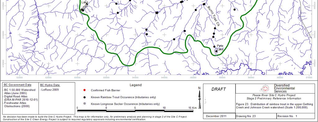
57 0
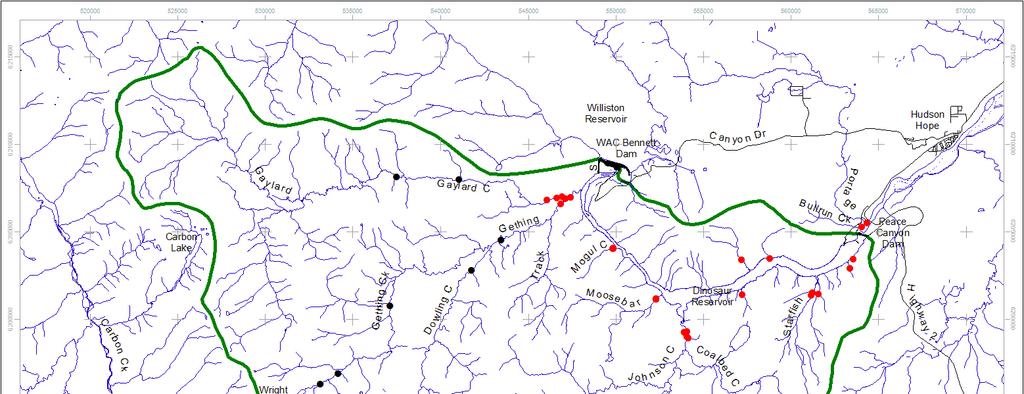
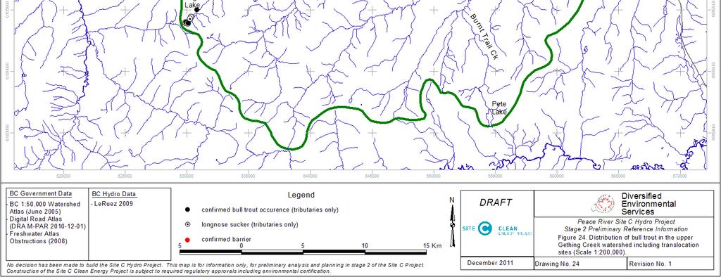
58
Dinosaur Reservoir 2002 Fish Collection Summary
 Dinosaur Reservoir 2002 Fish Collection Summary E.B. Murphy, 1 B.G. Blackman 2, D.M. Cowie 2 and Nick Baccante 3 November 2004 PWFWCP Report No. 297. The Peace/Williston Fish & Wildlife Compensation Program
SITE C FISHERIES STUDIES 2011 REVELSTOKE RESERVOIR FISH INVENTORY DATA REPORT
 Project number: 4534 Version: 2 January 13, 2012 SITE C FISHERIES STUDIES 2011 REVELSTOKE RESERVOIR FISH INVENTORY DATA REPORT Prepared for: Bruce Mattock, R.P. Bio. Fisheries and Aquatic Lead Site C Clean
SITE C FISHERIES STUDY UPPER HALFWAY RIVER WATERSHED BULL TROUT SPAWNING SURVEY 2008
 SITE C FISHERIES STUDY UPPER HALFWAY RIVER WATERSHED BULL TROUT SPAWNING SURVEY 2008 Note: This report has been redacted for protection of the bull trout (Salvelinus confluentus). Prepared for: B.C. Hydro
1 INTRODUCTION AND SUMMARY
 December 10, 2012 Pacific Booker Minerals 1702 1166 Alberni Street Vancouver, British Columbia V6E 3Z3 Erik Tornquist Executive VP and COO Dear Mr. Erik Tornquist: 1 INTRODUCTION AND SUMMARY This letter
Fish Species Presence and Abundance Of the Table River, 1995
 Fish Species Presence and Abundance Of the Table River, 1995 R. J. Zemlak and A. R. Langston March 1998 PWFWCP Report No. 173 The Peace/Williston Fish & Wildlife Compensation Program is a cooperative venture
Clowhom Project Water Use Plan
 Clowhom Project Water Use Plan Fish Productivity Monitoring Implementation Year 4 Reference: COMMON-2 Fish Productivity Monitoring Year 4 Data Summary 2010 Study Period: September 16 to October 6, 2010
Fisheries Enhancement Options for Dinosaur Lake, A Review
 Fisheries Enhancement Options for Dinosaur Lake, A Review R. Pattenden and G. Ash April 1993 PWFWCP Report No. 72 The Peace/Williston Fish & Wildlife Compensation Program is a cooperative venture of BC
Peace River Water Use Plan. Monitoring Program Terms of Reference. GMSMON-1 Peace River Creel Survey
 Peace River Water Use Plan Monitoring Program Terms of Reference GMSMON-1 Peace River Creel Survey April 10, 2008 Terms of Reference for the Peace River Water Use Plan Monitoring Program: Peace River Creel
Study Update Fish Distribution and Species Composition
 Study Update Fish Distribution and Species Composition Goals and Study Area Gain a better understanding of fish species composition and abundance in waters associated with the Packwood Lake Hydroelectric
P/FR/SK/41-B HATLEVIK, S. P. CREEL SURVEY OF UNCHA AND BINTA LAKES CQJF c. 1 mm SMITHERS A CREEL SURVEY OF UNCHA AND BINTA LAKES.
 P/FR/SK/41-B HATLEVIK, S. P. CREEL SURVEY OF UNCHA AND BINTA LAKES CQJF c. 1 mm SMITHERS A CREEL SURVEY OF UNCHA AND BINTA LAKES June August, 1982 BY S.P. HATLEVIK BRITISH COLUMBIA MINISTRY OF ENVIRONMENT
Redd Dewatering and Juvenile Salmonid Stranding in the Lower Feather River,
 Redd Dewatering and Juvenile Salmonid Stranding in the Lower Feather River, 2005-2006 Interim Report for NOAA Fisheries Prepared by: California Department of Water Resources Division of Environmental Services
Firth Creek Habitat Enhancement Project 1993
 Firth Creek Habitat Enhancement Project 1993 A. R. Langston December 1993 PWFWCP Report No. 77 The Peace/Williston Fish & Wildlife Compensation Program is a cooperative venture of BC Hydro and the provincial
Clowhom Project Water Use Plan
 Clowhom Project Water Use Plan Fish Productivity Monitoring Implementation Year 5 Reference: COMMON-2 Fish Productivity Monitoring Year 5 Data Summary 2011 Study Period: September 2011 D.J. Bates FSCI
SITE C CLEAN ENERGY PROJECT FISH AND FISH HABITAT TECHNICAL DATA REPORT
 SITE C CLEAN ENERGY PROJECT FISH AND FISH HABITAT TECHNICAL DATA REPORT Prepared for BC Hydro Power and Authority 333 Dunsmuir Street Vancouver, BC V6B 5R3 By Mainstream Aquatics Ltd. 6956 Roper Road Edmonton,
MINISTRY OF ENVIRONMENT ENVIRONMENTAL STEWARDSHIP DIVISION FISH AND WILDLIFE BRANCH. Horsefly River Angling Management Plan
 MINISTRY OF ENVIRONMENT ENVIRONMENTAL STEWARDSHIP DIVISION FISH AND WILDLIFE BRANCH Horsefly River Angling Management Plan January 30 th, 2006 Area/Fishery Description The Horsefly River watershed provides
NEVADA DEPARTMENT OF WILDLIFE STATEWIDE FISHERIES MANAGEMENT
 NEVADA DEPARTMENT OF WILDLIFE STATEWIDE FISHERIES MANAGEMENT FEDERAL AID JOB PROGRESS REPORTS F-20-52 2016 Lake Tahoe Rainbow Trout Study WESTERN REGION NEVADA DEPARTMENT OF WILDLIFE, FISHERIES DIVISION
NEVADA DEPARTMENT OF WILDLIFE STATEWIDE FISHERIES MANAGEMENT
 NEVADA DEPARTMENT OF WILDLIFE STATEWIDE FISHERIES MANAGEMENT FEDERAL AID JOB PROGRESS REPORTS F-20-52 2016 REDBAND TROUT EASTERN REGION NEVADA DEPARTMENT OF WILDLIFE, FISHERIES DIVISION ANNUAL JOB PROGRESS
Executive Summary Gantahaz Lake 2006
 Executive Summary Gantahaz Lake 2006 A stocking assessment was conducted at Gantahaz Lake on September 29, 2006. This was the third assessment completed since the inception of stocking in 1976. The management
An Overview and Summary of Methodologies of Arctic grayling ( Thymallus arcticus
 PEACE REGION An Overview and Summary of Methodologies of Arctic grayling (Thymallus arcticus) Projects Conducted in the Parsnip, Table, and Anzac rivers from 1995 to 2007 D.M. Cowie and B.G. Blackman September
Data Report : Russian River Basin Steelhead and Coho Salmon Monitoring Program Pilot Study
 Data Report 1999-1: Russian River Basin Steelhead and Coho Salmon Monitoring Program Pilot Study Sonoma County Water Agency 215 West College Avenue Santa Rosa, California 951 Prepared by David Cook Senior
Final Fish Salvage & Temporary Tailrace Barrier Report for the Wallowa Falls Hydroelectric Project Tailrace. (FERC No. P-308) December 18, 2017
 December 18, 2017") Final for the Wallowa Falls Hydroelectric Project Tailrace (FERC No. P-308) December 18, 2017 Prepared by: Jeremiah Doyle PacifiCorp 825 NE Multnomah Street Portland, OR 97232 December 18, 2017 Page 1
Final for the Wallowa Falls Hydroelectric Project Tailrace (FERC No. P-308) December 18, 2017 Prepared by: Jeremiah Doyle PacifiCorp 825 NE Multnomah Street Portland, OR 97232 December 18, 2017 Page 1
Trip Report: Eagle Creek, Arizona
 Trip Report: Eagle Creek, Arizona 15-17 June 2009 Participants: Abraham Karam, Brian Kesner, and Mike Childs Native Fish Lab Marsh & Associates, LLC 5016 South Ash Avenue Suite 108 Tempe, Arizona 85282
Final Fish Salvage & Temporary Tailrace Barrier Report for the Wallowa Falls Hydroelectric Project Tailrace. (FERC No. P-308) December 20, 2018
 December 20, 2018") Final Fish Salvage & Temporary Tailrace Barrier Report for the Wallowa Falls Hydroelectric Project Tailrace (FERC No. P-308) December 20, 2018 Prepared by: Jeremiah Doyle PacifiCorp 825 NE Multnomah Street
Final Fish Salvage & Temporary Tailrace Barrier Report for the Wallowa Falls Hydroelectric Project Tailrace (FERC No. P-308) December 20, 2018 Prepared by: Jeremiah Doyle PacifiCorp 825 NE Multnomah Street
Columbia Lake Dam Removal Project
 Columbia Lake Dam Removal Project The Columbia Lake dam located 1/4 mile upstream of the Paulins Kill River's confluence with the Delaware River in Knowlton Township, Warren County has been proposed for
Executive Summary Chubb Lake 2004
 Executive Chubb Lake 2004 A stocking assessment was conducted at Chubb Lake on September 29, 2004. The objective of this assessment was to document the status of the fishery. Chubb Lake is a 67.3 ha lake
Rivers and Streams Investigations
 Rivers and Streams Investigations Brian J. Flatter, Regional Fisheries Biologist Lance Hebdon, Regional Fisheries Biologist Jeff Dillon, Regional Fishery Manager ABSTRACT Three sections of the lower Boise
REC 6 FISHERIES HABITAT EVALUATION
 REC 6 FISHERIES HABITAT EVALUATION 1.0 EXECUTIVE SUMMARY Analysis of fisheries habitat for recreational angling opportunities was completed by reviewing the results of the CAWG 1, Characterize Stream and
2011 Haha Lake Northern Pike Control
 2011 Haha Lake Northern Pike Control Prepared By: Christin Davis Ministry of Forests, Lands, and Natural Resource Operations #401-333 Victoria Street Nelson, BC V1L 4K3 Summary In 2005, northern pike (Esox
Big Spring Creek Habitat Enhancement and Fishery Management Plans
 Big Spring Creek Habitat Enhancement and Fishery Management Plans November 5, 2012 Big Spring Events and Activities Center Newville, PA Charlie McGarrell Regional Habitat Biologist Pennsylvania Fish and
Review of Site C Environmental Impact Statement (EIS) - Fish and Fish Habitat
 - Fish and Fish Habitat") 470 Granville Street, Suite 630, Vancouver, BC V6B 1N3 t 604-629-9075 Memorandum Date: December 18, 2013 To: Jesse McCormick Donovan & Company Project: Site C Project From: Palmer Environmental Consulting
470 Granville Street, Suite 630, Vancouver, BC V6B 1N3 t 604-629-9075 Memorandum Date: December 18, 2013 To: Jesse McCormick Donovan & Company Project: Site C Project From: Palmer Environmental Consulting
LAKE DIANE Hillsdale County (T8-9S, R3W, Sections 34, 3, 4) Surveyed May Jeffrey J. Braunscheidel
 Surveyed May Jeffrey J. Braunscheidel") Michigan Department of Natural Resources Status of the Fishery Resource Report No. 2003-4, 2003 LAKE DIANE Hillsdale County (T8-9S, R3W, Sections 34, 3, 4) Surveyed May 2001 Jeffrey J. Braunscheidel Environment
Michigan Department of Natural Resources Status of the Fishery Resource Report No. 2003-4, 2003 LAKE DIANE Hillsdale County (T8-9S, R3W, Sections 34, 3, 4) Surveyed May 2001 Jeffrey J. Braunscheidel Environment
Evaluation of the 1992 and 1993 Arctic Grayling (Thymallus Arcticus) Transplants to Little Calais Lake and Current Fish Population Status, 1998
 Transplants to Little Calais Lake and Current Fish Population Status, 1998") Evaluation of the 99 and 99 Arctic Grayling (Thymallus Arcticus) Transplants to Little Calais Lake and Current ish Population Status, 998 A. R. Langston April 999 PWWCP Report No. 99 The Peace/Williston
Evaluation of the 99 and 99 Arctic Grayling (Thymallus Arcticus) Transplants to Little Calais Lake and Current ish Population Status, 998 A. R. Langston April 999 PWWCP Report No. 99 The Peace/Williston
Ecology and control of invasive Northern Pike in the Columbia River, Canada
 Ecology and control of invasive Northern Pike in the Columbia River, Canada Brian Heise, Daniel Doutaz, Matthias Herborg, Matt Neufeld, David Derosa, Jeremy Baxter 19 th International Conference on Aquatic
Jason Blackburn, Paul Hvenegaard, Dave Jackson, Tyler Johns, Chad Judd, Scott Seward and Juanna Thompson
 Alberta Conservation Association (ACA) Date: 2014-2015 Project Name: Owl River Walleye and Aquatic Habitat Assessment Fisheries Program Manager: Peter Aku Project Leader: Tyler Johns Primary ACA staff
Alberta Conservation Association 2017/18 Project Summary Report
 Alberta Conservation Association 2017/18 Project Summary Report Project Name: Abundance, Distribution, Spawning, and Thermal Habitat of Westslope Cutthroat Trout and Bull Trout in the Stimson Creek Watershed
Caro Impoundment, Tuscola County
 Caro Impoundment is a 200 acre impoundment of the Cass River located one mile south of the Village of Caro in Tuscola County. Caro Dam, originally constructed in 1906 for water supply to Michigan Sugar
* * * * * * * * * * * *
 Excerpts from Idaho Department of Fish and Game, 2003 Fishery Management Report. Southwest Region Nampa 2003. Brian J. Flatter, Regional Fishery Biologist, Kurtis Plaster, Senior Fishery Technician, Jeff
Clowhom Project Water Use Plan. Fish Productivity Monitoring. Reference: COMMON-2. Fish Productivity Monitoring Year 2 Data Summary 2008
 Clowhom Project Water Use Plan Fish Productivity Monitoring Reference: COMMON-2 Fish Productivity Monitoring Year 2 Data Summary 2008 Study Period: August 25 to October 16, 2008 D.J. Bates Resource Management
Arizona Game and Fish Department Region I Fisheries Program. Chevelon Canyon Lake Fish Survey Report Trip Report April 2015
 Arizona Game and Fish Department Region I Fisheries Program Chevelon Canyon Lake Fish Survey Report Trip Report April 2015 Authors: Sally Petre and Mike Lopez Report Date: June 25, 2015 The Arizona Game
Monitoring of Downstream Fish Passage at Cougar Dam in the South Fork McKenzie River, Oregon February 8, By Greg A.
 Monitoring of Downstream Fish Passage at Cougar Dam in the South Fork McKenzie River, Oregon 1998- February 8, 2 By Greg A. Taylor Oregon Dept. of Fish & Wildlife 315 E. Main Street Springfield, OR 97478
FISH POPULATION AND RIVERINE HABITAT INVENTORY OF THE ELK RIVER, SPARWOOD, BRITISH COLUMBIA
 FISH POPULATION AND RIVERINE HABITAT INVENTORY OF THE ELK RIVER, SPARWOOD, BRITISH COLUMBIA Submitted to: UMA Engineering Ltd. Calgary Alberta Submitted by: Applied Aquatic Research Ltd. Calgary, Alberta
1997 FRY EMERGENCE. NECHAKO FISHERIES CONSERVATION PROGRAM Technical Report No. M96-6
 1997 FRY EMERGENCE NECHAKO FISHERIES CONSERVATION PROGRAM Technical Report No. M96-6 Prepared by: Triton Environmental Consultants Ltd. June 22 Contents List of Figures... i List of Tables... iii List
Study Update Tailrace Slough Use by Anadromous Salmonids
 Study Update Tailrace Slough Use by Anadromous Salmonids Goals and Objectives Identify what anadromous salmonids use the tailrace slough by: Life Stage (Juvenile, migrating and spawning adults) Timing
Klamath Lake Bull Trout
 Klamath Lake Bull Trout Existing Populations The Klamath Lake Bull Trout SMU is comprised of seven existing populations and four populations classified as extinct or functionally extinct (Table 189). Populations
NEVADA DEPARTMENT OF WILDLIFE STATEWIDE FISHERIES MANAGEMENT
 NEVADA DEPARTMENT OF WILDLIFE STATEWIDE FISHERIES MANAGEMENT FEDERAL AID JOB PROGRESS REPORTS F-20-49 2013 SQUAW CREEK RESERVOIR WESTERN REGION Contents NEVADA DEPARTMENT OF WILDLIFE, FISHERIES DIVISION
Alberta Conservation Association 2009/10 Project Summary Report. Project Name: Crowsnest Drainage Sport Fish Population Assessment Phase 1
 Alberta Conservation Association 2009/10 Project Summary Report Project : Crowsnest Drainage Sport Fish Population Assessment Phase 1 Fisheries Program Manager: Peter Aku Project Leader: Jason Blackburn
Project Name: Distribution of Sport Fish in the Waterton River Tailwater, 2014
 Alberta Conservation Association (ACA) Date: 2014-2015 Project Name: Distribution of Sport Fish in the Waterton River Tailwater, 2014 Fisheries Program Manager: Peter Aku Project Leader: Jason Blackburn
Rehabilitation of Grimes Creek, a Stream Impacted in the Past by Bucket-lined Dredge Gold Mining, Boise River Drainage, July 2008 to August 2011.
 Rehabilitation of Grimes Creek, a Stream Impacted in the Past by Bucket-lined Dredge Gold Mining, Boise River Drainage, July 2008 to August 2011. Pam Harrington TU,1020 W. Main Street Suite 440, Boise,
Benchmark Statement Respecting the Fish, Fish Habitat and Fisheries of Fish and Little Fish Lake, within the Taseko River Watershed.
 Benchmark Statement Respecting the Fish, Fish Habitat and Fisheries of Fish and Little Fish Lake, within the Taseko River Watershed. Information Supporting the Environmental Assessment of the Prosperity
Job 1. Title: Estimate abundance of juvenile trout and salmon.
 STUDY PERFORMANCE REPORT State: Michigan Project No.: F-53-R-13 Study No.: 461 Title: Population dynamics of juvenile rainbow trout and coho salmon in Lake Superior tributaries Period Covered: April 1,
Bull Trout Studies in the Salmo River Watershed: 2001
 Bull Trout Studies in the Salmo River Watershed: 2001 Report Prepared For: BC Hydro Kootenay Generation Area 601 18 th Street Castlegar, B.C. V1N 4A2 Report Prepared By: James Baxter Baxter Environmental
NEVADA DEPARTMENT OF WILDLIFE STATEWIDE FISHERIES MANAGEMENT FEDERAL AID JOB PROGRESS REPORTS F EUREKA COUNTY Small Lakes and Reservoirs
 NEVADA DEPARTMENT OF WILDLIFE STATEWIDE FISHERIES MANAGEMENT FEDERAL AID JOB PROGRESS REPORTS F-20-48 2012 EUREKA COUNTY Small Lakes and Reservoirs NEVADA DEPARTMENT OF WILDLIFE, FISHERIES DIVISION ANNUAL
Crooked Lake Oakland County (T4N, R9E, Sections 3, 4, 9) Surveyed May James T. Francis
 Surveyed May James T. Francis") Michigan Department of Natural Resources Status of the Fishery Resource Report No. 2004-1, 2004 Crooked Lake Oakland County (T4N, R9E, Sections 3, 4, 9) Surveyed May 2002 James T. Francis Environment Crooked
Michigan Department of Natural Resources Status of the Fishery Resource Report No. 2004-1, 2004 Crooked Lake Oakland County (T4N, R9E, Sections 3, 4, 9) Surveyed May 2002 James T. Francis Environment Crooked
Michigan Dept. of Natural Resources Status of the Fishery Resource Report Page 1. Weber Lake Cheboygan County, T34N, R3W, Sec.
 Michigan Dept. of Natural Resources 2012-143 Status of the Fishery Resource Report Page 1 Weber Lake Cheboygan County, T34N, R3W, Sec. 31 Neal Godby, Fisheries Biologist Environment Weber Lake is a 28.5-acre
Columbia Lake Dam Removal Project
 Columbia Lake Dam Removal Project Major Goals of the Columbia Lake Dam Removal: Reconnect 10 miles of the Paulins Kill River to the Delaware River, restoring natural flow regime and sediment transport.
Executive Summary Mount Milligan 2004
 Executive Mount Milligan 2004 Mt. Milligan Lake is a shallow and productive, 24 ha, marl bottomed lake situated 110 km southwest of Mackenzie. A stocking assessment was conducted at Mt. Milligan Lake between
Parasitic Copepods (Salmincola sp.) and Fish Species Composition in Upper Willamette Reservoirs
 and Fish Species Composition in Upper Willamette Reservoirs") Parasitic Copepods (Salmincola sp.) and Fish Species Composition in Upper Willamette Reservoirs Jeremy D. Romer* Ryan Emig* Fred R. Monzyk Oregon Department of Fish and Wildlife Corvallis Research Lab
Parasitic Copepods (Salmincola sp.) and Fish Species Composition in Upper Willamette Reservoirs Jeremy D. Romer* Ryan Emig* Fred R. Monzyk Oregon Department of Fish and Wildlife Corvallis Research Lab
Final Bull Trout Redd Monitoring Report for the Wallowa Falls Hydroelectric Project
 Final for the Wallowa Falls Hydroelectric Project East Fork Wallowa River barrier to upstream fish migration, photo courtesy of Kendrick Moholt (FERC No. P-308) December 18, 2017 Prepared by: Jeremiah
Fish Passage Culvert Assessment for Cahilty Creek Watershed FIA Project #
 Fish Passage Culvert Assessment for Cahilty Creek Watershed FIA Project # 4602004 Prepared for Weyerhaeuser Company Ltd. Jason Ladyman R.P.F. 1550 Mission Flats Road PO Box 40 Kamloops BC V2C 5K3 Prepared
Proposed Reclassification of Cherry Creek, North Platte River Basin, Wyoming. October 25, 2010
 Proposed Reclassification of Cherry Creek, North Platte River Basin, Wyoming October 25, 2010 Waterbody: Location: Tributary to: Cherry Creek - Mainstem from headwaters downstream to the confluence with
Dauphin Lake Fishery. Status of Walleye Stocks and Conservation Measures
 Dauphin Lake Fishery Status of Walleye Stocks and Conservation Measures Date: December, 21 Dauphin Lake Fishery Status of Walleye Stocks and Conservation Measures Background: Walleye stocks in Dauphin
FISH COLLECTION PERMIT Inventory
 File: 34770-20 ATS Project: 120106 Permit No.: FJ16-225344 FISH COLLECTION PERMIT Inventory Permit Holder: BC Hydro and Power Authority Bettina Sander Suite 1100, 1055 Dunsmuir, 6 th Floor Vancouver BC
Coquitlam/Buntzen Project Water Use Plan
 Coquitlam/Buntzen Project Water Use Plan Temperature Monitoring Lower Coquitlam River Project Year 3 Report Reference: COQMON#6 Study Period: March 2008 April 2009 Report Date: April 2009 Trow Associates
STEELHEAD SURVEYS IN OMAK CREEK
 STEELHEAD SURVEYS IN OMAK CREEK 2002 Annual Report Prepared by Chris Fisher John Arterburn Colville Confederated Tribes Fish and Wildlife Department P.O. Box 150 Nespelem, WA 99155 Prepared for Project
FINAL Fish Salvage Plan for the Wallowa Falls Hydroelectric Project Tailrace. (FERC No. P-308) April 19, 2017
 April 19, 2017") FINAL for the Wallowa Falls Hydroelectric Project Tailrace (FERC No. P-308) April 19, 2017 Prepared by: Jeremiah Doyle PacifiCorp 825 NE Multnomah Street Portland, OR 97232 April 19, 2017 Page 1 of 10
FINAL for the Wallowa Falls Hydroelectric Project Tailrace (FERC No. P-308) April 19, 2017 Prepared by: Jeremiah Doyle PacifiCorp 825 NE Multnomah Street Portland, OR 97232 April 19, 2017 Page 1 of 10
Past, Present, and Future Fishery Management in Cabinet Gorge and Noxon Rapids Reservoirs
 Past, Present, and Future Fishery Management in Cabinet Gorge and Noxon Rapids Reservoirs Abstract Scott S. Rumsey and Joe E. Huston Montana Department of Fish, Wildlife and Parks Kalispell. MT 59901 Noxon
5B. Management of invasive species in the Cosumnes and Mokelumne River Basins
 5B. Management of invasive species in the Cosumnes and Mokelumne River Basins Cosumnes River The Cosumnes River basin has a number of distinct habitat types that require different management strategies
COLUMBIA LAKE DAM REMOVAL PROJECT
 COLUMBIA LAKE DAM REMOVAL PROJECT Major Goals of the Columbia Lake Dam Removal: Reconnect 10 miles of the Paulins Kill River to the Delaware River, restoring natural flow regime and sediment transport.
Minnesota Department of Natural Resources Division of Fish and Wildlife Section of Fisheries. Stream Survey Report. Luxemburg Creek.
 Minnesota F-29-R(P)-24 Area 315 Study 3 March 2016 Minnesota Department of Natural Resources Division of Fish and Wildlife Section of Fisheries Stream Survey Report Luxemburg Creek 2015 Mark Pelham Sauk
Assessment of Elizabeth Lake as a Potential Candidate for Stocking
 Assessment of Elizabeth Lake as a Potential Candidate for Stocking Region 1, Nanaimo West Coast Planning Unit Ministry of Water, Land and Air Protection Prepared by: Laura Cassin Scott Silvestri 2002 1.0
Invasive Fish in the Cariboo Region. Russell Bobrowski Fisheries Biologist, BC Gov Cariboo Region Dec 19, 2017
 Invasive Fish in the Cariboo Region Russell Bobrowski Fisheries Biologist, BC Gov Cariboo Region Dec 19, 2017 Cariboo - Fishery Combination of productive lake and river fisheries 700 lakes with known game
NEVADA DEPARTMENT OF WILDLIFE STATEWIDE SPORT FISHERIES MANAGEMENT
 NEVADA DEPARTMENT OF WILDLIFE STATEWIDE SPORT FISHERIES MANAGEMENT FEDERAL AID JOB PROGRESS REPORT F-2-52 216 WILDHORSE RESERVOIR EASTERN REGION NEVADA DEPARTMENT OF WILDLIFE, FISHERIES DIVISION ANNUAL
NEVADA DEPARTMENT OF WILDLIFE STATEWIDE FISHERIES MANAGEMENT
 NEVADA DEPARTMENT OF WILDLIFE STATEWIDE FISHERIES MANAGEMENT FEDERAL AID JOB PROGRESS REPORTS F-20-52 2016 BOULDER RESERVOIR WESTERN REGION NEVADA DEPARTMENT OF WILDLIFE, FISHERIES DIVISION ANNUAL PROGRESS
NEVADA DEPARTMENT OF WILDLIFE STATEWIDE FISHERIES MANAGEMENT
 NEVADA DEPARTMENT OF WILDLIFE STATEWIDE FISHERIES MANAGEMENT FEDERAL AID JOB PROGRESS REPORTS F-20-48 2012 LAKE TAHOE WESTERN REGION Contents NEVADA DEPARTMENT OF WILDLIFE, FISHERIES DIVISION ANNUAL PROGRESS
FINAL Caples Lake Fisheries Management Plan. Version 4.0
 FINAL Caples Lake Fisheries Management Plan Version 4.0 August 15, 2008 Purpose The Caples Lake Fisheries Management Plan (Plan) outlines the stocking plan to reestablish a sport fishery in Caples Lake
Executive Summary Opatcho Lake 2004
 Executive Summary Opatcho Lake 2004 Stocking assessments were conducted at Opatcho Lake on two separate occasions: May 20, 2004, and September 27, 2004. Opatcho Lake is a 40.5 ha lake situated 48 km southeast
Minnesota Department of Natural Resources Fisheries Division, Lake Superior Area
 Minnesota F-9-R(P)- Study 4 Job 616 Minnesota Department of Natural Resources Fisheries Division, Lake Superior Area Coaster Brook Trout Status in Minnesota-Lake Superior Tributaries Following Regulation
FISHERIES BLUE MOUNTAINS ADAPTATION PARTNERSHIP
 FISHERIES A warming climate, by itself, substantially affects the hydrology of watersheds in the Blue Mountains. Among the key hydrologic changes projected under all scenarios for the 2040s and beyond
Study 9.5 Fish Distribution and Abundance in the Upper Susitna River
 Initial Study Report Meeting Study 9.5 Fish Distribution and Abundance in the Upper Susitna River October 15, 2014 Prepared by R2 Resource Consultants, Inc. 10/15/2014 1 Study 9.5 Objectives 1. Describe
Chinook Salmon Spawning Study Russian River Fall 2005
 Chinook Salmon Spawning Study Russian River Fall 2005 Sonoma County Water Agency 2150 West College Avenue Santa Rosa, California 95401 Prepared by David Cook - Senior Environmental Specialist March 27,
Abundance of Steelhead and Coho Salmon in the Lagunitas Creek Drainage, Marin County, California
 scanned for KRIS Abundance of Steelhead and Coho Salmon in the Lagunitas Creek Drainage, Marin County, California Prepared for: Marin Municipal Water District 220 Nellen Drive Corte Madera, California
CUSHMAN RESERVOIRS. Skokomish Watershed Monitoring Conference - Public Meeting Florian Leischner 9/17/2015
 CUSHMAN RESERVOIRS Skokomish Watershed Monitoring Conference - Public Meeting Florian Leischner 9/17/2015 CUSHMAN RESERVOIRS MONITORING Management and monitoring of Tacoma Power reservoirs Lake Cushman
Discussion on the Selection of the Recommended Fish Passage Design Discharge
 Discussion on the Selection of the Recommended Fish Passage Design Discharge Introduction The provision of fish passage is a requirement for most proposed culvert and bridge installations in Alberta, depending
NEVADA DEPARTMENT OF WILDLIFE STATEWIDE FISHERIES MANAGEMENT
 NEVADA DEPARTMENT OF WILDLIFE STATEWIDE FISHERIES MANAGEMENT FEDERAL AID JOB PROGRESS REPORTS F-20-49 2013 LAKE TAHOE WESTERN REGION NEVADA DEPARTMENT OF WILDLIFE, FISHERIES DIVISION ANNUAL PROGRESS REPORT
SALMONID ACTION PLAN FINAL DRAFT
 SALMONID ACTION PLAN FINAL DRAFT Table of Contents 1 Introduction... 2 2 Overview context... 4 2.1 Fish and Fish Habitat in the Shuswap River... 5 2.2 Impacts and Threats... 6 2.3 Limiting factors... 7
Don Pedro Project Relicensing
 Don Pedro Project Relicensing M ODESTO I RRIGATION D ISTRICT TURLOCK I RRIGATION D ISTRICT FERC PROJECT N O. 2299 Resident Fish in Don Pedro Reservoir Don Pedro Reservoir Fish Stocking (1971-Present) CDFG
6TH PELLETIER BROOK LAKE T15 R9, Aroostook Co. U.S.G.S. Gardner Pond, Maine (7 1/2 )
") 6TH PELLETIER BROOK LAKE T15 R9, Aroostook Co. U.S.G.S. Gardner Pond, Maine (7 1/2 ) Fishes Brook trout Minnows Blacknose dace Pearl dace Physical Characteristics Area - 27 acres Average depth - 2 feet
6TH PELLETIER BROOK LAKE T15 R9, Aroostook Co. U.S.G.S. Gardner Pond, Maine (7 1/2 ) Fishes Brook trout Minnows Blacknose dace Pearl dace Physical Characteristics Area - 27 acres Average depth - 2 feet
ELECTRO-FISHING REPORT 2016 UPPER TWEED
 ELECTRO-FISHING REPORT 2016 UPPER TWEED The electro-fishing programme carried out each summer by The Tweed Foundation is part of our management plan, which details the information that is required to manage
Fraser River. FISH SURVEY AND MANAGEMENT INFORMATION Jon Ewert - Aquatic Biologist (Hot Sulphur Springs)
") Fraser River FISH SURVEY AND MANAGEMENT INFORMATION Jon Ewert - Aquatic Biologist (Hot Sulphur Springs) General Information: The Fraser River is a highly diverse river offering many transitions in habitat
Fraser River FISH SURVEY AND MANAGEMENT INFORMATION Jon Ewert - Aquatic Biologist (Hot Sulphur Springs) General Information: The Fraser River is a highly diverse river offering many transitions in habitat
Peace Project Water Use Plan
 Peace Project Water Use Plan Fish Index Implementation Year 4 Reference: GMSMON #2 Peace River Fish Index Project 211 Studies Study Period: August 24, 211 September 24, 211 Rick Pattenden, Senior Biologist
LAKE TANEYCOMO 2011 ANNUAL LAKE REPORT
 LAKE TANEYCOMO 211 ANNUAL LAKE REPORT Shane Bush Fisheries Management Biologist Missouri Department of Conservation Southwest Region March 1, 212 EXECUTIVE SUMMARY Lake Taneycomo was formed by the construction
Management Plan for the Obey River Trout Fishery
 Management Plan for the Obey River Trout Fishery 28-214 By: James Travis Scott Jack Swearengin Walter Scott Webb D.W. Young Tennessee Wildlife Resources Agency January 28 Management Plan for the Obey River
Steelhead Spawning Ground Surveys on the Entiat River, 2015.
 Steelhead Spawning Ground Surveys on the Entiat River, 2015. Kenneth Poczekaj and R.D. Nelle U.S. Fish and Wildlife Service Mid-Columbia River Fishery Resource Office Leavenworth, WA 98826 On the cover:
Review of Fish and Fish Habitat Information from the Bearberry Creek Drainage. Alberta Conservation Association Activity Report.
 Review of Fish and Fish Habitat Information from the Bearberry Creek Drainage. Alberta Conservation Kevin Fitzsimmons 1 2005 1 Alberta Conservation Association, Box 1420, Cochrane, Alberta, Canada, T4C
NEVADA DEPARTMENT OF WILDLIFE STATEWIDE FISHERIES MANAGEMENT
 NEVADA DEPARTMENT OF WILDLIFE STATEWIDE FISHERIES MANAGEMENT FEDERAL AID JOB PROGRESS REPORTS F-20-50 2014 BILK CREEK RESERVOIR WESTERN REGION 1 NEVADA DEPARTMENT OF WILDLIFE, FISHERIES DIVISION JOB PROGRESS
Justification for Rainbow Trout stocking reduction in Lake Taneycomo. Shane Bush Fisheries Management Biologist Missouri Department of Conservation
 Justification for Rainbow Trout stocking reduction in Lake Taneycomo Shane Bush Fisheries Management Biologist Missouri Department of Conservation December 14, 2017 Lake Taneycomo was formed by the construction
OKANAGAN LAKE FISH MANAGEMENT PLAN SUMMARY
 lin,'roduction 1990-1995 OKANAGAN LAKE FISH MANAGEMENT PLAN SUMMARY B.C. Environment's Fisheries Branch looks after the province's freshwater fish. In Okanagan Lake, game fish inventories reveal an alarming
Hydroacoustic surveys of Otsego Lake s pelagic fish community,
 Hydroacoustic surveys of Otsego Lake s pelagic fish community, 2010 1 Holly A. Waterfield 2 and Mark Cornwell 3 INTRODUCTION Hydroacoustic surveys were conducted in May and November 2010 to estimate pelagic
Lower Dolores River Corridor Planning Meeting Jim White Colorado Division of Wildlife
 Lower Dolores River Corridor Planning Meeting Jim White Colorado Division of Wildlife Objectives Overview of cold and warm water fishes in the Dolores River including: Flow and Fish Management Distribution
LONE TREE POCKET ESTUARY RESTORATION 2004 FISH SAMPLING AND PRE-RESTORATION PROJECT MONITORING REPORT
 Skagit River System Cooperative 11426 Moorage Way P.O. Box 368 LaConner, WA 98257-368 Phone: 36-466-7228 Fax: 36-466-447 www.skagitcoop.org LONE TREE POCKET ESTUARY RESTORATION 24 FISH SAMPLING AND PRE-RESTORATION