Coquitlam Water Use Plan
|
|
|
- Ariel Manning
- 6 years ago
- Views:
Transcription
1 Coquitlam Water Use Plan Assessment of Fisheries Access to Streams Tributary To Coquitlam Reservoir COQMON#1 Study Period: September 1, 2006 May 31, 2007 Report Date: January 2008 Scott Ducharme Aquatec Resources January 2008

2 ASSESSMENT OF FISHERIES ACCESS TO STREAMS TRIBUTARY TO COQUITLAM RESERVOIR Aquatec Resources
3 ASSESSMENT OF FISHERIES ACCESS TO STREAMS TRIBUTARY TO COQUITLAM RESERVOIR Prepared for: B.C. Hydro Coquitlam-Buntzen Water Use Plan Monitoring Program 6911 Southpoint Drive Burnaby, BC V3N 4X8 Prepared by: Scott Ducharme Aquatec Resources 1680 East Road Anmore, BC V3H 5E9 Phone: January 2008
4 EXECUTIVE SUMMARY This study represents a component of the monitoring program BC Hydro has been ordered to undertake as partial fulfillment of its commitments made during the Coquitlam-Buntzen Water Use Plan (WUP) process. A preliminary assessment of Coquitlam Reservoir tributary access conducted during the WUP, identified fish access at the mouth of Meech Creek during low reservoir conditions as a potential fisheries impact. After a brief review of fish access for tributaries to Coquitlam Reservoir, a fish inventory and habitat assessment was evaluated throughout the accessible portions of Meech Creek and its tributaries CO-43 and CO-35 and above the operating elevations of Coquitlam Reservoir. The results of the habitat assessment are summarized as follows: 1. Suitable habitat exists above the operating zone for cutthroat (or rainbow) trout in reach s 1 and 3, but is unlikely to be suitable for kokanee given the published accounts of reservoir spawning. CO-43 has zero fish presence and lacked suitable rearing or spawning habitat. CO-35 has suitable rearing and spawning habitat, but as trapping results indicated this tributary is under utilized. 2. As determined through bio-standards for fish access, a vertical barrier (log structure) to fish migration exists in Reach 1 for rainbow and cutthroat trout between mid March and early May given normal historic operating elevations of the Coquitlam Reservoir. Reservoir levels below 149m pose a potential migration barrier; due to lack of plunge pool and jump height to access upstream habitat. 3. The results indicate that the vertical barrier, as it exists, is limiting the availability of upstream spawning and rearing habitat for cutthroat (Oncorhynchus clarki) and or rainbow trout (Oncorhynchus mykiss) in the Coquitlam Reservoir and for this reason, barrier alteration is recommended. Trapping results show that juvenile and adult life stages of cutthroat trout currently inhabit the creek above the log structure which suggests that fish passage may be available or the population has been isolated from the reservoir since the log structure was created. i
5 This uncertainty has not been addressed in the study and findings have indicated migration can be impeded at the log structure and therefore options for barrier alteration or removal is recommended and provided for consideration to the Water Use Plan Monitoring Committee. ii
6 ACKNOWLEDGEMENTS (1) Tony Matahlija, North Fraser Salmon Assistance Society I would like to personally thank Tony for allowing me to contract his services in assisting me throughout the field work of this study. (2) Dave Hunter and Alf Leake, BC Hydro. (3) Brian De Gusseme and Scott Stuart, Metro Vancouver Watershed Management Division. (4) Sam Gidora, Fisheries and Oceans Canada, Habitat Biologist. (5) Peter Troffe ~ InStream Fisheries Research (6) John Sellers ~ Technical assistance iii
7 TABLE OF CONTENTS 1.0 INTRODUCTION Background METHODS RESULTS AND FINDINGS Meech Creek Environmental Data Fish habitat and fish use assessment Meech Creek - Reach 1 Lower Meech Meech Creek - Reach Meech Creek - Reach Meech Creek - Reach Meech Creek - Reach 5 ~ Upper Meech Tributary C Tributary C Potential for Fish Passage RECOMMENDATIONS Barrier Mitigation Prescriptions REFERENCES CITED 30 APPENDIX I 32 APPENDIX II 39 iv
8 LIST OF FIGURES Figure 1 Meech Creek and associated tributaries draining into the south western side of Coquitlam Reservoir. Figure 2 Meech Creek and tributary stream reaches surveyed. Figure 3 - Meech Creek average monthly flows and total daily precipitation during assessment periods. Figure 4 - Meech Creek average monthly flows including CO-35, Figure 5 - Meech Creek mouth, reservoir elevation at 144m, May-07. Figure 6 - Meech Creek mouth, May 15, 2007 Figure 7 - Log structure, 12m upstream of Meech Creek mouth, Oct-06, Reservoir level at 145m. Figure 8- Log structure, 12m upstream of Meech Creek mouth, Mar-07, reservoir elevation at 149 m. Figure 9 - Log structure, 12m upstream of Meech Creek mouth, reservoir elevation at 144m, May-07. Figure 10 - Upstream view of Meech Creek, Reach 2, Oct-06. Figure 11 - Upstream view of Meech Creek, Reach 2, May-07. Figure 12 Reach 3 - spawning & rearing habitat area, May-07. Figure 13 - Recent tree blow down in Reach 3, upper Meech, May-07. Figure 14 - Reach 4 390m, upper Meech Creek, Aug-06. Figure 15 Meech Creek, Reach 4 -Tree uprooted in creek, May-07. Figure 16 Meech Creek, Reach 5 looking upstream from road, culvert at West Mainline Br. Oct-06. Figure 17 - Mouth of Meech Creek tributary, CO-43, Oct-06. Figure 18-22m upstream CO-43 ~ gradient 21 %, Oct-06. Figure 19 - CO-35, downstream of culvert at Spur 400 road. May-07. v
9 LIST OF FIGURES Figure 20 - CO-35, 35m upstream of road culvert, Oct-06. Figure 21 - Predicted Coquitlam Reservoir Elevations once maximum operating level restored in vi
10 LIST OF TABLES Table 1 - Summary of Meech Creek mainstem, tributary CO-35 -CO 43 habitat assessment and fish inventory. Table 2 - Reach 1, log structure, seasonal jump height and plunge pool depth vs. Coquitlam reservoir elevation. Table 3 - Meech Creek - Reach 1 Lower Meech Log jam predicted seasonal pool depths required to allow adult upstream passage. Table 4 - Budget - Estimated costs of barrier alteration and monitoring. vii
11 LIST OF APPENDICES APPENDIX I FIELD NOTES Fish Distribution Data Quantitative habitat Assessment Data APPENDIX II ADDITIONAL PHOTOS Meech Creek May 31, 2007 Cutthroat trout Cutthroat juveniles - Reach 3 Cutthroat trout identified Cutthroat adult Parr and yearling juvenile viii
12 1.0 INTRODUCTION 1.1 Background The Coquitlam-Buntzen Water Use Plan identified possible fisheries impacts to Coquitlam Reservoir tributaries affected by variation in reservoir elevation height during Coquitlam Dam operations. A preliminary study was undertaken to evaluate fish access to all tributaries to the Coquitlam Reservoir and concluded all but three creeks retained fisheries access through out the historic range of reservoir elevations (Bussanich, et al. 2006). The present study will assess the three streams, Meech Creek and its two unnamed tributaries CO-43 and CO-35, for fish use, access and habitat potential (Figures 1, and 2). Watershed Code: Geo-data BC Trim Map reference: 092G.037 and 092G.036 Latitude: N Longitude: W Meech Creek watershed size, 34 hectares, (84 acres), (BC MOE, 2007). Meech Creek mean annual discharge (excluding CO-35) is cms. The Meech Creek drainage area has historically been a significant source of sediment to the reservoir with major slide events (Amos and Stuart 2005). In 1981 the first major slide occurred and in 1992 a stabilization plan was undertaken to remove debris accumulation and line the main channel with geo-textile and rip rap. The second major landslide occurred in 1998 and caused a cubic meter slide impacting the creek, scouring the channel and removing much of the rip rap lining that had been installed in previous years. The failure was sourced again to the upper reaches of Meech Creek. In 2004 the creek was again lined and armoured with large angular rip rap, control sections were installed and secured by concrete and steel pins, and as of to date no other major slides have occurred (De Gusseme et al. 2007). Some of the debris from the second slide ended up in the lower reaches of Meech Creek which has resulted in potential obstacles for fish passage to and from the reservoir. 1
 What are the impacts of Coquitlam Dam operations on fish access to")
13 The purpose of this study is to assess fish access to streams tributary to Coquitlam Reservoir, specifically Meech Creek and its two unidentified tributaries CO-43 and CO-35. Primarily, this study seeks to provide information and recommendations in order for management to answer these questions: (1) What are the impacts of Coquitlam Dam operations on fish access to Coquitlam Reservoir tributaries and how can they be addressed? (2) Are the streams fish bearing, and do they provide habitat value or potential? This study will identify fish use and/or fish habitat potential in each of the three streams and provide recommendations for restoring access through physical works or Dam operational controls Figure 1 Meech Creek and associated tributaries draining into the south western end of Coquitlam Reservoir (Ortho-photo, Navteq 2007). 2
14 Figure 2 Meech Creek and tributary stream reaches (BC MOE 2007). 3
15 2.0 METHODS Habitat and inventory assessments were conducted in accordance with Resource Inventory Standards Committee and Watershed Restoration Program guidelines. Inventory and monitoring occurred in late summer (August 2006), fall (October 2006) and spring (May 2007).Visual observations for spawning trout and cutthroat was also conducted in October 2006 and March At each sampling site, habitat characteristics were documented, quantified and photographed. The habitat data collected focused on bank-full width, wetted width, wetted depth, channel gradient, potential barriers, pool depth, jump height, substrate, canopy coverage, and basic water quality observations were monitored such as temperature, clarity and velocity. The following species are the main focus of this study; rainbow trout (Oncorhynchus mykiss) spawning, rearing, incubation and over-wintering year round; cutthroat trout (Oncorhynchus clarki) spawning, rearing, incubation and over-wintering year round; and kokanee (Oncorhynchus nerka) spawning and incubation in the fall and spring only. Fish sampling was conducted using 1 / 8 and 1 / 4 mesh size gee traps, baited with salmon roe. All fish species collected are identified, enumerated and measured for fork length and weight. For more details on field observations see summarized data in Appendix I 3.0 RESULTS AND FINDINGS 3.1 Meech Creek Environmental Data The information presented in Figure 3 illustrates the monthly average flow rate and precipitation data provided by Meech Creek monitoring station for the period August 2006 to May 2007 (De Gusseme 2007).Tributary CO-35 is not monitored for flow discharge but contributes significant flow during the year, therefore CO-35 flow contribution was estimated and calculated into the discharge data. Historical Meech Creek discharge rate from 2004 to 2007 including CO-35 illustrates how precipitation events during the fall and winter correlate with high flow periods. 4
16 Discharge was estimated by calculating the area and discharge of a known portion of the watershed and correlating the data to the drainage area of CO-35, this calculation provides a more accurate discharge rate in reach 1 and therefore future flow predictions should include the tributary contribution Meech Creek Monthly Average Discharge including CO-35 and Precipitation Data flow (cms) precipitation (mm) Aug-06 Sep-06 Oct-06 Nov-06 Dec-06 Jan-07 Feb-07 Mar-07 Apr-07 May-07 MONTH precipitation (mm) flow rate (m3/sec) Figure 3 - Meech Creek average monthly flows and total daily precipitation during assessment periods. 5
17 Meech Creek 5 year Average Monthly Discharge CMS Data Jan Feb Mar Apr May Jun Jul Aug Sep Oct Nov Dec Month Figure 4 - Meech Creek average monthly flows including CO-35, 2004 to Figure 4 illustrates the 2004 to 2007 average monthly discharge rate of Meech creek including estimated tributary CO-35 contribution. The varying discharge patterns indicate that Meech creek is significantly affected by precipitation induced flow events which, given the small size of Meech Creek Watershed, 34 hectares and an elevation of 670m indicates minimal influence from snow melt driven run off during spring and summer months. 6
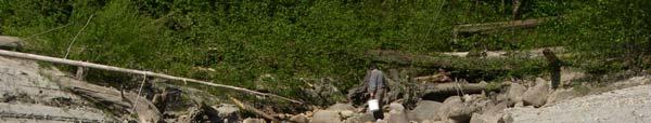
18 3.2 Fish habitat and fish Use Assessment Meech Creek - Reach 1 Lower Meech Reach 1 begins at the confluence of Meech Creek at the Coquitlam Reservoir and extends 68m upstream to the bridge crossing at Coquitlam Br. 400 spur road and Meech Creek (Figure 5). FISH HABITAT The available habitat in Reach 1 consists primarily of boulder-step pool and cascade step pool configuration which limited sampling methods. The mean bank-full width is 7.2m and the mean wetted width is 3.5m. This reach is characterized with small pools from the mouth to 40m upstream where boulder and large rock dominate the substrate. The mean gradient of reach 1 is 18% and increases to 21% 100m upstream above Meech Creek bridge crossing (Table 1). The substrate has been heavily impacted by upper debris torrents and a gravel bar is forming at Meech Creek mouth fanning into Coquitlam Lake (Figure 5). The lower reach substrate is dominated with boulder and large rock and sub-dominated with cobble, fines and organics, most of the available pockets of gravel have been scoured from pools. In-stream and riparian vegetation is sparse, moss was observed on many of the instream boulders and woody debris. 45m upstream in this reach, the riparian area consisted of a young mixed forest of conifers and deciduous trees that are under water at reservoir levels above 148m. Lower flood plain area is void of riparian canopy and in the channel young alders are submerged at a lake elevation of 149m. 7


19 Figure 5 - Meech Creek mouth, reservoir elevation at 144m, May-07. Figure 6 - Meech Creek mouth, May 15,
20 Table 1 - Summary of Meech Creek and tributaries CO-35, Co 43 habitat assessment and fish inventory. FISH ASSESSMENT MEECH CREEK FISH HABITAT August 2006 October 2006 May 2007 Reach 1 100m Boulder step pools. Areas of suitable spawning, rearing habitat mm Cutthroat Trout No trapping mm, Cutthroat Trout Reach 2 207m large boulder rock and cobble. Cascade pools. Grade >17 %. Not suitable rearing spawning habitat. No Fish Presence No Fish Presence No Fish Presence Reach 3 113m Cobble & gravel, riffles, pool areas. suitable spawning and rearing habitat, mm Cutthroat Trout mm Cutthroat Trout mm Cutthroat Trout Reach 4 190m Cobble gravel and fines. Pocket areas of pools, minimal spawning, and rearing habitat available. No Trapping, due to low flows. 0 Captured 0 Captured Reach 5 40m Bolder step pool area minimal during low flows. Not suitable rearing spawning habitat. Observed Cutthroat Trout in pool above Coq West mainline rd. No Trapping, due to low flows. 0 observed. No Trapping, due to low flows. 0 observed. CO-35 35m Cobble, gravel and fines. Pool, riffle areas. Areas of suitable rearing, spawning habitat. 0 Captured 0 Captured 0 Captured CO m Confined channel, large rock and cobble. Not suitable habitat. No Trapping, due to low flows. 0 observed. 0 Captured No Fish Presence No Trapping, due to low flows. 0 observed. 9

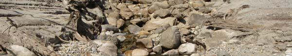
21 A large log structure 22 m upstream of the confluence is lodged across and within the channel, (Table 2, Figure 6-9). A gravel wedge has become trapped and stored above the log jam and lower reaches have become scoured of gravel. The height of the barrier (jump height) and pool depth below log structure varied with reservoir elevation and precipitation events and are outlined in Table 2. Table 2 - Reach 1, log structure, seasonal jump height and plunge pool depth vs. Coquitlam Reservoir elevation. Season Reservoir Elevation (m) Jump Height (m) Avg. Pool Depth (m) Late Summer (August 30 31, 2006) Fall (October 30-31, 2006 Spring (March 13, 2007) Early Summer (May 14-15, 2007) Figure 7 - Log structure, 12m upstream of Meech Creek mouth, Oct-06, Reservoir level at 145m. 10


22 Figure 8 - Log structure, 12m upstream of Meech Creek mouth, Mar-07, reservoir elevation at 149 m. Figure 9 - Log structure, 12m upstream of Meech Creek mouth, reservoir elevation at 144m, May
23 FISH ASSESSMENT Reach 1 Gee trapping data indicated that all life stages of cutthroat trout are present and inhabit the lower areas of reach 1. A total of 7 cutthroat trout were captured in six pool areas using ten gee traps. Less than 25% of captured cutthroat are considered mature and spawning or paring up was not observed at anytime during field surveys (see Appendix I for biological data) Other species found were western brook lamprey (Lampetra Richardsoni) and prickly sculpin (Cottus Asper) which are typically found in sandy, rocky shores of lakes and streams. Both species were captured downstream of log structure. Trapping results demonstrated that juvenile and adult cutthroat trout were found below and upstream of the log structure barrier. Reservoir operations below 150m may have an impact on the ability of cutthroat to migrate to upstream habitat if pool depth is inadequate to successfully jump log structure (Table 2). Fish sampled below the log structure are able to access the lake for food and refuge during high or low flows however overall weight and length did not vary from cutthroat trout captured above log structure Meech Creek - Reach 2 Reach 2 continues from the bridge crossing at Coquitlam Br. 400 spur road and Meech Creek to approximately 207m upstream. (Figure 3) FISH HABITAT Measuring 20m upstream of the bridge the gradient and substrate composition change to dominate large boulder and rock which continues 207m upstream. The lower portion of the reach consists of boulder, step pool and cascade step pool habitat (Figures 10 and 11). 100m upstream from the bridge several mature trees have been blown down uprooted and fallen across and within the creek channel. During the fall of 2006 wind and heavy precipitation had severe impacts with significant large woody debris accumulation trapping cobble, gravel and organic material causing stream flow to branch and braid into smaller flows across the width of the log structure. The mean channel width is 7.5m and gradient increases from 17% to 26% over the first 35m. The riparian vegetation consists primarily of mature coniferous vegetation with a secondary mix of deciduous mix at the lower reaches of the stream. Little in stream vegetation was observed with the exception of moss forming on the top of woody debris and boulders. 12

.")
24 FISH ASSESSMENT Trapping data in late summer and spring indicated fish presence in the lowest pool located 5m from the start point of reach 2. Trapping effort utilized 5 traps over 20m and captured 1 cutthroat during the spring survey. The steep gradient and lack of available rearing and spawning habitat indicates poor conditions for fish residence (Table 1). Figure 10 -Upstream view of Meech Creek, Reach 2, Oct06 Figure 11 - Upstream view of Meech Creek, Reach 2, May-07 13
. FISH HABITAT The assessed length of Reach 3 is 113m, the average channel width is 4.5m")
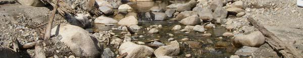
25 3.2.3 Meech Creek - Reach 3 Reach 3 starts approximately 207m upstream of the bridge crossing with decreasing gradient of <2 % and extends upstream to CO-35 confluence approximately 281m upstream of Meech bridge crossing (Figure 2). FISH HABITAT The assessed length of Reach 3 is 113m, the average channel width is 4.5m and the mean wetted area is 3.5m. The channel meanders frequently providing pools, runs, glides, riffles, and refuge areas were large and small woody debris have accumulated. The substrate throughout this reach is dominated by cobble and gravel and sub-dominant sands and organic material (Figure 12). Several boulders are scattered throughout this reach and several small areas of exposed and undercut banks were observed. May 2007 field study observed several large mature trees that have fallen, in a 10m area, into the channel increasing cover, refuge and pool habitat but also affecting water flow (Figure 13). The riparian vegetation is predominately an old growth coniferous canopy with a mix of conifers and deciduous vegetation such as salmon berry, vine maple and fern. Figure 12 Reach 3 - spawning & rearing habitat area, May

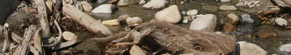
26 Figure 13 - Recent tree blow down in Reach 3, upper Meech, May FISH ASSESSMENT Trapping throughout this reach resulted in considerable numbers of cutthroat trout. Utilizing five gee traps covering 140m of habitat, 14 cutthroat trout were captured and identified at juvenile and adult life stages. The average fork-length is 61mm to 110mm and a weight range of 2g to 22g (Table 1). Reach 3 is recognized as the most productive fish habitat area of Meech Creek, providing areas of suitable incubation, rearing and spawning habitat for all life stages of cutthroat trout (Figure 12) Meech Creek - Reach 4 Reach 4 starts at CO-35 confluence and continues upstream 190m to the culvert at west mainline road (Figure 2). FISH HABITAT The mean gradient within the assessed length of Reach 4 is 14%; the average bank-full width is 2.2m and the mean wetted width 1.9m. The first 20m of reach 4 is confined and below a 2% grade, this section is significantly overgrown with vegetation and several areas have 15

27 accumulated large and small woody debris jams. The channel substrate is dominated by cobble, although there are pockets of gravel and fines in pool areas at the mid and upper reach. Approximately 98m upstream from the reach break the substrate becomes dominated by boulder and large rock. The bank vegetation contains a mix of young and mature coniferous and deciduous trees. Young vegetation such as salmon berry, sword fern and vine maple provide significant in-stream cover. Located at the upper reach, stream flow has actively eroded sections of the bank providing areas of refuge and cover; at present the banks are stable. Observations of water quality were good throughout survey dates although there is a significant presence of iron oxide on the substrate throughout this reach (Figure 14). Figure 14 - Reach 4 390m, upper Meech Creek, Aug-06. FISH ASSESSMENT Gee trapping was unsuccessful throughout this reach due to channel substrate, low flow, inadequate depth and lack of rearing or pool habitat. Trapping effort utilized 2 traps over 75m and captured zero species. Reach CO-35 has also been significantly impacted from trees that have been blown down and up-rooted during last fall (2006) storm events (Figure 14) which caused braiding an splitting of stream flow at several areas. The stream gradient in the upper reach of this section is 14-21% which may also impede fish movement (Table 1). 16
.")
28 Figure 15 Meech Creek, Reach 4 Large cedar uprooted in creek, May Meech Creek - Reach 5 ~ Upper Meech Reach 5 begins on the upstream side of Coquitlam West Mainline Road and was assessed to approximately 35m upstream from the road (Figure 2). FISH HABITAT Reach 5 is identified as boulder step pool habitat, the average bank-full width is 4m, wetted width is 0.9m, and mean gradient 18% (Table 1). During low flows movement may be impeded due to a significant boulder jump and shallow plunge pool that occurs 20m upstream of the starting point. Although pockets of pool habitat are available and provide temporary rearing habitat (Figure 16), the upstream 270m is dominated by large boulders and rock that were placed in the creek channel in 2004 as part of mitigation to prevent erosion and sediment slides from entering the reservoir. Upstream of this section the present configuration is a straight chute channel formation that does not provide rearing or spawning habitat. The banks are vegetated with a mix of deciduous and mature coniferous trees; any in stream vegetation has been impacted by previous slides and is minimal. Stream canopy cover decreases as gradient increases upstream to the headwaters. 17

29 FISH ASSESSMENT Trapping survey resulted in zero species captured although cutthroat trout were visually observed in a deep pool above road culvert during the August site survey (Table 2). Trapping effort utilized 6 gee traps covering a distance of 45m. Figure 16 Meech Creek, Reach 5 looking upstream from road, culvert at West Mainline Br. Oct Tributary C0-43 Tributary C0-43 is second order tributary and enters Meech Creek from the right bank side above log jam barrier, 26m upstream from the reservoir confluence (Figure 2). FISH HABITAT Trapping assessment was limited to October survey session due to precipitation providing sufficient flow and small pool areas. A 25m length was assessed before gradient increased to 21%, the mean bank-full width through this section was 1.7m and the wetted width was 0.8m (Table 1). Fish passage is impeded at the mouth with a small woody debris barrier that creates a vertical jump and lacks a plunge pool (Figure 17). Approximately 35m upstream substrate is dominated by large rock and boulders along the channel and stream banks (Figure 18). Riparian vegetation is dense and provides in-stream canopy. The flow in CO-43 is observed to be seasonal and provides no suitable rearing or off channel habitat. 18


30 Figure 17 - Mouth of Meech Creek tributary, CO-43, Oct-06. Figure 18-22m upstream CO-43 ~ gradient 21 %, Oct-06 19
31 FISH ASSESSMENT Gee trapping in the fall survey was unsuccessful throughout this reach due to channel substrate, low flow, inadequate water depth, lack of pool habitat and high gradient. Four gee traps were utilized in available pools and zero fish were captured. Tributary CO-43 does not provide suitable rearing or spawning habitat but the lower portion could be accessed for refuge during high water events in main-stem Meech Creek Tributary C0-35 Tributary Co-35 is a second order tributary of Meech Creek and its confluence occurs 376m upstream from the mouth of Meech Creek (Figure 2). The tributary continues upstream across Coquitlam West branch road and was assessed to 45 meter upstream of the road culvert. CO- 35 contributes a daily average of.026cms of flow to mainstem Meech and flows throughout the year. FISH HABITAT With an assessed length of 110m and an average gradient of <1%, CO-35 is a relatively short, low gradient reach. The mean channel width is 2.7m and the wetted width is 2.4m. The creek flow braids around in-stream woody debris at areas depending on seasonal flows (Table 1). Cobble is the most dominate substrate with gravel and fines sub-dominate in the lower section of the reach (Figure 19). Spring survey observed numbers of mature trees blown down within the channel and impeding directional flow through stream channel. CO-35 provides pockets with suitable spawning but lacks suitable year round rearing habitat. The upper reach of C0-35 above Coq West Br. 400 road, was assessed and trapped for a length of 45m (Figure 20). The lower 30m offers suitable substrate and pool areas for rearing; upstream the channel becomes more confined and the substrate is dominated with fines and organics offering minimal spawning and rearing habitat. Continuing 55m upstream the creek channel fans out into a wetland catchment area, the channel continues upstream until Coq west mainline road drainage. In-stream vegetation is dense with salmon berry and vine maple; young deciduous and coniferous vegetation overhang the stream channel throughout the length assessed. 20


32 Figure 19 - CO-35, downstream of culvert at Spur 400 road. May-07. Figure 20 - CO-35, 35m upstream of road culvert, Oct-06. FISH ASSESSMENT No fish were trapped in the fall and spring surveys above and below the culvert at spur 400 road crossing (Table 1). However, one cutthroat trout was observed in a pool above Coquitlam west branch 400 road in late August reconnaissance. Trapping effort utilized 12 gee traps covering a distance of 45m. Tributary CO-35 does provide suitable rearing, spawning habitat 21
33 but presently a small woody debris structure and vertical barrier (0.7m) upstream of Meech Creek confluence has the potential of impeding passage to the upstream habitat. 3.3 Potential for Fish Passage Factors including flow, jump height, and plunge pool depth were considered in assessing fish passage potential at the log structure in Reach 1. The bio-standard commonly used to assess fish passage potential is that the pool depth below the obstacle must be 1.25 times the jump height (Slaney 1996). The plunge pool depths observed during the monitoring period appear to restrict passage given the criteria that the pool depth must be 1.25 times the height (Table 3). Table 3 - Meech Creek - Reach 1 Lower Meech log jam predicted seasonal pool depths required to allow adult upstream passage. * Pool depth must be at least 1.25 times the height of the jump) Season Fall (October 30-31, 2006 Spring (March 13, 2007) Early Summer (May 14-15, 2007) Reservoir Jump Average Pool Predicted Pool Elevation Height Depth (m) Depth Required (m) (m) to Jump Barrier (m) * Based on projected completion of the Coquitlam Dam seismic upgrade in summer 2008, the maximum operating level of Coquitlam Reservoir will be returned to the normal maximum operating level of 154 m from the current maximum interim level of 149 m (Hunter, 2006). Figure 21 outlines the proposed seasonal reservoir fluctuation once the normal maximum reservoir level is reinstated. Fall drawdown gradually increasing through winter months and spring to a summer high and peak holding capacity. 22
34 Coquitlam Reservoir Elevation Elevation (m) Jan-01 Jan-31 Mar-03 Apr-02 May-03 Jun-02 Jul-03 Aug-02 Sep-02 Oct-02 Nov-02 Dec-02 Date 10%ile 50%ile 90%ile Figure 21 - Predicted Coquitlam Reservoir Elevations once maximum operating level restored in 2009 (Hunter 2006). Typically, resident cutthroat trout begin to spawn in mid May to early June with predicted reservoir levels varying from 149m to 151m (Table 3). Rainbow Trout begin spawning in mid March to late May (Gidora 2007) when reservoir elevations are typically 148m to 149m. Based on the predicted pool depth required to pass the log structure and estimated seasonal flow, rainbow and cutthroat trout access appears feasible when reservoir levels are 149.5m or greater. According to the passage criteria in Table 2, 149.5m would represent a 25cm jump and available pool depth of 1.18m suggesting passage would not be impeded. Therefore there is the potential for passage if the reservoir elevation is 149.5m or greater for extended periods of time during migration period. Kokanee peak spawning time in the Coquitlam Reservoir occurs mid October to mid November (Bussanich et al. 2006) when predicted reservoir levels vary from 144m to 145m. Jump height and lower reservoir levels in the fall appear to be the constraining factor, 23
35 however, it is unlikely that kokanee would access Meech Creek to spawn. According to a previous study (Bussanich et al. 2006) it was observed that kokanee in the Coquitlam Reservoir primarily utilize shoreline areas with gravel and up welling water influence. Tributaries in the Coquitlam reservoir are under utilized due to lack of quality spawning habitat, however, access to Meech Creek may be possible with higher reservoir levels. Considering the average fish size of sampled cutthroat trout is <200mm for adult and yearlings, lake access and migration can be impeded and affected by reservoir operations and the vertical log structure barrier in reach 1. It is a possibility that rainbow trout were not found due to seasonal low flows, a reservoir elevation below 149m and the log structure barrier during spring spawning migration. Other factors created by instream barriers is the inability of adult and juvenile fish to adjust to changing habitat conditions such as temperature fluctuations, high or low flows, available food and limited shelter. Catastrophic events can displace entire resident populations, and barriers have the potential to prevent re-colonization of these habitats (ODFW 2000). Pool depth must be at least 1.25 times the height of the jump for allowable fish migration (Slaney 1996). As illustrated by figure 8, in May 2007 the pool depth required a minimum depth of 1.75m to make the 1.4 meter jump successfully (table 3). Meech Creek discharge, although important, does not have a significant affect on plunge pool depth when the reservoir level is below 149m. Lower flows become braided at the log structure thus reducing the available flow over the center of the barrier and into the plunge pool. Cutthroat trout maximum jump heights are indicated below for example, in order for an adult cutthroat to successfully jump the present 1.5m jump, passage criteria indicates the pool depth would have to be at a minimum of 1.8m in depth. Cutthroat Maximum Jump Capability (Dane 1978) Life Stage Max Jump Height (m) Adult (>200mm) 1.5 Juvenile (125mm) 0.6 Fry (50 mm)
36 4.0 RECOMMENDATIONS Based on habitat assessment and trapping results, cutthroat trout of all life stages were captured in Reach s 1 and 3 of Meech Creek. Although two of the three target species were not captured lake migration is restricted to the lower 30m of Reach 1 due to the log structure impeding migration 24m upstream of the mouth. Reservoir levels below 149m pose a potential migration barrier; due to lack of plunge pool and jump height at log structure to access upstream habitat. Even though this particular creek and habitat is productive for resident cutthroat trout it is recommended that Option 2 (see section 5.1) be considered due to immediate increased habitat benefits, low cost to complete and a minimal impact to riparian area. A sustainable increase in resident fish populations will enrich the food web of the local ecosystem providing a productive habitat (BC Hydro 2003). The barrier alteration may be a medium priority restoration initiative but the overall productivity and complexity will increase in lower reach of Meech Creek and future migration will not be compromised by reservoir fluctuations. Alteration of the barrier, means future reservoir fluctuations and operations will have minimal impact on the migration of resident species and may encourage the introduction and usage by other species. Although present reservoir levels are under the projected holding capacity it may be advisable to continue monitoring migration when reservoir operations return to normal levels in 2009 to confirm fish access or presence. The following steps are recommended: 1. Low impact barrier alteration to be completed. In-stream woody debris utilized for increasing habitat complexity at the site. 2. Ongoing monitoring and evaluation of habitat work completed and maintenance work performed as required. Benefits: 1. Provide year round access to upstream habitat of Reach Create additional 80m to100m available spawning and rearing habitat. 3. Allow natural progression of gravel to be distributed to lower reach and mouth providing the potential of increased spawning habitat. 25
37 4. Increased available habitat may be beneficial to kokanee colonization and or other species, such as rainbow trout. 5. Lake access for cutthroat trout may serve as an alternative food source or refuge during high flows. 6. Reduce dam footprint impact within reservoir draw down zone. 4.1 Barrier Mitigation Prescriptions The habitat characteristics of lower Meech Creek (Reach 1) evaluated during field assessments concluded that during low flows and a reservoir elevation below 149m the log structure barrier surveyed 22m upstream of the mouth impedes fish passage and migration, (coordinates ~ N, W). The log structure is 9.8m wide across the channel and encompasses a 10m area with an average jump height of 1.5m observed during monitoring. A significant amount of gravel is trapped, wedged and stored above the log jam causing the lower reaches to become scoured of gravel, depriving available spawning habitat. Lake elevations below 146m and late summer flows also indicated a secondary smaller woody debris jam 1.7m below the main log structure that can also restrict fish movement and may require minor maintenance. The objective is to restore fish access to available upstream spawning habitat above the log structure. Barrier alteration will also keep the present natural configuration of step pool habitat and woody placement will provide complexity and minimize riparian disturbance. It is recommended that option two be considered as it provides a cost effective and efficient habitat improvement prescription (Table 4). Option 1. Minimal modification to log barrier - notch the main log in several places with a chain saw and punch holes using shovels and pry bars in the upstream area of the sediment wedge to allow water flow to scour an access area, permitting accumulated gravel and fines to be transferred downstream. Allowing gravel to transfer downstream unimpeded will increase substrate in pool and riffle areas, increasing spawning habitat availability. A secondary benefit is allowing channel flow to run in a defined line providing consistent flow in the stream bed when lake elevation is below 146m and creek flow is minimal. A disadvantage of not fully removing the log jam is the potential of upstream debris jams dislodging and increasing the 26
38 deposit of large woody debris and continuing to trap cobble and gravel braiding and splitting stream channel flow. Option 2. Complete barrier alteration - manually cut large woody debris in manageable 3 to 4m sections, anchor and secure log sections at a 45 degree angle on the left and right bank creating in-stream deflectors. Secure LWD to clusters of large boulder allowing the creation of pool areas and allowing flow to distribute in the center of stream channel creating access for migration and the natural transfer of stored gravel and fines to lower reach area. Using the logs as deflectors will increase existing pool habitat and provide rearing and refuge areas in extreme flows. The benefits of altering the barrier is primarily for fish (adult or juvenile) access to available upstream habitat for spawning / rearing, as well improving the complexity of the present habitat. Providing lake access for food, refuge and possible smolt migration will increase the health and viability of the species that inhabit Meech Creek watershed. Secondary benefits include creating alternate habitat sites with the cut sections of large woody debris (LWD) which can provide cover, refuge and also have potential to trap and accumulate small woody debris. Third, if the barrier is completely altered it will prevent upstream LWD becoming trapped at this section and having the potential of becoming a barrier again in the future. Option 3. Operational procedures during migration. During migration and spawning period of cutthroat, kokanee and rainbow trout, reservoir level will remain at a minimum height of 150m for the duration of the migration period. Activities and Time Line: Work must be completed during fisheries window and or during low flows in late summer ~ August. Maintenance work will be completed by trained personnel. 60 days prior ~ obtain in stream work and fish collection permits from Fisheries and Oceans Canada, Provincial Ministry and BC Hydro. Create safety procedure and protocol. Day 1 ~ install upstream fencing to stop potential movement of Cutthroat downstream. Complete installation of silt fencing material and structure 10m downstream to catch fines and sediment from entering reservoir. Set up pump for dewatering to provide a reduced flow through work site. 27
39 Day 2 ~ Complete fish salvage up and down stream of work site area. Transfer fish to upstream holding pools. Prepare intake and outflow and dewater work site area. Day 3 & 4 ~ Begin maintenance work. Cut log barrier in half 4.2 and 4.5 m sections with chain saw, winch and anchor in-stream logs to left and right bank at 35 degree angle in-stream. Secure to boulder clusters using cable anchor and epoxy. Using shovels and pry bars begin removing small woody debris and gravel deposits. Alteration and placement of boulders may be required to secure logs deflectors. Small woody debris jam can be cut in place and debris removed and utilized; every attempt will be made to preserve in-stream woody and organic debris content. Day 5 ~ Monitor flow pattern and adjust rock, cobble and boulder configuration if required. Removal of silt fencing and upstream fence; transfer cutthroat trout back to originating holding pools however it would be preferred if they are able to migrate on their own to decrease stress. Recommend ongoing monitoring of stream morphology as flows increase. Potential Problems: During the removal of the log structure there is a potential of temporary release of fines and sediment into the reservoir. To mitigate the effect into the reservoir, cloth silt fencing will be installed in a series to capture any fines and sediment released during procedures. A pump will also be used to de-water work area to allow minimal sediment discharge. Health and Safety issues are to be reviewed for the use of gas powered tools (chainsaw and hammer drill). First aid certification required for site supervisor and emergency call out procedures performed. 28
40 Table 4 - Budget - Estimated costs of barrier alteration and monitoring. The total estimated cost to complete this project is between $4, and $5, Tasks Expense Type Rate Number of Step 1 Field preparation, equipment and supplies Step 2 Fence installation, silt fence x 2 to install Step 2 Fish salvage and transfer Begin de-watering work area Step 2 Barrier removal, anchoring of large woody debris Step 3 Monitoring and evaluation, maintenance if required Units Program Cost Technician I 500 1/2 250 Technician I Technician II Technician I Technician II Technician I Technician II Technician I Technician II Step 4 Final report (if required) Miscellaneous Expenses Administration - TOTAL (estimate) Technician I ,000 Materials Mileage Equip. Rental ,
41 5.0 REFERENCES CITED Amos, B., Stuart, S Meech Creek Erosion Control Project, several un-authored reports. Greater Vancouver Regional District Watershed Management Div. BC Hydro Coquitlam River and Buntzen Lake Watersheds. Bridge Coastal Fish and Wildlife Restoration Program. Vol 2. BC Ministry of Environment Provincial base map website. Bussanich, R., Bocking, R.C. Nelson, R., Wood C Feasibility Assessment of Kokanee Re-Anadromization and Planning of Fish Propagation for Re-introduction of Sockeye Salmon in Coquitlam Reservoir. LGL Ltd, Burnaby, BC: 8 p. Dane B.G. 1978, a Review and Resolution of Fish Passage Problems at Culvert Sites in British Columbia. American Fisheries Society workshop, California. De Gusseme, B., et al Meech Creek Background History, various published and unpublished articles and reports, Watershed Management Div, Metro Vancouver. De Gusseme, B., Meech Creek Climate Station Data Watershed Management Div, Metro Vancouver. Gidora, S Personal Communication, via and verbal correspondence. Fisheries and Oceans, Canada, Resource Restoration Biologist. Hogan, D.L. and B. Ward, Watershed Geomorphology and Fish Habitat, Watershed Restoration Technical Circular No. 9, Ministry of Environment, Lands and Parks and Ministry of Forests. Hunter, D., Personal Communication, via and verbal correspondence. Natural Resource Specialist, Water License Requirements, BC Hydro. 30
42 Johnston, N.T. and G.D. Moore, 1995, Guidelines for Planning Watershed Restoration Projects, Watershed Restoration Technical Circular No. 1, Ministry of Environment, Lands and Parks and Ministry of Forests. Johnston, N.T., P.A. Slaney, 1996, Fish Habitat Assessment Procedures, Watershed Restoration Technical Circular No. 8, Ministry of Environment, Lands and Parks. Koning., Keely Fish Passage Criteria, Oregon Department of Fish and Wildlife, Portland, Fish habitat Criteria, Oregon Department of Fish and Wildlife, Portland, article by several authors, Fish habitat Criteria, 2000 Ortho-photo. Navteq, Digital Globe, Google Earth program. Ptolemy. R Juvenile Freshwater Rearing Habitat Limiting Factors. Coastal Cutthroat Trout as sentinels of Lower Mainland watersheds, Ministry of Environment, RISC, 2001, Steam Inventory Standards and Procedures, Chapter 4. Resource Information Standards Committee. British Columbia Integrated land management website. Slaney, P.A. and A.D. Martin, 1996, Planning Fish Habitat Rehabilitation: Linking to Habitat Protection, Watershed Restoration Technical Circular No. 9, Ministry of Environment, Lands and Parks and Ministry of Forests. Whyte, I.W., S. Babakaiff, M. Adams and P. Giroux, Restoring Fish Access and Rehabilitation of Spawning Sites, Applying Rehabilitation Techniques, Watershed Restoration Technical Circular No. 9, Watershed Restoration Program, Ministry of Environment, Lands and Parks and Ministry of Forests. 31
43 APPENDIX I FIELD NOTES 32
44 APPENDIX I FIELD NOTES Fish Distribution Data Form Watershed Name: Coquitlam Reservoir Watershed Code: Weather: Sunny, windy Date: Aug 31, Oct 31, 2006 Temp: Air = 16 to 21 C Survey Crew: Scott D, Tony M Reach Habitat Trap Distance Gradient No. Species Fork Weight Age Comment No. Type No. (m) % Captured Length (mm) (g) Class 1 pool CT juv start point at Meech mouth 3 sculpin n/a 1 pool CT 116, , 24 trap site below log obstruction 1 pool CT m jump at log jam 1 pool 4, CT Used 1/4 & 1/8 trap mesh 1 pool pool 7, CT 110, , 17.5 pool dwnstrm side of bridge X 2 pool upstrm of bridge X 2 pool
45 Oct 31 CO - 43 Reach Habitat Trap Distance Gradient No. Species Fork Weight Age Comment start point at meech No. Type No. (m) % Captured Length (mm) (g) Class 1 pool pool pool confluence small pocket of pools, minimal flow substrate change to rock / boulder 1 pool 4 25 >26 0 Oct Upper CO-35 Reach Habitat Trap Distance Gradient No. Species Fork Weight Age Comment No. Type No. (m) % Captured Length (mm) (g) Class Start point upstrm of CO35 pool culvert. CO35 pool % canopy cover CO35 pool min flow, end below wetland area substrate suitable for spawning CT Oct 31 Lower CO-35 Reach Habitat Trap Distance Gradient No. Species Fork Weight Age Comment No. Type No. (m) % Captured Length (mm) (g) Class CO35 pool Start dwnstrm of culvert effluent CO35 pool right bank channel / pool CO35 pool riparian veg thick with salmon berry CO35 pool and old growth, meandering. site end at Meech confluence Upper mainstem Meech
46 Reach Habitat Trap Distance Gradient No. Species Fork Weight Age Comment start point - below rd No. Type No. (m) % Captured Length (mm) (g) Class culvert 3 pool 5 75 < 3 5 CT 85, 80, 64, 81, , 5.5, 2.5, 5, 4 spawning / rearing habitat 3 pool < 2 3 CT 80, 84, 72, 6, 6.5, 4.5 nice gravel cobble mix, cover, flow 3 pool < 2 2 CT 83, , 4.5 water Temp = 5 C 3 pool CT 104, 74, 72, 67 13, 4, 4.5, 3 Dwnstream habitat change to boulder 3 pool CT 20% grade, impassable at present flow 5.4 Upper mainstem Meech Reach Habitat Trap Distance Gradient No. Species Fork Weight Age Comment start point - below monitor No. Type No. (m) % Captured Length (mm) (g) Class station 4 pool 1 0 pool below jump 4 pool 2 0 small but deep pool 127 m dwnstrm to CO35 confluence mainstem Upper Meech Reach Habitat Trap Distance Gradient No. Species Fork Weight Age Comment start point - above Coq No. Type No. (m) % Captured Length (mm) (g) Class mainline road 5 pool pool below jump 5 pool small but deep pool 5 pool water = 5 C
47 Watershed Name: Coquitlam Reservoir Watershed Code: Weather: Sunny Date: May 15, 2007 Temp: Air = 12 to 20 C Survey Crew: Scott D, Tony M Reach Habitat Trap Distance Gradient No. Species Fork Weight Age Comment Start point At Meech No. Type No. (m) % Captured Length (mm) (g) Class mouth 1 pool 1, 1b CT 67, , 2.5 r.bank pool, cobble, rock, gravel 4 Sculpin n/a 1 Lamprey n/a 1 pool 2, 2b R. bank pol under root wad 1 pool 3, 3b CT 80, , 7.5 Pool below Log X barrier 1 pool Sculpin n/a 1 pool 4, 4b CT 128, 108, 84, 68 22, 19, 5.5, 2 above barrrier adjacent to CO-43 1 glide R.bank pool under cedar 2 pool 6, 6b CT Ad pool below Meech Brdg X 2 pool pool above Meech Brdge X 15.7 Upper CO-35 Reach Habitat Trap Distance Gradient No. Species Fork Weight Age Comment Start point upstream No. Type No. (m) % Captured Length (mm) (g) Class of rd culvert CO-35 pool 1 3 <2 0 pool upstream of culvert CO-35 pool 2 9 <2 0 Lots of instream woody debris CO-35 pool 3 20 <2 0 small pool R. bank ~ min flow CO-35 pool wetland catachment
48 area above site. CO-35 pool 5 9 n/a 0 pool upstrm of Meech confluence 2.5 Upper Meech Reach Habitat Trap Distance Gradient No. Species Fork Weight Age Comment start point below Co- No. Type No. (m) % Captured Length (mm) (g) Class 35 confluence 3 pool 7 4 <2 11 CT 82,94,105,110,61,65, 5.5,13,13.5,2,2 pool below CO-35 confluence 81,78,71,72,72 5,5.5,5,4.5 decent flow, canopy cover, substrate 3 pool 8 20 <2 13 CT 150,108,102,80,122 22,13,14,5.5,18 pool mid strm, under fallen tree 82,112,82,98,88,128 6,12.5,6,14,5.5,22 100, , pool CT 100,90,110,100,95 8,7.5,13,8,6.5 Deep pool on bend, Lwd accumulation good rearing habiat 89,84,90,82,92,83 6,5,5.5,4.5,11,5 complexity
49 Quantitative Habitat Assessment ~ Sept, Oct 2006, May 2007 Aug ~ lower Meech Reach Habitat Dist. unit Gradiant bankfull wetted Wetted substrate # Type (m) leng (m) % width (m) width (m) depth(cm) Comment 1 pool Start at mouth of Meech. 1 pool g,cs below log X barrier. jump = 1.45 m 1 X g, f LWD jam barrier, 1.5m jump 1 pool g,c, f pool above log X barrier 1 Trib > b,c,g CO-43 confluence 1 pool g,f,s,c boulder 1 pool br,b, c Water temp 16 C 1 pool br,b, c below Meech Brdg X 2 pool br,b upstrm Brg X - 2 pool gradient and substrate change No available rearing or spawning no available spawning or rearing habitat upstream. Oct ~ Trib Reach Habitat Dist. unit Gradiant bankfull wetted Wetted substrate # Type (m) leng (m) % width (m) width (m) depth(cm) Comment CO- 43 pool g, f, s small pocket pools CO- 43 glide g, f, s impassable jump above pool CO- 43 pool g, f, r wate temp = 5 C CO- 43 pool g, f, r boulder and high grade above Oct ~ CO-35 above culvert Reach Habitat Dist. unit Gradiant bankfull wetted Wetted substrate # Type (m) legth (m) % width (m) width (m) depth(cm) Comment 4b pool 10 2 < g, c, s overgrown~ woody debris
50 accumulation 4b pool 32 2 < g, c, s trout spawning habiat 4b pool 50 2 < g, c, s R. bank undercut CO- 35 below culvert water = 4 C 3b pool 9 2 < g, c, start point dwnstrm of culvert 3b pool 30 2 < g, c, 3b pool 39 2 < g, c, s 70 % canopy 3b pool 47 2 < c, g good rearing / spawn substrate Oct ~ below CO-35 confluence Reach Habitat Dist. unit Gradiant bankfull wetted Wetted substrate # Type (m) (m) % width (m) width (m) depth(cm) Comment 3 pool 75 2 < g, c start point from Co-35 culvert 3 pool 89 2 < g, c flow ~.05 cfs 3 pool < g, c, s, Deep pool LWD accumulation 3 pool < g, c, s, Deep pool small jump 3 pool < r, b. c Gradient decreases after this site Oct ~ upper Meech Reach Habitat Dist. unit Gradiant bankfull wetted Wetted substrate # Type (m) legth (m) % width (m) width (m) depth(cm) Comment 4 pool c, g, b start below monitoring station 4 pool c, g, b series of pools and jumps 5 pool r, b, g located above Coq west main rd 5 pool r, b, g Large angular rock, boulder 5 pool r, b, g armouring has been completed May ~ lower Meech
51 Reach Habitat Dist. unit Gradiant bankfull wetted Wetted substrate # Type (m) leng (m) % width (m) width (m) depth(cm) Comment 1 pool g, c, b Start at mouth of Meech. 1 pool b,c,g below log X barrier. jump = 1.45 m 1 X 9.5 b,c,g LWD barrier / no fish passage 1 pool c,g,f 1 Trib b,c,g CO-43 confluence 1 pool b, r,c 1 pool b, r,c pool below Meech brdg X 1 pool b, r,c 1.7m jump above pool 2 X b,r,c gradient and sustrate change 1.7 m LWD barrier May ~ Upper Co 35 Reach Habitat Dist. unit Gradiant bankfull wetted Wetted substrate # Type (m) leng (m) % width (m) width (m) depth(cm) Comment 4b pool 3 2 < g,c, f staring above rd culvert 4b pool 9 2 < s, g, c 4b pool 20 2 < s, g, c R. bank undercut / erosion 4b pool 47 2 < s, g wetland catch area above 3b pool s, g, c Staring pt. below culvert upper Meech pool adjacent to Meech confluence 3 pool c,g,f Staring pt. below rd. culvert c,g,f many trees have blown into creek s, g, c Lwd debris ~ rearing, spawn substrate


52 APPENDIX II PHOTOS Meech Creek May 31, reservoir level 144m, flow.008cms. Meech Creek - Cutthroat Trout 110mm 39

 40")
53 Cutthroat Trout Juveniles. Cutthroat Trout (slash under mouth) 40

54 Cutthroat Trout yearling2+, juvenile Lower reach, Meech Creek, May 15,
Lower Coquitlam River Project Water Use Plan. Temperature Monitoring Lower Coquitlam River Project Year 2 Report
 Lower Coquitlam River Project Water Use Plan Temperature Monitoring Lower Coquitlam River Project Year 2 Report COQMON#6 Temperature Monitoring Study Lower Coquitlam River Study Period: Year 2-2007 Report
Clowhom Project Water Use Plan. Fish Productivity Monitoring. Reference: COMMON-2. Fish Productivity Monitoring Year 2 Data Summary 2008
 Clowhom Project Water Use Plan Fish Productivity Monitoring Reference: COMMON-2 Fish Productivity Monitoring Year 2 Data Summary 2008 Study Period: August 25 to October 16, 2008 D.J. Bates Resource Management
Firth Creek Habitat Enhancement Project 1993
 Firth Creek Habitat Enhancement Project 1993 A. R. Langston December 1993 PWFWCP Report No. 77 The Peace/Williston Fish & Wildlife Compensation Program is a cooperative venture of BC Hydro and the provincial
Steelhead Society of BC. Thompson River Watershed Restoration and Enhancement Project #4 Nicola River Bank Stabilization and Enhancement Project
 Steelhead Society of BC Presents: Thompson River Watershed Restoration and Enhancement Project #4 Nicola River Bank Stabilization and Enhancement Project Application for Funding December 2013 1.0 BACKGROUND
Coquitlam/Buntzen Project Water Use Plan
 Coquitlam/Buntzen Project Water Use Plan Temperature Monitoring Lower Coquitlam River Project Year 3 Report Reference: COQMON#6 Study Period: March 2008 April 2009 Report Date: April 2009 Trow Associates
Fish Passage Culvert Assessment for Cahilty Creek Watershed FIA Project #
 Fish Passage Culvert Assessment for Cahilty Creek Watershed FIA Project # 4602004 Prepared for Weyerhaeuser Company Ltd. Jason Ladyman R.P.F. 1550 Mission Flats Road PO Box 40 Kamloops BC V2C 5K3 Prepared
COA-F17-F-1343 YEAR END REPORT
 DAVE MARSHALL SALMON RESERVE RESTORATION, MAINTENANCE, AND UPGRADES YEAR END REPORT Prepared for: Fish and Wildlife Compensation Program Prepared by: Edith Tobe, RPBio, Executive Director Box 1791, Squamish,
Project Completion Abstract Fish Passage Activity ( Engineering Activities)
") Project Completion Abstract Fish Passage Activity ( Engineering Activities) SUBMIT COMPLETED FORM TO DISTRICT MANAGER AND FIA ADMINISTRATOR AFTER PROJECT COMPLETION SECTION A GENERAL INFORMATION Recipient:
Project Completion Abstract Fish Passage Activity ( Engineering Activities) SUBMIT COMPLETED FORM TO DISTRICT MANAGER AND FIA ADMINISTRATOR AFTER PROJECT COMPLETION SECTION A GENERAL INFORMATION Recipient:
FINAL REPORT. Yonkers Creek Migration Barrier Removal Project Wonderstump Road Del Norte County. Submitted By:
 FINAL REPORT Yonkers Creek Migration Barrier Removal Project Wonderstump Road Del Norte County Submitted By: Del Norte County Community Development Department Yonkers Creek Migration Barrier Removal Project
Removal of natural obstructions to improve Atlantic Salmon and Brook Trout habitat in western NL. 26/02/2015 Version 2.0
 Removal of natural obstructions to improve Atlantic Salmon and Brook Trout habitat in western NL 26/02/2015 Version 2.0 1 Table of Contents List of Tables... 2 Introduction... 3 Methods... 4 Preliminary
Rehabilitation of Grimes Creek, a Stream Impacted in the Past by Bucket-lined Dredge Gold Mining, Boise River Drainage, July 2008 to August 2011.
 Rehabilitation of Grimes Creek, a Stream Impacted in the Past by Bucket-lined Dredge Gold Mining, Boise River Drainage, July 2008 to August 2011. Pam Harrington TU,1020 W. Main Street Suite 440, Boise,
Five Counties Salmonid Conservation Program - Fish Passage Design Workshop. February 2013
 Program - Aquatic Organisms and Stream Crossings Ecological Connectivity A watershed is a network of channels that drain a common boundary. Channel characteristics formed by interaction of precipitation,
STEELHEAD SURVEYS IN OMAK CREEK
 STEELHEAD SURVEYS IN OMAK CREEK 2002 Annual Report Prepared by Chris Fisher John Arterburn Colville Confederated Tribes Fish and Wildlife Department P.O. Box 150 Nespelem, WA 99155 Prepared for Project
Clowhom Project Water Use Plan
 Clowhom Project Water Use Plan Fish Productivity Monitoring Implementation Year 4 Reference: COMMON-2 Fish Productivity Monitoring Year 4 Data Summary 2010 Study Period: September 16 to October 6, 2010
Sub-watershed Summaries
 Project Description The Salmon Drift Creek Watershed Council (SDCWC) has focused their efforts in the Salmon River estuary for the past few years. The multifaceted partnership effort is nearing completion
LIFE HISTORY DIVERSITY AND RESILIENCE
 LIFE HISTORY DIVERSITY AND RESILIENCE SPRING CHINOOK IN THE WILLAMETTE RIVER BASIN Kirk Schroeder Brian Cannon Luke Whitman Paul Olmsted Oregon Department of Fish and Wildlife Corvallis Research Lab Thanks
STREAM CLASSIFICATION AND MAPPING. Prepared For. MacMillan Bloedel Ltd. Menzies Bay Division BOX 6000, Campbell River V9W 5E1.
 STREAM CLASSIFICATION AND MAPPING OF STREAMS IN MENZIES AND OYSTER BAY Prepared For MacMillan Bloedel Ltd. Menzies Bay Division BOX 6000, Campbell River V9W 5E1 September 1998 a a North Island Biological
Blue Creek Chinook Outmigration Monitoring Technical Memorandum
 Blue Creek Chinook Outmigration Monitoring 2012 Technical Memorandum Prepared by: Andrew Antonetti and Erika Partee Yurok Tribe Fisheries Program PO Box 1027 Klamath, California 95548 In Partnership with:
Aquatic Organism Passage at Road-Stream Crossings CHUCK KEEPORTS FOREST HYDROLOGIST ALLEGHENY NATIONAL FOREST WARREN, PENNSYLVANIA
 Aquatic Organism Passage at Road-Stream Crossings CHUCK KEEPORTS FOREST HYDROLOGIST ALLEGHENY NATIONAL FOREST WARREN, PENNSYLVANIA TOPICS COVERED Aquatic Organism Passage (AOP) Benefits of AOP Crossings
Executive Summary. Map 1. The Santa Clara River watershed with topography.
 Santa Clara River Steelhead Trout: Assessment and Recovery Opportunities December 2005 Prepared By: Matt Stoecker and Elise Kelley, Ph.D. University of California, Santa Barbara Prepared For: The Santa
Chadbourne Dam Repair and Fish Barrier
 Chadbourne Dam Repair and Fish Barrier Final Report for the Western Native Trout Initiative Prepared by: Carol Endicott Yellowstone Cutthroat Trout Conservation Biologist Montana Fish, Wildlife & Parks
Study Update Tailrace Slough Use by Anadromous Salmonids
 Study Update Tailrace Slough Use by Anadromous Salmonids Goals and Objectives Identify what anadromous salmonids use the tailrace slough by: Life Stage (Juvenile, migrating and spawning adults) Timing
MINISTRY OF ENVIRONMENT ENVIRONMENTAL STEWARDSHIP DIVISION FISH AND WILDLIFE BRANCH. Horsefly River Angling Management Plan
 MINISTRY OF ENVIRONMENT ENVIRONMENTAL STEWARDSHIP DIVISION FISH AND WILDLIFE BRANCH Horsefly River Angling Management Plan January 30 th, 2006 Area/Fishery Description The Horsefly River watershed provides
Minnesota Department of Natural Resources Division of Fish and Wildlife Section of Fisheries. Stream Survey Report. Luxemburg Creek.
 Minnesota F-29-R(P)-24 Area 315 Study 3 March 2016 Minnesota Department of Natural Resources Division of Fish and Wildlife Section of Fisheries Stream Survey Report Luxemburg Creek 2015 Mark Pelham Sauk
Understanding the Impacts of Culvert Performance on Stream Health
 Understanding the Impacts of Culvert Performance on Stream Health Kristin Thomas Aquatic Ecologist Michigan Trout Unlimited Transportation and the Environment Conference 12/5/2018 Importance of adequately
Newaukum Watershed Culvert Assessment
 Newaukum Watershed Culvert Assessment Water Resource Inventory Area 23 Lewis County Conservation District Final Report By: Kelly Verd and Nikki Wilson July 2002 Funded by: Chehalis Fisheries Restoration
FISH PASSAGE IMPROVEMENT in California s Watersheds. Assessments & Recommendations by the Fish Passage Forum
 FISH PASSAGE IMPROVEMENT in California s Watersheds Assessments & Recommendations by the Fish Passage Forum FISH PASSAGE IMPROVEMENT in California s Watersheds The mission of the Fish Passage Forum is
Culvert Design for Low and High Gradient Streams in the Midwest. Dale Higgins, Hydrologist Chequamegon-Nicolet National Forest
 Culvert Design for Low and High Gradient Streams in the Midwest Dale Higgins, Hydrologist Chequamegon-Nicolet National Forest Overview Culvert Design Considerations Hydraulic Terms Culvert Impacts Low
SUMMARY OF MOVEMENT AND HABITAT USED BY TAGGED BROOK TROUT IN THE MAIN BRANCH AND NORTH BRANCH AU SABLE RIVER DURING SUMMER Data Submitted to:
 SUMMARY OF MOVEMENT AND HABITAT USED BY TAGGED BROOK TROUT IN THE MAIN BRANCH AND NORTH BRANCH AU SABLE RIVER DURING SUMMER 2014 Data Submitted to: Anglers of the Au Sable Submitted by: Dr. Mark R. Luttenton
Final Fish Salvage & Temporary Tailrace Barrier Report for the Wallowa Falls Hydroelectric Project Tailrace. (FERC No. P-308) December 18, 2017
 December 18, 2017") Final for the Wallowa Falls Hydroelectric Project Tailrace (FERC No. P-308) December 18, 2017 Prepared by: Jeremiah Doyle PacifiCorp 825 NE Multnomah Street Portland, OR 97232 December 18, 2017 Page 1
Final for the Wallowa Falls Hydroelectric Project Tailrace (FERC No. P-308) December 18, 2017 Prepared by: Jeremiah Doyle PacifiCorp 825 NE Multnomah Street Portland, OR 97232 December 18, 2017 Page 1
Final Bull Trout Genetics Monitoring Plan for the Wallowa Falls Hydroelectric Project. (FERC No. P-308) June 2017
 June 2017") Final for the Wallowa Falls Hydroelectric Project (FERC No. P-308) June 2017 Prepared by: Jeremiah Doyle PacifiCorp 825 NE Multnomah Street Portland, OR 97232 June, 2017 Page 1 of 8 Table of Contents 1.0
Final for the Wallowa Falls Hydroelectric Project (FERC No. P-308) June 2017 Prepared by: Jeremiah Doyle PacifiCorp 825 NE Multnomah Street Portland, OR 97232 June, 2017 Page 1 of 8 Table of Contents 1.0
Study Update Fish Distribution and Species Composition
 Study Update Fish Distribution and Species Composition Goals and Study Area Gain a better understanding of fish species composition and abundance in waters associated with the Packwood Lake Hydroelectric
South Fork Chehalis Watershed Culvert Assessment
 South Fork Chehalis Watershed Culvert Assessment Water Resource Inventory Area 23 Lewis County Conservation District Final Report By: Kelly Verd and Nikki Wilson March 2003 Funded by: The Washington State
Abundance of Steelhead and Coho Salmon in the Lagunitas Creek Drainage, Marin County, California
 scanned for KRIS Abundance of Steelhead and Coho Salmon in the Lagunitas Creek Drainage, Marin County, California Prepared for: Marin Municipal Water District 220 Nellen Drive Corte Madera, California
FISHERIES BLUE MOUNTAINS ADAPTATION PARTNERSHIP
 FISHERIES A warming climate, by itself, substantially affects the hydrology of watersheds in the Blue Mountains. Among the key hydrologic changes projected under all scenarios for the 2040s and beyond
Juvenile Steelhead and Stream Habitat Conditions Steelhead and Coho Salmon Life History Prepared by: DW ALLEY & Associates, Fishery Consultant
 Juvenile Steelhead and Stream Habitat Conditions Steelhead and Coho Salmon Life History Prepared by: DW ALLEY & Associates, Fishery Consultant I-1. Steelhead and Coho Salmon Ecology Migration. Adult steelhead
OKANAGAN RIVER RESTORATION INITIATIVE - FAQ
 OKANAGAN RIVER RESTORATION INITIATIVE - FAQ Initiative background: The health of the q awsitk w (Okanagan River) has been severely impacted by the channelization works that occurred in the mid-1950 s.
Eastern Brook Trout Joint Venture Annual Report The Nature Conservancy 2013
 Eastern Brook Trout Joint Venture Annual Report The Nature Conservancy 2013 2013 Annual Performance Report Enhancing Connectivity in the Ash-Black Rock Sub-basin of the West Branch Narraguagus River. Project
Shovelnose Creek Off-Channel Complex Berm Repair
 Shovelnose Creek Off-Channel Complex Berm Repair Recent high discharge events have put valuable off-channel salmonid rearing and spawning habitat at risk in the upper Squamish River. This document is a
1998 Willow Creek Downstream Migrant Trap Report. Draft. Prepared By: C. A. Walker. Lower Trinity Ranger District. Six Rivers National Forest
 1998 Willow Creek Downstream Migrant Trap Report Draft Prepared By: C. A. Walker Lower Trinity Ranger District Six Rivers National Forest September 1998 Executive Summary The downstream migrant trap was
Redd Dewatering and Juvenile Salmonid Stranding in the Lower Feather River,
 Redd Dewatering and Juvenile Salmonid Stranding in the Lower Feather River, 2005-2006 Interim Report for NOAA Fisheries Prepared by: California Department of Water Resources Division of Environmental Services
Final Fish Salvage & Temporary Tailrace Barrier Report for the Wallowa Falls Hydroelectric Project Tailrace. (FERC No. P-308) December 20, 2018
 December 20, 2018") Final Fish Salvage & Temporary Tailrace Barrier Report for the Wallowa Falls Hydroelectric Project Tailrace (FERC No. P-308) December 20, 2018 Prepared by: Jeremiah Doyle PacifiCorp 825 NE Multnomah Street
Final Fish Salvage & Temporary Tailrace Barrier Report for the Wallowa Falls Hydroelectric Project Tailrace (FERC No. P-308) December 20, 2018 Prepared by: Jeremiah Doyle PacifiCorp 825 NE Multnomah Street
Monitoring of Downstream Fish Passage at Cougar Dam in the South Fork McKenzie River, Oregon February 8, By Greg A.
 Monitoring of Downstream Fish Passage at Cougar Dam in the South Fork McKenzie River, Oregon 1998- February 8, 2 By Greg A. Taylor Oregon Dept. of Fish & Wildlife 315 E. Main Street Springfield, OR 97478
Big Spring Creek Habitat Enhancement and Fishery Management Plans
 Big Spring Creek Habitat Enhancement and Fishery Management Plans November 5, 2012 Big Spring Events and Activities Center Newville, PA Charlie McGarrell Regional Habitat Biologist Pennsylvania Fish and
Interim Guidance Fish Presence Absence
 Interim Guidance Fish Presence Absence Source: Forest Practices Act Guidance for Division 635 of the forest practices act dealing with stream classification when no fish surveys have been done (referenced
Trout Unlimited Comments on the Scope of Environmental Impact Statement for the Constitution Pipeline Project, Docket No. PF12-9
 October 9, 2012 Kimberly D. Bose, Secretary Federal Energy Regulatory Commission 888 First Street, NE, Room 1A Washington, DC 20426 RE: Trout Unlimited Comments on the Scope of Environmental Impact Statement
Amendment to a Biological Assessment/Evaluation completed for the Coon Creek Land Disposal completed December Grand Valley Ranger District
 Amendment to a Biological Assessment/Evaluation completed for the Coon Creek Land Disposal completed December 2007 Grand Valley Ranger District Grand Mesa, Uncompahgre, Gunnison National Forests Prepared
(Revised February,2005) CULVERTS, BRIDGES, AND FORDS
 CULVERTS, BRIDGES, AND FORDS") GUIDE TO STREAM CROSSINGS (Revised February,2005) CULVERTS, BRIDGES, AND FORDS Culverts, bridges, and fords are all methods used to cross-streams. Culverts are the most common stream crossing structure.
GUIDE TO STREAM CROSSINGS (Revised February,2005) CULVERTS, BRIDGES, AND FORDS Culverts, bridges, and fords are all methods used to cross-streams. Culverts are the most common stream crossing structure.
Final Bull Trout Redd Monitoring Report for the Wallowa Falls Hydroelectric Project
 Final for the Wallowa Falls Hydroelectric Project East Fork Wallowa River barrier to upstream fish migration, photo courtesy of Kendrick Moholt (FERC No. P-308) December 18, 2017 Prepared by: Jeremiah
Management of headwater streams in the White Mountain National Forest
 Management of headwater streams in the White Mountain National Forest White Mountain National Forest Weeks Act of 1911 authorized the federal government to purchase lands east of the Mississippi River
COLUMBIA LAKE DAM REMOVAL PROJECT
 COLUMBIA LAKE DAM REMOVAL PROJECT Major Goals of the Columbia Lake Dam Removal: Reconnect 10 miles of the Paulins Kill River to the Delaware River, restoring natural flow regime and sediment transport.
STREAM SURVEY File form No..
 scanned for KRIS THE RESOURCES AGENCY OF CALIFORNIA California Department of Fish and Game STREAM SURVEY File form No.. Date: September 4, 1969. NAME: North Fork Schooner Gulch Creek COUNTY: Mendocino.
Illinois State Water Survey
 Illinois State Water Survey HYDROLOGY DIVISION SWS Contract Report 508 COMPARISON OF 1987 AND 1989 BED PROFILE SURVEYS OF THE LOWER CACHE RIVER by Richard Allgire Office of Sediment and Wetland Studies
San Lorenzo Valley Water District, Watershed Management Plan, Final Version Part I: Existing Conditions Report
 LIST OF FIGURES Figure 1-1. Map of the San Lorenzo River watershed Figure 2-1. The Santa Cruz Mountains Bioregion Figure 2-2. Protected areas within the San Lorenzo River watershed Figure 2-3. Primary
Southern Oregon Coastal Cutthroat Trout
 Species Management Unit Description Southern Oregon Coastal Cutthroat Trout The Southern Oregon Coastal Cutthroat Trout SMU includes all populations of cutthroat trout inhabiting ocean tributary streams
3. The qualification raised by the ISRP is addressed in #2 above and in the work area submittal and review by the ISRP as addressed in #1.
 Please find attached a response from The Confederated Tribes of the Warm Springs Reservation of Oregon (CTWSRO) for Project # 2008-301-00, Habitat Restoration Planning, Design and Implementation within
Prescription to Restore Stream 11 (Orphan Channel) in the Burman River Watershed, March 2007
 in the Burman River Watershed, March 2007") Burman Watershed Funding Source: Land Based Investment Program Of the Forest Investment Account Investment #: COTFL196551 Project #; 6551001 Prescription to Restore Stream 11 (Orphan Channel) in the Burman
Burman Watershed Funding Source: Land Based Investment Program Of the Forest Investment Account Investment #: COTFL196551 Project #; 6551001 Prescription to Restore Stream 11 (Orphan Channel) in the Burman
Cheakamus River IR 11 Floodplain Restoration Final Report Project Number 13.CMS.01
 Cheakamus River IR 11 Floodplain Restoration Final Report Project Number 13.CMS.01 Prepared by: Squamish River Watershed Society Box 1791 Squamish, B.C. V08B 0B3 With financial support of: BC Hydro Fish
Alouette Water Use Plan
 Alouette Water Use Plan Sockeye Adult Enumeration ALUMON#4 Study Period: 2009 Report Date: January 2010 Alouette River Management Society January 2010 Alouette Adult Sockeye Enumeration - 2009 Prepared
Columbia Lake Dam Removal Project
 Columbia Lake Dam Removal Project Major Goals of the Columbia Lake Dam Removal: Reconnect 10 miles of the Paulins Kill River to the Delaware River, restoring natural flow regime and sediment transport.
CHAPTER 2 - THE COQUILLE FISHERY
 CHAPTER 2 - THE COQUILLE FISHERY TABLE OF CONTENTS A. INTRODUCTION... 2-1 FIGURE 2-1 Life Histories of Anadromous Salmonids in the Coquille River... 2-2 1. Coho Salmon... 2-2 FIGURE 2-2 Coho Packed or
TOP:001.3 U.S. Fish and Wildlife Service TECHNICAL OPERATING PROCEDURE
 TOP:001.3 March 12, 2015 U.S. Fish and Wildlife Service Marquette Biological Station 3090 Wright Street Marquette, Michigan 49855 U.S.A. and U.S. Fish and Wildlife Service Ludington Biological Station
Salmon responses to Climate change
 Salmon responses to Climate change Dr. Correigh Greene NOAA Fisheries October 17th, 2012 WSU, Mt. Vernon Importance of salmon in the skagit Importance to the ecosystem Tribal rights Recreational value
Winter Drawdown Issues of Concern
 Winter Drawdown Issues of Concern Wetland Connectivity Amphibians Fisheries Winter Drawdown Wetland Connectivity Wetland complex near Osprey Creek is not responsive to lake level Wetland at upper end of
Fish Friendly Crossings- Examples from Nash Stream
 Fish Friendly Crossings- Examples from Nash Stream Maggie Machinist- North Regional Forester, Division of Forests and Lands. Nash Stream Nash Stream Forest is 40,000 acres, owned and managed by NH Division
PROJECT TO INSTALL LARGE WOOD HABITAT STRUCTURES IN THE CARMEL RIVER USING CALIFORNIA DEPARTMENT OF FISH AND GAME GRANT FUNDS
 PROJECT TO INSTALL LARGE WOOD HABITAT STRUCTURES IN THE CARMEL RIVER USING CALIFORNIA DEPARTMENT OF FISH AND GAME GRANT FUNDS The Monterey Peninsula Water Management District (MPWMD), in cooperation with
Data Report : Russian River Basin Steelhead and Coho Salmon Monitoring Program Pilot Study
 Data Report 1999-1: Russian River Basin Steelhead and Coho Salmon Monitoring Program Pilot Study Sonoma County Water Agency 215 West College Avenue Santa Rosa, California 951 Prepared by David Cook Senior
REC 6 FISHERIES HABITAT EVALUATION
 REC 6 FISHERIES HABITAT EVALUATION 1.0 EXECUTIVE SUMMARY Analysis of fisheries habitat for recreational angling opportunities was completed by reviewing the results of the CAWG 1, Characterize Stream and
FISH POPULATION AND RIVERINE HABITAT INVENTORY OF THE ELK RIVER, SPARWOOD, BRITISH COLUMBIA
 FISH POPULATION AND RIVERINE HABITAT INVENTORY OF THE ELK RIVER, SPARWOOD, BRITISH COLUMBIA Submitted to: UMA Engineering Ltd. Calgary Alberta Submitted by: Applied Aquatic Research Ltd. Calgary, Alberta
Upper Yuba River Watershed Chinook Salmon and Steelhead Habitat Assessment
 Technical Report Upper Yuba River Watershed Chinook Salmon and Steelhead Habitat Assessment Prepared for California Department of Water Resources November 2007 Prepared by Upper Yuba River Studies Program
SARASOTA BAY ESTUARY PROGRAM OYSTER HABITAT MONITORING RESULTS: YEAR 1. Jay R. Leverone
 SARASOTA BAY ESTUARY PROGRAM OYSTER HABITAT MONITORING RESULTS: YEAR 1 by Jay R. Leverone Mote Marine Laboratory 1600 Ken Thompson Parkway Sarasota, Fl 34236 to Gary Raulerson Sarasota Bay Estuary Program
Fish Habitat Restoration and Monitoring in Southeast Washington. Andy Hill Eco Logical Research, Inc.
 Fish Habitat Restoration and Monitoring in Southeast Washington Andy Hill Eco Logical Research, Inc. Fish Habitat Restoration and Monitoring in Southeast Washington Talk overview: Restoration projects
OREGON DEPARTMENT OF FISH AND WILDLIFE ROGUE FISH DISTRICT REPORT
 OREGON DEPARTMENT OF FISH AND WILDLIFE ROGUE FISH DISTRICT REPORT TITLE: Upper Rogue Smolt Trapping Project, 1999 STREAM: Big Butte, Little Butte, South Fork Big Butte, Slate and West Fork Evans Creeks
Climate Change Adaptation and Stream Restoration. Jack Williams;
 Climate Change Adaptation and Stream Restoration Jack Williams; jwilliams@tu.org 1 Goals for this presentation Develop strategies for adapting streams to climate impacts by Thinking like a watershed Understanding
FINAL Fish Salvage Plan for the Wallowa Falls Hydroelectric Project Tailrace. (FERC No. P-308) April 19, 2017
 April 19, 2017") FINAL for the Wallowa Falls Hydroelectric Project Tailrace (FERC No. P-308) April 19, 2017 Prepared by: Jeremiah Doyle PacifiCorp 825 NE Multnomah Street Portland, OR 97232 April 19, 2017 Page 1 of 10
FINAL for the Wallowa Falls Hydroelectric Project Tailrace (FERC No. P-308) April 19, 2017 Prepared by: Jeremiah Doyle PacifiCorp 825 NE Multnomah Street Portland, OR 97232 April 19, 2017 Page 1 of 10
MCCAW REACH RESTORATION
 Final Report MCCAW REACH FISH RESTORATION PHASE B Jack McCaw Inland Empire Action Coalition http://www.wwccd.net/ Phone: 509-956-3777 Hours: 8:00-4:30 Walla Walla County Conservation District Snake River
Assessment of Elizabeth Lake as a Potential Candidate for Stocking
 Assessment of Elizabeth Lake as a Potential Candidate for Stocking Region 1, Nanaimo West Coast Planning Unit Ministry of Water, Land and Air Protection Prepared by: Laura Cassin Scott Silvestri 2002 1.0
Ecology of Place: What salmon need Eric Beamer Skagit River System Cooperative. November 2010
 Ecology of Place: What salmon need Eric Beamer Skagit River System Cooperative November 2010 Acknowledgements NOAA Fisheries NW Fisheries Science Center Tim Beechie George Pess Correigh Greene Talk overview
Illinois Lake Management Association Conference March 23, 2018 By Trent Thomas Illinois Department of Natural Resources Division of Fisheries
 Illinois Lake Management Association Conference March 23, 2018 By Trent Thomas Illinois Department of Natural Resources Division of Fisheries Sources of Habitat Impairment Sedimentation Channelization
Michigan Department of Natural Resources Status of the Fishery Resource Report Page 1
 Michigan Department of Natural Resources 2008-59 Status of the Fishery Resource Report Page 1 Bowens Manistee County, (T24N R16W Sec. 11, 12, 13, 14, 15, 24, and 30). Last surveyed 2008 Mark A. Tonello
Lakelse Sockeye Recovery Program
 Lakelse Sockeye Recovery Program The Ninth Annual BC Interior Stewardship Workshop May 7 th and 8 th, 2013 DFO North Coast Resource Restoration Unit Presentation Overview History/background Stock and habitat
Columbia Lake Dam Removal Project
 Columbia Lake Dam Removal Project The Columbia Lake dam located 1/4 mile upstream of the Paulins Kill River's confluence with the Delaware River in Knowlton Township, Warren County has been proposed for
Freshwater Fish Assessment
 Alaska Department of Transportation & Public Facilities Seward Highway MP 7-9 6-7 Freshwater Fish Assessment March 14, 8 Prepared by HDR Alaska C Street, Suite 3 Anchorage, Alaska 993 Project Number: BR-BH-NH-OA3
Union Pacific Railroad
 Input Questions: 404/401 Pre Application Meeting, December 18, 2013, Portland, Oregon 1. What is the project purpose and need? The purpose of the project is to improve the efficiency and average velocity
Chinook Salmon Spawning Study Russian River Fall 2005
 Chinook Salmon Spawning Study Russian River Fall 2005 Sonoma County Water Agency 2150 West College Avenue Santa Rosa, California 95401 Prepared by David Cook - Senior Environmental Specialist March 27,
River Medway Upper Medway Fly Fishers
 River Medway Upper Medway Fly Fishers An Advisory Visit by the Wild Trout Trust April 2015 1 1. Introduction This report is the output of a site meeting and walk-over survey of a 2-km stretch of the River
SALMON FACTS. Chinook Salmon. Oncorhynchus tshawytscha
 SALMON FACTS Chinook Salmon Oncorhynchus tshawytscha Other names: king, tyee, blackmouth (immature) Average size: 10-15 lbs, up to 135 lbs Fall spawner; fall, spring, and summer runs Chinook salmon are
Holderness. The Three Watersheds within the Newfound Lake Drainage Dorchester. Groton Plymouth. Ashland. Hebron. Canaan. Bridgewater.
 Background Brook trout are the only native stream dwelling trout species in New Hampshire, having a historic range that extended from Georgia to eastern Canada. It is believed that wild brook trout were
Fish Passage Culvert Inspection (FPCI) Nicklen Creek Watershed
 Nicklen Creek Watershed") Fish Passage Culvert Inspection (FPCI) Nicklen Creek Watershed FPCI Sites funded by FIA Prepared for: Tolko Industries Ltd., Okanagan Regional Woodlands & British Columbia Timber Sales, Okanagan-Shuswap
Fish Passage Culvert Inspection (FPCI) Nicklen Creek Watershed FPCI Sites funded by FIA Prepared for: Tolko Industries Ltd., Okanagan Regional Woodlands & British Columbia Timber Sales, Okanagan-Shuswap
Minnesota Department of Natural Resources Division of Fish and Wildlife Section of Fisheries. Stream Survey Report. Cold Spring Creek.
 Minnesota F-29-R(P)-24 Area 315 Study 3 March 2013 Minnesota Department of Natural Resources Division of Fish and Wildlife Section of Fisheries Stream Survey Report Cold Spring Creek 2012 Mark Pelham Montrose
Packwood Hydroelectric Project Barrier Analysis December 12, 2006
 Packwood Hydroelectric Project Barrier Analysis December 12, 2006 Study Area Natural barriers to upstream fish passage on Lake Creek at RM 1.03 and RM 1.95 Snyder Creek culvert under the Project tailrace
CUSHMAN RESERVOIRS. Skokomish Watershed Monitoring Conference - Public Meeting Florian Leischner 9/17/2015
 CUSHMAN RESERVOIRS Skokomish Watershed Monitoring Conference - Public Meeting Florian Leischner 9/17/2015 CUSHMAN RESERVOIRS MONITORING Management and monitoring of Tacoma Power reservoirs Lake Cushman
Proposed 2018 Fisheries Management Measures to Support Recovery of Interior Fraser River Steelhead
 Proposed 2018 Fisheries Management Measures to Support Recovery of Interior Fraser River Steelhead 22-March-2018 Spawning escapements of two Interior Fraser River steelhead stocks, Thompson and Chilcotin
Coho Salmon 1. COMMON NAMES: Silver salmon, Coho, blue back, silversides, and jack salmon.
 Coho Salmon 1 BACKGROUND 2 COMMON NAMES: Silver salmon, Coho, blue back, silversides, and jack salmon. DESCRIPTION: In the ocean the Coho is metallic blue on its back with silvery sides and white bellies.
Kasaan to Goose Creek Road Project Project Description U.S. Army Corps of Engineers Permit The following table presents the mile point of the culverte
 Kasaan to Goose Creek Road Project Project Description U.S. Army Corps of Engineers Permit The following table presents the mile point of the culverted open water crossings, name of water crossing if known,
Study 9.5 Fish Distribution and Abundance in the Upper Susitna River
 Initial Study Report Meeting Study 9.5 Fish Distribution and Abundance in the Upper Susitna River October 15, 2014 Prepared by R2 Resource Consultants, Inc. 10/15/2014 1 Study 9.5 Objectives 1. Describe
The Calawah River System
 The Calawah River System The Calawah River is the largest tributary of the Bogachiel River and is formed by the confluence of the north and south forks of the Calawah. The two forks of the Calawah, CALAWAH
Oregon Coast Coastal Cutthroat Trout
 Oregon Coast Coastal Cutthroat Trout Species Management Unit Description The Oregon Coast Coastal Cutthroat Trout Species Management Unit (SMU) includes all populations of cutthroat trout inhabiting ocean
Searsville Dam Removal
 Searsville Dam Removal A unique opportunity for all Presented by the Beyond Searsville Dam Coalition San Francisquito Creek flows into the San Francisco Bay near the Palo Alto Airport and Golf Course seen
Staff, Organizations Directly Affected (including but not limited to):
:") 3-2-02.01 Steelhead Stream Classification Effective Date: December 13, 2005 This Policy Replaces: None. Staff, Organizations Directly Affected (including but not limited to): Ministry of Water, Land and
3-2-02.01 Steelhead Stream Classification Effective Date: December 13, 2005 This Policy Replaces: None. Staff, Organizations Directly Affected (including but not limited to): Ministry of Water, Land and