MEETING MINUTES. Attending: The following attended all, or part of, the meeting either in person or via telephone:
|
|
|
- Vincent Paul
- 6 years ago
- Views:
Transcription
1 OREGON DEPARTMENT OF FISH AND WILDLIFE Fish Passage Task Force MEETING MINUTES February 10, 2016 Conference Call Oregon Department of Fish and Wildlife Headquarters Office Salem, Oregon Attending: The following attended all, or part of, the meeting either in person or via telephone: FPTF Ken Bierly Doug DeHart David Heller Kim Kambak Stuart Myers Bill Cunningham Harry Rectenwald Willie Tiffany ODFW Greg Apke Lisa Kingsley Ken Loffink Art Martin Alan Ritchey John Spangler ODOT John Raasch William Warncke Public Not Attending Richard Burke O Brien Representing Public-at-Large Fishing and Conservation Public-at-Large Water Users Fishing and Conservation Public-at-Large Fishing and Conservation Water Users Title Statewide Fish Passage Coordinator, Salem Fish Screening and Passage Program Assistant, Salem Assistant Statewide Fish Passage Coordinator, Salem ODFW-ODOT Fish Passage Liaison, Salem Fish Screening and Passage Program Manager, Salem Mid-Coast Watershed District Fish Biologist, Newport Title Natural Resources Unit Manager Aquatic Biology and Fish Passage Program Coordinator Representing Representing Water Users 1
2 OREGON DEPARTMENT OF FISH AND WILDLIFE Fish Passage Task Force CONFERENCE CALL - MEETING AGENDA February 10, 2016 Oregon Department of Fish & Wildlife Headquarters Office Commission Room Salem, Oregon Wednesday February 10, :00 p.m. to 3:00 p.m. ~1:00 a Call to Order ~1:05 a ODOT Hwy 20 Pioneer Mountain to Eddyville Fish Passage Waiver (Overview) ~1:10 a Project and Fish Passage Waiver Proposal ~1:50 a ODFW Benefit Analysis and Waiver Agreement ~2:00 b Public Comment & Testimony ~2:30 c Task Force Questions, Discussion and Motion ~3:00 Adjourn 2
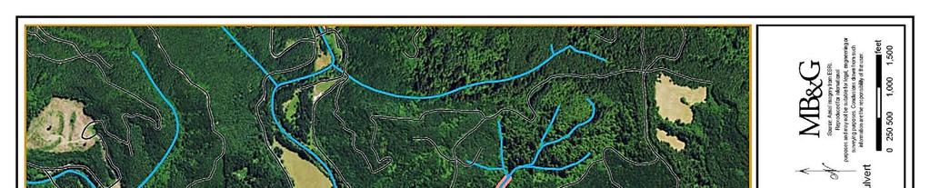
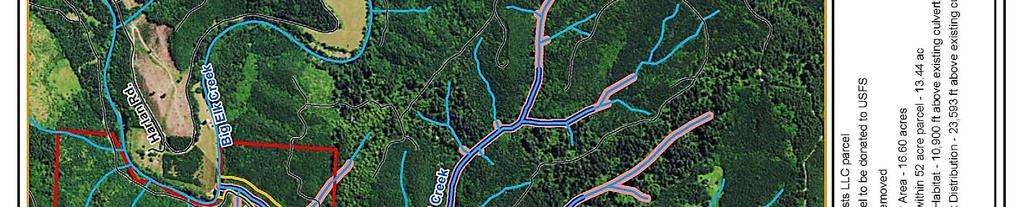
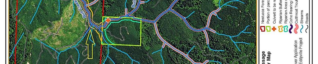
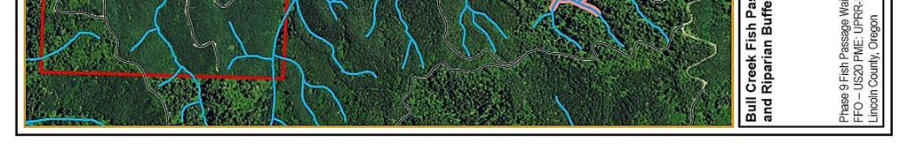
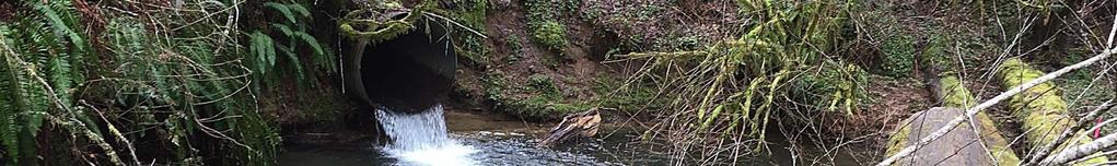
3 1. Call to Order Willie Tiffany, Chair, called the meeting to order at 1:03 p.m. The agenda was presented, and introductions were made. 2. Project and Fish Passage Waiver Proposal Overview Stuart Myers, Senior Scientist at Mason, Bruce & Girard, Inc., presented on behalf of Oregon Department of Transportation (ODOT) an overview of the request to waive fish passage requirement for two rock buttress fills and corresponding culverts on Cougar Creek and Eddy Creek Tributary C. John Raasch, ODOT Natural Resources Unit Manager, and William Warncke, ODOT Aquatic Biology and Fish Passage Program Coordinator, were available to answer questions. The Pioneer Mountain to Eddyville (PME) project will replace a 10-mile segment of US20 with a new 5.5-mile segment. Construction on the PME project began in 2006 and bridges were planned for the creek crossings. Due to landslide issues and highway bed instability, the design was changed to culverts and buttresses. Impacts The current design will block fish passage in Eddy Creek Tributary C and Cougar Creek. Both creeks contain cutthroat trout, coho, and pacific and western brook lamprey. The construction will also change water and sediment flow. The Task Force asked about potential impacts to steelhead at the project sites. John Spangler, ODFW Mid-Coast District Fish Biologist, responded that steelhead are present lower in the basin, but they are not likely to be present at the waiver sites. The PME project received a previous waiver for another portion of the project. The Task Force asked for an update on the status of the mitigation for the previous waiver. Warncke responded that the mitigation is scheduled to be completed during summer Bull Creek Mitigation Bull Creek mitigation will include removal of a culvert, decommissioning of a road, riparian buffers, and donation of a parcel of land. Removal of a high priority partial barrier perched culvert and localized channel/bank restoration will provide weighted volitional access to 6,540 feet of coho and 14,155 feet of cutthroat habitat. Bull Creek contains some of the highest quality coho habitat in the Big Elk Creek subbasin. Because the culvert is a partial barrier, the benefit for access to coho habitat will be adjusted from the actual 10,900 feet to 6,540 feet. The road beyond the culvert will be decommissioned and restored. Riparian buffers will encompass approximately 17 acres extending along both sides of Bull Creek downstream of the culvert location to the confluence of Big Elk Creek. The Wetland Conservancy (TWC) will conduct long-term monitoring of the buffers. 3
4 Dave Heller asked if the logging company would be able to cable-yard over this area after the riparian buffers are initiated. Myers responded this area is not anticipated to be utilized for cabling trees over due to the location, but the company can cable over the area after discussion with TWC, and TWC will monitor the site and require maintenance per the deed restrictions. Ken Bierly asked if the buffers are protected by a conservation easement. Myers clarified the buffers will be protected through a deed restriction only, not a conservation easement. Greg Apke, ODFW Fish Passage Program Coordinator, asked if mitigation will be required if timber is lost as a result of commercial yarding operations. Myers explained mitigation will be addressed through the contingency plan overseen by TWC. Apke requested ODOT and ODFW notification of operations affecting the buffer when discussions with TWC begin. Myers noted some maintenance activities are allowed without prior discussion including hazard tree removal and road maintenance. The mitigation will include the purchase of a 52-acre parcel to be donated to US Forest Service (USFS) Siuslaw National Forest. The parcel is currently surrounded on three sides by USFS lands. The donated parcel will be managed in late successional reserve (LSR) consistent with the adjoining USFS lands. Because the parcel was planted for a future commercial harvest in 2000, forest thinning will be necessary to set it on a LSR trajectory. The Task Force asked how the donated acres will tracked within USFS to ensure it is managed as designated. Myers responded the lands that adjoin the parcel are all managed for LSR and these lands will be managed consistent with the surrounding lands. Bill Cunningham asked if ODOT has secured an option to purchase the land and whether price negotiations have been completed. Myers explained that the next phase of the project includes appraising the land, negotiating price, and sequencing ownership. Big Elk Creek Mitigation Restoration at the Big Elk Creek mitigation site will include restoration of a 9.5-acre floodplain site approximately one mile downstream of the head of tide. The wetland areas will satisfy PME project wetland/waters mitigation needs. Riparian and floodplain habitat will be restored and three floodplain channels will be constructed to provide connectivity to off-channel habitat. NB: While this action will provide enhanced functions for native migratory fish in Big Elk Creek (floodplain and off-channel habitat connectivity), this action cannot be included into and credited towards the ODFW benefit analysis, as this mitigation action is a requirement of another agency authority and permit(s). 4
5 Summary The impacts to Cougar Creek and Eddy Creek Tributary C will result in the cumulative loss of 1,936 linear feet of headwater stream habitat for native migratory fish, particularly spawning and rearing habitat for resident cutthroat trout and coho salmon. The mitigation actions proposed by ODOT will provide access to 6,540 feet of weighted instream coho habitat and access to 14,155 feet of upstream cutthroat trout habitat, and conserve 30.4 acres of riparian buffer area, 38.6 acres of upland habitat, and 4,967 feet of stream length. 3. Public Comment & Testimony No public was present to comment. 4. ODFW Benefit Analysis and Waiver Agreement Apke and Spangler presented ODFW s benefit analysis of the waiver request. Apke provided policy and procedural information on fish passage waivers in Oregon. Waivers are authorized and based on an evaluation of conditions that occur at the time of the trigger for fish passage. ODFW or the Oregon Fish and Wildlife Commission approves a waiver when mitigation, in lieu of providing passage, results in benefits greater than if passage were provided at the obstruction for which a waiver is sought. Mitigation must be provided in the same Oregon Water Resources Drainage Basin in-proximity where the trigger occurs. Once granted, a waiver is valid until the next event that triggers fish passage. Spangler summarized the impacts and explained that the mitigation proposed would result in a net benefit to native migratory fish. Apke summarized the public involvement process noting that no public comments were received during the public notice period. 5. Task Force Questions, Discussion and Motion Cunningham noted the permanency of the impact to fish passage and noted appreciation for the permanency of the mitigation presented. Apke noted all impacts and mitigation for waivers should be considered permanent until the next trigger event at the site. Cunningham noted the mitigation value was adjusted for the culvert replacement since the culvert is currently a partial barrier to fish passage. Cunningham asked whether the loss of habitat is also weighted since water and some sediment will continue to flow past the impact sites. Apke responded that the impact site will completely block fish passage at the site, so the impact is not weighted. Bierly discussed another culvert close to the Bull Creek mitigation site. If the culvert were to be replaced, it would maximize project benefits to native migratory fish. Apke responded we would always like to increase passage, but the actions proposed for mitigation provide a net benefit to fish. The Task Force recognized the culvert replacement is not necessary to meet the requirement to provide a net benefit to fish for this project, but encouraged consideration of replacement during future work. 5
6 Prior to the meeting, the Task Force discussed via this culvert and the proposed wetland mitigation site. Those discussions are included as Attachment A. Bierly inquired about the cost for mitigation. Myers responded the mitigation package is anticipated to cost approximately $3 million, but separate component costs are not yet available as land negotiations and contracts have not yet been completed. Motion: Bill Cunningham moved to recommend ODFW approve the request to waive fish passage at Eddy C and Cougar Creeks in exchange for the proposed mitigation in Bull Creek. Doug DeHart seconded the motion, and the Task Force approved 7-0. Stuart Myers abstained from voting due to a conflict of interest. 6. Adjourn The meeting adjourned at 2:36 p.m. 6
7 Lisa Kingsley From: Sent: To: Cc: Subject: Burke O'Brien Tuesday, February 09, :46 PM Re: ODOT Hwy 20 Pioneer Mtn - Eddyville Project - Task Force Meeting Wednesday 1:00 PM The small addition with minimal cost could increase the net benefit enough to be worth while. I am sorry about tomorrows phone conference but I am tied up in some important meetings that I seem to have no control over, everyone's been there. Is a good project need to maximize is my summary. From: daheller@aol.com <daheller@aol.com> Sent: Tuesday, February 9, :40 AM To: bierlykenneth@gmail.com; greg.d.apke@state.or.us; ddehart@onemain.com; hrectenwald2@gmail.com; kimkambak@gmail.com; Burke O'Brien; stuartgraymyers@gmail.com; smyers@masonbruce.com; greyspey@gmail.com; williet@orra.net Cc: art.c.martin@state.or.us; ken.j.loffink@state.or.us; lisa.m.kingsley@state.or.us Subject: Re: ODOT Hwy 20 Pioneer Mtn Eddyville Project Task Force Meeting Wednesday 1:00 PM Ken - after re looking at all the material, it looks like the site you found would be a really nice addition. It looks like a relatively small additional cost wise as well. Worth discussing. I am surprised it hasn't come up before. Nice pics. Dave -----Original Message----- From: Ken Bierly <bierlykenneth@gmail.com> To: 'Greg D Apke' <greg.d.apke@state.or.us>; 'David Heller' <daheller@aol.com>; 'Douglas DeHart' <ddehart@onemain.com>; hrectenwald2 <hrectenwald2@gmail.com>; 'Kamback, Kim' <kimkambak@gmail.com>; 'O'Brien Burke' <mcroad@co.morrow.or.us>; 'Stuart Myers' <stuartgraymyers@gmail.com>; 'Stuart Myers' <smyers@masonbruce.com>; 'William Cunningham' <greyspey@gmail.com>; 'Willie Tiffany' <williet@orra.net> Cc: 'Art Martin' <art.c.martin@state.or.us>; 'Ken Loffink' <ken.j.loffink@state.or.us>; 'Lisa Kingsley' <lisa.m.kingsley@state.or.us> Sent: Mon, Feb 8, :45 pm Subject: RE: ODOT Hwy 20 Pioneer Mtn - Eddyville Project - Task Force Meeting Wednesday 1:00 PM I took advantage of the good weather last Thursday and looked at the site. On the way to the Bull Creek culvert I saw a tributary culvert that could easily be replaced while in the area. This would be a cost effective way to gain additional benefit. The wetland creation site raises a number of questions that I have not seen good answers; such as my observation is that the soils are quite porous and appear to be well drained alluvium. I am unclear what benefits to native migratory fish the wetlands will do at the chosen location. If the area is wet during the summer the temperatures will likely be very high. What is the tidal range and how frequent will the excavated area be inundated? I hope Stuart can help me with this. From: Greg D Apke [mailto:greg.d.apke@state.or.us] Sent: Monday, February 8, :35 PM To: David Heller; Douglas DeHart; hrectenwald2@gmail.com; Kamback, Kim (kimkambak@gmail.com); Ken Bierly; 1
8 O'Brien Burke; 'Stuart Myers'; Stuart Myers William Cunningham Willie Tiffany Cc: Art Martin Ken Loffink; Lisa Kingsley Subject: ODOT Hwy 20 Pioneer Mtn - Eddyville Project - Task Force Meeting Wednesday 1:00 PM Importance: High I wanted to remind Task Force members of the ODOT Hwy 20 Pioneer Mtn Eddyville Project Fish Passage Task Force Meeting from 1 to 3, Wednesday, Feb. 10. This is a GoTo phone in meeting venue and you all should have what you need to participate (see previous from Lisa Kingsley). Our goal of the meeting is to make a final recommendation on the ODOT Fish Passage Waiver. If you have any questions or need additional information, please contact me. Here s the meeting information if necessary: 1. Please join my meeting Join the conference call: Please call and use the access code Meeting ID: GoToMeeting Online Meetings Made Easy Not at your computer? Click the link to join this meeting from your iphone, ipad, Android or Windows Phone device via the GoToMeeting app. Greg ******************************* Greg Apke Oregon Department of Fish and Wildlife - Fish Division Statewide Fish Passage Program Leader 4034 Fairview Industrial Drive SE Salem, Oregon (office) (cell) greg.d.apke@state.or.us ODFW Fish Passage Internet Access ******************************* 2
9 Lisa Kingsley From: Sent: To: Cc: Subject: Ken Bierly Tuesday, February 09, :10 AM RE: ODOT Hwy 20 Pioneer Mtn - Eddyville Project - Task Force Meeting Wednesday 1:00 PM The other crossing is a bridge, so replacing the culvert would add additional habitat access to NMF. It would only enhance the net benefit of the project. I have no argument about the net benefit of the project as is, however for the amount of public money being used for mitigation there should be an effort to maximize access. From: daheller@aol.com [mailto:daheller@aol.com] Sent: Tuesday, February 9, :40 AM To: bierlykenneth@gmail.com; greg.d.apke@state.or.us; ddehart@onemain.com; hrectenwald2@gmail.com; kimkambak@gmail.com; mcroad@co.morrow.or.us; stuartgraymyers@gmail.com; smyers@masonbruce.com; greyspey@gmail.com; williet@orra.net Cc: art.c.martin@state.or.us; ken.j.loffink@state.or.us; lisa.m.kingsley@state.or.us Subject: Re: ODOT Hwy 20 Pioneer Mtn - Eddyville Project - Task Force Meeting Wednesday 1:00 PM Ken - after re looking at all the material, it looks like the site you found would be a really nice addition. It looks like a relatively small additional cost wise as well. Worth discussing. I am surprised it hasn't come up before. Nice pics. Dave -----Original Message----- From: Ken Bierly <bierlykenneth@gmail.com> To: 'Greg D Apke' <greg.d.apke@state.or.us>; 'David Heller' <daheller@aol.com>; 'Douglas DeHart' <ddehart@onemain.com>; hrectenwald2 <hrectenwald2@gmail.com>; 'Kamback, Kim' <kimkambak@gmail.com>; 'O'Brien Burke' <mcroad@co.morrow.or.us>; 'Stuart Myers' <stuartgraymyers@gmail.com>; 'Stuart Myers' <smyers@masonbruce.com>; 'William Cunningham' <greyspey@gmail.com>; 'Willie Tiffany' <williet@orra.net> Cc: 'Art Martin' <art.c.martin@state.or.us>; 'Ken Loffink' <ken.j.loffink@state.or.us>; 'Lisa Kingsley' <lisa.m.kingsley@state.or.us> Sent: Mon, Feb 8, :45 pm Subject: RE: ODOT Hwy 20 Pioneer Mtn - Eddyville Project - Task Force Meeting Wednesday 1:00 PM I took advantage of the good weather last Thursday and looked at the site. On the way to the Bull Creek culvert I saw a tributary culvert that could easily be replaced while in the area. This would be a cost effective way to gain additional benefit. The wetland creation site raises a number of questions that I have not seen good answers; such as my observation is that the soils are quite porous and appear to be well drained alluvium. I am unclear what benefits to native migratory fish the wetlands will do at the chosen location. If the area is wet during the summer the temperatures will likely be very high. What is the tidal range and how frequent will the excavated area be inundated? I hope Stuart can help me with this. From: Greg D Apke [mailto:greg.d.apke@state.or.us] Sent: Monday, February 8, :35 PM To: David Heller; Douglas DeHart; hrectenwald2@gmail.com; Kamback, Kim (kimkambak@gmail.com); Ken Bierly; O'Brien Burke; 'Stuart Myers'; Stuart Myers (smyers@masonbruce.com); William Cunningham (greyspey@gmail.com); Willie Tiffany Cc: Art Martin (art.c.martin@state.or.us); greg.d.apke@state.or.us; Ken Loffink; Lisa Kingsley 1
10 Subject: ODOT Hwy 20 Pioneer Mtn - Eddyville Project - Task Force Meeting Wednesday 1:00 PM Importance: High I wanted to remind Task Force members of the ODOT Hwy 20 Pioneer Mtn Eddyville Project Fish Passage Task Force Meeting from 1 to 3, Wednesday, Feb. 10. This is a GoTo phone in meeting venue and you all should have what you need to participate (see previous from Lisa Kingsley). Our goal of the meeting is to make a final recommendation on the ODOT Fish Passage Waiver. If you have any questions or need additional information, please contact me. Here s the meeting information if necessary: 1. Please join my meeting Join the conference call: Please call and use the access code Meeting ID: GoToMeeting Online Meetings Made Easy Not at your computer? Click the link to join this meeting from your iphone, ipad, Android or Windows Phone device via the GoToMeeting app. Greg ******************************* Greg Apke Oregon Department of Fish and Wildlife - Fish Division Statewide Fish Passage Program Leader 4034 Fairview Industrial Drive SE Salem, Oregon (office) (cell) greg.d.apke@state.or.us ODFW Fish Passage Internet Access ******************************* 2
11 Lisa Kingsley From: Sent: To: Cc: Subject: Ken Bierly Tuesday, February 09, :09 AM 'Stuart Myers'; RE: ODOT Hwy 20 Pioneer Mtn - Eddyville Project - Task Force Meeting Wednesday 1:00 PM Correct. From: Stuart Myers [mailto:smyers@masonbruce.com] Sent: Tuesday, February 9, :56 AM To: daheller@aol.com; bierlykenneth@gmail.com; greg.d.apke@state.or.us; ddehart@onemain.com; hrectenwald2@gmail.com; kimkambak@gmail.com; mcroad@co.morrow.or.us; stuartgraymyers@gmail.com; greyspey@gmail.com; williet@orra.net Cc: art.c.martin@state.or.us; ken.j.loffink@state.or.us; lisa.m.kingsley@state.or.us; William.M.WARNCKE@odot.state.or.us; Bradley.F.LIVINGSTON@odot.state.or.us Subject: RE: ODOT Hwy 20 Pioneer Mtn - Eddyville Project - Task Force Meeting Wednesday 1:00 PM Dave Based on Ken s description of his hike to the project site, I suspect he s referring to the two small tributaries identified by the yellow arrow on the attached map. Stuart From: daheller@aol.com [mailto:daheller@aol.com] Sent: Monday, February 8, :13 PM To: Stuart Myers <smyers@masonbruce.com>; bierlykenneth@gmail.com; greg.d.apke@state.or.us; ddehart@onemain.com; hrectenwald2@gmail.com; kimkambak@gmail.com; mcroad@co.morrow.or.us; stuartgraymyers@gmail.com; greyspey@gmail.com; williet@orra.net Cc: art.c.martin@state.or.us; ken.j.loffink@state.or.us; lisa.m.kingsley@state.or.us; William.M.WARNCKE@odot.state.or.us; Bradley.F.LIVINGSTON@odot.state.or.us Subject: Re: ODOT Hwy 20 Pioneer Mtn Eddyville Project Task Force Meeting Wednesday 1:00 PM Stuart/Ken - what is the tributary that was mentioned needing replacement seen on the way to the site? Is it close enough to bee considered in the project considerations? Dave -----Original Message----- From: Stuart Myers <smyers@masonbruce.com> To: Ken Bierly <bierlykenneth@gmail.com>; 'Greg D Apke' <greg.d.apke@state.or.us>; 'David Heller' <daheller@aol.com>; 'Douglas DeHart' <ddehart@onemain.com>; hrectenwald2 <hrectenwald2@gmail.com>; 'Kamback, Kim' <kimkambak@gmail.com>; 'O'Brien Burke' <mcroad@co.morrow.or.us>; 'Stuart Myers' <stuartgraymyers@gmail.com>; 'William Cunningham' <greyspey@gmail.com>; 'Willie Tiffany' <williet@orra.net> Cc: 'Art Martin' <art.c.martin@state.or.us>; 'Ken Loffink' <ken.j.loffink@state.or.us>; 'Lisa Kingsley' <lisa.m.kingsley@state.or.us>; WARNCKE William M <William.M.WARNCKE@odot.state.or.us>; LIVINGSTON Bradley F <Bradley.F.LIVINGSTON@odot.state.or.us> Sent: Mon, Feb 8, :32 pm Subject: RE: ODOT Hwy 20 Pioneer Mtn - Eddyville Project - Task Force Meeting Wednesday 1:00 PM 1
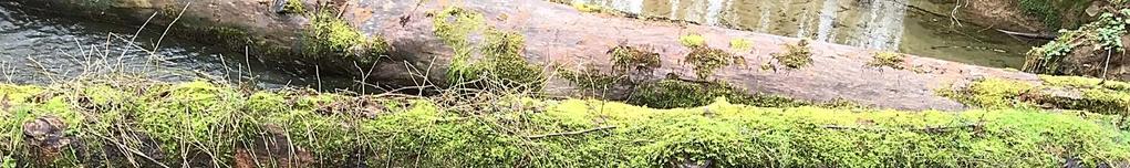
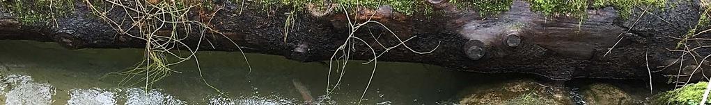
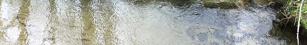
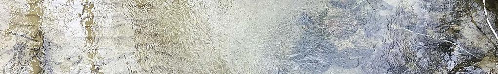
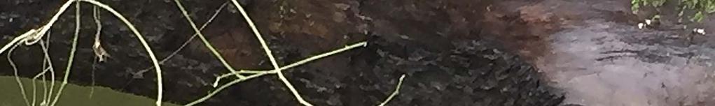
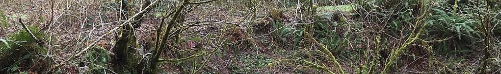
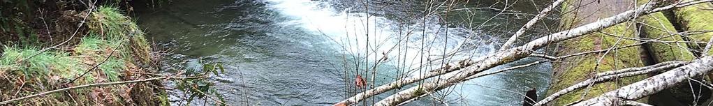
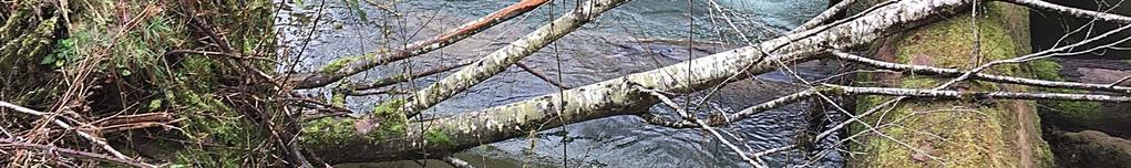
12 Ken I m glad you had an opportunity to review the proposed mitigation sites. I too was on site last week (Friday) and was able to snap the attached photos of adult steelhead congregating in the scour pool below the perched Bull Creek culvert proposed for removal and in another pool immediately downstream. The steelhead are hiding under the large wood in the photos. The soils at the Big Elk Creek mitigation site are indeed fairly well drained. We have been conducting water table monitoring/modeling at the site since last August and intend to do so for the next year as we lead up to 2017 construction and development of the final grading plan. Our hydrology model also includes tidal influences at the site. As documented in the FPWA, creek water will flow into the off channel wetlands during ~2 year flow events. From our initial modeling, these are the storm event water surface elevations that naturally overtop the existing bank elevations on the site. There will be three channels constructed to the wetland areas to provide the needed hydrology to support wetland characteristics and to provide ingress/egress for fish. Secondary wetland hydrology at the site comes from overland flow from three culverts that lie under Harlan Road and drain the forested hill side adjacent to the road. We anticipate that the existing small wetland out there is supported by a combination of water table inputs and surface flow from these culverts. We have a contingency plan to include a bentonite liner in the bottom of the upper wetland if additional hydrology monitoring/modeling suggests a lower than optimal water table to maintain wetland hydrology. The bentonite would help to slow water infiltration long enough to promote wetland soil characteristics during the growing season. This could lead to higher water temperature levels in summertime if the ponded water stayed put long enough for it to heat up in the sun. We have addressed this issue for fish through the initial grading design. The wetlands will have positively sloped egress channels to allow flow and fish to leave the wetlands as flows are released from the site. Fish entrapment and egress have been a key design component of these features. Given surface connectivity of the wetlands with Big Elk Creek will only occur during flows at or higher than the 2 year flood event, we expect this connectively to only occur during winter and early spring time and that as water recedes from the wetlands that fish will also instinctively leave with the flows. We are not expecting any hydrology inputs during the summer or fall month and are expecting the wetlands to be devoid of any standing water during these warm periods. The expected benefit of these features to fish is to provide high flow refugia for juvenile salmonids in a key, tidally influenced section of the Big Elk Creek watershed were very little to no off channel habitat exists. We can discuss the Big Elk Creek site more during our meeting Wed. more if necessary, though I did want to get back to you to address your specific Big Elk Creek site question. Stuart From: Ken Bierly [mailto:bierlykenneth@gmail.com] Sent: Monday, February 08, :45 PM To: 'Greg D Apke' <greg.d.apke@state.or.us>; 'David Heller' <daheller@aol.com>; 'Douglas DeHart' <ddehart@onemain.com>; hrectenwald2@gmail.com; 'Kamback, Kim' <kimkambak@gmail.com>; 'O'Brien Burke' <mcroad@co.morrow.or.us>; 'Stuart Myers' <stuartgraymyers@gmail.com>; Stuart Myers <smyers@masonbruce.com>; 'William Cunningham' <greyspey@gmail.com>; 'Willie Tiffany' <williet@orra.net> Cc: 'Art Martin' <art.c.martin@state.or.us>; 'Ken Loffink' <ken.j.loffink@state.or.us>; 'Lisa Kingsley' <lisa.m.kingsley@state.or.us> Subject: RE: ODOT Hwy 20 Pioneer Mtn Eddyville Project Task Force Meeting Wednesday 1:00 PM I took advantage of the good weather last Thursday and looked at the site. On the way to the Bull Creek culvert I saw a tributary culvert that could easily be replaced while in the area. This would be a cost effective way to gain additional benefit. The wetland creation site raises a number of questions that I have not seen good answers; such as my observation is that the soils are quite porous and appear to be well drained alluvium. I am unclear what benefits to native migratory fish the wetlands will do at the chosen location. If the area is wet during the summer the temperatures will likely be very high. What is the tidal range and how frequent will the excavated area be inundated? I hope Stuart can help me with this. 2
13 From: Greg D Apke [mailto:greg.d.apke@state.or.us] Sent: Monday, February 8, :35 PM To: David Heller; Douglas DeHart; hrectenwald2@gmail.com; Kamback, Kim (kimkambak@gmail.com); Ken Bierly; O'Brien Burke; 'Stuart Myers'; Stuart Myers (smyers@masonbruce.com); William Cunningham (greyspey@gmail.com); Willie Tiffany Cc: Art Martin (art.c.martin@state.or.us); greg.d.apke@state.or.us; Ken Loffink; Lisa Kingsley Subject: ODOT Hwy 20 Pioneer Mtn - Eddyville Project - Task Force Meeting Wednesday 1:00 PM Importance: High I wanted to remind Task Force members of the ODOT Hwy 20 Pioneer Mtn Eddyville Project Fish Passage Task Force Meeting from 1 to 3, Wednesday, Feb. 10. This is a GoTo phone in meeting venue and you all should have what you need to participate (see previous from Lisa Kingsley). Our goal of the meeting is to make a final recommendation on the ODOT Fish Passage Waiver. If you have any questions or need additional information, please contact me. Here s the meeting information if necessary: 1. Please join my meeting Join the conference call: Please call and use the access code Meeting ID: GoToMeeting Online Meetings Made Easy Not at your computer? Click the link to join this meeting from your iphone, ipad, Android or Windows Phone device via the GoToMeeting app. Greg ******************************* Greg Apke Oregon Department of Fish and Wildlife - Fish Division Statewide Fish Passage Program Leader 4034 Fairview Industrial Drive SE Salem, Oregon (office) (cell) greg.d.apke@state.or.us ODFW Fish Passage Internet Access ******************************* 3
14
15


16
17
Sub-watershed Summaries
 Project Description The Salmon Drift Creek Watershed Council (SDCWC) has focused their efforts in the Salmon River estuary for the past few years. The multifaceted partnership effort is nearing completion
Annual Report for Fiscal Year and Future Plans for the Tillamook Bay Watershed Council
 Annual Report for Fiscal Year 2012-2013 and Future Plans for the Tillamook Bay Watershed Council A report prepared for the Tillamook County Board of Commissioners August 2013 Table of Contents: Recently
Concurrent Sessions C: Prioritization - Oregon Fish Passage Priority List - A Statewide Barrier Prioritization Effort
 University of Massachusetts - Amherst ScholarWorks@UMass Amherst International Conference on Engineering and Ecohydrology for Fish Passage International Conference on Engineering and Ecohydrology for Fish
Trout Unlimited Comments on the Scope of Environmental Impact Statement for the Constitution Pipeline Project, Docket No. PF12-9
 October 9, 2012 Kimberly D. Bose, Secretary Federal Energy Regulatory Commission 888 First Street, NE, Room 1A Washington, DC 20426 RE: Trout Unlimited Comments on the Scope of Environmental Impact Statement
FINAL REPORT. Yonkers Creek Migration Barrier Removal Project Wonderstump Road Del Norte County. Submitted By:
 FINAL REPORT Yonkers Creek Migration Barrier Removal Project Wonderstump Road Del Norte County Submitted By: Del Norte County Community Development Department Yonkers Creek Migration Barrier Removal Project
The Blue Heron Slough Conservation Bank
 1 The Blue Heron Slough Conservation Bank CONSERVATION BANKING July 19-23, 2010 CASE STUDY SERIES The Blue Heron Slough Conservation Bank (Washington) I. OVERVIEW & BACKGROUND: Location: Snohomish River
Union Pacific Railroad
 Input Questions: 404/401 Pre Application Meeting, December 18, 2013, Portland, Oregon 1. What is the project purpose and need? The purpose of the project is to improve the efficiency and average velocity
PODFW Fish Passage Rules and Statutes Frequently Asked Questions
 P 1 PODFW Fish Passage Rules and Statutes Frequently Asked Questions 1. Is fish passage needed for servicing non-stream human constructed canals, ditches, channels? Oregon Fish Passage Statute (ORS 509.580
The Calawah River System
 The Calawah River System The Calawah River is the largest tributary of the Bogachiel River and is formed by the confluence of the north and south forks of the Calawah. The two forks of the Calawah, CALAWAH
Five Counties Salmonid Conservation Program - Fish Passage Design Workshop. February 2013
 Program - Aquatic Organisms and Stream Crossings Ecological Connectivity A watershed is a network of channels that drain a common boundary. Channel characteristics formed by interaction of precipitation,
Southern Oregon Coastal Cutthroat Trout
 Species Management Unit Description Southern Oregon Coastal Cutthroat Trout The Southern Oregon Coastal Cutthroat Trout SMU includes all populations of cutthroat trout inhabiting ocean tributary streams
PRE- PROPOSAL FORM - Lewis River Aquatic Fund
 PRE- PROPOSAL FORM - Lewis River Aquatic Fund 1. Applicant organization. USDA Forest Service Gifford Pinchot National Forest 2. Organization purpose Resource management agency 3. Project manager (name,
Interim Guidance Fish Presence Absence
 Interim Guidance Fish Presence Absence Source: Forest Practices Act Guidance for Division 635 of the forest practices act dealing with stream classification when no fish surveys have been done (referenced
Mid-Columbia Fisheries Enhancement Group Annual Report Fiscal Year 06: July 1, 2005 June 30, 2006
 Mid-Columbia Fisheries Enhancement Group Annual Report Fiscal Year 06: July 1, 2005 June 30, 2006 Mission Statement The mission of the Mid-Columbia Fisheries Enhancement Group is to restore self-sustaining
COA-F17-F-1343 YEAR END REPORT
 DAVE MARSHALL SALMON RESERVE RESTORATION, MAINTENANCE, AND UPGRADES YEAR END REPORT Prepared for: Fish and Wildlife Compensation Program Prepared by: Edith Tobe, RPBio, Executive Director Box 1791, Squamish,
MEMORANDUM Oregon Department of Fish and Wildlife
 MEMORANDUM Oregon Department of Fish and Wildlife Date: January 18, 2019 To: From: Oregon Fish and Wildlife Commission Greg Apke, ODFW Statewide Fish Passage Program Coordinator Tom Murtagh, North Willamette
San Lorenzo Valley Water District, Watershed Management Plan, Final Version Part I: Existing Conditions Report
 LIST OF FIGURES Figure 1-1. Map of the San Lorenzo River watershed Figure 2-1. The Santa Cruz Mountains Bioregion Figure 2-2. Protected areas within the San Lorenzo River watershed Figure 2-3. Primary
1.Mill Creek Watershed Summary Description and Land Use
 1.Mill Creek Watershed Summary Description and Land Use Table xxx: Mill Creek Watershed Overview Watershed Size 31,435 acres/49.1 sq miles/ 127.1 sq km Elevation Range 5,594 feet [4,967-10,561] Stream
Climate Change Adaptation and Stream Restoration. Jack Williams;
 Climate Change Adaptation and Stream Restoration Jack Williams; jwilliams@tu.org 1 Goals for this presentation Develop strategies for adapting streams to climate impacts by Thinking like a watershed Understanding
NEWS FROM THE WATERSHED
 O c t o b e r 2 0 1 8 NEWS FROM THE WATERSHED T h e C o q u i l l e W a t e r s h e d A s s o c i a t i o n Q u a r t e r l y E - N e w s l e t t e r Dear Members and Friends, Wishing you all a happy and
OREGON DEPARTMENT OF FISH AND WILDLIFE ROGUE FISH DISTRICT REPORT
 OREGON DEPARTMENT OF FISH AND WILDLIFE ROGUE FISH DISTRICT REPORT TITLE: Upper Rogue Smolt Trapping Project, 1999 STREAM: Big Butte, Little Butte, South Fork Big Butte, Slate and West Fork Evans Creeks
TESTIMONY OF THE COLUMBIA RIVER TREATY TRIBES BEFORE PACIFIC FISHERIES MANAGEMENT COUNCIL
 Agenda Item E.2.f Supplemental Tribal Report April 2012 TESTIMONY OF THE COLUMBIA RIVER TREATY TRIBES BEFORE PACIFIC FISHERIES MANAGEMENT COUNCIL April 2, 2012 Seattle, WA Good day Mr. Chairman and members
Oregon Department of Transportation (ODOT) Culvert Repair Fish Passage Pilot Programmatic Agreement Final ODFW Report
 Culvert Repair Fish Passage Pilot Programmatic Agreement Final ODFW Report") Oregon Department of Transportation (ODOT) Culvert Repair Fish Passage Pilot Programmatic Agreement 2014-17 Final ODFW Report Prepared by Pete Baki June 27, 2018 Table of Contents 1 Background 4 Culvert
Oregon Department of Transportation (ODOT) Culvert Repair Fish Passage Pilot Programmatic Agreement 2014-17 Final ODFW Report Prepared by Pete Baki June 27, 2018 Table of Contents 1 Background 4 Culvert
Tips for Using & Printing Spreadsheets
 Key to Spreadsheets Spreadsheet # Type Description/Purpose a Development & Construction in Waterways b Debits Development & Construction in Other Aquatic Areas c Indirect Impacts to Waterways from Development
OVERVIEW OF MID-COLUMBIA FISHERIES ENHANCEMENT GROUP
 Mid-Columbia Fisheries Enhancement Group MISSION STATEMENT The Mid-Columbia Fisheries Enhancement Group is a non-profit organization dedicated to restoring selfsustaining salmon and steelhead populations
R & E Grant Application 15 Biennium
 R & E Grant Application 15 Biennium Project #: 15-026 Project Information R&E Project Request: Total Project: Start Date: End Date: Organization: Cedar Creek Hatchery Raceway and Pump Replacement $500,000.00
3. The qualification raised by the ISRP is addressed in #2 above and in the work area submittal and review by the ISRP as addressed in #1.
 Please find attached a response from The Confederated Tribes of the Warm Springs Reservation of Oregon (CTWSRO) for Project # 2008-301-00, Habitat Restoration Planning, Design and Implementation within
MCCAW REACH RESTORATION
 Final Report MCCAW REACH FISH RESTORATION PHASE B Jack McCaw Inland Empire Action Coalition http://www.wwccd.net/ Phone: 509-956-3777 Hours: 8:00-4:30 Walla Walla County Conservation District Snake River
Big Spring Creek Habitat Enhancement and Fishery Management Plans
 Big Spring Creek Habitat Enhancement and Fishery Management Plans November 5, 2012 Big Spring Events and Activities Center Newville, PA Charlie McGarrell Regional Habitat Biologist Pennsylvania Fish and
Columbia Lake Dam Removal Project
 Columbia Lake Dam Removal Project Major Goals of the Columbia Lake Dam Removal: Reconnect 10 miles of the Paulins Kill River to the Delaware River, restoring natural flow regime and sediment transport.
STEELHEAD SURVEYS IN OMAK CREEK
 STEELHEAD SURVEYS IN OMAK CREEK 2002 Annual Report Prepared by Chris Fisher John Arterburn Colville Confederated Tribes Fish and Wildlife Department P.O. Box 150 Nespelem, WA 99155 Prepared for Project
Kootenai River Habitat Restoration Program. Kootenai Tribe of Idaho - January 27, 2014 Presentation for Kootenai Valley Resource Initiative
 Kootenai River Habitat Restoration Program Kootenai Tribe of Idaho - January 27, 2014 Presentation for Kootenai Valley Resource Initiative Decline of native species Kootenai River White Sturgeon ENDANGERED
Restoring the Kootenai: A Tribal Approach to Restoration of a Large River in Idaho
 Restoring the Kootenai: A Tribal Approach to Restoration of a Large River in Idaho Susan Ireland, Kootenai Tribe of Idaho Future of our Salmon Conference Technical Session August 2016 Healthy Floodplains,
RESILIENCE THROUGH RESTORATION
 RESILIENCE THROUGH RESTORATION RECLAMATION DISTRICT NO. 1601 TWITCHELL ISLAND SAN JOAQUIN RIVER SETBACK LEVEE PROJECT TWITCHELL ISLAND BASICS Nearly 12 miles of levee Storm drainage facilities Protects
Amendment to a Biological Assessment/Evaluation completed for the Coon Creek Land Disposal completed December Grand Valley Ranger District
 Amendment to a Biological Assessment/Evaluation completed for the Coon Creek Land Disposal completed December 2007 Grand Valley Ranger District Grand Mesa, Uncompahgre, Gunnison National Forests Prepared
PROJECT TO INSTALL LARGE WOOD HABITAT STRUCTURES IN THE CARMEL RIVER USING CALIFORNIA DEPARTMENT OF FISH AND GAME GRANT FUNDS
 PROJECT TO INSTALL LARGE WOOD HABITAT STRUCTURES IN THE CARMEL RIVER USING CALIFORNIA DEPARTMENT OF FISH AND GAME GRANT FUNDS The Monterey Peninsula Water Management District (MPWMD), in cooperation with
South Fork Chehalis Watershed Culvert Assessment
 South Fork Chehalis Watershed Culvert Assessment Water Resource Inventory Area 23 Lewis County Conservation District Final Report By: Kelly Verd and Nikki Wilson March 2003 Funded by: The Washington State
Columbia Lake Dam Removal Project
 Columbia Lake Dam Removal Project The Columbia Lake dam located 1/4 mile upstream of the Paulins Kill River's confluence with the Delaware River in Knowlton Township, Warren County has been proposed for
Wild Fish Conservancy Watertype Assessment Project Summary West Sound Watersheds Phase II October 2014
 Wild Fish Conservancy Watertype Assessment Project Summary West Sound Watersheds Phase II http://www.wildfishconservancy.org/maps October 2014 Water typing is the state-sanctioned process of mapping the
ELK RIVER WATERSHED ACTION PLAN
 ELK RIVER WATERSHED ACTION PLAN Prepared for The Elk River Watershed Council Prepared by Chris Massingill Mainstream Contracting South Coast Watershed Council September 2001 South Coast Watershed Council
COLUMBIA LAKE DAM REMOVAL PROJECT
 COLUMBIA LAKE DAM REMOVAL PROJECT Major Goals of the Columbia Lake Dam Removal: Reconnect 10 miles of the Paulins Kill River to the Delaware River, restoring natural flow regime and sediment transport.
Tuolumne River Gravel Introduction
 Tuolumne River Gravel Introduction 2000 2003 Tuolumne River La Grange Gravel Addition, Phase II Course Sediment Replenishment Program Tuolumne River Salmonid Habitat Improvement Project River Mile 49.9
Conserving the Forests, Lakes and Streams of Northeast Michigan
 4241 Old US 27 South, Suite 2, Gaylord, Michigan 49735 (989) 448-2293 www.huronpines.org info@huronpines.org Prioritized Restoration Projects in the AuSable River Watershed Summer 2015 Update from Huron
Burns Paiute Tribe Fisheries Department. Evaluate The Life History Of Native Salmonids Within The Malheur Subbasin Project #
 Burns Paiute Tribe Fisheries Department Evaluate The Life History Of Native Salmonids Within The Malheur Subbasin Project # 199701900 Prior to 1990 Technical and/or scientific background Malheur population,
NEVADA DEPARTMENT OF WILDLIFE STATEWIDE FISHERIES MANAGEMENT FEDERAL AID JOB PROGRESS REPORTS F LAHONTAN CUTTHROAT TROUT EASTERN REGION
 NEVADA DEPARTMENT OF WILDLIFE STATEWIDE FISHERIES MANAGEMENT FEDERAL AID JOB PROGRESS REPORTS F-20-50 2014 LAHONTAN CUTTHROAT TROUT EASTERN REGION NEVADA DEPARTMENT OF WILDLIFE, FISHERIES DIVISION ANNUAL
FISH PASSAGE IMPROVEMENT in California s Watersheds. Assessments & Recommendations by the Fish Passage Forum
 FISH PASSAGE IMPROVEMENT in California s Watersheds Assessments & Recommendations by the Fish Passage Forum FISH PASSAGE IMPROVEMENT in California s Watersheds The mission of the Fish Passage Forum is
Project Completion Abstract Fish Passage Activity ( Engineering Activities)
") Project Completion Abstract Fish Passage Activity ( Engineering Activities) SUBMIT COMPLETED FORM TO DISTRICT MANAGER AND FIA ADMINISTRATOR AFTER PROJECT COMPLETION SECTION A GENERAL INFORMATION Recipient:
Project Completion Abstract Fish Passage Activity ( Engineering Activities) SUBMIT COMPLETED FORM TO DISTRICT MANAGER AND FIA ADMINISTRATOR AFTER PROJECT COMPLETION SECTION A GENERAL INFORMATION Recipient:
Stevens Creek Corridor
 O F F I C E O F T H E D I R E C T O R O F P U B L I C W O R K S Stevens Creek Corridor Creek Restoration Project Volume Three Project Update: Creek Photos, Before & After BY GAIL SEEDS - PROJECT MANAGER,
2012 Bring Back the Natives Awarded Projects
 2012 Bring Back the Natives Awarded Projects EZG # Organization Project Title Project Description Location Description Total Award Amount Grantee Non- Federal Match 31904 Sanctuary Forest, Inc. Mattole
OKANAGAN RIVER RESTORATION INITIATIVE - FAQ
 OKANAGAN RIVER RESTORATION INITIATIVE - FAQ Initiative background: The health of the q awsitk w (Okanagan River) has been severely impacted by the channelization works that occurred in the mid-1950 s.
OREGON DEPARTMENT OF FISH AND WILDLIFE ROGUE WATERSHED DISTRICT REPORT INTRODUCTION
 OREGON DEPARTMENT OF FISH AND WILDLIFE ROGUE WATERSHED DISTRICT REPORT TITLE: Upper Rogue Smolt Trapping Project, 2003 STREAM: Bear, Little Butte, Elk, Slate and West Fork Evans Creeks and the Little Applegate
OREGON DEPARTMENT OF FISH AND WILDLIFE
 OREGON DEPARTMENT OF FISH AND WILDLIFE Ladd Marsh Wildlife Area 1 Benefits for all Oregonians 2 The Mission To protect and enhance Oregon's fish and wildlife and their habitats for use and enjoyment by
The Dipnetter. December published for tribal fishers by the Columbia River Inter-Tribal Fish Commission
 The Dipnetter published for tribal fishers by the Columbia River Inter-Tribal Fish Commission December 2009 A Record Spring Chinook Salmon Run for 2010 Forecast Marketing Workshops Give Valuable Advice
Strategies for mitigating ecological effects of hatchery programs
 Strategies for mitigating ecological effects of hatchery programs Some case studies from the Pacific Northwest Kathryn Kostow Oregon Department of Fish and Wildlife Ecological risks occur when the presence
Aquatic Organism Passage at Road-Stream Crossings CHUCK KEEPORTS FOREST HYDROLOGIST ALLEGHENY NATIONAL FOREST WARREN, PENNSYLVANIA
 Aquatic Organism Passage at Road-Stream Crossings CHUCK KEEPORTS FOREST HYDROLOGIST ALLEGHENY NATIONAL FOREST WARREN, PENNSYLVANIA TOPICS COVERED Aquatic Organism Passage (AOP) Benefits of AOP Crossings
April 26, Chairman Rockefeller and members of the Fish and Wildlife Committee. Briefing from Mid-Columbia Regional Fish Enhancement Group (RFEG)
") Joan M. Dukes Chair Oregon Bruce A. Measure Montana James A. Yost Idaho W. Bill Booth Idaho Rhonda Whiting Vice-Chair Montana Bill Bradbury Oregon Tom Karier Washington Phil Rockefeller Washington April
Joan M. Dukes Chair Oregon Bruce A. Measure Montana James A. Yost Idaho W. Bill Booth Idaho Rhonda Whiting Vice-Chair Montana Bill Bradbury Oregon Tom Karier Washington Phil Rockefeller Washington April
STREAM SURVEY File form No..
 scanned for KRIS THE RESOURCES AGENCY OF CALIFORNIA California Department of Fish and Game STREAM SURVEY File form No.. Date: September 4, 1969. NAME: North Fork Schooner Gulch Creek COUNTY: Mendocino.
Abundance of Steelhead and Coho Salmon in the Lagunitas Creek Drainage, Marin County, California
 scanned for KRIS Abundance of Steelhead and Coho Salmon in the Lagunitas Creek Drainage, Marin County, California Prepared for: Marin Municipal Water District 220 Nellen Drive Corte Madera, California
Dry Creek Project. The Dry Creek Habitat Enhancement Project provides a. Slowing velocity, creating refuge are key to habitat project
 Dry Creek Habitat Enhancement Bulletin The Dry Creek Habitat Enhancement Project provides a unique opportunity for the Sonoma County Water Agency (Water Agency) and landowners to protect endangered fish
Searsville Dam Removal
 Searsville Dam Removal A unique opportunity for all Presented by the Beyond Searsville Dam Coalition San Francisquito Creek flows into the San Francisco Bay near the Palo Alto Airport and Golf Course seen
APPENDIX J HYDROLOGY AND WATER QUALITY
 APPENDIX J HYDROLOGY AND WATER QUALITY J-1 Technical Report on Airport Drainage, Northern Sector Airport and Ordinance Creek Watershed / Preliminary Creek Constructed Natural Channel Culvert J-2 Preliminary
Guidance Note. Hydropower Guidance Note: HGN 8 Fish Passage. When do you need to install a fish pass?
 Guidance Note Hydropower Guidance Note: This guidance note is not intended as a statement of law. It should be read in combination with, and in the context of, the relevant enactments and EU obligations.
POLITICS A MONUMENTAL TASK FOR STREAM RESTORATION: AN EXAMPLE FROM TRAPPER CREEK OREGON
 POLITICS A MONUMENTAL TASK FOR STREAM RESTORATION: AN EXAMPLE FROM TRAPPER CREEK OREGON Bradley S. Houslet and Louis Wasniewski Deschutes National Forest TRAPPER CREEK, OR ODELL LAKE PROJECT OBJECTIVES
Michigan Department of Natural Resources Status of the Fishery Resource Report Page 1
 Michigan Department of Natural Resources 2008-59 Status of the Fishery Resource Report Page 1 Bowens Manistee County, (T24N R16W Sec. 11, 12, 13, 14, 15, 24, and 30). Last surveyed 2008 Mark A. Tonello
Shovelnose Creek Off-Channel Complex Berm Repair
 Shovelnose Creek Off-Channel Complex Berm Repair Recent high discharge events have put valuable off-channel salmonid rearing and spawning habitat at risk in the upper Squamish River. This document is a
Creation of Fish and Wildlife Habitat on the Closed Salmon Harbour Mine in Minto, NB
 Creation of Fish and Wildlife Habitat on the Closed Salmon Harbour Mine in Minto, NB M. Coleman 1, R. Rutherford 2, RA Currie 3 1 NB Power 2 Thaumas Environmental Consultants Ltd 3 RA Currie Ltd. Location
5B. Management of invasive species in the Cosumnes and Mokelumne River Basins
 5B. Management of invasive species in the Cosumnes and Mokelumne River Basins Cosumnes River The Cosumnes River basin has a number of distinct habitat types that require different management strategies
CHAPTER 4 DESIRED OUTCOMES: VISION, GOALS, AND OBJECTIVES
 CHAPTER 4 DESIRED OUTCOMES: VISION, GOALS, AND OBJECTIVES Vision One of the first steps in developing this Plan was articulating a vision - a clear statement of what the Plan strives to achieve and what
Gold Action #1: Instream and Floodplain Habitat Restoration
 Gold Action #1: Instream and Floodplain Habitat Restoration Action Type: Recovery Threat addressed: Severity: Significant Spawning/egg incubation, Pre/post spawning migrations, Juvenile rearing Action
Black Sturgeon Regional Plan
 Black Sturgeon Regional Plan This is one of twenty Regional Plans that support implementation of the Lake Superior Biodiversity Conservation Strategy (Strategy). The Strategy, prepared and overseen by
PRE- PROPOSAL FORM - 1. Applicant organization. USDA Forest Service Gifford Pinchot National Forest & WDFW Region 5
 PRE- PROPOSAL FORM - 1. Applicant organization. USDA Forest Service Gifford Pinchot National Forest & WDFW Region 5 2. Organization purpose USFS-Resource management agency WDFW-Fish and Wildlife management
Funding Habitat Restoration Projects for Salmon Recovery in the Snake River Region SRFB Grant Round Version: 2/19/16
 2016 SRFB Grant Round Version: 2/19/16 Funding Habitat Restoration Projects for Salmon Recovery in the Snake River Region The Project Funding Process Presented by the Snake River Salmon Recovery Lead Entity
middle deschutes progress in restoration
 middle deschutes progress in restoration Acknowledgements prepared by: Upper Deschutes Watershed Council Deschutes River Conservancy Oregon Department of Fish and Wildlife DESIGN & PRODUCTION FUNDED by:
Environmental Review and Permitting for Wild Trout
 Environmental Review and Permitting for Wild Trout Tom Shervinskie Wild Trout Summit Watershed Analysis Section August 26, 2017 Division of Environmental Services The mission of the Pennsylvania Fish and
Project Report for Marsh Creek and Albion River Instream Fish Barrier Removal Flynn Creek Road, CR 135, M.P. 8.1 and 8.3
 Project Report for Marsh Creek and Albion River Instream Fish Barrier Removal Flynn Creek Road, CR 135, M.P. 8.1 and 8.3 Project Title: Marsh Creek and Albion River Instream Fish Barrier Removal, Flynn
10 is bounded by wetlands between RM 1.8 and 3.1 on the south shore and more are scattered
 The Ozette System The Ozette watershed is made up of several lakes and large streams that combine to a total drainage area of 88.4 square miles. The most significant feature of the Ozette watershed is
Executive Summary. Map 1. The Santa Clara River watershed with topography.
 Santa Clara River Steelhead Trout: Assessment and Recovery Opportunities December 2005 Prepared By: Matt Stoecker and Elise Kelley, Ph.D. University of California, Santa Barbara Prepared For: The Santa
1.Warm Springs Creek (Anaconda) Watershed Description and Land Use
 Watershed Description and Land Use") 1.Warm Springs (Anaconda) Watershed Description and Land Use Table xxx: Warm Springs Watershed Overview Watershed Size 92,288 acres/144.2 sq miles/373.6 sq km Elevation Range 5,781 feet [4,800-10,581]
1.Warm Springs (Anaconda) Watershed Description and Land Use Table xxx: Warm Springs Watershed Overview Watershed Size 92,288 acres/144.2 sq miles/373.6 sq km Elevation Range 5,781 feet [4,800-10,581]
Newaukum Watershed Culvert Assessment
 Newaukum Watershed Culvert Assessment Water Resource Inventory Area 23 Lewis County Conservation District Final Report By: Kelly Verd and Nikki Wilson July 2002 Funded by: Chehalis Fisheries Restoration
WFC 10 Wildlife Ecology & Conservation Nov. 29, Restoration Ecology: Rivers & Streams. Lisa Thompson. UC Cooperative Extension
 Restoration Ecology: Rivers and Streams WFC 10 29 Nov 2010 Restoration of ecosystems often involves creating new systems with only partial resemblance to the original ecosystems Lisa Thompson Fisheries
Potlatch River Drainage: Salmonid Presence: Largest lower Clearwater River tributary
 X Y Potlatch River Drainage: Largest lower Clearwater River tributary Area = 1500 km 2 Mouth ~ 13 km upstream of Snake/Clearwater confluence X Y Dominated by private land Salmonid Presence: Steelhead,
THREATENED, ENDANGERED, AND SENSITIVE SPECIES 2010 ANNUAL REPORT
 LICENSE ARTICLE 410 THREATENED, ENDANGERED, AND SENSITIVE SPECIES 2010 ANNUAL REPORT REPORTING PERIOD JANUARY 1 DECEMBER 31, 2010 BAKER RIVER HYDROELECTRIC PROJECT FERC No. 2150 Puget Sound Energy Bellevue,
Coho Salmon 1. COMMON NAMES: Silver salmon, Coho, blue back, silversides, and jack salmon.
 Coho Salmon 1 BACKGROUND 2 COMMON NAMES: Silver salmon, Coho, blue back, silversides, and jack salmon. DESCRIPTION: In the ocean the Coho is metallic blue on its back with silvery sides and white bellies.
X.B WETLANDS ROGUE RIVER ESTUARY
 X.B WETLANDS ROGUE RIVER ESTUARY The Rogue River has a drainage area of 5,100 square miles, yet the estuary of the Rogue River is one of the smallest in Oregon, measuring approximately 1,880 acres during
Minnesota Department of Natural Resources Division of Fish and Wildlife Section of Fisheries. Stream Survey Report. Luxemburg Creek.
 Minnesota F-29-R(P)-24 Area 315 Study 3 March 2016 Minnesota Department of Natural Resources Division of Fish and Wildlife Section of Fisheries Stream Survey Report Luxemburg Creek 2015 Mark Pelham Sauk
Mountain Columbia Province
 Rolling Provincial Review: Implementation 2001-2003 Province 229 Columbia Basin Fish & Wildlife Authority Province FY 2001-2003 Spending Summaries NPCC Recommendations and BPA Spending by Project Category,
Project Award Presentation
 University of Massachusetts Amherst ScholarWorks@UMass Amherst International Conference on Engineering and Ecohydrology for Fish Passage International Conference on Engineering and Ecohydrology for Fish
Trout Buffer Variance
 Trout Buffer Variance Ashley L. Rodgers, PE Spring 2015 Why a Trout Buffer Capturing pollutants in runoff to keep the water clean. Capturing sediment to keep mud out of the water. Providing shade to keep
Identifying Areas with Potential to Contain High Value Fish Habitat (HVFH) June 2007
 June 2007") Identifying Areas with Potential to Contain High Value Fish Habitat (HVFH) June 2007 1 High Value Fish Habitat INTENT: To apply added precautionary protection to those special areas deemed of high value
Identifying Areas with Potential to Contain High Value Fish Habitat (HVFH) June 2007 1 High Value Fish Habitat INTENT: To apply added precautionary protection to those special areas deemed of high value
Study Update Fish Distribution and Species Composition
 Study Update Fish Distribution and Species Composition Goals and Study Area Gain a better understanding of fish species composition and abundance in waters associated with the Packwood Lake Hydroelectric
MEMORANDUM Oregon Department of Fish and Wildlife
 Attachment 3 MEMORANDUM Oregon Department of Fish and Wildlife Date: July 23, 2009 To: From: Oregon Fish and Wildlife Commission Bruce McIntosh, Assistant Fish Division Administrator Inland Fisheries Subject:
2 nd Steelhead Summit. October 27 & 28, 2016 in San Luis Obispo, CA
 + 2 nd Steelhead Summit October 27 & 28, 2016 in San Luis Obispo, CA 1 + Session Overview Sponsors: California Trout City of San Luis Obispo Sustainable Conservation California Conservation Corps Cachuma
Fish Friendly Crossings- Examples from Nash Stream
 Fish Friendly Crossings- Examples from Nash Stream Maggie Machinist- North Regional Forester, Division of Forests and Lands. Nash Stream Nash Stream Forest is 40,000 acres, owned and managed by NH Division
California Steelhead: Management, Monitoring and Recovery Efforts
 California Steelhead: Management, Monitoring and Recovery Efforts Jonathan Nelson Steelhead Restoration & Management Program Oncorhynchus mykiss irideus California Steelhead Distinct Population Segments
Assessing Ecosystem Impacts from Road Stream Crossings through Community Involvement
 Assessing Ecosystem Impacts from Road Stream Crossings through Community Involvement Background Why is the NH Fish and Game Department interested in culverts? Block fish migration Reduce opportunities
Lakelse Sockeye Recovery Program
 Lakelse Sockeye Recovery Program The Ninth Annual BC Interior Stewardship Workshop May 7 th and 8 th, 2013 DFO North Coast Resource Restoration Unit Presentation Overview History/background Stock and habitat
City of Burnaby Environmental Review Committee (ERC) Guide for Applicants
 Guide for Applicants") City of Burnaby Environmental Review Committee (ERC) Guide for Applicants 2017-2018 This Guide summarizes the ERC process for project review including applications for a relaxation (variance) to the development
City of Burnaby Environmental Review Committee (ERC) Guide for Applicants 2017-2018 This Guide summarizes the ERC process for project review including applications for a relaxation (variance) to the development
Aquatic Biological Assessment. Lassen 15 Restoration Project. Modoc National Forest Warner Mountain Ranger District
 Aquatic Biological Assessment Lassen 15 Restoration Project Modoc National Forest Warner Mountain Ranger District Prepared By:_/s/ Marty Yamagiwa Date: December 10, 2015 Marty Yamagiwa, Natural Resources
Deschutes WRIA 13 Salmon Habitat Recovery Committee SRFB / PSAR Letter of Intent Form
 Deschutes WRIA 13 Salmon Habitat Recovery Committee SRFB / PSAR Letter of Intent Form Project Sponsor: Sponsor Contact lnfo: Project Name: Key Partners: Project Location: lnclude wotershed Project Description:
FISHERIES MANAGEMENT PLAN FOR DUFFINS CREEK AND CARRUTHERS CREEK JUNE, 2004
 FISHERIES MANAGEMENT PLAN FOR DUFFINS CREEK AND CARRUTHERS CREEK JUNE, 2004 Toronto and Region Conservation 2004 ISBN0-9732764-0-1 www.trca.on.ca 5 Shoreham Drive, Toronto, Ontario M3N 1S4 phone: 416-661-6600