Snake River Salmon Recovery Board Lead Entity 2016 SRFB Grant Round. Project Tour June 1-3, 2016
|
|
|
- Aleesha McKenzie
- 5 years ago
- Views:
Transcription


1 Snake River Salmon Recovery Board Lead Entity 2016 SRFB Grant Round Project Tour June 1-3, 2016 Buford Creek Barrier Fish Passage Design Project, June, 2015
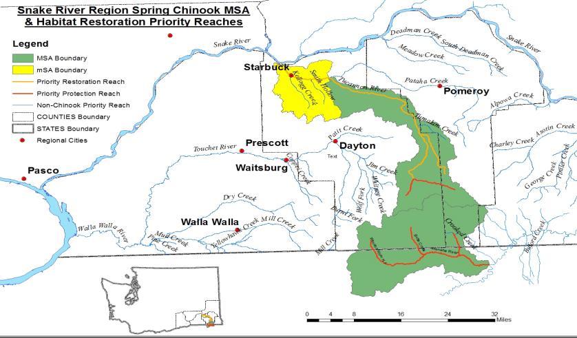
2 Table of Contents Tour Schedule SRSRB Lead Entity Score Card 5 Regional Priority Map 7 Map with Project Locations 8 Summary Table of Habitat Factors and Objectives for Each MSA 9 Critical Habitat Uncertainties within the Snake River Salmon Recovery Region 11 SRSRB Draft Application Summaries 12 Bridge to Bridge Restoration Phase 2 ( ) 13 Mill Creek Passage Update ( ) 15 Mill Creek Passage Implementation Upper Flume ( ) 17 Walla Walla County Fish Screen Projects ( ) 19 McCaw Reach Fish Habitat Rest. Phase B Construction ( ) 21 Tucannon Mobile PIT Tag Detection ( ) 23 Touchet River Conceptual Restoration Plan ( ) 25 North Touchet River Reach 2 Design ( ) 27 Tucannon Complexity & Connectivity PA-18 ( ) 29 Tucannon River PA-28 Phase II Habitat Restoration ( ) 31 Asotin Creek Riparian Protection Project ( ) 33 Asotin Intensively Monitored Watershed Monitoring YR10 ( ) 35 Draft Application Scoring Summary from May 3 rd Lead Entity Committee Meeting 37 1
3 Snake River Salmon Recovery Board Lead Entity SRFB Review Panel Draft Application Project Tour Schedule for June 1, :00 am Meet at SRSRB Office in Dayton, 410B East Main St. SRFB Review Panel, Attendees, Project Sponsors, and SRSRB Staff 8:15 am Leave Office 9:15 am Bridge to Bridge Restoration Phase 2 ( ) Brian Burns Tri-State Steelheaders Rest stop 10:30 am Mill Creek Passage Update ( ) Brian Burns Tri-State Steelheaders 11:15 am Mill Creek Passage Implementation Upper Flume ( ) Brian Burns Tri-State Steelheaders Noon Lunch Provided (Rooks Park) 1:30 pm Walla Walla County Fish Screen Projects ( ) Greg Kinsinger Walla Walla County Conservation District 2:45 pm McCaw Reach Fish Habitat Restoration Construction Phase B ( ) Jeff Klundt Walla Walla County Conservation District 5:00 pm Return to Dayton 2
4 Snake River Salmon Recovery Board Lead Entity SRFB Review Panel Draft Application Project Tour Schedule for June 2, :00 am Meet at SRSRB Office in Dayton, 410B East Main St. SRFB Review Panel, Attendees, Project Sponsors, and SRSRB Staff 8:15 am Tucannon Mobile PIT Tag Detection ( ) Joe Bumgarner Washington Department of Fish and Wildlife 9:00 am Touchet River Conceptual Restoration Plan ( ) Justin Pearson Columbia Conservation District 9:45 am Load up on Bus 10:00 am North Touchet River Reach 2 Design ( ) Jerry Middel Confederated Tribes of the Umatilla Indian Reservation Noon Lunch Provided (Last Resort) Tucannon Programmatic Coordination and Implementation in 2015 Kris Buelow SRSRB 1:15 pm Tucannon Complexity & Connectivity PA-18 ( ) Kris Fischer Confederated Tribes of the Umatilla Indian Reservation 2:30 pm Tucannon River PA-28 Phase II Habitat Restoration ( ) Terry Bruegman Columbia Conservation District 5:00 pm Return to Dayton 3
5 Snake River Salmon Recovery Board Lead Entity SRFB Review Panel Draft Application Project Tour Schedule for June 3, :00 am Meet at SRSRB Office in Dayton, 410B East Main St. SRFB Review Panel, Attendees, Project Sponsors, and SRSRB Staff 8:10 am Leave Office 9:45 am Asotin Creek Riparian Protection Project ( ) Megan Stewart Asotin County Conservation District 11:00 am Asotin Intensively Monitored Watershed Monitoring YR10 ( ) Steve Bennett Eco Logical Research Inc. Noon Lunch Provided (Asotin Park) 2:45 pm Return to Dayton 4
6 2016 SRSRB Lead Entity Score Card 5
7 6

8 7

9 8
10 Summary Table of Habitat Factors and Objectives for Each MSA Priority Habitat Factor and Objective Mainstem Walla Walla River MSA Imminent Threats: Fish Screens, Fish Passage Barriers, Low/Dewatered Streams I. Temperature: < 4 day > 72ºF II. Large Woody Debris: > 1 key pieces per channel width III. Embeddedness: < 10% embeddedness IV. Riparian:> 40 to 90% of maximum V. Channel Confinement: reduce to 40% to 60% of stream length Mill Creek MSA Imminent Threats: Fish Passage Barriers (including gravel berms), Fish Screens, Low/Dewatered Streams I. Embeddedness: < 10% II. Temperature < 4 day > 72ºF III. Large Woody Debris: > 1 key piece per channel width IV. Riparian: > 40 to 90% of maximum Middle Touchet River MSA (mainstem from Coppei creek to Patit Creek) Imminent Threats: Fish Screens, Fords, Low Stream Flows, Gravel Berms I. Embeddedness: < 10% II. Temperature: < 4 days > 72ºF III. Large Woody Debris: > 1 key piece per channel width IV. Channel Confinement: <15 to 40% of stream bank length Upper Touchet River MSA (Patit Creek upstream to Touchet headwaters) Imminent Threats: Fish Passage Barriers, Fish Screens, Fords, Low Stream Flows, Gravel Berms I. Temperature: < 4 days > 72ºF II. Riparian: >62 to 82% of maximum III. Large Woody Debris: > 1 key piece per channel width IV. Channel Confinement: <10 to 40% of stream bank length Upper Tucannon River MSA (from Pataha Creek upstream to Tucannon headwaters) Imminent Threats: Fish Screens, Low Stream Flows I. Riparian: > 40 to 75% of maximum II. Large Woody Debris: >1 key piece per channel width III. Channel Confinement: < 25 to 50% of stream bank length IV. Temperature: < 4 days > 72ºF Lower Tucannon River msa (from Pataha Creek downstream to Tucannon mouth) Imminent Threats: Fish Passage Barriers, Screens, Low Stream Flows I. Temperature: < 4 days > 72ºF II. Embeddedness: < 20% III. Large Woody Debris: > 1 key piece per channel width IV. Riparian: >40 to 75% of maximum V Channel Confinement: < 25 to 50% of stream bank length 9
11 Summary Table of Habitat Factors and Objectives for Each MSA (continued) Priority Habitat Factor and Objective I. Riparian: > 80% of maximum II. Embeddedness: < 10% III. Temperature: < 4 day > 72ºF IV. Alpowa Creek MSA Imminent Threats: Fish screens, Low Stream Flows, Remove Obstructions Large Woody Debris: > 1 key piece per channel width Joseph Creek MSA Joseph Creek lies primarily in Oregon. Therefore, priority actions for the portion of Joseph Creek within Washington are to address imminent threats. Lower Grande Ronde MSA Objectives for the Lower Grande Ronde are currently being developed in consultation with ODFW. Wenaha River MSA The vast majority of the Wenaha River lies entirely within a wilderness area administered by the USFS. The proposed action for this river is to continue protective status. Asotin Creek MSA (mouth to headwaters including all tributaries except George Creek) Imminent Threats: Fish Passage Barriers, Fish Screens, Dewatered Streams I. Large Woody Debris: > 1 key piece per channel width II. Embeddedness: < 20% III. IV. Bed Scour: Reduce to < 10 cm Riparian: >75% to 90% of maximum I. Embeddedness: < 10% II. III. George Creek MSA (tributary of Asotin Creek) Imminent Threats: Dewatered Streams Large Woody Debris: > 1 key piece per channel width Riparian: >75% of maximum IV. Temperature: < 4 day > 72ºC Pataha Creek MSA (tributary of Tucannon River) Imminent Threats: Fish Passage Barriers, Fish Screens, Ford, Dewatered Streams I. Embeddedness: Protect existing condition II. III. IV. Temperature: Protect existing condition Riparian: Protect existing condition Large Woody Debris: Protect existing condition V. Channel Confinement: Protect existing condition 10
12 Critical Habitat Uncertainties within the Snake River Salmon Recovery Region Subbasin/Stream Asotin Creek Sub basin Tucannon River Sub basin Walla Walla River Sub basin Almota Creek (Lower Snake River Sub basin) Deadman Creek (Lower Snake River Sub basin) Grande Ronde Sub basin Critical Uncertainties Large woody debris, Embeddedness, Turbidity, Fines, Riparian function, Bed scour, Natural temperature regime, Natural base flow condition Anthropogenic stream confinement, Habitat type (pools), Riparian function, Harassment, Woody debris, Carcasses Turbidity, Obstructions, Riparian function, Anthropogenic stream confinement, Temperature Large woody debris, Riparian function, Embeddedness, Low flow, Anthropogenic stream confinement Turbidity, Large woody debris, Riparian function Sediment, Temperature, Flows, Key habitat quality and diversity 11

13 Draft Application Summaries Snake River Salmon Recovery Board Lead Entity 2016 SRFB Grant Round Prepared by the Snake River Salmon Recovery Board Lead Entity Staff Mill Creek transition into the concrete flume 12
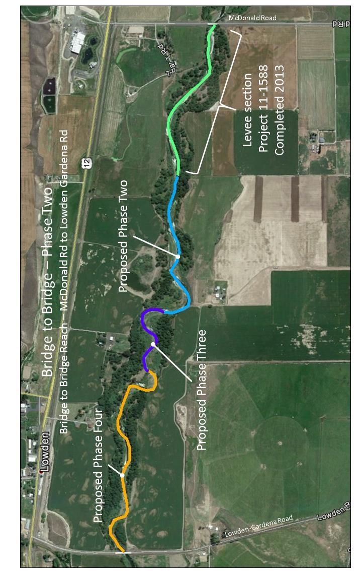
14 Bridge to Bridge Restoration Phase 2 ( ) Sponsor: Brian Burns Tri-State Steelheaders Location: Walla Walla River MSA Priority Restoration Reach 3 Year Plan: Yes Project Type: Restoration Request+Match: 300, ,807 $635,807 Species: Mid-Columbia Steelhead (DPS), Columbia River Bull Trout (DPS), Mid-Columbia River Chinook Description: The Bridge to Bridge Restoration Design completed in 2010 (RCO project # ) provided 30% plans for nearly two miles of the Walla Walla River near Lowden, WA. Final designs were completed for the upper third of the design reach, and implementation of those plans was completed in 2013 (Phase 1). Final designs are now complete for the remaining part of the design reach (RCO project # ). This current proposal is to implement restoration Phase 2 of 4. Tri-State Steelheaders will address limiting factors by placing logs and log structures along 0.6 miles of stream to improve channel complexity, maintain pools, create offchannel areas, and encourage side channels. A terrace will be excavated to re-establish riparian vegetation on eroding meander bank, with associated minor channel re-alignment. Riparian plantings will also address limiting factors by increasing shading, and improving riparian function. This section of the Walla Walla River is identified by The Snake River Salmon Recovery Plan as a priority restoration reach in the Walla Walla mainstem MSA. Adult and juvenile summer steelhead and spring Chinook use the project reach during their migrations and Bull Trout occur there seasonally. Other species of cultural value and state concern that utilize the project reach are Margined Sculpin, Leopard Dace, and River Lamprey. Goals and Objectives: The goals of the project are to improve width/depth ratio in the project reach, improve pool and cover habitat in the project reach, increase instream complexity, improve riparian buffer width and function in the project reach, increase shading to reduce thermal loading, and create self-sustaining conditions to maintain improved habitats. Specific project objectives are to: Increase large wood in the project reach to at least one piece per stream width. Increase pool and cover habitat by installing five large wood structures. Improve floodplain function and wood recruitment with 5,000 new riparian plants. Encourage side channel formation and off-channel areas by installing three large wood structures. Draft Application Lead Entity Meeting (5/3/16) Questions/Comments/Notes: How the channel has adjusted on the site implemented in 2013? We haven t had large flows since then but a small side channel is now active. How long is the treatment reach? ~3,200 ft. What is the cost share source? Project made the first cut at FbD and those funds will be used as match. SRSRB RTT Meeting (5/17/16) Questions/Comments/Notes: None Project Tour Questions/Comments/Notes: 13
15 14
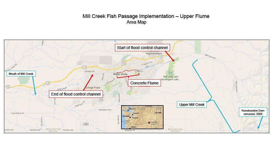
16 Mill Creek Passage Update ( ) Sponsor: Brian Burns Tri-State Steelheaders Location: Mill Creek MSA Priority Restoration and Protection Reach 3 Year Plan: Yes Project Type: Planning (Assessment) Request+Match: 48, $48,600 Species: Mid-Columbia Steelhead (DPS), Columbia River Bull Trout (DPS), Mid-Columbia River Chinook Description: In 2009, the Tri State Steelheaders, in cooperation with the Mill Creek Work Group, completed a fish passage assessment with conceptual passage designs for the Mill Creek flood control channel in Walla Walla, WA. The assessment determined that the overall passability of the channel for adult and juvenile summer steelhead, bull trout, and spring chinook was 37 percent. Since the original assessment, a hydraulic model study has been completed, four different sections of the channel have been modified with passage improvements, and a continued effort is being made at accommodating maintenance vehicle access in the channel with respect to the fish passage modifications. During a recent design phase (project # ), two bridges with piers in the channel were evaluated for passage. While both present passage problems, one was found to be much worse of a problem than the initial assessment could have detailed. The 2009 assessment rated passability at 37%. With new information, the passability is now rated at 18%. This illustrates the need to update the passage assessment. This project will update the 2009 Mill Creek Fish Passage Assessment (# ) with more accurate hydraulic and design data. The study will occur in the concrete channel section, between 9th Avenue and Roosevelt St (RM 6.7 to 8.7). The result will be updated and improved assessment of passability which will be used for future project prioritization and to possibly leverage transportation funding for bridge replacement. Goals and Objectives: The goal is to improve our understanding of fish passage problems in Mill Creek to inform future phases of passage work. Specific project objectives are: Acquire survey data at previously un-studied reaches, Conduct new hydraulic modelling, and Refine methods of providing maintenance access in the channel. Draft Application Lead Entity Meeting (5/3/16) Questions/Comments/Notes: Is the community/city/chamber of commerce is contributing to funding this work? No but the flood control district maintains the channel. Recently a community coalition requested USACOE 1135 funding to conduct a GI study because the infrastructure is failing, the community seeks a more appealing channel and passage for fish is poor. The USACOE constructed the channel back in the 1940 s but then turned it over to the local sponsor. What is the cost share? The project is an assessment and does not require a match, the total request with no cost share is $48k. SRSRB RTT Meeting (5/17/16) Questions/Comments/Notes: None Project Tour Questions/Comments/Notes: 15

.")
17 The Passability Summary from the 2009 Fish Passage Assessment. Estimated passage for steelhead, chinook, and bull trout is shown at discharges of 6, 20, 60, 100, 200 and 400 cfs. Column width for each discharge reflects exceedance flows (i.e. 100 cfs is the most typical flow). 16
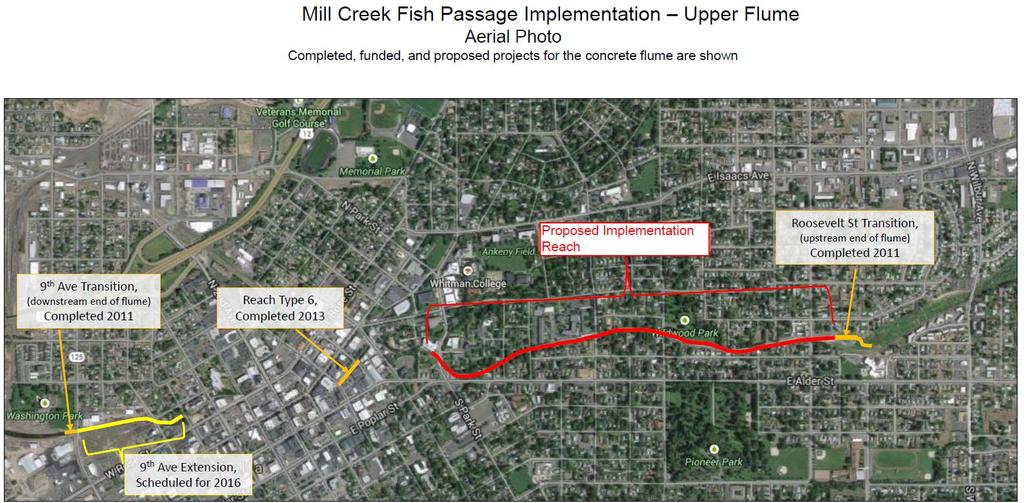
18 Mill Creek Passage Implementation Upper Flume ( ) Sponsor: Brian Burns Tri-State Steelheaders Location: Mill Creek MSA Priority Restoration and Protection Reach 3 Year Plan: Yes Project Type: Restoration Request+Match: 4,501, ,660 $5,296,439 (large capital project proposal) Species: Mid-Columbia Steelhead (DPS), Columbia River Bull Trout (DPS), Mid-Columbia River Chinook Description: Tri-State Steelheaders will implement final designs ( ) for fish passage improvements in a 5,000 foot long reach of the 2-mile long concrete-lined Mill Creek flood control channel in Walla Walla, WA. The implementationproject reach connects with a passage project completed in 2011 (Mill Creek Flume Transitions, ). The Mill Creek Barrier Assessment ( ) completed in 2009 identified and described barriers for ESA listed steelhead and Bull Trout, and for reintroduced spring Chinook. Returning adults encounter flow dependent depth and velocity barriers, and a lack of resting opportunities. Juvenile fish encounter low spring flows, and high water temperatures in late spring. Adults and juveniles often become trapped in the flood control channel by mid-may, where they experience lethal temperatures. Many of these passage issues are considered imminent threats in the Snake River Salmon Recovery Plan. Mill Creek, upstream of the flood control project, is a critical and under-utilized area for spawning and rearing of ESA listed species, and provides an important recovery opportunity for those listed fish, as well as good habitat for other native fish and reintroduction efforts for spring Chinook. Goals and Objectives: The goals of the project are to improve low flow passage for juvenile and adult steelhead, bull trout, and spring chinook, improve high flow passage for adult steelhead, bull trout, and spring chinook, and provide resting opportunities where none currently exist. Project objectives are to implement final fish passage designs for approximately 5,000 of Mill Creek channel. The project will address low flow and high flow barriers, and will incorporate resting pools providing fish passage through a 5,000 foot section of Mill Creek at multiple life stages for steelhead, Chinook, and bull trout. Specifically: Reconfigure concrete baffles in Mill Creek channel ~50 existing baffles will be removed, and ~325 will be installed. Install surface roughness to provide a low velocity boundary layer for discharges up to 320 cfs. Approximately five hundred 7 x10 panels will cover the approximate 5,000 feet in length of channel. Install ~80 resting pools in the concrete channel pools are 12 feet by 7 feet, covering approximately 900 feet in length of channel. Draft Application Lead Entity Meeting (5/3/16) Questions/Comments/Notes: Concerns were expressed about scoring this unrealistic project because if it scores highly and we choose to not approve it, we are compromised. To address this we will caveat and describe why this project is not approved by the LE/SRSRB when that time comes. We need to score it based on its description, pretend we do have the money and then when we submit our final ranked list we explicitly state that (assuming everyone on LE and SRSRB agree) that we do not want it funded from our lead entity allocation but rather this is our only Large Capital project for SRFB to advance to OFM and legislature It was expressed that even if the Large Cap gets approved by the legislature this request of $5 million will not solve/fund the complete Mill Creek fish passage project. It needs to be clearly stated this $5 million provides passage to one mile of the 7 mile project footprint. Is the project phase-able? Yes. SRSRB RTT Meeting (5/17/16) Questions/Comments/Notes: RTT determination that project addresses and imminent threat based on impacts at the population scale (I). Can we put in shoots in with the blocks? This has been considered within the energetics model. Project Tour Questions/Comments/Notes: 17

19 18
20 Walla Walla County Fish Screen Projects ( ) Sponsor: Greg Kinsinger Walla Walla County Conservation District Location: Walla Walla County streams, including the Mill Creek MSA, Touchet River Middle MSA, Walla Walla River MSA, and Dry Creek msa, 3 Year Plan: Yes Project Type: Restoration Request+Match: 236, ,790 $278,601 Species: Mid-Columbia Steelhead (DPS), Columbia River Bull Trout (DPS), Mid-Columbia River Chinook Description: It has been established by Federal, State, and local agencies that screening irrigation diversions with NMFS approved fish screens is key to ESA listed fish recovery. Since inception in 2001, the Washington Dept. of Fish and Wildlife (WDFW) Cooperative Compliance Review Program (CCRP), partnering with the Walla Walla County Conservation District (WWCCD), has had great success in reducing juvenile anadromous fish mortality by installing nearly 400 state and federally approved fish screens on irrigation pumps and diversions in Walla Walla county. The CCRP/WWCCD fish screen program reflects voluntary efforts by landowners to come into compliance with surface diversion regulations. We believe 50 to 75 irrigators basin-wide still need to come into screening compliance. Noncompliant diversions are contributing to immediate fish mortality. WWCCD requests funding to continue implementing the highly successful CCRP/WWCCD fish screen installation program by facilitating installation of 20 fish screen projects, all located in Walla Walla county, over the next two years ( ). The screens will be located at sites that are currently non-compliant with state and federal laws. Each project will be fitted with a NMFS compliant screen found most suitable for that location, and sized to a verified water right or, if smaller, a permanent irrigation practice. Previous CCRP/WWCCD screen projects funded by SRFB range in size from 15 to 4500 gpm (.033cfs-10cfs). Goals and Objectives: The goal is to eliminate fish mortality associated with the use of non-compliant screens found at irrigation pump stations and gravity diversions located throughout Walla Walla County. The objective is to install 20 National Marine Fisheries Service-approved fish screens at agricultural diversions in Walla Walla County by the end of These screening projects will eliminate salmonid species mortality associated with fish stranding at gravity flow irrigation diversions and will also eliminate mortality caused by impingement and entrainment at pumping stations. Draft Application Lead Entity Meeting (5/3/16) Questions/Comments/Notes: Proposal is for two year project but if budget constraints are such they would be willing to cut scope to 10 screens over one year then seek additional funding for the remaining 10 screens next year. What about the possibility of consolidating screens and then one pipe could serve multiple sites? The thought will be evaluated. This has been done in the past when land got subdivided as opposed to installing several screens, one for each new landowner, they used pipe to deliver water from the original point of diversion as opposed to several POD and several screens. How many screens are ready to move forward now? At the moment, 4 landowner acknowledgement forms are signed, 10 total are likely ready now, and 10 are reserved for walk ins. o *LE Committee requests that the sponsor decrease the funding request to the number of signed landowner acknowledgement forms in hand on July 7 th (final application deadline). Who will be responsible for maintenance costs? The landowner. What is the water withdraw range for the proposed screens? The range will be from 0.3 to 5 cfs for individual screens. SRSRB RTT Meeting (5/17/16) Questions/Comments/Notes: Request sponsor for additional information to make the imminent threat impact level (water withdraw amount, locations in basin and location in stream, etc.). Why isn t there any enforcement for withdraws, would we consider funding this sort of project at a lower level than 85%? Project Tour Questions/Comments/Notes: 19

21 20
22 McCaw Reach Habitat Rest. Phase B Construction ( ) Sponsor: Jeff Klundt Walla Walla County Conservation District Location: Middle Touchet River MSA Priority Restoration and Protection Reach 3 Year Plan: Yes Project Type: Restoration Request+Match: 529, ,344 $627,073 Species: Mid-Columbia Steelhead (DPS), Columbia River Bull Trout (DPS), Mid-Columbia River Chinook Description: Walla Walla County Conservation District (WWCCD) proposes the following project - Phase B of the McCaw Reach Fish Restoration Project will construct the project as designed (in project ) on 5500 ft of the Touchet River west of Waitsburg, WA. The project is located in the Touchet River Major Spawning Area for Mid-Columbia steelhead and is located in a priority area for restoration as identified in the Snake River Salmon Recovery Plan. The overall goals are to construct a project that will increase roughness elements, promote sediment storage and create a dynamic channel environment with complex side channels and large wood features. The existing channel is reduced in complexity and roughness, has degraded riparian vegetation and has incised in some areas. WWCCD will place large wood features in the main channel and side channels to encourage the activation of side channels, increase bar deposition, and develop pools. The project, when constructed will provide Mid Columbia steelhead rearing, passage and holding habitat, Bull Trout wintering habitat, and non-listed Chinook passage and holding habitat. When construction is completed on this project, overall river channel complexity will be improved by increased bar development, pool establishment, and overall increase in stream length. Side channels will increases stream length by 3000 ft. Goals and Objectives: The goals of this project are to increase instream habitat complexity with addition of LWD structures; increase stream channel length & sinuosity by activation of side channels; and restoring floodplain connectivity and function. Specific project objectives are: Increase channel complexity, promote retention of mobile wood, and increase local sediment deposition and sorting for adult Chinook passage and juvenile winter rearing, steelhead juvenile rearing and potential adult spawning, and all life stages of bull trout overwintering habitat, through the installation of 44number of large woody debris structures and11 engineered log jams sufficient to increase LWD key pieces to >2 pieces per bank full width. Increase floodplain access and connectivity by 11 acres at a 3 year flow and increase side channel connectivity by 3000 feet at a 3 year flow for juvenile Chinook and steelhead over winter habitat through the placement of large wood. Draft Application Lead Entity Meeting (5/3/16) Questions/Comments/Notes: The project footprint is in a conservation easement since about Designs are for ~5,500 feet including 3,000 feet of side channel addition. Was this reach straightened at one time, it appears the side channels might be historic channel locations? Not to our knowledge, but there was bank stabilization sites/levees here and there and a disconnection of the floodplain. SRSRB RTT Meeting (5/17/16) Questions/Comments/Notes: None Project Tour Questions/Comments/Notes: 21

23 22
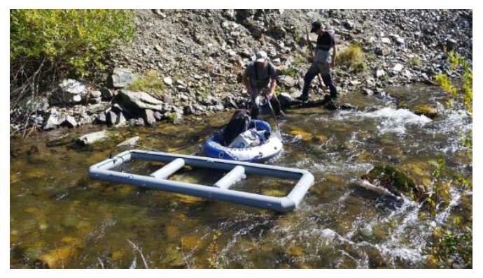
24 Tucannon Mobile PIT Tag Detection ( ) Sponsor: Joe Bumgarner Washington Department of Fish and Wildlife Location: Tucannon River MSA Priority Restoration and Protection Reach 3 Year Plan: Yes Project Type: Planning (Assessment) Request+Match: 50, ,909 $81,147 Species: Snake River Steelhead (DPS), Snake River Spring/Summer Chinook (ESU) Columbia River Bull Trout (DPS) Description: WA Dept of Fish and Wildlife (WDFW) will use this grant to conduct mid-winter mobile PIT Tag surveys on the Tucannon River from about river mile 11 to Panjab Bridge (river mile 49.9) or, if time allows, from the Tucannon River mouth to Panjab Bridge. The purpose of the survey is to supplement the data collected in the Life Cycle Model Study that was funded by SRFB in 2015 (RCO project # ) by detecting the location (i.e., re-sighting) PIT tagged ESA listed spring Chinook or summer steelhead from the Juvenile Life Cycle Model Study after fall movement but before smolt outmigration occurs. Re-sight surveys will consist of two to three staff members floating two small-scale PIT Tag antennas via raft or foot survey. Re-sight surveys will collect the GPS location and the type of micro habitat being utilized of each tagged fish that is detected. Data will be verified and summarized for inclusion in the Life Cycle Model Study. Re-sight surveys will greatly increase the PIT Tag data that is usable for the Life Cycle Model Study as it will greatly increase the sample size of PIT tagged fish present between the PIT Tag arrays after fall movement, and will increase the precision of the survival estimates between reaches. As seen in the past, detections from the PIT tag arrays alone on juveniles are limited by stream depth and the tag orientation as juveniles migrate. These mobile surveys will alleviate much of the uncertainty regarding fish movement and should provide greater information on the types of habitat they prefer over the winter. Goals and Objectives: The goal of this project is to determine mid-winter spatial distribution of PIT tagged juveniles and identify life-stage- and reach-specific habitat utilization, and to use this information to identify restoration priorities and potential population limiting factors. Specific project objectives are: Describe the mid-winter spatial distribution of overwintering juvenile spring Chinook salmon and steelhead within the Tucannon River mainstem. Describe the mid-winter specific habitat utilization of overwintering juvenile spring Chinook salmon and steelhead within the Tucannon River mainstem. Provide all collected data from this project to the Tucannon Salmonid Survival and Habitat Utilization study to estimate overwinter survival of spring Chinook and summer steelhead in the Tucannon River. Draft Application Lead Entity Meeting (5/3/16) Questions/Comments/Notes: This project is a direct complement to the Tucannon chinook and steelhead survival and habitat utilization project. It adds midseason detailed fish regarding where they go in between the PIT arrays and to assess micro habitat utilization mid-season. Most of the budget is for equipment and if funded (and if needed to occur again the following year or subsequent years) the budget will go down to around $20,000 a year. It was noted that the capital cost is large in year one but subsequent costs will go down considerably and Joe concurred. Is this considered monitoring and part of the eligible 10% of our allocation? Proposed as an assessment. Is the additional data collected (micro habitat utilization) already being collected? No, the current PIT arrays are at 4 static points, plus the data will be real time so repeat surveys to assess utilization and movement associated with environmental conditions can be assessed. How large is the raft? ~3 x 10. What is the read range? At ~200 cfs or less it should get 100% read below the raft and slightly toward the sides. What about using backpack probe interrogators instead or in addition, the current method might potentially bias against utilization of complex habitat and side channels? Concerned that the presence of a person may alter fish behavior. SRSRB RTT Meeting (5/17/16) Questions/Comments/Notes: Could this project seek endorsement funding? Potentially, check with WDFW. Project Tour Questions/Comments/Notes: 23
25 24
26 Touchet River Conceptual Restoration Plan ( ) Sponsor: Justin Pearson Columbia Conservation District Location: Middle and Upper Touchet River MSA Priority Restoration and Protection Reaches 3 Year Plan: Yes Project Type: Planning (Assessment) Request+Match: 200, ,472 $238,072 Species: Mid-Columbia Steelhead (DPS), Columbia River Bull Trout (DPS), Mid-Columbia River Chinook Description: The Columbia Conservation District (CCD) will use this grant to develop a conceptual restoration plan for the Touchet River and Tributaries in Columbia and Walla Walla Counties in the middle and upper Touchet River major spawning area (MSA) and Patit Creek minor spawning area (msa) as identified in the SE WA Salmon Recovery Plan (2011). These tributaries are inhabited by native ESA threatened Mid-Columbia steelhead and Bull Trout and re-introduced spring Chinook. The planning process will expand upon the Touchet River Geomorphic Assessment (GeoEngineers, 2011, PRISM # ) of existing information; conduct habitat surveys; identify priority stream reaches and habitat enhancement potential; and develop conceptual restoration designs. The guiding principle of this restoration plan will be to focus on improving the habitat factors limiting salmonid production and survival. To meet this goal, we will work closely with the Snake River Salmon Recovery Board, Regional Technical Team, co-managers, WWCCD, BPA, landowners, and other partners at all stages of the project to ensure high priority salmonid limiting factors and restoration actions are identified. This project is identified in the Snake River Salmon Recovery Plan and regional work plan in WRIA 32 Assessment and Planning Restoration. Deliverables will serve as the basis of future restoration project development in both the MSA and msa. Goals and Objectives: The goal of this project is to update the geomorphic/watershed assessment, build a prioritized conceptual restoration plan for the identified watersheds and to produce at least conceptual reach designs for as much of the project areas identified throughout the project that addresses the current degraded habitat condition and function by increasing channel complexity and confinement, restoration of riparian areas, and implement BMP s on distinct potential project areas. Specific project objectives are: Use existing data and support from the existing Touchet Geomorphic Assessment while filling in the gaps of information to complete a conceptual restoration plan. Develop a citizen work group and work with the Voluntary Stewardship Program s Watershed Work Group (WWG) to develop working relationships and seek input and feedback on the conceptual restoration plan to make it implementable. Coordinate and collaborate amongst local technical partners and landowners throughout the project to assist in scoping and developing the assessment and to provide input and vet project details. Develop discrete conceptual habitat restoration plans for middle and upper Touchet MSA stream reaches. The conceptual restoration plan will be used to communicate project concepts that address the identified limiting factors incorporating information that has been gleaned through the assessment process with input from project partners. This plan will include project prioritization for the watersheds identified in this proposal and will provide the basis to move forward to final design and project implementation. Draft Application Lead Entity Meeting (5/3/16) Questions/Comments/Notes: Much of the success on the Tucannon regarding strategic, transparent and supported implementation is due to the geomorphic assessment and conceptual restoration plan as people know the technical basis, understand the priorities and can plan implementation scheduling and budgeting. How long will the project budget take to be spent? Two years to complete the project. What phase does this project represent? The geomorphic assessment upstream from Dayton is done. What we lack is the conceptual restoration plans for the priority reaches identified in the Touchet River geomorphic assessment. Will one outcome will be a map of confined and floodplain potential? Yes. What is the match source? District will provide match. Why the budget is about same as Asotin yet the first two outputs (sediment budget and LiDAR) already exist on the Touchet? The footprint will be expanded, LiDAR may need re-collected since it is 6 years old. Will the project reveal any imminent threats and if so, should it get points for imminent threat? Yes, that could happen but it is not the basis for this project. Imminent threat points are assigned to specific projects sites for designs or implementation, not general assessments and the group agreed. SRSRB RTT Meeting (5/17/16) Questions/Comments/Notes: This project should be a priority. Project Tour Questions/Comments/Notes: 25

27 26
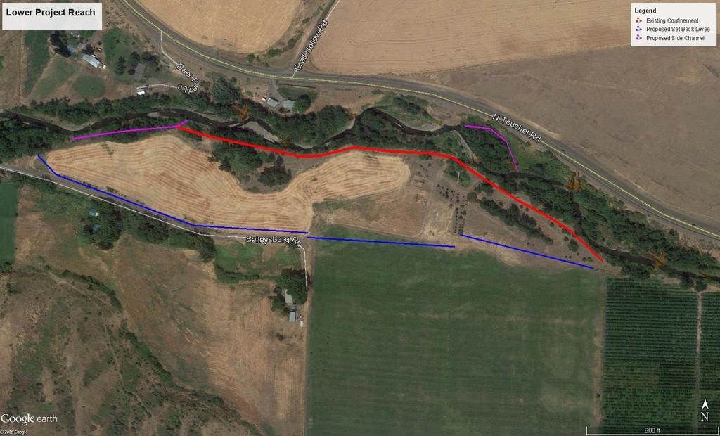
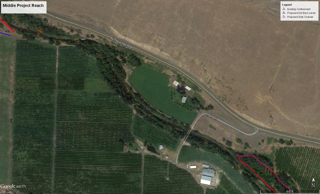
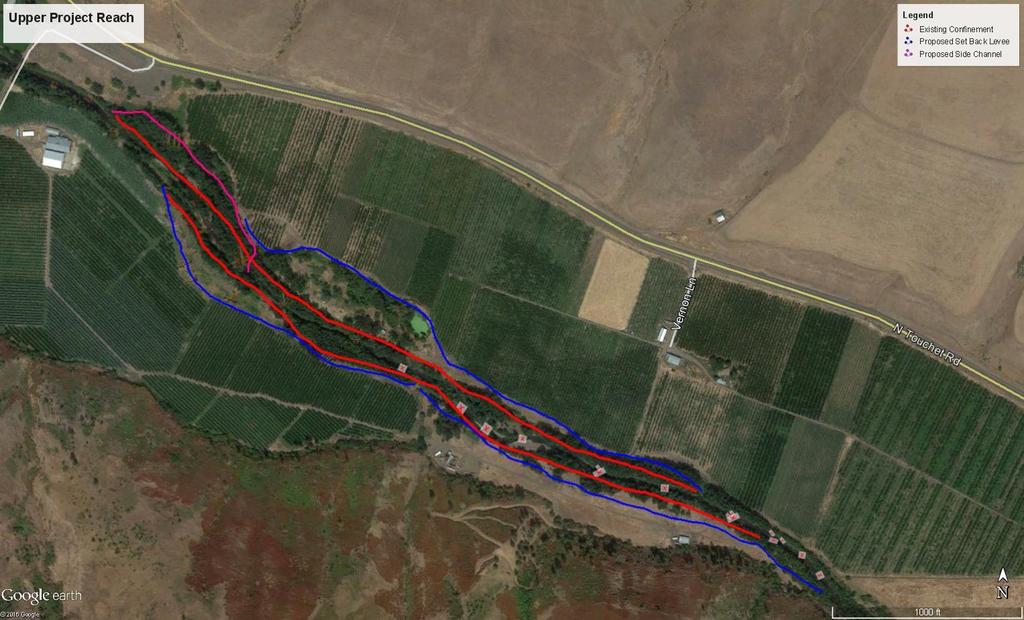
28 North Touchet River Reach 2 Design ( ) Sponsor: Jerry Middel CTUIR Location: Upper Touchet River MSA Priority Protection Reach 3 Year Plan: Yes Project Type: Planning (Design) Request+Match: 120, $120,080 Species: Mid-Columbia Steelhead (DPS), Columbia River Bull Trout (DPS), Mid-Columbia River Chinook Description: The Confederated Tribes of the Umatilla Indian Reservation (CTUIR) will use this grant to develop final habitat restoration designs that, when implemented, will restore and enhance floodplain connectivity, improve geomorphic and hydrologic function, place instream habitat elements to improve salmonid spawning and rearing habitat and complexity, and revegetate disturbed riparian areas along approximately 2 mile of the North Fork Touchet River near Dayton, WA. CTUIR and the design team will work with private landowners within the proposed project reach to ensure the final product meets CTUIR's River Vision goals and landowner needs. The project is identified as the third priority project reach for the North Touchet River in the Touchet River Geomorphic Assessment (SRFB # ). The project will benefit ESA listed Mid-Columbia steelhead and is located in a priority restoration reach of the Touchet River major spawning area, as identified in the Salmon Recovery Plan for SE Washington and the regional three year work plan. Goals and Objectives: The goal is to develop an agreed upon restoration design that when implemented would improve instream habitat conditions, primarily for juvenile summer steelhead, and restore natural stream processes through the 2 mile long project reach. The objective of this project is to provide a set of construction-ready designs adequately detailing a restoration actions. We anticipate that final design will include elements of removal of riprap/confining structures or levee setback, expansion of floodplain, construction of and encouragement of both low and high flow side channels, and the placement of LWD structures to increase channel roughness and pool frequency. The design must incorporate CTUIR s River Vision goals and meet landowner needs. Based upon our understanding of the project reach we anticipate the designs to incorporate these specific objectives: Upon completion of the implemented project design, the project will include 2 key pieces of wood per channel width. Upon completion of the implemented project design, the project will include approximately 3,700 feet of levee removed or levee setback allowing for flood plain connectivity and channel migration. Upon completion of the implemented project design, the project will include connection of approximately 16 acres of floodplain inundated at the 2-year reoccurrence flow (mostly on the upper portion of the project reach), and approximately 19 acres of floodplain inundated at the 10-year reoccurrence flow (mostly on the lower portion of the project reach). Draft Application Lead Entity Meeting (5/3/16) Questions/Comments/Notes: None (reviewed last year). Lead Entity supported re-scope of Baileysburg project ( ) to complete this design. SRSRB RTT Meeting (5/17/16) Questions/Comments/Notes: None. Previous discussion was to support the request to rescope the Baileysburg project ( ) to complete this design. Project Tour Questions/Comments/Notes: 27
29 28
30 Tucannon Complexity & Connectivity PA-18 ( ) Sponsor: Kris Fischer CTUIR Location: Tucannon River MSA Priority Restoration and Protection Reach 3 Year Plan: Yes Project Type: Restoration Request+Match: 406, ,380 $1,209,244 Species: Snake River Steelhead (DPS), Snake River Spring/Summer Chinook (ESU) Columbia River Bull Trout (DPS) Description: The Confederated Tribes of the Umatilla Indian Reservation (CTUIR) will use this grant to restore floodplain connectivity and channel complexity on the Tucannon River within what s known as Project Area 18 (RM & 34.3), located within Columbia County, Washington. The project is situated within the priority restoration reach for the ESA threatened (Snake River ESU) spring Chinook and summer steelhead (Snake River Restoration Plan 2011). The goals of this project are to increase channel complexity and restore floodplain connectivity, through the placement of LWD and the excavation of short pilot channels to reconnect existing side channels. LWD structures are designed to create channel impediments to flow, leading to increased floodplain inundation allowing for greater floodplain connectivity, and to provide places of low velocity refugia to winter rearing salmonids. The overall design objectives are to increase LWD key pieces (>6m long & 0.3 m dia) from the current ~0.5 pieces to >2 pieces per bank full width, and increase perennial channel length primarily through the reconnection of perennial side channels and off channel habitats. These goals are identified in the recovery plan (2011) and the restoration plan and are critical in increasing over winter survival for spring Chinook. Goals and Objectives: Project goals are to improve floodplain connectivity and flood frequency to the point that riparian habitat quantity and quality can reestablish and be supported by natural process; reverse impacts of simplified channel structure caused by limited LWD Key Pieces (>6m long & 0.3cm Diam.) on chinook redd scour and adult holding and spawning, juvenile rearing migration for chinook/steelhead leading improved survival; and reduce pre smolt emigration from the project reach by minimizing channel confinement and reconnecting side channel and floodplain habitats providing refuge areas. Specific objectives are: Construction of ~80 log and associate mobile single logs jams instream sufficient to increase LWD Key Pieces to >2 piece per bank width (Recovery Plan 2011) by Re-connection of four historic side channel near Hartsock Spring Cr. to reestablish 3,176 ft of side channel at ~1.5 yr return interval and off channel habitat by Reestablishment of riparian habitat over much of the low floodplain with native stock totaling 20 acres to stems/ac. Draft Application Lead Entity Meeting (5/3/16) Questions/Comments/Notes: Project is on WDFW property and purpose is to enhance floodplain and add complexity. If SRFB funds are not allocated, will CTUIR fund the project or will CTUIR phase the project? Attempting to secure other funds (BiOp), but won t know until the decision are made with other funding sources. Can the project be phased over two years? Basically the project is being phase in three parts already, design is ongoing now and this proposal is for construction, mobilizing twice will cost more but he may have to do so. Will this project will intentionally capture the spring branch? At high flows the spring branch is currently fed by the river and connected; the desirable condition would be for high flows to scour the spring lightly but not to direct the spring into the main side. What about all the deadfall in the project area, will it be re-placed, removed or enhanced? Very little work is intended for that upper area that is currently loaded with LWD. SRSRB RTT Meeting (5/17/16) Questions/Comments/Notes: None Project Tour Questions/Comments/Notes: 29

31 30
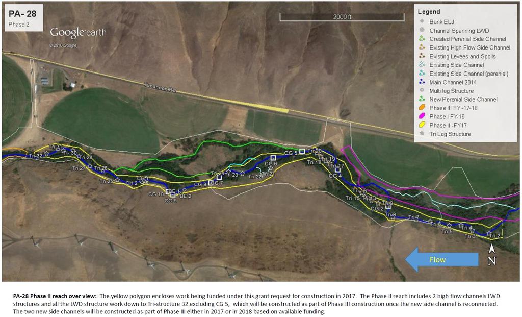
32 Tucannon River PA-28 Phase II Habitat Restoration ( ) Sponsor: Terry Bruegman Columbia Conservation District Location: Tucannon River MSA Priority Restoration and Protection Reach 3 Year Plan: Yes Project Type: Restoration Request+Match: 304, ,981 $631,756 Species: Snake River Steelhead (DPS), Snake River Spring/Summer Chinook (ESU) Columbia River Bull Trout (DPS) Description: The Columbia Conservation District will utilize these grant funds as match with BPA funds to complete PA 28 Phase II habitat enhancement & restoration implementation. The project is located in the Tucannon MSA, Reach 6 between RM 21.7-RM 19.5 and is a priority protection/restoration area for spring Chinook, Steelhead and Bull Trout habitats. Project reach is a focus area for spring Chinook, Steelhead & Bull Trout for various life cycles, spawning, rearing, migration & overwintering. Project reach has been impacted by past land management, stream channel straightening, confinement & LWD removal. These are common conditions throughout the Tucannon River and identified in the Tucannon Geomorphic Assessment (Anchor 2011) & Tucannon Conceptual Restoration Plan (Anchor 2011). Limiting factors being addressed in this project reach are deficient LWD key pieces ( 6mlong & cm Diam.), 2 pieces/channel width desired in the Recovery Plan (SRSRB 2011), channel confinement and floodplain connectivity. Existing conditions are detrimental to salmonids providing limited winter rearing habitat, causing early emigration from upper river reaches into habitats down river which may have additional detrimental conditions (Personnel communications WDFW). Phase II actions will construct ~41 log jams in main stem and side channels, to increase LWD Key Pieces to >2 piece per bank width (Recovery Plan 2011). Goals and Objectives: Project goals are to improve floodplain connectivity and flood frequency to the point that riparian habitat quantity and quality can re-establish and be supported by natural process; modify simplified channel structure, caused by limited LWD Key Pieces (>6m long & 0.3cm Diam.) and channel confinement which leads to redd scour, reduced winter rearing habitat quality for chinook/steelhead leading to poor survival; and reduce pre smolt emigration from the project reach by minimizing channel confinement and reconnecting side channel and floodplain habitats providing refuge areas. Specific objectives are: Construct ~41 log jams instream, sufficient to increase LWD Key Pieces to >2 piece per bank width (Recovery Plan 2011) by Re-connect 2 historic side channels to re-establish 0.43 miles of side channel and enhance with LWD complexity at ~1.5 yr return interval by Draft Application Lead Entity Meeting (5/3/16) Questions/Comments/Notes: Project is on private property downstream of Marengo a few miles. This is phase II of a III phase project. How much area will be opened up by setting back levies? The levy is a sugar berm that has become hardened by vegetation so connecting new floodplain will occur more by aggradation due to LWD/complexity more-so than by setting the levy back. Without a new setback levee, the landowner is not agreeable to allowing the level of complexity and aggradation we want to see. The setback levee will be only a couple feet high because it is so far back and it will be blended into natural topography and hardly noticeable. Where is the match coming from? Mostly from BPA/BiOp but about $50,000 from a commission grant. SRSRB RTT Meeting (5/17/16) Questions/Comments/Notes: None Project Tour Questions/Comments/Notes: 31

33 32
34 Asotin Creek Riparian Protection Project ( ) Sponsor: Megan Stewart Asotin County Conservation District Location: Asotin Creek MSA Priority Restoration Reach 3 Year Plan: Yes Project Type: Restoration $ Request+Match: 90, ,928 $287,928 Species: Snake River Steelhead (DPS), Snake River Spring/Summer Chinook (ESU) Columbia River Bull Trout (DPS) Description: The Asotin County Conservation District will use this grant to implement a project designed to protect and enhance three miles of stream on Asotin Cr by installing a riparian buffer to exclude livestock. Approximately 80 acres will be enrolled in the Conservation Reserve Enhancement Program (CREP) and the project will include alternative livestock water developments, tree/shrub planting, fencing and installation of a bridge. Asotin Cr is a high priority area for the WA Dept of Ecology and is also inhabited by native ESA threatened Snake River steelhead, Snake River spring Chinook, Columbia River Bull Trout and, to a lesser extent, Snake River fall Chinook. The landowner has installed fences along the stream, especially where winter feeding occurs, but there is still livestock access to the stream and riparian area. The current buffer is minimal and does not meet the current Natural Resource Conservation Service specifications. Land on the north side of the creek is used for winter feeding and calving for approximately 50 head of cattle. In late spring, the cattle are moved to the south side of the creek to utilize spring pasture. Currently, the only way to access the south side is for livestock to cross the creek. Due to high flows, a traditional livestock crossing is unsafe for young calves so the cattle have access to large sections of stream. The landowner has agreed to enroll in CREP to establish a buffer along this stretch of Asotin Cr however an alternative method for moving cattle across the creek will be required. Goals and Objectives: The goal of this project is to completely eliminate livestock access to approximately 3 miles of Asotin Creek to fully restore the riparian function on approximately 80 acres adjacent to Asotin Creek by enrolling in CREP for a 15 year contract while still maintaining the viability of the agricultural livestock operation by providing off stream livestock watering facilities and alternative option for crossing the stream. Specific objectives are: Improve riparian function by installing native riparian forest habitat along approximately 3 miles of Asotin Creek. CREP provides guidelines of 500 stem counts per acre for riparian forest habitat. Species diversity will be important for this site since there are very few conifers which are important for LWD recruitment. After through planning is done, a planting plan will be created to identify priority planting sites and species Eliminate all livestock access to the 3 miles of stream in the project area. Reduce risk of water quality contamination by installing larger riparian buffers between livestock operations and the stream. Draft Application Lead Entity Meeting (5/3/16) Questions/Comments/Notes: Is the bridge in the budget request? Yes. What is the source of match? DOE and BPA. Are there any pre-existing water development/wells on the project site? Yes, there are pre-existing wells on winter feeding areas but they need water for upland pasture for when cows can no longer drink from river. Noted was the high level of coordination on this project amongst agencies on behalf of the district. SRSRB RTT Meeting (5/17/16) Questions/Comments/Notes: None Project Tour Questions/Comments/Notes: 33


35 Site Map: Asotin Creek Riparian Protection Project Red Line CREP Fence; Yellow Line Additional Fence 34
36 Asotin Intensively Monitored Watershed Monitoring YR10 ( ) Sponsor: Steve Bennett Eco Logical Research Inc. Location: Asotin Creek MSA Priority Restoration and Protection Reach 3 Year Plan: Yes Project Type: Monitoring Request+Match: 118, ,419 $293,419 (monitoring proposal max 10% of Regional allocation) Species: Snake River Steelhead (DPS), Snake River Spring/Summer Chinook (ESU) Columbia River Bull Trout (DPS) Description: ELR Inc is the project sponsor and the project type is a monitoring project. This request is to support ongoing monitoring in the Asotin Creek Intensively Monitored Watershed project (Asotin IMW). The project was started in 2008 and is expected to run until The funds are being requested to support i) juvenile steelhead PIT tagging and mark-recapture surveys, and ii) habitat monitoring using the Columbia Habitat Monitoring protocol (CHaMP). These two monitoring efforts are being used to assess the effectiveness of large woody debris restoration at increasing juvenile productivity in Asotin Creek. Three tributaries in Asotin Creek need to be monitored: Charley Creek, North Fork Asotin Creek, and South Fork Asotin Creek. The overall goal is to maintain the current level on monitoring and funds are being requested because we have been informed that the current IMW monitoring budget that is currently provided by Pacific State Marine Funding Commission (PSMFC) may be reduced as of 2016 to between $0 and $100,000. It is critical at this stage in the Asotin IMW to maintain the basic monitoring levels to ensure that the goals of the IMW can be completed: namely to determine the effectiveness of LWD restoration methods, determine the casual mechanisms of habitat and fish responses, and to provide recommendations for implementing LWD restoration in other watersheds. The extent of fish monitoring is 12 sites m in length, 4 in each tributary (see attached map). The extent of the habitat monitoring is 12 CHaMP sites (length m) in Charley and North Fork Creek Tetra Tech is funding CHaMP monitoring in South Fork Creek in This project will support the ESA listed summer steelhead recovery. All of the fish and habitat data collected will be made publically available in the PTAGIS (ptagis.org) and on the CHaMP website (champmonitoring.org). Analyses of the data will be conducted with other funds provided to the Asotin IMW by PSMFC. Goals and Objectives: Project goals are to monitor juvenile steelhead populations pre- and post-restoration and determine 1) if populations responded to restoration, 2) what habitat changes were linked to fish responses, and 3) how to extrapolate the results to other watersheds. Objectives are to: Continue monitoring at permanent Fish (12) and Habitat (18) sites in IMW study area Manage and analyze the data Report results Draft Application Lead Entity Meeting (5/3/16) Questions/Comments/Notes: Noted was the challenge over the last 9 years in securing IMW funding and the deficit the project has had to operate with; the proposal will be retracted if we are successful in securing sufficient budget from other sources (not likely known until closer to September). What is the source of match? ISEMP donated tags/equipment. It was noted that ~$118,000 is the maximum allowed for monitoring (10% of allocation). Did the LE funding go to this program last year? Yes. Who funded the shortfall last year? It was a combination of PSMFC and SRFB last year. Is project implementation is part of this request? No, restoration has been funded and the final year of restoration actions will occur this summer, this request is just for monitoring. It was noted that the intent of our habitat restoration is to increase the number of fish have the results shown this or not? The results are preliminary and the number of fish in treatment sites is increasing relative to control sites. He noted the test is the effectiveness of restoration not population status and trends. Hypothesis is if treatment sites produce more fish and all other factors stay the same then the population should increase. This is not status/trend monitoring but rather project effectiveness monitoring project. It was noted this project is proposed to be sponsored by ELR. We don t know if we can get SRFB policy changes to allow this plan B is for WDFW or another entity to sponsor but that is additional bureaucracy and cost. The group debated moving it up to 30 points because it will identify protection or restoration actions in a priority reach and will fill a key data gap (is LWD effective at improving fish abundance). Group agreed to assign it 30 points. SRSRB RTT Meeting (5/17/16) Questions/Comments/Notes: None Project Tour Questions/Comments/Notes: 35

37 36
Funding Habitat Restoration Projects for Salmon Recovery in the Snake River Region SRFB Grant Round Version: 2/19/16
 2016 SRFB Grant Round Version: 2/19/16 Funding Habitat Restoration Projects for Salmon Recovery in the Snake River Region The Project Funding Process Presented by the Snake River Salmon Recovery Lead Entity
Snake River Salmon Recovery Board Lead Entity 2017 SRFB Grant Round. Project Tour May 31 st and June 1 st
 Snake River Salmon Recovery Board Lead Entity 2017 SRFB Grant Round Project Tour May 31 st and June 1 st Tucannon River PA-28 Phase II Habitat Restoration Project Site Visit, June, 2016 Table of Contents
MCCAW REACH RESTORATION
 Final Report MCCAW REACH FISH RESTORATION PHASE B Jack McCaw Inland Empire Action Coalition http://www.wwccd.net/ Phone: 509-956-3777 Hours: 8:00-4:30 Walla Walla County Conservation District Snake River
Fish Habitat Restoration and Monitoring in Southeast Washington. Andy Hill Eco Logical Research, Inc.
 Fish Habitat Restoration and Monitoring in Southeast Washington Andy Hill Eco Logical Research, Inc. Fish Habitat Restoration and Monitoring in Southeast Washington Talk overview: Restoration projects
Snake River Salmon Recovery Board Lead Entity 2018 SRFB Grant Round. Project Tour June 5 th 7 th
 Snake River Salmon Recovery Board Lead Entity 2018 SRFB Grant Round Project Tour June 5 th 7 th Restoring Native Riparian on Pataha Creek Project Site Visit, May, 2017 2 Table of Contents Tour Schedule
3. The qualification raised by the ISRP is addressed in #2 above and in the work area submittal and review by the ISRP as addressed in #1.
 Please find attached a response from The Confederated Tribes of the Warm Springs Reservation of Oregon (CTWSRO) for Project # 2008-301-00, Habitat Restoration Planning, Design and Implementation within
Mid-Columbia Fisheries Enhancement Group Annual Report Fiscal Year 06: July 1, 2005 June 30, 2006
 Mid-Columbia Fisheries Enhancement Group Annual Report Fiscal Year 06: July 1, 2005 June 30, 2006 Mission Statement The mission of the Mid-Columbia Fisheries Enhancement Group is to restore self-sustaining
Planning and Combination (Planning and Acquisition) Project Proposal
 Project Proposal") Planning and Combination (Planning and Acquisition) Project Proposal Project Number 16-2095 Project Name Tucannon Mobile PIT Tag Detection Sponsor Washington Dept of Fish and Wildlife List all related
Planning and Combination (Planning and Acquisition) Project Proposal Project Number 16-2095 Project Name Tucannon Mobile PIT Tag Detection Sponsor Washington Dept of Fish and Wildlife List all related
OVERVIEW OF MID-COLUMBIA FISHERIES ENHANCEMENT GROUP
 Mid-Columbia Fisheries Enhancement Group MISSION STATEMENT The Mid-Columbia Fisheries Enhancement Group is a non-profit organization dedicated to restoring selfsustaining salmon and steelhead populations
Five Counties Salmonid Conservation Program - Fish Passage Design Workshop. February 2013
 Program - Aquatic Organisms and Stream Crossings Ecological Connectivity A watershed is a network of channels that drain a common boundary. Channel characteristics formed by interaction of precipitation,
STEELHEAD SURVEYS IN OMAK CREEK
 STEELHEAD SURVEYS IN OMAK CREEK 2002 Annual Report Prepared by Chris Fisher John Arterburn Colville Confederated Tribes Fish and Wildlife Department P.O. Box 150 Nespelem, WA 99155 Prepared for Project
OKANAGAN RIVER RESTORATION INITIATIVE - FAQ
 OKANAGAN RIVER RESTORATION INITIATIVE - FAQ Initiative background: The health of the q awsitk w (Okanagan River) has been severely impacted by the channelization works that occurred in the mid-1950 s.
Yakima/Klickitat Fisheries Project
 Yakima/Klickitat Fisheries Project Lower Yakima River Supplementation and Research Project Operations and Maintenance Annual Report 2002-2003 March 2004 DOE/BP-00006677-1 This Document should be cited
THE CONFEDERATED TRIBES OF THE WARM SPRINGS RESERVATION OF OREGON
 THE CONFEDERATED TRIBES OF THE WARM SPRINGS RESERVATION OF OREGON To: Branch of Natural Resources P.0. Box C, Warm Springs, Oregon 97761 Phone (541) 553-2002/2003 Fax (541) 553-1994 The Independent Science
South Fork Chehalis Watershed Culvert Assessment
 South Fork Chehalis Watershed Culvert Assessment Water Resource Inventory Area 23 Lewis County Conservation District Final Report By: Kelly Verd and Nikki Wilson March 2003 Funded by: The Washington State
Sub-watershed Summaries
 Project Description The Salmon Drift Creek Watershed Council (SDCWC) has focused their efforts in the Salmon River estuary for the past few years. The multifaceted partnership effort is nearing completion
Restoring the Kootenai: A Tribal Approach to Restoration of a Large River in Idaho
 Restoring the Kootenai: A Tribal Approach to Restoration of a Large River in Idaho Susan Ireland, Kootenai Tribe of Idaho Future of our Salmon Conference Technical Session August 2016 Healthy Floodplains,
April 26, Chairman Rockefeller and members of the Fish and Wildlife Committee. Briefing from Mid-Columbia Regional Fish Enhancement Group (RFEG)
") Joan M. Dukes Chair Oregon Bruce A. Measure Montana James A. Yost Idaho W. Bill Booth Idaho Rhonda Whiting Vice-Chair Montana Bill Bradbury Oregon Tom Karier Washington Phil Rockefeller Washington April
Joan M. Dukes Chair Oregon Bruce A. Measure Montana James A. Yost Idaho W. Bill Booth Idaho Rhonda Whiting Vice-Chair Montana Bill Bradbury Oregon Tom Karier Washington Phil Rockefeller Washington April
Minnesota Department of Natural Resources Division of Fish and Wildlife Section of Fisheries. Stream Survey Report. Luxemburg Creek.
 Minnesota F-29-R(P)-24 Area 315 Study 3 March 2016 Minnesota Department of Natural Resources Division of Fish and Wildlife Section of Fisheries Stream Survey Report Luxemburg Creek 2015 Mark Pelham Sauk
Burns Paiute Tribe Fisheries Department. Evaluate The Life History Of Native Salmonids Within The Malheur Subbasin Project #
 Burns Paiute Tribe Fisheries Department Evaluate The Life History Of Native Salmonids Within The Malheur Subbasin Project # 199701900 Prior to 1990 Technical and/or scientific background Malheur population,
CHAPTER 4 DESIRED OUTCOMES: VISION, GOALS, AND OBJECTIVES
 CHAPTER 4 DESIRED OUTCOMES: VISION, GOALS, AND OBJECTIVES Vision One of the first steps in developing this Plan was articulating a vision - a clear statement of what the Plan strives to achieve and what
The Blue Heron Slough Conservation Bank
 1 The Blue Heron Slough Conservation Bank CONSERVATION BANKING July 19-23, 2010 CASE STUDY SERIES The Blue Heron Slough Conservation Bank (Washington) I. OVERVIEW & BACKGROUND: Location: Snohomish River
PRE- PROPOSAL FORM - 1. Applicant organization. USDA Forest Service Gifford Pinchot National Forest & WDFW Region 5
 PRE- PROPOSAL FORM - 1. Applicant organization. USDA Forest Service Gifford Pinchot National Forest & WDFW Region 5 2. Organization purpose USFS-Resource management agency WDFW-Fish and Wildlife management
PROTECTING LAND & RESTORING RIVERS FOR SALMON & STEELHEAD
 PROTECTING LAND & RESTORING RIVERS FOR SALMON & STEELHEAD Whychus Creek at Camp Polk Meadow Preserve. Photo: Russ McMillan Top photo: Deschutes River Conservancy 1 Photo: Byron Dudley A Unique Collaboration
Executive Summary. Map 1. The Santa Clara River watershed with topography.
 Santa Clara River Steelhead Trout: Assessment and Recovery Opportunities December 2005 Prepared By: Matt Stoecker and Elise Kelley, Ph.D. University of California, Santa Barbara Prepared For: The Santa
Union Pacific Railroad
 Input Questions: 404/401 Pre Application Meeting, December 18, 2013, Portland, Oregon 1. What is the project purpose and need? The purpose of the project is to improve the efficiency and average velocity
Trout Unlimited Comments on the Scope of Environmental Impact Statement for the Constitution Pipeline Project, Docket No. PF12-9
 October 9, 2012 Kimberly D. Bose, Secretary Federal Energy Regulatory Commission 888 First Street, NE, Room 1A Washington, DC 20426 RE: Trout Unlimited Comments on the Scope of Environmental Impact Statement
Riparian Planting Projects Completed within Asotin Creek Watershed. Final Report
 Riparian Planting Projects Completed within Asotin Creek Watershed Final Report 2000-2002 DOE/BP-00006436-1 October 2002 Field37: This Document should be cited as follows: Johnson, Bradley, ''Riparian
FINAL REPORT. Yonkers Creek Migration Barrier Removal Project Wonderstump Road Del Norte County. Submitted By:
 FINAL REPORT Yonkers Creek Migration Barrier Removal Project Wonderstump Road Del Norte County Submitted By: Del Norte County Community Development Department Yonkers Creek Migration Barrier Removal Project
FISH PASSAGE IMPROVEMENT in California s Watersheds. Assessments & Recommendations by the Fish Passage Forum
 FISH PASSAGE IMPROVEMENT in California s Watersheds Assessments & Recommendations by the Fish Passage Forum FISH PASSAGE IMPROVEMENT in California s Watersheds The mission of the Fish Passage Forum is
COA-F17-F-1343 YEAR END REPORT
 DAVE MARSHALL SALMON RESERVE RESTORATION, MAINTENANCE, AND UPGRADES YEAR END REPORT Prepared for: Fish and Wildlife Compensation Program Prepared by: Edith Tobe, RPBio, Executive Director Box 1791, Squamish,
Abundance of Steelhead and Coho Salmon in the Lagunitas Creek Drainage, Marin County, California
 scanned for KRIS Abundance of Steelhead and Coho Salmon in the Lagunitas Creek Drainage, Marin County, California Prepared for: Marin Municipal Water District 220 Nellen Drive Corte Madera, California
Kootenai River Habitat Restoration Program. Kootenai Tribe of Idaho - January 27, 2014 Presentation for Kootenai Valley Resource Initiative
 Kootenai River Habitat Restoration Program Kootenai Tribe of Idaho - January 27, 2014 Presentation for Kootenai Valley Resource Initiative Decline of native species Kootenai River White Sturgeon ENDANGERED
PRE- PROPOSAL FORM - Lewis River Aquatic Fund
 PRE- PROPOSAL FORM - Lewis River Aquatic Fund 1. Applicant organization. USDA Forest Service Gifford Pinchot National Forest 2. Organization purpose Resource management agency 3. Project manager (name,
FISHERIES BLUE MOUNTAINS ADAPTATION PARTNERSHIP
 FISHERIES A warming climate, by itself, substantially affects the hydrology of watersheds in the Blue Mountains. Among the key hydrologic changes projected under all scenarios for the 2040s and beyond
Strategies for mitigating ecological effects of hatchery programs
 Strategies for mitigating ecological effects of hatchery programs Some case studies from the Pacific Northwest Kathryn Kostow Oregon Department of Fish and Wildlife Ecological risks occur when the presence
Reintroduction of Pacific lamprey in the Umatilla River in Northeast Oregon
 Reintroduction of Pacific lamprey in the Umatilla River in Northeast Oregon Goal Restore natural production of Pacific lamprey to self sustaining and harvestable levels. CTUIR Restoration Strategies Utilize
Hatchery Scientific Review Group Review and Recommendations
 Hatchery Scientific Review Group Review and Recommendations Walla Walla River Summer Steelhead Population and Related Hatchery Programs January 31, 2009 Note: Spawning reaches likely vary from those depicted.
Washington State Fish Passage Barrier Removal Projects. Casey Kramer, PE WSDOT State Hydraulics Engineer
 Washington State Fish Passage Barrier Removal Projects Casey Kramer, PE WSDOT State Hydraulics Engineer 2014 National Hydraulic Engineering Conference Iowa City, IA August 20 th, 2014 WSDOT Fish Passage
Mountain Snake Province
 Rolling Provincial Review: Implementation 2001-2003 Province 253 Columbia Basin Fish & Wildlife Authority Province FY 2001-2003 Spending Summaries NPCC Recommendations and BPA Spending by Project Category,
1.Mill Creek Watershed Summary Description and Land Use
 1.Mill Creek Watershed Summary Description and Land Use Table xxx: Mill Creek Watershed Overview Watershed Size 31,435 acres/49.1 sq miles/ 127.1 sq km Elevation Range 5,594 feet [4,967-10,561] Stream
The Calawah River System
 The Calawah River System The Calawah River is the largest tributary of the Bogachiel River and is formed by the confluence of the north and south forks of the Calawah. The two forks of the Calawah, CALAWAH
Newaukum Watershed Culvert Assessment
 Newaukum Watershed Culvert Assessment Water Resource Inventory Area 23 Lewis County Conservation District Final Report By: Kelly Verd and Nikki Wilson July 2002 Funded by: Chehalis Fisheries Restoration
Conserving the Forests, Lakes and Streams of Northeast Michigan
 4241 Old US 27 South, Suite 2, Gaylord, Michigan 49735 (989) 448-2293 www.huronpines.org info@huronpines.org Prioritized Restoration Projects in the AuSable River Watershed Summer 2015 Update from Huron
California Steelhead: Management, Monitoring and Recovery Efforts
 California Steelhead: Management, Monitoring and Recovery Efforts Jonathan Nelson Steelhead Restoration & Management Program Oncorhynchus mykiss irideus California Steelhead Distinct Population Segments
Annual Report for Fiscal Year and Future Plans for the Tillamook Bay Watershed Council
 Annual Report for Fiscal Year 2012-2013 and Future Plans for the Tillamook Bay Watershed Council A report prepared for the Tillamook County Board of Commissioners August 2013 Table of Contents: Recently
Deschutes WRIA 13 Salmon Habitat Recovery Committee SRFB / PSAR Letter of Intent Form
 Deschutes WRIA 13 Salmon Habitat Recovery Committee SRFB / PSAR Letter of Intent Form Project Sponsor: Sponsor Contact lnfo: Project Name: Key Partners: Project Location: lnclude wotershed Project Description:
Chagrin River TMDL Appendices. Appendix F
 Appendix F The following are excerpts from the Eastern Brook Trout Joint Venture s Conservation Strategy (Working Draft v.6), Conserving the Eastern Brook Trout: Strategies for Action Found at: http://www.easternbrooktrout.org/constrategy.html
107 FERC 61,282 UNITED STATES OF AMERICA FEDERAL ENERGY REGULATORY COMMISSION
 107 FERC 61,282 UNITED STATES OF AMERICA FEDERAL ENERGY REGULATORY COMMISSION Before Commissioners: Pat Wood, III, Chairman; Nora Mead Brownell, and Joseph T. Kelliher. Public Utility District No. 1 of
LIFE HISTORY DIVERSITY AND RESILIENCE
 LIFE HISTORY DIVERSITY AND RESILIENCE SPRING CHINOOK IN THE WILLAMETTE RIVER BASIN Kirk Schroeder Brian Cannon Luke Whitman Paul Olmsted Oregon Department of Fish and Wildlife Corvallis Research Lab Thanks
Draft Central Valley Salmon and Steelhead Recovery Plan
 Draft Central Valley Salmon and Steelhead Recovery Plan for Sacramento River winter-run Chinook salmon Central Valley spring-run Chinook Salmon Central Valley Steelhead National Marine Fisheries Service
Anadromous Fish Committee Columbia Basin Fish and Wildlife Authority Project Implementation Review Conference
 Anadromous Fish Committee Columbia Basin Fish and Wildlife Authority Project Implementation Review Conference September 21-24, 2004 Red Lion Hotel Richland Hanford House Richland, Washington In April 2004,
Klamath Lake Bull Trout
 Klamath Lake Bull Trout Existing Populations The Klamath Lake Bull Trout SMU is comprised of seven existing populations and four populations classified as extinct or functionally extinct (Table 189). Populations
Rehabilitation of Grimes Creek, a Stream Impacted in the Past by Bucket-lined Dredge Gold Mining, Boise River Drainage, July 2008 to August 2011.
 Rehabilitation of Grimes Creek, a Stream Impacted in the Past by Bucket-lined Dredge Gold Mining, Boise River Drainage, July 2008 to August 2011. Pam Harrington TU,1020 W. Main Street Suite 440, Boise,
Attachment 1. Agenda Item Summary BACKGROUND
 Attachment 1 Agenda Item Summary BACKGROUND Spring Chinook Salmon: Prior to the late 1970s, non-treaty spring Chinook fisheries in the mainstem Columbia River occurred from February through May and harvested
10 is bounded by wetlands between RM 1.8 and 3.1 on the south shore and more are scattered
 The Ozette System The Ozette watershed is made up of several lakes and large streams that combine to a total drainage area of 88.4 square miles. The most significant feature of the Ozette watershed is
OREGON DEPARTMENT OF FISH AND WILDLIFE ROGUE FISH DISTRICT REPORT
 OREGON DEPARTMENT OF FISH AND WILDLIFE ROGUE FISH DISTRICT REPORT TITLE: Upper Rogue Smolt Trapping Project, 1999 STREAM: Big Butte, Little Butte, South Fork Big Butte, Slate and West Fork Evans Creeks
Eastern Brook Trout. Roadmap to
 Eastern Brook Trout Roadmap to CONSERVATION Our Brook Trout heritage he wild Brook Trout is an American symbol of persistence, adaptability, and the pristine wilderness that covered North America prior
PROJECT TO INSTALL LARGE WOOD HABITAT STRUCTURES IN THE CARMEL RIVER USING CALIFORNIA DEPARTMENT OF FISH AND GAME GRANT FUNDS
 PROJECT TO INSTALL LARGE WOOD HABITAT STRUCTURES IN THE CARMEL RIVER USING CALIFORNIA DEPARTMENT OF FISH AND GAME GRANT FUNDS The Monterey Peninsula Water Management District (MPWMD), in cooperation with
Little Kern Golden Trout Status:
 Little Kern Golden Trout Status: The Little Kern Golden trout (LKGT) was proposed for federal listing as Threatened under the Endangered Species Act (ESA) on September 1, 1977 by the U. S. Fish and Wildlife
Backgrounder and Frequently Asked Questions
 Backgrounder and Frequently Asked Questions Who Sent the Letter? The 60-day Notice of Intent to File Suit was sent by Conservation Angler, Wild Fish Conservancy, Snake River Waterkeeper, Friends of the
Incorporating Geomorphic Processes and Sediment Dynamics into Salmonid Habitat Restoration Design
 Salmonid Restoration Federation 35 th Annual Salmonid Restoration Conference Davis, CA Incorporating Geomorphic Processes and Sediment Dynamics into Salmonid Habitat Restoration Design Concurrent Session:
Rhode Island Department of Environmental Management Division of Fish and Wildlife American Shad Habitat Plan for the Pawcatuck River
 Rhode Island Department of Environmental Management Division of Fish and Wildlife American Shad Habitat Plan for the Pawcatuck River Prepared by: Phil Edwards, Rhode Island Department of Environmental
Columbia Lake Dam Removal Project
 Columbia Lake Dam Removal Project Major Goals of the Columbia Lake Dam Removal: Reconnect 10 miles of the Paulins Kill River to the Delaware River, restoring natural flow regime and sediment transport.
2012 Bring Back the Natives Awarded Projects
 2012 Bring Back the Natives Awarded Projects EZG # Organization Project Title Project Description Location Description Total Award Amount Grantee Non- Federal Match 31904 Sanctuary Forest, Inc. Mattole
5B. Management of invasive species in the Cosumnes and Mokelumne River Basins
 5B. Management of invasive species in the Cosumnes and Mokelumne River Basins Cosumnes River The Cosumnes River basin has a number of distinct habitat types that require different management strategies
COLUMBIA LAKE DAM REMOVAL PROJECT
 COLUMBIA LAKE DAM REMOVAL PROJECT Major Goals of the Columbia Lake Dam Removal: Reconnect 10 miles of the Paulins Kill River to the Delaware River, restoring natural flow regime and sediment transport.
Throughout the Pacific Northwest, salmon and steelhead have been listed under the Endangered Species Act because their existence is either threatened
 Throughout the Pacific Northwest, salmon and steelhead have been listed under the Endangered Species Act because their existence is either threatened or endangered. The Upper Willamette River Basin s spring
September 27, 2012 MEMORANDUM. Fish and Wildlife Committee. Lynn Palensky. Update on Geographic Review
 Rhonda Whiting Chair Montana Bruce A. Measure Montana James A. Yost Idaho W. Bill Booth Idaho Bill Bradbury Vice-Chair Oregon Henry Lorenzen Oregon Tom Karier Washington Phil Rockefeller Washington September
California Steelhead: Management, Monitoring and Recovery Efforts
 California Steelhead: Management, Monitoring and Recovery Efforts Jonathan Nelson Steelhead Management, Research and Restoration Program Oncorhynchus mykiss irideus California Steelhead - Hot Topics Implementation
(Revised February,2005) CULVERTS, BRIDGES, AND FORDS
 CULVERTS, BRIDGES, AND FORDS") GUIDE TO STREAM CROSSINGS (Revised February,2005) CULVERTS, BRIDGES, AND FORDS Culverts, bridges, and fords are all methods used to cross-streams. Culverts are the most common stream crossing structure.
GUIDE TO STREAM CROSSINGS (Revised February,2005) CULVERTS, BRIDGES, AND FORDS Culverts, bridges, and fords are all methods used to cross-streams. Culverts are the most common stream crossing structure.
September 4, Update on Columbia basin Salmon and Steelhead Recovery Planning
 Bill Bradbury Chair Oregon Henry Lorenzen Oregon W. Bill Booth Idaho James A. Yost Idaho Jennifer Anders Vice Chair Montana Pat Smith Montana Tom Karier Washington Phil Rockefeller Washington September
Addressing Critical Uncertainties in the Reintroduction of Chum Salmon to Oregon Tributaries of the Columbia River. Kris Homel
 Addressing Critical Uncertainties in the Reintroduction of Chum Salmon to Oregon Tributaries of the Columbia River Kris Homel NW Fish Culture Concepts Wilsonville, OR 2015 Historic distribution and abundance
State of San Francisco Bay 2011 Appendix O Steelhead Trout Production as an Indicator of Watershed Health
 State of San Francisco Bay 2011 Appendix O Steelhead Trout Production as an Indicator of Watershed Health Gordon Becker and Katherine Smetak, Center for Ecosystem Management and Restoration 290 Introduction
Hatchery Scientific Review Group Review and Recommendations
 Hatchery Scientific Review Group Review and Recommendations Lochsa River Spring Chinook Population and Related Hatchery Programs January 31, 2009 Lochsa River Spring Chinook Population Report Page - 1
Aquatic Organism Passage at Road-Stream Crossings CHUCK KEEPORTS FOREST HYDROLOGIST ALLEGHENY NATIONAL FOREST WARREN, PENNSYLVANIA
 Aquatic Organism Passage at Road-Stream Crossings CHUCK KEEPORTS FOREST HYDROLOGIST ALLEGHENY NATIONAL FOREST WARREN, PENNSYLVANIA TOPICS COVERED Aquatic Organism Passage (AOP) Benefits of AOP Crossings
Deschutes Bull Trout
 Deschutes Bull Trout Existing Populations The Deschutes Bull Trout SMU is comprised of eight populations, three of which are classified as extinct (Table 1). Populations are identified according to those
Oregon Department of Fish and Wildlife: Inland Fisheries - Hatchery Management
 Oregon Department of Fish and Wildlife: Inland Fisheries - Hatchery Management Primary Outcome Area: Economy & Jobs Secondary Outcome Area: Healthy Environments Program Contact: Ed Bowles, 503-947-6206
1998 Willow Creek Downstream Migrant Trap Report. Draft. Prepared By: C. A. Walker. Lower Trinity Ranger District. Six Rivers National Forest
 1998 Willow Creek Downstream Migrant Trap Report Draft Prepared By: C. A. Walker Lower Trinity Ranger District Six Rivers National Forest September 1998 Executive Summary The downstream migrant trap was
Packwood Hydroelectric Project Barrier Analysis December 12, 2006
 Packwood Hydroelectric Project Barrier Analysis December 12, 2006 Study Area Natural barriers to upstream fish passage on Lake Creek at RM 1.03 and RM 1.95 Snyder Creek culvert under the Project tailrace
NEVADA DEPARTMENT OF WILDLIFE STATEWIDE FISHERIES MANAGEMENT FEDERAL AID JOB PROGRESS REPORTS F LAHONTAN CUTTHROAT TROUT EASTERN REGION
 NEVADA DEPARTMENT OF WILDLIFE STATEWIDE FISHERIES MANAGEMENT FEDERAL AID JOB PROGRESS REPORTS F-20-50 2014 LAHONTAN CUTTHROAT TROUT EASTERN REGION NEVADA DEPARTMENT OF WILDLIFE, FISHERIES DIVISION ANNUAL
Mountain Columbia Province
 Rolling Provincial Review: Implementation 2001-2003 Province 229 Columbia Basin Fish & Wildlife Authority Province FY 2001-2003 Spending Summaries NPCC Recommendations and BPA Spending by Project Category,
Kasaan to Goose Creek Road Project Project Description U.S. Army Corps of Engineers Permit The following table presents the mile point of the culverte
 Kasaan to Goose Creek Road Project Project Description U.S. Army Corps of Engineers Permit The following table presents the mile point of the culverted open water crossings, name of water crossing if known,
Okanagan Sockeye Reintroduction
 Okanagan Sockeye Reintroduction Backgrounder Elders accounts, and other forms of Traditional Ecological Knowledge (TEK) tell us that many species of salmon once came into the Okanagan Valley and tell us
EXHIBIT ARWA-700 TESTIMONY OF PAUL BRATOVICH
 EXHIBIT ARWA-700 TESTIMONY OF PAUL BRATOVICH 1. I am a fisheries biologist employed by the firm of HDR, Inc. I hold a Bachelor of Science degree in Fisheries from the University of Washington, located
State of Washington Dept. of Fish and Wildlife invites applications for the position of: Permanent Fisheries Biologist 4 *
 State of Washington Dept. of Fish and Wildlife invites applications for the position of: Permanent Fisheries Biologist 4 *00593-15 SALARY: $3,819.00 - $5,010.00 Monthly OPENING DATE: 01/21/15 CLOSING DATE:
TESTIMONY OF THE COLUMBIA RIVER TREATY TRIBES BEFORE PACIFIC FISHERIES MANAGEMENT COUNCIL
 Agenda Item E.2.f Supplemental Tribal Report April 2012 TESTIMONY OF THE COLUMBIA RIVER TREATY TRIBES BEFORE PACIFIC FISHERIES MANAGEMENT COUNCIL April 2, 2012 Seattle, WA Good day Mr. Chairman and members
Interim Guidance Fish Presence Absence
 Interim Guidance Fish Presence Absence Source: Forest Practices Act Guidance for Division 635 of the forest practices act dealing with stream classification when no fish surveys have been done (referenced
Steelhead Society of BC. Thompson River Watershed Restoration and Enhancement Project #4 Nicola River Bank Stabilization and Enhancement Project
 Steelhead Society of BC Presents: Thompson River Watershed Restoration and Enhancement Project #4 Nicola River Bank Stabilization and Enhancement Project Application for Funding December 2013 1.0 BACKGROUND
145 FERC 62,070 UNITED STATES OF AMERICA FEDERAL ENERGY REGULATORY COMMISSION
 145 FERC 62,070 UNITED STATES OF AMERICA FEDERAL ENERGY REGULATORY COMMISSION Public Utility District No. 1 of Douglas County, Washington Project No. 2149-163 ORDER APPROVING BULL TROUT STRANDING, ENTRAPMENT,
P.O. Box 65 Hancock, Michigan USA fax
 This PDF file is a digital version of a chapter in the 2005 GWS Conference Proceedings. Please cite as follows: Harmon, David, ed. 2006. People, Places, and Parks: Proceedings of the 2005 George Wright
Implementation Toolkit
 Conservation and Recovery Plan for Oregon Steelhead s in the Middle Columbia Steelhead Distinct Segment: Implementation Toolkit Oregon Department of Fish & Wildlife September 2012 0 Introduction The Implementation
middle deschutes progress in restoration
 middle deschutes progress in restoration Acknowledgements prepared by: Upper Deschutes Watershed Council Deschutes River Conservancy Oregon Department of Fish and Wildlife DESIGN & PRODUCTION FUNDED by:
Lake Merwin and Swift Creek Reservoir Tributaries. Bull Trout Limiting Factors Analysis
 Lake Merwin and Swift Creek Reservoir Tributaries Bull Trout Limiting Factors Analysis Study Objectives Answer Key? s Do other tributaries to Swift Creek Reservoir and Lake Merwin not known to support
Summer Steelhead Surveys North Fork Trinity River Trinity County, California
 KRIS edition Summer Steelhead Surveys North Fork Trinity River Trinity County, California 1978-1997 By Loren Everest Fishery Biologist Weaverville Ranger District Shasta-Trinity National Forests October
Columbia Lake Dam Removal Project
 Columbia Lake Dam Removal Project The Columbia Lake dam located 1/4 mile upstream of the Paulins Kill River's confluence with the Delaware River in Knowlton Township, Warren County has been proposed for
Don Pedro Project Relicensing
 Don Pedro Project Relicensing M ODESTO I RRIGATION D ISTRICT TURLOCK I RRIGATION D ISTRICT FERC PROJECT N O. 2299 Resident Fish in Don Pedro Reservoir Don Pedro Reservoir Fish Stocking (1971-Present) CDFG
MEMORANDUM. July 2, Council members. Tony Grover, Fish and Wildlife Division Director SUBJECT:
 Bill Bradbury Chair Oregon Henry Lorenzen Oregon W. Bill Booth Idaho James A. Yost Idaho Jennifer Anders Vice Chair Montana Pat Smith Montana Tom Karier Washington Phil Rockefeller Washington July 2, 2013
APPENDIX B. Final reports on chinook salmon spawning surveys - Sultan River, Washington Report
 APPENDX B Final reports on chinook salmon spawning surveys - Sultan River, Washington B-1. B-2. 1987 Report. 1988 Report APPENDX B-l Final report on 1987 chinook spawning survey - Sultan River, Snohomish
Packwood Lake Intake Screen Velocity Test Report for Energy Northwest's Packwood Lake Hydroelectric Project FERC No Lewis County, Washington
 for Energy Northwest's Packwood Lake Hydroelectric Project FERC No. 2244 Lewis County, Washington Submitted to P.O. Box 968 Richland, Washington 99352-0968 Submitted by EES Consulting 1155 North State