Snake River Salmon Recovery Board Lead Entity 2018 SRFB Grant Round. Project Tour June 5 th 7 th
|
|
|
- Shannon Norton
- 5 years ago
- Views:
Transcription

1 Snake River Salmon Recovery Board Lead Entity 2018 SRFB Grant Round Project Tour June 5 th 7 th Restoring Native Riparian on Pataha Creek Project Site Visit, May, 2017
2 2
3 Table of Contents Tour Schedule SRSRB Lead Entity Score Card 6 Regional Priority Map 8 Summary Table of Habitat Factors and Objectives for Each MSA 9 Critical Habitat Uncertainties within the Snake River Salmon Recovery Region 11 SRSRB Draft Application Summaries 12 Walla Walla River Restoration Design at RM 35.5 ( ) 13 Russell Creek Fish Barrier ( ) 15 Cottonwood Creek PALS ( ) 17 Mill Creek Passage Design - 6th Ave. Extension ( ) 19 Bridge to Bridge Restoration - Phase 2b ( ) 21 Steptoe Creek Instream Habitat Rehabilitation ( ) 23 Beaver Mgmt. Reintro. & Habitat Enhancement ( ) 25 Tucannon River Habitat Restoration, PA-32 ( ) 27 NF Touchet Floodplain & Habitat Rest. RM 1-4, Ph.1 ( ) 29 Touchet River Water Diversion/Adult Fish Ladder ( ) 31 Buford Creek Barrier Fish Passage (Hwy 129) ( ) 33 Map with 2018 SRFB Project Locations 35 Snake River Salmon Recovery Board Lead Entity Committee Membership 36 Draft application scoring summary from April 17 th Lead Entity Committee Meeting 37 3
4 Snake River Salmon Recovery Board Lead Entity SRFB Review Panel Draft Application Project Tour Schedule for June 5, :30 am Meet at SRSRB Office in Dayton, 410B East Main St. Introductions and Overview John Foltz, SRSRB Staff SRFB Review Panel, SRSRB Staff, Project Sponsors, and Attendees 8:45 am Load up on bus and drive to first project site 9:40-10:25 am Walla Walla River Restoration Design at RM 35.5 ( ) Renee Hadley Walla Walla County Conservation District 10:45-11:3 am Russell Creek Fish Barrier ( ) Renee Hadley Walla Walla County Conservation District 11:40-12:30 pm Lunch Provided (Rooks Park) 12:45-1:30 pm Cottonwood Creek PALS ( ) Joanna Cowles-Cleveland Walla Walla County Conservation District 1:45-2:30 pm Mill Creek Passage Design - 6th Ave. Extension ( ) Aaron Mettler Tri-State Steelheaders 2:45-3:30 pm Bridge to Bridge Restoration - Phase 2b ( ) not on-site Aaron Mettler Tri-State Steelheaders 4:30 pm Return to Dayton 4
5 Snake River Salmon Recovery Board Lead Entity SRFB Review Panel Draft Application Project Tour Schedule for June 6, :15 am Meet at SRSRB Office in Dayton, 410B East Main St. Introductions and Overview John Foltz, SRSRB Staff SRFB Review Panel, SRSRB Staff, Project Sponsors, and Attendees 8:20 am Load up on Bus 10:00-10:45 am Steptoe Creek Instream Habitat Rehabilitation ( ) Brad Johnson Palouse Conservation District 12:15 pm Lunch Provided (Last Resort) 1:30-2:15 pm Beaver Mgmt. Reintro. & Habitat Enhancement ( ) Duane Bartels Pomeroy Conservation District 3:00-3:45pm Tucannon River Habitat Restoration, PA-32 ( ) Terry Bruegman, Columbia Conservation District 4:15 pm Return to Dayton 5
6 Snake River Salmon Recovery Board Lead Entity SRFB Review Panel Draft Application Project Tour Schedule for June 7, :15 am Meet at SRSRB Office in Dayton, 410B East Main St. Introductions and Overview John Foltz, SRSRB Staff SRFB Review Panel, SRSRB Staff, Project Sponsors, and Attendees 8:20 am Load up on Bus 8:30-9:15 am NF Touchet Floodplain & Habitat Rest. RM 1-4, Ph.1 ( ) Jerry Middel Confederated Tribes of the Umatilla Indian Reservation 9:30-10:15 am Touchet River Water Diversion/Adult Fish Ladder ( ) Joe Bumgarner Washington Department of Fish and Wildlife 10:30-11:15 am Buford Creek Barrier Fish Passage (Hwy 129) ( ) office presentation Katie Frenyea Nez Perce Tribe End of Project Tour 6
7 2018 SRSRB Lead Entity Score Card 7
8 8

9 9
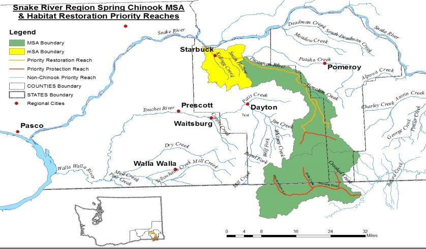
10 Summary Table of Habitat Factors and Objectives for Each MSA Priority Habitat Factor and Objective Mainstem Walla Walla River MSA Imminent Threats: Fish Screens, Fish Passage Barriers, Low/Dewatered Streams I. Temperature: < 4 day > 72ºF II. Large Woody Debris: > 1 key pieces per channel width III. Embeddedness: < 10% embeddedness IV. Riparian:> 40 to 90% of maximum V. Channel Confinement: reduce to 40% to 60% of stream length Mill Creek MSA Imminent Threats: Fish Passage Barriers (including gravel berms), Fish Screens, Low/Dewatered Streams I. Embeddedness: < 10% II. Temperature < 4 day > 72ºF III. Large Woody Debris: > 1 key piece per channel width IV. Riparian: > 40 to 90% of maximum Middle Touchet River MSA (mainstem from Coppei creek to Patit Creek) Imminent Threats: Fish Screens, Fords, Low Stream Flows, Gravel Berms I. Embeddedness: < 10% II. Temperature: < 4 days > 72ºF III. Large Woody Debris: > 1 key piece per channel width IV. Channel Confinement: <15 to 40% of stream bank length Upper Touchet River MSA (Patit Creek upstream to Touchet headwaters) Imminent Threats: Fish Passage Barriers, Fish Screens, Fords, Low Stream Flows, Gravel Berms I. Temperature: < 4 days > 72ºF II. Riparian: >62 to 82% of maximum III. Large Woody Debris: > 1 key piece per channel width IV. Channel Confinement: <10 to 40% of stream bank length Upper Tucannon River MSA (from Pataha Creek upstream to Tucannon headwaters) Imminent Threats: Fish Screens, Low Stream Flows I. Riparian: > 40 to 75% of maximum II. Large Woody Debris: >1 key piece per channel width III. Channel Confinement: < 25 to 50% of stream bank length IV. Temperature: < 4 days > 72ºF Lower Tucannon River msa (from Pataha Creek downstream to Tucannon mouth) Imminent Threats: Fish Passage Barriers, Screens, Low Stream Flows I. Temperature: < 4 days > 72ºF II. Embeddedness: < 20% III. Large Woody Debris: > 1 key piece per channel width IV. Riparian: >40 to 75% of maximum V Channel Confinement: < 25 to 50% of stream bank length Summary Table of Habitat Factors and Objectives for Each MSA (continued) Priority Habitat Factor and Objective 10
11 Priority Habitat Factor and Objective I. Riparian: > 80% of maximum II. Embeddedness: < 10% III. Temperature: < 4 day > 72ºF IV. Alpowa Creek MSA Imminent Threats: Fish screens, Low Stream Flows, Remove Obstructions Large Woody Debris: > 1 key piece per channel width Joseph Creek MSA Joseph Creek lies primarily in Oregon. Therefore, priority actions for the portion of Joseph Creek within Washington are to address imminent threats. Lower Grande Ronde MSA Objectives for the Lower Grande Ronde are currently being developed in consultation with ODFW. Wenaha River MSA The vast majority of the Wenaha River lies entirely within a wilderness area administered by the USFS. The proposed action for this river is to continue protective status. Asotin Creek MSA (mouth to headwaters including all tributaries except George Creek) Imminent Threats: Fish Passage Barriers, Fish Screens, Dewatered Streams I. Large Woody Debris: > 1 key piece per channel width II. Embeddedness: < 20% III. IV. Bed Scour: Reduce to < 10 cm Riparian: >75% to 90% of maximum I. Embeddedness: < 10% II. III. George Creek MSA (tributary of Asotin Creek) Imminent Threats: Dewatered Streams Large Woody Debris: > 1 key piece per channel width Riparian: >75% of maximum IV. Temperature: < 4 day > 72ºC Pataha Creek MSA (tributary of Tucannon River) Imminent Threats: Fish Passage Barriers, Fish Screens, Ford, Dewatered Streams I. Embeddedness: Protect existing condition II. III. IV. Temperature: Protect existing condition Riparian: Protect existing condition Large Woody Debris: Protect existing condition V. Channel Confinement: Protect existing condition 11
12 Critical Habitat Uncertainties within the Snake River Salmon Recovery Region Subbasin/Stream Asotin Creek Sub basin Tucannon River Sub basin Walla Walla River Sub basin Almota Creek (Lower Snake River Sub basin) Deadman Creek (Lower Snake River Sub basin) Grande Ronde Sub basin Critical Uncertainties Large woody debris, Embeddedness, Turbidity, Fines, Riparian function, Bed scour, Natural temperature regime, Natural base flow condition Anthropogenic stream confinement, Habitat type (pools), Riparian function, Harassment, Woody debris, Carcasses Turbidity, Obstructions, Riparian function, Anthropogenic stream confinement, Temperature Large woody debris, Riparian function, Embeddedness, Low flow, Anthropogenic stream confinement Turbidity, Large woody debris, Riparian function Sediment, Temperature, Flows, Key habitat quality and diversity 12
13 Draft Application Summaries Snake River Salmon Recovery Board Lead Entity 2018 SRFB Grant Round Prepared by the Snake River Salmon Recovery Board Lead Entity Staff 13
14 Walla Walla River Restoration Design at RM 35.5 ( ) Sponsor: Renee Hadley Walla Walla County Conservation District Location: Walla Walla River MSA Priority Restoration Reach 3 Year Plan: Yes Project Type: Design (planning) Request+Match: 42, ,500 $51,500 Species: Mid-Columbia Steelhead (DPS), Columbia River Bull Trout (DPS), Mid-Columbia River Chinook Description: The Walla Walla County Conservation District will use this grant to develop and provide engineered designs for an instream habitat restoration project on 0.56 miles of ideal Steelhead spawning and rearing habitat. The property is located on the Walla Walla River just upstream of Last Chance Road in WRIA 32 in Walla Walla County. The project is located within a major spawning area for ESA listed steelhead, bull trout and other species of concern. The design project will include construction ready plans to enhance instream habitat, re-establish side channels, and retain existing mature riparian vegetation. The project reach has recently exhibited significant lateral migration of the channel and disconnection of the floodplain resulting in concentrated erosion and loss of established riparian vegetation and cropland. There are currently 2 pump diversions on this stretch that require annual dredging to maintain river connection to the diversion. The design will incorporate large woody debris placement, side/overflow channel connection, setback levees in strategic locations and control structures to maintain water flow at diversion points. These design elements, once implemented, will reduce limiting factors for steelhead recovery and increase resiliency during flood events. Goals and Objectives: Upon implementation of the design, increase the quantity and quality of instream habitat for all species and create off channel rearing and over wintering habitat for Steelhead and Chinook Salmon. The objective of this project is to provide a set of construction-ready designs within 2 years of funding. Draft Application Questions/Comments/Notes: 1. Is this project design close to the large irrigation diversion? 2. How much riparian area are landowners willing to provide to the river? Has a width for a setback been developed? Project Tour Questions/Comments/Notes: 14

15 15
16 Russell Creek Fish Barrier ( ) Sponsor: Renee Hadley Walla Walla County Conservation District Location: Part of Walla Walla River MSA 3 Year Plan: Yes Project Type: Restoration (Imminent Threat; RTT local scale determination) Request+Match: 34, ,038 $40,250 Species: Mid-Columbia Steelhead (DPS) Description: Past actions have impacted salmonid populations. A historic concrete structure on Russell Creek is one of those past actions that is a 3.5 foot passage barrier preventing salmonid migration. A barrier evaluation form is included as part of this application. Dead Oncorhynchus mykiss have been observed below the barrier. An archeologist has expressed concerns about if the concrete structure is old enough to be considered historic and if it may be removed or if the structure must remain in place. An in-depth cultural resources assessment and agency negations will be needed to determine if and how much of the concrete structure may be removed. This obstacle was considered when developing the proposed project. This design/construction application aims to place a series of log controls downstream of the barrier to backwater up to the barrier elevation. This would allow the concrete structure to remain in place and remove the elevation barrier. This streambed control would be designed in accordance with WDFW guidelines. Removal of the barrier would open up to 5 miles of stream corridor on Russell Creek. The barrier is located at a corner of 5 parcels. Four of the landowners have expressed interest in resolving this passage concern. Goals and Objectives: The goal is to eliminate juvenile mortality by the passage barrier as observed below the barrier by fish biologists. The objective is install a series of log weirs to create step pools up to the elevation of the fish barrier within 2 years of funding. Draft Application Questions/Comments/Notes: 1. Will the cultural resource questions be resolved by July? 2. What is the height of the barrier, are their better pictures? 3. Do steelhead currently get past this barrier? 4. Is there temperature and flow data for Russel Creek? 5. How many land owners are in the project agreement? 6. What was the original purpose of the structure? 7. Who is responsible for maintenance of the structure? 8. Are the cultural issues going to be reviewed for this project by July? 9. Juveniles have been documented above this structure. Project Tour Questions/Comments/Notes: 16

17 17
18 Cottonwood Creek PALS ( ) Sponsor: Joanna Cowles Cleveland Walla Walla County Conservation District Location: Walla Walla River MSA Priority Protection Reach 3 Year Plan: Yes Project Type: Restoration Request+Match: 160, ,000 $242,050 Species: Mid-Columbia Steelhead (DPS) Description: Walla Walla County Conservation District proposes a restoration project to address limiting factors on a 2 mile stretch of Cottonwood Creek at Powerline Road, south of Walla Walla. This will be accomplished through the use of cost effective post assisted log structures (PALS) in combination with a few larger engineered wood structures and riparian plantings. Cottonwood Creek is a protection reach located within the Walla Walla River Major Spawning Area and supports ESA listed steelhead. In June 2017, the Department of Fish and Wildlife salvaged 196 juvenile salmonids during a fish screen installation. At least 15 of those fish were in the 2+ age class (Sean Taylor, personal communication). Limiting factors identified for the Walla Walla MSA include water temperature, low stream flow, habitat quality and quantity, channel confinement and stability. These conditions reduce spawning and rearing potential and limit natural vegetation recruitment. The proposed project will address water temperature, habitat quality and quantity, and channel stability by installing 80 PALS and 5-7 engineered bank structures. The engineered structures will be installed the first year along with a pilot project of PALS. The remainder of the PALS will be installed during the second year. Water temperature will also be addressed through riparian plantings. Approximately 5 acres will be planted through CREP and an additional 4-6 acres of willow and cottonwood will be planted along the banks and on bars along the project reach. Goals and Objectives: The goals of this project are to increase the amount of fully functioning riparian vegetation to provide shade and support habitat for Steelhead in Cottonwood Creek, increase habitat complexity for juvenile steelhead rearing in Cottonwood Creek, provide stabilization in key areas to limit excessive substrate movement and encourage riparian vegetation and habitat formation for juvenile and adult steelhead, and encourage recharge to regulate water temperature and promote cold-water inputs downstream into Yellowhawk Creek and the Walla Walla River. Specific project objectives include: Increase shade by 20% in the treated area over the next 10 years by establishing approximately 10 acres of riparian vegetation in and along the banks of Cottonwood Creek. Install 80 post-assisted log structures in locations where they will facilitate natural pool formation and habitat complexity while providing stabilization of gravel bars to assist riparian planting establishment. Construct five bank large woody debris structures and two engineered logjams to provide stability in key locations and encourage pool formation. Will also provide locations for any woody material lost from PALS to rack up. Draft Application Questions/Comments/Notes: 1. How much of the river reach goes sub-surface and what duration. 2. Have pals been tried in this reach before. Will post drive into substrate? 3. What is the bank full width? 4. What are flow rate ranges? 5. How was this reach selected and prioritized? Project Tour Questions/Comments/Notes: 18

19 19
20 Mill Creek Passage Design-6th Ave Extension ( ) Sponsor: Aaron Mettler Tri-State Steelheaders Location: Mill Creek MSA Priority Restoration and Protection Reach 3 Year Plan: Yes Project Type: Design Request+Match: 50, (design only, no match required) $50,000 Species: Mid-Columbia Steelhead (DPS), Columbia River Bull Trout (DPS), Mid-Columbia River Chinook Description: Flood control measures on Mill Creek include a concrete channel that extends over two miles through Walla Walla. The Mill Creek Barrier Assessment completed in 2009 identified and described barriers for ESA listed steelhead and bull trout, and for reintroduced spring chinook. Returning adults encounter flow dependent depth and velocity barriers, and a lack of resting opportunities. Juvenile fish encounter low spring flows, and high water temperatures in late spring. Often by mid-may adults and juveniles become trapped in the flood control channel where they experience lethal temperatures. Many of these passage issues are considered as imminent threats in the Snake River Salmon Recovery Plan. Mill Creek, upstream of the flood control project, is a critical and under-utilized area for spawning and rearing of ESA listed species, and provides for an important recovery opportunity for those listed fish, as well as good habitat for other native fish and reintroduction efforts for spring chinook. This project will complete final designs for passage improvements for a 1,050-foot section of channel in the concrete flume located between 6th Ave and 3rd Ave. This project is near the downstream end of the concrete channel and is adjacent to the 9th Ave Extension project ( ) completed in Goals and Objectives: The goals of the project are to improve low flow passage for juvenile and adult steelhead, bull trout, and spring chinook, and improve thermal and habitat conditions. The objective of this project is to provide a set of construction-ready designs for the portion of Mill Creek flume between the 6th Avenue Bridge and 3rd Avenue Bridge. Draft Application Questions/Comments/Notes: 1. How different are these designs from the previous ones that were used for implementation? 2. Can a description of the design need be described? 3. Have other design alternative been considered? Project Tour Questions/Comments/Notes: 20

21 21
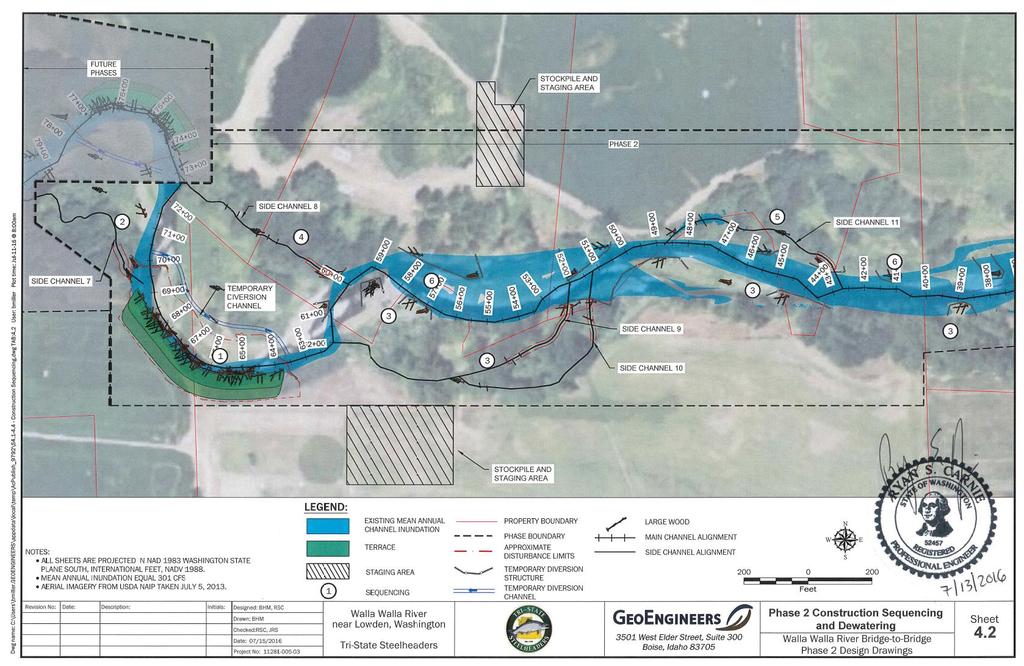
22 Bridge to Bridge Restoration Phase 2B ( ) Sponsor: Aaron Mettler Tri-State Steelheaders Location: Walla Walla River MSA Priority Restoration Reach 3 Year Plan: Yes Project Type: Restoration Request+Match: 232, ,001 $273,337 Species: Mid-Columbia Steelhead (DPS), Columbia River Bull Trout (DPS), Mid-Columbia River Chinook Description: The Bridge to Bridge Restoration design completed in 2010 (RCO project # ) developed preliminary plans for nearly two miles of the Walla Walla River near Lowden, WA. Finals designs were completed through RCO project # , breaking up the reach into four construction phases. Phase 1 was completed in This proposal is for the remainder of the required funding to complete Phase 2 of the Bridge to Bridge project plus increased project costs associated with adding large wood to apex jam structures. Tri-State Steelheaders will address limiting factors by placing logs and log structures along 0.6 miles of the Walla Walla River to improve channel complexity, maintain pools, create off-channel areas, and encourage side channels. A terrace will be excavated to re-establish riparian vegetation on the eroding meander bank, with associated minor channel re-alignment. Riparian plantings will address limiting factors by increasing shade and improving riparian function. This section of the Walla Walla River is identified by the Snake River Salmon Recovery Plan as a priority restoration reach in the Walla Walla River main stem major spawning area. Adult and juvenile summer steelhead and spring Chinook use this project reach during their migration and bull trout occur here seasonally. Other species of cultural value and state concern that utilize the project reach are Margined sculpin, Leopard dace, and River lamprey. Goals and Objectives: The goals of the project are to improve width/depth ratio in the project reach, improve pool and cover habitat in the project reach, increase instream complexity, improve riparian buffer width and function in the project reach, increase shading to reduce thermal loading, and create self-sustaining conditions to maintain improved habitats. Specific project objectives are to: Increase large wood in the project reach to at least one piece per stream width Increase pool and cover habitat by installing 30 large wood structures Improve floodplain function and wood recruitment with 5,000 new riparian plants Improve 2,800 feet of side channel and off-channel areas by installing 24 large wood structures Install 13 wood structures to increase floodplain inundation and hyporheic exchange Draft Application Questions/Comments/Notes: 1. What is the total length of the project being restored? 2. How much wood is being placed instream? Project Tour Questions/Comments/Notes: 22
23 23
24 Steptoe Creek Instream Habitat Rehabilitation ( ) Sponsor: Lovina Englund Palouse Conservation District Location: Within the Asotin Creek Steelhead msa not designated as a priority reach 3 Year Plan: Yes Project Type: Restoration Request+Match: 41, ,308 $48,603 Species: Snake River Steelhead (DPS) Description: The Palouse Conservation District (PCD) will use this grant to implement instream restoration work in Steptoe Creek, located in Whitman County, WA. The CD will to increase fish habitat complexity by improving instream wood and pool habitat for juvenile and adult wild steelhead by installing approximately 76 Post Assisted Logs Structures (PALS) in a reach located upstream of a completed fish passage project. PALS are a cost-effective way to install instream structure without damaging the existing riparian habitat and leaving a small footprint. The project, located in a minor spawning area, will address an imminent threat as identified in the Salmon Recovery Plan for Southeast WA and the regional work plan. The completed restoration project will add spawning habitat value beyond what currently exists in the system while also increasing the impact of project dollars expended to remove the downstream passage barrier and thus, broaden the impact of recent and future efforts to restore steelhead to Steptoe Creek. Furthering the impact of project funds, PCD is currently in the process of assisting the landowner in enrolling the surrounding uplands into the Conservation Reserve Enhancement Program (CREP) which will include planting herbaceous and woody native vegetation that will have both short- and long-term benefits to fish. A cultural resource inventory will be conducted that includes tentative in-stream habitat improvements (e.g. PALS). Goals and Objectives: The primary goal of this project is to increase available pool habitat and provide complex woody cover for summer steelhead populations in Steptoe Creek using a cost-effective and proven approach. The objective of this project is to construct approximately 76 woody habitat structures along approximately 2,500 linear feet of stream channel in the lower reach of Steptoe Creek, from the confluence to an upstream passage barrier at a road culvert. This restoration project will restore instream habitat complexity in a high-risk tributary, benefitting all life stages of summer steelhead by Draft Application Questions/Comments/Notes: 1. What is the stream gradient? Stream gradient 4-5% through the proposed project reach 2. What peek flows and hydrograph information is available? No hydrograph information available. The peak flows are probably similar to Alpowa Creek ( peaking at cfs during highest discharge stage, with an annual mean around 5 cfs, and minimum around 0.5 cfs 3. What section of the stream go dry? The stream does not typically go dry to my knowledge. It is fed yearlong by subsurface flows. 4. Has the CREP contracts been considered as part of the match? Not currently included, but it will be. Project Tour Questions/Comments/Notes: 24

25 25
26 Beaver Mgmt. Reintroduction & Habitat Enhancement ( ) Sponsor: Duane Bartels Pomeroy Conservation District Location: Tucannon MSA non-priority reach; Pataha MSA priority protection reach; Asotin MSA priority protection reach 3 Year Plan: Yes Project Type: Restoration Request+Match: 55, ,000 $69,000 Species: Snake River Steelhead (DPS), Columbia River Bull Trout (DPS) Description: The Pomeroy Conservation District is sponsoring this restoration project that will use nuisance (i.e., causing damage to private property) to relocate into areas where beaver are not present, or are in low densities. The project will take place at 2-3 sites in Garfield County in areas identified to be suitable for beaver and have ESA listed steelhead and/or bull trout present. The goals of this project are to 1) develop a beaver management plan 2) relocate nuisance beaver to suitable areas with low risk to property or infrastructure, and 3) provide demonstration sites for nuisance beaver relocation within southeast Washington that can be used to promote this restoration methods across the region. The benefits to fish are 1) direct improvement of floodplain and riparian habitat, 2) increase in instream habitat diversity, 3) potential increase in groundwater storage which will benefit downstream reaches (e.g., higher or extended base flows), and increased thermal diversity (e.g., cool water refugia). The project will consist of four phases: Phase 1 develop a beaver management and relocation plan. Phase 2 build a series of beaver dam analogs (BDAs) at 1-2 sites that were identified in the beaver management plan as suitable sites. Phase 3 relocate nuisance beaver into sites with completed BDAs. Phase 4 maintain the BDAs (if necessary). Monitoring the relocation sites to determine the fate of the beavers will be conducted with other funding. Goals and Objectives: The goals of this project are to 1) develop a beaver management plan with the support of the Pomeroy Conservation District, WDFW, and USFS, 2) provide demonstration sites for beaver reintroduction within southeast Washington that can be used to promote this restoration methods across the region, and 3) to begin the process of building climate change resilience within the project watersheds by improving groundwater recharge and riparian areas in mid-upper portions of the watersheds that will likely have downstream benefits. This type of project is critical in southeast Washington as climate and hydrologic modeling strongly suggest stream flows will be impaired in the future and stream temperatures will likely increase. Specific objectives are: develop a beaver management plan select 3 suitable sites for beaver reintroduction build a minimum of 3-5 BDAs at each site and reintroduce a pair or family group of beaver Draft Application Questions/Comments/Notes: 1. How does this interact with fish benefit? There is ample evidence that healthy beaver populations can improve habitat conditions for fish, and recent work in the John Day River, OR have provided strong evidence that juvenile production can increase in reaches with beaver dams compared to control streams (Bouwes et al. 2016). 2. What is the impact to spawning habitat? Are there issues with hunters and trappers? The overall extent and quantity of spawning habitat may decrease if beavers build numerous dams in formally planebed habitat; however, there is no evidence that the target streams are spawning habitat limited. Beaver dams are temporary and highly dynamic. Spawning gravels are constantly being formed and reformed in different areas due to dam building and failures; therefore, overall spawning conditions in treatment areas will likely improve in treated areas. We will be working with our partners (WDFW and USFS) to identify and address other potential issues including trapping actions or hunting that could impact beaver relocation success. 3. Make sure to coordinate with the existing federal and state agencies conducting this work regionally. Project Tour Questions/Comments/Notes: 26

27 27
28 Tucannon River Habitat Restoration, Project Area 32 ( ) Sponsor: Terry Bruegman Columbia Conservation District Location: Tucannon River MSA Priority Restoration and Protection Reach 3 Year Plan: Yes Project Type: Restoration Request+Match: 224, ,236 $360,993 Species: Snake River Steelhead (DPS), Snake River Spring/Summer Chinook (ESU) Columbia River Bull Trout (DPS) Description: The Columbia Conservation District will use this grant, leveraged with BPA funding to construct the planned habitat restoration actions (Conceptual Restoration Plan Reach 5, Anchor QEA October 2012), on Project Area 32 located between River Miles in the Tucannon River watershed, Columbia County. Restoration actions include construction of a Offset levee, modification and/or removal of existing levees (sugar/cobble dikes/levees) for enhanced floodplain connectivity (~26 acres),, LWD structures and single rootwad logs to enhance habitat complexity and diversity, and single rootwad logs for roughened floodplain conditions to reduce overland flow velocities addressing identified limiting factors (Snake River Salmon Recovery Plan (2011) with multiple life cycle benefits for ESA listed Spring Chinook, Snake River steelhead and Bull trout. Goals and Objectives: Project goals Improve floodplain connectivity and flood frequency to the point that riparian habitat quantity and quality can re-establish and be supported by natural process, modify simplified channel structure, caused by limited LWD Key Pieces (>6m long & 0.3cm Diam.) and channel confinement which leads to redd scour, reduced winter rearing habitat quality for chinook/steelhead leading to poor survival, and reduce pre smolt emigration from the project reach by minimizing channel confinement, flow flushing velocities and reconnecting side channel and floodplain habitats providing refuge areas. Specific objectives are: Construct ~32 LWD structures instream, sufficient to increase LWD Key pieces to 2 piece per bank width (Recovery Plan 2011) by Enhance floodplain connectivity to ~26 acres, re-connect side channels for enhanced flow refuga and install 18 LWD floodplain structures for roughness elements by 2021 Construct ~4,000 offset levee for floodplain benefits and protect landowner agricultural infrastructure allowing salmon habitat enhancements to occur by Draft Application Questions/Comments/Notes: 1. Will the additional high flow channel put downstream property at greater risk? 2. What is the total length of the offset levee? 3. What will the height of the levee on the downstream side?. 4. Do the maps represent water elevation in a typical year? 5. What will be the extent of phase 2? 6. What is the long-term maintenance plan? 7. What is fish passage at falls? Project Tour Questions/Comments/Notes: 28

29 29
30 NF Touchet Restoration RM Phase 1 & 2 Stage 1 ( ) Sponsor: Jerry Middel CTUIR Location: Middle Touchet River MSA Priority Restoration and Protection Reach 3 Year Plan: Yes Project Type: Restoration $ Request+Match: 515, ,108,226 $1,624,126 Species: Mid-Columbia Steelhead (DPS), Columbia River Bull Trout (DPS), Mid-Columbia River Chinook Description: The CTUIR is joining the interests of local farmers, the City of Dayton, and Columbia County to restore floodplain connectivity and fish habitat along a three-mile stretch of the North Touchet River. Project implementation will take two-three years to complete and will be done in three phases. This application addresses work that is proposed to commence in 2019 (Phase 1, Phase 2, Stage 1). Project goals include decreasing stream energy, increasing floodplain connectivity, increasing sediment deposition, increasing salmonid rearing and spawning habitat, and saving water by increasing irrigation efficiency. To achieve these goals we propose to either remove or set back nearly one mile of levee and to use large wood and boulders to act as roughness to sort sediment, provide habitat cover and scour pools. Off main channel habitat will be constructed to allow the river to spread out. We are also proposing to increase water use efficiency by replacing an older wheel irrigation system with a center pivot and replacing two inefficient pumps located at two different points of diversion with a single, efficient pump placed at one diversion point. The North Touchet is rated a priority for restoration and protection (Walla Walla Subbasin Plan 2004). The North Touchet mid-columbia Steelhead population of natural spawners and surviving offspring is at high risk (Middle Columbia ESA Recovery Plan 2009), and the river is a major spawning area for steelhead and spring/summer Chinook salmon. Goals and Objectives: The goal is to implement an agreed upon by multiple landowners restoration design to restore the reach to functional system that has connected floodplain (to the extent possible) and improved instream habitat conditions. This would primarily effect juvenile summer steelhead, and restore natural stream processes over a 3 mile foot long project reach. This application deals specifically with the level of implementation of the 3 mile long project. Phase 1 will restore the North Touchet from RM (Breithaupt), and we also include Phase 2, Stage 1 RM 1.3 (Station 25+00, lower Warren) in the 2019 implementation plan. Specific objectives are: Reconnect over 50 acres of floodplain to the river along a 3 mile stretch from RM over a 3 year project period by removing and setting back levees. Create off-channel habitat for rearing. Create channel roughness and in-stream habitat with LWD and boulder arrays. Create a balance of sediment deposition and transport. This application focuses on Phase 1 and Phase 2 Stage 1 which we propose to implement in 2019 subject to funding. Draft Application Questions/Comments/Notes: 1. Is the 1.6 m 4 request for phase 1 or the whole project? The budget and phase ½ stage 2 confused the group. 2. Is the funding by design funding in place or in process? 3. What is the approach in funding by design does not come through. 4. What are the total riparian acres being planted? 5. Will there be a test of wood plie driver before implementation or will there be an alternate? 6. Is there a temperature issue in the North Fork? Project Tour Questions/Comments/Notes: 30

31 31
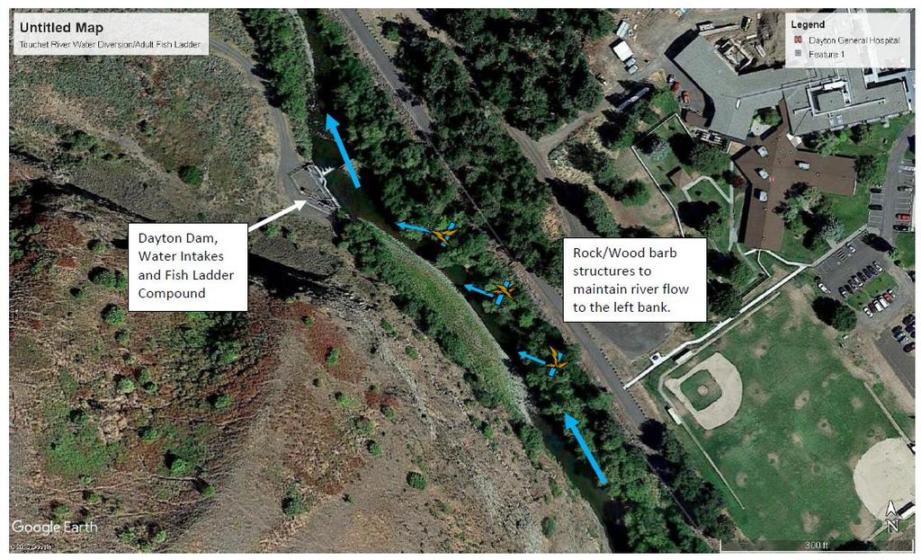
32 Touchet River Water Diversion/Adult Fish Ladder ( ) Sponsor: Joe Bumgarner WDFW Location: Upper Touchet River MSA Priority Restoration and Protection Reaches 3 Year Plan: Yes Project Type: Restoration Request+Match: 51, ,000 $186,512 Species: Mid-Columbia Steelhead (DPS), Columbia River Bull Trout (DPS), Mid-Columbia River Chinook Description: The WDFW will use this grant to implement habitat structures in the Priority Restoration Reach and MSA of the Touchet River. The primary purpose of proposed structures are to maintain the directional flow of the Touchet River towards the Dayton Dam water intake (adult salmon fish ladder, collection of water for the WDFW acclimation pond and the city irrigation system). The property is located in Columbia County, adjacent to the eastside of the Touchet River in Dayton, just upstream of the Dayton Dam. The project will add habitat structures to the river for both adult and juvenile rearing of salmonids and native fishes, but the main purpose is for continued fish passage through the ladder. The project is expected to be no more than 300m in length with maybe 3-5 habitat structures (see attached map/photo). The primary ESA listed species supported by this project are summer steelhead and bull trout, and reintroduced spring Chinook salmon (non-listed). The WDFW has identified this project as a high priority for fish passage, with secondary benefits since it may provide protection and/or enhancement of functioning habitat as identified in the Salmon Recovery Plan. The WDFW will work closely with the Lower Snake River Compensation Plan to secure the majority of funding (~75%) for this project. In addition, this project will build upon recent habitat restoration activities occurring in the Touchet River Basin for the betterment of summer steelhead and bull trout. Goals and Objectives: The goal of this project is to restore and maintain consistent river flow towards the Touchet River Intake/Fish Ladder Facility. Benefits to this action will supply water for the fish ladder around the Dayton Dam, water for city irrigation districts, and water for the juvenile steelhead acclimation pond. Instream structures may provide resting and rearing habitat for ESA listed species, and may sort gravel to provide additional spawning areas. Specific project objectives are: Construct historic-scale, in-stream combination rock barbs/logjams sufficient in size and number to redirect the majority of the Touchet River flow towards the Intake Facility on a consistent basis, Aid in fish passage at the facility, and Create pools and cover at each of the structure locations along the mainstem Touchet River for holding, rearing and potentially spawning habitat by Draft Application Questions/Comments/Notes: 1. Does the project more gravel back into the river rather than removal or downstream of the dam? 2. Will the gravel stay in the river? 3. What length up rive does the project go? 4. Does the estimate include both the design and implementation? Project Tour Questions/Comments/Notes: 32

33 33
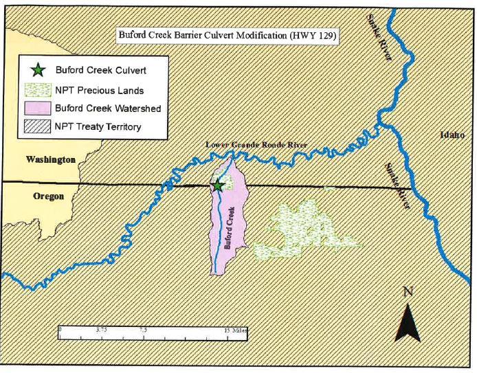
34 Buford Creek Barrier Fish Passage (Hwy 129) ( ) Sponsor: Kathryn Frenyea Nez Perce Tribe Location: Grande Ronde MSA Priority Protection Reach 3 Year Plan: Yes Project Type: Restoration (Imminent Threat; RTT local scale determination) Request+Match: 750, ,688,419 4,424,519 Species: Snake River Steelhead (DPS), Snake River Spring/Summer Chinook (ESU) Columbia River Bull Trout (DPS) Description: The Nez Perce Tribe is sponsoring the restoration of the Buford Creek culvert, which is a fish passage barrier where Buford Creek flows under State Highway 129 near the Oregon / Washington border. The barrier poses an imminent threat to anadromous fish (steelhead), and limits their access to nearly 5 miles of potential rearing and spawning habitat upstream of the culvert, 2 miles of which are designated critical habitat. As stated in the Snake River Salmon Recovery Plan, steelhead are especially effective at accessing and utilizing stream reaches with suitable habitat, however, their distribution is limited by environmental issues such as migration barriers. Buford Creek flows directly into the Grande Ronde River just 2.2 miles below the barrier. The crossing at State HWY 129 was identified by the Walla Walla Community College and WDFW in separate barrier assessments in 2008 and 2015 respectively. The fish populations within this reach and the land that this creek flows through are of great importance. Buford Creek has been identified as a priority restoration reach for steelhead, and according to the Grande Ronde Subbasin Plan, its benefit to the life history diversity within the Lower Grande Ronde steelhead population is considered to be significant. In addition to the unique steelhead population in this area, the land itself holds special value to The Nez Perce Tribe as it lies within the external boundary of Buford Parcel of their Precious Lands. Goals and Objectives: The primary goal is to remove a fish passage barrier that currently limits movement of both juvenile and adult steelhead in Buford Creek, limiting their access to spawning and rearing habitat upstream. The current undersized culvert will be replaced with an adequately sized structure restoring natural sediment transport and natural recruitment of riparian vegetation through the reach. Site restoration will also aim to enhance existing native riparian vegetation through planting while reducing the presence of noxious weeds. Specific project objectives include: Replace the existing 11 foot wide barrier culvert on Buford Creek with a 30 foot wide open bottom arch structure and achieve 100% fish passage for all life stages of steelhead and other aquatic organisms through the project reach. In addition to fish passage, full natural sediment transport and recruitment of riparian vegetation will be restored through the reach. Site restoration will also aim to enhance existing native riparian vegetation by planting Coyote Willow (Salix exigua) and other various native species over approximately 0.11 acres and 0.09 miles of riparian area upstream and downstream of the culvert. Plantings will occur one year post-implementation to allow for the channel to adjust and establish. To reduce the presence of noxious weeds on site NPT will treat roughly 2 acres with a mixture of hand pulling and aquatic herbicide pre- and post-implementation. Followed construction a native pasture seed mix will be applied to the site to further discourage noxious weed establishment. Draft Application Questions/Comments/Notes: 1. What is current passibility and have there been fish observed above the barrier? The number produced and used currently by WDFW is 67%. This percentage refers to the estimated overall passage of the culvert, lumped for all life stages. 2. There were no other comments of Buford outside of the budget and cost. Project Tour Questions/Comments/Notes: 34

35 35

36 36
37 Lead Entity Committee Jerry Hendrickson Rod Hostetler Don Howard Norm Passmore Billy Bowles Vacant David Crabtree Larry Hooker Bryan Jones Jon Jones Kris Fischer Diane Driscoll/Bob Reis/Jennifer Gatzke Ed Teel/Sean Taylor Heidi McRoberts Chris Pinney Erin Kuttle Bill Dowdy Chad Atkins Tom Schirm Megan Stewart (non-voting) Terry Bruegman (non-voting) Randy Stevens (non-voting) Duane Bartels (non-voting) Brian Burns (non-voting) Joanna Cowles (non-voting) Chris Highland (non-voting) Brad Johnson (non-voting) Kay Caromile (non-voting) Tom Slocum Jen O'Neal Kris Buelow (non-voting) John Foltz (non-voting) Asotin County Asotin County Columbia County Columbia County Garfield County Garfield County Walla Walla County Walla Walla County Whitman County Whitman County Confederated Tribes of the Umatilla Indian Reservation National Oceanic and Atmospheric Administration Natural Resources Conservation Service Nez Perce Tribe United States Army Corp of Engineers United States Fish and Wildlife Service United States Forest Service Washington Department of Ecology Washington Department of Fish and Wildlife Asotin County Conservation District Co-Lead Columbia County Conservation District Co-Lead Palouse Conservation District Co-Lead Pomeroy Conservation District Co-Lead Regional Fisheries Enhancement Group Walla Walla County Conservation District Co-Lead WRIA 32 Walla Walla Watershed Partnership WRIA 35 Planning Unit RCO SRFB Review Panel SRFB Review Panel SRSRB/LE Staff SRSRB/LE Staff 37
38 Draft Application Scoring Summary from April 17, 2018 Lead Entity Committee Meeting Project Ranking 2018 Grant Round Draft Applications Average Score SRFB Request SRFB Request Running Total Match 1 Buford Creek Barrier Fish Passage (Hwy 129) $ 750,000 $ 750,000 $ 3,688,419 2 NF Touchet Restoration RM Phase 1 and Phase 2 Stage $ 515,900 $ 1,265,900 $ 1,108,226 3 Tucannon River Habitat Restoration, Project Area $ 224,757 $ 1,490,657 $ 136,236 4 Asotin IMW Monitoring Data Analysis $ 150,000 $ 1,640,657 $ 68,000 5 Bridge to Bridge Restoration - Phase 2B $ 232,336 $ 1,872,993 $ 41,001 6 Touchet River Water Diversion/Adult Fish Ladder $ 51,512 $ 1,924,505 $ 135,000 7 Cottonwood Creek PALS $ 160,050 $ 2,084,555 $ 82,000 8 Russell Creek Fish Barrier $ 34,213 $ 2,118,768 $ 6,038 9 Beaver Mgmt. - Reintroduction & Habitat Enhancement $ 55,000 $ 2,173,768 $ 14, Walla Walla River Restoration Design at RM $ 42,000 $ 2,215,768 $ 9, Mill Creek Passage Design - 6th Ave. Extension $ 50,000 $ 2,265,768 $ - 12 Jones Ditch Fish Screens $ 65,790 $ 2,331,558 $ 11, Steptoe Creek Instream Habitat Rehabilitation 72.5 $ 41,295 $ 2,372,853 $ 7,308 $ 2,372,853 *Anticipated Regional Allocation $1,500,00 Withdrawn Walla Walla Basin Restoration Prioritization Plan $ 212,500 $ 212,500 $ 37,500 Withdrawn Tucannon salmonid survival and habitat utilization 2 0 $ 218,958 $ 2,804,311 $ 55,000 38
Snake River Salmon Recovery Board Lead Entity 2017 SRFB Grant Round. Project Tour May 31 st and June 1 st
 Snake River Salmon Recovery Board Lead Entity 2017 SRFB Grant Round Project Tour May 31 st and June 1 st Tucannon River PA-28 Phase II Habitat Restoration Project Site Visit, June, 2016 Table of Contents
Funding Habitat Restoration Projects for Salmon Recovery in the Snake River Region SRFB Grant Round Version: 2/19/16
 2016 SRFB Grant Round Version: 2/19/16 Funding Habitat Restoration Projects for Salmon Recovery in the Snake River Region The Project Funding Process Presented by the Snake River Salmon Recovery Lead Entity
Snake River Salmon Recovery Board Lead Entity 2016 SRFB Grant Round. Project Tour June 1-3, 2016
 Snake River Salmon Recovery Board Lead Entity 2016 SRFB Grant Round Project Tour June 1-3, 2016 Buford Creek Barrier Fish Passage Design Project, June, 2015 Table of Contents Tour Schedule 2 2016 SRSRB
MCCAW REACH RESTORATION
 Final Report MCCAW REACH FISH RESTORATION PHASE B Jack McCaw Inland Empire Action Coalition http://www.wwccd.net/ Phone: 509-956-3777 Hours: 8:00-4:30 Walla Walla County Conservation District Snake River
Fish Habitat Restoration and Monitoring in Southeast Washington. Andy Hill Eco Logical Research, Inc.
 Fish Habitat Restoration and Monitoring in Southeast Washington Andy Hill Eco Logical Research, Inc. Fish Habitat Restoration and Monitoring in Southeast Washington Talk overview: Restoration projects
3. The qualification raised by the ISRP is addressed in #2 above and in the work area submittal and review by the ISRP as addressed in #1.
 Please find attached a response from The Confederated Tribes of the Warm Springs Reservation of Oregon (CTWSRO) for Project # 2008-301-00, Habitat Restoration Planning, Design and Implementation within
Mid-Columbia Fisheries Enhancement Group Annual Report Fiscal Year 06: July 1, 2005 June 30, 2006
 Mid-Columbia Fisheries Enhancement Group Annual Report Fiscal Year 06: July 1, 2005 June 30, 2006 Mission Statement The mission of the Mid-Columbia Fisheries Enhancement Group is to restore self-sustaining
Sub-watershed Summaries
 Project Description The Salmon Drift Creek Watershed Council (SDCWC) has focused their efforts in the Salmon River estuary for the past few years. The multifaceted partnership effort is nearing completion
Five Counties Salmonid Conservation Program - Fish Passage Design Workshop. February 2013
 Program - Aquatic Organisms and Stream Crossings Ecological Connectivity A watershed is a network of channels that drain a common boundary. Channel characteristics formed by interaction of precipitation,
OVERVIEW OF MID-COLUMBIA FISHERIES ENHANCEMENT GROUP
 Mid-Columbia Fisheries Enhancement Group MISSION STATEMENT The Mid-Columbia Fisheries Enhancement Group is a non-profit organization dedicated to restoring selfsustaining salmon and steelhead populations
Executive Summary. Map 1. The Santa Clara River watershed with topography.
 Santa Clara River Steelhead Trout: Assessment and Recovery Opportunities December 2005 Prepared By: Matt Stoecker and Elise Kelley, Ph.D. University of California, Santa Barbara Prepared For: The Santa
STEELHEAD SURVEYS IN OMAK CREEK
 STEELHEAD SURVEYS IN OMAK CREEK 2002 Annual Report Prepared by Chris Fisher John Arterburn Colville Confederated Tribes Fish and Wildlife Department P.O. Box 150 Nespelem, WA 99155 Prepared for Project
OKANAGAN RIVER RESTORATION INITIATIVE - FAQ
 OKANAGAN RIVER RESTORATION INITIATIVE - FAQ Initiative background: The health of the q awsitk w (Okanagan River) has been severely impacted by the channelization works that occurred in the mid-1950 s.
COA-F17-F-1343 YEAR END REPORT
 DAVE MARSHALL SALMON RESERVE RESTORATION, MAINTENANCE, AND UPGRADES YEAR END REPORT Prepared for: Fish and Wildlife Compensation Program Prepared by: Edith Tobe, RPBio, Executive Director Box 1791, Squamish,
The Blue Heron Slough Conservation Bank
 1 The Blue Heron Slough Conservation Bank CONSERVATION BANKING July 19-23, 2010 CASE STUDY SERIES The Blue Heron Slough Conservation Bank (Washington) I. OVERVIEW & BACKGROUND: Location: Snohomish River
Yakima/Klickitat Fisheries Project
 Yakima/Klickitat Fisheries Project Lower Yakima River Supplementation and Research Project Operations and Maintenance Annual Report 2002-2003 March 2004 DOE/BP-00006677-1 This Document should be cited
Restoring the Kootenai: A Tribal Approach to Restoration of a Large River in Idaho
 Restoring the Kootenai: A Tribal Approach to Restoration of a Large River in Idaho Susan Ireland, Kootenai Tribe of Idaho Future of our Salmon Conference Technical Session August 2016 Healthy Floodplains,
FINAL REPORT. Yonkers Creek Migration Barrier Removal Project Wonderstump Road Del Norte County. Submitted By:
 FINAL REPORT Yonkers Creek Migration Barrier Removal Project Wonderstump Road Del Norte County Submitted By: Del Norte County Community Development Department Yonkers Creek Migration Barrier Removal Project
FISHERIES BLUE MOUNTAINS ADAPTATION PARTNERSHIP
 FISHERIES A warming climate, by itself, substantially affects the hydrology of watersheds in the Blue Mountains. Among the key hydrologic changes projected under all scenarios for the 2040s and beyond
South Fork Chehalis Watershed Culvert Assessment
 South Fork Chehalis Watershed Culvert Assessment Water Resource Inventory Area 23 Lewis County Conservation District Final Report By: Kelly Verd and Nikki Wilson March 2003 Funded by: The Washington State
PROJECT TO INSTALL LARGE WOOD HABITAT STRUCTURES IN THE CARMEL RIVER USING CALIFORNIA DEPARTMENT OF FISH AND GAME GRANT FUNDS
 PROJECT TO INSTALL LARGE WOOD HABITAT STRUCTURES IN THE CARMEL RIVER USING CALIFORNIA DEPARTMENT OF FISH AND GAME GRANT FUNDS The Monterey Peninsula Water Management District (MPWMD), in cooperation with
CHAPTER 4 DESIRED OUTCOMES: VISION, GOALS, AND OBJECTIVES
 CHAPTER 4 DESIRED OUTCOMES: VISION, GOALS, AND OBJECTIVES Vision One of the first steps in developing this Plan was articulating a vision - a clear statement of what the Plan strives to achieve and what
FISH PASSAGE IMPROVEMENT in California s Watersheds. Assessments & Recommendations by the Fish Passage Forum
 FISH PASSAGE IMPROVEMENT in California s Watersheds Assessments & Recommendations by the Fish Passage Forum FISH PASSAGE IMPROVEMENT in California s Watersheds The mission of the Fish Passage Forum is
Newaukum Watershed Culvert Assessment
 Newaukum Watershed Culvert Assessment Water Resource Inventory Area 23 Lewis County Conservation District Final Report By: Kelly Verd and Nikki Wilson July 2002 Funded by: Chehalis Fisheries Restoration
April 26, Chairman Rockefeller and members of the Fish and Wildlife Committee. Briefing from Mid-Columbia Regional Fish Enhancement Group (RFEG)
") Joan M. Dukes Chair Oregon Bruce A. Measure Montana James A. Yost Idaho W. Bill Booth Idaho Rhonda Whiting Vice-Chair Montana Bill Bradbury Oregon Tom Karier Washington Phil Rockefeller Washington April
Joan M. Dukes Chair Oregon Bruce A. Measure Montana James A. Yost Idaho W. Bill Booth Idaho Rhonda Whiting Vice-Chair Montana Bill Bradbury Oregon Tom Karier Washington Phil Rockefeller Washington April
The Calawah River System
 The Calawah River System The Calawah River is the largest tributary of the Bogachiel River and is formed by the confluence of the north and south forks of the Calawah. The two forks of the Calawah, CALAWAH
PROTECTING LAND & RESTORING RIVERS FOR SALMON & STEELHEAD
 PROTECTING LAND & RESTORING RIVERS FOR SALMON & STEELHEAD Whychus Creek at Camp Polk Meadow Preserve. Photo: Russ McMillan Top photo: Deschutes River Conservancy 1 Photo: Byron Dudley A Unique Collaboration
Riparian Planting Projects Completed within Asotin Creek Watershed. Final Report
 Riparian Planting Projects Completed within Asotin Creek Watershed Final Report 2000-2002 DOE/BP-00006436-1 October 2002 Field37: This Document should be cited as follows: Johnson, Bradley, ''Riparian
Strategies for mitigating ecological effects of hatchery programs
 Strategies for mitigating ecological effects of hatchery programs Some case studies from the Pacific Northwest Kathryn Kostow Oregon Department of Fish and Wildlife Ecological risks occur when the presence
Big Spring Creek Habitat Enhancement and Fishery Management Plans
 Big Spring Creek Habitat Enhancement and Fishery Management Plans November 5, 2012 Big Spring Events and Activities Center Newville, PA Charlie McGarrell Regional Habitat Biologist Pennsylvania Fish and
Hatchery Scientific Review Group Review and Recommendations
 Hatchery Scientific Review Group Review and Recommendations Walla Walla River Summer Steelhead Population and Related Hatchery Programs January 31, 2009 Note: Spawning reaches likely vary from those depicted.
Minnesota Department of Natural Resources Division of Fish and Wildlife Section of Fisheries. Stream Survey Report. Luxemburg Creek.
 Minnesota F-29-R(P)-24 Area 315 Study 3 March 2016 Minnesota Department of Natural Resources Division of Fish and Wildlife Section of Fisheries Stream Survey Report Luxemburg Creek 2015 Mark Pelham Sauk
1.Mill Creek Watershed Summary Description and Land Use
 1.Mill Creek Watershed Summary Description and Land Use Table xxx: Mill Creek Watershed Overview Watershed Size 31,435 acres/49.1 sq miles/ 127.1 sq km Elevation Range 5,594 feet [4,967-10,561] Stream
Anadromous Fish Committee Columbia Basin Fish and Wildlife Authority Project Implementation Review Conference
 Anadromous Fish Committee Columbia Basin Fish and Wildlife Authority Project Implementation Review Conference September 21-24, 2004 Red Lion Hotel Richland Hanford House Richland, Washington In April 2004,
Rehabilitation of Grimes Creek, a Stream Impacted in the Past by Bucket-lined Dredge Gold Mining, Boise River Drainage, July 2008 to August 2011.
 Rehabilitation of Grimes Creek, a Stream Impacted in the Past by Bucket-lined Dredge Gold Mining, Boise River Drainage, July 2008 to August 2011. Pam Harrington TU,1020 W. Main Street Suite 440, Boise,
TESTIMONY OF THE COLUMBIA RIVER TREATY TRIBES BEFORE PACIFIC FISHERIES MANAGEMENT COUNCIL
 Agenda Item E.2.f Supplemental Tribal Report April 2012 TESTIMONY OF THE COLUMBIA RIVER TREATY TRIBES BEFORE PACIFIC FISHERIES MANAGEMENT COUNCIL April 2, 2012 Seattle, WA Good day Mr. Chairman and members
LIFE HISTORY DIVERSITY AND RESILIENCE
 LIFE HISTORY DIVERSITY AND RESILIENCE SPRING CHINOOK IN THE WILLAMETTE RIVER BASIN Kirk Schroeder Brian Cannon Luke Whitman Paul Olmsted Oregon Department of Fish and Wildlife Corvallis Research Lab Thanks
Illinois Lake Management Association Conference March 23, 2018 By Trent Thomas Illinois Department of Natural Resources Division of Fisheries
 Illinois Lake Management Association Conference March 23, 2018 By Trent Thomas Illinois Department of Natural Resources Division of Fisheries Sources of Habitat Impairment Sedimentation Channelization
PRE- PROPOSAL FORM - 1. Applicant organization. USDA Forest Service Gifford Pinchot National Forest & WDFW Region 5
 PRE- PROPOSAL FORM - 1. Applicant organization. USDA Forest Service Gifford Pinchot National Forest & WDFW Region 5 2. Organization purpose USFS-Resource management agency WDFW-Fish and Wildlife management
September 27, 2012 MEMORANDUM. Fish and Wildlife Committee. Lynn Palensky. Update on Geographic Review
 Rhonda Whiting Chair Montana Bruce A. Measure Montana James A. Yost Idaho W. Bill Booth Idaho Bill Bradbury Vice-Chair Oregon Henry Lorenzen Oregon Tom Karier Washington Phil Rockefeller Washington September
Trout Unlimited Comments on the Scope of Environmental Impact Statement for the Constitution Pipeline Project, Docket No. PF12-9
 October 9, 2012 Kimberly D. Bose, Secretary Federal Energy Regulatory Commission 888 First Street, NE, Room 1A Washington, DC 20426 RE: Trout Unlimited Comments on the Scope of Environmental Impact Statement
Steelhead Society of BC. Thompson River Watershed Restoration and Enhancement Project #4 Nicola River Bank Stabilization and Enhancement Project
 Steelhead Society of BC Presents: Thompson River Watershed Restoration and Enhancement Project #4 Nicola River Bank Stabilization and Enhancement Project Application for Funding December 2013 1.0 BACKGROUND
Planning and Combination (Planning and Acquisition) Project Proposal
 Project Proposal") Planning and Combination (Planning and Acquisition) Project Proposal Project Number 16-2095 Project Name Tucannon Mobile PIT Tag Detection Sponsor Washington Dept of Fish and Wildlife List all related
Planning and Combination (Planning and Acquisition) Project Proposal Project Number 16-2095 Project Name Tucannon Mobile PIT Tag Detection Sponsor Washington Dept of Fish and Wildlife List all related
PRE- PROPOSAL FORM - Lewis River Aquatic Fund
 PRE- PROPOSAL FORM - Lewis River Aquatic Fund 1. Applicant organization. USDA Forest Service Gifford Pinchot National Forest 2. Organization purpose Resource management agency 3. Project manager (name,
Columbia Lake Dam Removal Project
 Columbia Lake Dam Removal Project Major Goals of the Columbia Lake Dam Removal: Reconnect 10 miles of the Paulins Kill River to the Delaware River, restoring natural flow regime and sediment transport.
COLUMBIA LAKE DAM REMOVAL PROJECT
 COLUMBIA LAKE DAM REMOVAL PROJECT Major Goals of the Columbia Lake Dam Removal: Reconnect 10 miles of the Paulins Kill River to the Delaware River, restoring natural flow regime and sediment transport.
Conserving the Forests, Lakes and Streams of Northeast Michigan
 4241 Old US 27 South, Suite 2, Gaylord, Michigan 49735 (989) 448-2293 www.huronpines.org info@huronpines.org Prioritized Restoration Projects in the AuSable River Watershed Summer 2015 Update from Huron
Kootenai River Habitat Restoration Program. Kootenai Tribe of Idaho - January 27, 2014 Presentation for Kootenai Valley Resource Initiative
 Kootenai River Habitat Restoration Program Kootenai Tribe of Idaho - January 27, 2014 Presentation for Kootenai Valley Resource Initiative Decline of native species Kootenai River White Sturgeon ENDANGERED
Mountain Columbia Province
 Rolling Provincial Review: Implementation 2001-2003 Province 229 Columbia Basin Fish & Wildlife Authority Province FY 2001-2003 Spending Summaries NPCC Recommendations and BPA Spending by Project Category,
Mountain Snake Province
 Rolling Provincial Review: Implementation 2001-2003 Province 253 Columbia Basin Fish & Wildlife Authority Province FY 2001-2003 Spending Summaries NPCC Recommendations and BPA Spending by Project Category,
JAP Additional Information Sheet
 JAP Additional Information Sheet Block 15: Purpose and Need The USACE purpose of the project is to provide a safe and reliable whitewater park for the recreational public in a city park, which will provide
10 is bounded by wetlands between RM 1.8 and 3.1 on the south shore and more are scattered
 The Ozette System The Ozette watershed is made up of several lakes and large streams that combine to a total drainage area of 88.4 square miles. The most significant feature of the Ozette watershed is
Annual Report for Fiscal Year and Future Plans for the Tillamook Bay Watershed Council
 Annual Report for Fiscal Year 2012-2013 and Future Plans for the Tillamook Bay Watershed Council A report prepared for the Tillamook County Board of Commissioners August 2013 Table of Contents: Recently
Washington State Fish Passage Barrier Removal Projects. Casey Kramer, PE WSDOT State Hydraulics Engineer
 Washington State Fish Passage Barrier Removal Projects Casey Kramer, PE WSDOT State Hydraulics Engineer 2014 National Hydraulic Engineering Conference Iowa City, IA August 20 th, 2014 WSDOT Fish Passage
Burns Paiute Tribe Fisheries Department. Evaluate The Life History Of Native Salmonids Within The Malheur Subbasin Project #
 Burns Paiute Tribe Fisheries Department Evaluate The Life History Of Native Salmonids Within The Malheur Subbasin Project # 199701900 Prior to 1990 Technical and/or scientific background Malheur population,
Deschutes WRIA 13 Salmon Habitat Recovery Committee SRFB / PSAR Letter of Intent Form
 Deschutes WRIA 13 Salmon Habitat Recovery Committee SRFB / PSAR Letter of Intent Form Project Sponsor: Sponsor Contact lnfo: Project Name: Key Partners: Project Location: lnclude wotershed Project Description:
WFC 10 Wildlife Ecology & Conservation Nov. 29, Restoration Ecology: Rivers & Streams. Lisa Thompson. UC Cooperative Extension
 Restoration Ecology: Rivers and Streams WFC 10 29 Nov 2010 Restoration of ecosystems often involves creating new systems with only partial resemblance to the original ecosystems Lisa Thompson Fisheries
Abundance of Steelhead and Coho Salmon in the Lagunitas Creek Drainage, Marin County, California
 scanned for KRIS Abundance of Steelhead and Coho Salmon in the Lagunitas Creek Drainage, Marin County, California Prepared for: Marin Municipal Water District 220 Nellen Drive Corte Madera, California
2012 Bring Back the Natives Awarded Projects
 2012 Bring Back the Natives Awarded Projects EZG # Organization Project Title Project Description Location Description Total Award Amount Grantee Non- Federal Match 31904 Sanctuary Forest, Inc. Mattole
WFC 50 California s Wild Vertebrates Jan. 11, Inland Waters (Lakes and Streams) Lisa Thompson
 Lisa Thompson") Inland Waters: Lakes and Streams WFC 50 11 January 2011 Lisa Thompson Fisheries Extension Specialist Wildlife, Fish, & Conservation Biology Department University of California, Davis Take home messages
Inland Waters: Lakes and Streams WFC 50 11 January 2011 Lisa Thompson Fisheries Extension Specialist Wildlife, Fish, & Conservation Biology Department University of California, Davis Take home messages
California Steelhead: Management, Monitoring and Recovery Efforts
 California Steelhead: Management, Monitoring and Recovery Efforts Jonathan Nelson Steelhead Restoration & Management Program Oncorhynchus mykiss irideus California Steelhead Distinct Population Segments
OREGON DEPARTMENT OF FISH AND WILDLIFE ROGUE FISH DISTRICT REPORT
 OREGON DEPARTMENT OF FISH AND WILDLIFE ROGUE FISH DISTRICT REPORT TITLE: Upper Rogue Smolt Trapping Project, 1999 STREAM: Big Butte, Little Butte, South Fork Big Butte, Slate and West Fork Evans Creeks
Tuolumne River Gravel Introduction
 Tuolumne River Gravel Introduction 2000 2003 Tuolumne River La Grange Gravel Addition, Phase II Course Sediment Replenishment Program Tuolumne River Salmonid Habitat Improvement Project River Mile 49.9
Columbia Lake Dam Removal Project
 Columbia Lake Dam Removal Project The Columbia Lake dam located 1/4 mile upstream of the Paulins Kill River's confluence with the Delaware River in Knowlton Township, Warren County has been proposed for
Hatchery Scientific Review Group Review and Recommendations
 Hatchery Scientific Review Group Review and Recommendations Lochsa River Spring Chinook Population and Related Hatchery Programs January 31, 2009 Lochsa River Spring Chinook Population Report Page - 1
middle deschutes progress in restoration
 middle deschutes progress in restoration Acknowledgements prepared by: Upper Deschutes Watershed Council Deschutes River Conservancy Oregon Department of Fish and Wildlife DESIGN & PRODUCTION FUNDED by:
P.O. Box 65 Hancock, Michigan USA fax
 This PDF file is a digital version of a chapter in the 2005 GWS Conference Proceedings. Please cite as follows: Harmon, David, ed. 2006. People, Places, and Parks: Proceedings of the 2005 George Wright
Aquatic Organism Passage at Road-Stream Crossings CHUCK KEEPORTS FOREST HYDROLOGIST ALLEGHENY NATIONAL FOREST WARREN, PENNSYLVANIA
 Aquatic Organism Passage at Road-Stream Crossings CHUCK KEEPORTS FOREST HYDROLOGIST ALLEGHENY NATIONAL FOREST WARREN, PENNSYLVANIA TOPICS COVERED Aquatic Organism Passage (AOP) Benefits of AOP Crossings
Union Pacific Railroad
 Input Questions: 404/401 Pre Application Meeting, December 18, 2013, Portland, Oregon 1. What is the project purpose and need? The purpose of the project is to improve the efficiency and average velocity
Amendment to a Biological Assessment/Evaluation completed for the Coon Creek Land Disposal completed December Grand Valley Ranger District
 Amendment to a Biological Assessment/Evaluation completed for the Coon Creek Land Disposal completed December 2007 Grand Valley Ranger District Grand Mesa, Uncompahgre, Gunnison National Forests Prepared
Rhode Island Department of Environmental Management Division of Fish and Wildlife American Shad Habitat Plan for the Pawcatuck River
 Rhode Island Department of Environmental Management Division of Fish and Wildlife American Shad Habitat Plan for the Pawcatuck River Prepared by: Phil Edwards, Rhode Island Department of Environmental
The Dipnetter. December published for tribal fishers by the Columbia River Inter-Tribal Fish Commission
 The Dipnetter published for tribal fishers by the Columbia River Inter-Tribal Fish Commission December 2009 A Record Spring Chinook Salmon Run for 2010 Forecast Marketing Workshops Give Valuable Advice
Klamath Lake Bull Trout
 Klamath Lake Bull Trout Existing Populations The Klamath Lake Bull Trout SMU is comprised of seven existing populations and four populations classified as extinct or functionally extinct (Table 189). Populations
San Lorenzo Valley Water District, Watershed Management Plan, Final Version Part I: Existing Conditions Report
 LIST OF FIGURES Figure 1-1. Map of the San Lorenzo River watershed Figure 2-1. The Santa Cruz Mountains Bioregion Figure 2-2. Protected areas within the San Lorenzo River watershed Figure 2-3. Primary
Klickitat County Shoreline Master Program Update. Open House March 15, 2017
 Klickitat County Shoreline Master Program Update Open House March 15, 2017 Agenda 6:00 6:10 Welcome 6:10 6:40 Presentation SMP Update Process Shoreline Analysis review 6:40 8:00 Open House Topics SMP Process
Firth Creek Habitat Enhancement Project 1993
 Firth Creek Habitat Enhancement Project 1993 A. R. Langston December 1993 PWFWCP Report No. 77 The Peace/Williston Fish & Wildlife Compensation Program is a cooperative venture of BC Hydro and the provincial
THE CONFEDERATED TRIBES OF THE WARM SPRINGS RESERVATION OF OREGON
 THE CONFEDERATED TRIBES OF THE WARM SPRINGS RESERVATION OF OREGON To: Branch of Natural Resources P.0. Box C, Warm Springs, Oregon 97761 Phone (541) 553-2002/2003 Fax (541) 553-1994 The Independent Science
1998 Willow Creek Downstream Migrant Trap Report. Draft. Prepared By: C. A. Walker. Lower Trinity Ranger District. Six Rivers National Forest
 1998 Willow Creek Downstream Migrant Trap Report Draft Prepared By: C. A. Walker Lower Trinity Ranger District Six Rivers National Forest September 1998 Executive Summary The downstream migrant trap was
Backgrounder and Frequently Asked Questions
 Backgrounder and Frequently Asked Questions Who Sent the Letter? The 60-day Notice of Intent to File Suit was sent by Conservation Angler, Wild Fish Conservancy, Snake River Waterkeeper, Friends of the
Hatchery Scientific Review Group Review and Recommendations
 Hatchery Scientific Review Group Review and Recommendations Willamette McKenzie Spring Chinook Salmon Population and Related Hatchery Programs January 31, 2009 Columbia River Hatchery Reform Project -
September 4, Update on Columbia basin Salmon and Steelhead Recovery Planning
 Bill Bradbury Chair Oregon Henry Lorenzen Oregon W. Bill Booth Idaho James A. Yost Idaho Jennifer Anders Vice Chair Montana Pat Smith Montana Tom Karier Washington Phil Rockefeller Washington September
Oregon Department of Fish and Wildlife: Inland Fisheries - Hatchery Management
 Oregon Department of Fish and Wildlife: Inland Fisheries - Hatchery Management Primary Outcome Area: Economy & Jobs Secondary Outcome Area: Healthy Environments Program Contact: Ed Bowles, 503-947-6206
Chagrin River TMDL Appendices. Appendix F
 Appendix F The following are excerpts from the Eastern Brook Trout Joint Venture s Conservation Strategy (Working Draft v.6), Conserving the Eastern Brook Trout: Strategies for Action Found at: http://www.easternbrooktrout.org/constrategy.html
Climate Change Adaptation and Stream Restoration. Jack Williams;
 Climate Change Adaptation and Stream Restoration Jack Williams; jwilliams@tu.org 1 Goals for this presentation Develop strategies for adapting streams to climate impacts by Thinking like a watershed Understanding
DEADWOOD CREEK FISH PASSAGE IMPROVEMENT PROJECT
 DEADWOOD CREEK FISH PASSAGE IMPROVEMENT PROJECT Coho Salmon in Deadwood Creek Project Area - November 2, 2004 FINAL REPORT National Fish and Wildlife Foundation Project #2002-0368-014 CA Department of
October 25, 2012 MEMORANDUM. Fish and Wildlife Committee. Lynn Palensky, Program Development Manager. Update on Geographic Review
 Rhonda Whiting Chair Montana Bruce A. Measure Montana James A. Yost Idaho W. Bill Booth Idaho Bill Bradbury Vice-Chair Oregon Henry Lorenzen Oregon Tom Karier Washington Phil Rockefeller Washington October
ENTIAT WATERSHED ANNUAL REPORT ENTIAT RIVER APPRECIATION A COMMUNITY CLEAN UP EVENT. Vol. II: 2012 INSIDE
 ENTIAT WATERSHED Vol. II: 2012 ANNUAL REPORT INSIDE 2 Featured Landowner 3 Featured Project 4 Overview of Projects 6 Monitoring Results ENTIAT RIVER APPRECIATION A COMMUNITY CLEAN UP EVENT I think the
Okanagan Sockeye Reintroduction
 Okanagan Sockeye Reintroduction Backgrounder Elders accounts, and other forms of Traditional Ecological Knowledge (TEK) tell us that many species of salmon once came into the Okanagan Valley and tell us
Study Update Tailrace Slough Use by Anadromous Salmonids
 Study Update Tailrace Slough Use by Anadromous Salmonids Goals and Objectives Identify what anadromous salmonids use the tailrace slough by: Life Stage (Juvenile, migrating and spawning adults) Timing
California Steelhead: Management, Monitoring and Recovery Efforts
 California Steelhead: Management, Monitoring and Recovery Efforts Jonathan Nelson Steelhead Management, Research and Restoration Program Oncorhynchus mykiss irideus California Steelhead - Hot Topics Implementation
Reintroduction of Pacific lamprey in the Umatilla River in Northeast Oregon
 Reintroduction of Pacific lamprey in the Umatilla River in Northeast Oregon Goal Restore natural production of Pacific lamprey to self sustaining and harvestable levels. CTUIR Restoration Strategies Utilize
Kasaan to Goose Creek Road Project Project Description U.S. Army Corps of Engineers Permit The following table presents the mile point of the culverte
 Kasaan to Goose Creek Road Project Project Description U.S. Army Corps of Engineers Permit The following table presents the mile point of the culverted open water crossings, name of water crossing if known,
MUCKLESHOOT INDIAN TRIBE Fisheries Division nd Avenue SE Auburn, Washington Phone: (253) Fax: (253)
 Fax: (253)") MUCKLESHOOT INDIAN TRIBE Fisheries Division 39015-172nd Avenue SE Auburn, Washington 98092-9763 Phone: (253) 939-3311 Fax: (253) 931-0752 U.S. Army Corps of Engineers Regulatory Branch Attn: Karen Urelius
MUCKLESHOOT INDIAN TRIBE Fisheries Division 39015-172nd Avenue SE Auburn, Washington 98092-9763 Phone: (253) 939-3311 Fax: (253) 931-0752 U.S. Army Corps of Engineers Regulatory Branch Attn: Karen Urelius
Interim Guidance Fish Presence Absence
 Interim Guidance Fish Presence Absence Source: Forest Practices Act Guidance for Division 635 of the forest practices act dealing with stream classification when no fish surveys have been done (referenced
2012 Summary Report on the Juvenile Salmonid and Stream Habitat Monitoring Program
 2012 Summary Report on the Juvenile Salmonid and Stream Habitat Monitoring Program Prepared by: Kristen Kittleson, Fishery Resource Planner County of Santa Cruz Water Resources Program January 10, 2012
Monitoring of Downstream Fish Passage at Cougar Dam in the South Fork McKenzie River, Oregon February 8, By Greg A.
 Monitoring of Downstream Fish Passage at Cougar Dam in the South Fork McKenzie River, Oregon 1998- February 8, 2 By Greg A. Taylor Oregon Dept. of Fish & Wildlife 315 E. Main Street Springfield, OR 97478
Eastern Brook Trout. Roadmap to
 Eastern Brook Trout Roadmap to CONSERVATION Our Brook Trout heritage he wild Brook Trout is an American symbol of persistence, adaptability, and the pristine wilderness that covered North America prior
Culvert Design for Low and High Gradient Streams in the Midwest. Dale Higgins, Hydrologist Chequamegon-Nicolet National Forest
 Culvert Design for Low and High Gradient Streams in the Midwest Dale Higgins, Hydrologist Chequamegon-Nicolet National Forest Overview Culvert Design Considerations Hydraulic Terms Culvert Impacts Low
Understanding the Impacts of Culvert Performance on Stream Health
 Understanding the Impacts of Culvert Performance on Stream Health Kristin Thomas Aquatic Ecologist Michigan Trout Unlimited Transportation and the Environment Conference 12/5/2018 Importance of adequately
Searsville Dam Removal
 Searsville Dam Removal A unique opportunity for all Presented by the Beyond Searsville Dam Coalition San Francisquito Creek flows into the San Francisco Bay near the Palo Alto Airport and Golf Course seen