The Aral Sea
|
|
|
- Chester Lloyd
- 5 years ago
- Views:
Transcription
1 The Aral Sea
2
3
4
5 Chart #1 Aral Sea: Water Volume and Water Surface 100% % of Water Level and Water Volume Before % 80% 70% 60% 50% 40% 30% 20% 10% 0% Water Surface Water Volume Chart #2 Aral Sea: Salt Content in the Aral Sea 5% Salt Content 4% 3% 2% 1% 0%
6 Economy Aral Sea Vocabulary Industry Raw Materials Human Environment Interaction Irrigation
7 Soviet Economy Begins to Fail Irrigation ditches are built on two major rivers Effect #1 Effect #2 Effect #3 Effect #4 Effect#5
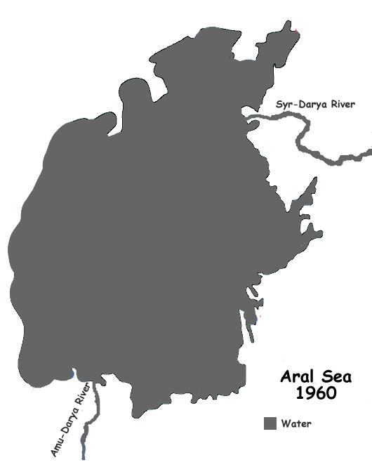
8 The Aral Sea: A Lesson in Human-Environment Interaction It was more than thirty years ago that the former Soviet Union decided to begin the building of irrigation ditches. These ditches diverted water from the Amu-Darya and the Syr-Darya Rivers. The water was used to provide water for millions of acres of farmland. More than 60% of the water that flowed down the rivers was used for irrigation. It was not until after the construction of the irrigation ditches were completed that problems began to occur. The Amu-Darya and the Syr-Darya Rivers also provide water for the Aral Sea. With the loss of the water flow to the Aral Sea, the water level began to drop. The Aral Sea was once the fourth largest sea in the world. Now, it is only half of its original size. The Aral Sea is made of salt water. In the 1960 s the amount of salt in the water was 1%. It jumped to almost 5% by The Aral Sea was once full of fish and many types of water plants. Today, the fishing industry is gone. Almost 200 tons of salt has been left on the shores. The left over salt gets blown around by the wind. Tuberculosis and throat cancer cases have risen. Many people have died because of these diseases.
9 Charts on the Aral Sea Questions Directions: Using the charts and your knowledge of social studies, answer the following questions. Chart #1 1. What was the approximate water volume in the year 1980? 2. In which year was the water surface and water volume the closest after 1960? 3. How many years did it take for the water surface to drop 60% of its original level? Chart #2 1. During what year was the salt content at 3%? 2. How many percentage points did the salt content increase from 1970 to 1990? 3. During which years was the increase in salt content the least? Chart #1 and Chart #2 1. What connection do you see between the water level and the salt content of the Aral Sea?
10 You Are There You are the ruler of a large country. Over the past ten years, the economy has gotten worse. More and more people in your country are becoming unemployed. One of your advisors proposes to begin building irrigation ditches along two major rivers to create new farms. These new farms would grow cotton and other raw materials that can make money for your country. The rivers that the irrigation ditches are to be built on both flow into a very large sea. Many people who live around the sea depend on the fishing and shipping industries the sea provides.
11 What are You Going to Do? The nation is waiting for your decision on whether or not to build the irrigation ditches on the two rivers that flow into the sea. Assignment: In your own words, issue a formal speech that will either begin the construction of the irrigation ditches or talk about another plan that you may have to save your nation s economy.
12
13 What are the possible benefits of your decision? What may be some of the consequences of your decision?
14 Unit Europe Lesson Plan A Study in human-environment interaction The Aral Sea Content Objectives The student will identify examples of human-environment interaction. TEKS 6.7b, 6.7c Language Objectives The student will identify vocabulary associated with human-environment interaction and the Aral Sea. The student will participate in group work, discussions, and create a product based on the lesson s vocabulary. Metacognitive Objectives The students will make predictions and draw conclusions based on information presented in the lesson. The students will be able to analyze the effects of the alteration to the flow of rivers. The student will be able to explain the effects caused by the lowering of the water level of the Aral Sea. Materials Handouts Aral Sea Vocabulary and Word Wall Strips Handouts Large Maps of the Aral Sea (1960/1990/2003) Handout Reading on the Aral Sea Handout 3 in 1: Maps of the Aral Sea ( ) Handouts Charts on the Aral Sea with questions Handout Graphic Organizer Cause leading to multiple effects Handouts You are There (Extension) Procedure Building Background 1. Before the lesson, have the vocabulary from the Aral Sea posted on your word wall. For maximum effectiveness, make each word interactive by folding a piece of card stock in half, writing the vocabulary term on the front, drawing an example right next to the word, and in the inside flap, write the definition of the word. 2. Have students copy the words that are going to be used in this lesson into their notes. 3. In groups of four, have the students define each word. 4. Have the students create a new visual for each of the words. 5. Have groups share their visuals and definitions 6. On the board or overhead, write The Gulf of Mexico and then circle it. Create a webbing diagram with several features branching off of it. 7. Ask students to describe things that we get from the Gulf of Mexico. Write their responses in the webbing diagram.
15 8. Ask students to describe the different types of businesses that depend on the Gulf of Mexico. Write their responses in the webbing diagram. 9. Ask students to describe the water of the Gulf of Mexico and write their responses in the webbing diagram. 10. Have students copy the completed diagram in their notes. 11. Underneath their diagrams, have the students answer the following questions: a. What would happen to the coastal wildlife if the water became saltier? b. How would the coastal economy be impacted if the water became saltier? Procedure Comprehensible Input, Lesson Delivery 12. Discuss with the students their answers from the two previous questions. Ensure that the students understand the cause and effect relationship between the conditions of the Gulf of Mexico and how people and the wildlife depend on it. 13. In their groups, students are to look at the three large maps of the Aral Sea. 14. Have students discuss how the three maps are different and write their responses in their notebooks. 15. Have students decide on how the changes demonstrated in the maps may have occurred. Have them write their reflections in their notes. 16. Have students look at assorted pictures of the Aral Sea. (Do an image search using ) 17. Ask students about the pictures that show ships stranded on dry land and how the ships ended up like that. 18. As a group have students read the passage on the Aral Sea. Students can look at the 3 maps in one handout as they read so they can see the effects of irrigation ditches. 19. Have students write out the cause of the shrinking of the Aral Sea, Also have them reflect on the multiple effects of the shrinking Aral Sea Procedure Comprehensible Input, Strategies, Practice 20. Hand out the charts to each group with the corresponding questions. 21. As a group students are to answer the questions in their notes. 22. Discuss with each group their findings 23. Discuss with the entire class the concept of human-environment interaction. a. Highlight that people will either adapt to their environment or change it. b. Have students reflect on how people in the community have changed the surrounding environment. c. Discuss whether or not there have been negative consequences with the changing of the surrounding environment. Assessment 24. Hand out the graphic organizer to each student. They are to fill out the effects of the irrigation ditches on the Aral Sea 25. Each group member is to pick one of the effects and create either a hand motion to reflect the effect or role-play a characteristics of an effect.
16 Technology Application Students can further use the Google Image Search engine to find other examples of human-environment interaction. They can create an original PowerPoint show demonstrating what they have learned and apply it to another example. (Rain Forest/Desertification ) Extensions Students use You are There and What are you Going to Do? Handouts and give an oral presentation as a persuasive speech.
17 Gulf of Mexico Webbing Example Salt Water Tourism Shrimp Fishing The Gulf of Mexico Oil Restaurants Boating Hotels
18 Gulf of Mexico Webbing The Gulf of Mexico
Module 1 Educator s Guide Investigation 2
 Module 1 Educator s Guide Investigation 2 What is happening to the Aral Sea? Investigation Overview In Investigation 2, students work as teams of NASA geographers using satellite images to measure the
Chapter 4: Google Earth Exercise
 Chapter 4: Google Earth Exercise Exercise 1 Visualizing the Three Gorges Dam Hydroelectric Project The Three Gorges Dam was the largest infrastructure project in China since the Great Wall. Completed in
F I N D I N G K A T A H D I N :
 F I N D I N G K A T A H D I N : An Online Exploration of Maine s Past LOBSTER ROLL!* Lesson 7.3 Objective: Students will collect data by playing a game that illustrates the delicate ecological balance
Investigating Natural Gas Production and Consumption with Web GIS
 Web GIS Natural Gas Handout Investigating Natural Gas Production and Consumption with Web GIS Natural gas is made up of remains of dead plants and animals that lived millions of years ago. In this activity,
Lesson 2 Pre-Visit The Negro Leagues
 Lesson 2 Pre-Visit The Negro Leagues Objective: Students will be able to: Identify important individuals associated with the formation and success of the Negro leagues. Practice research and note-taking
Borderline- Part 3 SURFACE. Syracuse University. Francis McKloskey. Spring 2013
 Syracuse University SURFACE Architecture Senior Theses School of Architecture Dissertations and Theses Spring 2013 Borderline- Part 3 Francis McKloskey Follow this and additional works at: http://surface.syr.edu/architecture_theses
Background Knowledge: Overfishing & Aquaculture
 Background Knowledge: Overfishing & Aquaculture Billions of people on earth depend on fish. For some, it is a popular source of healthy food due to its essential fatty acids and nutrients, while others
Sally Student, Sam Student Circle High School, Mrs. Teacher, grades 6 to 8
 Sally Student, Sam Student Circle High School, Mrs. Teacher, grades 6 to 8 As shown in these satellite images, the Aral Sea dramatically changed in size from August 2000 through August 2010. The Aral Sea
7.8 and US.8 Geography. The student uses geographic tools to collect, analyze, and interpret data.
 TITLE: Picturing History GRADES: 7 12 SUBJECT AREAS: Texas History, U.S. History, Geography, Visual Art TEXAS ESSENTIAL KNOWLEDGE AND SKILLS (TEKS) CONNECTIONS 7.6 History. The student understands how
In this lesson, students determine the speed of a tsunami using tsunami time travel maps and Google Earth.
 Speedy Tsunami Overview: In this lesson, students determine the speed of a tsunami using tsunami time travel maps and Google Earth. Targeted Alaska Grade Level Expectations: Science [] SA1.1 The student
World of Wet, World of Dry
 GRADE 3 Author: K. Ricca Unit Title: Hawaiʻi as an ESS Lab Lesson #: 5 Time Frames: Two 50 Minute Periods World of Wet, World of Dry ABSTRACT In World of Wet, World of Dry, students revisit the difference
OIMB GK12 CURRICULUM. LIGHT IN THE DEEP SEA Adapted from NOAA s All That Glitters
 5th Grade 60 minutes LIGHT IN THE DEEP SEA Adapted from NOAA s All That Glitters Oregon Science Content Standards: 5.2 Interaction and Change: Force, energy, matter, and organisms interact within living
Popular Book Company (Canada) Limited
 Limited") 2 4 12 16 20 24 2 32 36 3 40 44 1-30 1-2 Copyright 2009 Popular Book Company (Canada) Limited All rights reserved. No part of this book can be reproduced in any form or mechanically stored in any retrieval
2 4 12 16 20 24 2 32 36 3 40 44 1-30 1-2 Copyright 2009 Popular Book Company (Canada) Limited All rights reserved. No part of this book can be reproduced in any form or mechanically stored in any retrieval
What Country is Upstream? Conflicts that can occur because of relative position on a river
 What Country is Upstream? Conflicts that can occur because of relative position on a river The source of a river is the place where it starts - usually in hills or mountains. People who live near a river
Ups and Downs in an Estuary
 Ups and Downs in an Estuary Whooping Crane Dilemma Modified from Texas Aquatic Science and Estuaries in the Balance Curriculum TEKS 6.2 E; 6.3 C; 6.12 E; 7.2 E; 7.3 C; 7.5 A; 7.8 A; 7.13 A; 8.2 E; 8.3
Your web browser (Safari 7) is out of date. For more security, comfort and. the best experience on this site: Update your browser Ignore
 is out of date. For more security, comfort and. the best experience on this site: Update your browser Ignore") Your web browser (Safari 7) is out of date. For more security, comfort and Activitydevelop the best experience on this site: Update your browser Ignore Fisheries and Seafood Consumption How do the locations
Your web browser (Safari 7) is out of date. For more security, comfort and Activitydevelop the best experience on this site: Update your browser Ignore Fisheries and Seafood Consumption How do the locations
Grolier Online Kids Feature Showcase Animals of Africa Teacher s Guide
 Grolier Online Kids Feature Showcase Animals of Africa Teacher s Guide Opening The continent of Africa is teeming with the kinds of animals that most people can only see in captivity. Lions, leopards,
Population Fluctuations in an Ecosystem Grade 6
 TEACHING LEARNING COLLABORATIVE (TLC) LIFE SCIENCE Population Fluctuations in an Ecosystem Grade 6 Created by: Valerie Duncan (Upper Lake Middle School); Lynn Chick (Coyote Valley Elementary); Sue Cascio
Position and displacement
 /1/14 Position and displacement Objectives Describe motion in 1D using position, distance, and displacement. Analyze motion in 1D using position, distance, and displacement. Correctly use and interpret
Myra Miller Pheasant and the China Connection. Provided by the South Dakota Art Museum Brookings, South Dakota
 Myra Miller Pheasant and the China Connection Provided by the South Dakota Art Museum Brookings, South Dakota South Dakota Artists Curriculum Unit Unit of Study: Myra Miller, painter Title of Lesson Plan:
Prior Knowledge: Students should have an understanding that plants and animals compete for resources such as food, space, water, air and shelter.
 Science Lesson Plan Form Teacher: 4 th Grade Lesson: Predator/Prey SPI: 2.1 Science Goal: Recognize the impact of predation and competition on an ecosystem. What is the big idea of this standard? All life
Engineering Design Challenge. Mapping the Ocean Floor
 Engineering Design Challenge Project Title: Project Source: Project Submitter: Mapping the Ocean Floor NOAA, http://tinyurl.com/boydlek STEM Improvement Lesson Development Team Grade Level/Subject: Math,
1 Currents. TAKE A LOOK 2. Read a Map In what direction does the Gulf Stream flow?
 CHAPTER 5 1 Currents SECTION The Movement of Ocean Water BEFORE YOU READ After you read this section, you should be able to answer these questions: What factors affect ocean currents? Why are ocean currents
Authors: Luiz Barbieri and Martha Bademan
 This is a review and discussion of a proposal to develop and implement a Gulf Offshore Recreational Fishing Permit in support of more accurate, precise, and timely catch and effort estimates for offshore
Lesson Two. The Horses We All Own - The Wild Horse & Burro Program. Lessons about the Unwanted Horse. Teacher Guide and Resources: Goals
 Lessons about the Unwanted Horse The Horses We All Own - The Wild Horse & Burro Program Content explores government ownership of horses, the Wild Horse and Mustang Program (Description of current state
Academic Connections. Placement Test
 PART 1: READING 1.1 Reading 1 Read the passage. Then choose the correct answers. 1 The human societies that have the fewest social divisions are known as hunting and gathering societies. As the name implies,
Spirit Lesson 3 Robot Wheelies Lesson Outline Content: Context: Activity Description:
 Spirit Lesson 3 Lesson Title: Robot Wheelies Draft Date: July 13, 2008 1 st Author: Deb Hipnar 2 nd Author: Rachel Neurath Algebra Topic: Formulas: Circumference, Distance Grade Level: Upper Elementary,
BAY-SIC RATIOS. W. A.V.E. BAY-SIC Ratios
 BAY-SIC RATIOS INTRODUCTION: The land that surrounds the Chesapeake Bay spans 64,000 square miles and includes portions of six states Virginia, West Virginia, Maryland, Pennsylvania, Delaware, and New
Orientation and Conferencing Plan
 Orientation and Conferencing Plan Orientation Ensure that you have read about using the plan in the Program Guide. Book summary Read the following summary to the student. The kite surfer wants to go surfing,
San Patricio County Guided Fishing Market Research
 Guided Fishing Market Research San Patricio County, TX Miles Philips, Extension Specialist Texas A&M Agrilife Extension College Station, TX T: 979-845-1023 E: mdphillips@ag.tamu.edu http://fishing.tamu.edu
Adrift A Classroom Activity for Ocean Gazing Episode 18: The princeʼs predictions: Part II
 Adrift A Classroom Activity for Ocean Gazing Episode 18: The princeʼs predictions: Part II Written by: Liesl Hotaling (CIESE at Stevens Institute of Technology), Daniel Griesbach (Homdel High School),
The Oregon Coast Education Program. Concepts to Teach: Tidal cycles, interconnectedness and balance
 Tides of the Estuary Adapted from TIDES Activity 4- South Slough NERR Time requirement: 45 minutes Summary of Activity: This lesson is designed to give an introduction to how tides and tidal cycles work
Lesson Objectives. Core Content Objectives. Language Arts Objectives
 Lesson Objectives Habitat Destruction and 9 Endangered Species Core Content Objectives Students will: Explain why living things live in habitats to which they are particularly suited Identify the characteristics
Haitian Curriculum Fourth Grade Science Lesson Plan Coral Reefs in Haiti
 Haitian Curriculum Fourth Grade Science Lesson Plan Coral Reefs in Haiti Content/Theme: Coral Reefs in Haiti/Ecosystems Grade: Fourth Primary Benchmark: SC.4.L.17.4 Recognize ways plants and animals, including
Dissecting data. Amanda Bromilow Virginia Institute of Marine Science. Grade Level Middle School. Subject area Life, Environmental, or Marine Science
 Dissecting data Amanda Bromilow Virginia Institute of Marine Science Grade Level Middle School Subject area Life, Environmental, or Marine Science This work is sponsored by the National Estuarine Research
Invasive Species. No, not aliens from outer space!
 Invasive Species No, not aliens from outer space! Next Generation Science Standards This lesson about invasive species incorporates real data and tools used by Gulf of Mexico scientists and resource managers.
Traveling Waves Summative Assessment #5 For A Television in My Room
 Traveling Waves Summative Assessment #5 For A Television in My Room Table of Contents Item Page Number Traveling Waves - Instructions Page 2 Traveling Waves Assessment Pages 3 6 Traveling Waves Answer
Unit 6 Intro To Waves
 NOTE: This slide is for the purpose of including LP information that you may not necessarily show your scholars (if you include the information below in a different part of your PPT, there is no need to
ANIMALS UNIT 1 ACTIVATE YOUR KNOWLEDGE LEARNING OBJECTIVES
 UNIT ANIMALS LEARNING OBJECTIVES Key Reading Skills Reading for main ideas; using a Venn diagram Understanding key vocabulary; using your knowledge; reading for details; working out meaning; Additional
What is an ocean current? 1. wind action: the force of the wind blowing over the top of the water 2. spin of Earth 3. shape of the continents
 Ocean Currents Textbook pages 414 427 Before You Read Section 11.2 Summary What forces do you think cause ocean water to move? Do you think ocean water moves the same way everywhere in the ocean? Write
D u. n k MATH ACTIVITIES FOR STUDENTS
 Slaml a m D u n k MATH ACTIVITIES FOR STUDENTS Standards For MATHEMATICS 1. Students develop number sense and use numbers and number relationships in problem-solving situations and communicate the reasoning
PARENT/INSTRUCTOR. 3rd Grade and 4th Grade
 PARENT/INSTRUCTOR 3rd Grade and 4th Grade INTRODUCTION Congratulations on taking the first step in teaching children an important safety message. The Eddie Eagle GunSafe Program was first created in 1988
Black Sea Bass Encounter
 Black Sea Bass Encounter Below is an adaptation of the Shark Encounter (Lawrence Hall of Science: MARE 2002) lesson plan to be about Black Sea Bass and to incorporate information learned from Dr. Jensen
Set Up. Under Desk: Independent Reading Book Humanities Binder. On Desk: History Interactive Notebook Pencil Glue Stick Red Pen Agenda Crayons
 Set Up On Desk: History Interactive Notebook Pencil Glue Stick Red Pen Agenda Crayons Under Desk: Independent Reading Book Humanities Binder Paleo/Neo Flipbook due Wed., 9/27 Study for Ch. 1-3 Quiz on
Characteristics of the Text Genre Informational text Text Structure Cause-and-effect text structure
 LESSON 8 TEACHER S GUIDE by M. Lee Fountas-Pinnell Level L Informational Text Selection Summary When air warms, it rises; cooler air sinks. This movement of air makes wind. Wind direction and speed can
Lesson one. Linear Motion. Terminal Objective. Lesson 1. Linear Motion
 Lesson one Terminal Objective Using their class notes to complete the handout on linear motion, students will be able to demonstrate their understanding of speed and acceleration by problem solving different
Module 2 Narration What is a watershed?
 Module 2 Narration What is a watershed? Timing Key Narrative Snapshots a) 00:10 Every living thing relies on water to exist. But where does our water come from? The most natural place to look is upstream
Lesson 2 Pre-Visit Step Up to the Plate for Baseball Idioms
 Lesson 2 Pre-Visit Step Up to the Plate for Baseball Idioms Objective: Students will be able to: Demonstrate understanding of idioms by creating and interpreting simple examples. Create a PowerPoint show
THREE WATER DIVERSION CASES
 THREE WATER DIVERSION CASES PURPOSE Research the Internet and other s rces surrounding ecosystems and human communities Compare and contrast the problems and successes of various water diversions and describe
Rocky Shore Zones: The splash zone
 Rocky Shore Zones: The splash zone Topic Zones, Adaptations Duration Two sessions Vocabulary adaptation challenge feature splash zone zone Standards Practices Analyzing and Interpreting Data Core Ideas
What are the 5 senses of a Cricket?
 What are the 5 senses of a Cricket? An Elementary Science Lesson Plan Designed For Group Inquiry Based On The 5E Inquiry Model GRADE LEVEL: 2nd SCIENCE CONCEPT (the Main Idea or Enduring Understanding):
Managing Wildlife Populations
 Lesson C4 5 Managing Wildlife Populations Unit C. Animal Wildlife Management Problem Area 4. Game Birds Management Lesson 5. Managing Wildlife Populations New Mexico Content Standard: Pathway Strand: Natural
Your web browser (Safari 7) is out of date. For more security, comfort and the best experience on this site: Update your browser Ignore
 is out of date. For more security, comfort and the best experience on this site: Update your browser Ignore") Your web browser (Safari 7) is out of date. For more security, comfort and the best experience on this site: Update your browser Ignore Activityengage PERSPECTIVES O F L IO N CO NSERVATIO N What strategies
Your web browser (Safari 7) is out of date. For more security, comfort and the best experience on this site: Update your browser Ignore Activityengage PERSPECTIVES O F L IO N CO NSERVATIO N What strategies
TALKING ABOUT HOCKEY. Warm Up. Overview. Materials. Essential Question. Standards
 TALKING ABOUT HOCKEY Overview ELA Learning Objective: I can understand and define basic hockey terms. (~60 minutes) In this lesson, students will become familiar with common hockey terms that will serve
Pre-Visit Lesson for Baltimore Kids on the GFT. Attached Framework C(3) Standards for 4 th grade Social Studies, maps and activity descriptions
 Standards for 4 th grade Social Studies, maps and activity descriptions") Pre-Visit Lesson for Baltimore Kids on the GFT. Attached Framework C(3) Standards for 4 th grade Social Studies, maps and activity descriptions The field trip is in a Baltimore City park. Every city park
Pre-Visit Lesson for Baltimore Kids on the GFT. Attached Framework C(3) Standards for 4 th grade Social Studies, maps and activity descriptions The field trip is in a Baltimore City park. Every city park
Annotated Answer Key and Extension Activities 9 ISBN Copyright 2015 The Continental Press, Inc.
 TABLE OF CONTENTS Introduction 3 Format of Books 4 Suggestions for Use 8 Annotated Answer Key and Extension Activities 9 ISBN 978-0-8454-7878-3 Copyright 2015 The Continental Press, Inc. Excepting the
Where have all the Salmon Gone?
 Where have all the Salmon Gone? Lesson Overview In this lesson, students will participate in a simulation activity that illustrates the lifecycle of salmon in order to appreciate the different obstacles
Chapter 10, Section 2 Westward Bound
 Chapter 10, Section 2 Westward Bound (pages 314 319) Setting a Purpose for Reading Think about these questions as you read: How did land and water transportation improve in the early 1800s? How did settlements
Crossing Corridors. Objective. Materials. Background Information
 Objective Students will be able to demonstrate how habitat fragmentation limits survival of the Pacific Fisher, compare habitat specialists and generalists, and describe the importance of corridors within
Nueces County Guided Fishing Market Research
 Guided Fishing Market Research Nueces County, TX Miles Philips, Extension Specialist Texas A&M Agrilife Extension College Station, TX T: 979-845-1023 E: mdphillips@ag.tamu.edu http://fishing.tamu.edu Guided
Evolution by Natural Selection 1
 Evolution by Natural Selection 1 I. What is evolution by natural selection? A population of mice lived in a desert with gray sand. These drawings show how the population changed from time 1 to time 3.
Teacher Edition. AlphaWorld. Deserts. Written by Keith Pigdon
 Teacher Edition AlphaWorld Deserts Written by Keith Pigdon Published edition Eleanor Curtain Publishing 2003 First published 2003 Apart from any fair dealing for the purposes of study, research, criticism
Which Fish Where? Grade level: Elementary (Grades 4-7) Standards: Mathematics, Science, & Technology Standards 1, 4
 Standards: Mathematics, Science, & Technology Standards 1, 4") Which Fish Where? Students will use tables and graphs of fish collection data to draw conclusions about where fish live in the Hudson estuary. Objectives: Students will use data presented in tables and
Which Fish Where? Students will use tables and graphs of fish collection data to draw conclusions about where fish live in the Hudson estuary. Objectives: Students will use data presented in tables and
General Oceanography Geology 105 Expedition 3 Declining Marine Fisheries See Due Date in Greensheet
 General Oceanography Geology 105 Expedition 3 Declining Marine Fisheries See Due Date in Greensheet Name Expedition Objectives Learn about the conditions that resulted in the decline of many marine fish
Day. Facts. fish will be. take only. drag up not. in British
 Day 1: Fishing for the Future - Fishery Facts The world s fisheries are under more pressure than ever before. From 1950 to 1990, there was a fivefold increase in the world annual fish catch. The average
Educational Innovations
 Educational Innovations WHW-100/115 Wacky Hall Walker Constructing the Wacky Hall Walker 1. Attach a paper clip to the rubber band as shown. Insert the band through the hole in one orange cap and pull
GIRL SCOUT EARTH CONNECTIONS BADGE WORKSHEET
 Ecology is the study of how living things interact with each other and their environments. Ecology not only involves plants and animals, but people as well. The activities in this handout can be completed
Rocky Shore Zones: the lower intertidal zone
 Rocky Shore Zones: the lower intertidal zone Topic Zones, Adaptations Duration Two sessions Vocabulary adaptation challenge feature lower intertidal zone zone Standards Practices Analyzing and Interpreting
TITLE: North Carolina s Changing Shorelines. KEYWORDS: erosion - shorelines - mapping - sustainability
 UNC Coastal Studies Institute Teacher Resources 1 TITLE: North Carolina s Changing Shorelines KEYWORDS: erosion - shorelines - mapping - sustainability Changing shorelines impact coastal infrastructure.
Age of Fans
 Measures of Central Tendency SUGGESTED LEARNING STRATEGIES: Activating Prior Knowledge, Interactive Word Wall, Marking the Text, Summarize/Paraphrase/Retell, Think/Pair/Share Matthew is a student reporter
Beach Profiles: Monitoring Sea Level Rise. Student Activity Sheet. Name Date Class
 Beach Profiles: Monitoring Sea Level Rise Student Activity Sheet Name Date Class A shoreline is the area where the water and land meet. This is where we find beach: areas where sediments (sand or other
Chapter 2 Displaying and Describing Categorical Data
 Chapter 2 Displaying and Describing Categorical Data Graphs for Categorical Variables Our concern will be two types of visual representations. Graphs for Categorical Variables Our concern will be two types
Be sure students get all the combinations that add to , 1+9, 2+8, 3+7, 4+6, 5+5, 6+4, 7+3, 8+2, 9+1, 10+0
 Lesson: Ten Lap Challenge Grades: K-1 Skills: Ways to make 10, number sense Time: 20 minutes What to do: Tell students they have two days to run ten laps in the gym. Have them use the worksheet on the
Solar Water Heaters for Swimming Pools
 TEACHER OVERVIEWUNIT OF STUDY NO. No. 11 Solar Water Heaters for Swimming Pools For Grades 6, 7 and 8 OVERVIEW In this unit students will learn how solar energy can be used for heating swimming pools.
A Pyramid of Crunchkins
 Pictured below you will see Nestle Crunchkins stacked in a triangular pyramid. Each layer is in the shape of an equilateral triangle, and the top layer is a single Nestle Crunchkin. How many Nestle Crunchkins
Lesson Title: At the Gas Station. Method: Natural Approach & Jazz Chant
 At the Gas Station: Lesson Plan Lesson Title: At the Gas Station Method: Natural Approach & Jazz Chant Age/level of students: Chinese adults in a community-based survival-esl program in Chinatown; beginner-level.
AUSTRALIAN TEAMS OVER TIME
 LEVEL Upper primary AUSTRALIAN TEAMS OVER TIME DESCRIPTION In these activities, students learn about the number of athletes who have represented Australia in the Olympics, with a focus on the previous
Site Analysis and Parti Development
 Site Analysis and Parti Development 32_43 06.11N, 117_09 25.15W Dean Sartain Assignment # 4 AR 650: Programming Instructor: Mirkovich 1. LOCATION within the city. - The site is located between A St & B
Keeping Gulf Red Snapper on the Road to Recovery
 A brief from July 2016 Keeping Gulf Red Snapper on the Road to Recovery Overview In 2007, the Gulf of Mexico Fishery Management Council implemented a rebuilding plan for red snapper that included scientifically
Chapter 2: Visual Description of Data
 Chapter 2: Visual Description of Data El Mechry El Koudous Fordham University January 24, 2018 Meshry (Fordham University) Chapter 2 January 24, 2018 1 / 35 Introduction In this chapter we will cover:
MOTION IN THE OCEAN Density Waves
 W 533 MOTION IN THE OCEAN Density Waves Aaron Spurling, UT/TSU Extension 4-H Youth Development Jennifer Richards, Curriculum Specialist, Tennessee 4-H Youth Development Tennessee 4-H Youth Development
American English Vocabulary and Grammar Diagnostic Test - 2
 1. Vocabulary Test 1. There is only a time left. A. some B. few C. little D. any 2. John is person I know. A. the more intelligent B. more intelligent C. the most intelligent D. most intelligent 3. It
One Year Later A regional assessment of seafood consumption patterns after the Gulf oil spill
 One Year Later A regional assessment of seafood consumption patterns after the Gulf oil spill Lisa Krimsky 1 and Brooke Saari 2 UF/IFAS Sea Grant Extension Miami-Dade County 1, Okaloosa and Walton Counties
Activity #1: The Dynamic Beach
 Activity #1: The Dynamic Beach Beach Profiling By Betsy Sheffield, COASTeam Program, College of Charleston, Charleston, SC Subjects: Science, Math Skills: Analysis, description, listing, research, small
The Bruins I.C.E. School Math 1 st and 2 nd Grade Curriculum Materials. Lesson 3: Comparing Numbers Using <,> and = Symbols
 The Bruins I.C.E. School Math Curriculum Materials Lesson 1: Number Sequence Lesson 2: Odd/Even Numbers Lesson 3: Comparing Numbers Using and = Symbols Lesson 4: Classifying Angles Lesson 5: Decimals
Lesson 1: Decimal Place Value. Concept/Topic to Teach: Students use Bruins statistical data to order and compare decimals to the thousandths.
 Math Lesson 1: Decimal Place Value Concept/Topic to Teach: Students use Bruins statistical data to order and compare decimals to the thousandths. Standards Addressed: Standard 1: 5.NBT.3 Read, write, and
(Shell)Fish out of water... Skills: calculating, reasoning, critical thinking, writing, participating
Fish out of water... Skills: calculating, reasoning, critical thinking, writing, participating") (Shell)Fish out of water... Subject Areas: Science, Math Setting: Classroom or at upweller Duration: One class period Skills: calculating, reasoning, critical thinking, writing, participating Vocabulary:
(Shell)Fish out of water... Subject Areas: Science, Math Setting: Classroom or at upweller Duration: One class period Skills: calculating, reasoning, critical thinking, writing, participating Vocabulary:
GLOBE Data Explorations
 Rainfall in the GLOBE Africa Region: A GLOBE Data Exploration Purpose Through explorations of GLOBE rain depth data from Africa, students learn about seasonal patterns in locations affected by monsoons.
Vanishing Coast: Erosion
 Vanishing Coast: Erosion Overview: Students learn about erosion by observing two classroom demonstrations and listening to an Elder share local history. Objectives: The student will: identify erosion from
Your web browser (Safari 7) is out of date. For more security, comfort and. the best experience on this site: Update your browser Ignore
 is out of date. For more security, comfort and. the best experience on this site: Update your browser Ignore") Your web browser (Safari 7) is out of date. For more security, comfort and Activityengage the best experience on this site: Update your browser Ignore Gearing Up with Robots How are gears used to change
Your web browser (Safari 7) is out of date. For more security, comfort and Activityengage the best experience on this site: Update your browser Ignore Gearing Up with Robots How are gears used to change
13. TIDES Tidal waters
 Water levels vary in tidal and non-tidal waters: sailors should be aware that the depths shown on the charts do not always represent the actual amount of water under the boat. 13.1 Tidal waters In tidal
LESSON 4 - INVESTIGATING REFRACTION
 LESSON 4 - INVESTIGATING REFRACTION Overview: Through a series of demonstrations, students will learn why waves refract. By observing how different materials shift the position of an object, the concept
BUILD A HORSESHOE CRAB
 The Education Program at the New Jersey Sea Grant Consortium 22 Magruder Road Fort Hancock, NJ 07732 732 872 1300 njseagrant.org BUILD A HORSESHOE CRAB OVERVIEW OBJECTIVES During this lesson, students
Documentary Lens Lesson Plan for Octopus Hunt
 Documentary Lens Lesson Plan for Octopus Hunt Page 1 Documentary Lens Lesson Plan for Octopus Hunt By Jocelyn Vernon Withrow Avenue Public School, Toronto District School Board, ON Curriculum Connections
Commercial Red Grouper Fishing in the Gulf of Mexico States
 Commercial Red Grouper Fishing in the Gulf of Mexico States According to NOAA Fisheries (https://www.fisheries.noaa.gov/species/red-grouper), the red grouper (Epinephelus morio) fishery in the Gulf of
Red Cross Swim Instructor In-service Orientation
 Orientation In-Service Red Cross Swim Instructor In-service Orientation OUTCOME Provide information to Water Safety Instructors on the new Red Cross Swim programs. MATERIALS Mascot songs handout Appendix
The Bruins I.C.E. School
 The Bruins I.C.E. School Lesson 1: Decimal Place Value Lesson 2: Measurement and Data Lesson 3: Coordinate Graphing Lesson 4: Adding and Subtracting Fractions Lesson 5: Order of Operations Worksheets Included:
Chapter 17 Mechanical Waves And Sound Test Answers
 We have made it easy for you to find a PDF Ebooks without any digging. And by having access to our ebooks online or by storing it on your computer, you have convenient answers with chapter 17 mechanical
communautaire related to the CFP. Since Law 3/2001
 2.11 FISHING The European Union s Common Fisheries Policy (CFP), which has been in place for many years, establishes the fishing opportunities and regulations necessary to ensure that fishing remains sustainable
Developing a programme to make Taranaki predator-free
 Factsheet: 6 Developing a programme to make Taranaki predator-free The Taranaki Regional Council wants to initiate an innovative change in managing predators to benefit our native plants and wildlife,