EvaluationofHilsFeryBarierEfectiveness atrestrictingchinooksalmonpassageonthe SanJoaquinRiver
|
|
|
- Solomon Washington
- 5 years ago
- Views:
Transcription


1 EvaluationofHilsFeryBarierEfectiveness atrestrictingchinooksalmonpassageonthe SanJoaquinRiver U.S.DepartmentoftheInterior BureauofReclamation TechnicalServiceCenter FisheriesandWildlifeResourcesGroup Denver,Colorado October2011
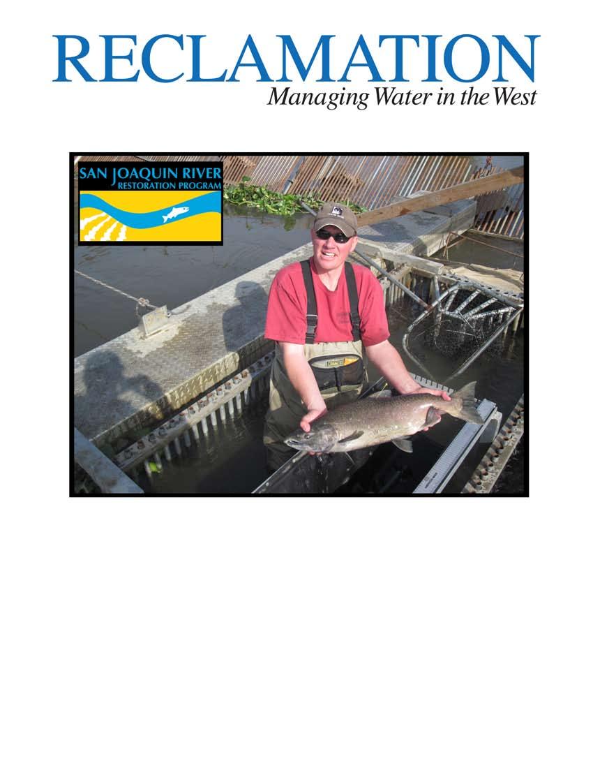
2 MISSION STATEMENTS The mission of the Department of the Interior is to protect and provide access to our Nation s natural and cultural heritage and honor our trust responsibilities to Indian tribes and our commitments to island communities. The mission of the Bureau of Reclamation is to manage, develop, and protect water and related resources in an environmentally and economically sound manner in the interest of the American public. COVER PHOTOGRAPH Bureau of Reclamation Fisheries Biologist, Eric Best, removes a Chinook salmon from the fish trap at the Hills Ferry Barrier, Newman, California. DISCLAIMER Mention of commercial products does not constitute endorsement.
3 San Joaquin River Restoration Program Evaluation of Hills Ferry Barrier Effectiveness at Restricting Chinook Salmon Passage on the San Joaquin River by Donald E. Portz, Ph.D. 1, Eric Best 1, and Connie Svoboda, P.E. 2 October 2011 U.S. Department of the Interior Bureau of Reclamation Technical Service Center Denver, Colorado 1 Bureau of Reclamation Technical Service Center Fisheries and Wildlife Resources Group PO Box Denver, CO Bureau of Reclamation Technical Service Center Hydraulic Investigations and Laboratory Services Group PO Box Denver, CO
4
5 TABLE OF CONTENTS Executive Summary... iv Introduction... 1 Materials and Methods... 4 Fish Barrier... 4 DIDSON Evaluation... 6 Water Velocities and Bathymetry... 7 Telemetry... 8 Results Fish Barrier DIDSON Evaluation Water Velocities and Bathymetry Telemetry Discussion Conclusions and Recommendations Acknowledgments References Page Table TABLES Page 1 Hydraulic Hydraulic data collected at Hills Ferry Barrier in October and November foot = 0.3 meters Figures FIGURES Page 1... Hills Ferry Fish Barrier and fish trap on the San Joaquin River, California 2 2 Merced and San Joaquin River confluence near Newman, Californian San Joaquin River Restoration Program i
6 Table of Contents continued 3 Hills Ferry Barrier is a sliding pipe weir constructed of aluminum channel with 2.5-cm (1-inch) holes that allow 1.9-cm (.75-inch) electrical conduit to slide freely vertically in the corresponding holes and are pushed into the riverbed Fish trap retrofitted to the Hills Ferry Barrier sliding pipe weir design that consisted of a 1-m wide x 2-m long x 1-m high (3.28-ft x 6.56-long x 3.28-ft high) box frame with 2.5-cm (1-in) bars spaced at 2.5 cm (1 in) and a funnel opening to deter escapement. The net entrance led from the weir to the trap River-wide transects were recorded along the barrier to monitor scouring and passage issues along with fish behaviors using a DIDSON camera affixed to a transom mount of a jon boat and manually maneuvered across the channel directly adjacent the barrier Measuring river velocity and bathymetric transects utilizing the Acoustic Doppler Current Profiler Sonotronics model CT-82-1-I acoustic transmitter and acrylic rod used for esophageal tag insertion Esophageal insertion of sonic transmitter into a Chinook salmon Manual tracking of an acoustically-tagged Chinook salmon using a Sonotronics USR-5W wide band receiver with DH-4 directional hydrophone Stand-alone submersible ultrasonic receiver (Photo courtesy of Sonotronics Inc.) Locations of fixed SUR-1-2D submersible ultrasonic receivers (SUR) Gaps in the conduit pickets can provide passage for adult Chinook salmon beyond the Hills Ferry Barrier Bank erosion and scoring causes holes in the barrier which may provide upstream passage at the Hills Ferry Barrier DIDSON image of a school of threadfin shad swimming along the upstream side of the Hills Ferry Barrier Chinook salmon observed swimming directly downstream of the Hills Ferry Barrier searching for passage opportunity A carp observed swimming along the downstream of the Hills Ferry Barrier seeking passage opportunity, note the conduit pickets in the background River transect collected with an Acoustic Doppler Current Profiler at 9.1 m (30 ft) upstream of the Hills Ferry Barrier for October (top) and November (bottom). West riverbank on left and east riverbank on right River transect collected with an Acoustic Doppler Current Profiler at 3.0 m (10 ft) upstream of the Hills Ferry Barrier for October (top) and November (bottom). West riverbank on left and east riverbank on right Page ii San Joaquin River Restoration Program
7 Table of Contents continued 19 River transect collected with an Acoustic Doppler Current Profiler at 1.5 m (5 ft) upstream of the Hills Ferry Barrier for October (top) and November (bottom). West riverbank on left and east riverbank on right River transect collected with an Acoustic Doppler Current Profiler at 0.61 m (2 ft) upstream of the Hills Ferry Barrier for October (top) and November (bottom). West riverbank on left and east riverbank on right River transect collected with an Acoustic Doppler Current Profiler at 0.61 m (2 ft) downstream of the Hills Ferry Barrier for October (top) and November (bottom). West riverbank on left and east riverbank on right River transect collected with an Acoustic Doppler Current Profiler at 1.5 m (5 ft) downstream of the Hills Ferry Barrier for October (top) and November (bottom). West riverbank on left and east riverbank on right River transect collected with an Acoustic Doppler Current Profiler at 3.0 m (10 ft) downstream of the Hills Ferry Barrier for October (top) and November (bottom). West riverbank on left and east riverbank on right Chinook salmon movement of fish tagged on November 17, 2010 at Hills Ferry Barrier. This fish did not re-ascend the San Joaquin River and eventually moved downstream out of detection by the submersible ultrasonic receivers (SUR) Chinook salmon movement of fish tagged on Novemebr 18, 2010 at Hills Ferry Barrier. This fish did not re-ascend the San Joaquin River and eventually moved downstream out of detection by the submersible ultrasonic receivers (SUR) San Joaquin River Restoration Program iii
8 EXECUTIVE SUMMARY The California Department of Fish and Game (DFG) constructs the Hills Ferry Barrier (HFB) on the San Joaquin River (SJR) near Newman, California, in the fall to restrict passage of adult fall-run Chinook salmon (Oncorhynchus tshawytscha) and Central Valley steelhead (Oncorhynchus mykiss) upstream of the confluence of the Merced River where habitat and water quality may be unsuitable for these fish. The San Joaquin River Restoration Program will restore flows in the SJR from Friant Dam to the Merced River confluence and re-establish a self sustaining population of Chinook salmon and other native fish. Beginning October 1, 2009, the San Joaquin River Restoration Program initiated a program of Interim Flows to collect relevant data on flows, temperatures, fish needs, seepage losses, recirculation, recapture and reuse. Public Law Section (h)(4) requires that the Secretary of the Interior, in consultation with the California Department of Fish and Game, evaluate the effectiveness of the Hills Ferry Barrier in preventing the unintended upstream migration of anadromous fish in the San Joaquin River and any false migratory pathways. Barrier physical characteristics, river hydrology and bathymetry, as well as fish behavior in proximity to the barrier were examined and evaluated in order to develop refined operating guidance and determine effectiveness of the barrier at preventing or reducing fish passage. Dual-frequency identification sonar underwater camera (DIDSON TM ), Acoustic Doppler Current Profiler (ADCP), and visual observations were used to identify problems and limitations of the barrier. Sand, silt, and clay river substrate eroded around the barrier s support structures, footings, base, and conduit panels. Scour holes underneath and at the terminal ends of the barrier develop from erosion and enable adult Chinook salmon to evade the barrier and swim upstream of this location. Upon detection, staff sandbagged scour holes and replaced or extended conduit pickets. Clearing floating hyacinth mats removed panels for cleaning and temporarily created gaps in the barrier. In November 2010, twenty-two fall-run Chinook salmon passed the barrier and were found upstream at Sack Dam, Mendota Pool, and upstream canals. Information gathered from DIDSON TM, ADCP, and visual accounts identified potential improvements to barrier design, operation, and location to improve barrier effectiveness including: 1. Locate the barrier downstream of the 2010 location for improved hydraulics 2. Improved debris removal procedures to avoid gaps from panel removal. The long-term use of the HFB is unknown; however, it is anticipated it will be used to block anadromous fish species from moving upstream until the Restoration Area is considered ready for salmon reintroduction. This report discusses observations and nearterm structural and non-structural modifications that can improve the effectiveness of the HFB. Page iv San Joaquin River Restoration Program
9 INTRODUCTION The San Joaquin River Restoration Program (SJRRP) is a long-term effort to restore flows to a 246-km-long (153-mi-long) stretch of the San Joaquin River below Friant Dam to the confluence with the Merced River and re-establish a self-sustaining Chinook salmon (Oncorhynchus tshawytscha) fishery in the river while reducing or avoiding adverse water supply impacts from Interim and Restoration Flows. Under the NRDC, et al., v. Kirk Rodgers, et al Settlement two parallel goals were mandated: 1) a restoration goal to restore and maintain fish populations in good condition in the main stem San Joaquin River below Friant Dam to the confluence with the Merced River, including naturally reproducing and self-staining populations of salmon and other fish, and 2) a water management goal to reduce or avoid adverse water supply impacts to Friant Division Long-term Contractors that may result from the Interim and Restoration Flows provided for in the Settlement. Public Law Section (h)(4) states that the Secretary, in consultation with the California Department of Fish and Game (DFG), shall evaluate the effectiveness of the Hills Ferry Barrier (HFB) in preventing the unintended upstream migration of anadromous fish in the San Joaquin River and any false migratory pathways. If that evaluation determines any such migration past the barrier is caused by the introduction of the Interim Flows and that the presence of such fish will result in the imposition of additional regulatory actions against third parties, the Secretary is authorized to assist DFG in making improvements to the barrier. From funding made available in accordance with section 10009, if third parties along the San Joaquin River south of its confluence with the Merced River are required to install fish screens or fish bypass facilities due to the release of Interim Flows in order to comply with the Endangered Species Act of 1973 (16 U.S.C et seq.), the Secretary shall bear the costs of the installation of such screens or facilities if such costs would be borne by the Federal Government under section 10009(a)(3), except to the extent that such costs are already or are further willingly borne by the State of California or by the third parties. This report evaluates the effectiveness of the HFB at preventing unintended migration of anadromous fish. HFB (Figure 1) is a sliding pipe weir located approximately 300 m (328 yd) upstream of the San Joaquin and Merced River confluence (Figure 2), 5.5 km (3.4 mi) east of Newman, California. The barrier is intended to impede passage of fall-run Chinook salmon from ascending the San Joaquin River above the confluence with the Merced River where habitat and water quality (temperature) are unsuitable for these fish. The HFB also blocks the Central Valley (CV) steelhead (Oncorhynchus mykiss) from moving upstream, although the HFB is not in p lace during the CV steelhead s greatest potential to occur in the area (mid-december through mid-february). Identifying salmon, steelhead, and other native species use of the river is important to the SJRRP s recovery program, and it is beneficial to determine fish species that are encountering the barrier. Information regarding the presence of non-native species such as catfish, carp, and striped bass may also be helpful but is a secondary priority. San Joaquin River Restoration Program Page 1

10 In 1988, DFG began an adult trapping and egg salvage effort in the San Luis Canal at the Los Banos Wildlife Area which continued through Fish were spawned and the eggs were transported to the Merced River Hatchery near Snelling, California, for incubation and rearing. Fish trapping efforts continued with modifications in location and design through This approach was abandoned due to high egg and juvenile mortality. During spawning season of fall 1992, DFG tested an electrical fish barrier made by Smith-Root, Inc., just upstream of the confluence of the San Joaquin and Merced Rivers to restrict adult Chinook salmon passage. The electrical barrier was later determined to be ineffective for this particular application due to corrosion of electrode cables from high water conductivity. A physical barrier was placed 46 m (50 yd) upstream of the electrical barrier on the San Joaquin River to act as a backup during electrical barrier feasibility assessments. Following the limited success of the electrical barrier, a physical barrier has been used until present. Physical barriers of several variations (i.e., Alaskan, resistance board, sliding pipe weirs) have been in place seasonally (September December) since For a detailed history of the Hills Ferry Barrier operation see Gates (2011). Figure 1. Hills Ferry Fish Barrier and fish trap on the San Joaquin River, California. The current design used since 2004 is a sliding pipe weir constructed with wooden tripod support structures and aluminum channel that have 2.5-cm (1-in) holes to allow pieces of 1.9-cm (.75-in) electrical conduit to slide into the riverbed. This type of weir has been Page 2 San Joaquin River Restoration Program
 to deeper water to allow for a fish trap to be retrofitted to the weir structure.")
11 used every year at the confluence with minor changes in location due to bank erosion. In 2010 the barrier was moved upstream approximately 100 m (109 yd) to deeper water to allow for a fish trap to be retrofitted to the weir structure. The alluvial river substrate of sand, silt, and clay poses a challenge to the integrity of the barrier throughout the season once it is installed. River hydraulics around weir support structures, barrier footings, base of conduit bars, and barrier panels cause substrate erosion resulting in scouring holes underneath the barrier and along the shoreline. DFG personnel fill these scour holes with sandbags on a daily basis to maintain a relatively fish tight barrier. This labor intensive activity is a challenge due the physical conditions at the site and the impermanence of the structure. Adult Chinook salmon have been observed in the past to take advantage of scour holes and elude the barrier. Others have been witnessed to pass during cleaning operations when excessive water hyacinth loads and vegetative debris become lodged against the sliding pipes requiring temporary removal of a panel of conduit pickets to allow the plant matter to travel downstream. Figure 2. Merced and San Joaquin River confluence near Newman, California. San Joaquin River Restoration Program Page 3
12 An assessment of the HFB was performed to evaluate its effectiveness throughout the installation period and under a wide range of flows to understand the current limitations of the structure. An evaluation to inhibit the migration of Chinook salmon up the San Joaquin River was performed during fall Physical characteristics of the barrier and river were examined as well as fish behavior adjacent to the barrier. Dual-frequency identification sonar underwater camera (DIDSON) and an Acoustic Doppler Current Profiler (ADCP) were used to identify problems and limitations, and information will be used to recommend improvements with barrier design, operation, and location. Scour holes and gaps in the barrier can be found and possibly predicted using erosion depth and sediment transition behavior. The goal of this task is to evaluate the barrier effectiveness and develop refined operating guidance and data collection protocols. Fish Barrier MATERIALS AND METHODS The HFB is a sliding pipe weir design used to exclude large migrating fish from swimming upstream while allowing water and other smaller species to pass. The barrier was installed August 31, 2010 and was removed December 9, 2010, which is the timeline of peak migration of fall-run Chinook salmon to Central Valley Rivers. The general principle of this type of weir is that an aluminum channel with 2.5 cm (1-in) holes allowed pieces of 1.9-cm (0.75-in) electrical conduit to slide freely vertically in the corresponding holes and can be pushed into the riverbed (Figure 3). The weir consisted of anchor points on each side of the river and a cable that spanned the river about 2 3 m ( ft) above the water level. Eighteen, 2.5-m-high (8.20-ft-high) tripods spaced approximately 0.5 m (1.64 ft) apart at their base were tethered to the overhead cable. Two horizontal rows of aluminum channel with 2.5-cm (1-in) holes machined every 3.8 cm (1.5 in) were affixed to the tripods. The 1.9-cm (.75-in) electrical conduit pickets were then slid through these holes to make a fish tight weir. The fish trap that was retrofitted to the barrier consisted of a 1-m-wide x 2-m-long x 1-m-high (3.28-ft-wide x 6.56-ft-long x 3.28-ft-high) box frame with 2.5-cm (1-in) bars spaced at 2.5 cm (1 in) and a funnel opening to deter escapement once fish entered (Figure 4). The trap was suspended upstream of the barrier by two pontoons. An opening in the weir was made by removing conduit pickets and affixing a net-tube that led from the weir to the trap. The trap was checked for fish daily when in operation. Page 4 San Joaquin River Restoration Program
 electrical conduit to slide freely vertically in the corresponding holes and are pushed into the riverbed. Figure 4.")
 box frame with 2.5-cm (1-in) bars spaced at 2.5 cm (1 in) and a funnel opening to deter escapement.")
13 Figure 3. Hills Ferry Barrier is a sliding pipe weir constructed of aluminum channel with 2.5-cm (1-in) holes that allow 1.9-cm (.75-in) electrical conduit to slide freely vertically in the corresponding holes and are pushed into the riverbed. Figure 4. Fish trap retrofitted to the Hills Ferry Barrier sliding pipe weir design that consisted of a 1-m-wide x 2-m-long x 1-m-high (3.28-ft-wide x 6.56-ft-long x 3.28-ft-high) box frame with 2.5-cm (1-in) bars spaced at 2.5 cm (1 in) and a funnel opening to deter escapement. The net entrance led from the weir to the trap. San Joaquin River Restoration Program Page 5
.")
14 DIDSON Evaluation Barrier effectiveness at blocking migrating fish under a variety of flow conditions was evaluated by assessing the location and behavior of sediment scouring using a dualfrequency identification sonar underwater camera (DIDSON; Sound Metrics Corp., Chesapeake, Virginia). The near video quality images of the DIDSON allowed detailed underwater inspections of the barrier structure and substrate in turbid water. The DIDSON camera was also used to observe fish interactions with the weir and determine fish species that encounter the barrier. The DIDSON was configured with a remotely operated pan and tilt actuator that allowed a scan of the weir and river bottom. The DIDSON camera was affixed to a transom mount that allowed for easy attachment to a jon boat and manually maneuvered across the channel directly adjacent the barrier (Figure 5). River-wide transects recording barrier condition as well as fish behaviors were performed above and below the weir on September 21 st, October 20 th and November 18 th. Figure 5. River-wide transects were recorded along the barrier to monitor scouring and passage issues along with fish behaviors using a DIDSON camera affixed to a transom mount of a jon boat and manually maneuvered across the channel directly adjacent the barrier. Page 6 San Joaquin River Restoration Program
 to map changes in bed elevations and velocity distributions and to identify scour and depositional zones during barrier operation (Figure 6).")
15 Water Velocities and Bathymetry River transects were measured upstream and downstream of the barrier with a Teledyne RD Instruments StreamPro Acoustic Doppler Current Profiler (ADCP; Teledyne RD Instruments, Poway, California) to map changes in bed elevations and velocity distributions and to identify scour and depositional zones during barrier operation (Figure 6). The StreamPro includes a 2.0 MHz ADCP with four transducers at a 20 degree beam angle mounted to a small float. The bottom-tracking capability of the StreamPro provides the ability to move the instrument continuously across the river. A tagline was set up at seven locations and the instrument was floated across the river at a velocity slower than the water velocity and raw data were processed with specialized StreamPro software. Velocity data were collected with a vertical cell size of cm ( ft) depending on the maximum water depth. Velocity resolution of the instrument is 0.1 cm/s (0.04 in/s). A handheld computer collected data via a Bluetooth transmitter and raw data were processed in specialized StreamPro software. River transects were collected 0.6, 1.5, 3.0, 9.1 m (2, 5, 10, and 30 ft) upstream of the barrier and 0.6, 1.5, 3.0, 9.1 m (2, 5, 10, and 30 ft) downstream of the barrier. Data were not collected 9.1 m (30 ft) downstream of the barrier since the 1.5-m (5-ft) and 3.0-m (10-ft) transects did not show significant changes in velocity or bed elevation during October. The river stage was recorded from USGS site (San Joaquin R AB Merced R near Newman, California) staff gage directly upstream of the barrier. Data were collected on October 19 20, 2010 and November 16 17, Additional field trips were scheduled in December 2010 and January 2011, but field work was canceled due to very high river flows producing unsafe working conditions. Figure 6. Measuring river velocity and bathymetric transects utilizing the Acoustic Doppler Current Profiler. San Joaquin River Restoration Program Page 7
16 Telemetry Chinook salmon behavior was monitored on the downstream side of the Hills Ferry Barrier to measure the effectiveness of the barrier at inhibiting passage using ultrasonic telemetry. However, due to concerns of fall-run Chinook salmon passing the barrier, additional monitoring was performed on the upstream side of the barrier to Mendota Pool at the request of the SJRRP and DFG Management. Adult fall-run Chinook salmon were collected in a fish trap attached to the HFB and other collected along the weir with a dip net. Initial plans were to collect and tag up to 30 fall-run Chinook salmon distributed throughout their run that spans late September to early December, generally peaking in mid-november, to determine movements and behavior in the proximity of the HFB and San Joaquin-Merced River confluence. Collected fall-run Chinook salmon were measured (fork length), sexed, scale sampled from the dorsal area posterior to the adipose fin, and tissue sampled from the pectoral fin for DNA studies. Fish were implanted with ultrasonic transmitters (Sonotronics model CT-82-1-I, Sonotronics, Inc., Tucson, Arizona) that emit high frequency sound which propagated mechanically through the water. Fish that received a telemetry transmitter were secondarily tagged with a colored Floy tag to facilitate quick identification of recaptured fish in the trap and alert hatchery personnel if ultrasonically tagged fish were collected. Esophageal implant of transmitters is the desired technique for tracking adult salmonids during migration (Burger et al. 1985, 1995; Eiler 1990; Ruggerone et al. 1990; Ramstad and Woody 2003). Utilizing the two percent rule for implanted telemetry tags (Winter 1983, 1996, 2000), it is recommended that the ratio of transmitter weight to body weight (in air) should be less than 2 percent. We determined that a 12-g transmitter (Sonotronics model CT-82-1-I, 38 mm x 15.6 mm (1.5 in x 0.61 in) with 60 day life span; Figure 7) was appropriate for fish larger than 600 g (1.32 lb) and would easily allow for tagging of any adult Chinook encountered in the trap. Fourteen frequencies were used (69 83 khz) and each tag had a unique pulse code (e.g., Code 234 would sound 2 pulses pause, 3 pulses pause, 4 pulses pause, repeat). Transmitter detection range varied depending on conditions (e.g., water turbulence, watercraft presence, and pump motor disturbance) with a maximum range of about 200 m (219 yards) under good conditions. Tags were activated, coated with glycerin for lubrication, and pushed passed the aortic sphincter into the upper stomach of the fish using an acrylic rod similar in diameter to the tag (Figure 8). Fish were held by an assistant while the tag was inserted. The entire handling procedure was performed without the use of anesthetic and took less than 4 minutes. The fish was then cradled in the trap until recovered and normal swimming behavior obtained. An ultrasonic handheld receiver was used to check the acoustic frequency emission of the tag and the fish released. Page 8 San Joaquin River Restoration Program


17 Figure 7. Sonotronics model CT-82-1-I acoustic transmitter and acrylic rod used for esophageal tag insertion. Figure 8. Esophageal insertion of sonic transmitter into a Chinook salmon. San Joaquin River Restoration Program Page 9
 that allowed for fixed deployment and manual on-site download via laptop were strategically deployed.")
18 Manual tracking of acoustically-tagged fish was accomplished using a Sonotronics USR-5W wide band receiver with DH-4 directional hydrophone (Figure 9). Five SUR-1-2D submersible ultrasonic receivers (SUR; Figure 10) that allowed for fixed deployment and manual on-site download via laptop were strategically deployed. SURs are a standalone battery powered receiver that continuously scan for tags and can be deployed and stay unmaintained for months between downloads. Fixed deployment locations were SUR 1: ~180 m (~197 yd) upstream of HFB, SUR 2: attached to the HFB, SUR 3: ~220 m (~241 yd) below HFB, SUR 4: ~245 m (~268 yd) upstream of the San Joaquin- Merced River confluence in the Merced River, and SUR 5: ~540 m (591 yd) downstream of the San Joaquin-Merced River confluence in the San Joaquin River (Figure 11). Figure 9. Manual tracking of an acoustically-tagged Chinook salmon using a Sonotronics USR-5W wide band receiver with DH-4 directional hydrophone. Page 10 San Joaquin River Restoration Program


19 Figure 10. Stand-alone submersible ultrasonic receiver (Photo courtesy of Sonotronics Inc.). Figure 11. Locations of fixed SUR-1-2D submersible ultrasonic receivers (SUR). San Joaquin River Restoration Program Page 11

20 RESULTS Fish Barrier An assessment of the relative effectiveness of the current HFB at blocking native and non-native fish species was performed from August 31, 2010 until high flows caused the failure of the barrier and erosion of the river banks at the anchoring points on November 26, The HFB was removed for the season on December 6, Observations from the DIDSON camera, ADCP, and visual accounts identified problems and limitations with the structure in fall The location of scouring, gaps in the pickets, and openings in the barrier were discovered with these instruments along with visual observations (i.e., Figures 12 and 13). Figure 12. Gaps in the conduit pickets can provide passage for adult Chinook salmon beyond the Hills Ferry Barrier. Page 12 San Joaquin River Restoration Program

21 Figure 13. Bank erosion and scoring causes holes in the barrier which may provide upstream passage at the Hills Ferry Barrier. DIDSON Evaluation The near-video quality images of the DIDSON allowed detailed underwater inspections of the barrier and substrate; however the angle of the weir and the surface reflection posed some difficulties on the downstream side of the barrier. Carp (Cyprinus carpio), channel catfish (Ictalurus furcatus), white catfish (Ameiurus catus), striped bass (Morone saxatilis), threadfin shad (Dorosoma petenense), and Chinook salmon were identified, especially on the downstream side where the barrier was inhibiting their movement upriver and/or providing structure. Schools of threadfin shad swam freely on both sides of the barrier and occasionally passed through the conduit pickets (Figure 14). Chinook salmon and carp were observed to move along the barrier looking for holes for passage opportunity (Figures 15 and 16). The DIDSON provided an interesting observation of an unidentifiable species (most likely a carp), using its body to attempt to burrow under the conduit pickets in the substrate at the barrier s base, accelerating the erosion process. Acoustic images of missing pickets, scour holes, and eroded areas were also identified. San Joaquin River Restoration Program Page 13

22 Figure 14. DIDSON image of a school of threadfin shad swimming along the upstream side of the Hills Ferry Barrier. Page 14 San Joaquin River Restoration Program

23 Figure 15. Chinook salmon observed swimming directly downstream of the Hills Ferry Barrier searching for passage opportunity. San Joaquin River Restoration Program Page 15

24 Figure 16. A carp observed swimming along the downstream of the Hills Ferry Barrier seeking passage opportunity, note the conduit pickets in the background. Page 16 San Joaquin River Restoration Program
25 Water Velocities and Bathymetry Data from the ADCP transects showed hydraulic conditions were similar in October and November with river flow rates slightly lower through mid-november (approximately 7 percent) and the water surface elevation approximately 0.61 m (2 ft) higher. Comparative data between October 19 and November 16, 2010 transects are displayed in Figures The velocity magnitude is shown on a scale of m/s (0 3 ft/s) across the width of the river. On the upstream side of the barrier, flow was distributed fairly uniformly in October. At 9.1 m (30 ft) upstream of the barrier, the average channel velocity was 0.38 m/s (1.24 ft/s; Table 1, Figure 12). At 0.61 m (2 ft) upstream of the barrier, the velocity on the left side of the fish trap was 0.38 m/s (1.24 ft/s) and the velocity of the right side of the trap was 0.36 m/s (1.18 ft/s; Table 1, Figure 20). In November, flow was greatly skewed to the left side of the channel. At 3.1 m (30 ft) upstream of the barrier, the average channel velocity was 0.37 m/s (1.20 ft/s). Average velocities were 0.61 m at (2 ft) upstream of the barrier, 0.52 m/s (1.70 ft/s) on the left side and 0.23 m/s (0.74 ft/s) on the right (Figure 20). Deposition of loose fine material occurs on right river transect in November (Figures 19 and 20), while mid-channel scouring was occurring m (2 10 ft) downstream of barrier between October and November (Figures 21 23). More aggressive scouring is noticeable 0.61 m (2 ft) downstream of barrier behind fish trap (Figure 21). The armored, riprap sill, upstream of the barrier on the left river bank remained stable throughout the evaluation period, and is seen as an elevation rise (Figures 18 20). San Joaquin River Restoration Program Page 17
26 Table 1. Hydraulic Hydraulic data collected at Hills Ferry Barrier in October and November foot = 0.3 meters. Average Test Date Flow Rate (ft 3 /s) Velocity (ft/s) Flow Area (ft 2 ) Water Surface Elevation (ft) Upstream 30 ft 10/19/ Full Transect 11/16/ Upstream 10 ft 10/19/ Left of Trap 11/16/ Upstream 10 ft 10/19/ Right of Trap 11/16/ Upstream 5 ft 10/19/ Left of Trap 11/16/ Upstream 5 ft 10/19/ Right of Trap 11/16/ Upstream 2 ft 10/19/ Left of Trap 11/16/ Upstream 2 ft 10/19/ Right of Trap 11/16/ Downstream 2 ft 10/19/ Full Transect 11/16/ Downstream 5 ft 10/19/ Full Transect 11/16/ Downstream 10 ft 10/19/ Full Transect 11/16/ Page 18 San Joaquin River Restoration Program
27 Full river transect collected October Flow rate ft 3 /s, velocity 1.24 ft/s, flow area ft 2. Full river transect collected November Flow rate ft 3 /s, velocity 1.20 ft/s, flow area ft 2. Figure 17. River transect collected with an Acoustic Doppler Current Profiler at 9.1 m (30 ft) upstream of the Hills Ferry Barrier for October (top) and November (bottom). West riverbank on left and east riverbank on right. (0.3 m = 1 ft.) San Joaquin River Restoration Program Page 19

28 Left river transect collected October Flow rate ft 3 /s, velocity ft/s, flow area ft 2. Right river transect collected October Flow rate ft 3 /s, velocity 1.28 ft/s, flow area ft Left river transect collected November Flow rate ft 3 /s, velocity 1.68 ft/s, flow area ft 2. Right river transect collected November Flow rate ft 3 /s, velocity 0.91 ft/s, flow area ft 2 Figure 18. River transect collected with an Acoustic Doppler Current Profiler at 3.0 m (10 ft) upstream of the Hills Ferry Barrier for October (top) and November (bottom). West riverbank on left and east riverbank on right. (0.3 m = 1 ft.) Page 20 San Joaquin River Restoration Program
29 Left river transect collected October Flow rate ft 3 /s, velocity 1.24 ft/s, flow area ft 2. Right river transect collected October Flow rate ft 3 /s, velocity 1.27 ft/s, flow area ft 2. Left river transect collected November Flow rate ft 3 /s, velocity 1.77 ft/s, flow area ft 2. Right river transect collected November Flow rate ft 3 /s, velocity 0.83 ft/s, flow area ft 2. Figure 19. River transect collected with an Acoustic Doppler Current Profiler at 1.5 m (5 ft) upstream of the Hills Ferry Barrier for October (top) and November (bottom). West riverbank on left and east riverbank on right. (0.3 m = 1 ft.) San Joaquin River Restoration Program Page 21

30 Left river transect collected October Flow rate ft 3 /s, velocity 1.24 ft/s, flow area ft 2. Right river transect collected October Flow rate ft 3 /s, velocity 1.18 ft/s, flow area ft 2. Left river transect collected November Flow rate ft 3 /s, velocity 1.70 ft/s, flow area ft 2. Right river transect collected November Flow rate ft 3 /s, velocity 0.74 ft/s, flow area ft 2. Figure 20. River transect collected with an Acoustic Doppler Current Profiler at 0.61 m (2 ft) upstream of the Hills Ferry Barrier for October (top) and November (bottom). West riverbank on left and east riverbank on right. (0.3 m = 1 ft.) Page 22 San Joaquin River Restoration Program

31 Full river transect collected October Flow rate ft 3 /s, velocity 0.97 ft/s, flow area ft 2. Full river transect collected November Flow rate ft 3 /s, velocity 0.65 ft/s, flow area ft 2. Figure 21. River transect collected with an Acoustic Doppler Current Profiler at 0.61 m (2 ft) downstream of the Hills Ferry Barrier for October (top) and November (bottom). West riverbank on left and east riverbank on right. (0.3 m = 1 ft.) San Joaquin River Restoration Program Page 23
32 Full river transect collected October Flow rate ft 3 /s, velocity 1.22 ft/s, flow area ft 2. Full river transect collected November Flow rate ft 3 /s, velocity 0.76 ft/s, flow area ft 2. Figure 22. River transect collected with an Acoustic Doppler Current Profiler at 1.5 m (5 ft) downstream of the Hills Ferry Barrier for October (top) and November (bottom). West riverbank on left and east riverbank on right. (0.3 m = 1 ft.) Page 24 San Joaquin River Restoration Program

33 Full river transect collected October Flow rate ft 3 /s, velocity 1.30 ft/s, flow area ft 2. Full river transect collected November Flow rate ft 3 /s, velocity 0.95 ft/s, flow area ft 2. Figure 23. River transect collected with an Acoustic Doppler Current Profiler at 3.0 m (10 ft) downstream of the Hills Ferry Barrier for October (top) and November (bottom). West riverbank on left and east riverbank on right. (0.3 m = 1 ft.) Telemetry Adult Chinook salmon behavior was monitored using ultrasonic telemetry, primarily on the downstream side of the HFB to assist in determining the effectiveness of the barrier at inhibiting passage and movement patterns in the proximity of the HFB and San Joaquin- Merced River Confluence. The fish trap at HFB proved to be relatively ineffective at catching Chinook salmon but did capture carp and catfish daily. Only two salmon were captured in the trap during the study duration and were immediately released by DFG San Joaquin River Restoration Program Page 25
34 without tagging due to fish condition and logistical restrictions. These fish were caught on October 13 and November 12, 2010, no data were made available. Salmon sightings at the barrier increased through the month of November, peaking midmonth. On November 17 and 18, 2010 two male Chinook (69.0 and 68.5 cm fork length, respectively) were netted along the upstream side of the barrier that apparently passed during cleaning, through scour holes, or barrier gaps along the shore. These two fish were attempting to find passage back downstream when they were captured and tagged with ultrasonic transmitters, and released downstream of the barrier were they were tracked with five pre-positioned receivers and a hand-held mobile receiver. They were detected only on receivers below the barrier and confluence, and did not re-ascend the San Joaquin or Merced Rivers (Figures 24 and 25). Figure 24. Chinook salmon movement of fish tagged on 11/17/10 at Hills Ferry Barrier. This fish did not re-ascend the San Joaquin River and eventually moved downstream out of detection by the submersible ultrasonic receivers. Page 26 San Joaquin River Restoration Program

35 Figure 25. Chinook salmon movement of fish tagged on 11/18/10 at Hills Ferry Barrier. This fish did not re-ascend the San Joaquin River and eventually moved downstream out of detection by the submersible ultrasonic receivers. DISCUSSION The SJRRP in its commitment to restore and maintain fish populations in the Restoration Area in accordance with the NRDC, et al., v. Kirk Rodgers, et al Settlement and Public Law Section (h)(4) has evaluated the effectiveness of the Hills Ferry Barrier in preventing the unintended upstream migration of anadromous fish in the San Joaquin River. HFB integrity was compromised under flooding and high flows which resulted in excessive bank erosion and river bed scouring. Observations from the DIDSON camera, ADCP, and visual accounts identified problems and limitations with the structure in fall Twenty-two fish passed the barrier location and migrated upstream to the Mendota and Sack dams, canals, and sloughs. HFB improvements are currently being considered for the fall 2011 season in order to improve opportunities for data collection, manage fish movement, better evaluate barrier effectiveness, and increase the rigidity and fish tightness of the structure. Operational changes may reduce the threat of Merced River fishery straying to unsuitable habitat on the San Joaquin River. The monitoring of fish species encountering the barrier and analyzing fish behavior under San Joaquin River Restoration Program Page 27
36 different hydraulic conditions at this location may provide information and create indices to help ensure the success of the restoration goal. The river substrate poses a challenge to the integrity of the barrier. Loose benthic material and river hydraulics around weir support structures, barrier footings, base of conduit bars, and barrier panels cause substrate erosion resulting in scouring holes along the barrier and shoreline destabilization. Scour holes and eroding banks are fortified with sandbags and conduit picket extensions are driven further into the substrate on a daily basis to maintain a relatively fish tight barrier. Adult Chinook salmon have been observed in the past to take advantage of scour holes and elude the barrier. DFG personnel, when alerted to failures in the barrier, promptly respond to the issues by sandbagging, replacing conduit pickets, and making other minor changes. It is not clear why the river flow was skewed to the left side of the channel in November, we recommend further investigation before installing barrier at this location as this difference may cause increased erosion on this bank. Flow rates were slightly lower through mid-november and the water surface elevation approximately 0.61 m (2 ft) higher, which was most likely caused by the Merced River backing up into the San Joaquin River at the confluence. In November, scour was greater mid-channel, downstream of the barrier, particularly at the 0.61 m (2 ft) and 1.5 m (5 ft) transects (Figures 21 and 22). This erosion was exacerbated by eddy currents and hydraulic disturbances assumed to be caused by the fish trap. Velocities were reduced downstream of the barrier as cross sectional flow area increased. As a result, deposition of eroded material caused a rise in river bed beyond 3 m (10 ft) below the barrier. Additionally, we found that tying the jon boat to the barrier on the far left river bank caused downwelling eddies that scoured a large area of the substrate directly adjacent to the weir. Our water velocity and bathymetry information can be used to recommend improvements with barrier design, operation, and location. Scour holes and gaps in the barrier can be predicted using erosion depth and sediment transition behavior. Due to variable river flows and unstable river substrate at this site and the temporary nature of the barrier, erosion of the substrate will be a continuous problem unless redesigned. Anecdotal information suggests that large fish pass through the barrier when excessive water hyacinth loads and vegetative debris become lodged against the sliding pipes and require a section of the barrier to be removed for a short period to allow the plant matter to travel downstream. The force created by the vegetative fouling on the pickets by water hyacinth and debris can cause weir failure if cleaning does not occur. Discussions to improve debris removal procedures are occurring to develop a strategy to maintain a fish-tight barrier design for fall Monitoring Chinook salmon movements near the HFB and San Joaquin-Merced River confluence using ultrasonic telemetry was not successful due to only capturing two fish in good condition to tag and release. These two fish swam back down river never to return. The 2011 monitoring will to increase the number of receivers downstream, increasing the detection area for future efforts. Also, at least ten adult Chinook salmon per month is recommended for future tagging and tracking to successfully monitor Page 28 San Joaquin River Restoration Program
37 migration and behavior at this site. This may be difficult to achieve due to the small quantity of fish that were caught in the past, however better traps and capturing techniques may increase capture success. Fall 2011 data will provide information regarding the fish-tight capability of the barrier, microhabitat utilization downstream of the barrier and at the confluence, and help improve knowledge on salmon migratory decision making when encountering the barrier inhibiting movement upstream in the San Joaquin River. Numbers of salmon reported above the barrier were greater in 2010 than in recent years (Gates 2011), most likely the result of the barrier breach under high flows. Nevertheless, past data dwarfs these numbers and indicates that much great quantities of salmon once maneuvered past the HFB upstream on the San Joaquin River. Current understanding is that the HFB is operational at flows up to approximately 28.3 m 3 /s (1,000 ft 3 /s), however further investigation is needed to evaluate the effectiveness of the HFB during higher flows to understand the current limitations. San Luis Canal Company (SLCC) employees, Department of Water Resources (DWR) staff, and fishermen alerted Reclamation and Department of Fish and Game (DFG) biologists to four fish below Sack Dam where one female was later tagged by Reclamation biologists with an ultrasonic transmitter and released upstream of the dam. This fish was later tracked to a pool directly below the base of Mendota Dam (Eric Guzman, DFG, personal communication). SLCC staff reconfigured the stop logs in the Sack Dam fish ladder to allow passage of other salmon that evaded the HFB. Reclamation and DFG biologists later observed several salmon (12 or more) below the base of Mendota Dam and DFG sonically tagged a few females and released them into Mendota Pool. Two males were also captured at a later date and transported to the base of Friant Dam and released (Matt Bigelow, DFG, personal communication). The HFB did not restrict all passage to fall-run Chinook salmon during the fall Twenty-two fish were observed at Sack and Mendota dams, irrigation canals, and sloughs upstream of HFB during the later part of the barrier implementation season (Gates 2011). CONCLUSIONS AND RECOMMENDATIONS The long-term use of the HFB is unknown; however, it will be used to block anadromous fish species from moving upstream until the Restoration Area is considered ready for salmon reintroduction. After salmon reintroduction, it may be necessary to continue to utilize the HFB for fall-run Chinook salmon and steelhead actions. The HFB may potentially be operated as a control structure to minimize interactions between spring-run and fall-run Chinook salmon once populations are established. The barrier may function to minimize hybridization between spring-run and fall-run Chinook salmon. Hybridization can reduce fitness parameters (i.e., growth, survival, and reproduction). Excessive hybridization can result in outbreeding depression, degraded performance (e.g., swimming performance, sexual maturity, and size), disrupt homing mechanisms, and lead to reduced survival and increased straying in fishes (Fish Management Plan 2010). HFB may also be used to reduce risk of redd superimposition among Chinook salmon runs. San Joaquin River Restoration Program Page 29
38 Regardless of the future of the barrier, near-term structural and non-structural modifications are necessary. The location needs to be moved downstream towards the confluence where there is a reduced risk of overtopping and bank erosion because the river channel is wider and shallower. Barrier improvements may be necessary due to the Settlement s requirement of water releases (i.e., Interim Flows and Restoration Flows) below Friant Dam, because these releases may potentially affect barrier performance if flows are greater than 28.3 m 3 /s (1,000 ft 3 /s). It is believed that the current barrier design cannot withstand high flows greater than this and substantial erosion will occur (Gates 2011). Long-term efforts may require a permanent concrete sill installed to stabilize erosion and provide a solid barrier foundation with suitable anchoring points. Methods for successful removal of floating hyacinth mats may need to be incorporated in the barrier s future design. Water hyacinth buildup on the barrier compromises structure integrity and risk failure from the force of water held back once clogged with debris. Barrier effectiveness is also reduced when conduit picket panels are removed to float excessive quantities of hyacinth through the structure for cleaning. Conduit panels should never be removed for cleaning because it allows for gaping holes in the barrier for extended periods of time allowing passage opportunity. Cleaning the barrier twice daily is recommended to reduce the accumulation of vegetative debris collected on the upstream side of the structure. Other passage locations upstream of HFB need to be considered and investigated. Open flow and exchange of water from the Merced River to the San Joaquin River through a small slough upstream of HFB that connects the rivers during high flows should be evaluated and a barrier installed if determined to allow potential migration. Fish that were found upstream of HFB in the fall of 2010 before the HFB failure in November may have passed using this opportunity. Lastly, due to poor capture success of the barrier-incorporated trap design and increased erosion associated with the upstream placement of the trap, a new design is being proposed for the fall 2011 survey. A modified fyke net with wingwalls to guide fish to the trap opening, independent of the weir, will be used to collect salmon downstream of the barrier for use in telemetry experiments. ACKNOWLEDGMENTS We thank Alicia Forsythe, Dave Mooney, and the San Joaquin River Restoration Program for their support. We would also like to thank Matt Bigelow, Eric Guzman, Dennis Blakeman, Dale Gates, Alton Metcalf, Daniel Regis, and David Leitaker with California Department of Fish and Game; Michelle Workman with the U.S. Fish and Wildlife Service; and Charles Hueth, Science Applications International Corporation, for their assistance. We are also grateful for the assistance and suggestions provided by the San Joaquin Recovery Program and the Fisheries Management Work Group. Funding for this research was provided by the San Joaquin River Restoration Program. Page 30 San Joaquin River Restoration Program
San Joaquin River Restoration Program, 2013 Chinook Salmon Trap and Haul Summary
 San Joaquin River Restoration Program, 2013 Chinook Salmon Trap and Haul Summary Introduction The Hills Ferry Barrier (HFB) is constructed annually by California Department of Fish and Wildlife (CADFW)
San Joaquin River Chinook Salmon Trap and Haul Donald E. Portz, PhD Bureau of Reclamation Fisheries & Wildlife Resources Group
 San Joaquin River Chinook Salmon Trap and Haul Donald E. Portz, PhD Bureau of Reclamation Fisheries & Wildlife Resources Group Water Management Technical Feedback Group Visalia, CA Adult Chinook Salmon
Segregation Weir Placement, Monitoring and Objective
 Study 36 Segregation Weir Placement, Monitoring and Objective Final 2014 Monitoring and Analysis Plan November 2013 San Joaquin River Restoration Program Fall - Run Monitoring Activities Segregation Weir
California Steelhead: Management, Monitoring and Recovery Efforts
 California Steelhead: Management, Monitoring and Recovery Efforts Jonathan Nelson Steelhead Restoration & Management Program Oncorhynchus mykiss irideus California Steelhead Distinct Population Segments
Chadbourne Dam Repair and Fish Barrier
 Chadbourne Dam Repair and Fish Barrier Final Report for the Western Native Trout Initiative Prepared by: Carol Endicott Yellowstone Cutthroat Trout Conservation Biologist Montana Fish, Wildlife & Parks
Redd Dewatering and Juvenile Salmonid Stranding in the Lower Feather River,
 Redd Dewatering and Juvenile Salmonid Stranding in the Lower Feather River, 2005-2006 Interim Report for NOAA Fisheries Prepared by: California Department of Water Resources Division of Environmental Services
Chapter 4. Flow Measurements at and Around the Head of Old River
 Chapter 4 HEAD OF OLD RIVER BARRIER INSTALLATION AND FLOWS The South Delta Temporary Barriers Project began in 1991 and included three temporary rock-fill agricultural barriers on interior channels in
San Joaquin River Restoration Program Juvenile Salmonid Survival and Migration Preliminary Report July 2011
 San Joaquin River Restoration Program Juvenile Salmonid Survival and Migration Preliminary Report July 2011 1 2011 Juvenile Salmonid Survival and Migration Study 1.1 Introduction The Fisheries Management
Don Pedro Project Relicensing
 Don Pedro Project Relicensing M ODESTO I RRIGATION D ISTRICT TURLOCK I RRIGATION D ISTRICT FERC PROJECT N O. 2299 Resident Fish in Don Pedro Reservoir Don Pedro Reservoir Fish Stocking (1971-Present) CDFG
Annex E Bridge Pier Protection Plan
 Annex E Bridge Pier Protection Plan Table E1 Bridge Types and Locations Table E2 Flow Conditions For River Sections Figure E1 Bridge Abutment Protection Figure E2 Bridge Pier Protection Figure E3 Central
Tuolumne River Gravel Introduction
 Tuolumne River Gravel Introduction 2000 2003 Tuolumne River La Grange Gravel Addition, Phase II Course Sediment Replenishment Program Tuolumne River Salmonid Habitat Improvement Project River Mile 49.9
LOWER MOKELUMNE RIVER UPSTREAM FISH MIGRATION MONITORING Conducted at Woodbridge Irrigation District Dam August 2014 through July 2015.
 LOWER MOKELUMNE RIVER UPSTREAM FISH MIGRATION MONITORING Conducted at Woodbridge Irrigation District Dam August 2014 through July 2015 August 2015 Casey Del Real and Matt Saldate East Bay Municipal Utility
Applying Engineering Solutions to the Science of Invasive Aquatic Species Control Asian Carp and Sea Lamprey. Bill Holman, P.E. Stanley Consultants
 Applying Engineering Solutions to the Science of Invasive Aquatic Species Control Asian Carp and Sea Lamprey Bill Holman, P.E. Stanley Consultants Sea Lamprey: Great Lakes Invader Lake Superior Sea Lamprey
STEELHEAD SURVEYS IN OMAK CREEK
 STEELHEAD SURVEYS IN OMAK CREEK 2002 Annual Report Prepared by Chris Fisher John Arterburn Colville Confederated Tribes Fish and Wildlife Department P.O. Box 150 Nespelem, WA 99155 Prepared for Project
Susitna-Watana Hydroelectric Project (FERC No ) Salmon Escapement Study Study Plan Section 9.7
 Salmon Escapement Study Study Plan Section 9.7") (FERC No. 14241) Salmon Escapement Study Study Plan Section 9.7 Part D: Supplemental Information to June 2014 Initial Study Report Prepared for Prepared by LGL Alaska Research Associates, Inc. & Alaska
(FERC No. 14241) Salmon Escapement Study Study Plan Section 9.7 Part D: Supplemental Information to June 2014 Initial Study Report Prepared for Prepared by LGL Alaska Research Associates, Inc. & Alaska
Upstream Passage Assessment of American Shad Using 3D Acoustic Telemetry
 Upstream Passage Assessment of American Shad Using 3D Acoustic Telemetry Timothy Hogan, Alden Research Laboratory Corey Wright, Blue Leaf Environmental Skip Medford, Enel Green Power North America Abstract
NEVADA DEPARTMENT OF WILDLIFE STATEWIDE FISHERIES MANAGEMENT
 NEVADA DEPARTMENT OF WILDLIFE STATEWIDE FISHERIES MANAGEMENT FEDERAL AID JOB PROGRESS REPORTS F-20-52 2016 Lake Tahoe Rainbow Trout Study WESTERN REGION NEVADA DEPARTMENT OF WILDLIFE, FISHERIES DIVISION
FINAL Caples Lake Fisheries Management Plan. Version 4.0
 FINAL Caples Lake Fisheries Management Plan Version 4.0 August 15, 2008 Purpose The Caples Lake Fisheries Management Plan (Plan) outlines the stocking plan to reestablish a sport fishery in Caples Lake
California Steelhead: Management, Monitoring and Recovery Efforts
 California Steelhead: Management, Monitoring and Recovery Efforts Jonathan Nelson Steelhead Management, Research and Restoration Program Oncorhynchus mykiss irideus California Steelhead - Hot Topics Implementation
Steelhead Society of BC. Thompson River Watershed Restoration and Enhancement Project #4 Nicola River Bank Stabilization and Enhancement Project
 Steelhead Society of BC Presents: Thompson River Watershed Restoration and Enhancement Project #4 Nicola River Bank Stabilization and Enhancement Project Application for Funding December 2013 1.0 BACKGROUND
FINAL REPORT. Yonkers Creek Migration Barrier Removal Project Wonderstump Road Del Norte County. Submitted By:
 FINAL REPORT Yonkers Creek Migration Barrier Removal Project Wonderstump Road Del Norte County Submitted By: Del Norte County Community Development Department Yonkers Creek Migration Barrier Removal Project
FISHERIES BLUE MOUNTAINS ADAPTATION PARTNERSHIP
 FISHERIES A warming climate, by itself, substantially affects the hydrology of watersheds in the Blue Mountains. Among the key hydrologic changes projected under all scenarios for the 2040s and beyond
STATUS REPORT FOR THE SUBMERGED REEF BALL TM ARTIFICIAL REEF SUBMERGED BREAKWATER BEACH STABILIZATION PROJECT FOR THE GRAND CAYMAN MARRIOTT HOTEL
 August 23 STATUS REPORT FOR THE SUBMERGED REEF BALL TM ARTIFICIAL REEF SUBMERGED BREAKWATER BEACH STABILIZATION PROJECT FOR THE GRAND CAYMAN MARRIOTT HOTEL performed by Lee E. Harris, Ph.D., P.E. Consulting
Admiralty Inlet Pilot Tidal Project FERC No Appendix C. Derelict Gear Monitoring Plan
 Appendix C Derelict Gear Monitoring Plan ADMIRALTY INLET PILOT TIDAL PROJECT FERC PROJECT NO. 12690 DERELICT GEAR MONITORING PLAN (submitted with the Final Application for a New Pilot Project License)
Meeting Summary Fisheries Management Technical Feedback Group Meeting Friday, November 2, 2012
 Meeting Summary Fisheries Management Technical Feedback Group Meeting Friday, November 2, 2012 Bureau of Reclamation, 2800 Cottage Way, Sacramento, CA 95825 Cafeteria Conference Room C1003 FINAL: 2013.1.14
Savannah River, Georgia and South Carolina
 Scope of Work for Use of the Fish Bypass at New Savannah Bluff Lock and Dam for the Savannah Harbor Expansion Project Monitoring and Adaptive Management Program Savannah River, Georgia and South Carolina
GRANT F-48-R. Investigations and Management of New Jersey s Freshwater Fisheries Resources FINAL REPORT JOB I-5
 GRANT F-48-R Investigations and Management of New Jersey s Freshwater Fisheries Resources FINAL REPORT JOB I-5 American Shad Restoration in the Raritan River January 2013 New Jersey Department of Environmental
Trout Unlimited Comments on the Scope of Environmental Impact Statement for the Constitution Pipeline Project, Docket No. PF12-9
 October 9, 2012 Kimberly D. Bose, Secretary Federal Energy Regulatory Commission 888 First Street, NE, Room 1A Washington, DC 20426 RE: Trout Unlimited Comments on the Scope of Environmental Impact Statement
BULL TROUT OPERATIONAL PLAN
 BULL TROUT OPERATIONAL PLAN ROCKY REACH HYDROELECTRIC PROJECT FERC Project No. 2145 April 10, 2001 Public Utility District No. 1 of Chelan County Wenatchee, Washington BULL TROUT OPERATIONAL PLAN This
1998 Willow Creek Downstream Migrant Trap Report. Draft. Prepared By: C. A. Walker. Lower Trinity Ranger District. Six Rivers National Forest
 1998 Willow Creek Downstream Migrant Trap Report Draft Prepared By: C. A. Walker Lower Trinity Ranger District Six Rivers National Forest September 1998 Executive Summary The downstream migrant trap was
FISH PASSAGE IMPROVEMENT in California s Watersheds. Assessments & Recommendations by the Fish Passage Forum
 FISH PASSAGE IMPROVEMENT in California s Watersheds Assessments & Recommendations by the Fish Passage Forum FISH PASSAGE IMPROVEMENT in California s Watersheds The mission of the Fish Passage Forum is
Colusa Basin Drain Watershed Fish Stranding Tour Concept Paper Mike Hendrick and Brycen Swart NMFS
 Colusa Basin Drain Watershed Fish Stranding Tour Concept Paper Mike Hendrick and Brycen Swart NMFS On May 31, 2013 representatives from CDFW, USFWS, and NMFS went on a field tour to look at locations in
Columbia Lake Dam Removal Project
 Columbia Lake Dam Removal Project The Columbia Lake dam located 1/4 mile upstream of the Paulins Kill River's confluence with the Delaware River in Knowlton Township, Warren County has been proposed for
Confederated Tribes of the Warm Springs Reservation Cyndi Baker Jen Graham
 Confederated Tribes of the Warm Springs Reservation Cyndi Baker Jen Graham Issue Abundance or escapement of Pacific lamprey in the Willamette Basin has never been estimated. until 2010 Willamette Falls
CALIFORNIA SALMONID STREAM HABITAT RESTORATION MANUAL APPENDIX IX-A CULVERT CRITERIA FOR FISH PASSAGE INTRODUCTION
 APPENDIX IX-A STATE OF CALIFORNIA RESOURCES AGENCY DEPARTMENT OF FISH AND GAME CULVERT CRITERIA FOR FISH PASSAGE For habitat protection, ecological connectivity should be a goal of stream-road crossing
MCCAW REACH RESTORATION
 Final Report MCCAW REACH FISH RESTORATION PHASE B Jack McCaw Inland Empire Action Coalition http://www.wwccd.net/ Phone: 509-956-3777 Hours: 8:00-4:30 Walla Walla County Conservation District Snake River
Mid-Columbia Fisheries Enhancement Group Annual Report Fiscal Year 06: July 1, 2005 June 30, 2006
 Mid-Columbia Fisheries Enhancement Group Annual Report Fiscal Year 06: July 1, 2005 June 30, 2006 Mission Statement The mission of the Mid-Columbia Fisheries Enhancement Group is to restore self-sustaining
(Revised February,2005) CULVERTS, BRIDGES, AND FORDS
 CULVERTS, BRIDGES, AND FORDS") GUIDE TO STREAM CROSSINGS (Revised February,2005) CULVERTS, BRIDGES, AND FORDS Culverts, bridges, and fords are all methods used to cross-streams. Culverts are the most common stream crossing structure.
GUIDE TO STREAM CROSSINGS (Revised February,2005) CULVERTS, BRIDGES, AND FORDS Culverts, bridges, and fords are all methods used to cross-streams. Culverts are the most common stream crossing structure.
COLUMBIA LAKE DAM REMOVAL PROJECT
 COLUMBIA LAKE DAM REMOVAL PROJECT Major Goals of the Columbia Lake Dam Removal: Reconnect 10 miles of the Paulins Kill River to the Delaware River, restoring natural flow regime and sediment transport.
Packwood Hydroelectric Project Barrier Analysis December 12, 2006
 Packwood Hydroelectric Project Barrier Analysis December 12, 2006 Study Area Natural barriers to upstream fish passage on Lake Creek at RM 1.03 and RM 1.95 Snyder Creek culvert under the Project tailrace
Technical Report 99-4 EFFECTS OF A SHAD FISHERY ON PASSAGE OF ADULT CHINOOK SALMON THROUGH THE OREGON-SHORE FISHWAY LADDER AT THE DALLES DAM
 Technical Report 99-4 EFFECTS OF A SHAD FISHERY ON PASSAGE OF ADULT CHINOOK SALMON THROUGH THE OREGON-SHORE FISHWAY LADDER AT THE DALLES DAM - 1996 A report for Project MPE-P-95-1 by C.A. Peery, T.C. Bjornn,
Suitable Applications Check dams may be appropriate in the following situations: To promote sedimentation behind the dam.
 Categories EC Erosion Control SE Sediment Control TC Tracking Control WE Wind Erosion Control Non-Stormwater NS Management Control Waste Management and WM Materials Pollution Control Legend: Primary Category
Session C9: Priest Rapids Fish Bypass: A Case Study from Start to Finish
 University of Massachusetts - Amherst ScholarWorks@UMass Amherst International Conference on Engineering and Ecohydrology for Fish Passage International Conference on Engineering and Ecohydrology for Fish
Packwood Lake Intake Screen Velocity Test Report for Energy Northwest's Packwood Lake Hydroelectric Project FERC No Lewis County, Washington
 for Energy Northwest's Packwood Lake Hydroelectric Project FERC No. 2244 Lewis County, Washington Submitted to P.O. Box 968 Richland, Washington 99352-0968 Submitted by EES Consulting 1155 North State
Final Fish Salvage & Temporary Tailrace Barrier Report for the Wallowa Falls Hydroelectric Project Tailrace. (FERC No. P-308) December 18, 2017
 December 18, 2017") Final for the Wallowa Falls Hydroelectric Project Tailrace (FERC No. P-308) December 18, 2017 Prepared by: Jeremiah Doyle PacifiCorp 825 NE Multnomah Street Portland, OR 97232 December 18, 2017 Page 1
Final for the Wallowa Falls Hydroelectric Project Tailrace (FERC No. P-308) December 18, 2017 Prepared by: Jeremiah Doyle PacifiCorp 825 NE Multnomah Street Portland, OR 97232 December 18, 2017 Page 1
Tracking Juvenile Summer Flounder
 Tracking Juvenile Summer Flounder East Coast MARE Materials For the leader: Whiteboard Markers (different colors) For each group: Copies of student group packets Copies of student worksheet Overview Scientists
STUDY PERFORMANCE REPORT
 STUDY PERFORMANCE REPORT State: Michigan Project No.: F-81-R-3 Study No.: 491 Title: Evaluation of lake sturgeon Acipenser fulvescens populations in the St. Clair River and Lake St. Clair Period Covered:
Susitna-Watana Hydroelectric Project (FERC No ) Salmon Escapement Study Study Plan Section 9.7
 Salmon Escapement Study Study Plan Section 9.7") (FERC No. 14241) Salmon Escapement Study Study Plan Section 9.7 Initial Study Report Part C: Executive Summary and Section 7 Prepared for Prepared by LGL Alaska Research Associates, Inc. & Alaska Department
(FERC No. 14241) Salmon Escapement Study Study Plan Section 9.7 Initial Study Report Part C: Executive Summary and Section 7 Prepared for Prepared by LGL Alaska Research Associates, Inc. & Alaska Department
Annex C Temporary Fish Passage Plan
 Annex C Temporary Fish Passage Plan Table C1 Figure C1 Figure C2 Figure C3 Figure C4 Figure C5 Figure C6 Figure C7 Figure C8 Figure C9 Figure C10 Figure C11 Figure C12 Figure C13 Options Considered in
Applying Engineering Solutions to the Science of Protection and Enhancement of Aquatic Environments. Bill Holman, P.E. Stanley Consultants
 Applying Engineering Solutions to the Science of Protection and Enhancement of Aquatic Environments Bill Holman, P.E. Stanley Consultants Project Development PHASE STAGE TASKS PURPOSE I II III Investigation
Final Fish Salvage & Temporary Tailrace Barrier Report for the Wallowa Falls Hydroelectric Project Tailrace. (FERC No. P-308) December 20, 2018
 December 20, 2018") Final Fish Salvage & Temporary Tailrace Barrier Report for the Wallowa Falls Hydroelectric Project Tailrace (FERC No. P-308) December 20, 2018 Prepared by: Jeremiah Doyle PacifiCorp 825 NE Multnomah Street
Final Fish Salvage & Temporary Tailrace Barrier Report for the Wallowa Falls Hydroelectric Project Tailrace (FERC No. P-308) December 20, 2018 Prepared by: Jeremiah Doyle PacifiCorp 825 NE Multnomah Street
Existing vs. Purpose-built Barriers for Sea Lamprey Control
 Existing vs. Purpose-built Barriers for Sea Lamprey Control Existing Structures were originally built for purposes other than blocking sea lamprey and are important to sea lamprey control and are more
Red Salmon Lake Data Report 2011
 Red Salmon Lake Data Report 2011 Prepared by: Nathan Weber, Biologist February 2012 The Red Salmon Lake Project was made possible through an Alaskan Sustainable Salmon Fund grant received from the Alaska
Columbia Lake Dam Removal Project
 Columbia Lake Dam Removal Project Major Goals of the Columbia Lake Dam Removal: Reconnect 10 miles of the Paulins Kill River to the Delaware River, restoring natural flow regime and sediment transport.
Project Report for Marsh Creek and Albion River Instream Fish Barrier Removal Flynn Creek Road, CR 135, M.P. 8.1 and 8.3
 Project Report for Marsh Creek and Albion River Instream Fish Barrier Removal Flynn Creek Road, CR 135, M.P. 8.1 and 8.3 Project Title: Marsh Creek and Albion River Instream Fish Barrier Removal, Flynn
USING A LABYRINTH WEIR TO INCREASE HYDRAULIC CAPACITY. Dustin Mortensen, P.E. 1 Jake Eckersley, P.E. 1
 USING A LABYRINTH WEIR TO INCREASE HYDRAULIC CAPACITY Dustin Mortensen, P.E. 1 Jake Eckersley, P.E. 1 Plum Creek Floodwater Retarding Structure No. 6 is located in an area of Kyle, Texas, that is currently
Monitoring of Downstream Fish Passage at Cougar Dam in the South Fork McKenzie River, Oregon February 8, By Greg A.
 Monitoring of Downstream Fish Passage at Cougar Dam in the South Fork McKenzie River, Oregon 1998- February 8, 2 By Greg A. Taylor Oregon Dept. of Fish & Wildlife 315 E. Main Street Springfield, OR 97478
Yakima Klickitat Fisheries Project
 Yakima Klickitat Fisheries Project Michael Porter Fisheries Biologist Avian and Fish Predation studies Yakima River Basin Identification of Smolt Survival within the Yakima River Survival may be linked
SUMMARY REPORT FOR LAKE ST. MALO FISHERIES ASSESSMENT. Prepared for the St. Malo and District Wildlife Association
 SUMMARY REPORT FOR LAKE ST. MALO FISHERIES ASSESSMENT Prepared for the St. Malo and District Wildlife Association Presented by August 25, 2014 Study dates thus far: Date Tasks February 16 Fishing derby;
Illinois State Water Survey
 Illinois State Water Survey HYDROLOGY DIVISION SWS Contract Report 508 COMPARISON OF 1987 AND 1989 BED PROFILE SURVEYS OF THE LOWER CACHE RIVER by Richard Allgire Office of Sediment and Wetland Studies
Yale Reservoir Kokanee (Oncorhynchus nerka) Escapement Report 2016
 Escapement Report 2016") Yale Reservoir Kokanee (Oncorhynchus nerka) Escapement Report 2016 North Fork Lewis River Hydroelectric Project Yale FERC No. 2071 Prepared by: Jeremiah Doyle, PacifiCorp April 4, 2017 1.0 INTRODUCTION
Yale Reservoir Kokanee (Oncorhynchus nerka) Escapement Report 2016 North Fork Lewis River Hydroelectric Project Yale FERC No. 2071 Prepared by: Jeremiah Doyle, PacifiCorp April 4, 2017 1.0 INTRODUCTION
THE CONFEDERATED TRIBES OF THE WARM SPRINGS RESERVATION OF OREGON
 THE CONFEDERATED TRIBES OF THE WARM SPRINGS RESERVATION OF OREGON To: Branch of Natural Resources P.0. Box C, Warm Springs, Oregon 97761 Phone (541) 553-2002/2003 Fax (541) 553-1994 The Independent Science
Date: 25 September Introduction
 To: David Clugston, USACE Portland District From: Matt Keefer, Eric Johnson, Tami Clabough, Mike Jepson, Chris Caudill, Mary Moser RE: Preliminary evaluation of radiotelemetry and half-duplex PIT tag data
JAP Additional Information Sheet
 JAP Additional Information Sheet Block 15: Purpose and Need The USACE purpose of the project is to provide a safe and reliable whitewater park for the recreational public in a city park, which will provide
Aquatic Organism Passage at Road-Stream Crossings CHUCK KEEPORTS FOREST HYDROLOGIST ALLEGHENY NATIONAL FOREST WARREN, PENNSYLVANIA
 Aquatic Organism Passage at Road-Stream Crossings CHUCK KEEPORTS FOREST HYDROLOGIST ALLEGHENY NATIONAL FOREST WARREN, PENNSYLVANIA TOPICS COVERED Aquatic Organism Passage (AOP) Benefits of AOP Crossings
Sontek RiverSurveyor Test Plan Prepared by David S. Mueller, OSW February 20, 2004
 Sontek RiverSurveyor Test Plan Prepared by David S. Mueller, OSW February 20, 2004 INTRODUCTION Sontek/YSI has introduced new firmware and software for their RiverSurveyor product line. Firmware changes
PROPOSING A NEW PORTABLE DEVICE FOR BRIDGE SCOUR INSPECTION
 PROPOSING A NEW PORTABLE DEVICE FOR BRIDGE SCOUR INSPECTION KISEOK KWAK Senior Researcher, Geotech. Eng. Res. Dept., Korea Institute of Construction Technology, 2311 Daehwa-dong, Ilsan-gu, Koyang City,
PROFILE OF SACRAMENTO RIVER, FREEPORT TO VERONA, CALIFORNIA,
 PROFILE OF SACRAMENTO RIVER, FREEPORT TO VERONA, CALIFORNIA, FLOOD OF FEBRUARY 1986 By J.C. Blodgett and J.B. Lucas U.S. GEOLOGICAL SURVEY Open-File Report 88-82 CO CM I m r-h CM Sacramento, California
Abundance of Steelhead and Coho Salmon in the Lagunitas Creek Drainage, Marin County, California
 scanned for KRIS Abundance of Steelhead and Coho Salmon in the Lagunitas Creek Drainage, Marin County, California Prepared for: Marin Municipal Water District 220 Nellen Drive Corte Madera, California
Fish Habitat Restoration and Monitoring in Southeast Washington. Andy Hill Eco Logical Research, Inc.
 Fish Habitat Restoration and Monitoring in Southeast Washington Andy Hill Eco Logical Research, Inc. Fish Habitat Restoration and Monitoring in Southeast Washington Talk overview: Restoration projects
CARL BLACKWELL LAKE MANAGEMENT PLAN
 CARL BLACKWELL LAKE MANAGEMENT PLAN Background Lake Carl Blackwell impounds Stillwater Creek, 10 miles west of Stillwater in Payne County, Oklahoma (Figure 1). The lake covers 3,370 surface acres and was
Executive Summary. Map 1. The Santa Clara River watershed with topography.
 Santa Clara River Steelhead Trout: Assessment and Recovery Opportunities December 2005 Prepared By: Matt Stoecker and Elise Kelley, Ph.D. University of California, Santa Barbara Prepared For: The Santa
BOGUS CREEK SALMON STUDIES 2002
 BOGUS CREEK SALMON STUDIES 2002 BY: JEANNINE RICHEY California Department of Fish and Game KLAMATH RIVER PROJECT 303 SOUTH STREET YREKA, CALIFORNIA 96097 (530) 842-3109 California Department of Fish and
Rock Ramp Design Guidelines. David Mooney MS Chris Holmquist-Johnson MS Drew Baird Ph.D. P.E. Kent Collins P.E.
 Rock Ramp Design Guidelines David Mooney MS Chris Holmquist-Johnson MS Drew Baird Ph.D. P.E. Kent Collins P.E. Rock Ramp Design Guidelines OUTLINE Local and System Interactions with Rock Ramps Ramp Geometry
Prospect No. 3 Hydroelectric Project FERC Project No. P Fish Passage Facilities Study Report: Biological Evaluation
 Prospect No. 3 Hydroelectric Project FERC Project No. P-2337 Fish Passage Facilities Study Report: Biological Evaluation Study Objectives Determine if Project fish passage facilities are biologically functional
Five Counties Salmonid Conservation Program - Fish Passage Design Workshop. February 2013
 Program - Aquatic Organisms and Stream Crossings Ecological Connectivity A watershed is a network of channels that drain a common boundary. Channel characteristics formed by interaction of precipitation,
Judd Lake Adult Sockeye Salmon Data Report 2012
 Judd Lake Adult Sockeye Salmon Data Report 2012 Prepared by: Nathan Weber, Biologist July 2013 The Judd Lake Project was made possible through a State of Alaska Designated Legislative Grant. This page
Minnesota Department of Natural Resources Division of Fish and Wildlife Section of Fisheries. Stream Survey Report. Luxemburg Creek.
 Minnesota F-29-R(P)-24 Area 315 Study 3 March 2016 Minnesota Department of Natural Resources Division of Fish and Wildlife Section of Fisheries Stream Survey Report Luxemburg Creek 2015 Mark Pelham Sauk
P.O. Box 65 Hancock, Michigan USA fax
 This PDF file is a digital version of a chapter in the 2005 GWS Conference Proceedings. Please cite as follows: Harmon, David, ed. 2006. People, Places, and Parks: Proceedings of the 2005 George Wright
I. Monitoring and Adaptive Management Approach. Potential Effects, Monitoring Studies & Mitigation
 I. Monitoring and Adaptive Management Approach Define the problem or management objective. Determine potential effects of the project on indicator species. Emphasis on examining potentially negative, rather
ST. LOUIS SECTION PROJECT OF THE YEAR AWARD
 ST. LOUIS SECTION PROJECT OF THE YEAR AWARD Originality and Innovation The St. Louis Harbor Project is located in the Upper Mississippi River between the entrance to the Chain of Rocks Canal at River
Within Phase I, researchers have identified four tasks that they think are essential for designing the most informative study.
 Revised Study Plan June 30, 2005 I. Introduction The Merwin upstream fish passage facility was originally completed with construction of the Merwin Dam. This trapping facility historically operated with
145 FERC 62,070 UNITED STATES OF AMERICA FEDERAL ENERGY REGULATORY COMMISSION
 145 FERC 62,070 UNITED STATES OF AMERICA FEDERAL ENERGY REGULATORY COMMISSION Public Utility District No. 1 of Douglas County, Washington Project No. 2149-163 ORDER APPROVING BULL TROUT STRANDING, ENTRAPMENT,
High Definition Laser Scanning (HDS) Underwater Acoustic Imaging and Profiling
 Underwater Acoustic Imaging and Profiling") High Definition Laser Scanning (HDS) Underwater Acoustic Imaging and Profiling Images at Depth: The Use of Acoustic Imaging on Large River Crossings A Case Study AGENDA Background of project Review of
High Definition Laser Scanning (HDS) Underwater Acoustic Imaging and Profiling Images at Depth: The Use of Acoustic Imaging on Large River Crossings A Case Study AGENDA Background of project Review of
Management and Control of Asian Carps in the United States. Greg Conover Asian Carp Working Group, Chair USFWS, Carterville FRO
 Management and Control of Asian Carps in the United States Greg Conover Asian Carp Working Group, Chair USFWS, Carterville FRO Asian Carp 7 carps native to Asia introduced into U.S. Asian carps = bighead,
EPA R6 Dive Team Operations Report. San Jacinto Waste Pits Channelview, TX December 9-10, 2015
 EPA R6 Dive Team Operations Report San Jacinto Waste Pits Channelview, TX December 9-10, 2015 BACKGROUND The San Jacinto River Waste Pit Site history has been documented in several documents prepared for,
Job Performance Report, Project F-73-R-9 Subproject II: SALMON AND STEELHEAD INVESTIGATIONS Study I: Salmon Spawning Ground Surveys
 FEDERAL AID IN FISH RESTORATION Job Performance Report, Project F-73-R-9 Subproject II: SALMON AND STEELHEAD INVESTIGATIONS Study I: Salmon Spawning Ground Surveys By Judy Hall-Griswold, Fishery Technician
Culvert Design for Low and High Gradient Streams in the Midwest. Dale Higgins, Hydrologist Chequamegon-Nicolet National Forest
 Culvert Design for Low and High Gradient Streams in the Midwest Dale Higgins, Hydrologist Chequamegon-Nicolet National Forest Overview Culvert Design Considerations Hydraulic Terms Culvert Impacts Low
CROSS-SHORE SEDIMENT PROCESSES
 The University of the West Indies Organization of American States PROFESSIONAL DEVELOPMENT PROGRAMME: COASTAL INFRASTRUCTURE DESIGN, CONSTRUCTION AND MAINTENANCE A COURSE IN COASTAL DEFENSE SYSTEMS I CHAPTER
LIFE HISTORY DIVERSITY AND RESILIENCE
 LIFE HISTORY DIVERSITY AND RESILIENCE SPRING CHINOOK IN THE WILLAMETTE RIVER BASIN Kirk Schroeder Brian Cannon Luke Whitman Paul Olmsted Oregon Department of Fish and Wildlife Corvallis Research Lab Thanks
Evaluation of Volitional Entry and Passage of Adult Pacific Salmonids through a Novel Fish Passage Technology
 Evaluation of Volitional Entry and Passage of Adult Pacific Salmonids through a Novel Fish Passage Technology BRIAN J. BELLGRAPH, ALISON H. COLOTELO, TIM J. LINLEY, LYSEL J. GARAVELLI, BRIANA M. RHODE,
Juvenile Steelhead and Stream Habitat Conditions Steelhead and Coho Salmon Life History Prepared by: DW ALLEY & Associates, Fishery Consultant
 Juvenile Steelhead and Stream Habitat Conditions Steelhead and Coho Salmon Life History Prepared by: DW ALLEY & Associates, Fishery Consultant I-1. Steelhead and Coho Salmon Ecology Migration. Adult steelhead
NEVADA DEPARTMENT OF WILDLIFE STATEWIDE FISHERIES MANAGEMENT
 NEVADA DEPARTMENT OF WILDLIFE STATEWIDE FISHERIES MANAGEMENT FEDERAL AID JOB PROGRESS REPORTS F-2-52 216 CHIMNEY RESERVOIR WESTERN REGION NEVADA DEPARTMENT OF WILDLIFE, FISHERIES DIVISION JOB PROGRESS
Minnesota Department of Natural Resources Fisheries Division, Lake Superior Area
 Minnesota F-9-R(P)- Study 4 Job 616 Minnesota Department of Natural Resources Fisheries Division, Lake Superior Area Coaster Brook Trout Status in Minnesota-Lake Superior Tributaries Following Regulation
Survival of razorback sucker stocked into the lower Colorado River
 Survival of razorback sucker stocked into the lower Colorado River Trip Report 2-6: Palo Verde and Cibola Divisions 9-13 and 23-27 October 2006 Prepared by Brian R. Kesner and Joshua R. Campbell Submitted
Fisheries Framework: Spring-run and Fall-run Chinook Salmon
 Fisheries Framework: Spring-run and Fall-run Chinook Salmon July 2018 Mission Statements The mission of the Department of the Interior is to protect and Provide access to our Nation s natural and cultural
APPENDIX C VEGETATED EMERGENCY SPILLWAY. VERSION 1.0 March 1, 2011
 APPENDIX C VEGETATED EMERGENCY SPILLWAY VERSION 1.0 March 1, 2011 [NOTE: Could use a better photo more clearly showing the emergency spillway in the context of the dam.] SECTION C-1: DESCRIPTION OF PRACTICE
Alaska Sustainable Salmon Fund Statement of Work
 Alaska Sustainable Salmon Fund Statement of Work I. Project Title: Pasagshak Escapement Monitoring Phase 3 II. Project Number: III. Principal Investigator Michelle Wattum, Fishery Biologist II Alaska Department
E.D. Chapman, A.R. Hearn, A.P. Klimley, P.E. LaCivita, W.N. Brostoff & A.M. Bremner
 Migration of late-fall Chinook and steelhead smolts relative to dredge removal and disposal sites in San Francisco Bay US Army Corps of Engineers E.D. Chapman, A.R. Hearn, A.P. Klimley, P.E. LaCivita,
APPLICANT: Pacific Northwest National Laboratory Attention: Mr. Charles Brandt 1529 West Sequim Bay Road Sequim, Washington 98382
 US Army Corps of Engineers Seattle District Joint Public Notice Application for a Department of the Army Permit and a Washington Department of Ecology Water Quality Certification and/or Coastal Zone Management