Massachusetts Lobstermen s Association 3/14/2018. March
|
|
|
- Rosanna French
- 5 years ago
- Views:
Transcription
1 Massachusetts Lobstermen s Association 3/14/2018 March
 December 2017 Federal Permitting Draft COP submitted Ongoing updates to COP until deemed sufficient Available for review before finalizing State Permitting ENF")
2 Where are we in the process? Public input opportunities (purple) December 2017 Federal Permitting Draft COP submitted Ongoing updates to COP until deemed sufficient Available for review before finalizing State Permitting ENF (MEPA) & EFSB Applications January/February 2018 MEPA hearing and scoping for Environmental Impact Report (DEIR). MEPA Certificate released April 2018 EIS Scoping Hearings EFSB Hearing DEIR Submitted May - August August/September DEIS Released by BOEM DEIR Review and FEIR production EFSB ongoing review March


3 Vineyard Wind: Local stakeholder and community focused since 2009 First offshore wind developer to enter into a community partnership: Vineyard Power Coop Non-profit serving 10% of Martha s Vineyard s customers Letters of Support from all towns of Martha s Vineyard and Nantucket, and Mashpee Wampanoag First US offshore wind developer to engage a fisheries representative Local staff with extensive U.S. offshore wind experience Based in New Bedford Offices in Vineyard Haven and Boston March


4 Turbine Site Identified by Multi-Year Stakeholder Process BOEM Federal Process 2010 BOEM Task Force Local government representatives Multiple stakeholder meetings Habitat and fisheries working groups 2011: Request for Interest 2012: Environmental Assessment & Call for Information 2014: Lease Sale Notices 2015: Auction and Lease issuance 2015 Present: Task Force & Working Groups on-going guidance and consultation Massachusetts Policy Energy Diversity Act of 2016 Utilities procure total of 1600MW of offshore wind March

5 Project Context and Background Vineyard Wind Lease area OCS-A 0501 ~261 square miles Northern tip of Lease Area is ~35 miles offshore from Cape Cod, and ~14 miles south of Martha s Vineyard and Nantucket Study and analysis began as soon as lease acquired in 2015 Building on earlier consultations by project and Vineyard Power Offshore geological surveys in 2016 and 2017 Additional surveys planned for spring and summer 2018 March
6 Outreach Alliance to Protect Nantucket Sound Martha s Vineyard Fishermen Preservation Trust; New England Fishery Management Council Association to Preserve Cape Cod; Massachusetts Audubon Society; Northeast Fisheries Sciences Center; Cape and Islands Self-Reliance; Massachusetts Clean Energy Center; Northeast Fishery Management Council; Cape and Vineyard Electrical Cooperative; Cape Cod Fishermen s Alliance; Cape Light Compact; Climate Action Business Association; Coalition for Social Justice; Conservation Law Foundation; Coonamessett Farm Foundation; Eastern Fisheries; Environment Massachusetts; Environmental Business Council of New England; Environmental League of Massachusetts; Hercules SLR; Long Island Commercial Fishing Association; Massachusetts Fisheries Institute; Massachusetts Fisheries Working Group; Massachusetts Fishermen s Partnership and Support Services; Massachusetts Habitat Working Group; Massachusetts Lobstermen s Association; Nantucket Rotary Club; National Academies of Sciences, Offshore Renewable Energy Development and Fisheries Conference; National Wildlife Federation; Natural Resources Defense Council; New Bedford Harbor Development Commission; New England Aquarium; New England Energy and Commerce Association; Northeast Fishery Sector Managers X, XI, XIII, VII, VIII; Port of New Bedford; Recreational Fishing Alliance; Rhode Island Fishermen s Advisory Board; Rhode Island Habitat Advisory Board; Scallop Industry Advisors Meeting; Sierra Club; Stoveboat - Saving Seafood; The Nature Conservancy; Town Dock; University of Massachusetts (various campuses); and Woods Hole Oceanographic Institute. March


7 Nearest suitable existing substations are in Barnstable Minimizes amount of cable installed No changes to existing transmission system will be required Connection location enhances grid reliability by providing power at edge of grid system ~ 37 miles Federal waters March
8 Construction and Operations Plan Project Envelope Layout and Project Size Foundation WTGs ~800MW project Up to 106 WTG positions Continuous construction from 2021 to 2024 or 2 ~400MW stages with up to 5 years in-between construction periods 800MW of monopiles or 400MW of piles and up to 400MW of jackets Pile driving hammer Scour protection on all positions Installation with a jack-up vessel or vessel on dynamic positioning (DP) with feeder barges 8 10MW WTG Rotor size of m ( ft) Hub height of m ( ft) Installation with a jack-up vessel or vessel on dynamic positioning (DP) with feeder barges Inter-array cables Export Cables Electrical Service Platform (ESP) 66kV cables Example layout identified, not finalized Maximum total cable lengths indicated Installation techniques include jet plow, mechanical plow & mechanical trenching. Installation with a vessel on dynamic positioning (DP) Pre-lay grapnel run Up to three 220kV export cables Two corridors identified with variants Max total cable lengths indicated Installation techniques include jet plow, mechanical plow & mechanical trenching. Dredging in some locations to achieve burial depth Installation with a vessel on dynamic positioning (DP) and some use of an anchored vessel Use of mattresses or rock protection on areas of minimal cable burial Pre-lay grapnel run Four light-weight ESPs or two conventional ESPs Each ESP installed on one monopile or a single jacket foundation Scour protection on all positions Installation using foundation and turbine installation vessels or specialized crane vessel
9 G:\Projects2\MA\MA\4903\MXD\COP\Wind_Development_Area_ mxd 70 50'0"W 70 40'0"W 70 30'0"W 70 20'0"W '0"W 41 20'0"N 41 20'0"N Project Layout '0"N 41 0'0"N 40 Vineyard Wind Lease Area (OCS-A 0501) ")") ")").756 nm.918 nm 1 nm nm 1 nm 1 nm '0"N '0"N '0"N LEGEND Vineyard Wind Lease Area by OCS Block Number Wind Development Area for COP Review Bathymetric Contours 10m Interval WTG 40 50'0"N Basemap: NOAA ") Electrical Service Platforms Service 70 50'0"W Layer Credits: 70 40'0"W '0"W *Please note, WTG and Offshore Substation yellow and green markers have been enlarged in this figure for visibility Scale 1:360,000 1 inch = 9 kilometers Kilometers Nautical Miles Map Coordinate System: 70 20'0"W NAD 1983 UTM Zone 19N 70 10'0"W
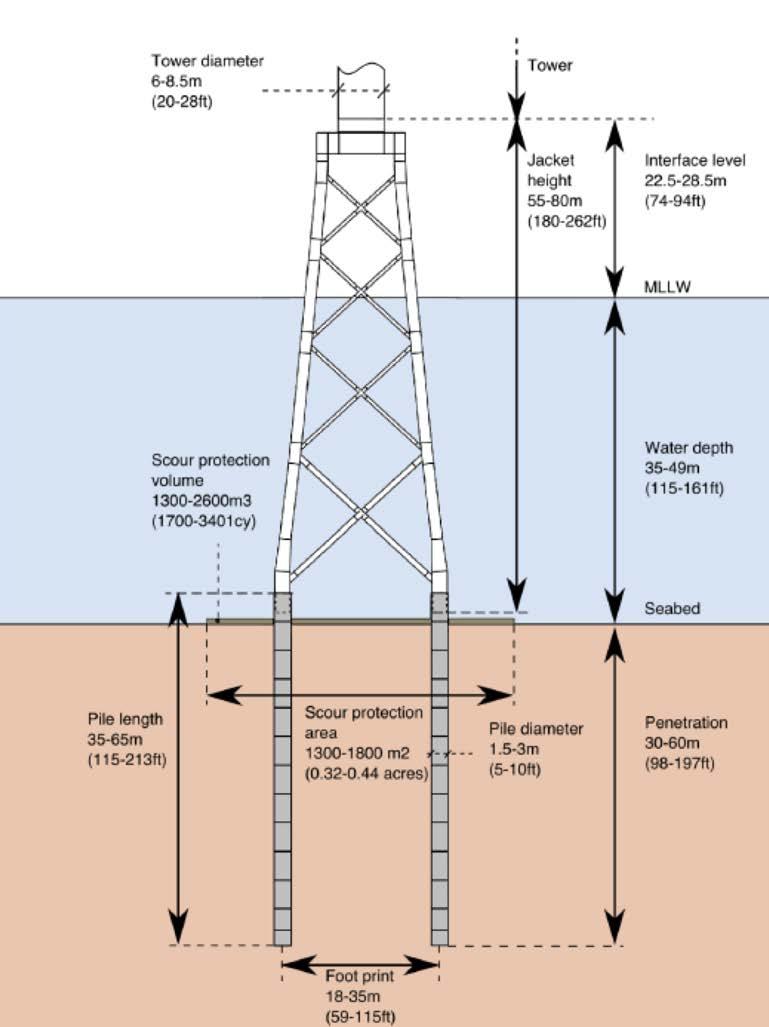
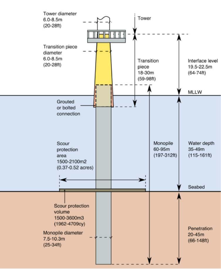
10 Foundations Monopiles Jackets March
 Protects the foundation from the removal of sediments near the base.")
11 Scour Protection Scour Stone placed around foundation Sized between 4-12 inches 3-6 feet high Scour protection radius 22-26m (72-85ft) Protects the foundation from the removal of sediments near the base. Dimensions 138ft - 170ft diameter March

12 Proposed Offshore Cable Corridors 2 possible corridors: Western & Eastern (only 1 will be used) Multiple options through Muskeget Channel August/September 2017 surveys, more in 2018 Routing Considerations include water depth, bathymetry, SSU areas, etc. Federal and state waters (Land Under the Ocean) Avoidance of mapped eelgrass habitat and core habitat for whales Minimization of impacts to hard/complex bottom areas Installation via jet-plow, plow, or mechanical trenching Target burial depth = 5 to 8 feet (1.5 to 2.5 m) 6-foot-wide swath affected by trenching Where sand waves are present, dredging will be used to achieve target burial depth Extensive outreach with local and regional fishermen and their representatives March


13 Site Data Extensive data is available on the site that has been collected by Vineyard Wind and others

14 Benthic Data Sampling and video available from: SMAST Coonamesset Farm Foundation NEFSC Vineyard Wind Cape Wind Side Scan Sonar & Bathymetry data throughout WDA and cable routes From COP: Impact area:.4% of Wind Development Area Data used to describe benthic resources (grab and image) in the Offshore Project Area came from a robust dataset and previous studies conducted within or near the Project Area between Data allowed for the characterization of abundance, diversity, community composition, and percent cover of benthic macrofauna and macroflora, both within the Project Area and surrounding area. Seafloor conditions within the WDA are very homogenous, dominated by fine sand and silt-sized sediments that become finer in deeper water. Overall, the simulations show that sediment is not transported far from the route and resettles rapidly due to the high proportion of coarse sand throughout the route. Mitigation: Siting of cables with sensitive habitat avoided as much as possible Utilize widely-spaced WTGs, so that the foundations (and associated scour protection) for the WTGs, along with the ESPs, inter-link cables, and inter-array cables, only occupy a minimal portion of the WDA, leaving a huge portion of the WDA undisturbed Conduct post-construction monitoring to document habitat disturbance and recovery. Where feasible and considered safe, use mid-line buoys on anchor lines to minimize impacts from anchor line sweep.
 Survey of the WDA Southern New England Industry- Based Yellowtail Flounder Survey Northeast Area Monitoring and Assessment Program From COP: Total biomass of fish is low across the")
15 Fisheries (biologic) Data Data resources: Northeast Fisheries Science Center multispecies bottom trawl surveys Massachusetts Department of Marine Fisheries Trawl surveys School of Marine Science and Techology (SMAST) Survey of the WDA Southern New England Industry- Based Yellowtail Flounder Survey Northeast Area Monitoring and Assessment Program From COP: Total biomass of fish is low across the Project Area, while species richness is relatively high. High species richness has been linked to increased ecosystem resilience or the ability of an ecosystem to recover from disturbance Many of the fish species found off the Massachusetts coast are important due to their value as commercial and/or recreational fisheries. Wind Development Area: Sediment dispersion modeling indicates that deposition of 0.2 mm or greater is centered around the cable trench and no deposition over five millimeters occurs. Cable Routes: The simulations show that sediment is not transported far from the route and resettles rapidly due to the high proportion of coarse sand throughout the route. The low total fish biomass and high species richness in the Project Area makes this location ideal for wind energy as it reduces impacts to individual organisms and targets an area which will likely be able to recover following any potential Project-related disturbances. Mitigation: To mitigate the potential impacts of injury to fish from pile driving, the Project will apply a soft-start procedure to the pile driving process, which delivers initial pile drives at a lower intensity, allowing fish to move out of the activity area before the full-power pile driving begins. Impacts to benthic organisms may be minimized through the use of mid-line buoys, if feasible and safe, and installation equipment that minimizes installation impacts, such as a jet plow. In nearshore areas where sensitive resources are located, horizontal directional drilling may be used to minimize impacts. Vineyard Wind is developing a framework for a pre- and post-construction fisheries monitoring program to measure the Project s effect on fisheries resources. Vineyard Wind is working with the Massachusetts School for Marine Science and Technology (SMAST) and local stakeholders to inform that effort and design the study.
 Vessel Trip Reports (2011-16) NE Fisheries Observer Program Database RI-SAMP MA Ocean Management Plan From COP: Commercial fishing revenue generated from within the MA WEA constitutes small")
16 Fisheries (socio) Data Data resources: Northeast Fisheries Science Center multispecies bottom trawl surveys Massachusetts Department of Marine Fisheries Trawl surveys VMS Trip & Dealer Reports ( ) Vessel Trip Reports ( ) NE Fisheries Observer Program Database RI-SAMP MA Ocean Management Plan From COP: Commercial fishing revenue generated from within the MA WEA constitutes small percentages of each fishery s total revenue Silver Hake was the most abundant landing of the small mesh species sourced from the MA WEA based on percentage of revenue. The annual average revenue of over $212 million for Lobster harvested between 2007 and 2012, approximately $300,000 per year was harvested from the MA WEA. Squid vessels are active throughout the WDA and along portions of the offshore export cable corridor through Nantucket Sound. Vessels targeting Monkfish are trawling portions of the WDA, though vessel density increases to the north of the WDA, in the areas on either side of Muskeget Channel. Mitigation: Siting of cables with sensitive habitat avoided as much as possible Burial of cables to address EMF concerns Conduct post-construction monitoring to document habitat disturbance and recovery. Grid pattern and transit corridors in wind turbine layout Utilizing suspended sediment minimizing installation techniques for cable installation

17 Existing Submarine Cables 2 Nantucket power cables each ~28 miles long 3 power cables to Martha s Vineyard Cable to Block Island from RI ~20 miles 2 cables between New Haven and Long Island Crosses Long Island Sound ~25 mi, ~15 years ago Sayreville NJ to Long Island 50 miles of submarine cable 15 mile underground on Long Island Many communications cables Decades old in many cases March
18 G:\Projects2\MA\MA\4903\MXD\COP\Wind_Development_Area_ mxd '0"W 70 40'0"W 70 30'0"W 70 20'0"W '0"W Active Consultation and Response '0"N 41 20'0"N Layout Grid pattern, transit corridors in consultation with fishermen Up to 1nm apart Active and live fisheries communication plan reviewed by regulators, fishermen and fishing organizations Fishery Liaison and Fishery Representatives Electronic chart thumb drives Feedback under review Loose turbine locations along 20 fathom contour line Consider larger rock size for scour protection (rip rap) Potential lobster habitat N/S & E/W corridor '0"N 41 0'0"N 40 50'0"N 40 Vineyard Wind Lease Area (OCS-A 0501) ")") ")").756 nm.918 nm March 2018 Map Coordinate System: NAD 1983 UTM Zone 19N 18 Service 70 50'0"W Layer Credits: 70 40'0"W 60 1 nm '0"W.918 nm 1 nm 1 nm LEGEND 30 Vineyard Wind Lease Area by OCS Block Number Wind Development Area for COP Review Bathymetric Contours 10m Interval WTG ") Electrical Service Platforms Scale 1:360,000 1 inch = 9 kilometers 70 20'0"W Kilometers Nautical Miles 70 10'0"W 41 10'0"N '0"N 40 50'0"N Basemap: NOAA *Please note, WTG and Offshore Substation yellow and green markers have been enlarged in this figure for visibility

19 Further Engagement with Fishing Community Agreement with SMAST for pre- and post-construction fishery studies SMAST will consult with fishing industry, regulators and academia - on what should be studied Data will be publically available Fishing Partnership & Support Services Partnership Vineyard Wind sponsorship of safety and survival trainings for fishermen Martha s Vineyard & New Bedford Fishery Liaison (FL) and Fishery Representatives (FR) Actively seeking permanent FL Looking to expand FR network Booth at the Massachusetts Lobstermen s Association trade show. 19
20 Contact Details Erik Peckar - erik@vineyardpower.com For the latest project information please visit March
Massachusetts on Offshore Wind and Fishing
 New England Fisheries Management Council: Massachusetts on Offshore Wind and Fishing October 4, 2017 Bill White Senior Director, Offshore Wind Sector Development Terminal Director, New Bedford Marine Commerce
New England Fishery Management Council
 FOR IMMEDIATE RELEASE May 16, 2018 PRESS CONTACT: Janice Plante (607) 592-4817, jplante@nefmc.org Scallop RSA Program: Council and Northeast Fisheries Science Center Announce 15 Awards Selected for 2018-2019
Overview of Southern New England Wind Energy Areas: MA, RIMA, NY WEAs
 NOAA NOAA FISHERIES SERVICE Science, Service, Stewardship Overview of Southern New England Wind Energy Areas: MA, RIMA, NY WEAs Vincent G. Guida and the BOEM Benthic Habitat Team US DOC, NOAA, NMFS, NEFSC
Skate Amendment 3 Scoping Hearings Staff summary of comments May 22-24, 2007
 Skate Amendment 3 Scoping Hearings Staff summary of comments May 22-24, 2007 The hearings were sparsely attended, the highest turnout was in Narragansett, RI by a processor and several fishermen that target
MARINERS BRIEFING NEW ENGLAND SURVEY ACTIVITY CONTACT. RODNEY AVILA FISHERIES LIAISON Phone:
 NEW ENGLAND SURVEY ACTIVITY MARINERS BRIEFING DATE OF NOTICE: 20 NOVEMBER 2018 NOTICE NO. 013 OVERVIEW ABOUT THE WIND FARMS These briefings are intended to update mariners on marine operations for the
COMMERCIAL & RECREATIONAL FISHING
 COMMERCIAL & RECREATIONAL FISHING Commercial fishing in New England has a long and storied history. Its importance culturally and economically has lasted hundreds of years, becoming a part of many tales
Eastern Shore Islands Area of Interest Community Newsletter
 Eastern Shore Islands Area of Interest Community Newsletter Fall 2018 1ỊNTRODUCTION In addition to information on our Fisheries and Oceans Canada (DFO) website, we have now created a seasonal, community
June NMFS Address 11, 2014 (NOAA): Council Address. Dover, DE 19901
: Council Address. Dover, DE 19901") BLACK SEA BASS SEASON OPENING FRAMEWORK ADJUSTMENT Discussion Document and Background June 2014 Mid-Atlantic Fishery Management Council in cooperation with the National Marine Fisheriess Service (NMFS)
BLACK SEA BASS SEASON OPENING FRAMEWORK ADJUSTMENT Discussion Document and Background June 2014 Mid-Atlantic Fishery Management Council in cooperation with the National Marine Fisheriess Service (NMFS)
Fishing for Energy Fund Project Summaries
 Fishing for Energy Fund Project Summaries Removal of 'ghost' blue crab pots from known hotspots in VA, College of William and Mary, Virginia Institute of Marine Science Virginia Fishing for Energy Fund
Coastal and marine recreation in New England is ingrained in the region s economic and
 RECREATION Coastal and marine recreation in New England is ingrained in the region s economic and social fabric. Recreation on the ocean and coast includes many of New Englanders most time-honored and
Notice of operations at London Array Offshore Wind Farm
 London Array Ltd. Construction Management Port of Ramsgate Military Road Ramsgate CT11 9LG www.londonarray.com Notice of operations at London Array Offshore Wind Farm Date of Notice: June 19th 2011 Notice
Charlottetown Marine Terminal Pipeline Decommissioning Project Description
 Charlottetown Marine Terminal Pipeline Decommissioning Project Description 69 Marr Road Unit B Rothesay NB, E2E 3J9 Tel (506) 848-1920 Fax (506) 848-1929 Charlottetown Marine Terminal Pipeline Decommissioning
COMMENT RESPONSE MATRIX Revised Micro-siting Plan for the OOI Pioneer Array PUBLIC COMMENT PERIOD: April 12 May 27, 2011
 COMMENT RESPONSE MATRIX Revised Micro-siting Plan for the OOI Pioneer Array PUBLIC COMMENT PERIOD: April 12 May 27, 2011 William J. Mulvey F/V Stormy Elizabeth Port of Galilee Point Judith, RI 20 May I
Spatial/Seasonal overlap between the midwater trawl herring fishery and predator focused user groups
 Spatial/Seasonal overlap between the midwater trawl herring fishery and predator focused user groups A working paper submitted to the Herring PDT Micah Dean July 26, 2017 Introduction A goal of Amendment
Framework 35 Northeast Multispecies FMP
 and 2. In addition to small mesh multispecies, vessels target herring in Small Mesh Areas 1 and 2 and therefore use mesh smaller than 2.5-inches in the codend. The net specifications listed in Section
RIVER HERRING PROGRAM
 RIVER HERRING PROGRAM River Herring NORTHEAST REGION Assessing Sustainability of River Herring Runs Department of Marine Resources Award Amount... $400,483 Grantee Match... $415,340 Total Project... $815,823
Burbo Bank Extension Offshore Wind Farm
 Burbo Bank Extension Offshore Wind Farm Developer: DONG energy Site Size: Covering an area of approximately 40 km² Site Location: The proposed project would be located west of the operational Burbo Bank
MARINERS BRIEFING NEW ENGLAND SURVEY ACTIVITY CONTACT. RODNEY AVILA FISHERIES LIAISON Phone:
 NEW ENGLAND SURVEY ACTIVITY MARINERS BRIEFING DATE OF NOTICE: 16 OCTOBER 2018 NOTICE NO. 003 OVERVIEW ABOUT THE WIND FARMS These briefings are intended to update mariners on marine operations for the Revolution
Atlantic States Marine Fisheries Commission
 Atlantic States Marine Fisheries Commission ADDENDUM XXVI TO THE SUMMER FLOUNDER, SCUP, BLACK SEA BASS FISHERY MANAGEMENT PLAN Summer Flounder Recreational Management in 2015 ASMFC Vision: Sustainably
Sustainable Fisheries for Future Generations The Fisheries White Paper
 Sustainable Fisheries for Future Generations The Fisheries White Paper Key messages The Fisheries White Paper Sustainable Fisheries for Future Generations charts the course for a sustainable and profitable
Marine Environment Plans
 Marine Environment Plans 1 Marine Sediment Management Plan 2 Marine Sediment Management Plan: Overview What The Marine Sediment Management Plan (MSMP) describes management of marine sediment disturbed
Report of the Committee to Study Offshore Wind Energy and the Development of Other Ocean Power Technology
 Report of the Committee to Study Offshore Wind Energy and the Development of Other Ocean Power Technology HB 1312 (Chapter 180, Laws of 2014) Membership Representative Robert Cushing, Chair Representative
COMMONWEALTH OF MASSACHUSETTS ENERGY FACILITIES SITING BOARD DEPARTMENT OF PUBLIC UTILITIES NOTICE OF ADJUDICATION NOTICE OF PUBLIC COMMENT HEARING
 COMMONWEALTH OF MASSACHUSETTS ENERGY FACILITIES SITING BOARD DEPARTMENT OF PUBLIC UTILITIES NOTICE OF ADJUDICATION NOTICE OF PUBLIC COMMENT HEARING EFSB 17-05/D.P.U. 18-18/18-19 Vineyard Wind LLC Notice
Virginia Offshore Wind Advanced Technology Demonstration Program and Test Pad Sites
 Virginia Offshore Wind Advanced Technology Demonstration Program and Test Pad Sites Briefing to Virginia Offshore Wind Development Authority Richmond, VA 08 December 2011 George Hagerman VCERC Director
US Offshore Wind An Industry in the Making
 US Offshore Wind An Industry in the Making November 14, 2017 Alla Weinstein Founder, Trident Winds LLC Trident Winds Page 2 Agenda Offshore Wind Development in the US Governing bodies Resource potential
Fresh, All Natural& Sustainable. January 2015
 Fresh, All Natural& Sustainable January 2015 Sourcing Sustainable Seafood Family Owned and Focused for Four Generations 2 Perishability Why is fish so much more perishable than meat? Harvesting - most
Commercial Fishing Transit Lanes and Offshore Wind Energy in the New York Bight Background, Process and Fishermen Survey Instructions
 Background Commercial Fishing Transit Lanes and Offshore Wind Energy in the New York Bight Background, Process and Fishermen Survey Instructions With the increase in demand for offshore wind energy development
ESTABLISHING AN OFFSHORE MUSSEL FARM IN FEDERAL WATERS IN THE GULF OF MAINE
 ESTABLISHING AN OFFSHORE MUSSEL FARM IN FEDERAL WATERS IN THE GULF OF MAINE Ted Maney, Mark Fregeau Northeastern Massachusetts Aquaculture Center (NEMAC) Cat Cove Marine Laboratory, Department of Biology
MAW01 Cable Risk Assessment Hazard Workshop
 MAW01 Cable Risk Assessment Hazard Workshop Anatec 8 th -9 th November 2018 Introduction Ørsted are carrying out a Cable Burial Risk Assessment (CBRA) for the export and inter-array cables associated with
Office of Science & Technology
 NOAA Fisheries Highlights of FEUS 2015 Highlights from the Annual Report Fisheries Economics of the United States, 2015 Office of Science & Technology Fisheries and the Economy U.S. fisheries provide jobs,
Habitat Omnibus Amendment DEIS draft sections relative to recreational fishery DRAFT. Omnibus Essential Fish Habitat Amendment 2
 DRAFT Omnibus Essential Fish Habitat Amendment 2 Amendment 14 to the Northeast Multispecies FMP Amendment 14 to the Atlantic Sea Scallop FMP Amendment 4 to the Monkfish FMP Amendment 3 to the Atlantic
COMPETING APPROACHES TO POLICY CHANGE IN FISHERIES: THE REGIONAL MANAGEMENT COUNCIL AND STAKEHOLDER ORGANIZATIONS
 COMPETING APPROACHES TO POLICY CHANGE IN FISHERIES: THE REGIONAL MANAGEMENT COUNCIL AND STAKEHOLDER ORGANIZATIONS M. Hall-Arber MITSG 13-31 Sea Grant College Program Massachusetts Institute of Technology
Marine Renewables Industry Association. Marine Renewables Industry: Requirements for Oceanographic Measurements, Data Processing and Modelling
 Marine Renewables Industry Association Marine Renewables Industry: Requirements for Oceanographic Measurements, Data Processing and Modelling October 2009 Table of Contents 1. Introduction... 1 2. Measurements
Herring River Restoration Project Chronology of Key Events
 August 2005 Cape Cod National Seashore (CCNS) and Town of Wellfleet Board of Selectmen entered into an MOU (MOU I) to review and summarize the scientific and technical information on the Herring River
Project Context. Legend. Jacky. Project Boundary. Fixed Platform/Structure Existing Demonstrator Turbine. Scottish Territorial Waters Boundary
 3 0'0"W Legend C A Jacky B Project Boundary Fixed Platform/Structure Existing Demonstrator Turbine Scottish Territorial Waters Boundary 58 0'0"N British Crown and SeaZone Solutions Limited. All rights
Fish Habitat and the Mid-Atlantic Fishery Management Council
 Fish Habitat and the Mid-Atlantic Fishery Management Council Jessica Coakley June 19, 2017 Today Council s habitat interests (evolution) Essential Fish Habitat Redo progress Mid-Atlantic fish habitat assessment
OFFSHORE WIND: A CRASH COURSE
 OFFSHORE WIND: A CRASH COURSE OFFSHORE WIND: DEFINED OFFSHORE WIND: Construction of wind farms in bodies of water to generate electricity from wind. Unlike the typical usage of the term offshore in the
Offshore Wind Vessels. Steven Kopits Douglas-Westwood LLC
 Offshore Wind Vessels Steven Kopits Douglas-Westwood LLC Offshore Wind: Removing Market Barriers DOE Webinar July 25, 2012 1 www.dw-1.com Our business History and Office Locations Established 1990 Aberdeen,
SUSTAINABLE SEAFOOD MATCHING
 RAINY DAY KITS FOR ENVIRONMENTAL EDUCATION This Lesson Created in Partnership with: SUSTAINABLE SEAFOOD MATCHING Overview Students play a matching game to learn about different fish species and whether
Northeast Area Monitoring and Assessment Program (NEAMAP)
") Northeast Area Monitoring and Assessment Program (NEAMAP) Photo credit: MADMF Nicole Lengyel Costa (RI DEM, Chair) ISFMP Policy Board October 25, 2018 Outline Overview What is NEAMAP? Data Uses Surveys
Northeast Area Monitoring and Assessment Program (NEAMAP) Photo credit: MADMF Nicole Lengyel Costa (RI DEM, Chair) ISFMP Policy Board October 25, 2018 Outline Overview What is NEAMAP? Data Uses Surveys
Update on Columbia Basin Partnership Task Force
 Update on Columbia Basin Partnership Task Force June 25, 2018 Marla Harrison Port of Portland M A F A C C B P T A S K F O R C E Overview of Today s Presentation: Background on Columbia Basin & why we need
World Shipping Council. Bureau of Ocean Energy Management U.S. Department of the Interior
 Comments of the World Shipping Council Submitted to the Bureau of Ocean Energy Management U.S. Department of the Interior In the matters of Commercial Leasing for Wind Power Development on the Outer Continental
17. High Resolution Application of the Technology Development Index (TDI) in State Waters. South of Block Island
 in State Waters. South of Block Island") 17. High Resolution Application of the Technology Development Index (TDI) in State Waters South of Block Island for the Rhode Island Ocean Special Area Management Plan 2010 by Annette Grilli 1, Malcolm
17. High Resolution Application of the Technology Development Index (TDI) in State Waters South of Block Island for the Rhode Island Ocean Special Area Management Plan 2010 by Annette Grilli 1, Malcolm
World Shipping Council. Bureau of Ocean Energy Management
 Comments of the World Shipping Council Submitted to the Bureau of Ocean Energy Management In the matter of Potential Commercial Leasing for Wind Power on the Outer Continental Shelf (OCS) Offshore New
Recap June Council meeting
 Michelle Bachman NEFMC Staff, Habitat PDT Chair NEFMC Habitat Committee October 4, 2017 New Bedford, MA Recap June Council meeting The Council adopted the following as final alternatives: Mt. Desert Rock
Deep-sea coral protection zones and management measures
 Deep-sea coral protection zones and management measures This presentation was originally provided to the New England Fishery Management Council on April 26, 2012 in Mystic, CT. Recent updates related to
1.0 Background. 2.0 Methods II-3
 Appendix II Summary of Scallop PDT Analyses used for Developing and Assessing the Potential Impacts of Alternatives Designed to Allow Limited Access Vessels Declare out of the Fishery on Return to Port
Atlantic States Marine Fisheries Commission
 Atlantic States Marine Fisheries Commission DRAFT ADDENDUM XXIV TO THE SUMMER FLOUNDER, SCUP AND BLACK SEA BASS FISHERY MANAGEMENT PLAN FOR PUBLIC COMMENT Summer Flounder Recreational Management in 2013
SUMMARY Pacific Fishery Management Council Preferred Alternative Groundfish Essential Fish Habitat Final Environmental Impact Statement
 SUMMARY Pacific Fishery Management Council Preferred Alternative Groundfish Essential Fish Habitat Final Environmental Impact Statement Introduction This document summarizes the Pacific Fishery Management
Fisheries of the Caribbean, Gulf of Mexico, and South Atlantic; Reef Fish Fishery of Puerto Rico and the U.S. Virgin Islands;
 This document is scheduled to be published in the Federal Register on 06/11/2018 and available online at https://federalregister.gov/d/2018-12420, and on FDsys.gov BILLING CODE: 3510-22-P DEPARTMENT OF
Cook Inlet pipeline crossing is about making the best choices
 Cook Inlet pipeline crossing is about making the best choices By Larry Persily lpersily@kpb.us Aug. 26, 2015 (This update, provided by the Kenai Peninsula Borough mayor s office, is part of an ongoing
Scottish Hydro Electric Power Distribution Operation, Inspection, Maintenance and Decommissioning Strategy Bute Cumbrae Cable Replacement
 SHEPD Section ID 154 Scottish Hydro Electric Power Distribution Operation, Inspection, Maintenance and Decommissioning Strategy Bute Cumbrae Cable Replacement Contents Definitions and Abbreviations...
SHELLFISH AQUACULTURE LICENSE APPLICATION
 .... 10/07/2009 Coonamessett Farm Shellfish Aquaculture License Application SHELLFISH AQUACULTURE LICENSE APPLICATION NAME OF APPLICANT: Matthew Weeks, Eric Matzen, and Ron Smolowitz. of Coonamessett Farm,
Management of Shellfish Aquaculture and Propagation in Massachusetts Waters
 Management of Shellfish Aquaculture and Propagation in Massachusetts Waters Chris Schillaci Aquaculture and Propagation Project Massachusetts Division of Marine Fisheries Shellfish In Massachusetts Massachusetts
Fisheries Resource Access Mapping Project (FishRAMP):
:") Fisheries Resource Access Mapping Project (FishRAMP): The Co. Down Wind Resource Zone Contributors: Matthew Service and Laurence Rooney (AFBI); Rod Cappell (Poseidon); Lynn Gilmore (Seafish) and the NI
Fisheries Resource Access Mapping Project (FishRAMP): The Co. Down Wind Resource Zone Contributors: Matthew Service and Laurence Rooney (AFBI); Rod Cappell (Poseidon); Lynn Gilmore (Seafish) and the NI
Use of Conservation Moorings as a Component of Eelgrass Restoration in two Massachusetts Harbors
 Use of Conservation Moorings as a Component of Eelgrass Restoration in two Massachusetts Harbors Massachusetts Bays Program Division of Marine Fisheries Jay Baker, Tay Evans, Mass Bays Program MarineFisheries
Michelle Bachman Habitat Plan Development Team Chair. Council Meeting April 21, 2016 Mystic, Connecticut
 Michelle Bachman Habitat Plan Development Team Chair Council Meeting April 21, 2016 Mystic, Connecticut Outline Coral groups found in the New England region: Problem statement, objectives, purpose & need
DECISION DOCUMENT. Framework Adjustment 53. Council Meeting November 17-20, for. to the Northeast Multispecies. Fishery Management Plan (FMP)
") DECISION DOCUMENT for Framework Adjustment 53 to the Northeast Multispecies Fishery Management Plan (FMP) Council Meeting November 17-20, 2014 Framework 53 Decision Document 1 November 2014 NEFMC Meeting
DECISION DOCUMENT for Framework Adjustment 53 to the Northeast Multispecies Fishery Management Plan (FMP) Council Meeting November 17-20, 2014 Framework 53 Decision Document 1 November 2014 NEFMC Meeting
RESEARCH Massachusetts Recreational Boater Survey. Project Summary
 Coastal and Marine Spatial Planning RESEARCH Project Summary 2010 Massachusetts Recreational Boater Survey The 2010 Massachusetts Recreational Boater Survey gathered spatial and economic data relating
DRAFT VMS Corridor Analysis updated for November meetings
 DRAFT VMS Corridor Analysis updated for November meetings Alternatives Currently DAS are allocated to the limited access fishery based on an estimate of projected catch in open areas divided by an estimate
Texas Shrimp Action Plan
 Texas Shrimp Action Plan Updated April 2017 Prepared by: Audubon Nature Institute Gulf United for Lasting Fisheries (G.U.L.F.) Laura Picariello - Technical Programs Manager Ashford Rosenberg - Outreach
New Bedford Fishing Heritage Center
 Lesson Title: Duration: 1-50 minute class period Overview: Students practice geography and math skills while learning about their relevancy to commercial fishing such as pinpointing locations, locating
New York District Briefing Template
 New York District Briefing Template New York District US Army Corps of Engineers Insert Text Here Dredging Windows Workshop November 30, 2011 Aquatic Biological Survey Winter Flounder Jenine Gallo & Kate
New England Fishery Management Council
 New England Fishery Management Council 50 WATER STREET NEWBURYPORT, MASSACHUSETTS 01950 PHONE 978 465 0492 FAX 978 465 3116 E.F. Terry Stockwell III, Chairman Thomas A. Nies, Executive Director Statement
2001 REVIEW OF THE ATLANTIC STATES MARINE FISHERIES COMMISSION FISHERY MANAGEMENT PLAN FOR WEAKFISH (Cynoscion regalis)
") 2001 REVIEW OF THE ATLANTIC STATES MARINE FISHERIES COMMISSION FISHERY MANAGEMENT PLAN FOR WEAKFISH (Cynoscion regalis) Plan Review Team Rick Cole, DE Louis Daniel, NC Charles Lesser, DE Rob O Reilly,
2001 REVIEW OF THE ATLANTIC STATES MARINE FISHERIES COMMISSION FISHERY MANAGEMENT PLAN FOR WEAKFISH (Cynoscion regalis) Plan Review Team Rick Cole, DE Louis Daniel, NC Charles Lesser, DE Rob O Reilly,
VIDEO TRANSCRIPT. A Proposal to Expand the Flower Garden Banks National Marine Sanctuary An interview with Sanctuary Superintendent, G.P.
 VIDEO TRANSCRIPT A Proposal to Expand the Flower Garden Banks National Marine Sanctuary An interview with Sanctuary Superintendent, G.P. Schmahl (Opening scene of Flower Garden Banks National Marine Sanctuary
Public Consultation Document
 Environment and Climate Change Canada Public Consultation Document From February 22 to March 21, 2018 Canadian Wildlife Service PROPOSED SERVICE FEES FOR THE MIGRATORY GAME BIRD HUNTING PERMIT AND CANADIAN
Andrew A. Rosenberg University of New Hampshire, USA
 by Andrew A. Rosenberg University of New Hampshire, USA Principles Recovery of overexploited stocks even after decades of overfishing is possible if fishing pressure and habitat impacts can be reduced
2000 REVIEW OF THE ATLANTIC STATES MARINE FISHERIES COMMISSION FISHERY MANAGEMENT PLAN FOR BLUEFISH (Pomatomus saltatrix)
") 2000 REVIEW OF THE ATLANTIC STATES MARINE FISHERIES COMMISSION FISHERY MANAGEMENT PLAN FOR BLUEFISH (Pomatomus saltatrix) Prepared by: Robert Beal (ASMFC) Bluefish Plan Review Team Elliot Atstupenas (USFWS)
2000 REVIEW OF THE ATLANTIC STATES MARINE FISHERIES COMMISSION FISHERY MANAGEMENT PLAN FOR BLUEFISH (Pomatomus saltatrix) Prepared by: Robert Beal (ASMFC) Bluefish Plan Review Team Elliot Atstupenas (USFWS)
Advancing the Gulf of Mexico Shellfish Initiative (GoMexSI)
") Advancing the Gulf of Mexico Shellfish Initiative (GoMexSI) Gulf States Marine Fisheries Commission Mississippi-Alabama Sea Grant Consortium Gulf States Marine Fisheries Commission Annual Meeting March
Advancing the Gulf of Mexico Shellfish Initiative (GoMexSI) Gulf States Marine Fisheries Commission Mississippi-Alabama Sea Grant Consortium Gulf States Marine Fisheries Commission Annual Meeting March
Sustainable Seafood Matching
 Sustainable Seafood Matching Overview: Students play a matching game to learn about different fish species and whether they are sustainably harvested. Ocean Literacy Principles: 5. The ocean supports a
The Array cable installation vessel Stemat 82 and Assist tugs Lydia D and Claudia B are expected to commence installing array cables during week 5.
 London Array Ltd. Construction Management Port of Ramsgate Military Road Ramsgate CT11 9LG www.londonarray.com Notice of operations at London Array Offshore Wind Farm Date of Notice: 29 th January 2012
APPLICANT: Pacific Northwest National Laboratory Attention: Mr. Charles Brandt 1529 West Sequim Bay Road Sequim, Washington 98382
 US Army Corps of Engineers Seattle District Joint Public Notice Application for a Department of the Army Permit and a Washington Department of Ecology Water Quality Certification and/or Coastal Zone Management
Rockhopper/Chain Sweep Relative Catch Efficiency Analysis
 Rockhopper/Chain Sweep Relative Catch Efficiency Analysis Northeast Fisheries Science Center Michael Martin Ecosystems Surveys Branch Northeast Fisheries Science Center Woods Hole, MA 5/31/2016 Study Motivation:
Offshore grid NL. Hollandse Kust (noord) & Hollandse Kust (west Alpha) General project introduction. 14 september 2018
 & Hollandse Kust (west Alpha) General project introduction. 14 september 2018") 1 Offshore grid NL Hollandse Kust (noord) & Hollandse Kust (west Alpha) General project introduction 14 september 2018 Offshore grid developer Four wind areas of 700 MW Planning of the Energy Agreement
1 Offshore grid NL Hollandse Kust (noord) & Hollandse Kust (west Alpha) General project introduction 14 september 2018 Offshore grid developer Four wind areas of 700 MW Planning of the Energy Agreement
Protection for Vessels Engaged in Servicing Submarine Cables
 Protection for Vessels Engaged in Servicing Submarine Cables Proposed Amendments to COLREGS Brief to Navigation Safety Advisory Council November 28, 2012 Tampa, FL Dr. Ronald J. Rapp TE SubCom and Representing
2002 REVIEW OF THE ATLANTIC STATES MARINE FISHERIES COMMISSION FISHERY MANAGEMENT PLAN FOR BLUEFISH (Pomatomus saltatrix)
") 2002 REVIEW OF THE ATLANTIC STATES MARINE FISHERIES COMMISSION FISHERY MANAGEMENT PLAN FOR BLUEFISH (Pomatomus saltatrix) Prepared by: Michael Lewis (ASMFC) Bluefish Plan Review Team Elliot Atstupenas
2002 REVIEW OF THE ATLANTIC STATES MARINE FISHERIES COMMISSION FISHERY MANAGEMENT PLAN FOR BLUEFISH (Pomatomus saltatrix) Prepared by: Michael Lewis (ASMFC) Bluefish Plan Review Team Elliot Atstupenas
WINDSPEED. Resultat og erfaringer med MSP. 26. september 2013 Hans Chr. Sørensen, SPOK ApS. Contract number: EIE/07/759/S
 WINDSPEED Resultat og erfaringer med MSP 26. september 2013 Hans Chr. Sørensen, SPOK ApS Contract number: EIE/07/759/S12.499460 www.windspeed.eu Background H C Sørensen Business and university background
Safety Zone Application Construction Phase Sheringham Shoal Wind Farm Project
 Safety Zone Application Construction Phase Sheringham Shoal Wind Farm Project Classification: Internal Status: Draft Expiry date: 2009-12-18 Page 1 of 19 Title: Safety Zone Application Sheringham Shoal
THE ORDEAL OF PERMITTING OFFSHORE MUSSEL CULTURE SITES IN MASSACHUSETTS COASTAL WATERS -ANOTHER REASON WHY WE IMPORT 80% OF OUR SEAFOOD
 THE ORDEAL OF PERMITTING OFFSHORE MUSSEL CULTURE SITES IN MASSACHUSETTS COASTAL WATERS -ANOTHER REASON WHY WE IMPORT 80% OF OUR SEAFOOD Richard C. Karney, Martha s Vineyard Shellfish Group Scott Lindell,
Evolution of Deepwater Coral Protection in the Southeast U.S
 Evolution of Deepwater Coral Protection in the Southeast U.S Tina Udouj, Florida Fish and Wildlife Conservation Commission Roger Pugliese, South Atlantic Fishery Management Council Overview Deepwater Corals
Project Title: Fisheries Content Provider Gulf Fisheries Info (FINFO) - #127. Gulf & South Atlantic Fisheries Foundation, Inc.
 - #127. Gulf & South Atlantic Fisheries Foundation, Inc.") Project Title: Fisheries Content Provider Gulf Fisheries Info (FINFO) - #127 Grantee: Gulf & South Atlantic Fisheries Foundation, Inc. Amount of Award: $19,000 Award Period: October 3, 2013 - March 31,
Project Title: Fisheries Content Provider Gulf Fisheries Info (FINFO) - #127 Grantee: Gulf & South Atlantic Fisheries Foundation, Inc. Amount of Award: $19,000 Award Period: October 3, 2013 - March 31,
Cape Cod Water Resources Restoration Project! Presented By:! Donald Liptack! USDA/NRCS District Conservationist!
 Cape Cod Water Resources Restoration Project! Presented By:! Donald Liptack! USDA/NRCS District Conservationist! CCWRRP Locally-led Coastal Habitat Restoration to Improve Water Quality on Cape Cod" Cape
Atlantic States Marine Fisheries Commission
 Atlantic States Marine Fisheries Commission ADDENDUM XXVIII TO THE SUMMER FLOUNDER, SCUP, BLACK SEA BASS FISHERY MANAGEMENT PLAN Summer Flounder Recreational Management in 2017 Approved February 2, 2017
World Shipping Council. Bureau of Ocean Energy Management Department of the Interior
 Comments of the World Shipping Council Submitted to the Bureau of Ocean Energy Management Department of the Interior In the matter of Commercial Leasing for Wind Power Development on the Outer Continental
East Central Florida Region Matt Culver, Brevard County James Gray, Indian River County Jim Oppenbourn, St. Lucie County Kathy Fitzpatrick, Martin
 James Gray, Indian River County January 14, 2015 East Central Florida Region Matt Culver, Brevard County James Gray, Indian River County Jim Oppenbourn, St. Lucie County Kathy Fitzpatrick, Martin County
Fleet diversity and ownership concentration. Eric Thunberg, Chad Demarest, Andrew Kitts Social Science Branch, NEFSC June 12, 2013
 Fleet diversity and ownership concentration Eric Thunberg, Chad Demarest, Andrew Kitts Social Science Branch, NEFSC June 12, 2013 An ecological approach to measuring fleet diversity: the diversity of fishing
The Marking of Offshore Wind Farms. Provide guidance for a response to IALA. M-4 B445.8 &.9 (& B for on-shore wind farms).
.") CSPCWG2-INF 2 The Marking of Offshore Wind Farms Submitted by: Executive Summary: Chairman (from IALA via IHB) Provide guidance for a response to IALA. Does the Related Project reference have any impact
CSPCWG2-INF 2 The Marking of Offshore Wind Farms Submitted by: Executive Summary: Chairman (from IALA via IHB) Provide guidance for a response to IALA. Does the Related Project reference have any impact
HOW CAN WE HELP TO SUSTAIN AQUATIC BIODIVERSITY?
 HOW CAN WE HELP TO SUSTAIN AQUATIC BIODIVERSITY? Marine Biodiversity The most marine biodiversity is found: 1. Coral reefs 2. Estuaries 3. Deep-ocean floor Biodiversity is higher near coasts than in the
Authors: Luiz Barbieri and Martha Bademan
 This is a review and discussion of a proposal to develop and implement a Gulf Offshore Recreational Fishing Permit in support of more accurate, precise, and timely catch and effort estimates for offshore
Atlantic States Marine Fisheries Commission
 Atlantic States Marine Fisheries Commission DRAFT ADDENDUM XXVI TO THE SUMMER FLOUNDER, SCUP, BLACK SEA BASS FISHERY MANAGEMENT PLAN FOR PUBLIC COMMENT Summer Flounder Recreational Management in 2015 ASMFC
APPENDIX A. F107 & 380 Lines OYSTER RIVER DURHAM, NH
 APPENDIX A F107 & 380 Lines OYSTER RIVER DURHAM, NH 1. The design and proposed construction of this crossing is shown on the attached PSNH Transmission Business Drawing entitled DOUBLE CKT F107 & 380 BETWEEN
Summer Flounder Fishery Information Document
 Summer Flounder Fishery Information Document June 2016 This document provides a brief overview of the biology, stock condition, management system, and fishery performance for summer flounder with an emphasis
JAN Approved Measures. Dr. John Quinn Chairman New England Fishery Management Council 50 Water Street, Mill 2 Newburyport, MA 01950
 UNITED STATES DEPARTMENT OF COMMERCE National Oceanic and Atmospheric Administration NATIONAL MARINE FISHERIES SERVICE GREATER ATLANTIC REGIONAL FISHERIES OFFICE 55 Great Republic Drive Gloucester, MA
US OFFSHORE WIND MARKET OVERVIEW NOVEMBER 2018/
 US OFFSHORE WIND MARKET OVERVIEW BUSINESS NETWORK FOR OFFSHORE WIND 1 2 3 Not-for-Profit Focus on developing US Offshore Wind and its supply chain Provide: information education introductions MEMBER DRIVEN
Utilizing Vessel Based Mobile LiDAR & Bathymetry Survey Techniques for Survey of Four Southern California Breakwaters
 Utilizing Vessel Based Mobile LiDAR & Bathymetry Survey Techniques for Survey of Four Southern California Breakwaters Western Dredging Association: Pacific Chapter September 2012 Insert: Pipe Location
MOANA NEW ZEALAND & SANFORD MĀUI DOLPHIN PROTECTION PLAN
 MOANA NEW ZEALAND & SANFORD MĀUI DOLPHIN PROTECTION PLAN The Māui dolphin or popoto (Cephalorhynchus hectori maui) is the world's rarest and smallest marine dolphin. They are only found off the west coast
New England Fishery Management Council MEMORANDUM
 New England Fishery Management Council 50 WATER STREET NEWBURYPORT, MASSACHUSETTS 01950 PHONE 978 465 0492 FAX 978 465 3116 John Pappalardo, Chairman Paul J. Howard, Executive Director MEMORANDUM DATE:
Sharing the Seas Safe Boating for Sailors and Whales. Information provided by Sharing the Seas for the 2017 Vineyard Cup
 Sharing the Seas Safe Boating for Sailors and Whales BEWARE: Whale Crossing Did you know that collisions with vessels is one of the leading causes of death among whales such as the endangered North Atlantic
DRAFT. October 17, 2014 File No Mr. Brendhan Zubricki Town Administrator Essex Town Hall 30 Martin Street Essex, MA.
 GZA GeoEnvironmental, Inc. Engineers and Scientists October 17, 2014 File No. 18.0171857.00 Mr. Brendhan Zubricki Town Administrator Essex Town Hall 30 Martin Street Essex, MA. 01929 DRAFT Re: Essex River