MONTANA BACKCOUNTRY HUNTERS AND ANGLERS. Recommendations for Montana s Rivers and Streams
|
|
|
- Hollie Maxwell
- 5 years ago
- Views:
Transcription
1 Recommendations for Montana s Rivers and Streams Prepared for Montana Backcountry Hunters and Anglers March
2 Table of Contents I. Introduction to the Quiet Waters Initiative... 4 II. Overview of Current Restrictions and Recommendations... 4 III. Recommendations for Off-Highway Vehicle Regulation... 5 IV. Recommendations by Watershed Area... 7 Clark Fork River watershed... 7 Upper Flathead River watershed:... 8 Upper Missouri River Three Forks to Pelican Point FAS Missouri River Pelican Point FAS to Upper Missouri River Breaks National Monument Upper Yellowstone River watershed IV. Further Considerations A Note on Horsepower Restrictions Seasonal Restrictions Explained User Safety Fish and Wildlife
3 Definitions This document references several vehicle classes. For sake of clarity and consistency these definitions are taken directly from those provided in the Montana State Code. Definitions are provided below with the relevant sections of the state code cited for reference. Off-highway vehicle (OHV): An off-highway vehicle means any vehicle used for recreation or cross-country travel over land or water including motorcycles, quadricycles, dune buggies, amphibious vehicles, air cushion vehicles, and any other vehicles that are not powered by muscle or wind. This definition does not include vehicles primarily designed for use in, over, or on the water, snowmobiles, and vehicles issued a certificate of title and registered in Montana, unless the vehicle is used for offroad recreation on public lands. The full statutory definition for off-highway vehicles can be found in Motorized watercraft Throughout the following document the term motorized watercraft is used to refer to motorboats as well as any vehicle propelled by an engine, jet-drive, or motor including personal watercraft or pontoons. Given the evolving nature of these craft this document uses the catchall term motorized watercraft instead of motorboats. When referring to these types of vehicles, we are reference the following definition: (7) (a) "Motorboat" means a vessel, including a personal watercraft or pontoon, propelled by any machinery, motor, or engine of any description, whether or not the machinery, motor, or engine is the principal source of propulsion. The term includes boats temporarily equipped with detachable motors or engines. (b) The term does not include a vessel that has a valid marine document issued by the U.S. coast guard or any successor federal agency. Personal watercraft: These vehicles are a sub-set of the aforementioned motorized watercraft and are included in the statutory definitions for motorboats. When used in this document, the term personal watercraft does not refer to canoes, kayaks, rafts, or other vessels that are strictly self-powered or used to float on a stream or river. Instead it refers to those motorized watercraft that fit the definition given in full below. This refers to vehicles including but not limited to jet-skis, wave runners, motorized kayaks, and motorized canoes (13) "Personal watercraft" means a vessel that uses an outboard motor or an inboard engine powering a water jet pump as its primary source of propulsion and that is designed to be operated by a person sitting, standing, or kneeling on the vessel rather than by the conventional method of sitting or standing in the vessel. 3
4 I. Introduction to the Quiet Waters Initiative Montana s rivers and streams comprise less than 1% of our landscapes, but are valued and used disproportionately by people, wildlife and, of course, fish. They are the focal points of communities, offer recreational opportunities for non-motorized and motorized uses, as well as provide important habitats for wildlife and fish. Montana, like other states, has experienced advanced motorized technology creep onto its waterways. There are now high-performance personal watercraft (jetskis), jetboats, airboats, hovercraft, motorized kayaks and other craft penetrating waters thought to be unusable to motorized watercraft in the past. And each year a different type of watercraft or high performance craft is introduced, threatening traditional uses or capable of penetrating previously quiet waters. And numbers of licensed motorized watercraft continue to increase, adding to the change of use on some waters from just occasional to more regular occurrences. FWP making proactive decisions about the types of uses on our waterways can avoid ugly conflicts in the future, protect traditional and safe Montana recreational uses, and assures that water dependent wildlife and fish have secure habitats for the future. Not taking action invites user conflicts, unsafe and highly risky conditions, and can damage fish and wildlife habitats. The following stream by stream assessment was developed to take a statewide look at current stream specific motorized watercraft regulations in light of what have been identified as growing conflicts and to prevent new and yet-to-be-developed forms of watercraft from affecting traditional uses, creating unsafe situations, and damaging fish and wildlife habitats. This effort does not propose to make major changes in motorized uses where already occurring, unless conflicts are known to have been occurring. Local agency personnel and knowledgeable local citizens were consulted on current situations and potential recommended changes in regulations. II. Overview of Current Restrictions and Recommendations Montana currently has regulations concerning the use of motorized watercraft on many streams and rivers throughout the state. These regulations are set by the Montana Fish Wildlife & Parks Commission. FWP often refers to these as motorboat regulations, although they do at times regulate other types of watercraft. For our purposes we use the more cumbersome term motorized watercraft as a catch-all to address all those watercrafts that are vessels driven by motive power other than a sail or a person. Other craft including air cushion vehicles and amphibious vehicles which are capable of transporting a user over surface waters are considered off-highway vehicles, and are regulated differently than watercraft. The level of regulation on any given stream is largely a function of the level of potential use on that particular stream. This does vary depending on a number of factors including stream size, nearby population centers, the opportunities for hunting, angling, and recreation, and the current and past uses of those streams as well as any conflicts that may have arisen in the past. Many streams throughout the state have no listed restrictions on motorized use. This is likely because of historically light usage, lack of navigability, or simply a lack of past conflicts over uses. The Quiet Waters Initiative seeks to close the gaps between those current and potential uses that may be made possible by emerging technologies. With this goal in mind motorized use restrictions were assessed in every watershed throughout the state. It was often found that no listed restrictions were in place for streams with heavy uses 4
5 and multiple use types. Furthermore, this has led to conflict in some areas, and creates high potential for conflict in others. Conversely, other areas without restrictions were not found to be in need of them or had other types of regulations. For instance, many streams throughout the state flow through public lands managed by the US Bureau of Land Management of the US Forest Service. Many of these stream segments have no listed restrictions despite being under the jurisdiction of the FWP. These are well protected under the Code of Federal Regulations. The prioritization of the recommendations that follow were developed from this assessment. Some watershed areas were found to have high potential for current or future user conflict. Other watershed areas are not listed because of low potential for these conflicts. The recommendations made here largely follow the existing format established by FWP in setting motorized watercraft restrictions. Where recommendations have been made they are listed by the stream segment and include the current level of restriction and the recommendations we have made. These recommendations fall into categories for watercraft class which limit the types of craft that can be used on a stream, seasonal restrictions which limit the times that watercraft can be used, directional restrictions which restrict travel upstream and downstream, and power restrictions which define either limitations to the speed at which a watercraft can be used or the size of the engine from which the motorcraft can derive motive power. III. Recommendations for Off-Highway Vehicle Regulation While the Quiet Waters Initiative is primarily concerned with motorized watercraft restrictions on streams and rivers, there are classes of vehicles including air cushion and amphibious vehicles that are not defined as watercraft under the statutory definitions under Montana State Law. Although these classes of vehicles do not meet those definitions they have many still have the ability to travel over surface waters and threaten traditional uses throughout the state. Moreover, by merit of design these vehicles pose a special hazard to the ecology of streams and riparian areas, and have high potential for disturbing ecologically important streambeds and instream habitat throughout Montana. These vehicles are considered off-highway vehicles under the definitions provided in the Montana Code Annotated Definition. (1) As used in this part, "off-highway vehicle" means a self-propelled vehicle used for recreation or cross-country travel on public lands, trails, easements, lakes, rivers, or streams. The term includes but is not limited to motorcycles, quadricycles, dune buggies, amphibious vehicles, air cushion vehicles, and any other means of land transportation deriving motive power from any source other than muscle or wind. (2) Off-highway vehicle does not include: (a) vehicles designed primarily for travel on, over, or in the water; (b) snowmobiles; or (c) except as provided in , vehicles otherwise issued a certificate of title and registered under the laws of the state, unless the vehicle is used for off-road recreation on public lands. While these vehicles are clearly described in as off-highway vehicles, they may also meet the definitions for motorboats under The section reads, Definitions. (7) (a) "Motorboat" means a vessel, including a personal watercraft or pontoon, propelled by any 5
6 machinery, motor, or engine of any description, whether or not the machinery, motor, or engine is the principal source of propulsion. The term includes boats temporarily equipped with detachable motors or engines. (b) The term does not include a vessel that has a valid marine document issued by the U.S. coast guard or any successor federal agency. It is unclear whether these vehicles meet the definitions for both off-highway vehicles and motorboats, which could create a question of how these vehicles are regulated on streams and rivers. Despite any confusion resulting from this seeming dual definition, they are explicitly defined as off-highway vehicles in Additionally, while these vehicles may be considered motorboats when used on surface waters, they are not primarily designed for operation upon the water. Montana law explicitly prevents the use of these vehicles under Title 23 Parks, Recreation, Sports, and Gambling and Title 61 Motor Vehicles of the Montana Code Annotated. The relevant sections read, " Recreational use permitted -- limitations -- exceptions. (1) Except as provided in subsections (2) through (5), all surface waters that are capable of recreational use may be so used by the public without regard to the ownership of the land underlying the waters. (2) The right of the public to make recreational use of surface waters does not include, without permission or contractual arrangement with the landowner: (a) the operation of all-terrain vehicles or other motorized vehicles not primarily designed for operation upon the water;" Operation of motor vehicle or off-highway vehicle below high-water mark on certain state or federal lands prohibited -- exceptions. (1) Except as provided in (3), (4), and subsections (2) and (3) of this section, a person may not operate a motor vehicle or an off-highway vehicle below the ordinary high-water mark, as defined in , of class I or class II waters, as defined in , that occurs on state or federal lands or below the ordinary high-water mark of class I waters flowing through private lands, within that portion of the streambed that is covered with water. (2) A motor vehicle or an off-highway vehicle may be operated below the ordinary high-water mark on state or federal lands on an established road or trail that enters or crosses a stream, but the stream crossing must be by the shortest practical or designated route to the road or trail on the opposite bank. (3) The prohibition in subsection (1) does not apply to: (a) off-highway or motor vehicle use that occurs on state or federal land that is designated for off-highway or motor vehicle use below the ordinary high-water mark if the use is in accordance with the requirements of the authorization; (b) off-highway or motor vehicle use conducted on state or federal land pursuant to and in accordance with a specific written authorization from the appropriate land management agency for that use below the ordinary high-water mark; and (c) operation of an off-highway vehicle by a nonambulatory person who is using the vehicle for recreational use, as defined in , as long as operation of the vehicle is prudent and minimizes destruction. (4) The state may authorize the use of a motor vehicle or off-highway vehicle on state property below the ordinary high-water mark only when the state has determined that the use will have a minimal impact on the streambed and on the fish and wildlife ecology of the stream or river. Federal land management agencies are requested to apply the same criteria when authorizing use of federal land. Given the explicit language in , Backcountry Hunters and Anglers recommends that the laws concerning off-highway vehicles be enforced as written to limit irresponsible, 6
7 disruptive, and damaging uses of these vehicles below the ordinary high-water mark on Montana s streams and rivers. IV. Recommendations by Watershed Area Clark Fork River watershed Motorized uses are effectively restricted throughout much of this area with complete restrictions in effect for the Blackfoot River drainage and Upper Clark Fork drainage. Thanks to the efforts of Trout Unlimited and many other groups, several common sense, seasonal motorized watercraft restrictions have been implemented elsewhere on the Clark Fork River and the Bitterroot River. Several streams in the Bitterroot drainage, however, have no listed restrictions. Many of these streams experience low base-flows and/or are highly manipulated by irrigation structures. Operation of a motorized watercraft on many of these tributaries would be both difficult or present a real risk to the user and any other users on those streams. It is recommended that these tributaries be restricted to all motorized watercraft use in a manner similar to those streams in the Upper Clark Fork and Blackfoot River drainages. Several major tributaries to the Bitterroot River are listed below with their current listed restrictions, as well as recommendations for future restrictions. It is recommended that these closures be applied to all tributary streams; the following streams are listed and mapped to provide an example of the scope of these recommendations. Stream Name Current Restrictions Recommendations Lolo Creek No Listed Restrictions Closed to motorized watercraft Burnt Fork Bitterroot River No Listed Restrictions Closed to motorized watercraft Skalkaho Creek No Listed Restrictions Closed to motorized watercraft Sleeping Child Creek No Listed Restrictions Closed to motorized watercraft Lost Horse Creek No Listed Restrictions Closed to motorized watercraft Rye Creek No Listed Restrictions Closed to motorized watercraft Blodgett Creek No Listed Restrictions Closed to motorized watercraft Fred Burr Creek No Listed Restrictions Closed to motorized watercraft 7


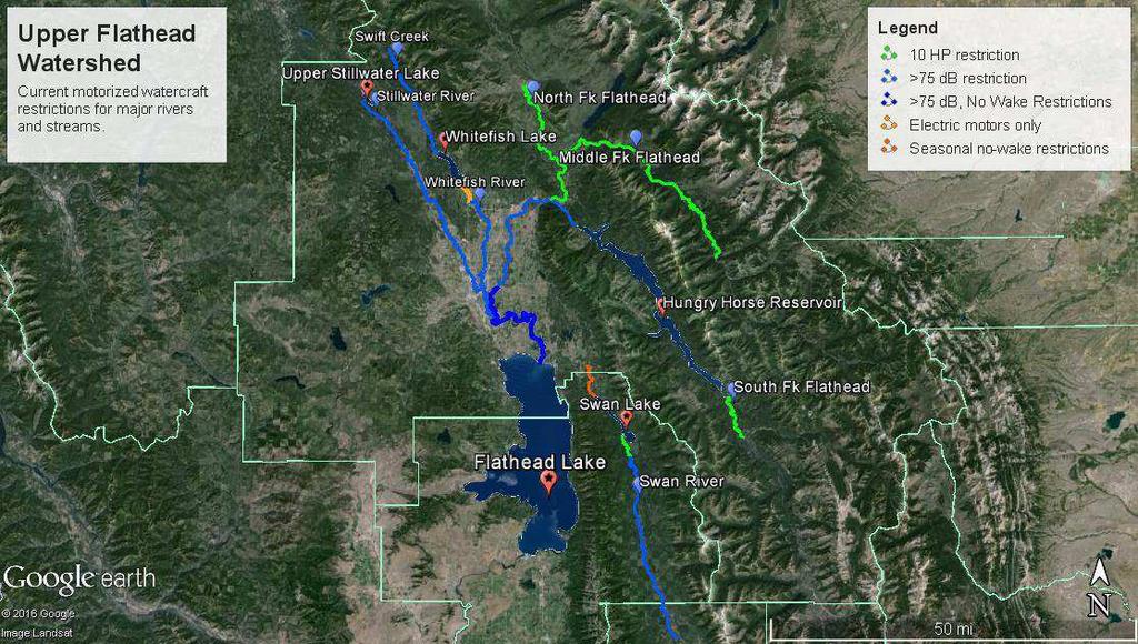
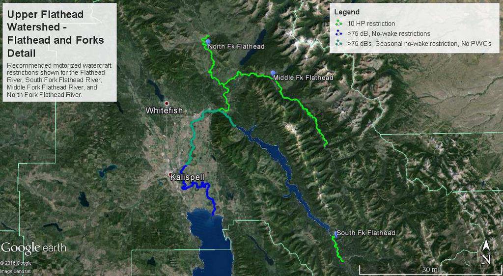
8 Upper Flathead River watershed: Motorized use in connection with Flathead Lake is common in both Flathead and Lake Counties. Because of higher population densities and development near many of the areas waterways motorized uses are restricted in a unique way through a noise restriction. Motorized watercraft and PWCs may not emit in excess of 75 decibels measured at the shoreline throughout both Flathead and Lake Counties. This restriction may effectively eliminate many conflicts and irresponsible uses before they start. The backwater of Flathead Lake makes the main stem of the 8
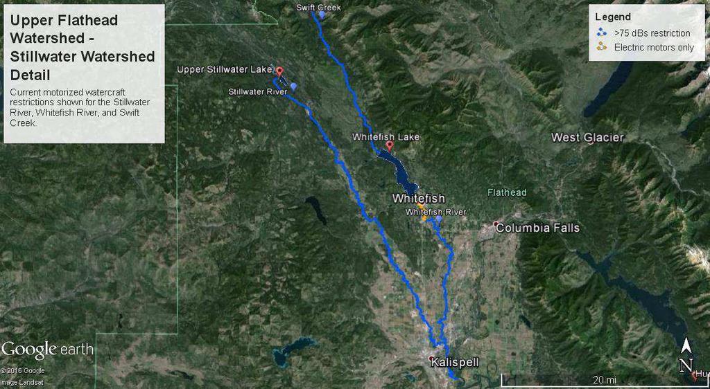
9 river from the mouth of the lake to the Highway 35 bridge navigable by motorcraft, however, this area is a no-wake restricted area. The section of the main stem coupled with the stretch of the South Fork from its confluence with the main stem to Hungry Horse Reservoir has no restrictions beyond the county-wide noise restriction. Occasional conflicts arising from personal watercraft use has been noted on the stretch of the South Fork from Hungry Horse to its confluence. Uses on the South Fork above the reservoir are restricted by a no-wake restriction to the Spotted Bear bridge and above by physical barriers and wilderness designations. The Middle Fork and the North Fork are both well protected by 10 HP restrictions and motorized use closures. It is recommended that the reaches of the South Fork of the Flathead River and mainstem of the Flathead River from the Hungry Horse Dam to the Highway 35 bridge be restricted as a seasonal no-wake area from June 1 to October 15. It is also recommended that a personal watercraft restriction be placed on this same area to prevent any future conflicts as well. The Swan River is restricted by a seasonal no-wake or minimum operating speed below Swan Lake. It is also protected by a no-wake rule from where the river enters the lake to the Porcupine Bridge approximately 4 ½ miles upstream. Further upstream the river becomes dangerous or difficult to operate a motorized watercraft on due to physical limitations and barriers. The headwaters of the Swan River can be found in a wilderness area. It is possible that the noise limitations in Flathead and Lake County preclude and misuses at the moment, however, emerging watercraft technologies may change these circumstances. Occasional conflicts are reported on the Swan River from motorized uses. It is recommended that the no-wake restriction on the Swan River simply be extended from its current boundary at the Porcupine Bridge to its headwaters in order to eliminate any potential conflicts in the future including those involving emerging watercraft technologies. The Stillwater and Whitefish Rivers both lack any restrictions beyond the county-wide noise restriction but are both limited in size and navigability. Some motorized uses have been noted on both. A longstanding no-wake designation is in place for a section of the Whitefish River near the city of Whitefish as well as a newly established electric motor only restriction for the river below the outlet of Whitefish Lake and the bridge at JP Road. To safely operate a motorized watercraft on the tributaries to the Whitefish River that feed Whitefish Lake including Swift Creek would likely be difficult, if not impossible. To address any potential conflicts over motorized use in the Stillwater and Whitefish River basins it is recommended that seasonal nowake restrictions, similar to those on the lower Swan River, be applied to these rivers from June 1 to September 15. It is also recommended that all motorized watercraft use be restricted on the tributaries to the Whitefish River that enter Whitefish Lake. Many of these, including Swift Creek, flow through the Stillwater State Forest and other ecologically sensitive areas. Although the size and grade of many of these streams may restrict any kind of motorized use at present, it is suggested that this be formalized to preclude any potential misuses. The current motorized watercraft restrictions and recommended changes can be found below. Stream and Segment Current Restrictions Recommendations Flathead River Bigfork Bay >75 dbs, No-Wake No Changes to Highway 35 Bridge Flathead River Highway 35 Bridge to confluence of S. Fork and Middle Fork. >75 dbs >75 dbs, Seasonal no-wake restriction (6/1-10/15), no personal watercraft South Fork Flathead River Confluence to Hungry Horse Reservoir >75 dbs >75 dbs, Seasonal no-wake restriction (6/1-10/15), no personal watercraft 9
10 Middle Fork Flathead River Confluence to Hwy 2 Bridge at Essex Middle Fork Flathead River Hwy 2 Bridge at Essex to Bob Marshall Wilderness boundary North Fork Flathead River Confluence to Camas Bridge North Fork Flathead River Camas Bridge to Canadian border Swan River Confluence with Bear Creek in Flathead County to Swan Lake Swan River Mouth of Swan Lake to Spotted Bear Bridge Stillwater River Confluence with Flathead River to Upper Stillwater Lake Whitefish River Confluence with Stillwater River to JP Road Bridge Whitefish River JP Road Bridge to railroad trestle south of Whitefish Lake outlet Swift Creek and tributaries to Whitefish Lake >75 dbs, 10 HP restriction No Changes >75 dbs, Closed to motorized watercraft No Changes >75 dbs, 10 HP restrictions No Changes >75 dbs, Closed to motorized watercraft >75 dbs, Seasonal no-wake restriction (7/1-9/15) No Changes No Changes >75 dbs, No-wake speed Extend upstream boundary restriction to headwaters >75 dbs >75 dbs, Seasonal no-wake restriction (7/1 9/15), no personal watercraft >75 dbs >75 dbs, Seasonal no-wake restriction (7/1 9/15), no personal watercraft >75 dbs, Electric motors No Changes only, no-wake speed restriction >75 dbs No motorized watercraft use 10

11 11
12 12

13 13

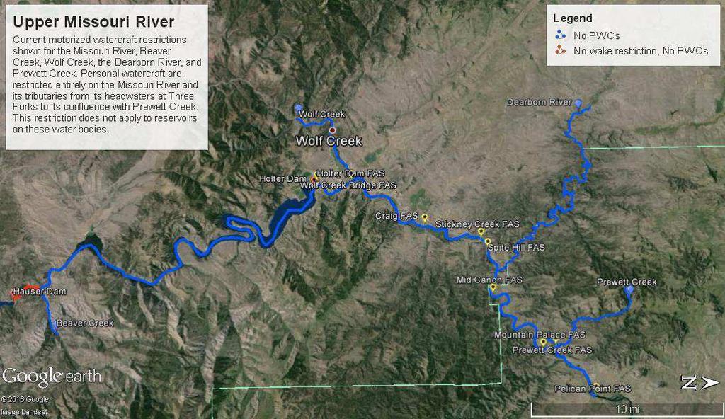
14 Upper Missouri River Three Forks to Pelican Point FAS The area from the headwaters of the Missouri River to the Pelican Point fishing access site just past the Cascade County line is a diverse fishery that is characterized largely by higher gradient streams and cold-water fisheries that are highly regulated by a system of reservoirs. These reservoirs are Canyon Ferry Reservoir, Hauser Reservoir, and Holter Reservoir. Personal watercraft are not allowed on this section of the Missouri River and its tributaries from its 14
15 headwaters to its confluence with Prewett Creek with the exception of reservoirs. The section of the Missouri River from its headwaters at Three Forks to the mouth of Canyon Ferry Reservoir is open to motorized watercraft except for personal watercraft. The reservoirs on this section of the Missouri allow for many recreation opportunities with motorized watercraft. The reservoirs have their own restrictions that are not addressed by Quiet Waters. From Hauser Dam to the Missouri River s confluence with Beaver Creek, the river flows through a narrow canyon bounded on the north and east by the Helena National Forest and on the south and west by land managed by the Bureau of Land Management. While this area has been designated as a no-wake area, there are numerous reports of conflicts arising from motorboats, particularly jet boats, running upstream on the river at wake speed. From Holter Dam to the Missouri s confluence with Prewett Creek the only restrictions on this reach of river are those restricting personal watercraft. The reach from Prewett Creek to the Pelican Point fishing access site has no restrictions to motorized watercraft. The reach of river from Holter Dam to the Missouri River s confluence with Wolf Creek is heavily used by many different types of recreationists among which there are increasing numbers of motorized watercraft users. An increasing number of conflicts and complaints have been noted in this area. The reach from Wolf Creek to the Pelican Point fishing access site has historically seen use by a diverse set of recreationalists including motorboat users. Increases in motorized watercraft use have also been noted for this reach. It is recommended that downstream only and no-wake restrictions be placed on this reach. From the Wolf Creek Bridge to the Pelican Point fishing access site it is recommended that a seasonal 20 horsepower restriction be placed on the Missouri River from June 1 to September 15. An exception should be made for local homeowners whose ability to access their properties may be limited by the proposed restriction. The tributaries to the Missouri River from Three Forks to its confluence with Prewett Creek are protected from personal watercraft use. Many of these tributaries are of such gradient and size as to present many physical barriers to motorized watercraft use at present. Many are also highly influenced by irrigation uses as well with diversion dams and other structures presenting physical barriers to these types of uses. It is recommended that a seasonal 10 horsepower use restriction from May 15 to September 15 be placed on all of these tributaries to prevent any potential misuses or conflicts that may arise. The current motorized restrictions and recommended changes are listed below: Stream and Segment Current Restrictions Recommendations Missouri River Three Forks Open to motorized No Changes to Clark Canyon watercraft, No personal watercraft Missouri River Hauser No-wake restriction, No No Changes. Stricter Dam to Beaver Creek Missouri River Holter Dam to Wolf Creek Bridge Missouri River Wolf Creek Bridge to Pelican Point FAS personal watercraft No personal watercraft No personal watercraft enforcement needed. No personal watercraft; downstream use only, Nowake restriction No personal watercraft, Seasonal 10 HP restriction (6/1 9/15) All Missouri River tributaries No personal watercraft No personal watercraft, Seasonal 10 HP restriction (5/15 9/15) 15

16 16
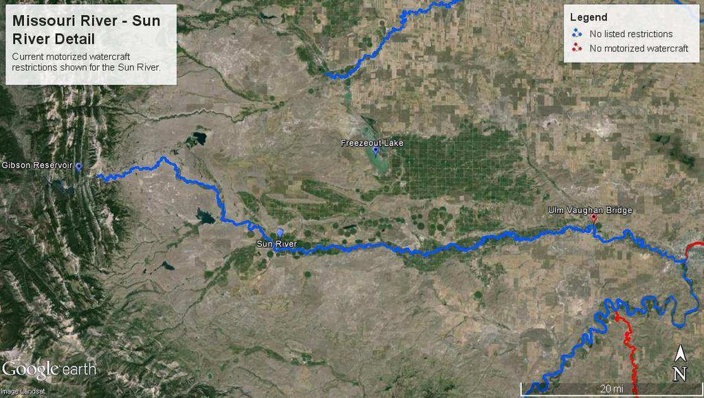
17 Missouri River Pelican Point FAS to Upper Missouri River Breaks National Monument This area sees the Missouri River transition from a cold-water to a warm-water fishery more characteristic of a prairie stream. The river runs past the former location of the Great Falls of the Missouri at Great Falls, MT towards Fort Benton, MT where it begins to cut through increasingly arid terrain as it makes its way through the Upper Missouri River Breaks National Monument. There are no listed restrictions on the Missouri River from the Pelican Point fishing access site in Cascade County to the city of Great Falls near the Missouri s confluence with the Sun River. A system of dams in the vicinity of Great Falls restrict motorized watercraft use for several miles. The river again has no listed restrictions from the Morony Dam north of Great Falls to Fort Benton. The BLM sets motorized use rules and restrictions from Fort Benton to the Fred Robinson Bridge at Highway 191. The Smith River enters the Missouri River south of Great Falls and is well-known as a nonmotorized stream that is specially protected in the Montana State Code. The Sun River enters the Missouri River at Great Falls. No restrictions are listed for the Sun River and approximately the bottom five miles of the river are used by all types of motorized watercraft. Rare use of the river above has been noted, however, extensive use in the upper sections are difficult because of the number of shallow riffles, boulders, diversion structures, and de-watering. Most of the users on the bottom section come up from the Missouri River. It is recommended here that the bottom section of the Sun River from the Ulm Vaughan Bridge to its confluence with the Missouri River be left open to motorized uses throughout the year. On the upper section of the river above the Ulm Vaughan Bridge to its headwaters It is suggested that a 10 horsepower restriction be placed on the river to ensure the safety of all users and prevent potential conflicts. It is also recommended that personal watercraft be restricted on all sections of the Sun River. The Marias River enters the Missouri northeast of Fort Benton on a reach of the Missouri designated as open to upstream and downstream motorized use. The Teton River enters the Marias just above its confluence with the Missouri near the town of Loma, MT. The Marias transitions from a cold-water fishery to a warm-water fishery from its headwaters to its confluence with the Missouri River. The Marias is divided by the Tiber Reservoir which sees considerable boating use throughout the year and serves to regulate flows from the outlet to the confluence with the Missouri. As such, the river below the outlet consistently flows around 500 cfs and allows for a cold-water fishery. As the Marias River flows towards the Missouri it begins to enter a series of arid badlands and becomes a warm-water fishery. Conflicts have been reported on the upper section of the Marias below Tiber Dam where jetboat users have been running through this shallow section. This section is difficult to navigate with a canoe between cfs. Moreover, the Bureau of Land Management does not recommend motorboat use on the Marias River below Tiber Dam. Given the physical limitations of the stream, a jet driven watercraft would often need to achieve a hydroplane, and therefore high speeds, to successfully navigate this section. These circumstances lend themselves to continued and future conflicts between users. It is recommended that a personal watercraft and 10 horsepower restriction be placed on the Marias River from Tiber Dam to the Highway 223 bridge. Alternately, a flow based restriction may be appropriate for reducing user conflicts and reaching compromise on this section. For example, a restriction that would limit motorized use when flows fell below a daily average of 400 cfs could possibly limit motorized uses when this section of river becomes shallow. From the Highway 223 bridge to the confluence of the Missouri it is recommended that it is recommended that a personal watercraft restriction and 10 HP limit be placed on motorized watercraft use. It is recommended that a 10 horsepower and personal watercraft restriction be placed on all sections of the Teton River to ensure user safety and prevent any future conflicts. 17
18 Marias River flows (cubic feet per second) at USGS gauging station near Loma, MT (confluence with Missouri River). 18
19 The current motorized restrictions and recommended changes are listed below: Stream and Segment Current Restrictions Recommendations Missouri River -- Pelican No listed restrictions No Changes Point FAS to Great Falls Missouri River Great Falls Closures throughout No Changes vicinity downstream to Morony Dam Missouri River Morony No listed restrictions No Changes Dam to Fort Benton Missouri River Fort Benton Restrictions set by BLM N/A to Fred Robinson Bridge Smith River Closed to motorized No Changes watercraft Sun River Headwaters to Ulm Vaughan Bridge No listed restrictions 10 HP restriction; No personal watercraft Sun River Ulm Vaughan No listed restrictions Open to motorized watercraft Bridge to Great Falls Marias River Headwaters to Tiber Reservoir No listed restrictions 10 HP restriction; No personal watercraft Marias River Tiber Dam to Highway 223 Bridge No listed restrictions 10 HP restriction; No personal watercraft 19


20 Marias River Highway 223 Bridge to confluence with Missouri River No listed restrictions 10 HP restriction; No personal watercraft Teton River No listed restrictions 10 HP restriction; No personal watercraft 20

21 21

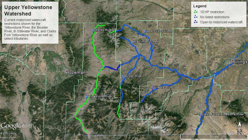
22 Upper Yellowstone River watershed Various opportunities for motorized and non-motorized uses are available on the Yellowstone River. The Yellowstone River flows out of Yellowstone National Park where uses are heavily restricted by the National Park Service into Park County Montana. Park County is one of several counties in the state wherein sensible 10 horsepower restrictions on rivers and streams protect these resources and safeguard users of all types against potential conflicts and dangers associated with motorized watercraft uses. The Yellowstone and its tributaries in Park County 22
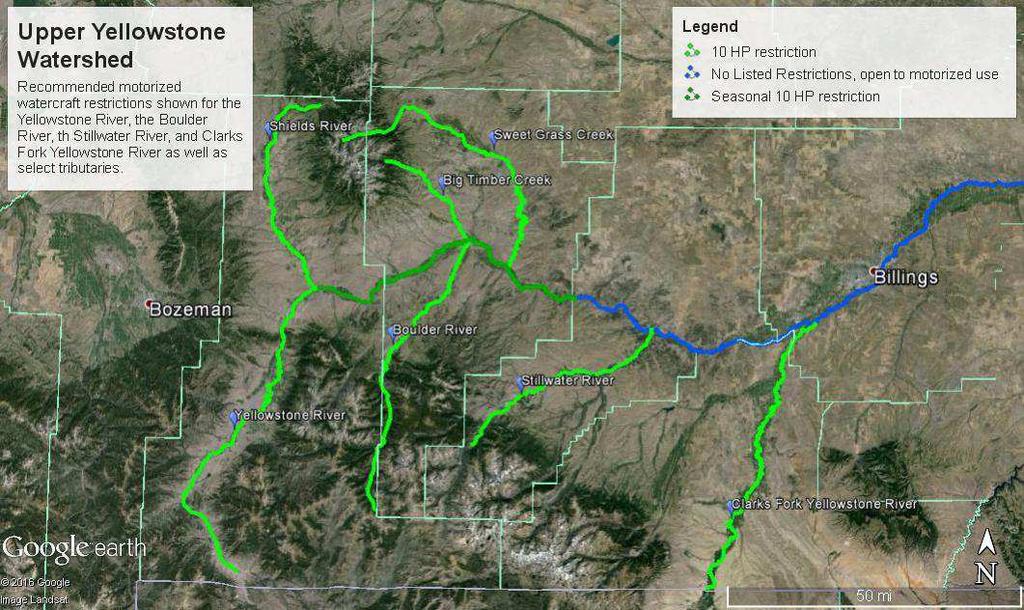
23 are largely shallow and high gradient waters with limited navigability. An exception to the 10 horsepower rule for the Yellowstone River begins at the Highway 89 Bridge in Livingston and extends to the Park County line. On this reach the Yellowstone River is open to motorized watercraft use. Downstream of the Park County line there are no listed restrictions for motorized watercraft use on the Yellowstone River. An increase in jet boat use in the area from Livingston to Reed Point has been noted in recent years. The increasing uses have caused the quality of recreation to decline while posing a potential danger to non-motorized users in the area. It is recommended that a seasonal 10 horsepower restriction during the busiest season from July 15 to September 15 be placed on the Yellowstone River from the Highway 89 Bridge in Livingston to Reed Point, MT. Several tributaries to the Yellowstone such as the Shields River are well protected by the current 10 horsepower restriction applicable in Park County. Others, including the Boulder River, have their headwaters in Park County - and therefore a 10 horsepower restriction on those stream segments but flow downstream through counties without these restrictions. Occasional reports of jet boat users running up Yellowstone River tributaries such as the Boulder River indicate that these rivers and streams could be vulnerable to irresponsible and dangerous uses in the future. Many, if not most, of these streams are high-gradient and physically limiting to adjacent motorized and non-motorized uses. In the interest of preventing future conflicts and promoting the safety of all user groups it is recommended that the 10 horsepower restriction be applied to all tributaries of the Yellowstone River from its headwaters to its confluence with the Clark s Fork of the Yellowstone River. The current motorized restrictions and recommended changes are listed below: Stream and Segment Current Restrictions Recommendations Yellowstone River 10 HP restriction No Changes Yellowstone National Park to Highway 89 Bridge Yellowstone River Highway 89 Bridge to Park Co. Line Open to motorized watercraft uses No personal watercraft; seasonal 10 HP restriction Yellowstone River Park Co. Line to Reed Point, MT No listed restrictions; open to motorized watercraft uses (7/15 9/15) No personal watercraft; seasonal 10 HP restriction (7/15 9/15) Shields River 10 HP restriction No Changes Boulder River Park County 10 HP restriction No Changes segments Boulder River Stillwater No listed restrictions 10 HP restriction County segments Stillwater River Wilderness No listed restrictions 10 HP restriction area boundary to confluence Clark s Fork Yellowstone River WY State Line to confluence No listed Restrictions 10 HP restriction All other Yellowstone River tributaries from headwaters to confluence with Clark s Fork Yellowstone River Various 10 HP restriction 23
24 24
25 IV. Further Considerations A Note on Horsepower Restrictions This document includes numerous recommendations for a 10 horsepower limit on motorized watercraft for many stream segments throughout the state. This is largely based on the very successful limitations placed on the headwaters of the Yellowstone and Missouri Rivers. The rivers and streams comprising the headwaters of these rivers are among some of the most productive cold-water fisheries found in Montana and the world over. Some of these rivers including the Big Hole River, the Red Rock River, and the Upper Ruby River hold the sole remaining populations of native fluvial arctic grayling in the lower 48 United States. The size of waters in these headwaters regions ranges from large rivers and fairly navigable rivers such as the Jefferson, Madison, and Yellowstone to small creeks on which no one could realistically operate a motorized watercraft. In between are streams that could possibly be accessed by present and future motorized watercraft technologies in a way that would disturb historical uses and possibly damage the resource, however, these are all fairly well protected by the 10 horsepower restriction. While many of the streams for which a 10 horsepower restriction has been recommended have limited navigability either seasonally or year round, these recommendations have been made in order to protect those streams and the traditional uses found on them in a way that echoes a clear and successful precedent. Seasonal Restrictions Explained Many of the recommendations for motorized watercraft restrictions included in this document are based on existing seasonal restrictions throughout the state. Seasonal use restrictions are recommended in order to curtail conflict based on accessibility, the potential for user conflicts, and escalating user conflicts which correspond to an increase in the frequency of use and number of users. These restrictions aim to eliminate the worst of current and potential conflicts while preserving some of the existing uses. On many streams, occasional use of motorized watercraft during the non-busy season has traditionally allowed for recreational activities such as game and waterfowl hunting. Backcountry Hunters and Anglers made a concerted effort to preserve these historical uses when making the recommendations found in this document. On several streams seasonal restrictions are aligned with patterns of seasonal run-off and high flows that would make an otherwise inaccessible stream temporarily accessible by motorized watercraft. Most often these are paired with horsepower restrictions. Elsewhere, on several large streams and rivers, the seasonal use recommendations are a reflection of a growing need to reduce user conflicts. In these cases, many traditional, non-motorized uses are being disrupted by an increase in motorized use. Seasonal restrictions are aimed to safeguard these uses during the busiest times of the year which correspond to escalating user conflicts. These waterways are often large enough to sustain motorized watercraft traffic outside of the recommended seasonal restrictions. User Safety Throughout this document, recommendations are made for restrictions based on motor speed or power. These are based on existing horsepower and no-wake speed restrictions found throughout the state. Some of these simply extend the boundaries of an existing restriction to safeguard a stream segment using the same reason and logic applied to the original restriction. Some of the listed reaches, however, which have been assigned horsepower or no-wake restrictions, are on smaller and shallower stream segments that have seen rare if any motorized 25
26 use in the past. Other reaches have noted occasional motorized use that will likely increase with time and the availability of innovative watercraft technologies. Past uses on these streams has largely been limited by the gradient and physical characteristics of the stream itself e.g. shallow riffles, large boulders, large woody debris. Despite this, the limitation of depth can be overcome by an increasing number of motorized watercraft users by motoring at high speeds and achieving a hydroplane with their craft. This in particular presents a very real hazard to users of all types both motorized and non-motorized. The power and speed restrictions recommended in this document largely address this hazard. Given the limited mobility of non-motorized users and the limited maneuverability of watercraft travelling at higher speeds the implicit dangers high-performance watercraft pose to other users on many of Montana s streams and rivers are both immediate and apparent. Similarly, the very same characteristics that have historically limited this irresponsible behavior present a corresponding hazard to watercraft and users who may collide with debris, submerged boulders, or other parts of the stream. Fish and Wildlife Streams and adjacent riparian areas are disproportionately important to fish and wildlife, as well as very desirable to humans. While many species of wildlife tolerate some human disturbance, several other species are vulnerable to displacement or are adversely affected by human intrusions. Perhaps the most visible disturbance is to nesting or resting eagles, herons and osprey. While humans can often pass underneath quietly in a non-motorized vessel, the often loud, fast moving craft often displace such birds. A large wake from a noisy craft can also displace waterfowl, and can scatter broods of young waterfowl. The adverse effects are, of course, magnified with increasing frequent use levels. Most fish tolerate watercraft, although are displaced to their secure areas such as deeper pools or overhead cover. However, jet thrust propelled watercraft can displace spawning bed material, especially during lower flows in riffles and pool tails. In addition, up to 25% of 2 stroke motor fuel is discharged unburned into the water. 26
Quiet Waters Rule Proposal. No changes proposed. No Listed Restrictions Closed to motorized watercraft Closed to motorized watercraft
 Quiet Waters Rule Proposal Bitterroot River (ARM 12.11.610) Proposed Rule Bitterroot River from the headwaters to the confluence with the Clark Fork Tributaries of the Bitterroot River (including Lolo
The Department's authority to administer the ownership of navigable water bodies is referenced in the following:
 NAVIGABLE WATER WAYS OWNED BY THE STATE OF MONTANA AND ADMINISTERED BY THE DEPARTMENT OF NATURAL RESOURCES AND CONSERVATION TRUST LAND MANAGEMENT DIVISION May 14, 2014 Subject to Update The State of Montana
Proposed Shuswap River Boating Regulations Open House
 Proposed Shuswap River Boating Regulations Open House Welcome, and thank you for attending this Open House regarding proposed boating regulations for the Shuswap River. A partnership of the Regional District
MINISTRY OF ENVIRONMENT ENVIRONMENTAL STEWARDSHIP DIVISION FISH AND WILDLIFE BRANCH. Horsefly River Angling Management Plan
 MINISTRY OF ENVIRONMENT ENVIRONMENTAL STEWARDSHIP DIVISION FISH AND WILDLIFE BRANCH Horsefly River Angling Management Plan January 30 th, 2006 Area/Fishery Description The Horsefly River watershed provides
Chadbourne Dam Repair and Fish Barrier
 Chadbourne Dam Repair and Fish Barrier Final Report for the Western Native Trout Initiative Prepared by: Carol Endicott Yellowstone Cutthroat Trout Conservation Biologist Montana Fish, Wildlife & Parks
Order Adopting Amendments. Title 58. Recreation Part II. Fish and Boat Commission Chapters 97, 109, 111 and 115 Boating. Preamble
 Order Adopting Amendments COMMONWEALTH OF PENNSYLVANIA PENNSYLVANIA FISH AND BOAT COMMISSION Title 58. Recreation Part II. Fish and Boat Commission Chapters 97, 109, 111 and 115 Boating Preamble The Fish
Executive Summary. Map 1. The Santa Clara River watershed with topography.
 Santa Clara River Steelhead Trout: Assessment and Recovery Opportunities December 2005 Prepared By: Matt Stoecker and Elise Kelley, Ph.D. University of California, Santa Barbara Prepared For: The Santa
Wildlife Introduction
 Wildlife Introduction The wildlife section of this chapter is divided into sections for various habitats and groups of species. Old growth, snags and downed wood, and riparian areas are unique habitats
Minnesota Department of Natural Resources Division of Fish and Wildlife Section of Fisheries. Stream Survey Report. Luxemburg Creek.
 Minnesota F-29-R(P)-24 Area 315 Study 3 March 2016 Minnesota Department of Natural Resources Division of Fish and Wildlife Section of Fisheries Stream Survey Report Luxemburg Creek 2015 Mark Pelham Sauk
Abundance of Steelhead and Coho Salmon in the Lagunitas Creek Drainage, Marin County, California
 scanned for KRIS Abundance of Steelhead and Coho Salmon in the Lagunitas Creek Drainage, Marin County, California Prepared for: Marin Municipal Water District 220 Nellen Drive Corte Madera, California
Hidden Lake Rules. e) Open Water Zone: the entire water surface of Hidden Lake, except the No-Wake Zone and the Sail/Ski Zone.
 Open Water Zone: the entire water surface of Hidden Lake, except the No-Wake Zone and the Sail/Ski Zone.") Hidden Lake Rules Definitions: a) Hidden Lake: the water surface of Mayham Reservoir as defined in that certain Cross License Agreement, dated January 9, 2004, among North Hidden Lake Owners Association,
Hidden Lake Rules Definitions: a) Hidden Lake: the water surface of Mayham Reservoir as defined in that certain Cross License Agreement, dated January 9, 2004, among North Hidden Lake Owners Association,
NEVADA DIVISION OF WILDLIFE STATEWIDE FISHERIES MANAGEMENT FEDERAL AID JOB PROGRESS REPORTS F YELLOWSTONE CUTTHROAT TROUT EASTERN REGION
 NEVADA DIVISION OF WILDLIFE STATEWIDE FISHERIES MANAGEMENT FEDERAL AID JOB PROGRESS REPORTS F-20-48 2012 YELLOWSTONE CUTTHROAT TROUT EASTERN REGION NEVADA DEPARTMENT OF WILDLIFE, FISHERIES DIVISION ANNUAL
WHEREAS, the ordinance will not create excessive additional requirements for public facilities and services at public cost.
 ORDINANCE 19-05 AN ORDINANCE OF VALLEY COUNTY, IDAHO, CREATING AN ORDINANCE TO BE ADMINISTERED BY THE VALLEY COUNTY SHERIFF S OFFICE AND TO BE KNOWN AS VALLEY COUNTY WATERWAYS ORDINANCE THAT INCLUDES PAYETTE
Final Bull Trout Redd Monitoring Report for the Wallowa Falls Hydroelectric Project
 Final for the Wallowa Falls Hydroelectric Project East Fork Wallowa River barrier to upstream fish migration, photo courtesy of Kendrick Moholt (FERC No. P-308) December 18, 2017 Prepared by: Jeremiah
Proposed Reclassification of Cherry Creek, North Platte River Basin, Wyoming. October 25, 2010
 Proposed Reclassification of Cherry Creek, North Platte River Basin, Wyoming October 25, 2010 Waterbody: Location: Tributary to: Cherry Creek - Mainstem from headwaters downstream to the confluence with
62. Gulkana River, Main Fork, Middle Fork, and West Fork
 62. Gulkana River, Main Fork, Middle Fork, and West Fork The Gulkana, a National Wild and Scenic River, is one of Alaska s most popular whitewater rivers because of its road accessibility and because of
BLM Cottonwood Field Office ATTN: Draft RMP/EIS 1 Butte Drive Cottonwood, ID Submitted Via to:
 Kevin Colburn National Stewardship Director American Whitewater 1035 Van Buren St. Missoula, MT 59802 406-543-1802 Kevin@amwhitewater.org BLM Cottonwood Field Office ATTN: Draft RMP/EIS 1 Butte Drive Cottonwood,
Summary of Research RESULTS SAFETY TRAINING. Selected Results From a 2006 Survey of Registered Off-Highway Vehicle (OHV) Owners in Montana YES 44%
 Owners in Montana YES 44%") Summary of Research Selected Results From a 2006 Survey of Registered Off-Highway Vehicle (OHV) Owners in Montana RMU Research Summary No. 21 Michael S. Lewis and Ray Paige July 2006 In the last decade,
Summary of Research Selected Results From a 2006 Survey of Registered Off-Highway Vehicle (OHV) Owners in Montana RMU Research Summary No. 21 Michael S. Lewis and Ray Paige July 2006 In the last decade,
Amendment to a Biological Assessment/Evaluation completed for the Coon Creek Land Disposal completed December Grand Valley Ranger District
 Amendment to a Biological Assessment/Evaluation completed for the Coon Creek Land Disposal completed December 2007 Grand Valley Ranger District Grand Mesa, Uncompahgre, Gunnison National Forests Prepared
Elko County Wildlife Advisory Board 571 Idaho Street, Room 105, Elko, Nevada Phone Fax
 Elko County Wildlife Advisory Board 571 Idaho Street, Room 105, Elko, Nevada 89801 775-738-5398 Phone 775-753-8535 Fax www.elkocountynv.net PUBLIC MEETING NOTICE The Elko County Wildlife Advisory Board,
Protection Measures Against Exotic Species
 MONTANA AUDUBON P.O. Box 595 Helena, MT 59624 406-443-3949 mtaudubon@mtaudubon.org April 9, 2010 MO River Reservoir Management Plan Montana Fish, Wildlife & Parks P.O. Box 200701 Helena, MT 59620-0701
Redd Dewatering and Juvenile Salmonid Stranding in the Lower Feather River,
 Redd Dewatering and Juvenile Salmonid Stranding in the Lower Feather River, 2005-2006 Interim Report for NOAA Fisheries Prepared by: California Department of Water Resources Division of Environmental Services
Visitor Guidelines for WPC-owned Properties. Last revised 5/20/2010
 WESTERN PENNSYLVANIA CONSERVANCY Visitor Guidelines for WPC-owned properties 800 Waterfront Dr., Pittsburgh, PA 15222 412-288-2777, www.waterlandlife.org Visitor Guidelines for WPC-owned Properties Last
TWO FORKS RANCH A5 REAL ESTATE. 790 Acres. Smiths Fork - Lincoln County - Wyoming
 TWO FORKS RANCH 790 Acres Smiths Fork - Lincoln County - Wyoming A5 REAL ESTATE WWW.A5REALESTATE.COM QUICK FACTS Located in the upper Smiths Fork drainage of Lincoln County, Wyoming, the Two Forks Ranch
Bitch Creek Canyon Ranch
 Bitch Creek Canyon Ranch LAMONT, IDAHO Fly Fishing Hunting Ranching Conservation Bitch Creek Canyon Ranch LAMONT, IDAHO Introduction: Within close driving distance to some of Idaho s most prestigious fisheries,
Proposed Reclassification of Deer Creek, North Platte River Basin, Wyoming
 Proposed Reclassification of Deer Creek, North Platte River Basin, Wyoming October 25, 2010 Waterbody: Location: Tributary to: Deer Creek - Mainstem from headwaters downstream to the confluence with the
FISH PASSAGE IMPROVEMENT in California s Watersheds. Assessments & Recommendations by the Fish Passage Forum
 FISH PASSAGE IMPROVEMENT in California s Watersheds Assessments & Recommendations by the Fish Passage Forum FISH PASSAGE IMPROVEMENT in California s Watersheds The mission of the Fish Passage Forum is
City of Pittsfield HARBORMASTER RULES AND REGULATIONS on docks
 City of Pittsfield HARBORMASTER RULES AND REGULATIONS on docks Definitions Dock: Any permanently fixed or floating structure extending from the upland into the water, capable of use for vessel mooring
2009 CONSERVATION PARTNERS GENERAL OPERATING GRANTEES $287,000
 GENERAL OPERATING GRANTEES $287,000 Alliance for the Wild Rockies Helena, MT $3,000 American Prairie Foundation Bozeman, MT $5,000 Alternative Energy Resources Org (AERO) Helena, MT $5,000 America Wildlands
middle deschutes progress in restoration
 middle deschutes progress in restoration Acknowledgements prepared by: Upper Deschutes Watershed Council Deschutes River Conservancy Oregon Department of Fish and Wildlife DESIGN & PRODUCTION FUNDED by:
Little Kern Golden Trout Status:
 Little Kern Golden Trout Status: The Little Kern Golden trout (LKGT) was proposed for federal listing as Threatened under the Endangered Species Act (ESA) on September 1, 1977 by the U. S. Fish and Wildlife
Columbia River Fishery Notice
 Columbia River Fishery Notice Oregon Department of Fish and Wildlife January 29, 2014 Compact Action The Columbia River Compact agencies of Oregon and Washington met today and took the following actions:
Removal of natural obstructions to improve Atlantic Salmon and Brook Trout habitat in western NL. 26/02/2015 Version 2.0
 Removal of natural obstructions to improve Atlantic Salmon and Brook Trout habitat in western NL 26/02/2015 Version 2.0 1 Table of Contents List of Tables... 2 Introduction... 3 Methods... 4 Preliminary
NEVADA DEPARTMENT OF WILDLIFE STATEWIDE FISHERIES MANAGEMENT
 NEVADA DEPARTMENT OF WILDLIFE STATEWIDE FISHERIES MANAGEMENT FEDERAL AID JOB PROGRESS REPORTS F-20-52 2016 EAST FORK AND MAIN STEM CARSON RIVER WESTERN REGION NEVADA DEPARTMENT OF WILDLIFE, FISHERIES DIVISION
CHAPTER 6 10/29/2018 Clean Version REGULATING PIERS, WHARVES, MOORING BUOYS, SWIMMING RAFTS AND INFLATABLES ON ROCK LAKE
 1 2 3 4 5 6 7 8 9 10 11 12 13 14 15 16 17 18 19 20 21 22 23 24 25 26 27 28 29 30 31 32 33 34 35 36 37 38 39 40 41 42 43 44 45 46 CHAPTER 6 10/29/2018 Clean Version REGULATING PIERS, WHARVES, MOORING BUOYS,
NEVADA DEPARTMENT OF WILDLIFE STATEWIDE FISHERIES MANAGEMENT
 NEVADA DEPARTMENT OF WILDLIFE STATEWIDE FISHERIES MANAGEMENT FEDERAL AID JOB PROGRESS REPORTS F-20-52 2016 Lake Tahoe Rainbow Trout Study WESTERN REGION NEVADA DEPARTMENT OF WILDLIFE, FISHERIES DIVISION
MINNESOTA DEPARTMENT OF NATURAL RESOURCES DIVISION OF FISHERIES AND WILDLIFE. Gamefish Assessment Report
 Minnesota DNR F-29-R(P) Area F312 February 1, 2013 MINNESOTA DEPARTMENT OF NATURAL RESOURCES DIVISION OF FISHERIES AND WILDLIFE Gamefish Assessment Report Spring Gamefish Assessment on the Mississippi
Searsville Dam Removal
 Searsville Dam Removal A unique opportunity for all Presented by the Beyond Searsville Dam Coalition San Francisquito Creek flows into the San Francisco Bay near the Palo Alto Airport and Golf Course seen
TRCP National Sportsmen s Survey Online/phone survey of 1,000 hunters and anglers throughout the United States
 #17144 TRCP National Sportsmen s Survey Online/phone survey of 1,000 hunters and anglers throughout the United States Methodology Public Opinion Strategies conducted a national survey of N =1,000 voters
NWS 44: Mining Activities Location #1, Stanislaus River
 NWS 44: Mining Activities Location #1, Stanislaus River Permit is for the use of a single 8 dredge on a federal mining claim at the location described on the map and as Twp 02N Range 14E, Section 04, MDM
Benchmark Statement Respecting the Fish, Fish Habitat and Fisheries of Fish and Little Fish Lake, within the Taseko River Watershed.
 Benchmark Statement Respecting the Fish, Fish Habitat and Fisheries of Fish and Little Fish Lake, within the Taseko River Watershed. Information Supporting the Environmental Assessment of the Prosperity
Woods Creek Ranch DRIGGS, IDAHO
 Woods Creek Ranch DRIGGS, IDAHO Woods Creek Ranch DRIGGS, IDAHO Introduction: Woods Creek Ranch is a sportsman s paradise located in the heart of Teton Valley, Idaho, less than 3 miles from downtown Driggs
Columbia Lake Dam Removal Project
 Columbia Lake Dam Removal Project The Columbia Lake dam located 1/4 mile upstream of the Paulins Kill River's confluence with the Delaware River in Knowlton Township, Warren County has been proposed for
Lower Dolores River Corridor Planning Meeting Jim White Colorado Division of Wildlife
 Lower Dolores River Corridor Planning Meeting Jim White Colorado Division of Wildlife Objectives Overview of cold and warm water fishes in the Dolores River including: Flow and Fish Management Distribution
Columbia Lake Dam Removal Project
 Columbia Lake Dam Removal Project Major Goals of the Columbia Lake Dam Removal: Reconnect 10 miles of the Paulins Kill River to the Delaware River, restoring natural flow regime and sediment transport.
Western native Trout Status report
 Bull trout (Salvelinus confluentus) Data: Draft Recovery Plan, USFWS, 2002; FR Final Critical Habitat Rule - 2005 Partners: ID, MT, OR, WA, NV, FWS, FS, BLM, NPS, Tribes, AK, Canada Species Status review:
STREAM SURVEY File form No..
 scanned for KRIS THE RESOURCES AGENCY OF CALIFORNIA California Department of Fish and Game STREAM SURVEY File form No.. Date: September 4, 1969. NAME: North Fork Schooner Gulch Creek COUNTY: Mendocino.
1.Mill Creek Watershed Summary Description and Land Use
 1.Mill Creek Watershed Summary Description and Land Use Table xxx: Mill Creek Watershed Overview Watershed Size 31,435 acres/49.1 sq miles/ 127.1 sq km Elevation Range 5,594 feet [4,967-10,561] Stream
5B. Management of invasive species in the Cosumnes and Mokelumne River Basins
 5B. Management of invasive species in the Cosumnes and Mokelumne River Basins Cosumnes River The Cosumnes River basin has a number of distinct habitat types that require different management strategies
The agenda for the Commission's upcoming meeting on April 15th in Billings (see the "Fisheries Division" section).
.") Glenda Wiles From: Sent: To: Cc: Subject: Attachments: Importance: Rose, Sharon Friday, April 10,2015 3:33 PM Rose, Sharon Rose, Sharon Proposed Bitterroot River Rule--F&W Commission Meeting
Glenda Wiles From: Sent: To: Cc: Subject: Attachments: Importance: Rose, Sharon Friday, April 10,2015 3:33 PM Rose, Sharon Rose, Sharon Proposed Bitterroot River Rule--F&W Commission Meeting
Chinook Salmon Spawning Study Russian River Fall 2005
 Chinook Salmon Spawning Study Russian River Fall 2005 Sonoma County Water Agency 2150 West College Avenue Santa Rosa, California 95401 Prepared by David Cook - Senior Environmental Specialist March 27,
Powder/Tongue River Basin Plan Available Surface Water Determination Task 3D
 Technical Memorandum Subject: Powder/Tongue River Basin Plan Available Surface Water Determination Task 3D Date: February 2002 Prepared by: HKM Engineering Inc. INTRODUCTION Spreadsheet water accounting
FLATHEAD INDIAN RESERVATION
 FLATHEAD INDIAN RESERVATION PHEASANTS, GRAY PARTRIDGE AND MIGRATORY WATERFOWL 2017-18 HUNTING SEASONS, SHOOTING HOURS AND LIMITS Upland Game Birds Gray Partridge Hunting Season: September 1, 2017 through
FISHERIES BLUE MOUNTAINS ADAPTATION PARTNERSHIP
 FISHERIES A warming climate, by itself, substantially affects the hydrology of watersheds in the Blue Mountains. Among the key hydrologic changes projected under all scenarios for the 2040s and beyond
3.9 Recreational Trails and Natural Areas
 3.9 Recreational Trails and Natural Areas 3.9.1 Introduction Parks and other recreational facilities such as trails, bicycle routes, and open space are important community resources. This section discusses
JAP Additional Information Sheet
 JAP Additional Information Sheet Block 15: Purpose and Need The USACE purpose of the project is to provide a safe and reliable whitewater park for the recreational public in a city park, which will provide
Interim Guidance Fish Presence Absence
 Interim Guidance Fish Presence Absence Source: Forest Practices Act Guidance for Division 635 of the forest practices act dealing with stream classification when no fish surveys have been done (referenced
IC Chapter 9. Regulation of Fishing
 IC 14-22-9 Chapter 9. Regulation of Fishing IC 14-22-9-1 Unlawful means of taking fish; special permits Sec. 1. (a) Except as allowed by sections 3 and 11 of this chapter, an individual may not take fish
Introduction of the term Traffic Control Zone and formalization of Fraser River Traffic Control Zone procedures
 Consideration Report Introduction of the term Traffic Control Zone and formalization of Fraser River Traffic Control Zone procedures Background Under the Canada Marine Act, all Canada Port Authorities
CHAPTER 4 DESIRED OUTCOMES: VISION, GOALS, AND OBJECTIVES
 CHAPTER 4 DESIRED OUTCOMES: VISION, GOALS, AND OBJECTIVES Vision One of the first steps in developing this Plan was articulating a vision - a clear statement of what the Plan strives to achieve and what
Lake Tahoe Shoreline Plan. 05 Policy Topic: Piers- Fish Habitat, Design, and Scenic Issues
 Lake Tahoe Shoreline Plan 05 Policy Topic: Piers- Fish Habitat, Design, and Scenic Issues 07.20.2016 1 Brief Description There are 768 piers located along the shoreline of Lake Tahoe. Approximately 43
A Comparison of Western Watershed Councils. Presentation Prepared by Jeff Salt, Great Salt Lakekeeper
 A Comparison of Western Watershed Councils Presentation Prepared by Jeff Salt, Great Salt Lakekeeper Presentation Overview Introduction Jordan River Watershed Council Lower Boise Watershed Council Clackamas
BASS LAKE PLANNING UNIT Willow Creek Watershed
 Existing Conditions & Uses Overview Reservoir that is a popular summer recreation destination, with substantial residential and recreation development 1,085 acres in Madera County; 149 acres outside and
Trout Unlimited Comments on the Scope of Environmental Impact Statement for the Constitution Pipeline Project, Docket No. PF12-9
 October 9, 2012 Kimberly D. Bose, Secretary Federal Energy Regulatory Commission 888 First Street, NE, Room 1A Washington, DC 20426 RE: Trout Unlimited Comments on the Scope of Environmental Impact Statement
Fish Community. Fish Habitat, Streams and Rivers
 Clear, Ston(e)y and White Lake Plan Fish Community The lakes support a cool/warm water fishery including muskellunge, walleye, largemouth and smallmouth bass, yellow perch, pumpkinseed, rockbass, blue
3.7 River Navigation Affected Environment
 3 Affected Environment and Environmental Consequences 3.7 River Navigation 3.7.1 Affected Environment Sterling Highway MP 45 60 Project Final EIS The Kenai River is approximately 82 river miles long in
Pre-Application Document Kaweah Project (FERC Project No. 298)
") TABLE OF CONTENTS Page 3.12 Aesthetic Resources... 3.12-1 3.12.1 Information Sources... 3.12-1 3.12.2 Setting... 3.12-1 3.12.3 Project Facilities... 3.12-2 3.12.4 Previous Visual Resources Assessment...
TABLE OF CONTENTS Page 3.12 Aesthetic Resources... 3.12-1 3.12.1 Information Sources... 3.12-1 3.12.2 Setting... 3.12-1 3.12.3 Project Facilities... 3.12-2 3.12.4 Previous Visual Resources Assessment...
August 27, Tom Melius Midwest Regional Director U.S. Fish & Wildlife Service 5600 West American Boulevard, Suite 990 Bloomington, MN
 Tom Melius Midwest Regional Director U.S. Fish & Wildlife Service 5600 West American Boulevard, Suite 990 Bloomington, MN 55437-1458 August 27, 2015 Dear Director Melius: We are writing to you on behalf
Guidelines for Public Use of WPC-owned Properties. Last revised 01/27/2017
 Guidelines for Public Use of WPC-owned Properties Last revised 01/27/2017 Properties owned by Western Pennsylvania Conservancy (WPC) are open to the public free-of-charge. Western Pennsylvania Conservancy
Broken Bar W Ranch TETON VALLEY, IDAHO. Hunting Ranching Fly Fishing Conservation
 Broken Bar W Ranch TETON VALLEY, IDAHO Hunting Ranching Fly Fishing Conservation Broken Bar W Ranch TETON VALLEY, IDAHO Introduction: The Broken Bar W Ranch is located in Driggs, Idaho, the county seat
Mid-Columbia Fisheries Enhancement Group Annual Report Fiscal Year 06: July 1, 2005 June 30, 2006
 Mid-Columbia Fisheries Enhancement Group Annual Report Fiscal Year 06: July 1, 2005 June 30, 2006 Mission Statement The mission of the Mid-Columbia Fisheries Enhancement Group is to restore self-sustaining
Proposed Reclassification of Horse Creek, North Platte River Basin in Goshen County, Wyoming
 Proposed Reclassification of Horse Creek, North Platte River Basin in Goshen County, Wyoming October 25, 2010 Waterbody: Location: Tributary to: Horse Creek - Mainstem from the confluence with Stinking
DECISION MEMO. Pursuant to 36 C.F.R (e), the following persons are exempted from this order:
, the following persons are exempted from this order:") DECISION MEMO Forest Supervisor s Orders for the Upper Tellico Off-Highway Vehicle System USDA Forest Service Southern Region Nantahala National Forest Tusquitee Ranger District Cherokee County, North
DECISION MEMO Forest Supervisor s Orders for the Upper Tellico Off-Highway Vehicle System USDA Forest Service Southern Region Nantahala National Forest Tusquitee Ranger District Cherokee County, North
Juvenile Steelhead and Stream Habitat Conditions Steelhead and Coho Salmon Life History Prepared by: DW ALLEY & Associates, Fishery Consultant
 Juvenile Steelhead and Stream Habitat Conditions Steelhead and Coho Salmon Life History Prepared by: DW ALLEY & Associates, Fishery Consultant I-1. Steelhead and Coho Salmon Ecology Migration. Adult steelhead
Section II: Project Description
 Project Funding 319 Funds Requested $89,700.00 Matching Funds State Cash Match $78,200.00 Local Cash Match $1,800.00 In-Kind Match $1,000.00 Total Match $81,000.00 Other Federal Funds $24,800.00 Total
Backgrounder and Frequently Asked Questions
 Backgrounder and Frequently Asked Questions Who Sent the Letter? The 60-day Notice of Intent to File Suit was sent by Conservation Angler, Wild Fish Conservancy, Snake River Waterkeeper, Friends of the
Teton River Confluence Ranch TETON VALLEY, IDAHO
 Teton River Confluence Ranch TETON VALLEY, IDAHO Teton River Confluence Ranch TETON VALLEY, IDAHO TETON RIVER CONFLUENCE RANCH INTRODUCTION Introduction: Teton River Confluence Ranch possesses that rare
ALBERTA FISH & GAME ASSOCIATION 2015 ANNUAL GENERAL MEETING PASSED RESOLUTIONS FEBRUARY 21, 2015
 ALBERTA FISH & GAME ASSOCIATION 2015 ANNUAL GENERAL MEETING PASSED RESOLUTIONS FEBRUARY 21, 2015 GENERAL RESOLUTION NUMBER G-1-2015 and Sustainable Resource Development permit the use of crossbows during
Fisheries Management Plan Idaho Department of Fish and Game
 Fisheries Management Plan 2007-2012 2012 Idaho Department of Fish and Game Plan History 1981-1985 1985 Plan Separate anadromous plan Evolved from 5 to 6-year 6 plan Angler Opinion Survey The Process Public-Agency
Proposed Reclassification of Muskrat Creek, North Platte River Basin in Goshen County, Wyoming
 Proposed Reclassification of Muskrat Creek, North Platte River Basin in Goshen County, Wyoming October 25, 2010 Waterbody: Muskrat Creek - Mainstem of Muskrat Creek from its headwaters downstream to its
3. The qualification raised by the ISRP is addressed in #2 above and in the work area submittal and review by the ISRP as addressed in #1.
 Please find attached a response from The Confederated Tribes of the Warm Springs Reservation of Oregon (CTWSRO) for Project # 2008-301-00, Habitat Restoration Planning, Design and Implementation within
Annual Report for Fiscal Year and Future Plans for the Tillamook Bay Watershed Council
 Annual Report for Fiscal Year 2012-2013 and Future Plans for the Tillamook Bay Watershed Council A report prepared for the Tillamook County Board of Commissioners August 2013 Table of Contents: Recently
Go l d Ran c h REXBURG, IDAHO. Fly Fishing Hunting Ranching Conservation
 Go l d Ran c h REXBURG, IDAHO Fly Fishing Hunting Ranching Conservation Go l d Ran c h REXBURG, IDAHO Introduction: The Gold Ranch is comprised of 980 deeded acres nestled along the river bottom of the
SOLITUDE MOUNTAIN RESORT MASTER DEVELOPMENT PLAN AMENDMENT PROPOSAL
 SOLITUDE MOUNTAIN RESORT MASTER DEVELOPMENT PLAN AMENDMENT PROPOSAL 6/02/14 INTRODUCTION Solitude Mountain Resort s (Solitude) current Master Development Plan (MDP) was accepted by the Wasatch-Cache National
EXECUTIVE SUMMARY Feasibility Study on the Reintroduction of Gray Wolves to the Olympic Peninsula
 EXECUTIVE SUMMARY Feasibility Study on the Reintroduction of Gray Wolves to the Olympic Peninsula Prepared by U.S. Fish and Wildlife Service Western Washington Office Introduction Historical records indicate
Alberta Conservation Association 2009/10 Project Summary Report. Project Name: Crowsnest Drainage Sport Fish Population Assessment Phase 1
 Alberta Conservation Association 2009/10 Project Summary Report Project : Crowsnest Drainage Sport Fish Population Assessment Phase 1 Fisheries Program Manager: Peter Aku Project Leader: Jason Blackburn
Brook Trout in Massachusetts: A Troubled History, A Hopeful Future
 Brook Trout in Massachusetts: A Troubled History, A Hopeful Future Brook trout are one of the most beautiful and beloved fish in the Eastern United States. In Massachusetts, anglers prize opportunities
TABLE OF CONTENTS LIST OF TABLES NONE LIST OF FIGURES NONE
 TABLE OF CONTENTS 7.4 RIVER-RELATED RECREATION SURVEYS (REC 4)... REC 4-1 7.4.1 Study Objectives... REC 4-1 7.4.2 Study Area... REC 4-1 7.4.3 Methods... REC 4-1 7.4.4 Key Questions... REC 4-3 7.4.5 Results...
SUMMARY OF GROUP DISCUSSIONS
 SAFE QUIET LAKES STAKEHOLDER MEETING PORT CARLING, APRIL 7, 2017 SUMMARY OF GROUP DISCUSSIONS INTRODUCTION At the sixth annual Safe Quiet Lakes Stakeholder meeting a set of six discussion groups were held
NEVADA DEPARTMENT OF WILDLIFE STATEWIDE FISHERIES MANAGEMENT FEDERAL AID JOB PROGRESS REPORTS F LAHONTAN CUTTHROAT TROUT EASTERN REGION
 NEVADA DEPARTMENT OF WILDLIFE STATEWIDE FISHERIES MANAGEMENT FEDERAL AID JOB PROGRESS REPORTS F-20-50 2014 LAHONTAN CUTTHROAT TROUT EASTERN REGION NEVADA DEPARTMENT OF WILDLIFE, FISHERIES DIVISION ANNUAL
Michigan Dept. of Natural Resources Status of the Fishery Resource Report Page 1. Weber Lake Cheboygan County, T34N, R3W, Sec.
 Michigan Dept. of Natural Resources 2012-143 Status of the Fishery Resource Report Page 1 Weber Lake Cheboygan County, T34N, R3W, Sec. 31 Neal Godby, Fisheries Biologist Environment Weber Lake is a 28.5-acre
Union Pacific Railroad
 Input Questions: 404/401 Pre Application Meeting, December 18, 2013, Portland, Oregon 1. What is the project purpose and need? The purpose of the project is to improve the efficiency and average velocity
Chagrin River TMDL Appendices. Appendix F
 Appendix F The following are excerpts from the Eastern Brook Trout Joint Venture s Conservation Strategy (Working Draft v.6), Conserving the Eastern Brook Trout: Strategies for Action Found at: http://www.easternbrooktrout.org/constrategy.html
Monday, December 2 nd, 2013 Meeting Minutes
 ELKO COUNTY WILDLIFE ADVISORY BOARD COUNTY OF ELKO, STATE OF NEVADA Will meet in the Mike Nannini Building, Suite102 (Hearing Room) of the Elko County Courthouse, 540 Court Street Elko, Nevada. Monday,
WATER SURFACE USE ORDINANCE STATE OF MINNESOTA COUNTY OF CROW WING ORDINANCE NO. 83
 WATER SURFACE USE ORDINANCE STATE OF MINNESOTA COUNTY OF CROW WING ORDINANCE NO. 83 AN ORDINANCE REGULATING THE SURFACE USE OF ALL WATERS OF CROW WING COUNTY Be it ordained and enacted by the Crow Wing
Black Sturgeon Regional Plan
 Black Sturgeon Regional Plan This is one of twenty Regional Plans that support implementation of the Lake Superior Biodiversity Conservation Strategy (Strategy). The Strategy, prepared and overseen by
Appendix G Whitewater Recreation Flow Study Plan
 Appendix G Whitewater Recreation Flow Study Plan Study Plan Whitewater Recreation Flow Study Grandfather Falls Hydroelectric Project FERC Project No. 1966 March 2013 An Integrys Energy Group Company Section
Borders BLM Lands Near The Dearborn and Missouri Rivers acres for $54,750
 Cascade/Wolf Creek, Montana Cascade County Borders BLM Lands Near The Dearborn and Missouri Rivers 47.98 acres for $54,750 Montana property bordering BLM land with amazing views from an incredible cabin
MIDDLE FORK RANCH FAIRPLAY, COLORADO PARK COUNTY PRESENTED BY
 MIDDLE FORK RANCH FAIRPLAY, COLORADO PARK COUNTY PRESENTED BY 1 06 OVERVIEW 08 LOCATION 11 FEATURES 13 ATTRACTIONS 14 RANCH HISTORY 17 WILDLIFE 2 3 N MIDDLE FORK RANCH FAIRPLAY, COLORADO 3,338 ACRES PARK
THREATENED, ENDANGERED, AND SENSITIVE SPECIES 2010 ANNUAL REPORT
 LICENSE ARTICLE 410 THREATENED, ENDANGERED, AND SENSITIVE SPECIES 2010 ANNUAL REPORT REPORTING PERIOD JANUARY 1 DECEMBER 31, 2010 BAKER RIVER HYDROELECTRIC PROJECT FERC No. 2150 Puget Sound Energy Bellevue,