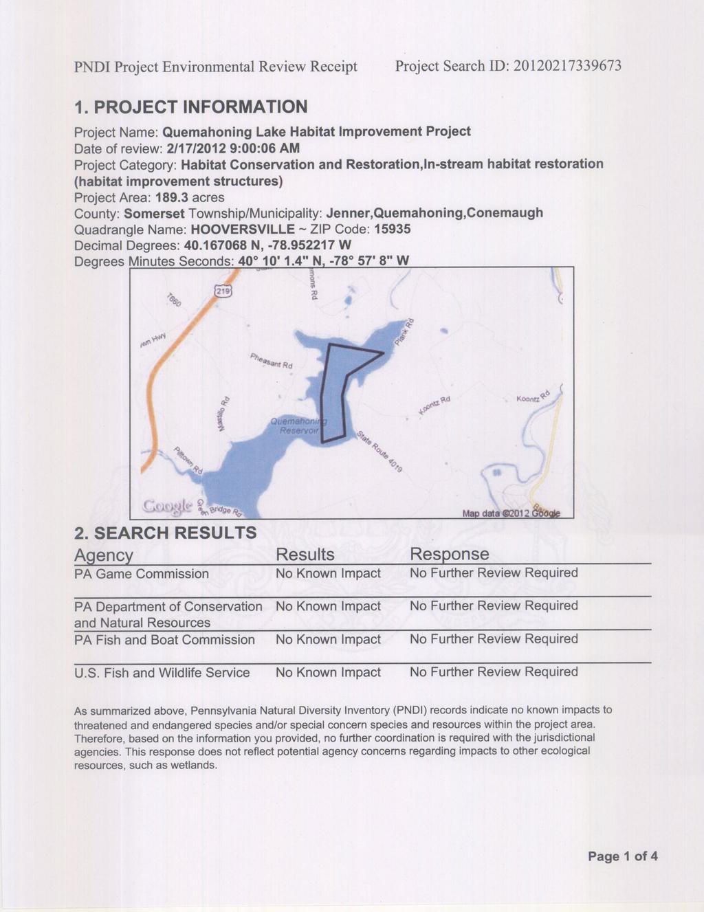
2012 PROPOSED FISH HABITAT MANAGEMENT PLAN FOR QUEMAHONING RESERVOIR, SOMERSET COUNTY, PA SOMERSET COUNTY CONSERVATION DISTRICT
|
|
|
- Giles Rose
- 6 years ago
- Views:
Transcription


1 2012 PROPOSED FISH HABITAT MANAGEMENT PLAN FOR QUEMAHONING RESERVOIR, SOMERSET COUNTY, PA SOMERSET COUNTY CONSERVATION DISTRICT PLANS BY: THE PA FISH & BOAT COMMISSION DIVISION OF HABITAT MANAGEMENT, LAKE SECTION
2 QUEMAHONING RESERVOIR, SOMERSET COUNTY PROJECT NUMBER 351 PAGE 1 OF THREE-YEAR FISH HABITAT MANAGEMENT PROJECT For QUEMAHONING RESERVOIR, SOMERSET COUNTY, PENNSYLVANIA Sponsored by SOMERSET COUNTY CONSERVATION DISTRICT Plans designed by THE DIVISION OF HABITAT MANAGEMENT LAKE SECTION PENNSYLVANIA FISH AND BOAT COMMISSION Plans prepared by Benjamin Page MANAGEMENT PLAN The purpose of this plan is to address the habitat needs of Quemahoning Reservoir as they relate to its classification, fish species diversity and abundance, angler use and paid and/or volunteer work force. This plan is being installed at the request of the Somerset County Conservation District. This project is aimed at long-term and long-lasting artificial habitats that fit the reservoir s existing native habitat features. This proposed plan will provide the basis for the Cooperative Habitat Improvement Program cooperator, Somerset County Conservation District, to place artificial fish habitat structures in Quemahoning Reservoir. Construction supervision, structure placement and design are the responsibility of the Pennsylvania Fish and Boat Commission s (PFBC), Division of Habitat Management (DHM) and/or its designee. All structures constructed must meet the requirements of the Division of Habitat Management s Lake Section. All structures included in this plan meet the requirements of the Department of Environmental Protection and the U.S. Army Corps of Engineers General Permits (BDWW- GP-1 & SPGP-4). FINANCIAL ASSISTANCE Financial assistance is available through the Division of Habitat Management (maximum $3,000 per project, per calendar year) for the purchase of materials on a 50/50 matching basis with the cooperator. All requests for funding must come from a representative of Somerset County Conservation District to the PFBC s Division of Habitat Management. The Cooperator is responsible for all other material and labor costs. IMPOUNDMENT INVENTORY Quemahoning Reservoir is a man-made impoundment, rather than a natural lake. Due to this fact, this impoundment contains native fish habitats (existing physical characteristics), artificial fish habitats (structures or devices placed to act as fish habitat), and natural fish habitats (aquatic vegetation). The native fish habitats in the impoundment combined with the natural topography of the land provide a basis for classification of reservoirs in relationship to habitat. These native habitats existing in Quemahoning Reservoir can be enhanced through the placement of appropriate artificial habitats that best match the reservoir s classification, the native habitats, and the fisheries and angler needs. Quemahoning Reservoir was physically surveyed by the Division of Habitat Management s Lake Section on April 17, 2012 using a Lowrance HDS8 sonar with StructureScan and an internal Lowrance GPS (global positioning system) with Insight USA on a 20' Boston Whaler Outrage utilizing a one 90-degree transducer and one LSS-1 imaging transducer. The survey was conducted to inventory the existing
3 QUEMAHONING RESERVOIR, SOMERSET COUNTY PROJECT NUMBER 351 PAGE 2 OF 7 native habitats, classify the impoundment and find any existing artificial habitats. Any existing artificial habitats found are shown on the attached plan map. Personnel from Somerset County Conservation District were present and involved in the inventory and the design phase of the plan. IMPOUNDMENT CLASSIFICATION Quemahoning Reservoir is a typical hill-land type impoundment. The impoundment has a well-defined meandering stream channel with feeder streams in every major bay. Shores near the main channel are typically steep, while opposing shores have a much slower taper. Major bays are scattered throughout the impoundment with few coves. The points are rounded and gradual. The impoundment has a few submerged foundations and one short causeway. These characteristics of Quemahoning Reservoir are typical of a hill-land impoundment (Lalo, Houser 1982) (Linder 1987) (Houser 2007). ARTIFICIAL HABITATS Artificial habitats (refuge, spawning, nesting and nursery) are designed to be effective, long lasting structures that allow fish to accomplish their daily and seasonal tasks with greater efficiency. Some artificial habitats have dual purposes and may also provide increased opportunities for anglers to catch and harvest fish (fish attraction). They can also provide increased surface areas for algae attachment, aquatic insect colonization and other food organisms which may increase fishery production (Wege, Anderson 1979) (Nilsen, Larimore 1973) (Benke, et al. 1984). Many of these artificial habitats are designed to aide multiple fish species in completing various survival tasks (performance structures), which may also provide an opportunity to increase productivity within some impoundments. Small fish may utilize habitat (artificial, native or natural) to avoid predation by occupying habitat where predators cannot forage (Glass 1971) (Savino, Stein 1982) or (as predators) to utilize complex habitat as foraging areas (Werner, et al. 1983). Increasing complex habitat may allow coexistence of predators and prey through the creation of microhabitat types (Crowder, Cooper 1977). Increasing habitat complexity may positively influence predator efficiency by providing small fish with refuge in areas of high structure densities (Hall, Werner 1977) (Werner, et al. 1983). Complex structural cover may also provide important habitat for aquatic invertebrates (Nilsen, Larimore 1973) (Benke, et al. 1984) and in turn provide foraging opportunities for juvenile and adult panfish that rely on invertebrates as a food source. Complex structure may also serve as habitat for prey resources of black bass (and other predators), thus increasing prey/predator efficiency. Game and panfish also benefit from complex habitat related to the advantages of camouflage (Angermeier, Karr 1984). Simple structural cover (Bass Nesting Structures, Half-Log structures) (Hoff 1992) can be more effective at providing positive spawning, nesting and parental habitat for black bass, than complex cover (Wills, Bremigan, Hayes 2004). Simple cover has less microhabitat types for invertebrates and refuge areas for small fish. Some studies have shown that angler success does not increase during spawning/nesting periods in spawning areas treated with simple artificial cover (Wills, Bremigan, Hayes 2004). Simple structural cover can play a major role in black bass spawning and nesting success when placed at appropriate sites with suitable substrate (Hoff 1992) (Hunt 2002) (Martin, Phillips 1998). Some artificial habitat structure designs matched with appropriate native habitats (physical features existing in the impoundment) may be species select or have preferences toward individual size (juvenile vs. adult) and/or fish habits (Prince, Maughan 1979). Artificial habitats known as forage type structures are designed to provide basic habitat needs of the impoundment s forage base (baitfish, invertebrates, and crustaceans) (Warnecke, Forbis 1990). In many cases a number of artificial habitat types are required in one reservoir to create habitat diversity (complex and simple/wood and rock/shallow and deep). This creates an opportunity for a more diverse fish community to develop and flourish (Benson, Magnusion 1992). Complex large wood structure in lakes may create positive fish habitat for a variety of species (Bozek 2001) (Barwick, Kwak 2004). Rough-cut hemlock lumber is used in all the wood structure designs due to its excellent submerged capabilities to create complex artificial fish habitat. In some cases large hardwood trees are used as large woody structure (Bozek 2001). Other materials used in construction of artificial fish habitats are sandstone, limestone rock, concrete blocks, nails and nylon banding.


4 QUEMAHONING RESERVOIR, SOMERSET COUNTY PROJECT NUMBER 351 PAGE 3 OF 7 All artificial habitats used in this plan have undergone a minimum one-year design phase and two-year durability test. Materials and construction techniques used in the construction of Pennsylvania artificial habitat structures provide the best balance of structure longevity and invertebrate, plankton colonization and fish utilization. Lumber used in the construction of Pennsylvania artificial habitat structures should be green (newly cut), rough-cut true dimensional hemlock or yellow poplar. If other lumber types are required, they will be specified in the plans. All other material types used will be specified in the plan as a specific type of material required for that structure. PENNSYLVANIA PORCUPINE CRIB Porcupine Brush Cribs (see attached standard drawing) are long lasting, deep water, complex structures designed as a refuge type habitat. This design should provide juvenile protection and improve recruitment of panfish and gamefish in impoundments that lack abundant, deep-water submerged aquatic vegetation. Construction materials consist of rough cut, true dimensional, green (fresh cut), hemlock or yellow poplar (50 pieces of 2"X 2"X 4'), eight 2-core 8" concrete blocks (min. 36 lbs. ea.) and 2 lbs. of 16d common bright nails (approx. 2 strips of 12d strip nails for nail guns), plus a 14' piece of ½" nylon security banding and one steel buckle. Placement is traditionally accomplished by specially equipped boats during softwater periods (no ice). Submerged structures are normally placed in a row with 4' to 8' spaces between individual structures. Normally 10 to 20 cribs are placed at one site. Structures are submerged in 10' to 60' depths (Lynch, Johnson & Kayle 1988) (Lynch, Johnson, Durfey 1988) along the contour parallel to the shore or the stream channel. Typically native habitats in hill-land impoundments benefit most from course brush structures (Lalo, Houser 1992). These areas are characterized by steep gradient shores, leading into breaks and/or channels. Steep shores that break onto flats or benches appear to be effective native habitats, when treated with course brush type artificial structures (Lynch, Kayle & Johnson 1988). Typical placement density is 20 structures per acre. This part of the plan will focus on the hill-land areas and their relationship to panfish and juvenile black bass. Twenty Porcupine Cribs are proposed at one site at an average depth of 16' to 18' (site numbers: ). All sites are inventoried by way of G.P.S. with each completed structure placement site having its own way-point (Lat/Lon). PENNSYLVANIA PORCUPINE CRIB JR. The Porcupine Crib Jr. (see attached standard drawing) is an adaptation of the original Porcupine Brush Crib. The original Porcupine Crib was designed as a deep-water structure. The Jr. is a shallow water version with additional density in the gable ends. The Porcupine Jr. was designed to mimic the habitat provided by native stumps. Stumps in shallow water provide an important habitat value in Pennsylvania reservoirs and sometimes are the only true native woody cover in the impoundment. Typically native habitats in hill-land impoundments benefit most from course brush structures (Lalo, Houser 1992). As impoundments age native stump fields may disappear, due to erosion by wind and/or annual or maintenance drawdowns as the stump fields disappear, so does that particular type of cover (Bozek 2001). In some cases, impoundments do not contain any native stumps, due to the policies in place during impoundment construction. Porcupine Crib Jr.s should provide similar cover to pre and post spawning adult panfish and black bass, plus seasonal ambush and security cover for juveniles and adults.
, eight 2-core 8\" concrete blocks (min. 36 lbs. ea.) and 2 lbs. of 16d common bright nails (approx.")
5 QUEMAHONING RESERVOIR, SOMERSET COUNTY PROJECT NUMBER 351 PAGE 4 OF 7 Construction materials consist of rough cut, true dimensional green (fresh cut) hemlock or yellow poplar (38 pieces of 2"X 2"X 4'), eight 2-core 8" concrete blocks (min. 36 lbs. ea.) and 2 lbs. of 16d common bright nails (approx. 2 strips of 12d strip nails for nail guns), plus a 10' piece of ½" nylon security banding and one steel buckle. Placement is traditionally accomplished by specially equipped boats during soft-water periods (no ice). Normally 10 to 20 Porcupine Crib Jr.s are placed at one site. The Porcupine Crib Jr. is normally placed in a five-point star fashion with an open center (Bryant, G. L. 1992) on shallow water flats in depths between 6' and 10' (unlike full sized porcupines that is placed in rows near deep water breaks) with varied distances between each individual structure. The Jr. is only 28" high, so even at 6' depths, the structures are not a navigation hazard, except during any drawdown periods where structures may become exposed. This part of the plan will focus on the flats and their relationship to panfish and black bass. These sites contain a limited number of native stumps, and these structures will provide additional. Typical placement density is 30 structures per acre. Fifteen Juniors are proposed at one site at an average depth of 10' to 15' (site numbers ). All sites are inventoried by way of G.P.S., with each completed structure placement site having its own way-point (Lat/Lon). PENNSYLVANIA SHORT VERTICAL PLANK STRUCTURE The Short Vertical Plank Structure is designed as a shallow water adult black bass habitat. Shorty s are designed for shallow water flats with depths ranging from 5 to 20. The most effective flats lead into stream of river channels. Shorty s will be placed on these flats in areas void of submerged aquatic vegetation. Shorty s with brush or conifers added to the interior are a beneficial complex habitat. This type of habitat will create excellent overhead cover for ambush or hunt and flush foraging opportunities for adult black bass (Barwick, Kwak 2004). Shorty s should also provide outstanding early season adult panfish cover when course brush is added to the structure (Barwick, Kwak 2004). Vertical wooded and course brush structures have been found successful in attracting fish in shallow water (less than 10') in hill-land and highland impoundments. The most effective placement appears to be in dense circles of structures with one or more openings in the center (Bryant 1992) or in an irregular line formation with large openings between individual devices (see standard placement drawing). Largemouth bass, sunfish, crappie and yellow perch favor coarse brush and wooden type structures when placed on or near steep gradient shores that break onto flats or benches (Lynch, Kayle & Johnson 1988). Construction materials consist of rough-cut, true dimensional green (fresh cut) hemlock or poplar (32 pieces of 1" X 4" X 24", 10 pieces of 1 X 4 X 48 and 35 pieces of 2"X 2"X 48"), nine 2-core 8" concrete blocks (min. 36 lbs. ea.) and ½ lb. of 16d common bright nails (approx. 1 strip of 12d strip nails for nail guns) and 2 lbs of 8 d common bright nails (approx. 2 strips of 2 5/8" strip nails for nail guns) plus a 10' piece of ½" nylon security banding and one steel buckle (see standard drawing). The Short Vertical Plank Structure is 29" high, so it can be placed in depths between 5 and 10 and still is safe from boating traffic (they may create a navigation hazard during draw-down periods where structures may become exposed). Placement is accomplished by specially equipped boats during softwater periods (no ice). This part of the plan will focus on sites that have shallow water near shoreline and offshore flats. Typical placement density is 30 structures per acre. A total of twenty structures are proposed at one site at approximately 20 to 23 depths (site numbers: ). All sites are inventoried by way of G.P.S., with each completed structure placement site having its own way-point (Lat/Lon). STRUCTURE CONSTRUCTION AND PLACEMENT The construction and placement of all artificial structures in this plan must be coordinated with the Lake Section of the Division of Habitat Management. Representatives of the Lake Section (or a designated representative) will be on hand to supervise and assist in construction of all artificial habitats designed for this project. Specialized PFBC tools and equipment may also be utilized by the cooperator to accomplish
6 QUEMAHONING RESERVOIR, SOMERSET COUNTY PROJECT NUMBER 351 PAGE 5 OF 7 construction of artificial structures supervised by Habitat Management Staff. Placement of artificial habitats can, in most cases, be accomplished by specially equipped DHM watercraft, operated by trained Lake Section staff. Other state and/or federal watercraft and operators may also be utilized to accomplish projects managed by the Division of Habitat Management. All artificial habitats must be constructed to the specification shown in the standard drawings attached to this plan packet. PROJECT APPROVAL AND COMPLETION This project is automatically approved after a fifteen-day review period that begins from the date of the cover letter or memo. This three-year plan provides the Cooperative Habitat Improvement Program cooperator an opportunity to construct and place a total of fifty-five artificial habitat structures in Quemahoning Reservoir at an approximate rate of eighteen per year. This three-year plan begins in 2012 and is planned for completion by 2014, unless otherwise extended by a cooperative agreement between Somerset County Conservation District and the Pennsylvania Fish and Boat Commission s Division of Habitat Management (BSP, 12).
7 QUEMAHONING RESERVOIR, SOMERSET COUNTY PROJECT NUMBER 351 PAGE 6 OF 7 LITERATURE CITED Angermeier, P. L., and J. R. Karr. Relationship between woody debris and fish habitat in a small warmwater stream. Transactions of the American Fisheries Society 113: Barwick, R. D., Kwak, T. J., Fish populations Associated with Habitat-Modified Piers and Natural Woody Debris in Piedmont Carolina Reservoirs., American Fisheries Society, North American Journal of Fisheries Management 24: Benke, A. C., T. C. Van Aardsall, Jr. D. M. Gillespie and F. K. Parrish, Invertebrate productivity in a subtropical blackwater river: the importance of habitat and life history. Ecological Monographs 54: Benson, B. J. And J.J. Magunson Spatialheterogeneity of Littoral Fish Assemblages in Lakes: Relation to Species Diversity and Habitat Structure. Canadian Journal of Fisheries and Aquatic Sciences, Bozek, M.A. A second Life for Trees in Lakes Lakeline, Magazine, 2001 Bryant, G. J. Direct Observations of Largemouth and Smallmouth Bass in Response to Various Brush Structure Designs in Ruth Reservoir, California. FHR Currents, Number 10, October Crowder, L. B., and W.E. Cooper Habitat structural complexity and the interaction between bluegills and their prey. Ecology 63: Glass, N. R Compuiter analysis of predator energetics in the largemouth bass. Pages in B. C. Pattern, Hall, D. J., and E. E. Werner, Seasonal distribution of fishes in the littoral zone of a Michigan Lake. Transactions of the American Fisheries Society 106: Hoff, M. H. Effects of Increased Nesting Cover on Nesting and Reproduction of Smallmouth Bass in Northern Wisconsin Lake. Mississippi State University, Houser, D. F., Fish Habitat Management for Pennsylvania Impoundments Pennsylvania Fish & Boat Commission, Hunt, J., Annett, C.A. Effects of Habitat Manipulations on Reproductive Success of individual Largemouth Bass in an Ozark Reservoir North American Journal of Fisheries Management, American Fisheries Society, 2002 Jackson, J.R., Noble, R.L., Irwin, E.R., Van Horn, S.L. Response of Juvenile Largemouth Bass to Habitat Enhancement Through Addition of Artificial Substrates. Proc. Annual Conference, SEAFWA, 2000 Lalo J., Houser, D.F. Fish Habitat Improvement for Lakes, Ponds and Reservoirs. and Boat Commission, Pennsylvania Fish Linder, A. The Secret Teachings of Angling Wisdom & Knowledge. In-Fisherman, Inc., Brainerd Minnesota, Lynch, W.E., Johnson, D. L., Kayle, K. A. Effects of Deep to Shallow Water Row on Fish Use of Artificial Structure. Ohio State University, Lynch, W. E., Johnson, D. L., Durfey, L. E. Importance of Depth as an Artificial Structure Placement Factor. Ohio State University, 1988.
8 QUEMAHONING RESERVOIR, SOMERSET COUNTY PROJECT NUMBER 351 PAGE 7 OF 7 Lynch, W. E., Kayle, A. K., Johnson, D. L. Importance of Bottom Gradient as an Artificial Structure Placement Factor. Ohio State University, Nilsen, H. C and R. W. Larimore Establishment of invertebrate communities on log substrates in the Kaskaskis River, Illinois. Ecology 54: Martin, T.H., Philips, C. An Evaluation of Artificial-Spawning-Structure use by largemouth bass in Blue Marsh and Lake Marburg, Pennsylvania. Penn State University, School of Forest Resources, Prince, E. D., and O. E. Maughan Telemetric observations of largemouth bass near underwater structures in smith Mountain Lake, Virginia. Pages in R. A. Stein and D. L. Johnson, editors. Response of fish to habitat structure in standing water. American Fisheries Society, North Central Division, Special Publication 6, Bethesda, MD. Savino, J. F. and R. A. Stein Predator-prey interaction between largemouth bass and bluegills as influenced by simulated, submerged vegetation. Transactions of the American Fisheries Society 111: Stein, R. A. and D. L. Johnson, editors. Response of fish to habitat structure in standing water. American Fisheries Society, North Central Division, Special Publication 6, Bethesda, MD. Warnecke, J., Forbis, L. A. Saguaro Lake project: artificial fisheries habitat structure. Arizona Game and Fish Department, Implementation Report, 1990 Wege, G. J., Anderson, R.O. Influence of artificial structures on largemouth bass and bluegill in small ponds. Johnson and Stein Werner, E. E., J. F. Gilliam, D. J. Hall and G. G. Mittelbach An Experimental test on the effects of predation of risk on habitat use in fish. Ecology 64: Wills, T.C, M.T. Bremigan and D. B. Hayes Variable Effects of Habitat Enhancement Structures across Species and Habitats in Michigan Reservoirs. Transactions of the American Fisheries Society 133:

9 # Porcupine Sr.s feet of water 40* # Post Clusters 14 Post Stumps 5'-6' of water 40* * # Post Clusters 5'-6' of water 40* * ACCESS 78* # Porcupine Crib Jr.s 10 feet of water 40* * * * # Short Vertical Plank Structures 5' of Water * # * Short Vertical Plank Structures 5' of Water Boulders E 40* W 40* * * # Black Bass Nesting Structures # '-7' of water 15 Porcupine Crib Jr.s 40* feet of water 78* * * # Short Vertical Plank Structures 5' of Water E 40* W 40* # * * Post Cluster Post Stumps 40* # * Stone Deflectors Rock Rubble Humps 40* # Short Vertical Plank Structures 17'-20' of Water 40* * # # Rock Rubble Humps 1 Stone Deflector 7'-9' of water 40* * * * # Fishing Pier 20 Rock Rubble Humps 10'-13' of water 40* * Launch STREAM CHANNEL # Rock Rubble Humps 19'-20' of water # * Rock Rubble Humps 78* '-11' of water * * # Rock Stars 5'-6' of water N 40* S 40* * * # # Spider Humps 5 Black Bass Nesting Structures 5'-6' of water 4'-7' of water 40* * * * Boulders 78* # Spider Humps 8 Rock Stars NOTE: Cove has significant aquatic vegetation annually. 1 Post Stump Cluster 4 Rock Rubble Humps 5'-6' of water N 40* S 40* * * # SVP's feet of water 40* # Felled Shoreline Trees 3 Completed in * ACCESS # Spider Humps 7 Rock Stars 8 Post Stumps 5'-6' of water N 40* S 40* * * # Felled Shoreline Trees 8 Completed in 2007 # # Porcupine Cribs 15'-22' of Water 40* * DAM BREAST 10 Felled Shoreline Trees PLAN MAP LEGEND CATFISH SPAWNING BOX STAKE TREE TURTLE BASKING PLATFORM VERTICAL PLANK STRUCTURE BLACK BASS NESTING STRUCTURE FELLED SHORELINE TREE PORCUPINE CRIB PORCUPINE CRIB JUNIOR SHORT VERTICAL PLANK STRUCTURE ROCK RUBBLE HUMPS CONIFER STRING POST CLUSTER PROPOSED COMPLETED # Spider Humps 1 Post Stump 5'-6' of water 40* * # Procupine Cribs 15'-16' of Water 40* * Completed in 2007 FISH HABITAT IMPROVEMENT PLAN for QUEMAHONING RESERVOIR, SOMERSET COUNTY by PA FISH AND BOAT COMMISSION DIVISION OF HABITAT MANAGEMENT Drawn By: M.B.S.; B.S.P.; P.E.T Habitat Manager: Benjamin Page Date: 3/1/2012 POST CLUSTERS PLUS SPIDER HUMPS NOT TO SCALE ROCK STAR STRUCTURES FIT IN FIELD POST STUMPS ALL SIZES APPROXIMATE STONE FRAMED DEFLECTOR SAW-TOOTHED DEFLECTOR ROOT WAD/LOG DEFLECTOR TIRE STRUCTURE ROAD BED N NOTE : Blue Text Indicates Proposed Sites Black Text Indicates Completed Sites
10 PENNSYLVANIA PORCUPINE CRIB STRUCTURE STANDARD DRAWING SECTION VIEW PROFILE VIEW 44" CEILING BOARDS RUNNER BOARDS FLOOR BOARDS CONCRETE BLOCKS PLAN VIEW MATERIALS AND NOTES 48" MATERIALS: ROUGH CUT HEMLOCK LUMBER 2" x 2" x 4'- 50 PIECES 8" x 8" x 16" 2 CORE CONCRETE BLOCKS- 8 TOTAL 16D COMMON NAILS- 2 LBS. ( OR 2 STRIPS OF 12D) 1/2" NYLON BANDING- 18' 1 STEEL BUCKLE NYLON BANDING & STEEL BUCKLE NOTES: LUMBER MUST BE TRUE DIMENSIONAL LUMBER MUST BE GREEN (FRESH CUT) YELLOW POPLAR MAY BE SUBSTITUTED FOR HEMLOCK CONCRETE BLOCKS MINIMUM WEIGHT: 35 LBS NYLON BANDING: 600 LBS TENSILE STRENGTH NOT TO SCALE ALL SIZES ARE APPROXIMATE FIT IN FIELD 48" PFBC 10/08/97 MBS 09
11 PENNSYLVANIA PORCUPINE CRIB JUNIOR STRUCTURE STANDARD DRAWING SECTION VIEW PROFILE VIEW 28" CEILING BOARDS RUNNER BOARDS FLOOR BOARDS CONCRETE BLOCKS PLAN VIEW MATERIALS AND NOTES 48" MATERIALS: ROUGH CUT HEMLOCK LUMBER 2" x 2" x 4'- 38 PIECES 8" x 8" x 16" 2 CORE CONCRETE BLOCKS- 8 TOTAL 16D COMMON NAILS- 2 LBS. ( OR 2 STRIPS OF 12D) 1/2" NYLON BANDING- 18' 1 STEEL BUCKLE NOTES: LUMBER MUST BE TRUE DIMENSIONAL LUMBER MUST BE GREEN (FRESH CUT) YELLOW POPLAR MAY BE SUBSTITUTED FOR HEMLOCK CONCRETE BLOCKS MINIMUM WEIGHT: 35 LBS NYLON BANDING: 600 LBS TENSILE STRENGTH NOT TO SCALE ALL SIZES ARE APPROXIMATE FIT IN FIELD NYLON BANDING & STEEL BUCKLE 48" PFBC 10/08/97 MBS 09
12 PENNSYLVANIA "SHORT" VERTICAL PLANK STRUCTURE STANDARD DRAWING SECTION VIEW PROFILE VIEW 16" 16" 16" 30" 24" 2" X 3" X 48" RUNNER BOARDS FLOOR BOARDS CONCRETE BLOCKS PLAN VIEW MATERIALS AND NOTES 48" MATERIALS: ROUGH CUT HEMLOCK LUMBER 1" X 4" X 24" - 32 PEICES ROUGH CUT HEMLOCK LUMBER 1" X 4" X 48" - 6 PEICES ROUGH CUT HEMLOCK LUMBER 2" X 2" X 48" - 18 PEICES ROUGH CUT HEMLOCK LUMBER 2" X 3" X 48" - 3 PEICES 8" X 8" X 16" 2 CORE CONCRETE BLOCKS- 9 TOTAL COMMON NAILS (12D) - 1/2 LB COMMON NAILS (8D) - 1 LB OPTIONAL: 1 OR 2 SMALL CONIFER TREES MAY BE ADDED NOTES: LUMBER MUST BE TRUE DIMENSIONAL LUMBER MUST BE GREEN (FRESH CUT) CONCRETE BLOCKS MINIMUM WEIGHT: 35 LBS NOT TO SCALE ALL SIZES ARE APPROXIMATE FIT IN FIELD NYLON BANDING & STEEL BUCKLE 48" PFBC 3/26/02 MBS 09
13 ' W ' W ' W ' N ' N ' N ' N ' N ' N ' W ' W Copyright (C) 2001, Maptech, Inc ' W
14
15

16
17
18 3930-PM-WM /2005 COMMONWEALTH OF PENNSYLVANIA DEPARTMENT OF ENVIRONMENTAL PROTECTION BUREAU OF WATERSHED MANAGEMENT GENERAL PERMIT BDWW-GP-1 FISH HABITAT ENHANCEMENT STRUCTURES TABLE OF CONTENTS PAGE INSTRUCTIONS FOR USING THE GENERAL PERMIT... i PART ONE: APPLIES SPECIFICALLY TO BDWW-GP-1 A. GENERAL DESCRIPTION AND FEES B. SITES AND CONDITIONS WHERE THIS GENERAL PERMIT DOES NOT APPLY C. DEFINITIONS APPLICABLE TO THIS GENERAL PERMIT D. PROJECT DESIGN AND CONSTRUCTION CRITERIA E. COOPERATIVE ADOPT-A-STREAM PROGRAM - SPECIAL PROCEDURES F. AUTHORITY AND CONTINUING AUTHORIZATION PART TWO: APPLIES TO BDWW-GP-1 AND OTHER BDWW GENERAL PERMITS A. REGISTRATION OF PROPOSED USE OF GENERAL PERMITS B. DENIAL OF AUTHORIZATION C. STANDARD DEFINITIONS FOR GENERAL PERMITS D. PRECONSTRUCTION REQUIREMENTS FOR ALL PROJECTS E. OTHER PRECONSTRUCTION REQUIREMENTS WHERE APPLICABLE F. STANDARD PROVISIONS OF THE GENERAL PERMIT ATTACHMENTS: DRAWING NO. 1 - SAMPLE LOCATION MAP EXHIBIT A - OFFICES OF THE PENNSYLVANIA FISH AND BOAT COMMISSION EXHIBIT B - REGIONAL OFFICES OF THE DEPARTMENT OF ENVIRONMENTAL PROTECTION AND U.S. ARMY CORPS OF ENGINEERS DISTRICT OFFICES EXHIBIT C - COUNTY CONSERVATION DISTRICTS GENERAL PERMIT REGISTRATION FORM (INCLUDES SINGLE AND COMPLETE PROJECT SCREENING QUESTIONNAIRE) PENNSYLVANIA NATURAL DIVERSITY INVENTORY FORM
19 3930-PM-WM /2005 PRIOR TO REGISTRATION TO USE: INSTRUCTIONS FOR USING THE GENERAL PERMIT BDWW-GP-1 Fish Habitat Enhancement Structures 1. Carefully review the definitions and requirements of the General Permit (Part One and Part Two) to determine if your project can qualify for authorization under this General Permit. Refer to Part One, Section B regarding area restrictions and Part One, Section D regarding criteria. If your project cannot be authorized under the General Permit, you may request approval of an individual permit by submitting an application to the appropriate Permitting and Technical Services Section in the Regional Office as listed on Exhibit B. 2. Contact the Pennsylvania Fish and Boat Commission, Division of Environmental Services or Division of Property Services at address and telephone number shown on Exhibit A to select a suitable structure and obtain Pennsylvania Fish and Boat Commission approval on the General Permit Registration form. For the Cooperative Adopt-A-Stream Program, the Pennsylvania Fish and Boat Commission will also register the use of the General Permit on behalf of the project sponsor. 3. Locate your project on a United States Geological Survey (U.S.G.S.) 7½ Minute Quadrangle Map 1 and prepare a project LOCATION MAP, utilizing a photocopy of the U.S.G.S. Quadrangle Map. 4. Complete the Pennsylvania Natural Diversity Inventory (PNDI) Form and submit it to the person conducting the online PNDI Project Planning and Environmental Review Tool search. This person performing the search could be someone from DEP, the County Conservation Districts, or a consultant. Alternatively, if you plan to conduct the PNDI online search yourself a search form is not needed prior to the PNDI online search. After conducting the PNDI online search, if your PNDI Project Environmental Review Receipt has "Potential Impacts," DEP and the jurisdictional agencies require that you submit additional information to the agencies noted on the Receipt for further review. Please send a copy of the PNDI Receipt, a completed PNDI Form, and a USGS 7.5 minute quadrangle map with project boundaries delineated on the map to the agencies referenced on your PNDI Receipt. 5. For any earthmoving activity 2 associated with your project, prepare an Erosion and Sediment Control Plan which must be reviewed and determined satisfactory by the County Conservation District in the county where your project is located. The required Erosion and Sediment Control Plan must be prepared and submitted to the Conservation District for review prior to or concurrent with your registration to use the General Permit. THE REGISTRATION PROCEDURE: 6. Fill in all information on the GENERAL PERMIT REGISTRATION form and make multiple copies. Send one copy each to the municipality and the county in which the project is located. 7. To register use of the General Permit, prepare a complete registration package consisting of: - Two Copies of the GENERAL PERMIT REGISTRATION form - Two copies of the LOCATION MAP - Two copies of the PNDI form and an initialed search receipt 1 2 Commonly called topographic maps, U.S.G.S. Quadrangles may be available from local merchants dealing in books, hunting supplies and camping equipment. For the definition of earthmoving activity, see Part Two, Section C. - i -
20 3930-PM-WM /2005 Send these items to either: - The County Conservation District for projects located in all counties where there is a delegation agreement (see Exhibit C). - OR - - The Permitting and Technical Services Section having responsibility for the counties where there is no delegation agreement with the County Conservation District (see Exhibit B). 8. If you are also applying for an individual Water Obstruction and Encroachment Permit to authorize related work, you may register to use the General Permit in conjunction with your individual permit application (See Part Two, Section A, Item 2). BEFORE AND DURING CONSTRUCTION: 9. Do not begin work until: a. You have received an acknowledgement from the Permitting and Technical Services Section or County Conservation District that your General Permit Registration form has been received and registered. b. Your Erosion and Sediment Control Plan has been reviewed and determined to be satisfactory by the County Conservation District. c. You have notified the Pennsylvania Fish and Boat Commission and the County Conservation District 10 days prior to start of construction (See Part Two, Section D). d. You have obtained any other Federal, State or local permits which may be required. e. You have complied with any other applicable preconstruction requirements as listed in Part Two, Section E. f. You have provided written notifications to the municipalities and county where the projects are located prior to the start of construction. 10. During construction of your project, you are responsible for adhering to all terms and conditions of the General Permit, including your approved Erosion and Sediment Control Plan and all applicable design and construction criteria in Part One, Section D. - ii -
21 3930-PM-WM /2005 COMMONWEALTH OF PENNSYLVANIA DEPARTMENT OF ENVIRONMENTAL PROTECTION BUREAU OF WATERSHED MANAGEMENT GENERAL PERMIT BDWW-GP-1 FISH HABITAT ENHANCEMENT STRUCTURES PART ONE A. GENERAL DESCRIPTION AND FEES - The Department of Environmental Protection hereby authorizes, by General Permit, subject to the terms and criteria set forth, the installation, operation and maintenance of fish habitat enhancement structures in the regulated waters of this Commonwealth. There is no registration fee required for a project authorized under this General Permit. B. SITES AND CONDITIONS WHERE THIS GENERAL PERMIT DOES NOT APPLY - This General Permit does not apply and is not valid in the following situations. Where the General Permit is not applicable, you may request approval of an individual permit by submitting an application to the appropriate Permitting and Technical Services Section in the Regional Office (see Exhibit B). 1. Historic, cultural or archaeological sites as identified in the latest published version of the Pennsylvania Inventory of Historical Places or the National Register of Historical Places. This information is available from the Pennsylvania Historical and Museum Commission, 400 North Street, Second Floor, Harrisburg, PA , telephone (717) Sites identified in the latest published version of the National Registry of Natural Landmarks. 3. Construction activities in stocked trout streams from March 1 through June 15, in wild trout streams from October 1 through December 31, and in Lake Erie tributaries from March 1 through June 15 and from September 1 through December 31, unless approval is obtained from the Pennsylvania Fish and Boat Commission s Division of Environmental Services (see Exhibit A). Stocked and wild trout stream locations are compiled by the Commission s Division of Fisheries Management (see Exhibit A). 4. Wetlands. 5. Projects located where there would be an impact on species of special concern listed under the Endangered Species Act of 1973, the Wild Resources Conservation Act, the Fish and Boat Code or the Game and Wildlife Code. Records regarding species of special concern are maintained in a computer database called the Pennsylvania Natural Diversity Inventory (PNDI). To verify that there will be no such impacts for a specific project, the Department requires submission of the attached PNDI Form and an initialed search receipt. 6. Areas in or within 100 feet of a watercourse designated wild in the National or State Scenic Rivers system in accordance with the National Wild and Scenic Rivers Act of 1968 or the Pennsylvania Scenic Rivers Act. For details on scenic river classifications, contact the DCNR, Division of Greenways and Conservation Partnerships, Pennsylvania Scenic Rivers Program, P.O. Box 8475, Harrisburg, PA , telephone (717) C. DEFINITIONS APPLICABLE TO THIS GENERAL PERMIT - The following words and terms, when used in this General Permit, have the following meanings: FISH HABITAT ENHANCEMENT STRUCTURES - Structures consisting of deflectors, low flow channel structures, channel blocks, mud sills, boulders, felled shoreline trees, special tire structures, brush structures, rubble reefs, half-log structures, elevated boulder structures and spawning/nursery structures placed in streams, lakes, ponds or reservoirs as developed and approved by the Pennsylvania Fish and Boat Commission. 1-1
22 3930-PM-WM /2005 RESERVOIR - A natural or artificial basin which contains or will contain the water or other fluid or semifluid impounded by a dam. D. PROJECT DESIGN AND CONSTRUCTION CRITERIA 1. PENNSYLVANIA FISH AND BOAT COMMISSION APPROVAL - The owner must contact the Pennsylvania Fish and Boat Commission s Division of Property Services or Division of Environmental Services (see Exhibit A) to select a Fish Habitat Enhancement Structure suitable for his individual situation and obtain the required approval of the Pennsylvania Fish and Boat Commission to install the structure as required on the General Permit Registration form. 2. Fish Habitat Enhancement Structures shall be designed and constructed to preclude interference with normal fish migration. 3. Stream flow will not be constricted to a degree greater than the most narrow natural point of the stream in the immediate vicinity of the work within 500 feet upstream or downstream of the project site. 4. Fish Habitat Enhancement Structures located in stream channels shall not extend more than 3 feet above the normal stream bed. Tire structures are prohibited in stream channels. 5. Any archaeological artifacts discovered during the performance of work authorized under this General Permit must be adequately protected and their discovery promptly reported to the Bureau for Historic Preservation, Pennsylvania Historical and Museum Commission, 400 North Street, Harrisburg, PA , telephone (717) Each Fish Habitat Enhancement Structure shall be constructed in such a way so that it does not hinder recreational navigation. 7. Excess fill or excavated and dredged material from the construction of a Fish Habitat Enhancement Structure shall be deposited outside of the adjacent floodplain, wetlands and other regulated waters of this Commonwealth and stabilized immediately in accordance with the Erosion and Sediment Control Plan. Waste materials, scrap or excess construction materials shall be collected, stored and disposed of in accordance with the Solid Waste Management Act and related rules and regulations. 8. Fish Habitat Enhancement Structures shall be maintained in a safe and functional condition. This includes the removal of debris. Where maintenance requires excavation or dredging, an Erosion and Sediment Control Plan must be reviewed and determined adequate by the County Conservation District in which the activity is located. Disposal of dredged material shall be in accordance with Item Only a clean, nonpolluting, rock material shall be used as fill material in order to minimize excessive turbidity by leaching of fines as well as to preclude the entrance of potentially polluted materials to the watercourse by natural runoff. 10. Slag is not authorized for use under this General Permit unless it qualifies as a co-product which is suitable for the specific use. 11. Construction of a Fish Habitat Enhancement Structure shall take place during periods coinciding with low stream flows. 12. Construction and other activities authorized by this General Permit shall be performed in a manner that minimizes use of equipment within the stream channel or body of water. 13. To the greatest extent possible, the project shall be designed and constructed in a manner which will (a) prevent permanent or long-term adverse changes in water quality, 1-2
23 3930-PM-WM /2005 (b) minimize alterations in natural aquatic habitat and (c) maintain natural stream flow velocities and mixing patterns. E. COOPERATIVE ADOPT-A-STREAM PROGRAM - SPECIAL PROCEDURES - The Pennsylvania Fish and Boat Commission is authorized to register the use of this General Permit on behalf of sponsors and landowners who participate in the Commission s Cooperative Adopt-A-Stream Program. To register use of the General Permit for Adopt-A-Stream projects, the Commission shall utilize a modified version of the General Permit Registration form named Alternative Exhibit D which has been approved by the Department and the U.S. Army Corps of Engineers. The standard attachments to the General Permit Registration form, as specified in Part Two, Section A, are not required to register the use of this General Permit for a Cooperative Adopt-A-Stream Project. F. AUTHORITY AND CONTINUING AUTHORIZATION - Authorization of this General Permit is under section 7 of the Dam Safety and Encroachments Act (32 P.S ) and the rules and regulations promulgated thereunder at 25 Pa. Code (relating to General Permits). This General Permit shall authorize the continued operation and maintenance of fish habitat enhancement structures previously authorized by General Permit BDWM-GP-1 (Fish Enhancement Structures) issued on July 25, 1981 and reauthorized on August 29, 1987 and October 7,
JadEco, LLC PO BOX 445 Shannon, IL 61078
 Introduction: With the assistance of Lake Holiday staff and volunteers, we were able to conduct an AC electrofishing survey on May 8, 27. Water temperatures were 2.3 C (8.5 F) and water clarity was decent
Introduction: JadEco, LLC PO BOX 445 Shannon, IL 61078
 Introduction: was contacted to collected data on the fishery for Lake Holiday. AC Electroshocking was conducted at 2 locations on September 28, 2015. Fish population data was collected for a total of 100
Estimated on-the-ground start and end dates: 1 June October 2018
 A. Applicant Information Name of Organization: U.S. Army Corps of Engineers, Carlyle Lake 801 Lake Road, Carlyle, IL 62231 Contact Information: Robert Wilkins, Operations Manager, (618) 594-2484, Robert.Wilkins@usace.army.mil
Quemahoning Reservoir
 Pennsylvania Fish & Boat Commission Biologist Report Quemahoning Reservoir Somerset County May 2011 Trap Net, Gill Net and Electrofishing Survey Quemahoning Reservoir is an 899 acre impoundment located
Big Spring Creek Habitat Enhancement and Fishery Management Plans
 Big Spring Creek Habitat Enhancement and Fishery Management Plans November 5, 2012 Big Spring Events and Activities Center Newville, PA Charlie McGarrell Regional Habitat Biologist Pennsylvania Fish and
Environmental Review and Permitting for Wild Trout
 Environmental Review and Permitting for Wild Trout Tom Shervinskie Wild Trout Summit Watershed Analysis Section August 26, 2017 Division of Environmental Services The mission of the Pennsylvania Fish and
Pennsylvania Fish & Boat Commission Biologist Report. Wilmore Dam. Cambria County. May 2011 Trap Net, Electrofishing and Hoop Net Survey
 Pennsylvania Fish & Boat Commission Biologist Report Wilmore Dam Cambria County May 2011 Trap Net, Electrofishing and Hoop Net Survey Wilmore Dam is a 195 acre impoundment located in central Cambria County
Illinois Lake Management Association Conference March 23, 2018 By Trent Thomas Illinois Department of Natural Resources Division of Fisheries
 Illinois Lake Management Association Conference March 23, 2018 By Trent Thomas Illinois Department of Natural Resources Division of Fisheries Sources of Habitat Impairment Sedimentation Channelization
FACT SHEET I. LOCATION
 STEAMBOAT ISLAND HABITAT REHABILITATION AND ENHANCEMENT PROJECT (HREP) SCOTT COUNTY, IOWA, UPPER MISSISSIPPI RIVER RESTORATION-ENVIRONMENTAL MANAGEMENT PROGRAM ROCK ISLAND DISTRICT FACT SHEET I. LOCATION
Sebec Lake Fisheries Management Plan 2012
 Sebec Lake Fisheries Management Plan 2012 Sebec Lake is a 6,800-acre oligotrophic lake located in northwestern Maine. It has popular fisheries for landlocked salmon, lake trout, and smallmouth bass. Other
EcoLogic Memorandum. TO: Ben Brezell; EDR FROM: Mark Arrigo RE: Possible Impacts of Dredging Snooks Pond DATE: 6/4/07
 EcoLogic Memorandum TO: Ben Brezell; EDR FROM: Mark Arrigo RE: Possible Impacts of Dredging Snooks Pond DATE: 6/4/07 Background EDR P.C. (EDR) has been contracted by a landowner to assess the feasibility
Hydraulic Modeling of Stream Enhancement Methods
 Hydraulic Modeling of Stream Enhancement Methods Matthew J. Curry John J. Levitsky Abstract Development within watersheds increases the amounts of runoff causing stream erosion and degradation of stream
Minnesota Department of Natural Resources Division of Fish and Wildlife Section of Fisheries. Stream Survey Report. Luxemburg Creek.
 Minnesota F-29-R(P)-24 Area 315 Study 3 March 2016 Minnesota Department of Natural Resources Division of Fish and Wildlife Section of Fisheries Stream Survey Report Luxemburg Creek 2015 Mark Pelham Sauk
Tittabawassee River Assessment. Miles. Gladwin Smallwood Impoundment. Harrison. Clare. Midland. Mt. Pleasant. St. Louis. Saginaw.
 Warmouth Lepomis gulosus feeding - clear lakes and impoundments and very low-gradient streams - abundant aquatic vegetation - silt-free water - mucky substrate often covered with organic debris spawning
Aquatic Plant Management and Importance to Sport Fisheries
 Aquatic Plant Management and Importance to Sport Fisheries Presentation to Michigan Inland Lakes Convention May 2014 Mike Maceina Professor Emeritus School of Fisheries, Aquaculture, and Aquatic Sciences
Columbia Lake Dam Removal Project
 Columbia Lake Dam Removal Project The Columbia Lake dam located 1/4 mile upstream of the Paulins Kill River's confluence with the Delaware River in Knowlton Township, Warren County has been proposed for
Caro Impoundment, Tuscola County
 Caro Impoundment is a 200 acre impoundment of the Cass River located one mile south of the Village of Caro in Tuscola County. Caro Dam, originally constructed in 1906 for water supply to Michigan Sugar
Claytor Lake View of the Claytor Lake dam from Claytor Lake State Park s boat ramp.
 Claytor Lake 2007 Imagine yourself on a waterbody that is more like a wide river than a lake. When you do, you will have a picture of Claytor Lake. Claytor Lake, a 4,475-acre reservoir, stretches northeastward
Fish Community. Fish Habitat, Streams and Rivers
 Clear, Ston(e)y and White Lake Plan Fish Community The lakes support a cool/warm water fishery including muskellunge, walleye, largemouth and smallmouth bass, yellow perch, pumpkinseed, rockbass, blue
SKIATOOK LAKE MANAGEMENT PLAN
 SKIATOOK LAKE MANAGEMENT PLAN Background Skiatook Lake impounds Hominy Creek, 5 miles west of Skiatook in Osage County, Oklahoma (Figure 1). Skiatook Lake covers 10,540 surface acres and was constructed
MIDDLE FORK RESERVOIR Wayne County 2004 Fish Management Report. Christopher C. Long Assistant Fisheries Biologist
 MIDDLE FORK RESERVOIR Wayne County 2004 Fish Management Report Christopher C. Long Assistant Fisheries Biologist FISHERIES SECTION INDIANA DEPARTMENT OF NATURAL RESOURCES DIVISION OF FISH AND WILDLIFE
NEVADA DEPARTMENT OF WILDLIFE STATEWIDE FISHERIES MANAGEMENT
 NEVADA DEPARTMENT OF WILDLIFE STATEWIDE FISHERIES MANAGEMENT FEDERAL AID JOB PROGRESS REPORTS F-20-52 2016 RYE PATCH RESERVOIR WESTERN REGION NEVADA DEPARTMENT OF WILDLIFE, FISHERIES DIVISION ANNUAL PROGRESS
NEVADA DEPARTMENT OF WILDLIFE STATEWIDE FISHERIES MANAGEMENT
 NEVADA DEPARTMENT OF WILDLIFE STATEWIDE FISHERIES MANAGEMENT FEDERAL AID JOB PROGRESS REPORTS F-2-52 216 CHIMNEY RESERVOIR WESTERN REGION NEVADA DEPARTMENT OF WILDLIFE, FISHERIES DIVISION JOB PROGRESS
Estuarine Shoreline Stabilization
 Estuarine Shoreline Stabilization Property Owner s Guide to Determining the Most Appropriate Stabilization Method Estuarine shorelines are dynamic features that experience continued erosion. Land is lost
Fisheries Survey of White Rapids Flowage, Marinette County Wisconsin during Waterbody Identification Code
 Fisheries Survey of White Rapids Flowage, Marinette County Wisconsin during 25 Waterbody Identification Code 6343 Michael Donofrio Fisheries Supervisor Wisconsin Department of Natural Resources Peshtigo,
Upper/Lower Owl Creek Reservoir
 Upper/Lower Owl Creek Reservoir Schuylkill County 2018 Largemouth Bass Survey Upper Owl Creek Reservoir and Lower Owl Creek Reservoir are 67-acre and 26-acre impoundments, respectively, created by two
MARTINDALE POND Wayne County 2004 Fish Management Report. Christopher C. Long Assistant Fisheries Biologist
 MARTINDALE POND Wayne County 2004 Fish Management Report Christopher C. Long Assistant Fisheries Biologist Fisheries Section Indiana Department of Natural Resources Division of Fish and Wildlife I.G.C.
feeding - clear moderate-sized shallow streams with moderate vegetation spawning - nests in gravel, sand, or hard rock substrate
 orthern longear sunfish (Lepomis peltastes) feeding - clear moderate-sized shallow streams with moderate vegetation - rocky substrates - little to no current spawning - nests in gravel, sand, or hard rock
LAKE DIANE Hillsdale County (T8-9S, R3W, Sections 34, 3, 4) Surveyed May Jeffrey J. Braunscheidel
 Surveyed May Jeffrey J. Braunscheidel") Michigan Department of Natural Resources Status of the Fishery Resource Report No. 2003-4, 2003 LAKE DIANE Hillsdale County (T8-9S, R3W, Sections 34, 3, 4) Surveyed May 2001 Jeffrey J. Braunscheidel Environment
Michigan Department of Natural Resources Status of the Fishery Resource Report No. 2003-4, 2003 LAKE DIANE Hillsdale County (T8-9S, R3W, Sections 34, 3, 4) Surveyed May 2001 Jeffrey J. Braunscheidel Environment
Resources and Guidance for writing a River Herring Management Plan
 Resources and Guidance for writing a River Herring Management Plan In 2011 members of the River Herring Network brainstormed a list of questions that should be answered in order to develop a plan for herring
MISSISSIPPI MAKEOVER A Plan for Restoration, Just Around the Bend
 MISSISSIPPI MAKEOVER A Plan for Restoration, Just Around the Bend Interim Report Card 2013 Project coordinated by the Dakota County Soil and Water Conservation District and sponsored by the Minnesota Pollution
NEVADA DEPARTMENT OF WILDLIFE STATEWIDE FISHERIES MANAGEMENT
 NEVADA DEPARTMENT OF WILDLIFE STATEWIDE FISHERIES MANAGEMENT FEDERAL AID JOB PROGRESS REPORTS F-20-52 2016 Lake Tahoe Rainbow Trout Study WESTERN REGION NEVADA DEPARTMENT OF WILDLIFE, FISHERIES DIVISION
Striped Bass and White Hybrid (x) Striped Bass Management and Fishing in Pennsylvania
 Striped Bass Management and Fishing in Pennsylvania") Striped Bass and White Hybrid (x) Striped Bass Management and Fishing in Pennsylvania Prepared by R. Lorantas, D. Kristine and C. Hobbs PFBC Warmwater Unit 2005 (stocking numbers updated after 2005) Goal:
Striped Bass and White Hybrid (x) Striped Bass Management and Fishing in Pennsylvania Prepared by R. Lorantas, D. Kristine and C. Hobbs PFBC Warmwater Unit 2005 (stocking numbers updated after 2005) Goal:
Chadbourne Dam Repair and Fish Barrier
 Chadbourne Dam Repair and Fish Barrier Final Report for the Western Native Trout Initiative Prepared by: Carol Endicott Yellowstone Cutthroat Trout Conservation Biologist Montana Fish, Wildlife & Parks
Crawford Reservoir. FISH SURVEY AND MANAGEMENT INFORMATION Eric Gardunio, Fish Biologist Montrose Service Center
 FISH SURVEY AND MANAGEMENT INFORMATION General Information: Crawford Reservoir is a popular fishery that provides angling opportunity for yellow perch, channel catfish, northern pike, rainbow trout, black
Current projects for Fisheries Research Unit of Minnesota Department of Natural Resources
 Current projects for Fisheries Research Unit of Minnesota Department of Natural Resources MAJOR RESOURCE ISSUES IN THE DIVISION OF FISHERIES Status of Fish Populations To effectively manage fish populations,
6TH PELLETIER BROOK LAKE T15 R9, Aroostook Co. U.S.G.S. Gardner Pond, Maine (7 1/2 )
") 6TH PELLETIER BROOK LAKE T15 R9, Aroostook Co. U.S.G.S. Gardner Pond, Maine (7 1/2 ) Fishes Brook trout Minnows Blacknose dace Pearl dace Physical Characteristics Area - 27 acres Average depth - 2 feet
6TH PELLETIER BROOK LAKE T15 R9, Aroostook Co. U.S.G.S. Gardner Pond, Maine (7 1/2 ) Fishes Brook trout Minnows Blacknose dace Pearl dace Physical Characteristics Area - 27 acres Average depth - 2 feet
FACT SHEET MCGREGOR LAKE RESTORATION HABITAT PROJECT POOL 10, UPPER MISSISSIPPI RIVER, WISCONSIN ENVIRONMENTAL MANAGEMENT PROGRAM
 FACT SHEET MCGREGOR LAKE RESTORATION HABITAT PROJECT POOL 10, UPPER MISSISSIPPI RIVER, WISCONSIN ENVIRONMENTAL MANAGEMENT PROGRAM LOCATION McGregor Lake is located within a mid-river island in Pool 10
Comprehensive Fisheries Survey of High Falls Reservoir, Marinette County Wisconsin during 2004 and Waterbody Identification Code
 Comprehensive Fisheries of High Falls Reservoir, Marinette County Wisconsin during 2004 and 2005 Waterbody Identification Code 540600 Justine Hasz Senior Fisheries Biologist Wisconsin Department of Natural
Crooked Lake Oakland County (T4N, R9E, Sections 3, 4, 9) Surveyed May James T. Francis
 Surveyed May James T. Francis") Michigan Department of Natural Resources Status of the Fishery Resource Report No. 2004-1, 2004 Crooked Lake Oakland County (T4N, R9E, Sections 3, 4, 9) Surveyed May 2002 James T. Francis Environment Crooked
Michigan Department of Natural Resources Status of the Fishery Resource Report No. 2004-1, 2004 Crooked Lake Oakland County (T4N, R9E, Sections 3, 4, 9) Surveyed May 2002 James T. Francis Environment Crooked
Lakeshore Woody Habitat in Review
 Max Wolter WDNR Fisheries Biologist Sawyer County Introduction Lakeshore Woody Habitat in Review Coarse woody habitat (CWH) in lakes is classified as trees, limbs, branches, roots, and wood fragments at
Finescale Dace. Appendix A: Fish. Chrosomus neogaeus. New Hampshire Wildlife Action Plan Appendix A Fish-60
 Finescale Dace Chrosomus neogaeus Federal Listing State Listing Global Rank State Rank Regional Status SC S3 Photo by John Lyons Justification (Reason for Concern in NH) Finescale dace are vulnerable to
30 DAY PUBLIC NOTICE MAINTENANCE DREDGING OF THE 8-FOOT CHANNEL OF THE FEDERAL NAVIGATION PROJECT IN KENNEBUNK RIVER KENNEBUNK & KENNEBUNKPORT, ME
 fr.iiif.i ~ US Anny Corps of Engineers New England District 696 Virginia Road Concord, MA 01742-2751 Public Notice In Reply Refer to: Mr. Jack Karalius nae-pn-nav@usace.army.mil Programs/Project Management
Quarry Lakes Fisheries Report EBRPD Fisheries Department. Joe Sullivan Fisheries Resource Analyst Peter Alexander Fisheries Program Manager
 Quarry Lakes Fisheries Report 2011 EBRPD Fisheries Department Joe Sullivan Fisheries Resource Analyst Peter Alexander Fisheries Program Manager Introduction The purpose of this report is to give lake supervisors
East Metro Forest Lake (2,251 acres): Coon Lake (1,481 acres):
: Coon Lake (1,481 acres):") East Metro Forest Lake (2,251 acres): Located within the City of Forest Lake and just east of Interstate 35, Forest Lake boasts good numbers of northern pike and walleye. Northern pike and walleye were
East Metro Forest Lake (2,251 acres): Located within the City of Forest Lake and just east of Interstate 35, Forest Lake boasts good numbers of northern pike and walleye. Northern pike and walleye were
Cat Island Chain Restoration
 Cat Island Chain Restoration 1820s Fox River Military Road Map to Fort Howard 1845 Chart of Green Bay & Fox River Cat Island Chain - 1938 Cat Island Brown County Aerial Photography, 1938 Historic Western
Fish Populations Associated with Habitat-Modified Piers and Natural Woody Debris in Piedmont Carolina Reservoirs
 North American Journal of Fisheries Management 24:1120 1133, 2004 Copyright by the American Fisheries Society 2004 Fish Populations Associated with Habitat-Modified Piers and Natural Woody Debris in Piedmont
Michigan Department of Natural Resources Status of the Fishery Resource Report Page 1
 Michigan Department of Natural Resources 2007-33 Status of the Fishery Resource Report Page 1 Grand Sable Lake Alger County, T49N, R14W, Sec. Many Lake Superior watershed, last year surveyed 2004 James
Mid-Columbia Fisheries Enhancement Group Annual Report Fiscal Year 06: July 1, 2005 June 30, 2006
 Mid-Columbia Fisheries Enhancement Group Annual Report Fiscal Year 06: July 1, 2005 June 30, 2006 Mission Statement The mission of the Mid-Columbia Fisheries Enhancement Group is to restore self-sustaining
Creation of Fish and Wildlife Habitat on the Closed Salmon Harbour Mine in Minto, NB
 Creation of Fish and Wildlife Habitat on the Closed Salmon Harbour Mine in Minto, NB M. Coleman 1, R. Rutherford 2, RA Currie 3 1 NB Power 2 Thaumas Environmental Consultants Ltd 3 RA Currie Ltd. Location
Current Status and Management Recommendations for the Fishery in the Cloverleaf Chain of Lakes
 Current Status and Management Recommendations for the Fishery in the Cloverleaf Chain of Lakes Jason Breeggemann Senior Fisheries Biologist Wisconsin Department of Natural Resources Outline DNR fisheries
NURSERY POND Fish Management Report. Jason C. Doll Assistant Fisheries Biologist
 NURSERY POND 2004 Fish Management Report Jason C. Doll Assistant Fisheries Biologist FISHERIES SECTION INDIANA DEPARTMENT OF NATURAL RESOURCES DIVISION OF FISH AND WILDLIFE I.G.C. South, Room W273 402
Interim Guidance Fish Presence Absence
 Interim Guidance Fish Presence Absence Source: Forest Practices Act Guidance for Division 635 of the forest practices act dealing with stream classification when no fish surveys have been done (referenced
Indiana Administrative Code Page IAC Aquaculture permit Authority: IC Affected: IC Sec. 17. (a) A person must not
 A person must not") Indiana Administrative Code Page 71 312 IAC 9-10-17 Aquaculture permit Affected: IC 14-22-27 Sec. 17. (a) A person must not import, raise, sell, or transport fish into or within Indiana without an aquaculture
Indiana Administrative Code Page 71 312 IAC 9-10-17 Aquaculture permit Affected: IC 14-22-27 Sec. 17. (a) A person must not import, raise, sell, or transport fish into or within Indiana without an aquaculture
EXTENT OF OBSERVATION
 scanned for KRIS THE RESOURCES AGENCY OF CALIFORNIA Department of Fish and Game STREAM SURVEY Date: May 25 and 31, 1977. NAME: Unnamed Stream (Tributary to Sonoma Creek) COUNTY: Sonoma. STREAM SECTION:
Trout Unlimited Comments on the Scope of Environmental Impact Statement for the Constitution Pipeline Project, Docket No. PF12-9
 October 9, 2012 Kimberly D. Bose, Secretary Federal Energy Regulatory Commission 888 First Street, NE, Room 1A Washington, DC 20426 RE: Trout Unlimited Comments on the Scope of Environmental Impact Statement
FINAL REPORT. Yonkers Creek Migration Barrier Removal Project Wonderstump Road Del Norte County. Submitted By:
 FINAL REPORT Yonkers Creek Migration Barrier Removal Project Wonderstump Road Del Norte County Submitted By: Del Norte County Community Development Department Yonkers Creek Migration Barrier Removal Project
NEVADA DEPARTMENT OF WILDLIFE STATEWIDE FISHERIES MANAGEMENT
 NEVADA DEPARTMENT OF WILDLIFE STATEWIDE FISHERIES MANAGEMENT FEDERAL AID JOB PROGRESS REPORTS F-20-52 2016 LAKE TAHOE WESTERN REGION NEVADA DEPARTMENT OF WILDLIFE, FISHERIES DIVISION ANNUAL PROGRESS REPORT
U.S. Army Corps of Engineers (USACE) P.O. Box 428 Smithville, MO
 P.O. Box 428 Smithville, MO") Applicant Information United States Army Corps of Engineers Kansas City District Principal Contact: Derek Dorsey, Natural Resource Manager U.S. Army Corps of Engineers P.O. Box 428 Smithville, MO 64089
Applicant Information United States Army Corps of Engineers Kansas City District Principal Contact: Derek Dorsey, Natural Resource Manager U.S. Army Corps of Engineers P.O. Box 428 Smithville, MO 64089
Cedar Lake Comprehensive Survey Report Steve Hogler and Steve Surendonk WDNR-Mishicot
 Cedar Lake- 2006 Comprehensive Survey Report Steve Hogler and Steve Surendonk WDNR-Mishicot ABSTRACT Cedar Lake is a 142 acre lake located in the southwest corner of Manitowoc County. It is a seepage lake
Summary of and Initial Response to public comments on MN Department of Natural Resources proposal to manage new waters for Muskellunge
 Summary of and Initial Response to public comments on MN Department of Natural Resources proposal to manage new waters for Muskellunge Summary of and Initial Response to public comments: This document
Pennsylvania s Unassessed Waters Initiative ( )
") Pennsylvania s Unassessed Waters Initiative (2010-2013) Robert Weber PA Fish and Boat Commission Division of Fisheries Management Fisheries Biologist Renae Hodorowicz Western PA Conservancy Watershed Conservation
Pennsylvania s Unassessed Waters Initiative (2010-2013) Robert Weber PA Fish and Boat Commission Division of Fisheries Management Fisheries Biologist Renae Hodorowicz Western PA Conservancy Watershed Conservation
ADOPT-A-STREAM WATERSHED APPROACH COMMUNITY-BASED STEWARDSHIP. Nova Scotia Salmon Association March 2005
 ADOPT-A-STREAM A WATERSHED APPROACH TO COMMUNITY-BASED STEWARDSHIP Nova Scotia Salmon Association March 2005 This manual is a revised and updated version of the 1994 Adopt-a-Stream manual that was prepared
RECREATIONAL PONDS AND LAKES
 RECREATIONAL PONDS AND LAKES POND ECOLOGY AQUATIC PLANTS & FISH F.S. Conte Department of Animal Science University of California Davis Photos By Flickr AQUATIC PLANTS POND HEALTH Chemical Recycling Oxygen
NEVADA DEPARTMENT OF WILDLIFE STATEWIDE FISHERIES MANAGEMENT
 NEVADA DEPARTMENT OF WILDLIFE STATEWIDE FISHERIES MANAGEMENT FEDERAL AID JOB PROGRESS REPORTS F-20-48 2012 LAKE TAHOE WESTERN REGION Contents NEVADA DEPARTMENT OF WILDLIFE, FISHERIES DIVISION ANNUAL PROGRESS
NEVADA DEPARTMENT OF WILDLIFE STATEWIDE FISHERIES MANAGEMENT
 NEVADA DEPARTMENT OF WILDLIFE STATEWIDE FISHERIES MANAGEMENT FEDERAL AID JOB PROGRESS REPORTS F-20-49 2013 LAKE TAHOE WESTERN REGION NEVADA DEPARTMENT OF WILDLIFE, FISHERIES DIVISION ANNUAL PROGRESS REPORT
2014 Island Lake Survey June 13 th, 2014 Andrew Plauck District Fisheries Biologist Report Prepared 4 March 2015
 2014 Island Lake Survey June 13 th, 2014 Andrew Plauck District Fisheries Biologist Report Prepared 4 March 2015 BACKGROUND - A fish survey was requested due to a moderately severe winterkill in Island
BENSON PARK POND FISH SPECIES
 BENSON PARK POND FISH SPECIES Bluegill (Lepomis macrochirus) From the Greek, lepomis means scaled gill cover and macrochirus means large hand, in reference to its body shape and size. Average adult size
Executive Summary. Map 1. The Santa Clara River watershed with topography.
 Santa Clara River Steelhead Trout: Assessment and Recovery Opportunities December 2005 Prepared By: Matt Stoecker and Elise Kelley, Ph.D. University of California, Santa Barbara Prepared For: The Santa
P.O. Box 65 Hancock, Michigan USA fax
 This PDF file is a digital version of a chapter in the 2005 GWS Conference Proceedings. Please cite as follows: Harmon, David, ed. 2006. People, Places, and Parks: Proceedings of the 2005 George Wright
IMPLEMENTING REGULATIONS OF THE WILDLIFE CONSERVATION LAW. Authorized by the Republic of China Wildlife Conservation Law, amended October 29, 1994.
 IMPLEMENTING REGULATIONS OF THE WILDLIFE CONSERVATION LAW Authorized by the Republic of China Wildlife Conservation Law, amended October 29, 1994. CHAPTER I: INTRODUCTION Section 1. The following regulations
FISH PASSAGE IMPROVEMENT in California s Watersheds. Assessments & Recommendations by the Fish Passage Forum
 FISH PASSAGE IMPROVEMENT in California s Watersheds Assessments & Recommendations by the Fish Passage Forum FISH PASSAGE IMPROVEMENT in California s Watersheds The mission of the Fish Passage Forum is
Public Notice U.S. Army Corps In Reply to Application Number CENAB-OP-RMS (NATIONAL HARBOR (FORMERLY PORT Baltimore District AMERICA])
![Public Notice U.S. Army Corps In Reply to Application Number CENAB-OP-RMS (NATIONAL HARBOR (FORMERLY PORT Baltimore District AMERICA])](/thumbs/89/100795623.jpg "Public Notice U.S. Army Corps In Reply to Application Number CENAB-OP-RMS (NATIONAL HARBOR (FORMERLY PORT Baltimore District AMERICA])") Public Notice U.S. Army Corps In Reply to Application Number of Engineers CENAB-OP-RMS (NATIONAL HARBOR (FORMERLY PORT Baltimore District AMERICA]) 88-01361 PN 14-05 Comment Period: January 16, 2014 to
Public Notice U.S. Army Corps In Reply to Application Number of Engineers CENAB-OP-RMS (NATIONAL HARBOR (FORMERLY PORT Baltimore District AMERICA]) 88-01361 PN 14-05 Comment Period: January 16, 2014 to
Restoring a Recreational Gem. Pete Jopke Water Resources Planner Dane County Land & Water Resources Department
 Restoring a Recreational Gem Pete Jopke Water Resources Planner Dane County Land & Water Resources Department Lake Park Association 1912 Land purchased, road constructed and dam built Late Fall 1912 January
APPENDIX C VEGETATED EMERGENCY SPILLWAY. VERSION 1.0 March 1, 2011
 APPENDIX C VEGETATED EMERGENCY SPILLWAY VERSION 1.0 March 1, 2011 [NOTE: Could use a better photo more clearly showing the emergency spillway in the context of the dam.] SECTION C-1: DESCRIPTION OF PRACTICE
Trout Buffer Variance
 Trout Buffer Variance Ashley L. Rodgers, PE Spring 2015 Why a Trout Buffer Capturing pollutants in runoff to keep the water clean. Capturing sediment to keep mud out of the water. Providing shade to keep
Stevens Creek Corridor
 O F F I C E O F T H E D I R E C T O R O F P U B L I C W O R K S Stevens Creek Corridor Creek Restoration Project Volume Three Project Update: Creek Photos, Before & After BY GAIL SEEDS - PROJECT MANAGER,
Water Resources Report RKLD Annual Meeting July 30, 2016
 Water Resources Report RKLD Annual Meeting 2016 July 30, 2016 Topics Hydrology Report Indianford Dam trash rack cleanout performance Experimental Project update Review of PAS project Twin floods- 1 to
Fish Community and Aquatic Ecosystem Responses to the Cessation of Eurasian Watermilfoil Chemical Treatment on Lake Ellwood, Wisconsin
 Fish Community and Aquatic Ecosystem Responses to the Cessation of Eurasian Watermilfoil Chemical Treatment on Lake Ellwood, Wisconsin Greg G. Sass Wisconsin Department of Natural Resources Fisheries and
Regulations. Grabbling season May 1 July 15; only wooden structures allowed.
 Enid Reservoir 218 REEL FACTS Keith Meals, Arthur Dunn, Stanley Turner Fisheries Biologists keithm@mdwfp.state.ms.us, ArthurD@mdwfp.state.ms.us, StanleyT@mdwfp.state.ms.us General Information: Enid Reservoir
LaSalle Park Marina Wave Break
 LaSalle Park Marina Wave Break Federal and Municipal Environmental Assessment Background History of the Marina and LaSalle Park The LaSalle Park Marina is located in LaSalle Park at the foot of LaSalle
Status Review and Management Outline for Quality Bluegill and Black Crappie Populations in the Grand Rapids Area.
 Status Review and Management Outline for Quality Bluegill and Black Crappie Populations in the Grand Rapids Area. Revised in 2013 By David L. Weitzel Assistant Area Fisheries Supervisor MN DNR, Grand Rapids
Unassessed Waters Initiative ( )
") Unassessed Waters Initiative (2010-2015) Robert Weber Fisheries Biologist PA Fish and Boat Commission Division of Fisheries Management Aiden Simpson Fisheries Biologist Western Pennsylvania Conservancy
Unassessed Waters Initiative (2010-2015) Robert Weber Fisheries Biologist PA Fish and Boat Commission Division of Fisheries Management Aiden Simpson Fisheries Biologist Western Pennsylvania Conservancy
Presented by Fred Halterman, URS Jennie Agerton, URS
 Presented by Fred Halterman, URS Jennie Agerton, URS What is Eco Friendly Culvert Design? Culvert design that: Maintains connectivity for aquatic organism migration Maintains connectivity for gene flow
OKANAGAN RIVER RESTORATION INITIATIVE - FAQ
 OKANAGAN RIVER RESTORATION INITIATIVE - FAQ Initiative background: The health of the q awsitk w (Okanagan River) has been severely impacted by the channelization works that occurred in the mid-1950 s.
TOP:001.3 U.S. Fish and Wildlife Service TECHNICAL OPERATING PROCEDURE
 TOP:001.3 March 12, 2015 U.S. Fish and Wildlife Service Marquette Biological Station 3090 Wright Street Marquette, Michigan 49855 U.S.A. and U.S. Fish and Wildlife Service Ludington Biological Station
Fish Texas AQUATIC ECOSYSTEMS
 27 Additionally, healthy aquatic communities in Texas rivers, reservoirs and estuaries provide unparalleled recreational opportunities to millions of Texans. Our fresh and saltwater environments vary from
Amendment to a Biological Assessment/Evaluation completed for the Coon Creek Land Disposal completed December Grand Valley Ranger District
 Amendment to a Biological Assessment/Evaluation completed for the Coon Creek Land Disposal completed December 2007 Grand Valley Ranger District Grand Mesa, Uncompahgre, Gunnison National Forests Prepared
Alcona Dam Pond Alcona County (T25N, R5E, Sections various) Surveyed June 6-12 and September 16, 2003
 Surveyed June 6-12 and September 16, 2003") Michigan Department of Natural Resources Status of the Fishery Resource Report No. 2004-6, Year 2004 Alcona Dam Pond Alcona County (T25N, R5E, Sections various) Surveyed June 6-12 and September 16, 2003
Michigan Department of Natural Resources Status of the Fishery Resource Report No. 2004-6, Year 2004 Alcona Dam Pond Alcona County (T25N, R5E, Sections various) Surveyed June 6-12 and September 16, 2003
Warmwater Fisheries Assessments 2014
 NJDEP Division of Fish and Wildlife Bureau of Freshwater Fisheries Warmwater Fisheries Assessments 2014 New Jersey has over 400 impoundments open to the general public for fishing and thousands more in
CHAPTER W-13 - POSSESSION OF WILDLIFE, SCIENTIFIC COLLECTING AND SPECIAL LICENSES INDEX #1300 DEFINITIONS 1 #1301 POSSESSION 1
 CHAPTER W-13 - POSSESSION OF WILDLIFE, SCIENTIFIC COLLECTING AND SPECIAL LICENSES INDEX Page ARTICLE I GENERAL PROVISIONS #1300 DEFINITIONS 1 #1301 POSSESSION 1 ARTICLE II SCIENTIFIC COLLECTING #1315 PURPOSE
HUBBARD LAKE Alcona County (T27N, R7E; T28N, R7E) Surveyed May and September Tim A. Cwalinski
 Surveyed May and September Tim A. Cwalinski") Michigan Department of Natural Resources Status of the Fishery Resource Report No. 2003-1, 2003 HUBBARD LAKE Alcona County (T27N, R7E; T28N, R7E) Surveyed May and September 1996 Tim A. Cwalinski Environment
Michigan Department of Natural Resources Status of the Fishery Resource Report No. 2003-1, 2003 HUBBARD LAKE Alcona County (T27N, R7E; T28N, R7E) Surveyed May and September 1996 Tim A. Cwalinski Environment
MIDDLE FORK RESERVOIR Wayne County 2006 Fish Management Report. Christopher C. Long Assistant Fisheries Biologist
 MIDDLE FORK RESERVOIR Wayne County 2006 Fish Management Report Christopher C. Long Assistant Fisheries Biologist Fisheries Section Indiana Department of Natural Resources Division of Fish and Wildlife
December 6, Via fedex
 December 6, 2016 Via fedex U.S. Fish & Wildlife Service Pennsylvania Field Office Endangered Species Section 110 Radnor Road, Suite 101 State College, PA 16801 Re: Rover Pipeline LLC, Rover Pipeline Project
Refined Designated Uses for the Chesapeake Bay and Tidal Tributaries
 A-1 appendixa Refined Designated Uses for the Chesapeake Bay and Tidal Tributaries BACKGROUND Federal water quality standards regulations establish that states must specify appropriate water uses to be
Figures. Fish and Habitat relationships: A comparison study for habitat similarities.
 Emanuel Figueroa Fish and Habitat relationships: A comparison study for habitat similarities. Abstract Fish abundance and diversity at four different habitats within Douglas Lake differing in substrate
D.B. Wilson Station CCR Landfill
 D.B. Wilson Station CCR Landfill Disposal of Coal Combustion Residuals (CCR) from Electric Utilities Final Rule Closure and Post-closure Care Plan October 11, 2016 Prepared By: Project ID: 160030A Big
Winter Drawdown Issues of Concern
 Winter Drawdown Issues of Concern Wetland Connectivity Amphibians Fisheries Winter Drawdown Wetland Connectivity Wetland complex near Osprey Creek is not responsive to lake level Wetland at upper end of
Environmental. Effects of Dredging
 Envi~onmental Effects of Dredging Technical Notes THE VALUE OF GRAVEL DISPOSAL MOUNDS IN RIVER SIDE CHANNELS FOR FRESHWATER MUSSELS PURPOSE: This note provides information on the value of gravel disposal
The Blue Heron Slough Conservation Bank
 1 The Blue Heron Slough Conservation Bank CONSERVATION BANKING July 19-23, 2010 CASE STUDY SERIES The Blue Heron Slough Conservation Bank (Washington) I. OVERVIEW & BACKGROUND: Location: Snohomish River