Pine River Instream Fish Habitat Assessment
|
|
|
- Ronald Rodgers
- 6 years ago
- Views:
Transcription

1 Pine River A report on the Pine River s instream fisheries habitat 1 Pine River Instream Fish Habitat Assessment Michigan Trout Unlimited February 2015 Kristin Thomas Dr. Bryan Burroughs
2 2 Table of Contents INTRODUCTION... 4 Table 1. Michigan stream and river temperature classification criteria... 4 Figure 1. Map of the Pine River DATA EXAMPLES... 5 Figure 2. Hypothetical bedform composition data for a healthy balanced river Figure 3. Hypothetical substrate composition data for a healthy river Figure 4. Hypothetical in-stream habitat data for a river with good diverse habitat... 9 METHODS Table 2. Bedform delineation Table 3. Substrate classes used to denote substrate composition Table 4. Descriptions of the 18 Pine River sites Figure 5. Pine River Substrate Composition Table 5. Description of the six Pine River segments used for analysis RESULTS AND DISCUSSION PINE RIVER ANALYSIS: WHOLE RIVER Figure 9. Pine River bedform delineation, bottom substrate, and in-stream fish cover PINE RIVER ANALYSIS: BY SEGMENT Bedform Structure Figure11. Pine River bedform diversity In-stream Habitat Availability Figure12. In-stream habitat structure in the Pine River Substrate Composition Recommendations and Management Actions LITERATURE CITED APPENDIX
3 3 Purpose & Context Many coldwater streams in Michigan, including the Pine River, lack comprehensive data on in-stream fish habitat conditions. Research has been done to verify that temperature, catchment size, and 90% exceedance flow have a substantial impact on fish community (Zorn et al. 2009, Zorn and Wiley 2004). However, at this time there is not research available which relates the amount, quality, or spatial distribution of in-stream habitat to fisheries population dynamics (density or size structure). Some work has been done to determine if the addition of woody debris has positive impacts on fisheries populations (Roni and Quinn 2001, Bryant 1983), but has not looked at how much wood is needed or optimal. It is our long-term intent to develop paired habitat and fisheries data sets that can be used to statistically determine the degree to which in-stream habitat, substrate, and bedforms shape fisheries populations in Michigan. The ultimate goal of having that scientific insight would be to assess a stream and fishery and be able to confidently diagnose its limiting factors and ensure that actions taken to improve fisheries will result in those benefits being realized. With that in mind, fisheries habitat data was collected, summarized, and discussed in the context of prioritizing restoration and protection efforts in the Pine River. An emphasis was placed on coldwater fisheries habitat. Habitat mapping was used because it provides a comprehensive habitat inventory for the entire river, or a segment of river, in contrast to a small random subsample that may not accurately depict the variability of habitats that truly represent a river s current conditions. The Pine River was surveyed from 20 Mile Rd. (North Branch Pine River) to the Tippy Reservoir for a total of 55 miles, from This report summarizes the data collected during this survey. It is important to note, that currently, rigorous statistical relationships between instream fish habitats and fish populations are not available. This means that we are not able yet, to place these results for the Pine River, in a broader statistical context for identifying and justifying priority improvements to target. At this point in time, we must interpret these results in limited context with the other rivers we have surveyed, and use the professional or expert judgment of those intimately familiar with our streams geomorphology and fish populations, and with experience in the practice of stream enhancement techniques and costs. With that said, this report provides summaries of the results of the survey, and interpretations and recommendations that represent TU professional staff s best judgment. This report will be best put to use through engaging with other partners and practitioners in review and interpretation, to ensure we all work together to improve and protect the Pine River. If you review this report and would like to provide comments, alternate interpretations, or recommendations for improving future versions, we welcome your ideas and participation.
4 4 Introduction The Pine River is a high quality trout stream located in northwest Michigan. The mainstem of the Pine is approximately 49 miles long, draining 265 square miles. The Pine River is located in the Manistee River watershed. The entire mainstem of the Pine River is considered a cold small river by the State of Michigan (Table 1). Table 1. Michigan stream and river temperature classification criteria. Temperature ranges are based on predicted mean July water temperature ( F). These classifications are the base for protection limits from large quantity water withdrawals under MI statute (Part 327). Classification Temperature Range Cold <63.5 F Cold-Transitional F Cool F Warm >69.8 F Prior to this survey there was limited current fish habitat data available for the Pine River. Road stream crossing and bank erosion inventories are available from Conservation Resource Alliance and the DNR has habitat data for a few select sites. These are great tools; however, they don t allow focus on the status of in-stream fish habitat conditions in the entire river. The purpose of this survey was to catalog in-stream habitat to determine how it may be limiting the coldwater fishery. It is important to note that fish habitat data is only one of the tools used to identify factors that may be limiting a coldwater fishery, albeit a critical one in which data is typically lacking. Habitat mapping differs from many types of habitat monitoring in that fish habitat is surveyed in the entire river, or an entire sub-section of a watershed. It serves as more of a census than a survey. It included; delineating the river channel into bedform types (run, riffle, or pool), recording the length, location, and width of each bedform unit; and the characterization of the amounts of in-stream fish cover (aquatic vegetation, woody debris, and deep water) and streambed substrate composition in each bedform unit. The full methodology is explained and supported in a separate manual, found at, Each of these variables is important to the health of a coldwater fish community. A variety of bedform structures are needed for a healthy fishery. Each species of fish, at different stages of their life, have specific needs for survival, growth and feeding, and reproduction, and it takes a variety of habitats to provide for all of those unique needs. For example, riffles with coarse substrate are used for spawning and are critical habitat for numerous species of macroinvertebrates, which provide food for trout. Bottom substrate heterogeneity is also important in providing a variety of food sources. A variety of substrate types (gravel, cobble, silt, wood, leaf packs, etc.) provide habitat for a diverse macroinvertebrate community and thus a variety of food sources for coldwater fish. Areas that can hold and hide fish are also important. Woody debris, deep water, and aquatic vegetation are examples of fish habitats which provide cover. Trout and other fish can seek refuge from predators in these areas.

5 5 From 2011 through 2014, approximately 55 miles of the Pine River were mapped (Figure 1). Habitat mapping data collected on the Pine River is summarized in this report. Trends in bedform composition, substrate composition, and fish habitat structure were compared in six segments of the Pine River. End Start Figure 1. Map of the Pine River. Mapping was completed from the start point to the end point. Data Examples As discussed in the Purpose & Context section, we do not currently possess well-developed quantitative relationships between instream fish habitat variables and stream fish populations. However, we do have confidence in several general ecological principles. 1.) Habitat heterogeneity and diversity is desired. It provides for habitats to suit many macroinvertebrate and fish species and their various life stages, generally leading to healthy populations, diverse fish communities, and ecosystem resiliency. In contrast, homogeneity of habitats, while possibly benefiting a few select species, generally leads to less productive and resilient fish communities. 2.) Stream fish such as trout, unless prevented from migrating throughout a river system by impassable barriers, will move considerable distances to reach unique habitats they need for different purposes. If connectivity between river segments exist, each segment need not offer all habitat elements in ideal levels, rivers can form mosaics of different habitats that taken and functioning as a whole provide all the necessary elements. 3.) Trout, salmon and steelhead are lithophilic spawners, meaning they require gravel substrates of the right size ranges, with specific water velocities to reproduce. We do not well understand the exact amounts of this habitat in a stream that are required to ensure maximum spawning potential and success for a given population, but these habitats are essential.
6 6 4.) Wood material is critically important in Michigan streams, for influencing channel form, localized substrates, nutrient cycling, substrates for macroinvertebrates, and cover for fish. We do not yet understand how much wood is optimal. Is more wood always better for trout, or is it only better to a certain point, with no real benefit after that? We do not yet understand finetuned wood dynamics, but do know it is a critical component to healthy stream fisheries in the Midwest. 5.) Deep water, defined here as >2.5 ft. deep, provides security and comfort to many species of fish in streams, and for large sizes of trout. Very wide and shallow habitats can be productive habitat for small fish and juvenile trout, but generally, larger sizes of stream trout require presence of deep water and other forms of cover. 6.) Moderate slopes or gradients of streams tend to lead to the formation of more riffle and pool bedforms, interspersed with runs. As slopes decrease, riffle and pools become less frequent, and bedforms are dominated by runs. When run bedforms are dominant, it becomes essential that habitat complexity and diversity is accomplished by other habitat elements such as deep water, wood material, and aquatic vegetation. 7.) We are not yet able to confidently state how much sand substrate is deleterious to a trout population. The negative impact of sand to a trout population generally, has been well documented. But exact impacts to a population will be dependent on many other variables, including the abundance and distribution of other forms of critical habitat (which may or may not co-vary with sand). So, we examine the results of instream fish habitat assessments through these very general principles, looking first for clear and obvious deficiencies or imbalances of critical habitats, and secondarily for potential elements that could be optimized further in specific locations. The following are hypothetical data scenarios to familiarize the reader with these concepts and the data summaries to follow.
7 Percent Total River Area Pine River A report on Pine River Instream fisheries habitat 7 A healthy stream will have diverse bedform structure with ample run, riffle, and pool habitat. The river will not be dominated by one bedform type (Figure 2). River A has a good balance of bedform types, whereas River B is dominated by run habitat with little riffle or pool habitat available. The dominance of run habitat in river B may indicate a problem. A) Pool Riffle Run B) Figure 2. Hypothetical bedform composition data for a healthy balanced river (A) and a river with limited bedform heterogeneity (B).
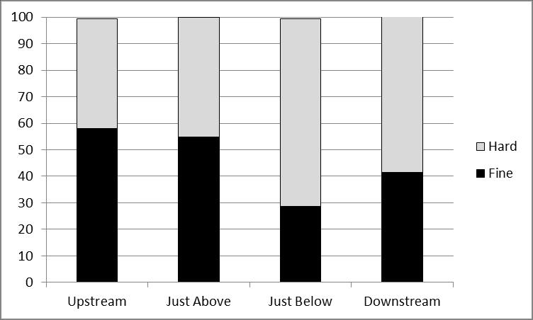
8 8 A variety of substrate types are also present in a healthy river. It is especially important that fine sediments (sand and silt) do not dominate a river bottom. Erosion is a major source of pollution to our waterways, an overabundance of fine sediment may be a sign that there is an erosion problem in the watershed, or a legacy of past sedimentation that has not been flushed out of the system. A healthy river will have a balance of substrate types (Figure 3). River A has a good balance of fine and hard substrate; whereas river B is dominated by silt and sand with little hard substrate present. A) B) Figure 3. Hypothetical substrate composition data for a healthy river (A), and a river with excess fine sediment (B).

9 9 In-stream habitat diversity, or fish cover is also an important portion of what makes a stream ideal for coldwater fish. Fish need a variety of places to seek cover from predators including aquatic vegetation, woody debris, and deep water. River A has abundant, diverse in-stream fish habitat (80%); whereas, river B has sparse in-stream habitat available (25%) (Figure 4). A) B) Figure 4. Hypothetical in-stream habitat data for a river with good diverse habitat (A), and a river deficient in-stream habitat (B). Graph A in Figures 2-4 depict a healthy river, ideally each river mapped will have data similar to that generally seen in the A graphs. Graph B in Figures 2-4 depict issues which may be indicative of a limitation to the coldwater fishery. When we see data similar to that in the B graphs restoration or enhancement may be needed, and more in-depth analysis and discussion is appropriate.
10 10 Methods Methodological details for this instream fish habitat assessment can be found in full detail in report form, at: This survey was conducted by volunteer members of the Pine River Chapter of Trout Unlimited, with support from interns or staff at Michigan Trout Unlimited. Members were trained in habitat mapping methods by Michigan Trout Unlimited Aquatic Ecologist Kristin Thomas. All mapping was completed during average or low flow conditions. It is important that habitat is not mapped during times of high flow because high flow can make it difficult to distinguish bedform delineations. Training included instruction on how to determine bedform delineation, substrate classification, and practice visually estimating percent of streambed. Stream diagrams were used to practice estimating the percent of streambed occupied by substrate types and fish cover. Volunteers estimated substrate composition and fish cover for each diagram. A key with a grid and actual percentages were then provided. This exercise was used to help volunteers visually estimate percent of stream bottom. Bedform delineation and qualitative observations were derived through independent visual observations and evaluations. Bedform delineation involved the categorization of the stream into bedforms (run, riffle, pool, rapid, as defined in Table 2). The length and widths (top and bottom) of each bedform section were measured. Latitude and longitudes were recorded at the top and bottom of each bedform section using a handheld GPS. Measurements of bedform lengths and widths were made with a Nikon Laser Rangefinder (+/- 0.5 yard accuracy) or a tape measure. Quantitative streambed substrate composition measurements were made through visual estimation. The percent area of each bedform segment occupied by clay, silt, sand, gravel, cobble, or boulder was estimated visually. Substrate classification followed Wolman size classes for sand, gravel (all sizes combined), and cobble (all sizes combined) (Table 3). The percent area of streambed in each bedform section covered by woody debris, aquatic vegetation and deep water (>2.5 ft.) was also visually estimated. The amount of wood, vegetation, and deep water was expressed as a percent of streambed area (5% increments). The maximum depth present in each bedform section was also recorded. In cases were maximum depth could not be measured; maximum depth was listed as greater than 4 feet.
11 11 Table 2. Bedform delineation explanation. Bedform Description Run Riffle Fast or slow current, unbroken water, average depth. Swift current, turbulent broken water, shallower than average depth. Pool Slow or no current, unbroken water. Generally about 1.5 times deeper than average depth. Rapid Waterfall Swift current, very turbulent, broken water. Large boulders or bedrock often breaking the surface. The majority of the stream flow over a ledge or cliff. Table 3. Substrate classes used to denote substrate composition. Particle Description Clay Silt Sand Gravel Cobble Boulder Bedrock Very fine sticky texture. Easily forms ribbons when rolled in hand, generally reddish or gray in color. Very fine texture. Smooth, silky feel when handled. Crumbles readily when handled. Single sand grains are apparent. Rocks 1/16 to 2 ½ inches in diameter Rocks 2 ½ to 10 inches in diameter. Rocks greater than 10 inches in diameter. Solid rock surface, not the tops of boulders. The Pine River was originally divided into 18 habitat mapping sites, for the purpose of organizing field data collection (Table 4). In most cases, access points dictated the beginning and end of each site. Habitat data for all of the mapped portions of the river were analyzed and then the 18 sites were grouped into 6 analysis segments. Segments were chosen based on commonalities in habitat conditions, and clear contrasts between them (Table 5). Figures 5-7 below are provided, to illustrate that the consolidation into 6 segments for analysis was based off similarities in in-stream habitat elements, and not arbitrary grouping that would obscure significant differences between the segments.

12 12 Table 4. Descriptions of the 18 Pine River sites. Site Name Site Description Segment Pine 1 20 Mile to End of 230 th Segment 1 Pine 2 End of 230 th to 17 Mile Segment 1 Pine 3 17 Mile to Raymond Rd. Segment 1 Pine 4 Raymond Rd. to Briar Patch (5 Rd.) Segment 1 Pine 5 Briar Patch (5 Rd.) to 6 Mile Segment 2 Pine 6 6 Mile to Coe Creek Segment 2 Pine 7 Coe Creek to Skookum Road Segment 2 Pine 8 Skookum Road to N. Pine River Road Segment 2 Pine 9 N. Pine River Road to State Road Segment 3 Pine 10 State Road to Silver Creek Campground Segment 3 Pine 11 Silver Creek Campground to Lincoln Bridge Segment 3 Pine 12 Lincoln Bridge to Elm Flats Segment 3 Pine 13 Elm Flats to Poplar Creek Segment 4 Pine 14 Poplar Creek to Dobson Bridge Segment 4 Pine 15 Dobson Bridge to Peterson Bridge Segment 4 Pine 16 Peterson Bridge to Forest Rd Segment 5 Pine 17 Forest Rd to Stronach Dam Road Segment 5 Pine 18 Stronach Dam Road to Tippy Pond Segment 6 Figure 5. Pine River Substrate Composition. Fine clay, silt, and sand. Hard gravel, cobble, and boulder. For the 18 original sites (vertical red lines depict segments).

13 13 Figure 6. Pine River bedform structure, in the 18 original sites. Figure 7. Pine River fish cover, in the 18 original sites.
 Segment 1 20 Mile to Briar Patch (5 Rd.) 12.45 Segment 2 Briar Patch (5 Rd.) to N. Pine River Road 5.68 Segment 3 N.")
14 14 Table 5. Description of the six Pine River segments used for analysis. Numbered in upstream to downstream order (from East to West approximately). Segment Name Segment Description Segment Length (miles) Segment 1 20 Mile to Briar Patch (5 Rd.) Segment 2 Briar Patch (5 Rd.) to N. Pine River Road 5.68 Segment 3 N. Pine River Road to Elm Flats 4.86 Segment 4 Elm Flats to Peterson Bridge Segment 5 Peterson Bridge to Stronach Dam Road 8.84 Segment 6 Stronach Dam Road to Tippy Pond Figure 8. Map of the mainstem of the Pine River, showing the 6 main segments of the river related to distinct differences in instream fish habitat conditions. Boundary descriptions found in Table 5. Habitat features for each section were summarized (Table 6). For all analyses, percent of total streambed was used. For example, to determine what percent of the river is run, riffle, and pool the total area of run, riffle, and pool was calculated and then expressed as a percent of total streambed area. To calculate the area of each bedform section the mean bedform section width (top width + bottom width/2) was multiplied by bedform section length. Percent substrate and habitat was calculated by expressing the percent substrate or habitat as an area (i.e. (percent gravel/100)*bedform section area). The total area of sand, gravel, cobble etc. was then summed and expressed as a percent of total stream or segment area. Thus, each percent presented on a graph represents the proportion of total stream bed occupied by that in-stream habitat element as estimated for this study. The deepest point in each bedform section was also recorded.
15 15 Results and Discussion Table 6. Instream fish habitat summary data for the Pine River. Percentages and proportions are percent are of the described section. All Sections Section 1 Section 2 Section 3 Section 4 Section 5 Section 6 Mapped Total Length (ft.) 289,671 65,716 29,981 59,842 75,482 46,656 11,994 Width (ft.) Mean Range Percent Run Bedform Percent Riffle Bedform Percent Pool Bedform % Deep Water (>2.5 ft.) % Woody Debris % Aquatic Vegetation Total Section - % Clay Total Section - % Silt Total Section - % Sand Total Section - % Gravel Total Section - % Cobble Total Section -% Boulder Pine River Analysis: Whole River The Pine River mainstem, as a whole, has 75% run habitat, 19% riffle, and 6% pool bedforms (Figure 9). While it is dominated numerically by run habitat, 75% run bedforms is relatively low in comparison to other Northern MI trout streams we have surveyed to date (Figure 10-A). The 19% riffle bedforms, along with the relatively large amounts of gravel and cobble substrates it provides, does not seem to indicate that the river is limited by hard substrates or riffle areas. Likewise, the 6% pool bedforms is moderate, and combined with total area of deep water (>2.5 ft.) at 33%, does not indicate that the Pine River is lacking in deeper water habitats. So the 74% run bedform estimate should be viewed, in regional context, as not excessive, and probably well-balanced for streams in this region. Similarly, substrate composition in the Pine River was relatively balanced (Figure 9B). Sand did still comprise the dominate substrate type at 44%. But, gravel (24%) and cobble (14%) substrates were abundant. Gravel substrates were moderate compared to other regional trout streams (Figure 10-B). It appears that despite the high average slope of the river, which would lead to the expectation of higher percent gravel, that those high slopes and flows of the Pine result in relatively high proportions of cobble and boulder substrates, and gravel abundance is relatively moderate. The Pine River has the highest abundance of boulders seen on any river yet surveyed. Conversely, it along with the Sturgeon River (commonly cited as the two highest gradient rivers in the Lower Peninsula) had the lowest relative abundances of silt substrates. When substrate types are grouped into hard or fine groupings, based on
16 16 their ecological function (fine = sand & silt), the Pine River is illustrated as having a relatively high abundance of hard substrates, compared to other regional streams that have been surveyed (Figure 10- C). The percent area of the streambed occupied cumulatively by wood debris, aquatic vegetation, and deep water, referred to here as cumulative fish cover, was nearly 50% of the stream bed area. When compared to other regional trout streams, this level of fish cover ranks as moderate low (Figure 10-D). Deep water area was high at 33%, a unique and valuable asset to fish habitat (Figure 10-E). Wood debris was low at 9%, in fact, the lowest seen of any of the rivers we ve surveyed to date (Figure 10-F). Aquatic vegetation, at 6%, was also low relative to other rivers in the region (Figure 10-G). Data for the whole river is useful in comparing to other rivers in the region and identifying clear deficiencies, such as wood debris abundance. However, data from analysis of specific segments will be used in the next section to identify areas of need and potential projects.
17 17 A) B) C) Figure 9. Pine River bedform delineation, bottom substrate, and in-stream fish cover.
 in")

18 18 Figure 10-A. Proportions of bedforms in the 11 trout streams (surveyed by MITU) in Northern Michigan, ordered by percent run bedform (black). Figure 10-B. Streambed substrate composition in the 11 trout streams (surveyed by MITU) in Northern Michigan, ordered by percent sand.
 in Northern Michigan, including deep water, wood debris and aquatic")
19 19 Figure 10-C. Hard and fine substrates composition in the 11 trout streams (surveyed by MITU) in Northern Michigan, ordered by percent fine substrate. Figure 10-D. Cumulative percent area of instream fish cover in the 11 trout streams (surveyed by MITU) in Northern Michigan, including deep water, wood debris and aquatic vegetation.
20 20 Figure 10-E. Percent area of deep water (>2.5 ft.) in the 11 trout streams (surveyed by MITU) in Northern Michigan. Figure 10-F. Percent area of wood debris in the 11 trout streams (surveyed by MITU) in Northern Michigan.
21 21 Figure 10-G. Percent area of aquatic vegetation in the 11 trout streams (surveyed by MITU) in Northern Michigan. Pine River Analysis: By Segment The Pine River was divided into 6 smaller segments for data analysis. Segment 1 consists of sites 1-4. These sites were grouped due to higher percentages of fine substrate and run habitat. Sites 5-8 were grouped into segment 2 due to an increase in hard substrate and riffle habitat relative to segment 1. Segment 4 consists of sites They were separated from segment 2 because segment 3 has more riffles, less pools, and much less deep water than segment 2. Run habitat, fine substrate and deep water increases in sites which are grouped into segment 4. Segment 5 is sites 16 and 17 where a decrease in run and increase in hard substrate relative to segment 5 is seen. Segment 6 is composed of site 18. Segment 6 is the lowermost reach of the river, and receives impoundment effects from Tippy Dam Reservoir, as well as receiving sand load from the entire watershed (Figures 5, 6 and 7). Bedform Structure Bedform diversity in the Pine River shows some clear differences between segments of the river (Figure 11). Segments 2 and 5 each have approximately 60% run habitat, with relatively larger proportions of riffles and pools, providing the best diversity of bedforms of all the segments. Segments 3 and 4 were slightly higher in run bedforms (70% and 75%) than 2, 3, and 5, but still provides significant riffle and pool habitats. Segment 1 had low bedform diversity with 89% run bedform present there. Segment 6, at the end of the river, had no bedform diversity, and was totally comprised of run bedform.
.")
22 22 Figure11. Pine River bedform diversity. In-stream Habitat Availability The relative high abundance of deep water habitat in the Pine River extends to all segments except segment 6, the lowermost section (Figure 12). Segment 6 was low in deep water availability (9%), as well as wood (6%) and aquatic vegetation (5%). Elsewhere, deep water habitat was plentiful, averaging from 27 44% in segments 1 5. This is a very good fish habitat asset of the Pine River. Even in segments 1 and 4, which had higher proportions of run habitat, the percent deep water was 33% and 44% respectively. This indicates that while bedforms are dominated by runs, they are at least deeper habitat runs, as opposed to shallow and wide runs. Presence of deep water habitat is a function of the stream channel shape, and as such, where deep water habitat is lacking, it s often difficult to create, as it requires either narrowing the stream banks, or creating localized scouring of the streambed. The Pine River appears in good shape in regards to deep water habitat availability. The abundance of wood debris in the Pine River was generally low. Segment 1 had the highest average abundance of wood at 17%, which compared with other regional trout rivers surveyed, should be viewed as average or moderate. All other segments of the river contained 6 10% wood debris, which is quite low compared to other trout streams, resulting in the Pine having the lowest wood debris ranking of the rivers we ve surveyed to date (Figure 10-F). The slope and stream power of the Pine may be a factor that mobilizes wood debris here more than other rivers, leading to less residency time, and lower abundances. This will need to be evaluated further if wood additions are pursued. However, a rough comparison with other rivers of known high gradient, and high percentages of riffle/pool bedforms, like the Sturgeon and Pigeon Rivers, shows that the Pine River also has significantly lower wood debris abundance than them, indicating wood abundance in the Pine is likely deficient.

23 23 Figure12. In-stream habitat structure in the Pine River. Aquatic vegetation was highest in segment 1 (12%), and lowest in segment 5 (2%). For the rest of segments, it ranged between 5 7%, and was 6% for the entire river. When compared with other regional trout streams, all segments except segment 1 appear low or deficient in aquatic vegetation, a critical habitat element for juvenile trout and other fish species. Substrate Composition In general, the Pine River exhibits a good diversity of substrates within the streambed. Segments 2, 3, 4, and 5 exemplify this particularly well (Figure 13). Segment 1, did have considerably more sand present than segments 2-5, but still had significant proportions of gravel, cobble and boulders, and had the highest percentage of silt substrates of any segment. Silts are important substrates for many forms of burrowing mayflies, responsible for some of the best flyfishing hatches, (e.g., Ephemera, brown drakes, Hexagenia). In fact, segments 2-6 could be considered as having very little silt present, something that could possibly be linked to management of aquatic vegetation in the future, to improve conditions of both. Segment 6 was the one segment of the Pine River with a clear lack of substrate diversity (92% sand). This is the section of stream that receives the sand load from the rest of the watershed, but also is impacted in its transport capacity by the Tippy Dam backwaters. This section was also downstream of the Stronach Dam removal site, where sand from the former Stronach Dam impoundment was allowed to be transported naturally, and deposited in this river segment. The substrate composition of this segment is reflective of an over-abundance of sand sedimentation. From the data presented, sand over-abundance does not seem to be a primary limiting factor for the Pine River. There is ample area of gravel and larger substrates, and ample riffles as well. From what was
 and hard (gravel, cobble, and boulder) substrate composition by segment.")

24 24 documented, these substrates and areas needed by lithophilic spawning fish species do not appear to be limiting in the Pine River. Figure 13. Pine River substrate composition by segment. Figure 14. Pine River fine (clay, silt, and sand) and hard (gravel, cobble, and boulder) substrate composition by segment. Recommendations and Management Actions When considered as a whole river, the Pine River appears generally to have good bedform diversity, very good substrate compositions of gravel, cobble and boulders, and ample deep water habitat available. However, it clearly is lacking wood debris compared with other regional trout streams. Additionally, the Pine appears to have low abundance of both silt substrates and aquatic vegetation (often related),
25 25 which are both related to shallower stream margin habitats, macroinvertebrate community diversity, and juvenile fish survival. We know that the Pine River has relatively high gradient or slope (total drop from headwaters to mouth is 417ft, average 10-15ft/mile) for the Lower Peninsula of Michigan, and has high contributions of groundwater to its flows. Water temperatures remain cold throughout its length, rarely exceeding 70 degrees F. Baseflows are relatively stable, and peak flows can be severe, (~10x the baseflow). With moderate flows and high gradient the river is expected to have high stream power and sediment transport capacity, in general. We also generally know from DNR and MSU fish surveys that the Pine produces lower densities of trout, but usually good to high survival rates of older age classes, compared to statewide averages. This general background understanding, taken with the results of this instream fish habitat assessment, may indicate that juvenile fish survival is limited due to lack of slow velocity areas with adequate cover (such as wood debris and aquatic vegetation beds). In general then, the clearest goals for improving fish habitat in the mainstem of the Pine may include additions of wood debris to improve fish cover, in both the deep and shallower water habitats. Additionally, it may well be worth pursuing the feasibility or viability of transplanting or augmenting aquatic vegetation beds. If appropriate microhabitats for their successful transplant could be identified, an increase in aquatic vegetation may help provide more juvenile fish cover, help collect and retain silts, create areas of slower water velocities, and possibly improve some nutrient retention. In addition, more vegetation may also create both food and substrates for enhanced macroinvertebrate communities. Wood Debris Enhancements Access The addition and management of wood debris are the clearest and best potential type of enhancement project for all sections of the Pine River. However, each section would need to be evaluated for the specific design and feasibility of pursuing wood debris additions, as each site will have unique access and design considerations and challenges. In considering access issues, the land ownership status will be important. According to the Pine River Natural River Plan (DNR Fisheries Division, 2003), the State of Michigan and the U.S. Forest Service have extensive land ownership, totaling approximately 35% of the Pine River corridor (Table 7). If work is pursued on state owned lands, early involvement and consent from DNR management staff is essential. Working on private lands will require the consent of willing landowners, which also necessitates early involvement and relationship building with the owners. Working on the abundant federal lands, will require that management staff from the US Forest Service agree with the need for the work, agree with the proposed designs for the work, and have appropriate lead time to complete the required permitting. Additionally, access will be challenging on certain segments of stream due to the physical or logistical limitations of access to the river with equipment appropriate for certain types of wood debris installation. For example, much of segment 5 is contained within steep river valley walls, with very limited access points.
26 26 Table 7. Landownership within the Pine River corridor in acres. Table taken from MDNR Fisheries Division, Pine River Natural River Plan (2003). Design Considerations In addition to access logistics, design of wood debris additions will need to consider both the physical carrying capacity of wood debris in each segment of the river, and also the social carrying capacity of wood debris in each segment of the river. By physical carrying capacity, we mean that given the general high slope and stream power of the Pine River, designs for the specific locations and installation techniques of the wood debris will be critical. In some sections of the Pine, it may be unrealistic to install large wood debris formations that will resist being mobilized by floods. Furthermore, where stability is sought, design specifications should utilize techniques that result in stabilized wood additions to prevent excessive movement or placed only partially in the water, trenched along the stream edge. Creating complex logjams using key pieces and a mixture of large diameter conifers and hard woods will maximize benefits to the fishery and ecosystem processes. Fine-tuned designs will be used to both identify areas where stable wood additions are appropriate and where intentionally mobile designs make sense. Social carrying capacity of wood debris will also need to be carefully discussed and addressed in design. The Pine River is a fast and challenging river for recreational floaters, therefore all wood debris formations will be constructed in a size and manner that will ensure safety and allow ample room for the passage of floaters and paddlers. Reasonably safe navigation on this river is necessary and may restrict wood debris additions to some extent. On the inverse side of the social carrying capacity consideration, is the clear evidence that the Pine ranks the lowest in wood debris of any of the rivers we ve surveyed to date in Northern Michigan (Figure 10-F). The only segment of the Pine which had average levels of wood, was segment 1, the furthest upstream segment and least utilized of the segments for recreational floating. All other segments had uniquely low amounts of wood debris. Both the Upper Manistee (a heavily used recreational floating river) and the Sturgeon River (comparable to the Pine in gradient and flow), both have approximately 20% wood on average, compared with the Pine River s average of 9%.
27 27 Designs for wood debris enhancements will need to honor the requirement for safe and reasonable passage for recreational floating, while balancing the ecological benefits to be derived from more wood debris. This balancing will only be accomplished by inclusive, respectful discussions among stakeholders and decision makers, and through creative wood debris enhancement designs. Aquatic Vegetation Enhancement Aquatic vegetation was low in all segments of the Pine except segment 1. We are not familiar, at this point in time, with pre-existing techniques or efforts to transplant or increase the establishment of aquatic vegetation beds in Michigan streams. However, if these techniques were developed, increasing the occurrence of aquatic vegetation in most of the Pine River could be an ideal priority project. These aquatic vegetation beds offer ideal juvenile trout and other fish habitat, as well as aiding retention of silts, forming slower water velocity microhabitats, and providing food and substrate for macroinvertebrates. Creating better juvenile trout habitat could be expected to boost overall trout survival and densities. Additionally, increasing aquatic vegetation would not pose any safety conflicts with recreational floaters. If there is interest in pursuing the feasibility of aquatic vegetation augmentation techniques, MITU will be glad to pursue a potential research study with partners. Segment 6. Segment 6, the lowermost segment of the river, stands in stark contrast to the other segments. This segment is 100% run bedform, dominated by sand substrate, with only 9% deep water, 6% wood debris, and 5% aquatic vegetation. This segment will continue to be challenged by it receiving the sediment load from entire watershed area upstream, and having diminished slope (and sediment transport capacity) because of the Tippy Dam impoundment effects that extend into this segment of river. For these reasons, this part of the river should not be expected to be restorable to conditions seen upstream of it. It will likely remain sediment impacted as long as current conditions persist (sediment load in the Pine stays the same, and Tippy Dam continues to exist). This section of river however, should be assumed important to fish migrations through it, from fish entering or leaving the Pine River to access either the habitat provided by Tippy Dam reservoir, and/or the segment of the Manistee River located upstream of Tippy Dam and downstream of Hodenpyle Dam. If particular portions of this segment 6 become homogenously wide and extremely shallow, it may deter certain fish species from migrating through it at certain times of year. Possible projects: 1.) Select placement of large wood debris formations to ensure localized scour pools or runs, to allow deep water habitats for fish migrating through this section. This would involve moderate to large wood debris pieces strategically placed in areas of big wide sand flats, to create small areas of deep water habitat throughout the segment 6. 2.) Relocating large wood debris back into the wetted stream channel. During the spring flood of 2014, following this in-stream fish habitat assessment, large pieces of wood debris from the river were mobilized. As high water receded, the mobilized large wood came to rest on the banks of the Pine River (particularly in segments 6 personal observation), at levels now above
28 28 the water line during normal flows. This loss of wood debris to fish habitat may be addressed through crews manually moving large wood debris pieces back into the stream, via power winches. The large sizes of this material would help re-create localized scouring if put back into the stream channel. Overall Prioritization Prioritizing protection and enhancement efforts is often a difficult process, which by necessity needs to explicitly consider: 1.) current status of the river and its fisheries, 2.) benefits to be derived by the activities, 3.) risk of creating unintended negative consequences, 4.) feasibility of the projects contemplated including coordination & management, funding, permitting and regulations, and access, 5.) the array of stakeholder values and motivations for undertaking such efforts. This habitat assessment report is intended to help contribute to elements 1, 2, and 3. Elements 4 and 5, along with the others, will be up to all those engaged in stewardship of the Pine River to consider. With that said, from the results of this in-stream fish habitat assessment, the following general priorities are offered as a starting place for further discussions that follow. Detailed maps of habitat conditions in each segment are included in Appendix 1 to aid in the refined selection of sites for future work. MITU staff will be available to produce specific data and graphics needed for projects that may not be included in this report, and also to participate in discussions, planning and implementation of work chosen to be pursued. - Develop a refined wood debris enhancement plan for the mainstem of the Pine River, and perhaps key tributaries. This would use detailed site specific information documented by this study, address and identify key priority areas, and key feasible areas. The report would address design alternatives that would increase the Pine River s wood debris abundance, while honoring feasibility issues, safety issues, logistic issues, and means to evaluate any efforts for effectiveness. Once target areas are identified, follow up field surveys may need to be done in recognition that the 2014 flood significantly redistributed wood debris in the river. The development of this report would be a vehicle for partner collaboration and discussions. - Investigate the feasibility of transplanting and/or promoting increased areas of aquatic vegetation. Aquatic vegetation serves as high quality juvenile fish cover and may be possible to promote in portions of wide/shallow stream channels otherwise lacking suitable fish habitat. While this may not increase suitability to larger trout, it could help ensure optimal juvenile rearing habitat within the river, which translates to better survival into older ages. - Ensure that sand from either upstream, severe bank erosion sites, roads, or other sources are prevented from delivering sand to this section of stream. Road crossing inventories for the watershed should be reviewed to identify remaining priorities. Bank erosion inventories should be reviewed for priorities. Tributaries contributing significant sediment into the mainstem should be evaluated for action.
29 29 - Consider evaluating significant tributaries of the Pine River. The Pine River is generally considered to have several tributaries that offer high quality coldwater fish habitat. Thought should be given to evaluating some of these. Literature Cited Our purpose was not to summarize all pertinent information and data for this river, so these references are limited and should not reflect all the applicable information available on this topic or for this river. Bryant, M.D The Role of Management of Woody Debris in West Coast Salmonid Nursery Streams. North American Journal of Fisheries Management 3: Michigan Department of Natural Resources, Fisheries Division Pine River Natural River Plan. Roni, P and T.P. Quinn Density and size of juvenile salmonids in response to placement of large woody debris in western Oregon and Washington streams. Canadian Journal of Fisheries and Aquatic Science 58: Tonello, M Little Manistee. Status of the Fishery Resource Report. MI DNR Found at Zorn, T.G., P.W. Seelbach, and M.J. Wiley Relationships between habitat and fish density in Michigan streams. Michigan Department of Natural Resources, Fisheries Report 2091, Ann Arbor. Zorn T.G. and M.J. Wiley Untangling relationships between river habitat and fishes in Michigan s Lower Peninsula with covariance structure analysis. Michigan Department of Natural Resources, Fisheries Research Report 2073, Ann Arbor.
30 30 Appendix 1. Frequency distribution plots, for the number of bedform units in each segment of the Pine River, containing different percentages of area of wood debris, in 10% increments.
31 31 Segment 1.
32 32 Segment 2.
33 33 Segment 3.
34 34 Segment 4.
35 35 Segment 5.
36 36 Segment 6.
.")
37 37 Other charts and maps are available upon request. For example, we have substrate compositions for each bedform unit in each section, and also made note of bank conditions (if significant erosion was noted, picture were also taken). GPS coordinates are also available for specific areas that ay be of interest in these charts, for planning purposes. Below are two examples, but they are omitted here for brevity. Please contact us at if you desire specific report outputs.
38 38 Appendix 2. Road Stream Crossings Assessments If road crossings are undersized, they may not allow natural levels of sediment transport. This can lead to fine sediments accumulating immediately upstream of the crossing, while a scour pool can be created immediately below the crossing. In these cases, we d expect to observe: Upstream: - Higher abundance of fine substrates like sand and silt (relative to that seen further upstream) - A widening of the stream width relative to further upstream - Loss of slope upstream would result in run bedforms Downstream: - Coarser substrates, or higher abundance of hard substrates, as fine sediment is not transported through the crossing naturally, erosion results, leaving coarser substrates. - With scour pool creation, we d expect to see pool bedforms immeidately downstream of the corssing, followed by more run bedforms. - A decrease in stream width, as the stream scours deeper, width should decrease. In addition to undersized road crossings, improper design of road-stream crossings can result in fine sediments being delivered to the stream from the banks, or road approaches, or road surface itself. In these cases, we d expect to see higher abundances of fine substrates such as sand, downstream of the crossings, as compared with further upstream, or further downstream. Since these aspects of streams were measured in this assessment, this appendix provides charts of the conditions of bedforms, substrates, and stream widths around crossings that were encountered. 4 sections were analyzed for each: immeidately upstream of the crossing, immediately downstream of the crossing, and further upstream and downstream of each crossing (to represent zones further removed from the influence of the crossings).
39 39 17 Mile Rd. Crossing Some indication of slight under-sizing possible, as well as sedimentation.

40 40 Raymond Rd. Crossing
41 41 6 Mile Rd Crossing Width indicates some undersizing issues.

42 42 Skookum Rd Crossing Slight indications of undersizing potential in bedforms and substrates.

43 43 State Rd Crossing
44 44 10 Mile Rd Crossing
45 45 No. 50 Rd. Crossing

46 46 Peterson Bridge

47 47 Low Bridge this crossing was being replaced during the survey time period.
Black River Instream Fish Habitat Assessment
 1 Black River Instream Fish Habitat Assessment Michigan Trout Unlimited October 15 Kristin Thomas Dr. Bryan Burroughs 2 Table of Contents INTRODUCTION... 4 Table 1. Michigan stream and river temperature
Little Manistee River Instream Fish Habitat Assessment
 Little Manistee River Instream Fish Habitat Assessment Michigan Trout Unlimited February 215 Kristin Thomas Dr. Bryan Burroughs 1 Table of Contents PURPOSE & CONTEXT... 3 INTRODUCTION... 4 Table 1. Michigan
Identifying and Executing Stream Projects Kristin Thomas, Aquatic Ecologist MITU
 Identifying and Executing Stream Projects Kristin Thomas, Aquatic Ecologist MITU Introduction 1. Methods for Identifying Projects 2. Methods in Action 3. The Partnership Paradigm 2 River Stewards Program
STUDY PERFORMANCE REPORT
 STUDY PERFORMANCE REPORT State: Michigan Project No.: F-80-R-4 Study No.: 702 Title: Effects of sediment traps on Michigan river channels Period Covered: October 1, 2002 to September 30, 2003 Study Objectives:
Interim Guidance Fish Presence Absence
 Interim Guidance Fish Presence Absence Source: Forest Practices Act Guidance for Division 635 of the forest practices act dealing with stream classification when no fish surveys have been done (referenced
FISH PASSAGE IMPROVEMENT in California s Watersheds. Assessments & Recommendations by the Fish Passage Forum
 FISH PASSAGE IMPROVEMENT in California s Watersheds Assessments & Recommendations by the Fish Passage Forum FISH PASSAGE IMPROVEMENT in California s Watersheds The mission of the Fish Passage Forum is
Abundance of Steelhead and Coho Salmon in the Lagunitas Creek Drainage, Marin County, California
 scanned for KRIS Abundance of Steelhead and Coho Salmon in the Lagunitas Creek Drainage, Marin County, California Prepared for: Marin Municipal Water District 220 Nellen Drive Corte Madera, California
January Submitted by: 2200 Commonwealth Blvd, Suite 300 Ann Arbor, MI Ph: Fax:
 BOARDMAN RIVER FEASIBILITY STUDY A Report on the Boardman River Fisheries Habitat Survey & Data Collection January 2009 Submitted by: 2200 Commonwealth Blvd, Suite 300 Ann Arbor, MI 48105 Ph: 734-769-3004
CHAPTER 4 DESIRED OUTCOMES: VISION, GOALS, AND OBJECTIVES
 CHAPTER 4 DESIRED OUTCOMES: VISION, GOALS, AND OBJECTIVES Vision One of the first steps in developing this Plan was articulating a vision - a clear statement of what the Plan strives to achieve and what
Understanding the Impacts of Culvert Performance on Stream Health
 Understanding the Impacts of Culvert Performance on Stream Health Kristin Thomas Aquatic Ecologist Michigan Trout Unlimited Transportation and the Environment Conference 12/5/2018 Importance of adequately
Steelhead Society of BC. Thompson River Watershed Restoration and Enhancement Project #4 Nicola River Bank Stabilization and Enhancement Project
 Steelhead Society of BC Presents: Thompson River Watershed Restoration and Enhancement Project #4 Nicola River Bank Stabilization and Enhancement Project Application for Funding December 2013 1.0 BACKGROUND
Big Spring Creek Habitat Enhancement and Fishery Management Plans
 Big Spring Creek Habitat Enhancement and Fishery Management Plans November 5, 2012 Big Spring Events and Activities Center Newville, PA Charlie McGarrell Regional Habitat Biologist Pennsylvania Fish and
Minnesota Department of Natural Resources Division of Fish and Wildlife Section of Fisheries. Stream Survey Report. Luxemburg Creek.
 Minnesota F-29-R(P)-24 Area 315 Study 3 March 2016 Minnesota Department of Natural Resources Division of Fish and Wildlife Section of Fisheries Stream Survey Report Luxemburg Creek 2015 Mark Pelham Sauk
Juvenile Steelhead and Stream Habitat Conditions Steelhead and Coho Salmon Life History Prepared by: DW ALLEY & Associates, Fishery Consultant
 Juvenile Steelhead and Stream Habitat Conditions Steelhead and Coho Salmon Life History Prepared by: DW ALLEY & Associates, Fishery Consultant I-1. Steelhead and Coho Salmon Ecology Migration. Adult steelhead
Aquatic Organism Passage at Road-Stream Crossings CHUCK KEEPORTS FOREST HYDROLOGIST ALLEGHENY NATIONAL FOREST WARREN, PENNSYLVANIA
 Aquatic Organism Passage at Road-Stream Crossings CHUCK KEEPORTS FOREST HYDROLOGIST ALLEGHENY NATIONAL FOREST WARREN, PENNSYLVANIA TOPICS COVERED Aquatic Organism Passage (AOP) Benefits of AOP Crossings
Study No. 18. Mystic Lake, Montana. PPL Montana 45 Basin Creek Road Butte, Montana 59701
 Study No. 18 Evaluation of the Current Fish Population and Habitat in West Rosebud Creek Downstream from Emerald Lake Mystic Lake Hydroelectric Project FERC No. 2301 Mystic Lake, Montana PPL Montana 45
Cold Small River. A Brief Ecological Description of this Michigan River Type
 Cold Small River A Brief Ecological Description of this Michigan River Type Cold Small River segments are defined (by the Michigan Department of Natural Resources, Fisheries Division) as typically having
Study Update Tailrace Slough Use by Anadromous Salmonids
 Study Update Tailrace Slough Use by Anadromous Salmonids Goals and Objectives Identify what anadromous salmonids use the tailrace slough by: Life Stage (Juvenile, migrating and spawning adults) Timing
Final Bull Trout Redd Monitoring Report for the Wallowa Falls Hydroelectric Project
 Final for the Wallowa Falls Hydroelectric Project East Fork Wallowa River barrier to upstream fish migration, photo courtesy of Kendrick Moholt (FERC No. P-308) December 18, 2017 Prepared by: Jeremiah
Southern Oregon Coastal Cutthroat Trout
 Species Management Unit Description Southern Oregon Coastal Cutthroat Trout The Southern Oregon Coastal Cutthroat Trout SMU includes all populations of cutthroat trout inhabiting ocean tributary streams
Rehabilitation of Grimes Creek, a Stream Impacted in the Past by Bucket-lined Dredge Gold Mining, Boise River Drainage, July 2008 to August 2011.
 Rehabilitation of Grimes Creek, a Stream Impacted in the Past by Bucket-lined Dredge Gold Mining, Boise River Drainage, July 2008 to August 2011. Pam Harrington TU,1020 W. Main Street Suite 440, Boise,
State of San Francisco Bay 2011 Appendix O Steelhead Trout Production as an Indicator of Watershed Health
 State of San Francisco Bay 2011 Appendix O Steelhead Trout Production as an Indicator of Watershed Health Gordon Becker and Katherine Smetak, Center for Ecosystem Management and Restoration 290 Introduction
FISHERIES BLUE MOUNTAINS ADAPTATION PARTNERSHIP
 FISHERIES A warming climate, by itself, substantially affects the hydrology of watersheds in the Blue Mountains. Among the key hydrologic changes projected under all scenarios for the 2040s and beyond
Hydraulic Modeling of Stream Enhancement Methods
 Hydraulic Modeling of Stream Enhancement Methods Matthew J. Curry John J. Levitsky Abstract Development within watersheds increases the amounts of runoff causing stream erosion and degradation of stream
Cold-transitional Small River
 Cold-transitional Small River A Brief Ecological Description of this Michigan River Type Cold-transitional Small River segments are defined (by the Michigan Department of Natural Resources, Fisheries Division)
Executive Summary. Map 1. The Santa Clara River watershed with topography.
 Santa Clara River Steelhead Trout: Assessment and Recovery Opportunities December 2005 Prepared By: Matt Stoecker and Elise Kelley, Ph.D. University of California, Santa Barbara Prepared For: The Santa
Cold-transitional Stream
 Cold-transitional Stream A Brief Ecological Description of this Michigan River Type Cold-transitional Stream segments are defined (by the Michigan Department of Natural Resources, Fisheries Division) as
3. The qualification raised by the ISRP is addressed in #2 above and in the work area submittal and review by the ISRP as addressed in #1.
 Please find attached a response from The Confederated Tribes of the Warm Springs Reservation of Oregon (CTWSRO) for Project # 2008-301-00, Habitat Restoration Planning, Design and Implementation within
Sub-watershed Summaries
 Project Description The Salmon Drift Creek Watershed Council (SDCWC) has focused their efforts in the Salmon River estuary for the past few years. The multifaceted partnership effort is nearing completion
Newaukum Watershed Culvert Assessment
 Newaukum Watershed Culvert Assessment Water Resource Inventory Area 23 Lewis County Conservation District Final Report By: Kelly Verd and Nikki Wilson July 2002 Funded by: Chehalis Fisheries Restoration
Trout Unlimited Comments on the Scope of Environmental Impact Statement for the Constitution Pipeline Project, Docket No. PF12-9
 October 9, 2012 Kimberly D. Bose, Secretary Federal Energy Regulatory Commission 888 First Street, NE, Room 1A Washington, DC 20426 RE: Trout Unlimited Comments on the Scope of Environmental Impact Statement
Fish Migration Barrier Severity and Steelhead Habitat Quality in the Malibu Creek Watershed
 Fish Migration Barrier Severity and Steelhead Habitat Quality in the Malibu Creek Watershed Produced for California State Coastal Conservancy and California Department of Parks and Recreation By: Heal
Chadbourne Dam Repair and Fish Barrier
 Chadbourne Dam Repair and Fish Barrier Final Report for the Western Native Trout Initiative Prepared by: Carol Endicott Yellowstone Cutthroat Trout Conservation Biologist Montana Fish, Wildlife & Parks
OKANAGAN RIVER RESTORATION INITIATIVE - FAQ
 OKANAGAN RIVER RESTORATION INITIATIVE - FAQ Initiative background: The health of the q awsitk w (Okanagan River) has been severely impacted by the channelization works that occurred in the mid-1950 s.
Removal of natural obstructions to improve Atlantic Salmon and Brook Trout habitat in western NL. 26/02/2015 Version 2.0
 Removal of natural obstructions to improve Atlantic Salmon and Brook Trout habitat in western NL 26/02/2015 Version 2.0 1 Table of Contents List of Tables... 2 Introduction... 3 Methods... 4 Preliminary
Job 1. Title: Estimate abundance of juvenile trout and salmon.
 STUDY PERFORMANCE REPORT State: Michigan Project No.: F-53-R-13 Study No.: 461 Title: Population dynamics of juvenile rainbow trout and coho salmon in Lake Superior tributaries Period Covered: April 1,
Michigan Department of Natural Resources Status of the Fishery Resource Report Page 1
 Michigan Department of Natural Resources 2008-59 Status of the Fishery Resource Report Page 1 Bowens Manistee County, (T24N R16W Sec. 11, 12, 13, 14, 15, 24, and 30). Last surveyed 2008 Mark A. Tonello
Chagrin River TMDL Appendices. Appendix F
 Appendix F The following are excerpts from the Eastern Brook Trout Joint Venture s Conservation Strategy (Working Draft v.6), Conserving the Eastern Brook Trout: Strategies for Action Found at: http://www.easternbrooktrout.org/constrategy.html
Notebooks or journals for drawing and taking notes
 Title: Have to Have a Habitat Grade Level: 5 th -8 th grade Topic: Trout Habitat Background: The following chart lists the ideal conditions for trout habitat. Dissolved Oxygen: > 7 mg/l ph: 5.5-7 Next
Chinook Salmon Spawning Study Russian River Fall 2005
 Chinook Salmon Spawning Study Russian River Fall 2005 Sonoma County Water Agency 2150 West College Avenue Santa Rosa, California 95401 Prepared by David Cook - Senior Environmental Specialist March 27,
SUMMARY OF MOVEMENT AND HABITAT USED BY TAGGED BROOK TROUT IN THE MAIN BRANCH AND NORTH BRANCH AU SABLE RIVER DURING SUMMER Data Submitted to:
 SUMMARY OF MOVEMENT AND HABITAT USED BY TAGGED BROOK TROUT IN THE MAIN BRANCH AND NORTH BRANCH AU SABLE RIVER DURING SUMMER 2014 Data Submitted to: Anglers of the Au Sable Submitted by: Dr. Mark R. Luttenton
Assessment of Baseline Geomorphic Features at. Proposed Stream Crossings On The Proposed County Road 595. Marquette County, Michigan
 Assessment of Baseline Geomorphic Features at Proposed Stream Crossings On The Proposed County Road 595 Marquette County, Michigan Prepared for: Kennecott Eagle Minerals Company Marquette, Michigan Prepared
Mid-Columbia Fisheries Enhancement Group Annual Report Fiscal Year 06: July 1, 2005 June 30, 2006
 Mid-Columbia Fisheries Enhancement Group Annual Report Fiscal Year 06: July 1, 2005 June 30, 2006 Mission Statement The mission of the Mid-Columbia Fisheries Enhancement Group is to restore self-sustaining
2011 SUMMARY REPORT Juvenile Steelhead Densities in the San Lorenzo, Soquel, Aptos and Corralitos Watersheds, Santa Cruz County, CA
 211 SUMMARY REPORT Juvenile Steelhead Densities in the San Lorenzo, Soquel, Aptos and Corralitos Watersheds, Santa Cruz County, CA, Aquatic Biology Don Alley, Jerry Smith and Chad Steiner, Fishery Biologists
South Fork Chehalis Watershed Culvert Assessment
 South Fork Chehalis Watershed Culvert Assessment Water Resource Inventory Area 23 Lewis County Conservation District Final Report By: Kelly Verd and Nikki Wilson March 2003 Funded by: The Washington State
Five Counties Salmonid Conservation Program - Fish Passage Design Workshop. February 2013
 Program - Aquatic Organisms and Stream Crossings Ecological Connectivity A watershed is a network of channels that drain a common boundary. Channel characteristics formed by interaction of precipitation,
Discussion on the Selection of the Recommended Fish Passage Design Discharge
 Discussion on the Selection of the Recommended Fish Passage Design Discharge Introduction The provision of fish passage is a requirement for most proposed culvert and bridge installations in Alberta, depending
STEELHEAD SURVEYS IN OMAK CREEK
 STEELHEAD SURVEYS IN OMAK CREEK 2002 Annual Report Prepared by Chris Fisher John Arterburn Colville Confederated Tribes Fish and Wildlife Department P.O. Box 150 Nespelem, WA 99155 Prepared for Project
STREAM SURVEY File form No..
 scanned for KRIS THE RESOURCES AGENCY OF CALIFORNIA California Department of Fish and Game STREAM SURVEY File form No.. Date: September 4, 1969. NAME: North Fork Schooner Gulch Creek COUNTY: Mendocino.
Columbia Lake Dam Removal Project
 Columbia Lake Dam Removal Project The Columbia Lake dam located 1/4 mile upstream of the Paulins Kill River's confluence with the Delaware River in Knowlton Township, Warren County has been proposed for
5B. Management of invasive species in the Cosumnes and Mokelumne River Basins
 5B. Management of invasive species in the Cosumnes and Mokelumne River Basins Cosumnes River The Cosumnes River basin has a number of distinct habitat types that require different management strategies
Appendix A Recommended EPA Temperature Thresholds for use in Establishing Thermal Potential and Species Life Stage Numeric Criteria
 Appendix A Recommended EPA Temperature Thresholds for use in Establishing Thermal Potential and Species Life Stage Numeric Criteria 1. Temperature Limits Recommended to Protect Salmonid Guilds In this
Culvert Design for Low and High Gradient Streams in the Midwest. Dale Higgins, Hydrologist Chequamegon-Nicolet National Forest
 Culvert Design for Low and High Gradient Streams in the Midwest Dale Higgins, Hydrologist Chequamegon-Nicolet National Forest Overview Culvert Design Considerations Hydraulic Terms Culvert Impacts Low
A PROJECT OF THE ANN ARBOR CHAPTER OF MICHIGAN TROUT UNLIMITED
 ESTABLISHING A TROUT FISHERY IN MILL CREEK A PROJECT OF THE ANN ARBOR CHAPTER OF MICHIGAN TROUT UNLIMITED A REPORT PREPARED BY THE MILL CREEK FISHERY DEVELOPMENT COMMITTEE: THOMAS EDSALL 1, CARLOS FETTEROLF
Brook Trout Life Cycle and Habitat
 Brook Trout Life Cycle and Habitat Directions: 1. As you watch this slide show, watch for vocabulary terms we learned today. The first time they appear, you will see them in RED! (not redd!) 2. At the
ELECTRO-FISHING REPORT 2016 UPPER TWEED
 ELECTRO-FISHING REPORT 2016 UPPER TWEED The electro-fishing programme carried out each summer by The Tweed Foundation is part of our management plan, which details the information that is required to manage
Packwood Hydroelectric Project Barrier Analysis December 12, 2006
 Packwood Hydroelectric Project Barrier Analysis December 12, 2006 Study Area Natural barriers to upstream fish passage on Lake Creek at RM 1.03 and RM 1.95 Snyder Creek culvert under the Project tailrace
EcoLogic Memorandum. TO: Ben Brezell; EDR FROM: Mark Arrigo RE: Possible Impacts of Dredging Snooks Pond DATE: 6/4/07
 EcoLogic Memorandum TO: Ben Brezell; EDR FROM: Mark Arrigo RE: Possible Impacts of Dredging Snooks Pond DATE: 6/4/07 Background EDR P.C. (EDR) has been contracted by a landowner to assess the feasibility
(Revised February,2005) CULVERTS, BRIDGES, AND FORDS
 CULVERTS, BRIDGES, AND FORDS") GUIDE TO STREAM CROSSINGS (Revised February,2005) CULVERTS, BRIDGES, AND FORDS Culverts, bridges, and fords are all methods used to cross-streams. Culverts are the most common stream crossing structure.
GUIDE TO STREAM CROSSINGS (Revised February,2005) CULVERTS, BRIDGES, AND FORDS Culverts, bridges, and fords are all methods used to cross-streams. Culverts are the most common stream crossing structure.
Know Your River River Afan Salmon and Sea Trout Catchment Summary
 Know Your River River Afan Salmon and Sea Trout Catchment Summary Introduction This report describes the status of the salmon and sea trout populations in the Afan catchments. Bringing together data from
Conserving the Forests, Lakes and Streams of Northeast Michigan
 4241 Old US 27 South, Suite 2, Gaylord, Michigan 49735 (989) 448-2293 www.huronpines.org info@huronpines.org Prioritized Restoration Projects in the AuSable River Watershed Summer 2015 Update from Huron
Refined Designated Uses for the Chesapeake Bay and Tidal Tributaries
 A-1 appendixa Refined Designated Uses for the Chesapeake Bay and Tidal Tributaries BACKGROUND Federal water quality standards regulations establish that states must specify appropriate water uses to be
Fraser River. FISH SURVEY AND MANAGEMENT INFORMATION Jon Ewert - Aquatic Biologist (Hot Sulphur Springs)
") Fraser River FISH SURVEY AND MANAGEMENT INFORMATION Jon Ewert - Aquatic Biologist (Hot Sulphur Springs) General Information: The Fraser River is a highly diverse river offering many transitions in habitat
Fraser River FISH SURVEY AND MANAGEMENT INFORMATION Jon Ewert - Aquatic Biologist (Hot Sulphur Springs) General Information: The Fraser River is a highly diverse river offering many transitions in habitat
Know Your River River Neath Salmon and Sea Trout Catchment Summary
 Know Your River River Neath Salmon and Sea Trout Catchment Summary Introduction This report describes the status of the salmon and sea trout populations in the Neath catchments. Bringing together data
Research Background: Name
 All washed up? The effect of floods on cutthroat trout Featured scientists: Ivan Arismendi and Stan Gregory from Oregon State University Written by: Leilagh Boyle Research Background: Streams are tough
FACT SHEET MCGREGOR LAKE RESTORATION HABITAT PROJECT POOL 10, UPPER MISSISSIPPI RIVER, WISCONSIN ENVIRONMENTAL MANAGEMENT PROGRAM
 FACT SHEET MCGREGOR LAKE RESTORATION HABITAT PROJECT POOL 10, UPPER MISSISSIPPI RIVER, WISCONSIN ENVIRONMENTAL MANAGEMENT PROGRAM LOCATION McGregor Lake is located within a mid-river island in Pool 10
NEVADA DEPARTMENT OF WILDLIFE STATEWIDE FISHERIES MANAGEMENT
 NEVADA DEPARTMENT OF WILDLIFE STATEWIDE FISHERIES MANAGEMENT FEDERAL AID JOB PROGRESS REPORTS F-20-50 2014 BILK CREEK RESERVOIR WESTERN REGION 1 NEVADA DEPARTMENT OF WILDLIFE, FISHERIES DIVISION JOB PROGRESS
Environmental. Effects of Dredging
 Envi~onmental Effects of Dredging Technical Notes THE VALUE OF GRAVEL DISPOSAL MOUNDS IN RIVER SIDE CHANNELS FOR FRESHWATER MUSSELS PURPOSE: This note provides information on the value of gravel disposal
RIVER CONONISH INVERTEBRATE SURVEY Dr Kjersti Birkeland
 RIVER CONONISH INVERTEBRATE SURVEY 26 Dr Kjersti Birkeland Background The Cononish, the upper reaches of the River Dochart, should be very important for spring salmon but surveys by the Tay District Salmon
Joe Rathbun Michigan DEQ Water Resources Division Nonpoint Source Unit * Thanks to The Nature Conservancy
 Joe Rathbun Michigan DEQ Water Resources Division Nonpoint Source Unit rathbunj@mi.gov * Thanks to The Nature Conservancy Road-stream intersections = 67,511 Culverts = 60,700 Bridges = 6,811 Perched Piping
Oregon Coast Coastal Cutthroat Trout
 Oregon Coast Coastal Cutthroat Trout Species Management Unit Description The Oregon Coast Coastal Cutthroat Trout Species Management Unit (SMU) includes all populations of cutthroat trout inhabiting ocean
MINNESOTA DEPARTMENT OF NATURAL RESOURCES DIVISION OF FISHERIES AND WILDLIFE. Gamefish Assessment Report
 Minnesota DNR F-29-R(P) Area F312 February 1, 2013 MINNESOTA DEPARTMENT OF NATURAL RESOURCES DIVISION OF FISHERIES AND WILDLIFE Gamefish Assessment Report Spring Gamefish Assessment on the Mississippi
Klamath Lake Bull Trout
 Klamath Lake Bull Trout Existing Populations The Klamath Lake Bull Trout SMU is comprised of seven existing populations and four populations classified as extinct or functionally extinct (Table 189). Populations
Study Update Fish Distribution and Species Composition
 Study Update Fish Distribution and Species Composition Goals and Study Area Gain a better understanding of fish species composition and abundance in waters associated with the Packwood Lake Hydroelectric
Assessing Ecosystem Impacts from Road Stream Crossings through Community Involvement
 Assessing Ecosystem Impacts from Road Stream Crossings through Community Involvement Background Why is the NH Fish and Game Department interested in culverts? Block fish migration Reduce opportunities
DMU 005 Antrim County Deer Management Unit
 DMU 005 Antrim County Deer Management Unit Area Description Antrim County Deer Management Unit is in the Northern Lower Peninsula Region (NLP). It has roughly 74 square miles (47,451 acres) of public land
Stony Creek Creel Census
 Stony Creek Creel Census conducted for Division of Fisheries Illinois Department of Conservation 600 North Grand Ave. West Springfield, IL 62706 by R. Weldon Larimore, Principal Investigator Jack A. Swanson,
Redd Dewatering and Juvenile Salmonid Stranding in the Lower Feather River,
 Redd Dewatering and Juvenile Salmonid Stranding in the Lower Feather River, 2005-2006 Interim Report for NOAA Fisheries Prepared by: California Department of Water Resources Division of Environmental Services
Fish Survey Report and Stocking Advice for Loch Milton. (Loch a Mhuilinn), May 2011
, May 2011") Fish Survey Report and Stocking Advice for Loch Milton (Loch a Mhuilinn), May 2011 Jonah Tosney Freshwater Fisheries Biologist Wester Ross Fisheries Trust 1 Loch Milton (Loch a Mhuilinn) Fish Survey Report
Fish Survey Report and Stocking Advice for Loch Milton (Loch a Mhuilinn), May 2011 Jonah Tosney Freshwater Fisheries Biologist Wester Ross Fisheries Trust 1 Loch Milton (Loch a Mhuilinn) Fish Survey Report
APPENDIX C VEGETATED EMERGENCY SPILLWAY. VERSION 1.0 March 1, 2011
 APPENDIX C VEGETATED EMERGENCY SPILLWAY VERSION 1.0 March 1, 2011 [NOTE: Could use a better photo more clearly showing the emergency spillway in the context of the dam.] SECTION C-1: DESCRIPTION OF PRACTICE
Data Report : Russian River Basin Steelhead and Coho Salmon Monitoring Program Pilot Study
 Data Report 1999-1: Russian River Basin Steelhead and Coho Salmon Monitoring Program Pilot Study Sonoma County Water Agency 215 West College Avenue Santa Rosa, California 951 Prepared by David Cook Senior
STREAM CLASSIFICATION AND MAPPING. Prepared For. MacMillan Bloedel Ltd. Menzies Bay Division BOX 6000, Campbell River V9W 5E1.
 STREAM CLASSIFICATION AND MAPPING OF STREAMS IN MENZIES AND OYSTER BAY Prepared For MacMillan Bloedel Ltd. Menzies Bay Division BOX 6000, Campbell River V9W 5E1 September 1998 a a North Island Biological
Know Your River - River Ogmore Salmon and Sea Trout Catchment Summary
 Know Your River - River Ogmore Salmon and Sea Trout Catchment Summary Introduction This report describes the status of the salmon and sea trout populations in the Ogmore catchments. Bringing together data
Shovelnose Creek Off-Channel Complex Berm Repair
 Shovelnose Creek Off-Channel Complex Berm Repair Recent high discharge events have put valuable off-channel salmonid rearing and spawning habitat at risk in the upper Squamish River. This document is a
FINAL REPORT. Yonkers Creek Migration Barrier Removal Project Wonderstump Road Del Norte County. Submitted By:
 FINAL REPORT Yonkers Creek Migration Barrier Removal Project Wonderstump Road Del Norte County Submitted By: Del Norte County Community Development Department Yonkers Creek Migration Barrier Removal Project
Know Your River Conwy Salmon & Sea Trout Catchment Summary
 Know Your River Conwy Salmon & Sea Trout Catchment Summary Introduction This report describes the status of the salmon and sea trout populations in the Conwy catchment. Bringing together data from rod
Quarterly Progress Meeting - May Brook Trout Outcome. Stephen Faulkner, USGS Brook Trout Action Team Lead
 Quarterly Progress Meeting - May 2017 Brook Trout Outcome Stephen Faulkner, USGS Brook Trout Action Team Lead Through the Chesapeake Bay Watershed Agreement, the Chesapeake Bay Program has committed to
REVISED DRAFT HABITAT SUITABILITY CURVES and COHO SALMON and STEELHEAD TROUT. Sawmill Creek Alaska
 REVISED DRAFT HABITAT SUITABILITY CURVES and COHO SALMON and STEELHEAD TROUT Sawmill Creek Alaska Blue Lake Hydroelectric Project, FERC No. 2230, Relicensing Prepared by: City and Borough of Sitka ( City
Cedar Lake Comprehensive Survey Report Steve Hogler and Steve Surendonk WDNR-Mishicot
 Cedar Lake- 2006 Comprehensive Survey Report Steve Hogler and Steve Surendonk WDNR-Mishicot ABSTRACT Cedar Lake is a 142 acre lake located in the southwest corner of Manitowoc County. It is a seepage lake
Minnesota Department of Natural Resources Division of Fish and Wildlife Section of Fisheries. Stream Survey Report. Cold Spring Creek.
 Minnesota F-29-R(P)-24 Area 315 Study 3 March 2015 Minnesota Department of Natural Resources Division of Fish and Wildlife Section of Fisheries Stream Survey Report Cold Spring Creek 2014 Mark Pelham Montrose
Columbia Lake Dam Removal Project
 Columbia Lake Dam Removal Project Major Goals of the Columbia Lake Dam Removal: Reconnect 10 miles of the Paulins Kill River to the Delaware River, restoring natural flow regime and sediment transport.
Fish Habitat Restoration and Monitoring in Southeast Washington. Andy Hill Eco Logical Research, Inc.
 Fish Habitat Restoration and Monitoring in Southeast Washington Andy Hill Eco Logical Research, Inc. Fish Habitat Restoration and Monitoring in Southeast Washington Talk overview: Restoration projects
Manual of Fisheries Survey Methods II: with periodic updates. Chapter 22: Guidelines for Sampling Warmwater Rivers with Rotenone
 Manual of Fisheries Survey Methods II: with periodic updates : Guidelines for Sampling Warmwater Rivers with Rotenone P. W. Seelbach, G. L. Towns, and D. D. Nelson Suggested citation: Seelbach, Paul W.,
2012 Summary Report on the Juvenile Salmonid and Stream Habitat Monitoring Program
 2012 Summary Report on the Juvenile Salmonid and Stream Habitat Monitoring Program Prepared by: Kristen Kittleson, Fishery Resource Planner County of Santa Cruz Water Resources Program January 10, 2012
REC 6 FISHERIES HABITAT EVALUATION
 REC 6 FISHERIES HABITAT EVALUATION 1.0 EXECUTIVE SUMMARY Analysis of fisheries habitat for recreational angling opportunities was completed by reviewing the results of the CAWG 1, Characterize Stream and
Results of the 2015 nontidal Potomac River watershed Smallmouth Bass Young of Year Survey
 Results of the 2015 nontidal Potomac River watershed Smallmouth Bass Young of Year Survey Natural reproduction of smallmouth bass in the nontidal Potomac River mainstem has been assessed annually since
STUDY PERFORMANCE REPORT
 STUDY PERFORMANCE REPORT State: Michigan Project No.: F-80-R-7 Study No.: 230654 Title: Evaluation of brown trout and steelhead competitive interactions in Hunt Creek, Michigan. Period Covered: October
A.23 RIVER LAMPREY (LAMPETRA
 A. RIVER LAMPREY (LAMPETRA AYRESII) A.. Legal and Other Status The river lamprey is a Class (Watch List) California Species of Special Concern (Moyle et al., DFG 0). It has no federal status. A.. Species
Tuolumne River Gravel Introduction
 Tuolumne River Gravel Introduction 2000 2003 Tuolumne River La Grange Gravel Addition, Phase II Course Sediment Replenishment Program Tuolumne River Salmonid Habitat Improvement Project River Mile 49.9
ASSESSMENT OF THE STATUS OF NESTUCCA RIVER WINTER STEELHEAD
 ASSESSMENT OF THE STATUS OF NESTUCCA RIVER WINTER STEELHEAD Gary Susac and Steve Jacobs Coastal Salmonid Inventory Project Oregon Department of Fish and Wildlife August 21, 2001 INTRODUCTION This report