Pelican Rapids Dam Environmental Issues and Restoration Options Luther Aadland, Ph.D. River Ecology Unit Department of Natural Resources
|
|
|
- Gervase Alexander
- 6 years ago
- Views:
Transcription


1 Pelican Rapids Dam Environmental Issues and Restoration Options Luther Aadland, Ph.D. River Ecology Unit Department of Natural Resources Related river functions and ecosystem health Dam related issues, problems, and implications Solutions and case examples Possibilities at Pelican Rapids


2 Components of Watershed Health Connectivity Geomorphology (habitat) Biology/Biodiversity Hydrology Water Quality


3 Rivers- Arteries of Life Minnesota would be fishless if it weren t for river connections 15,000 yr. B.P. 12,100 yr. B.P. 12,000 yr. B.P. 10,600 yr. B.P.

4 Large Migrations Up Tributaries They have made a barrier here in the Panbian River, and daily kill plenty of sturgeon April 13,1804 In the course of twenty four hours we caught one hundred and twenty sturgeon weighing from 60 to 180 lbs each. May 10 th, 1808 Juvenile Habitat Desmarais often takes small ones of the rough scaley sort called Sturgeon Millers - December 1, 1802 Sturgeon continue to jump day and night - September 22,1800 Winter Habitat The water appears very deep at the confluence of the two rivers and my guide tells me a great number of sturgeon pass the winter here. Indeed we saw several jump - November 9,1800 Spawning Habitat The river is very rapideous near the entrance where there is famous Sturgeon fishing in the spring season, and indeed it may be said to last all the summer unless when the water is very low - October 28, 1800 Spawning Habitat The Red River becomes shallow and rapid with frequent reefs of stone that cross the river. There is however no Fall or Cascade but one continual rapid for some distance. November 10,1800 Observations by Alexander Henry of lake sturgeon in the Red River of the North Basin
 13 native mussel species (3 listed) Height of Land Detroit Pelican Lizzie Lida Dead")
5 of North Toad River Otter Tail River Watershed 1909 mi 2 (493 mi 2 in Pelican Watershed) 21% lake and wetland (27% lake and wetland in Pelican watershed) 32% forest, shrub-land or prairie, 41% cultivated 75 native fish species; 54 native fish species in Pelican (3 listed) 13 native mussel species (3 listed) Height of Land Detroit Pelican Lizzie Lida Dead Otter
 to Grand Forks - Ojibwa Red Nicollet 1836")


6 The Otter Tail River Kakaweuapa (the River of the Falls ) Dakota Nequiquano ( Otter Tail ) to Grand Forks - Ojibwa Red Nicollet 1836 map, also in 1923 plat book from Alfred C. Seltz, J The Red River becomes shallow and rapid with frequent reefs of stone that cross the river. Alexander Henry November 10, 1800 We unexpectedly came upon turbulent rapids, the water foaming among a multitude of boulders. Major David Owen 1848


7 Fishes that spawn in falls, rapids, glides, and riffles Walleye and sauger 85% of harvested walleyes are naturally reproduced Most sucker species All sturgeon species Many darter spp. Most salmon and trout species Many minnow species

8 Dead Man s Rapids on Little Fork River Tagged sturgeon traveled 135 miles from Lake of the Woods to these rapids

9


10 Documented Migration Distances of Minnesota Fish Species Walleye 164 miles Channel catfish 454 miles miles Lake sturgeon 682 miles White bass 800 miles Sauger 217 miles Bigmouth Buffalo 318 miles Paddlefish American Eel 1900 miles 3440 miles Blue Sucker 108 miles References: Stancille et al. 2002, Mosindy and Rusak 1991, Bellgraph 2006, Ron Bruch, news release, Mike Larson, personal communications, Jaeger 2004, Nick Schloesser, personal communication, Altena 2003, Neely et al. 2009, Finke 1966)


11 Spawning walleye 85% of harvested walleyes are from natural reproduction Spawning lake sturgeon Spawning Coho salmon Why do fish need to migrate? Reproduction Spawning migrations can be hundreds or even thousands of miles Seasonal changes in habitat needs. Winter often initiates downstream migration to deep, low velocity habitat while spring initiates upstream migrations. Video courtesy of Chris Domeier. Overwintering Flathead catfish Changing forage and habitat needs. As fish grow larger they optimize feeding by migrating to habitats with abundant suitable forage Channel catfish fry Invertivores Channel catfish adult piscivore Drought, Minnesota River, Minnesota Fish Kill, Indian River, Florida 2012 Re-colonization Drought, low dissolved oxygen, winter stress, chemical spills, and catastrophic events can cause complete or extensive mortality. Many rivers periodically stop flowing during drought.


12 Native Mussel Life History Some mussel species been aged at over 280 years Host fish migrates, juvenile mussels drop off and start new mussel bed Glocidia attached to gills Glocidia Juvenile mussels Host fish is attracted to display and larval mussels (glocidia) attach to gills

13 Pocket book mussel Hosts: sauger, white crappie (Found in Otter Tail River)
 X Bowfin")
 Northern hogsucker X X White bass Giant Floater")


14 Otter Tail Watershed Mussel Species Mapleleaf Channel catfish White Heelsplitter Black Sandshell (Special Concern) X Bowfin Mooneye X Creek Heelsplitter (Special Concern) Fluted shell (Threatened) Northern hogsucker X X White bass Giant Floater Threeridge Sauger X X X Creeper Wabash Pigtoe X Cylindrical papershell Black crappie Spotfin shiner X Plain Pocketbook Pink Papershell Freshwater drum X Live in Pelican upstream of Elizabeth X Dead in Pelican upstream of Elizabeth X Live downstream of Elizabeth Dam X X Fat Mucket
. Stabilize Stream Beds Increased steam bed shear strength by 24% (Zimmerman and Szalay 2007).")
15 Important Functions of Mussels (Some mussels can live to over 200 years) Filter Water Mussels of the Upper Mississippi River filter 53.1 million m 3 of water per day or 76 times the Minneapolis- St. Paul Metropolitan Wastewater Treatment Plant, one of the largest in the USA (Newton et al. 2011). Stabilize Stream Beds Increased steam bed shear strength by 24% (Zimmerman and Szalay 2007). Increase Benthic Invertebrate Abundance and Diversity. Mussels increase the biodiversity and abundance of benthic invertebrates by increasing interstitial space in the stream bed, creating attachment surfaces, and deposition of pseudofaeces (Spooner and Vaughn 2006; Vaughn and Hakenkamp 2001; Gutierrez et al. 2003). Reduce prevalence of cyanobacteria Regulate N:P ratios and alleviate N limitation shifting phytoplankton from cyanobacteria to diatons (Atkinson et al. 2013). Remove CECs (Contaminants of Emerging Concern) Removed 80% of some CECs within 72 hours (Ismail et. al. 2014). Remove harmful bacteria Removed 98% of E-coli within 24 hours regardless of e-coli densities (Ismail et. al.2015)

16 Number built per decade Number built per decade Construction Years of Existing U.S. Dams 87,359 > 6 ft through 2012 Existing dams only many more were built and washed out Construction Years of Existing Minnesota Dams 1078 > 6 ft through 2012 (roughly 2000 total) Earliest fish surveys were 1893 (Woolman) to 1920 (Surber) 100 Most rivers blocked 50 0 Decade


17 Aging Dams The average age of the 90,580 dams in the U.S. is 56 years. At least 2170 of the 15,500 high hazard dams in the U.S. are deficient and repairing them would cost nearly $45 billion (ASCE 2017). The American Society of Civil Engineers gave the U.S. a D grade for dams. There are roughly 40 dam failures per year in the U.S (NRCS 2000). Dams can fail even when well maintained. Silver Lake Dam Failure 2003 (shortly after PMF upgrade) $102 million damages Pelican Rapids is a high hazard dam in poor condition


 $90 million")

 2000-y flood (June 24) High")


18 Some Recent Dam Failures in Minnesota Breckenridge Dam Failure Otter Tail River 200-y flood, also failed in 1989, 2001, 2006, and 2007 Willow River Dam Failure Willow River 5 to 8 inch Rain event Thomson Forebay Failure St. Louis River No major deficiencies 500-y flood (50,000 cfs) $90 million (forebay) + $21.3 million (hwy 210) +?? Heiberg Dam Failure 2002 Wild Rice River No major dam deficiencies 500-y Flood (June 9) 2000-y flood (June 24) High Island Carp Dam Failure High Island Creek 25-yr flood, no major dam deficiencies S. Mound Creek Dam Failure inch rain, No major dam deficiencies Appleton Dam Failure 1997 Pomme de Terre River 500-yr Flood Lake Shady Dam Failure 2010 Zumbro River 500-yr Flood, no major dam deficiencies


.")

19 Fergus Falls during the failure of the City Light Dam in September, The resulting flood surge washed out 5 additional dams including the Kirk Dam, Woolen Mill Dam, and Central Dam (September, 1909). The Otter Tail River was not flooding prior to the failure, flowing at 580 cfs (USGS gage data).

20 Over 300 pelicans killed by hydraulic undertow at Marsh Lake Dam


21 Grade Effects of Dams Progressive Sedimentation of Reservoir Progressive Degradation of River Downstream


22 Sedimentation (af/mi 2 / year) 1939 Reservoir 60 feet deep Sedimentation Rate in U.S. Reservoirs (From Bernard and Iivari 2000) Pre Rapidan Dam Built in Large dam construction Shift to row-crops, intensive drainage 2015 Sediment 60 feet deep 12 million yards of sediment in Over $105 million if dredged plus $2 million/ yr maintenance
 Freshwater extinction rates are about 5 times that of terrestrial rates and comparable to loss of tropical rainforest.")
23 Loss of Biodiversity Considered the most severe environmental decline facing humanity (Rockstrom et al. 2009) Freshwater extinction rates are about 5 times that of terrestrial rates and comparable to loss of tropical rainforest. (Ricciardi and Rasmussen 1999) Threatened with extinction (IUCN& other sources) 85% of global sturgeon species 72% of North American mussels listed 48% of U.S. & Canadian crayfishes 36% of global freshwater fish species 30% of global amphibians 21% global mammals 12% global birds 10% global marine fishes Dam construction is the most definitive cause of extirpation and extinction of freshwater species


24 Species Present in Watershed High Island Creek Carp Dam Upstream of Dam Upstream of Failed Dam (as of 2017) Tolerance Common carp tolerant Brassy minnow tolerant Creek chub tolerant White sucker tolerant Black bullhead tolerant Brook stickleback tolerant Green sunfish tolerant Pumpkinseed stocked Orangespotted sunfish tolerant Bluegill tolerant Largemouth bass stocked White crappie stocked Black crappie stocked Yellow perch stocked Walleye stocked Shortnose gar 1 1 Bowfin 1 Gizzard shad 1 1 Central stoneroller 1 tolerant Spotfin shiner 1 1 Common shiner 1 1 Hornyhead chub 1 1 intolerant Emerald shiner 1 1 Bigmouth shiner 1 1 tolerant Sand shiner 1 1 tolerant Mimic shiner 1 intolerant Northern redbelly dace 1 Bullhead minnow 1 1 Bluntnose minnow 1 1 Fathead minnow 1 1 tolerant Blacknose dace 1 1 tolerant Quillback 1 Northern hogsucker 1 intolerant Smallmouth buffalo 1 Bigmouth buffalo 1 Silver redhorse 1 Golden redhorse 1 Shorthead redhorse 1 Yellow bullhead 1 1 Channel catfish 1 intolerant Stonecat 1 1 Tadpole madtom 1 Northern pike 1 stocked Central mudminnow 1 tolerant Iowa darter 1 Johnny darter 1 1 Log perch 1 1 Blackside darter 1 1 Slenderhead darter 1 1 intolerant Freshwater drum 1 Total Percent absent 65% 30% 241 mi 2 Watershed 86% of watershed is upstream of dam High Island Carp Dam at High Flow High Island Carp Dam at Low Flow High Island Carp Dam failure in 2014 Dam was removed in 2015 From Lore 2011 and other sources


25 Where are the Rapids and Falls?? Little Falls Mississippi River Dammed in 1913 Granite Falls Minnesota River Dammed in 1913 International Falls Rainy River Dammed in 1909 Coon Rapids, Mississippi River Dammed in 1913 Upper St. Anthony Falls, Mississippi River Dammed in 1848 The Gorge Mississippi River Dammed in 1917 St. Croix Falls St. Croix River Dammed in 1890, 1907 St. Louis Falls St. Louis River Dammed in 1924 Pelican Rapids Pelican River Dammed in 1870 Keokuk Rapids Mississippi River Dammed in 1913 Fergus Falls Otter Tail River Dammed in 1871 Minnesota Falls Minnesota River Dammed in 1871, 1904 Rapidan Blue Earth River Dammed in 1910 Grand Rapids Mississippi River Dammed in 1902
26 Elevation (ft) Otter Tail River Profile and Dams 1900 Impassable dam Seasonally passable dam Dam with fishway Removed dam Elbow Many Little Point Bemidji Round Chippewa Height of Land Hubble 335 Frazee Lyons Little Big Pine Pine Rush Lake Otter Tail Lake Phelps Mill Frieberg Diversion Steam Plant Central Pisgah Dayton Hollow Orwell Breckenridge Water Plant

27 Hallock 1938 Stephen 1975 Old Mill 1886 Roseau 1930s Thief River Falls 1946 Sandhill Check Dam 1940 Heiberg 1875 Buffalo State Park Pre-1893 Breckenridge 1937 Mustinka 1940 Appleton 1872 Split Rock Creek 1937 What is the Effect of Barriers on Native Species? Dawson Granite Falls S. Mound Creek 1936 Redwood Falls Natural barrier High Island Carp 1958 Flandreau 1937 Rapidan 1910 Fond du Lac 1924 Sandstone 1908 Grindstone Knife Lake Pine City 1938 Kost 1885 Taylor s Falls 1890 St. Anthony Falls Natural Barrier Welch 1900 Mazeppa 1922 Zumbro Lake 1919 Stewartville 1857 Lanesboro 1868 Methods Used FISHMAPPER and additional geo-referenced fish surveys from DNR-Fisheries, DNR-EWR, PCA, the Bell museum, university collections, and other reliable sources. Evaluated species diversity above and below 32 downstream-most barriers on tributaries of the Minnesota, Red, Mississippi, Rock, Big Sioux, and St. Croix Rivers, and mainstem barriers at St. Anthony Falls, Taylors Falls, and Minnesota Falls. Only species absent from entire upstream watershed were considered absent River watersheds ranged from to 17 to 19,100 mi 2 Included only species documented from the tributary being evaluated. Didn t include species in the downstream river mainstem for tributary barriers. Assessment included 150 species of fish; 134 native LOTS OF HELP FROM AREA FISHERIES STAFF!!!

28 Some of the species often extirpated by dams (Percent of evaluated barriers above which they are absent) On average over 40% of fish species native to a watershed are absent upstream of barrier dams Carmine shiner 62% Mooneye 100% Emerald Shiner 55% Silver chub 93% Paddlefish 100% Flathead catfish 100% Sauger 100% Spotfin shiner 46% Lake sturgeon 79% channel catfish 63% White bass 100% Gravel chub 100% Blue Sucker 100% Shovelnose sturgeon 100%
29 Number of species Species Pollution Tolerance and Sensitivity to Fragmentation 11 6% 3% 6% 6% 23% Pollution Tolerant Species 0% Pollution Sensitive Species 0-24% 25-49% 50-74% % Least vulnerable 33% 47% 33% 33% Vulnerability to Barrier-Caused Extirpation Percent absence upstream of barriers 14 54% 71% 50% 59% 55% % 100% 100% 100% 80% 91% 100% 100% 91% Most Vulnerable Based on EPA designations


30 Dams Inundating or Blocking Access to Spawning Habitat Crookston Roller Mill Dam Red Lake River built 1883 Red Lake Falls Heiberg Dam Wild Rice River built 1875 Wild Rice Rapids Wright Dam, Fergus Falls Otter Tail River built 1871 Fergus Falls

 405")


, October, 1890 The")
 recorded from the Red River of the")
 Watershed")
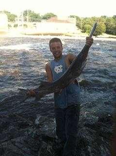
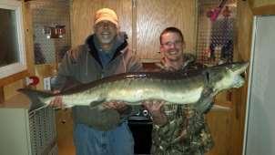
31 Lake sturgeon caught in 1941 from Tamarac River (Red Lake River Watershed) Lake sturgeon from Red Lake River (unknown size and date) 405 pound lake sturgeon from the Roseau River, October, pound lake sturgeon from White Earth Lake, Wild Rice Watershed May, pound lake sturgeon from Detroit Lake (Otter Tail Watershed), October, 1890 The last lake sturgeon (102 lbs.) recorded from the Red River of the North Basin was caught in 1947 in Lake Lida, Otter Tail (Pelican) Watershed Photo courtesy of the Pelican Rapids Press


32 Strategies for Reconnecting Rivers Dam Removal Nature-like Fish Passage Rock Arch Rapids By-pass Fishway Problem Corrected/Restored Dam Removal Rock Arch Rapids By-pass Fishway Stream Habitat * Safety Dam Failure Risk Safety hydraulic undertows Maintenance costs Fish & Wildlife Passage * Canoe passage, recreational boating * Geomorphic and ecological processes (sedimentation, incision, nutrient processes, etc.) *Size dependent


33 Minnesota Falls Dam Minnesota River Built in 1871 & 1905, Hydropower retired in feet high Upstream limit of 32 species of fish Inundated Minnesota Falls Worker drowned in 2011 during maintenance High hazard dam with significant structural deficiencies Repairs estimated at 5 to 7 Million dollars Dam


34 Dam Removed in January, 2013 for $942,000


35 Minnesota Falls Native species that have returned since dam removal American Eel Special Concern Over 6000 km from Sargasso Sea Sauger Paddlefish - Threatened Flathead Catfish Lake Sturgeon Special Concern River Carpsucker Highfin Carpsucker Gizzard Shad Shovenose Sturgeon Mooneye SILVER LAMPREY Black Buffalo - Threatened Blue Sucker Special Concern Longnose Gar Shortnose Gar


36 Healthier River = New Recreational Opportunities City of Granite Falls is assessing: Further development of paddling opportunities Options for fish passage through the Granite Falls Dam


37 Removal of the Appleton Milldam Pomme De Terre River $117,000 for dam removal $250,000 for river restoration Lake Christina Photo circa 1910 Dam built in Reservoir sediments up to 15 feet deep Morris Dam Dam failed in 1997, removed in River cutting through sediments Dams Appleton Milldam (Removed) Photo taken in 2016 River restoration Restored Pomme De Terre River Channel Sediments stabilized in place
 Carmine Shiner Returned White Bass Returned Lake")
 returned after")
38 Quillback Returned Silver Redhorse Returned Greater Redhorse Returned Banded Darter Returned Channel Catfish Returned Freshwater Drum Returned Smallmouth Buffalo (blocked by downstream dams) Carmine Shiner Returned White Bass Returned Lake Sturgeon (blocked by downstream dams but being reintroduced to Bigstone Lake) Emerald Shiner Returned Northern Hogsucker Central Stoneroller Pomme de Terre River Species absent upstream of Appleton Dam to Morris Dam 77% (10/13) returned after removal
 that recolonized upstream to the Morris Dam")


39 Appleton Milldam Removal Mussels found only as dead shells prior to removal (1990 survey) that recolonized upstream to the Morris Dam following removal (2007 survey). Video courtesy of Bernard Sietman Elktoe Mussel Alasmidonta marginata Hosts: Rock bass NI Shorthead redhorse NI White sucker NI Northern hogsucker * NI Silver redhorse**? Greater redhorse**? Pocketbook Mussel Lampsilis cardium Hosts: Walleye LT Sauger* NI Bluegill LT Largemouth bass LT Smallmouth bass LT White crappie NI, LT Green sunfish LT Tiger salamander LT Deertoe Mussel Truncilla truncata Host: Freshwater drum** NI * Species absent upstream of dam ** Species returned after removal NI Natural infestation LT Laboratory transformation Four other extirpated mussel species (round pigtoe, creek heelsplitter, mucket, and black sandshell) have not yet been found upstream of the former dam site


40 New Recreational Opportunities after Dam Removal and River Restoration

41 Knutson Dam at Cass Lake on the Mississippi River Owned by the U.S. Forest Service

42

43


44 Dunton Locks, Pelican River Maintained water level for Muskrat and Big Detroit Lake Historic Dam built in Dam removed and replaced with rock arch rapids
45

46 Breckenridge Dam, Otter Tail River built in 1936


47 Sedimentation of Breckenridge Reservoir Otter Tail River Built in


48 Breckenridge Dam Fishway Built in 1996 for $20,000


49 Fish per Day BRECKENRIDGE FISHWAY 2004 Bigmouth Buffalo Black bullhead Black Crappie Bluegill Bluntnose minnow Blackside darter Carp Channel catfish Chestnut lamprey Emerald shiner Freshwater drum Golden redhorse Goldeye Greater Redhorse Mooneye Northern pike Pumkinseed Quillback Redhorse Rock bass Sand shiner Spotfin shiner Shorthead Redhorse Silver Redhorse Smallmouth bass Spotfin shiner Walleye White bass White sucker April May June July August


50 Breckenridge Dam Failures Repaired with Federal Disaster Declaration Funds


51 Breckenridge Dam Removed in 2007 for $100,000 Rapids built for grade control County Park established, bike trails connect site to the city Record 2009 flood caused no damages at site


52 Native fish species absent from the Otter Tail Watershed upstream of Breckenridge Dam that returned after fish passage and dam removal Lake sturgeon Extirpated from Red River Basin, reintroduced Sauger returned White Bass returned Stonecat returned Longnose Gar Returned, rare Mooneye returned Goldeye returned Silver Lamprey 14 additional native species that had not been caught in the reach between Breckenridge and Orwell dams prior to the removal were caught in that reach after fishway construction.


53 Lake Shady Dam No major structural problems Reservoir largely filled with sediment County considered removal


54 Lake Shady Dam Dam failed in 2010 flood

55


56 Restoration of the Zumbro River
57 Number & (%) of Missing Species returning after dam removal Appleton* Flandreau Breckenridge* Heiberg* Sandstone Drywood Carp Welch Dawson* State Park* Lake Florence Barrier Removal Effects on Species Richness Species absent upstream of dam Species that returned after dam removal On average, 66% of species absent upstream of the dams returned following removal % % % % 55% 72% 74% % % 23% *river restoration following removal including rock arch rapids grade control.

58 Removed barrier Barrier dam


59 Sturgeon Reintroduction Starting in 1998 Eggs purchased from Rainy River First Nation Fry hatched at the Detroit Lakes Hatchery Fingerlings raised by USFWS at La Crosse, WI


60 Sturgeon in Dunton Locks Rapids Sturgeon in Diversion Fishway


61 Lake Oneida lake sturgeon grow faster than anywhere in North America; zebra mussels are the dominant forage for fish over 35 inches Leeches 1.2% Fish 0.3% Zooplankton 0.3% Aquatic Insects 17.9% Zebra mussels 31.7% Snails 20.8% Amphipods and isopods 27.8% Data from Cornell research station Zebra mussels taken from the stomachs of sturgeon speared in Lake Winnebago We have videos of sturgeon swimming over rocks carpeted with zebra mussels; and a few seconds later the rocks are clean, Michigan fisheries biologist Dr. Ed Baker

 Spotfin Shiner Channel Catfish Silver Redhorse Greater Redhorse Northern Hogsucker Blackside Darter Blacknose Dace")
62 Pelican Rapids Dam Built in feet high 11 fish species found in the Pelican river are absent from surveys upstream of Pelican Rapids and Elizabeth Dams. 35 fish species found in the Otter Tail watershed are absent upstream of Pelican Rapids Dam. The Pelican River upstream of Elizabeth got failing IBI scores in PCA surveys The highest IBI score in the Red River Basin was downstream of Orwell Dam Lake Sturgeon (Reintroduced in Detroit Lake but not yet reproducing) Spotfin Shiner Channel Catfish Silver Redhorse Greater Redhorse Northern Hogsucker Blackside Darter Blacknose Dace Golden Redhorse Creek chub Rainbow Darter Sand Shiner Bigmouth Shiner Longnose Dace Central Stoneroller
63 Elizabeth Elevation Dunton Locks Bucks Mill (historic rapids) Fish Lake Lake Lizzie Prairie Lake Pelican Rapids Pelican River Profile Distance from Confluence with Otter Tail River 10 0
 Current Pelican")
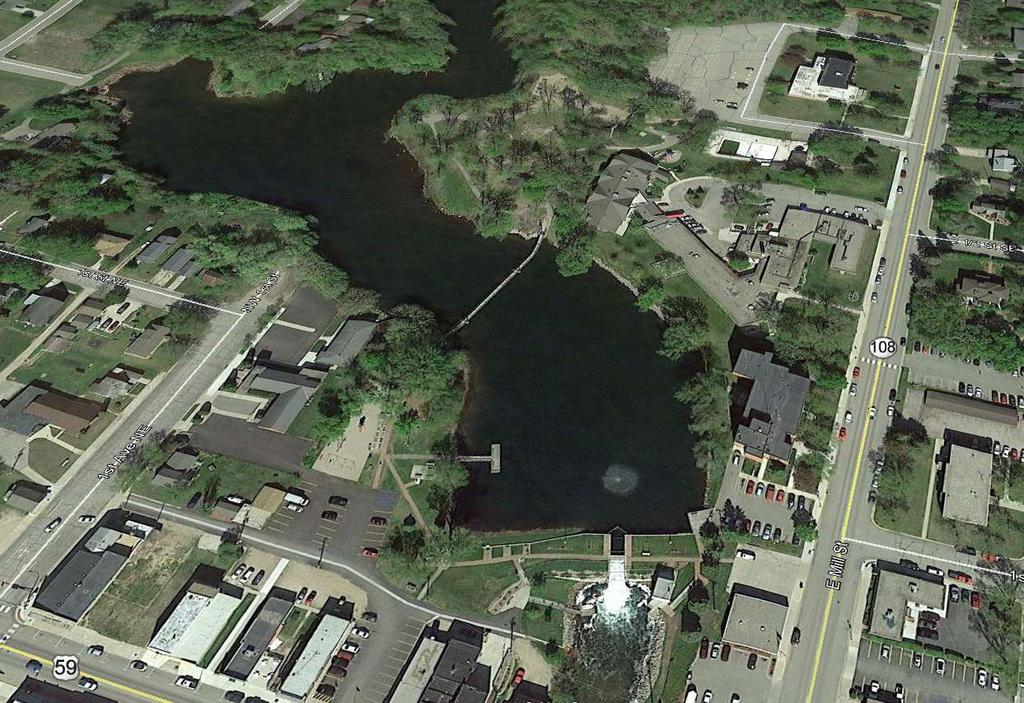
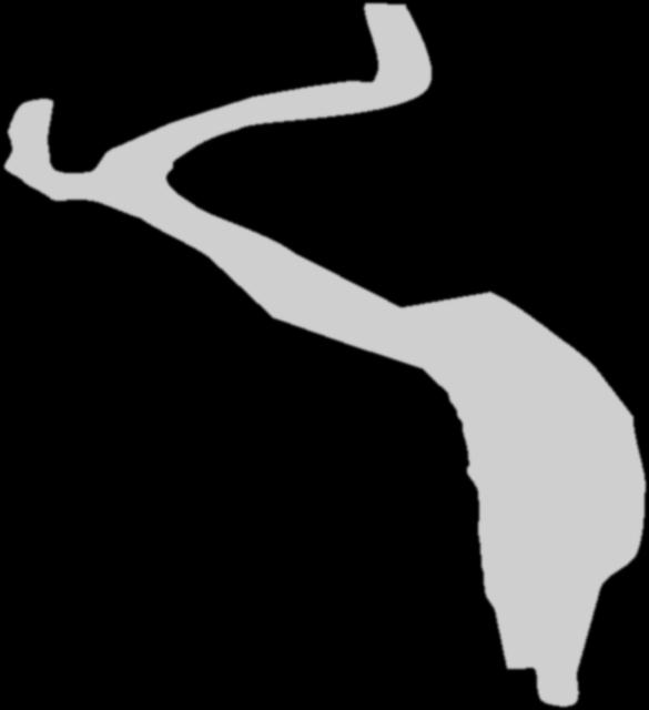
64 Original Land Survey 1870 (pre-dam) Current Pelican Rapids Dam

65


66
67


68


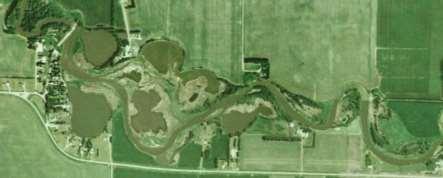
69 Drone image by Houston Engineering Bathymetry by Jamison Wendel, DNR

70 Humankind has not woven the web of life. We are but one thread within it. Whatever we do to the web, we do to ourselves. All things are bound together. All things connect. ~ Chief Seattle Photo courtesy of the Pelican Rapids Press
Thunder Bay River Assessment Appendix. Appendix 2
 Appendix 2 Known past and present fish distributions in the River system. Distribution of fishes were compiled from Bailey et al. (2003) and from records located at the Michigan Department of Natural Resources
SUMMARY REPORT FOR LAKE ST. MALO FISHERIES ASSESSMENT. Prepared for the St. Malo and District Wildlife Association
 SUMMARY REPORT FOR LAKE ST. MALO FISHERIES ASSESSMENT Prepared for the St. Malo and District Wildlife Association Presented by August 25, 2014 Study dates thus far: Date Tasks February 16 Fishing derby;
Investigating reproduction and abundance of bighead carp (Hypophthalmichthys nobilis) and silver carp (H. molitrix) in the Greenup pool, Ohio River
 and silver carp (H. molitrix) in the Greenup pool, Ohio River") Investigating reproduction and abundance of bighead carp (Hypophthalmichthys nobilis) and silver carp (H. molitrix) in the Greenup pool, Ohio River Nathan Fleshman Dr. Thomas Jones Photo: USGS Photo: USGS
Investigating reproduction and abundance of bighead carp (Hypophthalmichthys nobilis) and silver carp (H. molitrix) in the Greenup pool, Ohio River Nathan Fleshman Dr. Thomas Jones Photo: USGS Photo: USGS
Caro Impoundment, Tuscola County
 Caro Impoundment is a 200 acre impoundment of the Cass River located one mile south of the Village of Caro in Tuscola County. Caro Dam, originally constructed in 1906 for water supply to Michigan Sugar
Lake St. Clair Fish Community and Fishery
 Lake St. Clair Fish Community and Fishery Megan Belore Ontario Ministry of Natural Resources and Forestry Mike Thomas Michigan Department of Natural Resources Fish Community Fish Community Mixture of warm
Onondaga Lake Fishery: 2011 Fact Sheet
 October, 2011 Onondaga County Department of Water Environment Protection SUNY College of Environmental Science and Forestry Joanne M. Mahoney, County Executive Tom Rhoads, P.E., Commissioner Onondaga Lake
MISSISSIPPI MAKEOVER A Plan for Restoration, Just Around the Bend
 MISSISSIPPI MAKEOVER A Plan for Restoration, Just Around the Bend Interim Report Card 2013 Project coordinated by the Dakota County Soil and Water Conservation District and sponsored by the Minnesota Pollution
Tahquamenon River Assessment Appendix
 DNR DEPARTMENT OF NATURAL RESOURCES MICHIGAN STATE OF MICHIGAN DEPARTMENT OF NATURAL RESOURCES SR45 Appendix February 2008 Tahquamenon River Assessment Appendix James R. Waybrant and Troy G. Zorn www.michigan.gov/dnr/
Minnesota Department of Natural Resources Division of Fish and Wildlife Section of Fisheries. Stream Survey Report. Three Mile Creek 2011
 Minnesota Department of Natural Resources Division of Fish and Wildlife Section of Fisheries Stream Survey Report Three Mile Creek 2011 By Joseph D. Stewig Montrose Area Fisheries Office TABLE OF CONTENTS
Little Calumet River Rapid Response Fish Identification and Enumeration Branch Summary Report
 Little Calumet River Rapid Response Fish Identification and Enumeration Branch Summary Report Introduction A rotenone rapid response was completed on a 2.6-mile section of the Little Calumet River immediately
Success and Potential Impacts of Rock Ramp Fish Passages in the Saginaw Bay Watershed
 Success and Potential Impacts of Rock Ramp Fish Passages in the Saginaw Bay Watershed Tracy Galarowicz, Ph.D. Department of Biology Institute of Great Lakes Research Central Michigan University Central
Alcona Dam Pond Alcona County (T25N, R5E, Sections various) Surveyed June 6-12 and September 16, 2003
 Surveyed June 6-12 and September 16, 2003") Michigan Department of Natural Resources Status of the Fishery Resource Report No. 2004-6, Year 2004 Alcona Dam Pond Alcona County (T25N, R5E, Sections various) Surveyed June 6-12 and September 16, 2003
Michigan Department of Natural Resources Status of the Fishery Resource Report No. 2004-6, Year 2004 Alcona Dam Pond Alcona County (T25N, R5E, Sections various) Surveyed June 6-12 and September 16, 2003
Quemahoning Reservoir
 Pennsylvania Fish & Boat Commission Biologist Report Quemahoning Reservoir Somerset County May 2011 Trap Net, Gill Net and Electrofishing Survey Quemahoning Reservoir is an 899 acre impoundment located
Geology. Key Factors. Overfishing. Great Lakes Fishes. Historical Fishing. About 10,000 years since last glacial retreat very young ecologically
 Great Lakes Fishes Geology About 10,000 years since last glacial retreat very young ecologically Largest surface freshwater system on earth 21% of world s supply 84% of North America s supply Five unique
Proposed Changes to Bag and Size Limits Minnesota/Wisconsin Border Waters of the Mississippi River
 Proposed Changes to Bag and Size Limits Minnesota/Wisconsin Border Waters of the Mississippi River The Minnesota and Wisconsin DNRs are jointly reviewing fishing regulations on Pools 3-9 of the Mississippi
Elk Lake, Antrim and Grand Traverse counties T. 28, 29 N., R. 8, 9 W., Sec. many. Lake surveys. began at 40 feet
 Elk Lake, Antrim and Grand Traverse counties T. 28, 29 N., R. 8, 9 W., Sec. many Physical and chemical data surveyed August 1931 Temperature ( F) Secchi disk (feet) 9. 6 Surface 74 Bottom 45 PH 8.0 Thermocline
Job 1 Part JOB 1, PART 2: SUMMARY OF CONOWINGO DAM WEST FISH LIFT OPERATIONS, 2009
 2.0 JOB 1, PART 2: SUMMARY OF CONOWINGO DAM WEST FISH LIFT OPERATIONS, 2009 Lawrence M. Miller Normandeau Associates U. S. Fish and Wildlife Service 1921 River Road Harrisburg, Pennsylvania Drumore, Pennsylvania
WFC 50 California s Wild Vertebrates Jan. 11, Inland Waters (Lakes and Streams) Lisa Thompson
 Lisa Thompson") Inland Waters: Lakes and Streams WFC 50 11 January 2011 Lisa Thompson Fisheries Extension Specialist Wildlife, Fish, & Conservation Biology Department University of California, Davis Take home messages
Inland Waters: Lakes and Streams WFC 50 11 January 2011 Lisa Thompson Fisheries Extension Specialist Wildlife, Fish, & Conservation Biology Department University of California, Davis Take home messages
EXECUTIVE SUMMARY. Muskegon River Watershed Assessment
 EXECUTIVE SUMMARY This assessment for the Muskegon River watershed is one of a series being prepared by Michigan Department of Natural Resources, Fisheries Division, for river basins in Michigan. This
Minnesota Department of Natural Resources Division of Fish and Wildlife Section of Fisheries. Stream Survey Report. St. Francis River 2004
 Minnesota F-29-R(P)-17 Area 315 Study 3 April 2005 Minnesota Department of Natural Resources Division of Fish and Wildlife Section of Fisheries Stream Survey Report St. Francis River 2004 By Eric R. Altena
SUMMARY OF CONOWINGO DAM WEST FISH LIFT OPERATIONS 2012
 SUMMARY OF CONOWINGO DAM WEST FISH LIFT OPERATIONS 2012 Michael L. Hendricks Pennsylvania Fish and Boat Commission 1735 Shiloh Rd. State College, Pa 16801 INTRODUCTION The shore-based trapping device at
Great Lakes Coastal Wetland Communities: Vulnerabilities to Climate Change and Response to Adaptation Strategies
 Great Lakes Coastal Wetland Communities: Vulnerabilities to Climate Change and Response to Adaptation Strategies CCAF Wetlands Study Investigators: Susan Doka Fisheries & Oceans, Great Lakes Lab for Fisheries
Columbia Lake Dam Removal Project
 Columbia Lake Dam Removal Project The Columbia Lake dam located 1/4 mile upstream of the Paulins Kill River's confluence with the Delaware River in Knowlton Township, Warren County has been proposed for
Report prepared for: Prepared by: January 2002 BEAK Ref
 AQUATIC ENVIRONMENTAL STUDY KANATA WEST CONCEPT PLAN Report prepared for: ROBINSON CONSULTANTS Prepared by: BEAK INTERNATIONAL INCORPORATED 14 Abacus Road Brampton, Ontario L6T 5B7 January 2002 BEAK Ref.
Bode Lake - South Population Survey
 Bode Lake - South Survey Located in Hoffman Estates on the north side of Bode Rd. 1 mile west of Barrington Rd. Bode Lake is made up of two lakes along Poplar Creek; the larger and deeper Bode Lake South
Michigan Dept. of Natural Resources Status of the Fishery Resource Report Page 1. Weber Lake Cheboygan County, T34N, R3W, Sec.
 Michigan Dept. of Natural Resources 2012-143 Status of the Fishery Resource Report Page 1 Weber Lake Cheboygan County, T34N, R3W, Sec. 31 Neal Godby, Fisheries Biologist Environment Weber Lake is a 28.5-acre
The relationship between the spatial distribution of common carp and their environmental DNA in a small lake
 The relationship between the spatial distribution of common carp and their environmental DNA in a small lake Jessica Eichmiller*, Przemyslaw Bajer, and Peter Sorensen Department of Fisheries, Wildlife,
LAKE DIANE Hillsdale County (T8-9S, R3W, Sections 34, 3, 4) Surveyed May Jeffrey J. Braunscheidel
 Surveyed May Jeffrey J. Braunscheidel") Michigan Department of Natural Resources Status of the Fishery Resource Report No. 2003-4, 2003 LAKE DIANE Hillsdale County (T8-9S, R3W, Sections 34, 3, 4) Surveyed May 2001 Jeffrey J. Braunscheidel Environment
Michigan Department of Natural Resources Status of the Fishery Resource Report No. 2003-4, 2003 LAKE DIANE Hillsdale County (T8-9S, R3W, Sections 34, 3, 4) Surveyed May 2001 Jeffrey J. Braunscheidel Environment
FISH COMMUNITIES AND FISHERIES OF THE THOUSAND ISLANDS AND MIDDLE CORRIDOR
 St. Lawrence River Discussion Paper FISH COMMUNITIES AND FISHERIES OF THE THOUSAND ISLANDS AND MIDDLE CORRIDOR Issues Below is a synopsis of fish community issues and proposed management approaches. More
Salmon and Steelhead in the American River Tim Horner, PhD Geology Department California State University, Sacramento
 Salmon and Steelhead in the American River Tim Horner, PhD Geology Department California State University, Sacramento What kind of fish are in the American River? The American River provides habitat for
Montgomery Parks Biological Monitoring in the Anacostia Watershed of Montgomery County RESOURCE ANALYSIS SECTION
 Montgomery Parks Biological Monitoring in the Anacostia Watershed of Montgomery County PARK PLANNING & STEWARDSHIP Doug Redmond, Natural Resources Manager Montgomery County Department of Parks September
Rolling Knolls Pond Population Survey
 Located near the town of Elgin on the west side of Rohrssen Rd. between Illinois Route 58 and U.S.- 20. This small 1.8 acre pond has a maximum depth of 7.5 feet and is occasionally influenced by Poplar
2010 Fishing Opener Prognosis. Central Region
 2010 Fishing Opener Prognosis Central Region Hinckley PINE COUNTY Pokegama, Cross, Island, Oak and North and South Big Pine Lakes are typically the best lakes for targeting walleye in Pine County. They
Busse Reservoir South Lateral Pool Population Survey
 Busse Reservoir South Lateral Pool Survey Located in Elk Grove Village south of Higgins Rd. between RT 53/I-290 and Arlington Heights Rd. Busse Reservoir is comprised of three pools making up a total of
SKIATOOK LAKE MANAGEMENT PLAN
 SKIATOOK LAKE MANAGEMENT PLAN Background Skiatook Lake impounds Hominy Creek, 5 miles west of Skiatook in Osage County, Oklahoma (Figure 1). Skiatook Lake covers 10,540 surface acres and was constructed
JOB 1, PART 2. SUMMARY OF CONOWINGO DAM WEST FISH LIFT OPERATIONS 2011
 JOB 1, PART 2. SUMMARY OF CONOWINGO DAM WEST FISH LIFT OPERATIONS 2011 Michael L. Hendricks Pennsylvania Fish and Boat Commission 1735 Shiloh Rd. State College, Pa 16801 INTRODUCTION The shore-based trapping
Full Project Proposal
 PROJECT NAME: FIELD OFFICE: Full Project Proposal NFPP Phase I - Ferson-Otter Creek Dam Removal/Modification Project, Fox River Watershed, Illinois Carterville NFWCO PROJECT COORDINATOR: Nate Caswell FONS
HUBBARD LAKE Alcona County (T27N, R7E; T28N, R7E) Surveyed May and September Tim A. Cwalinski
 Surveyed May and September Tim A. Cwalinski") Michigan Department of Natural Resources Status of the Fishery Resource Report No. 2003-1, 2003 HUBBARD LAKE Alcona County (T27N, R7E; T28N, R7E) Surveyed May and September 1996 Tim A. Cwalinski Environment
Michigan Department of Natural Resources Status of the Fishery Resource Report No. 2003-1, 2003 HUBBARD LAKE Alcona County (T27N, R7E; T28N, R7E) Surveyed May and September 1996 Tim A. Cwalinski Environment
Brown County Historical Society. Fourteen tons of shells were shipped from Granite Falls and 16 tons from Wegdahl to the Muscatine Button Factory.
 MUSSEL OVERVIEW History Mussels are often the dominant community found in the substrate of streams and lakes. Historically, mussels were abundant across s Rivers and lakes. At one time, across the US and,
Delaware River Seine Survey: 2012 Sampling Summary
 Delaware River Seine Survey: 2012 Sampling Summary Fish and Wildlife employees pull in the seine net From June 18 to November 21, 2012, biologists conducted the Delaware River Seine Survey. Over the course
Methods for Evaluating Shallow Water Habitat Restoration in the St. Clair River
 Methods for Evaluating Shallow Water Habitat Restoration in the St. Clair River Objectives Document fish use of restoration sites Spawning Presence of larvae, juvenile, and adult fish Quantify differences
Fisheries Survey of White Rapids Flowage, Marinette County Wisconsin during Waterbody Identification Code
 Fisheries Survey of White Rapids Flowage, Marinette County Wisconsin during 25 Waterbody Identification Code 6343 Michael Donofrio Fisheries Supervisor Wisconsin Department of Natural Resources Peshtigo,
FRESHWATER MUSSELS. Master Naturalist Program September 27, 2016
 FRESHWATER MUSSELS Master Naturalist Program September 27, 2016 Alison Stodola Aquatic Field Biologist Illinois Natural History Survey Prairie Research Institute - University of Illinois alprice@illinois.edu
10000 Bluntnose minnow. White sucker Blacknose shiner. Northern pike Carp Silver shiner Tadpole madtom
 10000 Bluntnose minnow Common shiner umber of individuals 1000 100 potfin shiner chub hite sucker Blacknose shiner Bluegill Blacknose dace Hornyhead chub Rock bass and shiner chub pottail shiner Golden
OTTER TAIL RIVER PROJECT (FERC NO ) OTTER TAIL POWER COMPANY INITIAL STUDY REPORT 2017 AQUATIC STUDIES APRIL 26, 2018
 OTTER TAIL POWER COMPANY INITIAL STUDY REPORT 2017 AQUATIC STUDIES APRIL 26, 2018") OTTER TAIL RIVER PROJECT (FERC NO. 10853) OTTER TAIL POWER COMPANY INITIAL STUDY REPORT 2017 AQUATIC STUDIES APRIL 26, 2018 1 STUDY LIST Study Name Status Baseline Fisheries Completed June-August 2017
OTTER TAIL RIVER PROJECT (FERC NO. 10853) OTTER TAIL POWER COMPANY INITIAL STUDY REPORT 2017 AQUATIC STUDIES APRIL 26, 2018 1 STUDY LIST Study Name Status Baseline Fisheries Completed June-August 2017
Sag Quarry - West Population Survey
 Located in Lemont on RT 83 and Archer Ave. just north of 111 th St. Like Sag Quarry East, this lake is an old limestone quarry, 14 acres in size and with a maximum depth of 10.3 feet. The species found
Mussel Monitoring in Eau Claire County. Anna Mares Citizen Science Center April 10, 2013
 Mussel Monitoring in Eau Claire County Anna Mares Citizen Science Center April 10, 2013 Mussels/clams/fresh water bivalves What are the defining features of this group of animals? Clam comes from Old High
Fish Community. Fish Habitat, Streams and Rivers
 Clear, Ston(e)y and White Lake Plan Fish Community The lakes support a cool/warm water fishery including muskellunge, walleye, largemouth and smallmouth bass, yellow perch, pumpkinseed, rockbass, blue
THE LONG-TERM ILLINOIS RIVER FISH POPULATION MONITORING PROGRAM
 T E C H N I C A L R E P O R T THE LONG-TERM ILLINOIS RIVER FISH POPULATION MONITORING PROGRAM Project F-101-R-20 Annual Report to the Illinois Department of Natural Resources Michael A. McClelland and
Schiller Pond Population Survey
 Located in the town of Schiller Park on Irving Park Rd. just west of Cumberland Ave. This small 6 acre pond has a maximum depth of 6.3 feet. In addition to largemouth bass and bluegill, Schiller Pond is
RECREATIONAL PONDS AND LAKES
 RECREATIONAL PONDS AND LAKES POND ECOLOGY AQUATIC PLANTS & FISH F.S. Conte Department of Animal Science University of California Davis Photos By Flickr AQUATIC PLANTS POND HEALTH Chemical Recycling Oxygen
Okanagan Sockeye Reintroduction
 Okanagan Sockeye Reintroduction Backgrounder Elders accounts, and other forms of Traditional Ecological Knowledge (TEK) tell us that many species of salmon once came into the Okanagan Valley and tell us
Impacts of Aquatic Invasive Species on the Lake Superior Fishery. by Jeff Gunderson Minnesota Sea Grant Program
 Impacts of Aquatic Invasive Species on the Lake Superior Fishery by Jeff Gunderson Minnesota Sea Grant Program Can humans really impact the fishery of such a large waterbody? Lake Superior Fishery Change
Pigeon River Recovery Project: Bringing Back Aquatic Diversity
 Pigeon River Recovery Project: Bringing Back Aquatic Diversity Joyce Coombs and J. Larry Wilson University of Tennessee Department of Forestry, Wildlife and Fisheries Jonathon Burr Tennessee Department
Maple Lake Population Survey
 Maple Lake Survey Located in Willow Springs approximately 1 mile west of Willow Springs Rd. (104 th Ave.) at Wolf Rd. and 95 th St. Constructed in the 1920 s this 60 acre lake drops down to 20.4 feet in
Tampier Lake Population Survey
 Located in Palos Park on 131 st St. between Wolf and Will-Cook Rd. s. Tampier Lake has 131 acres of fishable water, with a maximum depth of 9.4 feet. Walleye, northern pike, largemouth bass and channel
Electrofishing Surveys Shed Light on Dynamic Millstone River Fishery. By Shawn Crouse, Principal Fisheries Biologist
 Electrofishing Surveys Shed Light on Dynamic Millstone River Fishery By Shawn Crouse, Principal Fisheries Biologist It is June, 2018 and American Shad have been on the move! Great efforts are being made
I Region I Area I DOW Number / County I DOW Lake Name I Acreage I
 LAKE MANAGEMENT PLAN 814 Bp I Region I Area I DOW Number / County I DOW Lake Name I Acreage I I I # I f 2 Duluth F213 690036 St Louis Salo DOW:149 Plan: 137 Long Range Goal: Manage for walleye with a gillnet
Big Bend Lake Population Survey
 Big Bend Lake Survey Located in Des Plaines on East River Rd. just south of Golf Rd. This 27 acre body of water has a depth of 27.8 feet; however because it is connected to the Des Plaines River by a spillway,
Management and Control of Asian Carps in the United States. Greg Conover Asian Carp Working Group, Chair USFWS, Carterville FRO
 Management and Control of Asian Carps in the United States Greg Conover Asian Carp Working Group, Chair USFWS, Carterville FRO Asian Carp 7 carps native to Asia introduced into U.S. Asian carps = bighead,
Site 4 PEESHOO. Approx. Head = 10 m Design Flow = 70 m 3 /s Capacity = 6 MW. Peeshoo. Kabinakagami River. Rogers Road HWY 11.
 Kabinakagami River Site 4 PEESHOO Rogers Road Peeshoo Approx. Head = 10 m Design Flow = 70 m 3 /s Capacity = 6 MW N 0 2 4 6 HWY 11 Kilometers Site 4 - PEESHOO Looking Downstream Looking Downstream Site
Big Spring Creek Habitat Enhancement and Fishery Management Plans
 Big Spring Creek Habitat Enhancement and Fishery Management Plans November 5, 2012 Big Spring Events and Activities Center Newville, PA Charlie McGarrell Regional Habitat Biologist Pennsylvania Fish and
Laurentian Great Lakes and their invasive species. Jeff Gunderson Minnesota Sea Grant College Program
 Laurentian Great Lakes and their invasive species Jeff Gunderson Minnesota Sea Grant College Program Largest Group of Freshwater Lakes in the World Contain 21% of the worlds surface freshwater Variety
East Metro Forest Lake (2,251 acres): Coon Lake (1,481 acres):
: Coon Lake (1,481 acres):") East Metro Forest Lake (2,251 acres): Located within the City of Forest Lake and just east of Interstate 35, Forest Lake boasts good numbers of northern pike and walleye. Northern pike and walleye were
East Metro Forest Lake (2,251 acres): Located within the City of Forest Lake and just east of Interstate 35, Forest Lake boasts good numbers of northern pike and walleye. Northern pike and walleye were
Minnesota Chapter Report. NCD Rivers and Streams Technical Committee
 Minnesota Chapter Report NCD Rivers and Streams Technical Committee Compiled by: Ann Kuitunen, MN NCD Rep. (ann.kuitunen@.state.mn.us) MN Division of Ecological and Water Resources, Minnesota Department
What was the historic coaster fishery like?
 1 of 6 1/30/2012 12:25 PM Home About Topics Contact Us Fishing Calendar Fish ID Tips FAQs Hack Noyes Research Vessel Is it a unique strain long lost from Wisconsin's shoreline? Fisheries Reports Tributaries
Profile of the Current Non-Asian Carp Commercial Fishing Industry on the Illinois River
 Profile of the Current Non-Asian Carp Commercial Fishing Industry on the Illinois River Rob Maher Illinois Department of Natural Resources Division of Fisheries Commercial Fishing Project Manager Historic
Advancing Fish Passage in the Menomonee River Watershed
 University of Massachusetts - Amherst ScholarWorks@UMass Amherst International Conference on Engineering and Ecohydrology for Fish Passage International Conference on Engineering and Ecohydrology for Fish
Current projects for Fisheries Research Unit of Minnesota Department of Natural Resources
 Current projects for Fisheries Research Unit of Minnesota Department of Natural Resources MAJOR RESOURCE ISSUES IN THE DIVISION OF FISHERIES Status of Fish Populations To effectively manage fish populations,
EVALUATION OF THE FISH COMMUNITY AND GAME FISH POPULATIONS IN SUGAR CREEK (MONTGOMERY AND PARKE COUNTIES)
") EVALUATION OF THE FISH COMMUNITY AND GAME FISH POPULATIONS IN SUGAR CREEK (MONTGOMERY AND PARKE COUNTIES) 2000 Fish Management Report Douglas C. Keller Fisheries Biologist FISHERIES SECTION INDIANA DEPARTMENT
EVALUATION OF THE FISH COMMUNITY AND GAME FISH POPULATIONS IN SUGAR CREEK (MONTGOMERY AND PARKE COUNTIES) 2000 Fish Management Report Douglas C. Keller Fisheries Biologist FISHERIES SECTION INDIANA DEPARTMENT
Lake information report
 Lake information report: Minnesota DNR Page of 5 Lake information report jf Prinlable senior Name: Spring Nearest Town: Spring Lake (Scott) Primary County: Scott Survey Date: 08/02/200 Inventory Number:
Swift Current Creek Watershed
 Swift Current Creek Watershed Watershed Boundary Gross drainage area 3939 km 2 973,343 acres Gross creek length 230 km 143 miles Primary water source for 20 000 people Major source of water base recreation
FACT SHEET I. LOCATION
 STEAMBOAT ISLAND HABITAT REHABILITATION AND ENHANCEMENT PROJECT (HREP) SCOTT COUNTY, IOWA, UPPER MISSISSIPPI RIVER RESTORATION-ENVIRONMENTAL MANAGEMENT PROGRAM ROCK ISLAND DISTRICT FACT SHEET I. LOCATION
Instructor Background Information
 Lake Sturgeon Version Instructor Background Information I. Overview II. Lake Sturgeon Information 1. History 2. Identification 3. Habitat 4. Food 5. Predators III. Lake Sturgeon Life Cycle IV. Limiting
6TH PELLETIER BROOK LAKE T15 R9, Aroostook Co. U.S.G.S. Gardner Pond, Maine (7 1/2 )
") 6TH PELLETIER BROOK LAKE T15 R9, Aroostook Co. U.S.G.S. Gardner Pond, Maine (7 1/2 ) Fishes Brook trout Minnows Blacknose dace Pearl dace Physical Characteristics Area - 27 acres Average depth - 2 feet
6TH PELLETIER BROOK LAKE T15 R9, Aroostook Co. U.S.G.S. Gardner Pond, Maine (7 1/2 ) Fishes Brook trout Minnows Blacknose dace Pearl dace Physical Characteristics Area - 27 acres Average depth - 2 feet
NEVADA DEPARTMENT OF WILDLIFE STATEWIDE FISHERIES MANAGEMENT
 NEVADA DEPARTMENT OF WILDLIFE STATEWIDE FISHERIES MANAGEMENT FEDERAL AID JOB PROGRESS REPORTS F-20-52 2016 Lake Tahoe Rainbow Trout Study WESTERN REGION NEVADA DEPARTMENT OF WILDLIFE, FISHERIES DIVISION
Indiana Administrative Code Page IAC Aquaculture permit Authority: IC Affected: IC Sec. 17. (a) A person must not
 A person must not") Indiana Administrative Code Page 71 312 IAC 9-10-17 Aquaculture permit Affected: IC 14-22-27 Sec. 17. (a) A person must not import, raise, sell, or transport fish into or within Indiana without an aquaculture
Indiana Administrative Code Page 71 312 IAC 9-10-17 Aquaculture permit Affected: IC 14-22-27 Sec. 17. (a) A person must not import, raise, sell, or transport fish into or within Indiana without an aquaculture
Penny Road Pond Population Survey
 Located in Barrington Hills on the south side of Penny Rd. west of Old Sutton Rd. This small 7 acre pond has a maximum depth of 4.6 feet and is connected to Spring Creek. The fish population of Penny Road
Co-operative Freshwater Ecology Unit 2004 Program
 Co-operative Freshwater Ecology Unit 2004 Program Nordic Fish Survey (2003 + 2004) A survey of fish communities present in 25 Sudbury lakes was performed using the international standard Nordic Method.
NJ DIVISION OF FISH AND WILDLIFE Bureau of Freshwater Fisheries
 NJ DIVISION OF FISH AND WILDLIFE Bureau of Freshwater Fisheries 2015 Warmwater Reproduction Checks (Shoreline Seining) Alloway Lake (Salem) A seining survey was completed at Alloway Lake (120 acres) on
2017 Lake Winnebago Bottom Trawling Assessment Report
 217 Lake Winnebago Bottom Trawling Assessment Report Adam Nickel, Winnebago System Gamefish Biologist, March 218 There were several highlights from the 217 Lake Winnebago bottom trawling survey, including
O&Mbuited Gwk k Fu\m w Kowm. Tke [Iwvmty $ Komm ftfwewtt o( HahmJt Hufottj cud State BfoCogM Suwey
 O&Mbuited Gwk k Fu\m w Kowm Tke [Iwvmty $ Komm ftfwewtt o( HahmJt Hufottj cud State BfoCogM Suwey UNIVERSITY OF KANSAS PUBLICATIONS MUSEUM OF NATURAL HISTORY The Public Education Series is intended to
Wampum Lake Population Survey
 Wampum Lake Survey Located in Thornton on Thornton-Lansing Rd. 1½ mile west of Torrence Ave. Wampum Lake is 35 acres is size and has a maximum depth of 14.1 feet. Northern pike, largemouth bass, bluegill,
FISHES OF THE KNIFE LAKE WATERSHED IN KANABEC AND MILLE LACS COUNTIES OF MINNESOTA. Konrad Schmidt, Vice-President
 Conservation Biology Research Grants Program Division of Ecological Services Minnesota Department of Natural Resources FISHES OF THE KNIFE LAKE WATERSHED IN KANABEC AND MILLE LACS COUNTIES OF MINNESOTA
Green Lake Population Survey
 Located next to the Green Lake Aquatic Center in Calumet City on the north side of 159 th St, east of Torrence Ave. Size can be deceiving; this 5 acre lake is the deepest lake in the District with a maximum
2014 Island Lake Survey June 13 th, 2014 Andrew Plauck District Fisheries Biologist Report Prepared 4 March 2015
 2014 Island Lake Survey June 13 th, 2014 Andrew Plauck District Fisheries Biologist Report Prepared 4 March 2015 BACKGROUND - A fish survey was requested due to a moderately severe winterkill in Island
Preakness Brook - FIBI098
 Preakness Brook - FIBI098 Preakn ess B rook Preakness " ( FIBI098 Naachtpunkt Brook 202 80 IBI Ratings FIBI Sampling Location Excellent Small Streams (1st and 2nd Order) Good Fair Large Streams (3rd Order
Crawford Reservoir. FISH SURVEY AND MANAGEMENT INFORMATION Eric Gardunio, Fish Biologist Montrose Service Center
 FISH SURVEY AND MANAGEMENT INFORMATION General Information: Crawford Reservoir is a popular fishery that provides angling opportunity for yellow perch, channel catfish, northern pike, rainbow trout, black
Crooked Lake Oakland County (T4N, R9E, Sections 3, 4, 9) Surveyed May James T. Francis
 Surveyed May James T. Francis") Michigan Department of Natural Resources Status of the Fishery Resource Report No. 2004-1, 2004 Crooked Lake Oakland County (T4N, R9E, Sections 3, 4, 9) Surveyed May 2002 James T. Francis Environment Crooked
Michigan Department of Natural Resources Status of the Fishery Resource Report No. 2004-1, 2004 Crooked Lake Oakland County (T4N, R9E, Sections 3, 4, 9) Surveyed May 2002 James T. Francis Environment Crooked
Arrowhead Lake Population Survey
 Located in Palos Heights at 135 th St, east of Harlem Ave. Arrowhead Lake is a 13 acre body of water with a maximum depth of 12.6 feet. Fish species found in this lake include largemouth bass, bluegill,
WFC 10 Wildlife Ecology & Conservation Nov. 29, Restoration Ecology: Rivers & Streams. Lisa Thompson. UC Cooperative Extension
 Restoration Ecology: Rivers and Streams WFC 10 29 Nov 2010 Restoration of ecosystems often involves creating new systems with only partial resemblance to the original ecosystems Lisa Thompson Fisheries
Allegheny Parker. Credit: Timothy Wertz, PFBC
 Pennsylvania Fish & Boat Commission 2012 Annual Summary Allegheny River @ Parker. Credit: Timothy Wertz, PFBC In this issue. Pennsylvania s Wildlife Action Plan Mussels of the Susquehanna River Fishes
Fashion a Michigan Fish
 4ENVIRONMENTAL SCIENCE Fashion a Michigan Fish Key Concept: Adaptations Grade Level: 1 7 Education Subject: Science Success Indicator: After participating in this activity, learners will be able to: Classify
MINNESOTA DEPARTMENT OF NATURAL RESOURCES DIVISION OF FISHERIES AND WILDLIFE. Gamefish Assessment Report
 Minnesota DNR F-29-R(P) Area F312 February 1, 2013 MINNESOTA DEPARTMENT OF NATURAL RESOURCES DIVISION OF FISHERIES AND WILDLIFE Gamefish Assessment Report Spring Gamefish Assessment on the Mississippi
JadEco, LLC PO BOX 445 Shannon, IL 61078
 Introduction: With the assistance of Lake Holiday staff and volunteers, we were able to conduct an AC electrofishing survey on May 8, 27. Water temperatures were 2.3 C (8.5 F) and water clarity was decent
Spring Lake 2017 REEL FACTS Keith Meals Fisheries Biologist
 Spring Lake 217 REEL FACTS Keith Meals Fisheries Biologist keithm@mdwfp.state.ms.us General Information: Spring Lake is a clear, shallow 6 acre spring-fed impoundment in Wall Doxey State Park. Nearly half
Fisheries and Lake Management Planning. CAP Mtg Nov21,2012 Brett Tregunno Aquatic Biologist, Kawartha Conservation
 Fisheries and Lake Management Planning CAP Mtg Nov21,2012 Brett Tregunno Aquatic Biologist, Kawartha Conservation Outline Aquatic Habitat Types Fish Communities Significance of Resource Current Management
Aquatic Organism Passage at Road-Stream Crossings CHUCK KEEPORTS FOREST HYDROLOGIST ALLEGHENY NATIONAL FOREST WARREN, PENNSYLVANIA
 Aquatic Organism Passage at Road-Stream Crossings CHUCK KEEPORTS FOREST HYDROLOGIST ALLEGHENY NATIONAL FOREST WARREN, PENNSYLVANIA TOPICS COVERED Aquatic Organism Passage (AOP) Benefits of AOP Crossings
Claytor Lake View of the Claytor Lake dam from Claytor Lake State Park s boat ramp.
 Claytor Lake 2007 Imagine yourself on a waterbody that is more like a wide river than a lake. When you do, you will have a picture of Claytor Lake. Claytor Lake, a 4,475-acre reservoir, stretches northeastward
Lake Butte des Morts Commercial Seining Project Report
 Lake Butte des Morts Commercial Seining Project Report Adam Nickel, Winnebago Gamefish (excluding sturgeon) Biologist, 22 December 2014 Conducting comprehensive fish surveys on the Upriver Lakes, including