OTTER TAIL RIVER PROJECT (FERC NO ) OTTER TAIL POWER COMPANY INITIAL STUDY REPORT 2017 AQUATIC STUDIES APRIL 26, 2018
|
|
|
- Caroline Todd
- 5 years ago
- Views:
Transcription
1 OTTER TAIL RIVER PROJECT (FERC NO ) OTTER TAIL POWER COMPANY INITIAL STUDY REPORT 2017 AQUATIC STUDIES APRIL 26,
2 STUDY LIST Study Name Status Baseline Fisheries Completed June-August 2017 Lake Sturgeon Sampling Initial Survey Completed Oct 2017 Friberg Instream Flow Completed late-august 2017 Hoot Diversion Reach Instream Completed October 2017 Flow Fish Passage Feasibility Completed Fall
3 3
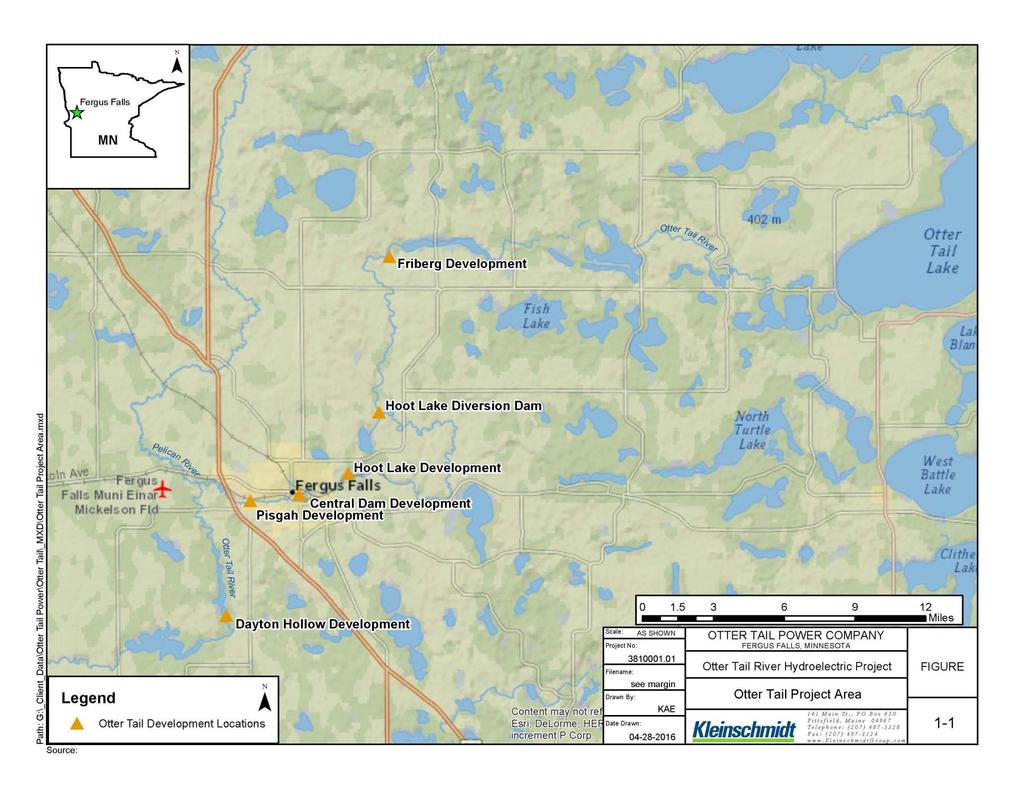
4 BASELINE FISHERIES GOALS / METHODS Goal provide current information about the composition, relative abundance, and size/age structure of fish species in the Otter Tail River Project area. Studies completed by the Midwest Biodiversity Institute Field methods (e.g., sampling locations, access, biosecurity) developed in consultation with MNDNR Standard MNDNR protocols Early Summer Sampling (trap nets, EFISH, gill nets) Central and Pisgah August Near Shore Sampling (seining, EFISH) Central, Pisgah, Friberg Lake, Hoot Lake, Wright Lake, Dayton Hollow August Sampling (Boat EFISH - riverine) Otter Tail River between Friberg dam and Hoot Diversion dam; Hoot Diversion Reach 111 sampling locations (gill nets, trap nets, seining, electrofishing) Minor modifications to protocols based on field conditions (i.e., shallow areas, heavy vegetation) 4
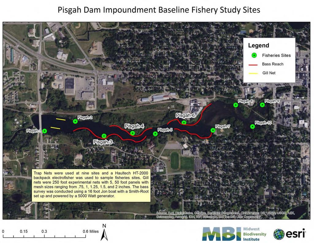
5 BASELINE FISHERIES GOALS / METHODS METHOD Gill Nets Trap Nets GENERAL DESCRIPTION OF GEAR AND SAMPLING PROTOCOLS Experimental; 250-feet-long, 6-feet-deep; five 50-foot panels with varying mesh size (0.75, 1.0, 1.25, 1.5 and 2.0 inches); nets fished overnight at two sites for 1 night 40-foot-long leads/wings approximately 3.5-feet deep; six 30-inch hoops; mesh size 0.75-inch nylon; nets fished overnight in each impoundment at nine sites for 1 night Beach Seines Boat Electrofisher Backpack Electrofisher 5-foot by 50-foot opening with a 0.25-inch nylon mesh bag seine; where vegetation allowed; one to two seine pulls parallel to shore across 100-foot e-fishing site at trap net locations 18-foot Jon boat outfitted with a 5000-Watt generator; 500-meter sites, sampling in direction of upstream to downstream Haultech HT-2000; 100 feet of shoreline was sampled at same location as trap net sets 5
6 WATER BODY SURVEY TYPE NUMBER OF SITES/NETS 2017 SAMPLING TIMEFRAME Central Impoundment Seining (too much vegetation) Shoreline backpack and boat electrofishing 1 site 10 sites August August Trap netting (too shallow for gill nets) 9 trap nets June Boat electrofishing 3 sites June Pisgah Impoundment Shoreline backpack and boat electrofishing 10 sites August Gill and trap netting 2 gill nets; 9 trap nets June Boat electrofishing 4 sites June Friberg Lake Seining (too much vegetation) 1 site August Shoreline backpack and boat electrofishing 10 sites August Hoot Lake Seining 4 sites August Shoreline backpack electrofishing 10 sites August Wright Lake Seining 5 sites August Shoreline backpack electrofishing 10 sites August Dayton Hollow Impoundment Seining Shoreline backpack electrofishing 1 site 10 sites August August Otter Tail River (between Friberg dam and Hoot Diversion dam) Otter Tail River (Hoot Diversion Reach) Boat electrofishing 4 sites August/October Boat electrofishing 4 sites August 6
7 7
8 8
9 CATCH/RESULTS Sampling Location Dayton Hollow Impoundment Pisgah Impoundment Central Impoundment Hoot Lake Wright Lake Friberg Impoundment No. Fish Collected No. Species Collected Dominant Species green sunfish (26%); Johnny darter (16.9%); blackside darter (15.5%); smallmouth bass (11.9%) green sunfish (25.6%); bluegill (10.5%); common shiner (8.8%); smallmouth bass (8.6%) hornyhead chub (14.5%); smallmouth bass (13.7%); common shiner (13.1%); green sunfish (10.9%); rock bass (10.5%) bluegill (39.2%); green sunfish (15.3%); largemouth bass (11.4%) rock bass (21.9%); bluegill (16.4%); Johnny darter (16.4%); green sunfish (14.8%) bluegill (24.7%); largemouth bass (24.7%); weed shiner (20.6%) Friberg (Riverine) smallmouth bass (37.9%); golden redhorse (10.8%) Hoot Diversion Reach (Riverine) common shiner (25.6%); hornyhead chub (21.7%); northern hogsucker (15.1%); smallmouth bass (15.1%) Total Catch 2, smallmouth bass (12.7%); common shiner (11.9%); green sunfish (9.2%); and hornyhead chub (8.4%) 9
10 CATCH/ RESULTS Fish Species Composition 5% or more of total Species Scientific Name Total collected % of Total Smallmouth bass Micropterus dolomieu % Common shiner Luxilus cornutus % Green sunfish Lepomis cyanellus % Hornyhead chub Nocomis biguttatus % Bluegill Lepomis macrochirus % Largemouth bass Micropterus salmoides % Fish Species Composition 1% to 5% or more of total Species Scientific Name Total collected % of Total Golden redhorse Moxostoma erythrurum % Northern hogsucker Hypentelium nigricans % Bluntnose minnow Pimephales notatus % Rock bass Ambloplites rupestris % Johnny darter Etheostoma nigrum % Notropis spp % Weed shiner Notropis texanus % Blackside darter Percina maculata % Nocomis spp % White sucker Catostomus commersonii % Northern pike Esox lucius % Iowa darter Etheostoma exile % 10
11 CATCH/RESULTS IMPOUNDMENT Species YOY Juvenile Adult Total Black crappie Bluegill Bowfin Channel catfish Largemouth bass Northern pike Pumpkinseed Rock bass Smallmouth bass Walleye Yellow perch Total Relative Percent 43.7% 19.8% 36.6% 100.0% Species Weight (pounds) Length (inches) Sample Method Impoundment Common carp Gill Net Pisgah Bowfin Trap Net Pisgah Smallmouth bass Boat Central Northern pike Trap Net Central Walleye Gill Net Pisgah Black crappie Trap Net Central Bluegill Boat Pisgah Rock bass Trap Net Pisgah Pumpkinseed Trap Net Pisgah Channel catfish Trap Net Central Yellow perch Trap Net Pisgah Largemouth bass Boat Pisgah 11
12 BASELINE FISHERIES SUMMARY Fisheries survey completed in accordance with study plan minor adjustments due to vegetation and water depth (too shallow) Otter Tail Project Area provides: Diverse assemblage of game, non-game, and native fish species and habitats Multiple life stages (nursery, rearing, spawning) Littoral shorelines, pelagic habitats, riverine habitats 12

13 BASELINE FISHERIES 13
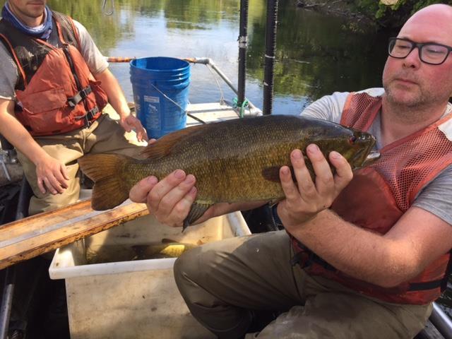
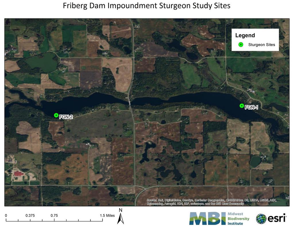
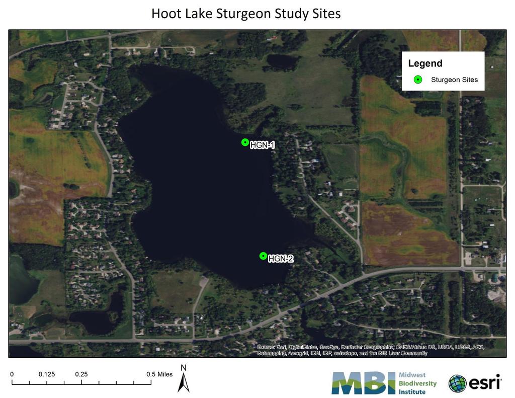
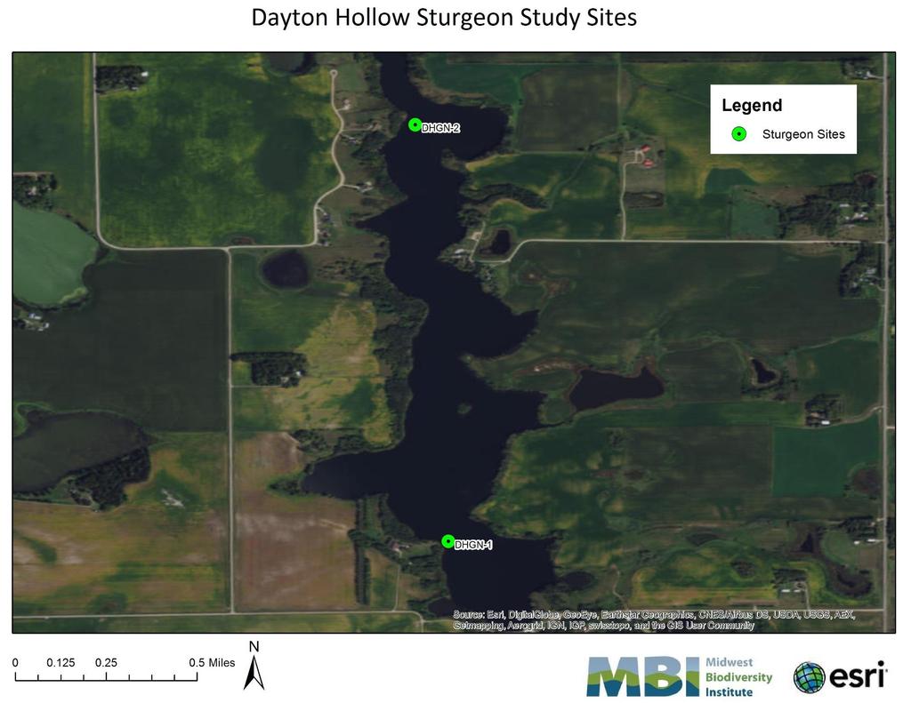
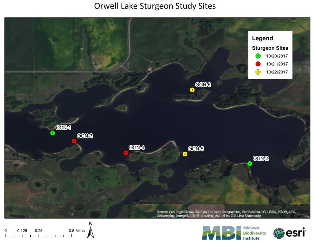
14 FALL LAKE STURGEON GOALS / METHODS Goal obtain information about the distribution, size, and age structure of lake sturgeon in 4 waterbodies: Orwell Lake Dayton Hollow Reservoir Hoot Lake Friberg Lake Field methods (logistics, sample locations) developed in consultation with MNDNR/USFWS prior to survey work Sampling from October 17 October 23 with assistance from USFWS/MNDNR 14
15 FALL LAKE STURGEON METHODS Two 200-foot-long experimental nets set in each waterbody for 3 consecutive nights Net soak times of 15 to 17 hours; checked each morning Biological data: length, weight, girth, presence of tags PIT-tagged with syringe applicator Sampling depth: 10 to 40 feet 15
16 16
17 17
18 18
19 19
20 FALL STURGEON RESULTS Location No. Collected Percent Total Catch Friberg Reservoir % Hoot Lake 17* 50.0% Dayton Hollow Reservoir 8* 26.5% Orwell Lake 0 0.0% Total % * plus 2 recaptured fish at each site Length Class Number Collected Percent Collected < 24 inches 0 0.0% 25 to 36 inches 2 6.1% 37 to 48 inches % > 48 inches % Total % 20
21 FALL STURGEON SUMMARY Fall sampling survey completed in accordance with study plan; no fin samples Spring sampling scheduled for the week of May 7; planning to collect pectoral fin samples 3 of 4 impoundments provide habitat for rearing lake sturgeon 21

22 FALL STURGEON 22
23 FRIBERG INSTREAM FLOW STUDY Study Goal assess the relationship between aquatic habitat, boating activities, and river flow in the reach at existing conditions up to 250 cfs. Friberg Development 1 turbine with capacity of ~245 cfs Study area ~ 2,200-ft of Otter Tail river between dam/powerhouse OTPC opens a gate ~ 3 inches during non-spill conditions (~16 cfs) to maintain aquatic habitats natural hydrology sustains river flow considerably higher than capacity of the turbine, which results in additional water to the reach 23
24 FIELD METHODS (LATE AUGUST 2017) Identification / establish 7 transects with MNDNR (prior to study) Engineering weir/orifice calculations to determine gate settings at dam for 5 releases Gauge river flow at each release and installed temp. staff gauges to verify stable flows Measure depth and velocity (microhabitat data) from the dam at all transects at all releases Classify substrates across each transect; measured wetted channel width Photographed each transect at each flow release Canoed reach at each flow release; qualitative assessment of boat navigability 24

25 FRIBERG INSTREAM FLOW STUDY GOALS / METHODS 25
 Measured Discharge at Transect 2 (cfs) 1 existing 3 inches 16 2 60 10.5 inches 54 3 110 22.")
26 RIVER FLOWS Flow Releases From the Friberg Dam During the 2017 Instream Flow Study Release No. Target Release Gate Opening (weir calcs) Measured Discharge at Transect 2 (cfs) 1 existing 3 inches inches inches inches inches
27 ANALYSIS METHODS Selected representative species/lifestages (12) with MNDNR using habitat guilds, based on fisheries catch, and study plan Species and Lifestages Evaluated for the Friberg Instream Flow Study Species/Lifestage Riffle Raceway/ Run Medium Pool Smallmouth bass (spawning) - - X Golden redhorse (juvenile) - - X Channel catfish (juvenile) - - X Longnose dace (spawning) X - - Smallmouth bass (juvenile) X - - Longnose dace (adult) X - - Golden redhorse (young-of-year) X - - Lake sturgeon (spawning) - X - Northern hogsucker (adult) - X Channel catfish (young-of-year) - X - Creeper (mussel) - X - Threeridge (mussel) - X - 27
28 ANALYSIS METHODS Field data entered into MS Excel; QC data entry Excel-based suitability assessment tool to compare flows/habitat and calculate a habitat suitability index Habitat Suitability Curves (MNDNR 2006); species-specific Poisson or Arctangent formulas that show micro-habitat (depth, velocity, substrate) preference SI =((( DEPTH)/( ))^ ) *2.718^(( / )*(1-( DEPTH)/( ))^ )) (Adult Longnose Dace Depth) Product of 3 suitability values (depth, velocity, and substrate) at each station on transect Summed across each transect at each flow release to calculate a unitless suitability index Graphed against discharge; incremental gain or loss; percent of the highest value observed 28

29 ANALYSIS METHODS HABITAT SUITABILITY CRITERIA 29
30 ANALYSIS METHODS Transect 2 (Raceway / Run Habitat) Station Depth (ft) Depth (cm) Velocity (fps) Velocity (cmps) Depth SI Velocity SI Substrate SI Composite SI Depth SI Velocity SI Substrate SI Composite SI Depth SI Velocity SI 9 Small gravel Small gravel Small gravel Small gravel Large gravel Large gravel Large gravel Large gravel Large gravel Large gravel Small boulder Cobble Cobble Small boulder Large gravel Small gravel Small gravel Small gravel Habitat Data Northern Hogsucker (Adult) Creeper (Mussel) Threeridge (Mussel) Release 2 (54 cfs) Substrate SI Composite SI (*) Total SI 3.99 Total SI 9.47 Total SI 3.13 Release 3 (113 cfs) 30
31 RESULTS Habitat Suitability Index Value Pool Species 31
32 RESULTS Habitat Suitability Index Value Riffle Species 32
33 RESULTS Habitat Suitability Index Value Raceway Species 33
34 Habitat Suitability Index Value for ALL Species 34
35 Release Approx. Flow Boater Rating Portage Required 1BOATER 16 NAVIGABILITY cfs Beginner Yes, shallow reaches with several obstructions 2 54 cfs Beginner- Intermediate Only 1 shallow area to portage cfs Intermediate None required cfs Intermediate None required cfs Did not paddle - too much water advanced or expert only Whitewater Features None Not quite whitewater but very fast runs; must maneuver to stay in deeper water Yes, several fast runs with some whitewater over boulders Fast water over boulders forms small white caps. Impediments to Boating Log jams, obstacles, and metal break wall Able to float over log jams None - able to float whole reach None - able to float whole reach Overall Comment Not navigable by canoe at this release, carried the boat more than floated; may be ok with kayak Fast water throughout, still some shallow areas with boulders Fast water throughout reach, some boulders to maneuver around; fast water results in increased tipping hazards to less experienced boaters Very fast runs, easily floated middle of the reach; fast water results in increased tipping hazards to less experienced boaters Overall Ranking
36 SUMMARY Existing operational protocol (16 cfs) provides suitable habitat for several species and lifestages of freshwater fish and mussels Biggest gains (inflection) in habitat suitability for creeper (mussel), YOY channel catfish, juvenile smallmouth bass, juvenile golden redhorse occur with release of 54 cfs Inflection at 113 cfs for adult longnose dace and spawning lake sturgeon Inflection at 185 cfs for threeridge mussels and northern hogsucker adults Flow releases of 54, 113, 185 provide quality boating; intermediate to advanced 36
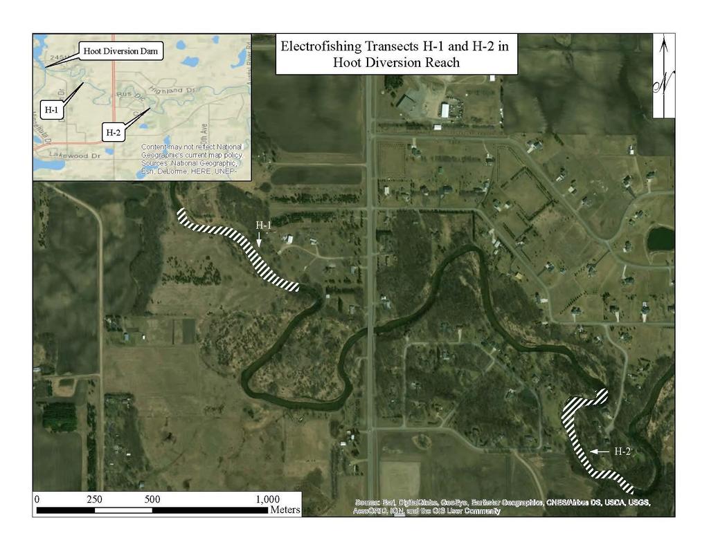
37 HOOT DIVERSION FLOW STUDY Goal assess existing minimum flow requirements; quantify relationship between aquatic habitat, boating, and river flow Hoot Development 1 turbine with capacity of ~300 cfs Study area mile reach of Otter Tail river between diversion dam/powerhouse current flow requirements: 30 cfs (or inflow, whichever is less) from the day after Labor Day through March cfs (or inflow, whichever is less) from April 1 to May cfs (or inflow, whichever is less) from June 1 through Labor Day Methods very similar/identical to Friberg 37

38 HOOT DIVERSION INSTREAM FLOW STUDY GOALS / METHODS 38
39 RIVER FLOWS Flow Releases From the Hoot Diversion Dam During the 2017 Instream Flow Study Release No. Target Release Gate Opening gate open 2.75 inches plus leaks through fishway and gates gates open, fishway flow at full pond plus leaks from dam gates gate open 7.25 inches plus fishway flow and leaks from dam gates gate open inches plus fishway flow and leaks from dam gates gate open 12 inches; 1 gate open 14.5 inches plus fishway flow and leaks from dam gates Measured Discharge at Transect 1 (cfs)
40 ANALYSIS METHODS (SAME AS FRIBERG) Selected representative species/lifestages (8) with MNDNR using habitat guilds, baseline fisheries data, and study plan Species and Lifestages Evaluated for the Hoot Diversion Instream Flow Study Species/Lifestage Riffle Raceway/Run Hornyhead chub (juvenile) X - Smallmouth bass (juvenile) X - Longnose dace (adult) X - Golden redhorse (young of year) X - Walleye (spawning) - X Northern hogsucker (adult) - X Channel catfish (young-of-year) - X Creeper (mussel) - X 40
41 Habitat Suitability Habitat Suitability Index Value Riffle Species Golden Redhorse (YOY) Longnose Dace (Adult) Smallmouth bass (Juvenile) Hornyhead chub (Juvenile) Habitat Suitability Index - Riffle Habitat - Hoot Diversion Reach River Flow Released from Hoot Diversion Dam (cfs) 41
42 Habitat Suitability Index Value Raceway Species 42
43 Habitat Suitability Index Value for ALL Species 43
44 BOATER NAVIGABILITY Releas e Approx. Flow Boater Rating 1 36 cfs Beginner 2 52 cfs Beginner cfs cfs cfs Portage Required? Yes, shallow in areas, 4 portages, upper reach more challenging than lower reach Yes, shallow in areas, 2 portages, upper reach more challenging than lower reach Whitewater features* None None Intermedia te Yes, 1 at artificial rapids None Intermedia te Yes, 1 at artificial rapids None Intermedia te None None Impediments to boating Shallow water at artificial rapids; shallow areas below the diversion dam Shallow water at artificial rapids; shallow areas below the diversion dam Shallow water at artificial rapids; shallow areas below the diversion dam Shallow water at artificial rapids Shallow water at artificial rapids Overall comment Carried the boat more than floated; may be ok with kayak. Lower reach generally navigable with 1 portage; many scrapes and arduous paddling 2.5 Easy to navigate, not excessively fast in upper reach; adequate flow except near artificial rapids in lower reach (portage required) 4.5 Easy to navigate, not excessively fast in upper reach; adequate flow except near artificial rapids in lower reach (portage required) 4.5 Some fast areas in upper reach, easy to navigate, not excessively fast in upper reach; adequate flow except near artificial rapids (portage required); lower reach has some fast water that requires skill 5 Some fast areas in upper reach, easy to navigate, not excessively fast in upper reach; adequate flow except near artificial rapids (portage required); lower reach has some fast water that requires skill 5 Overall ranking* * 44
45 SUMMARY Existing minimum flows (30, 60, 110) provide suitable habitat for several species and lifestages of freshwater fish and mussels Existing flow regime keeps a large percentage of the channel wetted, though in areas, it is shallow, especially during a release of approximately 30 cfs Suitable habitat remained consistent or decreased for young-of-year golden redhorse, young-of-year channel catfish, adult longnose dace at higher flow releases (154 and 221 cfs) Habitat suitability decreased or there was an inflection (i.e., notable decrease in rate of increase of habitat suitability) at 154 and 221 cfs for all of organisms Releases of 52, 109, 154, and 221 provide quality boating; beginner to intermediate Study plan implemented; met objectives; provided quantitative assessment to determine instream flow 45
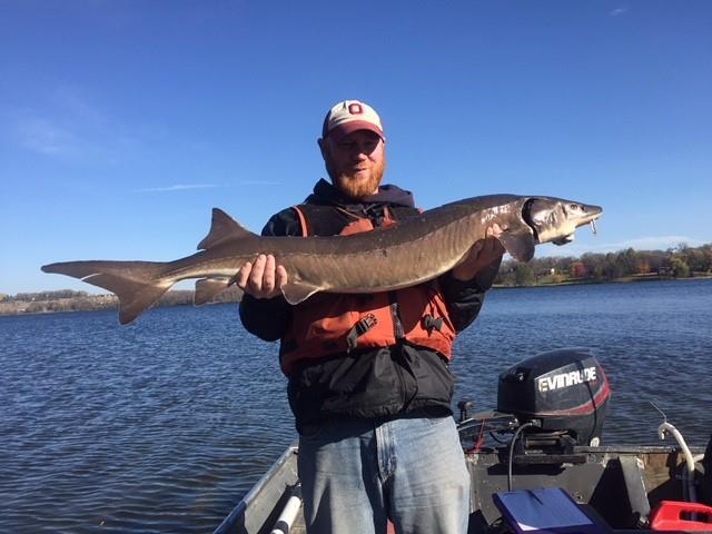
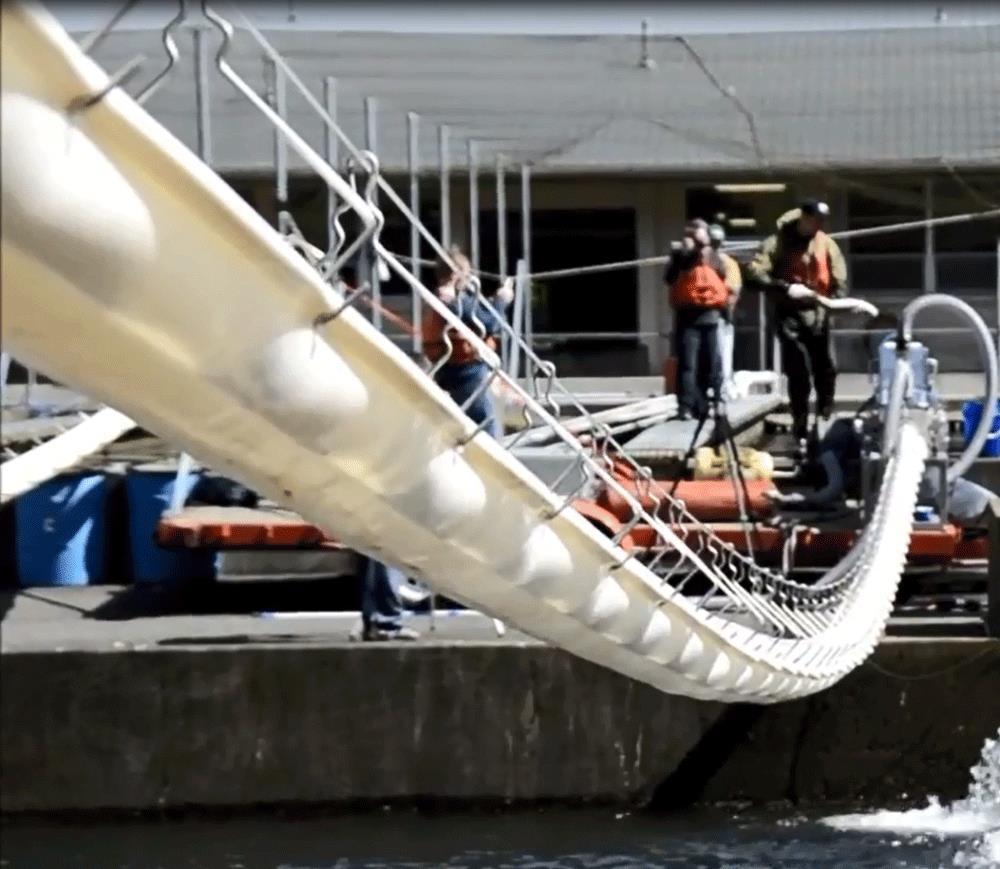
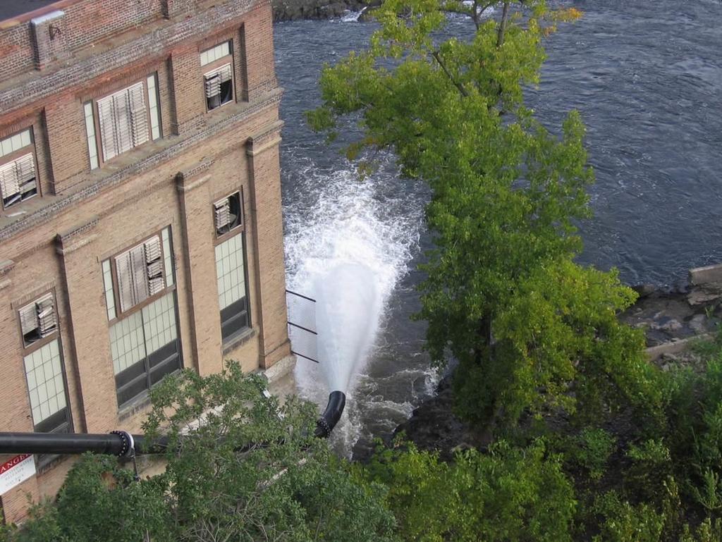
46 FISH PASSAGE FEASIBILITY Study Goal evaluate whether there are cost-effective and practical means to provide fish passage at the Friberg, Hoot, Central, Pisgah, and Dayton Hollow dams Methods Consultation with agencies (tele-conference Nov. 2017) to identify systems for review Review of biological effectiveness with focus on lake sturgeon and initial screening of alternatives Develop conceptual designs of up to two alternatives for upstream and downstream passage Opinion of probable construction cost estimates (order of magnitude; more review recommended) General advantages/disadvantages and operational issues Identification of alternative mitigation techniques 46

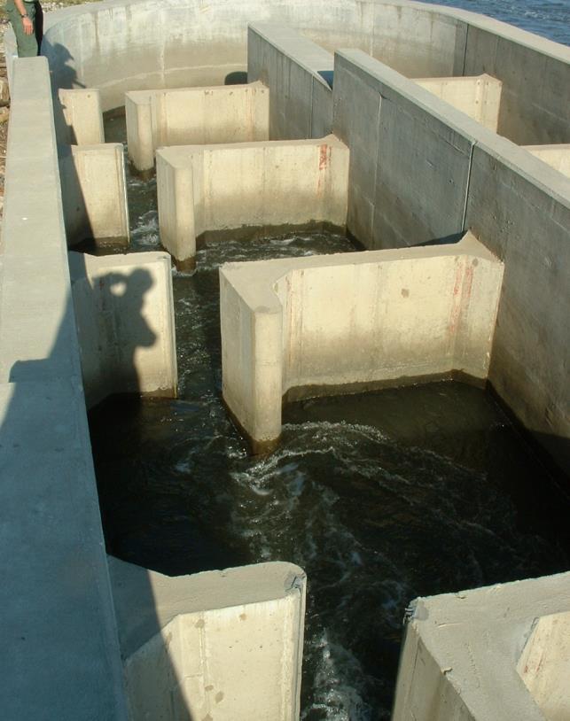
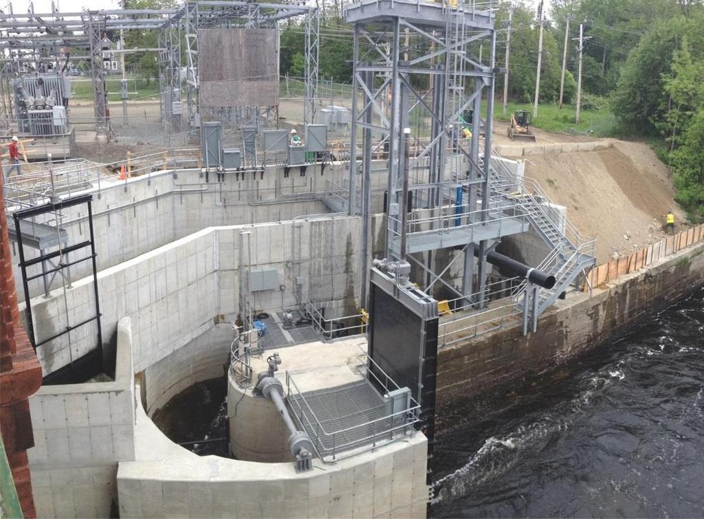
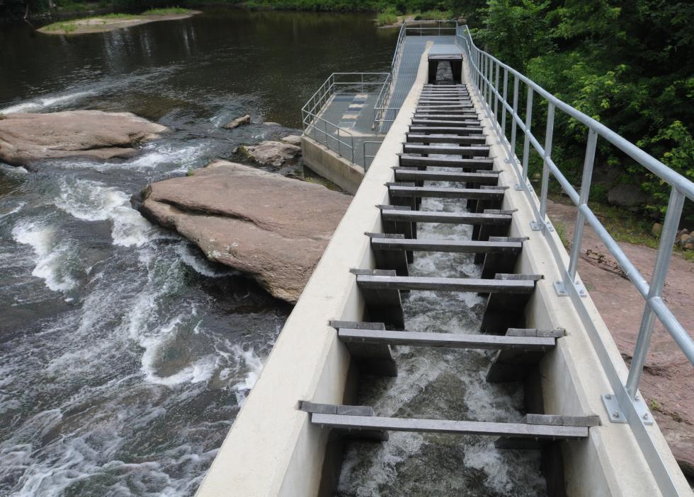
47 TYPICAL FISH WAYS 47

48 48
49 RESULTS BIOLOGICAL Fish passage for sturgeon experimental and challenging due to poor swimming ability and morphology (large body size and high drag) Limited literature Richelieu River (2010) vertical slot; low-head dam (8.5-feet) eighty-eight lake sturgeon (88.2 percent) entered volitionally 32 (36.4 percent) passed USGS Conte Fish Lab (2011) spiral-slot prototype; two 360-degree loops around a 20-foot diameter circle 125-feet-long, 3.3-feet-wide; total rise 6.3 feet 10 adults (90.9 percent) and 16 juvenile (72.2 percent) captive reared lake sturgeon ascended the fishway in a lab setting 49
50 RESULTS BIOLOGICAL Parsley et al. (2007) Pool and weir style on the Columbia River Limited passage of white sturgeon (8 percent; 8 of 90 fish) Fish Lifts (designed for sturgeon) Full depth entrance Applicable for higher heads or where space is limited. Less energy expenditure, which may result in less fall back and better effectiveness Some success on Menominee River and Holyoke Nature-like Fishways Limited information regarding success but gaining popularity Shovelnose sturgeon twice as likely to pass via nature-like then slotted fishways (White and Mefford 2002) Require low-gradient channel (3%) so land/space can be an issue 50 Provides upstream and downstream passage
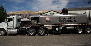
51 RESULTS INITIAL SCREENING Eliminated Whooshh - species-specific and experimental; need tubes for multiple species/lifestages Eliminated Trap and Truck due to handling / labor requirements Eliminated vertical slot fishways, Denil fishways, and Alaskan steeppasses; limited effectiveness at passing lake sturgeon; area constraints Included fish lifts given height of dams, space constraints, and possible improved performance as compared to other measures Included nature-like fishways (upstream and downstream), where practical Included downstream bypass orifices 51
52 RESULTS Site Dayton Hollow Upstream Passage Alternative 1 and Cost Opinion Upstream Passage Alternative 2 and Cost Opinion Downstream Passage Alternative 1 and Cost Opinion Downstream Passage Alternative 2 and Cost Opinion Pisgah Nature-like Fishway - $2M to $3M Fish Lift $5M to $6M Nature-like Fishway N/A Submerged Bypass $1M to $2M Central Nature-like Fishway $1.5M to $2.5M Fish Lift $4M to $5M Nature-like Fishway N/A Submerged Bypass $1M to $2M Friberg Spiral-slot Fishway $3M to $4.5M Fish Lift $3.5M to $4.5M Submerged Bypass $1M to $2M N/A Nature-like Fishway $1.5M to $2.5M Fish Lift $4M to $5M Nature-like Fishway N/A Submerged Bypass $1M to $2M 52
53 SUMMARY Passage for sturgeon experimental and challenging Construction / design costs throughout Otter Tail River Project area range as much as $30 million Substantial additional costs likely for land acquisition; structural modifications; administrative; lost generation Alternatives may include: conservation easements, watershed restoration plans, TMDLs, off site mitigation or stream restoration 53
54 QUESTIONS/COMMENTS 54
BA1 BA2 BA3 BA4 BA5 BA6 CP1 CP2 CP3 CP4 CP5 CP6
 Table 1: Results of fish collections within or adjacent to the Boyne Secondary Plan Area conducted by C. Portt and Associates. Station locations are provided in Figure 1. Stations BA1-BA6 were collected
Fisheries Survey of White Rapids Flowage, Marinette County Wisconsin during Waterbody Identification Code
 Fisheries Survey of White Rapids Flowage, Marinette County Wisconsin during 25 Waterbody Identification Code 6343 Michael Donofrio Fisheries Supervisor Wisconsin Department of Natural Resources Peshtigo,
Fish Survey of Arctic Lake (ID # ), Scott County, Minnesota in 2012
, Scott County, Minnesota in 2012") Snapping Turtle from Arctic Lake, September 2012 Fish Survey of Arctic Lake (ID #70-0085), Scott County, Minnesota in 2012 Survey Dates: September 18-20, 2012 MnDNR Permit Number: 18362 Prepared for: Shakopee
Snapping Turtle from Arctic Lake, September 2012 Fish Survey of Arctic Lake (ID #70-0085), Scott County, Minnesota in 2012 Survey Dates: September 18-20, 2012 MnDNR Permit Number: 18362 Prepared for: Shakopee
Thunder Bay River Assessment Appendix. Appendix 2
 Appendix 2 Known past and present fish distributions in the River system. Distribution of fishes were compiled from Bailey et al. (2003) and from records located at the Michigan Department of Natural Resources
Full Project Proposal
 PROJECT NAME: FIELD OFFICE: Full Project Proposal NFPP Phase I - Ferson-Otter Creek Dam Removal/Modification Project, Fox River Watershed, Illinois Carterville NFWCO PROJECT COORDINATOR: Nate Caswell FONS
Columbia Lake Dam Removal Project
 Columbia Lake Dam Removal Project The Columbia Lake dam located 1/4 mile upstream of the Paulins Kill River's confluence with the Delaware River in Knowlton Township, Warren County has been proposed for
Tittabawassee River Assessment. Miles. Gladwin Smallwood Impoundment. Harrison. Clare. Midland. Mt. Pleasant. St. Louis. Saginaw.
 Warmouth Lepomis gulosus feeding - clear lakes and impoundments and very low-gradient streams - abundant aquatic vegetation - silt-free water - mucky substrate often covered with organic debris spawning
Alcona Dam Pond Alcona County (T25N, R5E, Sections various) Surveyed June 6-12 and September 16, 2003
 Surveyed June 6-12 and September 16, 2003") Michigan Department of Natural Resources Status of the Fishery Resource Report No. 2004-6, Year 2004 Alcona Dam Pond Alcona County (T25N, R5E, Sections various) Surveyed June 6-12 and September 16, 2003
Michigan Department of Natural Resources Status of the Fishery Resource Report No. 2004-6, Year 2004 Alcona Dam Pond Alcona County (T25N, R5E, Sections various) Surveyed June 6-12 and September 16, 2003
Conewago Creek Initiative. Fish Survey Report for the Conewago Creek
 Conewago Creek Initiative Fish Survey Report for the Conewago Creek A compilation of historic fish survey data from 97, 973, 7, for three locations along the Conewago Creek Prepared by Kristen Kyler for
Lake St. Clair Fish Community and Fishery
 Lake St. Clair Fish Community and Fishery Megan Belore Ontario Ministry of Natural Resources and Forestry Mike Thomas Michigan Department of Natural Resources Fish Community Fish Community Mixture of warm
feeding - clear moderate-sized shallow streams with moderate vegetation spawning - nests in gravel, sand, or hard rock substrate
 orthern longear sunfish (Lepomis peltastes) feeding - clear moderate-sized shallow streams with moderate vegetation - rocky substrates - little to no current spawning - nests in gravel, sand, or hard rock
Appendix C Bill Cross Rapids Freshwater Mussel and Fishery Study Plan
 Appendix C Bill Cross Rapids Freshwater Mussel and Fishery Study Plan Study Plan Freshwater Mussel and Fishery Study Bill Cross Rapids Grandfather Falls Hydroelectric Project FERC Project No. 1966 March
SUMMARY REPORT FOR LAKE ST. MALO FISHERIES ASSESSMENT. Prepared for the St. Malo and District Wildlife Association
 SUMMARY REPORT FOR LAKE ST. MALO FISHERIES ASSESSMENT Prepared for the St. Malo and District Wildlife Association Presented by August 25, 2014 Study dates thus far: Date Tasks February 16 Fishing derby;
Caro Impoundment, Tuscola County
 Caro Impoundment is a 200 acre impoundment of the Cass River located one mile south of the Village of Caro in Tuscola County. Caro Dam, originally constructed in 1906 for water supply to Michigan Sugar
Conewago Creek Initiative
 Conewago Creek Initiative The Conewago Creek Revisited Fish Survey Report A compilation of historic fish survey data from 197, 1973, 7, 1, and 15 for three locations along the Conewago Creek Prepared by
Quemahoning Reservoir
 Pennsylvania Fish & Boat Commission Biologist Report Quemahoning Reservoir Somerset County May 2011 Trap Net, Gill Net and Electrofishing Survey Quemahoning Reservoir is an 899 acre impoundment located
Investigating reproduction and abundance of bighead carp (Hypophthalmichthys nobilis) and silver carp (H. molitrix) in the Greenup pool, Ohio River
 and silver carp (H. molitrix) in the Greenup pool, Ohio River") Investigating reproduction and abundance of bighead carp (Hypophthalmichthys nobilis) and silver carp (H. molitrix) in the Greenup pool, Ohio River Nathan Fleshman Dr. Thomas Jones Photo: USGS Photo: USGS
Investigating reproduction and abundance of bighead carp (Hypophthalmichthys nobilis) and silver carp (H. molitrix) in the Greenup pool, Ohio River Nathan Fleshman Dr. Thomas Jones Photo: USGS Photo: USGS
Trip Report: Eagle Creek, Arizona
 Trip Report: Eagle Creek, Arizona 15-17 June 2009 Participants: Abraham Karam, Brian Kesner, and Mike Childs Native Fish Lab Marsh & Associates, LLC 5016 South Ash Avenue Suite 108 Tempe, Arizona 85282
FISHES OF THE KNIFE LAKE WATERSHED IN KANABEC AND MILLE LACS COUNTIES OF MINNESOTA. Konrad Schmidt, Vice-President
 Conservation Biology Research Grants Program Division of Ecological Services Minnesota Department of Natural Resources FISHES OF THE KNIFE LAKE WATERSHED IN KANABEC AND MILLE LACS COUNTIES OF MINNESOTA
Student Worksheet: River Health and Indicator Species
 1 Student Worksheet: River Health and Indicator Species Mink frogs (Lithobates septentrionalis). Credit: Allan G. Austin Activity 1: Biodiversity and Indicator Species Watch the videothe Importance of
2014 Threatened and Endangered Fish Survey of. East Loon Lake and West Loon Lake. Lake County, Illinois
 2014 Threatened and Endangered Fish Survey of East Loon Lake and West Loon Lake Lake County, Illinois Prepared by Integrated Lakes Management 120 LeBaron St. Waukegan, IL 60085. Chris Ryan Chris Rysso
NEVADA DEPARTMENT OF WILDLIFE STATEWIDE FISHERIES MANAGEMENT
 NEVADA DEPARTMENT OF WILDLIFE STATEWIDE FISHERIES MANAGEMENT FEDERAL AID JOB PROGRESS REPORTS F-2-49 213 RYE PATCH RESERVOIR WESTERN REGION NEVADA DEPARTMENT OF WILDLIFE, FISHERIES DIVISION ANNUAL PROGRESS
FISH ASSEMBLAGE ASSESSMENT
 Relicensing Study 3.3.11 FISH ASSEMBLAGE ASSESSMENT Updated Study Report Summary Northfield Mountain Pumped Storage Project No. 2485) and Turners Falls Hydroelectric Project No. 1889) Prepared for: Prepared
MINNESOTA DEPARTMENT OF NATURAL RESOURCES DIVISION OF FISHERIES AND WILDLIFE. Gamefish Assessment Report
 Minnesota DNR F-29-R(P) Area F312 February 1, 2013 MINNESOTA DEPARTMENT OF NATURAL RESOURCES DIVISION OF FISHERIES AND WILDLIFE Gamefish Assessment Report Spring Gamefish Assessment on the Mississippi
Elk Lake, Antrim and Grand Traverse counties T. 28, 29 N., R. 8, 9 W., Sec. many. Lake surveys. began at 40 feet
 Elk Lake, Antrim and Grand Traverse counties T. 28, 29 N., R. 8, 9 W., Sec. many Physical and chemical data surveyed August 1931 Temperature ( F) Secchi disk (feet) 9. 6 Surface 74 Bottom 45 PH 8.0 Thermocline
Tahquamenon River Assessment Appendix
 DNR DEPARTMENT OF NATURAL RESOURCES MICHIGAN STATE OF MICHIGAN DEPARTMENT OF NATURAL RESOURCES SR45 Appendix February 2008 Tahquamenon River Assessment Appendix James R. Waybrant and Troy G. Zorn www.michigan.gov/dnr/
Fish community assessment in the Harpeth River prior to the removal of the dam at Franklin, TN
 Fish community assessment in the Harpeth River prior to the removal of the dam at Franklin, TN Submitted to Dorie Bolze, Harpeth River Watershed Association By Frank Fiss and Nathan Singer, Tennessee Wildlife
Current Status and Management Recommendations for the Fishery in the Cloverleaf Chain of Lakes
 Current Status and Management Recommendations for the Fishery in the Cloverleaf Chain of Lakes Jason Breeggemann Senior Fisheries Biologist Wisconsin Department of Natural Resources Outline DNR fisheries
Cedar Lake Comprehensive Survey Report Steve Hogler and Steve Surendonk WDNR-Mishicot
 Cedar Lake- 2006 Comprehensive Survey Report Steve Hogler and Steve Surendonk WDNR-Mishicot ABSTRACT Cedar Lake is a 142 acre lake located in the southwest corner of Manitowoc County. It is a seepage lake
MARTINDALE POND Wayne County 2004 Fish Management Report. Christopher C. Long Assistant Fisheries Biologist
 MARTINDALE POND Wayne County 2004 Fish Management Report Christopher C. Long Assistant Fisheries Biologist Fisheries Section Indiana Department of Natural Resources Division of Fish and Wildlife I.G.C.
Methods for Evaluating Shallow Water Habitat Restoration in the St. Clair River
 Methods for Evaluating Shallow Water Habitat Restoration in the St. Clair River Objectives Document fish use of restoration sites Spawning Presence of larvae, juvenile, and adult fish Quantify differences
Rouge Fish Surveys
 Rouge Fish Surveys 2011-16 Friends of the Rouge January 2017 Partially funded by the Areas of Concern Program Office of the Great Lakes (OGL), DEQ Additional data provided by MDNR and MDEQ Fall 2016 Sampling
Minnesota Department of Natural Resources Division of Fish and Wildlife Section of Fisheries. Stream Survey Report. Three Mile Creek 2011
 Minnesota Department of Natural Resources Division of Fish and Wildlife Section of Fisheries Stream Survey Report Three Mile Creek 2011 By Joseph D. Stewig Montrose Area Fisheries Office TABLE OF CONTENTS
Preakness Brook - FIBI098
 Preakness Brook - FIBI098 Preakn ess B rook Preakness " ( FIBI098 Naachtpunkt Brook 202 80 IBI Ratings FIBI Sampling Location Excellent Small Streams (1st and 2nd Order) Good Fair Large Streams (3rd Order
FISH COMMUNITIES AND FISHERIES OF THE THOUSAND ISLANDS AND MIDDLE CORRIDOR
 St. Lawrence River Discussion Paper FISH COMMUNITIES AND FISHERIES OF THE THOUSAND ISLANDS AND MIDDLE CORRIDOR Issues Below is a synopsis of fish community issues and proposed management approaches. More
NEVADA DEPARTMENT OF WILDLIFE STATEWIDE FISHERIES MANAGEMENT
 NEVADA DEPARTMENT OF WILDLIFE STATEWIDE FISHERIES MANAGEMENT FEDERAL AID JOB PROGRESS REPORTS F-2-52 216 CHIMNEY RESERVOIR WESTERN REGION NEVADA DEPARTMENT OF WILDLIFE, FISHERIES DIVISION JOB PROGRESS
Michigan Dept. of Natural Resources Status of the Fishery Resource Report Page 1. Weber Lake Cheboygan County, T34N, R3W, Sec.
 Michigan Dept. of Natural Resources 2012-143 Status of the Fishery Resource Report Page 1 Weber Lake Cheboygan County, T34N, R3W, Sec. 31 Neal Godby, Fisheries Biologist Environment Weber Lake is a 28.5-acre
Fisheries Sampling Technical Memorandum
 Appendix C Fisheries Sampling Technical Memorandum 2016 Google MEMORANDUM TO: FROM: Tom Mahood, P.Eng., CH2M Arnie Fausto, M.Sc., and Erica Wilkinson, B.A., ERPG, Matrix Solutions Inc. SUBJECT: Fisheries
Pennsylvania Fish & Boat Commission Biologist Report. Wilmore Dam. Cambria County. May 2011 Trap Net, Electrofishing and Hoop Net Survey
 Pennsylvania Fish & Boat Commission Biologist Report Wilmore Dam Cambria County May 2011 Trap Net, Electrofishing and Hoop Net Survey Wilmore Dam is a 195 acre impoundment located in central Cambria County
Proposed Reclassification of Cherry Creek, North Platte River Basin, Wyoming. October 25, 2010
 Proposed Reclassification of Cherry Creek, North Platte River Basin, Wyoming October 25, 2010 Waterbody: Location: Tributary to: Cherry Creek - Mainstem from headwaters downstream to the confluence with
EVALUATION OF THE FISH COMMUNITY AND GAME FISH POPULATIONS IN SUGAR CREEK (MONTGOMERY AND PARKE COUNTIES)
") EVALUATION OF THE FISH COMMUNITY AND GAME FISH POPULATIONS IN SUGAR CREEK (MONTGOMERY AND PARKE COUNTIES) 2000 Fish Management Report Douglas C. Keller Fisheries Biologist FISHERIES SECTION INDIANA DEPARTMENT
EVALUATION OF THE FISH COMMUNITY AND GAME FISH POPULATIONS IN SUGAR CREEK (MONTGOMERY AND PARKE COUNTIES) 2000 Fish Management Report Douglas C. Keller Fisheries Biologist FISHERIES SECTION INDIANA DEPARTMENT
Crooked Lake Oakland County (T4N, R9E, Sections 3, 4, 9) Surveyed May James T. Francis
 Surveyed May James T. Francis") Michigan Department of Natural Resources Status of the Fishery Resource Report No. 2004-1, 2004 Crooked Lake Oakland County (T4N, R9E, Sections 3, 4, 9) Surveyed May 2002 James T. Francis Environment Crooked
Michigan Department of Natural Resources Status of the Fishery Resource Report No. 2004-1, 2004 Crooked Lake Oakland County (T4N, R9E, Sections 3, 4, 9) Surveyed May 2002 James T. Francis Environment Crooked
MISSISSIPPI MAKEOVER A Plan for Restoration, Just Around the Bend
 MISSISSIPPI MAKEOVER A Plan for Restoration, Just Around the Bend Interim Report Card 2013 Project coordinated by the Dakota County Soil and Water Conservation District and sponsored by the Minnesota Pollution
Fisheries Review with Respect to Stormwater Management for Milton/Navan Road Property
 Fax: 613.935.6295 Mr. Jean-Luc Rivard 3223701 CANADA INC. 98 rue Lois Gatineau, QC J8Y 3R7 July 23, 2014 Re.: Fisheries Review with Respect to Stormwater Management for Milton/Navan Road Property Mr. Rivard:
An Assessment of the Fish Community in Lake Acworth
 An Assessment of the Fish Community in Lake Acworth By John Damer Fisheries Biologist Georgia Department of Natural Resources Wildlife Resources Division Fisheries Section Calhoun, GA 30701 July 2008 Introduction
I Region I Area I DOW Number / County I DOW Lake Name I Acreage I
 LAKE MANAGEMENT PLAN 814 Bp I Region I Area I DOW Number / County I DOW Lake Name I Acreage I I I # I f 2 Duluth F213 690036 St Louis Salo DOW:149 Plan: 137 Long Range Goal: Manage for walleye with a gillnet
Evaluation of Newbury Weirs (Rock Riffles) for Improving Habitat Quality and Biotic Diversity in Illinois Streams.
 for Improving Habitat Quality and Biotic Diversity in Illinois Streams.") Evaluation of Newbury Weirs (Rock Riffles) for Improving Habitat Quality and Biotic Diversity in Illinois Streams. Report submitted to The Wildlife Preservation Fund Illinois Department of Natural Resources
Evaluation of Newbury Weirs (Rock Riffles) for Improving Habitat Quality and Biotic Diversity in Illinois Streams. Report submitted to The Wildlife Preservation Fund Illinois Department of Natural Resources
American Currents Spring 1993 Vol 19 No 1
 -22- PUTTING BACK THE PIECES by Konrad Schmidt, St. Paul, Minnesota The Knife River meanders some 25 miles through small farms and woodlands in east central Minnesota before joining the Snake River near
Applying Engineering Solutions to the Science of Protection and Enhancement of Aquatic Environments. Bill Holman, P.E. Stanley Consultants
 Applying Engineering Solutions to the Science of Protection and Enhancement of Aquatic Environments Bill Holman, P.E. Stanley Consultants Project Development PHASE STAGE TASKS PURPOSE I II III Investigation
Job 1 Part JOB 1, PART 2: SUMMARY OF CONOWINGO DAM WEST FISH LIFT OPERATIONS, 2009
 2.0 JOB 1, PART 2: SUMMARY OF CONOWINGO DAM WEST FISH LIFT OPERATIONS, 2009 Lawrence M. Miller Normandeau Associates U. S. Fish and Wildlife Service 1921 River Road Harrisburg, Pennsylvania Drumore, Pennsylvania
Annex B SUPPLEMENTAL INFORMATION. Table of Contents. Scientific Names of Select Plants and Animals. Fish species collected in Curwensville Lake
 Annex B SUPPLEMENTAL INFORMATION Table of Contents Scientific Names of Select Plants and Animals Fish species collected in Curwensville Lake Alternative Plans Percentage of Future Years with Drawdowns
Fish Assemblages and Stream Conditions in the Kishwaukee River Basin: Spatial and Temporal Trends,
 Fish Assemblages and Stream Conditions in the Kishwaukee River Basin: Spatial and Temporal Trends, 2001 2011 Karen D. Rivera April 2012 Introduction The Kishwaukee River Basin covers an area of approximately
I L L I N 0 PRODUCTION NOTE. University of Illinois at Urbana-Champaign Library Large-scale Digitization Project, 2007.
 I L L I N S UNIVERSITY OF ILLINOIS AT URBA-CHAMPAIGN PRODUCTION NOTE University of Illinois at Urbana-Champaign Library Large-scale Digitization Project, 7. Uf'HS cft, Natural History Survey Library Illinois
SUMMARY OF CONOWINGO DAM WEST FISH LIFT OPERATIONS 2012
 SUMMARY OF CONOWINGO DAM WEST FISH LIFT OPERATIONS 2012 Michael L. Hendricks Pennsylvania Fish and Boat Commission 1735 Shiloh Rd. State College, Pa 16801 INTRODUCTION The shore-based trapping device at
2014 Island Lake Survey June 13 th, 2014 Andrew Plauck District Fisheries Biologist Report Prepared 4 March 2015
 2014 Island Lake Survey June 13 th, 2014 Andrew Plauck District Fisheries Biologist Report Prepared 4 March 2015 BACKGROUND - A fish survey was requested due to a moderately severe winterkill in Island
Proposed Changes to Bag and Size Limits Minnesota/Wisconsin Border Waters of the Mississippi River
 Proposed Changes to Bag and Size Limits Minnesota/Wisconsin Border Waters of the Mississippi River The Minnesota and Wisconsin DNRs are jointly reviewing fishing regulations on Pools 3-9 of the Mississippi
COLUMBIA LAKE DAM REMOVAL PROJECT
 COLUMBIA LAKE DAM REMOVAL PROJECT Major Goals of the Columbia Lake Dam Removal: Reconnect 10 miles of the Paulins Kill River to the Delaware River, restoring natural flow regime and sediment transport.
APPENDIX 3. Distribution Maps of Fish Species
 APPENDIX 3 Distribution Maps of Fish Species This appendix contains maps of known past and present fish distributions within the Manistique River watershed. The distributions of fish species were compiled
REEL FACTS. Regulations. Limblines Fishing with limblines and set hooks is prohibited at Lake Washington.
 Lake Washington 19 REEL FACTS Nathan Aycock Fisheries Biologist NathanA@mdwfp.state.ms.us (61) 432-2 General Information: Lake Washington is a 3, acre oxbow lake of the Mississippi River. It is one of
Bode Lake - South Population Survey
 Bode Lake - South Survey Located in Hoffman Estates on the north side of Bode Rd. 1 mile west of Barrington Rd. Bode Lake is made up of two lakes along Poplar Creek; the larger and deeper Bode Lake South
Pickwick Lake 2018 REEL FACTS Trevor Knight Fisheries Biologist (662)
") Pickwick Lake 218 REEL FACTS Trevor Knight Fisheries Biologist trevork@mdwfp.state.ms.us (662) 84-5176 General Information: Covering 43,1 acres, Pickwick Lake, which borders Alabama, Tennessee, and Mississippi,
Pickwick Lake 218 REEL FACTS Trevor Knight Fisheries Biologist trevork@mdwfp.state.ms.us (662) 84-5176 General Information: Covering 43,1 acres, Pickwick Lake, which borders Alabama, Tennessee, and Mississippi,
2010 Fishing Opener Prognosis. Central Region
 2010 Fishing Opener Prognosis Central Region Hinckley PINE COUNTY Pokegama, Cross, Island, Oak and North and South Big Pine Lakes are typically the best lakes for targeting walleye in Pine County. They
Big Spring Creek Habitat Enhancement and Fishery Management Plans
 Big Spring Creek Habitat Enhancement and Fishery Management Plans November 5, 2012 Big Spring Events and Activities Center Newville, PA Charlie McGarrell Regional Habitat Biologist Pennsylvania Fish and
Columbia Lake Dam Removal Project
 Columbia Lake Dam Removal Project Major Goals of the Columbia Lake Dam Removal: Reconnect 10 miles of the Paulins Kill River to the Delaware River, restoring natural flow regime and sediment transport.
MIDDLE FORK RESERVOIR Wayne County 2004 Fish Management Report. Christopher C. Long Assistant Fisheries Biologist
 MIDDLE FORK RESERVOIR Wayne County 2004 Fish Management Report Christopher C. Long Assistant Fisheries Biologist FISHERIES SECTION INDIANA DEPARTMENT OF NATURAL RESOURCES DIVISION OF FISH AND WILDLIFE
Largemouth Bass. Max 30 inches Average 4-12 inches EATS
 Largemouth Bass Max 30 inches Average 4-12 inches EATS Largemouth Bass may only be consumed if they are bigger than 12 to preserve the supply of Largemouth Bass in this pond. Please catch and release if
Onondaga Lake Fishery: 2011 Fact Sheet
 October, 2011 Onondaga County Department of Water Environment Protection SUNY College of Environmental Science and Forestry Joanne M. Mahoney, County Executive Tom Rhoads, P.E., Commissioner Onondaga Lake
Black crappie (Pomoxis nigromaculatus)
") Black crappie (Pomoxis nigromaculatus) feeding - larger clear non-silty low-gradient rivers; also in lakes and impoundments - clean hard sand or muck substrate - associated with submerged aquatic vegetation
Black crappie (Pomoxis nigromaculatus) feeding - larger clear non-silty low-gradient rivers; also in lakes and impoundments - clean hard sand or muck substrate - associated with submerged aquatic vegetation
LAKE SURVEY REPORT DRAFT VERSION PRELIMINARY DATA (AS OF 08/24/2018) Fisheries Management. DOW Number: Survey ID Date: 08/21/2018
 Fisheries Management. DOW Number: Survey ID Date: 08/21/2018") Fisheries Management DRAFT VERSION PRELIMINARY DATA (AS OF 8//8) Lake Name: Sisseton Survey Type: Standard Survey DOW Number: 6-- Survey ID Date: 8//8 Lake Identification Alternate Lake Name: Primary Lake
Fisheries Management DRAFT VERSION PRELIMINARY DATA (AS OF 8//8) Lake Name: Sisseton Survey Type: Standard Survey DOW Number: 6-- Survey ID Date: 8//8 Lake Identification Alternate Lake Name: Primary Lake
LAKE DIANE Hillsdale County (T8-9S, R3W, Sections 34, 3, 4) Surveyed May Jeffrey J. Braunscheidel
 Surveyed May Jeffrey J. Braunscheidel") Michigan Department of Natural Resources Status of the Fishery Resource Report No. 2003-4, 2003 LAKE DIANE Hillsdale County (T8-9S, R3W, Sections 34, 3, 4) Surveyed May 2001 Jeffrey J. Braunscheidel Environment
Michigan Department of Natural Resources Status of the Fishery Resource Report No. 2003-4, 2003 LAKE DIANE Hillsdale County (T8-9S, R3W, Sections 34, 3, 4) Surveyed May 2001 Jeffrey J. Braunscheidel Environment
(/ North Branch Raritan River - FIBI031 % FIBI031
 North Branch Raritan River - FIBI031 Drainage Area of FIBI031: 172.7 Square Miles Surface Water Quality Classification of FIBI031: FW2-NT.-,7 8.-,287 (/ 20 2 North Branch Raritan Chambers Brook (/ 2 2
The relationship between the spatial distribution of common carp and their environmental DNA in a small lake
 The relationship between the spatial distribution of common carp and their environmental DNA in a small lake Jessica Eichmiller*, Przemyslaw Bajer, and Peter Sorensen Department of Fisheries, Wildlife,
Little Calumet River Rapid Response Fish Identification and Enumeration Branch Summary Report
 Little Calumet River Rapid Response Fish Identification and Enumeration Branch Summary Report Introduction A rotenone rapid response was completed on a 2.6-mile section of the Little Calumet River immediately
Success and Potential Impacts of Rock Ramp Fish Passages in the Saginaw Bay Watershed
 Success and Potential Impacts of Rock Ramp Fish Passages in the Saginaw Bay Watershed Tracy Galarowicz, Ph.D. Department of Biology Institute of Great Lakes Research Central Michigan University Central
Minnesota Department of Natural Resources
 Minnesota Department of Natural Resources Fisheries Management Lake Name: Colby Survey Type: Population Assessment DOW Number: 699 Survey ID Date: 7// Lake Identification Alternate Lake Name: Partridge
LAKE MANAGEMENT PLAN
 LAKE MANAGEMENT PLAN Region Area DOW Number County DOW Lake Name Acreage 2 Duluth F213 69-0041 St. Louis Bassett DOW: 436 Plan: 442 Long Range Goal: Manage for walleye with a gillnet catch rate greater
Minnesota Department of Natural Resources Division of Fish and Wildlife Section of Fisheries. Stream Survey Report. St. Francis River 2004
 Minnesota F-29-R(P)-17 Area 315 Study 3 April 2005 Minnesota Department of Natural Resources Division of Fish and Wildlife Section of Fisheries Stream Survey Report St. Francis River 2004 By Eric R. Altena
SUMMARY OF RESULTS FIBI098
 SUMMARY OF RESULTS FIBI098 1. Stream Name: Preakness Brook 2. Sampling Date: 7/9/2009 3. Sampling Location: Preakness Avenue 4. Municipality Totowa 5. County: Passaic 6. Watershed Management Area: 4 7.
Schiller Pond Population Survey
 Located in the town of Schiller Park on Irving Park Rd. just west of Cumberland Ave. This small 6 acre pond has a maximum depth of 6.3 feet. In addition to largemouth bass and bluegill, Schiller Pond is
(/ Neshanic River - FIBI023 "! 3 1. ø ø 52 3 ø 57 9 FIBI023
 Neshanic River - FIBI023 Drainage Area of FIBI023: 23.1 Square Miles Surface Water Quality Classification of FIBI023: FW2-NT ø 52 3 ø 57 9 Neshanic River (/ 20 2 FIBI023 % #S Neshanic River Back Brook
MIDDLE FORK RESERVOIR Wayne County 2006 Fish Management Report. Christopher C. Long Assistant Fisheries Biologist
 MIDDLE FORK RESERVOIR Wayne County 2006 Fish Management Report Christopher C. Long Assistant Fisheries Biologist Fisheries Section Indiana Department of Natural Resources Division of Fish and Wildlife
NEVADA DEPARTMENT OF WILDLIFE STATEWIDE FISHERIES MANAGEMENT
 NEVADA DEPARTMENT OF WILDLIFE STATEWIDE FISHERIES MANAGEMENT FEDERAL AID JOB PROGRESS REPORTS F-20-52 2016 RYE PATCH RESERVOIR WESTERN REGION NEVADA DEPARTMENT OF WILDLIFE, FISHERIES DIVISION ANNUAL PROGRESS
Study Update Tailrace Slough Use by Anadromous Salmonids
 Study Update Tailrace Slough Use by Anadromous Salmonids Goals and Objectives Identify what anadromous salmonids use the tailrace slough by: Life Stage (Juvenile, migrating and spawning adults) Timing
Fish Survey of Goose Lake (ID # ), Ramsey County, Minnesota in 2012
, Ramsey County, Minnesota in 2012") Softshell Turtle from Goose Lake, July 2012 Fish Survey of Goose Lake (ID #62-0034), Ramsey County, Minnesota in 2012 Survey Dates: July 16-18, 2012 MnDNR Permit Number: 18362 Prepared for: VLAWMO and
Softshell Turtle from Goose Lake, July 2012 Fish Survey of Goose Lake (ID #62-0034), Ramsey County, Minnesota in 2012 Survey Dates: July 16-18, 2012 MnDNR Permit Number: 18362 Prepared for: VLAWMO and
EXECUTIVE SUMMARY FISH COMMUNITY AND HABITAT EXISTING CONDITIONS REPORT
 EXECUTIVE SUMMARY FISH COMMUNITY AND HABITAT EXISTING CONDITIONS REPORT First Mining Gold (First Mining) has completed a comprehensive Fish Community and Habitat Existing Conditions Report which has utilized
Comprehensive Fisheries Survey of High Falls Reservoir, Marinette County Wisconsin during 2004 and Waterbody Identification Code
 Comprehensive Fisheries of High Falls Reservoir, Marinette County Wisconsin during 2004 and 2005 Waterbody Identification Code 540600 Justine Hasz Senior Fisheries Biologist Wisconsin Department of Natural
Report prepared for: Prepared by: January 2002 BEAK Ref
 AQUATIC ENVIRONMENTAL STUDY KANATA WEST CONCEPT PLAN Report prepared for: ROBINSON CONSULTANTS Prepared by: BEAK INTERNATIONAL INCORPORATED 14 Abacus Road Brampton, Ontario L6T 5B7 January 2002 BEAK Ref.
Survival of razorback sucker stocked into the lower Colorado River
 Survival of razorback sucker stocked into the lower Colorado River Trip Report 2-6: Palo Verde and Cibola Divisions 9-13 and 23-27 October 2006 Prepared by Brian R. Kesner and Joshua R. Campbell Submitted
Flint River Assessment Appendix
 14 Appendix 3 Distribution Maps of Fish Species This appendix contains maps of past and known present fish distributions within the River watershed. The distributions of fish species were compiled from
Rolling Knolls Pond Population Survey
 Located near the town of Elgin on the west side of Rohrssen Rd. between Illinois Route 58 and U.S.- 20. This small 1.8 acre pond has a maximum depth of 7.5 feet and is occasionally influenced by Poplar
Herring Highway A Study of a New Fish Passage for River Herring at Rock Creek National Park
 Bridging the Watershed An Outreach Program of the Alice Ferguson Foundation in Partnership with the National Park Service and Area Schools Herring Highway A Study of a New Fish Passage for River Herring
Busse Reservoir South Lateral Pool Population Survey
 Busse Reservoir South Lateral Pool Survey Located in Elk Grove Village south of Higgins Rd. between RT 53/I-290 and Arlington Heights Rd. Busse Reservoir is comprised of three pools making up a total of
Arizona Game and Fish Department Region VI Fisheries Program
 Arizona Game and Fish Department Region VI Fisheries Program Saguaro Lake Fish Survey Report April 18 th 21 st, 2016 Author: Bryant Dickens Report Date: July 7, 2016 The Arizona Game and Fish Department
Fish Survey of Parkers Lake (ID # ), City of Plymouth, Hennepin County, Minnesota in 2013
, City of Plymouth, Hennepin County, Minnesota in 2013") Northern Pike from Parkers Lake, July, 2013 Fish Survey of Parkers Lake (ID #270107), City of Plymouth, Hennepin County, Minnesota in 2013 Survey Dates: July 2324, 2013 MnDNR Permit Number: 19241 Prepared
Northern Pike from Parkers Lake, July, 2013 Fish Survey of Parkers Lake (ID #270107), City of Plymouth, Hennepin County, Minnesota in 2013 Survey Dates: July 2324, 2013 MnDNR Permit Number: 19241 Prepared
Crawford Reservoir. FISH SURVEY AND MANAGEMENT INFORMATION Eric Gardunio, Fish Biologist Montrose Service Center
 FISH SURVEY AND MANAGEMENT INFORMATION General Information: Crawford Reservoir is a popular fishery that provides angling opportunity for yellow perch, channel catfish, northern pike, rainbow trout, black
Minnesota Department of Natural Resources Division of Fish and Wildlife Section of Fisheries. Stream Survey Report. Cold Spring Creek.
 Minnesota F-29-R(P)-24 Area 315 Study 3 March 2015 Minnesota Department of Natural Resources Division of Fish and Wildlife Section of Fisheries Stream Survey Report Cold Spring Creek 2014 Mark Pelham Montrose
Great Lakes Coastal Wetland Communities: Vulnerabilities to Climate Change and Response to Adaptation Strategies
 Great Lakes Coastal Wetland Communities: Vulnerabilities to Climate Change and Response to Adaptation Strategies CCAF Wetlands Study Investigators: Susan Doka Fisheries & Oceans, Great Lakes Lab for Fisheries
Fisheries Survey of Saratoga Lake
 Fisheries Survey of Saratoga Lake 7- Mark D. Cornwell Kevin Poole State University of New York College of Agriculture & Technology Department of Fisheries & Wildlife Cobleskill, NY ABSTRACT: This survey
Beaver Brook - FIBI047 Hope
 Beaver Brook - FIBI047.-,80 Silve r Lake Mud dy Br ook % Hope Honey Run Beaver Brook FIBI047 #S #S FIBI Sampling Location Small Streams (1st and 2nd Order) Large Streams (3rd Order and Above) N 0 1 2 3
HUBBARD LAKE Alcona County (T27N, R7E; T28N, R7E) Surveyed May and September Tim A. Cwalinski
 Surveyed May and September Tim A. Cwalinski") Michigan Department of Natural Resources Status of the Fishery Resource Report No. 2003-1, 2003 HUBBARD LAKE Alcona County (T27N, R7E; T28N, R7E) Surveyed May and September 1996 Tim A. Cwalinski Environment
Michigan Department of Natural Resources Status of the Fishery Resource Report No. 2003-1, 2003 HUBBARD LAKE Alcona County (T27N, R7E; T28N, R7E) Surveyed May and September 1996 Tim A. Cwalinski Environment