Herring Highway A Study of a New Fish Passage for River Herring at Rock Creek National Park
|
|
|
- Julie Fox
- 5 years ago
- Views:
Transcription


1 Bridging the Watershed An Outreach Program of the Alice Ferguson Foundation in Partnership with the National Park Service and Area Schools Herring Highway A Study of a New Fish Passage for River Herring at Rock Creek National Park Student Field Study Guide Name Date
 Air Temperature Weather Data Celsius 0% 25% 50% 75% 100%")
2 Group Members Date School BTW Educator(s) Teacher(s) Ranger(s) Volunteer(s) Herring Highway Field Data General Information Site Peirce Mill Dam - Picnic Grove 1 (check one) Milkhouse Ford - Picnic Grove 6 Latitude N Longitude W Water Temperature Dissolved Oxygen ph Water Quality Data Celsius milligram/liter Cloud Cover (circle symbol) Air Temperature Weather Data Celsius 0% 25% 50% 75% 100% Clear Partially Cloudy Overcast Current Precipitation (Circle one of the choices to the right) None Mist Rain Thunderstorm Snow Monthly Precipitation Total centimeters Stream Bottom Substrate (Circle one of the choices below) Habitat Assessment Stream Habitat Type (Circle one of the choices below) Stream Channel Width Water Depth Stream Speed Stream Flow (10 x Ave Depth x Channel Width Ave Speed) Trial 1 Trial 2 Trial 3 Average Trial 1 Trial 2 Trial 3 Average meters meters meters meters meters seconds seconds seconds seconds meters³/second 2
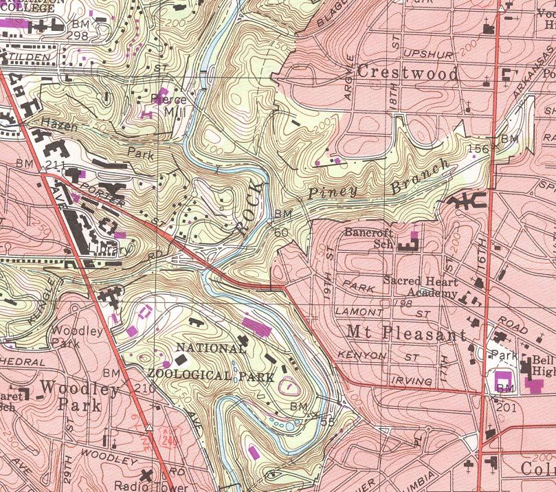
3 Sketch of Site Sketch and label your site from overhead. Show the creek, runs/pools/riffles, blockages, fish ladder, buildings, road, trails, vegetation (trees, shrubs, etc.). Indicate sampling site for fish collection/water quality study/measurement of width, depth, speed. Draw an arrow indicating north. This sketch is an important aspect of the scientific documentation of your field study. It is not a measure of artistic ability. 3

4 4
5 Fish Sampling Data Common Name Scientific Name Migratory Pattern Sea Lamprey American Eel Yellow Bullhead White Sucker Tessellated Darter Gizzard Shad Blueback Herring Alewife Bluntnose Minnow Spotfin Shiner Swallowtail Shiner Fallfish Blacknose Dace Longnose Dace Bluegill Sunfish Pumpkinseed Sunfish Satinfin Shiner Petromyzon marnius Anguilla rostrata Ameriurus natalis Catostomus commersoni Etheostoma olmstedi Dorosoma cepedianum Alosa aestivalis Alosa pseudoharengus Pimephales notatus Cyprinella spiloptera Notropis procne Semotilus corporalis Rhinichthys atratulus Rhinichthys cataractae Lepomis macrochirus Lepomis gibbosus Cyprinella analostana Catadromous Anadromous Anadromous Anadromous Number Collected Other Other Fish Characteristics Key to Identification 5

 E D No black")
 Pumpkinseed Sunfish")
6 Fish Identification Key Begin Description With A Body long and snake-like, pelvic fins absent A Body not long and snake-like, pelvic fins present B Jawless, mouth in center of round disk, 7 pairs of gill openings, no pectoral fins Go To B C B Jaws present, one pair of gill openings, pectoral fins present Sea Lamprey American Eel C Pelvic fins thoracic D C Pelvic fins abdominal F D Black flap on gill cover (operculum) E D No black flap on gill cover (operculum) E Orange or red spot on rear of black flap on the gill cover (operculum) Tessellated Darter E No orange or red spot on black flap of gill cover (operculum) Pumpkinseed Sunfish Bluegill Sunfish 6


7 Begin With F Description Adipose fin present, chin barbels present Go To Yellow Bullhead F Adipose fin not present G G Lateral line absent H G Lateral line present J H Upper jaw overhangs lower jaw, black spot behind gills as big as eyes H Lower jaw protrudes past upper, black spot behind gills is small I Dark blue back without significant hump, saw teeth on belly smaller and not obvious Gizzard Shad I I Greyish-green hump, saw teeth large and obvious Blueback Herring Alewife J Black spot on dorsal fin K J No black spot on dorsal fin L K Blunt snout, dorsal fin with black spot located in first few rays, lateral line ends in black spot K Snout not blunt, dorsal fin with black spot located in last few rays, lateral line does not end in black spot Bluntnose Minnow Spotfin Shiner 7


8 Begin With Description Go To L Lateral line shaded and dark M L Lateral line slightly dark or indistinct N M Scales distinctly diamond shaped, lateral line dark, but not heavily so M Scales not distinctly diamond shaped, lateral line dark and heavy Swallowtail Shiner N Upper jaw severely overhanging lower jaw N Upper jaw and lower jaws relatively even O Large sucker-like lips, very blunt snout, fish typically larger than 10cm Blacknose Dace O P O No sucker-like lips, snout not as blunt, fish not larger than 10cm White Sucker P Fins appear white and frosted at the tips, fish typically no larger than 10cm Longnose Dace P Tips of fins without frosted appearance, fish often larger than 10cm Satinfin Shiner Fallfish 8
9 Alewife Spawns late February to April Blueback Herring Spawns March to early May Chemical and Habitat Tolerances for Migrating and Spawning of Alewife and Blueback Herring Migrating Spawning Alewife Blueback Herring Alewife Blueback Herring DO > 5 mg/l DO > 5 mg/l Chemical ph ph Chemical H 2 O Temp > 5 C > 7 C H 2 O Temp C C Substrate Any Substrate Sand, Gravel or Silty Rocky Habitat Habitat Type Any Type Pool Riffle or Run Flow Any Flow < 0.5 m³/s m³/s
10 Herring Highway Data Analysis Using the data collected during your field study, answer the following questions for both fish. 1. Is it currently spawning season for either of these fish? Elaborate. 2. Summarize your findings of chemical and habitat tolerances for both fish. If it is spawning season for either or both fish, use your findings to explain the absence or presence of these anadromous fish.
SUMMARY OF RESULTS FIBI054
 SUMMARY OF RESULTS FIBI054 1. Stream Name: Lamington River 2. Sampling Date: 7/10/2007 3. Sampling Location: McCann Mill Road 4. Municipality Tewksbury Township 5. County: Hunterdon 6. Watershed Management
(/ Neshanic River - FIBI023 "! 3 1. ø ø 52 3 ø 57 9 FIBI023
 Neshanic River - FIBI023 Drainage Area of FIBI023: 23.1 Square Miles Surface Water Quality Classification of FIBI023: FW2-NT ø 52 3 ø 57 9 Neshanic River (/ 20 2 FIBI023 % #S Neshanic River Back Brook
Pohatcong Creek - FIBI033
 DELAWARE RIVER Pohatcong Creek - FIBI033 Drainage Area of FIBI033: 9.8 Square Miles Surface Water Quality Classification of FIBI033: FW2-TM Washington #S "! 3 1 % P ohatcong Creek FIBI033 "! 57 Merri l
Conewago Creek Initiative. Fish Survey Report for the Conewago Creek
 Conewago Creek Initiative Fish Survey Report for the Conewago Creek A compilation of historic fish survey data from 97, 973, 7, for three locations along the Conewago Creek Prepared by Kristen Kyler for
Conewago Creek Initiative
 Conewago Creek Initiative The Conewago Creek Revisited Fish Survey Report A compilation of historic fish survey data from 197, 1973, 7, 1, and 15 for three locations along the Conewago Creek Prepared by
[ Excellent [ Fair. Millbrook FIBI039. Calno. Upper Delaware WMA 1. Pahaquarry. Stream Order 1st, 2nd & 3rd Order. FIBI Rating.
 @ Millbrook [ @ FIBI039 Calno Upper Delaware WMA 1 @ Pahaquarry FIBI Rating [ Excellent [ Fair [ Good [ Poor Stream Order 1st, 2nd & 3rd Order 4th Order & Higher É 0 2 4 Miles SUMMARY OF RESULTS FIBI039
Tips for Identifying Common Fish Species in the Bush River
 Tips for Identifying Common Fish Species in the Bush River The Herrings (Family Clupeidae) Alewife (Alosa psuedoharengus) American shad (Alosa sapidissima) Blueback herring (Alosa aestivalis) Atlantic
Preakness Brook - FIBI098
 Preakness Brook - FIBI098 Preakn ess B rook Preakness " ( FIBI098 Naachtpunkt Brook 202 80 IBI Ratings FIBI Sampling Location Excellent Small Streams (1st and 2nd Order) Good Fair Large Streams (3rd Order
(/ North Branch Raritan River - FIBI031 % FIBI031
 North Branch Raritan River - FIBI031 Drainage Area of FIBI031: 172.7 Square Miles Surface Water Quality Classification of FIBI031: FW2-NT.-,7 8.-,287 (/ 20 2 North Branch Raritan Chambers Brook (/ 2 2
Tips for Identifying Common Fish Species in the Bush River
 Tips for Identifying Common Fish Species in the Bush River Juvenile Largemouth bass Spot Threadfin shad Juvenile White perch The Herrings (Family Clupeidae) Alewife American shad Blueback herring Atlantic
SUMMARY OF RESULTS FIBI098
 SUMMARY OF RESULTS FIBI098 1. Stream Name: Preakness Brook 2. Sampling Date: 7/9/2009 3. Sampling Location: Preakness Avenue 4. Municipality Totowa 5. County: Passaic 6. Watershed Management Area: 4 7.
[ # [ Excellent [ Fair. Upper Delaware WMA 1. North and South Branch Raritan WMA 8. Holland. Milford FIBI026. Frenchtown. Central Delaware WMA 11
 North and Sou Upper Delaware WMA 1 North and South Branch Raritan WMA 8 Holland # # Milford [ # FIBI026 Frenchtown Central Delaware WMA 11 FIBI Rating [ Excellent [ Fair [ Good [ Poor Stream Order 1st,
Thunder Bay River Assessment Appendix. Appendix 2
 Appendix 2 Known past and present fish distributions in the River system. Distribution of fishes were compiled from Bailey et al. (2003) and from records located at the Michigan Department of Natural Resources
BA1 BA2 BA3 BA4 BA5 BA6 CP1 CP2 CP3 CP4 CP5 CP6
 Table 1: Results of fish collections within or adjacent to the Boyne Secondary Plan Area conducted by C. Portt and Associates. Station locations are provided in Figure 1. Stations BA1-BA6 were collected
Herring Highway A Study of a New Fish Passage for River Herring
 Bridging the Watershed An Outreach Program of the Alice Ferguson Foundation in Partnership with the National Park Service and Area Schools Herring Highway A Study of a New Fish Passage for River Herring
Beaver Brook - FIBI047 Hope
 Beaver Brook - FIBI047.-,80 Silve r Lake Mud dy Br ook % Hope Honey Run Beaver Brook FIBI047 #S #S FIBI Sampling Location Small Streams (1st and 2nd Order) Large Streams (3rd Order and Above) N 0 1 2 3
Lake Superior. Ontonagon River Assessment. Ontonagon. Rockland. Victoria Dam. Bergland. Bergland. Dam. Bruce Crossing Agate Falls. Kenton Lower.
 Sand shiner otropis stramineus feeding - sand and gravel substrate - shallow pools in medium size streams, lakes, and impoundments - clear water and low gradient - rooted aquatic vegetation preferred -
Au Sable River Assessment Appendix
 54 Appendix 3 Appendix 3. Known past and present fish distributions in the Au Sable River system. Distributions of fishes were compiled from records located at the University of Michigan Museum of Zoology
Little Flat Brook - FIBI065
 Little Flat Brook - FIBI065 Beerskill Cre ek 15 FIBI065 Little Flat Br ook Layton 15 FIBI Sampling Location Small Streams (1st and 2nd Order) Large Streams (3rd Order and Above) SUMMARY OF RESULTS FIBI065
Fishes of Vermont Vermont Natural Heritage Inventory Vermont Fish & Wildlife Department 22 March 2017
 Fishes of Vermont Vermont Natural Heritage Inventory Vermont Fish & Wildlife Department 22 March 2017 The following is a list of fish species known to regularly occur in Vermont. Historic species (not
Using Habitat Guilds to Develop Habitat Suitability Criteria for a Warmwater Stream Fish Assemblage. Jason Persinger, Don Orth,, Tammy Newcomb
 Using Habitat Guilds to Develop Habitat Suitability Criteria for a Warmwater Stream Fish Assemblage Jason Persinger, Don Orth,, Tammy Newcomb Shenandoah River Basin North Fork Shenandoah River 20% discharge
F I B I ST 519 OP 57. [ Excellent [ Fair. [ Poor. U p p e r D e l a w a r e W M A 1. C e n t r a l D e l a w a r e W M A 1 1.
 L o p a t c o n g C r e e k F I B I 0 0 4 # Allens Mills Uniontown # ST 519 U p p e r D e l a w a r e W M A 1 Lopatcong Creek 22 OP 57 [ 78 Still Valley # C e n t r a l D e l a w a r e W M A 1 1 FIBI Rating
Montgomery Parks Biological Monitoring in the Anacostia Watershed of Montgomery County RESOURCE ANALYSIS SECTION
 Montgomery Parks Biological Monitoring in the Anacostia Watershed of Montgomery County PARK PLANNING & STEWARDSHIP Doug Redmond, Natural Resources Manager Montgomery County Department of Parks September
Va n Saun Mill Brook. FIBI062a !(208!( 4 !( 20. !( FIBI062a !( 7 !( 67 !( 3 !( 5 !( 21 !(120 !(495 !(139 !(440. !( Good. !( Poor.
 VanSaunMillBrook FIBI062a Brook Va n Saun Mill Brook HirshfeldBroo k!( 20 Pas saicriver Fleis cher Bro ok!(208 Sprout!( 4 " River Edge!( FIBI062a Metzler Brook 46!( 21 Be rryscre ek!( 17 80 Hacke nsack
Pequannock River - FIBI077
 Pequannock River - FIBI077 Canistear Rsvr. Clint on Brook Clinton R svr. k R r. idge Rs v Echo Lake Oa 23 Pequann ock R iver FIBI077 Kinnelon 287 23 FIBI Sampling Location Small Streams (1st and 2nd Order)
Fish faunal changes in Otsego Lake s Shadow Brook watershed following application of best management practices
 Fish faunal changes in Otsego Lake s Shadow Brook watershed following application of best management practices Ryan J. Reynolds 1, Joseph C. Lydon 2 and John R. Foster 3 Abstract: This study was conducted
La ming t onriver 206 FIBI078 !(183 !( 10 !(182 !( 57. !( Good. !( Poor FIBI078. !( Excellent. Lamington
 er iver Lamington River FIBI078 questr iv eru NT ek 80 206 W illsb rook!(183 Mu s cone tcong 80 46 ackery Brook cong t!(182 46 M u scone Broo k Mine Budd Lake Dr ake s Brook!( 10 R M usc onetc ong River!(
Flint River Assessment Appendix
 14 Appendix 3 Distribution Maps of Fish Species This appendix contains maps of past and known present fish distributions within the River watershed. The distributions of fish species were compiled from
Select Stream Fishes of North Texas
 Select Stream Fishes of North Texas Greg Conley, Pollution Biologist Adam Whisenant, Regional Biologist Texas Parks and Wildlife Department Kills and Spills Team 11810 FM 848 Tyler, Texas 75707 Fish ID
Rouge Fish Surveys
 Rouge Fish Surveys 2011-16 Friends of the Rouge January 2017 Partially funded by the Areas of Concern Program Office of the Great Lakes (OGL), DEQ Additional data provided by MDNR and MDEQ Fall 2016 Sampling
Importance of Temperature and Flow for Fish in Connecticut Streams
 Importance of Temperature and Flow for Fish in Connecticut Streams Chris Bellucci, CT DEEP Water Monitoring and Assessment Program Climate Change Conference, Litchfield, CT September 23, 2016 Today s Talk
DESERT SUCKER. Evaluation Species. Catostomus clarkii utahensis Sucker Family (Catostomidae)
") Fish DESERT SUCKER Catostomus clarkii utahensis Sucker Family (Catostomidae) John Rinne/Desert Fshes Council Description: A medium-sized (maximum length of 33 cm [13 in.]) fish with a round, sucker-shaped
Fish DESERT SUCKER Catostomus clarkii utahensis Sucker Family (Catostomidae) John Rinne/Desert Fshes Council Description: A medium-sized (maximum length of 33 cm [13 in.]) fish with a round, sucker-shaped
Columbia Lake Dam Removal Project
 Columbia Lake Dam Removal Project The Columbia Lake dam located 1/4 mile upstream of the Paulins Kill River's confluence with the Delaware River in Knowlton Township, Warren County has been proposed for
Fisheries Review with Respect to Stormwater Management for Milton/Navan Road Property
 Fax: 613.935.6295 Mr. Jean-Luc Rivard 3223701 CANADA INC. 98 rue Lois Gatineau, QC J8Y 3R7 July 23, 2014 Re.: Fisheries Review with Respect to Stormwater Management for Milton/Navan Road Property Mr. Rivard:
SPECIAL REPORT. St. Joseph River Assessment Appendix STATE OF MICHIGAN DEPARTMENT OF NATURAL RESOURCES DNR FISHERIES DIVISION
 Michigan DR TAT OF MICHIGA DPARTMT OF ATURAL ROURC umber 24 eptember 1999 Assessment Appendix Jay K. esley and Joan. Duffy FIHRI DIVIIO PCIAL RPORT MICHIGA DPARTMT OF ATURAL ROURC FIHRI DIVIIO Fisheries
The Life History and Management of Alewife (Alosa pseudoharengus)
") The Life History and Management of Alewife (Alosa pseudoharengus) Abigail Franklin, University of Massachusetts, Amherst Department of Natural Resources Conservation The Biology and Management of Alewife
The Life History and Management of Alewife (Alosa pseudoharengus) Abigail Franklin, University of Massachusetts, Amherst Department of Natural Resources Conservation The Biology and Management of Alewife
BENSON PARK POND FISH SPECIES
 BENSON PARK POND FISH SPECIES Bluegill (Lepomis macrochirus) From the Greek, lepomis means scaled gill cover and macrochirus means large hand, in reference to its body shape and size. Average adult size
Elk Lake, Antrim and Grand Traverse counties T. 28, 29 N., R. 8, 9 W., Sec. many. Lake surveys. began at 40 feet
 Elk Lake, Antrim and Grand Traverse counties T. 28, 29 N., R. 8, 9 W., Sec. many Physical and chemical data surveyed August 1931 Temperature ( F) Secchi disk (feet) 9. 6 Surface 74 Bottom 45 PH 8.0 Thermocline
SUMMARY OF CONOWINGO DAM WEST FISH LIFT OPERATIONS 2012
 SUMMARY OF CONOWINGO DAM WEST FISH LIFT OPERATIONS 2012 Michael L. Hendricks Pennsylvania Fish and Boat Commission 1735 Shiloh Rd. State College, Pa 16801 INTRODUCTION The shore-based trapping device at
Full Project Proposal
 PROJECT NAME: FIELD OFFICE: Full Project Proposal NFPP Phase I - Ferson-Otter Creek Dam Removal/Modification Project, Fox River Watershed, Illinois Carterville NFWCO PROJECT COORDINATOR: Nate Caswell FONS
Bean River. APPENDIX A. Fish Survey Summary by Subwatershed
 APPENDIX A. Fish Survey Summary by Subwatershed common name scientific name abbr alewife Alosa pseudoharengus AW American eel Anguilla rostrata AE banded sunfish Enneacanthus obesus BDS black crappie Pomoxis
Four Mile Run Restoration t Project
 Four Mile Run Restoration t Project D.I.R.T. studio December 2016 Four Mile Run Tidal Restoration Project Design Enhancements Final Submission 1 WATERMARKS: updated concept, December 2016 In 2011, DIRT
FISHES OF THE KNIFE LAKE WATERSHED IN KANABEC AND MILLE LACS COUNTIES OF MINNESOTA. Konrad Schmidt, Vice-President
 Conservation Biology Research Grants Program Division of Ecological Services Minnesota Department of Natural Resources FISHES OF THE KNIFE LAKE WATERSHED IN KANABEC AND MILLE LACS COUNTIES OF MINNESOTA
Largemouth Bass. Max 30 inches Average 4-12 inches EATS
 Largemouth Bass Max 30 inches Average 4-12 inches EATS Largemouth Bass may only be consumed if they are bigger than 12 to preserve the supply of Largemouth Bass in this pond. Please catch and release if
Fish community assessment in the Harpeth River prior to the removal of the dam at Franklin, TN
 Fish community assessment in the Harpeth River prior to the removal of the dam at Franklin, TN Submitted to Dorie Bolze, Harpeth River Watershed Association By Frank Fiss and Nathan Singer, Tennessee Wildlife
Muskegon River Watershed Assessment Appendix
 Michigan DR TAT OF MICHIGA DPARTMT OF ATURAL ROURC umber 19 July 1997 River atershed Assessment Appendix Richard P. O eal www.dnr.state.mi.us FIHRI DIVIIO PCIAL RPORT MICHIGA DPARTMT OF ATURAL ROURC FIHRI
Assessment of Pre-restoration Habitat Conditions and Fish Populations in Branch Brook
 Assessment of Pre-restoration Habitat Conditions and Fish Populations in Branch Brook Jacob Aman March 18, 2013 Wells National Estuarine Research Reserve Acknowledgments I would like to thank the Maine
Fish Survey of Arctic Lake (ID # ), Scott County, Minnesota in 2012
, Scott County, Minnesota in 2012") Snapping Turtle from Arctic Lake, September 2012 Fish Survey of Arctic Lake (ID #70-0085), Scott County, Minnesota in 2012 Survey Dates: September 18-20, 2012 MnDNR Permit Number: 18362 Prepared for: Shakopee
Snapping Turtle from Arctic Lake, September 2012 Fish Survey of Arctic Lake (ID #70-0085), Scott County, Minnesota in 2012 Survey Dates: September 18-20, 2012 MnDNR Permit Number: 18362 Prepared for: Shakopee
Using a Dichotomous Classification Key to Identify Common Freshwater Fish of New York State
 D3()O!PPPPPPPPPPPPPPPPPPPPPPPPPPPPPPPPPP!Q3*)!&'(N7)*)LO!PPPPPPPPPPPPPPPPPPPPPPPPPPPPP! &73,,O!PPPPPPPPPPPP!-34!#.06*),O!PPPPPPPPPPPPPPP!C)3B?)$O!PPPPPPPPPPPPPPPPPPPPPPPPPPPPPPP! Using a Dichotomous Classification
Evaluation of Newbury Weirs (Rock Riffles) for Improving Habitat Quality and Biotic Diversity in Illinois Streams.
 for Improving Habitat Quality and Biotic Diversity in Illinois Streams.") Evaluation of Newbury Weirs (Rock Riffles) for Improving Habitat Quality and Biotic Diversity in Illinois Streams. Report submitted to The Wildlife Preservation Fund Illinois Department of Natural Resources
Evaluation of Newbury Weirs (Rock Riffles) for Improving Habitat Quality and Biotic Diversity in Illinois Streams. Report submitted to The Wildlife Preservation Fund Illinois Department of Natural Resources
Delaware River Seine Survey: 2012 Sampling Summary
 Delaware River Seine Survey: 2012 Sampling Summary Fish and Wildlife employees pull in the seine net From June 18 to November 21, 2012, biologists conducted the Delaware River Seine Survey. Over the course
Fish Phenology in an Urban Stream
 Summer (July) 2013 American Currents Fish Phenology in an Urban Stream Even under pristine conditions, streams and the life they support lead a dynamic existence. Woody snags come and go with windfall
OHIO DEPARTMENT OF TRANSPORTATION Division of Planning, Office of Environmental Services 1980 West Broad Street, Columbus, Ohio 43223
 August 06, 2007 OHIO DEPARTMENT OF TRANSPORTATION Division of Planning, Office of Environmental Services 1980 West Broad Street, Columbus, Ohio 43223 U.S. Army Corps of Engineers Ohio Regulatory Transportation
APPENDIX 3. Distribution Maps of Fish Species
 APPENDIX 3 Distribution Maps of Fish Species This appendix contains maps of known past and present fish distributions within the Manistique River watershed. The distributions of fish species were compiled
Operation of a Removable Barrier on Morpion Stream
 Operation of a Removable Barrier on Morpion Stream - 2015 BJ Allaire, Fish Biologist Bradley Young, Supervisory Fish Biologist US Fish and Wildlife Service Lake Champlain Fish and Wildlife Resources Office
Neatness 0 1 Accuracy Completeness Lab Class Procedure Total Lab Score
 New Paltz High School Name:... Due Date:... Science Department Lab Title: Identifying NY s Gamefish Lab #... Lab Partners: Your Lab Score will be based on the following: Neatness: All labs must be well-written
Trip Report: Eagle Creek, Arizona
 Trip Report: Eagle Creek, Arizona 15-17 June 2009 Participants: Abraham Karam, Brian Kesner, and Mike Childs Native Fish Lab Marsh & Associates, LLC 5016 South Ash Avenue Suite 108 Tempe, Arizona 85282
Annex B SUPPLEMENTAL INFORMATION. Table of Contents. Scientific Names of Select Plants and Animals. Fish species collected in Curwensville Lake
 Annex B SUPPLEMENTAL INFORMATION Table of Contents Scientific Names of Select Plants and Animals Fish species collected in Curwensville Lake Alternative Plans Percentage of Future Years with Drawdowns
Job 1 Part JOB 1, PART 2: SUMMARY OF CONOWINGO DAM WEST FISH LIFT OPERATIONS, 2009
 2.0 JOB 1, PART 2: SUMMARY OF CONOWINGO DAM WEST FISH LIFT OPERATIONS, 2009 Lawrence M. Miller Normandeau Associates U. S. Fish and Wildlife Service 1921 River Road Harrisburg, Pennsylvania Drumore, Pennsylvania
Natural History of Vertebrates Characters Used in Fish Identification (modified )
") Natural History of Vertebrates Characters Used in Fish Identification 1-9-03 (modified 20050118) This lab is designed to familiarize the student with characters used in the identification of fishes. Only
Natural History of Vertebrates Characters Used in Fish Identification 1-9-03 (modified 20050118) This lab is designed to familiarize the student with characters used in the identification of fishes. Only
Brown Bullhead. Ameiurus nebulosus
 Brown Bullhead Ameiurus nebulosus Species overview. The Brown Bullhead is the most widely distributed Bullhead, found across Pennsylvania in suitable habitat. It is native to Atlantic and Gulf Coast watersheds,
Appendix 1. Analyses of 52 lakes in south-central Ontario, Canada to study the relationship of
 1 APPENDICES Appendix 1. Analyses of 52 lakes in south-central Ontario, Canada to study the relationship of environmental factors, symmetrical spatial structure, and asymmetrical spatial structure on fish
Introduction. Fluvial Geomorphology Hydrogeology. to minimize the consumption of paper resources.
 Duffins Creek State of the Watershed Report Aquatic Habitat and Species June 2002 Other topics in this series for both the Duffins Creek and the Carruthers Creek include: Introduction Study Area Human
JOB 1, PART 2. SUMMARY OF CONOWINGO DAM WEST FISH LIFT OPERATIONS 2011
 JOB 1, PART 2. SUMMARY OF CONOWINGO DAM WEST FISH LIFT OPERATIONS 2011 Michael L. Hendricks Pennsylvania Fish and Boat Commission 1735 Shiloh Rd. State College, Pa 16801 INTRODUCTION The shore-based trapping
Paulding Soil & Water Conservation District Fish Sale Guide
 2018 Fish Sale Guide Phone: 419-399-4771 Patrick Troyer Education Specialist, Paulding SWCD Email: patrick.troyer@pauldingswcd.org Bluegill The bluegill is small freshwater fish normally measuring around
Tahquamenon River Assessment Appendix
 DNR DEPARTMENT OF NATURAL RESOURCES MICHIGAN STATE OF MICHIGAN DEPARTMENT OF NATURAL RESOURCES SR45 Appendix February 2008 Tahquamenon River Assessment Appendix James R. Waybrant and Troy G. Zorn www.michigan.gov/dnr/
Manistee River Assessment Appendix
 DNR STATE OF MICHIGAN DEPARTMENT OF NATURAL RESOURCES Number 21 June 1998 River Assessment Appendix Thomas J. Rozich www.dnr.state.mi.us FISHERIES DIVISION SPECIAL REPORT MICHIGAN DEPARTMENT OF NATURAL
In accordance with 10 V.S.A. 4082, this regulation is designed to maintain the best health, population and utilization levels of Vermont s fisheries.
 TITLE 10 Conservation and Development APPENDIX CHAPTER 2. FISH Subchapter 2. Seasons, Waters, and Limits 141. Baitfish Regulation 1.0 Authority This regulation is adopted pursuant to 10 V.S.A. 4081(b).
Penny Road Pond Population Survey
 Located in Barrington Hills on the south side of Penny Rd. west of Old Sutton Rd. This small 7 acre pond has a maximum depth of 4.6 feet and is connected to Spring Creek. The fish population of Penny Road
Family Clupeidae. River Herring of the James
 Family Clupeidae River Herring of the James ANADROMOUS FISH There are 350 species of fish in the Chesapeake Bay! About 7 species are anadromous: the adults live in the Atlantic Ocean and migrate to the
feeding - downstream sections of large rivers, lakes, and impoundments
 River Assessment Appendix Shorthead redhorse (Moxostoma macrolepidotum) feeding - downstream sections of large rivers, lakes, and impoundments - rocky substrates - swift water near riffles - clear to slightly
American Currents Spring 1993 Vol 19 No 1
 -22- PUTTING BACK THE PIECES by Konrad Schmidt, St. Paul, Minnesota The Knife River meanders some 25 miles through small farms and woodlands in east central Minnesota before joining the Snake River near
Fish Dichotomous Key
 Fish Dichotomous Key The identification of biological organisms can be greatly simplified using tools such as dichotomous keys. A dichotomous key is an organized set of couplets of exclusive characteristics
River Raisin Assessment Appendix
 Michigan DR TAT OF MICHIGA DPARTMT OF ATURAL ROURC umber 23 October 1998 Raisin Assessment Appendix Kenneth. Dodge www.dnr.state.mi.us FIHRI DIVIIO PCIAL RPORT MICHIGA DPARTMT OF ATURAL ROURC FIHRI DIVIIO
Target Fish Communities and the MA Water Policy
 Target Fish Communities and the MA Water Policy Todd Richards MA Division of Fisheries and Wildlife Todd.Richards@state.ma.us MA Water Policy (2004) Principle: Protect Fish and Wildlife Habitat Recommendation:
Furnace Run and Segloch Run 2004
 Furnace Run and Segloch Run 2004 ` Prepared for: Furnace Run / Segloch Run Watershed Alliance Prepared by: Rettew Associates, Inc. TABLE OF CONTENTS INTRODUCTION Including: Purpose of Study Sport Fishing
Name That Fish : Identify living things using an existing classification key, and explain the rationale used.
 Outcome: 6-1-04: Identify living things using an existing classification key, and explain the rationale used. Materials: writing utensil Teacher Instructions: 1. Make a class set of pages 2-4. 2. Instruct
Minnesota Department of Natural Resources Division of Fish and Wildlife Section of Fisheries. Stream Survey Report. Three Mile Creek 2011
 Minnesota Department of Natural Resources Division of Fish and Wildlife Section of Fisheries Stream Survey Report Three Mile Creek 2011 By Joseph D. Stewig Montrose Area Fisheries Office TABLE OF CONTENTS
BASELINE FISH COMMUNITY STUDY REPORT
 BASELINE FISH COMMUNITY STUDY REPORT BLALOCK HYDROELECTRIC PROJECT FERC NO. 14338 Prepared for: Spartanburg Water System Spartanburg, South Carolina Prepared by: Lexington, South Carolina www.kleinschmidtgroup.com
Anadromous Fish Survey Cameron Run 2015
 109 Anadromous Fish Survey Cameron Run 2015 FINAL REPORT December 4, 2016 By Kim de Mutsert Assistant Professor, Department of Environmental Science and Policy George Mason University Co-Principal Investigator
My Key to Manitoba Fish
 My Key to Manitoba Fish Outcome: 6-1-03: Develop a system to classify common objects or living things into groups and subgroups, and explain the reasoning used in the system s development. Materials: large
Common Carp. Common Carp
 Common Carp This is one of the largest members of the minnow family, The carps closest look-alikes may be the bigmouth and smallmouth buffalos, which despite their resemblance to the carp, belong to an
PA FISH AND BOAT COMMISSION COMMENTS AND RECOMMENDATIONS February 16, WATER: Wapwallopen Creek Basin (405B) Luzerne County
 Luzerne County") PA FISH AND BOAT COMMISSION COMMENTS AND RECOMMENDATIONS February 16, 2012 WATER: Wapwallopen Creek Basin (405B) Luzerne County EAMINED: Summer 2005 BY: Moase, Wnuk, and McGrady Bureau Director Action:
PA FISH AND BOAT COMMISSION COMMENTS AND RECOMMENDATIONS February 16, 2012 WATER: Wapwallopen Creek Basin (405B) Luzerne County EAMINED: Summer 2005 BY: Moase, Wnuk, and McGrady Bureau Director Action:
Assessment of Brook Trout Habitat Conditions within the Dwaas Kill Nature Preserve
 Assessment of Brook Trout Habitat Conditions within the Dwaas Kill Nature Preserve September 2018 Eagle Scout Project of Mathieu R. DiPersio BSA Troop 4006, Jonesville United Methodist Church Clifton Park,
2016 Diadromous Migration Season on the Presumpscot A R E P O RT F R OM THE GMR I FIS HE R IE S E C O L OGY LAB ON CB AS S
 2016 Diadromous Migration Season on the Presumpscot A R E P O RT F R OM THE GMR I FIS HE R IE S E C O L OGY LAB ON CB AS S SEPTEMBER 2016 2016 Diadromous Migration Season on the Presumpscot 1 Beginning
Onondaga Lake Fishery: 2011 Fact Sheet
 October, 2011 Onondaga County Department of Water Environment Protection SUNY College of Environmental Science and Forestry Joanne M. Mahoney, County Executive Tom Rhoads, P.E., Commissioner Onondaga Lake
6TH PELLETIER BROOK LAKE T15 R9, Aroostook Co. U.S.G.S. Gardner Pond, Maine (7 1/2 )
") 6TH PELLETIER BROOK LAKE T15 R9, Aroostook Co. U.S.G.S. Gardner Pond, Maine (7 1/2 ) Fishes Brook trout Minnows Blacknose dace Pearl dace Physical Characteristics Area - 27 acres Average depth - 2 feet
6TH PELLETIER BROOK LAKE T15 R9, Aroostook Co. U.S.G.S. Gardner Pond, Maine (7 1/2 ) Fishes Brook trout Minnows Blacknose dace Pearl dace Physical Characteristics Area - 27 acres Average depth - 2 feet
American Currents Winter 1990 Vol 16 No 3
 -18- FISHES OF THE LOWER SUSQUEHANNA & TRIBUTARIES OF THE UPPER CHESAPEAKE TRIBUTARIES. Maybe Part VII by William H. Estes, Prospect Park, Pa., and Bruce Gebhardt, Philadelphia, Pa. Reintroduction This
DFO Request for Review - Miller Paving Limited, Carden Quarry, Nov. 16, 2015.
 DFO Request for Review - Miller Paving Limited, Carden Quarry, Nov. 16, 2015. Section D: Description of the Aquatic Environment Upstream of Site The northeast boundary of the property is along the Kirkfield
Columbia Lake Dam Removal Project
 Columbia Lake Dam Removal Project Major Goals of the Columbia Lake Dam Removal: Reconnect 10 miles of the Paulins Kill River to the Delaware River, restoring natural flow regime and sediment transport.
Herring Highway A Study of a New Fish Passage for River Herring
 Bridging the Watershed An Outreach Program of the Alice Ferguson Foundation in Partnership with the National Park Service and Area Schools Herring Highway A Study of a New Fish Passage for River Herring
Chinook Salmon Spawning Study Russian River Fall 2005
 Chinook Salmon Spawning Study Russian River Fall 2005 Sonoma County Water Agency 2150 West College Avenue Santa Rosa, California 95401 Prepared by David Cook - Senior Environmental Specialist March 27,
Rahway River Fish Passage Feasibility Evaluation. Weston Solutions, Inc. February 5, 2009
 Rahway River Fish Passage Feasibility Evaluation Weston Solutions, Inc. February 5, 2009 Project Impetus Learned of the potential for fish passage on the Rahway River during meetings with the HEP and local
The Fish Fauna of the Otsego Lake Watershed
 187 The Fish Fauna of the Otsego Lake Watershed John R. Foster THE LOTIC (STREAM) FISH COMMUNITIES Early Biological Field Station fisheries surveys (New, 1971; 1973; Harman et al., 198; MacWatters, 198;
TIDAL COMMUNITY EXCHANGE BETWEEN THE HUDSON RIVER AND A TRIBUTARY. A Final Report of the Tibor T. Polgar Fellowship Program.
 TIDAL COMMUNITY EXCHANGE BETWEEN THE HUDSON RIVER AND A TRIBUTARY A Final Report of the Tibor T. Polgar Fellowship Program Alec Schmidt Polgar Fellow Masters of Conservation Medicine Tufts University Cummings
Fashion a Michigan Fish
 4ENVIRONMENTAL SCIENCE Fashion a Michigan Fish Key Concept: Adaptations Grade Level: 1 7 Education Subject: Science Success Indicator: After participating in this activity, learners will be able to: Classify
Fish community assessment of the Harpeth River before and after a habitat restoration project in Franklin, Tennessee
 Fish community assessment of the Harpeth River before and after a habitat restoration project in Franklin, Tennessee Submitted to the Southeast Aquatic Resources Partnership and Harpeth River Watershed
BLUE RIDGE PARKWAY FISH SURVEY, 2007
 Spring 2014 American Currents 2 BLUE RIDGE PARKWAY FISH SURVEY, 2007 In 2004 I was offered a contract to survey fishes along the Blue Ridge Parkway for the National Park Service Inventory and Monitoring
2016 Milltown Fishway Research Trap Report St. Croix River, New Brunswick and Maine R. Goreham and H. Almeda Summary 1
 Summary 2016 Milltown Fishway Research Trap Report St. Croix River, New Brunswick and Maine R. Goreham and H. Almeda St. Croix International Waterway Commission P.O. Box 610, Calais, ME 04619 and P. O.
Student Worksheet: River Health and Indicator Species
 1 Student Worksheet: River Health and Indicator Species Mink frogs (Lithobates septentrionalis). Credit: Allan G. Austin Activity 1: Biodiversity and Indicator Species Watch the videothe Importance of