SUMMARY OF RESULTS FIBI054
|
|
|
- Chrystal Ford
- 5 years ago
- Views:
Transcription
1
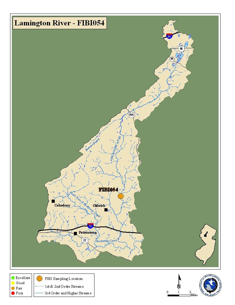
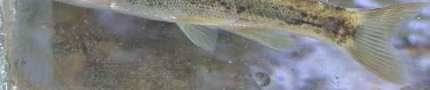
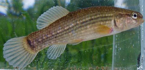
2 SUMMARY OF RESULTS FIBI Stream Name: Lamington River 2. Sampling Date: 7/10/ Sampling Location: McCann Mill Road 4. Municipality Tewksbury Township 5. County: Hunterdon 6. Watershed Management Area: 8 7. Contributing Drainage Area (Sq. Mi.): Electrofishing Gear: 2 Backpacks 9. FIBI Score and Rating: Round 1* Good (40); Round 2 Fair (36) 10. Habitat Score and Rating: Round 1 Optimal (175); Round 2 Optimal (178) 11. Fishable Species Present: Yes 12. Relevant AMNET 1 Station Data: Proximity of FIBI station to AMNET station: 2.2mi downstream AN0360 AMNET Rating: 1994 Non-Impaired; 1999 Non-Impaired; 2004 Non-Impaired 13. Stream Chemistries: Dissolved Oxygen (mg/l) 7.58 Temperature 0 C ph 7.47 Conductivity (μmhos/cm) Length of Stream Sampled: 150m 15. Water Clarity: Clear 16. Average Open Forest Canopy: 31.2% 17. Discharge: 16.48cfs 18. Substrate: 20% Gravel/Sand, 73% Cobble, 5% Boulder, 1% Mud, 1% Silt 19. Habitat: 55% Riffle, 35% Run, 10% Pool 20. Snags: Yes 21. Periphyton: Slight 22. Submerged Aquatic Vegetation: No 23. Outfalls: Number of Fish Species Identified: Total Number of Fish Collected: Number of Fish With Anomalies: Other Observations: Five young-of-the-year brown trout collected. 1 AMNET is the acronym for the DEP s ambient benthic macroinvertebrate monitoring network a series of 820 monitoring stations located throughout the state s waterways that collects data on the health of bottom dwelling stream fauna which in turn is used to assess general water quality * Round 1 data was scored prior to the FIBI metric recalibration.
3 FIBI054 LAMINGTON RIVER McCANN MILL ROAD TEWKSBURY TWP., HUNTERDON COUNTY Black R iv e r R oa d!! º Meters Ca nn Mi ll R oa d! Start! Finish Sampling Reach Mc Direction of Flow
4 FIBI054-Lamington McCann Mill Rd Excellent Good Fair Poor Date Sampled - 7/11/2007 Score # of Fish Species 5 # of Benthic Insectivorous Species (BI) 5 (excluding White Suckers and Bullheads) # of Trout and Centrarchid Species 3 (excluding Green Sunfish and Bluegill) # of Intolerant Species (IS) 5 Proportion of Tolerant Individuals 3 Proportion of Individuals as Generalists 3 Proportion of Individuals as Insectivorous Cyprinids 3 Proportion of Individuals as Trout *whichever gives better score OR Proportion of Individuals as Piscivores (excluding American Eel)* 1 # of Individuals in Sample 5 (excluding Tolerant Species) Proportion of Individuals w/disease/anomalies 3 (excluding blackspot) Total 36 Stream Rating Excellent Good Fair Poor
5 HABITAT ASSESSMENT FOR HIGH GRADIENT STREAMS Lamington River (FIBI054) 7/10/07 Condition Category Optimal Suboptimal Marginal Poor 1. Epifaunal Substrate /Available Cover Greater than 70% of substrate favorable for epifaunal colonization and fish cover; mix of snags, submerged logs, undercut banks, cobble or other stable habitat and at stage to allow full colonization potential (i.e., logs/snags that are not new fall and not transient) % mix of stable habitat; well-suited for full colonization potential; adequate habitat for maintenance of populations; presence of additional substrate in the form of newfall, but not yet prepared for colonization (may rate at high end of scale) % mix of stable habitat; habitat availability less than desirable; substrate frequently disturbed or removed. Less than 20% stable habitat; lack of habitat is obvious; substrate unstable or lacking. SCORE Embeddedness Gravel, cobble, and boulder particles are 0-25% surrounded by fine sediment. Layering of cobble provides diversity of niche space Gravel, cobble, and boulder particles are 25-50% surrounded by fine sediment. Gravel, cobble, and boulder particles are 50-75% surrounded by fine sediment. Gravel, cobble, and boulder particles are more than 75% surrounded by fine sediment. SCORE Velocity/Depth Regimes All 4 velocity/depth regimes present (slow-deep, slow-shallow, fast-deep, fast-shallow). (slow is <0.3 m/s, deep is >0.5 m) Only 3 of the 4 regimes present (if fast-shallow is missing, score lower than if missing other regimes). Only 2 of the 4 habitat regimes present (if fast-shallow or slowshallow are missing, score low). Dominated by 1 velocity / depth regime (usually slow-deep). SCORE Sediment Deposition Little or no enlargement of islands or point bars and less than 5% (<20% for low-gradient streams) of the bottom affected by sediment deposition. Some new increase in bar formation, mostly from gravel, sand or fine sediment; 5-30% (20-50% for low-gradient) of the bottom affected; slight deposition in pools. Moderate deposition of new gravel, sand or fine sediment on old and new bars; 30-50% (50-80% for low-gradient) of the bottom affected; sediment deposits at obstructions, constrictions, and bends; moderate deposition of pools prevalent. Heavy deposits of fine material, increased bar development; more than 50% (80% for low-gradient) of the bottom changing frequently; pools almost absent due to substantial sediment deposition. SCORE Channel Flow Status Water reaches base of both lower banks, and minimal amount of channel substrate is exposed. Water fills >75% of the available channel; or <25% of channel substrate is exposed. Water fills 25-75% of the available channel, and/or riffle substrates are mostly exposed. Very little water in channel and mostly present as standing pools. SCORE Channel Alteration Channelization or dredging absent or minimal; stream with normal pattern. Some channelization present, usually in areas of bridge abutments; evidence of past channelization, i.e., dredging, (greater than past 20 yr) may be present, but recent channelization is not present. Channelization may be extensive; embankments or shoring structures present on both banks; and 40 to 80% of stream reach channelized and disrupted. Banks shored with gabion or cement; over 80% of the stream reach channelized and disrupted. In stream habitat greatly altered or removed entirely. SCORE Frequency of Riffles (or bends) Occurrence of riffles relatively frequent; ratio of distance between riffles divided by width of the stream <7:1 (generally 5 to 7); variety of habitat is key. In streams where riffles are continuous, placement of boulders or other large, natural obstruction is important. Occurrence of riffles infrequent; distance between riffles divided by the width of the stream is between 7 to 15. Occasional riffle or bend; bottom contours provide some habitat; distance between riffles divided by the width of the stream is between 15 to 25. Generally all flat water or shallow riffles; poor habitat; distance between riffles divided by the width of the stream is a ratio of >25. SCORE Bank Stability (score each bank) Note: determine left or right side by facing downstream. Banks stable; evidence of erosion or bank failure absent or minimal; little potential for future problems. <5% of bank affected. Moderately stable; infrequent, small areas of erosion mostly healed over. 5-30% of bank in reach has areas of erosion. Moderately unstable; 30-60% of bank in reach has areas of erosion; high erosion potential during floods. Unstable; many eroded areas; "raw" areas frequent along straight sections and bends; obvious bank sloughing; % of bank has erosional scars. SCORE 10 (LB) Left SCORE 9 (RB) Right Bank Vegetative Protection (score each bank) More than 90% of the streambank surfaces and immediate riparian zone covered by native vegetation, including trees, under story shrubs, or nonwoody macrophytes; vegetative disruption through grazing or mowing minimal or not evident; almost all plants allowed to grow naturally % of the streambank surfaces covered by native vegetation, but one class of plants is not well-represented; disruption evident but not affecting full plant growth potential to any great extent; more than one-half of the potential plant stubble height remaining % of the streambank surfaces covered by vegetation; disruption obvious; patches of bare soil or closely cropped vegetation common; less than one-half of the potential plant stubble height remaining. Less than 50% of the streambank surfaces covered by vegetation; disruption of streambank vegetation is very high; vegetation has been removed to 5 centimeters or less in average stubble height. SCORE 10 (LB) Left SCORE 9 (RB) Right Riparian Vegetative Zone Width (score each bank riparian zone) HABITAT SCORE Width of riparian zone >18 meters; human activities (i.e., parking lots, roadbeds, clear-cuts, lawns, or crops) have not impacted zone. Width of riparian zone meters; human activities have impacted zone only minimally. Width of riparian zone 6-12 meters; human activities have impacted zone a great deal. Width of riparian zone <6 meters: little or no riparian vegetation due to human activities. SCORE 6 (LB) Left SCORE 8 (RB) Right HABITAT SCORES VALUE OPTIMAL SUB-OPTIMAL MARGINAL POOR < 60
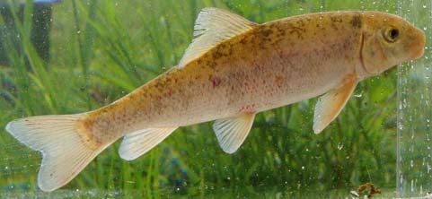
6 FIBI054-R2 Lamington River Common Name White Sucker Blacknose Dace Longnose Dace Tessellated Darter Fallfish American Eel Common Shiner American Brook Lamprey Pumpkinseed Redbreast Sunfish Brown Trout Shield Darter Bluegill Eastern Mudminnow Redfin Pickerel Spottail Shiner Yellow Bullhead Satinfin Shiner Scientific Name Catostomus commersoni Rhinichthys atratulus Rhinichthys cataractae Etheostoma olmstedi Semotilus corporalis Anguilla rostrata Luxilus cornutus Lampetra appendix Lepomis gibbosus Lepomis auritus Salmo trutta Percina peltata Lepomis macrochirus Umbra pygmaea Esox americanus americanus Notropis hudsonius Ameiurus natalis Cyprinella analostana 07/10/2007 Abundance
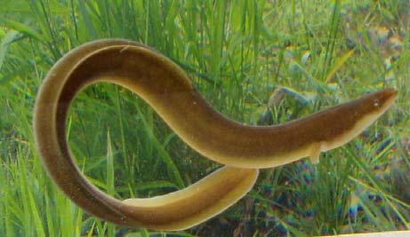
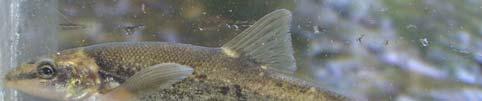
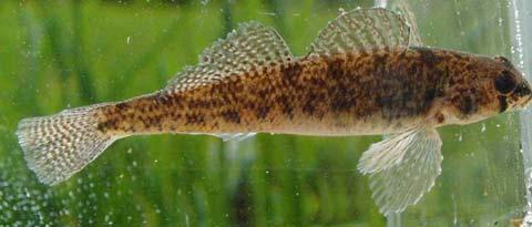
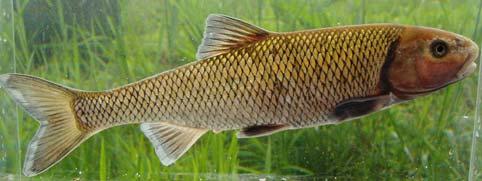
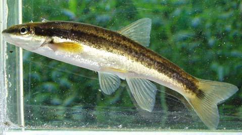
7 Species Identified at Lamington River (FIBI054) White Sucker American Eel Longnose Dace Tesselated Darter Fallfish Blacknose Dace


")

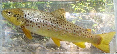
8 Species Identified at Lamington River (FIBI054) Redbreast Sunfish Pumpkinseed Common Shiner Brown Trout Bluegill Eastern Mudminnow


9 Species Identified at Lamington River (FIBI054) Satinfin Shiner Redfin Pickerel American Brook Lamprey Spottail Shiner Shield Darter Yellow Bullhead
Preakness Brook - FIBI098
 Preakness Brook - FIBI098 Preakn ess B rook Preakness " ( FIBI098 Naachtpunkt Brook 202 80 IBI Ratings FIBI Sampling Location Excellent Small Streams (1st and 2nd Order) Good Fair Large Streams (3rd Order
SUMMARY OF RESULTS FIBI098
 SUMMARY OF RESULTS FIBI098 1. Stream Name: Preakness Brook 2. Sampling Date: 7/9/2009 3. Sampling Location: Preakness Avenue 4. Municipality Totowa 5. County: Passaic 6. Watershed Management Area: 4 7.
F I B I ST 519 OP 57. [ Excellent [ Fair. [ Poor. U p p e r D e l a w a r e W M A 1. C e n t r a l D e l a w a r e W M A 1 1.
 L o p a t c o n g C r e e k F I B I 0 0 4 # Allens Mills Uniontown # ST 519 U p p e r D e l a w a r e W M A 1 Lopatcong Creek 22 OP 57 [ 78 Still Valley # C e n t r a l D e l a w a r e W M A 1 1 FIBI Rating
Beaver Brook - FIBI047 Hope
 Beaver Brook - FIBI047.-,80 Silve r Lake Mud dy Br ook % Hope Honey Run Beaver Brook FIBI047 #S #S FIBI Sampling Location Small Streams (1st and 2nd Order) Large Streams (3rd Order and Above) N 0 1 2 3
Pohatcong Creek - FIBI033
 DELAWARE RIVER Pohatcong Creek - FIBI033 Drainage Area of FIBI033: 9.8 Square Miles Surface Water Quality Classification of FIBI033: FW2-TM Washington #S "! 3 1 % P ohatcong Creek FIBI033 "! 57 Merri l
Pequannock River - FIBI077
 Pequannock River - FIBI077 Canistear Rsvr. Clint on Brook Clinton R svr. k R r. idge Rs v Echo Lake Oa 23 Pequann ock R iver FIBI077 Kinnelon 287 23 FIBI Sampling Location Small Streams (1st and 2nd Order)
[ # [ Excellent [ Fair. Upper Delaware WMA 1. North and South Branch Raritan WMA 8. Holland. Milford FIBI026. Frenchtown. Central Delaware WMA 11
 North and Sou Upper Delaware WMA 1 North and South Branch Raritan WMA 8 Holland # # Milford [ # FIBI026 Frenchtown Central Delaware WMA 11 FIBI Rating [ Excellent [ Fair [ Good [ Poor Stream Order 1st,
Little Flat Brook - FIBI065
 Little Flat Brook - FIBI065 Beerskill Cre ek 15 FIBI065 Little Flat Br ook Layton 15 FIBI Sampling Location Small Streams (1st and 2nd Order) Large Streams (3rd Order and Above) SUMMARY OF RESULTS FIBI065
Va n Saun Mill Brook. FIBI062a !(208!( 4 !( 20. !( FIBI062a !( 7 !( 67 !( 3 !( 5 !( 21 !(120 !(495 !(139 !(440. !( Good. !( Poor.
 VanSaunMillBrook FIBI062a Brook Va n Saun Mill Brook HirshfeldBroo k!( 20 Pas saicriver Fleis cher Bro ok!(208 Sprout!( 4 " River Edge!( FIBI062a Metzler Brook 46!( 21 Be rryscre ek!( 17 80 Hacke nsack
(/ Neshanic River - FIBI023 "! 3 1. ø ø 52 3 ø 57 9 FIBI023
 Neshanic River - FIBI023 Drainage Area of FIBI023: 23.1 Square Miles Surface Water Quality Classification of FIBI023: FW2-NT ø 52 3 ø 57 9 Neshanic River (/ 20 2 FIBI023 % #S Neshanic River Back Brook
(/ North Branch Raritan River - FIBI031 % FIBI031
 North Branch Raritan River - FIBI031 Drainage Area of FIBI031: 172.7 Square Miles Surface Water Quality Classification of FIBI031: FW2-NT.-,7 8.-,287 (/ 20 2 North Branch Raritan Chambers Brook (/ 2 2
[ Excellent [ Fair. Millbrook FIBI039. Calno. Upper Delaware WMA 1. Pahaquarry. Stream Order 1st, 2nd & 3rd Order. FIBI Rating.
 @ Millbrook [ @ FIBI039 Calno Upper Delaware WMA 1 @ Pahaquarry FIBI Rating [ Excellent [ Fair [ Good [ Poor Stream Order 1st, 2nd & 3rd Order 4th Order & Higher É 0 2 4 Miles SUMMARY OF RESULTS FIBI039
La ming t onriver 206 FIBI078 !(183 !( 10 !(182 !( 57. !( Good. !( Poor FIBI078. !( Excellent. Lamington
 er iver Lamington River FIBI078 questr iv eru NT ek 80 206 W illsb rook!(183 Mu s cone tcong 80 46 ackery Brook cong t!(182 46 M u scone Broo k Mine Budd Lake Dr ake s Brook!( 10 R M usc onetc ong River!(
Herring Highway A Study of a New Fish Passage for River Herring at Rock Creek National Park
 Bridging the Watershed An Outreach Program of the Alice Ferguson Foundation in Partnership with the National Park Service and Area Schools Herring Highway A Study of a New Fish Passage for River Herring
Conewago Creek Initiative. Fish Survey Report for the Conewago Creek
 Conewago Creek Initiative Fish Survey Report for the Conewago Creek A compilation of historic fish survey data from 97, 973, 7, for three locations along the Conewago Creek Prepared by Kristen Kyler for
Conewago Creek Initiative
 Conewago Creek Initiative The Conewago Creek Revisited Fish Survey Report A compilation of historic fish survey data from 197, 1973, 7, 1, and 15 for three locations along the Conewago Creek Prepared by
Montgomery Parks Biological Monitoring in the Anacostia Watershed of Montgomery County RESOURCE ANALYSIS SECTION
 Montgomery Parks Biological Monitoring in the Anacostia Watershed of Montgomery County PARK PLANNING & STEWARDSHIP Doug Redmond, Natural Resources Manager Montgomery County Department of Parks September
Using Habitat Guilds to Develop Habitat Suitability Criteria for a Warmwater Stream Fish Assemblage. Jason Persinger, Don Orth,, Tammy Newcomb
 Using Habitat Guilds to Develop Habitat Suitability Criteria for a Warmwater Stream Fish Assemblage Jason Persinger, Don Orth,, Tammy Newcomb Shenandoah River Basin North Fork Shenandoah River 20% discharge
Lake Superior. Ontonagon River Assessment. Ontonagon. Rockland. Victoria Dam. Bergland. Bergland. Dam. Bruce Crossing Agate Falls. Kenton Lower.
 Sand shiner otropis stramineus feeding - sand and gravel substrate - shallow pools in medium size streams, lakes, and impoundments - clear water and low gradient - rooted aquatic vegetation preferred -
Minnesota Department of Natural Resources Division of Fish and Wildlife Section of Fisheries. Stream Survey Report. Three Mile Creek 2011
 Minnesota Department of Natural Resources Division of Fish and Wildlife Section of Fisheries Stream Survey Report Three Mile Creek 2011 By Joseph D. Stewig Montrose Area Fisheries Office TABLE OF CONTENTS
Fish faunal changes in Otsego Lake s Shadow Brook watershed following application of best management practices
 Fish faunal changes in Otsego Lake s Shadow Brook watershed following application of best management practices Ryan J. Reynolds 1, Joseph C. Lydon 2 and John R. Foster 3 Abstract: This study was conducted
APPENDIX A. Stream Electrofishing Survey Data (2015)
") APPENDIX A Stream Electrofishing Survey Data (2015) This section of the report includes stream survey data completed by the Bureau of Freshwater Fisheries in 2015. All surveys, unless specifically noted
APPENDIX A Stream Electrofishing Survey Data (2015) This section of the report includes stream survey data completed by the Bureau of Freshwater Fisheries in 2015. All surveys, unless specifically noted
feeding - downstream sections of large rivers, lakes, and impoundments
 River Assessment Appendix Shorthead redhorse (Moxostoma macrolepidotum) feeding - downstream sections of large rivers, lakes, and impoundments - rocky substrates - swift water near riffles - clear to slightly
Bean River. APPENDIX A. Fish Survey Summary by Subwatershed
 APPENDIX A. Fish Survey Summary by Subwatershed common name scientific name abbr alewife Alosa pseudoharengus AW American eel Anguilla rostrata AE banded sunfish Enneacanthus obesus BDS black crappie Pomoxis
Quillback (Carpoides cyprinus)
") t. Joseph Assessment Appendix Quillback (Carpoides cyprinus) feeding - clear to turbid water - Michigan - sand, sandy gravel, sandy silt, or clay-silt substrate - medium- to low-gradient rivers and streams;
t. Joseph Assessment Appendix Quillback (Carpoides cyprinus) feeding - clear to turbid water - Michigan - sand, sandy gravel, sandy silt, or clay-silt substrate - medium- to low-gradient rivers and streams;
Rehabilitation of Grimes Creek, a Stream Impacted in the Past by Bucket-lined Dredge Gold Mining, Boise River Drainage, July 2008 to August 2011.
 Rehabilitation of Grimes Creek, a Stream Impacted in the Past by Bucket-lined Dredge Gold Mining, Boise River Drainage, July 2008 to August 2011. Pam Harrington TU,1020 W. Main Street Suite 440, Boise,
Target Fish Communities and the MA Water Policy
 Target Fish Communities and the MA Water Policy Todd Richards MA Division of Fisheries and Wildlife Todd.Richards@state.ma.us MA Water Policy (2004) Principle: Protect Fish and Wildlife Habitat Recommendation:
HURON RIVER WATERSHED
 Brown bullhead (Ameiurus nebulosus) feeding - larger streams and rivers, lakes and impoundments - clear cool water with little clayey silt - moderate amounts of aquatic vegetation - sand, gravel, or muck
BA1 BA2 BA3 BA4 BA5 BA6 CP1 CP2 CP3 CP4 CP5 CP6
 Table 1: Results of fish collections within or adjacent to the Boyne Secondary Plan Area conducted by C. Portt and Associates. Station locations are provided in Figure 1. Stations BA1-BA6 were collected
Thunder Bay River Assessment Appendix. Appendix 2
 Appendix 2 Known past and present fish distributions in the River system. Distribution of fishes were compiled from Bailey et al. (2003) and from records located at the Michigan Department of Natural Resources
Student Worksheet: River Health and Indicator Species
 1 Student Worksheet: River Health and Indicator Species Mink frogs (Lithobates septentrionalis). Credit: Allan G. Austin Activity 1: Biodiversity and Indicator Species Watch the videothe Importance of
Distribution. PFBC Northcentral Region Law Enforcement Office, Attention: WCO Kraynak, 1150 Spring Creek Road, Bellefonte, PA 16823
 Distribution Pennsylvania Department of Environmental Protection, Northcentral Region Office, Attention: Steve Means, 208 West Third St. Suite 101, Williamsport, PA 17701 PFBC Northcentral Region Law Enforcement
Report prepared for: Prepared by: January 2002 BEAK Ref
 AQUATIC ENVIRONMENTAL STUDY KANATA WEST CONCEPT PLAN Report prepared for: ROBINSON CONSULTANTS Prepared by: BEAK INTERNATIONAL INCORPORATED 14 Abacus Road Brampton, Ontario L6T 5B7 January 2002 BEAK Ref.
Tittabawassee River Assessment. Miles. Gladwin Smallwood Impoundment. Harrison. Clare. Midland. Mt. Pleasant. St. Louis. Saginaw.
 Warmouth Lepomis gulosus feeding - clear lakes and impoundments and very low-gradient streams - abundant aquatic vegetation - silt-free water - mucky substrate often covered with organic debris spawning
Columbia Lake Dam Removal Project
 Columbia Lake Dam Removal Project The Columbia Lake dam located 1/4 mile upstream of the Paulins Kill River's confluence with the Delaware River in Knowlton Township, Warren County has been proposed for
Big Spring Creek Habitat Enhancement and Fishery Management Plans
 Big Spring Creek Habitat Enhancement and Fishery Management Plans November 5, 2012 Big Spring Events and Activities Center Newville, PA Charlie McGarrell Regional Habitat Biologist Pennsylvania Fish and
Tahquamenon River Assessment Appendix
 DNR DEPARTMENT OF NATURAL RESOURCES MICHIGAN STATE OF MICHIGAN DEPARTMENT OF NATURAL RESOURCES SR45 Appendix February 2008 Tahquamenon River Assessment Appendix James R. Waybrant and Troy G. Zorn www.michigan.gov/dnr/
Fisheries Review with Respect to Stormwater Management for Milton/Navan Road Property
 Fax: 613.935.6295 Mr. Jean-Luc Rivard 3223701 CANADA INC. 98 rue Lois Gatineau, QC J8Y 3R7 July 23, 2014 Re.: Fisheries Review with Respect to Stormwater Management for Milton/Navan Road Property Mr. Rivard:
OHIO DEPARTMENT OF TRANSPORTATION Division of Planning, Office of Environmental Services 1980 West Broad Street, Columbus, Ohio 43223
 August 06, 2007 OHIO DEPARTMENT OF TRANSPORTATION Division of Planning, Office of Environmental Services 1980 West Broad Street, Columbus, Ohio 43223 U.S. Army Corps of Engineers Ohio Regulatory Transportation
Fishes of Vermont Vermont Natural Heritage Inventory Vermont Fish & Wildlife Department 22 March 2017
 Fishes of Vermont Vermont Natural Heritage Inventory Vermont Fish & Wildlife Department 22 March 2017 The following is a list of fish species known to regularly occur in Vermont. Historic species (not
Crooked Lake Oakland County (T4N, R9E, Sections 3, 4, 9) Surveyed May James T. Francis
 Surveyed May James T. Francis") Michigan Department of Natural Resources Status of the Fishery Resource Report No. 2004-1, 2004 Crooked Lake Oakland County (T4N, R9E, Sections 3, 4, 9) Surveyed May 2002 James T. Francis Environment Crooked
Michigan Department of Natural Resources Status of the Fishery Resource Report No. 2004-1, 2004 Crooked Lake Oakland County (T4N, R9E, Sections 3, 4, 9) Surveyed May 2002 James T. Francis Environment Crooked
Study Update Tailrace Slough Use by Anadromous Salmonids
 Study Update Tailrace Slough Use by Anadromous Salmonids Goals and Objectives Identify what anadromous salmonids use the tailrace slough by: Life Stage (Juvenile, migrating and spawning adults) Timing
Flint River Assessment Appendix
 14 Appendix 3 Distribution Maps of Fish Species This appendix contains maps of past and known present fish distributions within the River watershed. The distributions of fish species were compiled from
Joe Rathbun Michigan DEQ Water Resources Division Nonpoint Source Unit * Thanks to The Nature Conservancy
 Joe Rathbun Michigan DEQ Water Resources Division Nonpoint Source Unit rathbunj@mi.gov * Thanks to The Nature Conservancy Road-stream intersections = 67,511 Culverts = 60,700 Bridges = 6,811 Perched Piping
Fish Survey of Arctic Lake (ID # ), Scott County, Minnesota in 2012
, Scott County, Minnesota in 2012") Snapping Turtle from Arctic Lake, September 2012 Fish Survey of Arctic Lake (ID #70-0085), Scott County, Minnesota in 2012 Survey Dates: September 18-20, 2012 MnDNR Permit Number: 18362 Prepared for: Shakopee
Snapping Turtle from Arctic Lake, September 2012 Fish Survey of Arctic Lake (ID #70-0085), Scott County, Minnesota in 2012 Survey Dates: September 18-20, 2012 MnDNR Permit Number: 18362 Prepared for: Shakopee
Importance of Temperature and Flow for Fish in Connecticut Streams
 Importance of Temperature and Flow for Fish in Connecticut Streams Chris Bellucci, CT DEEP Water Monitoring and Assessment Program Climate Change Conference, Litchfield, CT September 23, 2016 Today s Talk
PA FISH AND BOAT COMMISSION COMMENTS AND RECOMMENDATIONS February 16, Coles Creek Basin (405C) Sullivan/Columbia/Luzerne Counties
 Sullivan/Columbia/Luzerne Counties") PA FISH AND BOAT COMMISSION COMMENTS AND RECOMMENDATIONS February 16, 2012 WATER: Coles Creek Basin (405C) Sullivan/Columbia/Luzerne Counties EXAMINED: July and August 2009 BY: Wnuk, Frey, and Precone
PA FISH AND BOAT COMMISSION COMMENTS AND RECOMMENDATIONS February 16, 2012 WATER: Coles Creek Basin (405C) Sullivan/Columbia/Luzerne Counties EXAMINED: July and August 2009 BY: Wnuk, Frey, and Precone
Rouge Fish Surveys
 Rouge Fish Surveys 2011-16 Friends of the Rouge January 2017 Partially funded by the Areas of Concern Program Office of the Great Lakes (OGL), DEQ Additional data provided by MDNR and MDEQ Fall 2016 Sampling
Au Sable River Assessment Appendix
 54 Appendix 3 Appendix 3. Known past and present fish distributions in the Au Sable River system. Distributions of fishes were compiled from records located at the University of Michigan Museum of Zoology
CREATION AND ASSESSMENT OF AN INDEX OF BIOTIC INTEGRITY FOR COLDWATER, SOUTHEASTERN MINNESOTA STREAMS. Jeffrey W. Quinn
 Conservation Biology Research Grants Program Division of Ecological Services Minnesota Department of Natural Resources CREATION AND ASSESSMENT OF AN INDEX OF BIOTIC INTEGRITY FOR COLDWATER, SOUTHEASTERN
feeding - clear moderate-sized shallow streams with moderate vegetation spawning - nests in gravel, sand, or hard rock substrate
 orthern longear sunfish (Lepomis peltastes) feeding - clear moderate-sized shallow streams with moderate vegetation - rocky substrates - little to no current spawning - nests in gravel, sand, or hard rock
Assessment of Brook Trout Habitat Conditions within the Dwaas Kill Nature Preserve
 Assessment of Brook Trout Habitat Conditions within the Dwaas Kill Nature Preserve September 2018 Eagle Scout Project of Mathieu R. DiPersio BSA Troop 4006, Jonesville United Methodist Church Clifton Park,
APPENDIX 3. Distribution Maps of Fish Species
 APPENDIX 3 Distribution Maps of Fish Species This appendix contains maps of known past and present fish distributions within the Manistique River watershed. The distributions of fish species were compiled
PA FISH AND BOAT COMMISSION COMMENTS AND RECOMMENDATIONS February 16, WATER: Wapwallopen Creek Basin (405B) Luzerne County
 Luzerne County") PA FISH AND BOAT COMMISSION COMMENTS AND RECOMMENDATIONS February 16, 2012 WATER: Wapwallopen Creek Basin (405B) Luzerne County EAMINED: Summer 2005 BY: Moase, Wnuk, and McGrady Bureau Director Action:
PA FISH AND BOAT COMMISSION COMMENTS AND RECOMMENDATIONS February 16, 2012 WATER: Wapwallopen Creek Basin (405B) Luzerne County EAMINED: Summer 2005 BY: Moase, Wnuk, and McGrady Bureau Director Action:
2012 SOUTH RIVER FISH COMMUNITIES AND PHYSICAL HABITAT ASSESSMENT, FRANKLIN COUNTY, MASSACHUSETTS
 2012 SOUTH RIVER FISH COMMUNITIES AND PHYSICAL HABITAT ASSESSMENT, FRANKLIN COUNTY, MASSACHUSETTS Prepared by Michael B. Cole, Ph.D. ABR, Inc. Environmental Research & Services Greenfield, MA For Deerfield
Steelhead Society of BC. Thompson River Watershed Restoration and Enhancement Project #4 Nicola River Bank Stabilization and Enhancement Project
 Steelhead Society of BC Presents: Thompson River Watershed Restoration and Enhancement Project #4 Nicola River Bank Stabilization and Enhancement Project Application for Funding December 2013 1.0 BACKGROUND
WAVE Assessments
 2 2012-2105 WAVE Assessments 3 4 5 6 7 8 Lake George WAVE Stream Monitoring Sites Stream sampling sites in 2015. 9 Stream Name Volunteer DEC Assessment Species Found (Common Name) Habitat Assessment West
Holderness. The Three Watersheds within the Newfound Lake Drainage Dorchester. Groton Plymouth. Ashland. Hebron. Canaan. Bridgewater.
 Background Brook trout are the only native stream dwelling trout species in New Hampshire, having a historic range that extended from Georgia to eastern Canada. It is believed that wild brook trout were
4.14 Aquatic Life and Essential Fish Habitat
 Alternative D Alternative D would have virtually identical impacts on WHPAs as discussed for Alternative A. The Alternative D footprint overlaps no private wells and is within 150 feet of 18 private wells.
PA FISH AND BOAT COMMISSION COMMENTS AND RECOMMENDATIONS February 16, Bureau Director Action: Division Chief Action:
 PA FISH AND BOAT COMMISSION COMMENTS AND RECOMMENDATIONS February 16, 2012 WATER: Berks County Section 04; Section 03 (partial) Lat/Lon 402537/755627 EXAMINED: October 13 and 14, 2004 BY: Kaufmann and
STREAM SURVEY File form No..
 scanned for KRIS THE RESOURCES AGENCY OF CALIFORNIA California Department of Fish and Game STREAM SURVEY File form No.. Date: September 4, 1969. NAME: North Fork Schooner Gulch Creek COUNTY: Mendocino.
JAP Additional Information Sheet
 JAP Additional Information Sheet Block 15: Purpose and Need The USACE purpose of the project is to provide a safe and reliable whitewater park for the recreational public in a city park, which will provide
Lamprey River Watershed. Fish Surveys
 1 Lamprey River Watershed Fish Surveys Report to the Lamprey River Advisory Committee New Hampshire Fish and Game Inland Fisheries Fish Conservation Program July 30, 2012 2 Contents INTRODUCTION... 4 METHODS...
Illinois Lake Management Association Conference March 23, 2018 By Trent Thomas Illinois Department of Natural Resources Division of Fisheries
 Illinois Lake Management Association Conference March 23, 2018 By Trent Thomas Illinois Department of Natural Resources Division of Fisheries Sources of Habitat Impairment Sedimentation Channelization
PA FISH AND BOAT COMMISSION COMMENTS AND RECOMMENDATIONS February 16, Tributaries to the Tioga-Hammond Lake Complex (404A)
") PA FISH AND BOAT COMMISSION COMMENTS AND RECOMMENDATIONS February 16, 2012 WATER: Tributaries to the Tioga-Hammond Lake Complex (404A) EXAMINED: July - August 2007 BY: Wnuk, Frey, and Koser Bureau Director
PA FISH AND BOAT COMMISSION COMMENTS AND RECOMMENDATIONS February 16, 2012 WATER: Tributaries to the Tioga-Hammond Lake Complex (404A) EXAMINED: July - August 2007 BY: Wnuk, Frey, and Koser Bureau Director
Black crappie (Pomoxis nigromaculatus)
") Black crappie (Pomoxis nigromaculatus) feeding - larger clear non-silty low-gradient rivers; also in lakes and impoundments - clean hard sand or muck substrate - associated with submerged aquatic vegetation
Black crappie (Pomoxis nigromaculatus) feeding - larger clear non-silty low-gradient rivers; also in lakes and impoundments - clean hard sand or muck substrate - associated with submerged aquatic vegetation
Evaluation of Newbury Weirs (Rock Riffles) for Improving Habitat Quality and Biotic Diversity in Illinois Streams.
 for Improving Habitat Quality and Biotic Diversity in Illinois Streams.") Evaluation of Newbury Weirs (Rock Riffles) for Improving Habitat Quality and Biotic Diversity in Illinois Streams. Report submitted to The Wildlife Preservation Fund Illinois Department of Natural Resources
Evaluation of Newbury Weirs (Rock Riffles) for Improving Habitat Quality and Biotic Diversity in Illinois Streams. Report submitted to The Wildlife Preservation Fund Illinois Department of Natural Resources
Trip Report: Eagle Creek, Arizona
 Trip Report: Eagle Creek, Arizona 15-17 June 2009 Participants: Abraham Karam, Brian Kesner, and Mike Childs Native Fish Lab Marsh & Associates, LLC 5016 South Ash Avenue Suite 108 Tempe, Arizona 85282
Fish population survey report
 Fish population survey report Upper River Avon Catchment This report provides a summary of results from recent fish population surveys on the Tetbury Avon, Sherston Avon and River Marden The surveys were
Volume 1 of 2. March Kim Guadagno, Lt. Governor
 New Jersey Department of Environmental Protection Water Monitoring and Standards Salvelinus fontinalis FISH IBI REPORT 2009 SAMPLING Round 2, Year 5 of 5 Volume 1 of 2 March 2011 State of New Jersey Chris
X.B WETLANDS ROGUE RIVER ESTUARY
 X.B WETLANDS ROGUE RIVER ESTUARY The Rogue River has a drainage area of 5,100 square miles, yet the estuary of the Rogue River is one of the smallest in Oregon, measuring approximately 1,880 acres during
Minnesota Department of Natural Resources Division of Fish and Wildlife Section of Fisheries. Stream Survey Report. Luxemburg Creek.
 Minnesota F-29-R(P)-24 Area 315 Study 3 March 2016 Minnesota Department of Natural Resources Division of Fish and Wildlife Section of Fisheries Stream Survey Report Luxemburg Creek 2015 Mark Pelham Sauk
STREAM Girls field notebook
 s STREAM Girls field notebook Welcome...... to your stream! Trout Unlimited is excited to offer you and other Girl Scouts the chance to really get to know your home waters. Over the next three days, you
American Eels in Virginia Mountain Streams
 American Eels in Virginia Mountain Streams Andy Dolloff 1,Craig Roghair 1, Colin Krause 1, Dawn Kirk 2, Scott Smith 3, Andy Strickland 4 1 US Forest Service, Southern Research Station 2 GW-Jeff National
The Fish Fauna of Cranberry Bog, Town of Burlington, Otsego County, N.Y.
 80 The Fish Fauna of Cranberry Bog, Town of Burlington, Otsego County, N.Y. Steven M. Foster* ABSTRACT In June 1995 a baseline fish survey of Cranberry Bog was conducted in order to identify the species
(Revised February,2005) CULVERTS, BRIDGES, AND FORDS
 CULVERTS, BRIDGES, AND FORDS") GUIDE TO STREAM CROSSINGS (Revised February,2005) CULVERTS, BRIDGES, AND FORDS Culverts, bridges, and fords are all methods used to cross-streams. Culverts are the most common stream crossing structure.
GUIDE TO STREAM CROSSINGS (Revised February,2005) CULVERTS, BRIDGES, AND FORDS Culverts, bridges, and fords are all methods used to cross-streams. Culverts are the most common stream crossing structure.
FISH ASSEMBLAGE ASSESSMENT
 Relicensing Study 3.3.11 FISH ASSEMBLAGE ASSESSMENT Updated Study Report Summary Northfield Mountain Pumped Storage Project No. 2485) and Turners Falls Hydroelectric Project No. 1889) Prepared for: Prepared
Stream Assessment. Date. Data Collected by. Location. Name of Stream and River Basin. Stream Order. Streambank Materials. Streambank Vegetation
 Stream Assessment Date Data Collected by Location Name of Stream and River Basin Stream Order Streambank Materials Streambank Vegetation Floodplain Soils Floodplain Vegetation Valley Type Valley Constraints
Fish Habitat Restoration and Monitoring in Southeast Washington. Andy Hill Eco Logical Research, Inc.
 Fish Habitat Restoration and Monitoring in Southeast Washington Andy Hill Eco Logical Research, Inc. Fish Habitat Restoration and Monitoring in Southeast Washington Talk overview: Restoration projects
Annex B SUPPLEMENTAL INFORMATION. Table of Contents. Scientific Names of Select Plants and Animals. Fish species collected in Curwensville Lake
 Annex B SUPPLEMENTAL INFORMATION Table of Contents Scientific Names of Select Plants and Animals Fish species collected in Curwensville Lake Alternative Plans Percentage of Future Years with Drawdowns
SUMMARY OF MOVEMENT AND HABITAT USED BY TAGGED BROOK TROUT IN THE MAIN BRANCH AND NORTH BRANCH AU SABLE RIVER DURING SUMMER Data Submitted to:
 SUMMARY OF MOVEMENT AND HABITAT USED BY TAGGED BROOK TROUT IN THE MAIN BRANCH AND NORTH BRANCH AU SABLE RIVER DURING SUMMER 2014 Data Submitted to: Anglers of the Au Sable Submitted by: Dr. Mark R. Luttenton
Notes from Fish Community Assessments and a Plan to Protect Wild Brook Trout Populations and their Habitats within the Warner River Watershed
 Notes from Fish Community Assessments and a Plan to Protect Wild Brook Trout Populations and their Habitats within the Warner River Watershed New Hampshire Fish and Game Department Basil W. Woods, Jr.
Fish monitoring requirements of new FERC licenses: are they adequate?
 Fish monitoring requirements of new FERC licenses: are they adequate? Joseph D. Kiernan, Peter B. Moyle and John G. Williams Center for Watershed Sciences University of California, Davis Trends from recently
Assessment of Pre-restoration Habitat Conditions and Fish Populations in Branch Brook
 Assessment of Pre-restoration Habitat Conditions and Fish Populations in Branch Brook Jacob Aman March 18, 2013 Wells National Estuarine Research Reserve Acknowledgments I would like to thank the Maine
Methods for Evaluating Shallow Water Habitat Restoration in the St. Clair River
 Methods for Evaluating Shallow Water Habitat Restoration in the St. Clair River Objectives Document fish use of restoration sites Spawning Presence of larvae, juvenile, and adult fish Quantify differences
2014 Threatened and Endangered Fish Survey of. East Loon Lake and West Loon Lake. Lake County, Illinois
 2014 Threatened and Endangered Fish Survey of East Loon Lake and West Loon Lake Lake County, Illinois Prepared by Integrated Lakes Management 120 LeBaron St. Waukegan, IL 60085. Chris Ryan Chris Rysso
SUMMARY REPORT FOR LAKE ST. MALO FISHERIES ASSESSMENT. Prepared for the St. Malo and District Wildlife Association
 SUMMARY REPORT FOR LAKE ST. MALO FISHERIES ASSESSMENT Prepared for the St. Malo and District Wildlife Association Presented by August 25, 2014 Study dates thus far: Date Tasks February 16 Fishing derby;
LITTLE LEHIGH CREEK LEHIGH AND BERKS COUNTIES WATER QUALITY STANDARDS REVIEW STREAM REDESIGNATION EVALUATION REPORT
 LITTLE LEHIGH CREEK LEHIGH AND BERKS COUNTIES WATER QUALITY STANDARDS REVIEW STREAM REDESIGNATION EVALUATION REPORT Segment: Mainstem Stream Code: 342 Drainage List: D WATER QUALITY MONITORING SECTION
 example, the abundance of a given fish species in a basin can be validly estimated using the MBSS design. Because first, second, and third order streams represent about 90% of the tidal and non-tidal stream
Caro Impoundment, Tuscola County
 Caro Impoundment is a 200 acre impoundment of the Cass River located one mile south of the Village of Caro in Tuscola County. Caro Dam, originally constructed in 1906 for water supply to Michigan Sugar
Full Project Proposal
 PROJECT NAME: FIELD OFFICE: Full Project Proposal NFPP Phase I - Ferson-Otter Creek Dam Removal/Modification Project, Fox River Watershed, Illinois Carterville NFWCO PROJECT COORDINATOR: Nate Caswell FONS
Fish Migration Barrier Severity and Steelhead Habitat Quality in the Malibu Creek Watershed
 Fish Migration Barrier Severity and Steelhead Habitat Quality in the Malibu Creek Watershed Produced for California State Coastal Conservancy and California Department of Parks and Recreation By: Heal
Environmental. Effects of Dredging
 Envi~onmental Effects of Dredging Technical Notes THE VALUE OF GRAVEL DISPOSAL MOUNDS IN RIVER SIDE CHANNELS FOR FRESHWATER MUSSELS PURPOSE: This note provides information on the value of gravel disposal
Four Mile Run Restoration t Project
 Four Mile Run Restoration t Project D.I.R.T. studio December 2016 Four Mile Run Tidal Restoration Project Design Enhancements Final Submission 1 WATERMARKS: updated concept, December 2016 In 2011, DIRT
Water Habitat Model. Outcome: Materials: Teacher Instructions: : Identify the components of an animal habitat..
 Water Habitat Model Outcome: 4-1-03: Identify the components of an animal habitat.. Materials: Shoe boxes (1 per student) Art supplies: Glue and/or tape Paint and brushes for the background Plasticine/clay
Brook Trout Life Cycle and Habitat
 Brook Trout Life Cycle and Habitat Directions: 1. As you watch this slide show, watch for vocabulary terms we learned today. The first time they appear, you will see them in RED! (not redd!) 2. At the
Culvert Design for Low and High Gradient Streams in the Midwest. Dale Higgins, Hydrologist Chequamegon-Nicolet National Forest
 Culvert Design for Low and High Gradient Streams in the Midwest Dale Higgins, Hydrologist Chequamegon-Nicolet National Forest Overview Culvert Design Considerations Hydraulic Terms Culvert Impacts Low
Study No. 18. Mystic Lake, Montana. PPL Montana 45 Basin Creek Road Butte, Montana 59701
 Study No. 18 Evaluation of the Current Fish Population and Habitat in West Rosebud Creek Downstream from Emerald Lake Mystic Lake Hydroelectric Project FERC No. 2301 Mystic Lake, Montana PPL Montana 45
VIMS CCRM Coastal Management Decision Tools. Decision Tree for Undefended Shorelines and Those with Failed Structures
 VIMS CCRM Coastal Management Decision Tools Decision Tree for Undefended Shorelines and Those with Failed Structures Center for Coastal Resources Management Virginia Institute of Marine Science Gloucester
Proposed Reclassification of Cherry Creek, North Platte River Basin, Wyoming. October 25, 2010
 Proposed Reclassification of Cherry Creek, North Platte River Basin, Wyoming October 25, 2010 Waterbody: Location: Tributary to: Cherry Creek - Mainstem from headwaters downstream to the confluence with