2012 SOUTH RIVER FISH COMMUNITIES AND PHYSICAL HABITAT ASSESSMENT, FRANKLIN COUNTY, MASSACHUSETTS
|
|
|
- Samantha Flynn
- 5 years ago
- Views:
Transcription

1 2012 SOUTH RIVER FISH COMMUNITIES AND PHYSICAL HABITAT ASSESSMENT, FRANKLIN COUNTY, MASSACHUSETTS Prepared by Michael B. Cole, Ph.D. ABR, Inc. Environmental Research & Services Greenfield, MA For Deerfield River Watershed Association Greenfield, MA Franklin Regional Council of Governments Greenfield, MA
2
3 2012 SOUTH RIVER FISH COMMUNITIES AND PHYSICAL HABITAT ASSESSMENT, FRANKLIN COUNTY, MASSACHUSETTS FINAL REPORT Prepared for Deerfield River Watershed Association 15 Bank Row, Suite A Greenfield, MA & Franklin Regional Council of Governments 12 Olive Street, Suite 2 Greenfield, MA Prepared by Michael B. Cole, Ph.D. ABR, Inc. Environmental Research & Services 15 Bank Row, Suite B Greenfield, MA June 2013
4
5 EXECUTIVE SUMMARY The South River flows through the Franklin County communities of Ashfield and Conway in western Massachusetts. Historic and contemporary modifications to the river and its floodplain have included construction of dams, channel straightening, and riparian tree removal. Their effects, even those of dams long-ago removed, persist into the present, and include increased rates of sedimentation and bank erosion. These effects can have consequences for landowners and native fish, alike. The Franklin Regional Council of Governments was awarded a 604b grant to perform a comprehensive assessment of the South River to provide information on the causes of erosion, channel instability, and habitat degradation. This assessment included a geomorphic study that resulted in the development of conceptual restoration designs for several highest-ranked priority sites and final designs and cost estimates for the highest ranked restoration priority site (Field 2013). In order to inform the development of projects that seek to benefit both landowner property and river health, a comprehensive assessment of river habitat and fish communities was performed as an attendant study to the geomorphic assessment. This study represents the most comprehensive description of these conditions in the South River watershed to date and also serves as a benchmark for future evaluations of both the potential success of restoration efforts, as well as of any further degradation. This report details the methods, findings, and recommendations of this study. Survey reaches were selected following reconnaissance surveys of the entire watershed and consultation with the geomorphic assessment consultant (Field Geology Services). Fish and habitat survey reaches were selected to represent a range of geomorphic conditions and habitat impact levels. Eleven reaches were selected from the South River, including six impact reaches that received geomorphic needs scores of 23 or higher (five scored 30 or higher) and five reference reaches that scored 18 or lower. Reaches were also selected across most of the length of the South River to examine the relative influence of major longitudinal gradients in river conditions on fish communities versus local variation in habitat conditions. Physical habitat, fish communities, and water chemistry were sampled from the 11 survey reaches in the South River in August Physical habitat surveys were performed in accordance with the Physical Habitat Characterization protocols of the US Environmental Protection Agency s Wadeable Streams Assessment Field Operations Manual. Fish community surveys followed Massachusetts Division of Fisheries and Wildlife stream electrofishing surveys protocols. Physical habitat conditions in the South River ranged widely, but a general trend in increasingly degraded conditions occurs in a downriver direction. A number of measured environmental variables showed such a trend, including bank stability, instream woody debris load, riparian tree cover, width-to-depth ratio, percent glide habitat, and water temperature. These longitudinal trends are a function of both natural processes and human alteration of the river, and they exhibit a stronger influence on fish community composition than does local variation in habitat conditions. Limiting factors in the upper river, where they occur, include a lack of instream complexity and cover, and elevated sediment loading. Much of the upper river supports intact habitat and summer water temperatures that are favorable for supporting wild trout populations. Fish communities in the upper river reflect this capacity and are dominated by wild trout and other intolerant species. The lower River, particularly below the town of Conway, suffers from i
6 localized effects of channel straightening and increased sediment production, and also from cumulative effects from upriver impacts. Fish communities were heavily dominated by tolerant fish species, and wild trout were almost absent. Limiting factors in much of the lower river include low habitat quality and complexity (lack of deep pools, instream cover, clean gravels, etc.), and high water temperatures. These degraded conditions are most evident in straightened and channelized sections of the river. These attributes create conditions that are likely also potentially allowing juvenile Atlantic salmon to out-compete wild trout in the lower and middle reaches of the river. The upper river would benefit from land conservation and riparian protection and improvement projects. Wild trout populations are supported by current conditions, and any improvements to habitat only stand to improve local conditions, and minimize cumulative impacts to downriver sections. Such work could be informed by a comprehensive riparian zone study that explicitly identifies reaches most in need of increased stream shading. The lower river would benefit from restoration projects recommended in the Geomorphic Assessment (Field 2013) that would help restore a more natural planform to the river and promote the creation of habitat features conducive to supporting wild fish. Further assessment of summertime trout distribution over a wider range of summer conditions and water temperatures will assist with further determining distribution and abundance of wild trout in the lower river and further identify limiting factors. Restoration and protection of riparian areas along the entire river are highly recommended and will be critical to the long-term improvement of habitat conditions in the lower river. ii
7 TABLE OF CONTENTS LIST OF TABLES... V LIST OF FIGURES... V LIST OF APPENDICES... VI ACKNOWLEDGEMENTS... VII INTRODUCTION...1 STUDY AREA...2 METHODS...3 SURVEY REACHES...3 FIELD ASSESSMENT...4 Instream Physical Habitat and Riparian Assessment... 4 temperature monitoring... 4 fish Community Assessment... 5 Water Chemistry Sampling... 5 DATA ANALYSIS...5 RESULTS...6 PHYSICAL HABITAT CONDITIONS...6 WATER TEMPERATURE...9 FISH COMMUNITY CONDITIONS...9 COMPREHENSIVE REACH DESCRIPTIONS...11 REACH F1 (RIVER MILE 2.6) - IMPACTED...11 REACH F2 (RIVER MILE 5.4) - IMPACTED...13 REACH F3 (RIVER MILE 5.6) - IMPACTED...15 iii
8 REACH F4 (RIVER MILE 8.3) - REFERENCE...16 REACH F5 (RIVER MILE 10.0) - IMPACTED...17 REACH F6 (RIVER MILE 10.4) REFERENCE...19 REACH F7 (RIVER MILE 11.3) IMPACTED...20 REACH F8 (RIVER MILE 11.4) REFERENCE...22 REACH F9 (RIVER MILE 11.9) REFERENCE...23 REACH F10 (RIVER MILE 12.4) IMPACTED...25 REACH F11 (RIVER MILE 12.5) REFERENCE...26 DISCUSSION...28 CONCLUSIONS AND RECOMMENDATIONS:...31 LITERATURE CITED...33 iv
9 LIST OF TABLES Table 1.List of reaches from which fish and physical habitat were sampled from the South River in August Table 2. Mean, minimum, and maximum values of physical habitat attributes measured from 11 reaches in the South River in August Table 3. Impacted and reference reach group means of physical habitat attributes measured from 11 reaches in the South River in August Table 4. Water temperature metrics calculated from 9 temperature monitoring stations in the South River, summer Table 5. Fish community composition from 11 South River and 1 Creamery Brook sample site surveyed in August Table 6. Fish community attributes calculated from fish surveys in the South River, August Table 7. Correlations between select environmental variables and fish community metrics measured from 11 sampling stations along the South River in August LIST OF FIGURES Figure 1. Map of summer 2012 fish and physical habitat sampling stations in the South River Figure 2. Habitat attributes measured in 2012 that exhibited apparent longitudinal trends along the South River Figure 3. Substrate size class frequencies measured during habitat assessments of the South River in August Figure 4. Fish cover index ratings for six cover elements assessed during physical habitat assessments of the South River in August Figure 5. Water temperature metrics by river mile along the South River, summer Figure 6. Summer 2012 water temperature warming rates calculated between temperature monitoring stations on the South River Figure 7. Fish metrics calculated from fish surveys performed in 11 reaches in the South River and 1 reach in Creamery Brook in August Figure 8. Number of brook trout captured plotted against maximum 7-day average maximum water temperatures in the South River, August v
10 Figure 9. Length frequencies of trout and salmon sampled from the South River in August EBT = eastern brook trout, BT = brown trout, and AS = Atlantic salmon LIST OF APPENDICES Appendix 1. Reach Assessment Summaries Appendix 2. Summary of habitat attributes measured from the South River in August, Appendix 3. Fish species sampled from the South River vi
11 ACKNOWLEDGEMENTS This project was supported by a 604b grant awarded to the Franklin Regional Council of Governments (FRCOG). Kimberly Noake MacPhee of FRCOG served as project manager. This study was made possible through the generous support of volunteers Bob Anderson, Nikos Marmaras, and Rob Creamer. Jason Saltman of ABR, Inc. and Ryan Clary of the Franklin Regional Council of Governments also provided field support for the project. vii
12 INTRODUCTION The South River flows through the Franklin County communities of Ashfield and Conway in western Massachusetts. Historic and contemporary modifications to the river and its floodplain have included construction of dams, channel straightening, and riparian tree removal. Their effects, even those of dams long-ago removed, persist into the present, and include increased rates of sedimentation and bank erosion. These effects can have consequences for both landowners and native fish. Accelerated bank erosion and channel migration lead to loss of property and occasionally threaten homes and infrastructure, and also deleteriously affect native fish communities by reducing river habitat quality and complexity. Rivers that are frequently adjusting to our attempts at controlling their behavior have unstable banks that contribute large amounts of fine sediment to the channel and decrease the quality of spawning habitat for native fish. Channel widening also occurs, resulting in shallower water during low flows and higher water temperatures, only exacerbated by the removal of river-side trees that provide shade from direct sun. These issues have long been known to occur along the South River. The Massachusetts Department of Environmental Protection s (MassDEP) 2000 water quality assessment report for the Deerfield River Watershed recommended for the South River an evaluation of habitat quality conditions related to erosion and instream deposition/sedimentation in the South River (MassDEP 2004). This same report also recommended continued monitoring of fish populations in the South River. In 2011, The Franklin Regional Council of Governments was awarded a 604b grant to perform a comprehensive assessment of the South River to provide information on the causes of erosion, channel instability, and habitat degradation. This assessment included a geomorphic study that resulted in the development of conceptual restoration designs for several highest-ranked priority sites and final designs and cost estimates for the highest ranked restoration priority site (Field 2013). Restoration efforts intended to reduce erosion and improve channel stability can also benefit river habitat by halting or reversing the harmful processes discussed above. Consequently, restoration actions implemented in the South River watershed may potentially benefit both landowners and the river s ecology, alike. To the extent possible, restoration efforts should consider this win-win possibility. In order to inform the development 1
13 of projects that seek this double bottom line, a comprehensive assessment of river habitat and fish communities was performed as an attendant study to the geomorphic assessment This study was performed to help identify potential opportunities to both improve geomorphic condition for protection of property and infrastructure and improve habitat for native fish communities. This study represents the most comprehensive description of these conditions in the South River watershed to date and also serves as a benchmark for future evaluations of both the potential success of restoration efforts, as well as of any further degradation. This report details the methods, findings, and recommendations of this study. STUDY AREA The South River is one of several major tributaries to the Deerfield River in western Massachusetts. The river drains a total watershed area of 26.3 sq mi, comprising forest (77%), agriculture (12.5%), and residential (6.1%) land uses. The river has its source at Ashfield Lake in the hill town of Ashfield, and flows for 15.8 miles to the Deerfield River. The river first flows in a generally easterly direction from Ashfield, confluenting with Creamery and Poland brooks before entering the town of Conway. In Conway, the river turns north, flowing though a wide valley before turning east again and flowing through a deep, narrow valley for the last few miles before entering the Deerfield River. Along its course to the Deerfield River, the South River flows through various valley topographies exhibiting a range of gradients and valley widths. Consequently, the river exhibits a range of natural channel morphologies and attendant habitat conditions; this range of conditions was expanded upon Euro-American settlement and industrialization of the watershed. 2
14 METHODS SURVEY REACHES Survey reaches were selected following reconnaissance surveys of the entire watershed and consultation with the geomorphic assessment consultant (Field Geology Services). The following criteria were also used to select the physical habitat and fish community assessment reaches: Reaches should be distributed throughout the South River. Reaches should occur in both unstable reaches with degraded habitat (channelized, modified reaches with heavy bank erosion and/or sand/gravel deposits) and stable reaches with intact aquatic habitat. To the extent possible, unstable and stable reaches would be paired to facilitate statistical comparisons of conditions between these reach types. Following geomorphic surveys, the geomorphic assessment consultant assigned an index score to each of ten geomorphic elements within each assessment reach and developed from these ranking a composite geomorphic needs score (Field 2013). Composite index scores could range from 0 (lowest need) to 50 (highest need). These scores were used to assist with selecting fish and habitat survey reaches across a range of geomorphic conditions (Table 1). Eleven reaches were selected from the South River, including six impact reaches that received geomorphic needs scores of 23 or higher (five scored 30 or higher) and five reference reaches that scored 18 or lower. Reaches were also selected across most of the length of the South River to examine the relative influence of major longitudinal gradients in river conditions on fish communities versus local variation in habitat conditions. Accordingly, reaches were distributed throughout the South River from river mile 2.6 to river mile While the project initially sought to pair impacted and reference sites, a lack of least disturbed channel morphology and habitat conditions in the Conway sections of the river largely precluded this approach. Accordingly, least disturbed reference conditions were more common in the upper sections of the river, while the more impacted reaches generally occurred in the middle and lower sections of the river. 3
15 FIELD ASSESSMENT Physical habitat, fish communities, and water chemistry were sampled from the 11 survey reaches in August First, each survey reach was marked and the reach length of 150 m was measured. Waypoints were acquired for the start and end of each reach using a GPS unit. INSTREAM PHYSICAL HABITAT AND RIPARIAN ASSESSMENT Instream and riparian field data collection was performed between August 13 and 26, Physical habitat surveys were performed in accordance with the Physical Habitat Characterization protocols of the EPA s Wadeable Streams Assessment Field Operations Manual (EPA 2004). Each selected reach measured at least 150-m. The physical habitat assessment consisted of three components: channel and riparian cross-sectional characterizations, a thalweg profile, and a woody debris tally. At each of 11 channel cross sections within each monitoring reach, channel dimensions, bank height, and riparian overhead cover (densiometer) were measured to determine the amount of shading provided by riparian cover. A thorough characterization of the streambed substrate was performed along these cross sections. Substrate size and embeddedness of particles were measured on each cross section to quantify substrate conditions in each reach in relation to its potential to support a diverse benthic community. Riparian vegetation attributes were also recorded on each cross section. The thalweg profile consisted of measuring water depths and classifying habitat units at 10 equallyspaced intervals between each pair of cross sections to produce comprehensive descriptions of the types, sizes, and quality of aquatic habitats occurring in each reach. A Rapid Habitat Assessment was also performed in each reach, including ocular estimates of a number of habitat parameters. TEMPERATURE MONITORING To determine whether water temperature is a potentially limiting factor to aquatic life in the South River watershed, a series of nine temperature loggers were deployed along the mainstem of the South River. Logger locations were largely selected to overlap with physical and biological sampling reaches. Loggers were deployed in early July 2012 and retrieved in October 4
16 2012. Temperature logger deployment and retrieval protocols followed Continuous Temperature Monitoring Standard Operating Procedures described by MassDEP (MassDEP 2005). FISH COMMUNITY ASSESSMENT Fish communities were surveyed from each reach using backpack electrofishing equipment. Standard single-pass surveys were performed in each reach using protocols employed by the Massachusetts Division of Fisheries & Wildlife (MDFW; Alicia Norris, personal communication). Fish were sampled by pulsed DC current electrofishing. Crews of three to four people conducted single pass electrofishing surveys through the sample reaches. The crew member wearing the backpack used two ring probes to electroshock fish. The rest of the crew members carried buckets and/or dipnets to collect fish that are influenced by the electric current. All portions and habitats in the stream were sampled, including habitat features such as woody debris, submerged aquatic vegetation, undercut banks, and overhanging vegetation. All netted fish were held in buckets until completion of the sampling run, at which time all fish were identified to species, measured to the nearest millimeter, and released back into the reach from they were captured. WATER CHEMISTRY SAMPLING Water temperature ( C), dissolved oxygen saturation (percent), dissolved oxygen concentration (mg/l), conductivity (µs/cm), and specific conductance (µs/cm) were measured at each reach at the time of fish community. Water temperature, dissolved oxygen, conductivity, and specific conductance were measured in situ with a multi-parameter YSI Pro Model 2030 water chemistry meter. Specific conductance is conductivity normalized to 25 C, thereby allowing more direct comparison of conductivity between water bodies or within a particular waterbody at different times. DATA ANALYSIS Physical habitat data were summarized for each site by calculating reach-wide means for a large number of physical habitat attributes. Water temperature data were summarized from each location using several metrics: mean daily water temperature, maximum daily water temperature, 5
17 average 7-day average maximum water temperature, and maximum 7-day average maximum water temperature. Each temperature metric was calculated for each location using the same range of monitoring dates (July 13 through September 26, 2012). Fish community and physical data were entered into Excel spreadsheets and summarized using descriptive statistics and graphical summaries. Fish community data were summarized in a manner similar to those employed by MassDEP in their evaluation of fish community conditions in Massachusetts streams. This approach focuses on a more qualitative description of the general condition of the fish community as a function of overall species richness and total fish abundance, collective community tolerance to disturbance, and relative abundance of different trophic classes and microhabitat-use assemblages. When appropriate, regression and correlation analysis was used to examine the data for relationships between physical and biological conditions. The results of the data analysis include concise summaries of the current biological and physical habitat conditions throughout the South River watershed, comparisons of these conditions in less stable reaches to those in more stable river/stream reaches, and inferences regarding the likely causes of any measured impairments to these communities. Importantly, these data will serve as a baseline for determining long-term improvements in ecological conditions in the South River watershed. RESULTS PHYSICAL HABITAT CONDITIONS Physical habitat conditions varied widely among reaches, and results from both natural variation in geomorphic character and the level of impact to the reach (Table 2). Wetted and bankfull widths increased predictably from upriver to downriver (Figure 2). Wetted width averaged 6.1 m across all reaches and ranged from 2.4 m below Emmett Road to 11.8 m upriver of the lower Reeds Bridge Road bridge. Bankfull width averaged 11.0 m and ranged from 3.2 m to 18.9 m (Table 2). Mean water depth did not vary among locations, averaging 0.1 m across 10 of the 11 reaches, despite large differences in channel dimensions between upper and lower reaches. Consequently, wetted width-to-depth ratios increased significantly from upriver to 6
18 downriver (Figure 2). As a result, the lower sections of the South River are generally wide and shallow during baseflows, a condition that has likely been exacerbated by erosion and threatens the ecological integrity of the river. Frequencies of riffle, pool, and glide habitats also varied among reaches (Table 2). Percent glide habitat generally increased from upriver to downriver, likely primarily as a result of generally decreased channel gradient in the lower sections of the river below Conway; however, it must be noted that significant differences in channel gradient occur even within the upper, middle, and lower portions of the watershed. The highest percent glide habitat was measured in two reaches that had historically been straightened F2 alongside the Conway town fields and F5 in south Ashfield. Substrate composition varied among reaches (Figure 3), but was generally dominated by coarse materials (gravel-sized or larger), averaging 67% streambed coverage among all 11 reaches. Mean particle sizes ranged widely from 45 mm to 995 mm, and appeared to show some longitudinal trending (Figure 2), as the largest mean particle sizes occurred in the lower and middle reaches of the river, while the smallest sizes occurred in the upper reaches. The largest particle sizes occurred in reach F4 at river mile 8.3 below Brester Road, a reach characterized as having a steeper gradient and a confined channel (Table 2) and included in the study to represent least disturbed conditions for this channel type (Table 3). This geomorphic condition produces a higher stream power through this section, which mobilizes and transports smaller sediment through this reach to lower-gradient downriver sections. Substrate embeddedness was generally high throughout the river, averaging 46.7% and ranging from 27.3% to 70.2% (Table 2). Embeddedness was lowest in reaches F4 and F6, both occurring in the higher-gradient and more confined mid-sections of the river, where stream power is higher and better able to transport suspended sediment. Substrate embeddedness was highest in reaches F2 (70.2%), F5 (60.6%), and F7 (57.2%), all classified as impacted reaches for this study (see Appendix 2). Each of these reaches shows evidence of significant recent or historic disturbance, and a consequent dominance by wide, shallow stream habitat. F2 and F5, as previously discussed, were historically channelized and are currently dominated by shallow glide habitat with little instream cover or habitat complexity. Reach F7 occurs on the downriver side 7
19 of Burton Hill Road. The riparian zone has been cleared of trees through most of this reach; resulting in bank slumping, channel widening, and loss of habitat complexity. Habitat characteristics related to streambank condition and erosion, including bank stability and vegetative cover also varied among reaches and exhibited some longitudinal trending (Figure 2). The bank stability index, rated between 0 (poor) to 20 (optimal), averaged 11.6 across all study reaches. Bank stability was rated as marginal in three of the six impact reaches, but suboptimal or optimal in all five reference reaches. Bank vegetative protective cover (also rated on a scale of 0 to 20) also received a moderate average rating across all study reaches (10.6), and ranged from a low of 4 (poor) in reach F7 to (optimal) in reaches F10 and F11. Canopy cover was generally adequate across the study reaches, averaging 74.4% (Table 2). However, several reaches F2 and F7 in particular had low canopy cover, and it should be noted that such conditions are commonplace in the lower watershed. Large woody debris (LWD) was generally scarce to absent from the river channel in the lower and middle sections of the river (see Appendix 2). Impacted reaches averaged 0.3 pieces LWD/100 m of river, while reference reaches averaged 5.1 pieces LWD/100 m (Table 3). In addition to LWD, a number of habitat variables appear to differ significantly between impacted and reference reaches (Table 3); however, these differences may result from a larger number of impacted reaches occurring in lower portions of the South River, while most reference reaches occur in the middle and upper river. As such, many of these differences may primarily be driven by longitudinal position along the river s length. As an example, large woody debris loading appears to be much higher in reference reaches than in impacted reaches. Because reference reaches occur in the upper river where channel dimensions are smaller, woody debris can accumulate more easily because the pieces need not be as large as they would in larger channels. Instream cover for fish in the form of LWD, boulders, root wads, undercut banks, and overhanging vegetation was generally low across the reaches (Figure 4). Fish cover indexes (rated from 0 to 4) for each of these elements were generally less than 1 across all reaches, suggesting that lack of available cover is a potential limiting factor to native fish, particularly in the lower South River. 8
20 WATER TEMPERATURE Average daily water temperatures for the period July 13 through September 26 ranged from 59.7 o F at the uppermost station to 68.9 o F at the lowermost station (Table 4). Average daily maximum water temperatures ranged from 62.9 o F to 74.4 o F at these same two stations. Maximum 7-day-average maximum temperatures showed the largest range of values among sites, ranging from 66.7 o F at the uppermost station to 81.4 o F at the lowermost station. Average daily (Spearman rho = , p < ), average daily maximum (Spearman rho = , p = ), and maximum 7-day average maximum (Spearman rho = , p = ) water temperatures were all highly correlated with river mile along the South River. River water temperatures exhibited a distinct longitudinal trend (Figure 5). Warming rates of river water temperatures were highest in the upper river between temperature monitoring stations T9-T8 (Emmett Road to Double Edge Theatre) and T8-T7 (Double Edge Theatre to Burton Hill Road; Figure 6). Cool-water inputs from Creamery and Pumpkin Hollow Brooks significantly reduced rates of warming in the sections of river each tributary intercedes. Warming rates were generally lowest in the lower section of the river, likely as a result of larger volumes of water requiring longer periods of time to warm at a given air temperature, as well as water temperatures being closer to ambient air temperatures. FISH COMMUNITY CONDITIONS Eleven fish species were sampled from across the 12 reaches assessed in this survey (including Creamery Brook, which was sampled for fish, but not physical habitat). The number of species sampled among reaches ranged from 4 to 8. Total number of fish sampled ranged from 49 from reach F1 to 267 from reach F3 (Table 5). Five coldwater-obligate and pollution intolerant species were sampled during the survey, including brook trout, brown trout, juvenile Atlantic salmon, longnose sucker, and slimy sculpin. The longnose sucker is listed as a species of special concern by the Commonwealth of Massachusetts. As observed with a number of physical habitat variables and water temperature metrics, metrics used to describe fish community condition exhibited longitudinal trends (upstream 9
21 versus downstream; Figure 7). The number of salmonid species (brook trout, brown trout, and Atlantic salmon) ranged from 0 to 3. Atlantic salmon, captured from reaches F2, F3, and F4, were the only salmonid captured below river mile 10, although a brook trout was observed evading capture immediately below the confluence with Pumpkin Hollow Brook. Brook trout were sampled only above river mile 10 and brown trout were sampled only above river mile The number of cold-water obligate/pollution intolerant species also generally increased in an upriver direction, as did the number of trout and salmon individuals sampled (Table 6, Figure 7). Where sampled, brown trout and Atlantic salmon abundance was generally low across all reaches, ranging from 2 to 8 and 1 and 7 individuals, respectively. Brook trout were the most abundant salmonid species, as numbers ranged from 9 to 33 individuals sampled among 6 of the 7 reaches from which they were captured. Brook trout abundance was generally highest in reaches supporting the lowest water temperatures, and brook trout were absent from the warmest reaches (Figure 8) Among measured environmental variables, fish community metrics showed significant correlations only with those exhibiting longitudinal condition gradients themselves. The number of trout and salmon species, number of cold-water species, and number of trout/salmon individuals metrics were all highly correlated with wetted width, width-to-depth ratio, and maximum 7-day average maximum water temperature (Table 7). The number of trout and salmon individuals sampled was significantly correlated with fish cover index scores (Table 7). 10

22 COMPREHENSIVE REACH DESCRIPTIONS REACH F1 (RIVER MILE 2.6) - IMPACTED Reach F1 occurred immediately upriver of the Reeds Bridge Road bridge at river mile 2.6. This study reach occurred within the Geomorphic Assessment Segment 7A, one of the most impaired segments in the watershed (Field 2013). This reach occurs in a section of river transitioning from a wide to narrow floodplain immediately before entering the steep V-shaped valley through which the river flows for the last two miles before entering the Deerfield River. As such, the channel gradient and confinement have both increased relative to the upriver sections flowing through the Conway agricultural zone, providing less opportunity for lateral channel movement. A very narrow floodplain occurs on river left through this reach. This reach is wide and shallow, supporting low habitat complexity or instream cover. Wetted thalweg depth averaged only 0.1 m, despite an average wetted width of 11.8 m. Pool habitat is scarce (4% of reach habitat), and that available is shallow and filling with sediment. Despite a large mean substrate particle size of 319 mm, substrate embeddedness by fines and sand was 48%. Large woody debris was absent from the reach, and fish cover index scores were among the lowest measured across all habitat assessment reaches. Water temperatures measured from this reach were the highest recorded in the watershed (Table 4). The maximum 7-day average maximum water temperature was o F, while the 11
23 average daily maximum water temperature during the monitoring period was 74.4 o F, nearly 3 degrees F warmer than the next temperature monitoring station at river mile 4.8. Only four species of fish were sampled from this reach of the river, the lowest richness observed among all reaches sampled in this study. Furthermore, the fish community sampled from this reach was heavily dominated by species tolerant to degraded habitat and water quality conditions, including longnose dace and blacknose dace. Two specimens tentatively identified as longnose sucker were also captured in this reach, representing the only species classified as intolerant to be sampled from this section of the river. Reach F1 was the only location from which no salmon or trout were sampled. However, the Massachusetts Division of Fisheries & Wildlife (MDFW) collected one brook trout from this reach during a 2010 fish survey, so occasional use of the reach by brook trout occurs, perhaps during more favorable summertime temperatures. High summer-time water temperatures and poor habitat conditions measured in this reach exemplify much of the lower river below Conway. The Geomorphic Assessment completed in conjunction with this habitat study provides significant detail and insight into the processes that have produced these degraded conditions in the lower river and offers solutions that would benefit river habitat. 12

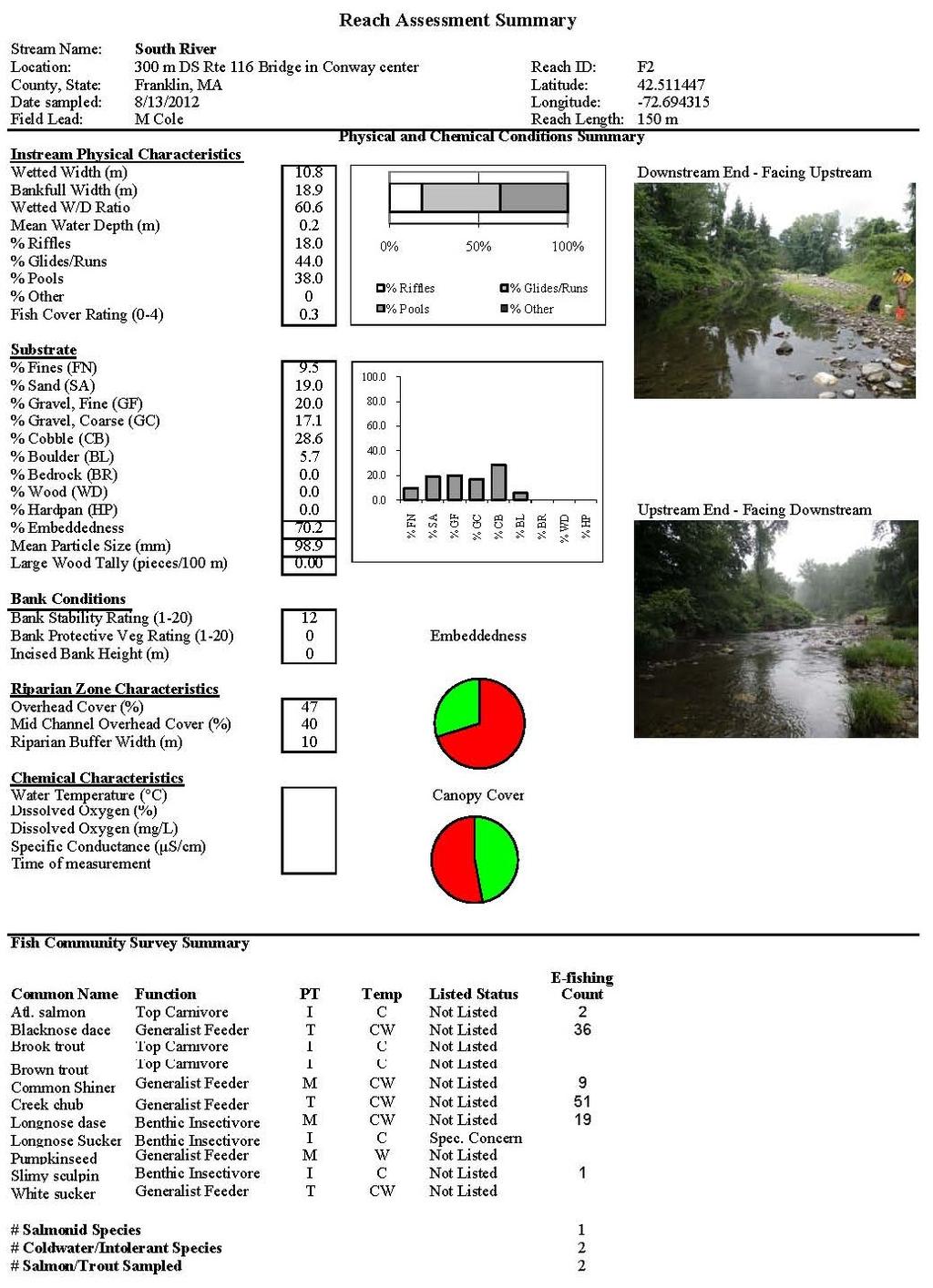
24 REACH F2 (RIVER MILE 5.4) - IMPACTED Reach F2 occurred at the lower end of a section of river approximately 300 m below the Main Street bridge in Conway Center. This reach was selected to exemplify the unsuitable habitat conditions prevalent in the lower river as a result of historic straightening of river segments. This study reach occurred within the Geomorphic Assessment Segment 10E (Field 2013), a section of river that is characterized as low-gradient (0.73%; Field 2013) and unconfined. In its current straightened condition, the river is attempting create meanders via bar development and lateral erosion. This section of river has been identified as a priority restoration location with a total needs score of 31 (Field 2013). The study reach occurring in this straightened section of river was dominated by shallow pool and glide habitats. In-stream habitat complexity was low, and channel widening due to lateral bank scour resulted in the highest bankfull width-to-depth ratio measured among all habitat assessment reaches. Large woody debris was absent from the reach. Bank erosion was rated as moderate, but the true extent and capacity for lateral erosion was likely concealed by late-summer overhanging vegetation. Substrate embeddedness (70.2%) was the highest measured among all reaches, partially influenced by the low gradient and lower-velocity habitats, but also a consequence of elevated erosion rates resulting from an unstable channel condition in this reach (as described in Field 2013). 13
25 Maximum daily water temperature measured another 0.6 miles downriver from this reach averaged 71.6 o F during the monitoring period, representing a rate warming of 1.26 o F/river mile between temperature monitoring station T2 and habitat assessment reach F1 (temperature monitoring station T1; Figure 5). Fish community sampling in this reach resulted in the capture of six fish species. The community was heavily dominated by disturbance tolerant species, including blacknose dace, creek chub, and longnose dace. A single slimy sculpin and two juvenile Atlantic salmon were also sampled from this reach. These community characteristics are consistent with the unfavorable habitat conditions measured in this reach, and are likely representative of community conditions throughout the lower South River within the Conway agricultural zone. In addition to degraded instream habitat conditions, riparian areas are lacking mature trees throughout much of this length of river. The Geomorphic Assessment suggests the potential for these areas in the lower river with reduced riparian tree cover to produce conditions unsuitable for trout (Field 2013), and the results of this report corroborate this concern. 14
26 REACH F3 (RIVER MILE 5.6) - IMPACTED Reach F3 extended from immediately below the confluence with Pumpkin Hollow Brook downriver to approximately 100 m below the Main Street bridge. This habitat assessment reach occurs at the upper end of the Geomorphic Assessment Reach 10. Field (2013) describes this short section of river immediately below the confluence of Pumpkin Hollow Brook as confined by glacial deposits and channel incision. This reach was included in the fish and habitat survey because the upper end of this reach immediately below Pumpkin Hollow Brook has been identified as a priority restoration area (Field 2013). Conceptual restoration plans include the installation of instream weirs that will potentially increase habitat complexity in the upper end of the reach. While only ~100 m upstream of the upper end of habitat assessment reach F2, this reach exhibits different habitat characteristics, including larger channel substrate and a more discrete riffle-pool morphology. Habitat was more heterogeneous than immediately downriver, consisting of relatively equal proportions of riffle, pool, and glide habitats. However, pools were small, shallow, and were dominated by fine sediment. No woody debris occurred within the reach. A general lack of instream cover resulted in the lowest fish cover index score among all reaches sampled. 15
. REACH F4 (RIVER MILE 8.")
27 Seven fish species were sampled from this reach, including two intolerant species: slimy sculpin and Atlantic salmon. However, this reach was still numerically dominated by tolerant fish species, including blacknose dace, creek chub, and longnose dace (Table 5). REACH F4 (RIVER MILE 8.3) - REFERENCE Reach F4 occurs at river mile 8.3, approximately 300 m downriver of the Route 116 bridge immediately east of Brester Road. This section occurs within Geomorphic Assessment Segment 17B, characterized as a steeper, confined channel supporting a step-pool morphology (Field 2013). This reach was selected as a reference habitat reach for steeper-gradient sections, as the steep valley walls and mature forested provide a local buffer against any significant channel or riparian alteration. Owing to the higher gradient (1.7%), the increased stream power that occurs in this section effectively transports smaller substrates to downstream reaches, resulting in dominance by cobble and boulder substrates. These large substrates provide complexity in the stream channel necessary to support diverse fish communities; as such, this reach received one of the highest fish cover index scores in the study. Despite a lack of woody debris in the immediate assessment reach, large wood pieces were observed in and spanning over the channel immediately upriver. 16

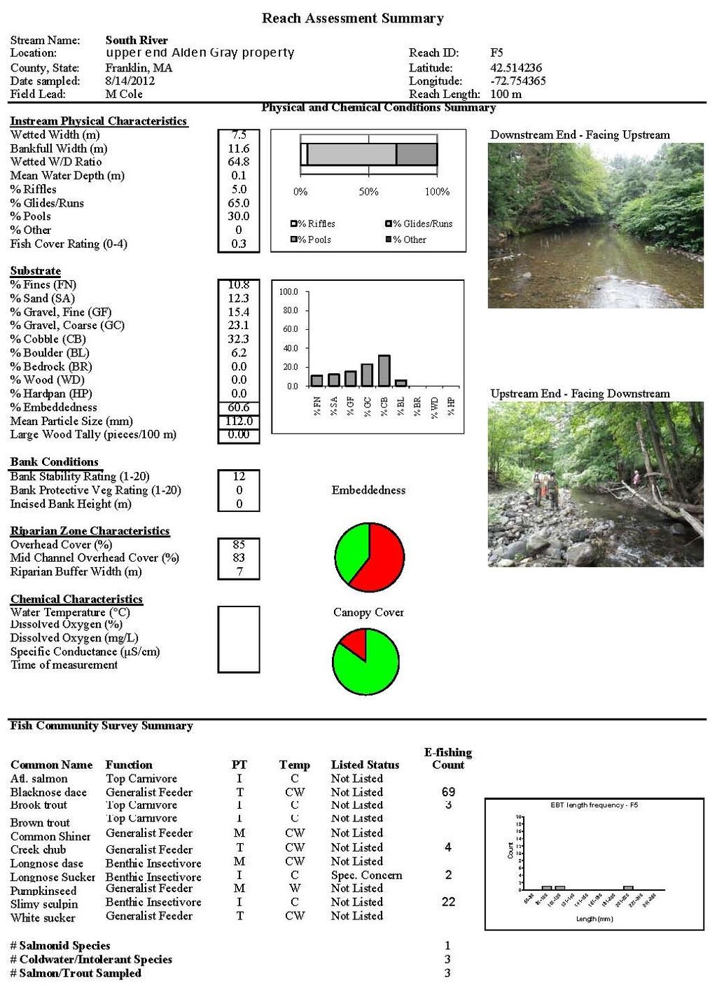
28 The fish community in this reach was similar to that sampled in reach F3, but also included the capture of 4 longnose suckers. Longnose and blacknose dace were once again numerically dominant species, but slimy sculpin abundance was higher than in reach F3. Importantly, sampling efficiency in this reach was reduced, as sampling was performed as a rain event increased streamflow and turbidity. Capture efficiencies in this reach were no doubt lower than in all other reaches. REACH F5 (RIVER MILE 10.0) - IMPACTED Fish and habitat assessment reach F5 occurs at river mile This section of river occurs upriver of the confluence with Poland Brook, and is characterized as occurring in a wide, lowergradient valley relative to upriver and downriver sections (Field 2013). This reach occurs within Geomorphic Assessment Segment 18G, much of which has historically been straightened and channelized (Field 2013). Habitat assessment reach F5 was established to characterize habitat and fish community attributes under these modified conditions. Among reaches in the upper portions of the South River, F5 had the highest proportion of glide habitat and the lowest fish cover index score. The reach was dominated by gravel and cobble substrate which was heavily embedded with sediment (60% reach-wide embeddedness), resulting in unfavorable conditions for trout spawning. Water depths were uniformly shallow 17
29 through the reach, creating low habitat diversity for fish communities. Large woody debris was absent from the reach. Five species of fish were sampled from this reach, and the sample was numerically dominated by blacknose dace. However, three intolerant species, including slimy sculpin, longnose sucker, and brook trout were all sampled from this reach. The three brook trout were all sampled from the upper end of the reach, where a scour pool has formed on river right, creating suitable cover for trout. Otherwise, the reach provides almost no suitable habitat for trout or salmon. Despite degraded habitat quality, water temperatures in this reach are likely suitable for supporting trout through the summer months, as evidenced by the low water temperatures measured at temperature monitoring station T6, located another 0.4 mile upriver. Daily maximum water temperatures at this station averaged nearly 3 o F lower at this station than at station T5, located at river mile 8.5. The geomorphic assessment identified this section of river as a strong candidate for opportunities for land conversation and restoration projects (Field 2013). Because water temperatures in this reach are likely suitable for supporting wild trout populations and habitat appears to be the primary limiting factor, such projects focused on restoring natural channel processes should restore habitat conditions more suitable for wild trout. 18
.")
30 REACH F6 (RIVER MILE 10.4) REFERENCE Reach F6 occurs downriver of the Creamery Brook confluence in a section of the South River that is constrained by a narrow valley. This section of the river exhibits a steep riffle-pool morphology occurring on a 1.9% channel gradient (Field 2013). An intact riparian zone provides ample stream shading and some bank erosion protection from increased sediment loads being delivered from Creamery Brook. Canopy cover was measured as 91%, the highest among all reaches included in the study. Instream habitat is dominated by a relatively even apportioning of riffle and pool habitat, although pool depths were generally shallow as a result of heavy silt and sand deposits. Substrate consisted of a heterogeneous mixture of grain sizes, dominated by cobble and small boulder. Reach-wide embeddedness was generally low (28%), primarily as a result of the higher stream power s capacity to move sediments through this reach. Despite an absence of instream large woody debris, the instream fish cover index was among the highest in the study as a result of the heterogeneous substrate composition and high frequency of pools. Water temperature monitoring station, T6, was co-located with this habitat assessment reach. Daily maximum water temperatures during the monitoring period averaged 66.1 o F, and the maximum 7-day average maximum temperature was 71.4 o F, both within the tolerance limits of brook trout. Despite these apparently favorable conditions, no brook trout were sampled from 19

31 this reach. In fact, only four fish species were sampled, and none of these were salmonids; blacknose dace numerically dominated the sample, while slimy sculpin and longnose dace were also relatively abundant. Four longnose suckers were also sampled from this reach. The absence of salmonids from the sample, while suggesting lower-than-expected abundance in this section of river, should not be interpreted to indicate an inability of this section of river to support these fish species. Brook trout were sampled both above and below this reach, and habitat attributes, while not optimal, can support trout. This section of river would undoubtedly benefit from occasional recruitment of large wood to produce a wider range of depth and velocity regimes. Rather than encouraging active restoration in these areas, simply leaving riparian zones intact in order to serve as natural sources of large wood would provide this function in the long term. REACH F7 (RIVER MILE 11.3) IMPACTED Reach F7 occurs at river mile 11.3 in an active pasture on the downriver side of Burton Hill Road in Ashfield. This reach occurs within Geomorphic Assessment Segment 20A, identified as having severely destabilized banks as a result of active grazing pressure and a lack of riparian vegetation (Field 2013). This reach was selected to represent heavily degraded habitat conditions in this section of the upper river, where agriculture firsts begins to significantly 20
32 impact the river along its course to the Deerfield River. This reach is paired with reach F9, occurring another 0.6 miles upriver, and as described later. Reach F7 is the first habitat reach occurring above the confluence with Creamery Brook. Consequently, channel dimensions are notably smaller than those in reach F6 (See Appendix 2). Reach F7 was dominated by shallow riffle habitat. Banks show areas of active erosion and slumping, a consequence of active grazing and trampling by cattle, combined with a lack of any riparian vegetation. Canopy cover was 52%, the lowest measured among all survey reaches. Substrates were dominated by gravels and cobbles. Embeddedness was high at 57.2%. The fish cover index score was the second lowest among all survey reaches. Several deep plunge pools formed by aged instream structures associated with a small bridge crossing created much-needed habitat diversity in the reach. Consequently, fish abundance and richness was the highest among all reaches in the upper river. While blacknose dace numerically dominated the sample, the intolerant species brook trout, longnose sucker, and slimy sculpin were all present. Two brown trout were also sampled from this reach, representing the downriver-most location this species was sampled. These results suggest that habitat and water quality conditions are generally favorable for supporting wild trout in this section of river above of the confluence of Creamery Brook. As such, any efforts to improve habitat conditions in locally degraded reaches such as the reach F7 cow pasture should result in significant benefits to trout populations. 21

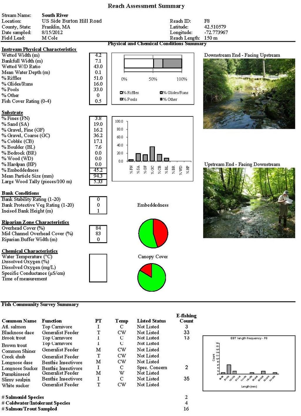
33 REACH F8 (RIVER MILE 11.4) REFERENCE Reach F8 occurs on the upstream side of Burton Hill Road at river mile This reach occurs within the Geomorphic Assessment Segment 20B. Although significant bank erosion occurs in this reach, it was assigned to the reference reach class because a sinuous planform and riffle-pool morphology has been maintained through this reach. However, for purposes of assessing the potential condition of reach F7 relative to its current degraded state, it was decided to choose another reference reach further upriver to represent a more stable channel condition with more favorable habitat conditions for wild trout (reach F9). Significant bank erosion is occurring at the lower end of the reach, in particular, where an absence of riparian vegetation along an outside bend on river left is resulting in property loss. This reach received the third lowest bank stability index rating (8 of 20, marginal). Shallow riffle habitat dominated the reach, interceded by shallow pools and glides. Substrate was dominated by gravel and cobble, with embeddedness averaging 57.2% through the reach. Canopy cover was high through most of the reach (excepting the lawn on river left at the lower end), but the bank protective vegetation index was marginal. This was the first reach within which large woody debris accumulation in the channel was measured; LWD frequency averaged 5.3 pieces/100 m. 22

34 Daily maximum water temperature in this reach averaged 66.5 o F, 0.5 o F warmer than that measured just downriver of the confluence with Creamery Brook, suggesting a slight cooling effect of Creamery Brook on the South River under hydrologic and climatic conditions similar to those during summer Five species of fish were sampled from this reach. Slimy sculpin were the most abundant fish, followed closely by blacknose dace. Three juvenile Atlantic salmon were sampled, as well as 13 brook trout. Two longnose suckers were also sampled from this reach. Reach F8 was the lowest reach in which the number of intolerant fish sampled exceeded the number of tolerant fish sampled. Despite obvious encroachment of agriculture and infrastructure on the riparian corridor and river channel along this longer section of the South River, habitat and water quality are still generally favorable for wild fish. Projects that seek to restore and conserve riparian areas in this section of river are highly encouraged. REACH F9 (RIVER MILE 11.9) REFERENCE Reach F9 occurs at river mile 11.9 immediately downriver of the Double Edge Theatre in Ashfield. This reach occurs within the Geomorphic Assessment Segment 20D, characterized as having a well-developed floodplain, lower gradient, and riffle-pool morphology. Reach F9 was selected as a reference to represent potentially attainable conditions in reach F7. Reach F9 23
35 supported an even mix of riffle and pool habitats, including several pools that were deep and provided cover in the form of root wads and/or undercut banks. Substrate was dominated by gravels and cobble, and while reach-wide embeddedness was moderately high at 45%, gravel substrates observed at pool tail outs appeared sufficiently clean to support trout spawning. A bank stability index of 14 out of 20 was among the highest recorded for the study, as was the rapid habitat assessment index of 14.6 out of 20. The fish cover index was the highest measured in the study, supported by a prevalence of deeper pools, undercut banks, and large woody debris. The fish community responded favorably to these habitat conditions, as seven species of fish were sampled, including four intolerant species and two trout species. Thirty-three brook and eight brown trout were sampled from this reach, the highest number of either species recorded from any reach. Slimy sculpin were the dominant species, and brook trout closely followed as the second most abundant. Several age classes of brook trout were sampled, and sizes ranged from 70 to 260 mm. The habitat features supported in this reach exemplify those that restoration efforts elsewhere should seek to produce. The abundance of wild trout and use of the reach by several age classes of these fish are testimony to these conditions. Importantly, these results also suggest good survival of wild fish in these upper reaches despite the severe floods experienced a year earlier during Tropical Storm Irene. 24

36 REACH F10 (RIVER MILE 12.4) IMPACTED Reach F10 occurs at river mile 12.4 on the downriver side of Emmett Road in Ashfield. This reach occurs in the Geomorphic Assessment Segment 20F, and was selected to further represent a disturbed channel condition in the upper watershed, impacted by drain tiles, channel straightening, and a lack of a riparian zone on river right (partially missing on river left). Both wetted and bankfull channel dimensions are less than 5 m through this reach, as it appears that some channel incision has occurred through sediments deposited on a wide valley floor. This reach exhibits a riffle-pool morphology, and while generally shallow, a few deeper pools also occurred within the reach. While trees are absent from the right-bank riparian zone, late summer growth of tall grasses provided ample shading and overhead cover for instream habitat. Consequently, the fish cover index scored in the range of most of the reference sites. Some large woody debris also occurred in the channel. Substrate was dominated by cobble and gravel, and reach-wide embeddedness was moderately high at 43.3%. With an average daily maximum of 66.7 o F, water temperatures measured at the Emmett Road crossing at the upper end of this reach were very favorable for maintenance of wild trout populations (Table 4). Fish community surveys revealed a dominance by sculpin and salmonids: all three salmonids were sampled at this site, only one of two sites (the other being F11 on the upriver side of Emmett Road) at which this occurred. The fish survey results suggest that 25

37 sensitive fish species continue to thrive in the upper reaches of the South River; disturbance to the channel and riparian zone in these upper reaches has greater consequences for downriver reaches where effects such as increased rates of warming and sediment loading are potentially cumulative. As such, efforts to improve riparian conditions should be the focus of restoration and conservation activities in the upper river. REACH F11 (RIVER MILE 12.5) REFERENCE Reach F11 occurs on the upriver side of Emmett Road at river mile This reach was selected to represent reference conditions for reach F10 occurring on the downriver side of the road crossing. In contrast to reach F10, reach F11 is flanked by mature forest (although the buffer width is narrow along a section of the river left bank) and has not been straightened. Despite this more natural planform, frequencies of riffles and pools were similar to those in reach F10, and substrate conditions were slightly less favorable, partially the result of the higher sinuosity in this reach having a higher capacity for sediment storage. Large woody debris loading was the highest measured in the study (17.3 pieces/100 m). Immediately upriver of this reach is a series of beaver dams impounding the South River. These dams appear to impound a significant amount of sediment, and their occasional failures potentially result in periodic influxes of large sediment loads into this reach. An area of mass wasting was also observed at 26
38 the upriver end of the reach, which also appears to have recently delivered a large quantity of fine sediment in the reach. Fish community conditions in this reach were almost identical to those measured from reach F10. Slimy sculpin appeared to be slightly more abundant, and were utilizing the abundant large woody debris for cover. Brook trout were also relatively abundant in this reach, and both brown trout and Atlantic salmon were captured. Only one species classified as tolerant, blacknose dace, was sampled from this reach, and was represented only by 6 specimens, suggesting a low abundance relative to their numbers sampled further downriver. 27
39 DISCUSSION The South River is a dynamic system, whose tendency to migrate, erode banks, and threaten property and infrastructure has only increased with past management of the river and its floodplain. While much of the South River corridor has been developed for agriculture or rural residential land uses, and the river continues to adjust to legacy effects of dams long gone, much of the corridor remains intact, particularly in the upper and middle reaches. Impacts to the river s condition and functioning are less pronounced in these upper reaches, except where channel straightening or riparian tree removal has resulted in obvious changes. The lessor impacts to the upper river partially result from the generally lower stream power in the upper reaches. Stream power is a function of discharge and channel slope, and stream slopes do not appreciably differ between the upper and lower sections of the river (there are some sections in the mid portions of the river that are more confined and have higher slopes). As such, the upper river, by virtue of transporting less water, should not be as prone to erosion problems as downriver sections. This assessment of the South River characterizes these longitudinal trends in river conditions and characteristics: channel dimensions, substrate, bank vegetation, bank stability, and water temperature. While we cannot precisely parse the effects of human disturbance from natural longitudinal gradients, the observed longitudinal trends in this study, such as warming water temperatures or increased incidence of eroding banks, have no doubt been altered by development of the watershed. This study sought to sample from a range of habitat and channel stability conditions throughout the river and to characterize biological communities across this range of conditions. By establishing sample sites throughout the length of the river and locally pairing sites as conditions allowed, the relative effects of longitudinal gradients versus localized variation in habitat conditions on biological communities could be examined. This study suggests that longitudinal gradients in river conditions, perhaps largely the water temperature regime, clearly have larger effects on biological communities than does local variation at the neighboring-reach scale. This is evidenced in the finding that while significant differences in some habitat attributes occurred between impacted-reference paired reaches (F7 vs F9 and F10 vs F11), fish community composition was almost identical. 28
40 In its current condition, the lower South River from the lower Reeds Bridge Road Bridge upriver through Conway generally lacks large woody debris and other instream cover, exhibits a wide channel that supports very shallow baseflows, and has warm water during summer months. In contrast, even the most heavily degraded reaches in the upper river maintain cool summer water temperatures and sufficient habitat complexity and cover to support wild trout. Corresponding longitudinal trends in fish community composition was highly evident: brook trout are effectively scarce in the lower river, but are abundant even in heavily disturbed reaches in the upper river such as reach F7. Furthermore, as the richness and abundance of intolerant fish species increased in an upriver direction, tolerant species trended in the opposite direction. Blacknose dace were the dominant species throughout the lower and middle river, but exhibited an abrupt decrease in dominance above reach F7, just upriver of the confluence with Creamery Brook. This study demonstrated that the upper South River supports wild populations of both brook trout and brown trout. Multiple year classes, including young-of-the-year fish, of each species were sampled. In contrast, brook and brown trout are scarce in the lower South River, at least during the summer months. Competition with and displacement by juvenile Atlantic salmon is one plausible explanation (Jackson and Zydlewski 2009). Both brook and brown trout have coevolved with Atlantic salmon in their native ranges, so under favorable environmental conditions, both trout species should be expected to co-exist with juvenile Atlantic salmon. However, as juvenile Atlantic salmon have a higher tolerance for elevated water temperatures than do brook trout, under temperature duress and high Atlantic salmon densities, brook trout may be at a competitive disadvantage. While Atlantic salmon abundance was generally low in the river (and result exclusively from stocking efforts) during these 2012 surveys, previous surveys by MDFW have shown that Atlantic salmon abundance has been much higher (2010 MDFW data, Alicia Norris, personal communication), suggesting that the lack of stocking this past year following Tropical Storm Irene has resulted in temporarily reduced numbers of juvenile salmon in the river. In fact a 2010 fish survey by MDFW of a 100-m section of the South River on the west side of Conway captured 147 juvenile Atlantic salmon. At these numbers, and considering a lack of instream habitat complexity through much of the river, juvenile Atlantic salmon may be suppressing brook trout numbers through much of the middle and lower river. 29
41 MassDEP s 2000 Deerfield River Watershed Assessment also calls into question the potential effect of juvenile Atlantic salmon on native brook trout and other fishes (MassDEP 2004). Most likely, an interplay between unfavorable habitat conditions and some inter-specific competition precludes regular use of the lower South River by brook and brown trout was a particularly hot and dry summer, likely producing less favorable habitat conditions for wild trout in the lower river than during cooler, wetter summers. Pumpkin Hollow Brook potentially serves as an important thermal refuge for trout in parts of the lower river, and provides a local source of individuals to seasonally utilize the South River when conditions are more favorable. While no brook trout were captured in the Conway section of the river during this survey, one brook trout was clearly observed evading capture in reach F3 within meters of the confluence with Pumpkin Hollow Brook. This fish was undoubtedly seeking the cool water inputs into the South River from Pumpkin Hollow Brook. Despite two centuries of modification and manipulation, much of the South River continues to provide valuable habitat for sensitive aquatic species. A 2006 survey by the Deerfield River Watershed Association suggested that most all of the South River supports minimally or nonimpaired macroinvertebrate communities (Cole 2007). The results of the present study suggest that a strategy for protecting and enhancing wild trout populations in the South River could partially focus on conserving and restoring riparian conditions in the upper South River. The upper river experiences the highest rates of water temperature warming. Improvement of riparian conditions and attendant stream shading may reduce these warming rates, thereby improving the capacity of downriver reaches to support intolerant fish species. The lower river, by virtue of widespread reduction in habitat complexity and quality, would benefit from projects that seek to improve river functioning and help return the river to more natural geomorphic state; these efforts would produce the habitat elements such as deep pools and instream cover that are requisite for healthy fish communities, and also provide capacity to support larger numbers of salmon and trout. The Geomorphic Assessment completed by Field Geology Services (Field 2013) provides a road map for such efforts. This study helps inform the virtue and necessity of those proposed efforts, and also serves as a baseline against which progress towards improving ecological conditions in the South River watershed can be measured. 30
42 CONCLUSIONS AND RECOMMENDATIONS: Physical habitat conditions in the South River range widely, but a general trend in increasingly degraded conditions occurs in a downriver direction. These longitudinal trends exhibit a stronger influence on fish community composition than does local variation in habitat conditions. Limiting factors in the upper river, where they occur, include a lack in instream complexity and cover, and elevated sediment loading. Much of the upper river supports intact habitat, and summer water temperatures are favorable for supporting wild trout populations. Fish communities in the upper river reflect this capacity and are dominated by salmonids and other intolerant species. The lower River, particularly below the town of Conway, suffers from localized effects of channel straightening and increased sediment production, and also from cumulative effects from upriver impacts. Limiting factors in much of the lower river include low habitat quality and complexity (lack of deep pools, instream cover, clean gravels, etc.), and high water temperatures. These degraded conditions are most evident in straightened and channelized sections of the river. These attributes create conditions that are likely also potentially allowing juvenile Atlantic salmon to out-compete wild trout in the lower and middle reaches of the river. The upper river would benefit from land conservation and riparian protection and improvement projects. Wild trout populations are supported by current conditions, and any improvements to habitat only stand to improve local conditions, and minimize cumulative impacts to downriver sections. Such work could be informed by a comprehensive riparian zone study that explicitly identifies reaches most in need of increased stream shading. The lower river would benefit from restoration projects recommended in the Geomorphic Assessment (Field 2013) that would help restore a more natural planform to the river and promote the creation of habitat features conducive to supporting wild fish. 31
43 Further assessment of summertime trout distribution over a wider range of summer conditions and water temperatures will assist with further determining distribution and abundance of wild trout in the lower river and further identify limiting factors. Restoration and protection of riparian areas along the entire river are highly recommended and will be critical to the long-term improvement of habitat conditions in the lower river. 32
44 LITERATURE CITED Cole, M. B South River Watershed Macroinvertebrate Assessment. Unpublished report prepared for the Deerfield River Watershed Association, Greenfield, Massachusetts. Field, J Fluvial Geomorphic Assessment of the South River Watershed, MA. Prepared for the Franklin Regional Council of Governments, Greenfield, Massachusetts. Jackson, C.A.L, and Zydlewski, J Summer movements of sub-adult brook trout, landlocked Atlantic salmon, and smallmouth bass in the Rapid River, Maine. Journal of Freshwater Ecology, 24:4. MassDEP Standard Operating Procedure: Continuous Temperature Monitoring. Massachusetts Department of Environmental Protection, Division of Watershed Management. Worcester, MA. MassDEP Deerfield River Watershed 2000 Water Quality Assessment Report. Report number 33-AC-1. Massachusetts Department of Environmental Protection, Division of Watershed Management. Worcester, MA. USEPA Wadeable Stream Assessment: Field Operations Manual. EPA841-B U.S. Environmental Protection Agency, Office of Water and Office of Research and Development, Washington, DC. 33
45 Table 1.List of reaches from which fish and physical habitat were sampled from the South River in August Reach Code River Mile Water-body Location Description Impact/ Ref Geomorph Segment Total Needs Score Channel Type Lat Long F1 2.6 South R above lower Reeds Bridge I 7A 32 C, L F2 5.4 South R 300 m below Main St bridge I 10E 31 UC, L F3 5.6 South R 100 m blw Main St Br to P. Hollow I 10E 31 C, M F4 8.3 South R 300 m DS Rt 116 Br blw Brester Rd R 17B 10 C, H F South R Alden Gray property I 18G 31 UC, L F South R 1/6 mile DS Bullitt Rd R 19C 24 C, H F South R DS side Burton Hill Road I 20A 31 UC, M F South R US side Burton Hill Road I/R 20B 18 UC, L F South R behind Double Edge Theatre R 20D 12 UC, L F South R Downstream of Emmet Road I 20F 23 UC, L F South R Upstream of Emmet Road R 20G 7 UC, L F Creamery Bk 50 m above confluence with SR I NA NA C, M Channel type: Classified according to major South River channel types identified in Field 2013: C = confined, U = unconfined, L = low energy, M = moderate energy, H = high energy. 34
46 Table 2. Mean, minimum, and maximum values of physical habitat attributes measured from 11 reaches in the South River in August Variable Mean Min Max Mean Water Depth Wetted Width W:D Ratio Bankfull Width Bankfull Height Bankfull W:D Ratio SD Thalweg Depth Percent Glide Habitat Percent Riffle Habitat Percent Pool Habitat Percent Cascade Habitat Embeddedness % Sand/Fines % Coarse Substrate Mean Particle Size Fish Cover Index (0-4) Bank Stability Index (0-20) Bank Veg Prot Index (0-20) % Canopy Cover Mid-Stream Can Cov Rip Veg Zone Width Index Pieces LWD/100 m Rapid Hab Assess
47 Table 3. Impacted and reference reach group means of physical habitat attributes measured from 11 reaches in the South River in August Impacted (n = 6) Reference (n = 5) Habitat Variable Mean SD Mean SD MeanWaterDepth WettedWidth WDRatio BankfullWidth BankfullHeight BankfullWDRatio SDThalwegDepth PercentGlideHabitat PercentRiffleHabitat PercentPoolHabitat PercentCascadeHabitat Embeddedness Sand/Fines CoarseSubstrate MeanParticleSize FishCoverIndex BankStabilityIndex BankVegProtIndex CanopyCover Mid-StreamCanCov RipZoneWidthIndex PiecesLWD RapidHabAssess
48 Table 4. Water temperature metrics calculated from 9 temperature monitoring stations in the South River, summer Temp Station Habitat Reach River Mile Avg Daily Mean ( o F) Avg Daily Max ( o F) Max 7D Avg Max ( o F) T1 F T T3 F T T5 F T6 F T7 F T8 F T9 F
49 Table 5. Fish community composition from 11 South River and 1 Creamery Brook sample site surveyed in August Reach Code Common Name PT Temp F1 F2 F3 F4 F5 F6 F7 F8 F9 F10 F11 F12 Atlantic salmon I C Blacknose dace T CW Brook trout I C Brown trout I C Common Shiner M CW Creek chub T CW Longnose dace M CW Longnose Sucker I C Pumpkinseed M W 1 Slimy sculpin I C White sucker T CW 3 Grand Total
50 Table 6. Fish community attributes calculated from fish surveys in the South River, August Reach Code Community Attribute F1 F2 F3 F4 F5 F6 F7 F8 F9 F10 F11 F12 # Salmonid Species # Coldwater/Intolerant Species # Salmon/Trout Sampled
51 Table 7. Correlations between select environmental variables and fish community metrics measured from 11 sampling stations along the South River in August # Salmonid Sp. # Cold-Water Sp. # Tr/Sal Indiv Environmental Variable Pearson r P Value Pearson r P Value Pearson r P Value Wetted Width W/D Ratio % Glides % Embeddedness Fish Cover Index Max 7D Avg Max Temp

52 Figure 1. Map of summer 2012 fish and physical habitat sampling stations in the South River. 41
53 Wetted Width (m) Mean Particle Size (mm) F1 F2 F3 F4 F5 F6 F7 F8 F9 F10 F11 Site Code 0 F1 F2 F3 F4 F5 F6 F7 F8 F9 F10 F11 Site Code W/DRatio Large Woody Debris Pieces LWD/100 m F1 F2 F3 F4 F5 F6 F7 F8 F9 F10 F11 Site Code 0 F1 F2 F3 F4 F5 F6 F7 F8 F9 F10 F11 Site Code %Glide Habitat Bank Stability Index F1 F2 F3 F4 F5 F6 F7 F8 F9 F10 F11 Site Code 0 F1 F2 F3 F4 F5 F6 F7 F8 F9 F10 F11 Site Code Mean Water Depth (m) Bank Vegetation Index F1 F2 F3 F4 F5 F6 F7 F8 F9 F10 F11 Site Code 0 F1 F2 F3 F4 F5 F6 F7 F8 F9 F10 F11 Site Code Figure 2. Habitat attributes measured in 2012 that exhibited apparent longitudinal trends along the South River. 42
54 Reach F1 Reach F2 Reach F Frequency (%) Frequency (%) Frequency (%) FN SA GF GC CB SB XB BR Particle Size Class 0 FN SA GF GC CB SB XB BR Particle Size Class 0 FN SA GF GC CB SB XB BR Particle Size Class Reach F4 Reach F5 Reach F Frequency (%) Frequency (%) Frequency (%) FN SA GF GC CB SB XB BR Particle Size Class 0 FN SA GF GC CB SB XB BR Particle Size Class 0 FN SA GF GC CB SB XB BR Particle Size Class Reach F7 Reach F8 Reach F Frequency (%) Frequency (%) Frequency (%) FN SA GF GC CB SB XB BR Particle Size Class 0 FN SA GF GC CB SB XB BR Particle Size Class 0 FN SA GF GC CB SB XB BR Particle Size Class Reach F10 Reach F Frequency (%) Frequency (%) FN SA GF GC CB SB XB BR Particle Size Class 0 FN SA GF GC CB SB XB BR Particle Size Class Figure 3. Substrate size class frequencies measured during habitat assessments of the South River in August
55 4 3 Heavy Impacted Reference Index Rating 2 1 Moderate Sparse 0 Woody Debris (>.3) Brush/Woody Debris Live Trees/Roots Overhang Veg Undercut Banks Boulders Cover Element Figure 4. Fish cover index ratings for six cover elements assessed during physical habitat assessments of the South River in August
56 Water Temperature ( o F) DailyAvg DailyMax Max7DayMax RiverMile Figure 5. Water temperature metrics by river mile along the South River, summer Warming rate ( degree F/river mile) Avg Daily Mean Avg Daily Max Max 7D Avg Max T2-T1 T3-T2 T4-T3 T5-T4 T6-T5 T7-T6 T8-T7 T9-T8 Segment Figure 6. Summer 2012 water temperature warming rates calculated between temperature monitoring stations on the South River. 45
57 #Trout/Salmon Species Sampled 3 # Species F1 F2 F3 F4 F5 F6 F7 F8 F9 F10 F11 F12 Reach Code # Cold-Water Species Sampled 4 # Species F1 F2 F3 F4 F5 F6 F7 F8 F9 F10 F11 F12 Reach Code # Trout/Salmon Sampled 50 # Individuals F1 F2 F3 F4 F5 F6 F7 F8 F9 F10 F11 F12 Reach Code Figure 7. Fish metrics calculated from fish surveys performed in 11 reaches in the South River and 1 reach in Creamery Brook in August
58 EBT abundance vs water temperature Max 7-day Avg Max Temp (F) Max Temp (F) 50 EBT Count River Mile EBT Count Figure 8. Number of brook trout captured plotted against maximum 7-day average maximum water temperatures in the South River, August
59 EBT length frequency - all sites Count Length (mm) BT length frequency - all sites Count Length (mm) AS length frequency - all sites Count Length (mm) Figure 9. Length frequencies of trout and salmon sampled from the South River in August EBT = eastern brook trout, BT = brown trout, and AS = Atlantic salmon. 48
60 Appendix 1. Reach Assessment Summaries 49

61 50
62 51

63 52
64 53

65 54
66 55

67 56

68 57

69 58
70 Appendix 2. Summary of habitat attributes measured from the South River in August, Site Code Variable F1 F2 F3 F4 F5 F6 F7 F8 F9 F10 F11 Mean Water Depth Wetted Width W:D Ratio Bankfull Width Bankfull Height Bankfull W:D Ratio SD Thalweg Depth Percent Glide Habitat Percent Riffle Habitat Percent Pool Habitat Percent Cascade Habitat Embeddedness % Sand/Fines % Coarse Substrate Mean Particle Size
71 Fish Cover Index (0-4) Bank Stability Index (0-20) Bank Veg Prot Index (0-20) % Canopy Cover Mid-Stream Can Cov Rip Veg Zone Width Index Pieces LWD/100 m Rapid Hab Assess


 Atlantic")
72 Appendix 3. Fish species sampled from the South River Brook trout (Salvelinus fontinalis) Brown trout (Salmo trutta) Atlantic salmon (Salmo salar) 61


73 Blacknose dace (Rhinichthys atratulus) Longnose dace (Rhinichthys cataractae) Common shiner (Luxillus cornutus) 62
 Longnose")
 Pumpkinseed")


74 Slimy sculpin (Cottus cognatus) Longnose sucker (Catostomus catostomus) Pumpkinseed (Lepomis gibbosus) Not pictured: White sucker (Catostomus commersoni), creek chub (Semotilus atromaculatus) 63
Minnesota Department of Natural Resources Division of Fish and Wildlife Section of Fisheries. Stream Survey Report. Luxemburg Creek.
 Minnesota F-29-R(P)-24 Area 315 Study 3 March 2016 Minnesota Department of Natural Resources Division of Fish and Wildlife Section of Fisheries Stream Survey Report Luxemburg Creek 2015 Mark Pelham Sauk
Rehabilitation of Grimes Creek, a Stream Impacted in the Past by Bucket-lined Dredge Gold Mining, Boise River Drainage, July 2008 to August 2011.
 Rehabilitation of Grimes Creek, a Stream Impacted in the Past by Bucket-lined Dredge Gold Mining, Boise River Drainage, July 2008 to August 2011. Pam Harrington TU,1020 W. Main Street Suite 440, Boise,
STEELHEAD SURVEYS IN OMAK CREEK
 STEELHEAD SURVEYS IN OMAK CREEK 2002 Annual Report Prepared by Chris Fisher John Arterburn Colville Confederated Tribes Fish and Wildlife Department P.O. Box 150 Nespelem, WA 99155 Prepared for Project
Report prepared for: Prepared by: January 2002 BEAK Ref
 AQUATIC ENVIRONMENTAL STUDY KANATA WEST CONCEPT PLAN Report prepared for: ROBINSON CONSULTANTS Prepared by: BEAK INTERNATIONAL INCORPORATED 14 Abacus Road Brampton, Ontario L6T 5B7 January 2002 BEAK Ref.
Minnesota Department of Natural Resources Division of Fish and Wildlife Section of Fisheries. Stream Survey Report. Three Mile Creek 2011
 Minnesota Department of Natural Resources Division of Fish and Wildlife Section of Fisheries Stream Survey Report Three Mile Creek 2011 By Joseph D. Stewig Montrose Area Fisheries Office TABLE OF CONTENTS
Preakness Brook - FIBI098
 Preakness Brook - FIBI098 Preakn ess B rook Preakness " ( FIBI098 Naachtpunkt Brook 202 80 IBI Ratings FIBI Sampling Location Excellent Small Streams (1st and 2nd Order) Good Fair Large Streams (3rd Order
Study Update Tailrace Slough Use by Anadromous Salmonids
 Study Update Tailrace Slough Use by Anadromous Salmonids Goals and Objectives Identify what anadromous salmonids use the tailrace slough by: Life Stage (Juvenile, migrating and spawning adults) Timing
Big Spring Creek Habitat Enhancement and Fishery Management Plans
 Big Spring Creek Habitat Enhancement and Fishery Management Plans November 5, 2012 Big Spring Events and Activities Center Newville, PA Charlie McGarrell Regional Habitat Biologist Pennsylvania Fish and
FISHERIES BLUE MOUNTAINS ADAPTATION PARTNERSHIP
 FISHERIES A warming climate, by itself, substantially affects the hydrology of watersheds in the Blue Mountains. Among the key hydrologic changes projected under all scenarios for the 2040s and beyond
Jason Blackburn, Paul Hvenegaard, Dave Jackson, Tyler Johns, Chad Judd, Scott Seward and Juanna Thompson
 Alberta Conservation Association (ACA) Date: 2014-2015 Project Name: Owl River Walleye and Aquatic Habitat Assessment Fisheries Program Manager: Peter Aku Project Leader: Tyler Johns Primary ACA staff
F I B I ST 519 OP 57. [ Excellent [ Fair. [ Poor. U p p e r D e l a w a r e W M A 1. C e n t r a l D e l a w a r e W M A 1 1.
 L o p a t c o n g C r e e k F I B I 0 0 4 # Allens Mills Uniontown # ST 519 U p p e r D e l a w a r e W M A 1 Lopatcong Creek 22 OP 57 [ 78 Still Valley # C e n t r a l D e l a w a r e W M A 1 1 FIBI Rating
Study No. 18. Mystic Lake, Montana. PPL Montana 45 Basin Creek Road Butte, Montana 59701
 Study No. 18 Evaluation of the Current Fish Population and Habitat in West Rosebud Creek Downstream from Emerald Lake Mystic Lake Hydroelectric Project FERC No. 2301 Mystic Lake, Montana PPL Montana 45
STUDY PERFORMANCE REPORT
 STUDY PERFORMANCE REPORT State: Michigan Project No.: F-80-R-4 Study No.: 702 Title: Effects of sediment traps on Michigan river channels Period Covered: October 1, 2002 to September 30, 2003 Study Objectives:
SUMMARY OF RESULTS FIBI098
 SUMMARY OF RESULTS FIBI098 1. Stream Name: Preakness Brook 2. Sampling Date: 7/9/2009 3. Sampling Location: Preakness Avenue 4. Municipality Totowa 5. County: Passaic 6. Watershed Management Area: 4 7.
MCCAW REACH RESTORATION
 Final Report MCCAW REACH FISH RESTORATION PHASE B Jack McCaw Inland Empire Action Coalition http://www.wwccd.net/ Phone: 509-956-3777 Hours: 8:00-4:30 Walla Walla County Conservation District Snake River
San Lorenzo Valley Water District, Watershed Management Plan, Final Version Part I: Existing Conditions Report
 LIST OF FIGURES Figure 1-1. Map of the San Lorenzo River watershed Figure 2-1. The Santa Cruz Mountains Bioregion Figure 2-2. Protected areas within the San Lorenzo River watershed Figure 2-3. Primary
Holderness. The Three Watersheds within the Newfound Lake Drainage Dorchester. Groton Plymouth. Ashland. Hebron. Canaan. Bridgewater.
 Background Brook trout are the only native stream dwelling trout species in New Hampshire, having a historic range that extended from Georgia to eastern Canada. It is believed that wild brook trout were
SUMMARY OF RESULTS FIBI054
 SUMMARY OF RESULTS FIBI054 1. Stream Name: Lamington River 2. Sampling Date: 7/10/2007 3. Sampling Location: McCann Mill Road 4. Municipality Tewksbury Township 5. County: Hunterdon 6. Watershed Management
FISH PASSAGE IMPROVEMENT in California s Watersheds. Assessments & Recommendations by the Fish Passage Forum
 FISH PASSAGE IMPROVEMENT in California s Watersheds Assessments & Recommendations by the Fish Passage Forum FISH PASSAGE IMPROVEMENT in California s Watersheds The mission of the Fish Passage Forum is
Trout Unlimited Comments on the Scope of Environmental Impact Statement for the Constitution Pipeline Project, Docket No. PF12-9
 October 9, 2012 Kimberly D. Bose, Secretary Federal Energy Regulatory Commission 888 First Street, NE, Room 1A Washington, DC 20426 RE: Trout Unlimited Comments on the Scope of Environmental Impact Statement
Culvert Design for Low and High Gradient Streams in the Midwest. Dale Higgins, Hydrologist Chequamegon-Nicolet National Forest
 Culvert Design for Low and High Gradient Streams in the Midwest Dale Higgins, Hydrologist Chequamegon-Nicolet National Forest Overview Culvert Design Considerations Hydraulic Terms Culvert Impacts Low
Hydraulic Modeling of Stream Enhancement Methods
 Hydraulic Modeling of Stream Enhancement Methods Matthew J. Curry John J. Levitsky Abstract Development within watersheds increases the amounts of runoff causing stream erosion and degradation of stream
Aquatic Organism Passage at Road-Stream Crossings CHUCK KEEPORTS FOREST HYDROLOGIST ALLEGHENY NATIONAL FOREST WARREN, PENNSYLVANIA
 Aquatic Organism Passage at Road-Stream Crossings CHUCK KEEPORTS FOREST HYDROLOGIST ALLEGHENY NATIONAL FOREST WARREN, PENNSYLVANIA TOPICS COVERED Aquatic Organism Passage (AOP) Benefits of AOP Crossings
Minnesota Department of Natural Resources Division of Fish and Wildlife Section of Fisheries. Fairhaven Creek 2000
 Minnesota F-29-R(P)-17 Area 340 Study 3 April 2001 Minnesota Department of Natural Resources Division of Fish and Wildlife Section of Fisheries Stream Survey Report Fairhaven Creek 2000 By Eric R. Altena
Minnesota Department of Natural Resources Division of Fish and Wildlife Section of Fisheries. Stream Survey Report. Cold Spring Creek.
 Minnesota F-29-R(P)-24 Area 315 Study 3 March 2015 Minnesota Department of Natural Resources Division of Fish and Wildlife Section of Fisheries Stream Survey Report Cold Spring Creek 2014 Mark Pelham Montrose
Data Report : Russian River Basin Steelhead and Coho Salmon Monitoring Program Pilot Study
 Data Report 1999-1: Russian River Basin Steelhead and Coho Salmon Monitoring Program Pilot Study Sonoma County Water Agency 215 West College Avenue Santa Rosa, California 951 Prepared by David Cook Senior
Minnesota Department of Natural Resources Division of Fish and Wildlife Section of Fisheries. Stream Survey Report. Cold Spring Creek.
 Minnesota F-29-R(P)-24 Area 315 Study 3 March 2013 Minnesota Department of Natural Resources Division of Fish and Wildlife Section of Fisheries Stream Survey Report Cold Spring Creek 2012 Mark Pelham Montrose
Beaver Brook - FIBI047 Hope
 Beaver Brook - FIBI047.-,80 Silve r Lake Mud dy Br ook % Hope Honey Run Beaver Brook FIBI047 #S #S FIBI Sampling Location Small Streams (1st and 2nd Order) Large Streams (3rd Order and Above) N 0 1 2 3
Management of headwater streams in the White Mountain National Forest
 Management of headwater streams in the White Mountain National Forest White Mountain National Forest Weeks Act of 1911 authorized the federal government to purchase lands east of the Mississippi River
Alberta Conservation Association 2017/18 Project Summary Report
 Alberta Conservation Association 2017/18 Project Summary Report Project Name: Abundance, Distribution, Spawning, and Thermal Habitat of Westslope Cutthroat Trout and Bull Trout in the Stimson Creek Watershed
Abundance of Steelhead and Coho Salmon in the Lagunitas Creek Drainage, Marin County, California
 scanned for KRIS Abundance of Steelhead and Coho Salmon in the Lagunitas Creek Drainage, Marin County, California Prepared for: Marin Municipal Water District 220 Nellen Drive Corte Madera, California
Pequannock River - FIBI077
 Pequannock River - FIBI077 Canistear Rsvr. Clint on Brook Clinton R svr. k R r. idge Rs v Echo Lake Oa 23 Pequann ock R iver FIBI077 Kinnelon 287 23 FIBI Sampling Location Small Streams (1st and 2nd Order)
Chagrin River TMDL Appendices. Appendix F
 Appendix F The following are excerpts from the Eastern Brook Trout Joint Venture s Conservation Strategy (Working Draft v.6), Conserving the Eastern Brook Trout: Strategies for Action Found at: http://www.easternbrooktrout.org/constrategy.html
Final Bull Trout Genetics Monitoring Plan for the Wallowa Falls Hydroelectric Project. (FERC No. P-308) June 2017
 June 2017") Final for the Wallowa Falls Hydroelectric Project (FERC No. P-308) June 2017 Prepared by: Jeremiah Doyle PacifiCorp 825 NE Multnomah Street Portland, OR 97232 June, 2017 Page 1 of 8 Table of Contents 1.0
Final for the Wallowa Falls Hydroelectric Project (FERC No. P-308) June 2017 Prepared by: Jeremiah Doyle PacifiCorp 825 NE Multnomah Street Portland, OR 97232 June, 2017 Page 1 of 8 Table of Contents 1.0
Columbia Lake Dam Removal Project
 Columbia Lake Dam Removal Project The Columbia Lake dam located 1/4 mile upstream of the Paulins Kill River's confluence with the Delaware River in Knowlton Township, Warren County has been proposed for
Distribution. PFBC Northcentral Region Law Enforcement Office, Attention: WCO Kraynak, 1150 Spring Creek Road, Bellefonte, PA 16823
 Distribution Pennsylvania Department of Environmental Protection, Northcentral Region Office, Attention: Steve Means, 208 West Third St. Suite 101, Williamsport, PA 17701 PFBC Northcentral Region Law Enforcement
Warner Lakes Redband Trout
 Warner Lakes Redband Trout Existing Populations Warner Valley is an endorheic basin that contains a complex series of interconnected lakes, marshes, sloughs, and potholes, all of which are remnants of
Steelhead Society of BC. Thompson River Watershed Restoration and Enhancement Project #4 Nicola River Bank Stabilization and Enhancement Project
 Steelhead Society of BC Presents: Thompson River Watershed Restoration and Enhancement Project #4 Nicola River Bank Stabilization and Enhancement Project Application for Funding December 2013 1.0 BACKGROUND
Fish Habitat Restoration and Monitoring in Southeast Washington. Andy Hill Eco Logical Research, Inc.
 Fish Habitat Restoration and Monitoring in Southeast Washington Andy Hill Eco Logical Research, Inc. Fish Habitat Restoration and Monitoring in Southeast Washington Talk overview: Restoration projects
Restoring the Kootenai: A Tribal Approach to Restoration of a Large River in Idaho
 Restoring the Kootenai: A Tribal Approach to Restoration of a Large River in Idaho Susan Ireland, Kootenai Tribe of Idaho Future of our Salmon Conference Technical Session August 2016 Healthy Floodplains,
Little Flat Brook - FIBI065
 Little Flat Brook - FIBI065 Beerskill Cre ek 15 FIBI065 Little Flat Br ook Layton 15 FIBI Sampling Location Small Streams (1st and 2nd Order) Large Streams (3rd Order and Above) SUMMARY OF RESULTS FIBI065
Va n Saun Mill Brook. FIBI062a !(208!( 4 !( 20. !( FIBI062a !( 7 !( 67 !( 3 !( 5 !( 21 !(120 !(495 !(139 !(440. !( Good. !( Poor.
 VanSaunMillBrook FIBI062a Brook Va n Saun Mill Brook HirshfeldBroo k!( 20 Pas saicriver Fleis cher Bro ok!(208 Sprout!( 4 " River Edge!( FIBI062a Metzler Brook 46!( 21 Be rryscre ek!( 17 80 Hacke nsack
SUMMARY OF MOVEMENT AND HABITAT USED BY TAGGED BROOK TROUT IN THE MAIN BRANCH AND NORTH BRANCH AU SABLE RIVER DURING SUMMER Data Submitted to:
 SUMMARY OF MOVEMENT AND HABITAT USED BY TAGGED BROOK TROUT IN THE MAIN BRANCH AND NORTH BRANCH AU SABLE RIVER DURING SUMMER 2014 Data Submitted to: Anglers of the Au Sable Submitted by: Dr. Mark R. Luttenton
3. The qualification raised by the ISRP is addressed in #2 above and in the work area submittal and review by the ISRP as addressed in #1.
 Please find attached a response from The Confederated Tribes of the Warm Springs Reservation of Oregon (CTWSRO) for Project # 2008-301-00, Habitat Restoration Planning, Design and Implementation within
TABLE 1. Riverscape surveys completed in the upper Chehalis River, Newaukum, and Satsop rivers.
 RIVERSCAPE SURVEYS OF IN-STREAM FISH ASSEMBLAGES AND HABITAT IN THE CHEHALIS RIVER Mara Zimmerman and John Winkowski Washington Department of Fish and Wildlife, Fish Program EXECUTIVE SUMMARY Introduction
NEVADA DEPARTMENT OF WILDLIFE STATEWIDE FISHERIES MANAGEMENT
 NEVADA DEPARTMENT OF WILDLIFE STATEWIDE FISHERIES MANAGEMENT FEDERAL AID JOB PROGRESS REPORTS F-20-52 2016 REDBAND TROUT EASTERN REGION NEVADA DEPARTMENT OF WILDLIFE, FISHERIES DIVISION ANNUAL JOB PROGRESS
Chinook Salmon Spawning Study Russian River Fall 2005
 Chinook Salmon Spawning Study Russian River Fall 2005 Sonoma County Water Agency 2150 West College Avenue Santa Rosa, California 95401 Prepared by David Cook - Senior Environmental Specialist March 27,
Executive Summary. Map 1. The Santa Clara River watershed with topography.
 Santa Clara River Steelhead Trout: Assessment and Recovery Opportunities December 2005 Prepared By: Matt Stoecker and Elise Kelley, Ph.D. University of California, Santa Barbara Prepared For: The Santa
Eastern Brook Trout. Roadmap to
 Eastern Brook Trout Roadmap to CONSERVATION Our Brook Trout heritage he wild Brook Trout is an American symbol of persistence, adaptability, and the pristine wilderness that covered North America prior
State of San Francisco Bay 2011 Appendix O Steelhead Trout Production as an Indicator of Watershed Health
 State of San Francisco Bay 2011 Appendix O Steelhead Trout Production as an Indicator of Watershed Health Gordon Becker and Katherine Smetak, Center for Ecosystem Management and Restoration 290 Introduction
Juvenile Steelhead and Stream Habitat Conditions Steelhead and Coho Salmon Life History Prepared by: DW ALLEY & Associates, Fishery Consultant
 Juvenile Steelhead and Stream Habitat Conditions Steelhead and Coho Salmon Life History Prepared by: DW ALLEY & Associates, Fishery Consultant I-1. Steelhead and Coho Salmon Ecology Migration. Adult steelhead
1.Mill Creek Watershed Summary Description and Land Use
 1.Mill Creek Watershed Summary Description and Land Use Table xxx: Mill Creek Watershed Overview Watershed Size 31,435 acres/49.1 sq miles/ 127.1 sq km Elevation Range 5,594 feet [4,967-10,561] Stream
Identifying and Executing Stream Projects Kristin Thomas, Aquatic Ecologist MITU
 Identifying and Executing Stream Projects Kristin Thomas, Aquatic Ecologist MITU Introduction 1. Methods for Identifying Projects 2. Methods in Action 3. The Partnership Paradigm 2 River Stewards Program
Cold-transitional Stream
 Cold-transitional Stream A Brief Ecological Description of this Michigan River Type Cold-transitional Stream segments are defined (by the Michigan Department of Natural Resources, Fisheries Division) as
PROJECT TO INSTALL LARGE WOOD HABITAT STRUCTURES IN THE CARMEL RIVER USING CALIFORNIA DEPARTMENT OF FISH AND GAME GRANT FUNDS
 PROJECT TO INSTALL LARGE WOOD HABITAT STRUCTURES IN THE CARMEL RIVER USING CALIFORNIA DEPARTMENT OF FISH AND GAME GRANT FUNDS The Monterey Peninsula Water Management District (MPWMD), in cooperation with
Columbia Lake Dam Removal Project
 Columbia Lake Dam Removal Project Major Goals of the Columbia Lake Dam Removal: Reconnect 10 miles of the Paulins Kill River to the Delaware River, restoring natural flow regime and sediment transport.
Little Kern Golden Trout Status:
 Little Kern Golden Trout Status: The Little Kern Golden trout (LKGT) was proposed for federal listing as Threatened under the Endangered Species Act (ESA) on September 1, 1977 by the U. S. Fish and Wildlife
Joe Rathbun Michigan DEQ Water Resources Division Nonpoint Source Unit * Thanks to The Nature Conservancy
 Joe Rathbun Michigan DEQ Water Resources Division Nonpoint Source Unit rathbunj@mi.gov * Thanks to The Nature Conservancy Road-stream intersections = 67,511 Culverts = 60,700 Bridges = 6,811 Perched Piping
Pohatcong Creek - FIBI033
 DELAWARE RIVER Pohatcong Creek - FIBI033 Drainage Area of FIBI033: 9.8 Square Miles Surface Water Quality Classification of FIBI033: FW2-TM Washington #S "! 3 1 % P ohatcong Creek FIBI033 "! 57 Merri l
Cold-transitional Small River
 Cold-transitional Small River A Brief Ecological Description of this Michigan River Type Cold-transitional Small River segments are defined (by the Michigan Department of Natural Resources, Fisheries Division)
Catlow Valley Redband Trout
 Catlow Valley Redband Trout Existing Populations The Catlow Valley Redband Trout SMU is comprised of five populations (Table 1). Three exist in Home, Threemile, and Skull creeks, located on the east side
5B. Management of invasive species in the Cosumnes and Mokelumne River Basins
 5B. Management of invasive species in the Cosumnes and Mokelumne River Basins Cosumnes River The Cosumnes River basin has a number of distinct habitat types that require different management strategies
Michigan Department of Natural Resources Status of the Fishery Resource Report Page 1
 Michigan Department of Natural Resources 2008-59 Status of the Fishery Resource Report Page 1 Bowens Manistee County, (T24N R16W Sec. 11, 12, 13, 14, 15, 24, and 30). Last surveyed 2008 Mark A. Tonello
REC 6 FISHERIES HABITAT EVALUATION
 REC 6 FISHERIES HABITAT EVALUATION 1.0 EXECUTIVE SUMMARY Analysis of fisheries habitat for recreational angling opportunities was completed by reviewing the results of the CAWG 1, Characterize Stream and
Proposed Reclassification of Cherry Creek, North Platte River Basin, Wyoming. October 25, 2010
 Proposed Reclassification of Cherry Creek, North Platte River Basin, Wyoming October 25, 2010 Waterbody: Location: Tributary to: Cherry Creek - Mainstem from headwaters downstream to the confluence with
1.Warm Springs Creek (Anaconda) Watershed Description and Land Use
 Watershed Description and Land Use") 1.Warm Springs (Anaconda) Watershed Description and Land Use Table xxx: Warm Springs Watershed Overview Watershed Size 92,288 acres/144.2 sq miles/373.6 sq km Elevation Range 5,781 feet [4,800-10,581]
1.Warm Springs (Anaconda) Watershed Description and Land Use Table xxx: Warm Springs Watershed Overview Watershed Size 92,288 acres/144.2 sq miles/373.6 sq km Elevation Range 5,781 feet [4,800-10,581]
Fish monitoring requirements of new FERC licenses: are they adequate?
 Fish monitoring requirements of new FERC licenses: are they adequate? Joseph D. Kiernan, Peter B. Moyle and John G. Williams Center for Watershed Sciences University of California, Davis Trends from recently
Illinois Lake Management Association Conference March 23, 2018 By Trent Thomas Illinois Department of Natural Resources Division of Fisheries
 Illinois Lake Management Association Conference March 23, 2018 By Trent Thomas Illinois Department of Natural Resources Division of Fisheries Sources of Habitat Impairment Sedimentation Channelization
[ # [ Excellent [ Fair. Upper Delaware WMA 1. North and South Branch Raritan WMA 8. Holland. Milford FIBI026. Frenchtown. Central Delaware WMA 11
 North and Sou Upper Delaware WMA 1 North and South Branch Raritan WMA 8 Holland # # Milford [ # FIBI026 Frenchtown Central Delaware WMA 11 FIBI Rating [ Excellent [ Fair [ Good [ Poor Stream Order 1st,
Don Pedro Project Relicensing
 Don Pedro Project Relicensing M ODESTO I RRIGATION D ISTRICT TURLOCK I RRIGATION D ISTRICT FERC PROJECT N O. 2299 Resident Fish in Don Pedro Reservoir Don Pedro Reservoir Fish Stocking (1971-Present) CDFG
COLUMBIA LAKE DAM REMOVAL PROJECT
 COLUMBIA LAKE DAM REMOVAL PROJECT Major Goals of the Columbia Lake Dam Removal: Reconnect 10 miles of the Paulins Kill River to the Delaware River, restoring natural flow regime and sediment transport.
6TH PELLETIER BROOK LAKE T15 R9, Aroostook Co. U.S.G.S. Gardner Pond, Maine (7 1/2 )
") 6TH PELLETIER BROOK LAKE T15 R9, Aroostook Co. U.S.G.S. Gardner Pond, Maine (7 1/2 ) Fishes Brook trout Minnows Blacknose dace Pearl dace Physical Characteristics Area - 27 acres Average depth - 2 feet
6TH PELLETIER BROOK LAKE T15 R9, Aroostook Co. U.S.G.S. Gardner Pond, Maine (7 1/2 ) Fishes Brook trout Minnows Blacknose dace Pearl dace Physical Characteristics Area - 27 acres Average depth - 2 feet
Geomorphic Stream Classification A Classification of Natural Rivers, Rosgen, D.L.
 Geomorphic Stream Classification A Classification of Natural Rivers, Rosgen, D.L. Why is Stream Classification Physical stream channel evolution Essential? Similar stream types manifest similar patterns
Cornwell brook Cornwell Manor
 Cornwell brook Cornwell Manor An Advisory Visit by the Wild Trout Trust February 2014 1 1. Introduction This report is the output of a Wild Trout Trust visit to a tributary of the Cornwell Brook at Cornwell
Job 1. Title: Estimate abundance of juvenile trout and salmon.
 STUDY PERFORMANCE REPORT State: Michigan Project No.: F-53-R-13 Study No.: 461 Title: Population dynamics of juvenile rainbow trout and coho salmon in Lake Superior tributaries Period Covered: April 1,
Assessment of Baseline Geomorphic Features at. Proposed Stream Crossings On The Proposed County Road 595. Marquette County, Michigan
 Assessment of Baseline Geomorphic Features at Proposed Stream Crossings On The Proposed County Road 595 Marquette County, Michigan Prepared for: Kennecott Eagle Minerals Company Marquette, Michigan Prepared
Chadbourne Dam Repair and Fish Barrier
 Chadbourne Dam Repair and Fish Barrier Final Report for the Western Native Trout Initiative Prepared by: Carol Endicott Yellowstone Cutthroat Trout Conservation Biologist Montana Fish, Wildlife & Parks
Cold Small River. A Brief Ecological Description of this Michigan River Type
 Cold Small River A Brief Ecological Description of this Michigan River Type Cold Small River segments are defined (by the Michigan Department of Natural Resources, Fisheries Division) as typically having
Habitat Conditions, Design Strategies,
 Habitat Conditions, Design Strategies, Coho on Cedar Ck. five years after analog-based stream restoration work. and Stream Classification In river work, computer modeling is an insidious procedure in which
Fraser River. FISH SURVEY AND MANAGEMENT INFORMATION Jon Ewert - Aquatic Biologist (Hot Sulphur Springs)
") Fraser River FISH SURVEY AND MANAGEMENT INFORMATION Jon Ewert - Aquatic Biologist (Hot Sulphur Springs) General Information: The Fraser River is a highly diverse river offering many transitions in habitat
Fraser River FISH SURVEY AND MANAGEMENT INFORMATION Jon Ewert - Aquatic Biologist (Hot Sulphur Springs) General Information: The Fraser River is a highly diverse river offering many transitions in habitat
River Medway Upper Medway Fly Fishers
 River Medway Upper Medway Fly Fishers An Advisory Visit by the Wild Trout Trust April 2015 1 1. Introduction This report is the output of a site meeting and walk-over survey of a 2-km stretch of the River
Mid-Columbia Fisheries Enhancement Group Annual Report Fiscal Year 06: July 1, 2005 June 30, 2006
 Mid-Columbia Fisheries Enhancement Group Annual Report Fiscal Year 06: July 1, 2005 June 30, 2006 Mission Statement The mission of the Mid-Columbia Fisheries Enhancement Group is to restore self-sustaining
LONGITUDINAL FIELD METHODOLOGY FOR THE ASSESSMENT OF TMDL SEDIMENT AND HABITAT IMPAIRMENTS
 LONGITUDINAL FIELD METHODOLOGY FOR THE ASSESSMENT OF TMDL SEDIMENT AND HABITAT IMPAIRMENTS Montana Department of Environmental Quality 1520 East Sixth Avenue Helena, Montana 59620 June 2007 TABLE OF CONTENTS
(/ North Branch Raritan River - FIBI031 % FIBI031
 North Branch Raritan River - FIBI031 Drainage Area of FIBI031: 172.7 Square Miles Surface Water Quality Classification of FIBI031: FW2-NT.-,7 8.-,287 (/ 20 2 North Branch Raritan Chambers Brook (/ 2 2
2011 SUMMARY REPORT Juvenile Steelhead Densities in the San Lorenzo, Soquel, Aptos and Corralitos Watersheds, Santa Cruz County, CA
 211 SUMMARY REPORT Juvenile Steelhead Densities in the San Lorenzo, Soquel, Aptos and Corralitos Watersheds, Santa Cruz County, CA, Aquatic Biology Don Alley, Jerry Smith and Chad Steiner, Fishery Biologists
Kootenai River Habitat Restoration Program. Kootenai Tribe of Idaho - January 27, 2014 Presentation for Kootenai Valley Resource Initiative
 Kootenai River Habitat Restoration Program Kootenai Tribe of Idaho - January 27, 2014 Presentation for Kootenai Valley Resource Initiative Decline of native species Kootenai River White Sturgeon ENDANGERED
Fish population survey report
 Fish population survey report Upper River Avon Catchment This report provides a summary of results from recent fish population surveys on the Tetbury Avon, Sherston Avon and River Marden The surveys were
CHAPTER 4 DESIRED OUTCOMES: VISION, GOALS, AND OBJECTIVES
 CHAPTER 4 DESIRED OUTCOMES: VISION, GOALS, AND OBJECTIVES Vision One of the first steps in developing this Plan was articulating a vision - a clear statement of what the Plan strives to achieve and what
FINAL REPORT. Yonkers Creek Migration Barrier Removal Project Wonderstump Road Del Norte County. Submitted By:
 FINAL REPORT Yonkers Creek Migration Barrier Removal Project Wonderstump Road Del Norte County Submitted By: Del Norte County Community Development Department Yonkers Creek Migration Barrier Removal Project
 D.W. ALLEY & Associates Aquatic Biology -------------------------------------------------------------------------- 2006 Juvenile Steelhead Densities in the San Lorenzo, Soquel, Aptos and Corralitos Watersheds,
Incorporating Geomorphic Processes and Sediment Dynamics into Salmonid Habitat Restoration Design
 Salmonid Restoration Federation 35 th Annual Salmonid Restoration Conference Davis, CA Incorporating Geomorphic Processes and Sediment Dynamics into Salmonid Habitat Restoration Design Concurrent Session:
Black River Instream Fish Habitat Assessment
 1 Black River Instream Fish Habitat Assessment Michigan Trout Unlimited October 15 Kristin Thomas Dr. Bryan Burroughs 2 Table of Contents INTRODUCTION... 4 Table 1. Michigan stream and river temperature
STREAM SURVEY File form No..
 scanned for KRIS THE RESOURCES AGENCY OF CALIFORNIA California Department of Fish and Game STREAM SURVEY File form No.. Date: September 4, 1969. NAME: North Fork Schooner Gulch Creek COUNTY: Mendocino.
SECTION F FISH HABITAT CONDITION AND AQUATIC SPECIES DISTRIBUTION
 SECTION F FISH HABITAT CONDITION AND AQUATIC SPECIES DISTRIBUTION INTRODUCTION The fish species currently inhabiting the Gualala River WAU are steelhead trout (Oncorhynchus mykiss), sculpin (Cottus spp.),
STREAM CLASSIFICATION AND MAPPING. Prepared For. MacMillan Bloedel Ltd. Menzies Bay Division BOX 6000, Campbell River V9W 5E1.
 STREAM CLASSIFICATION AND MAPPING OF STREAMS IN MENZIES AND OYSTER BAY Prepared For MacMillan Bloedel Ltd. Menzies Bay Division BOX 6000, Campbell River V9W 5E1 September 1998 a a North Island Biological
REPORT OF PHASE 1 OF AN EASTERN TAY DISTRICT RIPARIAN SURVEY. David Summers and Robert Mitchell Tay Foundation May 2010
 REPORT OF PHASE 1 OF AN EASTERN TAY DISTRICT RIPARIAN SURVEY 1. INTRODUCTON David Summers and Robert Mitchell Tay Foundation May 2010 The eastern half of the Tay district mainly consists of arable farmland
Stream Assessment. Date. Data Collected by. Location. Name of Stream and River Basin. Stream Order. Streambank Materials. Streambank Vegetation
 Stream Assessment Date Data Collected by Location Name of Stream and River Basin Stream Order Streambank Materials Streambank Vegetation Floodplain Soils Floodplain Vegetation Valley Type Valley Constraints
January Submitted by: 2200 Commonwealth Blvd, Suite 300 Ann Arbor, MI Ph: Fax:
 BOARDMAN RIVER FEASIBILITY STUDY A Report on the Boardman River Fisheries Habitat Survey & Data Collection January 2009 Submitted by: 2200 Commonwealth Blvd, Suite 300 Ann Arbor, MI 48105 Ph: 734-769-3004
EXHIBIT ARWA-700 TESTIMONY OF PAUL BRATOVICH
 EXHIBIT ARWA-700 TESTIMONY OF PAUL BRATOVICH 1. I am a fisheries biologist employed by the firm of HDR, Inc. I hold a Bachelor of Science degree in Fisheries from the University of Washington, located
MINNESOTA DEPARTMENT OF NATURAL RESOURCES DIVISION OF FISHERIES AND WILDLIFE. Gamefish Assessment Report
 Minnesota DNR F-29-R(P) Area F312 February 1, 2013 MINNESOTA DEPARTMENT OF NATURAL RESOURCES DIVISION OF FISHERIES AND WILDLIFE Gamefish Assessment Report Spring Gamefish Assessment on the Mississippi