Appendix D Spring Fisheries Investigations - Data Report (Hatch, 2012d)
|
|
|
- Jemimah Imogen Kennedy
- 6 years ago
- Views:
Transcription
1 Appendix D Spring Fisheries Investigations - Data Report (Hatch, 2012d) Hatch 2012/10
2 Horizon Hydro Inc Spring Fisheries Investigations - Data Report Trout Lake River Hydro Project Rev. 0 June 15, 2012
3 Project Report Horizon Hydro Trout Lake River Hydro Project DISTRIBUTION K. McGhee, Horizon Hydro L. Barnes, MNR June 15, Spring Fisheries Investigations - Data Report Table of Contents 1. Introduction Methodology Study Areas Timing of Assessment Fish Collection Walleye Other Species Egg Mats Spawning Habitat Assessment Results Water Temperature Head Pond Rapids General Description Fish Community Gill Net Results Angling Results Fish Catch Summary Egg Mats Spawning Habitat The Chutes General Description Fish Community Gill Net Results Angling Results Fish Catch Summary Egg Mats Spawning Habitat Summary Fisheries Spawning Habitat Summary References , Rev. 0, Page i
4 List of Tables Horizon Hydro - Trout Lake River Hydro Project Table 3.1 Water Temperatures in the Trout Lake River April 15, to May 1, Table 3.2 Head Pond Rapids Netting Effort and Results Table 3.3 Head Pond Rapids Angling Effort and Results Table 3.4 Head Pond Rapids Egg Mat Summary Table 3.5 Chutes Netting Effort and Results Table 3.6 Chutes Angling Effort and Results Table 3.7 Gonad Condition of Captured Walleye from the Chutes Rapids Table 3.8 Summary of Egg Mat Results for the Chutes Rapids Table 4.1 Fish Catch Summary For Trout Lake River Sites Spring Survey Table 4.2 Summary of Walleye Spawning Observations and Activity List of Figures Figure 1.1 Project and Study Area... 3 Figure 2.1 Hatch Egg Mat (Note metal plates in upper right corner of photo)... 7 Figure 3.1 Head Pond Rapids Sampling Locations, Spring Figure 3.2 Head Pond Rapids Egg Mat Locations, Spring Figure 3.3 Chutes Sampling Locations, Spring Figure 4.1 Upper Section of Head Pond Rapids Confirmed Spawning Habitat, Figure 4.2 Lower Section of Head Pond Rapids Confirmed Spawning Habitat, Figure 4.3 Chutes - Confirmed Spawning Habitat, , Rev. 0, Page ii
5 1. Introduction Horizon Hydro (Horizon) is proposing to construct a 3-5 MW hydro project at Big Falls on the Trout Lake River within the unorganized Township of Gerry in northern Ontario. The closest communities to the project area are Ear Falls, located approximately 30 km to the south, and Red Lake, located approximately 50 km to the northwest. Whitefish Falls and Big Falls are the adjacent significant gradient changes in the river, being located downstream and upstream, respectively (Figure 1.1). Trout Lake River is approximately 47 km long, and flows from Little Trout Lake, through Bruce Lake and finally into Pakwash Lake. Pakwash Lake then flows into Lac Seul, which is part of the English River drainage basin. The catchment area upstream from Big Falls is approximately 2370 km 2. The overall objective of the spring 2012 walleye spawning study was to gather additional information on the walleye within and above the proposed Trout Lake River project head pond and the Chutes to respond to agency (MNR and DFO) comments pertaining to their distribution, abundance and spawning habitat. A radio tagging study was undertaken during the winter in an attempt to collect and tag walleye from the head pond reach and large upstream embayment (the stomach ) to determine whether fish from upstream areas utilize the head pond rapids for spawning. Unfortunately, no walleye were collected, although a number of northern pike were captured, which were used to fill data gaps in fish flesh mercury content for that species. Specific objectives of the spring study were to determine the following: Where walleye that reside in the pool immediately above the falls spawn within the head pond rapids. Further to that determination, assess characteristics of spawning area in terms of substrate composition, flow velocity, depth and areal extent. Assess the current use of the Chutes as a walleye spawning area and undertake a detailed assessment of its suitability for walleye spawning (substrate composition, velocity, depth and areal extent of suitable habitat). Identify suitable areas in the vicinity of the Chutes for the construction of replacement spawning habitat (potential compensation for areas lost in head pond). Assess current characteristics of proposed area(s). Gather meristic information (lengths, weights, age) on spawning walleye. Collect additional fish flesh for Hg analysis to meet MOE requirements for sample size from any moribund walleye, northern pike and white sucker. This report documents the methodologies utilized, and presents the results of the various investigations. Information from this report will be carried forward into an updated Class Environmental Assessment (Class EA) Environmental Report , Rev. 0 Page 1
6 Blank back , Rev. 0 Page 2
7 Red Lake Trout Lake Pakwash Lake Ear Falls Project Site South Bay The Chutes Hwy 105 CN Rail Lac Seul Kenora CP Rail Hwy 17 Dryden Big Falls Project Location Whitefish Falls Legend Trout Lake River South Bay Road Road Exisiting Transmission Line Railway Watercourse Study Area Waterbody Bruce Lake Wetland Km 1:125,000 Figure 1.1 Horizon Hydro Inc. Trout Lake River Hydroelectric Project Project and Study Area
8 Blank back , Rev. 0 Page 4
9 2. Methodology Methodologies utilized during the 2012 spring spawning investigation included fish collection (by gill netting and angling), deployment of egg collection mats and preliminary habitat assessment. Water temperatures were recorded within the study areas daily. Each of these methodologies is discussed in the following sections. 2.1 Study Areas The two areas investigated on Trout Lake River during this study are identified and discussed in this report as the Head Pond Rapids and the Chutes. The Head Pond Rapids includes a reach approximately 1000 m in length that extends from the upstream limit of the pool above the crest of Big Falls to the upper limit of the proposed head pond (a distance of 1.7 km upstream from Big Falls). For the purposes of this study, the pool section of the head pond (first 700 m above Big Falls) was considered to be part of the Head Pond Rapids, as that area was sampled to determine whether fish were staging there prior to entering the rapids section. The Chutes is a set of rapids location within a narrow section of river located approximately 8.5 km upstream from Big Falls. The river turns right immediately below the rapids in response to a bedrock face along the south shore at that location. 2.2 Timing of Assessment The goal for the start of the investigation was to be on site netting and tagging prior to the commencement of spawning activities and remain for the duration of the walleye spawning period. Scott and Crossman (1998) note that walleye spawning may occur between 5.6 C and 11.1 C, with most spawning occurring between 6.7 C and 8.9 C. Through local outfitters, contacts within the Trout Lake River system area, the Water Survey of Canada gauge station O5QC003 and contact with the Red Lake District Ministry of Natural Resources (MNR) office, information was obtained on water temperature, ice/snow melt conditions and water flow. With this knowledge Hatch proposed to deploy field crews to begin their work once the river water temperature was approximately 5 C. The Hatch field crew mobilized to the Head Pond Rapids site on April, The daytime water temperature recorded was 7.0 C. Hatch reached the Chutes site on April, which had a daytime temperature of 6.2 C. 2.3 Fish Collection Fish collection was undertaken using a variety of techniques in order to document the presence/ absence and distribution of walleye and other fish species within the study areas during the spring period. Fish collections were undertaken under the authorization of a Licence to Collect Fish for Scientific Purposes issued by the MNR. Collection methodologies for walleye and other species of interest are noted in the following sections Walleye Short/long set gill nets and angling were the primary sampling methods utilized for the collection of walleye. All netting and angling locations in the head pond area are shown in Figure 3.1 while sampling locations at the Chutes are shown in Figure 3.3. Short/long set gill netting was conducted using m long by 1.82-m deep panels of 2.5-in. (64 mm) to 4-in. (102 mm) monofilament experimental gill net arranged in gangs comprised of two panels. Short duration net sets were , Rev. 0 Page 5
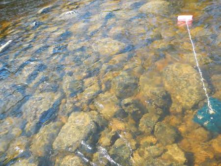
10 initially used to minimize fish stress and mortality, but longer-term sets were subsequently undertaken to increase capture rates. All gill net sets were given a unique net code and locations were recorded with a hand-held GPS. Angling was conducted by boat (where accessible and safe to do so) and from shore where boat passage was unsafe and suitable angling sites could be found. Angling was conducted using rod and reel and a variety of artificial lures (jigs, spoons). Angler effort (i.e., angler hours) was recorded for each angling event. All general angling locations were marked with a hand-held GPS. All walleye captured while netting and angling were measured for fork length, total length and round weight; aging structures (dorsal spines and scales) were taken, and the sex and gonad condition were determined (by attempting to extrude eggs or milt for live fish, or by internal examination for moribund fish ). Fish were identified as green (not ready to spawn, as evidenced by firm bellies and need for substantial abdominal pressure to extrude eggs or milt), ripe (as evidenced by free running eggs and milt with little abdominal pressure) or spent (flaccid bellies with few or no residual eggs or clear liquid or milt extruded when abdominal pressure applied). Identification of walleye was by external tagging with an individually numbered Floy tag. Tagged fish were live released. Morbid fish were retained for tissue mercury content analysis to meet sampling requirements identified by the Ministry of Environment (MOE). Flesh samples were to be taken from 20 specimens comprising a wide range of sizes Other Species Other species of interest in the study area include: sucker species (Catostomus sp.), northern pike (Esox lucius), and potentially sauger (Sander Canadensis). White sucker (Catostomus commersonii) have similar spawning habitat requirements as walleye, but typically spawn later at higher water temperatures (around 10 C). During this study, white suckers were also captured during gill netting targeted toward walleye. Sucker captured were measured for fork and total length and round weight, and the sex and gonad condition were determined by abdominal pressure. As well, a total of 20 tissue samples were collected for analysis of mercury concentration (as per MOE guidance). Captured northern pike were measured and weighed, sex and gonad condition were determined and scales were collected for aging purposes. Live pike were Floy tagged and/or fin clipped livereleased. Adequate northern pike tissue samples had previously been collected during the winter radio tagging attempt, and no additional flesh samples were collected. All other live fish were released. 2.4 Egg Mats Egg mats were installed in potential walleye and white sucker spawning areas in an effort to collect eggs to confirm spawning. Egg mats consisted of furnace filter material (American Air Filter Model number or equivalent) wrapped around a metal plate and secured with document clips (see Figure 2.1). The metal plate (214.3 mm by 381 mm by 7.93 mm thick) provided sufficient weight (~7 kg) to remain in place in high flow velocity locations. The sampling technique is an adaptation of one utilized by the United States Geological Service (USGS) to sample walleye eggs in the Detroit River, and utilizes the same exposed surface area. A rope attached to a ring in the centre of the upper surface of the plate allowed it to be deployed and retrieved (rope tied to shore or float , Rev. 0 Page 6

11 attached if required). The egg mat was typically lowered to the channel bed such that the ring faced upward, but wrapping of the filter material around the plate ensured that it would continue to sample should it be inverted. Potential spawning habitats were determined by visual assessment of substrate (from the surface) and measurement of water depth and flow velocity. Mats were typically set singly in areas considered to be potential spawning habitat. Figure 2.1 Hatch Egg Mat (Note metal plates in upper right corner of photo) Mats were typically retrieved every 2 days, and checked for the presence of eggs. All eggs collected were retained in 70% alcohol for future identification. The furnace filters were changed if they became clogged with organic material or gravel or ripped due to high flow velocities or contact with rocks. All egg mat locations were recorded with a hand-held GPS, and the egg mat sampling effort (days of deployment) was documented. 2.5 Spawning Habitat Assessment Previous field investigations by Hatch during the spring of 2008 on Trout Lake River indicated that there was walleye spawning habitat at the base of the head pond rapids. Hatch had not previously conducted an extensive spring spawning survey at the Chutes, although one egg mat (concrete block wrapped in furnace filter material) was deployed for 2 days in Potential spawning areas for walleye and white sucker (i.e., moderate velocity rapids with cobble substrate) were identified at each site once crew members were in the field. Daily water temperature measurements were recorded at each sampling location with an YSI 550 Model dissolved oxygen/temperature meter supplied by Pine Environmental. At each site, a reconnaissance level survey (by boat, shoreline walk and/or wading) was undertaken to collect substrate and flow information to assist in locating suitable habitat areas for the deployment of egg mats and for netting/angling. Habitat was photographed and described. Water depth was recorded at a number of egg mat locations using a graduated rod. Water velocity was recorded at , Rev. 0 Page 7
12 the egg mat locations at the channel bed, midpoint and surface using a Marsh-McBirney Flow-Mate Portable Velocity Flow Meter, supplied by Pine Environmental. Substrate composition was determined by visual assessment from the surface in areas that were safe to do so. Photographs were also taken of the rapids and associated shoreline areas , Rev. 0 Page 8
13 3. Results The following documents the results of the fish community, egg collection and spawning habitat assessment conducted at the Head Pond Rapids and the Chutes on Trout Lake River. 3.1 Water Temperature Water temperature in the study areas were taken at various times throughout the investigation and are summarized in Table 3.1. Water temperature was 7.0 C at the Head Pond Rapids upon commencement of the study on April 15. Following arrival on site, colder air temperature resulted in the water temperature declining to 5.2 C on the morning of April 17. Historical weather data was collected from Environment Canada to illustrate the range of air temperatures that occurred during the period of the investigation. Water temperatures remained below 7.0 C until April 21, when water temperatures steadily increased until the end of the study. The maximum water temperature recorded was 10.7 C on May 1, Table 3.1 Water Temperatures in the Trout Lake River April 15 to May 1, 2012 Date Time Trout Lake River Surface Water Temperature ( C) Environment Canada Historical Daily Air Temperature ( C) - Ear Falls, ON Head Pond Rapids The Chutes Daily Max Daily Min Daily Mean 15-Apr 18: Apr 17: : Apr 10: : : Apr 10: : : Apr 9: : : Apr 9: : Apr 12: : Apr 12: : Apr 8: : : : : , Rev. 0 Page 9
14 Date Time Trout Lake River Surface Water Temperature ( C) Environment Canada Historical Daily Air Temperature ( C) - Ear Falls, ON Head Pond Rapids The Chutes Daily Max Daily Min Daily Mean 24-Apr 9: : : Apr 9: : : : Apr 10: : : : Apr 9: : : : : Apr 13: : : Apr 12: : : : Apr 8: : : : May 8: : : : Head Pond Rapids General Description The reach immediately upstream from Big Falls consists of an approximately 700-m long pool, that is deep (compared to the upstream section) and slow flowing. Immediately above this pool, the river consists of a series of rapids and deep runs for approximately 1 km to the narrow bedrock dominated constriction at the upstream end of the proposed head pond. As you continue upstream before the river turns back toward the north there is a small constricting section of deep faster flowing water that contains areas of large bedrock and boulder outcrops in the main channel. At the crest of this small rapid prior to the constriction of bedrock banks a small , Rev. 0 Page 10
15 section along the north shoreline contained areas of boulder coble mixes. Substrate in this area was noted as ranging from boulder (20 to 70%) and coble (30 to 80%). As you move nearer the shoreline from the main flow an increase in cobble and decrease in bolder occurs. Two egg mats were used in this section to determine the area for spawning activity. The first main rapids in the proposed head pond upstream of Big Falls consist of a shallow, fast-flowing riffle-like section at the lower end, with fast-flowing rapids that drop off bedrock ledges and constrictions at the upstream end of the section. Approximately 50 m farther upstream from this first area is a relatively deep (>2 m), slow-flowing pool with substrate that consists primarily of boulder (50 to 70%) and cobble (30 to 50%). Egg mats were deployed along the shorelines of these first rapids to assess the presence of spawning activity. A long, deep and slow-flowing pool is located between the lower section of the head pond rapids and the upper portion of the head pond rapids. This area is mainly contained between bedrock shorelines and contains a number of very large boulders along shoreline. Substrate throughout the pool is that of bedrock with water depth during the survey being approximately 2 m. The area does not contain habitat that would be suitable for walleye spawning. Farther upstream sections of the rapids in the proposed head pond (i.e., 700 to 1500 m upstream from the proposed dam location) may also provide suitable spawning habitat areas for walleye and white sucker. The three main rapid sections in the upper section are very constricted on the western shoreline causing high flow velocity over bedrock causing pockets of cobble bolder mixes along the eastern shoreline. The first rapid section upstream of the large pool is where the bedrock shorelines narrow and water flows over bedrock substrate in main flow paths. A small section on the eastern shoreline as the wetted area widens near the base of the small drop contains substrate comprised of a cobble (20 to 70%) bedrock (10 to 60%) boulder (0 to 20%) and gravel (0 to 20%). Flow and water depth in this area out of the direct path of the main flow had maximum readings of 0.59 m/s at the surface flow velocity and a maxim depth of 0.61m. Due to the flow velocities, depth and substrate type two egg mats were deployed in the small area to confirm spawning activity. The next section of rapids is approximately 60 m upstream where this rapids is a longer (approximately 40 m) wider (approximatley20 m) section of river. This section of rapids also contains the main flow along the western side of the river channel with a bedrock substrate. Areas along the eastern shoreline is comprised of bedrock, boulder and cobble mixes increases in cobble as it moved farther from the main flow path. Due to the length of the rapids a total of seven egg mats were use to asses this area from the crest of the rapids to the base were depth greatly increased to >1 m. The greatest flow velocities along the shoreline were recorded as 0.67m/s at the surface. The very last rapid section within the Head Pond Rapids is at a very constricted area that a small bedrock island is developed with flow on either side. Like all the previous rapids in the upper section of the study area the main flow path is along the western side of the river channel with flows that are >2 m/s. This main flow is deep and contains substrate of 100% bedrock. The remaining flow is distributed over an approximate 0.5 m bedrock drop on the eastern side of the river where , Rev. 0 Page 11
16 the wetted width during the time of the investigation was approximately 2 m. At the base of this drop the substrate is bedrock with a depth of 0.57 m and surface flow velocity of 0.67 m/s. As the water disperses around the island and downstream the substrate starts to become mixed with boulder and bedrock with 80% still remaining bedrock. As the main flow path and the secondary flow path begin to join the main flow around the island areas of cobble (10 to 30%) are present among the largely dominated bedrock boulder areas. Five egg mats were deployed in this area on the east end of the island to determine spawning activity Fish Community Gill netting was conducted between April 17 and May 1, 2012 all in the area downstream of the Head Pond Rapids. Net (Thpgn) was deployed in the pool area at the crest of the rapids from 13:15 to 15:05 on April 22 nd. Angling efforts within this study area began on April 15 and concluded on April 30, Angling efforts were focused in staging areas downstream as well as any potential staging areas within the rapids area. Figure 3.1 provides angling and netting locations Gill Net Results A total of 46 gill net sets and 535 hours of net fishing effort was expended during the study. The netting effort collected 91 fish comprised of 5 species. White sucker were the most abundant (n = 76, 83.5%), followed by walleye (n=5, 5.5%), northern pike and yellow perch (n=4 each, 4.4%) and finally rock bass (n=2, 2.2%). Table 3.2 provides effort and catch data by net, while all catch data and metric information is provided in Appendix A. Table 3.2 Head Pond Rapids Netting Effort and Results Net Number Date Set Effort Fish Capture Fish Total Species Richness Hpgn1 17-Apr 02hrs 30min 0 0 Hpgn2 17-Apr 02hrs 45min 0 0 Hpgn3 17-Apr 04hrs 55min White Sucker Hpgn4 17-Apr 04hrs 10min White Sucker Hpgn5 18-Apr 08hrs 40min 0 0 Hpgn6 18-Apr 08hrs 40min Northern Pike Hpgn7 19-Apr 09hrs 10min 0 0 Hpgn8 19-Apr 09hrs 05min White Sucker Hpgn9 19-Apr 09hrs 00min 0 0 Hpgn10 20-Apr 08hrs 15min White Sucker -2 Northern Pike Hpgn11 20-Apr 08hrs 25min White Sucker Hpgn12 20-Apr 07hrs 55min 0 0 Hpgn13 21-Apr 03hrs 20min 0 0 Hpgn14 21-Apr 03hrs 00min Yellow Perch Hpgn15 21-Apr 02hrs 45min White Sucker Thpgn 22-Apr 01hrs 50min White Sucker Hpgn16 23-Apr 06hrs 15min 0 0 Hpgn17 23-Apr 06hrs 10min 0 0 Hpgn18 23-Apr 06hrs 10min , Rev. 0 Page 12
17 Net Number Date Set Effort Fish Capture Fish Total Species Richness Hpgn19 23-Apr 17hrs 25min White Sucker Hpgn20 23-Apr 17hrs 25min Walleye -1 White Sucker Hpgn21 23-Apr 17hrs 15min White Sucker Hpgn22 24-Apr 24hrs 10min White Sucker Hpgn23 24-Apr 23hrs 40min White Sucker Hpgn24 24-Apr 23hrs 20min 0 0 Hpgn25 25-Apr 05hrs 35min 0 0 Hpgn26 25-Apr 05hrs 35min Northern Pike -1 White Sucker Hpgn27 25-Apr 05hrs 20min Yellow Perch Hpgn28 25-Apr 16hrs 25min White Sucker Hpgn29 25-Apr 17hrs 25min White Sucker Hpgn30 25-Apr 18hrs 05min Hpgn31 26-Apr 24hrs 10min Walleye -1 Northern Pike -1 Rock bass Yellow Perch -1 Rock bass Hpgn32 26-Apr 05hrs 05min White Sucker Hpgn33 26-Apr 05hrs 10min 0 0 Hpgn34 27-Apr 07hrs 15min 0 0 Hpgn35 27-Apr 06hrs 20min 0 0 Hpgn36 27-Apr 19hrs 20min Walleye -1 White Sucker Hpgn37 27-Apr 20hrs 10min White Sucker Hpgn38 28-Apr 24hrs 05min White Sucker Hpgn39 28-Apr 24hrs 00min White Sucker Hpgn40 29-Apr 23hrs 50min White Sucker Hpgn41 29-Apr 21hrs 15min White Sucker Hpgn42 30-Apr 22hrs 05min Hpgn43 30-Apr 21hrs 25min Walleye -1 White Sucker Walleye -1 White Sucker Hpgn44 1-May 4hrs 30min 0 0 Hpgn45 1-May 4hrs 30min White Sucker Total 535hrs 00min Walleye -5 White Sucker -76 Northern Pike -4 Yellow Perch -4 Rock Bass Average/Net , Rev. 0 Page 13
18 Angling Results Eight hundred and thirty (830) minutes of angling effort was undertaken within the Head Pond Rapids (see Figure 3.1 for areas) in an effort to capture staging walleye. No fish were captured in this area, although similar techniques were successful in collecting walleye at the Chutes Table 3.3 indicates the locations and effort that was done. Table 3.3 Head Pond Rapids Angling Effort and Results Date Location Duration (min) 15-Apr Apr Apr Apr Apr Apr Apr Apr Apr Apr Apr-12 Area below Head Pond Rapids Area below Head Pond Rapids Area below all fast water upstream from Big Falls Angle areas within the bottom section of rapids from shoreline Angle within stretch of river downstream of the Head Pond Rapids Area below Head Pond Rapids Angle deep area above Big Falls Near water survey station Angle along shoreline in top section of Head Pond Rapids Angle within stretch of river downstream of the Head Pond Rapids Angle deep area above Big Falls Near water survey station Angle along shoreline in top section of Head Pond Rapids Species 90 No Catch 120 No Catch 80 No Catch 80 No Catch 100 No Catch 30 No Catch 40 No Catch 80 No Catch 60 No Catch 60 No Catch 90 No Catch Fish Number Fish Catch Summary Combining the netting and angling effort, a total of five walleye were collected which is 5.5% of the total fish capture. These fish were all females, with the first one being caught on the night of April 23, Single fish were caught on the nights of April 25 and 27, and two more were collected on May 30. All walleye were captured at the base of the rapid in overnight gill net sets. Of the five females collected, three containing reabsorbed eggs when internally examined. The remaining two females were collected on the night of April 30, 2012 and were spent. Water temperature recorded at that time was 10.0ºC , Rev. 0 Page 14
19 Flow 390 Trout Lake River Legend Angling Location Topographic Contour Gillnet and Angling Area Notes: 1. Produced by Hatch under licence from Ontario Ministry of Natural Resources, Copyright (c) Queens Printer Spatial referencing UTM NAD Metres N 1:6,000 Big Falls Figure 3.1 Horizon Hydro Inc. Trout Lake River Hydroelectric Project Headpond Rapids - Sampling Locations Spring Path: P:\HORIZON\327203\GIS\ZackFalls2012_Headpond_Fishery_Sampling.mxd Date Saved: 5/28/2012 1:24:16 PM
20 Blank back , Rev. 0 Page 16
21 Two walleye and eleven white suckers were taken for mercury analysis to meet MOE requirements. The walleye were 485 mm and 675 mm total length, while the white suckers ranged from 309 mm to 527 mm in total length. Tissue samples will be sent to Flett Research for analysis and results will be carried forward to the EA document Egg Mats Egg mats were installed at 31 locations within the Head Pond Rapids as noted in Figure 3.2. Egg mats were deployed at locations that were deemed to provide suitable spawning habitat, with initial deployment beginning on April 18, Additional egg mats were deployed as site access along the rapids became available. Eggs mats were checked for the presence of eggs, beginning on April 21, Walleye and white sucker eggs were first collected in the study area on April 26, and were present within the river reach through the spawning study until mats were removed. The number of walleye eggs collected was declining at the majority of egg mat sites during the last round of egg mat surveillance on May 2. This combined with the increase of sucker eggs appearing indicates that the sucker spawn had commenced and the walleye spawn was concluding. Table 3.4 indicates all of the egg mat results. Egg mat collection captured a total of walleye (n=302+) and white sucker eggs (n=46) throughout Head Pond Rapids section. Many egg mats only captured a low number of walleye eggs throughout the study period. The eggs captured at a location ranged from 1 (mats Hpegg11, Hpegg12A and Hpegg19) to 120+ on Hpegg , Rev. 0 Page 17
22 Blank back , Rev. 0 Page 18
23 380 Hpegg15 Hpegg14 Hpegg19 Hpegg20 Hpegg22 Hpegg13 Hpegg16 Hpegg17 Hpegg18 Hpegg21 Hpegg23 Hpegg24 Hpegg6 Hpegg8 Hpegg7 Hpegg8A Hpegg5 Hpegg12 Hpegg11 Zone 2 1:1800 Hpegg12AHpegg4 Hpegg2 Hpegg3 Hpegg1A Hpegg3A Hpegg1 Zone 3 1:1800 Zone 1 Hpegg Hpegg26 Hpegg10A Hpegg9 Hpegg Flow 370 Trout Lake River Hpegg7 Hpegg8 Hpegg12 Hpegg11 Hpegg10A Hpegg12A Hpegg2 Hpegg1A Hpegg9 Hpegg6 Hpegg8A Hpegg5 Hpegg10 Hpegg4 Hpegg3 Zone 3 Zone 2 Hpegg1 Hpegg3A Legend Egg Mat Capture No Eggs Walleye 370 White Sucker Hpegg13 Walleye and White Sucker Zone 1 1:850 Hpegg15Hpegg16 Hpegg14 Hpegg17 Hpegg18 Hpegg19 Hpegg20 Hpegg22 Hpegg21 Hpegg24 Hpegg23 Big Falls Topographic Contour Figure 3.2 Horizon Hydro Inc. Trout Lake River Hydroelectric Project Headpond Rapids - Egg Mat Locations Spring 2012 Notes: 1. Produced by Hatch under licence from Ontario Ministry of Natural Resources, Copyright (c) Queens Printer Spatial referencing UTM NAD Metres N 1:6,000 Path: P:\HORIZON\327203\GIS\ZackFalls2012_Headpond_EggFishery_Sampling.mxd Date Saved: 5/28/2012 1:26:58 PM
24 Blank back , Rev. 0 Page 20
25 Table 3.4 Head Pond Rapids Egg Mat Summary Egg Mat ID /GPS Point Date Set Velocity/Depth Hpegg1 Hpegg1A Hpegg2 Hpegg3 Hpegg3A Hpegg4 18-Apr 23-Apr 18-Apr 18-Apr 23-Apr 18-Apr Depth (m) Substrate (%) Date Checked Number of Eggs Species 0.41 m³/s-bottom 21-Apr m³/s-middle C10B 23-Apr m³/s-surface 0.25 m³/s-bottom 25-Apr m³/s-middle 27-Apr 1 Sucker Sp 0.54 m³/s-surface B 50C 29-Apr 1 Walleye 1-May 0 2-May 2 Sucker Sp 0.09 m³/s-bottom 21-Apr m³/s-middle 23-Apr m³/s-surface 25-Apr C 20B 27-Apr 2 Walleye 3 Walleye 29-Apr 5 2 Sucker Sp 1-May 1 Sucker Sp 2-May 9 Sucker Sp 0.11 m³/s-bottom 21-Apr m³/s-middle C 20B 23-Apr m³/s-surface 0.16 m³/s-bottom 25-Apr 0 1 Walleye 0.30 m³/s-middle 40G 30C 27-Apr 2 1 Sucker Sp 0.45 m³/s-surface B 29-Apr 0 1-May 3 Sucker Sp 2-May m³/s-bottom 21-Apr m³/s-middle 23-Apr m³/s-surface 25-Apr 0 50C 30G Apr 4 Sucker Sp 20B 29-Apr 3 Sucker Sp 1-May 4 Sucker Sp 2-May 7 Sucker Sp Date Pulled 23-Apr 2-May 2-May 23-Apr 2-May 2-May , Rev. 0 Page 21
26 Egg Mat ID /GPS Point Date Set Velocity/Depth Hpegg5 Hpegg6 Hpegg7 Hpegg8 Hpegg8A 18-Apr 18-Apr 18-Apr 18-Apr 23-Apr Depth (m) Substrate (%) Date Checked Number of Eggs Species 0.35 m³/s-bottom 21-Apr m³/s-middle 23-Apr m³/s-surface 25-Apr C10B 27-Apr 0 29-Apr 9 Walleye 1-May 0 2-May 4 Walleye 0.19 m³/s-bottom 21-Apr m³/s-middle 23-Apr m³/s-surface 25-Apr C10B 27-Apr 2 Walleye 29-Apr 2 Walleye 1-May 6 Walleye 2-May m³/s-bottom 21-Apr m³/s-middle 23-Apr m³/s-surface 25-Apr 0 40Bed 40C Apr 0 20B 29-Apr 0 1-May 0 2-May m³/s-bottom 21-Apr m³/s-middle C 30B 23-Apr m³/s-surface 0.27 m³/s-bottom 25-Apr m³/s-middle 27-Apr 2 Walleye 50G 30C 0.70 m³/s-surface Apr 0 10Bed 10B 1-May 0 2-May 0 Date Pulled 2-May 2-May 2-May 23-Apr 18-May , Rev. 0 Page 22
27 Egg Mat ID /GPS Point Date Set Velocity/Depth Hpegg9 Hpegg10 Hpegg10A Hpegg11 Hpegg12 Hpegg12A 19-Apr 19-Apr 29-Apr 19-Apr 19-Apr 23-Apr Depth (m) Substrate (%) Date Checked Number of Eggs Species 0.13 m³/s-bottom 21-Apr m³/s-middle 23-Apr m³/s-surface 25-Apr C 20B 27-Apr 0 29-Apr 6 Walleye 1-May 1 Walleye 2-May m³/s-bottom 21-Apr m³/s-middle 23-Apr m³/s-surface B 30C 25-Apr 0 27-Apr 0 29-Apr m³/s-bottom 1-May 6 Sucker Sp 0.22 m³/s-middle C 20B 2-May 1 Sucker Sp 0.27 m³/s-surface 0.08 m³/s-bottom 21-Apr m³/s-middle 23-Apr m³/s-surface 25-Apr B 10C 27-Apr 1 Walleye 29-Apr 0 1-May 0 2-May m³/s-bottom 21-Apr 0 60C 30B 0.26 m³/s-middle Apr 0 10G 0.30 m³/s-surface 0.02 m³/s-bottom 25-Apr m³/s-middle 27-Apr 0 70B 20Bed 0.09 m³/s-surface Apr 0 10C 1-May 1 Walleye 2-May 0 Date Pulled 29-Apr 29-Apr 2-May 2-May 23-Apr 2-May , Rev. 0 Page 23
28 Egg Mat ID /GPS Point Date Set Velocity/Depth Hpegg13 Hpegg14 Hpegg15 Hpegg16 Hpegg17 Hpegg18 19-Apr 19-Apr 19-Apr 19-Apr 19-Apr 19-Apr Depth (m) Substrate (%) Date Checked Number of Eggs Species 0.10 m³/s-bottom 22-Apr m³/s-middle 24-Apr m³/s-surface Bed 26-Apr 0 30-Apr 0 2-May m³/s-bottom 22-Apr m³/s-middle 24-Apr m³/s-surface B 10C 26-Apr 1 Walleye 30-Apr 0 2-May 1 Walleye 0.19 m³/s-bottom 22-Apr m³/s-middle 24-Apr m³/s-surface B 30C 26-Apr 0 30-Apr 0 2-May m³/s-bottom 22-Apr m³/s-middle 24-Apr 0 80Bed 0.06 m³/s-surface Apr 0 10B10C 30-Apr 0 2-May m³/s-bottom 22-Apr m³/s-middle 24-Apr 0 80Bed 0.23 m³/s-surface Apr 1 10B10C 30-Apr 0 Walleye 2-May 2 Walleye 0.14 m³/s-bottom 22-Apr m³/s-middle 24-Apr m³/s-surface B 20C 26-Apr 0 30-Apr 0 2-May 0 Date Pulled 2-May 2-May 2-May 2-May 2-May 2-May , Rev. 0 Page 24
29 Egg Mat ID /GPS Point Date Set Velocity/Depth Hpegg19 Hpegg20 Hpegg21 Hpegg22 Hpegg23 Hpegg24 19-Apr 19-Apr 19-Apr 19-Apr 20-Apr 20-Apr Depth (m) Substrate (%) Date Checked Number of Eggs Species 0.40 m³/s-bottom 22-Apr m³/s-middle 24-Apr m³/s-surface 50G 30C Apr 0 10Bed 10B 30-Apr 1 Walleye 2-May m³/s-bottom 22-Apr m³/s-middle 24-Apr 0 13 Walleye B 10C 0.41 m³/s-surface 26-Apr 14 1 Sucker Sp 30-Apr 3 Walleye 2-May 1 Walleye 0.32 m³/s-bottom 22-Apr m³/s-middle 24-Apr 0 80Bed 10C 0.63 m³/s-surface Apr 44 Walleye 10B 30-Apr 24 Walleye 2-May 16 Walleye 0.04 m³/s-bottom 22-Apr m³/s-middle 24-Apr 0 60Bed 20B 0.07 m³/s-surface Apr 4 Walleye 20C 30-Apr 6 Walleye 2-May 1 Walleye 0.31 m³/s-bottom 22-Apr m³/s-middle 24-Apr m³/s-surface B 10C 26-Apr 3 Walleye 30-Apr 0 1-May 1 Walleye 0.32 m³/s-bottom 22-Apr m³/s-middle 24-Apr m³/s-surface B 10C 26-Apr 0 30-Apr 0 2-May 0 Date Pulled 2-May 2-May 2-May 2-May 2-May 2-May , Rev. 0 Page 25
30 Egg Mat ID /GPS Point Date Set Velocity/Depth Hpegg25 Hpegg26 Total Egg Captures *S = Silt G= Gravel C= Cobble B= Boulder Bed= Bedrock 20-Apr 20-Apr Depth (m) Substrate (%) Date Checked Number of Eggs Species 0.08 m³/s-bottom 22-Apr m³/s-middle 24-Apr 0 70C 20G 36 Walleye m³/s-surface 10B 26-Apr 37 1 Sucker sp 30-Apr 70+ Walleye 2-May 13 Walleye 0.20 m³/s-1 m 22-Apr m³/s-0.5 m 24-Apr 0 60Bed 20B 0.59 m³/s-surface Apr 4 Walleye 20C 30-Apr 12 Walleye 2-May 4 Walleye Walleye Sucker Sp -46 Date Pulled 2-May 2-May , Rev. 0 Page 26
31 With more possible spawning habitat located on the east side of the main flow path the majority of the sampling locations were deployed along that side of the river. Only five egg mats were located along the west side (Hpegg9, Hpegg10, Hpegg10A, Hpegg11 and Hpegg12), and one egg mat was accessed by boat (Hpegg12A). Egg mats were generally deployed by wading, where safe to do so. Water depth ranged from 0.22 to 0.78 m at egg mat locations, while flow velocity at the substrate surface (Bottom in table above) ranged from 0.02 m³/s to 0.41 m³/s. At the completion of the study (a 15-day sampling period), no eggs were collected at 11 egg mats, only walleye eggs were collected at 13 locations, sucker eggs were collected at two locations, and both walleye and sucker sp. eggs were collected at 5 locations. Figure 3.2 shows all of the egg mat locations and catch results Spawning Habitat Visual observations of aquatic habitat in the Head Pond Rapids were taken at each egg mat location in conjunction with measurements of depth and flow velocity (see Table 3.4). As noted in Section above, the Head Pond Rapids consists of two series of rapids separated by a long (approximately500 m) pool. At the upstream end of the reach, a long (270 m) section of intermittent rapids contains minimal small pockets of cobble bolder mixes in areas along the eastern shoreline. Different variations of substrate mixes, flow velocities and water depth were noted at each section of rapids. At the upper most end of the Head Pond Rapids confirmed spawning habitat contained substrate material ranging from boulder (10 to 90%), bedrock 0 to 80% and cobble 10%. The substrate flow velocity at these locations ranged from 0.03 m/s to 0.15m/s where depths were between 0.27 m and 0.5 m. This was found to be a total area of 83 m² that would provide suitable spawning habitat for walleye in this area. The longest rapid section within the upper end of the Head Pond Rapid also had confirmed spawning from walleye and white sucker species in certain sections. Spawning habitat of confirmed walleye and white sucker had substrate comprised of boulder (10 to 90%), bedrock (0 to 80%), cobble (10 to 30%) and gravel (0 to 50%). Water depths in these areas ranged from 0.36 m to 0.57 m were substrate flow velocity readings were from 0.04 m/s to 0.4 m/s. The total area of suitable spawning habitat at these rapids was 232 m². The last section of rapids as you head downstream before the large pool area contained a small area of suitable spawning habitat near the base of the rapids on the eastern shoreline. This area had confirmed spawning from both walleye and white sucker during the investigation. This area contained substrate ranges of cobble (20 to 70%), bedrock (0 to 60%), boulder (10 to 20%) and gravel (0 to 20%). The substrate flow velocity at these locations ranged from 0.08 m/s to 0.20 m/s where depths were between 0.38 m and 0.67 m. A total area of 90 m² was determined to be spawning habitat for walleye and white sucker. Figure 4.1 indicates all of the confirmed spawning locations for the upper portion of the Head Pond Rapids. Continuing downstream past the large pool area, the next rapids contained spawning habitat on both the east and west shorelines. However, the western shoreline contained a smaller section due to larger areas of bedrock and high flows. On the western shore the area that contained substrate of , Rev. 0 Page 27
32 90% boulder and 10% cobble with a substrate flow velocity of 0.08 m/s in 0.4 m of water captured a single walleye egg. This small area of suitable walleye spawning habitat was 34 m². The eastern shoreline of this area contained a more diverse and suitable substrate. The substrate ranged from (30 to 90%) cobble, (0 to 50%) gravel, (10 to 20%) boulder, and minimal (0 to 10%) bedrock. Substrate flows were recorded as ranging from 0.19 m/s to 0.35 m/s in water depths between 0.36 m and 0.44 m where walleye spawning was confirmed. The area was determined to be 151 m². Farther downstream at the base of a bedrock drop area along the western shore an area was confirmed for white sucker spawning only. This area was recorded as being 80% cobble, 20% boulder with a bottom flow velocity of 0.17 m/s at a depth of 0.63 m. This area is was a total of 93 m². At the base of the intermittent rapid along the eastern shoreline and within the main flow areas spawning habitat for walleye and white sucker were present. This area along the eastern shoreline was confirmed walleye spawning habitat from early investigations. Confirmation of habitat area was to be verified in this investigation. The area along the east had substrate ranging from cobble (30 to 80%), gravel (0 to 40%) and boulder (10 to 30%). Flow velocities along the substrate ranged from 0.09 m/s to 0.25 m/s in water depths of 0.29 m to 0.64 m. This spawning habitat area was determined during this investigation to be 831 m². A small walleye spawning area within a back eddy of the main flow channel investigated by boat was comprised of 70% boulder, 20% bedrock and 10% cobble. The swirling water in this area indicated a substrate flow velocity of 0.02 m/s however in the flow channels on either side flow would be >1.0 m/s. Water depth at this location was 0.78 m. Within this 28 m² area only one walleye egg was collected. Below the pooling area at the base of the head pond rapids, spawning habitat is located on the western edge of the river channel before the river constricts and enters the large pool above Big Falls. This spawning habitat is 80% cobble and 20% boulder with riverbed flow velocity of 0.13 m/s and a depth of 0.31 m. This is a total of 102 m² of walleye spawning habitat. Figure 4.2 illustrates and delineates all of the confirmed spawning habitat areas within the lower section of the Head Pond Rapids. 3.3 The Chutes General Description The Chutes is located approximately 8.5 km upstream from the proposed dam location on Trout Lake River and approximately 7 km upstream from the limit of the backwater effect from the proposed project head pond. It is the first rapids upstream from the proposed head pond. The area consists of a narrow set of bedrock-controlled rapids across the main channel, discharging to a deeper plunge pool. Outflow from the pool discharges at approximately 90 deg to the upstream flow path, creating a right hand-bend in the river that directs the downstream flow to the west. Below the rapids, flow passes through the pool and against the bedrock wall on the south side of the river valley. This disperses water in both directions; creating back eddies on each side of the main flow path, with the , Rev. 0 Page 28
33 main flow path continuing downstream. This back flow motion has created a sand/fine sediment bar to the west of the main flow channel Fish Community Gill netting was conducted between April 17 and May 1, 2012 in an area that extended approximately 350 m downstream below the Chutes. Angling efforts within this study area began on April 16 and concluded on May 1, Angling efforts were focused in possible staging areas below the rapids, although the entire area was subjected to angling and netting methods (see Figure 3.3) Gill Net Results Thirty gillnets net sets and 101 hours and 5 minutes of fishing effort was used to sample this study area. The netting effort produced a total of 165 fish of 4 species. Yellow perch (n=60, 36.3%) were the most abundant, followed by white sucker (n=42, 25.5%), walleye (n=36, 21.8%) and finally, northern pike (n=27, 16.4%). A single walleye was recaptured (TAG# HA-01218), that had been captured by angling and tagged earlier in this study. Table 3.5 provides fishing effort and catch results by location. All catch data and fish metrics are provided in Appendix B. Table 3.5 Chutes Netting Effort and Results Net Number Date Set Effort Fish Capture Fish Total Species Richness Cgn1 17-Apr 01hrs 30min Walleye Cgn2 17-Apr 01hrs 25min 0 0 Cgn3 18-Apr 02hrs 35min Northern Pike White Sucker -1 Cgn4 18-Apr 02hrs 30min Northern Pike Cgn5 19-Apr 02hrs 45min Walleye Northern Pike -2 White Sucker -1 Cgn6 19-Apr 03hrs 10min Walleye Northern Pike -1 Cgn7 20-Apr 05hrs 40min Yellow Perch White Sucker -1 Cgn8 20-Apr 05hrs 50min Walleye White Sucker -1 Cgn9 22-Apr 03hrs 30min Northern Pike White Sucker -2 Yellow Perch -8 Cgn10 23-Apr 02hrs 15min White Sucker Yellow Perch -1 Cgn11 23-Apr 02hrs 30min 0 0 Cgn12 24-Apr 05hrs 25min Walleye -1 Northern Pike -5 White Sucker -4 Yellow Perch Cgn13 24-Apr 04hrs 25min Walleye -6 Yellow Perch -15 White Sucker , Rev. 0 Page 29
34 Net Number Date Set Effort Fish Capture Fish Total Species Richness Cgn14 25-Apr 01hrs 50min Walleye -2 Northern Pike -1 White Sucker Cgn15 25-Apr 02hrs 10min Walleye -1 Northern Pike -2 Yellow Perch Cgn16 26-Apr 03hrs 45min Walleye Cgn16B 26-Apr 02hrs 15min Walleye -3 Northern Pike -3 Yellow Perch -1 Cgn17 27-Apr 03hrs 40min Walleye -1 White Sucker -2 Cgn18 27-Apr 02hrs 20min Walleye -2 Northern Pike Cgn19 27-Apr 01hrs 15min Yellow Perch Cgn20 28-Apr 03hrs 00min Walleye -1 Northern Pike -3 White Sucker -1 Cgn21 28-Apr 02hrs 35min Walleye -2 White Sucker -6 Yellow Perch -1 Cgn22 29-Apr 05hrs 00min Walleye -2 Northern Pike -2 Yellow Perch -3 Cgn23 29-Apr 05hrs 00mn Walleye -1 White Sucker -3 Cgn24 30-Apr 02hrs 15min Walleye -3 Yellow Perch -7 White Sucker -3 Cgn25 30-Apr 02hrs 45min Walleye -1 White Sucker -3 Yellow perch -2 Cgn26 30-Apr 05hrs 25min Walleye -2 Northern Pike -2 Yellow Perch -11 Cgn27 30-Apr 05hrs 30min Northern Pike -1 White Sucker -3 Yellow Perch -1 Cgn28 1-May 04hrs 25min Walleye -1 White Sucker -2 Cgn29 1-May 04hrs 25min Walleye - 1 White Sucker -1 Yellow Perch Total 101hrs 05min Walleye Yellow Perch -60 White Sucker -42 Northern Pike -27 Average/Net , Rev. 0 Page 30
35 380 Flow Cegg6 Cegg5 Cegg1 Cegg4A 380 Cegg2 Cegg3 Cegg4 370 Legend 380 Trout Lake River Topographic Contour Egg Mats - Walleye Eggs Captured Gillnet and Angling Area Notes: 1. Produced by Hatch under licence from Ontario Ministry of Natural Resources, Copyright (c) Queens Printer Spatial referencing UTM NAD Metres N 1:3,000 Figure 3.3 Horizon Hydro Inc. Trout Lake River Hydroelectric Project Chutes - Sampling Locations Spring 2012 Path: P:\HORIZON\327203\GIS\ZackFalls2012_Chute_Fishery_Sampling.mxd 390 Date Saved: 5/28/2012 1:28:58 PM
36 Blank back , Rev. 0 Page 32
37 Angling Results A total angling effort of 1800 minutes was undertaken at the Chutes study area. Angling captured 44 fish, being walleye (n=15), northern pike (n=25) and yellow perch (n=4). Seven of the 25 pike were recaptures from earlier in the study. Table 3.6 provides sampling effort and catch results, while complete catch data and fish metrics are provided in Appendix B. Table 3.6 Chutes Angling Effort and Results Date Location Duration Species Fish Number Sex Maturity (min) 16-Apr-12 Near end of Rapids 90 No Catch 17-Apr-12 Downstream from base of chutes rapids 110 Walleye C-WALL1 Male Ripe Northern Pike C-NP1 Male Ripe Walleye C-WALL2 Male Ripe Walleye C-WALL3 Male Ripe 18-Apr-12 Downstream from base of chutes rapids 140 Northern Pike C-NP2 Male Ripe Northern Pike C-NP3 Unknown Spent Yellow Perch C-YP1 Female Green Yellow Perch C-YP2 Female Green Northern Pike C-NP4 Unknown Spent 20-Apr-12 Angle along rapid area on east side 30 No Catch 20-Apr-12 Downstream from base of chutes rapids 110 Northern Pike C-NP11 Unknown Spent Walleye C-WALL8 Male Ripe Walleye C-WALL9 Male Ripe Walleye C-WALL10 Male Ripe Walleye C-WALL11 Male Ripe Northern Pike Recap Tag# HA Northern Pike Recap Tag# HA Apr-12 Downstream from base of chutes rapids 220 Walleye CWALL13 Male Ripe Northern Pike C-NP13 Unknown Immature Northern Pike C-NP14 Northern Pike Recap Tag# HA Apr-12 Angle along rapid area on east side 60 No Catch 24-Apr-12 Downstream from base of chutes rapids 50 Northern Pike C-NP15 Unknown Spent Yellow Perch C-YP13 25-Apr-12 Downstream from base of chutes rapids 180 Walleye CWALL21 Female Ripe Northern Pike Recap Tag# HA Walleye CWALL22 Female Green Walleye CWALL23 Male Ripe Walleye CWALL24 Female Immature Northern Pike Recap Tag# HA Northern Pike C-NP21 Unknown Spent 27-Apr-12 Downstream from base of chutes rapids 160 Northern Pike Recap Tag# HA Northern Pike C-NP27 27-Apr-12 Angle along rapid area on west side 40 Northern Pike C-NP28 Northern Pike C-NP29 Yellow Perch C-YP33 Northern Pike C-NP30 27-Apr-12 Downstream from base of chutes rapids 70 Walleye CWALL35 Male Ripe Walleye CWALL36 Female Ripe Walleye CWALL37 Female Ripe , Rev. 0 Page 33
38 Date Location Duration Species Fish Number Sex Maturity (min) 28-Apr-12 Downstream from base of chutes rapids 120 Northern Pike C-NP31 Male Ripe Northern Pike Recap Tag# HA Apr-12 Downstream from base of chutes rapids 40 No Catch near first bend 29-Apr-12 Downstream from base of chutes rapids 40 No Catch 30-Apr-12 Downstream from base of chutes rapids 150 Northern Pike C-NP34 Unknown Immature 1-May-12 Downstream from base of chutes rapids 90 Northern Pike C-NP35 Northern Pike C-NP36 Northern Pike C-NP37 1-May-12 Near first bend and farther downstream 100 No Catch Totals 1800 Walleye -15 Northern Pike -25 Yellow Perch Fish Catch Summary When both capture techniques are combined, a total of 209 fish were collected at the Chutes location. These 209 fish were comprised of four species, in order of abundance being yellow perch (n=64), northern pike (n=52), walleye (n=51) and white sucker (n=42). The remains of female walleye (taken by other animals) were noted near egg mat location Cegg6 on April 24, The gonad condition of these fish was documented and is presented in Table 3.7. Of the 51 walleye captured and assessed, ripe males (n=33) were the most abundant, followed by ripe females (n=10). Only one spent fish was captured (the recaptured male - HA-01218) on April 30, This fish was first captured by angling on April 17 and was determined to be a ripe at that time. The water temperature in the area on April 30 was 10.5 C. Table 3.7 Gonad Condition of Captured Walleye from the Chutes Rapids Capture Method Green Males Ripe Males Spent Males Immature Females Reabsorbed Females Green Females Ripe Females Spent Females Totals Angling Netting Totals Nineteen walleye and 9 white suckers were taken for mercury analysis to meet MOE requirements for fish flesh samples from the reach above Big Falls. Walleye ranged in size from 365 mm to 541 mm total length, while white suckers ranged from 410 mm to 471 mm in total length. Tissue samples will be sent to Flett Research for processing and analysis, with the findings carried forward to the EA document Egg Mats Seven egg mat locations were used at the Chutes study area (see Figure 3.3 for locations). Egg mats were placed alongside both the east and west sides of the main flow channel by wading or from the boat. The mats were placed in areas of suitable substrate and good spawning potential (i.e., cobble substrate and adequate flow levels). Egg mats were first deployed on April 18 (Cegg1, Cegg2 and , Rev. 0 Page 34
39 Cegg3), then on April 20 (Cegg4, Cegg5, Cegg6), with the last location deployed on April 27 (Cegg4A). Egg mats were checked every other day from April 22 to May Location, depth, substrate and flow velocity as well as catch results are provided below in Table 3.8. All seven egg mat location captured only walleye eggs. Sucker species eggs were not captured at this location despite the presence of ripe male and female suckers in the area directly downstream. Eggs were first collected at the chutes site on April 22, 2012 at three of the locations (Cegg1, Cegg2 and Cegg6). Eggs were continuously collected at this site during all days that mats were investigated. Table 3.8 Summary of Egg Mat Results for the Chutes Rapids Egg Mat ID/GPS Point Date Set Velocity/Depth Depth (m) Substrate (%) Cegg1 18-Apr 0.17 m³/s-bottom Bed 30B 10C 10G Date Checked Number of Eggs Species Date Pulled 22-Apr 13 Walleye 2-May 0.26 m³/s-middle 24-Apr 13 Walleye 0.19 m³/s-surface 26-Apr 14 Walleye 28-Apr 17 Walleye 30-Apr 12 Walleye 2-May 9 Walleye Cegg2 18-Apr 0.12 m³/s-bottom B 20Bed 22-Apr 3 Walleye 2-May 0.18 m³/s-middle 10C 24-Apr 32 Walleye 0.18 m³/s-surface 26-Apr 9 Walleye 28-Apr 14 Walleye 30-Apr 10 Walleye 2-May 0 Cegg3 18-Apr 0.55 m³/s-bottom B 30C 22-Apr 0 2-May 0.67 m³/s-middle 24-Apr 81 Walleye 0.71 m³/s-surface 26-Apr 31 Walleye 28-Apr 22 Walleye 30-Apr 7 Walleye 2-May 1 Walleye Cegg4 20-Apr 0.08 m³/s-bottom C 20B 22-Apr m³/s-middle 24-Apr 25 Walleye Apr 0.02 m³/s-surface 26-Apr 100+ Walleye 27-Apr 100+ Walleye Cegg4A 27-Apr 0.06 m³/s-bottom B 10Bed 28-Apr 5 Walleye 2-May 0.20 m³/s-middle 30-Apr m³/s-surface 2-May 7 Walleye Cegg5 20-Apr 0.04 m³/s-bottom B 50C 22-Apr 0 2-May 0.22 m³/s-middle 24-Apr m³/s-surface 26-Apr 0 28-Apr 7 Walleye 30-Apr 0 2-May , Rev. 0 Page 35
40 Egg Mat ID/GPS Point Date Set Velocity/Depth Depth (m) Horizon Hydro - Trout Lake River Hydro Project Date Checked Number of Eggs Date Pulled Substrate Species (%) Cegg6 20-Apr 0.06 m³/s-bottom C10B 22-Apr 12 Walleye 2-May 0.11 m³/s-middle 24-Apr 13 Walleye 0.20 m³/s-surface 26-Apr 4 Walleye 28-Apr 5 Walleye 30-Apr 6 Walleye 2-May 3 Walleye Totals Walleye 575+ *S = Silt G = ravel C = Cobble B = Boulder Bed = Bedrock After 15 days of sampling, egg collection ranged from 7 to 225+ eggs at an individual location. The egg mat that exhibited the lowest captures was Cegg5, while the mat with the highest captures was Cegg4. Water depths at the chutes site ranged from 0.23 (Cegg1) to 0.76 m (Cegg4A). These locations had a substrate surface flow velocity range from 0.04 m³/s to 0.55 m³/s (Cegg3) Spawning Habitat Four defined sections were found and confirmed for walleye spawning during the site investigation. Suitable spawning habitat was located on either side of the main flow channel through the Chutes area. Substrate characteristics, and habitat data for each egg mat location is noted in Table 3.8. Figure 4.3 indicates all of the areas located within the Chutes study site. The majority of the suitable spawning habitat was located along the eastern shoreline against the bedrock wall in a large back eddy. Due to low water levels during the course of the investigation, portions of the east shoreline were not submerged, exposing a large cobble shoal near the bedrock wall at the end of the rapids. All egg mats placed along the edge of this location were successful in collecting walleye eggs throughout the entire duration of the study. Substrates at these locations along the cobble shoal consisted of cobble (10-80%), boulder (20 to 70%) and bedrock (0 to 20%). Flow velocities along the substrate at these locations ranged from 0.08 m/s to 0.55 m/s in water depths of 0.39 m to 0.5 m. Egg collection was significantly higher at locations in this area. The total walleye spawning habitat in this area is 680 m², this includes the exposed shoal area as well. Due to the ideal cobble mixture combined with a higher water level an increase in suitable spawning habitat is anticipated. The last section of spawning habitat located along the eastern side of the shore alongside the main flow path near the crest of the rapids. Two egg mats with walleye eggs captured and evidence of harvested ripe female walleye by a predator in this area confirm spawning. This area is 204 m² in size and contains substrate ranges of (50 to 90%) cobble and (10 to 50%) boulder. The substrate velocities in this area are 0.04 to 0.06 m at water depths of 0.26 m to 0.39 m , Rev. 0 Page 36
41 The smallest area that was confirmed for walleye spawning at the chutes was directly west of the main flow at the base as the constricted area begins to widen. This area is 22m² and consists of 50% bedrock, 30% boulder, 10% cobble and 10% gravel. This area is protected by a bedrock outcrop with swirling flows around it. The flow velocity along the substrate was 0.17 m/s at a depth of 0.23 m. The last section of suitable walleye spawning habitat that was observed at the Chutes was off of the bed rock wall to the north of the 90-deg bend in the river. This area was 90% Boulder and 10% bedrock. This area was in a back flow that was heading back to the main flow path. The substrate flow velocity reading was 0.06 m/s. Water depth at this location was 0.76 m. The total area of walleye spawning habitat was 43 m² for this location , Rev. 0 Page 37
42 Blank back , Rev. 0 Page 38
43 4. Summary The following section summarizes the results obtained during the 2012 spring spawning survey. 4.1 Fisheries Table 4.1 summarizes the species and totals that were captured and processed at each site. Table 4.1 Fish Catch Summary For Trout Lake River Sites Spring Survey Species Head Pond Rapids Chutes Rapids Total Number Percent Composition Number Percent Composition Number Percent Composition Walleye Northern Pike White Sucker Yellow Perch Rock Bass Totals White sucker was the most abundant fish species overall, accounting for 39.3% of the total catch. White sucker was the most abundant species at the Head Pond Rapids, and the fourth most abundant species at the Chutes. Walleye and northern pike each comprised 18.7% of the total catch, and were both much more abundant at the Chutes than at the Head Pond Rapids. Ninety-one percent of the captured walleye were from the Chutes area, while only 9% (5 walleye) were collected at the Head Pond Rapids. Northern pike showed a similar pattern (93% at the Chutes, 7% at the Head Pond Rapids). Table 4.2 provides a summary of spawning walleye observations at both sampling locations as well as walleye gonad condition. A total of 56 walleye were collected over the duration of the study with the majority of the captures coming from the Chutes study location (91.1%). Only one recaptured walleye was noted during this period. Based on information gathered during the study (water temperature, gonad conditions, egg collection) the spawning occurred over a long duration with no specific peak date. An early thaw and limited winter snow pack resulted in lower than normal river flows/water levels during the spring and may not have provided ideal spawning conditions for walleye. This combined to produce an earlier than normal spawning run, which may have been in factor for those females with reabsorbed eggs. Table 4.2 Summary of Walleye Spawning Observations and Activity Study Area Green Males Ripe Males Spent Males Immature Females Reabsorbed Females Green Females Ripe Females Spent Females Totals Head Pond Rapids Chutes Rapids Totals , Rev. 0 Page 39
44 Given the number of ripe and total walleye captured in the Chutes area indicates that this location the main spawning area between the Big Falls and the Chutes rapids. However minimal spawning did occur within the Head Pond rapids. The very low number of walleye captured downstream and within the Head Pond rapids indicates that this section of spawning area would be used most likely from resident fish within and downstream of the Head Pond rapids. Therefore, the chutes appears to be a critical spawning area for the stomach area populations of these species. 4.2 Spawning Habitat Summary Figures 3.2 and 3.3 illustrate the locations of egg collections at the Head Pond Rapids and the Chutes, while descriptions of spawning habitat are presented for each area. Factors taken into consideration in identifying spawning areas include the presence of ripe and/or spent males and females in close proximity to area with suitable habitat characteristics, direct observations of spawning behavior and/or the presence of eggs on egg mats. Figures 4.1 and 4.2 present summaries of spawning habitat at the Head Pond Rapids, based on the factors noted above. At the Head Pond Rapids, there are 9 confirmed spawning locations that represent a total of m 2 of walleye spawning habitat. White sucker spawning habitat was confirmed at 4 locations, and consists of a total of 1246 m 2. A total of 1154 m 2 of confirmed spawning habitat was overlapped between both walleye and white sucker in the Head Pond Rapids reach at three locations. Figure 4.3 presents the summary of the spawning habitat for the Chutes Rapids reach. The chutes contained four areas that walleye spawning was confirmed representing a total of 1246 m 2. These results will be carried forward into an updated Class EA Environmental Report , Rev. 0 Page 40


 Queens Printer 2011. 2. Spatial referencing UTM NAD 83.")


45 370 PHOTO 1, 2 Figure PHOTO 3 Figure 4.2 PHOTO 4, PHOTO PHOTO 5 Key Map Legend Topographic Contour Confirmed Walleye Spawning Habitat Confirmed Walleye and White Sucker Spawning Habitat Waterbody PHOTO 2 PHOTO 6 PHOTO 6 PHOTO Metres 1:1,500 Notes: Produced by Hatch under license from Ontario Ministry of Natural Resources, Copyright (c) Queens Printer Spatial referencing UTM NAD 83. N 390 Flow Figure 4.1 Horizon Hydro Inc. Trout Lake River Hydroelectric Project Upper Section of Headpond Rapids - Confirmed Spawning Habitat 2012 PHOTO 4 Path: P:\HORIZON\327203\GIS\ZackFalls2012_Headpond_UpperSpawning.mxd Date Saved: 6/15/2012 1:56:39 PM
46 Blank back , Rev. 0 Page 42


 Queens Printer 2011.")


47 Figure 4.1 PHOTO 1, 2 PHOTO 3, 4 Figure 4.2 PHOTO 1 PHOTO 5 PHOTO 7 Key Map Legend PHOTO 5, 6 Topographic Contour Confirmed Walleye Spawning Habitat Confirmed Walleye and White Sucker Spawning Habitat PHOTO PHOTO 6 PHOTO 8 Confirmed White Sucker Habitat PHOTO 12 PHOTO 7, 8, 9 Waterbody PHOTO 10, 11 PHOTO PHOTO Metres 1:1,500 N Notes: Produced by Hatch under license from Ontario Ministry of Natural Resources, Copyright (c) Queens Printer Spatial referencing UTM NAD 83. PHOTO 4 Figure 4.2 Horizon Hydro Inc. Trout Lake River Hydroelectric Project Lower Section of Headpond Rapids - Confirmed Spawning Habitat 2012 Path: \\NiaDATA2\Projects\HORIZON\327203\GIS\ZackFalls2012_Headpond_LowerSpawning.mxd Date Saved: 6/5/2012 3:50:06 PM PHOTO 10 PHOTO 11 PHOTO 12
48 Blank back , Rev. 0 Page 44


49 Figure PHOTO 1 Flow 370 PHOTO 5 PHOTO Figure 4.1 Figure Key Map PHOTO 5, 6 Legend Topographic Contour Confirmed Walleye Spawning Habitat PHOTO 2 PHOTO 1, 2 PHOTO PHOTO 8 Waterbody PHOTO 7, 8 PHOTO 3, 4 PHOTO 9, 10 PHOTO 3 PHOTO Metres 1:1,500 N Notes: Produced by Hatch under license from Ontario Ministry of Natural Resources, Copyright (c) Queens Printer Spatial referencing UTM NAD 83. PHOTO 4 PHOTO 10 Figure 4.3 Horizon Hydro Inc. Trout Lake River Hydroelectric Project Chutes - Confirmed Spawning Habitat 2012 Path: \\NiaDATA2\Projects\HORIZON\327203\GIS\ZackFalls2012_Chutes_Spawning.mxd Date Saved: 6/5/2012 4:03:38 PM
50 Blank back , Rev. 0 Page 46
51 5. References Environment Canada, 2012a. Canadian Climate Historical Daily Data (Ear Falls for April 2012). Accessed May 24, Available on-line at O Krafka, Z, Personal observations on the Trout Lake River in April Ministry of Environment (MOE) Guide to Eating Ontario Sport Fish, th Edition, Queen s Printer for Ontario. ISBN (on-line). Scott, W.B. and E.J. Crossman Freshwater Fishes of Canada. Galt House Publications Ltd. Oakville, Ontario , Rev. 0 Page 47

52 Suite 500, 4342 Queen Street Niagara Falls, Ontario, Canada L2E 7J7 Tel Fax
NORTHWEST SCIENCE AND INFORMATION
 Science and Information Branch NORTHWEST SCIENCE AND INFORMATION Aquatics Update 2002-1 Fall Walleye Index Netting (FWIN) and Trap Netting Summary for Niobe Lake, 2000 by T. Cano Introduction Since 1981,
NEVADA DEPARTMENT OF WILDLIFE STATEWIDE FISHERIES MANAGEMENT
 NEVADA DEPARTMENT OF WILDLIFE STATEWIDE FISHERIES MANAGEMENT FEDERAL AID JOB PROGRESS REPORTS F-20-52 2016 Lake Tahoe Rainbow Trout Study WESTERN REGION NEVADA DEPARTMENT OF WILDLIFE, FISHERIES DIVISION
Site 4 PEESHOO. Approx. Head = 10 m Design Flow = 70 m 3 /s Capacity = 6 MW. Peeshoo. Kabinakagami River. Rogers Road HWY 11.
 Kabinakagami River Site 4 PEESHOO Rogers Road Peeshoo Approx. Head = 10 m Design Flow = 70 m 3 /s Capacity = 6 MW N 0 2 4 6 HWY 11 Kilometers Site 4 - PEESHOO Looking Downstream Looking Downstream Site
Jason Blackburn, Paul Hvenegaard, Dave Jackson, Tyler Johns, Chad Judd, Scott Seward and Juanna Thompson
 Alberta Conservation Association (ACA) Date: 2014-2015 Project Name: Owl River Walleye and Aquatic Habitat Assessment Fisheries Program Manager: Peter Aku Project Leader: Tyler Johns Primary ACA staff
Assessment of Elizabeth Lake as a Potential Candidate for Stocking
 Assessment of Elizabeth Lake as a Potential Candidate for Stocking Region 1, Nanaimo West Coast Planning Unit Ministry of Water, Land and Air Protection Prepared by: Laura Cassin Scott Silvestri 2002 1.0
MINNESOTA DEPARTMENT OF NATURAL RESOURCES DIVISION OF FISHERIES AND WILDLIFE. Gamefish Assessment Report
 Minnesota DNR F-29-R(P) Area F312 February 1, 2013 MINNESOTA DEPARTMENT OF NATURAL RESOURCES DIVISION OF FISHERIES AND WILDLIFE Gamefish Assessment Report Spring Gamefish Assessment on the Mississippi
Final Bull Trout Redd Monitoring Report for the Wallowa Falls Hydroelectric Project
 Final for the Wallowa Falls Hydroelectric Project East Fork Wallowa River barrier to upstream fish migration, photo courtesy of Kendrick Moholt (FERC No. P-308) December 18, 2017 Prepared by: Jeremiah
Clowhom Project Water Use Plan. Fish Productivity Monitoring. Reference: COMMON-2. Fish Productivity Monitoring Year 2 Data Summary 2008
 Clowhom Project Water Use Plan Fish Productivity Monitoring Reference: COMMON-2 Fish Productivity Monitoring Year 2 Data Summary 2008 Study Period: August 25 to October 16, 2008 D.J. Bates Resource Management
Adopted Regulation Strategy Lake of the Woods Control Board Regulation Meeting March 12, 2013
 Adopted Regulation Strategy Lake of the Woods Control Board Regulation Meeting March 12, 2013 The Lake of the Woods Control Board held a Regulation Meeting March 12, 2013 in Kenora. The strategy was formulated
Final Bull Trout Genetics Monitoring Plan for the Wallowa Falls Hydroelectric Project. (FERC No. P-308) June 2017
 June 2017") Final for the Wallowa Falls Hydroelectric Project (FERC No. P-308) June 2017 Prepared by: Jeremiah Doyle PacifiCorp 825 NE Multnomah Street Portland, OR 97232 June, 2017 Page 1 of 8 Table of Contents 1.0
Final for the Wallowa Falls Hydroelectric Project (FERC No. P-308) June 2017 Prepared by: Jeremiah Doyle PacifiCorp 825 NE Multnomah Street Portland, OR 97232 June, 2017 Page 1 of 8 Table of Contents 1.0
FISH COMMUNITIES AND FISHERIES OF THE THOUSAND ISLANDS AND MIDDLE CORRIDOR
 St. Lawrence River Discussion Paper FISH COMMUNITIES AND FISHERIES OF THE THOUSAND ISLANDS AND MIDDLE CORRIDOR Issues Below is a synopsis of fish community issues and proposed management approaches. More
Firth Creek Habitat Enhancement Project 1993
 Firth Creek Habitat Enhancement Project 1993 A. R. Langston December 1993 PWFWCP Report No. 77 The Peace/Williston Fish & Wildlife Compensation Program is a cooperative venture of BC Hydro and the provincial
Cedar Lake Comprehensive Survey Report Steve Hogler and Steve Surendonk WDNR-Mishicot
 Cedar Lake- 2006 Comprehensive Survey Report Steve Hogler and Steve Surendonk WDNR-Mishicot ABSTRACT Cedar Lake is a 142 acre lake located in the southwest corner of Manitowoc County. It is a seepage lake
Dauphin Lake Fishery. Status of Walleye Stocks and Conservation Measures
 Dauphin Lake Fishery Status of Walleye Stocks and Conservation Measures Date: December, 21 Dauphin Lake Fishery Status of Walleye Stocks and Conservation Measures Background: Walleye stocks in Dauphin
STUDY PERFORMANCE REPORT
 STUDY PERFORMANCE REPORT State: Michigan Project No.: F-53-R-14 Study No.: 486 Title: Assessment of lake trout populations in Michigan s waters of Lake Michigan. Period Covered: April 1, 1997 to March
Fisheries Survey of White Rapids Flowage, Marinette County Wisconsin during Waterbody Identification Code
 Fisheries Survey of White Rapids Flowage, Marinette County Wisconsin during 25 Waterbody Identification Code 6343 Michael Donofrio Fisheries Supervisor Wisconsin Department of Natural Resources Peshtigo,
Figure 7-2. Fish sampling locations in Lake 1. August 25, 2018.
 Figure 7-2. Fish sampling locations in Lake 1. August 25, 2018. 24 Figure 7-3. Fish sampling locations in Lake 5. August 26, 2018. 25 Figure 7-4. Fish sampling locations in Lake 8. August 2-3, 2018. 26
EXECUTIVE SUMMARY FISH COMMUNITY AND HABITAT EXISTING CONDITIONS REPORT
 EXECUTIVE SUMMARY FISH COMMUNITY AND HABITAT EXISTING CONDITIONS REPORT First Mining Gold (First Mining) has completed a comprehensive Fish Community and Habitat Existing Conditions Report which has utilized
Chinook Salmon Spawning Study Russian River Fall 2005
 Chinook Salmon Spawning Study Russian River Fall 2005 Sonoma County Water Agency 2150 West College Avenue Santa Rosa, California 95401 Prepared by David Cook - Senior Environmental Specialist March 27,
I. Project Title: Upper Yampa River northern pike management and monitoring
 COLORADO RIVER RECOVERY PROGRAM FY 217 ANNUAL PROJECT REPORT RECOVERY PROGRAM PROJECT NUMBER: 98b I. Project Title: Upper Yampa River northern pike management and monitoring II. Bureau of Reclamation Agreement
Adopted Regulation Strategy LWCB Regulation Meeting - March 22, 2010
 Adopted Regulation Strategy LWCB Regulation Meeting - March 22, 2010 The Lake of the Woods Control Board held a Regulation Meeting in Kenora on March 25, 2010 and adopted the following strategy. The strategy
WHALE TAIL EXPANSION PROJECT 2018 FISH AND FISH HABITAT FIELD INVESTIGATIONS: AGNICO EAGLE MINES LTD. - MEADOWBANK DIVISION
 WHALE TAIL EXPANSION PROJECT 2018 FISH AND FISH HABITAT FIELD INVESTIGATIONS: AGNICO EAGLE MINES LTD. - MEADOWBANK DIVISION Submitted to: Agnico Eagle Mines Ltd: Meadowbank Division Regional Office - 93,
2015 Winnebago System Walleye Report
 215 Winnebago System Walleye Report Adam Nickel, Winnebago Gamefish Biologist, March 216 As winter passes in the rear view mirror, it won t be long until the spring rush of the 216 walleye run is here.
Executive Summary Mount Milligan 2004
 Executive Mount Milligan 2004 Mt. Milligan Lake is a shallow and productive, 24 ha, marl bottomed lake situated 110 km southwest of Mackenzie. A stocking assessment was conducted at Mt. Milligan Lake between
Fish Community. Fish Habitat, Streams and Rivers
 Clear, Ston(e)y and White Lake Plan Fish Community The lakes support a cool/warm water fishery including muskellunge, walleye, largemouth and smallmouth bass, yellow perch, pumpkinseed, rockbass, blue
Manual of Fisheries Survey Methods II: with periodic updates. Chapter 22: Guidelines for Sampling Warmwater Rivers with Rotenone
 Manual of Fisheries Survey Methods II: with periodic updates : Guidelines for Sampling Warmwater Rivers with Rotenone P. W. Seelbach, G. L. Towns, and D. D. Nelson Suggested citation: Seelbach, Paul W.,
FISH ASSEMBLAGE ASSESSMENT
 Relicensing Study 3.3.11 FISH ASSEMBLAGE ASSESSMENT Updated Study Report Summary Northfield Mountain Pumped Storage Project No. 2485) and Turners Falls Hydroelectric Project No. 1889) Prepared for: Prepared
Trip Report: Eagle Creek, Arizona
 Trip Report: Eagle Creek, Arizona 15-17 June 2009 Participants: Abraham Karam, Brian Kesner, and Mike Childs Native Fish Lab Marsh & Associates, LLC 5016 South Ash Avenue Suite 108 Tempe, Arizona 85282
Clowhom Project Water Use Plan
 Clowhom Project Water Use Plan Fish Productivity Monitoring Implementation Year 4 Reference: COMMON-2 Fish Productivity Monitoring Year 4 Data Summary 2010 Study Period: September 16 to October 6, 2010
2011 Haha Lake Northern Pike Control
 2011 Haha Lake Northern Pike Control Prepared By: Christin Davis Ministry of Forests, Lands, and Natural Resource Operations #401-333 Victoria Street Nelson, BC V1L 4K3 Summary In 2005, northern pike (Esox
NEVADA DEPARTMENT OF WILDLIFE STATEWIDE FISHERIES MANAGEMENT
 NEVADA DEPARTMENT OF WILDLIFE STATEWIDE FISHERIES MANAGEMENT FEDERAL AID JOB PROGRESS REPORTS F-2-52 216 CHIMNEY RESERVOIR WESTERN REGION NEVADA DEPARTMENT OF WILDLIFE, FISHERIES DIVISION JOB PROGRESS
Study Update Tailrace Slough Use by Anadromous Salmonids
 Study Update Tailrace Slough Use by Anadromous Salmonids Goals and Objectives Identify what anadromous salmonids use the tailrace slough by: Life Stage (Juvenile, migrating and spawning adults) Timing
Columbia Lake Dam Removal Project
 Columbia Lake Dam Removal Project The Columbia Lake dam located 1/4 mile upstream of the Paulins Kill River's confluence with the Delaware River in Knowlton Township, Warren County has been proposed for
Rainy Lake Open-water Creel Survey:
 Rainy Lake Open-water Creel Survey: 21 11 Darryl McLeod District Update 212-1 Introduction An open-water creel survey was conducted on the Ontario portion of Rainy Lake from May 15 th (the opening of the
REC 6 FISHERIES HABITAT EVALUATION
 REC 6 FISHERIES HABITAT EVALUATION 1.0 EXECUTIVE SUMMARY Analysis of fisheries habitat for recreational angling opportunities was completed by reviewing the results of the CAWG 1, Characterize Stream and
SUMMARY OF MOVEMENT AND HABITAT USED BY TAGGED BROOK TROUT IN THE MAIN BRANCH AND NORTH BRANCH AU SABLE RIVER DURING SUMMER Data Submitted to:
 SUMMARY OF MOVEMENT AND HABITAT USED BY TAGGED BROOK TROUT IN THE MAIN BRANCH AND NORTH BRANCH AU SABLE RIVER DURING SUMMER 2014 Data Submitted to: Anglers of the Au Sable Submitted by: Dr. Mark R. Luttenton
LAKE OF THE WOODS and RAINY RIVER INFORMATION. Minnesota Waters Fishing Regulation Summary
 LAKE OF THE WOODS and RAINY RIVER INFORMATION December 1, 2015 April 23, 2016 Lake of the Woods is a border water, shared with the Canadian provinces of Manitoba and Ontario. The Minnesota portion of Lake
Fish population survey report
 Fish population survey report Upper River Avon Catchment This report provides a summary of results from recent fish population surveys on the Tetbury Avon, Sherston Avon and River Marden The surveys were
Job 1 Part JOB 1, PART 2: SUMMARY OF CONOWINGO DAM WEST FISH LIFT OPERATIONS, 2009
 2.0 JOB 1, PART 2: SUMMARY OF CONOWINGO DAM WEST FISH LIFT OPERATIONS, 2009 Lawrence M. Miller Normandeau Associates U. S. Fish and Wildlife Service 1921 River Road Harrisburg, Pennsylvania Drumore, Pennsylvania
I Region I Area I DOW Number / County I DOW Lake Name I Acreage I
 LAKE MANAGEMENT PLAN 814 Bp I Region I Area I DOW Number / County I DOW Lake Name I Acreage I I I # I f 2 Duluth F213 690036 St Louis Salo DOW:149 Plan: 137 Long Range Goal: Manage for walleye with a gillnet
Fish Survey of Arctic Lake (ID # ), Scott County, Minnesota in 2012
, Scott County, Minnesota in 2012") Snapping Turtle from Arctic Lake, September 2012 Fish Survey of Arctic Lake (ID #70-0085), Scott County, Minnesota in 2012 Survey Dates: September 18-20, 2012 MnDNR Permit Number: 18362 Prepared for: Shakopee
Snapping Turtle from Arctic Lake, September 2012 Fish Survey of Arctic Lake (ID #70-0085), Scott County, Minnesota in 2012 Survey Dates: September 18-20, 2012 MnDNR Permit Number: 18362 Prepared for: Shakopee
Executive Summary Gantahaz Lake 2006
 Executive Summary Gantahaz Lake 2006 A stocking assessment was conducted at Gantahaz Lake on September 29, 2006. This was the third assessment completed since the inception of stocking in 1976. The management
SUMMARY REPORT FOR LAKE ST. MALO FISHERIES ASSESSMENT. Prepared for the St. Malo and District Wildlife Association
 SUMMARY REPORT FOR LAKE ST. MALO FISHERIES ASSESSMENT Prepared for the St. Malo and District Wildlife Association Presented by August 25, 2014 Study dates thus far: Date Tasks February 16 Fishing derby;
Interim Guidance Fish Presence Absence
 Interim Guidance Fish Presence Absence Source: Forest Practices Act Guidance for Division 635 of the forest practices act dealing with stream classification when no fish surveys have been done (referenced
2017 Lake Winnebago Bottom Trawling Assessment Report
 217 Lake Winnebago Bottom Trawling Assessment Report Adam Nickel, Winnebago System Gamefish Biologist, March 218 There were several highlights from the 217 Lake Winnebago bottom trawling survey, including
Executive Summary Chubb Lake 2004
 Executive Chubb Lake 2004 A stocking assessment was conducted at Chubb Lake on September 29, 2004. The objective of this assessment was to document the status of the fishery. Chubb Lake is a 67.3 ha lake
Current Status and Management Recommendations for the Fishery in the Cloverleaf Chain of Lakes
 Current Status and Management Recommendations for the Fishery in the Cloverleaf Chain of Lakes Jason Breeggemann Senior Fisheries Biologist Wisconsin Department of Natural Resources Outline DNR fisheries
APPENDIX 3E HYDROACOUSTIC ANALYSIS OF FISH POPULATIONS IN COPCO AND IRON GATE RESERVOIRS, CALIFORNIA NOVEMBER
 APPENDIX 3E HYDROACOUSTIC ANALYSIS OF FISH POPULATIONS IN COPCO AND IRON GATE RESERVOIRS, CALIFORNIA NOVEMBER 23 February 24 PacifiCorp Fish Resources FTR Appendix 3E.doc Hydroacoustic Analysis of Fish
A Report on the Collection of Lake Trout Eggs and Milt from Lake of Bays for the Purpose of Rehabilitation Stocking in Mary Lake
 A Report on the Collection of Lake Trout Eggs and Milt from Lake of Bays for the Purpose of Rehabilitation Stocking in Mary Lake Andrew Ivany Fisheries Technician Ontario Ministry of Natural Resources
NEVADA DEPARTMENT OF WILDLIFE STATEWIDE FISHERIES MANAGEMENT
 NEVADA DEPARTMENT OF WILDLIFE STATEWIDE FISHERIES MANAGEMENT FEDERAL AID JOB PROGRESS REPORTS F-2-49 213 RYE PATCH RESERVOIR WESTERN REGION NEVADA DEPARTMENT OF WILDLIFE, FISHERIES DIVISION ANNUAL PROGRESS
LAKE DIANE Hillsdale County (T8-9S, R3W, Sections 34, 3, 4) Surveyed May Jeffrey J. Braunscheidel
 Surveyed May Jeffrey J. Braunscheidel") Michigan Department of Natural Resources Status of the Fishery Resource Report No. 2003-4, 2003 LAKE DIANE Hillsdale County (T8-9S, R3W, Sections 34, 3, 4) Surveyed May 2001 Jeffrey J. Braunscheidel Environment
Michigan Department of Natural Resources Status of the Fishery Resource Report No. 2003-4, 2003 LAKE DIANE Hillsdale County (T8-9S, R3W, Sections 34, 3, 4) Surveyed May 2001 Jeffrey J. Braunscheidel Environment
Study Update Fish Distribution and Species Composition
 Study Update Fish Distribution and Species Composition Goals and Study Area Gain a better understanding of fish species composition and abundance in waters associated with the Packwood Lake Hydroelectric
Water Framework Directive Fish Stock Survey of Lough Meelagh, August 2014
 1 Water Framework Directive Fish Stock Survey of Lough Meelagh, August 2014 Fiona L. Kelly, Lynda Connor, Emma Morrissey, John Coyne, Rory Feeney, Ronan Matson and Kieran Rocks Inland Fisheries Ireland,
FY 2012 ANNUAL PROJECT REPORT PROJECT NUMBER: 123-b. I. Project Title: Nonnative fish control in the middle Green River
 COLORADO RIVER RECOVERY PROGRAM RECOVERY PROGRAM FY 2012 ANNUAL PROJECT REPORT PROJECT NUMBER: 123-b I. Project Title: Nonnative fish control in the middle Green River II. Bureau of Reclamation Agreement
Rehabilitation of Grimes Creek, a Stream Impacted in the Past by Bucket-lined Dredge Gold Mining, Boise River Drainage, July 2008 to August 2011.
 Rehabilitation of Grimes Creek, a Stream Impacted in the Past by Bucket-lined Dredge Gold Mining, Boise River Drainage, July 2008 to August 2011. Pam Harrington TU,1020 W. Main Street Suite 440, Boise,
Fall Walleye Index Netting at Battle Lake, Alberta, 2012
 Fall Walleye Index Netting at Battle Lake, Fisheries Management Red Deer Area February 28, 213 Fall Walleye Index Netting at Battle Lake, Fisheries Biologist(s): Jason Cooper, Kelly Dick Fisheries Management,
Fall Walleye Index Netting at Sylvan Lake, Alberta, 2012
 Fall Walleye Index Netting at Sylvan Lake, Fisheries Management Red Deer Area February 28, 213 Fall Walleye Index Netting at Sylvan Lake, Fisheries Biologist(s): Jason Cooper, Kelly Dick Fisheries Management,
Executive Summary Opatcho Lake 2004
 Executive Summary Opatcho Lake 2004 Stocking assessments were conducted at Opatcho Lake on two separate occasions: May 20, 2004, and September 27, 2004. Opatcho Lake is a 40.5 ha lake situated 48 km southeast
FY 2013 ANNUAL PROJECT REPORT PROJECT NUMBER: 123-b. I. Project Title: Nonnative fish control in the middle Green River
 COLORADO RIVER RECOVERY PROGRAM RECOVERY PROGRAM FY 2013 ANNUAL PROJECT REPORT PROJECT NUMBER: 123-b I. Project Title: Nonnative fish control in the middle Green River II. Bureau of Reclamation Agreement
Field survey of the fish populations of the lower Ngaruroro River
 Field survey of the fish populations of the lower Ngaruroro River Glenn Maclean March 2014 HBRC Publication No. 4873 Report No. RM16-54 CMB 93, RD 2, Owhango 3990 E glenn@technicallytrout.co.nz W www.technicallytrout.co.nz
Michigan Dept. of Natural Resources Status of the Fishery Resource Report Page 1. Weber Lake Cheboygan County, T34N, R3W, Sec.
 Michigan Dept. of Natural Resources 2012-143 Status of the Fishery Resource Report Page 1 Weber Lake Cheboygan County, T34N, R3W, Sec. 31 Neal Godby, Fisheries Biologist Environment Weber Lake is a 28.5-acre
Amendment to a Biological Assessment/Evaluation completed for the Coon Creek Land Disposal completed December Grand Valley Ranger District
 Amendment to a Biological Assessment/Evaluation completed for the Coon Creek Land Disposal completed December 2007 Grand Valley Ranger District Grand Mesa, Uncompahgre, Gunnison National Forests Prepared
2017 Glad Lake Pike Transfer Summary of Activities
 2017 Glad Lake Pike Transfer Summary of Activities Submitted by: Holly Urban, Brock Koutecky & Megan Paterson on behalf of Swan Valley Sport Fishing Enhancement 1 Date: November, 2017 Summary of Activities
Angling in Manitoba (2000)
") Angling in Manitoba (2000) TABLE OF CONTENTS Page Introduction 1 Angler Profile 2 Angling Effort 7 Catch and Harvest 10 Angling Expenditures 13 Bait Use 16 Nonresident Trip Characteristics 18 Angling in
Angling in Manitoba (2000) TABLE OF CONTENTS Page Introduction 1 Angler Profile 2 Angling Effort 7 Catch and Harvest 10 Angling Expenditures 13 Bait Use 16 Nonresident Trip Characteristics 18 Angling in
Appendix A Photo Set
 Appendix A Photo Set Fish Habitat Inventory, Mattamy Richmond Lands, Spring 2009 Submitted To: Susan Murphy Mattamy Homes 123 Huntmar Drive Ottawa, Ontario K2S 1B9 KILGOUR & ASSOCIATES LTD. 1500 Bank Street,
Status of Northern Pike and Yellow Perch at Goosegrass Lake, Alberta, 2006
 Status of Northern Pike and Yellow Perch at Goosegrass Lake, Alberta, 2006 CONSERVATION REPORT SERIES The Alberta Conservation Association is a Delegated Administrative Organization under Alberta s Wildlife
Application of a New Method for Monitoring Lake Trout Abundance in Yukon: Summer Profundal Index Netting (SPIN)
") Application of a New Method for Monitoring Lake Trout Abundance in Yukon: Summer Profundal Index Netting (SPIN) Prepared by: Lars Jessup Nathan Millar November 2011 Application of a New Method for Monitoring
Application of a New Method for Monitoring Lake Trout Abundance in Yukon: Summer Profundal Index Netting (SPIN) Prepared by: Lars Jessup Nathan Millar November 2011 Application of a New Method for Monitoring
Upstream Passage Assessment of American Shad Using 3D Acoustic Telemetry
 Upstream Passage Assessment of American Shad Using 3D Acoustic Telemetry Timothy Hogan, Alden Research Laboratory Corey Wright, Blue Leaf Environmental Skip Medford, Enel Green Power North America Abstract
Lake Butte des Morts Commercial Seining Project Report
 Lake Butte des Morts Commercial Seining Project Report Adam Nickel, Winnebago Gamefish (excluding sturgeon) Biologist, 22 December 2014 Conducting comprehensive fish surveys on the Upriver Lakes, including
NEVADA DEPARTMENT OF WILDLIFE STATEWIDE FISHERIES MANAGEMENT
 NEVADA DEPARTMENT OF WILDLIFE STATEWIDE FISHERIES MANAGEMENT FEDERAL AID JOB PROGRESS REPORTS F-20-52 2016 RYE PATCH RESERVOIR WESTERN REGION NEVADA DEPARTMENT OF WILDLIFE, FISHERIES DIVISION ANNUAL PROGRESS
Crawford Reservoir. FISH SURVEY AND MANAGEMENT INFORMATION Eric Gardunio, Fish Biologist Montrose Service Center
 FISH SURVEY AND MANAGEMENT INFORMATION General Information: Crawford Reservoir is a popular fishery that provides angling opportunity for yellow perch, channel catfish, northern pike, rainbow trout, black
Lake Monitoring Program: Lesser Slave Lake Stock Assessment
 Lake Monitoring Program: Lesser Slave Lake Stock Assessment Greg Fortier, John Tchir 1 1 Alberta Conservation Association, Bag 9000-26, Peace River, Alberta, Canada T8S 1T4 Disclaimer: This document is
During the mid-to-late 1980s
 The 2001 Yellow Perch Report by Rick Kubb During the mid-to-late 1980s the yellow perch popula tions in Lake Erie were among the highest on record. Limit catches by fishermen were extremely common during
THE FISHERY IN KENNEBEC LAKE Prepared by: Cam McCauley Landscape Planning Biologist Peterborough District, i t Kingston
 THE FISHERY IN KENNEBEC LAKE Prepared by: Cam McCauley Landscape Planning Biologist Peterborough District, i t Kingston 613-531-57055705 Questions 1. How many walleye and age structure now? 2. Status of
ELECTRO-FISHING REPORT 2016 UPPER TWEED
 ELECTRO-FISHING REPORT 2016 UPPER TWEED The electro-fishing programme carried out each summer by The Tweed Foundation is part of our management plan, which details the information that is required to manage
Tittabawassee River Assessment. Miles. Gladwin Smallwood Impoundment. Harrison. Clare. Midland. Mt. Pleasant. St. Louis. Saginaw.
 Warmouth Lepomis gulosus feeding - clear lakes and impoundments and very low-gradient streams - abundant aquatic vegetation - silt-free water - mucky substrate often covered with organic debris spawning
STREAM CLASSIFICATION AND MAPPING. Prepared For. MacMillan Bloedel Ltd. Menzies Bay Division BOX 6000, Campbell River V9W 5E1.
 STREAM CLASSIFICATION AND MAPPING OF STREAMS IN MENZIES AND OYSTER BAY Prepared For MacMillan Bloedel Ltd. Menzies Bay Division BOX 6000, Campbell River V9W 5E1 September 1998 a a North Island Biological
An Overview and Summary of Methodologies of Arctic grayling ( Thymallus arcticus
 PEACE REGION An Overview and Summary of Methodologies of Arctic grayling (Thymallus arcticus) Projects Conducted in the Parsnip, Table, and Anzac rivers from 1995 to 2007 D.M. Cowie and B.G. Blackman September
Pallid Sturgeon. Pallid sturgeon. Life history
 Pallid Sturgeon Pallid Sturgeon: biology & techniques for monitoring a large river fish Actinopterygii (ray finned fishes) Acipenseriformes (Sturg. & paddlefishes) Acipenseridae (Sturgeons) Scaphirhynchinae
First Nations Fish Habitat Program Discussion Workbook
 First Nations Fish Habitat Program Discussion Workbook The First Nations Fish Habitat Program is a joint initiative of the Centre for Indigenous Environmental Resources (CIER) and The Southern Chiefs Organization
Stillwater Status Report: Lough Muck, County Tyrone
 LOUGHS AGENCY OF THE FOYLE CARLINGFORD AND IRISH LIGHTS COMMISSION Stillwater Status Report: Lough Muck, County Tyrone Stillwater Fish Stock Survey Loughs Agency of the Foyle Carlingford and Irish Lights
Rivers and Streams Investigations
 Rivers and Streams Investigations Brian J. Flatter, Regional Fisheries Biologist Lance Hebdon, Regional Fisheries Biologist Jeff Dillon, Regional Fishery Manager ABSTRACT Three sections of the lower Boise
Angling in Manitoba Survey of Recreational Angling
 Angling in Manitoba 2005 Survey of Recreational Angling TABLE OF CONTENTS Page Introduction 1 Angler Profile 2 Angling Effort 6 Catch and Harvest 9 Angling Expenditures 11 Bait Use 14 Canadian and Nonresident
Yellow Perch. Rainy River (Mar. 1, 2019 Apr. 14, 2019) (NEW) Lake of the Woods and Fourmile Bay. Catch and release fishing is allowed during this time
 (NEW) Lake of the Woods and Fourmile Bay. Catch and release fishing is allowed during this time") LAKE OF THE WOODS and RAINY RIVER INFORMATION December 1, 2018 April 14, 2019 Lake of the Woods is a border water, shared with the Canadian provinces of Manitoba and Ontario. The Minnesota portion of Lake
LAKE OF THE WOODS and RAINY RIVER INFORMATION December 1, 2018 April 14, 2019 Lake of the Woods is a border water, shared with the Canadian provinces of Manitoba and Ontario. The Minnesota portion of Lake
STUDY PERFORMANCE REPORT
 STUDY PERFORMANCE REPORT State: Michigan Project No.: F-81-R-3 Study No.: 491 Title: Evaluation of lake sturgeon Acipenser fulvescens populations in the St. Clair River and Lake St. Clair Period Covered:
Arizona Game and Fish Department Region I Fisheries Program. Chevelon Canyon Lake Fish Survey Report Trip Report April 2015
 Arizona Game and Fish Department Region I Fisheries Program Chevelon Canyon Lake Fish Survey Report Trip Report April 2015 Authors: Sally Petre and Mike Lopez Report Date: June 25, 2015 The Arizona Game
Packwood Lake Intake Screen Velocity Test Report for Energy Northwest's Packwood Lake Hydroelectric Project FERC No Lewis County, Washington
 for Energy Northwest's Packwood Lake Hydroelectric Project FERC No. 2244 Lewis County, Washington Submitted to P.O. Box 968 Richland, Washington 99352-0968 Submitted by EES Consulting 1155 North State
Fall Walleye Index Netting at Jackson Lake, Alberta, 2010
 , 2010 Fisheries Management Lac La Biche Senior Fisheries Biologist(s): Dwayne Latty, Cold Lake Data Summary and Report by: Eric Hegerat, Fisheries Technician, Lac La Biche; Rebecca Skarsen, Fisheries
Regulatory Guidelines for Managing the Muskellunge Sport Fishery in Ontario
 Regulatory Guidelines for Managing the Muskellunge Sport Fishery in Ontario Fisheries Section Fish and Wildlife Branch Ontario Ministry of Natural Resources June 2003 Updated August 2005 Regulatory Guidelines
NEVADA DEPARTMENT OF WILDLIFE STATEWIDE FISHERIES MANAGEMENT
 NEVADA DEPARTMENT OF WILDLIFE STATEWIDE FISHERIES MANAGEMENT FEDERAL AID JOB PROGRESS REPORTS F-20-49 2013 LAKE TAHOE WESTERN REGION NEVADA DEPARTMENT OF WILDLIFE, FISHERIES DIVISION ANNUAL PROGRESS REPORT
Eastern Brook Trout Joint Venture Annual Report The Nature Conservancy 2013
 Eastern Brook Trout Joint Venture Annual Report The Nature Conservancy 2013 2013 Annual Performance Report Enhancing Connectivity in the Ash-Black Rock Sub-basin of the West Branch Narraguagus River. Project
Stillwater Status Report: Lough Muck, County Donegal
 LOUGHS AGENCY OF THE FOYLE CARLINGFORD AND IRISH LIGHTS COMMISSION Stillwater Status Report: Lough Muck, County Donegal Stillwater Fish Stock Survey Loughs Agency of the Foyle Carlingford and Irish Lights
EcoLogic Memorandum. TO: Ben Brezell; EDR FROM: Mark Arrigo RE: Possible Impacts of Dredging Snooks Pond DATE: 6/4/07
 EcoLogic Memorandum TO: Ben Brezell; EDR FROM: Mark Arrigo RE: Possible Impacts of Dredging Snooks Pond DATE: 6/4/07 Background EDR P.C. (EDR) has been contracted by a landowner to assess the feasibility
Minnesota Department of Natural Resources Division of Fish and Wildlife Section of Fisheries. Stream Survey Report. Three Mile Creek 2011
 Minnesota Department of Natural Resources Division of Fish and Wildlife Section of Fisheries Stream Survey Report Three Mile Creek 2011 By Joseph D. Stewig Montrose Area Fisheries Office TABLE OF CONTENTS
Great Lakes Stream Crossing Inventory Instructions
 Great Lakes Stream Crossing Inventory Instructions This document is a guide to completing the Stream Crossing Data Sheet (2/28/11 version). Careful attention to this guidance will ensure consistent crossing
Fish Passage Culvert Assessment for Cahilty Creek Watershed FIA Project #
 Fish Passage Culvert Assessment for Cahilty Creek Watershed FIA Project # 4602004 Prepared for Weyerhaeuser Company Ltd. Jason Ladyman R.P.F. 1550 Mission Flats Road PO Box 40 Kamloops BC V2C 5K3 Prepared
Swift Current Creek Watershed
 Swift Current Creek Watershed Watershed Boundary Gross drainage area 3939 km 2 973,343 acres Gross creek length 230 km 143 miles Primary water source for 20 000 people Major source of water base recreation
Winnebago System Walleye Report. Adam Nickel, Winnebago System Gamefish Biologist, August 2018
 2017-18 Winnebago System Walleye Report Adam Nickel, Winnebago System Gamefish Biologist, August 2018 The Winnebago System continues to boast a self-sustaining walleye population that serves as one of
ATTACHMENT F. Minnesota Department of Natural Resources. Marsh Lake Ecosystem Restoration Project
 ATTACHMENT F Minnesota Department of Natural Resources Marsh Lake Ecosystem Restoration Project Mussel Rescue and Translocation Plan for Pomme de Terre River Restoration (Prepared June, 2016) Attachment
NEVADA DEPARTMENT OF WILDLIFE STATEWIDE FISHERIES MANAGEMENT
 NEVADA DEPARTMENT OF WILDLIFE STATEWIDE FISHERIES MANAGEMENT FEDERAL AID JOB PROGRESS REPORTS F-20-52 2016 LAKE TAHOE WESTERN REGION NEVADA DEPARTMENT OF WILDLIFE, FISHERIES DIVISION ANNUAL PROGRESS REPORT