The Colorado River Compact
|
|
|
- Doreen Thompson
- 5 years ago
- Views:
Transcription

1 The Colorado River Compact 1922

2 Colorado River Watershed 1450 miles long Covers 246,000 mi 2 over parts of 7 U.S. states and Mexico Supplies water to 30 million people.

3 The Colorado River Begins High Up in the Colorado Rocky Mountains

4 Headwaters of the Colorado River in Rocky Mountain NP

5 Colorado River at Canyonlands NP, Utah


6 Colorado River Compact The Colorado River is a small river with a big impact. It currently supplies water to over 30 million people. It provides water to most of the agricultural fields used for winter crops in North America.

7 Water Storage and Electricity Its dams supplies electricity for 3-6 million The reservoirs store years worth of water
8 Colorado River Compact In 1922, the 7 states of the watershed got together to divvy up the water of the Colorado River. They agreed to a split of 15 million acre-feet per year based on recorded flows of the river (which happened to be based on good rain/snow years). Unfortunately today, that is more water allocated than typically flows in the river.
9 Upper Basin, 7.5 million acre ft/year Colorado 51.75% 3.86 m acre ft/year Utah 23.00% 1.71 m acre ft/year Wyoming 14.00% 1.04 m acre ft/year New Mexico 11.25% 0.84 m acre ft/year
10

11 Irrigation in the Upper Basin
12 Lower Basin, 7.5 million acre ft/year California 58.70% 4.40 m acre ft/year Arizona 37.30% 2.80 m acre ft/year Nevada 4.00% 0.30 m acre ft/year
13


14 What the Heck is An Acre-Foot? 325,853.4 gallons per year Is roughly the amount of water a typical U.S. household uses in a year. To visualize it is about one-football field covered in a foot of water.

15 The First Dam: Glen Canyon Completed in 1966 amid much public opposition. 710 feet high. Created Lake Powell.

16 Lake Powell Over 100 miles long


17 Glen Canyon Full of beautiful canyons and ancient artifacts. All now underwater.

18 Hoover Dam and Lake Mead 724 feet high Water diversions for Las Vegas happens here. Lake Mead is 112 miles long. Completed 1936 Can hold 28.5 million acre-feet of water.


19 There Were Proposals for Two More Dams on the Colorado River in the Grand Canyon These two would have been located between Hoover Dam and Glen Canyon Dam within Grand Canyon National Park.


20 Bridge Canyon Dam Would have been located on the edge of the Hualapai Indian Reservation and Grand Canyon NP


21 Bridge Canyon Dam Those buildings are old survey dwellings for the dam planning. Artist rendition of what it would have looked like

22 Proposed Marble Canyon Dam


23 Marble Canyon Dam Located between Page and Grand Canyon near Lee s Ferry Tailings from test cores to check the stability of the bed rock for a dam.

24 Echo Park Dam Site Dinosaur National Monument on Green River, CO First major dam controversy after Hetch Hetchy in the 1950 s that brought the Sierra Club back into the national spotlight. Group managed to stop dam from being built in another National Park.


25 David Brower Sierra Club First Executive Director of the Sierra Club He spent his life fighting the establishment of dams in Grand Canyon NP and Dinosaur NM. He also fought for the Wilderness Act of 1964 Helped with the establishment of Redwoods, North Cascades, Point Reyes, and other national parks.

26 Howard Zahniser Director of the Wilderness Society Author of Wilderness Act of 1964 Fought with David Brower to bring attention to plans to build the Echo Park Dam at Dinosaur National Monument. Their work changed public opinion that prevented the dam from being built.


27 Parker Dam Parker Dam creates Lake Havasu This is also where the CAP Canal leaves on its journey to Phoenix and Tucson.

28 What is the water used for? 85% of diverted water goes to agriculture. It is mostly used for water intensive crops like cotton and alfalfa (for cattle feed). Despite the enormous cost of the dams/canals and feed production, it only supports about 13% of the nations livestock supply. Despite growing rapidly, only 15% of the water goes to support Phoenix, Las Vegas, and Los Angeles.
29 Effects of Dams on the Colorado River Increased water temperature Reduced sand and silt in the water Erosion of sand bars and banks of riparian vegetation Interruption of fish and animal migration routes Loss of endangered species habitat and increased competition with non-native species Invasive species such as tamarisk, zebra mussels, bass and pikeminnows Increased evaporation and salt deposition Drowning of cultural sites


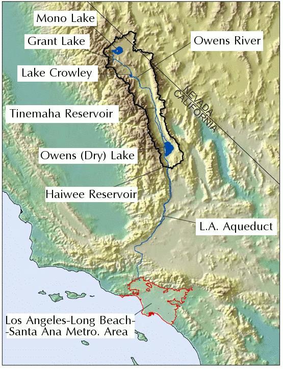
30 Endangered Fish Species in the River Humpback Chub Razorback sucker Boney tailed chub Gila trout


31 Replicating Flood Events Ecosystems of the Colorado River were based on flood events. With dams, there are no more seasonal floods. Twice, Glen Canyon Dam has released a large amount of water to try and replicate those floods and restore the sand bars. But, with increasing droughts lowering the reservoirs, that opportunity is becoming less available.


32 Central Arizona Project 361 mile canal delivering water to the Phoenix Basin and Tucson. It is the most expensive aqueduct ever built at $3.6B It carries virtually all of Arizona s allotment of water from the Colorado River.


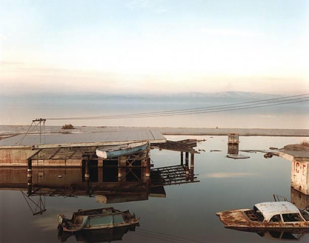
33 Colorado River Canal The Colorado River Canal that feeds Los Angeles also leaves from Parker Dam.

34 Imperial Dam Just north of Yuma, it generates electricity and diverts water into the All-American Canal

35 All-American Canal It crosses the Algodones Dunes on its way to the Imperial Valley for irrigation.

36 Imperial Valley, CA Located below sea level, it grows the vast majority of America s winter crops.

37 Los Angeles Aqueduct and the Drying of Owens Lake In 1905, work began on the L.A. aqueduct to supply water from the Eastern Sierras to L.A. Water was diverted from the Owens River. With the Owens river unable to feed the endoheric Owens Lake, the lake dried up completely by 1913.
38


39 Los Angeles Aquaduct 233 miles, mostly through unlined (and thus leaky) conduits to Los Angeles. Accounts for about 36% of L.A. s water needs.

40 The Now Dry Owens Lake When Owens Lake dried up alkaline toxic salt deposits and sediments would blow around in the wind, causing respiratory disease and cancer to nearby residents and contaminating farmers fields.

41 Lawsuits and Mitigation A series of lawsuits, culminating in a court ruling in 2008 requires the city of Los Angeles to return some water back to the lake. They are required to keep down toxic dust and restore a portion of the ecosystem.

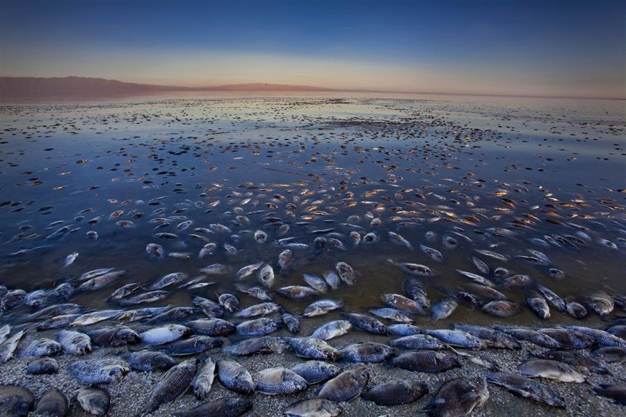
42 Mitigation at Owens Lake They spray a fine layer on water onto the lake sediments to keep them wet, so they are less likely to blow around as toxic dust. Nonetheless, Owens Lake remains the #1 source of dust pollution in the U.S.


43 Owens Lake Not as before, but better than it was Some portions of the former lakebed have been restored to a functioning ecosystem.

44 The Salton Sea


45 Formation of the Salton Sea In 1904, the Colorado River flooded and overflowed its levees. It cut a new path across the desert into the Salton Sink, a low area below sea level. It flowed uncontrollably for 3 years.

46 The water drained through a formerly dry wash called New River

47 The Salton Sea is California s Largest Lake


48 Salton Sea Boom Times Not long afterwards, lake front communities, marinas, and fishing vessels popped up all around the Salton Sea
49 The Lake Levels Quickly Dropped Without the rivers to feed it, the lake level quickly began to drop and the water became much more salty. Many of those resort villages now found themselves a long ways from shore. Today, the Salton Sea is saltier than the ocean and not many fish can survive in it.


50 Salton Sea Fish Die Off When conditions get too salty and eutrophication occurs, there are massive fish die offs


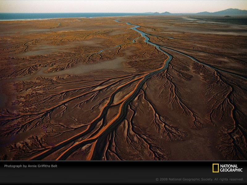
51 New River Today, the New River is an agricultural and sewage run off stream into the Salton Sea

52 Salton Sea Today The New River s flow is composed of agricultural and chemical runoff from irrigation in the U.S. (18%) and Mexico (51%) and sewage from the City of Mexicali (29%)
, and pesticides (including DDT) and PCBs.")
53 Salton Sea Today By the time the New River crosses the U.S./Mexico border near Calexico, CA, the channel contains a stew of about 100 contaminants: Volatile organic compounds, heavy metals (including U, As, and Hg), and pesticides (including DDT) and PCBs. The waterway also holds the pathogens that cause tuberculosis, encephalitis, cholera, hepatitis, typhoid, and fecal coliform bacteria.

54 Back to the Colorado River

55 Laguna Diversion Dam For lower Yuma Valley agriculture

56 The Last of the Water Mexico diverts the last of the Colorado River s waters to the Mexicali Valley for agriculture.

57 The Colorado River no longer flows to the ocean!


58 The Colorado Delta The Colorado River once fed into the Sea of Cortez creating an enormous estuary and wetland that was home to thousands of shorebirds. It s brackish waters were nurseries for millions of fish that fed fishing villages all up and down the coast of the sea.


59 The Clams There were unique clams so abundant that they build huge mounds with their shells. Those clams are gone, the wetlands are gone, the birds are gone, and so are the fishermen.
60

61 The Flow of the Colorado River Before After
SALINITY. It's the amount of dissolved salts the water contains.
 AQUATIC ECOSYSTEMS SALINITY The types of organisms in an aquatic ecosystem depend upon the water s Salinity. It's the amount of dissolved salts the water contains. Salinity determines the two main aquatic
Module 2 Narration What is a watershed?
 Module 2 Narration What is a watershed? Timing Key Narrative Snapshots a) 00:10 Every living thing relies on water to exist. But where does our water come from? The most natural place to look is upstream
Warm-up # 7 A day 5/17 - B day 5/18 UPDATE YOUR TABLE OF CONTENTS
 Warm-up # 7 A day 5/17 - B day 5/18 UPDATE YOUR TABLE OF CONTENTS Question: List all examples of surface water on Earth. Answer: Rivers and streams, lakes and reservoirs, (ponds) wetlands, estuaries and
Colorado River Interactive Simulation - Native Ecosystems Unit. Home. Native Ecosystems Unit
 Colorado River Interactive Simulation - Native Ecosystems Unit Home NPS/Mike Quinn Native Ecosystems Unit The Colorado River is the lifeblood of the southwestern United States and northwest corner of Mexico.
THREE WATER DIVERSION CASES
 THREE WATER DIVERSION CASES PURPOSE Research the Internet and other s rces surrounding ecosystems and human communities Compare and contrast the problems and successes of various water diversions and describe
Nonnative Fish Management River Specific Fact Sheets 2010
 Stephen D. Guertin, Chairman Implementation Committee Thomas E. Chart, Director Recovery Program U.S. Fish and Wildlife Service P.O. Box 25486 Denver Federal Center Denver, CO 80225 (303) 969-7322 Fax
1. Eating wild salmon is healthy for you and healthy for our environment. But this fishery will only continue to exist with help from you.
 Save Our Wild Salmon: It s Up to You Notes to Accompany PowerPoint Presentation by Barbara Hawkins, Education Director Central Coast Women for Fisheries, Inc. 1. Eating wild salmon is healthy for you and
Geology. Key Factors. Overfishing. Great Lakes Fishes. Historical Fishing. About 10,000 years since last glacial retreat very young ecologically
 Great Lakes Fishes Geology About 10,000 years since last glacial retreat very young ecologically Largest surface freshwater system on earth 21% of world s supply 84% of North America s supply Five unique
Searsville Dam Removal
 Searsville Dam Removal A unique opportunity for all Presented by the Beyond Searsville Dam Coalition San Francisquito Creek flows into the San Francisco Bay near the Palo Alto Airport and Golf Course seen
Marine Ecosystems. Aquatic Ecosystems Section 2
 Marine Ecosystems Marine ecosystems are located mainly in coastal areas and in the open ocean. Organisms that live in coastal areas adapt to changes in water level and salinity. Organisms that live in
Finding the Way Home
 Finding the Way Home Adapted from: Activity 27 The Great Anadromous Fish Game Living in Water. The National Aquarium in Baltimore, 1997. Migration Grade Level: Intermediate Duration: 1-2 class periods
Parts and Pieces The Story of Chicago and Lake Michigan
 Parts and Pieces The Story of Chicago and Lake Michigan You may draw pictures to show what each part of this history might have looked like. Draw your pictures next to the words. You also may cut these
Fish at the table and in the river: Nearing a quarter-century in the Upper Colorado River Endangered Fish Recovery Program
 Fish at the table and in the river: Nearing a quarter-century in the Upper Colorado River Endangered Fish Recovery Program Angela Kantola Deputy Program Director Partners State of Colorado State of Utah
At Home on the Elbow River. -Ours to share-
 At Home on the Elbow River -Ours to share- Living in the shed You are part of the Elbow River Watershed. The Elbow River and its tributaries drain over 1,200 km² of land. The source of the Elbow River
Coastal Environments Oceanographic and Engineering Expertise
 Coastal Environments Oceanographic and Engineering Expertise Coastal Environments La Jolla, CA www.coastalenvironments.com 14 May 2004 CE Ref. No. 04-05 EcoSystems Management Associates, Inc. Carlsbad,
WFC 50 California s Wild Vertebrates Jan. 11, Inland Waters (Lakes and Streams) Lisa Thompson
 Lisa Thompson") Inland Waters: Lakes and Streams WFC 50 11 January 2011 Lisa Thompson Fisheries Extension Specialist Wildlife, Fish, & Conservation Biology Department University of California, Davis Take home messages
Inland Waters: Lakes and Streams WFC 50 11 January 2011 Lisa Thompson Fisheries Extension Specialist Wildlife, Fish, & Conservation Biology Department University of California, Davis Take home messages
ELIZABETH RIVER FACTS
 ELIZABETH RIVER FACTS How is she different from inland rivers? The Elizabeth River is an estuary a tidal finger of the Chesapeake Bay, rather than a freshwater river with a spring as origin. The Elizabeth
Fighting for Life in French Creek
 Fighting for Life in French Creek Created By: An original Creek Connections activity created by David Hall, Creek Connections staff. Creek Connections, Allegheny College, Meadville, Pennsylvania, 16335
5B. Management of invasive species in the Cosumnes and Mokelumne River Basins
 5B. Management of invasive species in the Cosumnes and Mokelumne River Basins Cosumnes River The Cosumnes River basin has a number of distinct habitat types that require different management strategies
NYS Coastal Waters. Water Resources of NYS: THE NATURE of the COASTAL ZONE. NYS Coastal Waters. NYS Coastal Atlas. Coastal Zone Management 10/10/2014
 Water Resources of NYS: THE NATURE of the COASTAL ZONE NYS Coastal Waters NYS is the only state to border the Atlantic Ocean and the Great Lakes (Lakes Erie and Ontario). Great Lakes shoreline: 577 miles
Ecosystem Management Model
 Ecosystem Management Model What happens with water rights issues? Klamath Tribes Nez Perce Tribe Native American tribes, Yurok, Hupa, and Karuk tribes Confederation of the Klamath, Modoc, and Yahooskin
This is a digital document from the collections of the Wyoming Water Resources Data System (WRDS) Library.
 Library.") This is a digital document from the collections of the Wyoming Water Resources Data System (WRDS) Library. For additional information about this document and the document conversion process, please contact
This is a digital document from the collections of the Wyoming Water Resources Data System (WRDS) Library. For additional information about this document and the document conversion process, please contact
ADOPT-A-STREAM WATERSHED APPROACH COMMUNITY-BASED STEWARDSHIP. Nova Scotia Salmon Association March 2005
 ADOPT-A-STREAM A WATERSHED APPROACH TO COMMUNITY-BASED STEWARDSHIP Nova Scotia Salmon Association March 2005 This manual is a revised and updated version of the 1994 Adopt-a-Stream manual that was prepared
WHAT ARE ECOSYSTEMS? Dr. V. N. Nayak Professor of Marine Biology (Retd)
") WHAT ARE ECOSYSTEMS? Dr. V. N. Nayak Professor of Marine Biology (Retd) An ECOSYSTEM is an interacting system of plant, animals, and humans and the surrounding environment. An ecosystem contains living
WHAT ARE ECOSYSTEMS? Dr. V. N. Nayak Professor of Marine Biology (Retd) An ECOSYSTEM is an interacting system of plant, animals, and humans and the surrounding environment. An ecosystem contains living
Texas Water Resources Institute
 Texas Water Resources Institute November/December 1982 Volume 8 No. 6 A Precise Environment By Lou Ellen Ruesink, Editor, Texas Water Resources Aquarium enthusiasts know just how particular fish are about
The Ahamacave or Mohave The Mohave continue to live in their river valley homelands The Mohave eat many different types of food dammed
 The Ahamacave or Mohave The information below is taken from The Ahamacave (commonly pronounced as Mohave) Traveling Suitcase exhibit for Museum Education Outreach, Grade Levels 3-4, 5-6 Teacher Manual,
NEVADA DEPARTMENT OF WILDLIFE STATEWIDE FISHERIES MANAGEMENT
 NEVADA DEPARTMENT OF WILDLIFE STATEWIDE FISHERIES MANAGEMENT FEDERAL AID JOB PROGRESS REPORTS F-20-50 2014 BILK CREEK RESERVOIR WESTERN REGION 1 NEVADA DEPARTMENT OF WILDLIFE, FISHERIES DIVISION JOB PROGRESS
CHAPTER 11.1 THE WORLD OCEAN MARINE BIOMES NOTES
 CHAPTER 11.1 THE WORLD OCEAN MARINE BIOMES NOTES 1. The world ocean can be divided into zones both and. The,, and zones that apply to large lakes also apply to the ocean. 2. In addition to the depth zones,
California Steelhead: Management, Monitoring and Recovery Efforts
 California Steelhead: Management, Monitoring and Recovery Efforts Jonathan Nelson Steelhead Management, Research and Restoration Program Oncorhynchus mykiss irideus California Steelhead - Hot Topics Implementation
EcoLogic Memorandum. TO: Ben Brezell; EDR FROM: Mark Arrigo RE: Possible Impacts of Dredging Snooks Pond DATE: 6/4/07
 EcoLogic Memorandum TO: Ben Brezell; EDR FROM: Mark Arrigo RE: Possible Impacts of Dredging Snooks Pond DATE: 6/4/07 Background EDR P.C. (EDR) has been contracted by a landowner to assess the feasibility
Popular Book Company (Canada) Limited
 Limited") 2 4 12 16 20 24 2 32 36 3 40 44 1-30 1-2 Copyright 2009 Popular Book Company (Canada) Limited All rights reserved. No part of this book can be reproduced in any form or mechanically stored in any retrieval
2 4 12 16 20 24 2 32 36 3 40 44 1-30 1-2 Copyright 2009 Popular Book Company (Canada) Limited All rights reserved. No part of this book can be reproduced in any form or mechanically stored in any retrieval
Indian River Lagoon: Lessons, Challenges and Opportunities
 Indian River Lagoon: Lessons, Challenges and Opportunities Upper Chain of Lakes Lake Kissimmee Kissimmee River Indian River Lagoon Caloosahatchee Estuary Lake Okeechobee St. Lucie Estuary Mark Perry, Executive
NEVADA DEPARTMENT OF WILDLIFE STATEWIDE FISHERIES MANAGEMENT
 NEVADA DEPARTMENT OF WILDLIFE STATEWIDE FISHERIES MANAGEMENT FEDERAL AID JOB PROGRESS REPORTS F-20-52 2016 LAKE TAHOE WESTERN REGION NEVADA DEPARTMENT OF WILDLIFE, FISHERIES DIVISION ANNUAL PROGRESS REPORT
Examples of estuaries include bays, sounds, salt marshes, mangrove forests, mud flats, swamps, inlets, and sloughs.
 An estuary is a partially enclosed body of water where incoming seawater is mixed with fresh water coming from the land. Examples of estuaries include bays, sounds, salt marshes, mangrove forests, mud
Reduction in Biological Diversity Section 4.1 p Section 4.3 p
 Reduction in Biological Diversity Section 4.1 p. 57-65 Section 4.3 p. 72-78 Review Ecological Diversity A variety of ecosystems (mountains, forests, deserts) and how they interact together. Community Diversity
School District of Palm Beach County Elementary Curriculum
 School District of Palm Beach County Elementary Curriculum Spring Practice Grade Four Reading Grade 4 Read Desert Dwellers and then answer questions 1 through 5. Desert Dwellers If you go to Arizona today,
Paleo-Indians Indians. Pioneers
 Paleo-Indians Indians Archaeological evidence shows that people called Paleo-Indians were in the area of Utah Lake from about 12,000 to 8,500 B.C. They inhabited caves or brush and wood shelters. They
Let s take a closer look at estuaries and learn why they are important.
 ave you ever wondered what happens where a river or stream flows into the ocean? When fresh water meets saltwater in a protected bay or inlet, a partially enclosed body of water called an estuary often
Hoover Dam. Hoover Dam A Reading A Z Level M Leveled Book Word Count: 527 LEVELED BOOK M
 A Reading A Z Level M Leveled Book Word Count: 527 LEVELED BOOK M Connections Writing Write a paragraph about the importance of. Include a main idea and at least three supporting details from this book
NEVADA DEPARTMENT OF WILDLIFE STATEWIDE FISHERIES MANAGEMENT
 NEVADA DEPARTMENT OF WILDLIFE STATEWIDE FISHERIES MANAGEMENT FEDERAL AID JOB PROGRESS REPORTS F-20-52 2016 Lake Tahoe Rainbow Trout Study WESTERN REGION NEVADA DEPARTMENT OF WILDLIFE, FISHERIES DIVISION
Illinois Lake Management Association Conference March 23, 2018 By Trent Thomas Illinois Department of Natural Resources Division of Fisheries
 Illinois Lake Management Association Conference March 23, 2018 By Trent Thomas Illinois Department of Natural Resources Division of Fisheries Sources of Habitat Impairment Sedimentation Channelization
Managing Chesapeake Bay s Land Use, Fish Habitat, and Fisheries: Studies. Jim Uphoff & Margaret McGinty, Fisheries Service
 Managing Chesapeake Bay s Land Use, Fish Habitat, and Fisheries: Positive Image and or Negative Graphic Case Studies Jim Uphoff & Margaret McGinty, Fisheries Service Maryland Fisheries Service has been
VIDEO AUDIO Slide 1. Slide 2 Old timey 18 th century map of east coast
 VIDEO AUDIO Slide 1 1A Welcome to the Cooper River Rediversion Project at St. Stephen, Montage of exteriors of facility, South Carolina! Since 1985, this boating, fish runs, fishing, facility has served
2. Study Setting. This section describes the study domain, major terrain features, land use, meteorology, and regional air quality and visibility.
 2. Study Setting This section describes the study domain, major terrain features, land use, meteorology, and regional air quality and visibility. 2.1 The Southwestern United States Figure 2-1 shows a terrain
Where Animals and Plants Are Found
 About Animals and Plants What I Need to Know Many different animals and plants live on Earth. The animals and plants live in different places and make up parts of different ecosystems. In an ecosystem,
Productivity per unit area (m 2 ) Total Productivity (global)
 Total Productivity (global)") Productivity per unit area (m 2 ) Total Productivity (global) 1 Important concepts: Biodiversity and Fishery Stocks. Looked at lot of diversity in class what is happening to it and why? Biodiversity variety
Productivity per unit area (m 2 ) Total Productivity (global) 1 Important concepts: Biodiversity and Fishery Stocks. Looked at lot of diversity in class what is happening to it and why? Biodiversity variety
Vocabulary: Headwaters, watershed, tributaries, estuary, replica, point source pollution, nonpoint source pollution, amd river miles.
 From Source To Sea: Lesson Plan Concepts: 1. Understanding the path the Hudson River takes from the headwaters in the Adirondacks to the New York Harbor 2. Identifying the Hudson River watershed area,
Oceans Humans both depend on it and threaten it with their activities
 Oceans Humans both depend on it and threaten it with their activities Oceans Water covers nearly ¾ of the Earth s surface More than 50% of the world s population lives within an hour of the coast Oceans
The Salmonid Species. The Salmonid Species. Definitions of Salmonid Clans. The Salmonid Species
 The Salmonid Species The Salmonid Species N. American salmon (2 more Asian species) Chinook ( King ) Coho ( Silver ) Sockeye Chum ( Dog ) Pink ( Humpy ) Sea-run trout Steelhead, Cutthroat, Dolly Varden
Research report. Environmental Commission: Sub-commission 1 The question of the Aral Sea By: Aaron Gilchrist
 Research report Environmental Commission: Sub-commission 1 The question of the Aral Sea By: Aaron Gilchrist Introduction The Aral Sea forms part of southern Kazakhstan and part of the autonomous Republic
Section 2: Biodiversity at Risk
 Section 2: Biodiversity at Risk Preview Classroom Catalyst Objectives Biodiversity at Risk Current Extinctions Species Prone to Extinction How Do Humans Cause Extinctions? Habitat Destruction and Fragmentation
Full Name Class Date. 1. Draw and describe your prediction of what will happen to the eggplant after the teacher applies salt to it.
 Full Name Class Date Investigation Booklet Exploring: Salt in Our Lives 1. Draw and describe your prediction of what will happen to the eggplant after the teacher applies salt to it. Use these ecosystem
Ups and Downs in an Estuary
 Ups and Downs in an Estuary Whooping Crane Dilemma Modified from Texas Aquatic Science and Estuaries in the Balance Curriculum TEKS 6.2 E; 6.3 C; 6.12 E; 7.2 E; 7.3 C; 7.5 A; 7.8 A; 7.13 A; 8.2 E; 8.3
NEVADA DEPARTMENT OF WILDLIFE STATEWIDE FISHERIES MANAGEMENT
 NEVADA DEPARTMENT OF WILDLIFE STATEWIDE FISHERIES MANAGEMENT FEDERAL AID JOB PROGRESS REPORTS F-20-49 2013 LAKE TAHOE WESTERN REGION NEVADA DEPARTMENT OF WILDLIFE, FISHERIES DIVISION ANNUAL PROGRESS REPORT
MONSOONS. Summer Monsoon
 MONSOONS A monsoon is a seasonal change in the direction of the prevailing, or strongest, winds of a region. Monsoons cause wet and dry seasons throughout much of the tropics. Monsoons are most often associated
Nonnative Quagga Mussels Impacting Glen Canyon National Recreation Area
 Nonnative Quagga Mussels Impacting Glen Canyon National Recreation Area Quagga mussels on the shore with Lone Rock in the background at Glen Canyon National Recreation Area/David Rankin via NPS Though
U. S. Fish & Wildlife Service
 U. S. Fish & Wildlife Service Produced By U.S. Fish and Wildlife Service Pacific Region Illustrations by Gary Whitley Special thanks to the Sacramento Fish and Wildlife Office s Central Valley Improvement
Coastal management has lagged behind the growth in population leading to problems with pollution
 Fifty percent of the population of the industrialized world lives within 100 km of a coast. Coastal management has lagged behind the growth in population leading to problems with pollution and natural
Washington, D.C Washington, D.C April 22, Dear Chairs Mikulski and Rogers and Ranking Members Shelby and Lowey:
 The Honorable Harold Rogers The Honorable Barbara Mikulski Chairman Chairwoman The Capitol Building The Capitol Building House Committee on Appropriations Senate Committee on Appropriations United States
2012 Bring Back the Natives Awarded Projects
 2012 Bring Back the Natives Awarded Projects EZG # Organization Project Title Project Description Location Description Total Award Amount Grantee Non- Federal Match 31904 Sanctuary Forest, Inc. Mattole
Quay County, New Mexico 160 deeded acres; (MOL) $420,000
 $420,000") Quay County, New Mexico 160 deeded acres; (MOL) $420,000 Turn your steers out and watch them gain! FARMING House Ranch offers 60 acres of water rights This region of New Mexico just east of Tucumcaro
Quay County, New Mexico 160 deeded acres; (MOL) $420,000 Turn your steers out and watch them gain! FARMING House Ranch offers 60 acres of water rights This region of New Mexico just east of Tucumcaro
LESSON 1 Rewriting the Wilderness Act
 LESSON 1 Rewriting the Wilderness Act Objectives: Students will: Read the Wilderness Act of 1964 and rewrite phrases in their own words. Duration: 1 to 2 class periods Location: indoors or outdoors Background:
Collaborative. City of Stuart. September 7, Mark Perry, Executive Director Oceanographic Society. Upper Chain of Lakes
 Lake Okeechobee Collaborative Upper Chain of Lakes Lake Kissimmee Indian River Lagoon City of Stuart September 7, 2016 Kissimmee River Caloosahatchee Estuary Lake Okeechobee St. Lucie Estuary Everglades
West Africa Desertification in West Africa
 Non-fiction: West Africa Desertification in West Africa West Africa Desertification in West Africa In Arabic, Sahel means shore, or coast. The Sahel is the place where the waves of the ocean crash onto
Fisheries and Lake Management Planning. CAP Mtg Nov21,2012 Brett Tregunno Aquatic Biologist, Kawartha Conservation
 Fisheries and Lake Management Planning CAP Mtg Nov21,2012 Brett Tregunno Aquatic Biologist, Kawartha Conservation Outline Aquatic Habitat Types Fish Communities Significance of Resource Current Management
An Unwelcome Newcomer
 An Unwelcome Newcomer An Unwelcome Newcomer This article is provided courtesy of the American Museum of Natural History. million eggs each year. Then Invasion of the Zebra Mussels the young mussels float
California Steelhead: Management, Monitoring and Recovery Efforts
 California Steelhead: Management, Monitoring and Recovery Efforts Jonathan Nelson Steelhead Restoration & Management Program Oncorhynchus mykiss irideus California Steelhead Distinct Population Segments
Statement of Dr. Jack Williams Senior Scientist, Trout Unlimited. Before the
 Statement of Dr. Jack Williams Senior Scientist, Trout Unlimited Before the Subcommittee of Water and Power Energy and Natural Resources Committee United States Senate June 6, 2007 Mr. Chairman, Members
Fish Texas AQUATIC ECOSYSTEMS
 27 Additionally, healthy aquatic communities in Texas rivers, reservoirs and estuaries provide unparalleled recreational opportunities to millions of Texans. Our fresh and saltwater environments vary from
Today: Coastal Issues and Estuaries
 Today: Coastal Issues and Estuaries Coastal issues Human effect on coastlines What is an estuary Why are they so important? Circulation of water in estuary Environmental issues Coastal Issues: Problem
Bighorn Sheep, Mule Deer and The Central Arizona Project
 Bighorn Sheep, Mule Deer and The Central Arizona Project Some time last spring a young bighorn ram crossed the dozen miles of desert floor from the Harquahala Mountains to the Big Horn Mountains near Tonopah.
Habitat Fact Sheets. Rocky habitats are dominated by seaweeds and often mussels, which rely on the rocks for attachment.
 Habitat Fact Sheets Habitats in the Gulf of Maine serve many important roles for the environment and for humans as well. These include: cycling nutrients, filtering pollution, trapping sediments, storing
AN OVERVIEW OF RECENT PROJECTS RELATED TO SAND BUDGETS, SOUTHERN CALIFORNIA BEACHES
 AN OVERVIEW OF RECENT PROJECTS RELATED TO SAND BUDGETS, SAND SUPPLY, COASTAL ARMORING, MANAGEMENT, AND VALUING SOUTHERN CALIFORNIA BEACHES Dr. Kiki Patsch California State University Channel Islands Environmental
Colorado River Drought Response and System Sustainability. Chuck Cullom July 16, 2014
 Colorado River Drought Response and System Sustainability Chuck Cullom July 16, 2014 Study Structure and Schedule Summary of Key Activities Upcoming Meetings Further Discussion, Follow-up Colorado River
Executive Summary. Map 1. The Santa Clara River watershed with topography.
 Santa Clara River Steelhead Trout: Assessment and Recovery Opportunities December 2005 Prepared By: Matt Stoecker and Elise Kelley, Ph.D. University of California, Santa Barbara Prepared For: The Santa
First Nations Fish Habitat Program Discussion Workbook
 First Nations Fish Habitat Program Discussion Workbook The First Nations Fish Habitat Program is a joint initiative of the Centre for Indigenous Environmental Resources (CIER) and The Southern Chiefs Organization
NEVADA DEPARTMENT OF WILDLIFE STATEWIDE FISHERIES MANAGEMENT
 NEVADA DEPARTMENT OF WILDLIFE STATEWIDE FISHERIES MANAGEMENT FEDERAL AID JOB PROGRESS REPORTS F-20-52 2016 EAST FORK AND MAIN STEM CARSON RIVER WESTERN REGION NEVADA DEPARTMENT OF WILDLIFE, FISHERIES DIVISION
Restoring the Kootenai: A Tribal Approach to Restoration of a Large River in Idaho
 Restoring the Kootenai: A Tribal Approach to Restoration of a Large River in Idaho Susan Ireland, Kootenai Tribe of Idaho Future of our Salmon Conference Technical Session August 2016 Healthy Floodplains,
COASTAL WETLAND SURVEY. Location: Sec. 35, 36 T. 13N R. 17W Quadrangle: Pt. Arena (7 1/2 min) Field Investigator: Gayle Dana Date of Survey : 2/22/78
 Field Investigator: Gayle Dana Date of Survey : 2/22/78") COASTAL WETLAND SURVEY Name of Area: Garcia River County : Mendocino Location: Sec. 35, 36 T. 13N R. 17W Quadrangle: Pt. Arena (7 1/2 min) Ownership : Private Field Investigator: Gayle Dana Date of Survey
COASTAL WETLAND SURVEY Name of Area: Garcia River County : Mendocino Location: Sec. 35, 36 T. 13N R. 17W Quadrangle: Pt. Arena (7 1/2 min) Ownership : Private Field Investigator: Gayle Dana Date of Survey
Chapter 4: Google Earth Exercise
 Chapter 4: Google Earth Exercise Exercise 1 Visualizing the Three Gorges Dam Hydroelectric Project The Three Gorges Dam was the largest infrastructure project in China since the Great Wall. Completed in
SUMMARY.
 SUMMARY Regional Water Quality NEWSLETTER DATE: Report for February 2017 A Tempe, Glendale, Peoria, Chandler, Phoenix, ADEQ, CAP, SRP, Epcor NSF Central Arizona-Phoenix Long-Term Ecological Research ASU
Emergent Sandbar Habitat Program Middle Missouri River
 Emergent Sandbar Habitat Program Middle Missouri River Jeremiah Szynskie, P.E. Hydrologic Engineering Branch Introduction Main Stem System Dam Closures Fort Peck 1937 Fort Randall 1952 Garrison - 1953
UTAH LAKE JUNE SUCKER
 UTAH LAKE JUNE SUCKER PROCEDURE: Activity Game: UTAH LAKE JUNE SUCKER GAME Instructions: 1. Hand out one Utah Lake Card per student. 2. Select one area of the gym to be Utah Lake and another to be Provo
1. Welcome from Bob Burdick, US Fish and Wildlife Service
 100 th Meridian Initiative Colorado River Basin Team Grand Junction, Colorado July 31, 2002 1. Welcome from Bob Burdick, US Fish and Wildlife Service 2. Member Reports: Don Archer - Utah Division of Wildlife
Nechako white sturgeon are an Endangered Species
 Nechako white sturgeon are an Endangered Species There are likely less than 350 Nechako white sturgeon, and historically there were over 5000 in the Nechako Watershed. Endangered as per the Species at
The Oyster in Oyster Bay: Glaciers Set the Table
 The in Bay: Glaciers Set the Table In cooperation with NYS Department of Environmental Conservation Bay Long Island was created about 15,000 years ago when the last of the glaciers melted leaving behind
STREAM SURVEY File form No..
 scanned for KRIS THE RESOURCES AGENCY OF CALIFORNIA California Department of Fish and Game STREAM SURVEY File form No.. Date: September 4, 1969. NAME: North Fork Schooner Gulch Creek COUNTY: Mendocino.
NEVADA DEPARTMENT OF WILDLIFE STATEWIDE FISHERIES MANAGEMENT
 NEVADA DEPARTMENT OF WILDLIFE STATEWIDE FISHERIES MANAGEMENT FEDERAL AID JOB PROGRESS REPORT F-20-50 2014 LAHONTAN CUTTHROAT TROUT STUDY WESTERN REGION NEVADA DEPARTMENT OF WILDLIFE, FISHERIES DIVISION
PROJECT TO INSTALL LARGE WOOD HABITAT STRUCTURES IN THE CARMEL RIVER USING CALIFORNIA DEPARTMENT OF FISH AND GAME GRANT FUNDS
 PROJECT TO INSTALL LARGE WOOD HABITAT STRUCTURES IN THE CARMEL RIVER USING CALIFORNIA DEPARTMENT OF FISH AND GAME GRANT FUNDS The Monterey Peninsula Water Management District (MPWMD), in cooperation with
A Comparison of Western Watershed Councils. Presentation Prepared by Jeff Salt, Great Salt Lakekeeper
 A Comparison of Western Watershed Councils Presentation Prepared by Jeff Salt, Great Salt Lakekeeper Presentation Overview Introduction Jordan River Watershed Council Lower Boise Watershed Council Clackamas
Over 130 Environmental Groups Oppose Deep Cuts to Environment and Natural Resources Programs in the President s FY18 Budget Proposal
 Over 130 Environmental Groups Oppose Deep Cuts to Environment and Natural Resources Programs in the President s FY18 Budget Proposal March 16, 2017 Dear Senator/Representative: On behalf of our millions
Puget Sound Shorelines. Waves and coastal processes. Puget Sound shorelines: Effects of beach armoring
 Puget Sound Shorelines Puget Sound shorelines: Effects of beach armoring Waves and coastal processes Factors affecting wave energy hitting the coast Processes transporting sediment along coastlines What
Minnesota Department of Natural Resources Division of Fish and Wildlife Section of Fisheries. Stream Survey Report. Luxemburg Creek.
 Minnesota F-29-R(P)-24 Area 315 Study 3 March 2016 Minnesota Department of Natural Resources Division of Fish and Wildlife Section of Fisheries Stream Survey Report Luxemburg Creek 2015 Mark Pelham Sauk
The San Juan River Steven ChischiIIy
 The San Juan River Steven Chischiy ntroduction: The headwaters of the San Juan River begin on the western slope of the Rocky Mountains in southwestern Colorado. The headwaters, located at over 14,000 feet
Can Humpback Chub and a Blue Ribbon Trout Fishery Coexist in the Grand Canyon?
 Can Humpback Chub and a Blue Ribbon Trout Fishery Coexist in the Grand Canyon? Abstract Carson Jeffres Maintaining both a population of native Humpback Chub (Gila cypha) and non-native Rainbow Trout (Oncorhynchus
Restoration Project at Trout Run Nature Preserve
 Restoration Project at Trout Run Nature Preserve Report Prepared By Eli DePaulis, 12/30/17 Trout Run Nature Preserve is a 21.4-acre spring-fed wetland and upland ecosystem in Upper Allen Township, Cumberland
Up Your Creek! The electronic newsletter of the Alameda Creek Alliance
 Up Your Creek! The electronic newsletter of the Alameda Creek Alliance Steelhead Make a Showing in Alameda Creek Apparently not willing to wait until all of the fish ladders are constructed in Alameda
The future of the fishes of the Colorado River and it s tributaries
 The future of the fishes of the Colorado River and it s tributaries Phaedra Budy Utah State University U.S. Geological Survey, Utah Cooperative Fish and Wildlife Research Unit Logan, Utah, USA Moab, Utah
Communications Report August 2016
 Communications Report August 2016 Facebook 1,457 total likes, 71 new likes 15 CBBEP Facebook posts about our projects and staff achievements Most successful post reached 26,000 people, 26,000! (PSA to
Lower Dolores River Corridor Planning Meeting Jim White Colorado Division of Wildlife
 Lower Dolores River Corridor Planning Meeting Jim White Colorado Division of Wildlife Objectives Overview of cold and warm water fishes in the Dolores River including: Flow and Fish Management Distribution