COASTAL WETLAND SURVEY. Location: Sec. 35, 36 T. 13N R. 17W Quadrangle: Pt. Arena (7 1/2 min) Field Investigator: Gayle Dana Date of Survey : 2/22/78
|
|
|
- Vivien Jenkins
- 5 years ago
- Views:
Transcription
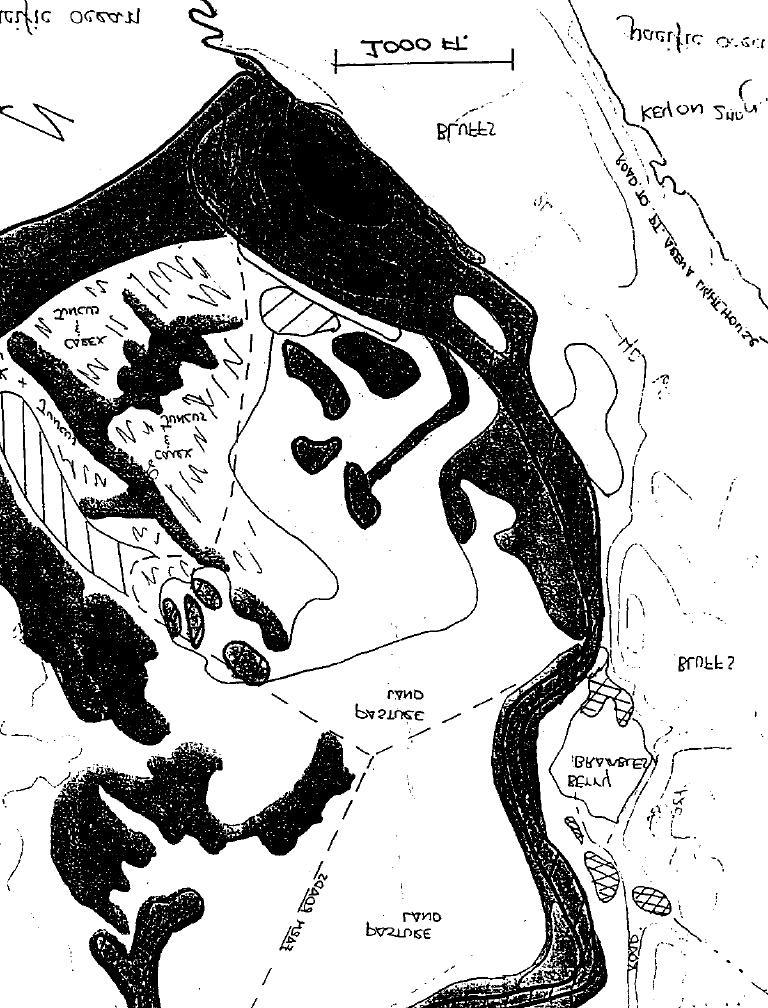
1 COASTAL WETLAND SURVEY Name of Area: Garcia River County : Mendocino Location: Sec. 35, 36 T. 13N R. 17W Quadrangle: Pt. Arena (7 1/2 min) Ownership : Private Field Investigator: Gayle Dana Date of Survey : 2/22/78 HABITAT: Estuary X Lagoon Coastal Freshwater Pond Comments : Tidal influence to about 2.3 miles or HWY 1 PRESENT STATUS: Water: Marine acres (area under water at mean low tide) Pond Area: High *1.50 acres; Low acres *near Stornetta Ranch. Littoral acres (total of marsh and mud flat): Mud Flat acres (sand flats = acres) Marsh acres (total of salt, brackish and freshwater): Salt Brackish 8.10 acres Dominant Species Salicornia, Distichlia acres. Dominant Species Cotula, Juncus Fresh 5.70 acres. Dominate Species Azolla, filiculoides, Hippuris vulgarus Typha; plus about acres of seasonally wet areas. (Juncus & Carex)in dune area Maritime acres (including pastureland which accounts for over 1/2 of this figure Lagoons: Mouth - Open Closed Do high waters breach the barrier yearly? Yes Every other year or so? Infrequently? Length of time mouth is open following breaching of barrier; Riparian : Stream Flow - Streamside Vegetation Dominant Vegetation acres Salix, Alnus Permanent X No days Comments : HISTORICAL INFORMATION AND SOURCE OF DATA: Interviews with Leslie & Frank Stornetta, local land owners, and George Curtis, local sportsman. ACCESS: The majority of this area is owned by the Stornetta family and permission should be secured before going onto their lands. Access to the north bank of the river is afforded by the first road north of Pt. Arena Lighthouse road. The bluffs overlooking the river on the south side of the road to the Pt. Arena Lighthouse affords a good view of the river's mouth.
2 Area Description GARCIA RIVER High bluffs dominate the western edge of the estuary at the mouth of the Garcia River. To the east, stabilized sand dunes and a large salt and brackish water marsh predominate. Marsh vegetation is composed principally of pickleweed (Salicornia), salt grass (Distichlis), brass button (Cotula), and rushes (Juncus). Small freshwater marshes with vegetative species, including azolla (Azolla filiculoides), mare's tail (Hippuris vulgarus), and cattail (Typha), are distributed along the river. Between 0.75 and 3.0 miles upriver, agricultural land, used both for grazing and crops, is separated from the river by a thin line of riparian vegetation. Pasture land is integrated with brush, woodland, and coniferous forest inland where the river valley becomes steep. Tidal influence appears to extend to the Highway 1 bridge, but local fishermen have reported seeing marine-related fish as far as 4.0 miles upstream from the mouth. Most of the bluffs, marshes, and pasture land in the immediate vicinity of the Garcia River is privately owned. Louisiana-Pacific Company owns some land adjacent to the river approximately 14 miles inland. The small town of Point Arena lies approximately 5 miles south of the estuary. Several small ranches and farms are scattered throughout the lower watershed. Manchester State Beach is located about 2 miles to the north. Hikers from this beach occasionally visit the mouth of the Garcia River. Natural Resources Waterfowl and gulls utilize the protected bay at the river's mouth to feed and rest. Harbor seals and other wildlife that use the rocky intertidal marine habitat occasionally utilize the bay as well. In the vicinity of the Garcia River-
3 -2- Hathaway Creek confluence, approximately 300 whistling swans winter on an open pasture. This flock is reported to have started using the area about 50 years ago (pers, comm., Frank and Leslie Stornetta). Their numbers are slowly increasing, and they can be found in the area from November to April. Although most whistling swans winter in the Central Valley, this is one of the few, if not only, whistling swan wintering areas on the northern California coast. In addition to the swans, other birds such as herring and mew gulls, mallards, blue-winged teal, marbled godwit, Canada geese, and brant utilize this pasture land. Another important area near the river for water-associated birds is the small freshwater marsh east of Highway 1 and north of the river. Pintail, gadwall, mallard, and cinnamon teal were observed in the wetland. The Garcia River provides excellent spawning and nursery habitat for steelhead and silver salmon. Fishing for these species is said to be very good in the river. The Garcia River is unusual in that the mouth remains open throughout the year. As a result, pink salmon (Oncorhynchus gorbuscha) occasionally visit the river. A private organization, Save Our Salmon, operates a salmon hatchery and rearing facility in the upper drainage of the Garcia. In addition to providing nursery habitat for young salmonids, the estuary is also used by various marine organisms. A number of species of flatfish, surfperch, and crustaceans (i.e., Dungeness crab) breed in the estuary. A high diversity of raptors (i.e., hawks and owls) were observed hunting over the salt marsh and dunes at the river's mouth. The ponds in the salt marsh provide feeding and resting habitat for dabbling ducks and wading birds. Osprey nest in the Garcia River drainage and feed in the river and estuary. Spotted owls are believed to nest in the general area.
4 -3- Adjacent Development In the past, the upper drainages of the Garcia River were severely damaged by logging activities, but have since largely recovered. During the summers, up to 100 head of cattle are grazed in the marshes. Dairy operations and logging activity may be sources of siltation and pollution in the river. The Manchester Anticline, located partially within the lower watershed of the Garcia River, is currently under consideration as a site for oil exploration. The initial phase of the project involves the drilling of two exploratory wells with the eventual establishment of up to 20 production wells if oil is discovered. Any resulting petroleum products are to be stored on site with transfer to Bay Area refineries by tanker trucks (as many as 20 trucks per day). The potential impacts of oil development could have very serious consequences. Major and minor spills of petroleum could occur during both the drilling and production phase of the project. The proposed method of transfer of oil from the project site is by truck along Highway 1 and Highway 128. This travel route is in the immediate watershed of 8 major coastal streams and 5 associated wetlands. The threat to these resources posed by 10 to 20 trucks a day loaded with 8,400 gallons of crude oil and contaminate waste water should not be overlooked. Many of the soils in the Manchester area are highly erodible and sedimentation of the river's valuable estuary may occur. Those wildlife species most susceptible to petroleum spills are the many. water-associated birds that depend on the Garcia River. The toxicity of petroleum products and substances used in drilling muds to aquatic organisms, particularly larval stages, is well documented.
5 - 4 - Relative Importance and Habitat Sensitivity The Garcia River estuary has the second largest salt marsh area of the 16 Mendocino County wetlands recently surveyed by DFG. Furthermore, the lower section of the river is associated with very extensive riparian vegetation, a habitat type similar in importance to wetlands in that it is an extremely productive habitat for fish and wildlife. The entire wetland complex is extremely valuable to fish and wildlife because of its high habitat diversity afforded by the close association of salt, brackish, and freshwater marsh, sand dunes, sand flats, riparian vegetation, and estuary. Current pastoral agricultural uses should be maintained, and no industrial or other incompatible developments should be allowed within the immediate watershed. Large parcel zoning should be maximized and parcel splits resulting in acreage units smaller than that necessary for efficient farm or dairy operations should be prohibited. Planning efforts in this area should treat Hathaway Creek, Garcia River, and Hunters Lagoon as a single resource unit. Steps should be taken to insure that agricultural practices are consistent with fish and wildlife needs. For example, livestock should not be grazed on marshes, sand dune communities, or in riparian vegetation. Proper soil management practices and the importance of not overgrazing should be addressed in a comprehensive and enforceable watershed management plan. An ordinance for the protection of riparian vegetation should be developed.
6
7
Examples of estuaries include bays, sounds, salt marshes, mangrove forests, mud flats, swamps, inlets, and sloughs.
 An estuary is a partially enclosed body of water where incoming seawater is mixed with fresh water coming from the land. Examples of estuaries include bays, sounds, salt marshes, mangrove forests, mud
STREAM SURVEY File form No..
 scanned for KRIS THE RESOURCES AGENCY OF CALIFORNIA California Department of Fish and Game STREAM SURVEY File form No.. Date: September 4, 1969. NAME: North Fork Schooner Gulch Creek COUNTY: Mendocino.
Warm-up # 7 A day 5/17 - B day 5/18 UPDATE YOUR TABLE OF CONTENTS
 Warm-up # 7 A day 5/17 - B day 5/18 UPDATE YOUR TABLE OF CONTENTS Question: List all examples of surface water on Earth. Answer: Rivers and streams, lakes and reservoirs, (ponds) wetlands, estuaries and
WHAT ARE ECOSYSTEMS? Dr. V. N. Nayak Professor of Marine Biology (Retd)
") WHAT ARE ECOSYSTEMS? Dr. V. N. Nayak Professor of Marine Biology (Retd) An ECOSYSTEM is an interacting system of plant, animals, and humans and the surrounding environment. An ecosystem contains living
WHAT ARE ECOSYSTEMS? Dr. V. N. Nayak Professor of Marine Biology (Retd) An ECOSYSTEM is an interacting system of plant, animals, and humans and the surrounding environment. An ecosystem contains living
RESTORING 400 ACRES OF TIDAL MARSH IN THE SNOHOMISH RIVER DELTA
 RESTORING 400 ACRES OF TIDAL MARSH IN THE SNOHOMISH RIVER DELTA Marya Moses, Danny Moses, Neil Moses, and Robert Moses fish on Tulalip Bay, near the mouth of the Snohomish River Estuary. QWULOOLT IS A
Types of Freshwater Ecosystems. Streams originate from underground water. Rivers form when streams join together. Freshwater Biome
 Definition Streams originate from underground water sources Types of Freshwater Ecosystems Streams Rivers Rivers form when streams join together Freshwater Lakes Ponds Basic Characteristics Directional
X.B WETLANDS ROGUE RIVER ESTUARY
 X.B WETLANDS ROGUE RIVER ESTUARY The Rogue River has a drainage area of 5,100 square miles, yet the estuary of the Rogue River is one of the smallest in Oregon, measuring approximately 1,880 acres during
Marine Ecosystems. Aquatic Ecosystems Section 2
 Marine Ecosystems Marine ecosystems are located mainly in coastal areas and in the open ocean. Organisms that live in coastal areas adapt to changes in water level and salinity. Organisms that live in
Steelhead Society of BC. Thompson River Watershed Restoration and Enhancement Project #4 Nicola River Bank Stabilization and Enhancement Project
 Steelhead Society of BC Presents: Thompson River Watershed Restoration and Enhancement Project #4 Nicola River Bank Stabilization and Enhancement Project Application for Funding December 2013 1.0 BACKGROUND
MARSH DEGRADATION AT THE MOUTH OF MOORE CREEK
 MARSH DEGRADATION AT THE MOUTH OF MOORE CREEK Hunter Winstanley, Department of Earth Sciences, University of South Alabama, Mobile, AL 36688. E-Mail: hcw501@jaguar1.usouthal.edu. Moore Creek is located
Acknowledgements Frank C. Bellrose & Daniel Holm
 Nesting Ducks of Tennessee Wood Ducks, Mallards, Hooded Mergansers Billy Minser UT FWF Acknowledgements Frank C. Bellrose & Daniel Holm Dick McCabe Featuring Frank Bellrose and Scott Neilson 1 There are
Species Conclusions Table
 Conclusions Table Project Name: Chesapeake Landing HOA- Breakwaters (NAO-14-0283) Date: February 25, 2014 /Resource Name Loggerhead sea turtle (Caretta caretta) Conclusion ESA Section 7 / Eagle Act Determination
MDWFP Aerial Waterfowl Survey Report. December 18-23, 2018
 MDWFP Aerial Waterfowl Survey Report December 18-23, 2018 Prepared by: Houston Havens Waterfowl Program Coordinator and Darrin Hardesty Waterfowl Program Biologist MS Department of Wildlife, Fisheries,
The Salmonid Species. The Salmonid Species. Definitions of Salmonid Clans. The Salmonid Species
 The Salmonid Species The Salmonid Species N. American salmon (2 more Asian species) Chinook ( King ) Coho ( Silver ) Sockeye Chum ( Dog ) Pink ( Humpy ) Sea-run trout Steelhead, Cutthroat, Dolly Varden
Little Kern Golden Trout Status:
 Little Kern Golden Trout Status: The Little Kern Golden trout (LKGT) was proposed for federal listing as Threatened under the Endangered Species Act (ESA) on September 1, 1977 by the U. S. Fish and Wildlife
Sub-watershed Summaries
 Project Description The Salmon Drift Creek Watershed Council (SDCWC) has focused their efforts in the Salmon River estuary for the past few years. The multifaceted partnership effort is nearing completion
SALINITY. It's the amount of dissolved salts the water contains.
 AQUATIC ECOSYSTEMS SALINITY The types of organisms in an aquatic ecosystem depend upon the water s Salinity. It's the amount of dissolved salts the water contains. Salinity determines the two main aquatic
Beach. Coastal Fishing
 Coastal Discoveries PROGRAM FOR GRADES 6-8 Beach Beach Seine Students explore the high energy surf zone using seine nets to sift and sort organisms. They will learn about functions of producers, consumers,
UNDERSTANDING YOUR ESTUARY Level IA- ESTUARY SEARCH
 UNDERSTANDING YOUR ESTUARY Level IA- ESTUARY SEARCH Kakagon/Bad River Sloughs, a Lake Superior estuary located on the Bad River Reservation near Ashland, WI. GOAL Select one Wisconsin estuary to study
Puget Sound Nearshore Ecosystem Restoration Project Restore America s Estuaries Conference 2012 Tampa, FL
 Restore America s Estuaries Conference 2012 Tampa, FL presented by: Theresa Mitchell, WA Dept. of Fish & Wildlife Nearshore General Investigation Change Analysis: Comparison of historical and current
The Malaspina Okeover
 Unit 7 Theodosia Inlet Marine Area Substrate Exposure Current Roughness Shoreline Slope Depth Benthic Summer Temp 2.0 sq km Mud 12.5 km Flat Shallow-Photic Warm DESCRIPTION: Theodosia Inlet is the most
Dr. Prakash N. Mesta
 Coastal Wetland Monitoring Dr. Prakash N. Mesta prakashhonavar@gmail.com Coastal Ecosystem is diverse in nature Most of the world human population p settled in Coastal region. Cities & Industries established
Puget Sound Shorelines. Waves and coastal processes. Puget Sound shorelines: Effects of beach armoring
 Puget Sound Shorelines Puget Sound shorelines: Effects of beach armoring Waves and coastal processes Factors affecting wave energy hitting the coast Processes transporting sediment along coastlines What
Wildlife Introduction
 Wildlife Introduction The wildlife section of this chapter is divided into sections for various habitats and groups of species. Old growth, snags and downed wood, and riparian areas are unique habitats
Background Information for Inside the Outdoors Programs
 Background Information for Programs ECOLOGY OF UPPER NEWPORT BAY In Upper Newport Bay, mud bubbles and bakes in the sun during low tide. Long-legged birds stalk the shallow pools searching for fish and
SELBY RANCH CALIFORNIA, YUBA COUNTY, BROWNS VALLEY. Recreational Haven in Northern California with Excellent Fishing and Hunting
 SELBY RANCH CALIFORNIA, YUBA COUNTY, BROWNS VALLEY Recreational Haven in Northern California with Excellent Fishing and Hunting This beautiful 1,812-acre ranch is located in the Gold Country Foothills
The week of October, 6 th Serving People, Managing Wildlife
 The week of October, 6 th 2014 Wildlife Division Serving People, Managing Wildlife! Resident only Pheasant season runs October 11 th October 13 th.! Regular Pheasant season starts October 18 th and runs
The Blue Heron Slough Conservation Bank
 1 The Blue Heron Slough Conservation Bank CONSERVATION BANKING July 19-23, 2010 CASE STUDY SERIES The Blue Heron Slough Conservation Bank (Washington) I. OVERVIEW & BACKGROUND: Location: Snohomish River
Columbia Lake Dam Removal Project
 Columbia Lake Dam Removal Project Major Goals of the Columbia Lake Dam Removal: Reconnect 10 miles of the Paulins Kill River to the Delaware River, restoring natural flow regime and sediment transport.
Coastal management has lagged behind the growth in population leading to problems with pollution
 Fifty percent of the population of the industrialized world lives within 100 km of a coast. Coastal management has lagged behind the growth in population leading to problems with pollution and natural
ADOPT-A-STREAM WATERSHED APPROACH COMMUNITY-BASED STEWARDSHIP. Nova Scotia Salmon Association March 2005
 ADOPT-A-STREAM A WATERSHED APPROACH TO COMMUNITY-BASED STEWARDSHIP Nova Scotia Salmon Association March 2005 This manual is a revised and updated version of the 1994 Adopt-a-Stream manual that was prepared
Texas Water Resources Institute
 Texas Water Resources Institute November/December 1982 Volume 8 No. 6 A Precise Environment By Lou Ellen Ruesink, Editor, Texas Water Resources Aquarium enthusiasts know just how particular fish are about
UNIT 4E. SALMON SUPPLEMENTAL INFORMATION
 UNIT 4E. SALMON SUPPLEMENTAL INFORMATION In the STUDENT HANDOUTS/TEACHER PAGES Section of this unit, we have provided you with a host of information from various sources to supplement not only this unit,
Outline. 1. Overview 2. Population 3. Flooding 4. Land Use 5. References. Overview
 Outline 1. Overview 2. Population 3. Flooding 4. Land Use 5. References Overview The two main rivers in the Cannon River watershed are the Cannon and Straight Rivers. The Cannon River originates in Shields
San Lorenzo Valley Water District, Watershed Management Plan, Final Version Part I: Existing Conditions Report
 LIST OF FIGURES Figure 1-1. Map of the San Lorenzo River watershed Figure 2-1. The Santa Cruz Mountains Bioregion Figure 2-2. Protected areas within the San Lorenzo River watershed Figure 2-3. Primary
FOR SALE Sprague River Ranch
 FOR SALE Sprague River Ranch Klamath County, OR 30,620 ± Total acres 15,620 Deeded acres 15,000 Leased acres $23,350,000 The Sprague River Ranch is the quintessential combination of a recreational and
Beach Coastal ecology PROGRAM FOR GRADES Beach. Coastal Fishing
 Coastal ecology PROGRAM FOR GRADES 9-12 Beach Beach Seine Students explore the high energy surf zone using a seine net to sift and sort critters. They will learn about behavioral and structural adaptations
The River Feale Catchment
 streamscapes feale The River Feale Catchment www.streamscapes.ie Welcome to thee Water-Cycle! Our River s Journey from Source to Sea The River Feale Catchments Our Wildlife If we can achieve high-quality
Alameda and Contra Costa County Wildlife-Friendly Livestock Pond Initiative
 Alameda and Contra Costa County Wildlife-Friendly Livestock Pond Initiative Alyson Aquino, Natural Resources Conservation Service, alyson.aquino@ca.usda.gov Hilary Phillips, Natural Resources Conservation
COLUMBIA LAKE DAM REMOVAL PROJECT
 COLUMBIA LAKE DAM REMOVAL PROJECT Major Goals of the Columbia Lake Dam Removal: Reconnect 10 miles of the Paulins Kill River to the Delaware River, restoring natural flow regime and sediment transport.
COA-F17-F-1343 YEAR END REPORT
 DAVE MARSHALL SALMON RESERVE RESTORATION, MAINTENANCE, AND UPGRADES YEAR END REPORT Prepared for: Fish and Wildlife Compensation Program Prepared by: Edith Tobe, RPBio, Executive Director Box 1791, Squamish,
Ranchers create ponds, wetlands in Owyhee County in partnership with U.S. Fish and Wildlife Service
 Ranchers create ponds, wetlands in Owyhee County in partnership with U.S. Fish and Wildlife Service By Steve Stuebner In the arid West, water is key to the survival of everything. That's why early-day
GONE! Coastal Erosion Happens During Storms! Why Worry About Coastal Setbacks? Goals for Today
 RI Regulatory Setbacks & Buffers: Coastal Zone Management Issues New England Onsite Wastewater Training Program @ URI OWT 155 November 21, 2013 Goals for Today Understand the impacts of storms, coastal
Habitat Fact Sheets. Rocky habitats are dominated by seaweeds and often mussels, which rely on the rocks for attachment.
 Habitat Fact Sheets Habitats in the Gulf of Maine serve many important roles for the environment and for humans as well. These include: cycling nutrients, filtering pollution, trapping sediments, storing
FINAL ENVIRONMENTAL IMPACT STATEMENT ON RESIDENT CANADA GOOSE MANAGEMENT Questions and Answers
 FINAL ENVIRONMENTAL IMPACT STATEMENT ON RESIDENT CANADA GOOSE MANAGEMENT Questions and Answers The following document answers some common questions about the issue of overabundant resident Canada goose
Otto E. Langer - Fisheries Biologist and Aquatic Ecologist. October 15, 2014.
 Social and Environmental Values in the Fraser River and Estuary in the Sandheads to Annacis Island Reach In Relationship to the Risks Caused by the Approved VAFFC* Proposal to Ship Jet Fuel into the Fraser
Geographic Response Plan Map: SC-17
 79 37'30"W Geographic Response Plan Map: SC-17 79 30'0"W 33 7'30"N Charleston County 33 7'30"N 33 0'0"N 79 37'30"W [ Awendaw [j [e!d!s(!d Graham Creek FRANCIS MARION NATIONAL FOREST 450 Awendaw Creek [j
Smith Ranch Okeechobee, Florida Saint Lucie & Okeechobee Counties
 Smith Ranch Okeechobee, Florida Saint Lucie & Okeechobee Counties 8,768 +/- Acres Cattle Operation and Exotic Game Preserve Smith Ranch Okeechobee, Florida Saint Lucie & Okeechobee Counties Cattle Operations
Ecology of Columbia River redband trout (Oncorhynchus mykiss gairdneri) in high desert streams
 in high desert streams") Ecology of Columbia River redband trout (Oncorhynchus mykiss gairdneri) in high desert streams Dry Creek October 2012 Chris A. Walser Ph.D., Professor of Biology Department of Biology and Environmental
Ecology of Columbia River redband trout (Oncorhynchus mykiss gairdneri) in high desert streams Dry Creek October 2012 Chris A. Walser Ph.D., Professor of Biology Department of Biology and Environmental
Cat Island Chain Restoration
 Cat Island Chain Restoration 1820s Fox River Military Road Map to Fort Howard 1845 Chart of Green Bay & Fox River Cat Island Chain - 1938 Cat Island Brown County Aerial Photography, 1938 Historic Western
MDWFP Aerial Waterfowl Survey Report. November 13-16, 2017
 MDWFP Aerial Waterfowl Survey Report November 13-16, 2017 Prepared by: Houston Havens Waterfowl Program Coordinator and Alec Conrad Private Lands Biologist Delta Region MS Department of Wildlife, Fisheries,
FISH PASSAGE IMPROVEMENT in California s Watersheds. Assessments & Recommendations by the Fish Passage Forum
 FISH PASSAGE IMPROVEMENT in California s Watersheds Assessments & Recommendations by the Fish Passage Forum FISH PASSAGE IMPROVEMENT in California s Watersheds The mission of the Fish Passage Forum is
EXTENT OF OBSERVATION
 scanned for KRIS THE RESOURCES AGENCY OF CALIFORNIA Department of Fish and Game STREAM SURVEY Date: May 25 and 31, 1977. NAME: Unnamed Stream (Tributary to Sonoma Creek) COUNTY: Sonoma. STREAM SECTION:
Freshwater Fish Assessment
 Alaska Department of Transportation & Public Facilities Seward Highway MP 7-9 6-7 Freshwater Fish Assessment March 14, 8 Prepared by HDR Alaska C Street, Suite 3 Anchorage, Alaska 993 Project Number: BR-BH-NH-OA3
California Steelhead: Management, Monitoring and Recovery Efforts
 California Steelhead: Management, Monitoring and Recovery Efforts Jonathan Nelson Steelhead Management, Research and Restoration Program Oncorhynchus mykiss irideus California Steelhead - Hot Topics Implementation
OREGON DEPARTMENT OF FISH AND WILDLIFE
 OREGON DEPARTMENT OF FISH AND WILDLIFE Ladd Marsh Wildlife Area 1 Benefits for all Oregonians 2 The Mission To protect and enhance Oregon's fish and wildlife and their habitats for use and enjoyment by
Crispin Redwood Property
 Crispin Redwood Property 160 acres Mendocino, California Proudly Offered By 707 Merchant Street, Suite 100, Vacaville, Ca 95688 (707) 455-4444 Office (707) 455-0455 Fax info@caoutdoorproperties.com www.californiaoutdoorproperties.com
TRCP National Sportsmen s Survey Online/phone survey of 1,000 hunters and anglers throughout the United States
 #17144 TRCP National Sportsmen s Survey Online/phone survey of 1,000 hunters and anglers throughout the United States Methodology Public Opinion Strategies conducted a national survey of N =1,000 voters
INDIANA REGIONAL GENERAL CONDITIONS FOR THE STATE OF INDIANA
 INDIANA REGIONAL GENERAL CONDITIONS FOR THE STATE OF INDIANA These regional conditions are in addition to but do not supersede the requirements in the Federal Register (Volume 82 No. 4 of January 6, 2017).
2012 Bring Back the Natives Awarded Projects
 2012 Bring Back the Natives Awarded Projects EZG # Organization Project Title Project Description Location Description Total Award Amount Grantee Non- Federal Match 31904 Sanctuary Forest, Inc. Mattole
Fish Texas AQUATIC ECOSYSTEMS
 27 Additionally, healthy aquatic communities in Texas rivers, reservoirs and estuaries provide unparalleled recreational opportunities to millions of Texans. Our fresh and saltwater environments vary from
1. Eating wild salmon is healthy for you and healthy for our environment. But this fishery will only continue to exist with help from you.
 Save Our Wild Salmon: It s Up to You Notes to Accompany PowerPoint Presentation by Barbara Hawkins, Education Director Central Coast Women for Fisheries, Inc. 1. Eating wild salmon is healthy for you and
For Creative Minds. Salt Marsh Plants and Animals
 For Creative Minds The For Creative Minds educational section may be photocopied or printed from our website by the owner of this book for educational, non-commercial uses. Cross-curricular teaching activities,
Let s take a closer look at estuaries and learn why they are important.
 ave you ever wondered what happens where a river or stream flows into the ocean? When fresh water meets saltwater in a protected bay or inlet, a partially enclosed body of water called an estuary often
California Steelhead: Management, Monitoring and Recovery Efforts
 California Steelhead: Management, Monitoring and Recovery Efforts Jonathan Nelson Steelhead Restoration & Management Program Oncorhynchus mykiss irideus California Steelhead Distinct Population Segments
Creation of Fish and Wildlife Habitat on the Closed Salmon Harbour Mine in Minto, NB
 Creation of Fish and Wildlife Habitat on the Closed Salmon Harbour Mine in Minto, NB M. Coleman 1, R. Rutherford 2, RA Currie 3 1 NB Power 2 Thaumas Environmental Consultants Ltd 3 RA Currie Ltd. Location
Fish Community. Fish Habitat, Streams and Rivers
 Clear, Ston(e)y and White Lake Plan Fish Community The lakes support a cool/warm water fishery including muskellunge, walleye, largemouth and smallmouth bass, yellow perch, pumpkinseed, rockbass, blue
FACT SHEET I. LOCATION
 STEAMBOAT ISLAND HABITAT REHABILITATION AND ENHANCEMENT PROJECT (HREP) SCOTT COUNTY, IOWA, UPPER MISSISSIPPI RIVER RESTORATION-ENVIRONMENTAL MANAGEMENT PROGRAM ROCK ISLAND DISTRICT FACT SHEET I. LOCATION
Columbia Lake Dam Removal Project
 Columbia Lake Dam Removal Project The Columbia Lake dam located 1/4 mile upstream of the Paulins Kill River's confluence with the Delaware River in Knowlton Township, Warren County has been proposed for
STEELHEAD SURVEYS IN OMAK CREEK
 STEELHEAD SURVEYS IN OMAK CREEK 2002 Annual Report Prepared by Chris Fisher John Arterburn Colville Confederated Tribes Fish and Wildlife Department P.O. Box 150 Nespelem, WA 99155 Prepared for Project
RI Regulatory Setbacks & Buffers: Coastal Management Issues
 RI Regulatory Setbacks & Buffers: Coastal Management Issues New England Onsite Wastewater Training Program @ URI OWT 155 - November 29, 2012 James Boyd - Coastal Policy Analyst Photo: October 30, 2012
Geographic Response Plan Map: SC-35 Pleasant Point. Map Continued on SC-36. SC35-05 Church Flats Creek. SC35-01 Mouth of Stono River XXX.
 wood [ 34-01 ogoodoo ek 32 45'0"N Map Continued on SC-34 32 37'30"N 80 15'0"W [y [ 80 15'0"W «165 «165 Meggett SC35-04 Wadmalaw River Wadmalaw River «165 Hollywood Martins Point [ SC35-03 Oyster House
Amendment to a Biological Assessment/Evaluation completed for the Coon Creek Land Disposal completed December Grand Valley Ranger District
 Amendment to a Biological Assessment/Evaluation completed for the Coon Creek Land Disposal completed December 2007 Grand Valley Ranger District Grand Mesa, Uncompahgre, Gunnison National Forests Prepared
1. Distribute the activity sheet, and allow 20 minutes for the first use.
 A LOCAL WAY OF LEARNING Title: MISSING MANGROVE MESSAGE Author: Eulalie R. Rivera Elementary School Environmental Education Team Grade Level: 4-6 Concepts: 2.Ecosystem 6.Resources 9.Change Disciplines:
5/8/2018. Estuaries are classified by: > Mode of formation e.g. glaciers, deposition, sea level rise. > Patterns of water circulation
 Prepared by Diana Wheat-LBCC Compare and contrast the various types of estuaries, including their origin, size, shape, and general location on earth. Distinguish and describe the different types of habitats
Significant Ecological Marine Area Assessment Sheet
 Significant Ecological arine Area Assessment Sheet Name: ouhora arbour arine Values Summary: The entrance subtidal channel, tidal flats, seagrass mangrove and saltmarsh habitats of ouhora arbour have given
SALMON FACTS. Chinook Salmon. Oncorhynchus tshawytscha
 SALMON FACTS Chinook Salmon Oncorhynchus tshawytscha Other names: king, tyee, blackmouth (immature) Average size: 10-15 lbs, up to 135 lbs Fall spawner; fall, spring, and summer runs Chinook salmon are
SHOREHAM BEACH LOCAL NATURE RESERVE
 SHOREHAM BEACH LOCAL NATURE RESERVE Coastal Geography Education Programme 2014-15 S. Savage 2014 COASTAL GEOGRAPHY OPPORTUNITIES Shoreham Beach Shoreham Beach is a shingle spit formed over many centuries
Figure 1. Schematic illustration of the major environments on Mustang Island.
 STOP #1: PACKERY CHANNEL BEACH TO BAY We will start this field guide near the north jetty of Packery Channel and hike across the island to Corpus Christi Bay (fig. 1). The island emerges from the Gulf
Subject to sale, withdrawal, or error.
 We are proud to offer for sale this long-term family ownership ranch located in northwestern Cottle County. The property is located northwest of Paducah in the central Rolling Plains and adjoins the 28,000
Bathing Water Profile - Carne (2017)
") Bathing Water Profile - Carne (2017) Bathing Water: Bathing Water Code: Local Authority: River Basin District: Monitoring Point: Carne IESEBWC050_0000_0300 Wexford County Council South Eastern 312952E,
Bathing Water Profile - Carne (2017) Bathing Water: Bathing Water Code: Local Authority: River Basin District: Monitoring Point: Carne IESEBWC050_0000_0300 Wexford County Council South Eastern 312952E,
THE RESOURCES AGENCY OF CALIFORNIA Department of Fish and Game STREAM SURVEY
 File form No.. Date: 4/1/73. NAME: Maacama Creek COUNTY: Sonoma. STREAM SECTION: FROM: Maacama Creek Ranch TO: Chalk Hill Rd. Bridge LENGTH: 1.5 mi.. Bridge OTHER NAMES: Weather - Clear & Sunny RIVER SYSTEM:
DMU 057 Missaukee County Deer Management Unit
 DMU 057 Missaukee County Deer Management Unit Area Description Missaukee County Deer Management Unit is in the Northern Lower Peninsula Region (NLP). It has over 100,000 acres of state land, just over
ACCESS & HABITAT PROGRAM Regional Advisory Council Project Proposal Review
 ACCESS & HABITAT PROGRAM Regional Advisory Council Project Proposal Review ODFW Region / A&H Regional Council: Southwest Project Proposal Title: New River Aleutian Goose Project Applicants(s): Mike Knapp,
LA INDIA RANCH DUVAL COUNTY, TX. JEFF BOSWELL Partner/ Agent REPUBLICRANCHES.COM
 LA INDIA RANCH DUVAL COUNTY, TX JEFF BOSWELL Partner/ Agent 713-304-8186 bosrepublicranches.com REPUBLICRANCHES.COM LA INDIA RANCH The La India Ranch is a finely tuned quail focused ranch that has been
Clearlake Road (State Road 501) Project Development & Environment (PD&E) Study
 Project Development & Environment (PD&E) Study") Clearlake Road (State Road 501) Project Development & Environment (PD&E) Study FROM MICHIGAN AVENUE TO INDUSTRY ROAD BREVARD COUNTY, FLORIDA Financial Project ID No: 433605-1-22-01 Federal Aid Project
Clearlake Road (State Road 501) Project Development & Environment (PD&E) Study FROM MICHIGAN AVENUE TO INDUSTRY ROAD BREVARD COUNTY, FLORIDA Financial Project ID No: 433605-1-22-01 Federal Aid Project
State of San Francisco Bay 2011 Appendix O Steelhead Trout Production as an Indicator of Watershed Health
 State of San Francisco Bay 2011 Appendix O Steelhead Trout Production as an Indicator of Watershed Health Gordon Becker and Katherine Smetak, Center for Ecosystem Management and Restoration 290 Introduction
CONSERVATION AND MANAGEMENT OF COASTAL WETLANDS IN CALIFORNIA
 Studies in Avian Biology No. 2: 151-155, 1979. CONSERVATION AND MANAGEMENT OF COASTAL WETLANDS IN CALIFORNIA JOHN SPETH' The title, Conservation and Management of Coastal Wetlands in California, implies
Estuarine Shoreline Stabilization
 Estuarine Shoreline Stabilization Property Owner s Guide to Determining the Most Appropriate Stabilization Method Estuarine shorelines are dynamic features that experience continued erosion. Land is lost
Conservation and Restoration Florida s Coastal Marshes: An Overview of MESS. Jeff Beal, Kent Smith, Erin McDevitt, Maria Merrill
 Conservation and Restoration Florida s Coastal Marshes: An Overview of MESS Jeff Beal, Kent Smith, Erin McDevitt, Maria Merrill FWC s MESS: -Marine/Estuarine Subsection -within Aquatic Habitat Conservation
Franklin County Ranch Hunting, Fishing, Recreation, Cattle Hardwoods, Lakes, Ponds, Waterfowl Habitat, Pastures
 Franklin County Ranch Hunting, Fishing, Recreation, Cattle Hardwoods, Lakes, Ponds, Waterfowl Habitat, Pastures +/- 4,335 Contiguous Acres Janet G. Helm Ranch Broker P.O. Box 399 Van Horn, TX 79855 915-828-3532
Hatfield Marine Science Center Nature Trail Quest
 Hatfield Marine Science Center Nature Trail Quest 118 The Oregon Coast Book, 2019 20 Edition South Beach NOAA Marine Operations Center Marina Store HMSC HMSC Tsunami Sustainability Quest Quest START START
11426 Moorage Way P.O. Box 368 LaConner, WA Phone: Fax:
 Skagit River System Cooperative 11426 Moorage Way P.O. Box 368 LaConner, WA 98257-368 Phone: 36-466-7228 Fax: 36-466-447 www.skagitcoop.org BULL TROUT USE OF SWINOMISH RESERVATION WATERS Eric Beamer, Rich
Our foundation introduce Nature and conservation in Lake Izunuma Uchinuma.
 Our foundation introduce Nature and conservation in Lake Izunuma Uchinuma. The photo shows morning flight of greater white fronted geese. The geese leave their roosts for foraging at rice fields in the
Tide Gate Modifications for Fish Passage and Water Quality Enhancement
 Tide Gate Modifications for Fish Passage and Water Quality Enhancement Tillamook Bay National Estuary Project 613 Commercial St. PO Box 493 Garibaldi, OR 97118 Phone (503) 322-2222 Fax (503) 322-2261 Jay
Oceans Humans both depend on it and threaten it with their activities
 Oceans Humans both depend on it and threaten it with their activities Oceans Water covers nearly ¾ of the Earth s surface More than 50% of the world s population lives within an hour of the coast Oceans
Ups and Downs in an Estuary
 Ups and Downs in an Estuary Whooping Crane Dilemma Modified from Texas Aquatic Science and Estuaries in the Balance Curriculum TEKS 6.2 E; 6.3 C; 6.12 E; 7.2 E; 7.3 C; 7.5 A; 7.8 A; 7.13 A; 8.2 E; 8.3
FACT SHEET MCGREGOR LAKE RESTORATION HABITAT PROJECT POOL 10, UPPER MISSISSIPPI RIVER, WISCONSIN ENVIRONMENTAL MANAGEMENT PROGRAM
 FACT SHEET MCGREGOR LAKE RESTORATION HABITAT PROJECT POOL 10, UPPER MISSISSIPPI RIVER, WISCONSIN ENVIRONMENTAL MANAGEMENT PROGRAM LOCATION McGregor Lake is located within a mid-river island in Pool 10
San Diego Shorebird Survey Tijuana River Survey Areas
 San Diego Shorebird Survey Tijuana River Survey Areas Legend Survey Area North McCoy South McCoy Helicopter Airfield North River Mouth- Beach North River Mouth-Marsh South River Mouth- Marsh South River
Searsville Dam Removal
 Searsville Dam Removal A unique opportunity for all Presented by the Beyond Searsville Dam Coalition San Francisquito Creek flows into the San Francisco Bay near the Palo Alto Airport and Golf Course seen