RIVER NAR CRAYFISH SURVEY 2010
|
|
|
- Lynn Hines
- 5 years ago
- Views:
Transcription

1 RIVER NAR CRAYFISH SURVEY 2010 Prepared by Steve Parnwell BA (Hons) AIEEM FLS with David and Gillian Shearing Registered in England & Wales Greenwillows Associates Ltd VAT Registration No: Registered Office: 88 High Street, Ramsey, Huntingdon, Cambridgeshire PE26 1BS
2 INTRODUCTION This survey was commissioned by the Norfolk Biodiversity Partnership with the main aim of obtaining a rapid assessment of the distribution and status of crayfish populations (both native and non-native) of the River Nar which is designated as a Site of Special Scientific Interest. Until recently there were no records of any crayfish (native or non-native) and the river was being considered as a good candidate to be made an Ark catchment. The Environment Agency issued trap licences in 2007 to a third party for the capture of Red Signal Crayfish (Pacifastacus leniusculus) for consumption. The understanding was that the Red Signal Crayfish were present in the lower reaches of the river (unit 40) but the exact location and spread is currently unknown to us at this point in time. The nearest known population of Red Signal Crayfish was recorded in the lower reaches of the River Babingley at TF approximately 8km or 5 miles from where the River Nar discharges in to the tidal River Great Ouse in Kings Lynn. This report outlines the methodology employed, the results obtained and recommendations for follow up actions.
3 METHODOLOGY The survey was carried out between the 18 th September 2010 and the 11 th October Using a 1:25,000 scale Ordnance Survey Explorer Map the extent of the River Nar was plotted and bridges and other easily accessible sites were marked. The river has its source in a field 2 kilometres North West of Mileham at TF and flows for a total of 42 km in roughly a Westerly direction before discharging in to the tidal Great Ouse in Kings Lynn at TF bridge sites, 3 fords and 2 easily accessible stretches of river were identified. These sites were visited sequentially in a downstream direction and were photographed and a habitat assessment was recorded. Each habitat assessment included estimates of the average water depth, channel width, water flow, water clarity, % of silt present. The presence of sand, gravel, cobbles, rocks, tree roots, weed and other potential crayfish habitat such as bricks, concrete etc. were also recorded. The water temperature at each site was recorded. Each site was also assessed for suitability for hand searching (to include kick sampling and netting if appropriate), trapping or night torching by boat or bank. In addition each site was graded on its overall suitability to support crayfish and any incidental sightings of any other significant species were noted. HAND SEARCHING If a site was assessed as suitable for hand searching (to include kick sampling and netting as appropriate) this was carried out during the first visit. A site was assessed as suitable for hand searching if it had permanent water, suitable crayfish habitat such as cobbles, rocks, tree roots, weed etc and was not excessively over shaded by trees or other vegetation. Each site assessed as suitable for hand searching was searched for a minimum of 20 minutes and an area of at least 20 metres upstream and downstream of the bridge or access site was searched. All potential refuges such as cobbles, rocks, bricks and lumps of concrete were carefully lifted to see if any creatures were beneath them. All of these refuges were carefully lowered back in to their original position after searching. Hands were used to investigate any overhangs, burrows, tree roots or crevices in the structure of the bridge. Kick sampling was carried out where the flow was fastest and netting was carried out in and under weed beds either where rooted to the bottom or occurring as hover. No stone was left unturned at each site unless it was in water that was too deep or silted. TRAPPING A site was trapped if it had a depth of water and/or silt which made wading to hand search potentially dangerous.
4 Another important consideration when assessing a site for its suitability for trapping was the possible presence of Water Voles (Arvicola amphibious). When the application for the trap licences from the Environment Agency was made the Agency took advice from Natural England who had concerns about trapping and the risk to Water Voles which are known to be present on the River Nar. The Agency made reference to some recent recommendations from David Rogers, Lead Partner, UK Biodiversity Steering Group (BAP) for the White-clawed crayfish. He has designed traps with an escapement hole built in to the top of a mesh trap which allows the fast and easy exit of any Water Vole that should enter the trap. Natural England stipulated that 50% of the traps should be modified in this way and paired with an unmodified trap when set. In this way the effectiveness of the escapement hole for an inadvertently trapped Water Vole to escape from could be tested whilst also comparing any effect on crayfish catch rates. However it transpired that no Water Voles or Crayfish were captured in either a standard trap or a modified one. The traps were modified using thin plastic 20 cms squares fixed to the inside of the traps which are of the minnow trap design. A 65 mm hole was then drilled through the mesh and then through the centre of the plastic square. The main difficulty when deploying these traps, even when they are fixed to another trap is to keep the hole at the top and if this is achieved keeping the bait container floating out of the escapement hole like a trapped Water Vole! To further minimize the chances of inadvertently trapping a Water Vole, care was taken to avoid setting the traps in areas where there were obvious signs of Water Vole activity such as burrows, latrines or feeding stations. Traps were then set at least 10 metres away from these areas of activity and always in the middle of the river with the traps lined up lengthwise. This would mean that the trap entrances are facing upstream or downstream and not across. This would hopefully minimize the chances of trapping a Water Vole as they tend to swim along the edge of the river or directly across either on the surface or underwater. The traps were baited with Salmon/Trout flavour cat food and in addition some Halibut oil fishing pellets. Both of these products release particles and scent downstream which experience has shown is effective in attracting crayfish in the vicinity to the bait in the traps. NIGHT TORCHING A site was assessed as suitable for night torching if there was clear, non turbulent water which was not choked with weed. Torching could be carried out by boat or from the bank if there was safe access. One site (High Bridge TF ) would have been ideal for torching by boat but launching a boat (and recovering it) would have been very difficult owing to the steep bank. Therefore it was decided that the survey would be conducted entirely from the bank. The torching was carried out using a 1 million candle powered torch starting at least 1 hour after sunset. Distances surveyed are detailed in the results appendix.
5 INCIDENTAL FINDINGS Other species of wildlife of note that were observed in the course of the survey were recorded. INFECTION CONTROL To prevent the potential spread of Crayfish plague (Aphanomyces astaci) all of the sites were visited sequentially in a downstream direction. Before returning to hand search, trap or night torch a site all equipment used was sterilised using household bleach diluted to a concentration of 100 ppm of free Chlorine.
6 RESULTS See results spread sheets for full details: Appendix 2 Habitat Assessments Appendix 3A Night Torching Appendix 3B Trapping Appendix 3C Hand Searching Appendix 3D Fish Species No Crayfish of any species native or non- native were found at any of the sites. A total of 23 sites were surveyed. 18 were bridge sites. 2 sites had easy access from a public road. 3 sites were fords. 13 sites were hand searched. 10 sites were trapped. 6 sites were night torched. 7 sites were assessed as being unlikely to support Crayfish. This was due to a combination of a lack of suitable water characteristics such as depth, flow, clarity and lack of suitable substrate or weed cover and presence of excessive silt or overhanging vegetation. 16 sites were assessed as being suitable or very suitable for supporting Crayfish because they had the right water conditions ie good depth, flow and clarity and an abundance of suitable habitat with little silting or overhanging vegetation. 10 species of fish were found during the course of the survey (see appendix) and most sites hand searched had an abundance of invertebrates present such as Fresh Water Shrimp (Gammerus pulex). A Stoat (Mustela erminea), frog (Rana temporaria) and a Little Grebe (Tachybaptus ruficollis) were seen. American Mink (Mustela vision) scats were found at site 1 near the source at Mileham. Otter (Lutra lutra) spraints were found as were Otter tracks but only in the lower reaches below Narborough. There were some very clear Otter tracks in the mud under bridge 23 in Kings Lynn where the river was tidal. Evidence of Water Vole activity was found at 4 sites above Narborough. South East of Litcham a very small tributary supplies the water for Bridge Farm fishing lakes. A walk around the Lakes revealed a pond choked with Australian Swamp Stonecrop (Crassula helmsii) and there were several stands of Gunnera manicata around the lakes. There is a definite possibility that fragments or seeds from these plants could find there way in to the main river especially in times of flood. Apart from these sightings, they were the only invasive non native plants seen during the survey.
7 DISCUSSION AND CONCLUSIONS The decision was taken to mainly target bridge sites for a number of reasons. 1) There was a very limited window for the survey and landowner permission, which often takes a long time to obtain, would not be needed. 2) Access from public roads was reasonably easy. 3) Bridge sites often have a concentration of the features that Crayfish prefer which are often lacking in the intervening sections of the river. These features include the presence of bricks, rubble and other debris which Crayfish use as hiding places. In addition the water level, flow and aeration are often increased at bridge sites which Crayfish also prefer. 4) The whole catchment could be covered reasonably evenly and be cost effective with a few exceptions in the lower reaches. 5) Similar methodologies have been used to good effect in other surveys such as the national Otter surveys conducted by the Vincent Trust. 6) It was possible to carry out a rapid survey of the River Nar for the presence of native or non-native Crayfish and carry out an assessment of the river s suitability to support Crayfish in the event of it being considered as an Ark catchment. The survey showed that in general the river was in good condition evidenced by the frequency that Bullheads (Cottus gobio) and Brown Trout (Salmo trutta) in particular and other fish were found. In addition there were good populations of invertebrates such as Fresh Water Shrimps (Gammarus pulex), various Mussels and snails. From Litcham downstream to Narborough the river exhibited the typical features found in a chalk stream/river ie fast flowing, clear, deep water with an abundance of fish, invertebrates and banks of water weed such as Water Cress (Nasturtium officinale) and Water Crowsfoot (Ranunculus aquatilis). At certain sites in the upper reaches, (9 and 16 for instance) the river seemed to have lost some water volume as compared with the site immediately upstream and this was possibly due to water abstraction by farmers or water companies. The lower reaches of the river below Narborough showed evidence of extensive channel management with wide, relatively straight sections contained in a deep trough of flood protection banks 7 metres high which gave it the appearance of a fen drain. Despite this management the river had surprisingly good depth, flow and clarity with many fish in residence which were seen mostly during the night torching. (Torching is a superb method for seeing what lives in a river. Hordes of Gudgeon (Gobio gobio) were seen at High Bridge as was a large Pike (Esox lucius), which had not been evident during the initial day time survey and around Narborough there were many large Rainbow Trout (Oncorhychus mykiss), Brown Trout (Salmo trutta) and Roach (Rutilus rutilus) to be seen.) Along the course of the River Nar there are at least 63 other waterbodies such as flooded pits, fish farms and ornamental estate lakes. Any of these could potentially contain native or non-native Crayfish. Surveying these waterbodies was outside of the scope of this survey. Enquiries were made at Bridge Farm Fishery TF and at Narborough Trout and Coarse fishery TF and neither reported that they had ever seen native or non-
8 native Crayfish in their waters or in the river. The Salmon and Trout Association who apparently control waters around Narborough were contacted, as were the fish farm between Narborough and West Acre at TF but no reply has been received yet. A total of 12 local walkers or anglers were asked about the presence of Crayfish in the River Nar and none had ever seen or heard of any being present. The fact remains that Red Signal Crayfish have been reported in the recent past below Narborough but none were found during the survey. Since completing the survey contact has been made with the person previously licensed to trap signal crayfish. He was able to confirm that Red Signal Crayfish had been present in 2007 and 2008 at Setchey Bridge on the River Nar at TF He had trapped a small number in total (15) from the area immediately down stream of the bridge in 2008 but had abandoned the trapping due to low catch returns and the fact that the traps were frequently interfered with. It remains unexplained why no crayfish were seen or trapped in this area as a total of 8 traps were set at the bridge and 14 about one mile downstream. It was noted that it was late in the year although the temperatures were perfectly acceptable. The temperature should be above 8 degrees C and survey temperatures were a minimum of 13 degrees. It would have been preferable preferred to do the trapping in September but it took 5 weeks to obtain the trap licences from the Environment Agency due to the concern about Water Voles expressed by natural England. The river had been through a recent flooded spell which could have re-located the Crayfish but then it would be expected to catch them downstream. Along the length of the river there are some significant barriers to impede the upstream progress of any Red signal Crayfish present below Narborough. There is a mill at Newton near to Castle Acre and at Narborough there is a 2.5 metre high weir on the main channel and a mill on the side stream. Due to the degree of hand searching/torching/trapping carried out in the upper reaches it is reasonable to conclude that there are no Crayfish present in the main river above Narborough.
9 RECOMMENDATIONS Systematically trap the river below Narborough next summer and yearly after this to chart any spread of Red Signal Crayfish upstream or downstream. Perform night torching on the stretch below Narborough by boat if possible. This is dependent on finding safe launch/ recovery areas and obtaining land owner permission. Failing this the torching should be carried out from the bank. Consider selecting a range of off river water bodies for follow up surveys to establish presence/absence of white clawed crayfish.


10 PHOTOGRAPHS Site 1 Site 2 Site 3 Site 4 Site 5 Site 6


11 Site 7 Site 8 Site 9 Site 10 Site 11 Site 12


12 Site 13 Site 14 Site 15 Site 16 Site 17 Site 18


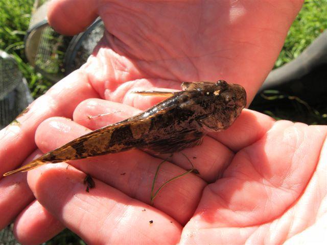
13 Site 19 Site 20 Site 21 Site 22 Site 23 Bullhead at Site 15
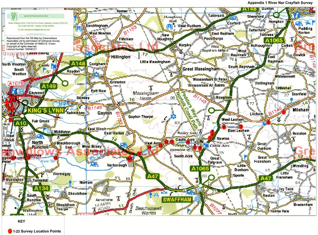
14 APPENDIX ONE Survey Site Locations (Red Dots Denote Survey Sites)
15
16
Fish population survey report
 Fish population survey report Upper River Avon Catchment This report provides a summary of results from recent fish population surveys on the Tetbury Avon, Sherston Avon and River Marden The surveys were
Manual of Fisheries Survey Methods II: with periodic updates. Chapter 22: Guidelines for Sampling Warmwater Rivers with Rotenone
 Manual of Fisheries Survey Methods II: with periodic updates : Guidelines for Sampling Warmwater Rivers with Rotenone P. W. Seelbach, G. L. Towns, and D. D. Nelson Suggested citation: Seelbach, Paul W.,
Otter and Water Vole Survey Land off Harrogate Road, Spofforth
 Otter and Water Vole Survey Land off Harrogate Road, Spofforth Report Reference: R-2925-04.1 Report Title: Otter and Water Vole Survey Land off Harrogate Road, Spofforth Report Reference: R-2925-04.1 Written
White-clawed crayfish survey for Ensor s Pool SSSI/SAC (Warwickshire)
") Improvement Programme for England s Natura 2000 Sites (IPENS) Planning for the Future IPENS065 White-clawed crayfish survey for Ensor s Pool SSSI/SAC (Warwickshire) Ensor s Pool Special Area of Conservation
Improvement Programme for England s Natura 2000 Sites (IPENS) Planning for the Future IPENS065 White-clawed crayfish survey for Ensor s Pool SSSI/SAC (Warwickshire) Ensor s Pool Special Area of Conservation
Fish Survey Report and Stocking Advice for Loch Milton. (Loch a Mhuilinn), May 2011
, May 2011") Fish Survey Report and Stocking Advice for Loch Milton (Loch a Mhuilinn), May 2011 Jonah Tosney Freshwater Fisheries Biologist Wester Ross Fisheries Trust 1 Loch Milton (Loch a Mhuilinn) Fish Survey Report
Fish Survey Report and Stocking Advice for Loch Milton (Loch a Mhuilinn), May 2011 Jonah Tosney Freshwater Fisheries Biologist Wester Ross Fisheries Trust 1 Loch Milton (Loch a Mhuilinn) Fish Survey Report
23 WHITE CLAWED CRAYFISH SPECIES ACTION PLAN
 23 WHITE CLAWED CRAYFISH SPECIES ACTION PLAN 23.1 INTRODUCTION The native crayfish Austropotamobius pallipes (Lereboullet) occupies a wide range of habitats including streams, rivers, lakes, reservoirs
Fish population survey report
 Fish population survey report River Teme 2016 This report provides a summary of results from recent coarse fish population surveys on the River Teme between Tenbury Wells and Powick. The surveys were carried
The Black Bourn An Advisory Visit by the Wild Trout Trust January 2016
 The Black Bourn An Advisory Visit by the Wild Trout Trust January 2016 1. Introduction This report is the output of a site visit to the Black Bourn, also known as the River Sapiston. The Black Bourn is
Water vole presentations notes
 Water vole presentations notes Slide One Hello everyone, my name is and I work for the Norfolk Wildlife Trust. The Norfolk Wildlife Trust is a conservation charity. Our job is to care for and to protect
Fish population survey report
 Fish population survey report River Lugg This report provides a summary of results from recent fish population surveys on the River Lugg between Leominster and Hereford. The surveys were carried out to
THE CURRENT DISTRIBUTION OF SIGNAL AND NATIVE CRAYFISH IN BROADMEAD BROOK, WILTSHIRE JOANNA SPINK AND JOANNA ROWE
 SIGNAL & NATIVE CRAYFISH IN BROADMEAD BROOK 3 THE CURRENT DISTRIBUTION OF SIGNAL AND NATIVE CRAYFISH IN BROADMEAD BROOK, WILTSHIRE (J. M. Spink, Environment Agency, Rivers House, East Quay, Bridgwater,
Appendix A Photo Set
 Appendix A Photo Set Fish Habitat Inventory, Mattamy Richmond Lands, Spring 2009 Submitted To: Susan Murphy Mattamy Homes 123 Huntmar Drive Ottawa, Ontario K2S 1B9 KILGOUR & ASSOCIATES LTD. 1500 Bank Street,
Guidance Note. Hydropower Guidance Note: HGN 8 Fish Passage. When do you need to install a fish pass?
 Guidance Note Hydropower Guidance Note: This guidance note is not intended as a statement of law. It should be read in combination with, and in the context of, the relevant enactments and EU obligations.
Margaritifera margaritifera Stage 1 and Stage 2 Survey Guidelines. Irish Wildlife Manuals No. 12
 Margaritifera margaritifera Stage 1 and Stage 2 Survey Guidelines Irish Wildlife Manuals No. 12 Margaritifera margaritifera Stage 1 and Stage 2 Survey Guidelines Citation: Anon (2004) Margaritifera margaritifera.
HURON RIVER WATERSHED
 Brown bullhead (Ameiurus nebulosus) feeding - larger streams and rivers, lakes and impoundments - clear cool water with little clayey silt - moderate amounts of aquatic vegetation - sand, gravel, or muck
White-clawed crayfish (Austropotamobius pallipes)
") Contents Objectives... 1 Introduction... 1 National Status... 2 Local Status... 2 Local Examples... 2 Legal Status... 3 Links to other Local Action Plans... 3 Threats... 3 Requirements... 4 Local Action...
Contents Objectives... 1 Introduction... 1 National Status... 2 Local Status... 2 Local Examples... 2 Legal Status... 3 Links to other Local Action Plans... 3 Threats... 3 Requirements... 4 Local Action...
Columbia Lake Dam Removal Project
 Columbia Lake Dam Removal Project The Columbia Lake dam located 1/4 mile upstream of the Paulins Kill River's confluence with the Delaware River in Knowlton Township, Warren County has been proposed for
POST-PLAGUE REINTRODUCTTON OF CRAYFISH 59
 POST-PLAGUE REINTRODUCTTON OF CRAYFISH 59 AN ASSESSMENT OF POST-PLAGUE REINTRODUCED NATIVE WHITE-CLAWED CRAYFISH, A USTROPOTAMOBIUS PALLIPES, IN THE SHERSTON AVON AND TETBURY AVON, WILTSHIRE JOANNA SPINK
Chadbourne Dam Repair and Fish Barrier
 Chadbourne Dam Repair and Fish Barrier Final Report for the Western Native Trout Initiative Prepared by: Carol Endicott Yellowstone Cutthroat Trout Conservation Biologist Montana Fish, Wildlife & Parks
Angling Trust East of England Fisheries Forum (Cambridge)
") Angling Trust East of England Fisheries Forum (Cambridge) Chris Middleton & Kye Jerrom Fisheries, Biodiversity & Geomorphology East Anglia Area 17 November 2016 This presentation is a snap shot of where
Angling Trust East of England Fisheries Forum (Cambridge) Chris Middleton & Kye Jerrom Fisheries, Biodiversity & Geomorphology East Anglia Area 17 November 2016 This presentation is a snap shot of where
Water Habitat Model. Outcome: Materials: Teacher Instructions: : Identify the components of an animal habitat..
 Water Habitat Model Outcome: 4-1-03: Identify the components of an animal habitat.. Materials: Shoe boxes (1 per student) Art supplies: Glue and/or tape Paint and brushes for the background Plasticine/clay
Investigation underway into cause of Crayfish Plague on River Bruskey, near Ballinagh, Co Cavan
 Department of Arts, Heritage and the Gaeltacht Monday, August 17 th 2015 Investigation underway into cause of Crayfish Plague on River Bruskey, near Ballinagh, Co Cavan The National Parks and Wildlife
Know Your River - River Ogmore Salmon and Sea Trout Catchment Summary
 Know Your River - River Ogmore Salmon and Sea Trout Catchment Summary Introduction This report describes the status of the salmon and sea trout populations in the Ogmore catchments. Bringing together data
Big Spring Creek Habitat Enhancement and Fishery Management Plans
 Big Spring Creek Habitat Enhancement and Fishery Management Plans November 5, 2012 Big Spring Events and Activities Center Newville, PA Charlie McGarrell Regional Habitat Biologist Pennsylvania Fish and
Escaped Rainbow Trout (Onchorhyncus mykiss) Management 2018 Operational Plan
 Management 2018 Operational Plan") Escaped Rainbow Trout (Onchorhyncus mykiss) Management 2018 Operational Plan Internal Document Last updated 9 th May 2018 INTRODUCTION Following the escape of a significant number of rainbow trout (Onchorhyncus
Escaped Rainbow Trout (Onchorhyncus mykiss) Management 2018 Operational Plan Internal Document Last updated 9 th May 2018 INTRODUCTION Following the escape of a significant number of rainbow trout (Onchorhyncus
feeding - downstream sections of large rivers, lakes, and impoundments
 River Assessment Appendix Shorthead redhorse (Moxostoma macrolepidotum) feeding - downstream sections of large rivers, lakes, and impoundments - rocky substrates - swift water near riffles - clear to slightly
Insights into otter diet from spraint analysis. - Rob Britton, student research teams at Bournemouth University & Pete Reading
 Insights into otter diet from spraint analysis - Rob Britton, student research teams at Bournemouth University & Pete Reading Overview 1. Introduction into spraint analysis 2. Analysis of spraints collected
White-clawed Crayfish Austropotamobius pallipes Survey of the River Dove between Hollinsclough and Beresford Dale, Peak District National Park
 Improvement Programme for England s Natura 2000 Sites (IPENS) Planning for the Future IPENS058 White-clawed Crayfish Austropotamobius pallipes Survey of the River Dove between Hollinsclough and Beresford
Crayfish Conservation in Hampshire s Chalk Streams
 Crayfish Conservation in Hampshire s Chalk Streams 7 th November 2014 Dr Ben Rushbrook Ecologist www.hiwwt.org.uk Protecting wildlife, inspiring people Southern Chalkstreams Project Chas Spradbery Partnership
1. Response to Powys of 5th November.
 1. Response to Powys email of 5th November. 1.1 In an email, dated 5th November 2013, Dominic Woodfield for Powys County Council (PCC) has asked for further information on the otter and badger surveys,
Alewife Brook, Cape Elizabeth, River Herring Monitoring Summary 2015
 University of Southern Maine USM Digital Commons Publications Casco Bay Estuary Partnership (CBEP) 2-3-2016 Alewife Brook, Cape Elizabeth, River Herring Monitoring Summary 2015 Matt Craig University of
STREAM CLASSIFICATION AND MAPPING. Prepared For. MacMillan Bloedel Ltd. Menzies Bay Division BOX 6000, Campbell River V9W 5E1.
 STREAM CLASSIFICATION AND MAPPING OF STREAMS IN MENZIES AND OYSTER BAY Prepared For MacMillan Bloedel Ltd. Menzies Bay Division BOX 6000, Campbell River V9W 5E1 September 1998 a a North Island Biological
River Restoration: Culvers Island weir removals and river naturalisation project.
 River Restoration: Culvers Island weir removals and river naturalisation project. Background Chalk streams are an incredibly rare habitat on a global scale, and owing to their international importance,
Project Name: Distribution of Sport Fish in the Waterton River Tailwater, 2014
 Alberta Conservation Association (ACA) Date: 2014-2015 Project Name: Distribution of Sport Fish in the Waterton River Tailwater, 2014 Fisheries Program Manager: Peter Aku Project Leader: Jason Blackburn
Columbia Lake Dam Removal Project
 Columbia Lake Dam Removal Project Major Goals of the Columbia Lake Dam Removal: Reconnect 10 miles of the Paulins Kill River to the Delaware River, restoring natural flow regime and sediment transport.
Stillwater Status Report: Lough Mourne, County Donegal
 LOUGHS AGENCY OF THE FOYLE CARLINGFORD AND IRISH LIGHTS COMMISSION Stillwater Status Report: Lough Mourne, County Donegal Stillwater Fish Stock Survey Loughs Agency of the Foyle Carlingford and Irish Lights
Field survey of the fish populations of the lower Ngaruroro River
 Field survey of the fish populations of the lower Ngaruroro River Glenn Maclean March 2014 HBRC Publication No. 4873 Report No. RM16-54 CMB 93, RD 2, Owhango 3990 E glenn@technicallytrout.co.nz W www.technicallytrout.co.nz
Water Framework Directive Habitat Survey. Upper River Yare and Blackwater, Norfolk. February 2012
 Water Framework Directive Habitat Survey Upper River Yare and Blackwater, Norfolk February 2012 1 1.0 Introduction This report is the output of a site visit undertaken by Tim Jacklin of the Wild Trout
Fish Community. Fish Habitat, Streams and Rivers
 Clear, Ston(e)y and White Lake Plan Fish Community The lakes support a cool/warm water fishery including muskellunge, walleye, largemouth and smallmouth bass, yellow perch, pumpkinseed, rockbass, blue
River Medway Upper Medway Fly Fishers
 River Medway Upper Medway Fly Fishers An Advisory Visit by the Wild Trout Trust April 2015 1 1. Introduction This report is the output of a site meeting and walk-over survey of a 2-km stretch of the River
Floating Pennywort Project. River Medway and River Cray locations
 Floating Pennywort Project River Medway and River Cray locations 2011 Andrea Griffiths (BSc) Partnership Officer Medway Valley Countryside Partnership MVCP Floating Pennywort Report 2011 Andrea Griffiths
Staffordshire Wildlife Trust. Native Crayfish & Small Streams
 Staffordshire Wildlife Trust Native Crayfish & Small Streams A remote upland limestone stream. Sites like this could hold the key to the long-term survival of white-claws in Europe. 2 White-clawed Crayfish
COLUMBIA LAKE DAM REMOVAL PROJECT
 COLUMBIA LAKE DAM REMOVAL PROJECT Major Goals of the Columbia Lake Dam Removal: Reconnect 10 miles of the Paulins Kill River to the Delaware River, restoring natural flow regime and sediment transport.
2013 Electrofishing Program Summary. Miramichi Salmon Association In collaboration with the Department of Fisheries and Oceans
 2013 Electrofishing Program Summary Miramichi Salmon Association In collaboration with the Department of Fisheries and Oceans Prepared by: Alex Parker Biologist Miramichi Salmon Association 485, Route
14 OTTER SPECIES ACTION PLAN
 14 OTTER SPECIES ACTION PLAN 14.1 INTRODUCTION As a 'top predator' the Otter Lutra lutra is naturally scarce and also highly sensitive to the health of the whole ecosystem that supports it. As such, the
Firth Creek Habitat Enhancement Project 1993
 Firth Creek Habitat Enhancement Project 1993 A. R. Langston December 1993 PWFWCP Report No. 77 The Peace/Williston Fish & Wildlife Compensation Program is a cooperative venture of BC Hydro and the provincial
Salmon Five Point Approach restoring salmon in England
 Salmon Five Point Approach restoring salmon in England Our Mission To restore the abundance, diversity and resilience of salmon stocks throughout England We will do this by:- a) Maximising the production
Final Fish Salvage & Temporary Tailrace Barrier Report for the Wallowa Falls Hydroelectric Project Tailrace. (FERC No. P-308) December 18, 2017
 December 18, 2017") Final for the Wallowa Falls Hydroelectric Project Tailrace (FERC No. P-308) December 18, 2017 Prepared by: Jeremiah Doyle PacifiCorp 825 NE Multnomah Street Portland, OR 97232 December 18, 2017 Page 1
Final for the Wallowa Falls Hydroelectric Project Tailrace (FERC No. P-308) December 18, 2017 Prepared by: Jeremiah Doyle PacifiCorp 825 NE Multnomah Street Portland, OR 97232 December 18, 2017 Page 1
STREAM SURVEY File form No..
 scanned for KRIS THE RESOURCES AGENCY OF CALIFORNIA California Department of Fish and Game STREAM SURVEY File form No.. Date: September 4, 1969. NAME: North Fork Schooner Gulch Creek COUNTY: Mendocino.
SUMMARY REPORT FOR LAKE ST. MALO FISHERIES ASSESSMENT. Prepared for the St. Malo and District Wildlife Association
 SUMMARY REPORT FOR LAKE ST. MALO FISHERIES ASSESSMENT Prepared for the St. Malo and District Wildlife Association Presented by August 25, 2014 Study dates thus far: Date Tasks February 16 Fishing derby;
Trout Unlimited Comments on the Scope of Environmental Impact Statement for the Constitution Pipeline Project, Docket No. PF12-9
 October 9, 2012 Kimberly D. Bose, Secretary Federal Energy Regulatory Commission 888 First Street, NE, Room 1A Washington, DC 20426 RE: Trout Unlimited Comments on the Scope of Environmental Impact Statement
1 of 5 1/8/2017 8:09 PM
 Three s: Pools Aquariums[2] Ponds[4] Water that is especially cloudy or turbid can be unhealthy, regardless of whether that water is in a pool, aquarium, or pond. Different problems can cause high turbidity,
Cornwell brook Cornwell Manor
 Cornwell brook Cornwell Manor An Advisory Visit by the Wild Trout Trust February 2014 1 1. Introduction This report is the output of a Wild Trout Trust visit to a tributary of the Cornwell Brook at Cornwell
White-clawed Crayfish
 White-clawed Crayfish Working for a Living Landscape 2 A typical stream at Cannock Chase with good water quality and excellent structure provided by woody debris falling into the channel. Cannock Chase
Assessment of Elizabeth Lake as a Potential Candidate for Stocking
 Assessment of Elizabeth Lake as a Potential Candidate for Stocking Region 1, Nanaimo West Coast Planning Unit Ministry of Water, Land and Air Protection Prepared by: Laura Cassin Scott Silvestri 2002 1.0
The key data from the analysis over the seasons 2009 to 2013 are shown in the table below.
 Fishing Catch Record Collection in a Small Village Fishing Club (modified 2014) The Purpose of the Catch Record Collection Hutton Rudby Fly Fishing Club is a small village fishing club with about 50 members
The Spey Catchment Initiative
 The Spey Catchment Initiative Introducing the Spey Catchment Initiative The Spey Catchment Initiative is a new project which aims to help deliver the objectives of the River Spey Catchment Management Plan
Rehabilitation of Grimes Creek, a Stream Impacted in the Past by Bucket-lined Dredge Gold Mining, Boise River Drainage, July 2008 to August 2011.
 Rehabilitation of Grimes Creek, a Stream Impacted in the Past by Bucket-lined Dredge Gold Mining, Boise River Drainage, July 2008 to August 2011. Pam Harrington TU,1020 W. Main Street Suite 440, Boise,
How to survey for otters, water voles, harvest mice and water shrews
 How to survey for otters, water voles, harvest mice and water shrews ESSEX Wildlife Trust Otters (otter spraint ID course essential) Each site needs to be visited at least once per year and is counted
Eastern Brook Trout Joint Venture Annual Report The Nature Conservancy 2013
 Eastern Brook Trout Joint Venture Annual Report The Nature Conservancy 2013 2013 Annual Performance Report Enhancing Connectivity in the Ash-Black Rock Sub-basin of the West Branch Narraguagus River. Project
Project Name: Distribution and Abundance of the Migratory Bull Trout Population in the Castle River Drainage (Year 4 of 4)
") Alberta Conservation Association (ACA) Date: 2014-2015 Project Name: Distribution and Abundance of the Migratory Bull Trout Population in the Castle River Drainage (Year 4 of 4) Fisheries Program Manager:
Alberta Conservation Association (ACA) Date: 2014-2015 Project Name: Distribution and Abundance of the Migratory Bull Trout Population in the Castle River Drainage (Year 4 of 4) Fisheries Program Manager:
THE RIVER ALUN (aka ALYN)
") THE RIVER ALUN (aka ALYN) Advisory Visit Report Undertaken On behalf of the Wild Trout Trust By Ron Holloway MIFM 22 nd April 2002-04-25 The River Alun The Rossett & Gresford Fly Fishing Club R H Associates
THE RIVER ALUN (aka ALYN) Advisory Visit Report Undertaken On behalf of the Wild Trout Trust By Ron Holloway MIFM 22 nd April 2002-04-25 The River Alun The Rossett & Gresford Fly Fishing Club R H Associates
Final Bull Trout Genetics Monitoring Plan for the Wallowa Falls Hydroelectric Project. (FERC No. P-308) June 2017
 June 2017") Final for the Wallowa Falls Hydroelectric Project (FERC No. P-308) June 2017 Prepared by: Jeremiah Doyle PacifiCorp 825 NE Multnomah Street Portland, OR 97232 June, 2017 Page 1 of 8 Table of Contents 1.0
Final for the Wallowa Falls Hydroelectric Project (FERC No. P-308) June 2017 Prepared by: Jeremiah Doyle PacifiCorp 825 NE Multnomah Street Portland, OR 97232 June, 2017 Page 1 of 8 Table of Contents 1.0
Fisheries Survey of White Rapids Flowage, Marinette County Wisconsin during Waterbody Identification Code
 Fisheries Survey of White Rapids Flowage, Marinette County Wisconsin during 25 Waterbody Identification Code 6343 Michael Donofrio Fisheries Supervisor Wisconsin Department of Natural Resources Peshtigo,
Aquatic Invasive Species. September 30 th, 2014, NOFNEC
 Aquatic Invasive Species September 30 th, 2014, NOFNEC Overview Introduction Invasive Species of Concern Round Goby Phragmites Asian Carps How can you help? Decontamination Resources AOFRC 2 Introduction
MINNESOTA DEPARTMENT OF NATURAL RESOURCES DIVISION OF FISHERIES AND WILDLIFE. Gamefish Assessment Report
 Minnesota DNR F-29-R(P) Area F312 February 1, 2013 MINNESOTA DEPARTMENT OF NATURAL RESOURCES DIVISION OF FISHERIES AND WILDLIFE Gamefish Assessment Report Spring Gamefish Assessment on the Mississippi
NEVADA DEPARTMENT OF WILDLIFE STATEWIDE FISHERIES MANAGEMENT
 NEVADA DEPARTMENT OF WILDLIFE STATEWIDE FISHERIES MANAGEMENT FEDERAL AID JOB PROGRESS REPORTS F-2-52 216 CHIMNEY RESERVOIR WESTERN REGION NEVADA DEPARTMENT OF WILDLIFE, FISHERIES DIVISION JOB PROGRESS
How Capel Brook An advisory visit carried out by the Wild Trout Trust July 2010
 How Capel Brook An advisory visit carried out by the Wild Trout Trust July 2010 1. Introduction This report is the output of a Wild Trout Trust advisory visit undertaken on the How Capel Brook, one of
Draft report on one day visit to Brampton Bryan, R. Teme
 Dr Nick Giles & Associates, 50 Lake Road, Verwood, Dorset, BH31 6BX. Telephone 01202 824245 Fax 01202 828056 email nickgiles@cix.co.uk Consultants : Freshwater Fisheries, Conservation & Wetland Ecology
Illinois Lake Management Association Conference March 23, 2018 By Trent Thomas Illinois Department of Natural Resources Division of Fisheries
 Illinois Lake Management Association Conference March 23, 2018 By Trent Thomas Illinois Department of Natural Resources Division of Fisheries Sources of Habitat Impairment Sedimentation Channelization
Conditions of Issue Game Licence
 Conditions of Issue Game Licence 1. Licence holders are required by law to tag all wild salmon caught and retained, immediately on landing the fish. Licence holders are required by law to tag all sea trout
Sports Fish Spawning Surveys Results of sports fish spawning surveys, June 2016-June 2017 in the West Coast Fish & Game Region
 Sports Fish Spawning Surveys 2016-2017 Results of sports fish spawning surveys, June 2016-June 2017 in the West Coast Fish & Game Region Lee Crosswell, Fish & Game Officer, July 2017 Rainbow Trout, Geologist
NORTH WEST WATER AUTHORITY RIVERS DIVISION SCIENTISTS DEPARTMENT TECHNICAL SUPPORT GROUP
 NORTH WEST WATER AUTHORITY RIVERS DIVISION SCIENTISTS DEPARTMENT TECHNICAL SUPPORT GROUP ELECTROFISHING SURVEY OF THE RIVER AND ITS TRIBUTARIES APRIL 1978 CALDER B. Williams N.W.W.A. RIVERS DIVISION SCIENTISTS
ATTACHMENT F. Minnesota Department of Natural Resources. Marsh Lake Ecosystem Restoration Project
 ATTACHMENT F Minnesota Department of Natural Resources Marsh Lake Ecosystem Restoration Project Mussel Rescue and Translocation Plan for Pomme de Terre River Restoration (Prepared June, 2016) Attachment
Trust Projects Cromarty Firth Fishery Trust Report. Wild Fishery Reform. New hatchery and facilities. Education Programme
 Cromarty Firth Fishery Trust Report Wild Fishery Reform In February 2017 the Scottish Government announced a scaling down of the Wild Fishery Reform process. The proposed merger of Fishery Boards and Trusts,
5B. Management of invasive species in the Cosumnes and Mokelumne River Basins
 5B. Management of invasive species in the Cosumnes and Mokelumne River Basins Cosumnes River The Cosumnes River basin has a number of distinct habitat types that require different management strategies
Fish Survey of Arctic Lake (ID # ), Scott County, Minnesota in 2012
, Scott County, Minnesota in 2012") Snapping Turtle from Arctic Lake, September 2012 Fish Survey of Arctic Lake (ID #70-0085), Scott County, Minnesota in 2012 Survey Dates: September 18-20, 2012 MnDNR Permit Number: 18362 Prepared for: Shakopee
Snapping Turtle from Arctic Lake, September 2012 Fish Survey of Arctic Lake (ID #70-0085), Scott County, Minnesota in 2012 Survey Dates: September 18-20, 2012 MnDNR Permit Number: 18362 Prepared for: Shakopee
Leech Lake Update 5/20/2009 Walker Area Fisheries Office State Hwy. 371 NW Walker, MN
 Frequency (N) Leech Lake Update 5/20/2009 Walker Area Fisheries Office 07316 State Hwy. 371 NW Walker, MN 56484 218-547-1683 Greetings! This update is part of a series of reports the Minnesota Department
Brook Trout Life Cycle and Habitat
 Brook Trout Life Cycle and Habitat Directions: 1. As you watch this slide show, watch for vocabulary terms we learned today. The first time they appear, you will see them in RED! (not redd!) 2. At the
Know Your River River Afan Salmon and Sea Trout Catchment Summary
 Know Your River River Afan Salmon and Sea Trout Catchment Summary Introduction This report describes the status of the salmon and sea trout populations in the Afan catchments. Bringing together data from
MINNESOTA FRESHWATER MUSSEL SURVEY AND RELOCATION PROTOCOL
 MINNESOTA FRESHWATER MUSSEL SURVEY AND RELOCATION PROTOCOL Minnesota Department of Natural Resources, Division of Ecological and Water Resources U.S. Fish and Wildlife Service, Twin Cities Field Office
Winter Drawdown Issues of Concern
 Winter Drawdown Issues of Concern Wetland Connectivity Amphibians Fisheries Winter Drawdown Wetland Connectivity Wetland complex near Osprey Creek is not responsive to lake level Wetland at upper end of
River Crane Cranford Park
 River Crane Cranford Park A Project Proposal by the Wild Trout Trust December 2015 1 1. Introduction This report is the output of a site meeting and walk-over survey of a 1-km stretch of the River Crane
The Blue Heron Slough Conservation Bank
 1 The Blue Heron Slough Conservation Bank CONSERVATION BANKING July 19-23, 2010 CASE STUDY SERIES The Blue Heron Slough Conservation Bank (Washington) I. OVERVIEW & BACKGROUND: Location: Snohomish River
Lake information report
 Page 1 of 6 Lake information report Name: Saganaga Nearest Town: Grand Marais Primary County: Cook Survey Date: 08/08/2011 Inventory Number: 16063300 walleye stocking. Purchase a walleye stamp. Your voluntary
Final Fish Salvage & Temporary Tailrace Barrier Report for the Wallowa Falls Hydroelectric Project Tailrace. (FERC No. P-308) December 20, 2018
 December 20, 2018") Final Fish Salvage & Temporary Tailrace Barrier Report for the Wallowa Falls Hydroelectric Project Tailrace (FERC No. P-308) December 20, 2018 Prepared by: Jeremiah Doyle PacifiCorp 825 NE Multnomah Street
Final Fish Salvage & Temporary Tailrace Barrier Report for the Wallowa Falls Hydroelectric Project Tailrace (FERC No. P-308) December 20, 2018 Prepared by: Jeremiah Doyle PacifiCorp 825 NE Multnomah Street
Thanks to Burt Strom, Dick Pearce, and Ed Lombardo, Sr. for their help and information.
 The upper section of the Wood River that runs approximately two miles downstream from the bridge on State Route 165 contains a number of significant pools. Although the river is constantly changing through
Water Framework Directive Fish Stock Survey of Rivers in the South Western River Basin District, 2013
 Water Framework Directive Fish Stock Survey of Rivers in the South Western River Basin District, 213 Fiona L. Kelly, Ronan Matson, Lynda Connor, Rory Feeney, Emma Morrissey, John Coyne and Kieran Rocks
Alberta Conservation Association 2017/18 Project Summary Report
 Alberta Conservation Association 2017/18 Project Summary Report Project Name: Abundance, Distribution, Spawning, and Thermal Habitat of Westslope Cutthroat Trout and Bull Trout in the Stimson Creek Watershed
Advisory Visit. Bradshaw Brook, Lancashire. August 2010
 Advisory Visit Bradshaw Brook, Lancashire August 2010 1.0 Introduction This report is the output of a site visit undertaken by Tim Jacklin of the Wild Trout Trust to the Bradshaw Brook, Bolton, Lancashire
RIVER CONONISH INVERTEBRATE SURVEY Dr Kjersti Birkeland
 RIVER CONONISH INVERTEBRATE SURVEY 26 Dr Kjersti Birkeland Background The Cononish, the upper reaches of the River Dochart, should be very important for spring salmon but surveys by the Tay District Salmon
TAY DISTRICT SALMON FISHERIES BOARD POLICY ON SALMON STOCKING
 TAY DISTRICT SALMON FISHERIES BOARD POLICY ON SALMON STOCKING August 2011 1 INTRODUCTION This document describes the policy adopted by the Tay District Salmon Fisheries Board for the artificial stocking
Stillwater Status Report: Lough Muck, County Donegal
 LOUGHS AGENCY OF THE FOYLE CARLINGFORD AND IRISH LIGHTS COMMISSION Stillwater Status Report: Lough Muck, County Donegal Stillwater Fish Stock Survey Loughs Agency of the Foyle Carlingford and Irish Lights
HOWSHAM FISH MONITORING
 HOWSHAM FISH MONITORING Assessment of fish passage through the Archimedes Turbine and associated by-wash Client: Mann Power Consulting Authors: Pete Kibel (BSc, MSc, MIFM) Toby Coe (BSc, MSc, MIFM) Robert
Stillwater Status Report: Lough Muck, County Tyrone
 LOUGHS AGENCY OF THE FOYLE CARLINGFORD AND IRISH LIGHTS COMMISSION Stillwater Status Report: Lough Muck, County Tyrone Stillwater Fish Stock Survey Loughs Agency of the Foyle Carlingford and Irish Lights
FINAL Fish Salvage Plan for the Wallowa Falls Hydroelectric Project Tailrace. (FERC No. P-308) April 19, 2017
 April 19, 2017") FINAL for the Wallowa Falls Hydroelectric Project Tailrace (FERC No. P-308) April 19, 2017 Prepared by: Jeremiah Doyle PacifiCorp 825 NE Multnomah Street Portland, OR 97232 April 19, 2017 Page 1 of 10
FINAL for the Wallowa Falls Hydroelectric Project Tailrace (FERC No. P-308) April 19, 2017 Prepared by: Jeremiah Doyle PacifiCorp 825 NE Multnomah Street Portland, OR 97232 April 19, 2017 Page 1 of 10
Restoring the Iconicc Lower Cache River
 Restoring the Iconicc Lower Cache River A new chapter holds promise of revitalizing cherished waters and woods The story of conservation in the lower Cache River and surrounding Big Woods of eastern Arkansas
REMIBAR REMIBAR. Evaluation of mitigation measures for otter in the Remibar project. EC LIFE+ programme LIFE10 NAT/SE/045
 REMIBAR REMIBAR Evaluation of mitigation measures for otter in the Remibar project EC LIFE+ programme LIFE10 NAT/SE/045 1 Author: Niklas Kemi and Torbjörn Nilsson, Trafikverket and Åsa Kestrup, The County
Downstream Migrant Trapping in Russian River Mainstem, Tributaries, and Estuary
 Downstream Migrant Trapping in Russian River Mainstem, Tributaries, and Estuary Introduction In September 2008, the National Marine Fisheries Service issued the Russian River Biological Opinion, which
Know Your River River Neath Salmon and Sea Trout Catchment Summary
 Know Your River River Neath Salmon and Sea Trout Catchment Summary Introduction This report describes the status of the salmon and sea trout populations in the Neath catchments. Bringing together data