Colorado State Wildlife Areas
|
|
|
- Jack Osborne
- 5 years ago
- Views:
Transcription

 297-1192 www.wildlife.state.co.us www.parks.state.co.us 1")
1 C o l o r a d o p a r k s & w i l d l i f e Colorado State Wildlife Areas online brochure Colorado parks and wildlife 6060 Broadway, Denver, CO (303)

 297-1192 Wildlife area offices Brush 122 E.")
 247-0855 fort collins 317 W.")
2 WILDLIFE offices v Plan your trip online Check out printable and interactive maps of each state wildlife area, available on the CPW website. Charlie Meyers State Wildlife Area Spinney Mountain Reservoir!_ "U Spinney Mountain State Park!_ "U "- "U "- "- "Q "- "U B i South ") 59 g M e a d o e s w s R e r!_ o i r "U "- "C "K "U "F "- RIO GRANDE NATIONAL FOREST Wildlife headquarters 6060 Broadway Denver, (303) Wildlife area offices Brush 122 E. Edison Brush, (970) colorado springs 4255 Sinton Road Colorado Springs, (719) Denver/nOrtheast 6060 Broadway Denver, (303) Durango 151 E. 16th St. Durango, (970) fort collins 317 W. Prospect Road Fort Collins, (970) GlenWOOd Springs 0088 Wildlife Way Glenwood Springs, (970) grand junction 711 Independent Ave. Grand Junction, (970) Gunnison 300 W. New York Ave. Gunnison, (970) hot Sulphur Springs 346 Grand County Rd. 362 Hot Sulphur Springs, (970) lamar 2500 S. Main St. Lamar, (719) Meeker Hwy. 64 Meeker, (970) monte Vista 0722 S. Road 1 E. Monte Vista, (719) montrose 2300 S. Townsend Ave. Montrose, (970) Pueblo 600 Reservoir Road Pueblo, (719) Salida 7405 Hwy. 50 Salida, (719) SteamBOat springs 925 Weiss Dr. Steamboat Springs, (970) Printed for free distribution by COLORADO PARKS AND WILDLIFE (CPW) 6060 Broadway, Denver, CO (303) On the cover: Photo by Vic Schendel Editor: Amy Nickelson. Printed August 2012, Publication Printers, Denver. 200,000 copies. Printing paid for with hunting and fishing license fees. The Colorado Parks and Wildlife Commission set land regulations in May. Rick D. Cables is Cpw director. Commission members are (as of July 2012): John Singletary, chairman Bill Kane, vice chairman Mark Smith, secretary Robert Bray, member Christopher Castilian, member Jeanne Horne, member Gaspar Perricone, member James Pribyl, member James Vigil, member Dean Wingfield, member Michelle Zimmerman, member Mike King, ex officio member John Salazar, ex officio member NOTE: Laws and regulations in this brochure are paraphrased for easier understanding and are intended only as a guide. Colorado wildlife statutes and regulations are available for viewing at CPW offices.

3 What s inside This brochure features regulations governing Colorado s state wildlife areas (SWAs) and state fish units (SFUs). Only properties listed in this brochure are open to the public. All recreation guidelines below are enforced at SWAs. In addition, property-specific rules can be found in the following pages. Note: Complete fishing regulations are in the Colorado Parks and Wildlife s 2012Fishing brochure, available in print and online, at in mid-march. Some SWAs may have specific fishing restrictions, anglers should consult the current fishing brochure to make sure they comply with all state fishing regulations.» new lands open: Many new state wildlife areas have opened during the past year to bring more opportunity for the public to hunt, fish and watch wildlife throughout the state. The new swas include: Smyth, Hardeman and Chesmore in Chaffee County, Cline Ranch in Park County, Karney Ranch in Bent County, Shriver-Wright in Rio Grande County and Willow Creek in Yuma County. See the list of lands for details about each SWA.» New reservation phone number: To improve customer service and reduce hold time on the phone, those hunting the Grand Valley area in the Pacific Flyway now have a local phone number to call to reserve a waterfowl blind. Check before you call to ensure you have the right reservation phone number and will be able to reserve your favorite hunting spot quickly and efficiently. Lands using the new phone number include: Colorado River Island swa, Franklin Island swa, Highline Lake State Park, Horsethief Canyon swa, James M. Robb Colorado River State Park, Orchard Mesa swa and Tilman Bishop swa. See page 3 for details. what s NEW IN 2012» Habitat Stamps are $10 and only one is required per person per year. Stamps are valid April 1-March 31. Habitat Stamps are not required to access swa and State Trust Land properties, but they are required for hunting and fishing. Anyone must purchase a stamp before buying or applying for a hunting or fishing license or a preference point. A lifetime stamp is $ Anyone buying a one-day or additionalday license for fishing and/or small game is exempt from purchasing the Habitat Stamp with the first two of these licenses. The habitat fee will be assessed when a third one-day or additional-day license is purchased for fishing or small game. Anyone who holds a free Lifetime Fishing license, a Veteran s Lifetime Combination Small-Game Hunting/Fishing license, or are approved for the Big Game Mobility Impaired Hunting Program is exempt from the Habitat Stamp requirement. See DisabledAccessibility/Pages/Disability Information.aspx for details. Except when specifically authorized, the following activities are prohibited on lands, waters, frozen surfaces of waters, rights- of-way, buildings or devices under Cpw control: recreation guidelines 1. To possess the following types of ammunition and/or firearms: tracer rounds, armor-piercing rounds, military hardened rounds with explosive or radioactive substances,.50-caliber BMG rounds, or fully automatic firearms. 2. To enter, use or occupy an area when posted against entry, use or occupancy. 3. To engage in illegal activities. 4. To enter, use or occupy an area for Continued on page 2 1
4 commercial purposes or to do land, water, oil, gas or mineral investigations, surveys or explorations. 5. To operate a vehicle (motorized or nonmotorized) except on established roads or within designated camping or parking areas. Drivers must obey state motor vehicle laws. 6. To drive faster than posted speed limits or faster than 25 mph if not posted. 7. To leave camp, tent, shelter, motor vehicle or trailer unattended more than 48 hours, to camp or to park travel trailers or campers on an SWA over 14 days in 45-day period. 8. To establish a permanent structure or plant vegetation. Only portable blinds, tree stands and steps can be erected on swas. No nails can be driven into trees. Man-made materials for blinds or tree stands must be removed within 10 days after the season in which they are used ends. 9. To remove, modify or destroy a building, water control device, fence, gate, sign, survey or section marker, vegetation or objects of archaeological, geological or historical value. 10. To litter, leave fish, entrails, human waste, waste water, containers or toxic substances; to bring household or commercial trash or toxic substances to an area for disposal; or to dump trailer waste in a sanitary facility. 11. To build fires without precautions to prevent spreading; to leave fires unattended. 12. To graze livestock. Horses, mules, llamas, burros may be used in wildlife activities. 13. To have or use fireworks, explosives, poisons, herbicides, pesticides or illegal substances. 14. To release wildlife or privately-owned game birds. Private game birds may be released for field trials, including group dog training on swas only where specifically allowed. To allow dogs, cats or domestic pets to run at large (not on a leash), except dogs used while hunting, while training hunting dogs or during CPW-authorized field trials. 15. To dig trenches, holes or pits. 16. To leave vessels beached, anchored, moored or docked unattended overnight except in designated areas. 17. To fish from Cpw boat ramps or docks in conflict with boaters or as posted. 18. To snorkel, scuba dive or spearfish with a diving mask, swim fins, snorkel or air tanks. The exception is where swimming is permitted, when location is identified by a divers down flag and when scuba diver has valid scuba certificate from recognized 2 boat regulations All vessels and floating devices, their contents, motors, trailers and equipment are subject to inspection by the CPW before being launched, operated on or leaving waters on SWAs. Any aquatic nuisance species found during inspection must be removed and disposed of properly according to CPW procedures before vessels are allowed to be launched, operate on or leave the water. youth/mentor hunting Youth/mentor hunting means hunting by youths under 18. Youth hunters under 16 must be accompanied by a mentor when hunting on youth/mentor properties. Mentors must be at least 18 and comply with hunter education requirements. scuba training organization. 19. To use air or gas-inflated floating devices for transportation on or across surface of the water unless the device has multi-compartments and a rigid motor mount when propelled by gasoline or electric motors. Singlecompartment air or gas-filled flotation devices restricted to designated swimming areas. 20. To promote, sponsor, conduct or participate in boat regattas, paintball shooting, questing or non-wildlife oriented activities. 21. To launch or land aircraft. 22. To leave decoys or anything used as decoys in the field or on water overnight. 23. To swim, except in designated waters or during authorized water contact activities. 24. To discharge a firearm or bow in parking, camping or picnic areas. 25. To fish in fish-rearing ponds, raceways, holding areas or streams on Cpw hatchery properties, except areas posted as open to fishing. 26. To conduct field trials or group dog training without a field-trial license. 27. To have, store or use hay, straw or mulch not certified as noxious-weed free. Certified materials must be clearly marked by certifying state or province. People who transport these materials on federal, state or county roads that cross Cpw property are exempt. Also exempt is hay produced on State Trust Lands leased from Cpw for wildlife recreation. 28. To trap unless done according to statutes and regulations and with authorization. 29. To partake in Internet-based or computerassisted remote hunting or fishing. Hunters and anglers must be physically in the immediate vicinity of their activity.
5 state WILDLIFE AREAS An alphabetical listing of properties and specific rules for each state wildlife area follows. If no special restrictions are included in this list, all recreation guidelines (pages 1-2) apply. 63 ranch SWA - PARk Co. Directions: From Fairplay, go 15 miles S on Hwy. 285, or 5.5 miles N of Antero Jct. on Hwy gmu/acres: 50 / 1,200 acres hunting: waterfowl, big game fishing camping prohibited ADAMS SWA - ROUTT Co. Directions: From Steamboat Springs, go E on Hwy. 40, turn S on Hwy At CR 14, go S. SWA 0.5 of a mile N of Stagecoach State Park. gmu: 15 hunting: elk, deer, rabbit, dusky grouse facilities: rest room a. Open to public July 1-Nov. 30. b. Camping, fires prohibited. c. Dogs allowed only as aid in hunting grouse. d. Vehicles prohibited beyond parking area. AdOBe Creek Res. SWA (BLUE Lake) - BENT, kiowa Cos. Directions: From Las Animas, go 15 miles N on CR 10. gmu/acres: 125 / 5,147 acres hunting: deer, pronghorn, rabbit, pheasant, scaled quail, dove, waterfowl recreation: boating, sail boating, sail surfing, waterskiing, camping, hiking, wildlife viewing facilities: rest rooms, boat ramps reservation procedures NEW! For properties listed below, reservations must be made by calling (970) All other reservation rules below apply.» Colorado River Island SWA, Franklin Island SWA, Highline Lake State Park, Horsethief Canyon SWA, James M. Robb Colorado River State Park, Orchard Mesa SWA, Tilman Bishop SWA For all other SWAs requiring reservations, call (1-800-UGO-WILD). Reservations taken 9 a.m.-4 p.m. Monday- Friday. For maps and information, go to the website at: co.us/land Water/StateWildlifeAreas/Pages/swa.aspx. Maximum 1 reservation per hunt date and 1 reservation per phone call. Reservations are not transferable. The person making the reservation must have a valid license for the species to be hunted and must hunt at the property the day of the hunt. Hunters with reservations may only hunt the area specified on the reservation. Reservations not accepted more than 14 days before hunt date nor after noon the day before the hunt date, or noon Friday for hunts on Sunday and holidays falling on Monday. To cancel, hunters must do so by noon the day before the hunt date. Failing to cancel reservations or follow check station procedures may result in losing future reservation rights for rest of hunting season. a. Open 1 hour before sunrise to 1 hour after sunset; no time restrictions for fishing. b. ATVs, dirt bikes, snowmobiles prohibited. c. Frozen surface of lake closed. d. Dams, inlets, outlet structures open only for fishing. abbreviations 4WD 4-wheel-drive ATV All-terrain vehicle Blm Bureau of Land Management Co. County Cos. Counties CPW Colorado Parks and Wildlife CR County Road GMU Game Management Unit Hwy. Highway JCT. Junction ohv Off-highway vehicle rd. Road Res. Reservoir SFU State Fishing Unit STL State Trust Land SWA State Wildlife Area USFS / fs U.S. Forest Service N/NW/ne North, northwest, northeast S/SW/se South, southwest, southeast E East W West 3
6 ALBerta park res. SWA - MINERAL Co. Directions: From South Fork, go 18 miles W on Hwy. 160 to Wolf Creek Ski Area, drive through parking lot. Continue 1.7 miles on Usfs Rd gmu/acres: 80 / 240 acres facilities: primitive boat ramp ALMA SWA - PARk Co. Directions: From Alma, go 1.5 miles N on Hwy. 9 to CR 4; then go 0.25 of a mile NW. gmu: 49, camping facilities: rest rooms, campsites ALMOnt triangle SWA - GUNNISON Co. Directions: From Almont, go 3 miles N on Hwy gmus: 54, 55 hunting: deer, elk, bighorn sheep, dusky grouse recreation: hiking, wildlife viewing open April 1-Dec. 19 ANDREWS lake SWA - SAN JUAN Co. Directions: From Durango, go 39 miles N on Hwy. 550 to access road; then go 0.5 of a mile E. gmu: 74 recreation: picnicking, wildlife viewing facilities: rest rooms, trailhead, parking, overlook Andrick ponds SWA - MORGAN Co. Directions: From I-76 take exit 66 (Hwy. 39), go 7.4 miles N on Hwy. 39 to Hwy. 144 and CR Y.5. Go 1.5 miles W on CR Y.5, then N on CR miles to CR AA. Go 1 mile to CR 2, go S on CR 2 for 0.5 of a mile to parking. gmu: 95 hunting: waterfowl Facilities: parking at N, S ends of swa Restrictions: a. Public access by foot and only through designated parking areas. Open only on Sat., Sun., Weds. and legal holidays from 3 a.m.-9 p.m. b. Camping, fires, hunting with centerfire rifles, dog training are prohibited. c. Discharge of firearms and bows prohibited, except when hunting. Night hunting prohibited. d. From the Sat. before Memorial Day holiday through Aug. 31, access is for wildlife observation only and is limited to areas as posted. Dogs prohibited at this time. e. From Sept. 1 through Fri. before Memorial Day holiday, only hunting permitted. f. From the end of dark goose season through the Fri. before Memorial Day holiday, only spring turkey hunting allowed. g. From the Thurs. before Sept. 1 through the end of dark goose season, scouting permitted from 10 a.m.-2 p.m. on Thurs. that are not open to hunting in and prior to waterfowl seasons. Must have reservation or letter from Cpw. All people must check in and out at check station. Firearms, dogs not allowed during scouting. h. Hunting is by reservation only. See Reservation Procedures (page 3) for details. Maximum 4 people per area at any time. Maximum 3 reservations annually per hunter from Sept. 1-end of regular goose season. Hunters must check in and out as posted at property. i. From Sept. 1-Nov. 30, migratory bird hunting only, and only within designated areas. j. From Dec. 1 through end of regular goose season, hunting permitted for migratory birds and small game. Hunting days will be set for each, see the 2012 Waterfowl or 2012 Small Game brochures for details. k. Hunting not allowed on Clark Lake. APISHAPA SWA - LAS ANIMAS Co. Directions: From Walsenburg, go 18.5 miles ne on Hwy. 10 to property sign; turn se and go 20 miles past Mica Butte. gmus/acres: 133, 134 / 7,935 acres hunting: deer, pronghorn, bighorn sheep, rabbit, scaled quail, dove recreation: hiking, wildlife viewing ARKANSAS river SWA - PROWERS Co. Directions: There is currently no vehicle access to this swa. Any access crosses private property and landowner permission is required. gmu/acres: 119 / 98 acres hunting: deer, rabbit, squirrel, pheasant, bobwhite quail, dove, waterfowl recreation: camping, hiking, wildlife viewing ARKANSAS river/big Bend SWA (FISHING EASEMENT) - CHAFFEE, Lake Cos. Directions: From Poncha Springs, go 4 miles N on Hwy. 285, the go of a mile E on CR 165. Parking is at W end. From Salida, go NW on Hwy. 291 for 3.5 miles. Go 0.75 of a mile S on CR 150, then 0.5 of a mile SW on CR 166 to N bank of Arkansas River. Parking E side of road. gmu/acres: 56 / 11 acres, Arkansas River; 4
7 Fishing only. (Note: Fishing access may not be on both sides of river. Check for signs.) ATWOOD SWA - LOGAN Co. Directions: From Atwood, go 3 miles sw on Hwy. 6 to CR 29.5, then go 0.5 of a mile S. gmu/acres: 96 / 180 acres hunting: deer, rabbit, squirrel, pheasant, turkey, bobwhite quail, dove, waterfowl a. Public access by foot only and only through designated parking areas. b. Access limited to 4 groups or vehicles, with a max. of 4 people per group. c. Camping, fires, horse use, dog training prohibited. d. Target practice prohibited except when authorized by area wildlife manager. e. Discharging firearms or bows prohibited except when hunting. Discharging bows allowed for bowfishing. f. From June 1-Aug. 31, open only Sat., Sun., Weds. and only for wildlife viewing. g. Turkey hunting only on opening day and after that only Sat., Sun., Weds., of turkey seasons. h. From Sept. 1-May 31, hunting only on Sat., Sun., Weds., legal holidays and opening day of late rifle deer season. All recreational activity except deer hunting are prohibited opening weekend of the regular plains rifle deer season and opening day and first weekend of late plains rifle deer season. i. During regular duck season, swa only open to hunting. Waterfowl and small-game hunters must check out at designated check station by 2 p.m. Deer and turkey hunters do not need to check out but reservation is required. 1. Hunting is by reservation only. See Reservation Procedures (page 3) for details. Maximum 4 people per reservation. 2. Waterfowl and small-game hunting during this time is only on Sat., Sun., Weds., Columbus Day (observed),veterans Day, Thanksgiving Day, Christmas Day, New Year s Day and Martin Luther King Jr. Day. 3. No reservation required for live trapping. j. Launching or taking out vessels prohibited first day of teal season to last day of dark goose season. Badger Basin SWA - PARk Co. Directions: From Hartsel go E and W along Hwy. 24. Land is directly N of Hartsel and N and S along Hwy. 9. gmus/acres: 50, 58, 581 / 752 acres fishing: 22 miles of fishing access. This is a fishing property only. a. Hunting, camping, fires prohibited. b. Parking only in designated areas. c. Access only from designated parking areas. Closed beyond fenced and posted easement. Banner lakes SWA - WELD Co. Directions: From Hudson, go 4 miles E on Hwy. 52. gmu/acres: 99 / 934 acres hunting: dove, waterfowl, rabbits, prairie dogs recreation: hiking, wildlife viewing facilities: rest rooms a. Foot access only, and only through designated parking area. Closed N of Hwy. 52 April 1-July 15. b. Camping, fires, horseback riding, bicycling prohibited. c. Boating prohibited except for hand-propelled craft and float tubes. d. Discharging firearms or bows prohibited except when hunting or training dogs. Discharging bows allowed for bowfishing. e. Fishing prohibited from opening of first regular duck season to last day of regular waterfowl season. f. Closed first day of regular waterfowl season to day before the first day of pheasant season except for waterfowl hunting on Sat., Sun., Mon. and legal holidays. During this period, waterfowl hunting reservations available but not required. See Reservation Procedures (page 3) for details. Reservations valid throughout reserved day until hunter with reservation checks out. Hunters may check in on firstcome, first-served basis after a hunter with a reservation checks out, or if no reservation exists for a hunt area after midnight immediately preceding the hunt, or if reserved area isn t claimed by legal sunrise. Maximum 4 hunters per reservation. Waterfowl hunters must check in and check out at designated station. g. From the Thurs. before Sept. 1 through the end of dark goose season, scouting permitted from 10 a.m.-2 p.m. on Thurs. that are not open to hunting in and prior to waterfowl seasons. Must have reservation or letter from Cpw. All people must check in and out at check station. Firearms, dogs not allowed during scouting. h. Dog training permitted N of Hwy. 52 during Feb., March, July 16-Aug. 31 only. Dog training permitted S of Hwy. 52, Feb. 1-Aug. 31 only. i. Field trials may be authorized Feb., March and Aug. No more than 4 per year. Group training events not limited. j. Domestic, feral or privately-owned game birds may be released with permit for field trials and 5
8 6 dog training S of Colo. 52. Birds taken must be removed from swa and privately-owned game birds prepared for human consumption. k. Cpw may implement a dog training reservation system to manage overcrowding. Basalt SWA (BASALT, CHRISTINE, TONER, PEACHBLOW, 7 CASTLES, SCHUCk UNITS) - EAGLE, PITkIN Cos. TOner unit: From Basalt, go 3.2 miles E on USFS Rd. 105 (Fryingpan Rd.) to signs; then go N. gmus/acres: 47, 444 / 2,577 acres christine unit: From Basalt, go 0.5 of a mile W on Two Rivers Rd. (old Hwy. 82) to Homestead Drive; then go N to access road. gmus/acres: 47, 444 / 2,230 acres hunting: deer, elk, bighorn sheep, dusky grouse, coldwater lake recreation: picnicking, wildlife viewing facilities: shooting range restrictions on all units: a. Alcohol prohibited on shooting range. b. Except for muzzleloaders, firearms on shooting range restricted to lower than.50 caliber. Discharging shotguns allowed. Fully automatic firearms prohibited. Discharging firearms on shooting range allowed only 7 a.m.-7 p.m. Mon.-Fri., and 9 a.m.-5 p.m. Sat.-Sun. c. Boating, water activities prohibited on Christine Lake. d. Camping prohibited at all times within 0.25 of a mile of Fryingpan River. Camping prohibited in other areas except during regular and late big-game seasons, plus 3 days before and 3 days after the seasons. e. Closed Dec. 1-April 15 except on Christine Lake and rifle ranges. f. Fires, mountain bikes prohibited. g. Dogs prohibited except field trials may be authorized Aug. and Sept. Beaver creek SWA - FREMONT Co. Directions: From Cañon City, go 8 miles E on Hwy. 50 to Hwy. 67 (Phantom Canyon Rd.), then go N 2 miles to CR 123, then E 0.2 of a mile to CR 132, then N 9 miles to property. Or: From Skaguay Dam, go downstream 12 miles on trail to property (2-day hike). gmu: 59 hunting: deer, elk, bear, rabbit, dove, turkey with limited license recreation: hiking, wildlife viewing. No overnight camping. Beaver creek res. SWA - RIO GRANDE Co. Directions: From South Fork, go 2 miles sw on Hwy. 160 to Usfs Rd. 360 (Beaver Creek Road), then go 6 miles S. gmu: 80 facilities: campgrounds (Usfs), rest room, drinking water, boat ramps a. Discharging firearms, bowfishing and open fires on ice are prohibited. b. Boating prohibited if it creates a whitewater wake. Beaver lake SWA - GUNNISON Co. Directions: From Marble, go 0.25 of a mile E on CR 3. gmu/acres: 43 / 41 acres, coldwater lake recreation: non-motorized boating, wildlife viewing a. Boating prohibited except for float tubes or hand-propelled craft. b. Camping, fires, discharging firearms or bows prohibited. c. Vehicles prohibited on dam. Bellaire lake SWA - LARIMER Co. Directions: I-25 N to Hwy. 14 exit toward Fort Collins. Take Hwy. 14, turn right onto N. College Ave., Hwy Follow Hwys. 14/287 N 10.7 miles. Turn left at CR 74E, Red Feather Lakes Road, and go 24 miles. Turn left at CR 162, go 2 miles to Bellaire Lake Road. gmu/acres: 8 / 12 acres Fishing: coldwater lake facilities: Usfs campground, drinking water, electrical hookups, rest room Boating prohibited except for float tubes or craft propelled by hand, wind or electric motor. Bellvue sfu - LARIMER Co. Directions: Go N of Fort Collins on Hwy. 287 to La Porte. Just N of La Porte go W on CR 28. gmu/acres: 19 / 58 acres recreation: limited public use, limited tours hunting, dogs prohibited Bergen peak SWA - CLEAR CREEk, JEFFERSON Cos. Directions: From Evergreen, go 4 miles N on Hwy. 74 to Hwy. 103, then go 5.9 miles W to Stinton Rd. Then go 2.2 miles E. B B L B
9 GMU: 39 hunting: deer, elk, squirrel, dusky grouse recreation: hiking, horseback riding a. Foot or horseback access only. b. Camping, fires prohibited. c. Dogs must be on leash except when hunting small game. d. Discharging firearms or bows prohibited except when hunting. Big meadows res. SWA - MINERAL Co. Directions: From South Fork, go 11 miles W on Hwy. 160 to USFS Rd. 410, then go 2 miles W. gmu: 76 facilities: campgrounds, rest room, drinking water, boat ramp Big thompson POnds SWA - LARIMER Co. Directions: From Loveland, go 5 miles E on Hwy. 402 to I-25 Frontage Road, then go 0.75 of a mile N to interstate underpass. Go left through the underpass, then 0.75 of a mile N. gmu/acres: 20 / 51 acres hunting: rabbit, dove, waterfowl recreation: picnicking, wildlife viewing facilities: rest room a. Open 1 hour before sunrise to 1 hour after sunset; no time restrictions for fishing or with night-hunting permit. b. Camping, fires, dog training, horseback riding, bicycling prohibited. c. Boating prohibited except for float tubes used while fishing. d. Discharging firearms or bows prohibited except when hunting. Discharging bows is allowed for bowfishing. BILLY CREEK SWA - Ouray, MONTROSE Cos. Beckett tract: From Montrose, go 18 miles S on Hwy. 550 to Ouray CR 4, then turn left. Go 0.5 of a mile. Billy creek tract: From Montrose, go 16 miles S on Hwy. 550 to Ouray CR 2, then turn left. Road also leads to Nicoll and Porter tracts. COLOna tract: From Montrose, go 7 miles S on Hwy. 550 to Government Springs Rd. Continue on Horsefly Rd. to signed access road. carmichael tract: From Montrose, go 21 miles S on Hwy. 550 to Ouray CR 8, turn left on lower road. Go through ranch yard; then go 1.25 miles on main road to access road. GMUs/Acres: 62, 65 / 5,498 acres, all tracts hunting: deer, elk, rabbit, dove, pond, camping, hiking a. Open May 1-Dec. 31 b. Snowmobiles prohibited on Colona tract. BitterBrush SWA - MOFFAT Co. Directions: From Craig, take Hwy. 40 W to Maybell. SWA is S of Hwy. 40 and W of CR 57. gmu: 11 a. Open May 1-Jan. 14. b. Camping, fires prohibited. c. Vehicles allowed only on CRs 59 and 143. d. Hunters may place portable blinds, markers, stands or related structures only after Aug. 1. These must be removed by the hunter within 1) 24 hours after harvesting an animal, or 2) 7 days after the end of archery pronghorn season, whichever is first. Blacktail (CONSERVATION EASEMENT) - ROUTT Co. Directions: From Steamboat Springs, go E on Hwy. 40, turn S on Hwy At CR 14, go S. Easement is S and E of Adams swa. gmu/acres: 15 / 610 acres a. Open July 1-Nov. 30. b. Camping, fires prohibited. c. Dogs prohibited except as aid in hunting grouse d. Motor vehicles prohibited beyond designated parking areas. Bliss SWA - LARIMER Co. Directions: From La Porte, go 5 miles N on Hwy. 287 to Hwy. 14, then go 41 miles W. gmus/acres: 8, 19 / 352 acres hunting: deer, elk, bighorn sheep, rabbit, dusky grouse vessel launching and take out prohibited Blue river SWA - SUMMIT Co. Blue river unit: From Silverthorne, go 17 miles N on Hwy acres. eagle S nest unit: From Silverthorne, go 9 miles N on Hwy acres. sutton unit: From Silverthorne, go 7 miles N on Hwy. 9. gmus: 37, 371 7
10 RECREATION: picnicking, hiking, wildlife viewing, watchable wildlife trail restrictions on all units: camping, fires, firewood cutting, discharging firearms or bows and overnight vehicle parking prohibited. BOb terrell SWA - GARFIELD Co. Directions: From the intersection of Hwys. 82 and 133, go about 1 mile W on Hwy. 82. Turn left onto CR 106, follow it back to the E, staying left at the fork in the road. Road dead ends at swa. gmu: 43 recreation: boat launch/take out BODO SWA - La PLATA Co. Directions: From Durango, go 1 mile S on Hwy. 160/550 to CR 210, then go 0.25 of a mile W to E boundary. gmu: 741 hunting: deer, elk, rabbit, dusky grouse, turkey, dove recreation: picnicking, hiking, wildlife viewing a. Open April 1-Nov. 30 for general use b. Open only for small-game hunting from Dec. 1-March 31; and only S of CR 210. c. Camping, fires, snowmobiles prohibited. d. Discharging firearms allowed only when hunting. BOedecker res. SWA - LARIMER Co. Directions: From Loveland, go 2 miles W on First Street to CR 21, then go 0.5 of a mile S. gmu/acres: 20 / 308 acres of water hunting: dove, waterfowl facilities: boat ramp a. Open 1 hour before sunrise to 1 hour after sunset; no time restrictions for fishing or for those with night-hunting permit. b. Boating prohibited if it creates a whitewater wake. c. Fishing prohibited from vessels Nov. 1 to end of waterfowl season. d. Camping, fires, horseback riding, sailboards prohibited. e. Discharging firearms or bows prohibited except when hunting. Discharging bows allowed for bowfishing. BOsque del OSO SWA - LAS ANIMAS Co. Directions: From Trinidad, take exit 14A off I-25. Go W on Hwy. 12 approximately 21 miles to Weston and look for access signs between Weston and Stonewall. Property S of Hwy. gmus/acres: 85, 851 / 30,000 acres hunting: deer, elk, bear, turkey, small game, mountain lion a. Open to public April 1-Nov. 30; open Dec. 1-March 31 only to licensed big-game hunters and one non-hunting companion. b. Campfires only in designated areas and containment structures. c. Discharging firearms or bows prohibited except while hunting. Discharging bows allowed for bowfishing. d. Camping only in designated areas; hunters may camp anywhere during hunting seasons. e. Parking allowed only in designated areas. f. Unattended food or garbage must be stored in bear-resistant manners or containers. g. Snowmobiles, motorized vehicles, ATVs and bicycles on established roads or trails may be prohibited to protect wildlife and prevent resource damage. Closures posted. h. Fishing prohibited on South fork of Purgatoire River in swa from day after Labor Day weekend until first day of Memorial Day weekend. BOyd POnds SWA - MORGAN Co. Directions: Go E on I-76 toward Fort Morgan. Go N on Hwy. 144, turn right on Elm Street, follow street to swa. swa is ne of Log Lane Village, extending E to Hwy. 52. gmu: 96 launching or taking out vessels prohibited from first day of teal season to last day of dark goose season BravO SWA - LOGAN Co. Directions: From I-76 at Sterling exit, go 0.5 of a mile W on Hwy. 6 to CR 370, then go 1.7 miles ne. gmu/acres: 91 / 1,082 acres hunting: deer, rabbit, squirrel, bobwhite quail, pheasant, turkey, dove, waterfowl a. Access from designated parking areas only. b. Camping, fires prohibited. c. Discharging firearms or bows prohibited except when hunting. d. Target practice prohibited except when authorized by area wildlife manager. e. All recreational activities except deer hunting are prohibited on opening weekend of regular plains rifle deer season, and opening day and first weekend of late plains rifle deer season. 8
11 f. One field trial may be authorized per year, in Feb., March or Aug. g. Horse use prohibited except when training hunting dogs and then only allowed in Feb., March and April (through Wed. before spring turkey season opens) and Aug. h. Launching or taking out vessels prohibited from first day of teal season to last day of dark goose season. i. During regular duck season, waterfowl and small-game hunters must check out at the mandatory check station. ON Scalva Parcel: Reservations required for all public use. From Sept. through May, follow standard reservation procedures, (see page 3). From June through Aug., make reservations by calling (970) Limited to 3 groups with max. of 4 people per group daily. 2. Open only 4 a.m.-9 p.m. Foot access only and only from designated parking areas. Mandatory check station. 3. From Sept. 1-May 31, only hunting allowed. Limited to archery, muzzleloading and shotguns during established seasons. Hunting allowed only Sat., Sun., Wed., Labor Day, Columbus Day (observed), Veterans Day, Thanksgiving Day, Christmas Day, New Year s Day, Martin Luther King Jr. Day and Presidents Day. 4. From June 1-Aug. 31, only wildlife viewing allowed. Open only Sat., Sun. and Weds. 5. Turkey hunting allowed on opening day, Sat., Sun., Weds. and legal holidays during turkey seasons. 6. Fires, camping, field trials, dog training prohibited. Discharging firearms, bows prohibited except while hunting. BROWer SWA - WELD Co. Directions: From Evans, go 1 mile E on 37th Street. gmu/acres: 94 / 65 acres hunting: rabbit, squirrel, dove, waterfowl a. Camping, horse use prohibited. b. Discharging firearms or bows prohibited except shotguns or bows while hunting Sept. 1-Feb. 28 and during spring turkey season. c. Open March 1-Aug. 31 only for spring turkey hunters with valid license; open for other access Sept. 1-end of February. d. Dogs prohibited except as hunting aid. Dog training prohibited except when training dogs for hunting. e. Parking allowed only in designated spaces within designated parking area. f. Launching or taking out vessels prohibited from first day of teal season to last day of dark goose season. BROWN lakes SWA - HINSDALE Co. Directions: From Creede, go 25 miles W on Hwy. 149 to USFS Rd. 515 (Hermit Lakes Rd.). Go 1.5 miles W. gmu/acres: 76 / 520 acres hunting: waterfowl, picnicking facilities: rest room, boat ramp camping prohibited BROWnlee SWA - JackSON Co. Directions north Platte River: From Walden, go 0.5 of a mile W on Hwy. 14 to CR 12; then 5.1 miles NW to CR 18; then 0.5 of a mile W. gmu/acres: 16 / 1.14 miles of river hunting prohibited BROWns park SWA - MOFFAT Co. COld spring MOuntain unit: From Maybell, go 41 miles NW on Hwy. 318 to CR 10N, then go 17 miles N to CR 72, then 9 miles W to fork. Take left fork 4 miles. Wiggins unit: From Maybell, go 41 miles NW on Hwy. 318 to CR 10N, then go 17 miles N to CR 72; then 15 miles W. Beaver creek unit: From Maybell, go 59 miles nw on Hwy Unit N of Hwy CallOWay Unit: Closed to public access in posted area. gmu/acres: 201 / 2,226 acres, all units hunting: pronghorn, deer, elk, rabbit, dusky grouse, waterfowl, dove recreation: camping, wildlife viewing Brush SWA - MORGAN Co. Directions: From Brush, go 2.5 miles N on Hwy. 71. Turn W on CR U. Go about 200 feet to CR 28, turn N and go 1 mile to parking lot. gmu/acres: 96 / 588 acres hunting: deer, rabbit, squirrel, pheasant, turkey, bobwhite quail, dove, waterfowl, hiking a. Open 3 a.m.-9 p.m., no time restrictions for those with night-hunting permit. Access from designated parking areas only. b. Camping, fires prohibited. c. Discharging firearms or bows prohibited except when hunting. Discharging bows allowed for bowfishing. 9
12 10 d. Target practice prohibited except when authorized by area wildlife manager. e. All recreational activities except deer hunting are prohibited on opening weekend of regular plains rifle deer season, and opening day and first weekend of late plains rifle deer season. f. Horse use prohibited except when training hunting dogs and then only allowed in Feb., March and April (through Wed. before spring turkey season opens) and Aug. h. Launching or taking out vessels prohibited from first day of teal season to last day of dark goose season. i. During regular duck season, property is only open to hunting, and: 1. Waterfowl and small-game hunting is by reservation only. Call (See page 3) Maximum 4 people per reservation. 2. Reservations limited to: one waterfowl and one small game each at south and northwest parking lots, and one youth/mentor waterfowl reservation at northeast lot (Hwy. 71). 3. Waterfowl and small-game hunters must check out at designated station by 2 p.m. 4. Waterfowl and small-game hunting during this time is only on Sat., Sun., Weds., Columbus Day (observed),,veterans Day, Thanksgiving Day, Christmas Day, New Year s Day and Martin Luther King Jr. Day. 5. Mentors must be at least 18 and have valid hunter education certificate. No more than two mentors and at least one youth per reservation. Mentors not required to hunt. 6. Deer and fall turkey hunting allowed in established seasons. Deer and turkey hunters do not need to check out but reservations are required and are unlimited in number. 7. No reservation required for live trapping and fishing on Chartier Pond. brush creek SWA - EAGLE Co. Directions: Take I-70 to exit 147 toward Eagle. Turn S and go to round-about. Exit roundabout going W on Hwy. 6 for 1 block. Turn S on Capitol Street, then turn E on Brush Creek Road and go to stop sign. Turn S, go 1 block, turn E to stay on Brush Creek Rd. SWA is miles from Eagle, between Peterson Draw and Sneve Gulch. The SWA is composed of 3 separate tracts of property within Sylvan Lake State Park. All properties are accessible from Brush Creek Road. Access and use of Sylvan Lake State Park requires a parks pass. gmu: 44 recreation: hunting, wildlife viewing Brush hollow SWA - FREMONT Co. Directions to BOat ramp: From Penrose at Hwy. 115, go W on 3rd (CR 123), then go 0.29 of a mile to E St. (CR 125). Go 5.5 miles to CR 129, then go 2.5 miles on CR 129 to SWA. gmu/acres: 59 / 461 acres fishing: coldwater/warmwater lake facilities: rest rooms, shelters, boat ramp a. Boating prohibited if it creates a whitewater wake. b. Camping, fires prohibited. Brush prairie POnds SWA - MORGAN Co. Directions: From Brush go S on Clayton Street to check station, then go S 2.25 miles to parking area. gmu/acres: 99 / 1,600 acres hunting: waterfowl, pheasant, rabbit, deer facilities: duck blinds a. Open 3 a.m.-9 p.m.; no time restrictions for those with night-hunting permit. b. Camping, fires prohibited. c. All users must check in and out at designated check station at Brush Memorial Park. User numbers regulated by check station. Maximum 4 hunters per area. d. From the last day of regular goose season until opening day of first waterfowl season, open only for wildlife viewing in limited areas as posted. Access property by foot only. e. NEW: Two hunting areas are reserved for residents of the city of Brush and are awarded through lottery system. Applications to enter lottery available at the Cpw Brush Area Office after the August Commission meeting. Hunters must have valid license for species to be hunted to enter the drawing. For complete application and hunt reservation details, call the Brush Area Office, (970) f. From opening of Sept. teal season through Nov. 30, only migratory bird hunting allowed, and only Sat., Sun., Wed., Columbus Day (observed), Veterans Day, Thanksgiving Day during established waterfowl seasons. g. From Sept. teal season through Dec. 1, reservations available, but not required. See Reservation Procedures (page 3) for details. Reservations valid until 9 a.m. Maximum 3 reservations per hunter annually. Hunters may check in on first-come, first-served basis after a hunter with a reservation checks out, or if no reservation exists for a hunt area after midnight immediately preceding the hunt. Hunters can only hunt the area specified on
13 the reservation or that they check into. h. From the Thurs. before Sept. 1 through Nov. 30, scouting permitted from 10 a.m.-2 p.m. on Thurs. that are not open to hunting in and prior to waterfowl seasons. Must have reservation or letter from Cpw. All people must check in and out at check station. Firearms, dogs not allowed during scouting. i. From Dec. 1 through the last day of regular goose season, only hunting allowed. Reservations available to hunt on Dec. 1. From Dec. 2-Jan. 31, reservations not available. Hunters may check in on first-come, first-served basis, but not until midnight before the hunt. Five hunting areas open for check in. Hunters who check in for one of these 5 areas may hunt anywhere on the property. buena vista SWA (FISHING EASEMENT) - CHAFFEE Co. Directions: From the stoplight on Main Street in Buena Vista, go E 0.5 of a mile to end of Main. Parking available in several locations along river. gmus: 49, 481, fishing access only Burchfield SWA - BACA Co. Directions: From Walsh, go 11 miles E on CR dd to property. gmu/acres: 139 / 178 acres hunting: deer, rabbit, pheasant, bobwhite quail, scaled quail, dove recreation: camping, wildlife viewing cabin creek SWA - GUNNISON Co. Directions: From Gunnison, go 2 miles N on Hwy. 135 to CR 10, then go 2 miles NE (right) to BLM Rd (becomes USFS Rd. 743). Then go 6 miles E (right) to USFS Rd. 604, then S (right) to the property. gmu: 55 / 640 acres hunting: deer, elk, dusky grouse, hiking, camping restrictions: open May 1-Nov. 30 CENTENNIAL SWA - GUNNISON Co. Directions: From Gunnison, go 10 miles W on Hwy. 50. SWA is N of Hwy. 50. gmu: 54 / 1,800 acres hunting: deer, elk, dusky grouse, rabbit a. open July 1-Nov. 30, with exception for elk hunting which is allowed through Dec. 31. b. Motorized and mechanized vehicles restricted as posted. c. Camping prohibited. CENTENNIAL Valley SWA - WELD Co. Directions: From Kersey, go 5 miles E on Hwy. 34 to CR 63 and go N to CR 380. Go E on CR of a mile to Pritchard parking lot and 2.1 miles to Centennial parking lot. gmu/acres: 951 / 1,195 acres a. Camping, dogs (except as aid in hunting), dog training, fires, target practice, recreational horse use, hunting with centerfire rifles prohibited. b. During regular waterfowl seasons, small-game and waterfowl hunting only in designated hunt areas. c. During regular duck seasons, waterfowl and small-game hunting requires reservation. See Reservation Procedures (page 3) for details. Maximum 4 hunters per reservation. Mandatory check in and check out as posted at designated station. d. Open to public during regular duck seasons only on Sat., Sun., Mon. and legal holidays. e. From March 1-Aug. 31, only open on designated trail for wildlife viewing and for hunters with valid spring turkey licenses. f. Waterfowl and small-game hunting is prohibited on opening weekend of regular rifle deer season, and opening day and first weekend of late plains rifle deer season. g. Parking only in designated areas. No motor vehicles outside parking areas. h. Launching or taking out vessels prohibited from first day of teal season to last day of dark goose season. CHALK cliffs sfu - CHAFFEE Co. Directions: From Nathrop, go W 2.5 miles on CR 162, then go N of a mile on CR 287. gmus/acres: 56, 481 / 61 acres recreation: limited public use, limited tours dogs prohibited CHAMPION SWA (FISHING EASEMENT) - CHAFFEE Co. Directions: From Buena Vista, go S on Hwy. 24, continue S onto Hwy Easement is E of Hwy Parking area off Hwy. 285, 0.5 of a mile S of junction of Hwys. 285 and 24. gmus: 57, 481 ; only accessible for fishing and only through designated parking. CHArlie meyers swa - PARk Co. Directions: From Hartsel, go E 10.3 miles on Hwy. 24 to CR 23 (mile marker 250). Turn S onto CR 23 and go 2.7 miles. Turn E on CR 59 and go 2.3 miles to junction of CRs 59 and 92. Turn S on 11
14 CR 59, go 1 mile to entrance. gmu: 58 camping, fires prohibited CHEROkee SWa - LARIMER Co. (UPPER, MIDDLE, LOWER, LONE PINE, RABBIT CREEk UNITS) Directions: From Fort Collins, go 22 miles N on Hwy. 287 to Cherokee Park Road (CR 80C), then 6 miles W to parking area on S side of road. gmus: 8, 191 hunting: deer, elk, squirrel, dusky grouse, rabbit, dove recreation: camping, hiking, wildlife viewing facilities: rest rooms a. Motor vehicles permitted on established roads as posted b. Open Sept. 1-May 1 only for hunting and fishing; open otherwise May 2-Aug. 31. c. Hunting and fishing access by foot only after last big-game season d. Horseback, bicycles restricted to designated roads and trails, except horses used to hunt big game NEW! CHesmore swa (FISHING EASEMENT) - CHAFFEE Co. Directions: From the stoplight in Buena Vista, go E on Main Street to end of road. Cross the Arkansas River on the foot bridge, walk downstream 0.5 of a mile to property. You will cross Town of Buena Vista property and BLM on the way. It is open fishing for that entire stretch of Arkansas River. gmus/acres: 57 / 5 acres hunting: fishing, minimal deer hunting Access by foot only CHIPETA lake SWA - MONTROSE Co. Directions: From Montrose, go 3 miles S on Hwy. 550 to Chipeta Drive, then go 0.5 of a mile N. gmu/acres: 62 / 12 acres and coldwater fishing recreation: picnicking, wildlife viewing a. Open 1 hour before sunrise to 1 hour after sunset; no time restrictions for fishing. b. Camping, fires, discharging bows and firearms prohibited. c. Field trials may be authorized only in Feb., March, Aug. and Sept. d. Float tubes or hand-propelled watercraft only. CHRISTINA SWA (Elk RIVER FISHING EASEMENT) - ROUTT Co. Directions: From Steamboat Springs, go 7 miles N on CR 129 (Elk River Rd.) 12 GMU: 214 recreation: hiking, wildlife viewing camping, fires prohibited ChuBB park ranch swa - CHAFFEE Co. Directions: From Buena Vista, go E 16 miles on Hwy. 24 to CR 309, then go N on CR of a mile to swa. gmu: 49 restrictions: a. Camping, fires, snowmobiles target practice prohibited. b. Vehicles prohibited off of the county road. CHUCK lewis SWA - ROUTT Co. Directions: From Hwy. 40, go S on Hwy. 131 to CR 14F. Take 14F W to CR 14. Go N to parking area. gmu: 131 hunting: waterfowl a. Open 4 a.m.-10 p.m. b. Overnight parking, camping, fires, bicycles prohibited. c. Dogs prohibited except in hunting waterfowl or dogs aiding the disabled. d. Big-game, small-game hunting prohibited. e. Waterfowl hunting permitted, except within 50 yards of the bridge on CR 14F. f. Horses prohibited outside parking area. g. Launching or taking out all flotation devices (including kayaks, canoes, rafts, tubes) prohibited, except those used exclusively for fishing. CIMARRON SWA - MONTROSE, GUNNISON Cos. Directions: From Montrose, go 23 miles E on Hwy. 50 to Little Cimarron Rd., then 2 miles S to access road, then go 1.5 miles SW. gmu/acres: 65 / 6,161 acres hunting: deer, elk, waterfowl, dusky grouse, picnicking a. Camping, fires, snowmobiles prohibited. b. Parking in established parking areas only. CLEAR creek res. SWA - CHAFFEE Co. Directions: From Buena Vista, go 13 miles N on Hwy. 24 to CR 390, then go 0.5 of a mile W. gmus/acres: 48, 481 / 500 acres hunting: deer, elk, waterfowl and 0.5 mile of stream
15 FACILITIES: rest rooms, boat ramps a. Camping allowed only in established camping areas on W end of swa. b. Fires allowed only in campgrounds. c. All access prohibited on dam, spillway, outlet and downstream to Hwy. 24. d. OHV use prohibited at lake and in campground. NEW! Cline ranch swa - PARk Co. Directions: From Jefferson, go S on Hwy. 285 for about 5 miles. SWA entrance near mile marker 194. gmu/acres: 500 / 1,600 acres Hunting: pronghorn, deer, elk, waterfowl, small game restrictions: a. Access by foot or horseback only from designated parking areas. No overnight parking. b. Camping, fires, dog training prohibited. c. Discharging firearms or bows allowed only when hunting. d. Dogs allowed only as aid in hunting. e. Horses allowed only on designated trails. Reservation required to use horses, call (719) Only two reservations allowed per day. f. Fishing allowed only March 1-Sept. 30 and only in designated areas. Only people in a vehicle in the assigned parking space may fish the corresponding assigned area. Maximum 4 anglers per vehicle and 1 vehicle per parking space. g. Artificial flies and lures only, two trout limit. h. Hunting access limited to the occupants of a vehicle parked in assigned parking space. Maximum 4 hunters per vehicle. COalBed canyon SWA - DOLORES Co. Directions: From Cortez, go NW on Hwy. 491 to Northdale. SWA is S of Hwy. 491 and CR 2, also 2 areas on N side of Hwy. 491, farther W. gmus: 72, 711 a. Camping, fires prohibited. b. Discharging firearms allowed only for hunting. COchetOpa SWA (SNYDER) - SAGUACHE Co. Directions: From Gunnison, go 8 miles E on Hwy. 50, turn right on Hwy. 114, then go 20 miles S/SE, turn right on CR NN14, go S 2 miles. gmu: 67 / 6,712 acres hunting: deer, elk, pronghorn, rabbit, waterfowl a. Open 1 hour before sunrise to 1 hour after sunset, with exception for hunters retrieving downed game. b. Foot access only and only from established parking areas. c. Camping, dogs, fires prohibited. d. Big-game hunting prohibited N of posted E/W center line of Sect. 27, Range 2 E, Township 46 N. COke Oven SWA - PITkIN Co. Directions: From Basalt, go 30 miles E on USFS Rd. 105 (Fryingpan River Rd.) gmu/acres: 444 / 330 acres recreation: hunting, wildlife viewing COller SWA - MINERAL, RIO GRANDE Cos. Directions: From South Fork, go 4.5 miles W on Hwy gmus/acres: 76, 79 / 579 acres hunting: deer, elk, rabbit, squirrel, dusky grouse recreation: picnicking, wildlife viewing facilities: rest room, drinking water camping, snowmobiles, overnight parking prohibited Colorado River Island SWA - MESA Co. Directions: From Grand Junction, go E on I-70; turn S on Hwy. 141 (32 Rd.). Turn W on D Rd. Colorado River swa is on S side of road, along the river. gmus: 30, 41 a. Camping, dogs (except as aid in hunting), prohibited. b. Waterfowl hunting from established blinds is the only hunting allowed. c. Hunting by reservation only. See Reservation Procedures (page 3) for details. Mandatory check in and check out as posted at station. d. Hunting areas that have not been reserved are available on first-come, first-served basis after 5 a.m. for that hunt day. Reserved areas unoccupied by 7 a.m. are available first-come, first-served basis. But any hunt area must be yielded at any time upon request of a hunter holding a valid reservation for that area. COnejOS river SWA (FISHING EASEMENTS) - CONEJOS Co. Directions: From Antonito, go 16 miles W on Hwy. 17 to Aspen Glade Campground. Fishing easement continues for next 3 miles from upper boundary of Aspen Glade Campground to lower boundary of Menkhaven Resort. Access points posted; no access through private lots. 13
16 GMU: 81, access along river, 25 feet from high-water line a. Fishing access only, no hunting. b. Camping prohibited. COttONWOOD SWA - MORGAN Co. Directions: From Snyder, go 2 miles E on CR W.7. gmu/acres: 96 / 884 acres hunting: deer, pheasant, bobwhite quail, waterfowl, dove, rabbit, squirrel, turkey a. Open 3 a.m.-9 p.m. daily; no time restrictions for hunters with night-hunting permit. b. Camping, fires prohibited. c. Target practice prohibited except when authorized by area wildlife manager. d. Discharging firearms or bows prohibited except when hunting. e. All recreational activities except deer hunting prohibited opening weekend of regular plains rifle deer season, and opening day and first weekend of late plains rifle deer season. f. Horse use prohibited except when training hunting dogs and only allowed in Feb., March, April (through Wed. before spring turkey season opens) and Aug. g. Launching or taking out vessels prohibited from first day of teal season to last day of dark goose season. CottonWOOd creek swa - CHAFFEE Co. Directions: From the stoplight in Buena Vista, go E 1 block; turn S on Railroad Street. Go S 0.3 of a mile to McGinnis Middle School entrance. swa is N boundary of the school property. Park on N end of school parking lot and walk 150 yards N along the path to get to Cottonwood Creek. gmu: 481 fishing: fishing only restrictions: no guns or other weapons allowed on school property as per state law COWdrey lake SWA - JackSON Co. Directions: From Cowdrey, go 2 miles S on Hwy Or: from Walden, go 7.5 miles N on Hwy Entrance W of road. gmu/acres: 161 / 15 acres of land, 80 acres of water hunting: small game, waterfowl recreation: camping, wildlife viewing facilities: rest room, boat ramp 14 RESTRICTIOns: a. Boating prohibited if it creates a whitewater wake. b. Sailboards prohibited. CREEDE SWA - MINERAL Co. Directions - Hatchery Tract: From Creede, go 1.2 miles E on Hwy. 149 to undesignated road, then go 0.5 of a mile S to Rio Grande River. Deep creek Tract: From Creede, go 1.25 miles W on Hwy. 149 to Airport Rd., then go 0.8 of a mile S to Rio Grande River. gmu: 76 CRYSTAL river sfu - GARFIELD Co. Directions: 1 mile S of Carbondale on Hwy. 33. gmu/acres: 43 / 19 acres recreation: limited public use, limited tours Camping, hunting, dogs, fishing equipment, waders prohibited DAN NOBle SWA - SAN MIGUEL Co. Directions: From Norwood, go 1.5 miles E on Hwy. 145 to USFS Rd. 610 (Dolores-Norwood Rd.); then 17 miles S. gmu/acres: 70 / 2,223 acres hunting: waterfowl, deer and elk on Greager Tract recreation: power boating, sail surfing, waterskiing, camping, wildlife viewing facilities: dump station, rest rooms, boat ramps, shelters a. Miramonte Res. Tract: 1. Camping only in designated areas along ne, sw, se parts of reservoir. 2. Discharging firearms or bows allowed only when hunting waterfowl. 3. Waterskiing permitted only 10 a.m.-6 p.m. Waterskiing, jetskiing only in designated areas on W half of reservoir. b. Greager Tract: 1. Access by foot or horseback only. 2. Open March 1-May 15 only with permit from area or district wildlife manager for wildlife viewing. Viewers must follow all restrictions and conditions on permit. Open for other access May 16-end of February. 3. Viewing site limited to designated area. 4. Snowmobiles, camping prohibited. c. john Kane Tract: 1. Access by foot or horseback only 2. Open May 16-end of February 3. Snowmobiles, camping prohibited
17 DAWN POnd SWA - BENT Co. Directions: Take Hwy. 50 W toward Las Animas. Go right on Hwy. 194, turn right on CR 5.5. swa is on E side of road around Adobe Creek. gmu: 125 a. Open for fishing only. Hunting only with landowner permission. b. Boating prohibited except float tubes or craft propelled by hand or electric motor. c. Parking allowed in designated areas only. DEADMAN SWA - PROWERS Co. Directions: From Granada, go N on Hwy. 385, 2.5 miles to CR JJ, then go 2.5 miles E on CR JJ to CR 27. Turn S on CR 27, go 0.5 of a mile to parking area. gmu/acres: 127 / 503 acres hunting: deer, small game, waterfowl DELANEY Butte lakes SWA (NORTH, SOUTH, EAST) - JackSON Co. Directions: From Walden, go 0.5 of a mile W on Hwy. 14 to CR 12, then go 5.3 miles W to CR 18. Go 4.5 miles W on to CR 5, then go 0.5 of a mile N. gmu/acres: 16 / 2,620 acres hunting: big game, small game, waterfowl recreation: camping, wildlife viewing facilities: rest room, boat ramp, shade shelters a. Boating prohibited if it creates a whitewater wake. b. Sailboards prohibited. DEVIL creek SWA - ARCHULETA Co. Directions: From Pagosa Springs, go 16 miles W on Hwy. 160 to Usfs Rd. 627 then go 2 miles N. gmu/acres: 77 / 561 acres hunting: deer, elk, rabbit, squirrel, dusky grouse, turkey, dove recreation: picnicking, wildlife viewing camping, fires, snowmobiles prohibited DeWeese res. SWA - CUSTER Co. Directions: From Westcliffe, go nw on Hwy. 69 for 5 miles, turn N on Copper Gulch Rd. to access road. gmus/acres: 69, 691 / 780 acres, coldwater stream recreation: picnicking, hiking, wildlife viewing, camping hunting: pronghorn, waterfowl, dove, coyote, cottontail, deer, small game FACILITIES: rest rooms, boat ramp OHVs prohibited DIAMOnd J SWA - JackSON Co. Directions: From Walden, go N on Hwy Parking areas are 1, 2 and 4 miles N of Walden. gmus/acres: 6, 161 / 3,129 acres of land, 10 miles of river hunting: small game, waterfowl recreation: picnicking, wildlife viewing facilities: city-owned camping no hunting E of Hwy. 125 DOLOres river SWA - MONTEzUMA Co. Directions: From Dolores, go 5 miles NE on Hwy gmus/acres: 71, 73 / 57 acres hunting: waterfowl camping, fires prohibited; fishing prohibited in rearing ponds DOme lakes SWA - SAGUACHE Co. Directions: From Gunnison, go 8 miles E on Hwy. 50. Turn right on Hwy. 114, go 20 miles S/ SE. Turn right on CR NN14, go 5 miles. gmu/acres: 67 / 420 acres hunting: waterfowl s recreation: hiking, wildlife viewing facilities: rest room, drinking water a. Access by foot or horseback only from parking areas. Parking only in designated areas. b. ATVs, dirt bikes, snowmobiles allowed only on CRs NN14 and 15GG. c. Camping permitted during waterfowl seasons in designated safety zones only. d. Discharging firearms and hunting prohibited in designated safety zones. e. Dogs prohibited except as hunting aid or when on leash. f. Bowfishing prohibited. DOme ROck SWA - TELLER Co. Directions: From Divide, go 5 miles S on Hwy. 67 to Rainbow Valley, then go 0.75 of a mile on right fork to access road on right (North Ranch is Mueller State Park). gmu/acres: 581 / 6,980 acres hunting: deer, elk, rabbit, dusky grouse, hiking a. Access by foot or horseback only from parking 15
18 lot and trails from Mueller State Park. b. Camping, dogs, fires, rock climbing prohibited. c. Horseback, pack animals allowed only on designated roads and trails except if used as a big-game hunting aid. d. Spring Creek, Dome View trails and Dome Rock Trail from Jackrabbit Lodge are open only July 16-Nov. 30. Douglas Res. SWA - LARIMER Co. Directions: From Wellington exit on I-25, go 5.5 miles W, S and W on Hwy. 1 to CR 15, go 1 mile N on CR 15 to CR 60, then 0.25 of a mile W to LaVina Drive. Go N on LaVina Drive to lake. From Fort Collins at Hwys. 287 and 1, take Hwy. 1 N for 4 miles to Waverly cutoff (CR 15). Go N on CR 15 to CR 60. Then go 0.25 of a mile W to LaVina Drive and go N. gmu: 9 and coldwater species facilities: rest room a. Open 1 hour before sunrise to 1 hour after sunset; no time restrictions for fishing. b. Hunting, fires, camping, discharging firearms or bows, sailboards, sailboats, ice skating, ATVs, dirt bikes, snowmobiles prohibited. c. Boating prohibited if it creates a whitewater wake. DOWdy lake SWA- LARIMER Co. Directions: From town of Red Feather Lakes, go 1 mile ne on Usfs Access Road. gmu/acres: 191 / 120 acres of water hunting: waterfowl recreation: power boating, hiking, camping facilities: rest room, boat ramp, campgrounds boating prohibited if it creates a whitewater wake Droney Gulch - CHAFFEE Co. Directions: From the junction of Hwys. 50 and 285, go 4 miles N to CR (Note: First mile of this road is private property, but after entering BLM land, the SWA can be accessed for next 2 miles, through BLM land and SWA property.) entrance 1: About 1 mile N of CR is an access point on Hwy. 285, a Point of Interest site about Zebulon Pike. There is parking and a gate into E portion of swa. entrance 2: Just under 1 mile farther N (about 1 mile S of Jct. of Hwys. 285/291) CR 251 goes W. There is parking and access 2.3 miles W of Hwy Do not attempt access from N via subdivision on CR 251A. GMU/acres: 56 / 2,949 acres HUNTING: Elk, deer, small game restrictions: Open Sept. 1-May 31 DRY creek Basin SWA - SAN MIGUEL Co. Directions: From Naturita, go 17 miles S on Hwy Hwy. 141 goes SW through property. gmu: 70 hunting: deer, elk, rabbit, dove, mountain lion, bobcat, coyote recreation: picnicking, hiking, wildlife viewing a. Camping only in designated areas. b. Snowmobiles prohibited. DUCK creek SWA - LOGAN Co. Directions: From Crook, go 1.5 miles N on Hwy. 55. gmu/acres: 90 / 1,121 acres hunting: rabbit, pheasant, dove, waterfowl, deer recreation: hiking, wildlife viewing a. Camping, fires prohibited. b. Target practice prohibited except when authorized by area wildlife manager. c. Discharging firearms or bows prohibited except when hunting. d. One field trial may be authorized per year in Feb., March or Aug. DUNE ridge SWA - LOGAN Co. Directions: From I-76 at Sterling exit, go 0.5 of a mile W on Hwy. 6 to CR 370, then go 5 miles SW. gmu/acres: 96 / 400 acres hunting: deer, rabbit, squirrel, pheasant, bobwhite quail, turkey, dove, waterfowl a. Camping, fires prohibited. b. Discharging firearms or bows prohibited except when hunting. c. Target practice prohibited except when authorized by area wildlife manager. d. All recreational activities except deer hunting prohibited opening weekend of regular plains rifle deer season, and opening day and first weekend of late plains rifle deer season. e. Horses prohibited except when training hunting dogs and only allowed in Feb., March and April (through Wed. before spring turkey season opens) and Aug. f. Launching or taking out vessels prohibited from first day of teal season to last day of dark goose season. 16
19 DURANGO sfu - La PLATA Co. Directions: In Durango, next to Animas River. gmus/acres: 74, 75 / 14 acres on Animas River recreation: visitors center open May 15-Sept. 15; limited tours available at other times, schedule by calling (970) facilities: rest room and drinking water available when visitor center is open dogs prohibited DUTCH gulch SWA - GUNNISON Co. Directions: From Gunnison, go 5.3 miles E on Hwy. 50, then 7.3 miles S on CR 42, which becomes BLM Rd gmu: 67 / 320 acres a. Open June 16-end of Feb. b. Access by foot or horseback only from designated parking areas. Parking only in designated areas. c. ATVs, dirt bikes, snowmobiles allowed only on improved road through property. d. Camping, fires prohibited. e. Dogs prohibited except as an aid in hunting or when on leash. EAGLE river SWA (FISHING LEASES) - EAGLE Co. Directions: From Eagle, go E on Hwy. 6 about 2-3 miles to property boundary sign. This is W edge of swa. Property extends E about 2 miles and includes 3 designated fishing access points. Access allowed only at these points. gmu: 35 a. Open for fishing only on N side of Eagle River. Access only at designated points as posted. b. Camping, fires, dogs prohibited ECHO canyon res. SWA - ARCHULETA Co. Directions: From Pagosa Springs, go 4 miles S on Hwy. 84. gmu/acres: 78 / 211 acres hunting: waterfowl recreation: boating, picnicking, wildlife viewing facilities: rest room, boat ramp a. Camping, fires, snowmobiles prohibited. b. Boating prohibited if it creates a whitewater wake. ELLIOtt SWA - MORGAN Co. Directions: From Snyder, go 6 miles ne on CR W.7. GMUs/Acres: 95, 96 / 2,576 acres hunting: deer, pheasant, bobwhite quail, rabbit, squirrel, turkey, waterfowl recreation: hiking, wildlife viewing facilities: duck blinds on Union Tract a. Open 3 a.m.-9 p.m.; no time restrictions for hunters with night-hunting permit. b. Camping, fires prohibited. c. Target practice prohibited except when authorized by area wildlife manager. d. Discharging firearms or bows prohibited except when hunting or bowfishing. e. All recreational activities except deer hunting are prohibited on opening weekend of regular plains rifle deer season, and opening day and first weekend of late plains rifle deer season. f. Horses prohibited except when training hunting dogs and then only allowed in Feb., March, April (through Wed. before spring turkey season opens) and Aug. g. Launching or taking out vessels prohibited from first day of teal season to last day of dark goose season. union tract: Waterfowl hunting only. see 2012 Waterfowl brochure for details. hamlin tract (N and S): Hunting allowed. See 2012 Waterfowl brochure for information. quint tract: Landowner permission required to hunt deer. EMERALD MOuntain swa - ROUTT Co. Directions: From Steamboat Springs, go S on Hwy. 40 to 5th Street. Turn right on 5th Street, turn left on Howelsen Pkwy., which becomes River Road/CR 14 to S. SWA is W of road. Park in the lot at the left posted for Chuck Lewis swa. Follow marked orange posts on W side of CR 14 along trail easement through private property to access Emerald Mountain. gmu: 131 a. Open from 4 a.m.-10 p.m. July 1-Nov. 30. b. Access by foot or horseback only. c. Camping, fires, dogs prohibited. ESCALANTE SWA - DELTA, MESA, MONTROSE Cos. hamilton tract: From Delta, go 2.2 miles W on 5th Street (G Rd.), to G50 Rd. Go 2 miles NW. Alternate route: From Delta, go 5.5 miles NW on Hwy. 50. LOWer ROUBideau tract: From Delta, go 4.5 miles W on 5th Street (G Rd.). pickett COrral tract: From Delta, go 12 miles NW on Hwy. 50 to Escalante Canyon turnoff; then 21 miles sw into Escalante Canyon. peach Orchard POint tract: From Delta, 17
20 18 go 6.5 miles W on 5th Street (G Rd.) to Sawmill Mesa Rd., then 11.5 miles N. cap smith tract: From Delta, go 12 miles NW on Hwy. 50 to Escalante Canyon turnoff; then 6 miles sw into Escalante Canyon. east Walker tract: From Delta, go 12 miles N on Hwy. 50 to Escalante Canyon turnoff, then go 4 miles SW into Escalante Canyon. upper ROUBideau tract: From Delta, go 6.5 miles W on 5th Street (G Rd.) to Sawmill Mesa Rd., then go 11.5 miles N. West Walker tract: From Delta, go 12 miles NW on Hwy. 50 to Escalante Canyon turnoff, then go 17 miles sw into Escalante Canyon to Palmer Gulch Rd. Go 5 miles W; then 1.2 miles N toward Tatum Ridge to Tatum Ridge/ Snowbelly Ridge Rds.; then 6 miles ne. WaterWheel tract: From Delta, go 12 miles NW on Hwy. 50 to Escalante Canyon turnoff; then 3 miles sw into Escalante Canyon. Then go 0.75 of a mile upstream S of Gunnison River (primitive road). gunnison river tract: From Delta, go 12 miles NW on Hwy. 50 to Escalante Canyon Rd., then go 3 miles SW to Gunnison River, then 0.75 of a mile upstream S of Gunnison River (primitive road). gmu/acres: 62 / 7,612 acres on all tracts hunting: deer, elk, rabbit, pheasant, dove, waterfowl recreation: hiking, wildlife viewing, interpretive program, historical area a. Dog training prohibited on Hamilton and Lower Roubideau tracts during upland game or migratory bird seasons. Hamilton and Lower Roubideau tracts open only Aug. 1-March 14. b. Lower Roubideau tract hunting are youth/ mentor hunting only. Only one mentor per youth may hunt. c. Field trials may be authorized in Feb., March, Aug. and Sept. d. Bowfishing prohibited. FINGER ROck sfu - ROUTT Co. Directions: From Yampa, go 3 miles S on Hwy gmu/acres: 26 / 34 acres, limited tours a. Fishing, camping, fires, dogs prohibited. b. Discharging firearms or bows prohibited in designated safety zones as posted. FISH creek SWA - DOLORES Co. Directions: From Dolores, go 12 miles N on Hwy. 145 to USFS Rd. 535, then 12 miles N to Fish Creek access road. Then go 1.5 miles N. gmu/acres: 71 / 314 acres hunting: deer, elk, rabbit, dusky grouse, snowshoe hare recreation: camping (only during deer & elk seasons), hiking, wildlife viewing camping allowed only in deer and elk seasons FLAGLER res. SWA - kit CARSON Co. Directions: From Flagler, go 5 miles E on Rd. U. gmu/acres: 107 / 400 acres hunting: deer, rabbit, pheasant, dove, waterfowl, turkey recreation: power boating, waterskiing, camping, picnicking, hiking, wildlife viewing facilities: rest rooms, boat ramps a. Boating prohibited during waterfowl seasons except float tubes or craft propelled by hand, wind or electric motors. b. Boating prohibited if it creates a whitewater wake. Waterskiing permitted only Sun. and Mon. from June 1-Aug. 31. c. Hunting open to youth/mentors only. Only one mentor per youth may hunt. FOrks SWA - LARIMER Co. Directions: Take Hwy. 34 W. Go W at Wilson Avenue for 14.4 miles to SWA on S, near mile marker 76. gmu: 20 a. Open 1 hour before sunrise to 1 hour after sunset. Foot access only, no vehicles, from Nov. 1-March 31. b. Camping, fires, hunting, target practice prohibited. FOrt lyon SWA - BENT Co. Directions: From Las Animas, go 20 miles E on Hwy. 50 to CR 183. SWA is S of Hwy. 50, next to John Martin Res. swa. gmus: 125 ATVs, dirt bikes prohibited FOur mile SWA - DOUGLAS Co. Directions: From Deckers, take Hwy. 67 S to Westcreek. From Westcreek, travel W on Stump Rd. to 9J Rd. Go N on 9J Rd. to SWA. gmu: 51 a. Access by foot or horseback only. b. Camping, fires prohibited.
21 FRANK SWA - WELD, LARIMER Cos. Directions: From I-25 at Windsor exit, go 2.3 miles E on Hwy. 392 to CR 13, then go 0.5 of a mile S. gmu/acres: 94 / 324 acres hunting: deer, rabbit, squirrel, pheasant, dove, waterfowl a. Camping, fires prohibited. b. Discharging firearms or bows allowed only when hunting. Discharging bows allowed for bowfishing. c. Hunting only with shotguns or bows. d. Boating prohibited if it creates a whitewater wake. e. During regular duck season, all waterfowl and small game hunting limited to Sat., Sun., Mon. and legal holidays. Reservations required. See Reservations Procedures (page 3) for details. Maximum 4 hunters per reservation. Mandatory check in and check out as posted at designated check station. f. Hunting prohibited west of CR 13 and as posted in ne corner of swa. Franklin Island SWA - MESA Co. Directions: From Grand Junction, go E on I-70; turn S on Hwy. 141 (32 Rd.). Enter Colorado River State Park (just north of Colorado River), swa is west of the park and accessed from the Riverfront Trail. gmus: 30, 41 a. Waterfowl hunting from established blinds is only type of hunting allowed. b. Camping, dogs (except as aid in hunting), prohibited. c. Hunting by reservation only. See Reservation Procedures (page 3) for details. Mandatory check in and check out as posted at station. d. Hunting areas that have not been reserved are available on first-come, first-served basis after 5 a.m. for that hunt day. Reserved areas unoccupied by 7 a.m. are available first-come, firstserved basis. Any hunt area must be yielded at any time upon request of a hunter holding a valid reservation for that area. FRANZ lake swa - CHAFFEE Co. Directions: From Salida, go 0.75 of a mile NW on Hwy. 291 to CR 154, then 0.75 of a mile W. swa is sw of Mt. Shavano sfu. gmu: 56 facilities: rest room camping, discharging bows and firearms prohibited FRENCHMAN creek SWA - PHILLIPS Co. Directions: From Holyoke, go 5 miles W on Hwy. 6 to CR 29, then go 0.5 of a mile S. gmu/acres: 98 / 69 acres hunting: deer, rabbit, pheasant, dove recreation: hiking, wildlife viewing a. Camping, fires prohibited. b. Target practice prohibited except when authorized by area wildlife manager. c. Discharging firearms or bows allowed only when hunting. GARFIELD creek SWA - GARFIELD Co. Directions: From New Castle, go 2 miles sw on CR 312 to Garfield Creek Rd., then 1 mile S. gmu/acres: 42 / 13,179 acres hunting: deer, elk, dusky grouse a. Camping allowed only 7 days before start of regular big-game seasons through 7 days after regular big-game seasons. b. Hunting prohibited within 75 yards of centerline of CRs 312 and 328. Hunting prohibited in designated safety zone as posted. c. Open Dec. 1-July 15 only for spring turkey hunting below and small-game hunting above junction of CRs 312 and 328. Open for other access July 16-Nov. 30. d. Dogs prohibited except as hunting aid. e. Bicycles allowed only on CRs 312 and 328. GEOrgetOWN SWA - CLEAR CREEk Co. Directions: From I-70, take exit 228. Turn N on 15th St. gmu/acres: 39 / 670 acres hunting: small game, deer, bighorn sheep recreation: wildlife observation, hiking hunting bighorn sheep prohibited within 0.25 of a mile of I-70 throughout SWA GLENWOOD springs sfu - GARFIELD Co. Directions: From Glenwood Springs, go 2.2 miles N along Mitchell Creek. gmu/acres: 34 / 2 acres, limited tours camping, dogs prohibited GRANADA SWa - PROWERS Co. Directions: From Granada go N on Hwy. 385; turn E on Half Street (first road N of railroad). Go 1.5 miles. gmus/acres: 127, 132 / 5,630 acres hunting: small game, waterfowl, deer fishing in Arkansas River, photography 19
22 RESTRICTIOns: a. Open 1 hour before sunrise to 1 hour after sunset. b. Parking allowed only in designated areas. All motor vehicles restricted to access roads and parking areas. c. Camping, fires, ATVs, dirt bikes prohibited. On midwestern Farms Tract: 1. Hunting restricted to S of river road and by shotgun and archery only. 2. Swimming, boating, float tubes prohibited. GRANBY ranch (CONSERVATION EASEMENT) - GRAND Co. Directions: SWA is 0.75 of a mile E of Hwy. 40 on CR 89, near Granby. gmu/acres: 28 / 451 acres recreation: hiking, wildlife viewing a. Open April 16-Nov. 14 b. Fires, motor vehicles prohibited c. Dogs must be on leash GRANITE SWA (FISHING EASEMENT) - CHAFFEE Co. Directions: From Buena Vista, 17 miles N on Hwy. 24. Access from Chaffee-Lake county line downstream to 0.25 of a mile below Granite Bridge. gmus: 48, 49 fishing: fishing access only; coldwater fishing on Arkansas River. Fishing area is from Lake Co. line downstream to 1.5 miles below the Granite bridge. a. Camping, fires, dogs, mining activities and panning prohibited. b. Launching or take out of vessels prohibited. Grieve Ranch (CONSERVATION EASEMENT) - ROUTT Co. Directions: From Craig, take Hwy. 13 N 44 miles to Baggs, Wyo. Turn right on Wyo. Hwy. 70, go 17 miles to CR 129. Turn right and go 3 miles to swa campground. gmu: 5 a. Fires, snowmobiles, ATVs, motorcycles, commercial use, woodcutting and gathering prohibited. b. Dogs allowed only as hunting aid. c. Firearms allowed only for hunting. d. Camping only in developed campgrounds. e. Closed on hay meadows N of CR 129. f. Fishing access to Little Snake River restricted to river corridor, plus 20 feet above high-water line on either bank. GROundhOG res. SWA - DOLORES Co. Directions: From Dolores, go 25 miles N on USFS Rd. 526 to USFS Rd. 533, then 5 miles NE. gmu: 71 facilities: rest room, boat ramp a. Boating prohibited if it creates a whitewater wake. b. Camping prohibited. GUNNISON SWA - GUNNISON Co. Directions: From Gunnison, go 6 miles W on Hwy. 50. gmu/acres: 54 / 2,800 acres hunting: deer, elk, rabbit, dusky grouse a. Open April 1-Nov. 30. b. Camping only in designated areas. c. Foot or horseback access only on Beaver Creek Trail. GUNNISON river SWA (VAN TUYL & REDDEN) - GUNNISON Co. Directions: From Gunnison go N on Hwy. 135 to CR 13. Turn left and go 0.25 of a mile to where road jogs left and becomes Tincup Street in Gunnison. Go W 3 blocks to Palisade City Park. Parking N side park. Access by foot 0.5 of a mile W of parking lot. gmu: 54 hunting: waterfowl by shotgun only recreation: hiking, wildlife viewing facilities: parking area a. Foot access only. b. Discharging firearms or bows prohibited except when hunting. c. Waterfowl hunting only, with shotguns. GYPSUM POnds SWA - EAGLE Co. Directions: I-70 to Gypsum exit, take S side frontage road of I-70 E to parking area. swa is on N side of Eagle River only. gmu/acres: 35 / 90 acres hunting: waterfowl, coldwater lake facilities: parking area a. Open sunrise to sunset; no time restrictions for hunters and anglers. b. Camping, fires, glass containers, boat launch- 20
23 ing and takeouts prohibited. c. Dogs prohibited March 15-June 15 to protect nesting waterfowl. Dogs prohibited at all times on eastern ponds except when used in waterfowl hunting. d. Field trials may be authorized in Aug. and Sept. NEW! hardeman SWA - CHAFFEE Co. Directions: From Buena Vista, go 18 miles N on Hwy. 24. SWA is on both sides of river, upstream from Lake/Chaffee county line. gmu: 48 fishing: 1.25 miles of fishing access to Arkansas River restrictions: a. Camping, fires, dogs, firearms, mining activities and panning prohibited. b. No launching or take out of vessels. HARMON SWA (FISHING EASEMENT) - CHAFFEE Co. directions: From the stoplight in Buena Vista, go W on CR 306 for 2.2 miles. Turn right on CR 361 for 0.2 of a mile to parking area. gmu: 481 Fishing only. Campfires, dogs, overnight camping, firearms, hunting prohibited. HAVILAND lake SWA - La PLATA Co. Directions: From Durango, go 18 miles N on Hwy. 550 to USFS Rd. 671, then go 0.5 of a mile E. gmu/acres: 74 / 208 acres hunting: waterfowl recreation: boating, camping on Usfs property on E side of lake; fee for camping/day use facilities: gravel boat ramp, Usfs campground with rest room and drinking water on E of lake float tubes or craft propelled by hand or electric motor only HECKENDOrf SWA - CHAFFEE Co. Directions: From Buena Vista, go 5 miles N on Hwy. 24 to CR 361, then go 1 mile W. gmu/acres: 481 / 720 acres hunting: elk, deer, small game, pronghorn recreation: hiking, wildlife viewing a. Access from designated parking areas only. b. Camping, fires prohibited. HIGEL SWA - ALAMOSA Co. Directions: From Alamosa, take Hwy. 160 NW to CR 104 N. SWA is N of junction of CRs 104 and 3.0S. GMU: 791 a. Open only Sat., Sun., Wed. and legal holidays from Sept. 1-Feb. 14. b. Permit required Sept. 1-Feb. 14. Maximum of 25 permits issued daily, available free, first come, first served. From Sept. 1-30, and Nov. 11-Feb.14, permits obtained by reservation by calling (719) or at the Wildlife Area Office in Monte Vista. Oct. 1-Nov. 10, permits obtained through reservation system. See Reservation Procedures, (page 3) for details. Reservations for weekends can be made up to 14 days in advance but not less than 2 days before Saturday of weekend requested. Reservations for Wed. can be made up to 14 days in advance but not less than 2 days before date requested. Maximum 2 people per reservation. c. Closed Feb. 15-July 15 to protect nesting water birds. Area wildlife manager may authorize educational or scientific uses during closures. d. Bowfishing prohibited. HOhnhOLZ lakes SWA - LARIMER Co. Directions: From Hwy. 14 at upper end of Poudre Canyon, go 30 miles N on Laramie River Rd. (CR 103). gmu/acres: 7 / 80 acres of water, 1 mile of river; 133 acres total hunting: waterfowl, coldwater lake facilities: rest rooms a. Boating prohibited except float tubes or craft propelled by hand, wind or electric motor. b. Sailboards prohibited. c. Camping only in Laramie River camping area. d. Grace Creek Rd. closed Dec. 1-Aug. 15. HOLBROOK res. SWA - OTERO Co. Directions: From Swink, go 3 miles N on CR 24.5 to CR FF, then go 0.5 of a mile E. gmu/acres: 125 / 670 acres hunting: deer, rabbit, squirrel, pheasant, bobwhite quail, dove, waterfowl recreation: powerboating, sailboating, sailsurfing, waterskiing, camping, wildlife viewing facilities: rest rooms, boat ramps hunting prohibited as posted in safety zone on SW side near residence HOlly SWA - PROWERS Co. Directions: From Holly, go 1 mile N on CR 34. gmus/acres: 127, 132 / 277 acres hunting: rabbit, pheasant, dove, waterfowl 21
24 RESTRICTIOns: a. Camping, open fires, ATVs, dirt bikes prohibited. b. Hunting prohibited in designated safety zones between Hwy. 50 and CR FF. HOlyOke SWA - PHILLIPS Co. Directions: From Holyoke, go 4 miles S on Hwy. 385 to CR 14; then 4 miles W. gmu/acres: 98 / 80 acres hunting: rabbit, pheasant, dove, deer a. Camping, fires prohibited. b. Target practice prohibited except when authorized by area wildlife manager. c. Discharging firearms or bows allowed only when hunting. HOme lake SWA - RIO GRANDE Co. Directions: From Monte Vista, go 1.5 miles E on Sherman Avenue. gmu: 791 a. Open sunrise to sunset; no time restrictions for fishing or with night-hunting permit. b. Float tubes or craft propelled by hand, wind, electric motor only. Motorboats up to 10 hp allowed any time. Motorboats 10 hp or more allowed only 10 a.m.-4 p.m. HOrse creek res. SWA (TIMBER Lake) - OTERO, BENT Cos. Directions: From LaJunta, go 8 miles N on Hwy. 109 to Cheraw; then 2 miles E on CR JJ.5 to CR 33. Go 7 miles N. gmu/acres: 125 / 2,603 acres recreation: power boating, sail surfing, waterskiing, camping, wildlife viewing, hunting by permission only facilities: rest rooms, boat ramps a. Open 1 hour before sunrise to 1 hour after sunset; no time restrictions for fishing. b. ATVs, dirt bikes, snowmobiles prohibited. c. Frozen surface of lake closed. Dams, inlets, outlet structures closed except when fishing. HOrsethief canyon SWA - MESA Co. Directions: I-70 W to Fruita exit, take Hwy. 340 S 1 mile to property sign. Take access road 4 miles. gmus: 30, 40 hunting: waterfowl, dove, deer, coyote, rabbit, pheasant 22 FISHING: warmwater a. Open 5 a.m.-9 p.m., no time restrictions for fishing. b. Camping, fires, quail hunting prohibited. c. Turkey hunting allowed only by permit for youth/mentor hunting in spring. d. Hunting permitted with shotguns, hand-held bows and muzzleloading rifles. e. Fishing prohibited in rearing ponds and as posted. f. Waterfowl hunting on Sat. restricted to youth/ mentors only and only from 100 yards E of blind No. 1 to western swa boundary. g. To hunt waterfowl on W end of property, reservations required for specific blind. Hunting restricted to within 100 yards of blind. Maximum 4 hunters per blind. See Reservation Procedures, (page 3) for details. Hunters must check in and out as posted. h. Hunt areas not reserved are available on firstcome, first-served basis after 5 a.m. each hunting day. Reserved areas not claimed by 7 a.m. also available first-come, first-served. Any hunt area must be yielded at any time by request of a hunter with a valid reservation for that area. i. Permits not required for waterfowl hunting 100 yards E of blind No. 1 to eastern swa boundary, including Skipper s Island. j. Waterfowl hunting prohibited Wed.-Fri. except Thanksgiving Day, Christmas Day and New Year s Day. HOT creek SWA - CONEJOS Co. Directions: From Monte Vista, go 20 miles S on Hwy. 15 to access road, then go 5 miles W. gmu/acres: 81 / 9,485 acres hunting: deer, elk, black bear, mountain lion, rabbit, dove, waterfowl a. Vehicles prohibited Jan. 1-April 30. b. Snowmobiles prohibited. HOT sulphur springs SWA - GRAND Co. Byers canyon rifle range: From Hot Sulphur Springs, go 4 miles W on Hwy. 40 to range (N of highway). HOT sulphur springs state ranch: From Hot Sulphur Springs, go 3 miles W on Hwy. 40 to Colorado River bridge, then go S at W end of bridge. LOne Buck unit: From Hot Sulphur Springs, go 3.5 miles W on Hwy. 40 to unit (S of Hwy.). jenny Williams unit: From Hot Sulphur Springs, go 3 miles W on Hwy. 40 to CR 50 (E
25 end of Colorado River bridge), then go 2 miles S. JOE gerrans, pioneer park units: From Hot Sulphur Springs, go 3 miles W on Hwy. 40 to Colorado River bridge, then go S at E end of bridge. Pioneer park unit: N and W of Hot Sulphur Springs on the edge of town, N side of Colorado River. paul F. gilbert fishing area: From Hot Sulphur Springs, go 3 miles W on Hwy. 40 to W end of Colorado River bridge; then S. gmus/acres: 18, 28 / 2,160 acres, all units hunting: deer, elk, black bear, mountain lion, rabbit, dusky grouse, waterfowl, dove recreation: camping, hiking, wildlife viewing, photography, shooting range facilities: rest room, rifle range, campsites a. Camping only in Joe Gerrans Unit and Lone Buck campgrounds. b. Discharging firearms prohibited in Joe Gerrans Unit, Lone Buck campgrounds and Paul F. Gilbert Fishing Area. c. Byers Canyon Rifle Range open sunrise to sunset. The range may be closed to protect wintering big game. d. Bowfishing prohibited. e. Fires and off-road travel prohibited in Parshall Divide Unit. HUERFANO SWA - HUERFANO Co. Directions: From Gardner, go 13 miles W on CR 580. gmu/acres: 861 / 544 acres hunting: deer, bear, rabbit, dove recreation: camping, hiking, wildlife viewing facilities: rest rooms, picnic tables HUGO SWA - LINCOLN Co. clingingsmith tract: From Hugo, go 14 miles S on CR 109, then 2.25 miles E on CR 2G. gmu/acres: 113 / 2,240 acres hunting: deer, pronghorn, rabbit, dove, waterfowl ; spring stocked trout fishing recreation: camping, hiking, wildlife viewing facilities: rest rooms boating prohibited INDIAN run SWA - ROUTT Co. Directions: From Hamilton, go 12 miles se on Hwy. 317 to CR 67, then go 6 miles S. gmu/acres: 12 / 2,039 acres hunting: deer, elk, black bear, rabbit, dusky grouse RECREATION: camping, hiking, wildlife viewing a. Camping allowed only in designated areas. b. Discharging firearms or bows prohibited in designated safety zones. JACKSON lake SWA - MORGAN Co. Directions: From I-76 at Hwy. 39 exit, go 7.4 miles N on Hwy. 39 to Hwy Then go 1 mile NE to CR 5, then 3.8 miles N to CR CC, then 1 mile W to CR 4, then 0.25 of a mile S. gmu/acres: 95 / 394 acres hunting: pheasant, waterfowl, dove, rabbit, deer recreation: powerboating, sailboating, sail surfing, waterskiing, wildlife viewing (no boat ramp) a. Access only from designated parking areas. b. Camping, fires, ice fishing, hunting with centerfire rifles prohibited. c. Discharging firearms or bows prohibited except when hunting. Discharging bows allowed for bowfishing. d. No fishing Oct. 1 through last day of regular waterfowl season in the swa portion of the lake. swa property is marked with signs. No fishing Nov. 1 through last day of regular waterfowl season in the state park portion of the lake north of the boat ramp. e. Hunting prohibited from frozen surface of lake and elsewhere as posted. Vessels prohibited on frozen surface of the lake. f. Target practice prohibited except with area wildlife manager s authorization. g. During regular duck season, waterfowl and small-game hunters must check out at check station. h. From the first day of regular duck season to the opening of regular goose season, 3 reservations available for waterfowl hunting from vessels on the lake. 1. Boat hunting prohibited beginning Nov. 1 except for hunters with boating reservation. Hunters with boat reservations must call reservation line 2 days before scheduled hunt to confirm ice conditions. 2. During this time, all hunting from vessels is by reservation only. See Reservation Procedures, (page 3) for details. Maximum 4 people per reservation. 3. Hunters and vessels must stay in designated hunt zone. Hunting prohibited within 150 yards of shore and other vessels. Vessels launched from Jackson Lake State Park must have state parks pass. Vessels can also be hand launched from swa as posted. 4. Waterfowl hunting from vessels permitted only Sat., Sun., Wed., Columbus Day 23
26 24 (observed), Veterans Day, Thanksgiving Day, Christmas Day, New Year s Day and Martin Luther King Jr. Day. JAMES M. JOhn SWA - LAS ANIMAS Co. Directions: From Raton, N.M., go 7 miles on N.M. Hwys. 72 & 526. Go N up Sugarite Canyon 12 miles to Lake Dorothey SWA, then go NW 4 miles on unmarked trail to top of Fishers Peak Mesa. gmu/acres: 140 / 8,200 acres hunting: elk, deer, bear, mountain lion, small game, turkey, hiking, picnicking a. Open April 2-Nov. 30. b. Access by foot or horseback only. c. Camping prohibited within 100 feet of streams. d. Hunting access by drawing only and for big game only in regular rifle deer and elk seasons. JAMES mark JOnes SWA - PARk Co. Directions: From Hwy. 24 E of Hartsel, take CR 15 (Elkhorn Rd.) N 15 miles to sign. Go W 1.8 miles to parking area. From Hwy. 285 at Como turnoff, take CR 15 SE 8 miles to sign. Go W 1.8 miles to parking area. Road to parking area not maintained in winter. gmu/acres: 50 / 17,429 acres hunting: deer, elk, pronghorn, small game facilities: parking areas a. Open May 2-Dec. 31. b. Fires only in established fire rings at designated parking areas. JEAN K. TOOl swa - MORGAN Co. Directions: From Fort Morgan, go 4 miles NE on I-76 to Dodd Bridge Rd., then go 1.75 miles N. gmu/acres: 96 / 903 acres hunting: deer, rabbit, squirrel, pheasant, bobwhite quail, turkey, dove, waterfowl, hiking a. Access from designated parking areas only. Open 3 a.m.-9 p.m.; no time restrictions for hunters with night-hunting permit. b. Camping, fires prohibited. c. Discharging firearms or bows prohibited except when hunting. d. Target practice prohibited except when authorized by area wildlife manager. e. All recreational activities except deer hunting prohibited opening weekend of regular plains rifle deer season, and opening day and first weekend of late plains rifle deer season. f. Horses prohibited except when training hunting dogs and only allowed in Feb., March, April (through Wed. before spring turkey season opens) and Aug. g. Launching or taking out vessels prohibited from first day of teal season to last day of dark goose season. h. During regular duck season: 1. Waterfowl and small-game hunters must check out at check station by 2 p.m. 2. Waterfowl and small-game hunting is by reservation only. See Reservation Procedures, (page 3) for details. Reservations limited to 3 waterfowl and 3 small-game per day. Maximum 4 people per reservation. Mentors must be 18 and have a valid hunter education certificate. Mentors are not required to hunt. 3. Waterfowl and small-game hunting permitted only Sat., Sun., Wed., Columbus Day (observed), Veterans Day, Thanksgiving Day, Christmas Day, New Year s Day and Martin Luther King Jr. Day. 4. Deer and fall turkey hunting permitted in established seasons. These hunters are not required to check in or out, but reservations are required and are unlimited in number. 5. Uses other than hunting prohibited during this time. Live trapping is allowed. JENSEN SWA - RIO BLANCO Co. Directions: From Meeker, go 9 miles ne on Hwy. 13 to CR 30. gmus/acres: 12, 23, 211 / 5,955 acres hunting: deer, elk, black bear, rabbit, dusky grouse, waterfowl recreation: camping, wildlife viewing a. Open July 16-Dec. 31. b. Camping only in designated areas. JERRY creek res. SWA (JERRY CREEk RES. Nos.1 & 2) - MESA Co. Directions: From Molina, take Hwy. 330 W. swa is on N side of highway at confluence of Plateau and spring creeks. gmu: 421 lake (catch and release only) Recreation: wildlife viewing a. Hunting, firearms, ice fishing, camping, fires, motorized and non-motorized vehicles, pets, domestic animals, boating, floating, swimming, wading prohibited. b. Belly boats used with waders are allowed. c. Frozen surface of lake closed.
27 JIM Olterman/LOne COne SWA - DOLORES Co. Directions: From Norwood, go 1.5 miles E on Hwy. 145 to USFS Rd. 610, then go 24 miles S. gmus/acres: 70, 71 / 5,030 acres hunting: deer, elk, black bear, dusky grouse recreation: camping, picnicking, wildlife viewing facilities: two horse corrals, campsites snowmobiles prohibited JOE MOOre RES. SWA - MONTEzUMA Co. Directions: From Mancos, go 5 miles NE on Hwy. 184 to CR 40, then go 4 miles N. gmu/acres: 73 / 120 acres hunting: waterfowl facilities: rest room, boat ramp a. Boating prohibited if it causes a whitewater wake. b. Camping prohibited. JOHN martin res. SWA - BENT Co. Directions: From Las Animas, go 20 miles E on Hwy. 50 to Hasty. SWA 2 miles S of Hasty. gmus/acres: 125, 126, 146 / 19,471 acres hunting: deer, rabbit, squirrel, pheasant, bobwhite quail, scaled quail, dove, waterfowl recreation: power boating, sail boating, sail surfing, waterskiing, camping, hiking, wildlife viewing facilities: rest rooms, boat ramps a. Field trials may be authorized Feb., March, Aug. and Sept. b. Closed except to retrieve downed waterfowl Nov. 1 through last day of waterfowl season as posted on U.S. Army Corps of Engineer land under lease by Cpw to provide for waterfowl resting. c. ATVs, dirt bikes prohibited. JOhnsON village SWA - CHAFFEE Co. Directions: From Hwy. 24 bridge over Arkansas River, SWA is on the W half of river 0.25 of a mile upstream and 0.5 of a mile downstream. Fishing access only. gmu: 481 JULESBurg SWA (JULESBURG, OVID LEASES) - SEDGWICk Co. Directions: From Ovid, go 0.5 of a mile S on CR 29. gmu: 92 hunting: deer, rabbit, squirrel, pheasant, bobwhite quail, dove, turkey, waterfowl recreation: hiking, wildlife viewing a. Camping, fires prohibited. b. Target practice prohibited except when authorized by area wildlife manager. c. Discharging firearms or bows prohibited except when hunting. d. All recreational activities except deer hunting prohibited opening weekend of regular plains rifle deer season, and opening day and first weekend of late plains rifle deer season. e. Horses prohibited except when training hunting dogs and only allowed in Feb., March, April (through Wed. before spring turkey season opens) and Aug. f. Launching or taking out vessels prohibited from first day of teal season to last day of dark goose season. JUMBO res. SWA - SEDGWICk, LOGAN Cos. Directions: From I-76 at Red Lion exit (No. 155), go 3 miles N to Hwy. 138, then 1 mile NE to CR 95, then 2 miles N. gmu/acres: 90 / 1,703 acres hunting: rabbit, pheasant, waterfowl, doves recreation: camping, wildlife viewing facilities: rest rooms, boat ramp a. Anyone ages must purchase an annual Jumbo Res./Prewitt Res. access permit to enter the property. Anyone who has a valid Colorado annual hunting or fishing license does not need to have an access permit. Permits are $36, valid April 1-March 31, and available anywhere you can purchase Cpw hunting and fishing licenses. b. Maximum of 250 vehicles on property at once. c. Boating prohibited Oct. 1 through last day of regular goose season, with exceptions listed below. Hand-propelled craft may be used to set and pick up decoys and to retrieve downed waterfowl. d. Waterskiing permitted 10 a.m.-7 p.m. Fri., Sat., Sun. and Mon. of Memorial Day weekend. e. Fishing restricted to 2 S dams and bank around outlet tower from Oct. 1 to last day of waterfowl season. Ice fishing is allowed anywhere. f. Boats prohibited within 50 feet of outlet structure. g. Hunting prohibited from frozen surface of lake. h. Hunting from floating devices by reservation only from opening day of regular Eastern 25
28 26 Plains duck season until opening day of dark goose season. 1. Reservations required. See Reservation Procedures, (page 3) for details. Reservations not transferable, 3 available for waterfowl hunting on reservoir. 2. Boat hunting prohibited beginning first day of regular dark goose season. Hunters with boat reservations must call reservation line 2 days before scheduled hunt to confirm ice conditions. Only boat hunters with reservations are exempt from boat closure. 3. Hunting from floating devices permitted only Sat., Sun., Wed., Columbus Day (observed) and Veterans Day. 4. Boat hunters must leave reservoir by 2 p.m. and are prohibited from hunting within 150 yards of hunters on shore or other vessels. jumping cow SWA - ELBERT Co. directions: From Kiowa, take Hwy. 86 about 16 miles E to CR 105. Turn N, go about 2 miles to CR 122, turn E to swa. gmu: 105 hunting: by permit only, for dove, turkey, doe pronghorn, anterless elk, doe white-tailed deer doe and doe mule deer a. Hunting access by permit only. Must have valid license for the activity prior to applying for the permit. Permits must be kept on hunter at all times. 1. Permits may designate hunt zones, if so, activity is restricted to those zones only. The permit is not valid property-wide. 2. Permits are free and available through drawing process. Applications available from the Wildlife Area Office in Denver, (303) Applications are due: a. Third Mon. in Aug. for: dove, fall turkey, doe pronghorn, antlerless elk, doe whitetailed deer and doe mule deer. b. Third Mon. in March for: spring turkey 4. Permitted hunters may take one other nonhunter onto the property. Person must remain with permit holder. 5. Permitted hunters may not enter the property before the first Mon. after the opening day of their season. b. Open two hours before sunrise to one hour after sunset. Hunters may remain as long as reasonable to retrieve downed game. c. Vehicle use permitted only on marked existing roadways that lead to parking areas. All other access by foot or horseback only. d. Gates shall be left as found after passing through. e. Camping, fires prohibited. JUNCTION Butte SWA - GRAND Co. Directions: From Kremmling, go 3 miles S on Hwy. 9 to CR 387 (dirt road); then 0.5 of a mile E. gmu: 37 hunting: deer, elk, rabbit, dusky grouse a. Camping, hang gliding prohibited. b. Vehicles allowed only from day after Labor Day through last day of regular big-game season. NEW! karney Ranch SWA - BENT Co. Directions: From Las Animas, go E on Hwy. 50, then go N on CR 18. Veer left on Fort Lyon Canal Rd. gmu/acres: 126 / 13,580 acres hunting: deer, pronghorn, small game recreation: wildlife viewing restrictions: a. Open one hour before sunrise to one hour after sunset. Hunters may remain as long as reasonable to retrieve downed game. b. Closed in building safety zone as posted. c. Camping, fires, firewood collection, OHV use prohibited. d. Ornate box turtle collection and/or release is prohibited. KARVAL res. SWA - LINCOLN Co. Directions: From Hwys. 94 and 109, go S 10 miles on Hwy gmu/acres: 120 / 235 acres hunting: deer, rabbit, scaled quail, dove, waterfowl ; spring stocked trout fishing recreation: camping, wildlife viewing facilities: rest room, shade shelters only float tubes or craft propelled by hand, wind or electric motor allowed KEMP-BreeZE SWA - GRAND Co. BreeZE unit: About 15 miles W of Granby on Hwy. 40 past Parshall, go 0.5 of a mile. Look for mile marker 196. Turn left 0.25 of a mile past marker for parking or go W 0.75 of a mile for parking. Unit is 11.5 miles W of Kremmling. kemp unit: From Granby, go 14.5 miles W on Hwy. 40, turn left on CR 3 and go over Colorado River bridge. Turn right on second road, or go another 0.5 of a mile, and turn right for parking. Unit is 12 miles E of Kremmling. gmus: 18, 28 a. Fishing at Breeze Unit Kids Pond restricted to youth fishing and anglers with mobility impairments who are restricted to a wheelchair.
29 b. Breeze Unit hay meadow wetland closed March 15-July 15. KINNEY lake SWA - LINCOLN Co. kinney lake tract: From Hugo, go about 11.7 miles S of the town on CR 109 (also called CR 32) to CR 2J. Then go 1 mile E on CR 2J to sw corner of swa. gmu: 113 hunting: small game, waterfowl, pronghorn, deer ; stocked trout in spring, camping, photography only float tubes or craft propelled by hand, wind or electric motor allowed KNIGHT-imler SWA - PARk Co. Directions: From Fairplay, go 10 miles S on Hwy gmu: 50 a. Camping, fires prohibited. b. No public access beyond 25 feet from centerline of stream. KNUDSON SWA - LOGAN Co. Directions: From I-76 at Sterling exit, go 0.5 of a mile W to CR 370 (information center, museum), then go 1 mile sw. gmu/acres: 96 / 581 acres hunting: deer, squirrel, pheasant, bobwhite quail, dove, turkey, waterfowl a. se portion is private property. Landowner permission required for deer hunting as posted. b. Camping, fires prohibited. c. Discharging firearms or bows allowed only when hunting. d. All recreational activities except deer hunting prohibited opening weekend of regular plains rifle deer season, and opening day and first weekend of late plains rifle deer season. e. Horses prohibited except when training hunting dogs and only allowed in Feb., March, April (through Wed. before spring turkey season opens) and Aug. f. Launching/taking out vessels prohibited from first day of teal season to last day of dark goose season. KOdak WatchaBle Wildlife Area - WELD Co. Directions: From Windsor at Hwys. 392 & 257, go 3 miles S on Hwy. 257 to parking area S of Poudre River. gmu: 94, photography a. Open sunrise to sunset. b. Hunting, fishing, camping, fires prohibited. c. Dogs must be on leash. LA jara SWA - CONEJOS Co. Directions: From Capulin, take CR 8 S and W 10.5 miles. gmu/acres: 81 / 2,808 acres hunting: deer, elk, black bear, mountain lion, rabbit, dove a. Snowmobiles prohibited. b. Vehicles prohibited Jan. 1 through Thursday before Memorial Day. LA jara res. SWA - CONEJOS Co. Directions: From La Jara at Hwy. 285, go 10.5 miles W on Hwy. 15 to USFS Rd. 255, then go 0.5 of a mile to USFS Rd. 240, turn S and go 13.5 miles to reservoir. gmu/acres: 81 / 635 acres hunting: deer, elk, waterfowl facilities: rest room, drinking water, boat ramp LAKE BeckWith swa - PUEBLO Co. Directions: From Pueblo, go S on I-25. Exit Hwy. 165 toward Colorado City. Turn right on Cuerno Verde Road. swa is on W side of road before road curves E. gmu: 84 a. Hunting, camping, fires, ice fishing prohibited. b. Only float tubes or craft propelled by hand, wind or electric motor allowed. c. Frozen surface of lake closed. LAKE DOROthey SWA - LAS ANIMAS Co. Directions: From Raton, N.M., go 7 miles ne on N.M. Hwys. 72 & 526, then go N up Sugarite Canyon 5 miles. gmu/acres: 140 / 4,500 acres hunting: deer, elk, turkey, bear, coldwater stream recreation: picnicking, hiking, wildlife viewing facilities: rest room a. Access by foot or horseback only from established parking areas. b. Camping prohibited within 200 yards of Lake 27
30 28 Dorothey or 100 feet of streams except in designated areas. c. Discharging firearms or bows prohibited except shotguns or bows for hunting. Discharging bows allowed for bowfishing. d. Big-game hunting by archery only. e. Trapping prohibited. LAKE FOrk OF the gunnison river SWA - HINSDALE Co. Directions: From Lake City, go miles N on Hwy. 149 to S end of fishing easement. gmu: 66 LAKE JOhn SWA - JackSON Co. Directions: From Walden, go 0.5 of a mile W on Hwy. 14 to CR 12W, then 8 miles W to CR 7. Then go 7 miles. gmu/acres: 161 / 565 water acres, 282 land acres hunting: small game, waterfowl recreation: camping, wildlife viewing facilities: private campground and electrical hook-ups, rest room, boat ramp, shade shelters, picnic tables a. Camping in established areas only. b. Waterskiing, sailboards prohibited. LAS animas sfu - BENT Co. Directions: From Las Animas W on Hwy. 194, go 4 miles, then go N on CR 5.5. gmu/acres: 125 / 69 acres, limited tours camping, dogs prohibited LEAPS gulch SWA - GUNNISON Co. Directions: From Gunnison go N on Hwy. 135 to CR 10. Go E on paved road to where USFS Rd. 743 begins. Go E 8.2 miles to where USFS Rd. 743 turns left from main road. Go left 2.5 miles, take second trail left to swa. gmu: 55 / 560 acres hunting: deer, elk, dusky grouse recreation: hiking, wildlife viewing open May 1- Nov. 30 LEATHA jean stassen SWA - MESA Co. Directions: From Grand Junction, take Hwy. 340 W to 20 1/2 Rd. turn N. Turn E on F 3/4 Rd.; go N on Roundup Drive and E on Baseline Drive. Parking lot N of road. gmu: 40 a. Open a half hour before sunrise to a half hour after sunset. b. Camping, fires, hunting, motor vehicles prohibited. LITTLE snake SWA - MOFFAT Co. Directions: From Maybell, go 17 miles N on CR 19. CR 19 runs through swa. gmus/acres: 2, 3 / 4,860 acres hunting: pronghorn, deer, rabbit, sage grouse recreation: camping, hiking, wildlife viewing Camping allowed only in selfcontained units. Camping allowed by all methods 3 days before regular big-game seasons until 3 days after regular big-game seasons. LOma BOat launch SWA - MESA Co. Directions: From Fruita, take I-70 to Loma exit (No. 15), then go 0.5 of a mile E on frontage road, turn S 0.25 of a mile to Colorado River. gmu: 30 recreation: boating, wildlife viewing facilities: boat ramp, rest room a. Parking in designated areas only. b. Camping, discharging firearms, launching or using personal water craft (jet skis) prohibited. LON hagler SWA - LARIMER Co. Directions: From Campion, go 3.25 miles W on CR 14 to CR 21, then go 1.5 miles N. gmu/acres: 20 / 181 water acres, 121 land acres, coldwater, archery range, nature trail facilities: rest room, boat ramp a. Fishing prohibited in inlet structure and annex pond. b. Boating prohibited if it creates a whitewater wake. c. Camping, fires, horseback riding, sailboards, sailboats, bicycling, target practice prohibited. d. Pets must be on leashes no longer than 6 feet. e. Dogs on boats not required to be leashed. f. From Sept. 1-end of Feb., dogs prohibited W of lakeside parking lots, except as aid in hunting. g. From March 1-Aug. 31, dogs prohibited W of lakeside parking lots. h. Dogs prohibited on annex pond and adjacent lands as posted to protect wildlife. LOne DOme SWA - MONTEzUMA, DOLORES Cos. Directions: From Cortez, go 21 miles N on Hwy. 491 to CR DD, then 1 mile E to CR 16, then 3 miles N to access road, then 1.5 miles E to
31 Bradfield Bridge. gmu/acres: 711 / 1,724 acres hunting: deer, elk, rabbit, dusky grouse, turkey, dove recreation: picnicking, wildlife viewing facilities: campgrounds a. Overnight parking only in designated areas. b. Fires prohibited. LOne tree res. SWA - LARIMER Co. Directions: From Campion, go 3.5 miles W on CR 14 to Lone Tree Drive, then go 1 mile S on access road. gmu/acres: 20 / 502 water acres hunting: dove, waterfowl facilities: rest rooms, boat ramps, shade shelters a. Open one hour before sunrise to 1 hour after sunset; no time restrictions for fishing or for hunters with night-hunting permit. b. Camping, fires, sailboards, sailboats, bicycling, horseback riding prohibited. c. Boating prohibited if it creates a whitewater wake. d. Fishing prohibited from boats Nov. 1 through last day of waterfowl season. e. Fishing prohibited in outlet canal as posted. f. Heron nesting area closed as posted. g. Discharging firearms or bows prohibited except when hunting. Discharging bows allowed for bowfishing. h. Discharging firearms may be prohibited by posting to protect public safety. i. Pets must be on leashes no longer than 6 feet. e. Dogs on boats not required to be leashed. f. Dogs prohibited on N and E shores, except as aid in hunting. LOve meadow Watchable wildlife area - CHAFFEE Co. Directions: From Nathrop (8 miles S of Buena Vista on Hwy. 285), go W on CR 162 about 8 miles. Parking is on N side of road at the meadow. gmu/acres: 481 / 11 acres only LOWell POnds SWA - ADAMS Co. Directions: In Denver at 56th Way and Lowell Blvd. gmu: 38 recreation: picnicking, hiking, wildlife viewing RESTRICTIOns: a. Open 1 hour before sunrise to 1 hour after sunset; no time restrictions for fishing. b. Boating prohibited except float tubes for fishing. All boating prohibited on Sheets Lake. c. Hunting, discharging firearms or bows, camping, fires, dog training prohibited. MANVILLE SWA - JackSON Co. Directions: From Walden, go 0.5 of a mile W on Hwy. l4 to CR l2w, go 5 miles W to CR 18, go 4.5 miles SW to CR 5, then go of a mile S. Approximately 4.4 miles of river. gmu: 16 hunting, bowfishing prohibited MASON family SWA - HINSDALE Co. Directions: From Powderhorn, go 14.7 miles S on CR 27 (Cebolla Creek Rd.). gmus/acres: 66, 67 / 1,429 acres hunting: deer, elk, rabbit facilities: vault toilets, hiking, picnicking, camping Mccluskey SWA - DELTA Co. Directions: From Paonia s Onarga Avenue, go S on Lamborn Mesa Rd., which becomes 4100 Rd. At stop sign, turn right on Stewart Mesa Rd., which turns S and becomes 4050 Rd. At S end, road forks, turn left on L30 Rd. gmu/acres: 53 / 1,600 acres hunting: deer, elk, dusky grouse, rabbit a. Open only to hunt, fish or trap. Open May 1-end of regular big-game seasons. b. Camping, fires, dogs prohibited. MEEKER pasture SWA - RIO BLANCO Co. Directions: From Meeker, go 1.5 miles N on Hwy.13 to CR8, then 2 miles E. gmu/acres: 23 / 48 acres hunting: waterfowl recreation: picnicking, wildlife viewing MELOn valley swa - OTERO Co. Directions: Go 2 miles N of Hwys. 71 and 50, then go 1 mile E of Hwy. 71 on Rd gmus: 125, 129 hunting limited to youth/mentor hunting; only 1 mentor per youth may hunt MESSEX SWA - WASHINGTON, LOGAN Cos. Directions: From I-76 at Merino exit, go 2 29
32 miles N to Hwy. 6, then 1.75 miles NE to CR R, then 1.5 miles N, then 0.5 of a mile W. gmu/acres: 96 / 680 acres hunting: deer, pheasant, turkey, quail, waterfowl a. Open 3 a.m.-9 p.m.; no time restrictions for hunters with night-hunting permit. b. Camping, fires prohibited. c. Target practice prohibited except when authorized by area wildlife manager. d. Discharging firearms or bows allowed only when hunting. Discharging bows allowed for bowfishing. e. Landowner permission required for deer hunting on Skaggs portion as posted. f. All recreational activities except deer hunting prohibited opening weekend of regular plains rifle deer season, and opening day and first weekend of late plains rifle deer season. g. One field trial may be authorized per year, in Feb., March, Aug., or Sept. Trials require landowner permission on easement. Trials in Sept. must be incidental to field trials on adjacent private property. h. Horses prohibited except when training hunting dogs and only allowed in Feb., March, April (through Wed. before spring turkey season opens) and Aug. i. Launching or taking out vessels prohibited from first day of teal season to last day of dark goose season. MIDDLE taylor creek SWA - CUSTER Co. Directions: From Westcliffe, go 8 miles W on Hermit Lakes Rd. gmu/acres: 86 / 486 acres hunting: deer, elk, dusky grouse recreation: camping, hiking, wildlife viewing facilities: picnic tables MIKE higbee SWA - PROWERS Co. Directions: From Lamar, go 4 miles E on Hwy. 50. gmu/acres: 132 / 876 acres hunting: deer, rabbit, squirrel, pheasant, bobwhite quail, scaled quail, dove, waterfowl recreation: camping, hiking, archery/rifle range a. Open 1 hour before sunrise to 1 hour after sunset, unless camping in designated areas or actively hunting or fishing. b. ATVs, dirt bikes prohibited. MILLER ranch SWA - GUNNISON Co. Directions: From Gunnison, go N on Hwy. 135, turn left and continue N on CR 730. Turn left at CR 7. swa begins shortly after junction of CRs 7 and 7A. gmu/acres: 54 / 1,604 acres a. Open Sept. 1-end of February. Access by foot or horseback only. b. N of CR 7: Closed except for youth/mentor hunting by permit. Maximum 4 free permits available daily, first come, first served. Permits available by reservation from CPW s Gunnison Area Office, 300 W. New York Ave., Gunnison, or call (970) Reservations may be made up to 30 days in advance but not less than 2 days before requested hunt date. With reservations, youths and mentors will receive map with access points and restrictions. Mentors cannot hunt. c. Camping, fires, dogs prohibited. d. Discharging firearms or bows prohibited in designated safety zones, as posted. MITANI-TOkuyasu SWA - WELD Co. Directions: From Greeley, go 5 miles E on Hwy gmu/acres: 951 / 68 acres hunting: squirrel, dove, waterfowl a. Open Aug. 16-end of Feb., also open on during spring turkey hunting season. b. Parking only in designated area and spaces. During waterfowl season, parking area closed 1 hour after sunset to 4 a.m. c. Camping, fires prohibited. d. Discharging firearms or bows allowed only when hunting. Discharging bows allowed for bowfishing. e. Waterfowl hunting access limited to occupants of vehicles parked in designated areas. f. Launching or taking out vessels prohibited from first day of teal season to last day of dark goose season. MOgensen POnds SWA - MESA Co. Directions: From Molina, take Hwy. 330 W. swa is on N side of highway after crossing Coon Creek. gmu: 421 Fishing: warmwater lake hunting: waterfowl from designated blinds recreation: wildlife viewing a. Hunting, firearms prohibited, except for waterfowl from designated blinds. 30
33 b. Camping, fires, motorized and non-motorized vehicles, pets, domestic animals prohibited. MOunt evans SWA - CLEAR CREEk Co. Directions: From Denver, take I-70 W to Evergreen Pkwy. exit; go 6 miles S on Hwy. 74 to Evergreen Lake; turn right on Upper Bear Creek Rd. Go 6.5 miles W; turn right again on Upper Bear Creek Rd. (CR 480) and go 3 miles, following signs for swa. gmu/acres: 39 / 3,438 acres hunting: deer, elk, dusky grouse, rabbit recreation: picnicking, wildlife viewing a. Open June 15-Dec. 31. b. Camping limited to 5 days in 45-day period in designated campgrounds, except in big-game seasons. c. Dogs prohibited except for hunting or on leash. d. Vehicles prohibited day after Labor Day-June 14 except in regular rifle deer and elk seasons. e. Groups of 25 or more must obtain a permit before use; 1 group allowed at a time. MOunt Ouray SWA - CHAFFEE Co. Directions: From Salida, go 0.5 of a mile NW on Hwy. 291, then go 0.5 of a mile W on CR 154 and then 1.25 miles NW on CR 160. gmu/acres: 56 / 231 acres, ponds, Arkansas River (access S of river only) a. Access from designated parking areas only. b. Closed S of CR 160. c. Camping, fires prohibited. d. Hunting allowed with shotguns, handheld bows only. MOunt shavano sfu - CHAFFEE Co. Directions: From Salida, go 0.5 of a mile NW on Hwy. 291 to CR 154, then go 0.5 of a mile W. gmus/acres: 56 / 45 acres, coldwater lake, limited tours facilities: rest room, drinking water dogs prohibited MOunt shavano SWA - CHAFFEE Co. Directions: From Salida, go 0.5 of a mile NW on Hwy. 291 to CR 154. Wildlife area is along S side of Arkansas River, between Sand Lake and Mount Shavano sfu diversion dam above the sfu. gmu/acres: 56 / 84 acres a. Closed S of CR 154. b. Camping, fires, discharging firearms prohibited. MOuntain HOme res. SWA - COSTILLA Co. Directions: From Fort Garland, go 2.5 miles E on Hwy. 160 to Trinchera Ranch Rd., then 2 miles S to Icehouse Rd., then go 1 mile W to N entrance. Or, continue 1 mile S to S entrance. gmu: 83 facilities: rest room, boat ramp waterskiing prohibited MURPHY SWA (FISHING LEASE) - JackSON Co. Directions: From Walden, go 1 mile E on CR 12. gmu/acres: 6 / 6 miles of river fishing access only; hunting and other activities prohibited NAKAGAWA SWA - WELD Co. Directions: From Kersey, go 5 miles E on Hwy. 34 to CR 61, then 2 miles N. gmu: 951 hunting: deer, rabbit, squirrel, pheasant, dove, waterfowl a. Camping, fires prohibited. b. Discharging firearms or bows allowed only when hunting. NARRAGUINNEP res. SWA - MONTEzUMA Co. Directions: From Cortez, go 11 miles NW on Hwy. 491 to Hwy. 184, then go 2 miles E. gmu: 711 hunting: waterfowl recreation: boating, picnicking, wildlife viewing facilities: rest room, boat ramp a. Open 1 hour before sunrise to 1 hour after sunset; no time restrictions for fishing. b. Camping, fires, alcoholic beverages, glass containers prohibited. NARROWS SWA - LARIMER Co. Directions: From Hwy. 34, go W at Wilson Avenue 9.1 miles. SWA is on N, near mile marker gmu: 20 31
34 32 a. Open 1 hour before sunrise to 1 hour after sunset. Foot access only, no vehicles, from Nov. 1-March 31. b. Camping, fires, hunting, target shooting prohibited. NOrth FOrk SWA - LARIMER Co. Directions: From Drake, go 0.25 of a mile W on Devil s Gulch Rd. gmu: 20 open for fishing only NOrth lake SWA - LAS ANIMAS Co. Directions: From Trinidad, go 35 miles NW on Hwy. 12. gmus/acres: 85, 851 / 840 acres and stream hunting: deer, elk, turkey, bear recreation: picnicking, hiking, wildlife viewing facilities: rest rooms, boat ramp with parking a. Only float tubes or craft propelled by hand, wind or electric motor allowed. b. Camping, fires prohibited. Oak ridge SWA - RIO BLANCO Co. Bel aire unit: From Meeker, go 21 miles E on CR 8 to CR 17 (Buford/Newcastle Rd.), then go 1.5 miles S. lake avery unit: From Meeker, go 1.5 miles N on Hwy. 13 to CR 8, then go 19 miles E. sleepy cat POnds unit: From Meeker, go 16 miles E on CR 8. sleepy cat fishing easement: From Meeker, go 17 miles E on CR 8 to Sleepy Cat Guest Ranch. gmus/acres: 23, 24 / 13,664 total acres, all units hunting: deer, elk, rabbit, dusky grouse, dove, waterfowl recreation: camping, hiking, wildlife viewing facilities: campsites, rest room, drinking water, boat ramp a. Oak Ridge Unit open July 16-Nov. 30. b. Camping allowed only in designated areas. c. Sleepy Cat Ponds and Sleepy Cat Fishing Easement open only for fishing. d. Hunting prohibited except archery S of CR 8, W of CR 17, and N and E of CR 10. e. On Lake Avery, waterskiing and jet skis prohibited. Boating permitted only if it does not create whitewater wake. Odd fellows SWA (FISHING LEASE) - JackSON Co. Directions: From Walden, go 0.5 of a mile W on Hwy. 14 to CR 12, then 5.1 miles W to CR 18, then 4.5 miles W to CR 5, then 0.5 of a mile N to CR 20, then 4.2 miles W to parking area. Follow signs S to river. gmu: 16 camping, hunting prohibited ogden/treat SWA (FISHING EASEMENT) - FREMONT Co. Directions: From Coaldale, go W on Hwy. 50 for 2 miles to CR 45, turn N and go 1.5 miles. Public access may not be on both sides of the river. Check for signs. gmus: 58, 86. Fishing access only. Orchard mesa SWA - MESA Co. Directions: From Grand Junction, go S on Hwy. 50 to Orchard Mesa. Go N on Hwy. 141 (32 Rd.). Turn W on C Rd. Parking for swa is between roads along C Rd. gmu: 41 a. Access only from parking area on C Rd. between roads 30 and 31. b. Camping, fires, horses prohibited. Vehicles prohibited beyond parking area. c. Closed March 15-July 14 to protect nesting migratory birds. d. Waterfowl hunters must use designated blinds or zones. Maximum 4 hunters per blind. See the 2012 Waterfowl brochure. e. No other small-game hunting allowed. f. Waterfowl hunting by reservation only. See Reservation Procedures, (page 3) for details. Hunters must check in and out as posted. g. Hunt areas not reserved are available on firstcome, first-served basis after 5 a.m. each hunt day. Reserved areas not occupied by 7 a.m. available on first-come, first-served basis. But any hunt area must be yielded upon request of a hunter with a valid reservation for the area. h. Deer hunting by permit only. Permit applications available from the Wildlife Area Office in Grand Junction, (970) Permits issued by drawing. Application deadline Aug. 1. i. Hunting with bows and shotguns with shotshells only. j. Dogs allowed only as hunting aid. Overland trail SWA - LOGAN Co. Directions: From Atwood, go 0.5 of a mile S on Hwy. 63 to CR 16, then go E 0.5 of a mile. gmu/acres: 96 / 192 acres
35 HUNTING: deer, rabbit, squirrel, pheasant, bobwhite quail, turkey, dove, waterfowl a. Access from designated parking areas only. b. Camping, fires prohibited. c. Target practice prohibited except when authorized by area wildlife manager. d. Discharging bows, firearms allowed only when hunting. Discharging bows allowed for bowfishing. e. All recreational activities except deer hunting are prohibited on opening weekend of regular plains rifle deer season, and opening day and first weekend of late plains rifle deer season. f. Horse use prohibited, except when training hunting dogs, and then only allowed in Feb., March, April (through the Weds. before opening of spring turkey season), and Aug. g. During regular duck season, all waterfowl and small-game hunters must check out at designated check station. h. Launching or taking out vessels prohibited from first day of teal season to last day of dark goose season. OWL MOuntain SWA - JackSON Co. Directions: From Walden, go 13 miles se on Hwy. 14 to CR 25, then go 6 miles SW. gmu/acres: 171 / 920 acres hunting: small game, big game recreation: camping, wildlife viewing OXBOW SWA - OTERO Co. Directions: From La Junta, go 9 miles E on Hwy. 50 to CR 36, then go 0.5 of a mile N to parking area. gmu/acres: 130 / 410 acres hunting: deer, turkey, bobwhite quail, mourning dove PAddock SWA - Lake Co. Directions: swa is in scattered parcels generally 2-5 miles S and SE of Leadville in Iowa, Thompson and Empire gulches. Accessible by CR 2 or CR 52. Acquire map and information from the Wildlife area Office in Salida or the Usfs Ranger Office in Leadville. gmu/acres: 49 / 1,300 acres a. Access by foot only. b. Access restricted to hunting only during bighorn sheep, regular rifle deer, elk and bear seasons. Must have valid license for species being hunted. c. Camping, fires, dogs prohibited. d. Fishing allowed only in Iowa Gulch and Upper Empire Gulch. PARACHUTE POnds SWA - GARFIELD Co. Directions: From I-70, take exit 75, go SE on North Battlement Pkwy. Turn right at stoplight to get on the frontage road (Cardinal Way). Turn left on Colorado Avenue and go S. Colorado Avenue becomes Yampa Avenue. Turn left onto La Plata circle, swa parking area is at end of circle. gmus: 32, 42 a. Camping, fires, swimming prohibited. b. Float tubes permitted only for fishing. PARVIN lake SWA - LARIMER Co. Directions: From Red Feather Lakes, go 2 miles E on Red Feather Lakes Rd. gmu/acres: 191 / 62 water acres, 180 land acres hunting: waterfowl recreation: hiking, wildlife viewing facilities: rest room a. Boating prohibited except float tubes for fishing. b. Anglers must enter on foot through gate at check station and must check in and out at station if open. PASTOrius res. SWA - La PLATA Co. Directions: From Durango, go 8 miles E on Hwy. 160 to Hwy. 172, then go 2 miles S to CR 302, then 1 mile S to CR 304, then 0.5 of a mile W. gmu/acres: 75 / 85 acres hunting: waterfowl recreation: picnicking, wildlife viewing facilities: rest room, boat ramp a. Only float tubes or craft propelled by hand or electric motor allowed. b. Camping, fires prohibited. c. Discharging firearms or bows allowed only when hunting. d. Hunting only on Sat., Sun. and Weds. PERINS peak SWA - La PLATA Co. tract A: From Durango, go 4 miles W on Hwy. 160 to CR 207 (Lightner Creek Rd.), turn right and go 2 miles N to CR 208 (Dry Fork Rd.). tract B: From Durango, go 5 miles W on Hwy. 160 to Victory Coal Mine Rd., turn right and go 0.5 of a mile on access road (through private property). gmu/acres: 74 / 7,720 total acres, both tracts hunting: deer, elk, rabbit, squirrel, dusky grouse, turkey, black bear a. Tract B and portions of Tract A that are W of 33
36 CR 208 (Dry Fork Rd.) are open only April 1 through last day of regular deer and elk seasons. b. Tract A area E of CR 208 and N of Hwy. 160 open only July 16-last day of regular deer and elk seasons. c. Camping only during deer and elk seasons d. Discharging firearms allowed only for hunting e. Fires, snowmobiles prohibited PICEANCE SWA - RIO BLANCO, GARFIELD Cos. square S ranch: From Meeker, go 20 miles W on Hwy. 64 to CR 5 (Piceance Creek Rd.), then go 9 miles S to N edge of boundary. square S summer range: From Meeker, go 20 miles W on Hwy. 64 to CR 5 (Piceance Creek Rd.), then go 17 miles S to CR 26 (Black Sulphur Creek Rd.), then 20 miles W to E entrance. yellow creek unit: From Meeker, go 20 miles W on Hwy. 64 to CR 5 (Piceance Creek Rd.), then go 6 miles S to CR 20 (dirt road), then 5 miles W to Yellow Creek Rd. little hills EXperiment station: From Meeker, go 20 miles W on Hwy. 64 to CR 5 (Piceance Creek Rd.), then 7 miles S to CR 22. Follow signs to station (3 miles). gmus: 11, 21, 22, 31 hunting: deer, elk, rabbit, dusky grouse, dove, waterfowl recreation: camping in designated areas, wildlife viewing facilities: rest room, drinking water PIKES peak SWA - TELLER Co. Directions: From Gillette, go 2 miles S on dirt road; then 1.5 miles E to Bison Res. (NE of res.). gmu/acres: 59 / 635 acres hunting: bighorn sheep open July 16-March 31 Pioneer park SWA - GRAND Co. Directions: From Granby, go W on Hwy. 40 to Hot Sulphur Springs. swa is N of town and follows the W bank of the Colorado River. gmu: 18 PITKIN sfu - GUNNISON Co. Directions: From Gunnison, go 14 miles E on Hwy. 50 to Quartz Creek Rd., then go 14 miles E to Parlin and turn N. gmus/acres: 55, 551 / 48 acres, limited tours a. Fishing only in Quartz Creek. b. Dogs prohibited. PLATEAU creek SWA - MESA Co. Directions: From Grand Junction, go E on I-70 to exit No. 49, then go 8 miles E on Hwy. 65 to Hwy. 330, go about 8 miles and turn left to Sunnyside Rd. (V Rd.), go of a mile N. gmu/acres: 421 / 1,346 acres hunting: deer, elk, dove facilities: rifle range vehicles allowed only Aug. 2-Nov. 30. PLAYA Blanca SWA - ALAMOSA Co. Directions: From Alamosa, go S on Hwy Turn W on CR 8.0S. swa starts at junction of CRs 8.0S and 106 and goes nw. gmu: 80 open Tues., Thurs., Sat. from Nov. 1-Jan. 30 in designated areas POny EXpress SWA - SEDGWICk Co. Directions: From I-76 at Julesburg exit (No. 180), go 0.1 of a mile N on Hwy. 385 to CR 28, then go 1.5 miles W on CR 28 to service road. Go 0.1 of a mile N to parking lot. Or, from Julesburg, go 0.7 of a mile W on Hwy. 138 to CR 39, then go 0.9 of a mile S on CR 39. gmu/acres: 92 / 1,854 acres hunting: deer, rabbit, squirrel, pheasant, bobwhite quail, turkey, waterfowl recreation: hiking, wildlife viewing a. Camping, fires prohibited. b. Target practice prohibited except when authorized by area wildlife manager. c. Discharging firearms or bows allowed only when hunting. d. All recreational activities except deer hunting are prohibited on opening weekend of regular plains rifle deer season, and opening day and first weekend of late plains rifle deer season. e. Horses prohibited except when training hunting dogs and only allowed in Feb., March, April (through Wed. before spring turkey season opens) and Aug. f. Launching or taking out vessels prohibited from first day of teal season to last day of dark goose season. POudre river sfu - LARIMER Co. Directions: From La Porte, go 5 miles N on Hwy. 287 to Hwy. 14, then 38 miles W. gmus/acres: 8, 19 / 460 acres recreation: picnicking, hiking, wildlife view- 34
37 ing, limited tours facilities: rest room a. Camping, dogs, boat launching and takeouts prohibited. b. Hunting prohibited in designated safety zone as posted. POudre river SWA - LARIMER Co. Directions: From La Porte, go 5 miles N on Hwy. 287 to Hwy. 14, then go 1.5 miles W. gmus/acres: 19, 191 / 395 acres hunting: deer, rabbit recreation: rafting, picnicking, hiking, wildlife viewing facilities: rest room a. Camping prohibited. b. Discharging firearms or bows allowed only when hunting. Discharging bows allowed for bowfishing. PREWitt res. SWA - WASHINGTON, LOGAN Cos. Directions: From I-76 and Merino exit, go 1 mile N to Hwy. 6, then 3.3 miles ne. gmu/acres: 96 / 2,924 acres hunting: waterfowl, pheasant, bobwhite quail, deer recreation: camping, wildlife viewing facilities: rest room, boat ramp a. Anyone ages must purchase an annual Jumbo Res./Prewitt Res. access permit to enter the property. Anyone who has a valid Colorado annual hunting or fishing license does not need to have an access permit. Permits are $36, valid April 1-March 31, and available anywhere you can purchase Cpw hunting and fishing licenses. b. Maximum of 250 vehicles on property at once. a. Boating prohibited if it creates a whitewater wake. b. Boating prohibited Oct. 1 through last day of regular goose season, except hand-propelled craft used to set and pick up decoys and retrieve downed waterfowl. b. Camping, fires prohibited as posted. c. Fishing allowed only from dam Oct. 1 through last day of waterfowl season. Ice fishing allowed only within 50 yards of dam during this time. e. Waterskiing, glass beverage containers prohibited. Sailing, windsurfing allowed only in July and Aug. f. Hunting prohibited from floating devices and as posted to protect resting waterfowl. PUEBLO sfu - PUEBLO Co. Directions: From Pueblo, go 6 miles W of Pueblo Blvd. on Hwy. 96. gmu: 84, limited tours facilities: rest room, aquarium dogs, hunting prohibited PUEBLO res. SWA - PUEBLO Co. Directions: From Pueblo, go 7 miles W on Hwy. 96. gmu/acres: 84 / 11,864 acres hunting: deer, rabbit, turkey, dove, waterfowl, scaled quail, coldwater lake recreation: picnicking, hiking, wildlife viewing facilities: rest room, nature trail a. Camping, fires, target practice prohibited. b. Discharging firearms or bows prohibited, except shotguns or bows while hunting. Discharging bows allowed for bowfishing. c. Field trials may be authorized Feb., March, Aug., and Sept. PUETT res. SWA - MONTEzUMA Co. Directions: From Mancos, go 10 miles nw on Hwy. 184 to CR 33, then go 1 mile S to access trail, 1.5 miles E. gmu: 73 hunting: waterfowl a. Camping, fires prohibited. b. Boating prohibited if it creates a whitewater wake. PURGATOire river SWA - BENT Co. Directions: From Hwys. 50 and 101 in Las Animas, go S 1 mile on Hwy. 101 to CR Then go S on Rd to Rd. EE, then W to Rd. 9.5, then S 1 mile to property at Rds. DD and 9.5. gmu/acres: 130 / 960 acres hunting: deer, rabbit, squirrel, pheasant, bobwhite quail, scaled quail, turkey, dove, waterfowl recreation: picnicking, hiking, wildlife viewing QUEENS SWA - kiowa Co. LOWer queens (Neeskah): From Eads, go 15 miles S on Hwy. 287 to CR C, then 3.5 miles E to Upper Queens. Follow access road S 2 miles. upper queens: From Eads, go 15 miles S on Hwy. 287 to CR C, then 3.5 miles E. nee gronda: From Eads, go 15 miles S on Hwy. 287 to CR C, then 1 mile. nee SO pah: Closed as posted. 35
38 NEE NOshe: From Eads, go 11 miles S on Hwy. 287 to Kiowa Co. boat ramp access road, then go 0.25 of a mile E to public boat ramp. gmus/acres: 126, 127 / 13,886 acres total hunting: deer, rabbit, squirrel, pheasant, bobwhite quail, scaled quail, dove, waterfowl recreation: powerboating, sail boating, sailsurfing, waterskiing, camping, wildlife viewing. Hand-launched vessels only due to low water levels. facilities: rest rooms, boat ramps restrictions on all units: a. Boating prohibited if it creates a whitewater wake in channel between Upper and Lower Queens. b. Boating prohibited in Lower Queens if it creates a whitewater wake from opening day of waterfowl season through Dec. 1. c. Hunters in Lower Queens, Upper Queens (including channel), Nee Gronda and Nee Noshe must check in and out at check station when open. d. Closed as posted in Lower Queens except to retrieve downed waterfowl Dec. 1 through last day of waterfowl season as posted. e. Closed as posted in Upper Queens (including the channel), Nee Gronda, Nee Noshe and Nee So Pah except to retrieve downed waterfowl Nov. 1-last day of waterfowl season. f. ATVs, dirt bikes prohibited on swa. RADIUM SWA - GRAND, EAGLE, ROUTT Cos. Directions: From Kremmling, go 2.5 miles S on Hwy. 9 to CR 1 (Trough Rd. to State Bridge), then go 12 miles sw. gmus: 15, 27, 361 hunting: deer, elk, rabbit, dusky grouse, dove, waterfowl, black bear, mountain lion recreation: camping, wildlife viewing facilities: rest room hunting prohibited in designated safety zone as posted ralston creek SWA - JEFFERSON Co. Directions: From Golden, go 1 mile N on Hwy. 93 to Golden Gate Canyon Rd. Turn left and go W 13 miles up canyon. Turn right at Crawford Gulch, go 3-4 miles E, SWA parking is on right. gmu/acres: 38 / 2,100 acres hunting: big game, small game, furbearers a. Camping, fires prohibited. b. Discharging firearms allowed only for hunting. RAMAH SWA - El PASO Co. Directions: From Ramah, go 4 miles W on 36 Hwy. 24. gmu/acres: 110 / 400 acres hunting: small game, migratory waterfowl, deer recreation: sail boating, wildlife viewing, archery range. Note: As of Aug. 2012, the lake is currently dry. facilities: boat ramp, rest room a. Boating prohibited Nov. 1 through last day of waterfowl season except float tubes or craft propelled by hand, wind or electric motor. b. Camping, fires, water contact activities prohibited. c. Discharge of firearms or bows allowed only when hunting. Centerfire rifles prohibited. d. No target practice except for archery equipment on established archery range. e. Discharging bows allowed for bowfishing. RED DOG SWA - PROWERS Co. Directions: From Holly go N on CR 35 to Rd. JJ, then go E on Rd. JJ 2 miles. gmu/acres: 127 / 570 acres hunting: small game RED lion SWA - LOGAN Co. Directions: From I-76, take Red Lion exit (No. 155), then go 3 miles N to Hwy. 138, then 1 mile NE to CR 95, then go 0.25 of a mile N. gmus/acres: 90, 92 / 1,297 acres hunting: rabbit, pheasant, dove, waterfowl (as posted), bobwhite quail, deer a. Access from designated parking areas only. b. Boating prohibited except float tubes or carry-on craft propelled by hand for fishing or hunting only. c. All boating prohibited Oct. 1-March 31 except hand-propelled craft to place or retrieve decoys or downed waterfowl. d. Fishing only from the dam Oct. 1-March 31. During this time ice fishing restricted to within 50 yards of dam. e. Camping, fires prohibited. f. Target practice prohibited except when authorized by area wildlife manager. g. Discharging firearms or bows allowed only when hunting. Discharging bows allowed for bowfishing. h. Hunting prohibited from frozen surface of lake and floating devices. i. During special late light goose season and conservation orders for light geese, light goose hunting allowed in area bounded on N by CR
39 970, on E by CR 97 (CR 1), on S by Hwy. 138 and on W by CR 95. j. During regular duck season, all waterfowl and small-game hunting is by reservation only. See Reservation Procedures, (page 3) for details. Maximum 4 people per reservation. 1. Hunters must check out as posted at check station by 2 p.m. 2. Reservations regulated by areas. There are 9 waterfowl reservations, 3 small-game, 1 youth/mentor hunting only, with maximum 2 mentors and at least 1 youth per reservation. Mentors must be at least 18 and have a valid hunter education certificate. They are not required to hunt. 3. Waterfowl and small-game hunting allowed only on Sat., Sun., Weds., Columbus Day (observed), Veterans Day, Thanksgiving Day, Christmas Day, New Year s Day and Martin Luther King, Jr. Day. 4. All uses other than hunting prohibited during this time, except: a) fishing on Jumbo Annex and live trapping. No reservation required for trapping. k. Deer hunting allowed during established deer seasons. Deer hunters not required to check out at station but reservation is required. Reservations are unlimited in number. RED MOuntain swa - GRAND Co. Directions: SWA is 2.5 miles E of Granby on CR 60. Public access available with permission from adjacent private landowner. gmu/acres: 28 / 161 acres a. Open April 16-Nov. 14. b. Fires, motor vehicles prohibited. c. Dogs must be on a leash. Reddy SWA (FISHING EASEMENT) - Lake Co. Directions: swa is about 7 miles S of Leadville on Hwy. 24, at the Arkansas River highway overpass. gmus: 48, 49 a. Fishing only. b. Access allowed only within 30 feet of highwater line or as posted. Access only from Hwy. 24 overpass parking or Crystal Lake STL. c. Dogs prohibited. RICHARD SWA - JackSON Co. Fishing Access: from Walden, go 0.5 of a mile W on Hwy. 14 to CR 12W, then 8 miles W to CR 7. Then go 7 miles N to Lake John swa. Go to S end of Lake John to parking lot. Hunting access: from Walden, go 0.5 of a mile W on Hwy. 14 to CR 12W, then go 13.7 miles W to parking area. Hunting area E of CR 12W. gmus/acres: 16, 161 / 2,323 acres, 6 miles of river hunting: big game, small game, waterfowl a. Camping prohibited. b. Hunting prohibited within 200 yards of buildings. RIFLE falls sfu - GARFIELD Co. Directions: From Rifle, go 15 miles N on Hwy gmu/acres: 33 / 600 acres, limited tours a. Dogs, fires, rock climbing prohibited. Camping allowed only with hatchery manager s authorization. b. Hunting prohibited in designated safety areas. RIO BlancO lake SWA - RIO BLANCO Co. Directions: From Meeker, go 20 miles W on Hwy. 64. gmus/acres: 11, 22 / 383 acres hunting: waterfowl, rabbit, warmwater lake recreation: power boating, waterskiing, wildlife viewing, camping in designated area facilities: rest room, boat ramp a. Field trials may be authorized Feb., March, Aug. and Sept. b. Waterskiing permitted June 16-end of Feb. RIO grande SWA - RIO GRANDE Co. Directions: From Monte Vista, go 3 miles E on Sherman Avenue. gmu/acres: 791 / 935 acres hunting: deer, rabbit, dove, waterfowl recreation: hiking, wildlife viewing facilities: rest room, parking areas a. Open July 16-Feb. 14. Area wildlife manager may authorize access during closure if it won t harm nesting or wintering birds. b. Fires, bowfishing prohibited. c. Camping only in parking areas with toilets. d. Area wildlife manager may post closures to manage hunting pressure and safety during waterfowl seasons. RIO grande river SWA (DEL NORTE FISHING EASEMENTS) - RIO GRANDE Co. Directions: From Del Norte, take Hwy. 160 W. swa is on N side of Hwy. 160 and starts just 37
40 past town of Hanna. gmu: 79 a. Fishing only. b. Camping prohibited. RITO HOndO res. SWA - HINSDALE Co. Directions: From Creede, go 35 miles W on Hwy. 149 to USFS Rd. 513, then go 2 miles NW to fork. Take right fork 200 yards N. gmu: 76 recreation: camping, wildlife viewing facilities: rest room, campgrounds Only float tubes or craft propelled by hand, wind or electric motor allowed. ROad canyon res. SWA - HINSDALE Co. Directions: From Creede, go 25 miles W on Hwy. 149 to USFS Rd. 520, then go 4 miles W. gmu: 76 facilities: rest room, drinking water, boat ramp a. Camping prohibited. b. Boating prohibited if it creates a whitewater wake. ROaring fork swa - GARFIELD Co. Directions: Three swa parcels are along the Roaring Fork River between Carbondale and Glenwood Springs. Westbank parcel: At intersection of CRs 109 and 154. Burry Parcel: At mile marker 9 on Hwy. 82. Gianinetti Parcel: Entrance is 100 yards E of intersection of Hwys. 82 and 133. For coldwater fishing access. gmus: 43, 444 camping, fires, discharging firearms prohibited ROaring judy sfu - GUNNISON Co. Directions: From Gunnison, go 15 miles NW on East River. gmus/acres: 54, 55 / 778 acres, pond fishing, limited tours facilities: rest room a. Open for fishing from sunrise to sunset only. b. Camping, fires prohibited. c. Target practice only in designated areas. d. Discharging firearms prohibited in designated safety zone. ROck creek SWA - ROUTT, GRAND Cos. Directions: From Kremmling, go 6 miles N on Hwy. 40 to Hwy. 134, then go 12 miles W over 38 Gore Pass to USFS Rd. 206, then 2.5 miles SW. gmu: 15 hunting: deer, elk, rabbit, dusky grouse, waterfowl recreation: camping, hiking, wildlife viewing ROcky FOrd SWA - OTERO Co. Directions: From Rocky Ford, go 2 miles ne on Hwy. 266, cross the bridge and turn E on CR acres. Mcclelland Tract: Go 1.25 miles farther E from above directions. gmus/acres: 125, 129 / 1,142 acres total hunting: deer, rabbit, pheasant, bobwhite quail, dove, waterfowl recreation: camping, hiking, wildlife viewing facilities: rest rooms fires prohibited ROEBer SWA - DELTA Co. Directions: From Paonia on Onarga Ave, go S on Lamborn Mesa Rd. to Minerich Rd. Go 1 mile S on Minerich Rd. to parking lot. gmu/acres: 53 / 1,030 acres hunting: deer, elk, rabbit a. Open only to hunting or fishing. b. Open May 1 through last day of regular biggame season. c. Camping, fires, dogs, bowfishing prohibited. d. Discharging firearms and hunting prohibited in open space easement. ROsemOnt res. SWA - TELLER Co. Directions: From Divide, go 15 miles S on Hwy. 67 to Gold Camp Rd. near Victor, then 20 miles E. gmu/acres: 59 / 357 acres facilities: rest rooms a. Open May 11-Oct. 31. b. Foot access only from established parking areas. c. Fishing permitted from 5 a.m.-9 p.m. d. Closed near dam, caretaker s house and N side of reservoir as posted. e. Boating, camping, dogs, fires, picnicking, water contact activities prohibited. RUNYON/FOuntain lakes SWA - PUEBLO Co. Directions: From Pueblo, go S on I-25 to exit 98-A, then go S on Santa Fe to Runyon Field, then go E on Runyon Field Rd. 0.5 of a mile.
41 GMU/Acres: 123 / 88 acres, coldwater fishing recreation: picnicking, hiking, wildlife viewing facilities: rest rooms, nature trail, handicapped fishing dock a. Open sunrise to sunset; no time restrictions for fishing. b. Camping, fires, water contact activities prohibited. c. Boating allowed with float tubes or carry-on craft propelled by hand for fishing only. RUSSELL lakes SWA - SAGUACHE Co. Directions: From Saguache, go 9 miles S on Hwy. 285 to CR R, then go 1.5 miles E. gmu/acres: 682 / 4,579 acres hunting: rabbit, dove, waterfowl a. Closed Feb. 15-July 15 and otherwise as posted. Sect. 29 closed during waterfowl seasons. b. Closed after 1 p.m. during first split waterfowl season. c. Camping only in self-contained units in designated areas. d. Field trials may be authorized Feb., March, Aug. and Sept. e. Parking only in established parking areas. f. Bowfishing prohibited. SAN luis lakes SWA - ALAMOSA Co. Directions: From Alamosa, go 13 miles N on Hwy. 17 to Sand Dunes Monument Rd., then go 8 miles E to access road, then go 0.25 of a mile N. gmu: 82 hunting: waterfowl, dove facilities: boat ramp, parking areas a. Boating prohibited N of buoy line. Closed Feb. 15-July 15 N of buoy line and E-W fence line. b. Camping prohibited N of buoy line and E-W fence line. SAN miguel SWA (APPLEBAUGH FISHING EASEMENT) - SAN MIGUEL Co. Directions: From Placerville, go 0.75 of a mile S on Hwy gmu: 70 SANCHEZ res. SWA - COSTILLA Co. Directions: From San Luis, go 3 miles E on Hwy. 152 to Hwy. 242, then go 5.2 miles S. GMU: 83 lake facilities: rest room, boat ramp a. Open only for fishing. b. Hunting, waterskiing, bowfishing prohibited. c. Camping prohibited in boat ramp parking area. d. All crayfish must be returned to the water they came from immediately, or killed and taken into possession as soon as caught. Abdomen must be separated from the tail. SAND draw SWA - SEDGWICk Co. Directions: From I-76 at Julesburg (No. 180), go 8 miles S on Hwy. 385 to CR 16, turn E to CR 49 and go 1 mile S. gmu/acres: 93 / 209 acres hunting: deer, rabbit, pheasant, dove recreation: hiking, wildlife viewing a. Camping, fires prohibited. b. Target practice prohibited except when authorized by area wildlife manager. c. Discharging firearms or bows allowed only when hunting. d. Hunting open only to youth/mentors. One mentor per youth may hunt. SANDS lake SWA - CHAFFEE Co. Directions: From Salida, go 0.5 of a mile nw on Hwy swa is E of highway, opposite Heart of the Rockies Regional Medical Center. gmu: 56 Facilities: rest room camping prohibited SANDSAGE SWA - YUMA Co. Directions: From Wray, go 4.5 miles W on Hwy. 34 to CR 35, then 0.25 of a mile W to CR CC. Then go 0.5 of a mile S. gmu: 101 hunting: rabbit, squirrel, pheasant, bobwhite quail, dove, waterfowl, turkey, deer recreation: hiking, wildlife viewing a. Camping, fires prohibited. b. Hunting allowed only with shotguns or bows. c. Target practice prohibited except when authorized by area wildlife manager. d. Discharging firearms or bows allowed only when hunting. Discharging bows allowed for bowfishing. SAPINERO SWA - GUNNISON Co. Directions: From Gunnison, go 15 miles W on Hwy. 50. Access from Hwy. 50 at Rainbow Lake, 39
42 40 Red Creek, East Elk Creek and Dry Gulch roads. gmu/acres: 54 / 7,129 acres hunting: deer, elk, rabbit, dusky grouse snowmobiles allowed only on main road (Rainbow Lake Road) SARVIS creek SWA - ROUTT Co. Directions: From Steamboat Springs, go 4.5 miles S on Hwy. 131 to CR 18, then 7 miles se. gmu/acres: 15 / 309 acres hunting: deer, elk, rabbit, dusky grouse, waterfowl recreation: hiking, wildlife viewing facilities: rest room camping and campfires allowed only 3 days before regular big-game seasons until 3 days after regular big-game seasons SAWhill POnds - BOULDER Co. Directions: From I-25 take Hwy. 7 W. Turn N on 75th Street. SWA is W of 75th Street after crossing Valmont Drive. gmu: 29 a. Open 5 a.m.-midnight. b. Dogs must be on 6-foot leash, controlled by handler, except in designated areas. c. Motorized, non-motor vehicles (including bicycles) prohibited beyond designated parking areas. d. Hunting, boating, belly boats prohibited. Other activities prohibited as posted. e. Horseback riding only on established maintenance roads. f. Collecting allowed only with authorized permit. SEDGWick Bar SWA - SEDGWICk Co. Directions: From Sedgwick, go 2 miles ne on Hwy. 138 to access road, then go 0.5 of a mile S. gmu/acres: 92 / 885 acres hunting: deer, rabbit, squirrel, pheasant, bobwhite quail, dove, waterfowl, turkey recreation: hiking, wildlife viewing a. Camping, fires prohibited. b. Discharging firearms or bows allowed only when hunting. Discharging bows allowed for bowfishing. c. Target practice prohibited except when authorized by area wildlife manager. d. All recreational activities except deer hunting are prohibited on opening weekend of regular plains rifle deer season, and opening day and first weekend of late plains rifle deer season. e. Horses prohibited except when training hunting dogs and only allowed in Feb., March, April (through Wed. before spring turkey season opens) and Aug. f. Launching or taking out vessels prohibited from first day of teal season to last day of dark goose season. SEGO springs SWA - CONEJOS Co. Directions: From Manassa, go 3 miles E on Hwy. 142 to access road, then go 0.5 of a mile N. gmu/acres: 81 / 640 acres hunting: rabbit, dove, waterfowl a. Open July 16-Feb. 14. b. Field trials may be authorized Aug. and Sept. c. Fires, bowfishing prohibited. SETCHFIELD SWA - BENT Co. Directions: From Hwys. 50 & 101 in Las Animas, take Hwy. 101 S 16 miles to CR P. Go W on CR P 1 mile to CR 11, then go S 6 miles on CRs 11 and 10. gmu/acres: 130 / 2,438 acres hunting: pronghorn, rabbit, bobwhite quail, scaled quail, dove recreation: picnicking, wildlife viewing camping, fires prohibited SEYMOur lake SWA - JackSON Co. Directions: From Walden, go 14 miles SW on Hwy. 14 to CR 28, then go 1 mile S to CR 11, then 3 miles S to CR 11A and 0.5 of a mile W. gmu/acres: 17 / 81 water acres hunting: waterfowl recreation: camping, wildlife viewing facilities: rest room, boat ramp a. Boating prohibited if it creates a whitewater wake. b. Sailboards prohibited. SHARPTAIL ridge SWA - DOUGLAS Co. Directions: Take Hwy. 85 S toward Roxborough Park. Turn W on Titan Pkwy., merge into Titan Rd. Turn S on Roxborough Park Drive. swa is near end of road (before it curves W). swa extends S. gmu: 51 a. Day use only. Foot access only. b. Camping prohibited. c. Hunting allowed only for deer and elk by permit. Hunters must have limited deer or elk license for GMU 51 before applying for permit. Maximum 2 hunters daily. Group applications allowed for max. 2 hunters per
43 group. Permits valid only 2-3 days starting after Labor Day weekend. Permits issued by drawing. Application deadline: 5 p.m. Aug. 9, 2012, available at the Wildlife Area Office in Denver, (303) Permit holders can take 1 non-hunting person, that person must stay with hunters at all times. Hunters can park in parking area behind gate during times they are allowed to hunt. Driving elsewhere on property prohibited. NEW! Shriver-Wright SWA - rio GRANDE Co. Directions: From Monte Vista, go 3 miles E on Sherman Ave. gmu/acres: 791 / 120 acres hunting: deer, rabbit, dove, waterfowl fishing: coldwater river recreation: wildlife viewing, photography restrictions: a. Fires, bowfishing prohibited. b. Camping allowed only in parking areas with self-contained trailers or campers. c. Area wildlife manager may post area-specific closures to manage waterfowl hunting pressure and for safety. SIMMOns SWA - YUMA Co. Directions: From Wray, go S 5 mi. on Hwy. 385 to CR 30. Go E about 1 mile on paved road, turn S following paved road, turn E onto CR JJ, continue 0.5 of a mile E to parking lot. gmu: 102 a. Open Sept. 1-May 31. b. Foot access only. c. Camping, fires, dog training prohibited. d Target practice prohibited except when authorized by area wildlife manager. SIMPSON POnds SWA - LARIMER Co. Directions: From I-25 at Hwy. 402 exit (No. 255), go 2 miles W on Hwy. 402 to CR 9E, then go 0.5 of a mile N. gmu/acres: 20 / 44 acres hunting: dove, waterfowl a. Open 1 hour before sunrise to 1 hour after sunset; no time restrictions for fishing or hunters with a night-hunting permit. b. Camping, fires, dog training, horseback riding, bicycling prohibited. c. Boating prohibited except float tubes for fishing. d. Discharging firearms or bows allowed only when hunting. Discharging bows allowed for bowfishing. SKAGUAY res. SWA - TELLER Co. Directions: From Victor, go 0.5 of a mile E on CR 67 to CR 86, then go 2 miles E to CR 861. Go 12 miles E to SWA. gmu/acres: 59 / 715 acres facilities: rest rooms, boat ramps boating prohibited if it creates a whitewater wake SMITH res. SWA - COSTILLA Co. Directions: From Blanca, go 0.5 of a mile W on Hwy. 160 to Airport Rd., then 4 miles S. gmu: 83 hunting: waterfowl facilities: trailer dump station, rest room, boat ramp a. N and E shores open only July 16-Feb. 14. b. Fishing only within 200 yards of dam from Nov. 1 through end of waterfowl season. c. Field trials may be authorized Feb., March, Aug. and Sept. d. Waterskiing prohibited. e. Vehicles prohibited within 50 feet of water. NEW! smyth SWA - CHAFFEE Co. Directions: From Poncha Springs, go 6 miles N on Hwy Then go of a mile E and N on CR 191. Turn right at sign, parking at end of access road. gmu/acres: 56 / 10 acres fishing: public access for fishing only on W side of Arkansas River SOuth republican SWA - YUMA Co. Directions: From Burlington, go 21 miles N on Hwy. 385 to CR 1, then go 3 miles E. Go 2 miles N and 2 miles E. gmus/acres: 103, 109 / 18,365 acres hunting: deer, rabbit, squirrel, turkey, pheasant, bobwhite quail, dove, waterfowl, snipe lake recreation: power boating, sail boating, sail surfing, waterskiing, camping, wildlife viewing facilities: campsites, trailer dump station, rest rooms, drinking water, boat ramps, picnic area with barbeque pit a. Field trials may be authorized Feb., March, Aug. and Sept. No more than 2 trials may be authorized Feb.-March. Only 1 trial may be authorized Aug.-Sept. b. Waterfowl hunting prohibited on downstream 41
44 face of dam and as posted. c. Parking for waterfowl hunting only in designated areas. d. Waterfowl hunting prohibited as posted. SPANISH peaks SWA - LAS ANIMAS Co. Directions: From Aguilar, go W on Apishapa Rd.; follow signs. gmu/acres: 85 / 6,450 acres hunting: deer, elk, rabbit, squirrel, turkey recreation: camping, hiking, wildlife viewing facilities: rest rooms, drinking water a. Access only from established parking areas. Parking only in designated areas. b. Camping, fires permitted only in designated areas. SPINNEY MOuntain SWA - PARk Co. Directions: From Hartsel, go 3 miles S on CR 59. gmus/acres: 58, 581 / 1,937 acres hunting: waterfowl camping, fires prohibited SPRING creek res. SWA - GUNNISON Co. Directions: From Gunnison go N on Hwy. 135 to Almont. Turn right on CR 742, travel 6 miles to Spring Creek. Turn left on CR 744 and go 14 miles. gmu: 55 recreation: camping, fishing, wildlife viewing access: limited to summer travel, usually July-Oct. facilities: Usfs campsites, drinking water, rest rooms, boat ramp STALKER lake SWA - YUMA Co. Directions: From Wray, go 2 miles W on Hwy. 34 to CR FF, then go 1.5 miles N to access road, then 0.5 of a mile W. gmu/acres: 98 / 75 acres hunting: pheasant, bobwhite quail, dove, waterfowl, warmwater lake recreation: picnicking, hiking, wildlife viewing facilities: rest room, boat ramp, picnic shelters, tables a. Only float tubes or craft propelled by hand, wind or electric motor allowed. b. Camping, fires prohibited. c. Hunting only with shotguns or bows. d. Discharging firearms or bows allowed only 42 when hunting. Discharging bows allowed for bowfishing. e. Target practice prohibited except when authorized by area wildlife manager. f. Hunting on W half of lake prohibited. Hunting permitted from closed area E to dam until Oct. 31. STOrm MOuntain access ROad - LARIMER Co. Directions: From Masonville, go 3.25 miles nw on CR 27 to road. gmu: 20 closed as posted when necessary to prevent road and habitat damage. Road closed when Usfs closes the gate, usually around Dec. 1. SUMMIT res. SWA - MONTEzUMA Co. Directions: From Mancos, go 9 miles nw on Hwy gmu: 73 hunting: waterfowl facilities: rest room, boat ramp a. Camping, fires prohibited. b. Boating prohibited if it creates a whitewater wake. TAMARACK ranch SWA - LOGAN Co. Directions: From I-76 at Crook exit (No. 149), go 0.5 of a mile N on Hwy. 55. gmus/acres: 91, 93 / 10,696 acres hunting: deer, rabbit, squirrel, pheasant, bobwhite quail, dove, waterfowl, turkey recreation: hiking, wildlife viewing, limited camping facilities: rest room, drinking water a. Camping only in designated area. b. Fires only in designated camping area. c. Field trials may be authorized Feb., March, Aug. and Sept. No more than 3 trials may be authorized Feb.-March and Aug., and only 1 in Sept. d. Mandatory check station with assigned parking spots. Hunters must stay at assigned area until 9 a.m., then can walk to adjacent areas and hunt. Deer and turkey hunters required only to check into E or W Tamarack, Unit 91. At S Tamarack, S of I-76, Unit 93, mandatory check in and out. e. Reservations available but not required on weekends as listed and Columbus Day (observed), Veterans Day, Thanksgiving Day, Christmas, New Year s Day, Martin Luther King Jr. Day and Presidents Day.
45 See Reservation Procedures, (page 3) for details. The first hunt date available for reservations is the Sat. after Oct. 24 and the last date available is the last Sun. of regular duck season. Weekdays, weekends and holidays outside the reservation period and any unreserved or open units are available for hunting without reservations and are regulated through check station. Hunters must check in and check out as posted. f. Target practice prohibited except when authorized by area wildlife manager. g. Discharging firearms or bows allowed only when hunting. Discharging bows allowed for bowfishing. h. All recreational activities except deer hunting are prohibited on opening weekend of regular plains rifle deer season, and opening day and first weekend of late plains rifle deer season. i. Horses prohibited N of I-76 except when training hunting dogs and then only allowed in Feb., March, April (through Wed. before spring turkey season opens) and Aug. j. Launching or taking out vessels prohibited from first day of teal season to last day of dark goose season. TARRYALL res. SWA - PARk Co. Directions: From Jefferson, go 16.5 miles SE on CR 77. gmus/acres: 50, 501 / 886 acres (175 acres of water) hunting: deer, elk, waterfowl, stream fishing recreation: camping facilities: rest room, boat ramp a. Closed at dam, spillway, outlet structures. b. Boating prohibited if it creates whitewater wake. TAYLOR river SWA - GUNNISON Co. Directions: From Gunnison, go 10 miles N on Hwy. 135 to USFS Rd. 742 (Taylor River Rd.); then 18 miles E to base of Taylor Res. gmu: 55 a. Camping, fires, hunting prohibited. b. Parking only in designated areas. c. Closed from Taylor dam to 325 yards downstream. TERRACE res. SWA - CONEJOS Co. Directions: From Monte Vista, go 12 miles S on Hwy. 15 to USFS Rd. 250, then 9 miles W. gmus: 80, 81 FISHING: coldwater lake TETER-MichigaN creek SWA - PARk Co. Directions: From Jefferson, 2 miles S on Hwy. 285, then go 2 miles N on CR 35. gmu/acres: 500 / 950 acres hunting: big game, waterfowl fishing camping, fires prohibited THURSTON res. SWA - PROWERS Co. Directions: From Lamar, go 9 miles N on Hwy. 196 to CR TT, then go 1 mile W to CR 7, then go 0.25 of a mile N. gmu/acres: 127 / 400 acres hunting: dove, waterfowl, rabbit recreation: power boating, sail boating, sail surfing, waterskiing, camping, wildlife viewing facilities: boat ramps, rest room a. Open 1 hour before sunrise to 1 hour after sunset; no time restrictions for fishing. b. Boating prohibited if it creates whitewater wake Nov. 1 through last day of waterfowl season. c. ATVs, dirt bikes, snowmobiles prohibited. d. Frozen surface of lake closed. e. Dams, inlets, outlet structures open only for fishing. TILMAN BishOP SWA - MESA Co. Directions: Take I-70 W toward Grand Junction. Exit Hwy. 6 to Palisade. Turn S on 38 Road, merge into F 1/4 Road. SWA along river N of junction of roads F 1/4 and 37 1/4. gmus: 30, 41 a. Closed during nesting and migratory bird period, March 15-July 14. b. Camping, turkey hunting prohibited. Dogs prohibited except as an aid to hunting. c. Waterfowl hunters must hunt from designated blinds/zone. Maximum 4 hunters per blind. Mandatory check in and out at station. d. Hunting only with bows and shotguns with shot-shells only. e. Deer hunting allowed by permit. Applications available at the Wildlife Area Office in Grand Junction (970) Application deadline is Aug. 1. Permits by drawing; successful applicants notified by mail. Date, time and location of drawing included on application. f. Waterfowl hunting by reservation only. See Reservation Procedures, (page 3) for details. g. Hunt areas not reserved are available on first- 43
46 come, first-served basis after 5 a.m. each hunt day. Reserved areas unoccupied by 7 a.m. also available on first-come, first-served basis. Any hunt area must be yielded upon request of hunter holding valid reservation for that area. TIMPAS creek SWA (INCLUDING OTERO POND) - OTERO Co. Directions: From Rocky Ford, go 4 miles S on Hwy. 71 to Hwy. 10, then 2 miles E across Timpas Creek Bridge, then go 1 mile S on CR 21, then 1 mile W on CR Z. gmu/acres: 135 / 141 acres hunting: rabbit, squirrel, pheasant, bobwhite quail, dove, waterfowl recreation: camping, wildlife viewing fires prohibited TOmahaWK SWA - PARk Co. Directions: From Hartsel, go 5 miles N on Hwy. 9, then go 0.5 of a mile to parking area. Or: from Fairplay, go 10 miles S on Hwy. 9, then 0.5 of a mile to parking area. gmu/acres: 50 / 1,655 acres hunting: deer, elk, rabbit, waterfowl, pronghorn camping, fires prohibited Tomichi creek SWA - GUNNISON Co. Directions: In Gunnison, go S on Teller St. to end of road. At parking lot for softball fields, find W Mountain trailhead sign. Take the dirt road to the swa parking lot. gmu/acres: 67 / 465 acres hunting: waterfowl fishing: coldwater Restrictions: a. Access by foot only from designated points. b. Access restricted south of Tomichi Creek to 100 feet S of high water line from Jan. 1-June 30, as posted. c. Camping, fires prohibited. d. Dogs must be on leash, except as aid in hunting. e. Discharging firearms or bows prohibited in designated safety zones, as posted. TOtten res. SWA - MONTEzUMA Co. Directions: From Cortez, go 3.5 miles E on Hwy. 160 to CR 29, then 1 mile N. gmu: 73 hunting: waterfowl recreation: picnicking, wildlife viewing facilities: rest room, boat ramp 44 a. Open 1 hour before sunrise to 1 hour after sunset; no time restrictions for fishing. b. Closed along N shore March 1-May 31. c. Camping, fires, alcoholic beverages, glass containers prohibited. d. Hunting prohibited in inlet Sept. 30-Jan. 20 as posted to protect resting waterfowl. e. Boating prohibited if it creates a whitewater wake. TRUJILLO meadows SWA - CONEJOS Co. Directions: From Antonito, go 36 miles W on Hwy. 17 to USFS Rd. 118, then go 4 miles W. gmu: 81 recreation: camping, wildlife viewing facilities: rest room, drinking water boating prohibited if it creates a whitewater wake TURK S POnd SWA - BACA Co. Directions: From Springfield, go 2 miles N on Hwy. 287 to CR HH, then go 14 miles E to CR 39. Go 3.5 miles N. gmu/acres: 139 / 200 acres hunting: dove, pheasant, waterfowl, rabbit recreation: picnicking, wildlife viewing a. Boating prohibited except float tubes or craft propelled by hand, wind or electric motor. b. Camping and fires prohibited. c. Closed near pond and administrative building except to retrieve downed waterfowl from opening day of waterfowl season through end of Feb. TWin sisters SWA - LARIMER Co. Directions: From Allenspark, go 4 miles N on Hwy. 7 to Meeker Park (Usfs Rd. 119), then go 2.5 miles N to USFS Rd. 325, then 1 mile W. gmu/acres: 20 / 640 acres hunting: deer, elk, dusky grouse recreation: hiking, wildlife viewing TWO Buttes res. SWA - BACA, PROWERS Cos. Directions: From Springfield, go 18 miles N on Hwy. 287 to CR B.5, then 3 miles E. gmus/acres: 138, 139 / 8,533 acres hunting: deer, pronghorn, rabbit, pheasant, bobwhite quail, scaled quail, dove, waterfowl recreation: camping, hiking, rock climbing, wildlife viewing facilities: rest rooms, drinking water, rifle range, boat ramps boating prohibited in Two
47 Buttes Ponds below dam except float tubes or craft propelled by hand, wind or electric motor VAIL DEER underpass SWA - Eagle Co. Directions: From Vail, go 4 miles W on S side of frontage road of I-70. gmus: 36, 45 a. Open June 16-Oct. 31. b. Hunting prohibited. van tuyl SWA - GUNNISON Co. Cabin creek unit: From Gunnison, go 6.5 miles E on Hwy. 50, then go 0.2 of a mile N on BLM Rd acres lost Canyon unit: From Gunnison, go 1.2 miles N on Hwy. 135, turn E and take CR 10 for 3 miles. Turn E on CR 743 and go about 6 miles to swa. 310 acres gmu/acres: 55 / 510 total acres hunting: deer, elk, dusky grouse recreation: camping, hiking, wildlife viewing BLM road closures March 1-May 15. Motorized travel, including over the snow, restricted to BLM Rd (Cabin Creek) and CR 743 (Lost Canyon). VERNER SWA - JackSON Co. Directions: From Walden, go 0.5 of a mile W on Hwy. 14 to CR 12, then go 5.1 miles W to CR 18, then 0.5 of a mile W to access road. SWA is 1 mile of river. gmu: 16 open for fishing only WahatOya SWA - HUERFANO Co. Directions: From LaVeta, go 1 mile E on Bear Creek Rd. gmu/acres: 85 / 80 acres recreation: picnicking, hiking, wildlife viewing facilities: rest room a. Boating prohibited except float tubes or craft propelled by hand or wind. b. Camping, fires prohibited. Walker SWA - MESA Co. Directions: From Grand Junction, go 2 miles W on Hwys. 6 and 50, turn S on River Rd., go 0.5 of a mile and turn S on gravel road. gmus/acres: 30, 40 / 351 acres recreation: rafting, canoeing, wildlife viewing, interpretive program a. Open a half hour before sunrise until a half hour after sunset. b. Camping, fires, dogs, hunting, trapping prohibited. c. Discharging firearms or bows prohibited. Bows permitted for bowfishing. Ward ROad POnd SWA - JEFFERSON Co. Directions: In Denver at I-70 and Ward Rd. gmu: 38 facilities: rest room a. Open for fishing only. b. Only float tubes or craft propelled by hand allowed. c. Camping, fires, hunting, dog training, discharging firearms or bows prohibited. WatsON lake sfu - LARIMER Co. Directions: From Fort Collins, go 7 miles nw on Hwy. 287 to Rist Canyon Rd. (CR 28), then go 1 mile. gmu/acres: 19 / 90 acres recreation: limited tours facilities: rest room a. Hunting, dogs prohibited. b. Closed along W bank of Poudre River next to employee housing. WatsON lake SWA - LARIMER Co. Directions: From Fort Collins, go 7 miles NW on Hwy. 287 to Rist Canyon Rd. (CR 52E), then go 1 mile W. gmu/acres: 19 / 44 acres, warmwater lake recreation: picnicking, wildlife viewing facilities: rest rooms, nature trails a. Open 1 hour before sunrise to 1 hour after sunset; no time restrictions for fishing. b. Boating, camping, hunting, ice fishing, ice skating, discharging firearms prohibited. c. Parking prohibited on S dam. d. Closed on nw side as posted. e. Use or possession of live minnows prohibited. Waunita WatchaBle Wildlife area - GUNNISON Co. Directions: From Gunnison, go E on Hwy. 50. Turn left at CR 887 to WWA site. gmu: 551 April 1-May 15 for Gunnison sage-grouse a. Camping, fires, dogs, discharging firearms 45
48 46 prohibited. b. Trash must be packed out. WEBster SWA - WELD Co. Directions: From LaSalle, go 0.25 of a mile N on Hwy. 85 to CR 394, then go 2.25 miles. gmu/acres: 94 / 158 acres hunting: rabbit, pheasant, dove, waterfowl recreation: hiking, wildlife viewing a. Camping, fires, horses prohibited. b. Discharging firearms or bows prohibited, except shotguns, muzzleloaders or bows allowed for hunting Sept. 1-Feb. 28. Shotguns or bows also allowed in spring turkey season. c. From March 1-Aug. 31, swa is only open to spring turkey hunters with valid license during spring turkey season. d. Dogs allowed only as hunting aid. Dog training allowed only when training for hunting. WellingtON res. no. 4, smith lake SWA - LARIMER Co. Directions: From I-25 at the Wellington exit, go 0.3 of a mile W on Hwy. 1 to CR 7, then 1.4 miles N to CR 66, then 2 miles W. gmu/acres: 9 / Wellington Res. No. 4: 105 acres. Smith Lake: 30 acres. and coldwater species recreation: picnicking, wildlife viewing facilities: rest rooms a. Open 1 hour before sunrise to 1 hour after sunset; no time restrictions for fishing. b. Boating prohibited if it creates a whitewater wake. c. Hunting, discharging firearms or bows, camping, open fires, OHVs, snowmobiles prohibited. d. Sailboards prohibited on Wellington Res. No. 4. WellingtON SWA - LARIMER, WELD Cos. WellingtON unit: From I-25 and Hwy. 14 exit, go 9 miles N on E service road to CR 64 and then 1.5 miles E. gmu: 87 COBB lake unit: From I-25 and Hwy. 14 exit, go 5 miles N on E service road to CR 56, then 1.4 miles E. schware unit: From I-25 and Hwy. 14 exit, go 7 miles N on E service road to CR 60, then 1 mile E. hunting: rabbit, pheasant, dove, waterfowl recreation: hiking, wildlife viewing a. Wellington and Schware units open only July 16-March 14. b. Wellington Unit closed from first day of regular waterfowl season to first day of pheasant season except Sat., Sun., Mon. and legal holidays. c. Boating prohibited except craft propelled by hand to hunt waterfowl. d. Camping, fires prohibited. e. Field trials may be authorized on Wellington and Schware units Feb., March 1-14 and Aug. Trials may be authorized on Cobb Lake Unit year-round. f. Target practice must be authorized by area wildlife manager. g. Horseback riding prohibited except at Cobb Lake Unit during field trials. h. Big-game hunting only with archery, shotguns with slugs and muzzleloading. i. Domestic, feral or privately-owned game birds may be released with permit for dog training on Cobb Lake Unit. All birds taken shall be removed, and all privately-owned game birds shall be prepared for human consumption. West Bank SWA - GARFIELD Co. Directions: Go S on Hwy. 82, turn right at mile marker 5 on CR 154. gmus: 43, 444. recreation: boat launch, angler access. camping, fires, discharging firearms prohibited West lake SWA - LARIMER Co. Directions: From Red Feather Lakes, go 1 mile E on Red Feather Lakes Rd. gmu/acres: 191 / 38 water acres hunting: waterfowl, fishing, camping facilities: campground, rest room, drinking water only float tubes or craft propelled by hand, wind or electric motor allowed West lake SWA - MESA Co. Directions: 711 Independent Ave., Grand Junction. gmu/acres: 30 / 6 acres lake facilities: rest room a. Open 7 a.m.-9 p.m. b. Boating, water contact activities prohibited. West rifle creek SWA - GARFIELD Co. Directions: From Rifle, go 4 miles N on Hwy. 13 to Hwy. 325, turn right and go 4 miles to CR 252. Go 1.5 miles NW. gmu: 33
49 HUNTING: deer, elk, black bear, mountain lion, turkey, rabbit, dove, bobcat recreation: hiking, wildlife viewing facilities: campground on CR 252, 4 miles NW of Hwy. 325; non-potable water only camping only from day after Labor Day-Dec. 31 Wheeler SWA - GARFIELD Co. Directions: From Silt, take I-70 W about 1 mile. swa on N side of interstate between I-70 and Hwys. 6 & 24, adjacent to Colorado River. swa only legally accessible via river. gmus/acres: 33, 42 / 48 acres hunting: rabbit, dove, waterfowl fishing: trout, whitefish WhitehOrse SWA - ADAMS Co. Directions: Take I-76 E toward Barr Lake. Exit 152nd Avenue, go E. Turn left on Picadilly Road, turn left on 128th Avenue. swa is at corner of 128th and Tower Rd. and extends se. gmu: 104 a. Open only for youth/mentor waterfowl hunting when authorized by area wildlife manager as participants in Cpw youth hunter program. b. Reservations required for waterfowl hunting. See Reservation Procedures, (page 3). Hunters with reservations can only hunt area specified on reservation except in areas where reservations are not required or are unreserved and unoccupied. Mandatory check in and check out as posted at designated check station. williams creek res. SWA - HINSDALE Co. Directions: From Pagosa Springs, go 3 miles W on Hwy. 160 to Usfs Rd. 631, then go 30 miles N. gmu/acres: 77 / 508 acres hunting: waterfowl recreation: boating, wildlife viewing, camping facilities: rest room, drinking water, boat ramp, campgrounds a. Camping, open fires, sailboards prohibited. b. Boating prohibited if it creates white-water wake. c. Snowmobiles allowed only as aid in ice fishing. NEW! willow creek SWA - YUMA Co. Directions: From Wray, go S on Hwy. 385 about 6 miles to CR 30. Turn E on CR 30, go 5 miles and turn S on CR NN. Go 3.5 miles S to parking area on W side of road. gmu/acres: 102 / 920 acres hunting: deer, turkey, dove, rabbit recreation: wildlife viewing restrictions: a. Open Sept. 1-May 31. Access by foot only, no horses allowed on property. b. Camping, fires, dog training prohibited. c. Target practice must be authorized by area wildlife manager. windy gap watchable wildlife area - GRAND Co. Directions: From Granby, go 2 miles W on Hwy. 40. WWA is on Hwy gmus/acres: 18, 28 / 12 acres facilities: picnic tables, toilets, 0.25 of a mile interpretive trail a. Open sunrise to sunset, only viewing area open. b. Dogs prohibited beyond parking area. c. Fishing, discharging firearms, camping, fires, hunting, trapping prohibited. WOOds lake SWA - SAN MIGUEL Co. Directions: From Telluride, go 13 miles W on Hwy. 145 to USFS Rd. 618 in Fall Creek; then 9 miles S. gmu/acres: 70 / 160 acres, coldwater lake recreation: canoeing, wildlife viewing facilities: rest room a. Boats prohibited except float tubes or craft propelled by hand, wind or electric motor. b. Camping prohibited. Wray sfu - YUMA Co. Directions: From Wray, go 2 miles W on Hwy. 34 to CR FF, then go 2 miles N. gmu/acres: 98 / 355 acres recreation: limited tours a. Camping, hunting, dogs prohibited. b. Closed E of CR ff. Wright S lake SWA - CHAFFEE Co. Directions: From Nathrop, go 8 miles W on CR 162 to CR 291. Then go 0.4 of a mile W on CR 291 to parking area. gmus: 56, 481 fishing: open for fishing only, coldwater lake and stream, artificial flies and lures only Yampa River SWA - ROUTT Co. Directions: From Craig, go E on Hwy. 40. SWA is on S side of Hwy. 40 shortly after passing CR 29 turn-off. gmu: 13 camping, fires prohibited 47

50 County maps NORthEASt COLORADO 48
51 southeast COLORADO 49
52 northwest COLORADO 50

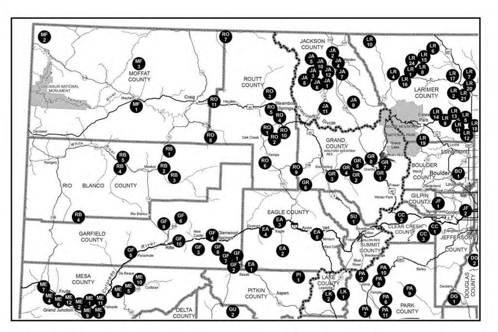
53 southwest COLORADO 51
CHAPTER 9 - DIVISION PROPERTIES. Index #900 REGULATIONS APPLICABLE TO ALL DIVISION PROPERTIES, 1 STATE TRUST LANDS
 CHAPTER 9 - DIVISION PROPERTIES 05/10/2012 Index Page ARTICLE I GENERAL PROVISIONS #900 REGULATIONS APPLICABLE TO ALL DIVISION PROPERTIES, EXCEPT STATE TRUST LANDS 1 ARTICLE II PROPERTY SPECIFIC PROVISIONS
2014 Colorado State Recreation Lands
 C O L O R A D O P A R K S & W I L D L I F E 2014 Colorado State Recreation Lands inside: state wildlife areas, State trust lands, State Parks online brochure cpw.state.co.us 2014 Colorado State Recreation
#900 - REGULATIONS APPLICABLE TO ALL DIVISION PROPERTIES, EXCEPT STATE TRUST LANDS
 DEPARTMENT OF NATURAL RESOURCES Division of Wildlife CHAPTER 9 - DIVISION PROPERTIES 2 CCR 406-9 [Editor s Notes follow the text of the rules at the end of this CCR Document.] ARTICLE I - GENERAL PROVISIONS
#900 - REGULATIONS APPLICABLE TO ALL WILDLIFE PROPERTIES, EXCEPT STATE TRUST LANDS
 CodeofCol or adoregul at i ons Sec r et ar yofst at e St at eofcol or ado DEPARTMENT OF NATURAL RESOURCES CHAPTER W-9 - WILDLIFE PROPERTIES 2 CCR 406-9 [Editor s Notes follow the text of the rules at the
CHAPTER W-9 - WILDLIFE PROPERTIES. Index #900 REGULATIONS APPLICABLE TO ALL WILDLIFE PROPERTIES, EXCEPT STATE TRUST LANDS
 03/07/2018 CHAPTER W-9 - WILDLIFE PROPERTIES Index Page ARTICLE I GENERAL PROVISIONS #900 REGULATIONS APPLICABLE TO ALL WILDLIFE PROPERTIES, EXCEPT STATE TRUST LANDS 1 ARTICLE II PROPERTY SPECIFIC PROVISIONS
#900 - REGULATIONS APPLICABLE TO ALL DIVISION PROPERTIES, EXCEPT STATE TRUST LANDS
 ARTICLE I - GENERAL PROVISIONS #900 - REGULATIONS APPLICABLE TO ALL DIVISION PROPERTIES, EXCEPT STATE TRUST LANDS A. Prohibited Activities Except as specifically authorized by contractual agreement, official
RULE-MAKING NOTICE PARKS AND WILDLIFE COMMISSION MEETING November 16-17, 2017
 RULE-MAKING NOTICE PARKS AND WILDLIFE COMMISSION MEETING November 16-17, 2017 September 29, 2017 In accordance with the State Administrative Procedure Act, section 24-4-103, C.R.S., the Parks and Wildlife
Guidelines for Public Use of WPC-owned Properties. Last revised 01/27/2017
 Guidelines for Public Use of WPC-owned Properties Last revised 01/27/2017 Properties owned by Western Pennsylvania Conservancy (WPC) are open to the public free-of-charge. Western Pennsylvania Conservancy
ISSUES SUBMITTAL FORM
 Date: 12/2/13 ISSUE: Should the West Bank Boat Ramp be renamed to Sam Caudill SWA? The West Bank Boat Ramp has been under lease to the DOW and now CPW for several years. CPW acquired the property through
Visitor Guidelines for WPC-owned Properties. Last revised 5/20/2010
 WESTERN PENNSYLVANIA CONSERVANCY Visitor Guidelines for WPC-owned properties 800 Waterfront Dr., Pittsburgh, PA 15222 412-288-2777, www.waterlandlife.org Visitor Guidelines for WPC-owned Properties Last
Outdoor Sporting Program
 Frost Valley YMCA Outdoor Sporting Program Membership Rules and Regulations: 2013-2014 Season Hunting, Fishing, Trail Use, and Camping The Outdoor Sporting Membership Program is dedicated to the responsible
RULES AND REGULATIONS
 RULES AND REGULATIONS All rules apply to the sections of the Backcountry Wilderness Area of Highlands Ranch which are owned by the Highlands Ranch Community Association (HRCA) and have access provided
PUBLIC NOTICE OF PROPOSED RULE NUMBER W 3812(I)
") MISSISSIPPI DEPARTMENT OF WILDLIFE, FISHERIES, AND PARKS DIVISION OF ENFORCEMENT, WILDLIFE AND FISHERIES POST OFFICE BOX 451 JACKSON, MISSISSIPPI 39205 PUBLIC NOTICE OF PROPOSED RULE NUMBER W 3812(I) TO:
MISSISSIPPI DEPARTMENT OF WILDLIFE, FISHERIES, AND PARKS DIVISION OF ENFORCEMENT, WILDLIFE AND FISHERIES POST OFFICE BOX 451 JACKSON, MISSISSIPPI 39205 PUBLIC NOTICE OF PROPOSED RULE NUMBER W 3812(I) TO:
PEPPER RANCH PRESERVE QUALITY WILDLIFE MANAGEMENT HUNT PROGRAM Brochure FOR COLLIER COUNTY RESIDENTS ONLY
 PEPPER RANCH PRESERVE QUALITY WILDLIFE MANAGEMENT HUNT PROGRAM FOR COLLIER COUNTY RESIDENTS ONLY 2017-2018 Brochure Pepper Ranch Preserve Check Station 6315 Pepper Road Immokalee, FL 34142 Phone: 239-657-1999
Tennessee Fish and Wildlife Commission Proclamation Hunting Seasons and Bag Limits on Select National Wildlife Refuges and Other Federal Areas
 &~. ve C. Page 1 of 6 eff. Tennessee Fish and Wildlife Commission Proclamation 15-05 Hunting Seasons and Bag Limits on Select National Wildlife Refuges and Other Federal Areas Pursuant to the authority
Rule 1.1 BASIC REGULATIONS FOR ALL WILDLIFE MANAGEMENT AREAS (WMAs). 1. Target shooting is prohibited, except on designated ranges.
. 1. Target shooting is prohibited, except on designated ranges.") Rule 1.1 BASIC REGULATIONS FOR ALL WILDLIFE MANAGEMENT AREAS (WMAs). A. Safety Precautions: 1. Target shooting is prohibited, except on designated ranges. 2. No hunting or shooting within 200 yards of
Rule 1.1 BASIC REGULATIONS FOR ALL WILDLIFE MANAGEMENT AREAS (WMAs). A. Safety Precautions: 1. Target shooting is prohibited, except on designated ranges. 2. No hunting or shooting within 200 yards of
Youth Cow Elk and Doe Deer Hunts at Burns Hole -Ranching for Wildlife-
 Youth Cow Elk and Doe Deer Hunts at Burns Hole -Ranching for Wildlife- Bull Basin Outfitters in conjunction with the Burns Hole Ranching for Wildlife Program is proud to offer the Northern Colorado Chapter
Hunt ID: OK-WMDeerTurkeyQuailDuck-All-ETTARN-OW-EITHK Deer hunt for the Long Ranger, I didn t say Lone ranger, it is Long Ranger, as in shooting big w
 Hunt ID: OK-WMDeerTurkeyQuailDuck-All-ETTARN-OW-EITHK Deer hunt for the Long Ranger, I didn t say Lone ranger, it is Long Ranger, as in shooting big whitetail at yardages over 300 yards, This is open country
Prairie WMUs (100 Series & 732)
") BIG GAME S Prairie WMUs (100 Series & 732) Sunday hunting for big game is prohibited in Prairie WMUs (102 160). Archery Only Seasons are those where only a bow and arrow may be used to hunt. General Seasons
BIG GAME S Prairie WMUs (100 Series & 732) Sunday hunting for big game is prohibited in Prairie WMUs (102 160). Archery Only Seasons are those where only a bow and arrow may be used to hunt. General Seasons
2018/2019 On-reservation Hunting Season Dates and Rules and Regulation. Hunt Date Summary. Mountain Lion Sept. 24 Nov.1 Aug.
 2018/2019 On-reservation Hunting Season Dates and Rules and Regulation Hunt Date Summary Pick-up Deer and Elk Aug. 13 Early Archery General Season Dates Aug.25 Sept.7 Sept.8 Dec.31 Upland Game Birds Aug.13
Whitney & Aquilla Lakes Hunting Policy
 Whitney & Aquilla Lakes Hunting Policy 2014-2015 AREAS Permitted public hunting is available on approximately 14,000 acres in parts of Bosque County and Hill County. Hunting is not the exclusive use of
CHAPTER P-1 - PARKS AND OUTDOOR RECREATION LANDS INDEX. Page GENERAL PROVISIONS APPLICABLE TO ALL PARKS AND
 09/06/2018 CHAPTER P-1 - PARKS AND OUTDOOR RECREATION LANDS INDEX ARTICLE I Page GENERAL PROVISIONS APPLICABLE TO ALL PARKS AND 2 OUTDOOR RECREATION LANDS AND WATERS #100 Parks and Outdoor Recreation Lands
Hunting Seasons and Bag Limits
 2017-18 Hunting Seasons and Bag Limits These are the seasons and bag limits for most hunting and trapping seasons from July 1, 2017 through June 30, 2018. 2017-18 HUNTING SEASONS AND BAG LIMITS SQUIRRELS,
Regulations governing hunting and other conduct on Forever Wild Lands
 Regulations governing hunting and other conduct on Forever Wild Lands N. Gunter Guy, Jr. 220-4-.15 Regulation of Certain Conduct On Lands Under State Lands Division Jurisdiction (1) Except as otherwise
Allatoona Lake Hunting Permit Information
 Hunting Permit Information The U.S. Army Corps of Engineers at Project announced today that a $20.00 special activity permit fee for Hunting Permits will be assessed beginning in the 2017/2018 hunting
Hunt ID: 5044-G-C-5500-ElkMDeerAlopeSheepLionBear-CO-XXX-TCLIF3FEWES- DC7OS-O1MT-Ranching 4 Wildlife
 Hunt ID: 5044-G-C-5500-ElkMDeerAlopeSheepLionBear-CO-XXX-TCLIF3FEWES- DC7OS-O1MT-Ranching 4 Wildlife These outfitters guides are exceptionally qualified, offering you more than 50 years combined experience.
ARTICLE I - GENERAL PROVISIONS RELATING TO PARKS AND OUTDOOR RECREATION LANDS AND WATERS
 DEPARTMENT OF NATURAL RESOURCES CHAPTER P-1 - PARKS AND OUTDOOR RECREATION LANDS 2 CCR 405-1 [Editor s Notes follow the text of the rules at the end of this CCR Document.] ARTICLE I - GENERAL PROVISIONS
Tennessee Fish and Wildlife Commission Proclamation Hunting Seasons and Bag Limits on Select National Wildlife Refuges and Other Federal Areas
 Tennessee Fish and Wildlife Commission Proclamation 17-06 Hunting Seasons and Bag Limits on Select National Wildlife Refuges and Other Federal Areas 05-~:l-)t Page 1 of 7 Pursuant to the authority granted
FLATHEAD INDIAN RESERVATION
 FLATHEAD INDIAN RESERVATION PHEASANTS, GRAY PARTRIDGE AND MIGRATORY WATERFOWL 2017-18 HUNTING SEASONS, SHOOTING HOURS AND LIMITS Upland Game Birds Gray Partridge Hunting Season: September 1, 2017 through
General Capitol Forest Questions and Answers 7/23/15
 General Capitol Forest Questions and Answers 7/23/15 Do I need a discover pass to recreate in the forest? yes no exceptions Where can I purchase a discover pass? Anyplace that sells fishing licenses or
Stimson Lumber Company Oregon Lands Public Access Policy 2013 Revised 9/3/2013
 Stimson Lumber Company Oregon Lands Public Access Policy 2013 Revised 9/3/2013 Stimson Lumber Company owns and manages approximately 174,000 acres of commercial timberland in northwest Oregon. It is Stimson
Stimson Lumber Company Oregon Lands Public Access Policy 2016 Revised 7/19/16 (Subject to modification without notice)
") Stimson Lumber Company Oregon Lands Public Access Policy 2016 Revised 7/19/16 (Subject to modification without notice) Stimson Lumber Company owns and manages approximately 175,000 acres of commercial
Stimson Lumber Company Oregon Lands Public Access Policy 2016 Revised 7/19/16 (Subject to modification without notice) Stimson Lumber Company owns and manages approximately 175,000 acres of commercial
Rules, Regulations, Provisions, and Directives
 Rules, Regulations, Provisions, and Directives District hunting and parking permits All participants and their helpers must clearly display a District-issued parking permit on the dashboard of their vehicle.
2017 State Park Land and Water Regulations
 COLORADO PARKS & WILDLIFE 2017 State Park Land and Water Regulations CPW/CHRIS STARK CPW/WAYNE LEWIS CPW/KEN PAPALEO CPW/VERDON TOMAJKO cpw.state.co.us Map of Colorado state parks HIKING BOATING CABINS
COLORADO DEPARTMENT OF EDUCATION
 ADAMS COUNTY MAPLETON 1 6 2 1 0 0 0 0 9 5,721 286.5 20.0 N/A N/A NORTHGLENN-THORNTON 12 29 8 6 2 4 0 0 49 34,869 1767.2 19.7 N/A N/A ADAMS COUNTY 14 9 2 2 1 0 0 0 14 6,528 366.7 17.8 N/A N/A BRIGHTON 27J
Stimson Lumber Company Oregon Lands Public Access Policy 2017 Revised 3/6/2017 (Subject to modification without notice)
") Stimson Lumber Company Oregon Lands Public Access Policy 2017 Revised 3/6/2017 (Subject to modification without notice) Stimson Lumber Company owns and manages approximately 175,000 acres of commercial
Stimson Lumber Company Oregon Lands Public Access Policy 2017 Revised 3/6/2017 (Subject to modification without notice) Stimson Lumber Company owns and manages approximately 175,000 acres of commercial
Spring Valley Property Owners & Recreation Corporation Policy #810: SVPORC Property Recreational Regulations Policy Revised 12/22/2017 Page 1 of 7
 SPRING VALLEY PROPERTY OWNERS & RECREATIONAL CORPORATION Policy Number 810 SVPORC PROPERTY RECREATIONAL REGULATIONS Effective January 1, 2010 I. GENERAL A. The Spring Valley subdivision includes four parcels
440+ Acres. Laramie Mountains Cow Camp Converse County, Wyoming Offered at $660,000
 LAND FOR SALE Serving America s Landowners Since 1929 440+ Acres Laramie Mountains Cow Camp Converse County, Wyoming Offered at $660,000 L-1600011 440+ deeded acres Texas Creek runs the full length of
CR SEASONS, BAG LIMITS, AND SPECIAL REGULATIONS FOR MIGRATORY WATERFOWL
 STATE OF NEVADA BOARD OF WILDLIFE COMMISSIONERS #17 The Board of Wildlife Commissioners under the authority of Section 501.181, 503.090, 503.140 and 503.245 of the Nevada Revised Statutes, does hereby
COLUMBIA COUNTY, OREGON
 COLUMBIA COUNTY, OREGON Forests, Parks, and Recreation Department 1054 Oregon Street St. Helens, Oregon 97051 Reservation Number: (503) 366-3984 Telephone Number: (503) 397-2353 Facsimile Number: (503)
The regulatory items detailed below are scheduled to be addressed at the Colorado Parks and Wildlife Commission s March 4-5, 2015 meeting in Denver.
 1313 Sherman, Room 111 Denver, CO 80203 P 303.866.3203 TO: Members of the Colorado Parks and Wildlife Commission FROM: Danielle Isenhart, Regulations Manager RE: March 2015 Parks and Wildlife Commission
Guilford Sportsmen s Association. Rules and Regulations
 Guilford Sportsmen s Association Rules and Regulations Revised June 1, 2009 TABLE OF CONTENTS PAGE SEC. 1. CLUB HOUSE 1 SEC. 2. GROUNDS 2 SEC. 3. PICNIC AREA 2 SEC. 4. HUNTING ON CLUB CONTROLLED LAND 3
DEER MANAGEMENT HUNTING PERMIT TERMS & CONDITIONS
 DEER MANAGEMENT HUNTING PERMIT TERMS & CONDITIONS GENESEE COUNTY DEPARTMENT OF PARKS, RECREATION & FORESTRY 153 CEDAR STREET, BATAVIA, NY 14020 Phone (585) 344-8508 Administration/Reservations/Parks Supervisor
DRAFT RULE Specific Regulations for Wildlife Management Areas North Central Region Agenda Item 12A December 13, 2018
 DRAFT RULE Specific Regulations for Wildlife Management Areas North Central Region Agenda Item 12A December 13, 2018 RULE NO.: 68A-15.062 RULE TITLE: Specific Regulations for Wildlife Management Areas
The Lake Creek Ranch. Located in the foothills of the Owl Creek Mountains in western Hot Springs County, Wyoming
 The Lake Creek Ranch Located in the foothills of the Owl Creek Mountains in western Hot Springs County, Wyoming Experienced Professional Ranch Brokers Specializing in the sale of ranches, farms, & recreational
Minutes of the Meeting of the Mineral County Advisory Board to Manage Wildlife Monday January 22, 2018 at 6:00 PM
 Minutes of the Meeting of the Mineral County Advisory Board to Manage Wildlife Monday January 22, 2018 at 6:00 PM MEETING ROOM, HAWTHORNE FIRE HOUSE Present: Glenn Bunch, Chairman, Members: Billie Williams
STATE OF NEVADA BOARD OF WILDLIFE COMMISSIONERS CR SEASONS, BAG LIMITS, AND SPECIAL REGULATIONS FOR MIGRATORY GAME BIRDS
 STATE OF NEVADA BOARD OF WILDLIFE COMMISSIONERS The Board of Wildlife Commissioners under the authority of Section 501.181, 503.090, 503.140 and 503.245 of the Nevada Revised Statutes, does hereby adopt
City of Anoka Archery Deer Hunting Program
 City of Anoka Archery Deer Hunting Program - 2018 The City of Anoka is currently allowing archery deer hunting on two publically owned properties within the City of Anoka: Federal Premium Ammunition Wildlife
2017 RULE CHANGE PROPOSALS
 OKLAHOMA DEPARTMENT OF WILDLIFE CONSERVATION 2017 RULE CHANGE PROPOSALS 1. 800:10-1-3. Additional definitions Add definition for OLAP - walk-in fishing areas and stream access means bodies of water designated
Regulation Change Notification: Migratory Bird Seasons for Colorado 2012 Prepared by: Jim Gammonley, Draft 28 November 2011
 Regulation Change Notification: Migratory Bird Seasons for Colorado 01 Prepared by: Jim Gammonley, Draft 8 November 011 These proposed regulations for migratory game bird hunting seasons in Colorado are
Hunt ID: CO-ElkMDeerGoatSheepBear-All-ISONGUNN-CGSG-JN
 Hunt ID: CO-ElkMDeerGoatSheepBear-All-ISONGUNN-CGSG-JN This is the best wilderness horseback hunting adventures ever, tucked tightly in the heart of the Colorado Rockies. These guided hunts and premium
Premier Outdoor Recreation
 Premier Outdoor Recreation Frequently Asked Questions (FAQs) for our Northwest Permits 1. What is a Recreational Permit? A Weyerhaeuser Recreational Permit grants to Permittee the right to recreate on
STATE OF NEVADA BOARD OF WILDLIFE COMMISSIONERS CR SEASONS, BAG LIMITS, AND SPECIAL REGULATIONS FOR MIGRATORY GAME BIRDS
 STATE OF NEVADA BOARD OF WILDLIFE COMMISSIONERS The Board of Wildlife Commissioners under the authority of Section 501.181, 503.090, 503.140 and 503.245 of the Nevada Revised Statutes, does hereby adopt
Schuylkill County Parks and Recreation Rules and Regulations for Sweet Arrow Lake County Park
 Schuylkill County Parks and Recreation Rules and Regulations for Sweet Arrow Lake County Park All visitors to the Park must comply with all the Park Rules and Regulations while within the Park. Section
JC Mesa Ranch. Colorado - San Miguel County - Telluride
 Commanding stunning views of Telluride and surrounding peaks, the 2,379 deeded-acre JC Mesa Ranch is one of the only remaining undeveloped and unencumbered ranches in the Telluride area. Surrounded by
I. OUTDOOR RECREATION AND WILDLIFE
 I. OUTDOOR RECREATION AND WILDLIFE 1. Update on National Trends (Table I-1) Table I-1 contains data from the U.S. Fish & Wildlife s 2011 National Survey Fishing, Hunting, and Wildlife-Associated Recreation,
2012 North Ottawa Dunes Deer Management Hunt. Rules and Regulations
 2012 North Ottawa Dunes Deer Management Hunt Rules and Regulations You MUST read and agree to abide by all of the rules listed below. All participants must comply with all Michigan DNR rules and regulations
Faler Creek Ranch DANIEL, WYOMING. Fly Fishing Hunting Ranching Conservation
 Faler Creek Ranch DANIEL, WYOMING Fly Fishing Hunting Ranching Conservation Faler Creek Ranch DANIEL, WYOMING Introduction: Faler Creek Ranch is comprised of 91 acres, providing stunning views of the Wyoming
Riding Mountain National Park Fishing Regulations Summary
 Riding Mountain National Park Fishing Regulations Summary Riding Mountain Fishing Regulations Summary Key Reminders : All National Parks of Canada Fishing Regulations apply A Riding Mountain National Park
OWASIPPE CONSERVATION GROUP RULES 2018
 OWASIPPE CONSERVATION GROUP RULES 2018 The Owasippe Conservation Group (OCG) was formed in 1997 to offer the camp work as part of the maintenance program in exchange for the hunting privileges for each
Confederated Tribes of the Colville Reservation. Aboriginal Territories in Washington
 Confederated Tribes of the Colville Reservation Aboriginal Territories in Washington Tribal Trust Lands and Allotments Outside of the Colville Reservation and North Half 2016 Traditional Hunting Season
Saint John's Abbey Arboretum Controlled Deer Hunt 2013
 Saint John's Abbey Arboretum Controlled Deer Hunt 2013 Welcome to Saint John s for the 12th controlled deer hunt since 1933. 17 July 2013 The following rules apply to all hunters allowed on Saint John
TOWN OF PERINTON 2016 HUNTING PERMIT REGULATIONS
 Anyone That Desires To Hunt On Town of Perinton Owned Property Must First Obtain A Town Issued Hunting Permit. To Obtain A Town Hunting Permit You Must Meet The Following Criteria: You must be a resident
Hunt ID: 5083-G-L-4295-MDeerWDeerAntelopeElk-CO-105-IO9WAK-C9OK-A1ND-Trophy Hunts Only
 tttttttt rrr rr Hunt ID: 5083-G-L-4295-MDeerWDeerAntelopeElk-CO-105-IO9WAK-C9OK-A1ND-Trophy Hunts Only Trophy Hunting in Colorado and Texas. Our Colorado operation encompasses over 40,000 acres between
RULES AND REGULATIONS Title 58 RECREATION
 RULES AND REGULATIONS Title 58 RECREATION GAME COMMISSION [58 PA. CODE CH. 141] Hunting and Trapping To effectively manage the wildlife resources of this Commonwealth, the Game Commission (Commission),
White Clay Creek State Park Hunting Rules
 White Clay Creek State Park 2018-19 Hunting Rules Refer to map for approximate locations of indicated areas. In addition to the rules and regulations found in the Delaware Hunting and Trapping Guide: 2018-2019,
Maryland Department of Natural Resources Wildlife and Heritage Service
 Maryland Department of Natural Resources Wildlife and Heritage Service Gwynnbrook Wildlife Management Area 3740 Gwynnbrook Avenue Owings Mills, Maryland 21117 410-356-9272 Soldiers Delight Natural Environment
FINAL REGULATIONS - CHAPTER W-3 - FURBEARERS and SMALL GAME, EXCEPT MIGRATORY BIRDS
 MAILING 03/01/2019 FINAL REGULATIONS - CHAPTER W-3 - FURBEARERS and SMALL GAME, EXCEPT MIGRATORY BIRDS ARTICLE I - GENERAL PROVISIONS #300 - Definitions A. "Canada Lynx Recovery Area" means the area of
Premier Outdoor Recreation
 Premier Outdoor Recreation Frequently Asked Questions (FAQs) for our Northwest Permits 1. What is a Recreational Permit? A Weyerhaeuser Recreational Permit grants to Permittee the right to recreate on
CHAPTER W-5 - SMALL GAME - MIGRATORY BIRDS INDEX
 11/16/2017 CHAPTER W-5 - SMALL GAME - MIGRATORY BIRDS INDEX ARTICLE I ARTICLE II ARTICLE III ARTICLE IV ARTICLE V ARTICLE VI BASIS and PURPOSE Page GENERAL PROVISIONS #500 DEFINITIONS 2 #501 HUNTING HOURS
Rules, Regulations, Provisions, and Directives
 Rules, Regulations, Provisions, and Directives District hunting and parking permits: All participants and their helpers must clearly display a District-issued parking permit on the dashboard or rearview
GENERAL HUNTING REGULATIONS
 GENERAL HUNTING REGULATIONS The following are brief summaries of some of the hunting regulations that apply to the purchase and use of licences obtained through a draw. A more comprehensive summary is
GENERAL HUNTING REGULATIONS
 GENERAL HUNTING REGULATIONS The following are brief summaries of some of the hunting regulations that apply to the purchase and use of licences obtained through a draw. A more comprehensive summary is
CHAPTER 11. Article 1 Hunting Regulations, General 2 Special Either-Sex Deer Hunting Regulations. Article 1 General Hunting Regulations
 CHAPTER 11 HUNTING REGULATIONS Article 1 Hunting Regulations, General 2 Special Either-Sex Deer Hunting Regulations Article 1 General Hunting Regulations 11101. Legal Shooting Time. 11102. Hunting License
MIDDLE FORK RANCH FAIRPLAY, COLORADO PARK COUNTY PRESENTED BY
 MIDDLE FORK RANCH FAIRPLAY, COLORADO PARK COUNTY PRESENTED BY 1 06 OVERVIEW 08 LOCATION 11 FEATURES 13 ATTRACTIONS 14 RANCH HISTORY 17 WILDLIFE 2 3 N MIDDLE FORK RANCH FAIRPLAY, COLORADO 3,338 ACRES PARK
PROPOSED REGULATION OF THE BOARD OF WILDLIFE COMMISSIONERS. LCB File No. R May 6, 2002
 PROPOSED REGULATION OF THE BOARD OF WILDLIFE COMMISSIONERS LCB File No. R054-02 May 6, 2002 EXPLANATION Matter in italics is new; matter in brackets [omitted material] is material to be omitted. AUTHORITY:
Hunting and Fishing Bag Limits and Seasons
 III Corps & FH Circular 210-13-22 Installations Hunting and Fishing Bag Limits and Seasons Headquarters III Corps and Fort Hood Fort Hood, Texas76544 4 SEPTEMBER 2013 UNCLASSIFIED SUMMARY of CHANGE III
D. "Dark geese" means Canada geese, white-fronted geese, brant, and all other species of geese except light geese.
 MAILING - 06/27/2014 FINAL REGULATIONS - CHAPTER W-5 - MIGRATORY BIRDS ARTICLE I GENERAL PROVISIONS #500 DEFINITIONS: A. Migratory birds means those migratory birds included in the terms and conventions
CANDLEWOOD SHORES TAX DISTRICT ORDINANCE GOVERNING USE OF THE CSTD RECREATION AREAS
 BE IT ORDAINED THAT: Section 1 - TITLE: This Ordinance shall be known and may be cited as the Recreation Area Use Ordinance of the Candlewood Shores Tax District (CSTD). Section 2 - PURPOSE: The purpose
MISSISSIPPI DEPARTMENT OF WILDLIFE, FISHERIES, AND PARKS RULE 5.3 ALLIGATOR HUNTING SEASON FOR PUBLIC WATERS.
 MISSISSIPPI DEPARTMENT OF WILDLIFE, FISHERIES, AND PARKS Title 40: Wildlife, Fisheries, and Parks Part 2: Wildlife Part 2, Chapter 5: Regulations regarding alligators. RULE 5.3 ALLIGATOR HUNTING SEASON
OREGON ADMINISTRATIVE RULES OREGON DEPARTMENT OF FISH AND WILDLIFE
 DIVISION 008 DEPARTMENT OF FISH AND WILDLIFE LANDS 635-008-0015 Agreements to Restrict Use of Motor-Propelled Vehicles No person shall violate posted motor-propelled vehicle use restrictions established
Economic Contribution of Off-Highway Vehicle Recreation in Colorado July 2009
 Colorado Off-Highway Vehicle Coalition Economic Contribution of Off-Highway Vehicle Recreation in Colorado July 2009 www.cohvco.org THE Louis Berger Group, INC. 12596 W. Bayaud Ave. Suite 201 Lakewood,
Confederated Tribes of the Umatilla Indian Reservation -- Cayuse, Umatilla, and Walla Walla Tribes
 2018-2019 Treaty Hunting Seasons and Regulations Confederated Tribes of the Umatilla Indian Reservation -- Cayuse, Umatilla, and Walla Walla Tribes CTUIR Tribal Hunting Rights Reserved in 1855 Treaty a
RANCH & FARM SALES PRESENTS
 SOUTHWEST RANCH & FARM SALES PRESENTS Chaffin Ranch 2000 +/- ACRES $1,295 PER ACRE Oklahoma Hunting Ranch/Recreational Property/Timber Land nestled in the beautiful Ozark Plateau. Information in this brochure
Agenda Item 16 Chapter W-3 - Furbearers and Small Game, Except Migratory Birds
 1313 Sherman, Room 111 Denver, CO 80203 P 303.866.3203 TO: Members of the Colorado Parks and Wildlife Commission FROM: Danielle Isenhart, Regulations Manager RE: May 2017 Parks and Wildlife Commission
RANCH & FARM SALES PRESENTS
 SOUTHWEST RANCH & FARM SALES PRESENTS Chaffin Ranch 2000 +/- ACRES $1,295 PER ACRE Oklahoma Hunting Ranch/Recreational Property/Timber Land nestled in the beautiful Ozark Plateau. Information in this brochure
RANCH & FARM SALES PRESENTS
 SOUTHWEST RANCH & FARM SALES PRESENTS Chaffin Ranch 2000 +/- ACRES $1,295 PER ACRE Oklahoma Hunting Ranch/Recreational Property/Timber Land nestled in the beautiful Ozark Plateau. Information in this brochure
NAVAJO NATION DEPARTMENT OF FISH AND WILDLIFE Non-Navajo Fall Big Game Hunt Proclamation ARCHERY DEER HUNTS
 NAVAJO NATION DEPARTMENT OF FISH AND WILDLIFE 2017-2018 Non-Navajo Fall Big Game Hunt Proclamation The following 2017-2018 Non-Navajo Big Game Permits will be sold beginning Monday, April 3, 2017. Deadline
Subject to sale, withdrawal, or error.
 We are privileged to have the exclusive listing on a very scenic ranch in the beautiful western foothills of the Jemez Mountains in the northwest central area of New Mexico. This outstanding offering is
2019 JAVELINA OVER-THE COUNTER NONPERMIT-TAG INFORMATIONAL HANDOUT
 This Informational Handout for the Javelina Over-the-Counter Nonpermit-tags is being provided for reference only to assist hunters in understanding this unique but limited and restricted hunting opportunity.
Saint John's Abbey Arboretum Controlled Deer Hunt 2017 Welcome to Saint John s for the 16th controlled deer hunt since 1933.
 Saint John's Abbey Arboretum Controlled Deer Hunt 2017 Welcome to Saint John s for the 16th controlled deer hunt since 1933. 1 July 2017 The following rules apply to all hunters allowed on Saint John s
The 2017 Economic Contributions of Outdoor Recreation in Colorado A regional and county-level analysis
 July 23, 2018 The 2017 Economic Contributions of Outdoor Recreation in Colorado A regional and county-level analysis Colorado Parks & Wildlife Denver, CO PO Box 6435 Fernandina Beach, FL 32035 Office (904)
Utah. North Stansbury Mountains Wilderness Study Area Site-Specific Monitoring Guide
 Utah North Stansbury Mountains Wilderness Study Area Site-Specific Monitoring Guide 1 General Information WildSNAP Monitoring Peter Woodruff, American Conservation Experience Coordinator Phone (801) 989-7069
Deer Hunting Frequently Asked Questions 2017 Deer Hunting Rules September 22, 2017
 What to Know for 2017 Season Structure Licenses and tags Bonus antlerless tags Crossbow regulations Public and private lands tags Tagging deer Harvest Registration Transportation of deer Chronic wasting
15A NCAC 10D.0102 GENERAL REGULATIONS REGARDING USE (a) For purposes of this Subchapter, the following definitions apply: (1) "Permanent Hunting
 For purposes of this Subchapter, the following definitions apply: (1) Permanent Hunting") 15A NCAC 10D.0102 GENERAL REGULATIONS REGARDING USE (a) For purposes of this Subchapter, the following definitions apply: (1) "Permanent Hunting Blind" means any structure that is used for hunter concealment,
15A NCAC 10D.0102 GENERAL REGULATIONS REGARDING USE (a) For purposes of this Subchapter, the following definitions apply: (1) "Permanent Hunting Blind" means any structure that is used for hunter concealment,
FERN RIDGE WILDLIFE AREA HUNT SEASON HUNTER PERMIT STATISTICS
 2010-11 HUNT SEASON HUNTER PERMIT STATISTICS SEASON SUMMARY SPREADSHEETS and OVERVIEW PAGE 1 2010-11 PERMIT AREA OVERVIEW 2 2010-11 HUNT PERMIT SUMMARY 3 1990-2010-11 COMPARATIVE HUNT PERMIT STATISTICS
DUETTE PRESERVE. Manatee County Natural Resources QUALITY WILDLIFE MANAGEMENT PROGRAM
 Manatee County Commission District 1 Larry Bustle District 2 Gwendolyn Brown District 3 John Chappie District 4 Ron Getman District 5 Donna Hayes At-Large Carol Whitmore At-Large Joe McClash DUETTE PRESERVE
Floating the Buffalo National River. with First River Outfitter. Michelle Hulett. exp2010_w01h3buffalo2_ann_solution
 Floating the Buffalo National River with First River Outfitter Michelle Hulett The Buffalo River Beginning as just a trickle, The Buffalo National River runs down the Boston Mountains, flows north and
Background Report Draft Rule 68A Agenda Item 15.A.(1) and (2) November 21, 2014 Version 2, November 7, 2014 DRAFT RULE
 and (2) November 21, 2014 Version 2, November 7, 2014 DRAFT RULE") Background Report Draft Rule 68A-15.063 Agenda Item 15.A.(1) and (2) November 21, 2014 Version 2, November 7, 2014 Explanation of Version 2: This update addresses proposed rule amendments to Joe Budd Wildlife
Background Report Draft Rule 68A-15.063 Agenda Item 15.A.(1) and (2) November 21, 2014 Version 2, November 7, 2014 Explanation of Version 2: This update addresses proposed rule amendments to Joe Budd Wildlife
APAFR MILITARY RECREATION AREA REGULATIONS. A Current and retired DoD civilian personnel, contractors, and program volunteers.
 2014-2015 APAFR MILITARY RECREATION AREA REGULATIONS A1.1. OUTDOOR RECREATION PROCEDURES: The Military Recreation Area (MRA) is open daily throughout the year except when prohibited by military activities.