VTS Louisville User Manual
|
|
|
- Ella Parrish
- 6 years ago
- Views:
Transcription
1 VTS Louisville User Manual Revised July 2013
 gauge is at or predicted to stay above 13.0 feet.")
2 Vessel Traffic Service (VTS) Louisville ( ) Just the Facts 1. VTS Louisville Area: McAlpine Locks (MM 606.8) to Twelve Mile Island (MM 593); the VTS monitors VHF CH When the VTS is activated: The VTS is activated when the McAlpine (upper) gauge is at or predicted to stay above 13.0 feet. This usually corresponds to McAlpine L/D having all gates fully open (all-out), and Markland L/D having gates opened at 76 feet or more. 3. Applicable to which vessels: Generally, all vessels must comply with directives issued by the VTS. Vessels that are subject to Vessel Bridge-to-Bridge Radiotelephone Act and vessels that are required to participate in the Vessel Movement Reporting System (VMRS Users) are all considered VTS Users. You are a VMRS User if you operate in the VTS Area and your vessel is: (a) A towing vessel of 8 meters (approx 26 feet) or more in length; (b) A passenger vessel certificated to carry 50 or more passengers for hire, when engaged in trade; or (c) Any other power-driven vessel of 40 meters (approx 131 feet) or more in length. 4. When & where to report: If you are a VMRS User, you must file a Sailing Plan at least 15 minutes before navigating in the VTS area. VTS Louisville will accept Sailing Plan reports at the lower & upper ends of the VTS Area (McAlpine Locks and Twelve-Mile Island), as well as 15 minutes before entering the VTS Area. You must also file Position Reports at specific locations within the VTS area as described below (includes initial Sailing Plan): Position Reporting Upbound Vessels Downbound Vessels McAlpine L/D (MM 606.8) (Sailing Plan) Twelve Mile Island (MM 593) (Sailing Plan) L&I Railroad Bridge (MM 604.4) Six Mile Island (MM 598) Towhead Island (MM 602.5) Louisville Waterworks (MM 600.5) Six Mile Island (MM 598) Towhead Island (MM 602.5) Twelve Mile Island (MM 593) (check-out) L&I Railroad Bridge (MM 604.4) McAlpine L/D (MM 606.8) (check-out) For vessels initiating their voyage from within the VTS Area, they should file their Sailing Plan before getting underway, and then file Position Reports at the same locations listed above for either Upbound or Downbound vessels as applicable. They should also report when they reach their destination or mooring. 5. What & how to report: The initial report or Sailing Plan should include at minimum the following information: (a) Vessel name and type; (b) Present position; (c) Destination; (d) Intended route/planned stops; (e) Time and point of entry; and (f) Barges types (hopper, red flag/tank, crane, etc.) including any Dangerous cargoes Example Sailing Plan: Louisville Traffic, this is M/V John Doe currently downbound at Twelve-Mile Island with 15 hoppers (loads of coal); I ll be stopping at Six Mile for fuel, then proceeding downbound through McAlpine For Position reports, you need only give the name of the vessel and the name of the checkpoint. Example Position Report: Louisville Traffic, this is M/V John Doe; finished fueling and passing Six Mile Island downbound. All Sailing Plan and Position Reports should be communicated via VHF/FM CH-13 unless directed to another frequency by the VTS. 6. How to report Certain Dangerous Cargoes: For towing vessels pushing barges that are loaded (or were previously loaded) with Certain Dangerous Cargoes (CDC), or for any other vessel that does not want to advertise their cargoes, please consider using telephone or cellular (in lieu of VHF/FM) to report your Sailing Plan. VTS Louisville can be reached at The VTS encourages you to report your initial Sailing Plan via telephone to accommodate your privacy wishes and to avoid broadcasting any CDC cargoes that are in tow; however, Position Reports must be made via VHF/FM radio for safety purposes, so that other traffic will know your route and position. i
3 Example Sailing Plan (via radio & telephone): First via radio: Louisville Traffic, this is M/V John Doe currently downbound at Twelve-Mile Island, checking into the system; I ll get back to you in a moment. Then via telephone: Louisville Traffic, this is the John Doe with the rest of my Sailing Plan. I m pushing 3 loads of ammonium nitrate and 1 empty Chlorine barge, in addition to 5 loads of coal; I ll be stopping at Six Mile for fuel, then proceeding downbound through McAlpine 7. What are Certain Dangerous Cargoes? Certain Dangerous Cargoes (CDC) are defined in 33 CFR The list(s) are too extensive to publish in this guide; however, the most common CDC cargoes that are likely to ever be transported on the Western Rivers are outlined below. Disclaimer: this is not a complete listing of CDC cargoes, but we are not aware of any other CDC cargoes that have been shipped through the Western Rivers in the past five years, and it is improbable that any would be shipped in bulk other than those on this list: CDC Bulk Cargoes CHRIS Proper Shipping Name Type AAD Acetaldehyde Liquefied Gas ACY Acetone cyanohydrin Liquid ALA Allyl alcohol Liquid AMA Ammonia, anhydrous Liquefied Gas AMN Ammonium nitrate Powder/Granular (Hopper) AN2 Ammonium nitrate based fertilizers Powder/Granular (Hopper) BDI Butadiene Liquefied Gas BTN Butylene Liquefied Gas BUT Butane Liquefied Gas CLX Chlorine Liquefied Gas CSA Chlorosulfonic acid Liquid CTA Crotonaldehyde Liquid DMA Dimethylamine Liquefied Gas EAM Ethylamine Liquefied Gas ECH Ethylene chlorohydrin Liquid ECL Ethyl chloride Liquefied Gas CDC Bulk Cargoes CHRIS Proper Shipping Name Type EDB Ethylene dibromide Liquid EOX Ethylene oxide Liquefied Gas ETH Ethane Liquefied Gas ETL Ethylene Liquefied Gas LNG Methane (LNG) Liquefied Gas MAP Methyl acetylene-propadiene mixture Liquefied Gas MET Methacrylonitrile Liquid MTB Methyl bromide Liquefied Gas MTC Methyl chloride Liquefied Gas OLM Oleum (fuming sulfuric acid) Liquid PO2 Propylene Oxide/Ethylene Oxide Mixtures Liquefied Gas POX Propylene Oxide Liquid PPL Propylene Liquefied Gas PRP Propane Liquefied Gas SFD Sulfur dioxide Liquefied Gas VCM Vinyl chloride Liquefied Gas 8. What type of service does the VTS provide? VTS Louisville provides most of the services defined by the International Association of Marine Aids to Navigation and Lighthouse Authorities (IALA) as an Information Service, as a Navigation Service and as a Traffic Organization Service. These services include, but are not limited to the following functions: communicating the approximate position, intentions and destination of vessels operating within the VTS area; information on meteorological and hydrological conditions and status of aids to navigation (ATON); information on the presence of traffic congestion in the waterway and waterway restrictions; and, information to assist in the on-board navigational decision-making process provided at the request of a vessel, or when deemed necessary by the VTS. The VTS also monitors and provides advance planning and prioritization of vessel movements, including the allocation of space, established routes, and/or other measures that may be considered necessary and appropriate by the VTS, including the establishment of vessel queues. Some of these services are possible because of mandatory position reporting. Exception: Due to sensor limitations, VTS Louisville cannot determine the exact position, course and speed of vessels in the system; therefore the VTS is limited to relaying approximate vessel locations (i.e., via landmarks such as Six-Mile Island or mile marker), and/or vessel locations as reported by other VTS Users. 9. One-Way Traffic? One of the most important functions that VTS Louisville performs is to actively manage traffic in the crucial area between Towhead Island (MM 602.5) and the Louisville & Indiana (L&I) Railroad Drawbridge at the entrance to the Portland Canal (MM 604.4). Due to strong out-drafts along the Kentucky bank and the limited space available at the canal entrance, the VTS manages the system to ensure only one-way traffic is allowed between Towhead Island and L&I Bridge, and with few exceptions, that only a single tow is allowed to transit the area at a time. The VTS also ensures that the L&I Bridge is in the Up (Open) position before granting clearance for downbound traffic to proceed below Towhead Island. 10. Where are the Queues? Any downbound vessel queue will be managed by the VTS. The VTS will inform mariners of their order in any queue. If you are a downbound tow and the VTS notifies you that you are next in queue, generally your tow should hold at Louisville Waterworks (MM 600.5); if your tow is not next in the downbound queue, you should consider holding at or above Six Mile Island. For any upbound queues, your order will generally be established by order of lockage, and you will be allowed to hold in the Portland Canal unless directed otherwise by the McAlpine Lockmaster or the VTS. ii

4 Useful Numbers Name Phone VHF FM Clark County, IN Sheriff Clarksville, IN Fire Dept Clarksville, IN Police Dept Floyd County, IN Sheriff Harrods Creek, KY Fire Dept Jeffersonville, IN Fire Dept Jeffersonville, IN Police Dept L&I Railroad Drawbridge CH-13 Louisville Metro Fire/Police Dispatch 911 or McAlpine Lockmaster CH-13 McAlpine Lower Automated Gauge McAlpine Upper Automated 2nd Street Bridge National Response Center New Albany, IN Police Dept USCG Navigation Center USCG Sector Ohio Valley (Louisville, KY) or Utica, IN Fire Dept CH-16 VTS Louisville CH-13 iii
5 U. S. COAST GUARD VESSEL TRAFFIC SERVICE LOUISVILLE Page JUST THE FACTS USEFUL NUMBERS i iii INTRODUCTION 2 SECTION I GENERAL PROCEDURES 4 (1) Purpose and Applicability (2) Vessel Operations (3) Intention To Deviate From These Rules (4) Requirement To Carry The Rules (5) Emergencies SECTION II VTS LOUISVILLE AREA DESCRIPTION 6 SECTION III COMMUNICATIONS PROCEDURES AND MISCELLANEOUS REPORTS 7 (1) Designated Frequency For VTSL Area (2) Voice Call Sign (3) Radio Listening Watch (4) Radiotelephone Equipment (5) English language (6) Time (7) Report Of Impairment To The Operation Of a Vessel (8) Miscellaneous Reports SECTION IV VESSEL MOVEMENT AND REPORTING SERVICE 9 (1) Reports (2) Sailing Plan (3) Position Reporting Points (4) Sailing Plan Deviation Report APPENDIX A SAMPLE MESSAGES 12 I. General II. Sailing Plan III. Position Reports IV. Final Report APPENDIX B DEFINITIONS 15 APPENDIX C SELECTED PARTS: 33 CFR PARTS161 and APPENDIX D BRIDGE-TO-BRIDGE RADIOTELEPHONE REGS 29 APPENDIX E CHARTLETS 33 1
6 U. S. COAST GUARD VESSEL TRAFFIC SERVICE LOUISVILLE INTRODUCTION During high river stages at Louisville, Kentucky, downbound tows on the Ohio River face a combination of navigational challenges. Due to unusually strong and variable current patterns, a down bound tow passing under the former Louisville and Jeffersonville Railroad (Big-Four) Bridge is committed until it reaches the Louisville-Portland Canal. If a tow has to stop or back down because the Louisville and Indiana Railroad Bridge cannot be opened, the pilot will have control difficulties. Consequently, the tow could be carried by strong outdraft currents toward the middle of the river and the McAlpine Dam. As such, it is unsafe for more than one tow at a given time to be in the reach of the channel between Towhead Island and the entrance to the Louisville and Portland Canal. In 1971 and 1972 a series of casualties occurred on the Ohio River in the Louisville area. The most serious was in February of 1972 when a barge carrying chlorine gas became lodged in the McAlpine Dam threatening the Louisville metropolitan area. As a result of these casualties, in 1973 the Vessel Management System Louisville (VSML) was created. Effective 13 October 13, 1994, changes to Title 33 of the United States Code of Federal Regulations (CFR) Part 161 shifted the participation requirement from a voluntary system to a mandatory system. Vessel Traffic Service Louisville (VTSL) is a mandatory Vessel Traffic Service (VTS) designed to enable vessel operators to better cope with the hazards associated with navigation during high water conditions in the Louisville area. The VTS is placed into operation when the water level at the upper gauge of McAlpine Dam is at 13 feet and rising. The VTS remains in operation until the level falls below 13 feet. The VTS provides the mariner with information related to the safe navigation of the waterway. Mariners are cautioned that information provided by the Vessel Traffic Center (VTC) can be no more accurate than the reports received from the VTS Users. The VTC may not have first hand knowledge of all hazardous conditions that may exist in the VTSL area. As such, unreported hazards may confront the mariner at any time. Such hazards should be reported to the VTC as soon as possible so the VTC may pass that information on to other mariners. This information, coupled with the mariner s compliance with VTS directions and measures, and the provisions set forth in 33 CFR 161, serve to enhance the safe routing of vessels through the hazardous waterway in the VTSL area during periods of high water. However, the owner, operator, charterer, master or person directing the movement of a vessel remains at all times responsible for the manner in which the vessel is operated and maneuvered, and for the safe navigation of the vessel under all circumstances. Compliance with these rules or with a direction of the VTS is at all times contingent upon the exigencies of safe navigation. The VTC processes information received from vessels operating in the VTSL area. The VTC also communicates directly with the Louisville and Indiana Railroad Bridge Office via telephone and passes bridge status information to vessels within the VTSL area. The goal of the VTS is to improve vessel safety by implementation of the following procedures: (1) The VTC will coordinate the raising of the Louisville and Indiana Railroad Bridge with the needs of river traffic; 2
7 (2) The VTC will notify participating vessels of the location of other vessels and information about any known hazards within the VTSL area; (3) Through advanced planning, vessel advisories and vessel movement directives, the VTC will direct vessels in order to avoid congestion in the critical area between Towhead Island and the Louisville and Indiana Railroad Bridge; (4) The VTC will permit only one tow at a time to transit between Towhead Island and the entrance to the Louisville and Portland Canal. VTS Louisville operates on a VHF-FM communications network and provides coverage from Twelve Mile Island (Mile 593.0) to McAlpine Lock and Dam (Mile 606.8) on the Ohio River. The VTS maintains a listening guard on Channel 13. The Sector Ohio Valley Communications Center also maintains a listening guard on Channel 16 except when working radio traffic on another frequency. The primary frequency for communicating with the VTC is Channel 13 ( MHz). In the event of communications failure on Channel 13, initial contact with the VTC can be made on Channel 16. The voice call sign for VTS Louisville is Coast Guard Louisville Traffic. Vessels required to participate in the VTS are listed in this manual. The Ports and Waterways Safety Act, as amended, prescribes civil and criminal penalties for violation of the VTS regulations. Any person who willfully and knowingly violates any regulation issued hereunder commits a Class C Felony. This manual is intended to provide the mariner with a description of the services offered and rules in force for VTS Louisville. It incorporates regulations which are published in Title 33 Code of Federal Regulations (CFR). This manual is not intended to conflict with or modify the Regulations in any respect. This manual hereby cancels and supersedes previous editions of the Vessel Traffic Service User s Manual. This manual is effective July 1, Earlier versions should be discarded. We encourage all interested parties to visit the Vessel Traffic Center, and we encourage suggestions for improvements to this manual or to VTS operating procedures. Send suggestions and comments to: Commander Coast Guard Sector Ohio Valley 600 Martin Luther King Jr. Place Room 409-D Louisville, KY
8 SECTION I. GENERAL PROCEDURES 1. Purpose and Applicability a. The purpose of this User s Manual is to provide procedures to be followed by vessels operating in the Vessel Traffic Service Louisville (VTSL) area and to enhance safe passage by reducing the potential for rammings, groundings and collisions and to minimize risk of environmental harm resulting from those events. b. The following procedures in this section apply to Vessel Traffic Service (VTS) Users (required participants): (1) Every power-driven vessel of 40 meters (approximately 131 feet) or more in length; (2) Every towing vessel of 8 meters (approximately 26 feet) or more in length; (3) Every vessel certified to carry 50 or more passengers for hire, when engaged in trade; or (4) Every vessel subject to the Vessel Bridge-to-Bridge Radiotelephone Act. Participation may also apply to any vessel underway or at anchor within the Louisville VTS area to the extent the VTS considers it necessary 2. Vessel Operation. VTS Users shall ensure that all VTS directions or measures and the procedures contained in the regulations set forth in Appendix C are adhered to. Compliance with these rules or with a direction of the VTS is at all times contingent upon the exigencies of safe navigation. If a VTS User is unable to safely comply with a direction issued by VTS, the VTS User may deviate only to the extent necessary to avoid endangering persons, property or the environment. This deviation shall be reported to the VTS as soon as possible. 3. Intention to Deviate From These Rules. Requests to deviate from these rules for an extended period of time of if anticipated before the start of a transit, must be submitted in writing to the District Commander. Upon receipt of the written request, the District Commander may authorize a deviation if the proposed deviation provides a level of safety equivalent to or beyond that provided by these procedures or is a maneuver considered necessary for safe navigation under the circumstances. Correspondence requesting a deviation of these regulations should be addressed to: Commander (dpw) Eighth Coast Guard District 500 Poydras Street New Orleans, LA The VTC may, upon request, authorize a deviation from these rules for a voyage or part of a voyage through the VTSL area. The deviation request must be made well in advance to allow the requesting vessel and the VTC sufficient time to assess the safety of the proposed maneuver. The requesting vessel and the VTC must exchange relevant information on vessel handling characteristics, traffic density and environmental conditions and, must otherwise cooperate to promote a safe transit. 4
9 4. Requirement to Carry the Rules. Each VTS User must carry on board and maintain for ready reference a copy of the regulations. Carrying a copy of this User s Manual meets the requirement to carry the rules. 5. Emergencies a. Emergency Mooring Buoys. The U. S. Army Corps of Engineers has established four pairs of emergency mooring buoys within the VTSL area. Each buoy is 10 feet in diameter with retro-reflective sides. The two buoys which comprise each pair are 585 feet apart and are located approximately at: (1) Indiana Bank Mile (near 18 Mile Island); (2) Six Mile Island Mile 597.5; (3) Six Mile Island Mile 598.2; and (4) Kentucky Bank Mile (Cox s Park). Note: All buoys, except those at Six Mile Island Mile 598.2, are removed between May 1 and September 30. Due to the close proximity of the municipal water intakes, mooring of tank vessels laden with petroleum products or hazardous materials is not authorized on the Kentucky Bank - Mile (Cox s Park). b. The Regulations. A vessel will not use the emergency mooring buoys that have been established by the U. S. Army Corps of Engineers, unless specifically authorized. The VTS, upon request, may authorize the use of the emergency mooring buoys by down bound towing vessels that are awaiting VTS approval to proceed. 5
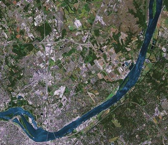
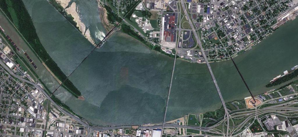
10 SECTION II. VESSEL TRAFFIC SERVICE LOUISVILLE AREA DESCRIPTION The VTSL area consists of that section of the Ohio River between the McAlpine Lock (Mile 606.8) and Twelve Mile Island (Mile 593.0) only at such time when the McAlpine upper pool gauge is at 13.0 feet or above. Within this area lie the following bridges, islands and landmarks: Point of Reference Mile Bank *Twelve Mile Island Harrods Creek/Captain's Quarters Boat Dock/Marina LDB *Six Mile Island Wootons Dock Light RDB Cox's Park Public Boat Ramp LDB *+Louisville Water Company Intake LDB JeffBoat Shipyard RDB *Towhead Island Louisville & Jeffersonville Railroad Bridge (Big Four Railroad Bridge) John F. Kennedy Memorial Highway Bridge (Interstate 65 Bridge) Clark Memorial Bridge (Second Street Bridge) *Louisville and Indiana (L&I) Railroad Bridge (Conrail Bridge) *McAlpine Lock and Dam RDB Right Descending Bank LDB Left Descending Bank *VTS Check Points *+Louisville Water Intake check point for down bound vessels only 6
11 SECTION III. COMMUNICATIONS PROCEDURES AND MISCELLANEOUS REPORTS The procedures in this section apply to the following class of vessels (VTS Users): (1) Every power-driven vessel of 40 meters (approximately 131 feet) or more in length. (2) Every towing vessel of 8 meters (approximately 26 feet) or more in length. (3) Every vessel certificated to carry 50 or more passengers for hire, when engaged in trade. (4) Every vessel subject to the Vessel Bridge-to-Bridge Radiotelephone Act. 1. Designated Frequency for VTSL Area. The primary frequency for communicating with the VTC is MHz (Channel 13). The VTC also monitors Channel 16 (156.8 MHz). If communications on Channel 13 fail, VTSL communications shall be on Channel 16. All references to channel refer to VHF-FM marine radio channels. Note: As stated in 47 CFR (b), a VHF watch on Channel 16 ( MHz) is not required on vessels subject to the Vessel Bridge-to-Bridge Radiotelephone Act and participating in a Vessel Traffic Service (VTS) system when the watch is maintained on both the vessel bridge-to-bridge frequency and a designated VTS frequency. 2. Voice Call Sign. The voice call sign for VTSL is COAST GUARD LOUISVILLE TRAFFIC. After communications have been established, the abbreviated call sign LOUISVILLE TRAFFIC may be used. 3. Radio Listening Watch a. When not exchanging communications, a VTS User shall maintain a listening watch on the VTS frequency, VHF-FM Channel 13 ( MHz), and shall respond promptly when hailed by the VTC. b. All communication and reports required by these procedures shall be made from the navigational bridge of the vessel, or in case of a dredge, from its main control station. 4. Radiotelephone Equipment. A vessel s radiotelephone equipment shall be maintained in effective operating condition. A VTS User that cannot meet the radiotelephone requirements of these rules may not enter or get underway in the VTS Area without permission from the VTC. If the required radiotelephone ceases to operate, the VTS User shall ensure that it is restored to operating condition as soon as possible. The failure of a vessel s radiotelephone equipment while the vessel is underway, shall not in itself constitute a violation of these rules nor shall it obligate the vessel to moor or anchor, however required reports shall be made by other means if possible. 5. English Language. All communications and reports shall be made in the English language. 6. Time. In all communications and reports, time shall be specified by using the Louisville local time, either Eastern Standard Time (EST) or Eastern Daylight Savings Time (EDT) depending on which is in effect, and by using the 24 hour clock system (i.e., 1:00 pm is 1300). 7
12 7. Report of Impairment to the Operation of a Vessel. A VTS User shall report to the VTC any conditions of the vessel related to a vessel s ability to safely navigate or maneuver such as, but not limited to: a. The absence or malfunction of vessel operating equipment such as propulsion machinery, steering gear, radar system, gyrocompass, depth sounding device, Automatic Radar Plotting Aid (ARPA), radiotelephone, automated dependent surveillance equipment, navigational lighting, sound signaling devices or similar equipment; b. Any condition on board the vessel likely to impair navigation, such as lack of current nautical charts and publications, personnel shortage, or similar conditions; or c. Vessel characteristics that affect or restrict maneuverability, such as cargo arrangement, trim, loaded condition, underkeel clearance, speed or similar characteristics. 8. Miscellaneous Reports. A VTS User shall notify the VTC of any of the following: a. A marine casualty (as defined in 46 CFR ); b. Involvement in the ramming of a fixed or floating object; c. A pollution incident (as defined in 33 CFR ); d. A defect or discrepancy in an aid to navigation; e. A hazardous condition (as defined in 33 CFR ); f. Improper operation of vessel equipment (as defined in 33 CFR 164); g. Adverse weather or reduced visibility. 8
13 SECTION IV. VESSEL MOVEMENT REPORTING SERVICE VMRS Users are those vessels that are required to monitor, report and respond to VTS directions in the VTSL area. VTS Users are those vessels that are required to monitor and respond to directions from the VTC. The procedures in this section apply to the following vessels (VMRS Users): (5) Every power-driven vessel of 40 meters (approximately 131 feet) or more in length. (6) Every towing vessel of 8 meters (approximately 26 feet) or more in length. (7) Every vessel certificated to carry 50 or more passengers for hire, when engaged in trade. 1. Reports. Except as otherwise provided, all reports and communications shall be made promptly by radiotelephone to the VTC on Channel 13 ( MHz). 2. Sailing Plan. Vessels (i.e., up bound, local transit* or down bound) are required to report 15 minutes prior to entering the VTS area (i.e., when a vessel is getting underway from berth, anchor or mooring within the VTSL area or entering the VTS area from outside). The report shall contain the following information: a. Name of vessel: b. Horsepower; c. Location of the vessel; d. Estimated time of entering or beginning to navigate in the VTS Area; e. Destination; f. Any planned maneuvers within the VTSL area before proceeding to final destination (i.e., fleeting or tow work, overnight stopping, bunkering or taking on stores/supplies); g. Tow configuration to include number of barges (loaded and unloaded) and types of cargos. The barge name and specific cargo** (last cargo for empties) is to be provided for any dangerous cargo or any regulated cargo barges (commonly referred to as red flag) as defined by Subchapter D and Subchapter O of 46 CFR and 151; and h. Any impairment to the operational capability of the vessel including those described in Paragraph 7 of Section III. (*A local transit vessel is a vessel whose transit originates and terminates within the VTSL area.) 9
14 (**The USCG Chemical Hazards Response Information System (CHRIS) code designation is the preferred method of identifying cargo required to be reported by name.) 3. Position Reporting Points. Vessels are required to report its name and location to the VTC at the following Reporting Points: a. Up bound vessel (1) The initial report for entering the VTSL area is the McAlpine Lock (Mile 606.8)+. (2) Louisville and Indiana Railroad Bridge (Mile 604.4); (3) Towhead Island (Mile 602.5); (4) Six Mile Island (Mile 598.0); a. The final report for an up bound vessel departing the VTSL area is Twelve Mile Island (Mile 593.0)++. b. Down bound vessel (1) The initial report for entering the VTSL area is Twelve Mile Island (Mile 593.0)+. (2) Six Mile Island (Mile 598.0); (3) Louisville Water Company Municipal Intake (Mile 600.6); (4) Towhead Island (Mile 602.5); (5) Louisville and Indiana Railroad Bridge (Mile 604.4); (6) The final report for a down bound vessel departing the VTSL area is the McAlpine Lock (Mile 606.8)++. c. It is requested that vessel movements, such as, but not limited to turning, making up, changing or reassembling tows, be reported to the VTC at lease 15 Minutes prior to commencing, at commencement and immediately upon completion of operation. d. When directed by the VTC +VTS Users entering the VTS area from within the VTSL area (i.e., when a vessel is getting underway from berth, anchor or mooring) will use that location as their beginning point and report at the next check point they arrive as per the above designated locations. ++VTS Users terminating their voyage within the VTSL area (i.e., berths, anchors, or moors for an extended period of time to totally reconfigure or pick up a new tow) will use that location as their final report for their transit of the VTSL area. 10
15 4. Sailing Plan Deviation Report. A vessel must report: a. Any intention to deviate from a VTS direction; b. Any significant deviation from previously reported information. 11
16 APPENDIX A SAMPLE MESSAGES I. GENERAL VTSL communications shall be on VHS FM Channel 13 ( MHz). This is the Bridge-to-Bridge radiotelephone frequency and shall be used for navigational safety purposes. For VTSL purposes the following points are emphasized: a. Use the name of the vessel or the station being called first, then the calling vessel or station s name (do not use call signs). b. In the interest of courtesy to other mariners please listen for other radio traffic in progress before transmitting so that traffic is not interrupted. II. SAILING PLAN SAMPLE 1. A down bound vessel with tow is calling 15 minutes from approaching Twelve Mile Island (Mile 593.0) bound for Cairo IL. The tow has 6 empty open hopper barges, 2 loads of petroleum products and 2 loads of Propylene Oxide (a CDC cargo). Call- Up: COAST GUARD LOUISVILLE TRAFFIC THIS IS MOTOR VESSEL JOHN DOE OVER. VTC: JOHN DOE THIS IS COAST GUARD LOUISVILLE TRAFFIC OVER. Message: VTC: VSL: VTC: LOUISVILLE TRAFFIC THIS IS- MOTOR VESSEL JOHN DOE AT MILE 588 ABOVE TWELVE MILE ISLAND WITH 6 EMPTY HOPPERS AND 4 LOADED RED-FLAGS. MY DESTINATION IS CAIRO IL. OVER. JOHN DOE THIS IS LOUISVILLE TRAFFIC ROGER ARE ANY OF YOUR BARGES CDC OVER. LOUISVILLE TRAFFIC ROGER I LL FINISH CHECK-IN IN A FEW MINUTES - OVER JOHN DOE THIS IS LOUISVILLE TRAFFIC ROGER (VTC PASSES ANY ADVISORY INFORMATION); STANDING-BY *NOTE: If the tow contains CDC cargos (or other cargos that the mariner wishes to keep private), the vessel may request to switch to another channel, or to finish check-in via cell-phone to avoid excessive transmission on CH-13 or to avoid advertising the cargos in tow. SAMPLE 2. An up bound vessel is calling 15 minutes prior to departing McAlpine Lock and entering the Louisville Portland Canal with 10 loads coal and 5 loads of steel bound for Cincinnati, OH. Call- Up: COAST GUARD LOUISVILLE TRAFFIC THIS IS MOTOR VESSEL JOHN DOE OVER. 12
17 VTC: Message: VTC: JOHN DOE THIS IS COAST GUARD LOUISVILLE TRAFFIC OVER. LOUISVILLE TRAFFIC THIS IS- MOTOR VESSEL JOHN DOE AT MCALPINE LOCK WITH 15 LOADED BARGES; 10 COAL AND 5 STEEL. UP BOUND FOR CINCINNATI, OH. NO RED FLAGS OVER. JOHN DOE THIS IS LOUISVILLE TRAFFIC ROGER (VTC PASSES ANY ADVISORY INFORMATION) CALL AGAIN WHEN CLEARING MCALPINE LOCK OUT. III. POSITION REPORTS SAMPLE 1. An up bound tow clearing McAlpine Lock at 1600 EST. Call-Up: VTC: COAST GUARD LOUISVILLE TRAFFIC THIS IS MOTOR VESSEL JOHN DOE OVER. JOHN DOE THIS IS COAST GUARD LOUISVILLE TRAFFIC OVER. Report: LOUISVILLE TRAFFIC THIS IS MOTOR VESSEL JOHN DOE - CLEAR OF MCALPINE LOCK - OVER VTC: Message: JOHN DOE THIS IS COAST GUARD LOUISVILLE TRAFFIC ROGER - (VTC PASSES ANY ADVISORY INFORMATION) STAND BY FOR L&I BRIDGE CLEARANCE OVER. JOHN DOE THIS IS LOUISVILLE TRAFFIC - THE L&I BRIDGE IS IN THE FULL UPRIGHT POSITION YOU ARE CLEAR TO PROCEED - CALL AGAIN WHEN YOU ARE CLEAR OF THE L&I BRIDGE OVER. Reply: LOUISVILLE TRAFFIC THIS IS JOHN DOE ROGER OUT. SAMPLE 2. A down bound tow passes Six Mile Island. Call-Up & Message COAST GUARD LOUISVILLE TRAFFIC THIS IS MOTOR VESSEL JOHN DOE OVER. VTC: Report: VTC: JOHN DOE THIS IS COAST GUARD LOUISVILLE TRAFFIC OVER. LOUISVILLE TRAFFIC THIS IS MOTOR VESSEL JOHN DOE I AM AT SIX MILE ISLAND - OVER JOHN DOE THIS IS COAST GUARD LOUISVILLE TRAFFIC ROGER (VTC PASSES ANY ADVISORY INFORMATION) - OUT. 13
18 IV. FINAL REPORT. SAMPLE 1. A vessel completing its voyage within the VTSL area. Call-Up & Message COAST GUARD LOUISVILLE TRAFFIC THIS IS MOTOR VESSEL JOHN DOE OVER. VTC: Report: VTC: JOHN DOE THIS IS COAST GUARD LOUISVILLE TRAFFIC OVER. LOUISVILLE TRAFFIC THIS IS MOTOR VESSEL JOHN DOE I HAVE REACHED MY DESTINATION AT JEFFBOAT INDIANA SIDE - ESTIMATED TIME OF DEPARTURE IS 2000 EST WITH NEW TOW- OVER JOHN DOE THIS IS COAST GUARD LOUISVILLE TRAFFIC ROGER - OUT. 14
19 APPENDIX B DEFINITIONS AS USED IN THIS MANUAL Bulk Material in any quantity that is shipped, stored, or handled without the benefit of package, label, mark or count and carried in integral or fixed independent tanks. Captain of the Port The Coast Guard officer designated by the Commandant to command a Captain of the Port Zone. Certain Dangerous Cargo (CDC) CDCs are defined in 33 CFR , which includes toxic and/or flammable cargoes commonly transported on the Western Rivers, including Chlorine, Anhydrous Ammonia, Propylene Oxide, Butadiene, Butane, Propane, other LFG/LNG, Ammonium Nitrate and Ammonium Nitrate based fertilizers. Specifically, 33 CFR defines CDC as any of the following: (1) Division 1.1 or 1.2 explosives as defined in 49 CFR (2) Division 1.5D blasting agents for which a permit is required under 49 CFR or, for which a permit is required as a condition of a Research and Special Programs Administration exemption. (3) Division 2.3 poisonous gas, as listed in 49 CFR that is also a material poisonous by inhalation as defined in 49 CFR 171.8, and that is in a quantity in excess of 1 metric ton per vessel. (4) Division 5.1 oxidizing materials for which a permit is required under 49 CFR or for which a permit is required as a condition of a Research and Special Programs Administration exemption. (5) A liquid material that has a primary or subsidiary classification of Division 6.1 poisonous material as listed in 49 CFR that is also a material poisonous by inhalation, as defined in 49 CFR and that is in a bulk packaging, or that is in a quantity in excess of 20 metric tons per vessel when not in a bulk packaging. (6) Class 7, highway route controlled quantity radioactive material or fissile material, controlled shipment, as defined in 49 CFR (7) All bulk liquefied gas cargo carried under 46 CFR or listed in 46 CFR that is flammable and/or toxic and that is not carried as certain dangerous cargo residue (CDC residue). (8) The following bulk liquids except when carried as CDC residue: (i) Acetone cyanohydrin; (ii) Allyl alcohol; (iii) Chlorosulfonic acid; (iv) Crotonaldehyde; (v) Ethylene chlorohydrin; (vi) Ethylene dibromide; (vii) Methacrylonitrile; (viii) Oleum (fuming sulfuric acid); and (ix) Propylene oxide, alone or mixed with ethylene oxide. 15
20 (9) The following bulk solids: (i) Ammonium nitrate listed as a Division 5.1 (oxidizing) material in 49 CFR except when carried as CDC residue; and (ii) Ammonium nitrate based fertilizer listed as a Division 5.1 (oxidizing) material in 49 CFR except when carried as CDC residue. Certain Dangerous Cargo residue (CDC residue) includes any of the following: (1) Ammonium nitrate in bulk or ammonium nitrate based fertilizer in bulk remaining after all saleable cargo is discharged, not exceeding 1,000 pounds in total and not individually accumulated in quantities exceeding two cubic feet. (2) For bulk liquids and liquefied gases, the cargo that remains onboard in a cargo system after discharge that is not accessible through normal transfer procedures, with the exception of the following bulk liquefied gas cargoes carried under 46 CFR or listed in 46 CFR 154.7: (i) Ammonia, anhydrous; (ii) Chlorine; (iii) Ethane; (iv) Ethylene oxide; (v) Methane (LNG); (vi) Methyl bromide; (vii) Sulfur dioxide; and (viii) Vinyl chloride Commandant The Commandant of the United States Coast Guard. Director, Vessel Traffic Services The Coast Guard officer or civilian designated by the Commandant to direct the Vessel Traffic Service (VTS) as described in 33 CFR 161. Deviation Any departure from any rule in this manual. District Commander The Coast Guard officer designated by the Commandant to command a Coast Guard District. Hazardous Condition Any condition that may adversely affect the safety of any vessel, bridge, structure or shore area or the environmental quality of any port, harbor, or navigable waterway. This includes a vessel s ability to safely navigate or maneuver, and includes, but is not limited to: a. The absence or malfunction of vessel operating equipment, such as propulsion machinery, steering gear, radar system, gyrocompass, depth sounding device, automatic radar plotting aid (ARPA), radiotelephone, automated dependent surveillance equipment, navigational lighting, sound signaling devices or similar equipment. b. Any condition on board the vessel likely to impair navigation, such as lack of current nautical charts and publications, personnel shortage, or similar condition. c. Vessel characteristics that affect or restrict maneuverability, such as cargo arrangement, trim, loaded condition, underkeel clearance, speed, or similar characteristics. 16
21 Length Overall length of a vessel (including its tow) Length of Tow When towing with a hawser, the length in feet from the stern of the towing vessel to the stern of the last vessel in tow. When pushing ahead or towing alongside, length of tow means the tandem length in feet of the vessels in tow excluding the length of the towing vessel Tank Vessel A vessel that is constructed or adapted to carry, or that carries, oil or hazardous materials in bulk as cargo or cargo residue. Towing Vessel Any commercial vessel engaged in towing another vessel astern, alongside, or by pushing ahead. Vessel Every description of watercraft or other artificial contrivance used, or capable of being used, as a means of transportation on water. Vessel Movement Reporting System (VMRS) A system used to manage and track vessel movements within a VTS area. This is accomplished by a vessel providing information under established procedures as set forth in this part, or as directed by the VTS. Vessel Traffic Center (VTC) The shore-based facility that operates the Vessel Traffic Service. VTS Special Area A waterway within a VTS area in which special operating requirements apply. Vessel Movement Reporting System (VMRS) User A vessel, or an owner, operator, charterer, master, or person directing the movement of a vessel, that is required to participate in a VMRS within a VTS area. VMRS participation is required for: (8) Every power-driven vessel of 40 meters (approximately 131 feet) or more in length. (9) Every towing vessel of 8 meters (approximately 26 feet) or more in length. (10) Every vessel certificated to carry 50 or more passengers for hire, when engaged in trade. Vessel Traffic Service (VTS) A service implemented under 33 CFR 161 by the United States Coast Guard designed to improve the safety and efficiency of vessel traffic and to interact with marine traffic and respond to traffic situations developing in the VTS area. Vessel Traffic Service Area The geographical area encompassing a specific VTS area of service as described in 33 CFR 161. This area of service may be subdivided into sectors for the purpose of allocating responsibility to individual Vessel Traffic Centers or to identify different operating requirements. VTS Louisville area of service is described in Section II of this manual. VTS User A vessel, or an owner, operator, charterer, master, or person directing the movement of a vessel, that is: (1) Subject to the Vessel Bridge-to-Bridge Radiotelephone Act; or 17
22 (2) Required to participate in a VMRS within a VTS area (VMRS User). VTS User s Manual The manual established and distributed by the VTS to provide the mariner with a description of the services offered and rules in force for that VTS. Additionally, the manual may include chartlets showing the area and sector boundaries, general navigational information about the area, and procedures, radio frequencies, reporting provisions and other information which may assist the mariner while in the VTS area. 18
23 APPENDIX C SELECTED PARTS OF 33 CODE OF FEDERAL REGULATION PARTS 161 AND 162 PART 161 VESSEL TRAFFIC MANAGEMENT Subpart A Vessel Traffic Services General Rules Purpose and Intent Definitions Applicability Requirement to carry the rules Deviations from the rules Preemption Services, VTS Measures, and Operating Requirements Services VTS measures Vessel operating requirements VTS Special Area operating requirements. Subpart B Vessel Movement Reporting System Purpose and intent Applicability Definitions Reporting requirements Sailing Plan (SP) Position Report (PR) Automated reporting Final Report (FR) Reporting exemptions. Subpart C Vessel Traffic Service and Vessel Movement Reporting System Areas and Reporting Points Vessel Traffic Service Louisville. Authority: 33 U.S.C. 1223, 1231; 46 U.S.C , 70119; Pub. L , 116 Stat. 2064; Department of Homeland Security Delegation No Source: CGD , 59 FR 36324, July 15, 1994, unless otherwise noted. Subpart A Vessel Traffic Services General Rules Purpose and Intent. (a) The purpose of this part is to promulgate regulations implementing and enforcing certain sections of the Ports and Waterways Safety Act (PWSA) setting up a national system of Vessel Traffic Services that will enhance navigation, vessel safety, and marine environmental protection, and promote safe vessel movement by reducing the potential for collisions, rammings, and groundings, and the loss of lives and property associated with these incidents within VTS areas established hereunder. (b) Vessel Traffic Services provide the mariner with information related to the safe navigation of a waterway. This information, coupled with the mariner's compliance with the provisions set forth in this 19
24 part, enhances the safe routing of vessels through congested waterways or waterways of particular hazard. Under certain circumstances, a VTS may issue directions to control the movement of vessels in order to minimize the risk of collision between vessels, or damage to property or the environment. (c) The owner, operator, charterer, master, or person directing the movement of a vessel remains at all times responsible for the manner in which the vessel is operated and maneuvered, and is responsible for the safe navigation of the vessel under all circumstances. Compliance with these rules or with a direction of the VTS is at all times contingent upon the exigencies of safe navigation. (d) Nothing in this part is intended to relieve any vessel, owner, operator, charterer, master, or person directing the movement of a vessel from the consequences of any neglect to comply with this part or any other applicable law or regulation (e.g., the International Regulations for Prevention of Collisions at Sea, 1972 (72 COLREGS) or the Inland Navigation Rules) or of the neglect of any precaution which may be required by the ordinary practice of seamen, or by the special circumstances of the case Definitions. For the purposes of this part: Cooperative Vessel Traffic Services (CVTS) means the system of vessel traffic management established and jointly operated by the United States and Canada within adjoining waters. In addition, CVTS facilitates traffic movement and anchorages, avoids jurisdictional disputes, and renders assistance in emergencies in adjoining United States and Canadian waters. Hazardous Vessel Operating Condition means any condition related to a vessel's ability to safely navigate or maneuver, and includes, but is not limited to: (1) The absence or malfunction of vessel operating equipment, such as propulsion machinery, steering gear, radar system, gyrocompass, depth sounding device, automatic radar plotting aid (ARPA), radiotelephone, Automatic Identification System equipment, navigational lighting, sound signaling devices or similar equipment. (2) Any condition on board the vessel likely to impair navigation, such as lack of current nautical charts and publications, personnel shortage, or similar condition. (3) Vessel characteristics that affect or restrict maneuverability, such as cargo or tow arrangement, trim, loaded condition, underkeel or overhead clearance, speed capabilities, power availability, or similar characteristics, which may affect the positive control or safe handling of the vessel or the tow. Navigable waters means all navigable waters of the United States including the territorial sea of the United States, extending to 12 nautical miles from United States baselines, as described in Presidential Proclamation No of December 27, Precautionary Area means a routing measure comprising an area within defined limits where vessels must navigate with particular caution and within which the direction of traffic may be recommended. Towing Vessel means any commercial vessel engaged in towing another vessel astern, alongside, or by pushing ahead. Vessel Movement Center (VMC) means the shore-based facility that operates the vessel tracking system for a Vessel Movement Reporting System (VMRS) area or sector within such an area. The VMC does not necessarily have the capability or qualified personnel to interact with marine traffic, nor does it necessarily respond to traffic situations developing in the area, as does a Vessel Traffic Service (VTS). Vessel Movement Reporting System (VMRS) means a mandatory reporting system used to monitor and track vessel movements. This is accomplished by a vessel providing information under established procedures as set forth in this part in the areas defined in Table (c) (VTS and VMRS Centers, Call Signs/MMSI, Designated Frequencies, and Monitoring Areas). 20
25 Vessel Movement Reporting System (VMRS) User means a vessel, or an owner, operator, charterer, Master, or person directing the movement of a vessel that is required to participate in a VMRS. Vessel Traffic Center (VTC) means the shore-based facility that operates the vessel traffic service for the Vessel Traffic Service area or sector within such an area. Vessel Traffic Services (VTS) means a service implemented by the United States Coast Guard designed to improve the safety and efficiency of vessel traffic and to protect the environment. The VTS has the capability to interact with marine traffic and respond to traffic situations developing in the VTS area. Vessel Traffic Service Area or VTS Area means the geographical area encompassing a specific VTS area of service. This area of service may be subdivided into sectors for the purpose of allocating responsibility to individual Vessel Traffic Centers or to identify different operating requirements. NOTE: Although regulatory jurisdiction is limited to the navigable waters of the United States, certain vessels will be encouraged or may be required, as a condition of port entry, to report beyond this area to facilitate traffic management within the VTS area. VTS Special Area means a waterway within a VTS area in which special operating requirements apply. VTS User means a vessel, or an owner, operator, charterer, master, or person directing the movement of a vessel, that is: (a) Subject to the Vessel Bridge-to-Bridge Radiotelephone Act; or (b) Required to participate in a VMRS within a VTS area (VMRS User). VTS User's Manual means the manual established and distributed by the VTS to provide the mariner with a description of the services offered and rules in force for that VTS. Additionally, the manual may include chartlets showing the area and sector boundaries, general navigational information about the area, and procedures, radio frequencies, reporting provisions and other information which may assist the mariner while in the VTS area. [CGD , 59 FR 36324, July 15, 1994, as amended by CGE , 62 FR 33364, June 19, 1997; USCG , 68 FR 39364, July 1, 2003; USCG , 75 FR 66314, Oct. 28, 2010] Applicability. The provisions of this subpart shall apply to each VTS User and may also apply to any vessel while underway or at anchor on the navigable waters of the United States within a VTS area, to the extent the VTS considers necessary Requirement to carry the rules. Each VTS User shall carry on board and maintain for ready reference a copy of these rules. Note: These rules are contained in the applicable U.S. Coast Pilot, the VTS User's manual which may be obtained by contacting the appropriate VTS, and periodically published in the Local Notice to Mariners. The VTS User's Manual and the World VTS Guide, an International Maritime Organization (IMO) recognized publication, contain additional information which may assist the prudent mariner while in the appropriate VTS area Deviations from the rules. (a) Requests to deviate from any provision in this part, either for an extended period of time or if anticipated before the start of a transit, must be submitted in writing to the appropriate District Commander. Upon receipt of the written request, the District Commander may authorize a deviation if it is determined that such a deviation provides a level of safety equivalent to that provided by the required measure or is a maneuver considered necessary for safe navigation under the circumstances. An 21
26 application for an authorized deviation must state the need and fully describe the proposed alternative to the required measure. (b) Requests to deviate from any provision in this part due to circumstances that develop during a transit or immediately preceding a transit, may be made verbally to the appropriate VTS Director. Requests to deviate shall be made as far in advance as practicable. Upon receipt of the request, the VTS Director may authorize a deviation if it is determined that, based on vessel handling characteristics, traffic density, radar contacts, environmental conditions and other relevant information, such a deviation provides a level of safety equivalent to that provided by the required measure or is a maneuver considered necessary for safe navigation under the circumstances. [CGD , 59 FR 36324, July 15, 1994, as amended by USCG , 70 FR 36350, June 23, 2005] Preemption. The regulations in this part have preemptive impact over State laws or regulations on the same subject matter. The Coast Guard has determined, after considering the factors developed by the Supreme Court in U.S. v. Locke, 529 U.S. 89 (2000), that by enacting Chapter 25 of the Ports and Waterways Safety Act (33 U.S.C et seq. ), Congress intended that Coast Guard regulations preempt State laws or regulations regarding vessel traffic services in United States ports and waterways. [USCG , 75 FR 66314, Oct. 28, 2010] Services, VTS Measures, and Operating Requirements Services. To enhance navigation and vessel safety, and to protect the marine environment, a VTS may issue advisories, or respond to vessel requests for information, on reported conditions within the VTS area, such as: (a) Hazardous conditions or circumstances; (b) Vessel congestion; (c) Traffic density; (d) Environmental conditions; (e) Aids to navigation status; (f) Anticipated vessel encounters; (g) Another vessel's name, type, position, hazardous vessel operating conditions, if applicable, and intended navigation movements, as reported; (h) Temporary measures in effect; (i) A description of local harbor operations and conditions, such as ferry routes, dredging, and so forth; (j) Anchorage availability; or (k) Other information or special circumstances VTS measures. (a) A VTS may issue measures or directions to enhance navigation and vessel safety and to protect the marine environment, such as, but not limited to: (1) Designating temporary reporting points and procedures; (2) Imposing vessel operating requirements; or 22
27 (3) Establishing vessel traffic routing schemes. (b) During conditions of vessel congestion, restricted visibility, adverse weather, or other hazardous circumstances, a VTS may control, supervise, or otherwise manage traffic, by specifying times of entry, movement, or departure to, from, or within a VTS area Vessel operating requirements. (a) Subject to the exigencies of safe navigation, a VTS User shall comply with all measures established or directions issued by a VTS. (b) If, in a specific circumstance, a VTS User is unable to safely comply with a measure or direction issued by the VTS, the VTS User may deviate only to the extent necessary to avoid endangering persons, property or the environment. The deviation shall be reported to the VTS as soon as is practicable. (c) When not exchanging voice communications, a VTS User must maintain a listening watch as required by 26.04(e) of this chapter on the VTS frequency designated in Table (c) (VTS and VMRS Centers, Call Signs/MMSI, Designated Frequencies, and Monitoring Areas). In addition, the VTS User must respond promptly when hailed and communicate in the English language. Notes: As stated in 47 CFR (b), a very high frequency watch on Channel 16 ( MHz) is not required on vessels subject to the Vessel Bridge-to-Bridge Radiotelephone Act and participating in a Vessel Traffic Service (VTS) system when the watch is maintained on both the vessel bridge-to-bridge frequency and a designated VTS frequency. *Louisville Traffic MHz (Ch. 13) The waters of the Ohio River between McAlpine Locks (Mile 606) and Twelve Mile Island (Mile 593), only when the McAlpine upper pool gauge is at approximately 13.0 feet or above. *In the event of a communication failure, difficulties or other safety factors, the Center may direct or permit a user to monitor and report on any other designated monitoring frequency or the bridge-to-bridge navigational frequency, MHz (Channel 13) or MHz (Ch. 67), to the extent that doing so provides a level of safety beyond that provided by other means. The bridge-to-bridge navigational frequency, MHz (Ch. 13), is used in certain monitoring areas where the level of reporting does not warrant a designated frequency. (d) As soon as is practicable, a VTS User shall notify the VTS of any of the following: (1) A marine casualty as defined in 46 CFR ; (2) Involvement in the ramming of a fixed or floating object; (3) A pollution incident as defined in of this chapter; (4) A defect or discrepancy in an aid to navigation; (5) A hazardous condition as defined in of this chapter; (6) Improper operation of vessel equipment required by Part 164 of this chapter; (7) A situation involving hazardous materials for which a report is required by 49 CFR ; and (8) A hazardous vessel operating condition as defined in [CGD , 59 FR 36324, July 15, 1994, as amended by CGD , 60 FR 28329, May 31, 1995; CGD , 61 FR 45326, Aug. 29, 1996; USCG , 64 FR 69636, Dec. 14, 1999; USCG , 68 FR 39364, July 1, 2003; 68 FR 60569, Oct. 22, 2003; USCG , 69 FR 34926, June 23, 2004; CGD , 72 FR 50058, Aug. 30, 2007; 72 FR 70780, Dec. 13, 2007; USCG , 73 FR 35016, June 19, 2008; USCG , 75 FR 66314, Oct. 28, 2010] 23
28 VTS Special Area operating requirements. The following operating requirements apply within a VTS Special Area: (a) A VTS User shall, if towing astern, do so with as short a hawser as safety and good seamanship permits. (b) A VMRS User shall: (1) Not enter or get underway in the area without prior approval of the VTS; (2) Not enter a VTS Special Area if a hazardous vessel operating condition or circumstance exists; (3) Not meet, cross, or overtake any other VMRS User in the area without prior approval of the VTS; and (4) Before meeting, crossing, or overtaking any other VMRS User in the area, communicate on the designated vessel bridge-to-bridge radiotelephone frequency, intended navigation movements, and any other information necessary in order to make safe passing arrangements. This requirement does not relieve a vessel of any duty prescribed by the International Regulations for Prevention of Collisions at Sea, 1972 (72 COLREGS) or the Inland Navigation Rules. Subpart B Vessel Movement Reporting System Purpose and intent. (a) A Vessel Movement Reporting System (VMRS) is a system used to monitor and track vessel movements VTS or VMRS area. This is accomplished by requiring that vessels provide information under established procedures as set forth in this part, or as directed by the Center. (b) To avoid imposing an undue reporting burden or unduly congesting radiotelephone frequencies, reports shall be limited to information which is essential to achieve the objectives of the VMRS. These reports are consolidated into three reports (sailing plan, position, and final). [CGD , 59 FR 36324, July 15, 1994, as amended by USCG , 68 FR 39366, July 1, 2003; USCG , 76 FR 31838, June 2, 2011] Applicability. Unless otherwise stated, the provisions of this subpart apply to the following vessels and VMRS Users: (a) Every power-driven vessel of 40 meters (approximately 131 feet) or more in length, while navigating; (b) Every towing vessel of 8 meters (approximately 26 feet) or more in length, while navigating; or (c) Every vessel certificated to carry 50 or more passengers for hire, when engaged in trade. [CGD , 59 FR 36324, July 15, 1994, as amended by USCG , 68 FR 39366, July 1, 2003] Definitions. As used in this subpart: Center means a Vessel Traffic Center or Vessel Movement Center. Published means available in a widely-distributed and publicly available medium (e.g., VTS User's Manual, ferry schedule, Notice to Mariners). [USCG , 68 FR 39366, July 1, 2003] 24
29 Reporting requirements. (a) A Center may: (1) Direct a vessel to provide any of the information set forth in Table (a) (IMO Standard Ship Reporting System); TABLE (A) THE IMO STANDARD SHIP REPORTING SYSTEM A ALPHA Ship Name, call sign or ship station identity, and flag. B BRAVO Dates and time of A 6 digit group giving day of month (first two digits), hours and event minutes (last four digits). If other than UTC state time zone used. C CHARLIE Position A 4 digit group giving latitude in degrees and minutes suffixed with N (north) or S (south) and a 5 digit group giving longitude in degrees and minutes suffixed with E (east) or W (west); or. D DELTA Position True bearing (first 3 digits) and distance (state distance) in nautical miles from a clearly identified landmark (state landmark). E ECHO True course A 3 digit group. F FOXTROT G GOLF H HOTEL I INDIA Speed in knots A 3 digit group. and tenths of knots Port of Departure Name of last port of call. Date, time and point of entry system Destination and expected time of arrival Entry time expressed as in (B) and into the entry position expressed as in (C) or (D). Name of port and date time group expressed as in (B). J JULIET Pilot State whether a deep sea or local pilot is on board. K KILO L LIMA Date, time and point of exit from system Route information Intended track. Exit time expressed as in (B) and exit position expressed as in (C) or (D). M MIKE Radio State in full names of communications stations/frequencies guarded. N NOVEMBER Time of next report Date time group expressed as in (B). O OSCAR Maximum present static draught in meters 4 digit group giving meters and centimeters. P PAPA Cargo on board Cargo and brief details of any dangerous cargoes as well as harmful substances and gases that could endanger persons or the environment. Q QUEBEC R ROMEO S SIERRA Defects, damage, deficiencies or limitations Description of pollution or dangerous goods lost Weather conditions Brief detail of defects, damage, deficiencies or other limitations. Brief details of type of pollution (oil, chemicals, etc) or dangerous goods lost overboard; position expressed as in (C) or (D). Brief details of weather and sea conditions prevailing. 25
30 T TANGO U UNIFORM V VICTOR W WHISKEY Ship's representative and/or owner Details of name and particulars of ship's representative and/or owner for provision of information. Ship size and type Details of length, breadth, tonnage, and type, etc., as required. Medical personnel Doctor, physician's assistant, nurse, no medic. Total number of persons on board State number. X XRAY Miscellaneous Any other information as appropriate. [i.e., a detailed description of a planned operation, which may include: its duration; effective area; any restrictions to navigation; notification procedures for approaching vessels; in addition, for a towing operation: configuration, length of the tow, available horsepower, etc.; for a dredge or floating plant: configuration of pipeline, mooring configuration, number of assist vessels, etc.]. (2) Establish other means of reporting for those vessels unable to report on the designated frequency; or (3) Require reports from a vessel in sufficient time to allow advance vessel traffic planning. (b) All reports required by this part shall be made as soon as is practicable on the frequency designated in Table (c) (VTS and VMRS Centers, Call Signs/MMSI, Designated Frequencies, and Monitoring Areas). (c) When not exchanging communications, a VMRS User must maintain a listening watch as described in 26.04(e) of this chapter on the frequency designated in Table (c) (VTS and VMRS Centers, Call Signs/MMSI, Designated Frequencies, and Monitoring Areas). In addition, the VMRS User must respond promptly when hailed and communicate in the English language. Note: As stated in 47 CFR (b), a VHF watch on Channel 16 ( MHz) is not required on vessels subject to the Vessel Bridge-to-Bridge Radiotelephone Act and participating in a Vessel Traffic Service (VTS) system when the watch is maintained on both the vessel bridge-to-bridge frequency and a designated VTS frequency. (d) A vessel must report: (1) Any significant deviation from its Sailing Plan, as defined in , or from previously reported information; or (2) Any intention to deviate from a VTS issued measure or vessel traffic routing system. (e) When reports required by this part include time information, such information shall be given using the local time zone in effect and the 24-hour military clock system. [CGD , 59 FR 36324, July 15, 1994, as amended by USCG , 68 FR 39366, July 1, 2003] Sailing Plan (SP). Unless otherwise stated, at least 15 minutes before navigating a VTS area, a vessel must report the: (a) Vessel name and type; (b) Position; (c) Destination and ETA; (d) Intended route; 26
31 (e) Time and point of entry; and (f) Dangerous cargo on board or in its tow, as defined in of this chapter, and other required information as set out in and of this chapter, if applicable Position Report (PR). A vessel must report its name and position: (a) Upon point of entry into a VMRS area; (b) At designated reporting points as set forth in subpart C; or (c) When directed by the Center. [CGD , 59 FR 36324, July 15, 1994, as amended by USCG , 68 FR 39366, July 1, 2003] Automated reporting. (a) Unless otherwise directed, vessels equipped with an Automatic Identification System (AIS) are required to make continuous, all stations, AIS broadcasts, in lieu of voice Position Reports, to those Centers denoted in Table (c) of this part. (b) Should an AIS become non-operational, while or prior to navigating a VMRS area, it should be restored to operating condition as soon as possible, and, until restored a vessel must: (1) Notify the Center; (2) Make voice radio Position Reports at designated reporting points as required by (b) of this part; and (3) Make any other reports as directed by the Center. [USCG , 68 FR 39366, July 1, 2003] Final Report (FR). A vessel must report its name and position: (a) On arrival at its destination; or (b) When leaving a VTS area Reporting exemptions. (a) Unless otherwise directed, the following vessels are exempted from providing Position and Final Reports due to the nature of their operation: (1) Vessels on a published schedule and route; (2) Vessels operating within an area of a radius of three nautical miles or less; or (3) Vessels escorting another vessel or assisting another vessel in maneuvering procedures. (b) A vessel described in paragraph (a) of this section must: (1) Provide a Sailing Plan at least 5 minutes but not more than 15 minutes before navigating within the VMRS area; and (2) If it departs from its promulgated schedule by more than 15 minutes or changes its limited operating area, make the established VMRS reports, or report as directed. [CGD , 59 FR 36324, July 15, 1994, as amended by CGD , 62 FR 33364, June 19, 1997; USCG , 68 FR 39367, July 1, 2003] 27
32 Subpart C Vessel Traffic Service and Vessel Movement Reporting System Areas and Reporting Points Vessel Traffic Service Louisville. The VTS area consists of the navigable waters of the Ohio River between McAlpine Locks (Mile 606.8) and Twelve Mile Island (Mile 593), only when the McAlpine upper pool gauge is at 13.0 feet or above. [CGD , 59 FR 36324, July 15, 1994, as amended by USCG , 63 FR 35531, June 30, 1998] PART 162 INLAND WATERWAYS NAVIGATION REGULATIONS General. Geographic coordinates expressed in terms of latitude or longitude, or both, are not intended for plotting on maps or charts whose referenced horizontal datum is the North American Datum of 1983 (NAD 83), unless such geographic coordinates are expressly labeled NAD 83. Geographic coordinates without the NAD 83 reference may be plotted on maps or charts referenced to NAD 83 only after application of the appropriate corrections that are published on the particular map or chart being used. [CGD , 52 FR 33811, Sept. 8, 1987] Definitions. The following definition applies to this part: Merchant mariner credential or MMC means the credential issued by the Coast Guard under 46 CFR part 10. It combines the individual merchant mariner's document, license, and certificate of registry enumerated in 46 U.S.C. subtitle II part E as well as the STCW endorsement into a single credential that serves as the mariner's qualification document, certificate of identification, and certificate of service. [USCG , 74 FR 11212, Mar. 16, 2009] Ohio River at Louisville, KY. (a) Emergency Mooring Buoys. The U.S. Army Corp of Engineers has established four pairs of emergency mooring buoys. Each buoy is 10 feet in diameter with retro-reflective sides. The two buoys which comprise each pair are 585 feet apart and are located approximately at: (1) Indiana Bank Mile (near 18 Mile Island); (2) Six Mile Island Mile 597.5; (3) Six Mile Island Mile 598.2; and (4) Kentucky Bank Mile (Cox's Park). Note: All buoys, except those at Six Mile Island Mile 598.2, are removed between May 1 and September 30. Due to the close proximity of the municipal water intakes, mooring of tank vessels laden with petroleum products or hazardous materials is not authorized on the Kentucky Bank, Mile (Cox's Park). (b) The regulations. A vessel must not use the emergency mooring buoys that have been established by the U.S. Army Corps of Engineers, unless specifically authorized. The Captain of the Port, upon request, may authorize the use of the emergency mooring buoys by down bound towing vessels that are awaiting Vessel Traffic Center approval to proceed. [CGD , 59 FR 36333, July 15, 1994] 28
33 APPENDIX D VESSEL BRIDGE-TO-BRIDGE RADIOTELEPHONE REGULATIONS Title 33: Navigation and Navigable Waters PART 26 VESSEL BRIDGE-TO-BRIDGE RADIOTELEPHONE REGULATIONS Contents Purpose Definitions Radiotelephone required Use of the designated frequency Use of radiotelephone Maintenance of radiotelephone; failure of radiotelephone Communications Exemption procedures List of exemptions. AUTHORITY: 14 U.S.C. 2, 33 U.S.C ; Pub. L , 116 Stat. 2064; Department of Homeland Security Delegation No Rule 1, International Regulations for the Prevention of Collisions at Sea. SOURCE: CGD R, 37 FR 12720, June 28, 1972, unless otherwise noted Purpose. (a) The purpose of this part is to implement the provisions of the Vessel Bridge-to-Bridge Radiotelephone Act. This part: (1) Requires the use of the vessel bridge-to-bridge radiotelephone; (2) Provides the Coast Guard's interpretation of the meaning of important terms in the Act; (3) Prescribes the procedures for applying for an exemption from the Act and the regulations issued under the Act and a listing of exemptions. (b) Nothing in this part relieves any person from the obligation of complying with the rules of the road and the applicable pilot rules Definitions. For the purpose of this part and interpreting the Act: Act means the Vessel Bridge-to-Bridge Radiotelephone Act, 33 U.S.C. sections ; Length is measured from end to end over the deck excluding sheer; Power-driven vessel means any vessel propelled by machinery; and Secretary means the Secretary of the Department in which the Coast Guard is operating; Territorial sea means all waters as defined in 2.22(a)(1) of this chapter. Towing vessel means any commercial vessel engaged in towing another vessel astern, alongside, or by pushing ahead. Vessel Traffic Services (VTS) means a service implemented under Part 161 of this chapter by the United States Coast Guard designed to improve the safety and efficiency of vessel traffic and to protect the environment. The VTS has the capability to interact with marine traffic and respond to traffic situations developing in the VTS area. 29
34 Vessel Traffic Service Area or VTS Area means the geographical area encompassing a specific VTS area of service as described in Part 161 of this chapter. This area of service may be subdivided into sectors for the purpose of allocating responsibility to individual Vessel Traffic Centers or to identify different operating requirements. NOTE: Although regulatory jurisdiction is limited to the navigable waters of the United States, certain vessels will be encouraged or may be required, as a condition of port entry, to report beyond this area to facilitate traffic management within the VTS area. (Rule 1, International Regulations for Preventing Collisions at Sea, 1972 (as rectified); EO (14 U.S.C. 2); 49 CFR 1.46(b)) [CGD R, 37 FR 12720, June 28, 1972, as amended by CGD a, 42 FR 35784, July 11, 1977; CGD , 59 FR 36322, July 15, 1994; USCG , 68 FR 42601, July 18, 2003] Radiotelephone required. (a) Unless an exemption is granted under and except as provided in paragraph (a)(4) of this section, this part applies to: (1) Every power-driven vessel of 20 meters or over in length while navigating; (2) Every vessel of 100 gross tons and upward carrying one or more passengers for hire while navigating; (3) Every towing vessel of 26 feet or over in length while navigating; and (4) Every dredge and floating plant engaged in or near a channel or fairway in operations likely to restrict or affect navigation of other vessels except for an unmanned or intermittently manned floating plant under the control of a dredge. (b) Every vessel, dredge, or floating plant described in paragraph (a) of this section must have a radiotelephone on board capable of operation from its navigational bridge, or in the case of a dredge, from its main control station, and capable of transmitting and receiving on the frequency or frequencies within the Mega-Hertz band using the classes of emissions designated by the Federal Communications Commission for the exchange of navigational information. (c) The radiotelephone required by paragraph (b) of this section must be carried on board the described vessels, dredges, and floating plants upon the navigable waters of the United States. (d) The radiotelephone required by paragraph (b) of this section must be capable of transmitting and receiving on VHF FM channel 22A (157.1 MHz). (e) While transiting any of the following waters, each vessel described in paragraph (a) of this section also must have on board a radiotelephone capable of transmitting and receiving on VHF FM channel 67 ( MHz): (1) The lower Mississippi River from the territorial sea boundary, and within either the Southwest Pass safety fairway or the South Pass safety fairway specified in 33 CFR , to mile AHP (Above Head of Passes) near Baton Rouge; (2) The Mississippi River-Gulf Outlet from the territorial sea boundary, and within the Mississippi River- Gulf outlet Safety Fairway specified in 33 CFR , to that channel's junction with the Inner Harbor Navigation Canal; and (3) The full length of the Inner Harbor Navigation Canal from its junction with the Mississippi River to that canal's entry to Lake Pontchartrain at the New Seabrook vehicular bridge. (f) In addition to the radiotelephone required by paragraph (b) of this section, each vessel described in paragraph (a) of this section while transiting any waters within a Vessel Traffic Service Area, must have on board a radiotelephone capable of transmitting and receiving on the VTS designated frequency in Table (c) (VTS and VMRS Centers, Call Signs/MMSI, Designated Frequencies, and Monitoring Areas). 30
35 NOTE: A single VHF-FM radio capable of scanning or sequential monitoring (often referred to as dual watch capability) will not meet the requirements for two radios. [CGD , 57 FR 14485, Apr. 21, 1992; 57 FR 21740, May 22, 1992, as amended by CGD , 59 FR 36322, July 15, 1994; CGD , 60 FR 28328, May 31, 1995; CGD , 61 FR 45325, Aug. 29, 1996; CGD , 64 FR 69635, Dec. 14, 1999; USCG , 68 FR 39364, July 1, 2003] Use of the designated frequency. (a) No person may use the frequency designated by the Federal Communications Commission under section 8 of the Act, 33 U.S.C. 1207(a), to transmit any information other than information necessary for the safe navigation of vessels or necessary tests. (b) Each person who is required to maintain a listening watch under section 5 of the Act shall, when necessary, transmit and confirm, on the designated frequency, the intentions of his vessel and any other information necessary for the safe navigation of vessels. (c) Nothing in these regulations may be construed as prohibiting the use of the designated frequency to communicate with shore stations to obtain or furnish information necessary for the safe navigation of vessels. (d) On the navigable waters of the United States, channel 13 ( MHz) is the designated frequency required to be monitored in accordance with 26.05(a) except that in the area prescribed in 26.03(e), channel 67 ( MHz) is the designated frequency. (e) On those navigable waters of the United States within a VTS area, the designated VTS frequency is an additional designated frequency required to be monitored in accordance with (85 Stat. 164; 33 U.S.C ; 49 CFR 1.46(n)(2)) [CGD R, 37 FR 12720, June 28, 1982, as amended by CGD , 48 FR 30107, June 30, 1983; CGD , 57 FR 14486, Apr. 21, 1992; 57 FR 21741, May 22, 1992; CGD , 59 FR 36323, July 15, 1994; CGD , 60 FR 28329, May 31, 1995] Use of radiotelephone. Section 5 of the Act states that the radiotelephone required by this Act is for the exclusive use of the master or person in charge of the vessel, or the person designated by the master or person in charge to pilot or direct the movement of the vessel, who shall maintain a listening watch on the designated frequency. Nothing herein shall be interpreted as precluding the use of portable radiotelephone equipment to satisfy the requirements of this act. [CGD , 59 FR 39963, Aug. 5, 1994] Maintenance of radiotelephone; failure of radiotelephone. Section 6 of the Act states: (a) Whenever radiotelephone capability is required by this Act, a vessel's radiotelephone equipment shall be maintained in effective operating condition. If the radiotelephone equipment carried aboard a vessel ceases to operate, the master shall exercise due diligence to restore it or cause it to be restored to effective operating condition at the earliest practicable time. The failure of a vessel's radiotelephone equipment shall not, in itself, constitute a violation of this Act, nor shall it obligate the master of any vessel to moor or anchor his vessel; however, the loss of radiotelephone capability shall be given consideration in the navigation of the vessel. 31
36 26.07 Communications. No person may use the services of, and no person may serve as, a person required to maintain a listening watch under section 5 of the Act, 33 U.S.C. 1204, unless the person can communicate in the English language. [CGD , 59 FR 36323, July 15, 1994, as amended by CGD , 60 FR 28329, May 31, 1995] Exemption procedures. (a) The Commandant has redelegated to the Assistant Commandant for Marine Safety, Security and Environmental Protection, U.S. Coast Guard Headquarters, with the reservation that this authority shall not be further redelegated, the authority to grant exemptions from provisions of the Vessel Bridge-to- Bridge Radiotelephone Act and this part. (b) Any person may petition for an exemption from any provision of the Act or this part; (c) Each petition must be submitted in writing to U.S. Coast Guard, Marine Safety, Security and Environmental Protection, (CG-5), nd St., SW., Stop 7355, Washington, DC , and must state: (1) The provisions of the Act or this part from which an exemption is requested; and (2) The reasons why marine navigation will not be adversely affected if the exemption is granted and if the exemption relates to a local communication system how that system would fully comply with the intent of the concept of the Act but would not conform in detail if the exemption is granted. [CGD R, 37 FR 12720, June 28, 1972, as amended by CGD , 39 FR 9176, Mar. 8, 1974; CGD , 53 FR 25119, July 1, 1988; CGD , 60 FR 34150, June 30, 1995; CGD , 61 FR 33663, June 28, 1996; CGD , 62 FR 33362, June 19, 1997; USCG , 67 FR 41331, June 18, 2002; USCG , 75 FR 36278, June 25, 2010] List of exemptions. (a) All vessels navigating on those waters governed by the navigation rules for Great Lakes and their connecting and tributary waters (33 U.S.C. 241 et seq. ) are exempt from the requirements of the Vessel Bridge-to-Bridge Radiotelephone Act and this part until May 6, (b) Each vessel navigating on the Great Lakes as defined in the Inland Navigational Rules Act of 1980 (33 U.S.C et seq. ) and to which the Vessel Bridge-to-Bridge Radiotelephone Act (33 U.S.C ) applies is exempt from the requirements in 33 U.S.C. 1203, 1204, and 1205 and the regulations under 26.03, 26.04, 26.05, 26.06, and Each of these vessels and each person to whom 33 U.S.C. 1208(a) applies must comply with Articles VII, X, XI, XII, XIII, XV, and XVI and Technical Regulations 1-9 of The Agreement Between the United States of America and Canada for Promotion of Safety on the Great Lakes by Means of Radio, [CGD R, 37 FR 28633, Dec. 28, 1972, as amended by CGD , 39 FR 44980, Dec. 30, 1974; CGD , 48 FR 7442, Feb. 18, 1983; CGD , 57 FR 14486, Apr. 21, 1992] 32
37 85 40' W 38 21' N 85 40' W INDIANA CLARK COUNTY A B C D E CLARK COUNTY CASTING & CONSERVATION CLUB CHARLESTOWN AMMUNITION DEPOT INDUTRIAL INTAKES (INACTIVE) CITY OF CHARLESTOWN MUNICIPAL INTAKE LOUISVILLE WATER COMPANY INTAKE LOUISVILLE SAILING CLUB 38 23' N LITTLE BATTLE CREEK 85 39' W 38 24' N TWELVE MILE ISLAND UPPER LIGHT & DAYMARKS FL G4s SG(U), SG(D) F LOUISVILLE YACHT CLUB INDIANA ARSENAL UTICA MATCH LINE CHART SAILING LINE OHW D 594 BATTLE CREEK RESTRICTED AREA (SEE NOTES B) E A TWELVE MILE ISLAND LIGHT & DAYMARKS FL(2) R5s TR(U), TR(D) 593 TWELVE MILE ISLAND (K Y) F 592 JENNY LIND RUN PROJECT POOL McALPINE DAM ELEV B B KENTUCKY OLDHAM COUNTY 85 38' W 85 38' W 85 37' W C 591 MATCH LINE CHART 89 NOTE B: VESSEL TRAFFIC SERVICE LOUISVILLE (VTSL) THE VTSL AREA CONSISTS OF THAT SECTION OF THE OHIO RIVER BETWEEN McALPINE LOCKS (MILE OHIO RIVER) AND TWELVE MILE ISLAND (MILE OHIO RIVER) ONLY AT SUCH TIME WHEN THE McALPINE UPPER POOL GAGE IS AT 13.0 FEET OR ABOVE. VESSEL TRAFFIC SERVICE LOUISVILLE (VTSL) MAINTAINS A LISTENING GUARD ON CHANNEL 13 ( MHz). VESSELS ARE REQUIRED TO REPORT 15 MINUTES PRIOR TO ENTERING THE VTSL AREA. THIS REPORT IS ALSO REQUIRED OF VESSELS GETTING UNDERWAY WITHIN THE VTSL AREA ' N 85 37' W 38 21' N KENTUCKY Legend OHIO RIVER JEFFERSON COUNTY 38 22' N 85 36' W 0 1,000 2,000 4,000 VTS Boundary: SCALE: 1" = 2000' VTS Upbound Reporting Point: REVISED: JUN 2010 CHART NO. 88 VTS Downbound Reporting Point: Feet
38 85 42' W 600 A 38 18' N 85 42' W JEFFERSONVILLE A B C D E F G H J 38 19' N DUFFY'S LANDING WOOTEN RIVER SERVICE COAST GUARD AUXILIARY DARLING RAMP ADMIRALS ANCHOR MARINA EAGLE STEEL PRODUCTS PORT OF INDIANA -JEFFERSONVILLE MARINE BUILDERS RUBIYAT BOAT CLUB K L M N O P Q R 85 41' W 38 20' N COX'S PUBLIC PARK & RAMP LOUISVILLE BOAT CLUB K of C BOAT CLUB JUNIPER BEACH DOCK LIMESTONE BAY MARINE McBRIDE DRYDOCK CAPTAIN'S QUARTERS RIVERSIDE GRILL W/ CG PRINCESS CAPTAIN'S QUATERS MARINA INDIANA CLARK COUNTY 85 40' W UTICA 85 39' W 38 17' N 85 41' W K MATCH LINE CHART 86 OHW L 599 B C D M E SIX MILE ISLAND (KY) FEDERAL MOORING BUOYS 598 SAILING LINE 597 RESTRICTED AREA (SEE NOTES B) G F N J H 596 PROJECT POOL McALPINE DAM ELEV O P Q R OHW HARRODS CREEK MATCH LINE CHART 88 GOOSE CREEK 85 38' W 38 20' N SIX MILE ISLAND LIGHT & DAYMARKS FL (2) R 5s TR(U), TR(D) NOTE B: VESSEL TRAFFIC SERVICE LOUISVILLE (VTSL) THE VTSL AREA CONSISTS OF THAT SECTION OF THE OHIO RIVER BETWEEN McALPINE LOCKS (MILE OHIO RIVER) AND TWELVE MILE ISLAND (MILE OHIO RIVER) ONLY AT SUCH TIME WHEN THE McALPINE UPPER POOL GAGE IS AT 13.0 FEET OR ABOVE. VESSEL TRAFFIC SERVICE LOUISVILLE (VTSL) MAINTAINS A LISTENING GUARD ON CHANNEL 13 ( MHz). VESSELS ARE REQUIRED TO REPORT 15 MINUTES PRIOR TO ENTERING THE VTSL AREA. THIS REPORT IS ALSO REQUIRED OF VESSELS GETTING UNDERWAY WITHIN THE VTSL AREA ' W 38 17' N 85 39' W KENTUCKY JEFFERSON COUNTY 38 18' N 85 38' W OHIO Legend RIVER 0 1,000 2,000 4,000 VTS Upbound Reporting Point: Feet VTS Downbound SCALE: Reporting 1" = Point: 2000' 38 19' N REVISED: JUN 2010 CHART NO. 87
39 38 15' N (2) LOUISVILLE LIGHTS (1) McALPINE VANE DIKE LIGHT & DAYMARKS FL G4s SG(U), SG(D) (2) CANAL HEAD LIGHT & DAYMARKS FL(2) R5s TR(U), TR(D) (1) 604 FALLS OF THE OHIO UPPER GATES RESTRICTED AREA (SEE NOTE A) MATCH LINE CHART 85 H I RESTRICTED AREA NOTE A: TITLE 33 CODE OF FEDERAL REGULATIONS, SECTION OHIO RIVER AT LOUISVILLE, KY; REGULATED NAVIGATION AREA: (a) THE FOLLOWING IS A REGULATED NAVIGATION AREA: THE WATERS OF THE OHIO RIVER FROM CLARK MEMORIAL BRIDGE AT MILE 603.5, DOWNSTREAM TO McALPINE DAM AT MILE (b) THE GENERAL REGULATIONS GOVERNING REGULATED NAVIGATION AREAS CONTAINED IN 33 CFR PART 165, SUBPART B APPLY. (c) NO VESSEL SHALL BE OPERATED WITHIN THE REGULATED NAVIGATION AREA AT ANY TIME WITHOUT THE PERMISSION OF THE CAPTAIN OF PORT, LOUISVILLE, KY EXCEPT IN CASE OF EMERGENCY AND FOR PASSAGE THROUGH McALPINE LOCKS. NOTE B: VESSEL TRAFFIC SERVICE LOUISVILLE (VTSL) THE VTSL AREA CONSISTS OF THAT SECTION OF THE OHIO RIVER BETWEEN McALPINE LOCKS (MILE OHIO RIVER) AND TWELVE MILE ISLAND (MILE OHIO RIVER) ONLY AT SUCH TIME WHEN THE McALPINE UPPER POOL GAGE IS AT 13.0 FEET OR ABOVE. VESSEL TRAFFIC SERVICE LOUISVILLE (VTSL) MAINTAINS A LISTENING GUARD ON CHANNEL 13 ( MHz). VESSELS ARE REQUIRED TO REPORT 15 MINUTES PRIOR TO ENTERING THE VTSL AREA. THIS REPORT IS ALSO REQUIRED OF VESSELS GETTING UNDERWAY WITHIN THE VTSL AREA. J A 1 B C D CLARKSVILLE ' N E TOWHEAD ISLAND INDIANA PROJECT DEPTH McALPINE POOL ELEV T ' N 85 45' W A B C D E F G H I J K MARATHON / ASHLAND OIL COLGATE PALMOLIVE CO. INTAKE BUCKHEAD MOUNTAIN GRILL KINGFISH RESTAURANT CITY OF JEFFERSONVILLE RAMP JEFFBOAT, INC. KAYROUZ BOAT STORAGE LG&E INDUSTRIAL INTAKE BELLE OF LOUISVILLE JOE'S CRAB SHACK COAST GUARD BOAT FACILITY L RESTRICTED AREA (SEE NOTE B) CLARK COUNTY SAILING LINE SOUTH FORK BEARGRASS CREEK CLARK MEMORIAL HIGHWAY BRIDGE (US 31E) JFK MEMORIAL HIGHWAY BRIDGE (I-65) BIG FOUR RAILROAD BRIDGE AERIAL POWER LINES V/C P.P ' W 85 44' W 85 43' W F L M N O P Q R S T KENTUCKY JEFFERSON COUNTY LOUISVILLE HARBOR ASSOCIATION, INC. NUGENT SAND CO. AMERICAN COMMERCIAL BARGE LINE AMERICAN COMMERCIAL BARGE LINE MARQUETTE TRANSPORTATION MARINE SALES & SERVICE LOUISVILLE WATER CO. MUNICIPAL INTAKE KINGFISH RESTAURANT M N O P Q R 85 42' W 38 18' N LOUISVILLE 38 16' N 4 G S 85 43' W LOUISVILLE METRO POLICE RIVER PATROL HEADQUARTERS (502) MONITORS CH. 13 & 16 K Legend OHIO OHW RIVER 0 1,000 2,000 4,000 Feet VTS Upbound Reporting Point: SCALE: 1" = 2000' VTS Downbound Reporting Point: REVISED: JUN 2010 CHART NO ' N 85 42' W MATCH LINE CHART ' N 85 41' W
40 RESTRICTED AREA NOTE A: TITLE 33 CODE OF FEDERAL REGULATIONS, SECTION OHIO RIVER AT LOUISVILLE, KY; REGULATED NAVIGATION AREA: (a) THE FOLLOWING IS A REGULATED NAVIGATION AREA: THE WATERS OF THE OHIO RIVER FROM CLARK MEMORIAL BRIDGE AT MILE 603.5, DOWNSTREAM TO McALPINE DAM AT MILE (b) THE GENERAL REGULATIONS GOVERNING REGULATED NAVIGATION AREAS CONTAINED IN 33 CFR PART 165, SUBPART B APPLY. (c) NO VESSEL SHALL BE OPERATED WITHIN THE REGULATED NAVIGATION AREA AT ANY TIME WITHOUT PRIOR PERMISSION OF THE CAPTAIN OF PORT, LOUISVILLE, KY EXCEPT IN CASE OF EMERGENCY AND FOR PASSAGE THROUGH McALPINE LOCKS. NOTE B: VESSEL TRAFFIC SERVICE LOUISVILLE (VTSL) THE VTSL AREA CONSISTS OF THAT SECTION OF THE OHIO RIVER BETWEEN McALPINE LOCKS (MILE OHIO RIVER) AND TWELVE MILE ISLAND (MILE OHIO RIVER) ONLY AT SUCH TIME WHEN THE McALPINE UPPER POOL GAGE IS AT 13.0 FEET OR ABOVE. VESSEL TRAFFIC SERVICE LOUISVILLE (VTSL) MAINTAINS A LISTENING GUARD ON CHANNEL 13 ( MHz) ' W VESSELS ARE REQUIRED TO REPORT 15 MINUTES PRIOR TO ENTERING THE VTSL AREA. THIS REPORT IS ALSO REQUIRED OF VESSELS GETTING UNDERWAY WITHIN THE VTSL AREA. NOTE C: RESTRICTED AREA: NO VESSELS ALLOWED BELOW BRIDGE EXCEPT FOR PASSAGE THROUGH McALPINE LOCKS. NOTE D: RESTRICTED AREA: NO VESSELS ALLOWED BELOW BRIDGE ' N 64 NEW ALBANY 38 16' N F 609 A SAILING LINE 1 64 B VTS Legend: VTS Boundary: VTS Upbound Reporting Point: VTS Downbound Reporting Point: MATCH LINE CHART ' W 608 PROJECT POOL CANNELTON DAM ELEV ' W 2 INDIANA CLARK COUNTY 607 SAND IS LAND SHERMAN MINTON BRIDGE (I-64) 2 K & I RAILROAD BRIDGE 3 PORTLAND SHIPPINGPORT BRIDGE 4 AERIAL POWER LINE V/C P.P. 5 AERIAL POWER LINES V/C P.P. 6 L & I RAILROAD BRIDGE 85 49' W ' W 3 4 A B C D E F D 606 McALPINE LOCKS AND DAM MILE TELEPHONE (502) MAXIMUM LOCKING STAGE 32.0 FEET UPPER GAGE UPPER GAGE OHW LOWER GAGE OHW FOR LOCK INFORMATION USE MARINE RADIO CHANNEL ' W C LOWER GATES RESTRICTE D AREA (SEE NOTE C) FIXED WIER 5 LOUISVILLE JAYCEES BOAT RAMP NEW ALBANY BOAT CLUB GEORGE ROGERS CLARK PARK U.S. ARMY CORPS OF ENGINEERS LOUISVILLE REPAIR STATION ASHLAND OIL, INC. INDIANA AMERICAN WATER CO. INTAKE 605 McALPINE DAM CREST ELEV PROJECT POOL McALPINE DAM ELEV SHIPPINGPORT ISLAND KENTUCKY JEFFERSON COUNTY 85 46' W PORTLAND CHANNEL 38 15' N 85 47' W RESTRICTED AREA (SEE NOTE D) CLARKSVILLE FALLS OF THE OHIO 6 OHIO Legend (1) UPPER GATES RIVER SCALE: 1" = 2000' VTS Upbound Reporting Point: REVISED: JUN 2010 VTS Downbound Reporting Point: CHART NO SAILING LINE 0 1,000 2,000 4,000 VTS Boundary: Feet E RESTRICTED AREA (SEE NOTES A, B, C, & D) LIGHTS (1) 3 AMBER LIGHTS IN VERTICAL LINE (2) McALPINE VANE DIKE LIGHT & DAYMARKS FL G4s SG(U), SG(D) (3) CANAL HEAD LIGHT & DAYMARKS FL(2) R5s TR(U), TR(D) (2) VANE DIKE ELEV (3) 85 45' W 38 17' N MATCH LINE CHART ' W 38 15' N
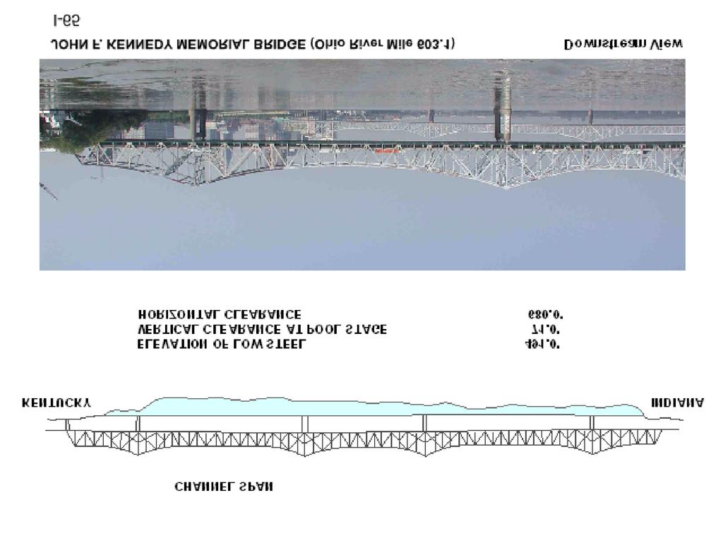
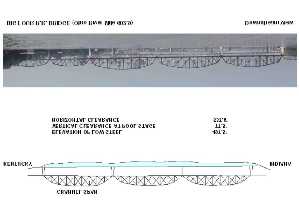
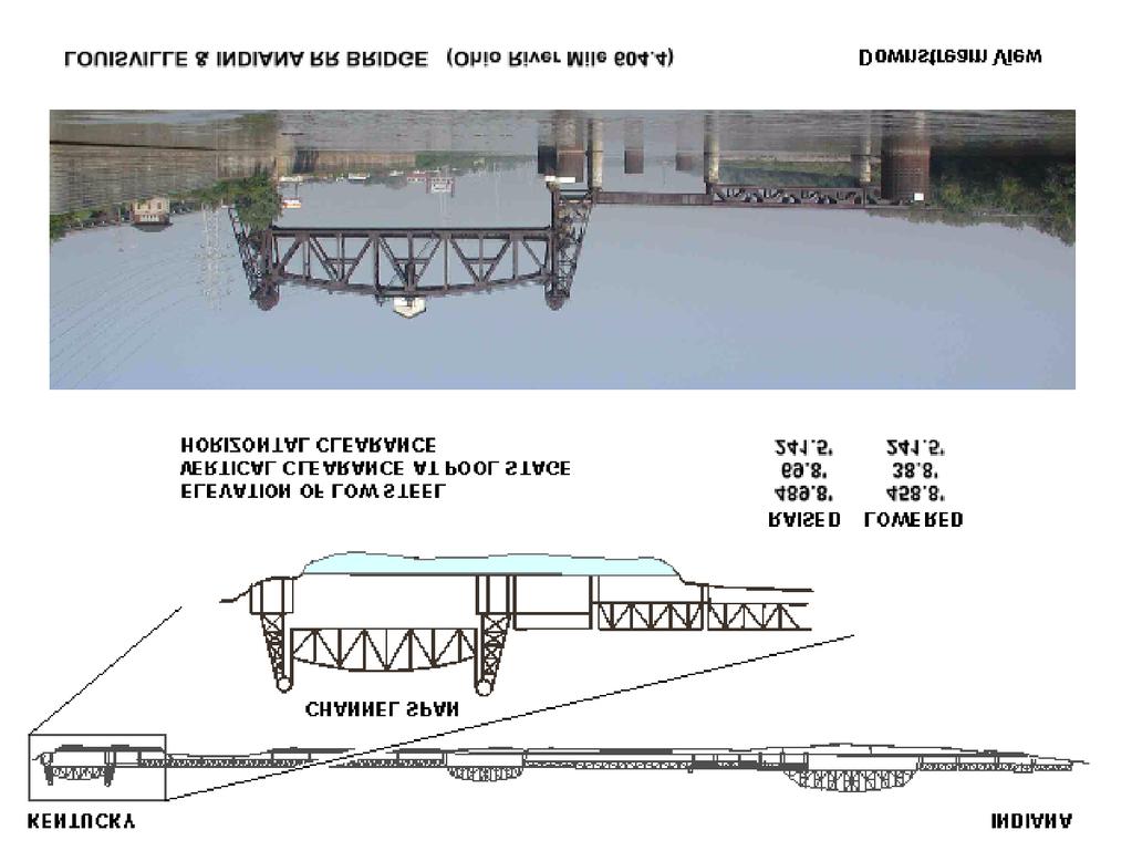
41
 493.33 73.33' 33.18' 110.0' U.P. + 12.0' UPPER GAGE McAlpine Locks SHIPPINGPORT ISLAND +35.")
42 KENTUCKY SOUTH LOCK 110' x 1200' ELEVATION OF LOW STEEL VERTICAL CLEARANCE AT POOL STAGE VERTICAL CLEARANCE H.W. HORIZONTAL CLEARANCE NORTH LOCK 110' x 1200' SOUTH LOCK ( 110' x 1200' ) ' 33.18' 110.0' RIVER LOCK 1200' LAND LOCK 1200' OPERATIONS BUILDING ON MAIN WALL 110' 110' U.P ' UPPER GAGE NORTH LOCK ( 110' x 1200' ) ' 33.18' 110.0' U.P ' UPPER GAGE McAlpine Locks SHIPPINGPORT ISLAND +35.0' TOP OF WALL ZERO UPPER GAGE -6.0' EMERGENCY GATE SILL UPPER GAGE: ZERO ELEV. PROJECT POOL. = = ' LOWER GAGE: ZERO ELEV. PROJECT POOL. = = ' -37.0' UPPER & LOWER SILLS -41.0' UPPER & LOWER SILLS McAlpine Locks ELEVATION LOOKING DOWNSTREAM ELEVATION SHOWN IN FEET ABOVE ELEV INDIANA (PULL CHAIN FOR SMALL PLEASURE CRAFT) KENTUCKY PORTLAND SHIPPINGPORT BRIDGE (OHIO RIVER MILE 606.8) DOWNSTREAM VIEW OHIO RIVER LEGEND Floating mooring bit Check post Ladder
Delaware River Vessel Reporting System Mariners Advisory Committee For
 Delaware River Vessel Reporting System Mariners Advisory Committee For the Bay and River Delaware The Mariner's Advisory Committee is comprised of Master Mariners, River Pilots, and concerns itself with
MSC Guidelines for Liquefied Gas Barge General Arrangements
 T. O. PHILLIPS, CDR, Chief, Tank Vessel and Offshore Division Purpose: To establish a procedure for reviewing general arrangement plans for a liquefied gas barge with independent pressure tanks regulated
VESSEL TRAFFIC SERVICE HOUSTON/GALVESTON
 VESSEL TRAFFIC SERVICE HOUSTON/GALVESTON USER'S MANUAL Revised August 2017 VMRS Users (Full Participation): USER GROUPS These vessels must monitor the designated VTS VHF-FM frequency, make reports to the
LOWER MISSISSIPPI RIVER PRE-ENTRY INFORMATION
 LOWER MISSISSIPPI RIVER PRE-ENTRY INFORMATION Notice of Arrivals Prior to Arrival at any U.S. port, the vessel master should ensure a complete and accurate Notice of Arrival has been submitted to National
1972 Collision Regulations definition of a vessel. Note: Vessel length is measured from end to end over the deck, excluding sheer.
 User Definitions VMRS (Vessel Movement Reporting System) Users: Every power-driven vessel of 40 meters (approximately 131 feet) or more in length, while navigating; Every commercial vessel engaged in towing
U.S. Coast Guard Sector Mobile
 U.S. Coast Guard Sector Mobile Maritime Severe Weather Contingency Port Plan A Guide to Port Planning and Preparation X-2-1 TABLE OF CONTENTS INTRODUCTION Background 1 Authority 1 Applicability and Purpose
COOPERATIVE VESSEL TRAFFIC SERVICE (CVTS) TAMPA BAY, FLORIDA
 TAMPA BAY, FLORIDA") COOPERATIVE VESSEL TRAFFIC SERVICE (CVTS) TAMPA BAY, FLORIDA USERS MANUAL Oct 2010 1 st Edition Serving the Port of Tampa, Port Manatee, Port of Saint Petersburg, and the Waterways of Tampa Bay 1 Table
COOPERATIVE VESSEL TRAFFIC SERVICE (CVTS) TAMPA BAY, FLORIDA USERS MANUAL Oct 2010 1 st Edition Serving the Port of Tampa, Port Manatee, Port of Saint Petersburg, and the Waterways of Tampa Bay 1 Table
VESSEL TRAFFIC SERVICE HOUSTON/GALVESTON
 VESSEL TRAFFIC SERVICE HOUSTON/GALVESTON USER'S MANUAL Revised July 2008 VMRS Users (Full Participation): USER GROUPS These vessels must monitor the designated VTS VHF-FM frequency, make reports to the
PILOTAGE DIRECTIONS REVIEWED DECEMBER 2016
 PILOTAGE DIRECTIONS REVIEWED DECEMBER 2016 REVISION LIST Revision No. Date Details Approved by: Original All sections 12 Dec 2013 First edition of C W Brand v1.0 Pilotage Directions Revision 2 all sections
VESSEL TRAFFIC SERVICE NEW YORK USER'S MANUAL
 USER S MANUAL Revised March 2016 VESSEL TRAFFIC SERVICE NEW YORK USER'S MANUAL Revised March 2016 TABLE OF CONTENTS SECTION Page Table of Contents 1 Introduction 2 Vessel Traffic Management (33 CFR 161)
Rules Practice Exam 11
 1 BOTH INTERNATIONAL & INLAND While underway in fog, you hear a vessel sound one prolonged blast followed by two short blasts on the whistle. What does this signal indicate? A. A vessel towing B. A vessel
OSAKA MARTIS USER MANUAL TABLE OF CONTENTS
 OSAKA MARTIS USER MANUAL TABLE OF CONTENTS Ⅰ Ⅱ Ⅲ INTRODUCTION OPERATIONAL CONCEPT OF "Osaka MARTIS" IMPORTANT NAVIGATIONAL RULES Ⅳ COMMUNICATION 1 VHF Channels 2 Language Ⅴ PRE-ENTRY REPORT AND POSITION
Vessel Traffic Service Lower Mississippi River
 Vessel Traffic Service Lower Mississippi River User Manual Third Edition 2013 Available for self printing at: http://homeport.uscg.mil TABLE OF CONTENTS INTRODUCTION... 1 GENERAL INFORMATION... 1 DEFINITIONS...
References: Manual Chapt. 9 ISO 9001 par.7 ISO par. 4 ISM Code par. 7; 8
 SQEMS OPERATING PROCEDURE OP-SAF-03 1 of 5 References: Manual Chapt. 9 ISO 9001 par.7 ISO 14001 par. 4 ISM Code par. 7; 8 1. SCOPE This Procedure establishes criteria for the control and management of
VTS Prince William Sound User s Manual May 2017 Edition. U.S. Coast Guard. Vessel Traffic Service Prince William Sound.
 U.S. Coast Guard Vessel Traffic Service Prince William Sound User s Manual Twelfth Edition May 2017 1 Notes 2 Purpose of this Manual: With the implementation of Vessel Traffic Management regulations contained
Marine Safety Information Bulletin COAST GUARD GUIDANCE FOR DEAD SHIP MOVEMENT IN SECTOR HONOLULU CAPTAIN OF THE PORT ZONE.
 Marine Safety Information Bulletin 16-002 U.S. DEPARTMENT OF HOMELAND SECURITY U. S. Coast Guard Sector Honolulu Sand Island Parkway Honolulu, Hawaii 96819 (808) 842-2600 COAST GUARD GUIDANCE FOR DEAD
National Maritime Center
 National Maritime Center Providing Credentials to Mariners Q301 Rules of the Road-Inland (Sample Examination) Page 1 of 19 Choose the best answer to the following Multiple Choice Questions. NO reference
AK-APC-NTV Operating Procedures for Cargo and Passenger Non Tank Vessels Transiting and Operating in Alaska Waters December 26, 2015
 AK-APC-NTV Operating Procedures for Cargo and Passenger Non Tank Vessels Transiting and Operating in Alaska Waters December 26, 2015 The Alternative Planning Criteria (APC) Operating Procedures were developed
ASSOCIATED BRITISH PORTS - LOWESTOFT
 ASSOCIATED BRITISH PORTS - LOWESTOFT PILOTAGE DIRECTION (With Amendments To 01/02/2012) 1. AUTHORISATION Pilotage Act 1987. Associated British Ports Lowestoft (Pilotage) Harbour Revision Order 1988. 2.
properly applied assessment in the use.1 landmarks.1 approved in-service of ECDIS is not experience The primary method of fixing required for those
 STCW Code Table A-II/3 Specification of minimum standard of for officers in charge of a navigational watch and for masters on ships of less than 500 gross tonnage engaged on near-coastal voyages Ref: https://www.edumaritime.net/stcw-code
Pilotage Directions 2017
 Pilotage Directions 2017 1. Commencement These Pilotage Directions shall come into force on 31 st August 2017 on which date the existing Pilotage Directions are revoked. 2. Short Title These Pilotage Directions
LOCAL NOTICE TO MARINERS
 USCG Notice to Mariners 3/7/18 (View full Notice here) LNM 10/18 Coast Guard District 1: U.S. Department of Homeland Security United States Coast Guard LOCAL NOTICE TO MARINERS COASTAL WATERS FROM EASTPORT,
VESSEL TRAFFIC SERVICE NEW YORK USER'S MANUAL Revised September 2018
 USER S MANUAL Revised September 2018 VESSEL TRAFFIC SERVICE NEW YORK USER'S MANUAL Revised September 2018 TABLE OF CONTENTS SECTION Page Table of Contents 1 Introduction 2 Contact Information 4 Vessel
COAST GUARD ADVISORY NOTICE (CGAN ) To: Distribution Date: September 1, 2017
 To: Distribution Date: September 1, 2017") Commander United States Coast Guard Sector New York 212 Coast Guard Drive Staten Island, NY 10305 Staff Symbol: (spw) Phone: (718) 354-2353 Fax: (718) 354-4190 COAST GUARD ADVISORY NOTICE (CGAN 2017-016)
Commander United States Coast Guard Sector New York 212 Coast Guard Drive Staten Island, NY 10305 Staff Symbol: (spw) Phone: (718) 354-2353 Fax: (718) 354-4190 COAST GUARD ADVISORY NOTICE (CGAN 2017-016)
Subj: CHANGE 2 to USER MANUAL FOR VESSEL MOVEMENT REPORTING SYSTEM (VMRS) BUZZARDS BAY
 BUZZARDS BAY") Commander U.S. Coast Guard Sector Southeastern New England Prevention Department 20 Risho Ave East Providence, RI 02914-1208 Staff Symbol: Phone: 401-435-2351 Fax: 401-435-2399 Email: Edward.G.LeBlanc@uscg.mil
Commander U.S. Coast Guard Sector Southeastern New England Prevention Department 20 Risho Ave East Providence, RI 02914-1208 Staff Symbol: Phone: 401-435-2351 Fax: 401-435-2399 Email: Edward.G.LeBlanc@uscg.mil
GUIDELINES FOR NAVIGATION UNDER THE CONFEDERATION BRIDGE
 (12/2009) GUIDELINES FOR NAVIGATION UNDER THE CONFEDERATION BRIDGE REVISION 1 DECEMBER 2009 Responsible Authority The Regional Director Marine Safety Atlantic Region is responsible for this document, including
SAILING INSTRUCTIONS. Port of Los Angeles Harbor Cup Cal Maritime Invitational Intercollegiate Regatta March 9 th -11 th, RULES
 SAILING INSTRUCTIONS Port of Los Angeles Harbor Cup Cal Maritime Invitational Intercollegiate Regatta March 9 th -11 th, 2018 1 RULES 1.1 The regatta will be governed by the ICSA Procedural Rules (PR),
IMO RESOLUTION A.960(23) Adopted 5 December 2003 (Agenda item 17)
 Adopted 5 December 2003 (Agenda item 17)") INTERNATIONAL MARITIME ORGANIZATION E IMO ASSEMBLY 23rd session Agenda item 17 A 23/Res.960 5 March 2004 Original: ENGLISH RESOLUTION A.960(23) Adopted 5 December 2003 (Agenda item 17) RECOMMENDATIONS
INTERNATIONAL MARITIME ORGANIZATION E IMO ASSEMBLY 23rd session Agenda item 17 A 23/Res.960 5 March 2004 Original: ENGLISH RESOLUTION A.960(23) Adopted 5 December 2003 (Agenda item 17) RECOMMENDATIONS
MARINER S GUIDE TO THE FORTH
 MARINER S GUIDE TO THE FORTH INTRODUCTION 1. The Statutory Harbour Authority s area of jurisdiction on the River and Firth of Forth ( The Forth ) extends from approximately one mile west of the Isle of
29 cfr. 33 cfr. 46 US Code (Annotated) 46 cfr CHAPTER II CHAPTER I
 46 cfr CHAPTER II CHAPTER I") 29 cfr Captain Joe's DECK LICENSE PROGRAM G Documentation and Measurement of Vessels H Passenger Vessels 1902 Develop And Enforce Of State Standards I Cargo and Misc. Vessels 1903 Inspections, Citations
29 cfr Captain Joe's DECK LICENSE PROGRAM G Documentation and Measurement of Vessels H Passenger Vessels 1902 Develop And Enforce Of State Standards I Cargo and Misc. Vessels 1903 Inspections, Citations
3 Navigation Rules Rules General
 115 3 Navigation Rules Rules General Basis for Rules The International Rules were formalized at the Convention for Preventing Collisions at Sea of 1972. These International Rules were ratified in 1977
Enhanced Discussion of Requirements for Commercial Fishing Vessels
 Update on U.S. Commercial Fishing Industry Vessel Requirements Based On Section 604 of the Coast Guard Authorization Act of 2010 (Public Law 111-281) And Section 305 of the Coast Guard and Maritime Transportation
Enclosure (5) to NVIC 03-16
 to NVIC 03-16") TOWING OFFICER ASSESSMENT RECORD LIMITED LOCAL AREA LOCAL LIMITED AREA (LLA) TOAR INSTRUCTIONS FOR USE The following Towing Officer Assessment Record (TOAR) is intended as a model for endorsements as Limited
TOWING OFFICER ASSESSMENT RECORD LIMITED LOCAL AREA LOCAL LIMITED AREA (LLA) TOAR INSTRUCTIONS FOR USE The following Towing Officer Assessment Record (TOAR) is intended as a model for endorsements as Limited
Rules Practice Exam 9
 1 BOTH INTERNATIONAL & INLAND If your vessel is underway in fog and you hear one prolonged and three short blasts, this is a. A. vessel not under command B. sailing vessel C. vessel being towed (manned)
You must stop your. pass with caution on the port side of vessel "B" The vessel moving upstream against the current
 BK NUM ANS QUESTION ANSWER A ANSWER B ANSWER C ANSWER D ILLUST 1 1 C 1 2 B INLAND ONLY You are navigating in a narrow channel and must remain in the channel for safe operation. Another vessel is crossing
WORK-REST REQUIREMENTS FOR PILOTS
 AN ORDER OF THE BOARD OF PILOT COMMISSIONERS FOR THE PORT OF CORPUS CHRISTI AUTHORITY REGARDING WORK-REST REQUIREMENTS FOR PILOTS AND COMBINED BEAM RESTRICTION Whereas, the current Rules and Regulations
17. CARGO MEASUREMENT AND CALCULATION
 Page 1 17. CARGO MEASUREMENT AND CALCULATION 17.1 GENERAL Liquefied gas cargoes are measured and calculated in a similar manner to that of other bulk liquid cargoes such as crude oils and petroleum products.
Towed Barge Standard of Care
 Lower Columbia Region Harbor Safety Committee Towed Barge Standard of Care Page 1 of 6 A. 1. Purpose The Columbia River is intended to eliminate conflicts between towing vessels conducting astern towing
APC Operating Procedures Oil Tankers
 APC Operating Procedures Oil Tankers August 2013 The APC Operating Procedures were developed to aid the Master and Operator of oil tankers in ensuring all aspects of the APC are complied with when transiting
U.S. Department Of Homeland Security
 U.S. Department Of Homeland Security CHANGE NUMBER DATE OF CHANGE RECORD OF CHANGES DATE ENTERED BY WHOM ENTERED i CONTENTS INTRODUCTION... iv LEGAL CITATIONS... vi CONVERSION TABLE... vii NAVIGATION RULES...
The LA/LB Harbors handle more than 5,500 commercial vessel arrivals per year (excluding local coastwise and Catalina Island traffic).
.") X. SMALL CRAFT For the purpose of the Los Angeles and Long Beach Harbor Safety Plan, pleasure vessels, commercial fishing vessels and sportfishing boats are designated as small craft. A. BACKGROUND: The
X. SMALL CRAFT For the purpose of the Los Angeles and Long Beach Harbor Safety Plan, pleasure vessels, commercial fishing vessels and sportfishing boats are designated as small craft. A. BACKGROUND: The
Important Information for Yachts & Agents
 Important Information for Yachts & Agents 1. The Yacht Services of Alaska agent is your contact for all requests for pilotage and pilot boat services. Refer all communication regarding pilotage to them.
Whitstable Harbour Pilotage Information
 Whitstable Harbour Pilotage Information (Issue 4 October 2014) Contents 1. Pilotage Services 2. Pilotage Directions 3. Pilotage Directions - Supporting Information 4. Passage Plan 5. Pilotage Recruitment
Maritime Hurricane Contingency Plan
 Maritime Hurricane Contingency Plan A Guide to Port Planning and Preparation Captain of the Port Houma/Morgan City Updated May 2017 TABLE OF CONTENTS TOPIC Page Record of Changes 3 INTRODUCTION Background
GENERAL LIMITATIONS AND RESTRICTIONS. LNGC Temporary Exemption (Effective August 21, 2018)
") RULES AND REGULATIONS GOVERNING PILOTS AND PILOTAGE ON THE CORPUS CHRISTI SHIP CHANNEL EFFECTIVE AUGUST 1, 2013 AMENDED EFFECTIVE MAY 13, 2014 AMENDED EFFECTIVE OCTOBER 1, 2014 AMENDED EFFECTIVE JANUARY
RULES AND REGULATIONS GOVERNING PILOTS AND PILOTAGE ON THE CORPUS CHRISTI SHIP CHANNEL EFFECTIVE AUGUST 1, 2013 AMENDED EFFECTIVE MAY 13, 2014 AMENDED EFFECTIVE OCTOBER 1, 2014 AMENDED EFFECTIVE JANUARY
RECORD OF CHANGES DATE EFFECTIVE
 RECORD OF CHANGES CHANGE NUMBER DATE OF CHANGE DATE EFFECTIVE BY WHOM ENTERED CONTENTS INTRODUCTION... i LEGAL CITATIONS... iii CONVERSION TABLE... iv NAVIGATION RULES AND REGULATIONS INTERNATIONAL AND
33 CFR Ch. I ( Edition)
") 151.1512 (b) No master of a vessel subject to this subpart shall separately discharge sediment from tanks or holds containing ballast water unless it is disposed of ashore in accordance with local requirements.
151.1512 (b) No master of a vessel subject to this subpart shall separately discharge sediment from tanks or holds containing ballast water unless it is disposed of ashore in accordance with local requirements.
MAC Transit Advisories as of April 30, 2018
 MAC Transit Advisories as of April 30, 2018 The Mariners Advisory Committee for the Bay and River Delaware was established in October 1964. Its members and associate members are mainly comprised of master
New Requirements for Commercial Fishing Industry Vessels Section 604 Coast Guard Authorization Act of 2010 (Public Law )
") New Requirements for Commercial Fishing Industry Vessels Section 604 Coast Guard Authorization Act of 2010 (Public Law 111-281) On October 15, 2010, the President signed the law that included provisions
New Requirements for Commercial Fishing Industry Vessels Section 604 Coast Guard Authorization Act of 2010 (Public Law 111-281) On October 15, 2010, the President signed the law that included provisions
RESOLUTION MSC.161(78) (adopted on 17 May 2004) AMENDMENTS TO THE EXISTING MANDATORY SHIP REPORTING SYSTEM "THE TORRES STRAIT AND INNER ROUTE OF THE
 (adopted on 17 May 2004) AMENDMENTS TO THE EXISTING MANDATORY SHIP REPORTING SYSTEM THE TORRES STRAIT AND INNER ROUTE OF THE") MSC 78/26/Add.2 RESOLUTION MSC.161(78) REPORTING SYSTEM THE TORRES STRAIT AND INNER ROUTE OF THE GREAT BARRIER REEF THE MARITIME SAFETY COMMITTEE, RECALLING Article 28(b) of the Convention on the International
MSC 78/26/Add.2 RESOLUTION MSC.161(78) REPORTING SYSTEM THE TORRES STRAIT AND INNER ROUTE OF THE GREAT BARRIER REEF THE MARITIME SAFETY COMMITTEE, RECALLING Article 28(b) of the Convention on the International
National Maritime Center
 National Maritime Center Providing Credentials to Mariners (Sample Examination) Page 1 of 19 Choose the best answer to the following multiple choice questions. NO reference materials are authorized for
Rules Practice Exam 14
 1 BOTH INTERNATIONAL & INLAND Additional light signals are provided in the Annexes to the Rules for vessels. A. engaged in fishing B. not under command C. engaged in towing D. under sail 2 BOTH INTERNATIONAL
This direction contains the requirements for the compulsory pilotage areas within the Auckland region. This
 Harbourmaster s Direction 2-15 Pilotage Foreword This direction contains the requirements for the compulsory pilotage areas within the Auckland region. This direction updates and supersedes previous Harbourmaster
GENERAL LIMITATIONS AND RESTRICTIONS. Draft Restrictions
 RULES AND REGULATIONS GOVERNING PILOTS AND PILOTAGE ON THE CORPUS CHRISTI SHIP CHANNEL EFFECTIVE AUGUST 1, 2013 AMENDED EFFECTIVE MAY 13, 2014 AMENDED EFFECTIVE OCTOBER 1, 2014 I GENERAL The Rules and
PILOTAGE INFORMATION
 PILOTAGE INFORMATION Revised A PILOTAGE DIRECTIONS The Gloucester Harbour Trustees is the Competent Harbour Authority for the Gloucester Harbour under the Pilotage Act 1987 and responsible for the provision
Towing Officers' Assessment Record: Western Rivers
 Towing Officers' Assessment Record: Western Rivers NAME: LICENSE NO.: Task No. Considered Proficient Common Element Task or Duty DE's Initials Date A. Vessel Familiarization A.1. X Locate and demonstrate
EBA Position Statement AIS Virtual Aids to Navigation
 EBA Position Statement AIS Virtual Aids to Navigation Document date: 17 October 2015 Latest update: 9 December 2015 Executive Summary The European Boating Association 1 (EBA) recognises the value of Automatic
South African Maritime Safety Authority Ref: SM6/5/2/1 /1
 South African Maritime Safety Authority Ref: SM6/5/2/1 /1 Date: 27 March 2014 Marine Notice 6 of 2014 Sail and Motor Yachts of over 25 GT but less than 100 GT used for Charter Purposes TO ALL PRINCIPAL
Rules Practice Exam 7
 1 INTERNATIONAL ONLY The light which may be used with a vessel's whistle is to be. A. used when the whistle is broken B. used prior to sounding the whistle C. used only at night D. a white light 2 INTERNATIONAL
August April 18,2008 First Revision
 August 15 2011 Slide 01 April 18,2008 First Revision August 15, 2011 Text converted to Tables for ease of formatting instructor guide. Slide 23 Sound Signals Corrected Danger Signal 5 or More Short Blasts
SUMMARY: The Coast Guard is establishing a temporary 500 yard safety zone around the
 This document is scheduled to be published in the Federal Register on 06/13/2017 and available online at https://federalregister.gov/d/2017-12163, and on FDsys.gov 9110-04-P DEPARTMENT OF HOMELAND SECURITY
NavRule Practice Exam, 70 Series Practice April 24, Labeled F (I received a reply from the testing service that all these answers were
 1. INTERNATIONAL & INLAND An all-round flashing yellow light may be exhibited by a(n)? a. vessel laying cable b. vessel towing a submerged object c. vessel not under command d. air cushion vessel 2. INTERNATIONAL
MARINE INCIDENT SUMMIT INCIDENT BRIEFS FROM THE 2ND & 3RD QUARTERS OF CY 2014
 MARINE INCIDENT SUMMIT INCIDENT BRIEFS FROM THE 2ND & 3RD QUARTERS OF CY 2014 MARINE SAFETY UNIT PITTSBURGH Office: (412) 644-5808 Fax (412) 644-3479 Pittsburgh2692@uscg.mil Disclaimer: This document is
TOWING OFFICER ASSESSMENT RECORD
 TOWING OFFICER ASSESSMENT RECORD NEAR COASTAL / OCEANS SIGNATED EXAMINER INFORMATION All Designated Examiners (s) signing off successful completion of practical assessments should provide the information
LAPWARE, LLC. Since 2002
 CORRECTED THROUGH 23 NOV 2011 LAPWARE, LLC www.lapware.org Since 2002 www.lapwareengine.org Since 2011 CHANGE NUMBER DATE OF CHANGE RECORD OF CHANGES DATE ENTERED BY WHOM ENTERED 001 25 MAR 99 ONGOING
International regulations and guidelines for maritime spatial planning related to safe distances to multiple offshore structures (e.g.
 International regulations and guidelines for maritime spatial planning related to safe distances to multiple offshore structures (e.g. wind farms) Introduction This is a summary of the most important international
COMDTINST M D MAR
 Commandant United States Coast Guard 2100 Second St., SW United States Coast Guard Washington, DC 20593-0001 Staff Symbol: G-MW Phone: 202-267-0407 Fax: 202-267-4826 COMDTINST M16672.2D MAR 25 1999 COMMANDANT
National Maritime Center
 National Maritime Center Providing Credentials to Mariners U.S.C.G. Merchant Marine Exam (Sample Examination) Page 1 of 22 U.S.C.G. Merchant Marine Exam: Illustrations: 10 Choose the best answer to the
Ballast Water Management Reporting form Instructions
 Ballast Water Management Reporting form Instructions NOTE: Adobe Acrobat or Adobe Reader, version 9 or later, is required to use the PDF BWMR form. Adobe Reader can be downloaded for free here. VESSEL
NavRule Practice Exam, 70 Series Practice April 18, Labeled C have been copied to collection
 1C. INTERNATIONAL & INLAND There are two classes of vessel which, to the extent necessary to carry out their work, do not have to comply with the rule regarding traffic separation schemes. One of these
Table of Contents. Introduction... ii. Section 1 Vessel Operator Quick Reference Guide. 1-1
 i Table of Contents Introduction... ii Section 1 Vessel Operator Quick Reference Guide. 1-1 Section 2 - Title 33: Navigation and Navigable waters PART 161 VESSEL TRAFFIC MANAGEMENT. 2-1 Subpart A Vessel
KANMON KAIKYO VESSEL TRAFFIC SERVICE CENTER KANMON MARTIS USER MANUAL TABLE OF CONTENTS Ⅱ OPERATIONAL CONCEPT OF THE "KANMON MARTIS" 1
 KANMON KAIKYO VESSEL TRAFFIC SERVICE CENTER KANMON MARTIS USER MANUAL TABLE OF CONTENTS Ⅰ INTRODUCTION 1 Ⅱ OPERATIONAL CONCEPT OF THE "KANMON MARTIS" 1 Ⅲ IMPORTANT NAVIGATIONAL RULES 2 Ⅳ COMMUNICATION
Rules Practice Exam 12
 1 INLAND ONLY You are on vessel "A", and vessel "B" desires to overtake you on your starboard side as shown. After the vessels have exchanged one blast signals, you should. Diagram 31 A. alter course to
How To Enter Kushiro Port and Things To Be Aware of When Entering
 How To Enter Kushiro Port and Things To Be Aware of When Entering 1.How to enter Kushiro Port (1)How to enter the East Area When entering the port from Nemuro, navigate while maintaining a safe distance
NOTICE TO SHIPPING #1 NIAGARA REGION WELLAND CANAL GENERAL INSTRUCTIONS 1. HOLDING POSITION - 'HEAD OF THE LOCK'
 2014 - NOTICE TO SHIPPING #1 NIAGARA REGION WELLAND CANAL GENERAL INSTRUCTIONS 1. HOLDING POSITION - 'HEAD OF THE LOCK' Mariners are advised that when a vessel is dispatched to hold at the Head of the
DUBLIN PORT COMPANY PILOTAGE BYE-LAWS. 1st July Dublin Port Company Pilotage Bye-Laws, 1 st July 2018 Page 1
 DUBLIN PORT COMPANY PILOTAGE BYE-LAWS 1st July 2018 Dublin Port Company Pilotage Bye-Laws, 1 st July 2018 Page 1 Contents PILOTAGE BYE-LAWS... 3 1) Interpretation... 3 2) Compulsory Pilotage and Exempted
SOLAS requirements for nonpassenger ships 300 or above but less than 500 gross tonnage
 SOLAS requirements for nonpassenger ships 300 or above but less than 500 gross tonnage Guidance for owners, masters and surveyors for ships undertaking international voyages SOLAS requirements applied
HELSINKI COMMISSION HELCOM SAFE NAV 4/2014 Group of Experts on Safety of Navigation Fourth Meeting Helsinki, Finland, 4 February 2014
 HELSINKI COMMISSION HELCOM SAFE NAV 4/2014 Group of Experts on Safety of Navigation Fourth Meeting Helsinki, Finland, 4 February 2014 Agenda Item 3 Accidents and ship traffic in the Baltic Sea Document
Severe Weather Planning Information. Maritime Stakeholders
 Severe Weather Planning Information for the Maritime Stakeholders Port Arthur Captain of the Port Zone Sabine-Neches Waterway, Calcasieu Waterway and Gulf Intracoastal Waterway Revised: May 2018 INTRODUCTION
WAK-APC-T Operating Procedures for Oil Tankers Transiting or Operating in Western Alaska Waters
 WAK-APC-T Operating Procedures for Oil Tankers Transiting or Operating in Western Alaska Waters RECORD OF CHANGE WAK-APC-T Operating Procedures for Oil Tankers Transiting or Operating In Western Alaska
UNITED NEW YORK SANDY HOOK PILOTS BENEVOLENT ASSOCIATION AND UNITED NEW JERSEY SANDY HOOK PILOTS BENEVOLENT ASSOCIATION
 UNITED NEW YORK SANDY HOOK PILOTS BENEVOLENT ASSOCIATION AND UNITED NEW JERSEY SANDY HOOK PILOTS BENEVOLENT ASSOCIATION TO: All Shipping Agents and Interested Parties January 19, 2017 SUBJECT: Anchorage
GENERAL GUIDELINES FOR VESSELS TRANSITING RESTRICTED WATERWAYS OR PORTS
 GENERAL GUIDELINES FOR VESSELS TRANSITING RESTRICTED WATERWAYS OR PORTS Revised: March 5, 2018 TABLE OF CONTENTS GENERAL DEFINITIONS... 2 VESSEL SPACING... 3 HORIZONTAL CLEARANCE... 3 UNDER-KEEL CLEARANCE
Commandant United States Coast Guard NAVIGATION AND VESSEL INSPECTION CIRCULAR NO. 2-97, CHANGE 1
 Commandant United States Coast Guard 200 Second Street, S.W. Washington, DC 20593-000 Staff Symbol: G-MOC Phone: 202-267-464 A DISTRIBUTION SDL No. 34 a b c d e f g h I j k l m n o p q r s t u v w x y
LOCAL NOTICE TO MARINERS
 USCG Notice to Mariners 3/26/15 (View full Notice here) LNM 12/15 Coast Guard District 1 : U.S. Department of Homeland Security United States Coast Guard LOCAL NOTICE TO MARINERS COASTAL WATERS FROM EASTPORT,
Convention on the International Regulations for Preventing Collisions at Sea, 1972 (COLREGs) EXPLANATORY NOTES
 EXPLANATORY NOTES") Convention on the International Regulations for Preventing Collisions at Sea, 1972 (COLREGs) EXPLANATORY NOTES Adoption: 20 October 1972 Entry into force: 15 July 1977 Introduction Amendment procedure
Convention on the International Regulations for Preventing Collisions at Sea, 1972 (COLREGs) EXPLANATORY NOTES Adoption: 20 October 1972 Entry into force: 15 July 1977 Introduction Amendment procedure
Rules of the Road. United States Power Squadrons USPS University
 Rules of the Road United States Power Squadrons USPS University Seminar and contents copyrighted by USPS 2008 Per Inland Rules: Boats 12 m or greater must carry a copy of these rules Seminar Reference
INTERNATIONAL Steering and Sailing Rules
 INTERNATIONAL Section II Conduct of Vessels in Sight of One Another RULE 11 Application Rules in this section apply to vessels in sight of one another. RULE 12 Sailing Vessels (a) When two sailing vessels
National Standard for Commercial Vessels
 National Standard for Commercial Vessels Part E Operations Published 17 May 2013 Endorsed by the Standing Council on Transport and Infrastructure 10 May 2013 Commonwealth of Australia This work is copyright.
THE SYLLABUS FOR WRITTEN EXAMINATION PILOT'S FOURTH CLASS LICENCE (TEES AND HARTLEPOOL) AND
 AND") PD TEESPORT CONSERVANCY DIVISION HARBOUR MASTER'S OFFICE THE SYLLABUS FOR WRITTEN EXAMINATION IN RESPECT OF A PILOT'S FOURTH CLASS LICENCE (TEES AND HARTLEPOOL) AND PILOTAGE EXEMPTION CERTIFICATE (Issued
PD TEESPORT CONSERVANCY DIVISION HARBOUR MASTER'S OFFICE THE SYLLABUS FOR WRITTEN EXAMINATION IN RESPECT OF A PILOT'S FOURTH CLASS LICENCE (TEES AND HARTLEPOOL) AND PILOTAGE EXEMPTION CERTIFICATE (Issued
Movement and traffic procedures
 Section 3 Movement and traffic procedures Maritime Safety Queensland, through the authority of the Regional Harbour Master, has jurisdiction over the safe movement of all shipping within the pilotage area.
East Building, PHH-30 U.S. Department New Jersey Avenue S.E. of Transportation Washington, D.C DOT-SP (TWENTY-THIRD REVISION)
") East Building, PHH-30 U.S. Department 1200 New Jersey Avenue S.E. of Transportation Washington, D.C. 20590 Pipeline and Hazardous Materials Safety Administration DOT-SP 11054 (TWENTY-THIRD REVISION) EXPIRATION
East Building, PHH-30 U.S. Department 1200 New Jersey Avenue S.E. of Transportation Washington, D.C. 20590 Pipeline and Hazardous Materials Safety Administration DOT-SP 11054 (TWENTY-THIRD REVISION) EXPIRATION
MANAGEMENT SYSTEM MANUAL
 1. Purpose The purpose of this procedure is to establish routine check-off lists to be used in preparation for arrival and departure aboard the R/V Oceanus. 2. Responsibility The Master is responsible
1. PURPOSE. This instruction forwards International and Inland Navigation Rules and Regulations for use by Coast Guard personnel.
 U.S. Department of Transportation United States Coast Guard Commandant United States Coast Guard Mailing Address: 2100 2nd Street, S.W. Washington, DC 0593-001 Phone: (202) 267-0352 COMMANDANT INSTRUCTION
ARTICLE III. CERTAIN PUBLIC PLACES* DIVISION 1. GENERALLY DIVISION 2. MUNICIPAL YACHT BASIN DIVISION 3. MANAGED MOORING FIELD
 ARTICLE III. CERTAIN PUBLIC PLACES* *Cross References: Parks and recreation, Ch. 14. Secs. 17-56--17-65. Reserved. DIVISION 1. GENERALLY DIVISION 2. MUNICIPAL YACHT BASIN Sec. 17-66. Mooring. It shall
 7 The Guidelines of Measures for preventing Typhoon Disaster ( Objective ) Article1 The objective of this guideline is to establish steps necessary to implement the measures for preventing typhoon
PANAMA CANAL AUTHORITY
 OFFICIAL Item No. 1060.0000 1060.0000 CN 10/1/98 1/1/01 PILOTAGE General: (1) Pilotage is charged at fees and is subject to the conditions contained in this tariff section. Pilotage services are furnished
iii) Satisfactory completion of approved training in the following:
 Satisfactory completion of approved training in the following:") Enclosure (1) to NVIC 13-14 DISCUSSION OF QUALIFICATION REQUIREMENTS FOR MASTER AND OFFICER IN CHARGE OF A NAVIGATIONAL WATCH ON VESSELS OF LESS THAN 500 GT LIMITED TO NEAR-COASTAL WATERS 1. GENERAL. This
Enclosure (1) to NVIC 13-14 DISCUSSION OF QUALIFICATION REQUIREMENTS FOR MASTER AND OFFICER IN CHARGE OF A NAVIGATIONAL WATCH ON VESSELS OF LESS THAN 500 GT LIMITED TO NEAR-COASTAL WATERS 1. GENERAL. This
National Maritime Center
 National Maritime Center Providing Credentials to Mariners (Sample Examination) Page 1 of 8 Choose the best answer to the following Multiple Choice Questions. 1. Assume that your vessel has just entered
Towing Officers' Assessment Record: Near Coastal/Oceans
 Towing Officers' Assessment Record: Near Coastal/Oceans NAME: LICENSE NO.: Task No. Considered Proficient Common Element Task or Duty DE's Initials Date A. Vessel Familiarization A.1. X Locate and demonstrate
TOWAGE GUIDELINES FOR THE GLOUCESTER HARBOUR. August 2018
 TOWAGE GUIDELINES FOR THE GLOUCESTER HARBOUR August 2018 Version History Version Reason for Change Date 1.0 Original Document 1 December 2011 1.1 Revised small craft requirements 3 February 2016 1.2 Revised