establish Idle Speed No Wake boating safety zones within 300 feet around the Canoe/Kayak Launch Ramp located with the City Dog/Water Park area; and
|
|
|
- Philip Jenkins
- 6 years ago
- Views:
Transcription
1 ORDINANCE AN ORDINANCE OF THE CITY OF TARPON SPRINGS, FLORIDA, AMENDING CHAPTER 5: - BOATS, DOCKS AND WATERWAYS, ARTICLE 1 IN GENERAL, BY ADDING A NEW SECTION ENTITLED SECTION ESTABLISHMENT OF SPECIAL SLOW SPEED MINIMUM WAKE ZONES AND SPECIAL IDLE SPEED NO WAKE ZONES ON THE ANCLOTE RIVER; PROVIDING FOR REPEAL OF ORDINANCES OR PARTS OF ORDINANCES IN CONFLICT HEREWITH; PROVIDING FOR SEVERABILITY; PROVIDING FOR INCLUSION IN THE CODE OF ORDINANCES OF THE CITY OF TARPON SPRINGS, FLORIDA; AND PROVIDING FOR THE EFFECTIVE DATE OF THIS ORDINANCE. WHEREAS, the Board of Commissioners of the City of Tarpon Springs desires to provide for the health, safety, and welfare of its citizens, residents and visitors; and WHEREAS, boating safety concerns around the Alt. 19 Bridge, the Pinellas Trail Bridge, and the US 19 Bridge within the Anclote River, around the Canoe/Kayak Launch Ramp, and around a Narrow Bend within the Anclote River have been brought to the attention of the Board of Commissioners of the City of Tarpon Springs; and WHEREAS, Florida Statutes (1) (b) authorizes the Board of Commissioners of City of Tarpon Springs to establish Slow Speed Minimum Wake boating safety zones by ordinance without additional agency approval, within 300 feet of any bridge fender system and within 300 feet of any bridge span presenting a vertical clearance of less than 25 feet or a horizontal clearance of less than 100 feet; and WHEREAS, the Board of Commissioners of the City of Tarpon Springs has elected to establish Slow Speed Minimum Wake boating safety zones around the Pinellas Trail Bridge, and the US 19 Bridge within the Anclote River; and WHEREAS, Florida Statutes (1) (c) grants the Board of Commissioners of the City of Tarpon Springs the authority to implement Idle Speed No Wake boating safety zones within 300 feet of a confluence of water bodies presenting a blind corner, a bend in a narrow channel or fairway, or such other area if an intervening obstruction to visibility may obscure other vessels or other users of the waterway on the Anclote River after the Florida Fish and Wildlife Conservation Commission has reviewed the ordinance and determined by substantial competent evidence that the ordinance is necessary to protect public safety; and
2 WHEREAS, the Board of Commissioners of the City of Tarpon Springs has elected to establish Idle Speed No Wake boating safety zones around specified blind corner within the Anclote River; and WHEREAS, the Board of Commissioners of the City of Tarpon Springs has elected to establish Idle Speed No Wake boating safety zones around the Alt US 19 Bridge within the Anclote River; and WHEREAS, Florida Statutes (1) (b) authorizes the Board of Commissioners of the City of Tarpon Springs to establish Idle Speed No Wake boating safety zones, within 300 feet of any boat ramp or other launching or landing facility available for use by the general boating public; and WHEREAS, the Board of Commissioners of the City of Tarpon Springs has elected to establish Idle Speed No Wake boating safety zones within 300 feet around the Canoe/Kayak Launch Ramp located with the City Dog/Water Park area; and WHEREAS, the Board of Commissioners of the City of Tarpon Springs have identified areas within the Anclote River that require regulation in order to protect the boating public. Allowing boaters to operate at speeds greater than Idle Speed No Wake within these gaps would create dangerous navigational hazards; and WHEREAS, Florida Statutes (1)(c) grants the Board of Commissioners of the City of Tarpon Springs the authority to implement an Idle Speed No Wake boating safety zone within these gaps after the Florida Fish and Wildlife Conservation Commission has reviewed the ordinance and determined by substantial competent evidence that the ordinance is necessary to protect public safety; and WHEREAS, the Board of Commissioners of the City of Tarpon Springs elected to establish Idle Speed No Wake boating safety zones within the Anclote River, pursuant to Florida Statutes (1) (b) and within the gaps with the Anclote River boating safety zones that are less than 1000 feet apart, pursuant to Florida Statutes (1) (c).; and WHEREAS, nothing in this ordinance shall limit or nullify any no wake zones, slow speed minimum wakes zones, and/or idle speed no wake zones already existing within the waterways and boundaries of the City of Tarpon Springs. NOW, THEREFORE, BE IT ORDAINED BY THE CITY OF TARPON SPRINGS THAT: SECTION 1. Chapter 5: - Boats, Docks and Waterways, shall hereinafter be amended to read as follows: ARTICLE I IN GENERAL
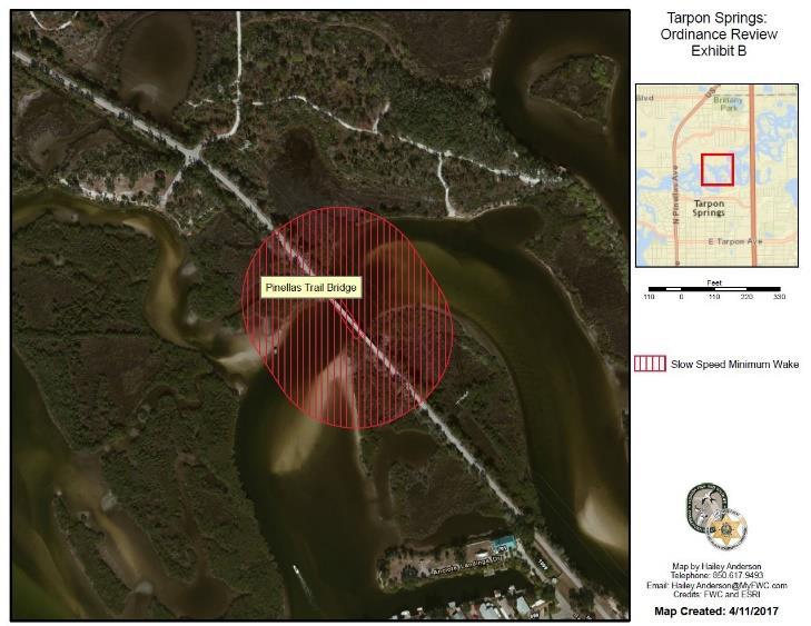
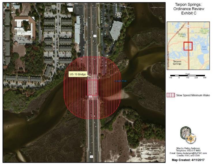
3 ESTABLISHMENT OF SPECIAL SLOW SPEED MINIMUM WAKE ZONES AND SPECIAL IDLE SPEED NO WAKE ZONES ON THE ANCLOTE RIVER. (a) Slow Speed and Slow Speed Minimum Wake Zones. (1) Pursuant to Florida Administrative Code Chapter 68D , Slow Speed and Slow Speed Minimum Wake may be used interchangeably, and means that a vessel must be fully off plane and completely settled into the water and the vessel must then proceed at a speed which is reasonable and prudent under the prevailing circumstances so as to avoid the creation of an excessive wake or other hazardous condition which endangers or is likely to endanger other vessels or other persons using the waterway. At no time is any vessel required to proceed so slowly that the operator is unable to maintain control over the vessel or any other vessel or object that it has under tow. A vessel that is: a. Operating on plane is not proceeding at this speed; b. In the process of coming off plane and settling into the water or coming up onto plane is not proceeding at this speed; c. Operating at a speed that creates a wake which unreasonably or unnecessarily endangers other vessels or other persons using the waterway, or is likely to do so, is not proceeding at this speed; d. Completely off plane and which has fully settled into the water and is proceeding at a reasonable and prudent speed with little or no wake is proceeding at this speed. (2) The following described waterways or portions of waterways are hereby established as Slow Speed Minimum Wake zones within 300 feet of any bridge fender system and within 300 feet of any bridge span presenting a vertical clearance of less than 25 feet or a horizontal clearance of less than 100 feet (excluding all associated tributaries, boat basins and other waterways unless otherwise designated or specifically described for inclusion): a. A boating safety zone from shoreline to shoreline, on the Anclote River, that extends 300 feet southwest of the Pinellas Trail Bridge to a line drawn perpendicular to the waterway and 300 feet northeast of said bridge to a line drawn perpendicular to the waterway, as depicted in the attached Exhibit B. b. A boating safety zone from shoreline to shoreline, on the Anclote River, that extends 300 feet southwest of the US 19 Bridge to a line drawn perpendicular to the waterway and 300 feet northeast of said bridge to a line drawn perpendicular to the waterway, as depicted in the attached Exhibit C. (b) Idle Speed No Wake and Idle Speed Zones.
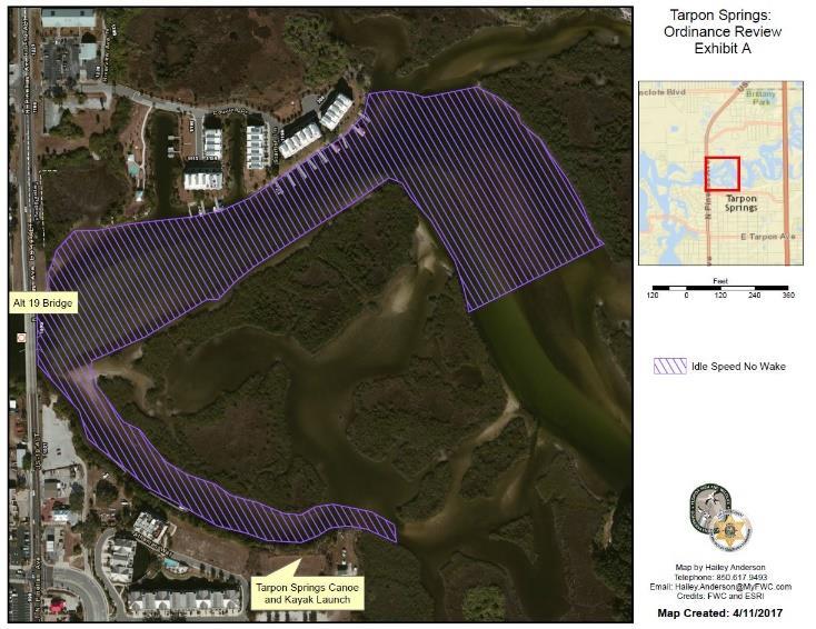
4 (1) Pursuant to Florida Administrative Code Chapter 68D , Idle Speed No Wake and Idle Speed may be used interchangeably and mean that a vessel must proceed at a speed no greater than that which will maintain steerageway and headway. At no time is any vessel required to proceed so slowly that the operator is unable to maintain control over the vessel or any other vessel or object that it has under tow. (2) The following described waterways or portions of waterways are hereby established as Idle Speed No Wake zones within 300 feet of a Narrow bend/blind corner: a. A boating safety zone from shoreline to shoreline, within the Anclote River, which encompasses the area northeast of a line drawn perpendicular to the waterway, that passes through a point ( W, N) to a line that passes through a point ( W, N) as depicted in the attached Exhibit D1. (3) The following described waterways or portions of waterways are hereby established as Idle Speed No Wake zones within 300 feet of any bridge fender system and within 300 feet of any bridge span presenting a vertical clearance of less than 25 feet or a horizontal clearance of less than 100 feet: a. A boating safety zone, from shoreline to shoreline on the Anclote River, that extends 300 feet southwest of the Alt 19 Bridge to a line drawn perpendicular to the waterway and 300 feet northeast of said bridge to a line drawn perpendicular to the waterway, as depicted in the attached Exhibit A. (4) The following described waterways or portions of waterways are hereby established as Idle Speed No Wake zones within 300 feet of any boat ramp or other launching or landing facility available for use by the general boating public (including all associated tributaries, boat basins and other waterways unless otherwise designated or specifically described for exclusion): a. A boating safety zone from shoreline to shoreline, on the Anclote River, that extends 300 feet southeast of the Canoe/Kayak launch ramp ( W, N) to a line drawn perpendicular to the waterway, and 300 feet northeast of the said ramp to a line drawn perpendicular to the waterway, as depicted in the attached Exhibit E. SECTION 2. All Ordinances or parts of Ordinances in conflict herewith are hereby repealed to the extent of such conflict.
5 SECTION 3. In the event a court of competent jurisdiction finds any part or provision of this Ordinance unconstitutional or unenforceable as a matter of law, the same shall be stricken and the remainder of the Ordinance shall continue in full force and effect. SECTION 4. The keeper of Code of Ordinances for the City of Tarpon Springs is directed to include this Ordinance in the Code of Ordinances and may renumber and reclassify the same as may be required for inclusion in the Code of Ordinances of the City of Tarpon Springs. SECTION 5. EFFECTIVE DATE. This ordinance shall take effect immediately upon its passage and adoption in the manner provided by law.

6 Overview of Anclote River from Alt 19 Bridge east to the US 19 Bridge
7 Boating-restricted areas. (1) Boating-restricted areas, including, but not limited to, restrictions of vessel speeds and vessel traffic, may be established on the waters of this state for any purpose necessary to protect the safety of the public if such restrictions are necessary based on boating accidents, visibility, hazardous currents or water levels, vessel traffic congestion, or other navigational hazards.
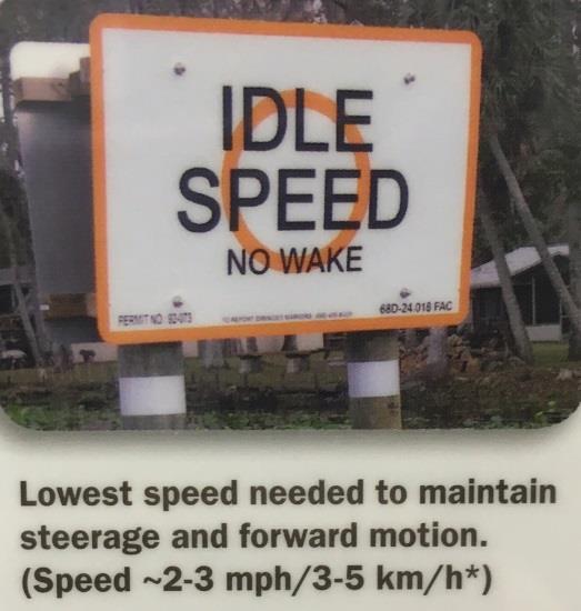
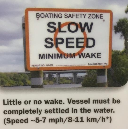
8 Idle Speed No Wake means that a vessel must proceed at a speed no greater than that which will maintain steerageway and headway. At no time is any vessel required to proceed so slowly that the operator is unable to maintain control over the vessel or any other vessel or object that it has under tow. Slow Speed Minimum Wake mean that a vessel must be fully off plane and completely settled into the water. The vessel must then proceed at a speed which is reasonable and prudent under the prevailing circumstances so as to avoid the creation of an excessive wake or other hazardous condition which endangers or is likely to endanger other vessels or other persons using the waterway. At no time is any vessel required to proceed so slowly that the operator is unable to maintain control over the vessel or any other vessel or object that it has under tow. A vessel that is: (1) Operating on plane is not proceeding at this speed; (2) In the process of coming off plane and settling into the water or coming up onto plane is not proceeding at this speed; (3) Operating at a speed that creates a wake which unreasonably or unnecessarily endangers other vessels or other persons using the waterway, or is likely to do so, is not proceeding at this speed; (4) Completely off plane and which has fully settled into the water and is proceeding at a reasonable and prudent speed with little or no wake is proceeding at this speed.
9 3 Bridges in this area: Alt 19, Pinellas Trail and US 19. Slow Speed Minimum Wake zone within 300 ft. of a bridge under Section (1)(b), Florida Statute (b) Municipalities and counties have the authority to establish the following boating-restricted areas by ordinance: 2. An ordinance establishing a slow speed, minimum wake boating-restricted area if the area is: a. Within 300 feet of any bridge fender system. b. Within 300 feet of any bridge span presenting a vertical clearance of less than 25 feet or a horizontal clearance of less than 100 feet.
10 Narrow Bend adjacent to Anclote Point Townhomes. Slow Speed Minimum Wake Zone restrictions around the blind curves will need to go through the review process required by (1)(c) (c) Municipalities and counties have the authority to establish by ordinance the following other boating-restricted areas: 2. An ordinance establishing a slow speed, minimum wake, or numerical speed limit boating-restricted area if the area is: a. Within 300 feet of a confluence of water bodies presenting a blind corner, a bend in a narrow channel or fairway, or such other area if an intervening obstruction to visibility may obscure other vessels or other users of the waterway. Any of the ordinances adopted pursuant to this paragraph shall not take effect until the commission has reviewed the ordinance and determined by substantial competent evidence that the ordinance is necessary to protect public safety pursuant to this paragraph. The rule for this review process is 68D-21, Florida Administrative Code
11 Canoe/Kayak Launch, and contiguous contributory canal from Alt 19 bridge Boating-restricted areas. (b) Municipalities and counties have the authority to establish the following boating-restricted areas by ordinance: 1. An ordinance establishing an idle speed, no wake boating-restricted area, if the area is: a. Within 500 feet of any boat ramp, hoist, marine railway, or other launching or landing facility available for use by the general boating public on waterways more than 300 feet in width or within 300 feet of any boat ramp, hoist, marine railway, or other launching or landing facility available for use by the general boating public on waterways not exceeding 300 feet in width.
12
13
14

15
16 FLORIDA UNIFORM WATERWAY MARKER APPLICATION areference anumber: aaaaaaaaaaaaa anote each apiling/buoy aequals (1) areference anumber. This amust match anumber on ascale adrawing. aaaaaaaaaaaaaaaaaaaaaaaaaaaaaaaaaaaaaaaaaaaaaaaaaaaaaaaaaaaaaaaaaaaaaaaaaaaaaaaaaaa alatitude / LONGITUDE: aaaa aaaaaaaaaaaaaaaaaaaaaaaaaaaaaaaaaaaaaaaaaaaaaaaaaaaaaaaaaaaaaaaaaaaaaaaaa aprovide exact coordinates for alocation of marker expressed in adegrees and Decimal minutes. aexample N, W aaaaaaaaaaaaaaaaaaaaaaaaaaaaaaaaaaaaaaaaaaaaaaaaaaaaaaaaaaaaaaaaaaaaaaa aformat IN WGS 84 DATUM REQUIRED asign identifier for each reference number ashould be denoted with an A, B, C or D asite CODE: a a a01 - bay/sound a02 - inlet/pass a03 - ocean/gulf a04 - lake/pond a05 - river/creek a06 - canal/cut a07 - port/harbor a08 - marsh/ aaaaaaswamp a99 - other a alocation acode: a a as - shore aw - water amounting acode: a a ab - Buoy abf - Bridge Fender ad - Dock adp - Double Pile amb - Mooring aaasaaaaabuoy asp - Single Pile ayb - Yellow Spec. aaaaaaaapurp. Buoy aym - Yellow Spec. aaaaaaaaapurp. Mrk ao - Other (Specify) adirection afacing CODE: aaaaaaaaaaaaaaaa an - North ane - Northeast ae - East ase - Southeast as - South asw - Southwest aw - West anw - Northwest asymbol CODE: aaaaaaaaaaaaaaaaa ac - Circle ad - Diamond am - Moor ar - Rectangle as - Square at - Triangle ax - Crossed aaaaaadiamond ay - Yellow Spec. aaaaaapurp. asign SHAPE: aaaaaaaaaaaaa ad - Diamong am - Mooring aaaaaabuoy ar - Rectangle as - Square at - Triangle ax - Crossed aaaaaadiamond ay - Yellow aaaaaaspec. Purp. aregulatory CODE: aaaaaaaaaaaaaaaaaa absz - Boating Safety aaaaaaaaaaazone amtzn - Manatee Zone ainfo - Information adngr - Danger (i.e., arocks, reef, etc.) avslx - Vessel Exlusion aswim - Swimming Area aconst - Construction aaaaaaaaaaaaaaaarea amoor - Mooring Area aother - (must specify) aaaaaaaaaaaaaaaaaaaaaaaaaaaaaa a MPH a MPH in marked achannel SSMW out of amarked channel a MPH in marked achannel SSMW out of amarked channel a004 - Area Closed a005 - Caution a006 - Danger a007 - Idle speed no wake a008 - Information a009 - Mooring Buoy a SIGN WORDING CODE: aaaaaaaaaaaaaaaaaaaaaaaaaaaaaaaaaaaaaaaaa a010 - No Anchoring a011 - No Entry Area a012 - No internal combustion aaaaaaaaamotors a013 - No Motor Zone a014 - No Power Driven Vessels a015 - Resume Normal Safe aaaaaaaaaoperation a016 - Slow Speed Minimum Wake a017 - Swim Area a018 - Vessel Exclusion Zone a019 - OTHER (Specify) alight LIST: ssssssssssssss suscg Light alist Number aif located on a afederal Aids ato Navigation a(aton) NO. SIGN ID LATITUDE LONGITUDE SITE LOCATION MOUNTING DIRECTION SYMBOL SHAPE SIGN WORDING SIGN WORDING ADDITIONAL SIGN WORDING LIGHT LIST FWCDLE 153 (07/2010) 68D F.A.C.
68D Broward County Boating Restricted Areas.
 68D-24.008 Broward County Boating Restricted Areas. (1) For the purpose of regulating speed and operation of vessel traffic on and adjacent to the Florida Intracoastal Waterway in Broward County, Florida,
CHAPTER 6 10/29/2018 Clean Version REGULATING PIERS, WHARVES, MOORING BUOYS, SWIMMING RAFTS AND INFLATABLES ON ROCK LAKE
 1 2 3 4 5 6 7 8 9 10 11 12 13 14 15 16 17 18 19 20 21 22 23 24 25 26 27 28 29 30 31 32 33 34 35 36 37 38 39 40 41 42 43 44 45 46 CHAPTER 6 10/29/2018 Clean Version REGULATING PIERS, WHARVES, MOORING BUOYS,
Okeechobee Waterway Speed Restrictions
 Okeechobee Waterway Speed Restrictions Rulemaking Authority 327.46 FS. Law Implemented 327.46 FS. History New 9-18-88, Amended 12-7-89, Formerly 16N-24.010, Amended 10-1- 96, Formerly 62N-24.010, Amended
: AUTHORITY: This ordinance is adopted under the authority granted by Section 30.13(2) and 30.13(3) of the Wisconsin Statutes.
 and 30.13(3) of the Wisconsin Statutes.") 1 2 3 4 5 6 7 8 9 10 11 12 13 14 15 16 17 18 19 20 21 22 23 24 25 26 27 28 29 30 31 32 33 34 35 36 37 38 39 40 41 42 43 44 45 CHAPTER 6 REGULATING PIERS, WHARVES, MOORING BUOYS, RAFTS, AND INFLATABLES
1 2 3 4 5 6 7 8 9 10 11 12 13 14 15 16 17 18 19 20 21 22 23 24 25 26 27 28 29 30 31 32 33 34 35 36 37 38 39 40 41 42 43 44 45 CHAPTER 6 REGULATING PIERS, WHARVES, MOORING BUOYS, RAFTS, AND INFLATABLES
As directed last month, I ve placed the matter back on your agenda for further discussion.
 SOUTHAMPTON COUNTY BOARD OF SUPERVISORS Regular Session i July 25, 2016 14. CONTINUED DISCUSSION EXPANSION OF NO-WAKE ZONES As you know, following the close of last month s public hearing, the Board took
LAW AND PUBLIC SAFETY BOAT REGULATION COMMISSION MOTOR VEHICLE COMMISSION. Readoption with Amendments: N.J.A.C. 13:82. Boating Regulations
 LAW AND PUBLIC SAFETY BOAT REGULATION COMMISSION MOTOR VEHICLE COMMISSION Readoption with Amendments: N.J.A.C. 13:82 Boating Regulations Proposed: August 17, 2009 at 41 N.J.R. 3033(a). Adopted: November
WHEREAS, the ordinance will not create excessive additional requirements for public facilities and services at public cost.
 ORDINANCE 19-05 AN ORDINANCE OF VALLEY COUNTY, IDAHO, CREATING AN ORDINANCE TO BE ADMINISTERED BY THE VALLEY COUNTY SHERIFF S OFFICE AND TO BE KNOWN AS VALLEY COUNTY WATERWAYS ORDINANCE THAT INCLUDES PAYETTE
WATER SURFACE USE ORDINANCE STATE OF MINNESOTA COUNTY OF CROW WING ORDINANCE NO. 83
 WATER SURFACE USE ORDINANCE STATE OF MINNESOTA COUNTY OF CROW WING ORDINANCE NO. 83 AN ORDINANCE REGULATING THE SURFACE USE OF ALL WATERS OF CROW WING COUNTY Be it ordained and enacted by the Crow Wing
State of Minnesota County of Douglas Water Surface Use Ordinance No A
 State of Minnesota County of Douglas Water Surface Use Ordinance No. 062309A The County Board of Douglas County hereby ordains that the following act shall be known as the Douglas County Water Surface
The notice of public hearing was published in the Tidewater News on June 5 and June 12, 2016 as required by law.
 SOUTHAMPTON COUNTY BOARD OF SUPERVISORS Regular Session i June 27, 2016 10C. PUBLIC HEARING ORDINANCE AMENDMENT NO WAKE ZONES ON THE NOTTOWAY RIVER EAST OF THE GENERAL VAUGHAN BRIDGE This public hearing
Re: Oppose HB 1565, An act relative to jet skis, wet bikes, and other personal watercraft in municipalities
 Senator James Timilty, Senate Chair Representative Harold Naughton, Jr., House Chair Senator Michael Moore, Senate Vice Chair Representative Michael Brady, House Vice Chair Joint Committee on Public Safety
CHAPTER 14 ENVIRONMENTAL PROTECTION
 CHAPTER 14 ENVIRONMENTAL PROTECTION A. Water Use Ordinance A sole ordinance to regulate the use of the waters of the Town of Fox Lake and prescribing penalties for violation thereof. The Town Board of
ORDINANCE NO AN ORDINANCE MAKING CERTAIN FINDINGS AND ESTABLISHING THE MALL REDEVELOPMENT DISTRICT
 Introduced: January 20, 2015 Passed: January 20, 2015 Published: January 23, 2015 ORDINANCE NO. 2015-2 AN ORDINANCE MAKING CERTAIN FINDINGS AND ESTABLISHING THE MALL REDEVELOPMENT DISTRICT WHEREAS, K.S.A.
City of Chicago O Office of the City Clerk. Document Tracking Sheet
 City of Chicago Office of the City Clerk O2019-2185 Document Tracking Sheet Meeting Date: Sponsor(s): Type: Title: Committee(s) Assignment: 3/13/2019 Emanuel (Mayor) Ordinance Adoption of Tax Increment
 Page 1 of 6 Nav-Aid Basics Unlike the roads and highways that we drive on, the waterways we go boating on do not have road signs that tell us our location, the route or distance to a destination, or of
City of Pittsfield HARBORMASTER RULES AND REGULATIONS on docks
 City of Pittsfield HARBORMASTER RULES AND REGULATIONS on docks Definitions Dock: Any permanently fixed or floating structure extending from the upland into the water, capable of use for vessel mooring
Order Adopting Amendments. Title 58. Recreation Part II. Fish and Boat Commission Chapters 97, 109, 111 and 115 Boating. Preamble
 Order Adopting Amendments COMMONWEALTH OF PENNSYLVANIA PENNSYLVANIA FISH AND BOAT COMMISSION Title 58. Recreation Part II. Fish and Boat Commission Chapters 97, 109, 111 and 115 Boating Preamble The Fish
Wexford Harbour. Yachting Guide. Navigation
 Wexford Harbour Yachting Guide Navigation This document supersedes all previous editions. Approvals: Yacht Club Committee April, 2015 Wexford Board of Directors April, 2015 # Date Section Revision 1 6.5.2015
ARTICLE III. CERTAIN PUBLIC PLACES* DIVISION 1. GENERALLY DIVISION 2. MUNICIPAL YACHT BASIN DIVISION 3. MANAGED MOORING FIELD
 ARTICLE III. CERTAIN PUBLIC PLACES* *Cross References: Parks and recreation, Ch. 14. Secs. 17-56--17-65. Reserved. DIVISION 1. GENERALLY DIVISION 2. MUNICIPAL YACHT BASIN Sec. 17-66. Mooring. It shall
A buoy, for example is an aid to navigation. Aids to navigation include many types of buoys as well as day beacons, range markers, and lighthouses.
 This online study guide has been approved by Transport Canada strictly on the basis that it meets the requirements of the Standard for Pleasure Craft Operator Testing over the Internet (TP 15080E) and
City of Pittsfield Harbormaster APPLICATION FOR AN INDIVIDUAL MOORING PERMIT
 City of Pittsfield Harbormaster APPLICATION FOR AN INDIVIDUAL MOORING PERMIT INSTRUCTIONS: This application may only be used for requests to place lake moorings. This application must be completed in its
MEMORANDUM CITY OF ST. PETERSBURG
 MEMORANDUM CITY OF ST. PETERSBURG City Council Meeting of September 7, 2006 TO : The Honorable David W. "Bill" Foster, Chair and Members of City Council FROM : Sherman W. Smith, Legal Advisor, St. Petersburg
Aids to navigation can include buoys, day beacons, range markers, and lighthouses.
 This boating safety course manual has been approved by Transport Canada strictly on the basis that it meets the minimum requirements of basic boating safety knowledge set out in Transport Canada s Boating
You must stop your. pass with caution on the port side of vessel "B" The vessel moving upstream against the current
 BK NUM ANS QUESTION ANSWER A ANSWER B ANSWER C ANSWER D ILLUST 1 1 C 1 2 B INLAND ONLY You are navigating in a narrow channel and must remain in the channel for safe operation. Another vessel is crossing
ORDINANCE NO WHERAS, Goal 105 provides that Lee County will Protect Human Life And Developed Property From Natural Disasters; and,
 ORDINANCE NO. 12-16 AN ORDINANCE AMENDING LEE COUNTY LAND DEVELOPMENT CODE, CHAPTER 6, TO REPLACE EXISTING MAP M-3, WITH FIGURES 169A (ULTIMATE DESIGN WIND SPEEDS RISK CATEGORY II BUILDINGS), 169B (ULTIMATE
Mr. Barry Dragon, March 16, 2015 Commander, Seventh Coast Guard District (dob) Brickell Plaza 909 S.E. 1st Ave. Miami, FL
 Brickell Plaza 909 S.E. 1st Ave. Miami, FL") Mr. Barry Dragon, March 16, 2015 Commander, Seventh Coast Guard District (dob) Brickell Plaza 909 S.E. 1st Ave. Miami, FL 33130-3050 Commander, On behalf of the Florida Council of Yacht Clubs representing
Mr. Barry Dragon, March 16, 2015 Commander, Seventh Coast Guard District (dob) Brickell Plaza 909 S.E. 1st Ave. Miami, FL 33130-3050 Commander, On behalf of the Florida Council of Yacht Clubs representing
CITY OF CANANDAIGUA 2002 PROPOSED CANANDAIGUA LAKE UNIFORM DOCKING AND MOORING LAW
 CITY OF CANANDAIGUA 2002 PROPOSED CANANDAIGUA LAKE UNIFORM DOCKING AND MOORING LAW TABLE OF CONTENTS Section 44-1 Title...1 44-2 Purpose...1 44-3 Authority...1 44-4 Definitions...1 44-5 General Regulations
2005 ABC. Chapter 3 Part 2. Navigating with ATON's. Revision to D-13 Local Notes. Instructor Notes for Mike Brough. Mike Brough
 2005 ABC Chapter 3 Part 2 Navigating with ATON's Revision to D-13 Local Notes Instructor Notes for Mike Brough Mike Brough June 24 2008 June 24 2008 Slide 1 June 24 2008 New graphics Navigating on Water
Performance Evaluation
 Performance Evaluation Regulating Vessel Noise on the Florida Intracoastal Waterway Manasota League of Cities November 10, 2016 Presented By: Maggie Mooney-Portale & Regina Kardash 1 Local Governments
TOWN OF SURRY HARBORS AND WATERWAYS ORDINANCE
 TOWN OF SURRY HARBORS AND WATERWAYS ORDINANCE Attest Town Clerk: EFFECTIVE / /2014 TOWN OF SURRY WATERWAYS AND HARBORS ORDINACE 2014 I. GENERAL PROVISIONS A. Purpose of Ordinance This Waterways and Harbor
Vince Auriemma, P.E., Deputy Public Works Director
 Council Memorandum To: From: Through: The Honorable Mayor and City Council Vince Auriemma, P.E., Deputy Public Works Director Dan Hartman, Public Works Director Michael C. Bestor, City Manager Date: September
ORDINANCE NO AMENDMENT TO THE CITATION ESTATES MPD DEVELOPMENT AGREEMENT
 ORDINANCE NO. 2015- AMENDMENT TO THE CITATION ESTATES MPD DEVELOPMENT AGREEMENT AN ORDINANCE OF THE CITY COUNCIL OF THE CITY OF PALM COAST, FLORIDA, PROVIDING FOR THE SECOND AMENDED AND RESTATED MASTER
The Common Council of the City of Superior, Wisconsin, does ordain as follows:
 O18 ORDINANCE INTRODUCED BY THE PUBLIC WORKS COMMITTEE AND THE PUBLIC SAFETY COMMITTEE PARKS & RECREATION COMMISSION REPEALING AND RECREATING CHAPTER 90 PARKS, RECREATION AND FORESTRY, ARTICLE VII MOTORIZED
CHAPTER 5: BOAT CODE
 TOWN OF RHINE MUNICIPAL CODE CHAPTER 5: BOAT CODE Section Title Page Table of Contents 1 5.01 Boat Code - Intent 3 5.02 State Statutes Adopted 3 5.03 Local Regulations of Prohibited Operation 4 5.04 Sunday
LOCAL NOTICE TO MARINERS
 USCG Notice to Mariners 3/26/15 (View full Notice here) LNM 12/15 Coast Guard District 1 : U.S. Department of Homeland Security United States Coast Guard LOCAL NOTICE TO MARINERS COASTAL WATERS FROM EASTPORT,
Chart Features Maritime maps and Admiralty charts have these features:
 Introduction to Charts A chart or map of the area is an important safety item to carry on board. It allows the Master to obtain knowledge of the area to be travelled, and indicates the navigable channels
NOTICE OF CIRCUMSTANCES OF CLAIM AND CLAIM
 WHEELER, VAN SICKLE & ANDERSON, S.C. a Wisconsin Service Corporation NILES BERMAN JEFFREY L. LANDSMAN THOMAS J. ZAREMBA* STUART G. MONDSCHEIN COURT COMMISSIONER WILLIAM PRAY O'CONNOR DENIS R. VOGEL** RHEA
ORDINANCE NO AN ORDINANCE OF THE CITY OF FOLSOM AMENDING CHAPTER OF THE FOLSOM MUNICIPAL CODE CONCERNING SWIMMING POOLS, SPAS AND HOT TUBS
 ORDINANCE NO. 1267 AN ORDINANCE OF THE CITY OF FOLSOM AMENDING CHAPTER 14.28 OF THE FOLSOM MUNICIPAL CODE CONCERNING SWIMMING POOLS, SPAS AND HOT TUBS THE CITY COUNCIL OF THE CITY OF FOLSOM HEREBY DOES
Save the Date for the Annual Meeting:
 Spring, 2018 www.austinlakeportage.com Portage, Michigan Save the Date for the Annual Meeting: The annual meeting of the Austin Lake Riparians will be held on Wednesday, June 6, 2018, from 7:00-8:30 PM
CHAPTER 2G. PREFERENTIAL AND MANAGED LANE SIGNS
 2011 Edition - Revision 2 Page 275 Section 2G.01 Scope CHAPTER 2G. PREFERENTIAL AND MANAGED LANE SIGNS 01 Preferential lanes are lanes designated for special traffic uses such as high-occupancy vehicles
Figure 3B-1. Examples of Two-Lane, Two-Way Marking Applications
 Figure 3B-1. Examples of Two-Lane, Two-Way Marking Applications A - Typical two-lane, two-way marking with passing permitted in both directions B - Typical two-lane, two-way marking with no-passing zones
Rules Practice Exam 11
 1 BOTH INTERNATIONAL & INLAND While underway in fog, you hear a vessel sound one prolonged blast followed by two short blasts on the whistle. What does this signal indicate? A. A vessel towing B. A vessel
77th OREGON LEGISLATIVE ASSEMBLY Regular Session. House Bill 2732 SUMMARY
 Sponsored by Representative BUCKLEY th OREGON LEGISLATIVE ASSEMBLY--0 Regular Session House Bill SUMMARY The following summary is not prepared by the sponsors of the measure and is not a part of the body
HEADWAY SPEED The slowest speed at which a personal watercraft can be operated and maintain steerage way. [Added by Ord. No.
 86-1. Purpose The purpose of this chapter shall be to promote the safety of persons and property through reasonable regulation in the use, operation, equipment and anchorage of vessels in all bodies of
3 Navigation Rules Rules General
 115 3 Navigation Rules Rules General Basis for Rules The International Rules were formalized at the Convention for Preventing Collisions at Sea of 1972. These International Rules were ratified in 1977
FILED 11/28/ :27 AM ARCHIVES DIVISION SECRETARY OF STATE
 OFFICE OF THE SECRETARY OF STATE DENNIS RICHARDSON SECRETARY OF STATE LESLIE CUMMINGS DEPUTY SECRETARY OF STATE ARCHIVES DIVISION MARY BETH HERKERT DIRECTOR 800 SUMMER STREET NE SALEM, OR 97310 503-373-0701
05 Boat Handling. Captain
 05 Boat Handling Competence (Skills) Knowledge, Understanding and Proficiency Level Required Boat handling theory and techniques Coxswain Crew RQ RQ Describe the forces acting on a vessel while manoeuvering
CHAPTER 1 STANDARD PRACTICES
 CHAPTER 1 STANDARD PRACTICES OBJECTIVES 1) Functions and Limitations 2) Standardization of Application 3) Materials 4) Colors 5) Widths and Patterns of Longitudinal Pavement Marking Lines 6) General Principles
BookletChart. Intracoastal Waterway Matecumbe to Grassy Key NOAA Chart A reduced-scale NOAA nautical chart for small boaters
 BookletChart Intracoastal Waterway Matecumbe to Grassy Key NOAA Chart 11449 A reduced-scale NOAA nautical chart for small boaters When possible, use the full-size NOAA chart for navigation. Published by
LOCAL NOTICE TO MARINERS
 USCG Notice to Mariners 3/7/18 (View full Notice here) LNM 10/18 Coast Guard District 1: U.S. Department of Homeland Security United States Coast Guard LOCAL NOTICE TO MARINERS COASTAL WATERS FROM EASTPORT,
2004 NC Supplement to the Manual on Uniform Traffic Control Devices (MUTCD)
") 2004 NC Supplement to the Manual on Uniform Traffic Control Devices (MUTCD) CHAPTER 4D. TRAFFIC CONTROL SIGNAL FEATURES Section 4D.04 Meaning of Vehicular Signal Indications Standard: Vehicular traffic
2004 NC Supplement to the Manual on Uniform Traffic Control Devices (MUTCD) CHAPTER 4D. TRAFFIC CONTROL SIGNAL FEATURES Section 4D.04 Meaning of Vehicular Signal Indications Standard: Vehicular traffic
DANE COUNTY ORDINANCE AMENDMENT NO: Internal Tracking Number: RECU25760
 DANE COUNTY ORDINANCE AMENDMENT NO: 10246 Internal Tracking Number: RECU25760 Amending Section 10.03 relating to Zoning Districts in the Town of Vienna. The Dane County Board of Supervisors does ordain
JUNE 2018 RECREATIONAL SHRIMPING REGULATIONS
 K STATE OF ALABAMA DEPARTMENT OF CONSERVATION AND NATURAL RESOURCES MARINE RESOURCES DIVISION POST OFFICE BOX 189 DAUPHIN ISLAND, AL 36528 TEL (251) 861-2882 FAX (251) 861-8741 JUNE 2018 RECREATIONAL SHRIMPING
NOTICE TO MARINERS. No 60(T) of Port of Southampton Southampton Boat Show, River Test 16 th to 25 th September 2016
 of Port of Southampton Southampton Boat Show, River Test 16 th to 25 th September 2016") NOTICE TO MARINERS No 60(T) of 2016 Port of Southampton Southampton Boat Show, River Test 16 th to 25 th September 2016 NOTICE IS HEREBY GIVEN that the Southampton Boat Show will take place on and adjacent
NOTICE TO MARINERS No 60(T) of 2016 Port of Southampton Southampton Boat Show, River Test 16 th to 25 th September 2016 NOTICE IS HEREBY GIVEN that the Southampton Boat Show will take place on and adjacent
1/9/2018. City Council City Hall Wilmington, North Carolina Dear Mayor and Councilmembers:
 ITEM O2 OFFICE OF THE CITY MANAGER (910) 341-7810 FAX (910)341-5839 TDD (910)341-7873 1/9/2018 City Council City Hall Wilmington, North Carolina 28401 Dear Mayor and Councilmembers: On March 21, 2017,
Chapter 8. Port hand buoy. Starboard hand buoy. Canadian Aids to Navigation System (CANS) 8.1 Introduction. 8.2 Lateral Buoys
 8.1 Introduction. 8.2 Lateral Buoys") Chapter 8 Canadian Aids to Navigation System (CANS) 8.1 Introduction Various buoys, beacons and signs are known as "Aids to Navigation" or "Navigation Aids". They are devices or systems external to the
Chapter 8 Canadian Aids to Navigation System (CANS) 8.1 Introduction Various buoys, beacons and signs are known as "Aids to Navigation" or "Navigation Aids". They are devices or systems external to the
DEPARTMENT OF THE ARMY GALVESTON DISTRICT, CORPS OF ENGINEERS P.O. BOX 1229 GALVESTON, TEXAS CESWG-CDR (1145)
") DEPARTMENT OF THE ARMY GALVESTON DISTRICT, CORPS OF ENGINEERS P.O. BOX 1229 GALVESTON, TEXAS 77553-1229 REPLY TO ATTENTION OF CESWG-CDR (1145) TBD MEMORANDUM FOR All Galveston District Personnel. SUBJECT:
DEPARTMENT OF THE ARMY GALVESTON DISTRICT, CORPS OF ENGINEERS P.O. BOX 1229 GALVESTON, TEXAS 77553-1229 REPLY TO ATTENTION OF CESWG-CDR (1145) TBD MEMORANDUM FOR All Galveston District Personnel. SUBJECT:
80th OREGON LEGISLATIVE ASSEMBLY Regular Session. House Bill 2352 SUMMARY
 0th OREGON LEGISLATIVE ASSEMBLY--0 Regular Session House Bill Sponsored by Representatives POWER, HELM (Presession filed.) SUMMARY The following summary is not prepared by the sponsors of the measure and
Lake Minnetonka Conservation District 2016 Summer Rules Watercraft Operation and General Recreation
 Lake Minnetonka Conservation District 2016 Summer Rules Watercraft Operation and General Recreation Vern WhittenPhotography 125 Miles of Shoreline 14,043 Acres of Surface Use Area (42 Bays/Areas) 30 Foot
Mecklenburg County Health Ordinance Rules Governing Residential Swimming Pools
 Mecklenburg County Health Ordinance Rules Governing Residential Swimming Pools Mecklenburg County Health Department 700 N. Tryon Street, Suite 211 Charlotte, North Carolina 28202-2236 Phone (704) 336-5103
Office of Traffic, Security and Operations 1500 West County Road B2 Tel: Mail Stop 725 Fax: Roseville, MN 55113
 Minnesota Department of Transportation Office of Traffic, Security and Operations 1500 West County Road B2 Tel: 651-634-5269 Mail Stop 725 Fax: 651-634-5256 Roseville, MN 55113 October 21, 2005 To: From:
ALPHABETICAL ORDINANCES
 ALPHABETICAL ORDINANCES BEACHES SURFING ZONES SPILL-OVER LIGHTING BIDS BOATS BEACHES 43 12/04/52 Beaches Beaches: An Ordinance prohibiting the removal of sand, shell, gravel and other earthen material
SENATE, No STATE OF NEW JERSEY. 218th LEGISLATURE INTRODUCED FEBRUARY 1, 2018
 SENATE, No. STATE OF NEW JERSEY th LEGISLATURE INTRODUCED FEBRUARY, 0 Sponsored by: Senator TROY SINGLETON Assemblywoman CAROL A. MURPHY Assemblyman HERB CONAWAY, JR. Assemblyman DANIEL R. BENSON District
ORDINANCE NO. WHEREAS, the feeding of wildlife can lead to negative impacts on animals, people and the environment; and
 ORDINANCE NO. AN ORDINANCE OF THE CITY COUNCIL OF THE CITY OF DAVIS ADDING ARTICLE 5.05 TO CHAPTER 5 OF THE DAVIS MUNICIPAL CODE TO PROHIBIT THE FEEDING OF CERTAIN WILDLIFE WHEREAS, the City of Davis (
WORK-REST REQUIREMENTS FOR PILOTS
 AN ORDER OF THE BOARD OF PILOT COMMISSIONERS FOR THE PORT OF CORPUS CHRISTI AUTHORITY REGARDING WORK-REST REQUIREMENTS FOR PILOTS AND COMBINED BEAM RESTRICTION Whereas, the current Rules and Regulations
THE CORPORATION OF THE CITY OF KENORA BY-LAW NUMBER
 THE CORPORATION OF THE CITY OF KENORA BY-LAW NUMBER 94-2006 Being a by-law to provide that the Line Fences Act does not apply to all of Kenora and for the regulation, erection and maintenance of fences
Florida Department of Environmental Protection
 Florida Department of Environmental Protection Bob Martinez Center 2600 Blair Stone Road Tallahassee, Florida 32399-2400 Rick Scott Governor Jennifer Carroll Lt. Governor Herschel T. Vinyard Jr. Secretary
Tees & Hartlepool Pilotage Co. Ltd. Effective from 1 st January Pilotage Charges. Tees and Hartlepool Pilotage District
 Tees & Hartlepool Pilotage Co. Ltd Effective from 1 st January 2013 Pilotage Charges Pursuant to Section 10 of the Pilotage Act 1987, PD Teesport Limited (PDT) hereby approves the following list of pilotage
JUNE 2018 RECREATIONAL SHRIMPING REGULATIONS
 K STATE OF ALABAMA DEPARTMENT OF CONSERVATION AND NATURAL RESOURCES MARINE RESOURCES DIVISION POST OFFICE BOX 189 DAUPHIN ISLAND, AL 36528 TEL (251) 861-2882 FAX (251) 861-8741 JUNE 2018 RECREATIONAL SHRIMPING
Berkeley Island Marine Pre-Rental Instructions. If you do not have a
 Berkeley Island Marine Pre-Rental Instructions. If you do not have a safe boating certificate or a boat license in the state of NJ, or an equivalent in another state, you must take this instruction. Approximate
ORDINANCE NO CITY OF MONTICELLO ADOPTING TAX INCREMENT FINANCING TAX INCREMENT FINANCING DISTRICT II
 ORDINANCE NO. 2006-59 CITY OF MONTICELLO ADOPTING TAX INCREMENT FINANCING TAX INCREMENT FINANCING DISTRICT II WHEREAS, the City of Monticello, Illinois, desires to adopt tax increment financing pursuant
REVISED ORDINANCE NO. O
 REVISED ORDINANCE NO. O2017.05 AN ORDINANCE OF THE CITY COUNCIL OF THE CITY OF TEMPE, ARIZONA, AMENDING CHAPTER 7, TEMPE CITY CODE, RELATING TO BICYCLES, BY AMENDING THE TITLE OF CHAPTER 7, BY AMENDING
OSAKA MARTIS USER MANUAL TABLE OF CONTENTS
 OSAKA MARTIS USER MANUAL TABLE OF CONTENTS Ⅰ Ⅱ Ⅲ INTRODUCTION OPERATIONAL CONCEPT OF "Osaka MARTIS" IMPORTANT NAVIGATIONAL RULES Ⅳ COMMUNICATION 1 VHF Channels 2 Language Ⅴ PRE-ENTRY REPORT AND POSITION
Rules Practice Exam 5
 1 BOTH INTERNATIONAL & INLAND Vessel "A" (towing) and vessel "B" are meeting as shown. In this situation, which statement is TRUE? Diagram 12 A. Both vessels should alter course to starboard and pass port
NavRule Practice Exam, 70 Series Practice April 18, Labeled C have been copied to collection
 1C. INTERNATIONAL & INLAND There are two classes of vessel which, to the extent necessary to carry out their work, do not have to comply with the rule regarding traffic separation schemes. One of these
CHAPTER Committee Substitute for Committee Substitute for Committee Substitute for House Bill No. 41
 CHAPTER 2015-101 Committee Substitute for Committee Substitute for Committee Substitute for House Bill No. 41 An act relating to hazardous walking conditions; providing a short title; amending s. 1006.23,
2018 Boat Slip & Mooring Lease Agreement
 BOATER INFORMATION 2018 Boat Slip & Mooring Lease Agreement Boat Owner(s) Name: Phone(s): Contact Email: Boat Name: Make: Registration #: Boat Length: Model: Boat Color: ** A copy of your current, valid
LIST OF NOTICES TO MARINERS 2017 PAC 201 JUAN DE FUCA STRAIT AND STRAIT OF GEORGIA, FIRST EDITION, 2012
 1 Chapter 1 After paragraph 154 Insert: 154.1 Pacific Gateway Marina (250-412-5509) is located west of the community wharf. Moorage, gas, diesel, a launching ramp and deep water berths for sailboats are
Section 9A.07 Meaning of Standard, Guidance, Option, and Support
 2012 Edition Page 895 PART 9. TRAFFIC CONTROLS FOR BICYCLE FACILITIES CHAPTER 9A. GENERAL Section 9A.01 Requirements for Bicyclist Traffic Control Devices 01 General information and definitions concerning
An Introduction To Marine Charts
 An Introduction To Marine Charts //captnmike.com Revised August 29, 2011 An Illustrated introduction to U. S. Aids to Navigation in the Shilshole Bay area of Puget Sound, Washington. The chart symbols
Introduction of the term Traffic Control Zone and formalization of Fraser River Traffic Control Zone procedures
 Consideration Report Introduction of the term Traffic Control Zone and formalization of Fraser River Traffic Control Zone procedures Background Under the Canada Marine Act, all Canada Port Authorities
By order of the Lake Quinsigamond Commission
 The Lake Quinsigamond Commission acting under the authority of Chapter 294 of the Special Acts of the Legislature of Massachusetts of the year 1916, as amended by Chapter 357 of the Acts of 1973 and other
CHAPTER House Bill No. 1509
 CHAPTER 2006-358 House Bill No. 1509 An act relating to Flagler Estates Road and Water Control District, St. Johns County; amending chapter 98-529, Laws of Florida; providing additional powers of the district
Columbia River Fishery Notice
 Columbia River Fishery Notice Oregon Department of Fish and Wildlife January 29, 2014 Compact Action The Columbia River Compact agencies of Oregon and Washington met today and took the following actions:
MANUAL ON UNIFORM TRAFFIC CONTROL DEVICES INTRODUCTION
 2011 Edition Page I-1 MANUAL ON UNIFORM TRAFFIC CONTROL DEVICES INTRODUCTION 01 Traffic control devices shall be defined as all signs, signals, markings, and other devices used to regulate, warn, or guide
BOATING ACCIDENTS STATISTICAL REPORT
 BOATING ACCIDENTS STATISTICAL REPORT Cover Photos: (Courtesy of FWC) Officers working on boating accident investigations. BOATING ACCIDENTS STATISTICAL REPORT Violation Summary photo detail Top picture
Chapter 48 Coastal Waters
 The following Code does not display images or complicated formatting. Codes should be viewed online. This tool is only meant for editing. Chapter 48 Coastal Waters [HISTORY: Adopted by the Town of Cumberland
Appendix B Warrants, Standards, and Guidelines for Traffic Control Devices used at Senior Citizen and Disabled Person Crossings
 Appendix B Warrants, Standards, and Guidelines for Traffic Control Devices used at Senior Citizen and Disabled Person Crossings B.1 General Minnesota Statute 169.215 and Highway Traffic Regulation 169.222
National Maritime Center
 National Maritime Center Providing Credentials to Mariners U.S.C.G. Merchant Marine Exam (Sample Examination) Page 1 of 22 U.S.C.G. Merchant Marine Exam: Illustrations: 10 Choose the best answer to the
Violation Summary photo detail Top picture
 Violation Summary photo detail Top picture On April,, a single vessel crash occurred on Lake Maitland. The vessel, a jet boat was occupied by eight people. The group boarded the vessel at a lake front
BE IT ORDAINED BY THE CITY COUNCIL OF THE CITY OF CHARLOTTE:
 Petition No. 2010-066 Petitioner: Charlotte-Mecklenburg Planning Department 10-5-10 AN ORDINANCE AMENDING APPENDIX A OF THE CITY CODE ZONING ORDINANCE ORDINANCE NO. BE IT ORDAINED BY THE CITY COUNCIL OF
A by-law to regulate pool enclosures within the Town of Oakville
 THE CORPORATION OF THE TOWN OF OAKVILLE BY-LAW NUMBER 2006-071 A by-law to regulate pool enclosures within the Town of Oakville WHEREAS section 11 of the Municipal Act, 2001, S.O. 2001, c. 25, as amended,
TIDE TABLES FOR WARRENPOINT PORT (CARLINGFORD LOUGH) All times in GREENWICH MEANTIME HEIGHTS REFER TO CHART DATUM Chart Datum is mts.
 All times in GREENWICH MEANTIME HEIGHTS REFER TO CHART DATUM Chart Datum is mts.") TIDE TABLES FOR WARRENPOINT PORT (CARLINGFORD LOUGH) 2019 Times and Heights of High and Low Waters. All times in GREENWICH MEANTIME HEIGHTS REFER TO CHART DATUM Chart Datum is -3.05 mts. OD Belfast Tide
TIDE TABLES FOR WARRENPOINT PORT (CARLINGFORD LOUGH) 2019 Times and Heights of High and Low Waters. All times in GREENWICH MEANTIME HEIGHTS REFER TO CHART DATUM Chart Datum is -3.05 mts. OD Belfast Tide
MUNICIPALITY OF ANCHORAGE TRAFFIC CODE UPDATE MASTER RECOMMENDATION REPORT: 9.14, 9.16, 9.18
 MUNICIPALITY OF ANCHORAGE TRAFFIC CODE UPDATE MASTER RECOMMENDATION REPORT: 9.14, 9.16, 9.18 Report Date: Please send all recommendations for update to Shane Locke (343-8413, lockesr@muni.org) 8-Apr-09
Presentation Library for Inland ECDIS
 Edition 2.0 1.6.2006 Standard Electronic Chart Display and Information System for Inland Navigation Inland ECDIS for Inland ECDIS In addition to the IHO-S-52 Edition 2.0 IES 20-Section 3 PresLib.doc Page
RULES AND GUIDELINES FOR USE OF LYTLE LAKE. The following persons shall have the right to use Lytle Lake for boating, water skiing,
 1 RULES AND GUIDELINES FOR USE OF LYTLE LAKE 2 3 4 I. Access to, and use of, Lytle Lake shall be governed by the laws of the State of Texas (including the Texas Water Safety Act), Rules of the Texas Parks
OREGON AND WASHINGTON DEPARTMENTS OF FISH AND WILDLIFE JOINT STAFF REPORT SUMMER FACT SHEET NO.
 OREGON AND WASHINGTON DEPARTMENTS OF FISH AND WILDLIFE JOINT STAFF REPORT SUMMER FACT SHEET NO. 1b Columbia River Compact/Joint State Hearing June 14, 2017 Fisheries under consideration: Estuary Recreational
APRIL 2017 COMMERCIAL SHRIMPING REGULATIONS
 K STATE OF ALABAMA DEPARTMENT OF CONSERVATION AND NATURAL RESOURCES MARINE RESOURCES DIVISION POST OFFICE BOX 189 DAUPHIN ISLAND, AL 36528 TEL (251) 861-2882 FAX (251) 861-8741 APRIL 2017 COMMERCIAL SHRIMPING
TICES TO MARINERS 1 TO 46 ANNUAL EDITION 2018 SECTION A AIDS TO NAVIGATION AND MARINE SAFETY
 A5 NAVIGATION SAFETY 10 Routeing of Ships 1 GENERAL 1.1 Rule 10 of the Collision Regulations applies to all ships navigating in or near a routeing system. 1.2 The information on ships' routeing in this
SAILING INSTRUCTIONS. Port of Los Angeles Harbor Cup Cal Maritime Invitational Intercollegiate Regatta March 9 th -11 th, RULES
 SAILING INSTRUCTIONS Port of Los Angeles Harbor Cup Cal Maritime Invitational Intercollegiate Regatta March 9 th -11 th, 2018 1 RULES 1.1 The regatta will be governed by the ICSA Procedural Rules (PR),