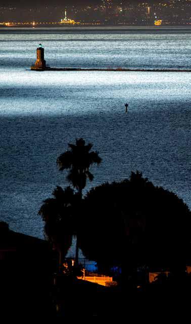
Cover photo by Michael Justice. PORT OF LOS ANGELES 425 S. Palos Verdes Street San Pedro, CA Phone/TDD: (310) portoflosangeles.
|
|
|
- Ethelbert Randall
- 6 years ago
- Views:
Transcription


1 2018 MARINERS GUIDE
2 PORT OF LOS ANGELES 425 S. Palos Verdes Street San Pedro, CA Phone/TDD: (310) The data contained herein is provided only for general informational purposes and no reliance should be placed upon it for determining the course of conduct by any user of the Port of Los Angeles. The accuracy of statistical data is not assured by this Port, as it has been furnished by outside agencies and sources. Cover photo by Michael Justice Acceptance of Port of Los Angeles Pilot Service is pursuant to all the terms, conditions and restrictions of the Port of Los Angeles Tariff and any amendments thereto.
 Vessel Safety.")
3 TABLE OF CONTENTS Introduction Welcome to the Port of Los Angeles Welcome to the LA Waterfront Los Angeles Pilot Service Telephone Directory Facilities for Visiting Seafarers Safety Boating Safety Information Small (Recreational) Vessel Safety Mariner s Guide For Emergency Calls Horizontal and Vertical Clearances Underkeel Clearance Controlled Navigation Areas Depth of Water Alongside Berths Pilot Ladder Requirements Inclement Weather Standards of Care for Vessel Movements National Weather Service Wind Force Chart Tug Escort/Assist Information Tug Escort/Assistance for Tank Vessels Tanker Force Selection Matrix Tugs Employed in Los Angeles/Long Beach Tugs, Water Taxis, and Salvage Vessel Operating Procedures Radio Communications Vessel Operating Procedures Vessel Traffic Management Vessel Speed Limits Map of the Port of Los Angeles Environmental Policies Environmental Notices to Ships Port of Los Angeles Environmental Programs Port of Los Angeles Clean Marina Program/Marina Directory.. 49 Foreign Quarantine Marine Mammal Viewing Guidelines Reference Metric Conversion Table Sunrise and Sunset Table Tide Tables Notes Introduction 1

4 WELCOME TO THE PORT OF LOS ANGELES! The Port of Los Angeles is America's Port, North America's premier gateway for international commerce, located in San Pedro Bay, 20 miles south of downtown Los Angeles. The Port of Los Angeles is a global model for sustainability, security, and social responsibility. With over 7,500 acres of land with 43 miles of waterfront and a main channel depth of 53 feet, the Port is positioned to meet the future of international trade, routinely welcoming the largest container ships in the transpacific trade. As North America's leading port by cargo value and container volume, L.A.'s thriving seaport manages record-setting cargo volumes, moving billions of dollars of cargo annually. The Port is committed to maintaining industry-leading facilities and infrastructure for its stakeholders while also continuously testing the latest technology available in the areas of low and zeroemission equipment and supply chain information flow. Through a 10-year, $2.6 billion infrastructure investment program, efficiency and productivity is expected to increase. As the busiest container port in North America, the Port of Los WELCOME TO THE LA WATERFRONT Set against the expansive backdrop of the Port of Los Angeles, the LA Waterfront is truly a feast for the senses. With an eclectic selection of international dining options, a unique assortment of local craft breweries, charming shops and an immense indoor craft marketplace, historical museums and a multitude of waterrelated activities to choose from, the LA Waterfront is quickly becoming a must-see tourist destination for domestic and international travelers alike - a place where visitors can play, dine, shop, and explore. Spanning across 400 acres of prime waterfront property and complemented by outdoor art installations and meandering promenades, the LA Waterfront is home to several historic landmarks, such as the Vincent Thomas Bridge, Angels Gate Lighthouse, Battleship IOWA, and SS Lane Victory. Visitors will encounter an intriguing choice of activities and places to visit including the award-winning Wilmington Waterfront and 22nd Street Parks, Fanfare Fountains & Water Feature at Gateway Plaza, Downtown Harbor, Los Angeles Maritime Museum, CRAFTED at the Port of Los Angeles, Brouwerij West, Cabrillo Way Marina and Cabrillo Marine Aquarium. The centerpiece of the LA Waterfront, the Downtown Harbor, is a vibrant, public harbor and plaza that connects downtown San Pedro s shops and restaurants to the LA Waterfront. The area features a harbor inlet for recreational vessels to dock free of charge accompanied by a public plaza, pedestrian promenade, a picnic area and an overlook pier. Angeles handles nearly a quarter of the cargo that enters the The Port of Los Angeles has made great strides toward connecting United States annually, which means the Port wields tremendous the community to the LA Waterfront, while progress continues on economic impact both locally and nationally. As a result, the several redevelopment projects over the next few years. Slated for Port generates employment for more than 3 million Americans completion in 2018, the Harbor Boulevard Roadway Improvements nationwide. The San Pedro Bay Port Complex operations and Project will feature a reconfigured entrance to the shops and restaurants along the waterfront and the downtown harbor and commerce facilitate approximately 500,000 or one in nine jobs, plaza. Future developments include AltaSea, a state-of-the-art which are connected to the five-county Southern California region, marine research facility, the Wilmington Waterfront Promenade and and nearly 1 million jobs in the state of California, making global San Pedro Public Market. trade and goods movement Southern California s strongest industries in terms of jobs and economic activity. Last year alone nearly 2 million people visited the LA Waterfront, earning it the reputation of a world-class tourism destination. With With an exceptional credit record, the Port maintains an AA bond an extensive selection of activities, there is never a shortage of rating, the highest rating attainable for self-funded ports. things to do on the LA Waterfront. 2 Introduction Introduction 3
5 Los Angeles Pilot Traffic: lapilots.org Port of Los Angeles: portoflosangeles.org LA Waterfront: lawaterfront.org LOS ANGELES PILOT SERVICE Berth 68 San Pedro (310) VHF Radio Channel 73 ( MHz) Call: KEB260 Los Angeles Pilots LOS ANGELES PILOTS ARE AVAILABLE 24 HOURS A DAY. Pilots board arriving vessels from the pilot boat in the vicinity of Los Angeles Channel RACON Buoy #3. Tank vessels will be boarded at least two nautical miles from the Los Angeles entrance. Deep-draft vessels (more than 55 feet) will be boarded in the vicinity of Los Angeles Channel Buoy #1. Under normal weather conditions, the pilot ladder should be rigged on the starboard side one meter above water. PILOTS REQUIRE A MINIMUM OF TWO HOURS NOTICE FOR PORT SERVICE. Masters or agents are requested to advise the Los Angeles Pilot Station when there is a change in the arrival or sailing time. Chief Port Pilots John Dwyer Craig Flinn Pilots John Betz Jacob Crawford Richard Crowley Kerry DeMatos Joseph Manlove Brett McDaniel Richard Rauhut Edward Royles Trainee Pilots Erik Cutforth Kyle Hamill Joseph Mayer Jeffrey White Dispatchers Beth Adamik Tamara Armstrong Kathleen Bautista Pauline Hospe Cherie Ivers Boat Operators John Cameron Danny Domingo Raymond Maese Alex Suarez Deckhands Robin Craigen Garrick Gilham Johnny Kostich Lindsay Magnall Ryan Ruppert The Los Angeles Pilot Service dates back to 1907, when the Port of Los Angeles was founded. Today, the Pilot Service employs 29 dedicated professionals, combining the skills of pilots, dispatchers and boat crew to provide expert pilotage services to Port of Los Angeles customers. The mission of the Los Angeles Pilot Service is to provide safe, reliable and efficient pilotage and marine services. Over the last decade, the Los Angeles Pilots have safely completed more than 55,000 vessel movements. They are among the best-trained pilots in the maritime industry. After a rigorous two-year training program, each pilot renews their skills with ship-handling courses in Grenoble, France every four years, and ship-simulator training every two years. 4 Introduction Introduction 5
6 TELEPHONE DIRECTORY EMERGENCY Los Angeles Port Police (310) Los Angeles Fire Department Fire Station 49 (Berths ) (310) Fire Station 110 (Berth 44) (310) Fire Station 111 (Fish Harbor) (310) Fire Station 112 (Berths 85-86) (310) Pilots Los Angeles Pilot Service (310) Long Beach Pilots c/o Jacobsen Pilot Service... (562) Marine Exchange of Southern California (310) Port of Los Angeles Administration Executive Offices (310) Environmental Management (310) Public Relations (310) Real Estate (310) Security (310) Wharfinger (310) Bridges (Cerritos Channel Drawbridges) Henry Ford (Badger Avenue) Bridge (310) U.S. Department of Homeland Security Customs and Border Protection-Service Port....(562) Immigration & Customs Enforcement (562) Customs-Marine Section (562) U.S. Department of Agriculture Long Beach (562) El Segundo (310) Vessel Services Jankovich Company (310) FACILITIES FOR VISITING SEAFARERS Catholic Maritime Ministry (c/o Mary Star of the Sea Catholic Church) World Cruise Center Berth 93A, Level 1 (310) Norwegian and Swedish Seamen s Church 1035 South Beacon Street San Pedro, CA (310) California Department of Fish & Wildlife Marine Region (858) U.S. Coast Guard 24-Hour Emergency (800) 221-USCG Captain of the Port (310) Environmental Response (310) Facilities/Container Inspections (310) Investigations (310) Regional Exam Center (562) Vessel Inspections (Domestic) (310) Vessel Inspections (International) (310) Waterways Management (310) Introduction Introduction 7

7 Safety 8 9
8 BOATING SAFETY INFORMATION The California Department of Boating and Waterways offers a home study boating course. The course, which includes a colorful handbook, can be completed at one s own pace. Upon successful completion of the optional final examination, the student will receive a certificate from the State of California. California Division of Boating and Waterways One Capitol Mall, Suite 500 Sacramento CA (888) California Division of Boating and Waterways: pubinfo@parks.ca.gov dbw.ca.gov Those interested in taking boating safety classes in Southern California may contact the U.S. Coast Guard Auxiliary at (310) , or U.S. Power Squadron at (888) Most courses have received approval from the National Association of State Boating Law Administrators (NASBLA). Many marine insurance providers will honor a NASBLA approved course to reduce their clients premiums. For general safety information, contact the Los Angeles Port Police, (310) SMALL (RECREATIONAL) VESSEL SAFETY Recreational vessels should follow the Standards of Care (listed on the next page) to ensure the safe operation of craft while in and around the port. Recreational vessel operators should be sensitive to the fact that large commercial vessels are severely limited in the ability to stop or alter course, and many times are limited in the ability to see small vessels due to blind spots that extend more than 1/2 mile ahead. These large commercial vessels cannot easily avoid a collision with a smaller, more maneuverable recreational vessel. 1. Ensure vessel is safe before getting underway. 2. Ensure vessel is seaworthy. 3. Keep flares and distress calling equipment readily accessible. 4. Be extra careful in fog. 5. Comply with Rules of the Road, Rule 9 : Small vessels remain clear of large vessels that must navigate within a narrow channel. 6. Avoid passing larger vessels close aboard. 7. Pass tugs with caution. 8. Know the locations of traffic lanes and the regulated navigational area. 9. Know how and when to monitor VHF Channels 16, 14, and Know vessel s position. 11. Be an informed mariner: Know the Rules of the Road, read Coast Guard Notices to Mariners, monitor the weather and listen to Channel 16 for Coast Guard information broadcasts. MARINERS GUIDE FOR EMERGENCY CALLS FOR SERVICE Be prepared to provide the following information Your Name/Name of Vessel Phone number or VHF channel Location of Incident i.e GPS/Berth/Terminal/Waterway What is the emergency? Be prepared to answer following questions 1. Persons involved or Person on Board (clothing, physical features) 2. Vessel Description (type of vessel, length, color, unique features) 3. What happen or is occurring? 10 Safety Safety 11
9 Types of activity Los Angeles Port Police respond to, but not limited to, suspicious activity, drone/plane activity, security breaches or attempts, USCG safety/security/protection zone violations; crimes on land and water, navigation rule violation, vessels in distress, rescues, fires and emergencies. See Something, Say something Los Angeles Port Police VHF 16 or HORIZONTAL AND VERTICAL CLEARANCES Vertical clearances are given above Mean High Water (+4.7 feet) Vincent Thomas Bridge Horizontal usable width (of channel): 1150 feet Vertical clearance: 165 feet Middle 500 feet width: Vertical clearance 185 feet Cerritos Channel Drawbridge Consolidated Requirements The U.S. Coast Guard has consolidated the requirements for drawbridge operations, including Cerritos Channel, as contained in Code 33 of Federal Regulations, Part 117. Radio telephones are installed to enable the drawtender at the Henry Ford Avenue Railroad Bridge to communicate with vessels on radio telephone frequency MHz (Channel 13), or such other frequency as may be assigned by the Federal Communications Commission. Henry Ford (Badger Avenue) Railroad Bridge (310) VHF Channels 13 and 16 Call Sign: WXJ-947 Horizontal clearance: 180 feet Vertical clearance: 6.7 feet (bridge down); 165 feet (bridge up) Draw to remain in the open-to-navigation position except when a train is crossing or maintenance work is being performed. Whistle Signals Opening signal: 2 short, 1 long Acknowledging Signal: 2 long, 1 short Bridge cannot open: 5 short Gerald Desmond Bridge Horizontal usable width (of channel): 260 feet Vertical clearance: 155 feet The Gerald Desmond Bridge Replacement Project is a joint effort of Caltrans and the Port of Long Beach, to update and modernize a critical access route for the Port of Long Beach, downtown Long Beach and surrounding communities. The new bridge will have six lanes and four emergency lanes (two in each direction on the inner and outside shoulders) to meet the long-term regional transportation needs. Estimated completion of the replacement project is Southern California Edison Co. Overhead Power Cables Vertical clearance: 155 feet Commodore Schuyler F. Heim Highway Bridge The Schuyler Heim Bridge Replacement and SR-47 Expressway Project is being advanced through a joint partnership between the California Department of Transportation (Caltrans) and the Alameda Corridor Transportation Authority. The project is replacing the Schuyler Heim Highway Bridge, which does not meet current earthquake standards, with a fixed-span bridge over the Cerritos Channel. The new span is a four-lane elevated expressway that allows cars and trucks to move from Terminal Island directly onto Alameda Street. During construction, navigational clearances through Cerritos Channel are as indicated in the Weekly Coast Guard Local Notice to Mariners at navcen.uscg.gov. UNDERKEEL CLEARANCE Underkeel clearance (UKC) is the minimum clearance available between the deepest point on the vessel and the bottom in still water. UKC = (Charted Depth of Water + Height of Tide) (Static Deep Draft) 12 Safety Safety 13
10 Masters and pilots should use their vessel s deepest draft in still water when calculating UKC. Masters and pilots should apply a plus or minus allowance for the tide when calculating depth of water, and consider the following factors: 1. Vessel s trim and list characteristics; 2. Depth of the transit area; 3. Depth at the facility or anchorage 4. Tide and current conditions 5. Weather impact on water depth The master should discuss the vessel s anticipated UKC with the pilot. Within the ports of Los Angeles and Long Beach, actual tide heights do not normally vary significantly from predicted tide heights. Minimum Underkeel Clearance Guidelines for All Vessels NOAA Tides & Currents: Meteorological information for Los Angeles/Long Beach PORTS tidesandcurrents.noaa.gov/ports/ These guidelines for minimum UKC apply during normal weather for the ports of Los Angeles and Long Beach (POLA/POLB). Severe weather or other abnormal conditions may demand case-by-case evaluation. Masters and pilots shall use prudent seamanship at all times when piloting vessels in the POLA/POLB harbors and approaches. Port of Los Angeles Between the Los Angeles Approach Channel Lighted Buoy #1 and the Los Angeles Main Channel Buoy #11, minimum underkeel clearance before correction for roll and pitch is 10% of the vessel's draft. In the channel between the Los Angeles Main Channel Buoy #11 and a position off the designated berth, minimum underkeel clearance is: 2.0 (.61m) In the final approach to the berth, and while at berth, the vessel must always remain afloat At anchorages inside the breakwater, minimum underkeel clearance is 3.5 (.76m) For shifts via outer harbor between Los Angeles and Long Beach, minimum underkeel June 30, 2013 XIV - 2 clearance is 3' (.91m). Port of Long Beach Between the Long Beach Seabuoy and the Long Beach Channel Buoy #3, minimum underkeel clearance before correction for roll and pitch is 10% of the vessel's draft. In the channel between the Long Beach Channel Buoy #3 and a position off the designated berth, minimum underkeel clearance is: 2.0 (.61m) In the final approach to the berth, and while at berth, the vessel must always remain afloat. At anchorages inside the breakwater, minimum underkeel clearance is: 4' (1.22m) for anchorages B-7 and B-11 when vessels draft is 50' (15.24m) or more 2.5 (0.76m) for all other anchorages For shifts via outer harbor between Long Beach and Los Angeles, minimum underkeel clearance is 3' (.91m). Tank Vessels The above guidelines are intended to include safety margins for sinkage due to squat and for an increase in draft due to pitch and roll during the weather and sea state conditions normally encountered in the Los Angeles and Long Beach harbors and approaches. The pilot organization management, the vessel's master/operator, and the USCG Captain of the Port (COTP) should concur with any deviation below the above guidelines. Terminal or vessel operators may require minimum underkeel clearances that are more restrictive than the above guidelines. Vessel masters should be aware of this and should consider terminal policy, fleet operating requirements, and the guidelines contained in the Los 14 Safety Safety 15
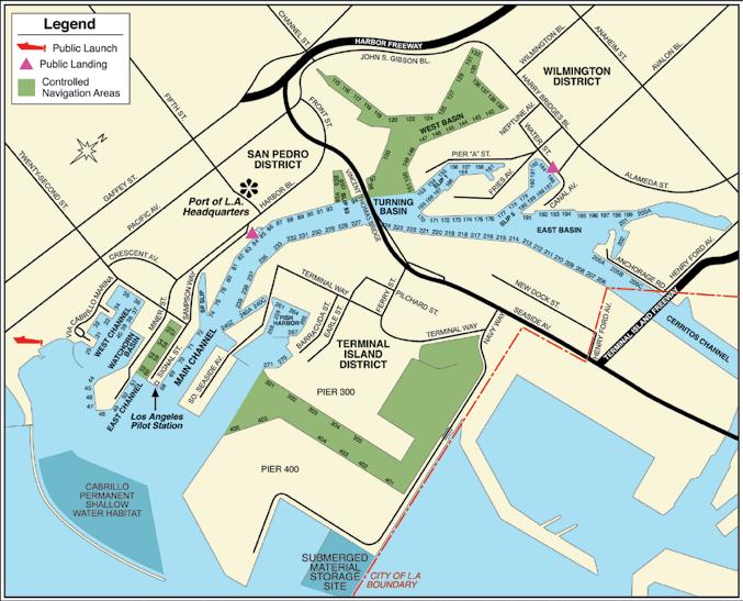
11 Angeles/Long Beach Harbor Safety Plan when deciding upon their minimum allowable underkeel clearances. Tank vessel masters and operators should also be guided by the underkeel clearance regulations for tank vessels contained in 33 CFR C. The pilot organization management, the vessel s master/operator, and the USCG Captain of the Port (COTP) should concur with any deviation below the above guidelines. Terminal or vessel operators may require minimum underkeel clearances that are more restrictive than the above guidelines. Vessel masters should be aware of this and should consider terminal policy, fleet operating requirements, and the guidelines contained in the Los Angeles Long Beach Harbor Safety Plan when deciding upon their minimum allowable underkeel clearances. Evaluating Underkeel Clearance While the above guidelines should ensure adequate UKC under normally encountered circumstances of weather, sea state and vessel configuration, the LA/LB Harbor Safety Committee recommends that all vessel masters should estimate the anticipated UKC that they expect their vessel will encounter during the various phases of the transit, particularly during severe weather or other abnormal conditions. In complying with the above guidelines, the master should consider sea state conditions that might cause an increase in draft due to pitch and roll and plan/adjust transit speeds with regard to vessel squat characteristics. Studies indicate that swell crests and troughs affect vessel immersion (heave) when a vessel is rising and falling with swells off the beam. However, the studies also indicate that vessels will normally experience significant and measurable roll before increased draft due to heave becomes a problem. Therefore, the sound practice of measuring roll and calculating the corresponding increase to vessel draft before entering port helps the master evaluate safe underkeel clearance. will help to ensure navigational safety for large commercial vessels by reducing non-essential boating traffic, while also increasing waterside security by limiting access to commercial or permitted vessels. The Main Channel and other primary waterways will remain open to recreational boaters, but those areas best kept for commercial-only vessels will be restricted. (See map on pages ) Controlled Navigation Areas, part of the Port of Los Angeles Responsible Marina Program, are identified with posted signs and enforced by the Los Angeles Port Police. Recreational vessel owners/operators may request to enter a CNA by contacting the Port Police at (310) CONTROLLED NAVIGATION AREAS Controlled Navigation Areas (CNAs) have been added to Tariff No. 4, restricting entry into certain areas of the Port by recreational boats without a Port Police-issued permit. Creation of the CNAs 16 Safety Safety 17
12 DEPTH OF WATER ALONGSIDE BERTHS (In Feet) Mean Lower Low Water = 0.0 Feet Berth Depth Berth Depth Berth Depth 45/ / / / A / / / / / / / / / / / / / / / / / / /A /G / / / / / / B C Z Fish Harbor L.B L.B L.B Channel Depth Main Channel East Basin Ch The information provided here is based upon sources deemed to be reliable and is believed to be correct as of October 2016, but the accuracy is not guaranteed. Whenever a vessel is scheduled which would approach the depth of a particular berth, the Pilot Station management should be contacted so that an individual judgment can be made. 18 Safety Safety 19
13 PILOT LADDER REQUIREMENTS Pilot Ladder Requirements for Los Angeles Pilots in Addition to SOLAS Regulation 17, Chapter 5. a) Please contact Los Angeles Pilots KEB260 by VHF Radio Channel 73 a minimum of two hours prior to arrival to confirm estimated time of arrival and for information regarding desired lee. b) Rigging of the pilot ladder, as well as the embarking or disembarking of the pilot, should be under supervision of a responsible officer. c) The ladder should be made in one length and fitted with spreaders approximately 10 feet apart to comply with SOLAS, Chapter V, Regulation 23. d) The area of the deck where the pilot boards should be clear of obstacles to ensure a safe passage for the pilot. e) Trailing lines or retrieving lines should not be attached to the lower end of the ladder. f) Ladders should be rigged well clear of discharge and water outlets and at a place near midship clear of the finer lines of the vessel. At no time should the ladder be rigged near the stern of the ship. g) The ladder should be in good condition and rigged so that the steps remain horizontal when used. h) Accommodation ladders must not be used for pilot boarding or disembarking. RIG LADDER ON LEE SIDE AMIDSHIP 3 FEET (1 METER) FROM WATER PILOT BOAT DIRECTION OF WIND AND SWELL PILOT LADDER FWD 3 FEET INCLEMENT WEATHER STANDARDS OF CARE FOR VESSEL MOVEMENTS Inclement weather requires heightened awareness and vigilance. This section is intended to provide clear guidance to mariners as to what is expected of them when navigating in inclement weather in the area covered by the LA-LB Harbor Safety Plan (HSP). Nothing in this section shall be construed to require the master of a vessel to commence a transit during inclement weather, nor does this section replace compliance with the Convention on the International Regulations for Preventing Collisions at Sea, 1972 (72 COLREGS). It is recognized; however, under certain circumstances, vessels may safely transit during inclement weather provided that equivalent safety levels are applied. This section defines inclement weather (both reduced visibility and high winds), provides guidance for determining whether or not to commence a vessel transit, and outlines minimum equivalent safety levels to be applied when transiting during inclement weather. Standards of Care for Vessel Movements During Reduced Visibility Reduced visibility requires that all mariners apply extra vigilant attention. This section is intended to provide clear guidance to mariners as to what is expected of them when navigating in reduced visibility in the area covered by the HSP. Nothing in this section shall be construed to require the Master of a vessel to commence a transit in reduced visibility, nor does this section replace compliance with 72 COLREGS. It is recognized, however, that under certain circumstances, vessels may safely transit in reduced visibility provided that equivalent safety levels are employed. This section defines reduced visibility, provides guidance for use in determining whether or not to commence a vessel transit and outlines minimum equivalent levels of safety to be used when transiting in reduced visibility. Background It is important to understand the dynamics of the ports of Los Angeles and Long Beach, and their vessel traffic systems in order to anticipate what is expected from all levels of port users. 20 Safety Safety 21
14 Under a memorandum of agreement, vessel traffic management in the LA-LB area is divided into three zones, each handled by a separate vessel traffic center (VTC). The jointly operated Marine Exchange of Southern California/U.S. Coast Guard Vessel Traffic Service functions as the VTC for traffic outside the federal breakwater, and out to 25 nautical miles from Point Fermin. Each respective pilot station (LA and LB) function as the VTC for traffic inside the breakwater. Definition of Inclement Weather High Winds Whenever the National Weather Service issues a small craft advisory for sustained winds of 21 to 33 knots potentially in combination with wave heights exceeding 10 feet (or wave steepness values exceeding local thresholds). Restricted Visibility Whenever conditions of visibility fall below the following: Tankers 150,000 DWT or greater: 1 nautical mile Tankers greater than 60,000 DWT, but less than 150,000 DWT:.75 nautical mile All other vessels 45 draft or more:.75 nautical mile All other tankers and petroleum barges: 0.5 nautical mile All other vessels: 3 times vessel s LOA Guidelines for Commencing a Transit During Inclement Weather Vessel characteristics, navigational equipment and the availability of shoreside support must be considered when a movement is undertaken during inclement weather. Conditions of visibility and wind can vary considerably throughout the port complex at any given time and may impact the decision to proceed. While specific movement parameters are difficult, if not impossible, to define, it is recommended that mariners carefully consider commencing vessel movements inside the federal breakwater when conditions reach the defined thresholds listed above. Piloted Vessel Guidelines When inclement weather exists along a vessel s intended route: The respective pilot station management will be notified, and prior to commencing a transit, the operating pilot will conduct a risk analysis that includes consultation with a second pilot. This expanded participation is a key risk reduction measure. Reduced Visibility When visibility inside the federal breakwater is less than 0.5 mile, the respective vessel traffic center (VTC) will impose one-way traffic restrictions when and where appropriate. When commencing a vessel movement in reduced visibility, as defined above, shoreside radar assistance and carry-on enhanced navigational tools, such as a Portable Pilot Unit (PPU) shall be readily available for use. When reduced visibility is encountered after commencing a transit, the operating pilot should take appropriate precautions to minimize the risk of collision. Precautions may include but are not limited to: continuing the transit, anchoring, reducing speed, enlisting shore-based radar support, and securing additional tug assistance. High Winds Vessel movements will proceed on a case by case basis. Depending on direction and force of wind, type and characteristics of the vessel, movements requiring more than 50 tons of force to hold the vessel against a wind on the beam shall be carefully considered. Below are examples of wind velocities acting on corresponding sail areas that would require 50 tons of counter force exerted by tugs and/or thrusters [formula: (total area/1000) x (V2/18) = wind effect in tons where V is the wind speed in meters/second]: 1000 square meters 60 knots 5000 square meters 28 knots 10,000 square meters 18 knots 22 Safety Safety 23
15 Non-Piloted Vessel Guidelines It is recommended all vessels develop and follow their own internal operating guidelines for inclement weather transits, including a provision for second opinion consultation. Application of Equivalent Safety Levels When a vessel master intends to commence a transit during inclement weather, at minimum, the following equivalent safety levels should be adhered to: Vessels 1600 Gross Tons (GT) or greater: shore based radar support) shall make the following broadcast to the VTC on VHF Channel 14 at least 15 minutes prior to getting underway: Vessel name/call sign, making our inclement weather Captain of the Port notification, as per guidance within the Harbor Safety Plan, that we intend to transit from vessel location to intended destination. In addition, a safety broadcast will be made on Channel 13 and the vessel will coordinate its movement with the appropriate vessel traffic center. When operating inside the federal breakwater, be under the control of a USCG-licensed pilot with the appropriate endorsement for the vessel and area of operation, and have shore-based radar immediately available to assist the vessel. All vessel masters and pilots (if employed) should make a positive evaluation of the following: Number of vessels transiting within the harbor and expected traffic concentrations Planned transit speeds appropriate for prevailing conditions Maneuvering characteristics of the vessel Quality of the vessel s radar and navigation systems Vessel s size and draft in relation to the area to be transited Number, type, and power of assist tugs Number and power of bow/stern thrusters available Maneuvering room at various stages of the transit, Quality of the vessel s bridge team Special circumstances to be encountered (e.g. dredging projects, obstructions) Wind direction in relation to planned maneuvers Captain of the Port (COTP) Notification of Intention to Move in Inclement Weather Without Applying Equivalent Safety Levels Summary of Other Existing Measures The following are non-encompassing examples of regulations or internal standards of care already followed by entities within the port during inclement weather: Federal Anchorage Regulations under 33 CFR , require all vessels greater than 1600 GT to have a licensed deck officer on watch at all times and to maintain a continuous radio listening watch. When wind conditions exceed 40 knots, these vessels shall ensure their propulsion plant is placed in immediate standby and a second anchor is made ready to let go. Vessels unable to comply are required to notify the COTP and may be required to have stand-by tugs. When winds exceed 40 knots, VTC will maintain a heightened awareness for dragging anchors in federal anchorages. VTC will notify users of low visibility conditions (<1 nautical mile) along their intended track(s) outside the breakwater and advise them of targets they may encounter. The following organizations have their own internal guidelines for inclement weather: Pilots: Pilot Operations Manuals prescribe a variety of criteria specific to vessel size and berth/port area. Vessels 1600 GT or greater that intend to commence a vessel transit during inclement weather without complying with the Ferry operators: High Speed Craft Operations Manuals contain Application of Equivalent Safety Levels section above (including guidance on wave heights. 24 Safety Safety 25
16 Small passenger vessels: Some of these vessels have internal guidelines to curtail operations in heavy winds. Facilities regulated under 33 CFR Part 154 have wind criteria in their individual operations manuals for ceasing cargo operations and disconnecting cargo transfer equipment. In addition, the State of California has specific Marine Oil Terminal Engineering and Maintenance Standards (MOTEMS) that include inclement weather guidelines. NATIONAL WEATHER SERVICE VHF Radio Frequency MHz; Station KW037 Continuous, taped broadcast of public and marine forecasts and observations. Updated hourly. Channel W1-Channel W10 Reserved for weather transmissions. Channels W1-W4 are receive-only channels with weather broadcasts from NOAA. National Oceanic and Atmospheric Administration (NOAA) National Weather Service Los Angeles/Oxnard Local forecast (recorded): (805) NOAA Tides & Currents: Meteorological information for Los Angeles/ Long Beach PORTS tidesandcurrents.noaa.gov/ports/ National Weather Service Los Angeles/Oxnard: weather.gov/lox United States Voluntary Observing Ship Program: vos.noaa.gov WIND FORCE CHART Force necessary to counter lateral wind pressure 400 A 350 B C I Wind Force in Tons Square Meters 12, D E 250 F I J 200 Tons G 11,000 10,000 9,000 8,000 7,000 6,000 5,000 4,000 3,000 2,000 A B C D E F G H H 150 1,000 K L J 100 K 50 L Wind Speed in Meters/Seconds** **Meter/Seconds x 2 = Knots 26 Safety Safety 27

17 Tug/Escort Assistance 28 29
18 TUG ESCORT/ASSISTANCE Tug Escort refers to stationing tugs in proximity to a vessel during port transits to provide immediate assistance should a steering or propulsion failure occur. Tug Assist refers to positioning tugs alongside a vessel and applying force to assist making turns, reducing speed, providing propulsion and docking. TUG ESCORT/ASSISTANCE FOR TANK VESSELS Tug Escort Applicability State regulations require escort tug(s) to meet inbound, laden tank vessels (carrying 5,000 or more metric tons of oil in bulk as cargo) at the seaward limit of the applicable Tank Vessel Escort Zone. Also, all tank vessels shifting within the harbor(s) including dock to anchor, anchor to anchor and dock to dock must comply with the escort requirements. Assist tugs, in addition to the prescribed escort tugs, may be required during port transits. Outbound laden tank vessels are not required to use escort tugs once they have safely cleared the breakwater. Arrangements should be made via the vessel agent, tug company, or appropriate pilot service to ensure compliance with these regulations. Three Tank Vessel Escort Zones are established as follows: Zone 1: Upon all waters within 2.0 nautical miles to seaward of the Federal Breakwater, escort tugs required for all laden tank vessels. Zone 2: Upon all waters in the approaches to the Port of Long Beach within 3.5 nautical miles to seaward of the Federal Breakwater, escort tugs required for all laden tank vessels with static deep draft greater than 16.5 meters. Zone 3: Upon all waters in the approaches to the Port of Los Angeles within 4.0 nautical miles to seaward of the Federal Breakwater, escort tugs required for all laden tank vessels with static deep draft greater than 14.0 meters. Except for tank barge/primary towing units that have total displacements of 20,000 metric tons or less, escort tugs must be tethered. Inbound, laden Oil and Chemical Tank Vessels shall not proceed closer than the seaward limit of the applicable Tank Vessel Escort Zone, as described in (c), unless the prescribed escort tug(s) are in position at the seaward limit of the applicable Tank Vessel Escort Zone. Masters shall also ensure that anchors are ready for letting go prior to entering the applicable Tank Vessel Escort Zone. Prior to commencing an escorted transit, the tank vessel master/ pilot shall hold a pre-escort conference that should at a minimum include: Contacting the escort tug operator to confirm the number and position of escort tug(s) Establishing the radio frequency to be used Establishing the destination of the tank vessel Discussing any other pertinent information the master/ pilot and escort tug operator deem necessary 30 Tug/Escort Assistance Tug/Escort Assistance 31
19 TANKER FORCE SELECTION MATRIX Tanker Displacement Metric Tons Forces for Tug(s) * Tethered at the Stern ** Short Tons 0 to < 60, ,000 to < 100, ,000 to < 140, ,000 to < 180, ,000 to < 220, ,000 to < 260, ,000 to < 300, ,000 to < 340, ,000 to < 380, ,000 to < 420, * Note 1: Ahead forces for tugs using stern lines, e.g., Voith- Schneider Propeller (VSP) tugs. Astern forces for tugs using headlines, e.g., Azimuth Stern Drive (ASD) tugs. ** Note 2: The Forces For Tugs described in the Tanker Force Selection Matrix were evaluated in a water depth equal to 1.2 times the tanker s deep draft for tankers with a displacement of less than 260,000 metric tons, and in a water depth equal to 1.1 times the tanker s deep draft for tankers with a displacement equal to or greater than 260,000 metric tons. All the escort tugs required to satisfy the Tanker Force Selection Matrix shall be tethered on the tanker s stern. The force requirements contained in this subchapter reflect favorable circumstances and conditions. The tanker master/pilot shall arrange for additional escort tug(s) should adverse weather conditions, unusual port congestion, contemplated movement of the vessel, or as other conditions or circumstances occur. TUGS EMPLOYED IN LOS ANGELES/LONG BEACH Bollard Bollard Company Name Pull Pull Tug Name Total HP Ahead Astern (ADV) (Short Tons) (Short Tons) Crowley Maritime Corporation Admiral Leader Master Veteran Foss Maritime Company Alta June Arthur Foss Campbell Foss Carolyn Dorothy Edith Foss Pacific Star Harley Marine Services/ Millennium Maritime John Quigg Lela Franco Michelle Sloan Millennium Maverick Robert Franco Tim Quigg AMNAV Maritime Corporation Independence Sarah Tug/Escort Assistance Tug/Escort Assistance 33
 901-3383 201 Burma Road, Oakland, CA Crowley Maritime Corporation...........(310) 732-6570 Berth 86, 300 S. Harbor Blvd., San Pedro Curtin Maritime Corp.")
20 TUGS, WATER TAXIS, AND SALVAGE American Marine Corp (310) Berths , 1500 S. Barracuda Street, Terminal Island AmNav Marine Services (310) Burma Road, Oakland, CA Crowley Maritime Corporation (310) Berth 86, 300 S. Harbor Blvd., San Pedro Curtin Maritime Corp (562) Berth 57, 1500 Pier C, Long Beach Foss Maritime Company (562) Berth 35, Pier D Avenue, Long Beach Harley Marine Services (310) Millennium Maritime Inc. - Public Service Marine, Inc. - Westoil Marine Services Inc. Berth 301, 1610 Barracuda, San Pedro Muldoon Marine Services, Inc (562) W. 14th Street, Long Beach Pacific Tugboat Service, Inc (562) Berth C-58, 1512 W. Pier C Street, Long Beach Sause Bros. Ocean Towing (562) W. Pier D Street, Long Beach SoCal Ship Services (310) Berth 240X, 971 S. Seaside Avenue, Terminal Island U.S. Water Taxi (310) Berth 60, San Pedro Vessel Operating Procedures 34 Tug/Escort Assistance 35
21 RADIO COMMUNICATIONS VESSEL OPERATING PROCEDURES Operational communications in the Los Angeles/Long Beach harbor area are conducted by marine VHF radio and commercial telephone from five principal nodes: VTS, Los Angeles Port Pilot Service, Long Beach Pilots, Port of Long Beach Security, and U.S. Coast Guard Los Angeles-Long Beach. All users are encouraged to minimize voice traffic on all channels, maintain circuit discipline and broadcast on low power whenever possible. FIRE ALARM SIGNAL All Vessels Except Those Underway Five prolonged blasts on whistle or siren. Repeat at intervals to attract attention. In a non-emergency, call the Los Angeles Fire Department Dispatch Center at (213) IN AN EMERGENCY, CALL 911 PRINCIPAL OPERATING CHANNELS Los Angeles/Long Beach Area VHF Radio Station Channel Frequency Bridge-to-Bridge MHz Distress Safety and Calling MHz Harbor Tugs 77 (Primary LA) MHz 5A (Primary LB) MHz 65A (Secondary) MHz Intership Safety MHz Los Angeles Port Pilots MHz 63A MHz Los Angeles Port Police MHz Long Beach Port Pilots MHz MHz 65A (Secondary) MHz Noncommercial Calling MHz Vessel Traffic Information Service MHz U.S. Coast Guard 16 (Primary) MHz 12 (Secondary) MHz U.S. Navy 12 (Primary) MHz The LA/LB Harbor Safety Plan (HSP) contains operating procedures for vessels. An electronic copy of the HSP can be seen on the Marine Exchange website at mxsocal.org. All of the procedures are considered Good Marine Practice, but some are regulations (local, state, and/or federal) while others are non-regulatory Standards of Care. These Vessel Operating Procedures have been extracted from the main text of the HSP in order to create a helpful Quick Reference Guide containing the most important information necessary for safe, reliable and environmentally sound vessel movements in and around the port area. These Vessel Operating Procedures list only the basics. Additional and more detailed information can be found in HSP chapters addressing each topic. Port tariffs also contain requirements for vessels operating in and around the port. Familiarization and compliance with the Harbor Safety Plan and the port tariff(s) are a must! Nothing in these procedures precludes a master and/or pilot from taking necessary and prudent actions to avoid or mitigate unsafe conditions. Pilot Requirements Local port tariffs require vessels of greater than 300 GT to use a federally-licensed pilot whenever navigating inside the Federal Breakwater. In most circumstances, vessels employ the services of a federally-licensed local pilot from the Los Angeles Pilot Service (for the Port of Los Angeles) or Jacobsen Pilot Service (for the Port of Long Beach). In instances where a local pilot is not used, Masters must have a local federal pilot license and receive approval from the U.S. Coast Guard Captain of the Port (COTP) prior to entering or departing port. Outbound vessels are required 15 minutes prior to getting underway and inbound vessels are required 15 minutes prior to entering the Federal Breakwater to establish communications and coordinate movements with the appropriate local pilot organization and Vessel Traffic Service (VTS). Equipment Failures Vessels are required by law to report navigational equipment, propulsion, steering, or other vital system failures as soon as possible to the U.S. Coast Guard via the COTP office or COTP 36 Vessel Operating Procedures Vessel Operating Procedures 37
22 representative at VTS on Channel 14. The COTP will require appropriate equivalent levels of safety provided by: Directing vessels to outside anchorage pending verification of repairs Proceeding into port at safest slow speed with suitable tug escort/assist Second licensed navigation officer on the bridge for radar plotting, etc. Sea trials performed to the satisfaction of the Master, pilot and COTP Vessel Traffic Service (VTS): mxsocal.org VESSEL TRAFFIC MANAGEMENT Vessel traffic in the ports of and approaches to Los Angeles and Long Beach is managed by three entities: 1. Vessel Traffic Service for the port approaches (25 nautical miles from Point Fermin to the Federal Breakwater). 2. Los Angeles Pilot Service for the Port of Los Angeles. 3. Jacobsen Pilot Service for the Port of Long Beach. Vessel Traffic Service (VTS) A VTS is in operation on the approaches to Los Angeles and Long Beach harbors. Operated jointly by the U.S. Coast Guard and the Marine Exchange, the VTS provides information about commercial, other vessel traffic and navigation safety. Covered vessels are required to participate in the VTS. Covered Mandatory Full Participant Vessels: Every power-driven vessel of 40 meters (131 feet) or more in length, while navigating. Commercial vessels 8 meters (26 feet) or more in length that are towing alongside, astern or by pushing ahead. Every vessel certificated to carry 50 or more passengers for hire, while engaged in trade, under sail or power. Mandatory Passive Participants Vessels: Every power-driven vessel 20 meters (65 feet) or more in length, every vessel 100 gross tons or more carrying one or more passengers for hire and every dredge or floating plant are required to monitor Channel 14 VHF/FM when operating in the VTS area. Arriving Vessels Upon Entering the 25-Mile Outer Limit The outer limit of the VTS AOR is defined by a 25-nm arc from Point Fermin (LAT N, W). Call San Pedro Traffic on VHF/FM Channel 14 and provide the following information: 1. Vessel name/call sign 2. Position, course and speed 3. Vessel destination 4. State whether or not taking a pilot 5. Estimated time of arrival to the breakwater/anchorage 6. Tank vessels report their displacement Contact Los Angeles Pilots on Channel 73 or Long Beach Pilots on Channel 12 to arrange pilot service. Limit speed to 12 knots or less upon entry to the Precautionary Area. Upon Entering the Precautionary Area Call San Pedro Traffic and provide the following information: 1. Confirm vessel speed is 12 knots or less. 2. Confirm master is on the bridge. 3. Confirm vessel is in hand steering. 4. Confirm main propulsion has been successfully tested ahead and astern. 5. Maintain a minimum vessel separation of 1/4 nm. Code of Federal Regulations, CFR 33, Part 165, Subsection , identifies portions of the Precautionary Area as a Regulated Navigation Area. A minimum vessel separation of 1/4 nm is required in the Precautionary Area. Departing Vessels from Inside the Breakwater 15 minutes prior to getting underway, contact Los Angeles Pilots on Channel 73 or Long Beach Pilots on Channel 12 (depending 38 Vessel Operating Procedures Vessel Operating Procedures 39
23 on which harbor the vessel is in) to check into the traffic system. Provide vessel name, type, departure point, destination and intended route. 15 minutes prior to the breakwater entrance, call San Pedro Traffic on VHF/FM Channel 14. Breakwater entrances include Los Angeles Gate (LA), Long Beach Gate (LB) and Anaheim Bay (Naval Weapons Support Facility, Seal Beach). Provide the following: 1. Vessel name/call sign 2. Destination 3. Acknowledge VTS traffic report 4. Report departure from Precautionary Area to VTS 5. If outbound, ETA to 25 nm from Point Fermin 6. Report departure from VTS at 25 nm limit Maintain speed at 12 knots or less through Precautionary Area. Sea Approaches CAUTION The Master s attention is directed to NOAA Chart Nos & or BA 1063 & 1082 regarding regulations for: Passage of Los Angeles and Long Beach sea buoys Transit of Los Angeles and Long Beach pilot boarding areas Anchorage G, outside the Breakwater VESSEL SPEED LIMITS Less than 60,000 metric tonne displacement kts 60,000 metric tonnes displacement, or more kts Other Than Tank Vessels Precautionary area (approach to port) kts Port of Los Angeles Between the breakwater and Reservation Point (if draft is greater than 1.5 meters): Outer Harbor kts Inner Harbor kts Fish Harbor, West Channel, marinas, and yacht anchorages 4.4kts No Wake Zone kts No Wake Zone includes the portion of the Cabrillo Beach recreation area extending from the launch ramp to an imaginary line extending northwesterly from the west end of the municipal fishing pier to the west end of Berth 47. Port of Long Beach Within the Main Channel, between the breakwater and Long Beach Channel Lights kts Everywhere else in the harbor kts U.S. Coast Guard Los Angeles-Long Beach homeport.uscg.mil/lalb These speed restrictions do not preclude the master or pilot from adjusting speeds to avoid or mitigate unsafe conditions. Weather, vessel-maneuvering characteristics, traffic density, construction/ dredging and other possible items should also be taken into account. Tank Vessels Precautionary area (approach to port) kts Between the seaward limits of the tank vessel escort zones and anywhere inside the Federal Breakwater (except where lower speed limits apply): 40 Vessel Operating Procedures Vessel Operating Procedures 41

24 Environmental Policies 42 43
25 44 45
26 ENVIRONMENTAL NOTICES TO SHIPS Excessive Smoke/Boiler Tube Blowing If boiler tube blowing results in soot being deposited in such quantities as to create a nuisance, Section of the California Health and Safety Code will be enforced. Section provides that no person shall discharge from any source whatsoever such quantities of air contaminants or other material, which cause injury, detriment, nuisance, or annoyance to any considerable number of persons or to the public, or which endanger the comfort, repose, health or safety of any such persons or the public, or which cause, or have a natural tendency to cause, injury or damage to business or property. Furthermore, as provided in Section of the California Health and Safety Code, it shall be unlawful for any person from any source whatsoever to discharge into the atmosphere any contaminant, other than uncombined water vapor, for a period or periods aggregating more than three minutes in any one hour, which is as dark, or darker in shade as that designated as No. 2 on the Ringelmann Chart, as published by the United States Bureau of Mines. Ballast Water The introduction of non-native organisms can create serious ecological, human health, and economic impacts in receiving environments. California state law requires ballast water management, i.e., ballast water exchange or ballast water treatment, for ships that will be discharging ballast water into California waters unless safety considerations do not permit such management. A Ballast Water Management Report must be filled out and submitted 24 hours in advance of each arrival at a California port, and filed with the U.S. Coast Guard at the first U.S. port of call. Other federal requirements may apply. Contact the U.S. Coast Guard at (310) for more information. Vessels must also submit annual reporting forms addressing hull husbandry and use of ballast water treatment systems. The California State Board of Equalization collects a $1,000 fee for each qualifying voyage arrival. Contact the California State Lands Commission ( ) or visit slc.ca.gov for further information about state requirements. Water Pollution Regulation Los Angeles Harbor is one of the cleanest in the world due to extensive efforts to combat water pollution. Anti-pollution regulations at the Port of Los Angeles are strictly enforced. It is unlawful to discharge oil into the water in any quantity sufficient to cause a sheen. All discharges of oil must be reported immediately to the National Response Center (NRC) at (800) If unable to reach NRC, you can contact the local Coast Guard unit at (310) or on VHF/FM Channel 16. Also notify the California Office of Emergency Services at (800) Low Sulfur Fuel Regulation Beginning January 2014, the California Air Resources Board (CARB) requires vessels to use less than or equal to 0.1% sulfur fuel within 24 nm of the California coastline in main engines, auxiliary engines and boilers. Shore Power Regulation The Shore Power Regulation is a California law administered by the California Air Resources Board (CARB). Vessel operators (shipping lines) are responsible for complying with the regulation, effective January Fleets calling at California ports must shut down their auxiliary engines and plug into the electrical grid while at berth. This regulation applies to container ships, cruise ships, and refrigerated cargo ships. Shore power at the Port of Los Angeles, is otherwise known as Alternative Maritime Power (AMP ), the time-honored air quality program that focuses on reducing emissions from container and cruise vessels docked at the Port of Los Angeles. The Port of Los Angeles became the first port in the world to use AMP technology for in-service container ships in Shore Power Regulations arb.ca.gov/ports/shorepower/shorepower.htm North American Emission Control Area The North American Emission Control Area began in August 2012 requiring the use less than or equal to 1.0% sulfur (in main engines, auxiliary engines and boilers) fuel 200 nm from the North America coastline, excluding Mexico. In 2015, vessels are required to use less than or equal to 0.1% sulfur fuel. 46 Environmental Policies Environmental Policies 47
27 PORT OF LOS ANGELES ENVIRONMENTAL PROGRAMS Vessel Speed Reduction Program First established in 2001, the Vessel Speed Reduction Program is a voluntary program designed to reduce smog-forming emissions from ocean-going vessels that slow their speeds as they approach or depart the Port, generally at 20 nautical miles from Point Fermin. Some participants have extended this voluntary speed limit to 40 nautical miles. Vessel speeds are monitored by the Marine Exchange of Southern California. For more information, call (310) Environmental Ship Index Program The Port of Los Angeles voluntary Environmental Ship Index (ESI) program has been developed to reward vessel operators for reducing Diesel Particulate Matter (DPM) and nitrogen oxide (NOx) emissions from their ocean-going vessels (OGVs). This program rewards operators for going beyond compliance by bringing their newest and cleanest vessels to the Port and demonstrating technologies onboard their vessels. It also encourages use of cleaner technology and practices in advance of regulations. OGVs are the single largest source of Southern California goods PORT OF LOS ANGELES CLEAN MARINA PROGRAM The Port of Los Angeles worked with the Clean Marinas California Program to produce a guidebook as part of the Port s Clean Marina Program. This guidebook has been compiled to introduce marina managers, marina staff, and boat owners to the Clean Marina Program and guide marina managers through the Clean Marina certification process. The guidebook contains the Clean Marinas California Program, local resource guide, educational material, and an overview of applicable government regulations. It is intended to guide and educate the boating community about environmentally sound boating practices with the ultimate goal of improving Los Angeles Harbor water quality through the community s use of these recommendations and compliance with established regulations. The Port encourages marina managers and staff to help educate boaters about Best Management Practice (BMPs) and to implement BMPs specific to their marina s particular environmental needs. Clean Marina Program Guidebook portoflosangeles.org/pdf/clean_marina_ guidebook.pdf PORT OF LOS ANGELES MARINA DIRECTORY movement air emissions and make up approximately half of Al Larson s Marina Berth 258 (310) all port-related air emissions. Since 2005, voluntary emission Cabrillo Beach Yacht Club Berth 35 (310) reduction programs have yielded substantial reductions. However, Cabrillo Way Marina Berths (310) California Yacht Marina - Cabrillo Berth (310) based on current forecasts, the Port needs additional emission California Yacht Marina - Wilmington Berth 202 (310) reductions to meet goals established in the Clean Air Action Plan. Cerritos Yacht Anchorage Berth 205C (310) By 2023, this plan calls for 77 percent DPM reductions and 59 Holiday Harbor-Cabrillo Marina Berth 34 (424) percent NOx reductions. Holiday Harbor-Willmington Berth 201 (310) There are three incentive opportunities within this ESI program. To Island Yacht Anchorage #1 Berth 205D (310) Island Yacht Anchorage #2 Berth 200X (310) be eligible for these incentives, operators must register with the Leeward Bay Marina Berth 201 (310) international ESI. To receive the incentive payment, operators also Lighthouse Yacht Landing Berth 205B (310) must register with the Los Angeles Harbor Department (LAHD). Pacific Yacht Landing Berth 203 (310) Registration is free, and the incentive grant is paid on a quarterly Yacht Centre - Newmarks Berth 204 (310) basis. For registration information, visit portoflosangeles.org. Yacht Haven Marina Berth 202 (310) Environmental Policies Environmental Policies 49
28 FOREIGN QUARANTINE U.S. Public Health Service Center for Disease Control (CDC), National Center for Infectious Diseases (NCID) Division of Quarantine Los Angeles Quarantine Station 380 World Way, Box N-19, Los Angeles, CA Phone: (310) (24 hours) Fax: (310) Standard Procedures Radio Free Pratique may clear a vessel to enter the harbor without inspection. Inspection officer will board a vessel based on the following criteria: days prior to entering a U.S. port, if any crew member or passenger exhibits these symptoms: Temperature of 100 degrees or higher for 48 hours, or any temperature accompanied by rash, jaundice, or glandular swelling. Diarrhea severe enough to prevent performing normal duties. Death aboard ship. 2. Any ship visiting a plague-infested country within 60 days prior to entering a U.S. port. 3. Any ship that has requested a deratting inspection/exemption certificate. If subject to inspection, regular vessel boarding hours are 0600 to 1800, Monday-Saturday. Overtime hours are , including Sundays and holidays. Reporting or request for boarding must be relayed and received by the office 24 hours prior to a ship s arrival. Under conditions A and B above, the quarantine flag may be ordered flown. CDC Los Angeles Quarantine Station: cdc.gov/quarantine/stations/los-angeles.html MARINE MAMMAL VIEWING GUIDELINES The following information is provided courtesy of the Ocean Conservation Society. Observing marine mammals in the wild can be a rewarding and educational experience, but we must respect them and their habitat. Whales, dolphins and pinnipeds are protected under the Marine Mammal Protection Act of It s a violation of Federal law to harass or harm them and penalties can include up to one year imprisonment and fines of up to $20,000. Harassment includes pursuit, torment, or annoyance of a marine mammal or attempting to do so. Distance You should remain at least 100 yards (300 feet) from cetaceans and at least 50 yards (150 feet) from pinnipeds. Observation When observing marine mammals at sea, make sure your actions do not cause any change in their behavior. Upon sighting marine mammals, stop your vessel, observe, and then attempt to parallel the animal s course. Avoid sudden changes to vessel speed and direction. Dolphins and whales may surface unpredictably at any time or location. Never follow behind, approach animals head-on, encircle or trap cetaceans between your vessel and shore. Never feed, touch or ride marine mammals; it is against the law. If cetaceans approach your vessel, maintain your course and speed. If the animals cut your course, put the boat in neutral and wait until they clear your vessel. Limit viewing time to 30 minutes to avoid creating unnecessary stress for the animals. They need our help to survive and flourish. Ocean Friends in Peril The ocean is a remarkable ecosystem, full of life and resources, but it s also a fragile world. Pollution, climate change and overfishing are only a few of the problems affecting our waters, but the real issue is the cumulative human impact on our oceans. 50 Environmental Policies Environmental Policies 51


29 Today, numerous species of marine mammals are threatened, endangered, or critically endangered and a few have already disappeared within the past several decades. Another significant threat to whales is vessel strikes. In recent years, endangered Blue Whales reaching up to 90 feet in length have become regular visitors to the Southern California Bight using this area as foraging grounds. These whales, unfortunately, tend to move along the same routes used by ships in commercial shipping lanes. You can help marine mammals in distress. If you see a stranded animal, keep your distance and call National Marine Fisheries Service (NMFS) California Stranding Coordinator at (562) Please report injured, entangled or ship-struck whales to the 24-hour WET hotline at (877) SOS-WHALE ( ). Reference 52 Environmental Policies 53
30 METRIC CONVERSION TABLE Meters Feet Meters Feet Meters Feet METRIC CONVERSION TABLE Meters Feet Meters Feet Meters Feet Reference 55 Reference 55
31 METRIC CONVERSION TABLE Meters Feet Meters Feet Meters Feet METRIC CONVERSION TABLE Meters Feet Meters Feet Meters Feet Reference Reference 57
32 METRIC CONVERSION TABLE Meters Feet Meters Feet Meters Feet METRIC CONVERSION TABLE Meters Feet Meters Feet Meters Feet Reference Reference 59
33 METRIC CONVERSION TABLE Meters Feet Meters Feet SUNRISE AND SUNSET TABLE LOS ANGELES, CALIFORNIA Pacific Standard Time (Time Meridian 120 West for Latitude N., Longitude W.) This table gives the time of the rising and setting of the sun s upper limb for every fifth day of the year. An allowance of five meters has been made for the elevation of the observer. The table is approximately correct for any year, as the declination of the sun varies but little from its mean value from year to year. Add one hour for daylight-saving time where applicable. Date Sunrise Sunset Jan Feb March April May June Date Sunrise Sunset July Aug Sept Oct Nov Dec The information provided here has been compiled from reliable government sources. The Port assumes no responsibility for its accuracy. 60 Reference Reference 61


34 Tide Tables 62 63
WELCOME TO THE PORT OF LOS ANGELES!
 CONTENTS Introduction...2-3 Los Angeles Pilot Service...4-5 Pilot Ladder Requirements...6-7 Radio Communications...8 Information Sources - Websites...8 Land Line Telephone Numbers...9 Tugs, Water Taxis
WELCOME TO THE PORT OF LOS ANGELES!
 CONTENTS Introduction...2-3 Los Angeles Pilot Service...4-5 Pilot Ladder Requirements...6-7 Radio Communications...8 Information Sources - Websites...8 Land Line Telephone Numbers...9 Tugs, Water Taxis
The LA/LB Harbors handle more than 5,500 commercial vessel arrivals per year (excluding local coastwise and Catalina Island traffic).
.") X. SMALL CRAFT For the purpose of the Los Angeles and Long Beach Harbor Safety Plan, pleasure vessels, commercial fishing vessels and sportfishing boats are designated as small craft. A. BACKGROUND: The
X. SMALL CRAFT For the purpose of the Los Angeles and Long Beach Harbor Safety Plan, pleasure vessels, commercial fishing vessels and sportfishing boats are designated as small craft. A. BACKGROUND: The
WORK-REST REQUIREMENTS FOR PILOTS
 AN ORDER OF THE BOARD OF PILOT COMMISSIONERS FOR THE PORT OF CORPUS CHRISTI AUTHORITY REGARDING WORK-REST REQUIREMENTS FOR PILOTS AND COMBINED BEAM RESTRICTION Whereas, the current Rules and Regulations
GENERAL LIMITATIONS AND RESTRICTIONS. Draft Restrictions
 RULES AND REGULATIONS GOVERNING PILOTS AND PILOTAGE ON THE CORPUS CHRISTI SHIP CHANNEL EFFECTIVE AUGUST 1, 2013 AMENDED EFFECTIVE MAY 13, 2014 AMENDED EFFECTIVE OCTOBER 1, 2014 I GENERAL The Rules and
GENERAL LIMITATIONS AND RESTRICTIONS. LNGC Temporary Exemption (Effective August 21, 2018)
") RULES AND REGULATIONS GOVERNING PILOTS AND PILOTAGE ON THE CORPUS CHRISTI SHIP CHANNEL EFFECTIVE AUGUST 1, 2013 AMENDED EFFECTIVE MAY 13, 2014 AMENDED EFFECTIVE OCTOBER 1, 2014 AMENDED EFFECTIVE JANUARY
RULES AND REGULATIONS GOVERNING PILOTS AND PILOTAGE ON THE CORPUS CHRISTI SHIP CHANNEL EFFECTIVE AUGUST 1, 2013 AMENDED EFFECTIVE MAY 13, 2014 AMENDED EFFECTIVE OCTOBER 1, 2014 AMENDED EFFECTIVE JANUARY
Delaware River Vessel Reporting System Mariners Advisory Committee For
 Delaware River Vessel Reporting System Mariners Advisory Committee For the Bay and River Delaware The Mariner's Advisory Committee is comprised of Master Mariners, River Pilots, and concerns itself with
GENERAL GUIDELINES FOR VESSELS TRANSITING RESTRICTED WATERWAYS OR PORTS
 GENERAL GUIDELINES FOR VESSELS TRANSITING RESTRICTED WATERWAYS OR PORTS Revised: March 5, 2018 TABLE OF CONTENTS GENERAL DEFINITIONS... 2 VESSEL SPACING... 3 HORIZONTAL CLEARANCE... 3 UNDER-KEEL CLEARANCE
HELSINKI COMMISSION HELCOM SAFE NAV 4/2014 Group of Experts on Safety of Navigation Fourth Meeting Helsinki, Finland, 4 February 2014
 HELSINKI COMMISSION HELCOM SAFE NAV 4/2014 Group of Experts on Safety of Navigation Fourth Meeting Helsinki, Finland, 4 February 2014 Agenda Item 3 Accidents and ship traffic in the Baltic Sea Document
3.9 Marine Transportation
 3.9 Marine Transportation 3. Affected Environment and Environmental Analysis 3.9 Marine Transportation 3.9.1 Introduction This section describes existing marine vessel transportation within the Port, the
National Maritime Center
 National Maritime Center Providing Credentials to Mariners Q301 Rules of the Road-Inland (Sample Examination) Page 1 of 19 Choose the best answer to the following Multiple Choice Questions. NO reference
3.7 VESSEL TRANSPORTATION Environmental Setting Area of Influence Setting. Vessel Transportation Service
 3.7.1 Environmental Setting 3.7.1.1 Area of Influence The vessel transportation analysis covers the waters serving POLB, and the San Pedro Bay, which is shared with POLA. This analysis considers the shipping
COAST GUARD ADVISORY NOTICE (CGAN ) To: Distribution Date: September 1, 2017
 To: Distribution Date: September 1, 2017") Commander United States Coast Guard Sector New York 212 Coast Guard Drive Staten Island, NY 10305 Staff Symbol: (spw) Phone: (718) 354-2353 Fax: (718) 354-4190 COAST GUARD ADVISORY NOTICE (CGAN 2017-016)
Commander United States Coast Guard Sector New York 212 Coast Guard Drive Staten Island, NY 10305 Staff Symbol: (spw) Phone: (718) 354-2353 Fax: (718) 354-4190 COAST GUARD ADVISORY NOTICE (CGAN 2017-016)
Pilotage Directions 2017
 Pilotage Directions 2017 1. Commencement These Pilotage Directions shall come into force on 31 st August 2017 on which date the existing Pilotage Directions are revoked. 2. Short Title These Pilotage Directions
MAC Transit Advisories as of April 30, 2018
 MAC Transit Advisories as of April 30, 2018 The Mariners Advisory Committee for the Bay and River Delaware was established in October 1964. Its members and associate members are mainly comprised of master
Port Sections Guide Section 01
 s Guide 01 Cow Bay Marina Date 10/1/2016 Position (lat / lon) Minimum controlled water depth Chart datum Range of water densities Tidal range alongside Bottom type Dredging regime Distance pilot station
PILOTAGE DIRECTIONS REVIEWED DECEMBER 2016
 PILOTAGE DIRECTIONS REVIEWED DECEMBER 2016 REVISION LIST Revision No. Date Details Approved by: Original All sections 12 Dec 2013 First edition of C W Brand v1.0 Pilotage Directions Revision 2 all sections
International regulations and guidelines for maritime spatial planning related to safe distances to multiple offshore structures (e.g.
 International regulations and guidelines for maritime spatial planning related to safe distances to multiple offshore structures (e.g. wind farms) Introduction This is a summary of the most important international
Rules Practice Exam 11
 1 BOTH INTERNATIONAL & INLAND While underway in fog, you hear a vessel sound one prolonged blast followed by two short blasts on the whistle. What does this signal indicate? A. A vessel towing B. A vessel
APC Operating Procedures Oil Tankers
 APC Operating Procedures Oil Tankers August 2013 The APC Operating Procedures were developed to aid the Master and Operator of oil tankers in ensuring all aspects of the APC are complied with when transiting
Marine Safety Information Bulletin COAST GUARD GUIDANCE FOR DEAD SHIP MOVEMENT IN SECTOR HONOLULU CAPTAIN OF THE PORT ZONE.
 Marine Safety Information Bulletin 16-002 U.S. DEPARTMENT OF HOMELAND SECURITY U. S. Coast Guard Sector Honolulu Sand Island Parkway Honolulu, Hawaii 96819 (808) 842-2600 COAST GUARD GUIDANCE FOR DEAD
COOPERATIVE VESSEL TRAFFIC SERVICE (CVTS) TAMPA BAY, FLORIDA
 TAMPA BAY, FLORIDA") COOPERATIVE VESSEL TRAFFIC SERVICE (CVTS) TAMPA BAY, FLORIDA USERS MANUAL Oct 2010 1 st Edition Serving the Port of Tampa, Port Manatee, Port of Saint Petersburg, and the Waterways of Tampa Bay 1 Table
COOPERATIVE VESSEL TRAFFIC SERVICE (CVTS) TAMPA BAY, FLORIDA USERS MANUAL Oct 2010 1 st Edition Serving the Port of Tampa, Port Manatee, Port of Saint Petersburg, and the Waterways of Tampa Bay 1 Table
V. HARBOR DEPTHS, CHANNEL DESIGN AND PROPOSED CONSTRUCTION AND DREDGING
 V. HARBOR DEPTHS, CHANNEL DESIGN AND PROPOSED CONSTRUCTION AND DREDGING A. DISCUSSION: For the most part, projects that involve dredging and construction require a comprehensive design and review process
3.7 VESSEL TRANSPORTATION Environmental Setting Area of Influence Setting
 3.7 VESSEL TRANSPORTATION 3.7.1 Environmental Setting 3.7.1.1 Area of Influence The vessel transportation analysis covers the waters of San Pedro Bay, which includes the Pier S site. Given the proximity
Rules Practice Exam 7
 1 INTERNATIONAL ONLY The light which may be used with a vessel's whistle is to be. A. used when the whistle is broken B. used prior to sounding the whistle C. used only at night D. a white light 2 INTERNATIONAL
IMO RESOLUTION A.960(23) Adopted 5 December 2003 (Agenda item 17)
 Adopted 5 December 2003 (Agenda item 17)") INTERNATIONAL MARITIME ORGANIZATION E IMO ASSEMBLY 23rd session Agenda item 17 A 23/Res.960 5 March 2004 Original: ENGLISH RESOLUTION A.960(23) Adopted 5 December 2003 (Agenda item 17) RECOMMENDATIONS
INTERNATIONAL MARITIME ORGANIZATION E IMO ASSEMBLY 23rd session Agenda item 17 A 23/Res.960 5 March 2004 Original: ENGLISH RESOLUTION A.960(23) Adopted 5 December 2003 (Agenda item 17) RECOMMENDATIONS
August April 18,2008 First Revision
 August 15 2011 Slide 01 April 18,2008 First Revision August 15, 2011 Text converted to Tables for ease of formatting instructor guide. Slide 23 Sound Signals Corrected Danger Signal 5 or More Short Blasts
Rules Practice Exam 14
 1 BOTH INTERNATIONAL & INLAND Additional light signals are provided in the Annexes to the Rules for vessels. A. engaged in fishing B. not under command C. engaged in towing D. under sail 2 BOTH INTERNATIONAL
SECTION 3.6 VESSEL TRANSPORTATION
 3.6 VESSEL TRANSPORTATION The vessel transportation analysis assesses the waters serving Channels 2 and 3, the POLB, and San Pedro Bay. Given the proximity of the Project to the POLA, the vessel transportation
properly applied assessment in the use.1 landmarks.1 approved in-service of ECDIS is not experience The primary method of fixing required for those
 STCW Code Table A-II/3 Specification of minimum standard of for officers in charge of a navigational watch and for masters on ships of less than 500 gross tonnage engaged on near-coastal voyages Ref: https://www.edumaritime.net/stcw-code
ABP South Wales and River Usk Towage Guidelines
 Date of issue: Jan 2012 ABP South Wales and River Usk wage January 2012 Page 1 of 17 Approved by: Deputy Harbour Master South Wales Issue 1.0 Date of issue: Jan 2012 AMENDMENTS Amendment issue number Page
Columbia River Pilots Vessel Movement Guidelines. Table of Contents
 Columbia River Pilots Vessel Movement Guidelines Table of Contents I. Introduction.... 2 II. Pilot Transfers.. 3 III. General Information.... 4 Harbor Safety Plan... 4 Restricted Main Engine RPMs 4 Channel
ANCHORING. Small Craft Advisories (sustained winds 21 to 33 knots
 SOC Quick Reference ANCHORING Risk General Information All Puget Sound regions other than Smith Cove East and West in Elliott Bay and Commencement Bay All Weather Visibility Gale Warnings (sustained winds
National Maritime Center
 National Maritime Center Providing Credentials to Mariners (Sample Examination) Page 1 of 19 Choose the best answer to the following multiple choice questions. NO reference materials are authorized for
Code Of Practice For Towage Operations In The Port of St Helier (Towage Guidelines)
") Code Of Practice For Towage Operations In The Port of St Helier (Towage Guidelines) This Code Covers The Use Of Tugs And Towage In The Port Of St Helier Page number Contents 2 Introduction 3 Communication
Code Of Practice For Towage Operations In The Port of St Helier (Towage Guidelines) This Code Covers The Use Of Tugs And Towage In The Port Of St Helier Page number Contents 2 Introduction 3 Communication
AK-APC-NTV Operating Procedures for Cargo and Passenger Non Tank Vessels Transiting and Operating in Alaska Waters December 26, 2015
 AK-APC-NTV Operating Procedures for Cargo and Passenger Non Tank Vessels Transiting and Operating in Alaska Waters December 26, 2015 The Alternative Planning Criteria (APC) Operating Procedures were developed
UNITED NEW YORK SANDY HOOK PILOTS BENEVOLENT ASSOCIATION AND UNITED NEW JERSEY SANDY HOOK PILOTS BENEVOLENT ASSOCIATION
 UNITED NEW YORK SANDY HOOK PILOTS BENEVOLENT ASSOCIATION AND UNITED NEW JERSEY SANDY HOOK PILOTS BENEVOLENT ASSOCIATION TO: All Shipping Agents and Interested Parties January 19, 2017 SUBJECT: Anchorage
3.9 Marine Transportation
 3.9 Marine Transportation 3. Affected Environment and Environmental Analysis 3.9 Marine Transportation 3.9.1 Introduction This section describes existing marine vessel transportation within the Port, the
GUIDELINES FOR NAVIGATION UNDER THE CONFEDERATION BRIDGE
 (12/2009) GUIDELINES FOR NAVIGATION UNDER THE CONFEDERATION BRIDGE REVISION 1 DECEMBER 2009 Responsible Authority The Regional Director Marine Safety Atlantic Region is responsible for this document, including
PORT INFO GENERAL BERTH INFO
 s ervices SHIPWRIGHT WWW.SHIPWRIGHTSERVICES.CO.ZA 9 DE DUINE CLOSE, BLUEWATERBAY, SALDANHA, 7395, WESTERN CAPE, SOUTH AFRICA TEL. +27 71 040 6022 EMAIL. DERICK@SHIPWRIGHTSERVICES.CO.ZA PORT INFO GENERAL
NavRule Practice Exam, 70 Series Practice April 24, Labeled F (I received a reply from the testing service that all these answers were
 1. INTERNATIONAL & INLAND An all-round flashing yellow light may be exhibited by a(n)? a. vessel laying cable b. vessel towing a submerged object c. vessel not under command d. air cushion vessel 2. INTERNATIONAL
Rules Practice Exam 5
 1 BOTH INTERNATIONAL & INLAND Vessel "A" (towing) and vessel "B" are meeting as shown. In this situation, which statement is TRUE? Diagram 12 A. Both vessels should alter course to starboard and pass port
You must stop your. pass with caution on the port side of vessel "B" The vessel moving upstream against the current
 BK NUM ANS QUESTION ANSWER A ANSWER B ANSWER C ANSWER D ILLUST 1 1 C 1 2 B INLAND ONLY You are navigating in a narrow channel and must remain in the channel for safe operation. Another vessel is crossing
WELCOME TO THE PORT OF LOS ANGELES!
 CONTENTS Introduction......................................... 2-3 Los Angeles Pilot Service.............................. 4-5 Pilot Ladder Requirements............................. 6-7 Radio Communications.................................
Rules Practice Exam 12
 1 INLAND ONLY You are on vessel "A", and vessel "B" desires to overtake you on your starboard side as shown. After the vessels have exchanged one blast signals, you should. Diagram 31 A. alter course to
Rules Practice Exam 9
 1 BOTH INTERNATIONAL & INLAND If your vessel is underway in fog and you hear one prolonged and three short blasts, this is a. A. vessel not under command B. sailing vessel C. vessel being towed (manned)
References: Manual Chapt. 9 ISO 9001 par.7 ISO par. 4 ISM Code par. 7; 8
 SQEMS OPERATING PROCEDURE OP-SAF-03 1 of 5 References: Manual Chapt. 9 ISO 9001 par.7 ISO 14001 par. 4 ISM Code par. 7; 8 1. SCOPE This Procedure establishes criteria for the control and management of
DUBLIN PORT COMPANY PILOTAGE BYE-LAWS. 1st July Dublin Port Company Pilotage Bye-Laws, 1 st July 2018 Page 1
 DUBLIN PORT COMPANY PILOTAGE BYE-LAWS 1st July 2018 Dublin Port Company Pilotage Bye-Laws, 1 st July 2018 Page 1 Contents PILOTAGE BYE-LAWS... 3 1) Interpretation... 3 2) Compulsory Pilotage and Exempted
ADANI PORTS & SEZ LTD. ++ MUNDRA PORT ++ GENERAL INFORMATION
 ADANI PORTS & SEZ LTD. ++ MUNDRA PORT ++ GENERAL INFORMATION LOCATION Mundra Port is all weather, independent, commercial port with geographical and hydrological advantages on the West Coast of India,
SECTION SUMMARY. Section 3.10 Marine Transportation
 Section.0 Marine Transportation 0 0 0 SECTION SUMMARY This section describes existing marine transportation within the Port and identifies potential impacts to marine transportation including navigation
Introduction Environmental Setting. Section 3.10 Marine Transportation Vessel Transportation Safety
 Section.0 Marine Transportation 0 0.0. Introduction This section describes existing marine transportation within the Port of Los Angeles (Port) and the West Basin and potential s on marine transportation
Commandant United States Coast Guard NAVIGATION AND VESSEL INSPECTION CIRCULAR NO. 2-97, CHANGE 1
 Commandant United States Coast Guard 200 Second Street, S.W. Washington, DC 20593-000 Staff Symbol: G-MOC Phone: 202-267-464 A DISTRIBUTION SDL No. 34 a b c d e f g h I j k l m n o p q r s t u v w x y
Important Information for Yachts & Agents
 Important Information for Yachts & Agents 1. The Yacht Services of Alaska agent is your contact for all requests for pilotage and pilot boat services. Refer all communication regarding pilotage to them.
TOWAGE GUIDELINES FOR THE GLOUCESTER HARBOUR. August 2018
 TOWAGE GUIDELINES FOR THE GLOUCESTER HARBOUR August 2018 Version History Version Reason for Change Date 1.0 Original Document 1 December 2011 1.1 Revised small craft requirements 3 February 2016 1.2 Revised
Harbourmaster s Office Tamaki River. Navigation Safety Operating Requirements 2014
 Harbourmaster s Office Tamaki River Navigation Safety Operating Requirements 2014 Auckland Council Harbourmaster s Office TAMAKI RIVER Navigation Safety Operating Requirements FOREWARD The purpose of these
Forth Ports Limited. Port of Dundee. Rig Move Guidelines
 Forth Ports Limited Port of Dundee Contents 1 Introduction... 4 2 Pre-Arrival... 4 2.1 Planning Meetings... 4 2.2 Priority of Movements... 4 2.3 Confirmation/Cancellations... 5 2.4 Weather Parameters...
Enhanced Discussion of Requirements for Commercial Fishing Vessels
 Update on U.S. Commercial Fishing Industry Vessel Requirements Based On Section 604 of the Coast Guard Authorization Act of 2010 (Public Law 111-281) And Section 305 of the Coast Guard and Maritime Transportation
NOTICE TO SHIPPING #1 NIAGARA REGION WELLAND CANAL GENERAL INSTRUCTIONS 1. HOLDING POSITION - 'HEAD OF THE LOCK'
 2014 - NOTICE TO SHIPPING #1 NIAGARA REGION WELLAND CANAL GENERAL INSTRUCTIONS 1. HOLDING POSITION - 'HEAD OF THE LOCK' Mariners are advised that when a vessel is dispatched to hold at the Head of the
C C S Technical Information
 C C S Technical Information (2014) Technical Information No.7 Total No.129 Jan.28,2014 (Total 3+5+1 pages) To: CCS Surveyors, Plan Approval Surveyors, Relevant Ship Companies, Shipyards and Design Institutes
LOCAL NOTICE TO MARINERS
 USCG Notice to Mariners 3/7/18 (View full Notice here) LNM 10/18 Coast Guard District 1: U.S. Department of Homeland Security United States Coast Guard LOCAL NOTICE TO MARINERS COASTAL WATERS FROM EASTPORT,
SECTION THREE PILOTAGE DEFINITIONS
 SECTION THREE PILOTAGE First Revised Page... 30 Original Page... 30 DEFINITIONS (a) Pilotage is the charge, calculated in accordance with the pilotage rates named in this Tariff, assessed against a vessel,
NavRule Practice Exam, 70 Series Practice April 18, Labeled C have been copied to collection
 1C. INTERNATIONAL & INLAND There are two classes of vessel which, to the extent necessary to carry out their work, do not have to comply with the rule regarding traffic separation schemes. One of these
Enclosure (5) to NVIC 03-16
 to NVIC 03-16") TOWING OFFICER ASSESSMENT RECORD LIMITED LOCAL AREA LOCAL LIMITED AREA (LLA) TOAR INSTRUCTIONS FOR USE The following Towing Officer Assessment Record (TOAR) is intended as a model for endorsements as Limited
TOWING OFFICER ASSESSMENT RECORD LIMITED LOCAL AREA LOCAL LIMITED AREA (LLA) TOAR INSTRUCTIONS FOR USE The following Towing Officer Assessment Record (TOAR) is intended as a model for endorsements as Limited
Rules of the Road. United States Power Squadrons USPS University
 Rules of the Road United States Power Squadrons USPS University Seminar and contents copyrighted by USPS 2008 Per Inland Rules: Boats 12 m or greater must carry a copy of these rules Seminar Reference
Forth Ports Limited. Port of Dundee. Marine Guidelines and Port Information
 Forth Ports Limited Port of Dundee Marine Guidelines and Port Information LIST OF AMENDMENTS DATE PAGE NUMBER 22 NEW EDITION 7 March 2016 Ruling Depths 18 23 rd Application updated 3 23 rd - Tug fleet
SS&S Chapter 8 Instructor Guide
 SS&S Chapter 8 Instructor Guide The Rules of the Nautical Road The PowerPoints (PPT) slides for this SS&S chapter were copied from the BS&S-13 th Ed PPT because they are identical. Only the chapter numbers
National Maritime Center
 National Maritime Center Providing Credentials to Mariners U.S.C.G. Merchant Marine Exam (Sample Examination) Page 1 of 22 U.S.C.G. Merchant Marine Exam: Illustrations: 10 Choose the best answer to the
TOWING OFFICER ASSESSMENT RECORD
 TOWING OFFICER ASSESSMENT RECORD NEAR COASTAL / OCEANS SIGNATED EXAMINER INFORMATION All Designated Examiners (s) signing off successful completion of practical assessments should provide the information
SEMI FINAL EXAMINATION
 SEMI FINAL EXAMINATION 1. Which vessel may exhibit, if practicable, the lights for sailing vessels, but if she does not, she shall have ready at hand a electric torch or lighted lantern showing a white
All comments received will be taken into consideration before the proposed amendments are implemented.
 Notice of Amendment Port Information Guide Notification date: February 13 th, 2018 Preamble In accordance with the Canada Marine Act, 1998, Section 57 Notice, the Vancouver Fraser Port Authority is proposing
Transport Infrastructure Act 1994 Gladstone Ports Corporation. Port Notice 04/17 LNG Vessel Operating Parameters
 Transport Infrastructure Act 1994 Gladstone Ports Corporation Port Notice 04/17 LNG Vessel Operating Parameters 1. These operating parameters have been developed based on navigation simulations with LNG
Severe Weather Planning Information. Maritime Stakeholders
 Severe Weather Planning Information for the Maritime Stakeholders Port Arthur Captain of the Port Zone Sabine-Neches Waterway, Calcasieu Waterway and Gulf Intracoastal Waterway Revised: May 2018 INTRODUCTION
Rule 8 - Action to avoid collision
 a) Any action to avoid collision shall be taken in accordance with the Rules of this Part and shall, if the circumstances of the case admit, be positive, made in ample time and with due regard to the observance
General Directions for Navigation in the Forth
 General Directions for Navigation in the Forth Forth Ports Limited, in exercise of their powers under section 3 of the Forth Ports Authority Order 1980 and having carried out the consultations required
Harbourmaster s Office Operation of Superyacht in the Auckland Region Navigation Safety Operating Requirements
 Harbourmaster s Office Operation of Superyacht in the Auckland Region Navigation Safety Operating Requirements Foreword Maritime Rule 90 requires that every vessel of 500 Gross tonnage or greater carries
New Requirements for Commercial Fishing Industry Vessels Section 604 Coast Guard Authorization Act of 2010 (Public Law )
") New Requirements for Commercial Fishing Industry Vessels Section 604 Coast Guard Authorization Act of 2010 (Public Law 111-281) On October 15, 2010, the President signed the law that included provisions
New Requirements for Commercial Fishing Industry Vessels Section 604 Coast Guard Authorization Act of 2010 (Public Law 111-281) On October 15, 2010, the President signed the law that included provisions
Scientific Journal of Silesian University of Technology. Series Transport Zeszyty Naukowe Politechniki Śląskiej. Seria Transport
 Scientific Journal of Silesian University of Technology. Series Transport Zeszyty Naukowe Politechniki Śląskiej. Seria Transport Volumme 92 2016 p-issn: 0209-3324 e-issn: 2450-1549 DOI: 10.20858/sjsutst.2016.92.12
Incident Management Guidelines for Initial Actions and Communications
 Lower Columbia Region Harbor Safety Committee Incident Management Guidelines for Initial Actions and Communications Page 1 of 16 Table of Contents A. INCIDENT MANAGEMENT GUIDELINES... 3 1. PURPOSE... 3
LOCAL NOTICE TO MARINERS
 USCG Notice to Mariners 3/26/15 (View full Notice here) LNM 12/15 Coast Guard District 1 : U.S. Department of Homeland Security United States Coast Guard LOCAL NOTICE TO MARINERS COASTAL WATERS FROM EASTPORT,
ABP South Wales Towage Guidelines. Date of issue: January ABP South Wales and River Usk Towage Guidelines
 Date of issue: January 2017 ABP South Wales and River Usk wage January 2017 Date of issue: January 2017 AMENDMENTS Amendment issue number Page Amendment made by (Initials) Date of amendment One 15 & 16
Harbor Safety Committee HEAVY WEATHER (WX)
") HEAVY WEATHER (WX) SOC Quick Reference Risk Petroleum transfers Mooring buoys- Operating Policies and Weather Criteria General mooring policies, breakaway prevention Derelict and unattended vessels (abandoned
HEAVY WEATHER (WX) SOC Quick Reference Risk Petroleum transfers Mooring buoys- Operating Policies and Weather Criteria General mooring policies, breakaway prevention Derelict and unattended vessels (abandoned
STANDARD PILOTAGE CONDITIONS
 STANDARD PILOTAGE CONDITIONS (Revised on 1st January 2009) THE TOKYO BAY LICENCED PILOTS' ASSOCIATION 1 STANDARD PILOTAGE CONDITIONS (Revised on 1st January 2009) Chapter I General Conditions (Scope of
MARINE SAFETY REGULATION 2016 EXEMPTION ORDER. Clause 140(1)
") MARINE SAFETY REGULATION 2016 EXEMPTION ORDER Clause 140(1) I, Angus Mitchell, Executive Director, NSW Maritime, a delegate of Roads and Maritime Services (RMS), pursuant to clause 140(1) of the Marine
MARINE SAFETY REGULATION 2016 EXEMPTION ORDER Clause 140(1) I, Angus Mitchell, Executive Director, NSW Maritime, a delegate of Roads and Maritime Services (RMS), pursuant to clause 140(1) of the Marine
BookletChart. Intracoastal Waterway Matecumbe to Grassy Key NOAA Chart A reduced-scale NOAA nautical chart for small boaters
 BookletChart Intracoastal Waterway Matecumbe to Grassy Key NOAA Chart 11449 A reduced-scale NOAA nautical chart for small boaters When possible, use the full-size NOAA chart for navigation. Published by
WAK-APC-T Operating Procedures for Oil Tankers Transiting or Operating in Western Alaska Waters
 WAK-APC-T Operating Procedures for Oil Tankers Transiting or Operating in Western Alaska Waters RECORD OF CHANGE WAK-APC-T Operating Procedures for Oil Tankers Transiting or Operating In Western Alaska
MANAGEMENT SYSTEM MANUAL
 1. Purpose The purpose of this procedure is to establish routine check-off lists to be used in preparation for arrival and departure aboard the R/V Oceanus. 2. Responsibility The Master is responsible
South African Maritime Safety Authority Ref: SM6/5/2/1 /1
 South African Maritime Safety Authority Ref: SM6/5/2/1 /1 Date: 27 March 2014 Marine Notice 6 of 2014 Sail and Motor Yachts of over 25 GT but less than 100 GT used for Charter Purposes TO ALL PRINCIPAL
Whitstable Harbour Pilotage Information
 Whitstable Harbour Pilotage Information (Issue 4 October 2014) Contents 1. Pilotage Services 2. Pilotage Directions 3. Pilotage Directions - Supporting Information 4. Passage Plan 5. Pilotage Recruitment
Movement and traffic procedures
 Section 3 Movement and traffic procedures Maritime Safety Queensland, through the authority of the Regional Harbour Master, has jurisdiction over the safe movement of all shipping within the pilotage area.
Uncontrolled document if printed.
 APPENDIX 3 APPRENTICE PILOT S TRAINING SYLLABUS Issue Date: 16 th March, 2010 Date of Revision: 22nd May, 2013 Revision #2 i THE PURPOSE OF THIS SYLLABUS The purpose of this training syllabus is to ensure
Convention on the International Regulations for Preventing Collisions at Sea, 1972 (COLREGs) EXPLANATORY NOTES
 EXPLANATORY NOTES") Convention on the International Regulations for Preventing Collisions at Sea, 1972 (COLREGs) EXPLANATORY NOTES Adoption: 20 October 1972 Entry into force: 15 July 1977 Introduction Amendment procedure
Convention on the International Regulations for Preventing Collisions at Sea, 1972 (COLREGs) EXPLANATORY NOTES Adoption: 20 October 1972 Entry into force: 15 July 1977 Introduction Amendment procedure
ASSOCIATED BRITISH PORTS - LOWESTOFT
 ASSOCIATED BRITISH PORTS - LOWESTOFT PILOTAGE DIRECTION (With Amendments To 01/02/2012) 1. AUTHORISATION Pilotage Act 1987. Associated British Ports Lowestoft (Pilotage) Harbour Revision Order 1988. 2.
PILOTAGE INFORMATION
 PILOTAGE INFORMATION Revised A PILOTAGE DIRECTIONS The Gloucester Harbour Trustees is the Competent Harbour Authority for the Gloucester Harbour under the Pilotage Act 1987 and responsible for the provision
MARINER S GUIDE TO THE FORTH
 MARINER S GUIDE TO THE FORTH INTRODUCTION 1. The Statutory Harbour Authority s area of jurisdiction on the River and Firth of Forth ( The Forth ) extends from approximately one mile west of the Isle of
Gorgon - Pilotage - Passage Plan Materials Offloading Facility (MOF) to PBG
 to PBG") Gorgon - Pilotage - Passage Plan Materials Offloading Facility (MOF) to PBG 1.0 Introduction Vessels transiting within port limits from the Materials Offloading Facility (MOF) to the Barrow Island Pilot
Gorgon - Pilotage - Passage Plan Materials Offloading Facility (MOF) to PBG 1.0 Introduction Vessels transiting within port limits from the Materials Offloading Facility (MOF) to the Barrow Island Pilot
National Standard for Commercial Vessels
 National Standard for Commercial Vessels Part E Operations Published 17 May 2013 Endorsed by the Standing Council on Transport and Infrastructure 10 May 2013 Commonwealth of Australia This work is copyright.
STANDARD PILOTAGE CONDITIONS
 STANDARD PILOTAGE CONDITIONS (Revised on 1st July 2018) THE TOKYO BAY LICENCED PILOTS' ASSOCIATION 1 STANDARD PILOTAGE CONDITIONS (Revised on 1st July 2018) Chapter I General Conditions (Scope of these
Port of Corpus Christi
 Port of Corpus Christi Pilot Board Meeting Tuesday, May 13, 2014 8:00 AM Port of Corpus Christi Pilot Board Meeting Tuesday, May 13, 2014-8:00 AM Congressman Solomon P. Ortiz International Center located
iii) Satisfactory completion of approved training in the following:
 Satisfactory completion of approved training in the following:") Enclosure (1) to NVIC 13-14 DISCUSSION OF QUALIFICATION REQUIREMENTS FOR MASTER AND OFFICER IN CHARGE OF A NAVIGATIONAL WATCH ON VESSELS OF LESS THAN 500 GT LIMITED TO NEAR-COASTAL WATERS 1. GENERAL. This
Enclosure (1) to NVIC 13-14 DISCUSSION OF QUALIFICATION REQUIREMENTS FOR MASTER AND OFFICER IN CHARGE OF A NAVIGATIONAL WATCH ON VESSELS OF LESS THAN 500 GT LIMITED TO NEAR-COASTAL WATERS 1. GENERAL. This
THE SYLLABUS FOR WRITTEN EXAMINATION PILOT'S FOURTH CLASS LICENCE (TEES AND HARTLEPOOL) AND
 AND") PD TEESPORT CONSERVANCY DIVISION HARBOUR MASTER'S OFFICE THE SYLLABUS FOR WRITTEN EXAMINATION IN RESPECT OF A PILOT'S FOURTH CLASS LICENCE (TEES AND HARTLEPOOL) AND PILOTAGE EXEMPTION CERTIFICATE (Issued
PD TEESPORT CONSERVANCY DIVISION HARBOUR MASTER'S OFFICE THE SYLLABUS FOR WRITTEN EXAMINATION IN RESPECT OF A PILOT'S FOURTH CLASS LICENCE (TEES AND HARTLEPOOL) AND PILOTAGE EXEMPTION CERTIFICATE (Issued