Marine Accident Inquiry Agency
|
|
|
- Albert O’Brien’
- 5 years ago
- Views:
Transcription

 due")


1 Marine Accident Inquiry Agency From spring to summer, the Japanese archipelago is often enveloped by dense fog. Many collisions and groundings occur every year during this time along the Pacific Coast and in the Seto Inland Sea (Seto Naikai) due to restricted visibility. In July 2005, a series of collisions occurred in fog in the wide area of the Pacific Coast, from Kumano Nada, east of the Kii Peninsula, to offshore of Inubo Saki, Boso Peninsula, that killed 15 people in total. This issue of MAIA DIGEST, Marine Accidents in Fog, features in-depth analyses of recent significant casualties caused by fog, and lessons learned from these cases. We hope this booklet would be a good reference for those navigating around Japan in the foggy situations, and contribute to the prevention of similar casualties in future.

2 1 Marine Accidents in Fog Foreign vessels are involved in 20% of casualties in fog We pronounced 3,890 judgments related to 5,673 vessels in five years from 2001 to collisions or groundings occurred in fog, in which 264 vessels were involved. These cases account for 4% of the total number of marine accidents that occurred in the same period, and 5% of the number of vessels involved. In other words, about 30 accidents occur due to fog every year around Japan. One fifth of these cases involve foreign vessels, and 37 foreign vessels were involved in accidents in fog in the vicinity of the Japanese archipelago. When and where did they occur? As we see in the monthly data, most of accidents related to fog occurred in spring and summer. It is remarkable that 71% (108 cases) of casualties in fog occurred in the three months between May and July. The above hourly data shows that the occurrence of fog-related accidents is concentrated in the hours between 01:00 and 10:00. This is because the fog came on in the chilled air around midnight and dispersed in the morning. The peak time of fog-related accidents, 05:00 to 09:00, coincides with the time period when the fogs were thickest.

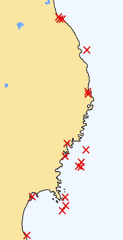
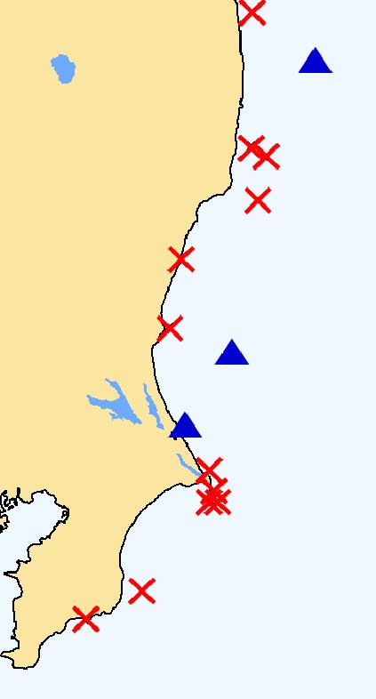
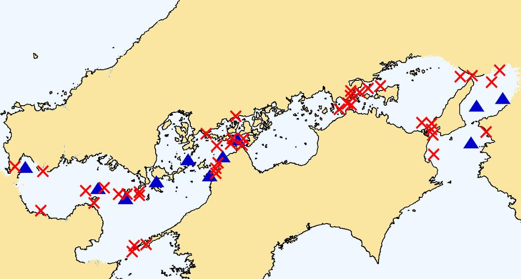
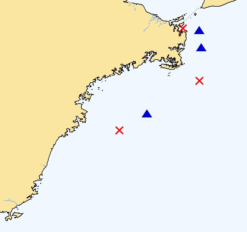
3 Occurred areas
 of 111 collision cases in fog which were pronounced from 2001 to 2005.")
4 Collisions in Fog Half of the vessels failed to sound fog signals! Half of the vessels failed to keep proper lookout by radar! We analyzed 91 cases (157 vessels; cargo vessels, oil tankers and passenger ships) of 111 collision cases in fog which were pronounced from 2001 to The causes of collisions are as follows (plural causes can be detected for each vessel.); Failure in sounding fog signals83 vessels53% Improper lookout by radar81 vessels52% Non-compliance with navigation rules in fog(rule 19 of International Regulations for Preventing Collision at Sea (COLREGS))74 vessels47% In the present situation, most vessels are now equipped with radars, and the role of fog signals is diminishing. However, it is important to note that more than half of the vessels that collided failed to keep proper lookout by radar. Therefore, sound signals are indispensable in fog to announce the vessel s location to other vessels and to avoid collision. 5 safety rules in fog Command by the master! Use fog signals! Safe speed! Keep proper lookout by radar! Observe navigation rules in fog!
5 80% recognized the other vessel s echoes on the radar screen, but Out of 157 vessels that were involved in collisions; 5 vessels (3%) did not recognize the echoes of the other vessel on the radar screen; 28 vessels18% did not recognize the echoes of the other vessel until the approach was too late to be avoided; 48 vessels31% had once recognized the echoes in a remote zone, but failed to keep watch on it; 74 vessels47% kept watching the vessel on the radar screen, but did not reduce speed; 2 vessels1% took proper action, but collided due to improper operation of the other vessel. Why didn t the vessel recognize the other vessel while being equipped with radar? In cases of and, 33 vessels (21%) didn t recognize the other vessels until immediately before collision. The reasons are as follows: Among 8 vessels, they were concentrating on watching the echo of a third vessel that was close to them; Among 6 vessels, the radar was not used effectively. In some cases, they used only long-distance range and could not detect the echo. In others, they used only short-distance range in a narrow passage and could not recognize the other vessel until they came into close vicinity. Some vessels failed to adjust the sensitivity or surface reflection properly. Among 6 vessels, they conjectured that there were no other vessels around them, judging from the location, time, or the weather, and neglected to keep proper lookout. Among 5 vessels, they did not watch the screen at all for such reasons as sudden aggravation of the weather, etc. Some vessels mistook the other vessel s echoes as that of a small island, or misread the speed or direction of the vessel. 33 vessels The reasons why the vessel didn t recognize the other vessel (and)

6 The other vessel had been once recognized, but after that 48 vessels had once recognized the echo in a remote zone (case ), but collided due to the following reasons : More than half of them, 25 vessels, presumed carelessly that there was little possibility of collision and discontinued watching the vessel. Accordingly, they did not recognize the other vessel s change of course. 17 vessels altered their course after recognizing the other vessel, and presumed carelessly that the risk of collision had been totally avoided. They did not recognize that the other vessel had also changed the course, and that the two vessels were approaching. In some cases, disarray of the echo after the alternation of the course, or the change of the mode to short distance range also caused the misjudgments. The reasons why the vessel didn t keep watching the other vessel after once recognizing it. Among 3 vessels, the existence of the other vessel slipped out of their mind while paying more attention to other vessels that were closer to them or approaching them. 3 vessels presumed erroneously that the other vessel was at anchor, and that she would not weigh the anchor in the restricted visibility. Keep watching the movement of the other vessel until passing has been safely completed! 74 vessels kept watching the vessel on the radar screen (case ), but finally collided for such reasons as: The operator presumed that the vessel would be able to pass through without taking any action although CPA (Closest Point of Approach) was close; The operator presumed that the vessel would be able to avoid collision by altering her course at a small angle or by taking action after catching sight of the other vessel; The other vessel took an unexpected action. Collisions are frequently attributed to the gap between the expectation on one hand and the actual movement of the other. In some cases, the vessel repeated alternation of her course at a small angle in order to avoid the other vessel. It should be noted that alternation at a small angle makes it difficult for the other vessel to recognize the change of course.
7 Turn port Straight Turn starboard 23% 36% 41% Out of the 74 vessels that didn t reduce their speed, 17 vessels (23%) turned port after recognizing that they would not be able to avoid a close quarters situation. 27 vessels (36%) maintained the same course, and 30 vessels (41%) turned starboard. The following figure shows the relation between the other vessel s location on the radar screen and the action taken by the operator of the vessel: As the other vessel s echo was located starboard side of heading marker, the operator Turned port; Kept straight; Turned starboard 12 vessels (40%); 13 vessels (43%); 5 vessels (17%) As the other vessel s echo was located almost on heading marker, the operator Turned port; Kept straight; Turned starboard 3 vessels (30%); 1 vessel (10%); 6 vessels (60%) As the other vessel s echo was located port side of heading marker, the operator Turned port; Kept straight; Turned starboard 2 vessels (6%); 12 vessels (36%); 19 vessels (58%) As the other vessel s echo was located in the port aft quarter, the operator Turned port; Kept straight; Turned starboard 0 vessel; 1 vessel; 0 vessel Decision on alternation of the course depends on the location of the other vessel on the radar screen Out of the 17 vessels (23% of all) that turned port, 12 vessels (71%) had observed the other vessel s echo on the starboard side of heading marker, and only 2 vessels (12%) had observed it on the port side of heading marker. The reasons for the port turn are explained on the next page. Out of 26 vessels (36% of all) which proceeded straight, 13 vessels had observed the other vessel s echo on the starboard side of heading marker, 12 vessels on the port side, and 1 vessel had observed it almost on her heading marker. The reason why the operator decided to proceed straight was that he judged that the vessel would be able to pass through safely without taking any action. Out of 30 vessels41% of allwhich turned starboard, 19 vessels (63%) had observed the other vessel s echo on the port side of heading marker, and only 5 vessels (17%) had observed it on the starboard side of heading marker. The reasons why the operator decided to turn starboard was that he judged he would be able to pass through the port side of the other vessel, or he just wanted to increase distance from the other vessel.
8 Why did vessels turn port? Rule 19 of International Regulations for Preventing Collision at Sea (COLREGS) prescribes that a vessel which detects by radar alone the presence of another vessel shall determine if a close quarters situation is developing and/or risk of collision exists. If so, she shall take avoiding action in ample time, provided that when such action consists of an alteration of course, so far as possible the following shall be avoided: (i) an alternation of course to port for a vessel forward of the beam, other than for a vessel being overtaken; (ii) an alternation of course towards a vessel abeam or abaft the beam. Why did many vessels alter the course to port despite the COLREGS rule? The reasons are as follows: 6 vessels; the third vessels were on the starboard side; 5 vessels; the operator judged it was the appropriate action to avoid the other in ample time. 2 vessels; the seashore was close to the starboard side. 2 vessels; the other vessel s echo was on the starboard side of heading marker. 1 vessel; the operator carelessly expected that the other vessel would also alter the course to port. Are you aware of the risk of port turn in fog? You turn port, and the other vessel turns starboard, then 12 vessels out of 17 which turned port steered port at less than 10 degrees each time. In 16 cases out of the 17 collisions due to port turn, the other vessels turned starboard. Many vessels collided after repeating port turns at small angles. This is because the relative direction on the radar screen to the other vessel did not change as had been expected due to the starboard turn of the other, so the operator tried again to increase the distance by port turn at a small angle. Accordingly, in many cases, the vessel collides at a great angle with another which was putting the helm on the opposite side. This is the reason why collisions in fog tend to be serious casualties, in which the vessels are totally lost.
 and TCPA (Time to CPA) of other vessels by")
9 Movement of Radar Echoes and Action to Avoid Collision In restricted visibility in fog, OOW (Officer Of the Watch) totally relies on the radar screen to watch the movement of other vessels. Therefore, it is very important to master the operation of radar devices, and to be practiced in judging the course, speed, CPA (Closest Point of Approach) and TCPA (Time to CPA) of other vessels by radar plotting and other skills needed for systematic observation. In order to clarify basic matters concerning reading radar echoes, let s see the difference between the actual movement of vessels and its movement on the radar screen. In the following example, you are on board S. S and another vessel H are approaching. Movement of H s echo Movement of the echo of H on S s radar Actual movement of H Actual movement of both vessels Actual movement of S Movement of H s echo

, the other vessel will cross ahead or stern of your own vessel.")


10 Echoes approaching from the port bow Other vessels positions observed from your own vessel and their moving direction can be recognized on your radar screen. However, all OOW should pay attention to the fact that the movement of radar echoes is a relative one, and they are different from the actual course or speed. You are in the most vulnerable position to collision, when the echo is approaching toward the center of your radar screen with no bearing change. When the echo is approaching toward the center of your radar screen while changing its bearing (as shown in the left figure), the other vessel will cross ahead or stern of your own vessel. Where the echo is moving almost parallel to your heading marker, the other vessel will pass through your port side. In case of 1 and 2, you should note that the other vessel is actually pointing closer to the heading marker than it appears on the radar screen. What you must do in these cases is to turn starboard substantially at greater angle than what seems to be needed judging from the radar screen. At the same time, you should bear in mind that, in these situations, the other vessel is prone to make a port turn despite the COLREGS rule, because the other vessel can possibly judge that she can pass on the starboard side of your vessel whose echo on her radar screen is on the starboard side. In case of 3, most vessels will change their course to starboard even when CPA is insufficient intending to pass on your port side, because echo of your vessel is observed at port bow. However, in restricted visibility by fog, you should keep sufficient CPA in order not to cause undue alarm with other vessels. Echoes approaching from the starboard bow

11 1 Also in cases where the echoes of other vessels are approaching from the starboard bow, the vessel is actually pointing closer to the heading marker than her movement on the radar screen. In such a case, you may be inclined to make a port turn, because the echo is on your starboard side. Especially when the echo is remote from the heading marker, you may judge that you will be able to pass through the starboard side of the vessel safely. But you should note that the other vessel will most probably make a starboard turn, because your echo on their radar screen is located on their port side, and they know that your port turn would be against the COLREGS rule. You should always bear in mind that turning port in fog multiplies your risk. 2 When an echo is moving almost parallel to your heading marker, the vessel will pass through your starboard side safely. However, when the CPA is not sufficient, the other vessel may take action and try to make a starboard turn in order to pass through your port side. Even for small vessels, CPA should always be more than 0.5 miles, and should be 0.75 to 1.0 miles in the open sea. It is hard to predict what happens in fog. It is essential to turn starboard as early and substantially as possible to secure ample CPA when you detect the risk of collision. Now we suppose the situation where two vessels are heading straight to each other at the speed of 12 knots each, and one vessel alters her course to starboard at the distance of 2 miles. If the alteration of course is 10, the CPA will be no more than 0.17 miles (310m), and if the alteration of course is 30, the CPA will be 0.5 miles. A CPA of around 0.3 miles is not a safe distance. There are some cases in which two vessels collide, although the CPA was 0.3 miles, due to unnecessary alternation of course by one or both of them, driven by anxiety or confusion. Taking account of the maneuverability of ships and the unusual state of mind of the crew members in emergency, CPA should always be more than 0.5 miles for all vessels including small ones, and should be 0.75 to 1.0 miles in the open sea. TCPA: After 5 min. CPA : 0 mile TCPA: After 5 min. CPA : 0.17 miles TCPA: After: 5 min. CPA: 0.52 miles
 Kisarazu Port, Chiba Kamaishi Port, Iwate Master Age: 49 License: Second class (Deck) Experience at sea: 30")
12 4 Case Studies Case 1 Collision between Cargo vessel S and Oil tanker A Off east of Yotsukura Port, Fukushima Pref. Under visibility of about 120m Cargo vessel S G/T: 682 t Crew: 7 Cargo:Water dregs(1,600 t) Kisarazu Port, Chiba Kamaishi Port, Iwate Master Age: 49 License: Second class (Deck) Experience at sea: 30 years C/O (OOW) Age: 51 Experience at sea: 32 years License: Third class (Deck) (18 years after acquisition) Oil tanker A G/T: 499 t Crew: 5 No cargo Ishinomaki Port Keihin Port Master (OOW) Age: 54 Experience at sea: 32years License: Forth class (Deck) (31 years after acquisition) Time and date: At 17:46 (UTC+9h) on July 27, 2004 Weather: Fog, South wind with force 1 Visibility: About 120m A Despite poor visibility of less than 1 mile, judging that it would be safe to navigate in the open sea area, the master of A proceeded southward Daytime at full speed with auto-pilot, but gave no sound signals. 18 min. before collision A recognized S at 6 miles, 10.5 on the starboard bow on radar screen. (-)about 11 min. Since the visibility decreased to about 300m, the master concentrated on the command of the vessel and lookout by radar, while instructing the C/O to steer by hand. But, the master neither gave sound signals nor reduced her speed. (-)about 8 min. S was detected at 3.0 miles, 10.5 on the starboard bow. A turned 10 to port in order to pass S on the starboard side, because another vessel was proceeding in the same direction on the starboard side. (-)5 min. Although S got closer to 1.8 miles, 22 on the starboard bow, A continued to proceed without reducing the speed, still judging that A would be able to pass S on the starboard side. (-)2 min.collision A recognized that S was approaching with no bearing change, so she turned 10 to port twice in a row. Collision (-)3 min. Collision S turned 15 to starboard, because A got closer to 1.0 miles, 27 on the port bow and further headed for her. S stopped her engine and steered hard-a-starboard just before the collision. (-)5 min. A got closer to 1.8 miles, 16 on the port bow. S turned 10 to starboard, assuming that A would have already agreed to the port to port passing. (-)about 8 min. S turned 9 to starboard in order to Off east of pass A on the port side, because A got closer to 3.0 miles with no bearing change. Yotsukura Port, Fukushima (-)about 13 min. C/O recognized by radar that A was proceeding southward at 5.0 miles, 8 on the port bow, so he notified A of his present position and course, and proposed to pass on the port side several times by VHF 16 ch., but no response. S The master of S had instructed the 2/O to report when the visibility became less than 1 mile, but the 2/O did not inform the C/O, next OOW, of the instruction. Although the visibility became less than 500 m, 50 minutes before the collision, the C/O neither reported to the master nor gave sound signals, and proceeded northward at full speed with auto-pilot, judging that it was safe to navigate in the open sea area. Collision 1 mile
13 Radar screen of A (True bearing mode) 18 min. before collision Course miles range scale Heading marker Actual course of S S : 6 miles, 10.5 on A s starboard bow (-) about 8 min. Just before port turn 6 miles range scale Radar screen of A [Movement of S ] 6 miles range scale Relative bearing mode (-)18 min. A Radar screen of S (True bearing mode) 13 min. before collision Course miles range scale A : 5 miles, 8 on S s port bow (-) about 8 min. Just before starboard turn 6 miles range scale S : 3 miles, 10.5 on A s starboard bow (-) about 8 min. Just after 10 port turn 3 miles range scale (-) about 8 min. (-) 5 min. (-) 3 min. A : 3 miles, 8 on S s port bow (-) about 8 min., Just after 9 starboard turn (030 ) 3 miles range scale S : 3 miles, 20.5 on A s starboard bow (-) 5 min., Course miles range scale (-) 3 min. (-) 5 min. (-) about 8 min. A : 3 miles, 16 on S s port bow (-) 5 min. Just before starboard turn 3 miles range scale (-) about 13 min. S : 1.8 miles, 22 on A s starboard bow (-) 3 min., Course miles range scale S miles A : 1.8 miles, 16 on S s port bow (-) 3 min., Just after 10 starboard turn (040 ) 3 miles range scale S : 1 mile, 21 on A s starboard bow 6 miles range scale Relative bearing mode Radar screen of S [Movement of A ] A : 1 mile, 21 on S s port bow
14 Case 2 Collision between Cargo vessel T and Cargo vessel S Off NE of Shioya Saki, Fukushima Pref. Under visibility of about 100m Cargo vessel T G/T: 498 t Crew: 5 Cargo: Aggregate (1,530 t) Omoto Port, Iwate Chiba Port Master Age: 70 License: Fifth class(deck) (35 years after acquisition) C/O (OOW): Age 55 License: Fifth class (Deck) (35 years after acquisition) Experience at sea: 35 years Cargo vessel S Register: Panama G/T: 6,530 t Crew: 15 Cargo: Plywood (2,227 t) Kashima Port Tomakomai Port, Hokkaido Master Japanese 2/O (OOW) Age: 36 Experience at sea: 8 years Time and date: At 02:15 (UTC+9h) on Sep. 10, 2003 Weather: Fog No wind Visibility: 100m T Under the visibility of about 2 miles, at the watch relief, the master left the bridge after giving instruction to the C/O, who had a long experience as a master, to report without reserve if the visibility decreased extremely. But, even after the visibility got worse, the C/O neither reported to the master nor gave sound signals, and proceeded southward at full speed with auto-pilot. 33 min. before collision C/O recognized S at 12 miles, 7 on the starboard bow on radar screen. Some northbound vessels were also displayed on the west side of S on her radar. (-)15 min. S was at 5.0 miles, 4.5 on the starboard bow. A turned 7 to port in order to ensure ample passing distance on the starboard side. (-)10 min. S was at 3.1 miles, 11 on the starboard bow. A proceeded without slow-down with repeated Night small port turns, so that the echo of S on the radar screen came to starboard side from heading marker. (-)7 min.collision S got closer to 2.0 miles, 26 on the starboard bow. T continued to proceed with repeated small port turns in order to pass S on the starboard side. The C/O became anxious about S s approach with no bearing change, so he used searchlight. After recognizing Off Shioya Saki, Fukushima the lights of S, he took hard-a-starboard and full astern just before the collision. Collision (-)7 min.collision T got closer to 2.0 miles, 31 on the port bow. When the distance between the vessels became 1 mile, S turned 8 to starboard in order to avoid T, but did not reduce the speed sufficiently. S sighted the side light of T on the port side and steered hard-a-starboard just before the collision. (-)10 min. T got closer to 3.1 miles, 10 on the port bow. The 2/O ordered the Q/M to steer by hand and to put the helm at starboard 10 to secure passing distance on the port side. S turned 19 to starboard. (-)17 min.2/o recognized on radar screen that T was at 6 miles, 9 on the port bow and was proceeding southward. Although the visibility became less than 300m, he neither reported to the master nor gave sound signals and proceeded northward at full speed with auto-pilot, instructing a Q/M to lookout. S The master did not give OOW the concrete instruction to report decreased visibility.
 (32 years after acquisition) Cargo vessel S Register: China G/T: 6,734 t Crew: 21(Chinese) Cargo: Container (3,260 t) Outer harbor of Nagoya Port (Anchoring for cargo")
15 Case 3 Oil tanker K G/T: 494 t Crew: 5 No-cargo Nagoya Port Yokkaichi Port Master Age 38 License: Fifth class (Deck) (12 years after acquisition) Experience at sea: 15 years 2/O (OOW) Age: 57 License: Forth class (Deck) (32 years after acquisition) Cargo vessel S Register: China G/T: 6,734 t Crew: 21(Chinese) Cargo: Container (3,260 t) Outer harbor of Nagoya Port (Anchoring for cargo waiting) Nagoya Port No pilot on board Master (OOW) Chinese Age: 47 Experience at sea: 30years Time and date: At 06:54(UTC+9h) on May 17, 2004 Weather: Fog No wind Visibility: about 200m During dense-fog warning K 13 min. before collision Although the master of K knew dense-fog warning was issued after leaving berth, he expected that the situation would not be very serious because the visibility was about 2 miles at that time. He left the bridge for breakfast assigning the 2/O to operate the vessel. After that, despite deterioration of the visibility, the 2/O neither reported to the master nor gave sound signals, and proceeded at full speed with auto-pilot on the starboard side of the West Passage. Even in the fog, keep right in the passage. Collision between Oil tanker K and Cargo vessel S West Passage, Nagoya Port Under visibility of about 200m (-)6 min. The 2/O recognized S at 1.3 miles, 33 on the port bow on the radar screen (3 miles range scale). After that, assuming that K would be able to pass S on the port side if K proceeded on the starboard side of the passage, the 2/O started hand steering and prepared for course change, but did not keep proper lookout of radar. (-)4 min. K turned to port along the passage and proceeded on the starboard side of the passage. Nagoya Port Early morning (-)3 min. Thevisibility decreased to 200m. The 2/O reduced her speed to dead slow ahead, but gave no sound signals. He was not monitoring the radar screen because he was steering by hand. So he did not notice S approaching her through the center of the passage. (-)2.5 min.collision The master went up to the bridge and recognized S at 0.5 miles, 3 on the port bow on radar screen. So he ordered to stop engine, but did not take astern. K proceeded under inertia with sound signals. The master sighted S close to the starboard bow and steered hard-a-starboard with half astern. Collision (-)1.5 min. Collisio When K got closer to about 500m, S turned port so as to head for the arrival berth. Just after that, the master sighted K close to the starboard bow and steered hard-a-starboard with half astern. (-)4 min. K got closer to 1,550m on the almost right ahead, but S kept proceeding at 4.0 knots in the center of the passage. S (-)6 min. The master recognized by radar (1.5 miles range scale) that K was at 1.3 miles, 11 on the starboard bow and was leaving the port. 14 min. before collision The master assigned the 3/O to lookout and an able seaman to hand steering respectively and proceeded at dead slow ahead toward the center, not along the starboard side of the passage, with sound signals.
16 Case 4 Collision between Chemical tanker K and Cargo vessel H Off SSE of Inubo Saki, Chiba pref. Under visibility of about 200m Chemical tanker K G/T: 749 t Crew: 6 No cargo Shimizu Port, Shizuoka pref. Onahama Port, Fukushima pref. Master: Age 50 License: Third class (Deck) C/O (OOW) Age 47 License: Forth class (Deck) Experience at sea: 28 years Cargo vessel H G/T: 498 t Crew: 5 Cargo: Plaster (1,500 t) Soma Port, Fukushima pref. Chiba Port Master Age: 50 License: Forth class (Deck) C/O (OOW) Age: 44 License: Forth class (Deck) Experience at sea: 29 years Time and date: At 05:55(UTC+9h) on May 9, 2001 Weather: Fog NW wind with force 2 Visibility: 200m (-)55 min. Visibility: About 1 mile Judging that the fog would clear away soon, the C/O neither reported to the master nor gave sound signals and continued to proceed at full speed with auto-pilot. Although the C/O had been (-)17 min. C/O recognized K at 6 miles, 12 temporarily on board for just 5 days, on the port bow by radar (6 miles range scale). After the master did not give concrete 1 min., K got closer to 5.6 miles, 13 on the port bow instruction to the C/O about the (CPA: 1.1 miles) and the C/O judged that H would navigation in fog, because the C/O pass K on the port side safely. So he did not report had experience as a master. to the master in spite of rapid deterioration of the visibility. (-)15 min. The C/O recognized K at 6 miles, 12 K turned on the port bow by radar.since another preceding starboard. vessel on H s starboard bow turned port, H also turned 38 to port following the vessel so as to cross ahead of K and to pass on the starboard side. H turned port. The master of K had repeatedly reminded the crew at meetings of the importance of reporting poor visibility and other actions on board. Early morning (-)5 min. K got closer to 1.5 miles, 23 on the starboard bow, so H turned 20 to port. (-)1 min.collision K got closer to 0.3 miles on the radar. The C/O sighted K at close range just after it became difficult to distinguish the echo of K on the screen with the center of the radar. Stopped engine Collision (-)2.5 min.collision The distance further decreased to 0.7 miles with no bearing change. The C/O stopped engine, but, did not take astern. K proceeded under inertia with sound signals, and then sighted H at close range. Full astern and Hard-a-starboard (-)6 min. The bearing to H did not change (21 on the port bow) and the distance decreased to 1.8 miles. K added 10 starboard turn. (-)11 min. The bearing to H did not change (11 on the port bow) and the distance decreased to 3.7 miles. K turned 10 to starboard in order to secure the passing distance with H, the position of which became at 3.7 miles, 21 on the port bow. (-)16 min. The C/O recognized H at 5.6 miles, 11 on the port bow by radar (6 miles range scale). He judged from echo trails of H that K would be able to pass on the port side, and kept proceeding at full speed. K (-)about 25 min. Despite rapid deterioration of the visibility, judging easily that the fog would clear away soon, The C/O of K neither reported to the master nor gave sound signals, and continued to proceed at full speed with auto-pilot.
17 Movement of radar echo Radar screen of H 6 miles range scale Relative bearing mode Radar screen of K 6 miles range scale Relative bearing mode H turned port How did the echo of K move on H s radar screen? (-) 17 min.: H first recognized K at 6.0 miles, 12 on the port bow. (-) 15 min. (before changing course): K was at 5.2 miles, 14 on the port bow. ( H turned 38 to port in order to pass starboard to starboard with K, following the port turn of the other preceding vessel on the starboard bow.) (-) 15 min. (just after changing course): K was at 5.2 miles, 24 on the starboard bow. (-) 5 min. (before changing course): K was at 1.5 miles, 23 on the starboard bow. ( H turned 20 to port to avoid K.) (-) 5 min. (just after changing course): K was at 1.5 miles, 43 on the starboard bow. (-) 1 min.: K was at 0.3 miles on the starboard bow. (The echo of K was too close to the center of the radar to be distinguished from it.) K turned starboard How did the echo of H move on K s radar screen? (-) 16 min.: K first recognized H at 5.6 miles, 11 on the port bow. ( K judged from H s track that K would be able to pass H on the port side.) (-) 11 min. (before changing course): H was at 3.7 miles, 11 on the port bow. ( K turned 10 to starboard, considering that the passing distance would not be enough.) (-) 11 min. (just after changing course): H was at 3.7 miles, 21 on the port bow. (-) 6 min (before changing course): H was at 1.8 miles, 21 on the port bow. ( K turned 10 to starboard to avoid H.) (-) 6 min. (just after changing course): H was at 1.8 miles, 31 on the port bow. (-) 2.5 min.: H was at 0.7 miles, 31 on the port bow. (The echo of H approached with no bearing change.)
18 Oil tanker G/T: 697 t Crew: 7 Cargo: DM Reformate (2,000kl) Yokkaichi Port Matsuyama Port Master Age: 56 (OOW is not identified) Chemical tanker G/T: 499 t Crew: 5 Cargo: Deoxidized naphthalin (203 t) and Creosote oil (805 t) Mizushima Port Chiba Port Master Age: 60 License: Fifth class (Deck) (36 years after acquisition) Experience at sea: 36 years C/O (OOW) Age: 53 License: Third class (Deck) (16 years after acquisition) Experience at sea: 38 years Time and date : At 04:05 JST (UTC+9h) on July 15, 2005 Place of accident: Kumano Nada Weather: Fog No wind Visibility: About 250m During dense-fog warning 20 min. before collision: K set course on 230 and proceeded southward at full speed. (-)12 min.: K turned 24 to port and proceeded without reducing her speed despite poor visibility. (-)7 min.collision: N got closer to 2.15 miles, 30 on the starboard bow and continued proceeding without reducing her speed. Just before collision: K stopped her engine. Collision K burst into flames. 6 crew members including the master died. Collision between Oil tanker K and Chemical tanker N Just before collision: N sighted K s starboard light. Hard-a-port Collision (-)7 min.: Although N recognized that K got closer to 2.15 miles, 29 on the port bow, the C/O assumed that N would be able to pass K on the port side. N was still unaware of K s port turn due to improper radar observation, and proceeded without reducing her speed. mile (-)12 min.: N turned 15 to starboard in order to increase the passing distance because K got closer to 3.7 miles, 14 on the port bow. Not recognizing K s port turn, the master assumed that N would be able to pass K on the port side. The master continued proceeding because he was paying attention to another vessel far away on the starboard bow. (-)14.5 min.: N recognized K at 4.5 miles, 13 on the port bow on radar screen (6 miles range scale). N noticed that the bearing to K slightly changed to port. 20 minutes before collision: The 2/O informed the C/O, next OOW, of the course, the condition of the fog and the existence of another vessel on the opposite course on the starboard bow, and left the bridge. The visibility became less than 5 miles, but the C/O did not report it to the master. The vessel continued proceeding at full speed without giving sound signals nor reducing her speed. Because dense-fog warning had been issued off north of Shikoku, the master predicted that visibility would be poor. He told the 2/O, next OOW, to be careful of dense fog before leaving bridge: He gave instruction to avoid at large angle and report to him when the 2/O felt any risk of collision. When the vessel reached Kajitori Saki in Kumano Nada, the visibility became 1 mile, but the 2/O did not report it to the master. The 2/O set course on 070 and proceeded northbound at full speed.
 Chinese Age: 38 Experience at sea: 23 years 2/O (OOW) Chinese Age: 27 Experience at sea: 6 years Cargo vessel Register: Mongol G/T: 952 t Crew: 11 Cargo: Stone(1,600t) Baiquan,")
19 Collision between Cargo vessel and Cargo vessel Cargo vessel Register: Belize G/T: 1,205 t Crew: 8 Cargo: Scrap(1,135 t) Osaka Port Haimen Port, China No pilot on board Master (He went up to bridge just before collision) Chinese Age: 38 Experience at sea: 23 years 2/O (OOW) Chinese Age: 27 Experience at sea: 6 years Cargo vessel Register: Mongol G/T: 952 t Crew: 11 Cargo: Stone(1,600t) Baiquan, China Katakami Port, Okayama No pilot on board Master Chinese Age: 45 Experience at sea: 21 years 2/O (OOW) Chinese Age: 30 Experience at sea: 12 years Time and dateat 04:25 JST (UTC+9h) on May 14, 2004 Place of accident: Kurusima Kaikyo Traffic Route Weather: Fog SE wind with force 1 (-)4 min. Visibility: About 40m Current: 1 knot to east The 2/O failed to (the fastest current of the day) report to the master that visibility Maritime Traffic Safety Law worsened rapidly. (Art.20.1 (2)) The 2/O recognized Vessel shall navigate as close as L at 1.2 miles on possible to O Shima and Oge Shima, when the port bow on navigating via Naka Suido radar screen while M turned port (-)4 min. The master went up to gradually. L turned 43 to starboard bridge noticing poor visibility. M proceeded He recognized L on radar L and headed for traffic route. without giving L recognized M at 1.2 screen. sound signals, or miles on the right ahead on Hard-a-port Collision reducing the speed. radar screen. L proceeded Sinking without giving sound signals, or decreasing the speed. To Naka Suido Visibility: About 40m (-)About 1 minute Hard-a-starboard Collision L (-)11 min. L recognized M at 2.9 miles on the starboard bow on radar screen (3 miles range scale). The 2/O had not received any instruction from the master. 2/O: Commanded operation Q/M: Steered by hand Visibility: About 40m Master: Commanded operation 2/O: Observed the radar Q/ M: Steered by hand What is the Sail Naka Suido with the tidal current, Sail Nishi Suido against the tidal current rule? Vessels shall navigate the Kurushima Kaikyo Naka Suido with the tidal current and to navigate the Kurushima Kaikyo Nishi Suido against the tidal current. (-)10 min. The master left bridge. The 2/O took over the master. Started turning port along the traffic route. M recognized L at 3.1 miles on the port bow on radar screen (3 miles range scale). Vessels shall navigate as close as possible to Shikoku side, when navigating via Nishi Suido. M M When visibility is poor in the Kurushima Kaikyo, many vessels suspend the passing through the channel until visibility recovers. But sometimes the visibility worsens rapidly during passing. In such casesyou must follow the rule of Sail Naka Suido with the tidal current, Sail Nishi Suido against the tidal current, and navigate as close as possible to O Shima and Oge Shima, when navigating via Naka Suido and navigate as close as possible to Shikoku side, when navigating via Nishi Suido.
20 Collision between Cargo vessel and Cargo vessel K Cargo vessel G/T: 699 t Crew: 5 Cargo: Cement (1,086 t) Higashi Harima Port, Hyogo Kanda Port, Fukuoka Master Age: 54 License: Forth class (Deck) (29 years after acquisition) Experience at sea: 36 years C/O (OOW) Age: 73 License: Fifth class (Deck) (35 years after acquisition) Experience at sea: 60 years Cargo vessel G/T: 198 t Crew: 2 Cargo: Stainless steel(364t) Kanmon Port Kinuura Port, Aichi Master (OOW) Age: 42 License: Fifth class(deck) (16 years after getting license) Experience at sea: 19 years Time and date : At 02:35JST (UTC+9h) on May 17, 2002 Place of accident: Iyo Nada Weather: Fog, no wind Visibility: About 100m (-)5 min.collision (-)7 min. Visibility: About 500m (-)10 min. The master had relied on the T reduced her speed to The C/O did not report the visibility The C/O well-experienced C/O, and had half ahead of 9.6 knots to the master. He did not give sound recognized the not instructed him to report due to dense fog. signals nor reduced her speed. T fog emerging poor visibility to the master. The C/O of T proceeded at full speed with ahead of T (-)12 min. concentrated on auto-pilot. because he After T changed course to watching ahead, (-)6.5 min. could not sight 275, T recognized K at 4.0 assuming that he would T recognized K at 2.0 miles, 11 the K s light, mile, 8 on the starboard bow sight K s light shortly, on the starboard bow. Because the 3.2 miles from on radar screen (12 miles range and paid no attention to echo of K was in starboard side of T. scale and Off center). the radar. heading marker on radar screen, T recognized that K was on Just before collision, T judged that T would be able to the opposite course. The C/O sighted the pass K on the starboard side. T light of K close to continued proceeding without T s bow. slow-down. T steered hard-a-starboard and stopped her engine. Collision Because the master had obtained fog information, the master had ordered the C/E (OOW) to report to the master when visibility became poor. (-)About 1 hour The C/E reported to the master that visibility became poor about 100m. The master went up to the bridge and commanded operation. (-)5 min. T got closer to 1.5 miles, 8 on the port bow. K reduced her speed to half ahead of 9.0 knots. (-)4 minutes Because T got closer to 1.2 miles, 8 on the port bow with no bearing change, K changed course to 120. (-)18 min. The master recognized T at 6.0 miles on the right ahead on radar screen (6 miles range scale). He recognized that T was on the opposite course. He turned 5 to starboard in order to pass T on the port side, so that the echo of T is located on the port side of heading marker on the radar. K proceeded at full speed using auto-pilot without giving sound signals. (-)2 min. Because T got closer to 1,050m, K changed course to 125. ( K expected that T would enter port side on radar screen.) (-)8 min. Because T got closer to 2.6 miles on the almost right ahead, K changed course to 110. (-)6.5 min. Because T got closer to 2.0 miles, 4 on the port bow, K assumed that T would turn starboard and pass K on the port side. K did not reduce her speed. (-)6 min. Because T got closer to 1.8 miles, 4 on the port bow with no bearing change, K changed course to 115. (-)1 min. Collision Because T got closer to 500m, K felt danger and stopped her engine. The master engaged in steering by hand and paid attention to port bow with the C/E. Just before collision, K sighted the light of T close to her bow. Starboard 10 and Half astern Collision
8 min: K altered 5 to starboard.) (-)6.5 min.: T recognized K at 2.0 miles, 11 on the starboard bow. CPA was 0.12 miles.")
 (-)5 min.: T recognized K at 1.5 miles, 13 on the starboard bow. ( T reduced her speed to half ahead of 9.6 knots.) (-)4 min.: T recognized K at 1.2 miles, 13 on the starboard bow.")
 Radar screen of K K turned starboard Modest slow-down or alternation of course at a small angle of 5 is hard to be recognized by other vessels. How did the echo of T move on K s radar screen?")
21 Movement of radar echo Radar screen of T T went straight How did the echo of K move on T s radar screen? (-)12 min.: T recognized K at 4.0 miles, 8 on the starboard bow. (-)10 min.: T recognized K at 3.2 miles, 9 on the starboard bow. ((-)8 min: K altered 5 to starboard.) (-)6.5 min.: T recognized K at 2.0 miles, 11 on the starboard bow. CPA was 0.12 miles. ( T judged that T would be able to pass K on the starboard side because K was in the starboard side of heading marker.) (-)6 min.: T recognized K at 1.8 miles, 11 on the starboard bow. ( K altered 5 to starboard.) (-)5 min.: T recognized K at 1.5 miles, 13 on the starboard bow. ( T reduced her speed to half ahead of 9.6 knots.) (-)4 min.: T recognized K at 1.2 miles, 13 on the starboard bow. ( K altered 5 to starboard.) (-)2 min.: T recognized K at 1,050m, 13 on the starboard bow. ( K altered 5 to starboard.) Radar screen of K K turned starboard Modest slow-down or alternation of course at a small angle of 5 is hard to be recognized by other vessels. How did the echo of T move on K s radar screen? (-)18 min.before changing course: K recognized T at 6.0 miles on the almost right ahead. ( K intended to pass T on the port side. And K altered 5 to starboard expecting that T would enter port side of the heading marker.) (-)18 min.just after changing course: K recognized T at 6.0 miles, 5 on the port bow. (-)8 min.before changing course: K recognized T at 2.6 miles on the almost right ahead. ( K altered 5 to starboard.) (-)8 min.just after changing course: K recognized T at 2.6 miles, 5 on the port bow. (-)6.5 min.: K recognized T at 2.0 miles, 4 on the port bow. CPA was 0.12 miles. ( K judged that T would turn starboard and K would be able to pass T on the port side.) (-)6 min.before changing course: K recognized T at 1.8 miles, 4 on the port bow. ( K altered 5 to starboard.) (-)6 min.just after changing course: K recognized T at 1.8 miles, 9 on the port bow. (-)5 min.: K recognized T at 1.5 miles, 8 on the port bow. ( K reduced her speed to 9.0 knots.) (-)4 min.before changing course: K recognized T at 1.2 miles, 8 on the port bow. ( K altered 5 to starboard.) (-)4 min.just after changing course: K recognized T at 1.2 miles, 13 on the port bow. (-)2 min.before changing course: K recognized T at 1,050m, 13 on the port bow. ( K altered 5 to starboard.) (-)2 min.just after changing course: K recognized T at 1,050m, 18 on the port bow.
 C/O (OOW) Age: 61 Forth class (Deck) Experience at sea: 18 years Cargo vessel Register: Panama G/T: 1,478 t Crew: 8 Cargo: Steel (990 t) Himeji Port, Hyogo Pusan Port, South Korea No pilot on")

22 Collision between Cargo vessel C and Cargo vessel A Cargo vessel G/T: 199 t Crew: 3 Chip(450 t) Aburatsu Port, Miyazaki Mishima Kawanoe Port, Ehime Master (in the bridge) Age: 60 License: Fifth class (Deck) C/O (OOW) Age: 61 Forth class (Deck) Experience at sea: 18 years Cargo vessel Register: Panama G/T: 1,478 t Crew: 8 Cargo: Steel (990 t) Himeji Port, Hyogo Pusan Port, South Korea No pilot on board Master (OOW) Filipino Age: 54 3/O (Lookout) Filipino Time and date : At 02:53 JST (UTC+9h) on July 13, 2001 Place of accident: Aki Nada Weather: Fog SW wind with force 1 Visibility: About 100m The master commanded operation and assigned the 3/O to lookout. A proceeded southward with sound signals along the recommended course line, sighting light buoy on the starboard side, at full speed using auto-pilot. (-) 9.5 min. A recognized C at 3 miles on the starboard bow. A judged that A would pass C on the starboard bow and proceeded without reducing her speed. (-)1.5 min. Collision When C got closer to 0.5 miles on A s bow, A was not able to explicitly identify the radar echo of C and felt anxiety. But A did not reduce her speed, and continued proceeding on the port side of the recommended course line. Just before collision, A sighted the light of C close to A s bow. Hard-a-starboard Collision You must proceed along the recommended course line sighting the light buoy on your port side! (-)1.5 hours The master of C went up to bridge after hearing sound signals, but the master continued to have the C/O to watch, and the master himself did not command the operation. He looked into the radar screen or engaged in lookout in port wing from time to time. (-)18 min. Visibility: 100m The C/O of C set her course on the south (starboard) side of the recommended course line and proceeded using auto-pilot with sound signals manually. (-) 13.5 min. The C/O recognized A at 4 miles on her bow on radar screen. (-)9.5 min. The C/O recognized A at 3 miles on her bow on radar screen. The C/O worried that A was proceeding southward on the port side of recommended course line. But, C assumed that A would turn starboard, and continued proceeding without reducing her speed. (-)4 min. Collision The C/O recognized A at 1 mile on the almost right ahead on radar screen. Assuming that C would pass A on the port side, the C/O of C altered 20 to starboard, reduced her speed to dead slow ahead and gave a long blast. Just before collision, C sighted the light of A on the port bow. Full ahead Collision C sank.
 South Korean Age: 44 No pilot on board")

40 min.")
23 Collision between Cargo vessel P and Chemical tanker S Cargo vessel Register: Panama G/T: 7,433 t Crew: 18 No cargo Dalian Port, China Mizushima Port, Okayama Master (Commanding operation) Filipino Age: 61 No pilot on board Chemical tanker Register: South Korea G/T: 1,592 t Crew: 13 No cargo Keihin Port Onsan Port, South Korea Master (Commanding operation) South Korean Age: 44 No pilot on board Time and date: At 09:10 JST (UTC+9h) on April 12, 2003 Place of accident: Off North of Mutsure Shima, Yamaguchi Weather: Fog, WNW wind with force 3 Visibility: About 400m Although P S got close to recognized S 1.0 mile on P s proceeding on the bow with no opposite course at bearing change. 2.0 miles, 10 on the Assuming that starboard bow, P S would turn Assuming that P would did not reduce her port, P neither turn starboard, S did not speed. Master Commanded the reduced her speed reduce her speed. operation nor stopped. 3/O Assisted the operation Q/M Steered by hand P got closer to 2.0 miles, 9 on the (-)40 min. Visibility: About port bow. But S did not reduce her 400m speed and continued proceeding. P gave sound signals and S got close to reduced her speed to half ahead. 2.8 miles on the Because the bearing to P turned (-)10 min. almost right to port, S altered 30 to port. Although P recognized S at ahead. Assuming Although visibility became poorer to 3.5 miles, 2 on the starboard that S would about 400m, S proceeded at the bow on radar screen (6 miles pass P on the same speed without giving sound range scale) with ARPA, P starboard side, signals continued proceeding without P turned 9 to reducing her speed. port. Assuming that S would possibly turn port and proceed westward near Ai-no-Shima, P Master Commanded the addressed to S, without being operation able to identify her name, by 3/O Engaged in lookout VHF to confirm her course. Q/M Steered by hand But P received no response. (-)25 min. Visibility: About 1,000m S did not recognize other vessels ahead of her and proceeded northbound at full speed without giving sound signals. S passed north entrance of Kanmon Passage. S recognized P on the port bow on radar screen (6 miles range scale). S continued proceeding Lessons for the navigation under poor visibility northward paying attention to the approach of P. What is a safe speed A safe speed means that she can; () take proper and effective action to avoid collision and Is your speed () be stopped within a distance appropriate to the prevailing circumstances and conditions. safe in the fog? Don t turn port to avoid a close quarters situation! Don t hesitate to reduce your speed substantially or stop! Don t count on the action of other vessels. YOU must take definite actions to avoid a close quarters situation in ample time. But remember not to turn port! Take apparent actions that can be easily recognized by other vessels! Turn starboard largely (at least 30 ) before approaching other vessels! Don t hesitate to reduce your speed largely or stop when you are in a close quarters situation!

 A power-driven vessel shall have her engines ready for immediate maneuver. Take large action in ample time when you recognize other vessels!")

 Except where it has been determined that a risk of collision")
24 The master himself must command in the bridge when the vessel enters port, passes through narrow channel, or faces any other vulnerable situations. In restricted visibility, the lights prescribed by the rules in COLREGS shall also be exhibited from sunrise to sunset. Every vessel shall at all times proceed at a safe speed so that she can take proper and effective action to avoid collision and be stopped within a distance appropriate to the prevailing circumstances and conditions. First, prepare the engine (b) A power-driven vessel shall have her engines ready for immediate maneuver. Take large action in ample time when you recognize other vessels! (d) A vessel which detects by radar alone the presence of another vessel shall determine if a close-quarters situation is developing and / or risk of collision exists. If so, she shall take avoiding action in ample time. Don t turn port in fog (d) Provided that when such action consists of an alteration of course, so far as possible the following shall be avoided: () an alteration of course to port for a vessel forward of the beam, other than for a vessel being overtaken Don t hesitate to go astern when you are in a close quarters situation (e) Except where it has been determined that a risk of collision does not exist, every vessel which hears apparently forward of her beam the fog signal of another vessel, or which cannot avoid a close quarters situation with another vessel forward of her beam, shall reduce her speed to the minimum at which she can be kept on her course. She shall if necessary take all her way off and in any event navigate with extreme caution until danger of collision is over. () an alteration of course towards a vessel abeam or abaft the beam
Marine Accident Inquiry Agency
 Marine Accident Inquiry Agency No. Feb., 007 Kasumigaseki --, Chiyoda-ku, Tokyo, 00-898 TEL 0-55-88 FAX 0-55-680 E-mail maia@mlit.go.jp URL http://www.mlit.go.jp/maia/index.htm Marine Accidents in (Channel)
Rule Conduct of vessels in restricted visibility
 Section III Rule 19 -- Conduct of vessels in restricted visibility (a) This Rule applies to vessels not in sight of one another when navigating in or near an area of restricted visibility. (b) Every vessel
Collision in restricted visibility
 August 2018 Collision in restricted visibility Vessel A, a container vessel, was approaching the pilot station at full speed which was 17 knots and on a course of 280. It was in the afternoon there was
Rule 8 - Action to avoid collision
 a) Any action to avoid collision shall be taken in accordance with the Rules of this Part and shall, if the circumstances of the case admit, be positive, made in ample time and with due regard to the observance
INTERNATIONAL Steering and Sailing Rules
 INTERNATIONAL Section II Conduct of Vessels in Sight of One Another RULE 11 Application Rules in this section apply to vessels in sight of one another. RULE 12 Sailing Vessels (a) When two sailing vessels
National Maritime Center
 National Maritime Center Providing Credentials to Mariners (Sample Examination) Page 1 of 19 Choose the best answer to the following multiple choice questions. NO reference materials are authorized for
Rules Practice Exam 14
 1 BOTH INTERNATIONAL & INLAND Additional light signals are provided in the Annexes to the Rules for vessels. A. engaged in fishing B. not under command C. engaged in towing D. under sail 2 BOTH INTERNATIONAL
Rules Practice Exam 11
 1 BOTH INTERNATIONAL & INLAND While underway in fog, you hear a vessel sound one prolonged blast followed by two short blasts on the whistle. What does this signal indicate? A. A vessel towing B. A vessel
Rule 17 - Action by stand-on vessel
 (a) (i) Where one of two vessels is to keep out of the way the other shall keep her course and speed. (ii) The latter vessel may however take action to avoid collision by her manoeuvre alone, as soon as
Japan Transport Safety Board
 Special edition Marine Accident Cases Accidents in Kanmon Kaikyo (issued in August 2010) Japan Transport Safety Board Special edition Marine Accidents Introduction Investigated accidents in Kanmon Kaikyo
Rules Practice Exam 7
 1 INTERNATIONAL ONLY The light which may be used with a vessel's whistle is to be. A. used when the whistle is broken B. used prior to sounding the whistle C. used only at night D. a white light 2 INTERNATIONAL
Navigation: Navigation In Restricted Visibility. Notice to all Ship Owners, Masters, Skippers, Ships Officers, and Pilots.
 MARINE GUIDANCE NOTE MGN 369 (M+F) Navigation: Navigation In Restricted Visibility Notice to all Ship Owners, Masters, Skippers, Ships Officers, and Pilots. This notice replaces Marine Guidance Note 202
Marine Accident Inquiry Agency
 Marine Accident Inquiry Agency No.4 January, 2008 Kasumigaseki 2-1-2, Chiyoda-ku, Tokyo, 100-8918 TEL +81-3-5253-8821 FAX +81-3-5253-1680 E-mail maia@mlit.go.jp URL http://www.mlit.go.jp/maia/index.htm
Rule 15 - Crossing situation
 When two power-driven vessels are crossing so as to involve risk of collision, the vessel which has the other on her own starboard side shall keep out of the way and shall, if the circumstances of the
Rules Practice Exam 12
 1 INLAND ONLY You are on vessel "A", and vessel "B" desires to overtake you on your starboard side as shown. After the vessels have exchanged one blast signals, you should. Diagram 31 A. alter course to
National Maritime Center
 National Maritime Center Providing Credentials to Mariners Q301 Rules of the Road-Inland (Sample Examination) Page 1 of 19 Choose the best answer to the following Multiple Choice Questions. NO reference
Rules Practice Exam 9
 1 BOTH INTERNATIONAL & INLAND If your vessel is underway in fog and you hear one prolonged and three short blasts, this is a. A. vessel not under command B. sailing vessel C. vessel being towed (manned)
August April 18,2008 First Revision
 August 15 2011 Slide 01 April 18,2008 First Revision August 15, 2011 Text converted to Tables for ease of formatting instructor guide. Slide 23 Sound Signals Corrected Danger Signal 5 or More Short Blasts
NavRule Practice Exam, 70 Series Practice April 24, Labeled F (I received a reply from the testing service that all these answers were
 1. INTERNATIONAL & INLAND An all-round flashing yellow light may be exhibited by a(n)? a. vessel laying cable b. vessel towing a submerged object c. vessel not under command d. air cushion vessel 2. INTERNATIONAL
Incident Report. Close Quarters Pegasus II & Distraction. 26 April 2006 Class B
 Incident Report Close Quarters Pegasus II & Distraction 26 April 2006 Class B NARRATIVE Pegasus II (See Photograph 1 Pegasus II) is a 15.46 metre commercial fishing vessel with a gross tonnage of 40. She
MARINE ACCIDENT INVESTIGATION REPORT
 MA2013-10 MARINE ACCIDENT INVESTIGATION REPORT October 25, 2013 Japan Transport Safety Board The objective of the investigation conducted by the Japan Transport Safety Board in accordance with the Act
National Maritime Center
 National Maritime Center Providing Credentials to Mariners U.S.C.G. Merchant Marine Exam (Sample Examination) Page 1 of 22 U.S.C.G. Merchant Marine Exam: Illustrations: 10 Choose the best answer to the
Rules Practice Exam 5
 1 BOTH INTERNATIONAL & INLAND Vessel "A" (towing) and vessel "B" are meeting as shown. In this situation, which statement is TRUE? Diagram 12 A. Both vessels should alter course to starboard and pass port
Rules of the Road. United States Power Squadrons USPS University
 Rules of the Road United States Power Squadrons USPS University Seminar and contents copyrighted by USPS 2008 Per Inland Rules: Boats 12 m or greater must carry a copy of these rules Seminar Reference
Collision in restricted visibility
 August 2013 Collision in restricted visibility It was early morning and both vessels were sailing in a busy traffic separation scheme in South East Asia. The sea was calm but there were some rain showers
Rule 13 - Overtaking
 Rule 13 - Overtaking (a) Notwithstanding anything contained in the Rules of part B, sections I and II, any vessel overtaking any other shall keep out of the way of the vessel being overtaken. (b) A vessel
E Navigation Data Auditing Report
 E Navigation Data Auditing Report Ship s Name Name_not_disclosed Period March 1 st to 31 st, 2016 General 1. Introduction. The data from the above ship was analyzed in order to carry our Navigational Audit
SEMI FINAL EXAMINATION
 SEMI FINAL EXAMINATION 1. Which vessel may exhibit, if practicable, the lights for sailing vessels, but if she does not, she shall have ready at hand a electric torch or lighted lantern showing a white
TRAFFIC MANAGEMENT. Traffic Control. Information Signals Remarks. Combination of >=== LO CODE indicating the ports.
 SNPWG 17-10.1C TRAFFIC MANAGEMENT Traffic Control Ships Routeing A Navigation Rules Vessels should observe the following in addition to navigation pursuant to the provisions of Maritime Traffic Safety
You must stop your. pass with caution on the port side of vessel "B" The vessel moving upstream against the current
 BK NUM ANS QUESTION ANSWER A ANSWER B ANSWER C ANSWER D ILLUST 1 1 C 1 2 B INLAND ONLY You are navigating in a narrow channel and must remain in the channel for safe operation. Another vessel is crossing
Rule 18 - Responsibilities between vessels
 Except where Rules 9, 10 and 13 otherwise require: (a) A power-driven vessel underway shall keep out of the way of: (i) a vessel not under command; (ii) a vessel restricted in her ability to manoeuvre;
RADAR PLOTTING Ranger Hope 2008
 RADAR PLOTTING Ranger Hope 2008 THE BASIC PLOT Introduction Priority targets and the EBL Proper use of radar Plotting terms and abbreviations The radar display, SHU and NHU NHU plot step by step SHU plot
SS&S Chapter 8 Instructor Guide
 SS&S Chapter 8 Instructor Guide The Rules of the Nautical Road The PowerPoints (PPT) slides for this SS&S chapter were copied from the BS&S-13 th Ed PPT because they are identical. Only the chapter numbers
NavRule Practice Exam, 70 Series Practice April 18, Labeled C have been copied to collection
 1C. INTERNATIONAL & INLAND There are two classes of vessel which, to the extent necessary to carry out their work, do not have to comply with the rule regarding traffic separation schemes. One of these
THE REPUBLIC OF LIBERIA LIBERIA MARITIME AUTHORITY
 THE REPUBLIC OF LIBERIA LIBERIA MARITIME AUTHORITY 8619 Westwood Center Drive Suite 300 Vienna, Virginia 22182, USA Tel: +1 703 790 3434 Fax: +1 703 790 5655 Email: safety@liscr.com Web: www.liscr.com
Rule 35 - Sound signals in restricted visibility
 Rule 35 - Sound signals in restricted visibility In or near an area of restricted visibility, whether by day or night, the signals prescribed in this Rule shall be used as follows: (a) A power-driven vessel
National Maritime Center
 National Maritime Center Providing Credentials to Mariners Able Seaman Unlimited, Limited, Special, Special OSV, Sail, Fishing Industry (Sample Examination) Page 1 of 17 Choose the best answer to the following
MA MARINE ACCIDENT INVESTIGATION REPORT
 MA2013-5 MARINE ACCIDENT INVESTIGATION REPORT May 31, 2013 The objective of the investigation conducted by the Japan Transport Safety Board in accordance with the Act for Establishment of the Japan Transport
Convention on the International Regulations for Preventing Collisions at Sea, 1972 (COLREGs) EXPLANATORY NOTES
 EXPLANATORY NOTES") Convention on the International Regulations for Preventing Collisions at Sea, 1972 (COLREGs) EXPLANATORY NOTES Adoption: 20 October 1972 Entry into force: 15 July 1977 Introduction Amendment procedure
Convention on the International Regulations for Preventing Collisions at Sea, 1972 (COLREGs) EXPLANATORY NOTES Adoption: 20 October 1972 Entry into force: 15 July 1977 Introduction Amendment procedure
Accident Report. Close Quarters Manutere & Ocean Monarch. 12 March 2006 Class C
 Accident Report Close Quarters Manutere & Ocean Monarch 12 March 2006 Class C NARRATIVE On Saturday 11 March 2006, at about 1800 hours New Zealand Daylight Time (NZDT), Manutere left Tauranga harbour.
Rule 5 - Look-out. 1
 Every vessel shall at all times maintain a proper look-out by sight and hearing as well as by all available means appropriate in the prevailing circumstances and conditions so as to make a full appraisal
KANMON KAIKYO VESSEL TRAFFIC SERVICE CENTER KANMON MARTIS USER MANUAL TABLE OF CONTENTS Ⅱ OPERATIONAL CONCEPT OF THE "KANMON MARTIS" 1
 KANMON KAIKYO VESSEL TRAFFIC SERVICE CENTER KANMON MARTIS USER MANUAL TABLE OF CONTENTS Ⅰ INTRODUCTION 1 Ⅱ OPERATIONAL CONCEPT OF THE "KANMON MARTIS" 1 Ⅲ IMPORTANT NAVIGATIONAL RULES 2 Ⅳ COMMUNICATION
Comments on the collision between a tanker and a U.S. Navy ship in the Strait of Singapore
 Comments on the collision between a tanker and a U.S. Navy ship in the Strait of Singapore August 2017 (chronologically from bottom to top) Wed, Aug 23, 2017 at 3:05 PM Turning all deck lights on should
Appendix HK1 HKSF Prescriptions
 Appendix HK1 HKSF Prescriptions Introduction Effective date Rule The HKSF prescribes that these rules become effective in Hong Kong on 1 January 2017. Prescription 67 Damages 1 No claim for damages arising
MARINE ACCIDENT INVESTIGATION REPORT
 MARINE ACCIDENT INVESTIGATION REPORT December 8th,2016 Adopted by the Japan Transport Safety Board Member Kuniaki Shoji Member Satoshi Kosuda Member Mina Nemoto Accident Type Contact (light buoy) Date
The Analysis of Possibilities How the Collision Between m/v 'Gdynia' and m/v 'Fu Shan Hai' Could Have Been Avoided
 International Journal on Marine Navigation and Safety of Sea Transportation Volume 2 Number 4 December 2008 The Analysis of Possibilities How the Collision Between m/v 'Gdynia' and m/v 'Fu Shan Hai' Could
Give way to the right
 Many people at this time of year will be starting to use their boats having perhaps not used them since towards the end of last year. It is very easy to forget the collision regulations that we must obey
MARINE ACCIDENT INVESTIGATION REPORT
 MA2011-6 MARINE ACCIDENT INVESTIGATION REPORT June 24, 2011 Japan Transport Safety Board The objective of the investigation conducted by the Japan Transport Safety Board in accordance with the Act for
International regulations and guidelines for maritime spatial planning related to safe distances to multiple offshore structures (e.g.
 International regulations and guidelines for maritime spatial planning related to safe distances to multiple offshore structures (e.g. wind farms) Introduction This is a summary of the most important international
Report on Vessel Casualty of Accident (Form Casualty) Instructions:
 Instructions:") Report on Vessel Casualty of Accident (Form Casualty) Tuvalu Ship Registry 10 Anson Road #25-16 International Plaza Singapore 079903 Tel: (65) 6224 2345 Fax: (65) 6227 2345 Email: info@tvship.com Website:
Report on Vessel Casualty of Accident (Form Casualty) Tuvalu Ship Registry 10 Anson Road #25-16 International Plaza Singapore 079903 Tel: (65) 6224 2345 Fax: (65) 6227 2345 Email: info@tvship.com Website:
OSAKA MARTIS USER MANUAL TABLE OF CONTENTS
 OSAKA MARTIS USER MANUAL TABLE OF CONTENTS Ⅰ Ⅱ Ⅲ INTRODUCTION OPERATIONAL CONCEPT OF "Osaka MARTIS" IMPORTANT NAVIGATIONAL RULES Ⅳ COMMUNICATION 1 VHF Channels 2 Language Ⅴ PRE-ENTRY REPORT AND POSITION
MARINE ACCIDENT INVESTIGATION REPORT
 MA2010-5 MARINE ACCIDENT INVESTIGATION REPORT May 28, 2010 Japan Transport Safety Board The objective of the investigation conducted by the Japan Transport Safety Board in accordance with the Act for Establishment
Marine Navigation Navigational Errors and Assessment of Fault By Capt. Francis Lansakara Master Mariner. LLM (London)
") Marine Navigation Navigational Errors and Assessment of Fault By Capt. Francis Lansakara Master Mariner. LLM (London) -Abstract- Maritime accidents involving ships normally take place due to navigational
Marine Navigation Navigational Errors and Assessment of Fault By Capt. Francis Lansakara Master Mariner. LLM (London) -Abstract- Maritime accidents involving ships normally take place due to navigational
3 Navigation Rules Rules General
 115 3 Navigation Rules Rules General Basis for Rules The International Rules were formalized at the Convention for Preventing Collisions at Sea of 1972. These International Rules were ratified in 1977
COLLISIONS: HOW TO AVOID THEM
 COLLISIONS: HOW TO AVOID THEM North of England P&I Association COLLISIONS: HOW TO AVOID THEM NORTH OF ENGLAND P&I ASSOCIATION Published by North of England P&I Association Limited The Quayside, Newcastle
28 Distress. Rules of the Road John C. Kelly, Rule 36 Signals to Attract Attention
 28 Distress Rule 36 Signals to Attract Attention Can make any signals which will not be confused with signals defined in these Rules. May direct search light in direction of danger so as not to embarrass.
LAPWARE, LLC. Since 2002
 CORRECTED THROUGH 23 NOV 2011 LAPWARE, LLC www.lapware.org Since 2002 www.lapwareengine.org Since 2011 CHANGE NUMBER DATE OF CHANGE RECORD OF CHANGES DATE ENTERED BY WHOM ENTERED 001 25 MAR 99 ONGOING
Rule 7 - Risk of collision
 a) Every vessel shall use all available means appropriate to the prevailing circumstances and conditions to determine if risk of collision exists. If there is any doubt such risk shall be deemed to exist.
ASSESSMENT OF CORRECTNESS OF INFORMATION OBTAINED FROM AUTOMATIC IDENTIFICATION OF SHIP S SYSTEM (AIS)
") ASSESSMENT OF CORRECTNESS OF INFORMATION OBTAINED FROM AUTOMATIC IDENTIFICATION OF SHIP S SYSTEM (AIS) Henryk Śniegocki Akademia Morska w Gdyni, Katedra Nawigacji Aleja Jana Pawła II 3, 81-345 Gdynia,
ASSESSMENT OF CORRECTNESS OF INFORMATION OBTAINED FROM AUTOMATIC IDENTIFICATION OF SHIP S SYSTEM (AIS) Henryk Śniegocki Akademia Morska w Gdyni, Katedra Nawigacji Aleja Jana Pawła II 3, 81-345 Gdynia,
ASSESSMENT OF CORRECTNESS OF INFORMATION OBTAINED FROM AUTOMATIC IDENTIFICATION OF SHIP S SYSTEM (AIS)
") Journal of KONES Powertrain and Transport, Vol. 17, No. 3 2010 ASSESSMENT OF CORRECTNESS OF INFORMATION OBTAINED FROM AUTOMATIC IDENTIFICATION OF SHIP S SYSTEM (AIS) Henryk niegocki Gdynia Maritime University,
Journal of KONES Powertrain and Transport, Vol. 17, No. 3 2010 ASSESSMENT OF CORRECTNESS OF INFORMATION OBTAINED FROM AUTOMATIC IDENTIFICATION OF SHIP S SYSTEM (AIS) Henryk niegocki Gdynia Maritime University,
IMO DEVELOPMENT OF MODEL PROCEDURE FOR EXECUTING SHIPBOARD EMERGENCY MEASURES. Emergency steering drills. Submitted by the Republic of Korea
 INTERNATIONAL MARITIME ORGANIZATION E IMO SUB-COMMITTEE ON STANDARDS OF TRAINING AND WATCHKEEPING 41st session Agenda item 12 STW 41/12/2 9 October 2009 Original: ENGLISH DEVELOPMENT OF MODEL PROCEDURE
Consolidated version Collision Contact. Very serious casualty: collision between a fishing vessel and a passenger ship
 Consolidated version Collision Contact COLLISION (FSI 20) Very serious casualty: collision between a fishing vessel and a passenger ship At night and with visibility at about three nautical miles, a 28-metre
Simplified report of safety investigation
 Simplified report of safety investigation COLLISION BETWEEN SALVATORE CAFIERO AND NAUSICAA ON 22 APRIL 2012 IN THE WESTERN APPROACHES TO THE ENGLISH CHANNEL Report published on : July 2013 2 COLLISION
 ON SHIPS OF 200 GRT/500 GT OR MORE Assessment Sheets Enclosure (1) to CG-543 Policy Letter 11-07 ASSESSMENT NO. OICNW-1-1A COMPETENCE: Plan and conduct a passage and determine position KNOWLEDGE, UNDERSTANDING
RECOMMENDATION OF THE ROAD
 RECOMMENDATION OF THE ROAD IN TOKYO BAY AND OTHER BAYS AND STRAITS IN JAPANESE WATERS The 31 st Revised Edition July, 2011 JAPAN COAST GUARD Maritime Traffic Department Navigation Safety Division The JAPAN
1. PURPOSE. This instruction forwards International and Inland Navigation Rules and Regulations for use by Coast Guard personnel.
 U.S. Department of Transportation United States Coast Guard Commandant United States Coast Guard Mailing Address: 2100 2nd Street, S.W. Washington, DC 0593-001 Phone: (202) 267-0352 COMMANDANT INSTRUCTION
Maritime Traffic Situations in Bornholmsgat
 http://www.transnav.eu the International Journal on Marine Navigation and Safety of Sea Transportation Volume 9 Number 1 March 2015 DOI: 10.12716/1001.09.01.14 Maritime Traffic Situations in Bornholmsgat
1. An aid to navigation is any object external to the boat that: 1) helps a boater pilot a boat safely, 2) aids a boater in finding position and 3)
 helps a boater pilot a boat safely, 2) aids a boater in finding position and 3)") 1. An aid to navigation is any object external to the boat that: 1) helps a boater pilot a boat safely, 2) aids a boater in finding position and 3) a. marks the best fishing holes. b. provides a place
1. An aid to navigation is any object external to the boat that: 1) helps a boater pilot a boat safely, 2) aids a boater in finding position and 3) a. marks the best fishing holes. b. provides a place
Incident Report. Close Quarters Situations Challenger, Aratere & Lotus. 21 February 2006
 Incident Report Close Quarters Situations Challenger, Aratere & Lotus 21 February 2006 NARRATIVE On 20 February 2006, at about 1600 hours New Zealand Daylight Time (NZDT), a Skipper and an agent from KMS
COMDTINST M D MAR
 Commandant United States Coast Guard 2100 Second St., SW United States Coast Guard Washington, DC 20593-0001 Staff Symbol: G-MW Phone: 202-267-0407 Fax: 202-267-4826 COMDTINST M16672.2D MAR 25 1999 COMMANDANT
Rule 1. Application. (d) Traffic separation schemes may be adopted by the Organization for the purpose of these Rules.
 Traffic separation schemes may be adopted by the Organization for the purpose of these Rules.") Part A - General Rule 1 Application (a) These Rules shall apply to all vessels upon the high seas and in all waters connected therewith navigable by seagoing vessels. (b) Nothing in these Rules shall interfere
Part A - General Rule 1 Application (a) These Rules shall apply to all vessels upon the high seas and in all waters connected therewith navigable by seagoing vessels. (b) Nothing in these Rules shall interfere
A GUIDE TO HELICOPTER OPERATIONS FOR VESSELS EFFECTING PILOT TRANSFERS BY HELICOPTER IN THE
 A GUIDE TO HELICOPTER OPERATIONS FOR VESSELS EFFECTING PILOT TRANSFERS BY HELICOPTER IN THE THE HYDROGRAPHERS PASSAGE 1. THE HELICOPTER OPERATION 1.1 HELICOPTER OPERATIONS GENERAL INFORMATION The helicopter
U.S. Department Of Homeland Security
 U.S. Department Of Homeland Security CHANGE NUMBER DATE OF CHANGE RECORD OF CHANGES DATE ENTERED BY WHOM ENTERED i CONTENTS INTRODUCTION... iv LEGAL CITATIONS... vi CONVERSION TABLE... vii NAVIGATION RULES...
By the type of vessel The proportion of cargo ships and tankers is high
 . Statistics Of the collision accidents between vessels for which JTSB conducted investigations sometime between October 008 and March 0 and published accident investigation reports, there were 50 accidents
Accident Report. Onetangi & C Walker. Collision
 Accident Report Onetangi & C Walker Collision On Auckland Harbour on 9 April 2005 NARRATIVE At approximately 1030 hours NZST on 9 April 2005, the recreational fishing vessel C Walker was fishing whilst
SAILING INSTRUCTIONS. Port of Los Angeles Harbor Cup Cal Maritime Invitational Intercollegiate Regatta March 9 th -11 th, RULES
 SAILING INSTRUCTIONS Port of Los Angeles Harbor Cup Cal Maritime Invitational Intercollegiate Regatta March 9 th -11 th, 2018 1 RULES 1.1 The regatta will be governed by the ICSA Procedural Rules (PR),
REGULATORY SCOPING EXERCISE FOR THE USE OF MARITIME AUTONOMOUS SURFACE SHIPS (MASS)
") E MARITIME SAFETY COMMITTEE 100th session Agenda item 5 MSC 100/INF.6 28 September 2018 ENGLISH ONLY REGULATORY SCOPING EXERCISE FOR THE USE OF MARITIME AUTONOMOUS SURFACE SHIPS (MASS) Preliminary analysis
E MARITIME SAFETY COMMITTEE 100th session Agenda item 5 MSC 100/INF.6 28 September 2018 ENGLISH ONLY REGULATORY SCOPING EXERCISE FOR THE USE OF MARITIME AUTONOMOUS SURFACE SHIPS (MASS) Preliminary analysis
THE INTERNATIONAL REGULATIONS FOR PREVENTING COLLISIONS AT SEA 1972
 http://www.sailtrain.co.uk/irpcs/index.htm THE INTERNATIONAL REGULATIONS FOR PREVENTING COLLISIONS AT SEA 1972 Rule 1 Application PART A. GENERAL With amendments adopted from November 1995 and 2003 (a)
MARINE OCCURRENCE REPORT
 MARINE OCCURRENCE REPORT COLLISION BETWEEN THE U.S. FISHING VESSEL "EAGLE" AND THE U.S. RAIL BARGE "AQUA TRAIN" UNDER TOW OF THE U.S. TUG "CRAIG FOSS" CHATHAM SOUND, BRITISH COLUMBIA 28 MAY 1995 REPORT
COLREGS A GUIDE TO GOOD PRACTICE
 COLREGS A GUIDE TO GOOD PRACTICE The Nautical Institute Foreword by the President of the Nautical Institute COLREGS A GUIDE TO GOOD PRACTICE Loss Prevention Guide COLREGS A GUIDE TO GOOD PRACTICE Authors:
PREVENTION OF COLLISIONS AT SEA REGULATIONS (Section 402 of the National Maritime Act, 1997) REQUIREMENTS FOR PREVENTION OF COLLISIONS AT SEA
 REQUIREMENTS FOR PREVENTION OF COLLISIONS AT SEA") PREVENTION OF COLLISIONS AT SEA REGULATIONS (Section 402 of the National Maritime Act, 1997) PART 1 GENERAL PROVISIONS 1.1 Authority 1.2 Short Title 1.3 Definitions PART 2 REQUIREMENTS FOR PREVENTION OF
PREVENTION OF COLLISIONS AT SEA REGULATIONS (Section 402 of the National Maritime Act, 1997) PART 1 GENERAL PROVISIONS 1.1 Authority 1.2 Short Title 1.3 Definitions PART 2 REQUIREMENTS FOR PREVENTION OF
RECORD OF CHANGES DATE EFFECTIVE
 RECORD OF CHANGES CHANGE NUMBER DATE OF CHANGE DATE EFFECTIVE BY WHOM ENTERED CONTENTS INTRODUCTION... i LEGAL CITATIONS... iii CONVERSION TABLE... iv NAVIGATION RULES AND REGULATIONS INTERNATIONAL AND
Båtførerkurset. Baatskolen Poseidon. Båtførerkurset, kveld2,
 Båtførerkurset 1 Velkommen til Båtførerkurset - 4.kveld 2 International Regulations for Preventing Collisions at Sea COLREGS Applies to any vessel used at sea and directly connected waters Assigns a joint
Berkeley Island Marine Pre-Rental Instructions. If you do not have a
 Berkeley Island Marine Pre-Rental Instructions. If you do not have a safe boating certificate or a boat license in the state of NJ, or an equivalent in another state, you must take this instruction. Approximate
International Regulations for the Prevention of Collision at Sea
 International Regulations for the Prevention of Collision at Sea Part A - General Part B - Steering and Sailing Rules Rule 1 Application (a) These Rules shall apply to all vessels upon the high seas and
Maritime Rules. Part 22 Collision Prevention
 Maritime Rules Part 22 Collision Prevention Effective 30 July 2009 Maritime Rules ISBN 978-0-478-35401-0 Published by Maritime New Zealand, PO Box 27006, Wellington 6141, New Zealand Maritime New Zealand
The LA/LB Harbors handle more than 5,500 commercial vessel arrivals per year (excluding local coastwise and Catalina Island traffic).
.") X. SMALL CRAFT For the purpose of the Los Angeles and Long Beach Harbor Safety Plan, pleasure vessels, commercial fishing vessels and sportfishing boats are designated as small craft. A. BACKGROUND: The
X. SMALL CRAFT For the purpose of the Los Angeles and Long Beach Harbor Safety Plan, pleasure vessels, commercial fishing vessels and sportfishing boats are designated as small craft. A. BACKGROUND: The
Suez Canal grounding with pilot onboard
 August 2016 Suez Canal grounding with pilot onboard The oil tanker was transiting the Suez Canal and had loaded crude oil in North Africa, and was on its way to India. On the bridge were the pilot, master,
Chittagong, Bangladesh (Asia Region)
") General Information: Port Information (Asia Region) Extract of port information from Chittagong Port Authority: The Port of Chittagong is the principal Port of the People's Republic of Bangladesh. It is
General Information: Port Information (Asia Region) Extract of port information from Chittagong Port Authority: The Port of Chittagong is the principal Port of the People's Republic of Bangladesh. It is
Class B Accident Report. West Bay Water Taxi and Kontiki Collision
 Class B Accident Report West Bay Water Taxi and Kontiki Collision Picton Harbour on 14 November 2004 REPORT NO: 04 3602 WEST BAY WATER TAXI AND KONTIKI COLLISION The West Bay water taxi collided with pleasure
Incorrect declaration caused charcoal fire
 August 2017 Incorrect declaration caused charcoal fire The container vessel was sailing in open sea. In the afternoon smoke was seen coming from the vent of one of the cargo holds. The Master sounded the
RULING 6 OF 2014 OF THE MARITIME DISCIPLINARY COURT OF THE NETHERLANDS IN CASE NUMBER 2013.V4B - STATENGRACHT
 RULING 6 OF 2014 OF THE MARITIME DISCIPLINARY COURT OF THE NETHERLANDS IN CASE NUMBER 2013.V4B - STATENGRACHT As petitioned by: petitioner The Minister of Transport, Public Works and Water Management,
The Owners of the Ship 'Mineral Dampier' v The Owners of the Ship 'Hanjin Madras'
 Page 1 All England Reporter/2000/The Owners of the Ship 'Mineral Dampier' v The Owners of the Ship 'Hanjin Madras' - [2000] All ER (D) 152 [2000] All ER (D) 152 The Owners of the Ship 'Mineral Dampier'
BEHAVIOR OF SHIP OFFICERS IN MANEUVERING TO PREVENT A COLLISION
 Journal of Marine Science and Technology, Vol. 14, No. 4, pp. 225-230 (2006) 225 BEHAVIOR OF SHIP OFFICERS IN MANEUVERING TO PREVENT A COLLISION Bin Lin* Key words: navigational safety, ship collision,
STANDARD PILOTAGE CONDITIONS
 STANDARD PILOTAGE CONDITIONS (Revised on 1st January 2009) THE TOKYO BAY LICENCED PILOTS' ASSOCIATION 1 STANDARD PILOTAGE CONDITIONS (Revised on 1st January 2009) Chapter I General Conditions (Scope of
MANAGEMENT SYSTEM MANUAL
 1. Purpose The purpose of this procedure is to establish routine check-off lists to be used in preparation for arrival and departure aboard the R/V Oceanus. 2. Responsibility The Master is responsible
NAUTICAL TERMINOLOGY
 It s important to have a basic understanding of common nautical terms associated with the parts, positions and directions of your vessel. Knowing these terms will make it easier to communicate with people
MA MARINE ACCIDENT INVESTIGATION REPORT
 MA2017-2 MARINE ACCIDENT INVESTIGATION REPORT February 23, 2017 The objective of the investigation conducted by the Japan Transport Safety Board in accordance with the Act for Establishment of the Japan
Collision between Chinese bulk carrier FU SHAN HAI and Cypriot container vessel GDYNIA
 CASUALTY REPORT Date: August 7, 2003 File 199935831 DIVISION FOR INVESTIGATION OF MARITIME ACCIDENTS Collision between Chinese bulk carrier FU SHAN HAI and Cypriot container vessel GDYNIA FU SHAN HAI sank
NAVIGATION ACCIDENTS AND THEIR CAUSES IS SHIPBOARD TECHNOLOGY A HELP OR HINDERANCE? CAPT.CLEANTHIS ORPHANOS MSc HEAD MAIC SERVICE
 NAVIGATION ACCIDENTS AND THEIR CAUSES IS SHIPBOARD TECHNOLOGY A HELP OR HINDERANCE? CAPT.CLEANTHIS ORPHANOS MSc HEAD MAIC SERVICE Shipboard Technology Radar/Arpa ECDIS GPS/DGPS/ LRIT VDR Loran Gyro compass