Eelgrass Survey Reporting Form 2222 Channel Road Newport Beach, CA Eelgrass (Zostera marina) Survey
|
|
|
- Bonnie Sparks
- 5 years ago
- Views:
Transcription
 412-9446 Prepared for: Mr.")
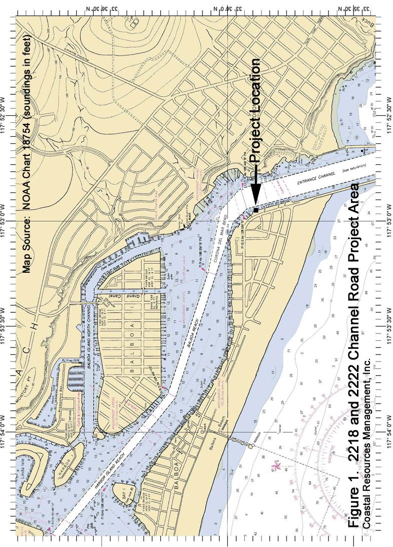
1 Eelgrass Survey Reporting Form 2222 Channel Road Newport Beach, CA Eelgrass (Zostera marina) Survey Survey Date: July 19th, 2013 Report Date: July 26 th, 2013 Prepared by: Coastal Resources Management, Inc. PMB 327, 3334 East Coast Highway Corona del Mar, CA Contact: Rick Ware, Senior Marine Biologist (949) Prepared for: Mr. John Abell 2222 Channel Road Newport Beach, CA This form is required to be submitted for any surveys conducted for the eelgrass, Zostera marina, that are required to be conducted under federal or state permits and authorizations issued by the U.S. Army Corps of Engineers and the Coastal Commission. The form has been designed to assist in identifying eelgrass while ensuring that the required information is consistently documented. Surveys required to be conducted for this species are subject to modification through publication of revisions to the eelgrass survey policy. It is incumbent upon the authorized permittee to ensure that survey work is following the latest protocols. For further information on these protocols, contact: Robert Hoffman, National Marine Fisheries Service, , or William Paznokas, California Department of Fish & Game,
2 Site Name: (common reference) Survey Contact: (name, phone, ) 2222 Channel Road, Newport Beach, California on the Balboa Peninsula. See Figures 1 and 2 Rick Ware, Senior Marine Biologist, Coastal Resources Management, Inc. (949) , rware.crm@earthlink.net Lisa Miller, Shellmaker, Inc. Shellmaker@sbcglobal.net Permit Reference: (ACOE Permit No., CCC Permit No.) Hydrographic System: (bay, estuary, lagoon, or harbor) Specific Location: (UTM, Lat./Long., datum, accuracy level, attach electronic survey area map if possible) Was Eelgrass Detected: ACOE SPL BLR CCC: Newport Harbor 33 o N, 117 o W. NAD 83. Accuracy within 1 meter. See accompanying figures of locations. Yes, Eelgrass was found at this site. EELGRASS WITHIN 15 OF PROJECT Description of Permitted Work: (describe briefly the work to be conducted at the site under the permits identified above) * No, Eelgrass was not found at this site. The property owners subdivided the existing 2222 Channel Road lot into a 36 ft-wide lot at 2218 Channel Road (Carol Helou, property owner) and a 35 ft-wide lot at 2222 Channel Road (John Abell, property owner). A new home was constructed on each lot and each property will have new dock system in front of the residence. The dock systems are being designed by William Simpson and Associates, Inc. Shellmaker Inc. is the project contractor. The project components for 2222 Channel Road include: (1) a dock with an outside length dimension of 18 5, inside length dimension of 5 6 and a width of 10 ; (2) a 4 x 12 8 pier supported by a T pile and (3) a 3 5 x 24 gangway. 2
3 Description of Site: (describe the physical and biological conditions within the survey area at the time of the survey and provide insight into variability, if known. Please provide units for all numerical information). Depth range: Substrate type: Temperature: Salinity: Dominant flora: -2.0 to ft MLLW based on Corona del Mar Newport Entrance Channel Tide Station fine sand to silt Water temperature during the survey was 63 degrees F. Harbor Range: ppt A total of 7,231 square feet (sq ft) of eelgrass (Zostera marina) was mapped in the project area (Figure 3). Of this total, 2,489.3 sq ft were within the boundaries of the 2222 Channel Road (Figure 3 and 4) including two eelgrass patches close to the bulkhead (42.2 and 98.2 sq ft) and a separate larger bed (2,348.9 sq ft). Eelgrass depth limits varied from -2.0 to feet Mean Lower Low Water, and extended from the shallow habitat near the bulkhead to the slope of the main channel. Eelgrass turion density counts (turions per sq meter) were recorded throughout the survey area: South eelgrass patch: mean=200 n=3, 2-3 ft depth North eelgrass patch: mean=117 n=13, ft depth Eelgrass Bed Seaward of Patches Overall mean turion density was /- 57/1 n=33 Impacts on Eelgrass: There will be no direct project-related impacts on eelgrass (Figure 5). The two small eelgrass patches will have a potential to be affected by dock and 3
4 gangway shading requiring that a twoyear post-construction monitoring survey be conducted to determine if shading results in a loss of eelgrass, per Southern California Eelgrass Mitigation Policy Guidelines (NMFS 1991 as amended). Mitigation Measures: Construction mitigation measures to avoid and reduce impacts to eelgrass include: The project marine biologist shall mark the positions of eelgrass beds in the vicinity of the dock and gangway construction area with buoys prior to the initiation of any construction activities; The project marine biologist shall meet with the construction crew prior to construction to orient them to specific areas where eelgrass occurs; The project marine biologist will perform weekly on-site inspections to ensure that BMPs and mitigation measures are being implemented during construction; Support vessels and the work barge should maneuver and work over eelgrass beds only during tides of +2 feet MLLW or higher to prevent grounding within eelgrass beds, damage to eelgrass from propellers, and to limit water turbidity. The work barge and work boat shall not be continuously moored over eelgrass beds; Anchors and anchor chains shall not impinge upon eelgrass habitat; and 4
5 Post-construction marine biological surveys (per the Southern California Eelgrass Mitigation Policy and any permit conditions) will be performed to map eelgrass cover in the project area to determine actual impacts of short-term construction and long-term shading effects on eelgrass bed resources. Dominant fauna: Exotic species encountered: One giant kelp (Macrocystis pyrifera) was present. This will not be affected by the project. Macro-invertebrates observed during the dive survey included the spiny sand star (Astropecten armatus), the tube-dwelling anemone (Pachycerianthus fimbriatus), and the ornate tube worm Diopatra ornata. black perch (Embiotoca jacksoni), kelp bass (Paralabrax clathratus), and round sting ray (Urolophus halleri). Zoobotryon verticillatum Other site description notes: None Description of Survey Effort: (please describe the surveys conducted including type of survey (SCUBA, remote video, etc.) and survey methods employed, date of work, and survey density (estimated percentage of Survey date and time period: July 19 th, hrs The survey was conducted by marine biologists using SCUBA, using agencyapproved transect techniques and mapping techniques using a diverbiologist, a surface-biologist in a kayak following the diver-biologist, and a GPS mapping of the bed s perimeter. 100 % 5
6 the bottom actually viewed). Describe any limitations encountered during the survey efforts. of the project area bay floor was observed. No limitations were encountered during the survey. See more detail below. Horizontal visibility in water: Survey type and methods: 20 ft Underwater surveys were conducted by using SCUBA. Reconnaissance dives were first made to determine the extent of eelgrass in the project area. Where eelgrass was located, divers buoyed the location and continued the reconnaissance survey. Once the reconnaissance survey was completed, GPS (Global Positioning System) technology and a Thales Mobile Mapper GPS/GIS Unit were used to map eelgrass areas. A biologist in a kayak equipped with the GPS followed a SCUBA-diving biologist who towed a surface buoy to mark the perimeter of the eelgrass vegetation. Small patches that were too small for mapping were recorded as point values and an estimated size of the patch was determined by the diver. The estimated GPS error of the Thales Mobile Mapper unit with post-processing correction was approximately 1 meter. GPS data were initially entered into the Mobile Mapper Software and then transferred into GPS TRACKER and ARCVIEW GIS software. The amount of eelgrass habitat in the survey area was calculated using ArcGIS 10.1 and Mobile Mapper Software, and distances from the eelgrass vegetation to the existing docks 6
7 and the bulkhead was were calculated to assist in determining potential project impacts on eelgrass bed resources. Eelgrass turion counts were made within all of the eelgrass vegetation within the 2222 Channel Road project area. Survey personnel: Bottom type, common marine life, and the presence or absence of Caulerpa taxifolia and Zostera marina was noted. Depths were standardized to Mean Lower Low Water (MLLW) based upon time of observation and tidal corrections for the Corona del Mar/Newport Bay Entrance Channel NOAA tide station. Rick Ware, Senior Marine Biologist and Tom Gerlinger, Marine Biologist, CRM Survey density: A total of 25 underwater transects (averaging 122 ft long) were swam between the bulkhead and out past the dock line. These transects were spaced approximately 3 meters apart during the recon survey. From this recon survey, the eelgrass bed perimeters were mapped and eelgrass turion densities counted. 100% of the bottom habitat was surveyed during the field investigation due to excellent visibility Survey Limitations: None. Other Information: (use this space to provide any additional information or references to attached materials such as maps, reports, etc.) See attached project figures. 7
8 8


9 Figure 1. Figure 2. Location of Where Dock Will Be Constructed at 2222 Channel Road 9


10 Figure 3. Pre-Construction Eelgrass Survey, 2222 Channel Road.19 July 2013 Note: Aerial Photograph Does Not Show New Split of 2222 and 2218 Channel Road 10


11 Figure Channel Road Dock Layout With July 2013 Eelgrass Survey Superimposed on the Layout. (Note: Black lines indicate boundary of 2013 eelgrass survey) Source Dock Design: William Simpson and Associates 11
Use of Conservation Moorings as a Component of Eelgrass Restoration in two Massachusetts Harbors
 Use of Conservation Moorings as a Component of Eelgrass Restoration in two Massachusetts Harbors Massachusetts Bays Program Division of Marine Fisheries Jay Baker, Tay Evans, Mass Bays Program MarineFisheries
Eelgrass and Macroalgae Presence/Absence Preliminary Surveys BHP Proposed Grays Harbor Potash Export Facility A Task 400
 Memorandum 40600-HS-MEM-55036 Revision 0 Date: 26 July 2018 Subject: Eelgrass and Macroalgae Presence/Absence Preliminary Surveys BHP Proposed Grays Harbor Potash Export Facility A17.0202.00 Task 400 INTRODUCTION
Eelgrass Survey PARADISE CAY BELVEDERE, MARIN COUNTY CALIFORNIA. Prepared For:
 Eelgrass Survey PARADISE CAY BELVEDERE, MARIN COUNTY CALIFORNIA Prepared For: Radford (Skid) Hall, Ph.D. Land Planning and Permitting Consultant 500 Airport Blvd., Suite 350 Burlingame, CA 94010 (650)
MAINTENANCE DREDGING IN A SENSITIVE ENVIRONMENT CASE STUDY: MANCHESTER ENTRANCE CHANNEL
 MAINTENANCE DREDGING IN A SENSITIVE ENVIRONMENT CASE STUDY: MANCHESTER ENTRANCE CHANNEL Carlos G. Peña, P.E. 1 ABSTRACT Eelgrass (Zostera marina) is a shallow water plant species common in coastal regions
Nome Harbor Page 2 of 12
 Nome Harbor Nome Harbor Page 2 of 12 Condition of Improvements 30 December 2015 Nome Harbor, Alaska (CWIS No. 010422, 012270, 072742, 087755) Authorization (1) Rivers and Harbors Act, 8 August 1917 (House
Comparison of Acoustic and Aerial Photographic Methods for Quantifying the Distribution of Submersed Aquatic Vegetation in Sagamore Creek, NH
 Comparison of Acoustic and Aerial Photographic Methods for Quantifying the Distribution of Submersed Aquatic Vegetation in Sagamore Creek, NH by Bruce Sabol, Elizabeth Lord, Kevin Reine, and Deborah Shafer
Nearshore Habitat Mapping in Puget Sound Using Side Scan Sonar and Underwater Video
 Nearshore Habitat Mapping in Puget Sound Using Side Scan Sonar and Underwater Video Dana Woodruff, Paul Farley, Amy Borde, John Southard, Ron Thom Battelle Marine Sciences Laboratory Jim Norris Marine
DRAFT TECHNICAL MEMORANDUM
 DRAFT TECHNICAL MEMORANDUM From: File No.: 213.001 Re: Beaux Arts Village Shoreline - 2016 Introduction The Washington Academy of Beaux Arts (WABA) completed shoreline habitat restoration at three locations
Friends of Semiahmoo Bay Society Eelgrass Transplant Pilot Project May 6, 2007, Blackie Spit, Surrey, BC.
 Friends of Semiahmoo Bay Society Eelgrass Transplant Pilot Project May 6, 2007, Blackie Spit, Surrey, BC. Prepared for: Friends of Semiahmoo Bay Society Prepared by: Ramona C. de Graaf, BSc., MSc., Emerald
Hydrographic Surveying Methods, Applications and Uses
 Definition: Hydrographic Surveying Methods, Applications and Uses It is the branch of surveying which deals with any body of still or running water such as a lake, harbor, stream or river. Hydrographic
Good Mooring to You! Jensen Beach Mooring Field. Kathy Fitzpatrick, P.E. Coastal Engineer, Martin County
 Good Mooring to You! Kathy Fitzpatrick, P.E. Coastal Engineer, Martin County Penny Cutt Regional Manager, Coastal Systems International Mooring Field Advantages Provide a safe and secure anchorage at a
BASELINE SURVEY, VISUAL - SITE SPECIFIC
 BASELINE SURVEY, VISUAL - SITE SPECIFIC Introduction As stated in SEPA s policy and in the Fish Farm Manual (1998), scientific data are required by SEPA in order to assess the existing condition on the
Admiralty Inlet Pilot Tidal Project FERC No Appendix C. Derelict Gear Monitoring Plan
 Appendix C Derelict Gear Monitoring Plan ADMIRALTY INLET PILOT TIDAL PROJECT FERC PROJECT NO. 12690 DERELICT GEAR MONITORING PLAN (submitted with the Final Application for a New Pilot Project License)
Vieques Underwater Demonstration Project
 Vieques Underwater Demonstration Project NOAA Office of Response and Restoration National Ocean Service 2006-2007 2007 University of New Hampshire Joint Hydrographic Center 2006 Science Application International
Welcome! Did You Know...? Aquatic Centre Dock Rebuild. Key Objectives
 1 Welcome! Aquatic Centre Dock Rebuild The City of Vancouver is improving the dock at the Vancouver Aquatic Centre, which is nearing the end of its service life and is in need of replacement. This creates
Seagrass Surveys in Kampot
 Coastal Annual Forum 23 rd October 2014 Sihanoukville, Cambodia Seagrass Surveys in Kampot Presentation by Louis Bourne INTERNATIONAL UNION FOR CONSERVATION OF NATURE Presentation Overview Location and
ATTACHMENT F. Minnesota Department of Natural Resources. Marsh Lake Ecosystem Restoration Project
 ATTACHMENT F Minnesota Department of Natural Resources Marsh Lake Ecosystem Restoration Project Mussel Rescue and Translocation Plan for Pomme de Terre River Restoration (Prepared June, 2016) Attachment
EPA R6 Dive Team Operations Report. San Jacinto Waste Pits Channelview, TX December 9-10, 2015
 EPA R6 Dive Team Operations Report San Jacinto Waste Pits Channelview, TX December 9-10, 2015 BACKGROUND The San Jacinto River Waste Pit Site history has been documented in several documents prepared for,
Redondo Beach Boat Launch Ramp Facility
 Redondo Beach Boat Launch Ramp Facility Feasibility Report for the California Department of Boating and Waterways 2015 Grant Cycle For the City of Redondo Beach Submitted by March 13, 2014 Table of Contents
V. HARBOR DEPTHS, CHANNEL DESIGN AND PROPOSED CONSTRUCTION AND DREDGING
 V. HARBOR DEPTHS, CHANNEL DESIGN AND PROPOSED CONSTRUCTION AND DREDGING A. DISCUSSION: For the most part, projects that involve dredging and construction require a comprehensive design and review process
Public Notice U.S. Army Corps In Reply to Application Number CENAB-OP-RMS (NATIONAL HARBOR (FORMERLY PORT Baltimore District AMERICA])
![Public Notice U.S. Army Corps In Reply to Application Number CENAB-OP-RMS (NATIONAL HARBOR (FORMERLY PORT Baltimore District AMERICA])](/thumbs/89/100795623.jpg "Public Notice U.S. Army Corps In Reply to Application Number CENAB-OP-RMS (NATIONAL HARBOR (FORMERLY PORT Baltimore District AMERICA])") Public Notice U.S. Army Corps In Reply to Application Number of Engineers CENAB-OP-RMS (NATIONAL HARBOR (FORMERLY PORT Baltimore District AMERICA]) 88-01361 PN 14-05 Comment Period: January 16, 2014 to
Public Notice U.S. Army Corps In Reply to Application Number of Engineers CENAB-OP-RMS (NATIONAL HARBOR (FORMERLY PORT Baltimore District AMERICA]) 88-01361 PN 14-05 Comment Period: January 16, 2014 to
MINNESOTA FRESHWATER MUSSEL SURVEY AND RELOCATION PROTOCOL
 MINNESOTA FRESHWATER MUSSEL SURVEY AND RELOCATION PROTOCOL Minnesota Department of Natural Resources, Division of Ecological and Water Resources U.S. Fish and Wildlife Service, Twin Cities Field Office
Video-Based Mapping of Oyster Bottom in the Upper Piscataqua River, Sturgeon Creek, and Spruce Creek
 University of New Hampshire University of New Hampshire Scholars' Repository PREP Reports & Publications Institute for the Study of Earth, Oceans, and Space (EOS) 1-21-2009 Video-Based Mapping of Oyster
Ketchikan Harbors Thomas Basin and Bar Point Harbor
 Ketchikan Harbors Thomas Basin and Bar Point Harbor Condition of Improvements 30 December 2014 Thomas Basin & Bar Point Harbors Ketchikan, Alaska (CWIS No. 000631 & 087071) Authorization (1) Rivers and
X.B WETLANDS ROGUE RIVER ESTUARY
 X.B WETLANDS ROGUE RIVER ESTUARY The Rogue River has a drainage area of 5,100 square miles, yet the estuary of the Rogue River is one of the smallest in Oregon, measuring approximately 1,880 acres during
LAKE JESUP VEGETATION MAPPING: AN INTER-AGENCY COLLABORATION. Lakshmi Sankaran, GISP Public Works Department, Seminole County
 LAKE JESUP VEGETATION MAPPING: AN INTER-AGENCY COLLABORATION Lakshmi Sankaran, GISP Public Works Department, Seminole County LAKE JESUP Area - 12 sq miles Shoreline - 53 miles Watershed - 136 sq miles
The SONGS artificial reef mitigation project is linked to the adverse effects of the SONGS single pass seawater cooling system on the San Onofre kelp
 1 Welcome to the annual public workshop to review the status and findings of the reef mitigation project for the San Onofre Nuclear Generating Station Compensating for losses to the San Onofre kelp forest
Essential Fish Habitat Description White hake (Urophycis tenuis)
") Description White hake (Urophycis tenuis) In its Report to Congress: Status of the Fisheries of the United States (September 1997), NMFS determined white hake is not currently overfished, but it is approaching
Description White hake (Urophycis tenuis) In its Report to Congress: Status of the Fisheries of the United States (September 1997), NMFS determined white hake is not currently overfished, but it is approaching
New York District Briefing Template
 New York District Briefing Template New York District US Army Corps of Engineers Insert Text Here Dredging Windows Workshop November 30, 2011 Aquatic Biological Survey Winter Flounder Jenine Gallo & Kate
1-22. KETCHIKAN, ALASKA (Thomas and Bar Point Basins) (CWIS NOS & 87071) Condition of Improvement 30 September 2007
 (CWIS NOS & 87071) Condition of Improvement 30 September 2007") KETCHIKAN HARBOR 1-22 KETCHIKAN, ALASKA (Thomas and Bar Point Basins) (CWIS NOS. 00631 & 87071) Condition of Improvement 30 September 2007 AUTHORIZATION: (1) Rivers and Harbors Act, 3 July 1930 (House
KETCHIKAN HARBOR 1-22 KETCHIKAN, ALASKA (Thomas and Bar Point Basins) (CWIS NOS. 00631 & 87071) Condition of Improvement 30 September 2007 AUTHORIZATION: (1) Rivers and Harbors Act, 3 July 1930 (House
APPLICANT: Pacific Northwest National Laboratory Attention: Mr. Charles Brandt 1529 West Sequim Bay Road Sequim, Washington 98382
 US Army Corps of Engineers Seattle District Joint Public Notice Application for a Department of the Army Permit and a Washington Department of Ecology Water Quality Certification and/or Coastal Zone Management
Ninilchik Harbor Page 2 of 11
 Ninilchik Harbor Ninilchik Harbor Page 2 of 11 Condition of Improvements 31 December 2017 Ninilchik Harbor, Alaska (CWIS No. 012640, 087345) Authorization Rivers and Harbors Act, 3 July 1958 (P.L. 85-500
1-44. SITKA HARBOR, ALASKA (Western Channel, Crescent Bay Basin, Channel Rock Breakwaters) (CWIS NOS , 16840, 10322, 55030, 13787)
 (CWIS NOS , 16840, 10322, 55030, 13787)") SITKA 1-44 SITKA HARBOR, ALASKA (Western Channel, Crescent Bay Basin, Channel Rock Breakwaters) (CWIS NOS. 72845, 16840, 10322, 55030, 13787) Condition of Improvement 30 September 2011 AUTHORIZATION:
SITKA 1-44 SITKA HARBOR, ALASKA (Western Channel, Crescent Bay Basin, Channel Rock Breakwaters) (CWIS NOS. 72845, 16840, 10322, 55030, 13787) Condition of Improvement 30 September 2011 AUTHORIZATION:
City of Pittsfield Harbormaster APPLICATION FOR AN INDIVIDUAL MOORING PERMIT
 City of Pittsfield Harbormaster APPLICATION FOR AN INDIVIDUAL MOORING PERMIT INSTRUCTIONS: This application may only be used for requests to place lake moorings. This application must be completed in its
Marine Environment Plans
 Marine Environment Plans 1 Marine Sediment Management Plan 2 Marine Sediment Management Plan: Overview What The Marine Sediment Management Plan (MSMP) describes management of marine sediment disturbed
DRAFT. October 17, 2014 File No Mr. Brendhan Zubricki Town Administrator Essex Town Hall 30 Martin Street Essex, MA.
 GZA GeoEnvironmental, Inc. Engineers and Scientists October 17, 2014 File No. 18.0171857.00 Mr. Brendhan Zubricki Town Administrator Essex Town Hall 30 Martin Street Essex, MA. 01929 DRAFT Re: Essex River
Essential Fish Habitat Description Atlantic cod (Gadus morhua)
") Description Atlantic cod (Gadus morhua) In its Report to Congress: Status of the Fisheries of the United States (September 1997), NMFS determined the Gulf of Maine stock of cod is considered overfished,
Description Atlantic cod (Gadus morhua) In its Report to Congress: Status of the Fisheries of the United States (September 1997), NMFS determined the Gulf of Maine stock of cod is considered overfished,
Orange County MPA Watch A n n u a l R e p o r t
 Orange County MPA Watch 2 0 1 4 A n n u a l R e p o r t WHAT IS AN MPA? Marine Protected Areas (MPAs) are discrete geographic marine or estuarine areas designed to protect or conserve marine life and habitat.
Seagrass surveys must be conducted between the dates of April 1 st and October 31 st with the following exceptions:
 Florida Fish and Wildlife Conservation Commission (FWC) Recommended Survey Protocols for Estuarine and Marine Submerged Aquatic Vegetation (SAV) related to Permitting Applications 12/14/2011 DRAFT 1) Survey
U.S. Army Corps of Engineers Sacramento District
 U.S. Army Corps of Engineers Sacramento District Regional General Permit (RGP) 3 Pre-Construction Notification (PCN) Form This form may be used to request verification for a small, private, recreational
1-32 NOME HARBOR, ALASKA (CWIS NOS , 87755, 12270, & 10422) Condition of Improvement 30 September 2012
 Condition of Improvement 30 September 2012") NOME HARBOR 1-32 NOME HARBOR, ALASKA (CWIS NOS. 72742, 87755, 12270, & 10422) Condition of Improvement 30 September 2012 AUTHORIZATION: (1) Rivers and Harbors Act, 8 August 1917 (House Doc. 1932, 64th
NOME HARBOR 1-32 NOME HARBOR, ALASKA (CWIS NOS. 72742, 87755, 12270, & 10422) Condition of Improvement 30 September 2012 AUTHORIZATION: (1) Rivers and Harbors Act, 8 August 1917 (House Doc. 1932, 64th
LOCAL COASTAL PROGRAM UPDATE
 LOCAL COASTAL PROGRAM UPDATE Agenda Meeting #1 General Information (1 1:45 pm) Introductions and Background Grants involved What is a Local Coastal Program? What is required? LCP Update tasks and schedule
Essential Fish Habitat Description Atlantic herring (Clupea harengus)
") Description Atlantic herring (Clupea harengus) In its Report to Congress: Status of the Fisheries of the United States (September 1997), NMFS determined Atlantic herring is not currently overfished. This
Description Atlantic herring (Clupea harengus) In its Report to Congress: Status of the Fisheries of the United States (September 1997), NMFS determined Atlantic herring is not currently overfished. This
Project Incorporation of Sea Level Rise City of Newport Beach Approach for Balboa Islands, City of Newport Beach, California
 Project Incorporation of Sea Level Rise City of Newport Beach Approach for Balboa Islands, City of Newport Beach, California Ying Poon, Everest International Consultants, Inc. CMANC Annual Winter Meeting
Rising Tide Oyster Company 2.0 Acre Bellamy Site Marine Aquaculture License Application
 Rising Tide Oyster Company 2.0 Acre Bellamy Site Marine Aquaculture License Application Joshua and Jessica Carloni 264 Swain Road Barrington, N.H. 03825 Summary This is an amendment to our existing license
Orange County MPA Watch M o n i t o r i n g H u m a n U s a g e
 Orange County MPA Watch M o n i t o r i n g H u m a n U s a g e WHAT IS AN MPA? Marine Protected Areas (MPAs) are discrete geographic marine or estuarine areas designed to protect or conserve marine life
Vieques Munitions Response: Current Issues
 Vieques Munitions Response: Current Issues NAOC General Membership Meeting December 7, 2016 Agenda Project Overview Surface Clearance Subsurface Clearance Remote Controlled Equipment Underwater MEC Open
Survey Technique for Underwater Digital Photography with Integrated GPS Location Data
 Survey Technique for Underwater Digital Photography with Integrated GPS Location Data Tim Siwiec: United States Environmental Protection Agency Abstract This survey technique is an inexpensive method of
Juneau Douglas Harbor
 Juneau Douglas Harbor Douglas Harbor Page 2 of 8 Condition of Improvements 31 December 2015 Douglas Harbor, Alaska (CWIS No. 072789, 180942) Authorization Rivers and Harbors Act, 3 July 1958 (House Doc.
Condition of Improvements 30 December 2014 Wrangell Harbors, Alaska (CWIS No , )
") Wrangell Harbors Condition of Improvements 30 December 2014 Wrangell Harbors, Alaska (CWIS No. 010435, 021500) Authorization (1) Rivers and Harbors Act, 22 September 1922 (House Doc. 161, 67th Congress,
Wrangell Harbors Condition of Improvements 30 December 2014 Wrangell Harbors, Alaska (CWIS No. 010435, 021500) Authorization (1) Rivers and Harbors Act, 22 September 1922 (House Doc. 161, 67th Congress,
Two types of physical and biological standards are used to judge the performance of the Wheeler North Reef 1) Absolute standards are measured against
 Absolute standards are measured against") 1 Two types of physical and biological standards are used to judge the performance of the Wheeler North Reef 1) Absolute standards are measured against fixed value at Wheeler North Reef only 2) Relative
1 Two types of physical and biological standards are used to judge the performance of the Wheeler North Reef 1) Absolute standards are measured against fixed value at Wheeler North Reef only 2) Relative
Near-Field Sturgeon Monitoring for the New NY Bridge at Tappan Zee. Quarterly Report July 1 September 30, 2014
 Near-Field Sturgeon Monitoring for the New NY Bridge at Tappan Zee Quarterly Report July 1 September 30, 2014 Prepared by AKRF, Inc. 7250 Parkway Drive, Suite 210 Hanover, MD 21076 for New York State Thruway
CITY OF NEWPORT BEACH HARBOR COMMISSION STAFF REPORT
 CITY OF NEWPORT BEACH HARBOR COMMISSION STAFF REPORT Agenda Item No. 2 TO: FROM: SUBJECT: HARBOR COMMISSION Harbor Resources Division (City Manager's Office) Chris Miller, Harbor Resources Supervisor,
Final Cruise Report Marine Mammal Observer UNDET Monitoring Hawaii Range Complex, April, 2011
 213 APPENDIX I. Cruise Report, Marine Mammal Observer UNDET Monitoring Hawaii Range Complex, August 12, 2011 Final Cruise Report Marine Mammal Observer UNDET Monitoring Hawaii Range Complex, 26-27 April,
Baa Atoll Project. Hanifaru Training Guidelines
 Baa Atoll Project Hanifaru Training Guidelines Baa Atoll Project All six resorts in the Baa Atoll have come together with the local communities to form a working group to target environmental issues. The
1-32 NOME HARBOR, ALASKA (CWIS NOS , 87755, & 10422) Condition of Improvement 30 September 2009
 Condition of Improvement 30 September 2009") NOME HARBOR 1-32 NOME HARBOR, ALASKA (CWIS NOS. 72742, 87755, & 10422) Condition of Improvement 30 September 2009 AUTHORIZATION: (1) Rivers and Harbors Act, 8 August 1917 (House Doc. 1932, 64th Congress,
NOME HARBOR 1-32 NOME HARBOR, ALASKA (CWIS NOS. 72742, 87755, & 10422) Condition of Improvement 30 September 2009 AUTHORIZATION: (1) Rivers and Harbors Act, 8 August 1917 (House Doc. 1932, 64th Congress,
Quantitative Freshwater Mussel Survey Date Prepared: 11/20/2017
 PARTNERSHIP FOR THE DELAWARE ESTUARY Science Group Quantitative Freshwater Mussel Survey Date Prepared: 11/20/2017 Prepared By: Kurt Cheng Suggested Citation: Cheng, K. 2017. Quantitative Freshwater Mussel
Appendix F: Ecology F-6 Methodology for Estimating Potential Hydroacoustic Impacts to Abundant Hudson River Fish Species and Shortnose Sturgeon from
 Appendix F: Ecology F-6 Methodology for Estimating Potential Hydroacoustic Impacts to Abundant Hudson River Fish Species and Shortnose Sturgeon from Pile-driving Activities during Construction of the Tappan
STATE OF MAINE DEPARTMENT OF MARINE RESOURCES
 STATE OF MAINE DEPARTMENT OF MARINE RESOURCES IN THE MATTER OF THE APPLICATION OF GREAT ) EASTERN MUSSEL FARMS FOR AN AQUACULTURE ) FINDINGS OF FACT, LEASE LOCATED OFF OF HADLEY POINT IN THE ) CONCLUSIONS
Department of Marine Resources Site Review #
 Department of Marine Resources Site Review #2017-11 Taunton Bay Oyster Company, Inc. P.O. Box 613 Ellsworth, ME 04605 207-266-3353 Figure 1: Vicinity map 1 Location: Taunton Bay, Town of Hancock, Hancock
Keywords: marine habitat recovery, derelict fishing gear
 Marine habitat recovery after derelict fishing net removal. Jeff June*, Kyle Antonelis, Natural Resources Consultants, Inc. Seattle, WA. *Corresponding author: jjune@nrccorp.com Keywords: marine habitat
Delineation of the Asian Clam (Corbicula fluminea) Population at Sand Harbor State Park, Nevada
 Population at Sand Harbor State Park, Nevada") Delineation of the Asian Clam (Corbicula fluminea) Population at Sand Harbor State Park, Nevada Report to the Nevada Division of State Lands and the Tahoe Regional Planning Agency Final Draft Brant Allen,
Delineation of the Asian Clam (Corbicula fluminea) Population at Sand Harbor State Park, Nevada Report to the Nevada Division of State Lands and the Tahoe Regional Planning Agency Final Draft Brant Allen,
INCIDENT REPORT OASIS SAILING CLUB
 1) BOAT DESCRIPTION INCIDENT REPORT OASIS SAILING CLUB Name: Make: CATALINA Length: 34' 6" Registration: Model: CATALINA 34 MKII Type: SLOOP Hull ID: Year Built: Motor: 30 hp Diesel 2) BOAT OWNER Friends
Chateaugay Lakes Milfoil Control Program
 Chateaugay Lakes Milfoil Control Program Summary of Activities and Findings for June August 29 Prepared By: Daniel L. Kelting Executive Director Adirondack Watershed Institute Paul Smith's College P.O.
Underwater Videographic and Hydroacoustic Eelgrass Survey Chimacum/Irondale Beach Restoration Site September 12, 2006
 Underwater Videographic and Hydroacoustic Survey Chimacum/Irondale Beach Restoration Site September 12, 2006 by James G. Norris and Ian E. Fraser Submitted To: North Olympic Salmon Coalition PO Box 699
New Millennium Dive Expeditions
 New Millennium Dive Expeditions 15030 N Timberline Drive Reno, NV 89511 (775)850-2510 * nmde@att.net www.nmde.org Project Report July 12, 2013: Phase 1 of 2 (Phase 2: August 26 th 30 th, 2013) Supporting
NEVADA DEPARTMENT OF WILDLIFE STATEWIDE FISHERIES MANAGEMENT
 NEVADA DEPARTMENT OF WILDLIFE STATEWIDE FISHERIES MANAGEMENT FEDERAL AID JOB PROGRESS REPORTS F-2-49 213 RYE PATCH RESERVOIR WESTERN REGION NEVADA DEPARTMENT OF WILDLIFE, FISHERIES DIVISION ANNUAL PROGRESS
Figure 1. Schematic illustration of the major environments on Mustang Island.
 STOP #1: PACKERY CHANNEL BEACH TO BAY We will start this field guide near the north jetty of Packery Channel and hike across the island to Corpus Christi Bay (fig. 1). The island emerges from the Gulf
FACT SHEET NAVY CORAL REEF PROTECTION
 FACT SHEET NAVY CORAL REEF PROTECTION 1. MAPPING ASSESSING AND MONITORING OF CORAL REEFS DoD Coral Reef Assessment. DoD Legacy Resource Management Program funding was received in FY-01 to support an overall
Citizen Science Based Survey GBR Far North Dive Trip 2016 April 18-26
 Citizen Science Based Survey GBR Far North Dive Trip 2016 April 18-26 Chris Roelfsema Karen Johnson Douglas Stetner Trevor Baerenger Peran Brady May 2016 GBR Far North Citizen Science Trip 5 May 2016 1
New two-lane bridge to replace the existing structure spanning the Maple River just south of the Village s central business district
 New two-lane bridge to replace the existing structure spanning the Maple River just south of the Village s central business district Rehabilitate the old bridge Convert to a nonmotorized trail Restore
Data Collection and Processing: Elwha Estuary Survey, February 2013
 Data Collection and Processing: Elwha Estuary Survey, February 2013 Ian Miller, WA Sea Grant Olympic Peninsula Field Office, 1502 E. Lauridsen Blvd #82, Port Angeles, WA 98362 immiller@u.washington.edu
Preventing Damage to Harbour Facilities and. Ship Handling in Harbours PART 2 INDEX
 Preventing Damage to Harbour Facilities and Ship Handling in Harbours PART 2 INDEX 1 Vessel handling is based on the basic knowledge that a vessel floats in the water and returns to its original position
THE CHALLENGES OF A LARGE-AREA BATHYMETRIC SURVEY
 THE CHALLENGES OF A LARGE-AREA BATHYMETRIC SURVEY Agenda: - Introduction - Tender - Project Planning - Survey - Processing - Delivery - Conclusion 2 Introduction We know less of the oceans at our feet,
STUDY REPORT W&AR-03 RESERVOIR TEMPERATURE MODEL ATTACHMENT B DON PEDRO RESERVOIR BATHYMETRIC STUDY REPORT
 STUDY REPORT W&AR-03 RESERVOIR TEMPERATURE MODEL ATTACHMENT B DON PEDRO RESERVOIR BATHYMETRIC STUDY REPORT DON PEDRO RESERVOIR BATHYMETRIC STUDY REPORT Prepared for: TURLOCK IRRIGATION DISTRICT MODESTO
Chinook Salmon Spawning Study Russian River Fall 2005
 Chinook Salmon Spawning Study Russian River Fall 2005 Sonoma County Water Agency 2150 West College Avenue Santa Rosa, California 95401 Prepared by David Cook - Senior Environmental Specialist March 27,
NEVADA DEPARTMENT OF WILDLIFE STATEWIDE FISHERIES MANAGEMENT
 NEVADA DEPARTMENT OF WILDLIFE STATEWIDE FISHERIES MANAGEMENT FEDERAL AID JOB PROGRESS REPORTS F-20-52 2016 RYE PATCH RESERVOIR WESTERN REGION NEVADA DEPARTMENT OF WILDLIFE, FISHERIES DIVISION ANNUAL PROGRESS
Unalaska Navigation Channel Improvements
 1 237 237 237 255 255 255 0 0 0 Unalaska Navigation Channel Improvements 217 217 217 200 200 200 163 163 163 131 132 122 239 65 53 80 119 27 252 174.59 110 135 120 112 92 56 62 102 130 102 56 48 130 120
City of Pittsfield HARBORMASTER RULES AND REGULATIONS on docks
 City of Pittsfield HARBORMASTER RULES AND REGULATIONS on docks Definitions Dock: Any permanently fixed or floating structure extending from the upland into the water, capable of use for vessel mooring
Environmental. Effects of Dredging
 Envi~onmental Effects of Dredging Technical Notes THE VALUE OF GRAVEL DISPOSAL MOUNDS IN RIVER SIDE CHANNELS FOR FRESHWATER MUSSELS PURPOSE: This note provides information on the value of gravel disposal
EXECUTIVE SUMMARY. Argyll Marine Special Areas of Conservation
 Argyll Marine Special Areas of Conservation Legislative Background Under the Habitats Directive (Council Directive 92/43/EEC on the conservation of natural habitats and of wild fauna and flora), Loch Creran
Determining coral reef impacts associated with boat anchoring and user activity
 Determining coral reef impacts associated with boat anchoring and user activity Protect Our Reefs Grant Interim Report October 1, 2008 March 31, 2009 Donald C. Behringer 1, Thomas K. Frazer 1, Robert A.
Welcome to Paddle for the Edge!
 Welcome to Paddle for the Edge! Thank you for volunteering to conduct a survey of the Barnegat Bay s shorelines. As a citizen scientist, you become part of a project to collect critical data about current
UPPER BEACH REPLENISHMENT PROJECT RELATED
 ASSESSMENT OF SAND VOLUME LOSS at the TOWNSHIP of UPPER BEACH REPLENISHMENT PROJECT RELATED to the LANDFALL OF HURRICANE SANDY - PURSUANT TO NJ-DR 4086 This assessment is in response to Hurricane Sandy
SEAGRASS MAPPING FOR THE PENRHYN ESTUARY HABITAT ENHANCEMENT PLAN
 SEAGRASS MAPPING FOR THE PENRHYN ESTUARY HABITAT ENHANCEMENT PLAN PREPARED FOR SYDNEY PORTS CORPORATION By D. E. Roberts, S. R. Murray, G. R., Sainty August 2008 TABLE OF CONTENTS INTRODUCTION...3 METHODS...3
ADL Attachment 1
 (formerly) 106502 Kina Cove A reapplication for an expired lease. The type of commercial use is identical to that previously. The immediate off-shore tidelands will be used to dump, raft, and store round
Orange County MPA Watch A n n u a l R e p o r t
 Orange County MPA Watch 2 0 1 5 A n n u a l R e p o r t WHAT IS AN MPA? Marine Protected Areas (MPAs) are discrete geographic marine or estuarine areas designed to protect or conserve marine life and habitat.
Context Most US West Coast open coast estuaries have: INTERTIDAL AQUACULTURE AS HABITAT IN PACIFIC NORTHWEST COASTAL ESTUARIES: CONSIDERING SCALE
 INTERTIDAL AQUACULTURE AS HABITAT IN PACIFIC NORTHWEST COASTAL ESTUARIES: CONSIDERING SCALE Brett Dumbauld USDA Agricultural Research Service Context Most US West Coast open coast estuaries have: Broad
Fine-Scale Survey of Right and Humpback Whale Prey Abundance and Distribution
 DISTRIBUTION STATEMENT A. Approved for public release; distribution is unlimited. Fine-Scale Survey of Right and Humpback Whale Prey Abundance and Distribution Joseph D. Warren School of Marine and Atmospheric
Summary of Research within Lamlash Bay No-Take Zone - Science report for COAST July
 Summary of Research within Lamlash Bay No-Take Zone - Science report for COAST July 2013 - *Picture of a spider crab (Macropodia spp) inside a plumose anemone. Taken within Lamlash Bay No-Take Zone by
UNITED NEW YORK SANDY HOOK PILOTS BENEVOLENT ASSOCIATION AND UNITED NEW JERSEY SANDY HOOK PILOTS BENEVOLENT ASSOCIATION
 UNITED NEW YORK SANDY HOOK PILOTS BENEVOLENT ASSOCIATION AND UNITED NEW JERSEY SANDY HOOK PILOTS BENEVOLENT ASSOCIATION TO: All Shipping Agents and Interested Parties January 19, 2017 SUBJECT: Anchorage
2005 ABC. Chapter 3 Part 2. Navigating with ATON's. Revision to D-13 Local Notes. Instructor Notes for Mike Brough. Mike Brough
 2005 ABC Chapter 3 Part 2 Navigating with ATON's Revision to D-13 Local Notes Instructor Notes for Mike Brough Mike Brough June 24 2008 June 24 2008 Slide 1 June 24 2008 New graphics Navigating on Water
VIDEO TRANSCRIPT. A Proposal to Expand the Flower Garden Banks National Marine Sanctuary An interview with Sanctuary Superintendent, G.P.
 VIDEO TRANSCRIPT A Proposal to Expand the Flower Garden Banks National Marine Sanctuary An interview with Sanctuary Superintendent, G.P. Schmahl (Opening scene of Flower Garden Banks National Marine Sanctuary
Port Townsend Waterfront Eelgrass Survey September 5 & 8, 2014 Jefferson MRC
 September 5 & 8, 2014 Jefferson MRC This project has been funded wholly or in part by the United States Environmental Protection Agency. The contents of this document do not necessarily reflect the views
SAN DIEGUITO WETLANDS RESTORATION PROJECT 08 JANUARY 2018 BEACH PROFILES CITY OF DEL MAR, CALIFORNIA. Data Report
 SAN DIEGUITO WETLANDS RESTORATION PROJECT 08 JANUARY 2018 BEACH PROFILES CITY OF DEL MAR, CALIFORNIA Data Report Prepared by Coastal Environments, Inc. 2166 Avenida de la Playa, Suite E La Jolla, CA 92037
NEED FOR SUPPLEMENTAL BATHYMETRIC SURVEY DATA COLLECTION
 305 West Grand Avenue, Suite 300 Montvale, New Jersey 07645 Phone 201.930.9890 Fax 201.930.9805 www.anchorqea.com M EMORANDUM To: Caroline Kwan and Nica Klaber U.S. Environmental Protection Agency Region
Figure 4, Photo mosaic taken on February 14 about an hour before sunset near low tide.
 The Impact on Great South Bay of the Breach at Old Inlet Charles N. Flagg and Roger Flood School of Marine and Atmospheric Sciences, Stony Brook University Since the last report was issued on January 31
SHOOTING ISLAND RESTORATION: LIVING SHORELINE AND HABITAT CONSTRUCTION
 : : : : LIVING SHORELINE AND HABITAT CONSTRUCTION CITY OF OCEAN CITY, NEW JERSEY CONTRACT NO. 8 ID 4468 Sheet List Table Sheet Number Sheet Description Sheet Title Newark T- TITLE SHEET G- SITE OVERVIEW
Sussex County, DE Preliminary Study Overview
 Sussex County, DE Preliminary Study Overview Coastal study scope: 102 miles of entire County shoreline Revised 102 panels for coastal study Riverine study scope: 14 streams, 67.1 miles, within the Nanticoke
Thanks to: -Current and former Habitat staff -Fish Program Marine Fish Division & Region 6 Staff
 Thanks to: -Current and former Habitat staff -Fish Program Marine Fish Division & Region 6 Staff - Overview Intro to forage fish What they are and why are they important Nearshore Forage Fish Habitat surveys