Friends of Semiahmoo Bay Society Eelgrass Transplant Pilot Project May 6, 2007, Blackie Spit, Surrey, BC.
|
|
|
- Felix Walton
- 5 years ago
- Views:
Transcription


1 Friends of Semiahmoo Bay Society Eelgrass Transplant Pilot Project May 6, 2007, Blackie Spit, Surrey, BC. Prepared for: Friends of Semiahmoo Bay Society Prepared by: Ramona C. de Graaf, BSc., MSc., Emerald Sea Research and Consulting


2 Acknowledgments: Funding and support provided by: Vancity EnviroFund and the Vancouver Foundation Additional funding and support provided by: Nature Canada; Brian Naito, Pacific Region, Fisheries and Oceans Canada; Seagrass Conservation Working Group; Cynthia Durance, Precision Identification Biological Consultants; Greg Ward, City of Surrey, Parks; Margaret Cuthbert, Sharon Jeffery, FreeDive Canada, and Emerald Sea Research and Consulting;. With special thanks to all Friends of Semiahmoo Bay Society and FreeDive Canada volunteers: Elaine Cox, Christine Cummings, Yvonne Dawydiak, Greg Fee, Esther Johnson, Joe Johnson, Eileen and Fred Kaarsemaker, Tom Lightfoot, Manfred Lippe, Jennifer Pollard, Lynn Pollard, Dr. Al Schultz, Michelle Scott, Jane Weiss, Faye Wilson, and Bryony. Photos by: Ramona de Graaf, Eileen Kaarsemaker
3 Executive Summary Eelgrass Transplant Pilot Project May 6, 2007, Blackie Spit, Surrey, BC. On May 6, 2007, 17 volunteers and the field coordinator conducted an eelgrass (Zostera marina) transplant at Blackie Spit, Surrey, BC. Four hundred shoots were transplanted at three different locations (southern site, northern site, and lagoon site) in two different sediment types (mud and gravel) and at three depths. On August 13, 2007, the southern and northern sites were monitored by walking the low tide line and walking waist deep in the water. No shoots were found. On September 20, 2007, the two subtidal sites were monitored by scuba and freedivers. In total, nine surviving shoots were found. All surviving shoots were located in gravel sediments. The average length of blades (83.2 cm) on surviving shoots, as at September 20, was 22.9 cm greater than the length of the May 6 donor shoots (60.3 cm). Some individual shoots measured on September 20, 2007, were two times the length of the average blade length measured on May 6, All surviving shoots were in gravel sediment and in the deepest transplant plots. Results indicate that mud sediment should be avoided when transplanting Zostera marina at this location. Overall, 16% of shoots planted in gravel, subtidal plots survived the transplant. Any future transplants within the proposed compensation area should be conducted in gravel sediments at depths below chart datum (or subtidal). Favourable depths for transplanting eelgrass in gravel sediments are -0.3 m to -0.6/-0.8m. Introduction: Friends of Semiahmoo Bay Society conducted an eelgrass, Zostera marina, transplant at Blackie Spit, Surrey, BC on May 6, Eelgrass transplants can be conducted to restore environments where eelgrass was once present. Eelgrass transplants are often used for mitigation where eelgrass habitat is lost and proponents are required to restore the hectares lost at compensation areas. Therefore, an inventory of potential compensation/restoration sites is important as part of a larger strategy and Fisheries and Oceans Canada s policy of no-net loss of eelgrass in British Columbia. Before largescale transplants are conducted, sites are accessed for their potential to support Z. marina growth. After such an assessment, small test plots of transplanted donor stock are conducted and then monitored. In November of 2006, an assessment of the Blackie Spit area was conducted by Precision Identification Biological Consultants. (Appendix A). The purpose of the FoSBS 2007 transplant was to investigate conditions for growth of Zostera marina at Blackie Spit. Zostera marina and Zostera japonica beds were mapped by FoSBS in 2004 (Figure 1) (see report Zostera marina and Zostera japonica Sensitive Habitat Inventory: a comparison of seagrass distribution and abundance 1995, 2002, and 2004 Blackie Spit 2004, Crescent Beach, Surrey, British Columbia). At Blackie Spit, there is an eelgrass bed on the northern corner of the spit but it does not extend beyond the tip of the spit to the south. As part of the restoration and enhancement of habitat for species within the Boundary Bay Wildlife Management Area, expanding eelgrass habitat is an important component of habitat protection and environmental enhancement. The May 6, 2007, pilot transplant project was conducted to test the conditions in the area for eelgrass growth.

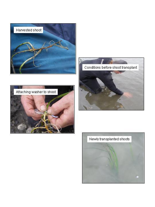
4 Figure 1: Location of eelgrass beds, Blackie Spit, Surrey, BC. The Transplant: On May 6, 2007, 17 volunteers met for an orientation and training session at Blackie Spit. At approximately 12:30 pm, 400 hundred donor shoots were harvested from the extensive Zostera marina bed located along the edge of the boat dredge at Crescent Beach. These shoots were brought to Blackie Spit where volunteers attached a 5/8 stainless steel washer to each rhizome and all shoots were transplanted within three hours of being harvested (Appendix B). Length and width measurements of 30 representative donor shoots are given in Table 1. Photos of the transplant process are in Appendix B. The day was cool and rainy; and as a result, there were very few visitors to the area on the day of the transplant. Approximately 10 individuals were informed of the transplant event and were given copies of the FoSBS eelgrass brochure and a flyer (Appendix C). Appendix D is a copy of the article from the Peace Arch News of two FoSBS events that week. Within the potential compensation area (Appendix A), two sites were chosen with different sediment conditions (Figure 2). The sediment character at the southern site (site one) progresses from a mud/silt intertidal to a subtidal that is primarily gravel and mud. The sediment character at the northern site (site two) progresses from a gravel intertidal to a subtidal that is primarily mud/silt. The two subtidal sites were less than 100 metres apart.

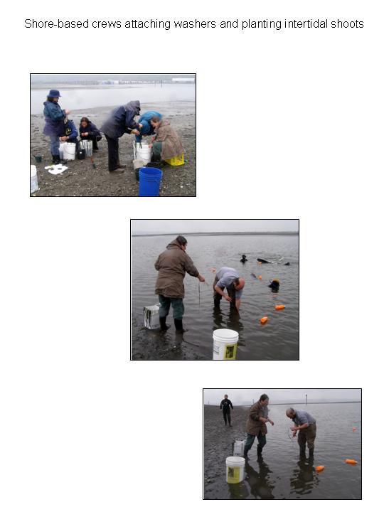
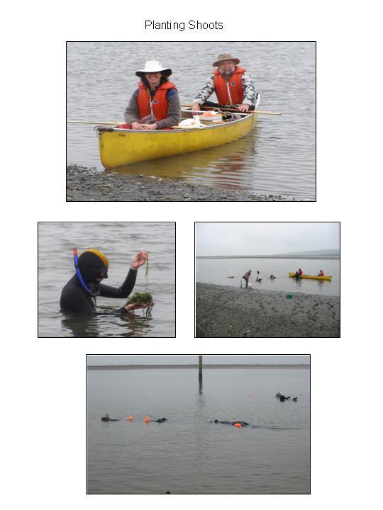
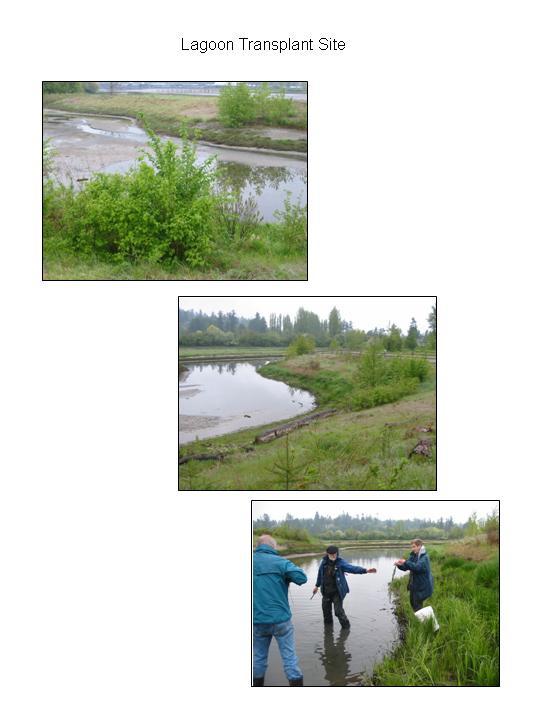
5 Figure 2: Map of Blackie Spit, Surrey, BC showing transplant site locations. The total length of each subtidal transplant site was less than 15 metres. The divers commented that transplanting at the northern site was much easier due to the softer sediments relative to the southern site. As well as testing different sediment characteristics, three different tide heights were also tested in three plots at each subtidal site: intertidal +0.6/0.8 m, 0.0 m, and subtidal -0.6/-0.8 m relative to chart datum. Divers depths are subject to errors due to divers depth gauges and published tide tables to barometric pressure deviation. None of the sediments were anoxic. A third site was planted in the intertidal `mitigation lagoon. The southern site was the first planted with the divers commencing at 2:30 p.m., and the shore crew commencing at the low tide line at 3 p.m. Shore-based crews located at the low tide line (+0.6 m) planted 5 eelgrass patches consisting of 10 shoots per patch and placed approximately 1 meter apart. Snorkelers and freedivers planted 5 eelgrass patches (10 shoots per patch) at 0.0 m and -0.8 m depth. At the northern site, divers commenced planting at 3:30 p.m. and ended at 4:10 pm; and the shore crew commenced planting at 3 p.m. Shore-based crews located at the low tide line (+0.8 m) planted 5 eelgrass patches consisting of 10 shoots per patch placed approximately 1 metre apart. Snorkelers and freedivers planted 5 eelgrass patches (10 shoots per patch) at 0.0 m and -0.6 m/-0.8 m depth. At the north site, there was one Z. marina shoot located near the low tide mark (+0.5m) in gravel sediment; and 13 shoots were planted around that single shoot. Also, as part of a plan for a future public education display, at 4:10 5:00 p.m., 87 shoots were transplanted in 9 patches (8 patches of 10 shoots; and 1 patch of 7 shoots) in the intertidal `mitigation` lagoon located at the southern edge of Blackie Spit.
6 In total, 15 patches totaling 150 shoots were transplanted at each subtidal site, 13 additional shoots to reinforce a single shoot already present; and 87 shoots planted at the lagoon site. In total, 400 shoots were transplanted. Monitoring Results: On August 13, 2007, all transplant sites were walked to look for transplanted shoots. No shoots were detected using this visual survey. While the tide height of the day did not allow for proper inspection of the 0.0 m and -0.8 m transplant patches, the intertidal patches would have been detectable. One stainless steel washer was recovered at the northern site. The lagoon site was also monitored on foot. No shoots were detected in this shallow lagoon. The surface waters of the lagoon where thick with green algae (Ulva sps). As well, the sediments were noted to be anoxic both near the surface and to approximately 20 cm deep, a condition that would not permit eelgrass growth. On September 20, 2007, the transplant sites were monitored by divers Sharon Jeffery, Greg Fee and field crew David Jeffery. Using a GPS, and coordinates from the original transplant, the outer edges of the transplant site were marked with floats. Divers searched from 15m north of each transplant site to 15m south of the sites using a grid search with 1m intervals. A depth range of more than 2.0 m was searched which overlapped with the depth the eelgrass was originally planted at (+0.8 to -0.8m). For every plant encountered, the total length, sheath length, width and number of leaves were measured and recorded (Table 2). The location of each plant was also marked with a GPS at the surface (Figure 3). Approximately 45 minutes were spent searching at each site. The kayak stayed close to the divers to record GPS points, and kept a dive flag near them to ward off passing boats. Eight plants (P3-P10) were found at the southern transplant site corresponding to three of the original transplanted patches. They were all at a depth of -0.3 m relative to chart datum corresponding to the deepest transplant patches (Figure 3). Two of the transplanted patches had three healthy plants each (from the original five transplanted patches with ten shoots in each patch), and the third patch had only two plants. These two plants were broken such that only the sheath remained. The transplanted patches of plants were positioned less than a meter from each other, and the plants within each cluster were very close to one another so that the original planting arrangement of transplanted patches was very obvious. Divers searched carefully in the vicinity of the three patches clusters hoping to find evidence (uprooted shoots, rhizomes, washers etc) of the other plants from the transplant, but nothing was found. Although the dive depth information varies slightly, the depth of the surviving shoots at the southern location correspond to the subtidal transplant plots of May 6, At the northern transplant site a single, small and healthy looking plant (P1) was found. It was within the depth range of where the intertidal transplanted plants should have been, but was all alone, and no evidence of other plants or transplant materials (i.e. washers) could be found near it. No evidence of the single plant with 13 donor shoots added to the patch above the low tide line transplant patches was found. Well outside of either transplant area a single, healthy eelgrass plant was found growing slightly shallower than the transplant areas. This plant was likely not part of the original transplant. All surviving transplanted shoots were in gravel sediments (northern site having gravel intertidal sediments and the southern site having gravel subtidal sediments).

7 Figure 3: Relative location of May 6, 2007, transplanted eelgrass patches, perimeter markers and surviving transplanted shoots monitored on September 20, 2007.
8 Blade Measurements: The average blade length of the transplanted shoots measured on September 20, 2007, (83.2 cm) was 22.9 cm longer than the average lengths measured on May 6, 2007 (60.3 cm). The blade widths were not different. Some individual blades grew to 100, 150 and 160 cm in length (Table 2). Table 1: Lengths and widths of Zostera marina donor stock eelgrass blades, May 6, P la n t ID L e n g th (c m ) W id th (m m ) P la n t ID L e n g th (cm ) W id th (m m ) A v e ra g e : Table 2: Shoot blade measurements on September 20, Plant ID Total length (cm) Sheath length (cm) Leaf length (cm) (totalsheath) Width Number Waypoint (mm) of leaves Comment north site between transplant sites South site South site South site South site South site South site South site- Broken plant South site- Broken plant Average
9 Discussion and Recommendations: The proposed compensation area is within a dredged boat channel with considerable boat traffic in the summer months and maximum depths are limited to only a few metres below chart datum. The design of this transplant project allowed both sediment and depth parameters to be tested. Sediments: The northern transplant site is the closest location to the existing eelgrass bed which extends around the tip of Blackie Spit but ends several hundred metres before the northern transplant site (see FoSBS 2004 report). Knowing the sediment characteristics and light environment of this eelgrass bed would be useful to future transplants. While light characteristics are likely the same at both the northern and the southern sites, the results from this project show that consideration of benthic sediments is important as all surviving Zostera marina shoots were located in gravel sediment. It appears that the subtidal mud sediments at the northern site and the intertidal mud sediment at the southern site did not provide a favourable location for eelgrass growth. At the intertidal `mitigation` lagoon transplant location, none of the 87 transplanted shoots survived. The lagoon is an unfavourable location for Zostera marina growth. This may have been due to the growth of algae at the site which may have blocked sunlight as well as the condition of the sediments. Depth: Due to the failure of intertidal eelgrass patches to survive or gain in blade length, conditions within the intertidal zone (+0.6/+0.8 m and 0.0 m relative to chart datum) appear to be unfavourable for Zostera marina growth at these specific test locations. As well, the single surviving shoot at the northern site did not show any change in blade length. From the GPS location map (Figure 3), the shoot was likely planted in the intertidal transect plots with a gravel sediment character. All surviving shoots at the southern site were in the subtidal transplant plot. Eight shoots out of 50 transplanted (or 16 percent) at that depth survived. As the average length of eelgrass blades in the subtidal transplant plot was more than 20 cm longer after six months, the surviving shoots grew very well. Some single shoots measured were two times the length of the average shoot length on May However, it should be noted that only 15 donor shoots were measured for length and width arriving at the average shoot length measurement. It is possible that the surviving shoots measured on September 20 were from donor shoots that were already longer than the average shoot length measured on May 6, 2007; and that shoot growth between May and September is less than reported. Overall, 16 percent of shoots planted in gravel, subtidal plots survived the transplant. Any future transplants within the proposed compensation area should be conducted in gravel sediments at subtidal depths. Favourable depths for transplanting eelgrass in gravel sediments are -0.3 m to -0.6/-0.8m (below chart datum).
, and observed that the subtidal eelgrass habitat extends well beyond the area")
10 Appendix A Boundary Bay, Blackie Spit The Friends of Semiahmoo Bay Society (FoSBS) suggested the eastern side of Blackie Spit as a potential eelgrass compensation area. The FoSBS have mapped the intertidal and shallow subtidal eelgrass habitat along the western side of the spit (Figure 3), and observed that the subtidal eelgrass habitat extends well beyond the area that was mapped. The area along the western side of Blackie Spit had not been assessed, however the FOSBS noted that there was not any eelgrass exposed at this location during low tide. Figure 3. Blackie Spit. The intertidal and shallow subtidal eelgrass beds (Zostera marina; dark green and Z. japonica; light green and brown) were mapped by the Friends of Semiahmoo Bay. The potential compensation area is located along the banks of the channel within the area delineated by the yellow dotted line. Blackie Spit was created by pumping dredged material into the slough between Crab Man s Island and a dyke many decades ago. 1 The local community has been actively restoring the upland habitat of the spit by replacing exotic vegetation with native species. A dyke has been breached to create an intertidal lagoon at the mouth of the Nicomekl River, adjacent to the proposed compensation area. The lagoon was developed as compensation for dredging in the area. 1
11 The Nicomekl River and its tributaries support runs of coho, Chinook, chum, and pink salmon; cutthroat, steelhead, and rainbow trout; as well as red-sided shiners, three-spine stickleback, western lamprey, brown bullhead, carp, and sculpins. A bed of native Olympia oysters replaced by the more common introduced Pacific is located at the mouth of the river 2. The Nicomekl Estuary also provides intensively utilized migratory bird habitat and is the site of a Purple Martin recovery nest box program. A dive survey was conducted at the site on November 21, 2006 to determine whether eelgrass has colonized the shallow subtidal area along the eastern side of the spit, and whether the sediment and depth would be suitable for the species. The survey followed several storms and a period of high rainfall; hence the water was extremely turbid with visibility of <1 meter. The divers examined the lower half of the potential compensation area shown in Figure 3. The sediment throughout the shallow subtidal was sandy silt, suitable for eelgrass. The intertidal sediment contained a higher percentage of silt and appeared anaerobic. The subtidal sediment did not appear anaerobic based on colour. The only live species that were noted were bubble snails (Haminoea sp). The only vegetation that was observed was drift eelgrass, uprooted from adjacent areas during the recent storms. The eelgrass beds on the western side of the spit would be able to provide donor stock that is adapted for the local water conditions. However, the area and density of native eelgrass (Z. marina) would need to be assessed to ensure that an adequate amount could be removed without damaging the bed. There is an extensive eelgrass slightly south of Blackie Spit that could supply material for transplant if necessary. There are two possible limitations to eelgrass growth in the proposed compensation area. Light may be limiting at depths suitable for eelgrass. However, the FoSBS have observed that the water clarity tends to be similar on either side of the spit. The other potential problem is the migratory birds. Once established the eelgrass would benefit the birds, however large numbers of birds foraging in recently transplanted eelgrass can have a negative impact. Canada geese and mute swans have removed recently transplanted eelgrass at several locations, and it is likely that other species could have a similar impact. A transplant at this location should be timed to ensure that the transplanted eelgrass has several months to develop prior to the arrival of migratory birds. It would be advisable to contact Carrie Baron (Surrey Environmental Engineering) to ensure that transplants are not located in areas slated for maintenance dredging. 2 Lower Fraser Valley Streams Strategic Review, Fraser River Action Plan, Fisheries and Oceans Canada, 1999.

12 Appendix B:
13
14
15
16
.")
17 Appendix C: Flyer Produced for Public/Visitors to Blackie Spit on May 6 07 WHY TRANSPLANT? Eelgrass beds have been declining in areas around the world. In British Columbia, eelgrass beds have been lost due to human activities (marinas, dredging, coastal shoreline alteration, pollution, and land-based runoff). We can help offset these losses by transplanting eelgrass. Just like in your home garden, we are underwater gardeners taking plants from a donor area (which has an abundance of plants) and plant new beds where eelgrass has been lost. These transplants have incredible positive benefits by providing fish and crab nursery habitat, foraging habitat for birds and so much more. The area of Blackie Spit has been the focus of large efforts for restoration. Increasing the area of eelgrass beds around Blackie Spit will increase its value for fish and bird habitat. Appendix D: Press Coverage
Zostera marina and Zostera japonica
 Zostera marina and Zostera japonica Sensitive Habitat Inventory: a comparison of seagrass distribution and abundance 1995, 2002, and 2004 Blackie Spit 2004, Crescent Beach, Surrey, British Columbia Prepared
Eelgrass Survey Reporting Form 2222 Channel Road Newport Beach, CA Eelgrass (Zostera marina) Survey
 Survey") Eelgrass Survey Reporting Form 2222 Channel Road Newport Beach, CA 92660 Eelgrass (Zostera marina) Survey Survey Date: July 19th, 2013 Report Date: July 26 th, 2013 Prepared by: Coastal Resources Management,
Eelgrass Survey Reporting Form 2222 Channel Road Newport Beach, CA 92660 Eelgrass (Zostera marina) Survey Survey Date: July 19th, 2013 Report Date: July 26 th, 2013 Prepared by: Coastal Resources Management,
Use of Conservation Moorings as a Component of Eelgrass Restoration in two Massachusetts Harbors
 Use of Conservation Moorings as a Component of Eelgrass Restoration in two Massachusetts Harbors Massachusetts Bays Program Division of Marine Fisheries Jay Baker, Tay Evans, Mass Bays Program MarineFisheries
Eelgrass Survey PARADISE CAY BELVEDERE, MARIN COUNTY CALIFORNIA. Prepared For:
 Eelgrass Survey PARADISE CAY BELVEDERE, MARIN COUNTY CALIFORNIA Prepared For: Radford (Skid) Hall, Ph.D. Land Planning and Permitting Consultant 500 Airport Blvd., Suite 350 Burlingame, CA 94010 (650)
Puget Sound Shorelines. Waves and coastal processes. Puget Sound shorelines: Effects of beach armoring
 Puget Sound Shorelines Puget Sound shorelines: Effects of beach armoring Waves and coastal processes Factors affecting wave energy hitting the coast Processes transporting sediment along coastlines What
Keywords: marine habitat recovery, derelict fishing gear
 Marine habitat recovery after derelict fishing net removal. Jeff June*, Kyle Antonelis, Natural Resources Consultants, Inc. Seattle, WA. *Corresponding author: jjune@nrccorp.com Keywords: marine habitat
Restoration of Eelgrass to Upper Casco Bay: Feasibility Tests in Hilary A. Neckles US Geological Survey Augusta, ME
 Restoration of Eelgrass to Upper Casco Bay: Feasibility Tests in 2015 Hilary A. Neckles US Geological Survey Augusta, ME hneckles@usgs.gov Robert J. Orth Eelgrass: Zostera marina * marine flowering plant
Florida Seagrass Integrated Mapping and Monitoring Program
 Florida Seagrass Integrated Mapping and Monitoring Program - 2004 The following document is composed of excerpts taken from the 2011 publication, Seagrass Integrated Mapping and Monitoring for the State
Habitat Fact Sheets. Rocky habitats are dominated by seaweeds and often mussels, which rely on the rocks for attachment.
 Habitat Fact Sheets Habitats in the Gulf of Maine serve many important roles for the environment and for humans as well. These include: cycling nutrients, filtering pollution, trapping sediments, storing
Juvenile Salmon Use of Knik Arm Estuaries. Hannah N. Ramage
 Juvenile Salmon Use of Knik Arm Estuaries Hannah N. Ramage Literature Review Function of estuaries for juvenile salmon Migration pathway Pink salmon use estuaries as a neutral pathway (Simenstad 1982)
COA-F17-F-1343 YEAR END REPORT
 DAVE MARSHALL SALMON RESERVE RESTORATION, MAINTENANCE, AND UPGRADES YEAR END REPORT Prepared for: Fish and Wildlife Compensation Program Prepared by: Edith Tobe, RPBio, Executive Director Box 1791, Squamish,
Steelhead Society of BC. Thompson River Watershed Restoration and Enhancement Project #4 Nicola River Bank Stabilization and Enhancement Project
 Steelhead Society of BC Presents: Thompson River Watershed Restoration and Enhancement Project #4 Nicola River Bank Stabilization and Enhancement Project Application for Funding December 2013 1.0 BACKGROUND
The Malaspina Okeover
 Unit 7 Theodosia Inlet Marine Area Substrate Exposure Current Roughness Shoreline Slope Depth Benthic Summer Temp 2.0 sq km Mud 12.5 km Flat Shallow-Photic Warm DESCRIPTION: Theodosia Inlet is the most
How many adult oysters are in the Great Bay Estuary and how has it changed over time?
 Indicator: in the Great Bay Estuary Question How many adult oysters are in the Great Bay Estuary and how has it changed over time? Short Answer The number of adult oysters decreased from over 25 million
Repeat Monitoring of Seagrass Beds for Project Next Generation Autumn 2016
 Repeat Monitoring of Seagrass Beds for Project Next Generation Autumn 2016 Prepared by April 2016 Project Next Generation: Repeat Seagrass Monitoring: Autumn 2016 1 Repeat Monitoring of Seagrass Beds for
Eastern Shore Islands Area of Interest Community Newsletter
 Eastern Shore Islands Area of Interest Community Newsletter Fall 2018 1ỊNTRODUCTION In addition to information on our Fisheries and Oceans Canada (DFO) website, we have now created a seasonal, community
The Blue Heron Slough Conservation Bank
 1 The Blue Heron Slough Conservation Bank CONSERVATION BANKING July 19-23, 2010 CASE STUDY SERIES The Blue Heron Slough Conservation Bank (Washington) I. OVERVIEW & BACKGROUND: Location: Snohomish River
LONE TREE POCKET ESTUARY RESTORATION 2004 FISH SAMPLING AND PRE-RESTORATION PROJECT MONITORING REPORT
 Skagit River System Cooperative 11426 Moorage Way P.O. Box 368 LaConner, WA 98257-368 Phone: 36-466-7228 Fax: 36-466-447 www.skagitcoop.org LONE TREE POCKET ESTUARY RESTORATION 24 FISH SAMPLING AND PRE-RESTORATION
Rivers Inlet Salmon Initiative
 Rivers Inlet Salmon Initiative 5-YEAR BUSINESS PLAN C AS E F O R S U P P O R T M AR C H 2 0 1 5 Dedication Rick Hansen had been inspired to go to Rivers Inlet in July 2010 by his good friend, and fellow
Warm-up # 7 A day 5/17 - B day 5/18 UPDATE YOUR TABLE OF CONTENTS
 Warm-up # 7 A day 5/17 - B day 5/18 UPDATE YOUR TABLE OF CONTENTS Question: List all examples of surface water on Earth. Answer: Rivers and streams, lakes and reservoirs, (ponds) wetlands, estuaries and
FINAL REPORT. Yonkers Creek Migration Barrier Removal Project Wonderstump Road Del Norte County. Submitted By:
 FINAL REPORT Yonkers Creek Migration Barrier Removal Project Wonderstump Road Del Norte County Submitted By: Del Norte County Community Development Department Yonkers Creek Migration Barrier Removal Project
Angela Lane, Lowe Environmental Impact / Karen Akuhata (WDC) The Wairoa wastewater treatment system requires a replacement consent by May 2019.
 The Wairoa wastewater treatment system requires a replacement consent by May 2019.") MEMORANDUM Job No.10292 To: From: Jamie Cox, Wairoa District Council Angela Lane, Lowe Environmental Impact / Karen Akuhata (WDC) Date: 11 September 2017 Subject: Task A2I2 Current Outfall Pipe Description
MEMORANDUM Job No.10292 To: From: Jamie Cox, Wairoa District Council Angela Lane, Lowe Environmental Impact / Karen Akuhata (WDC) Date: 11 September 2017 Subject: Task A2I2 Current Outfall Pipe Description
EcoLogic Memorandum. TO: Ben Brezell; EDR FROM: Mark Arrigo RE: Possible Impacts of Dredging Snooks Pond DATE: 6/4/07
 EcoLogic Memorandum TO: Ben Brezell; EDR FROM: Mark Arrigo RE: Possible Impacts of Dredging Snooks Pond DATE: 6/4/07 Background EDR P.C. (EDR) has been contracted by a landowner to assess the feasibility
Oceanic Society Reef Research Team: Nicole Crane, Avigdor Abelson, Peter Nelson, Giacomo Bernardi, Michelle Paddack, Kate Crosman
 The coral reef of Tamil (Yap, FSM): Preliminary ecological assessment of reef state and fish assemblages, and potential of conservation for sustainable use Report compiled by vigdor belson, Peter Nelson
CHAPTER 4 DESIRED OUTCOMES: VISION, GOALS, AND OBJECTIVES
 CHAPTER 4 DESIRED OUTCOMES: VISION, GOALS, AND OBJECTIVES Vision One of the first steps in developing this Plan was articulating a vision - a clear statement of what the Plan strives to achieve and what
Perspectives of a State Director Selective fisheries as a tool in fisheries management and salmon recovery
 Perspectives of a State Director Selective fisheries as a tool in fisheries management and salmon recovery Jeffrey P. Koenings, PhD. Washington Department of Fish and Wildlife American Fisheries Society
Charter Boat Fishing in Lake Michigan: 2017 Illinois Reported Harvest
 Illinois Department of Natural Resources Division of Fisheries Charter Boat Fishing in Lake Michigan: 2017 Illinois Reported Harvest Steven R. Robillard Illinois Department of Natural Resources Lake Michigan
SEAGRASS MAPPING FOR THE PENRHYN ESTUARY HABITAT ENHANCEMENT PLAN
 SEAGRASS MAPPING FOR THE PENRHYN ESTUARY HABITAT ENHANCEMENT PLAN PREPARED FOR SYDNEY PORTS CORPORATION By D. E. Roberts, S. R. Murray, G. R., Sainty August 2008 TABLE OF CONTENTS INTRODUCTION...3 METHODS...3
X.B WETLANDS ROGUE RIVER ESTUARY
 X.B WETLANDS ROGUE RIVER ESTUARY The Rogue River has a drainage area of 5,100 square miles, yet the estuary of the Rogue River is one of the smallest in Oregon, measuring approximately 1,880 acres during
Okanagan Sockeye Reintroduction
 Okanagan Sockeye Reintroduction Backgrounder Elders accounts, and other forms of Traditional Ecological Knowledge (TEK) tell us that many species of salmon once came into the Okanagan Valley and tell us
Salmon and Migratol~Y Trout of the N,anaimo 'River lind Adjacent Streams (Revised 1,973)
") .. '.' ~! ~j-:-t. ~" I. This s~rie~ includes " unpublished preliminary' reports. ana Glatd rec
.. '.' ~! ~j-:-t. ~" I. This s~rie~ includes " unpublished preliminary' reports. ana Glatd rec
JadEco, LLC PO BOX 445 Shannon, IL 61078
 Introduction: With the assistance of Lake Holiday staff and volunteers, we were able to conduct an AC electrofishing survey on May 8, 27. Water temperatures were 2.3 C (8.5 F) and water clarity was decent
Nearshore Habitat Mapping in Puget Sound Using Side Scan Sonar and Underwater Video
 Nearshore Habitat Mapping in Puget Sound Using Side Scan Sonar and Underwater Video Dana Woodruff, Paul Farley, Amy Borde, John Southard, Ron Thom Battelle Marine Sciences Laboratory Jim Norris Marine
Indian River Lagoon: Lessons, Challenges and Opportunities
 Indian River Lagoon: Lessons, Challenges and Opportunities Upper Chain of Lakes Lake Kissimmee Kissimmee River Indian River Lagoon Caloosahatchee Estuary Lake Okeechobee St. Lucie Estuary Mark Perry, Executive
The Salmonid Species. The Salmonid Species. Definitions of Salmonid Clans. The Salmonid Species
 The Salmonid Species The Salmonid Species N. American salmon (2 more Asian species) Chinook ( King ) Coho ( Silver ) Sockeye Chum ( Dog ) Pink ( Humpy ) Sea-run trout Steelhead, Cutthroat, Dolly Varden
STREAM SURVEY File form No..
 scanned for KRIS THE RESOURCES AGENCY OF CALIFORNIA California Department of Fish and Game STREAM SURVEY File form No.. Date: September 4, 1969. NAME: North Fork Schooner Gulch Creek COUNTY: Mendocino.
Aquatic Plant Point-Intercept Survey for Pike Lake, Scott County, Minnesota
 Campers on Pike Lake, Scott County, Minnesota, 2015 Aquatic Plant Point-Intercept Survey for Pike Lake, Scott County, Minnesota [Plant Survey Conducted August 24, 2015] Prepared for: Prior Lake/Spring
HB 2209 / Section 5 - OR Shellfish Task Force (2015)
") HB 2209 / Section 5 - OR Shellfish Task Force (2015) Identified the need for restoration and enhancement of shellfish populations as a component of the OR Shellfish Initiative (2) The task force shall
HB 2209 / Section 5 - OR Shellfish Task Force (2015) Identified the need for restoration and enhancement of shellfish populations as a component of the OR Shellfish Initiative (2) The task force shall
Green crabs: invaders in the Great Marsh Featured scientist: Alyssa Novak from the Center for Coastal Studies/Boston University
 Name Green crabs: invaders in the Great Marsh Featured scientist: Alyssa Novak from the Center for Coastal Studies/Boston University Research Background: Marshes are areas along the coast that flood with
Staff, Organizations Directly Affected (including but not limited to):
:") 3-2-02.01 Steelhead Stream Classification Effective Date: December 13, 2005 This Policy Replaces: None. Staff, Organizations Directly Affected (including but not limited to): Ministry of Water, Land and
3-2-02.01 Steelhead Stream Classification Effective Date: December 13, 2005 This Policy Replaces: None. Staff, Organizations Directly Affected (including but not limited to): Ministry of Water, Land and
Large-scale Trap Surveys for European Green Crab, Carcinus maenas, in British Columbia
 Large-scale Trap Surveys for European Green Crab, Carcinus maenas, in British Columbia Graham E. Gillespie and Antan C. Phillips Fisheries and Oceans Canada Pacific Biological Station Nanaimo, BC, Canada
SUMMARY REPORT FOR LAKE ST. MALO FISHERIES ASSESSMENT. Prepared for the St. Malo and District Wildlife Association
 SUMMARY REPORT FOR LAKE ST. MALO FISHERIES ASSESSMENT Prepared for the St. Malo and District Wildlife Association Presented by August 25, 2014 Study dates thus far: Date Tasks February 16 Fishing derby;
Video-Based Mapping of Oyster Bottom in the Upper Piscataqua River, Sturgeon Creek, and Spruce Creek
 University of New Hampshire University of New Hampshire Scholars' Repository PREP Reports & Publications Institute for the Study of Earth, Oceans, and Space (EOS) 1-21-2009 Video-Based Mapping of Oyster
Eelgrass and Macroalgae Presence/Absence Preliminary Surveys BHP Proposed Grays Harbor Potash Export Facility A Task 400
 Memorandum 40600-HS-MEM-55036 Revision 0 Date: 26 July 2018 Subject: Eelgrass and Macroalgae Presence/Absence Preliminary Surveys BHP Proposed Grays Harbor Potash Export Facility A17.0202.00 Task 400 INTRODUCTION
Firth Creek Habitat Enhancement Project 1993
 Firth Creek Habitat Enhancement Project 1993 A. R. Langston December 1993 PWFWCP Report No. 77 The Peace/Williston Fish & Wildlife Compensation Program is a cooperative venture of BC Hydro and the provincial
FACT SHEET MCGREGOR LAKE RESTORATION HABITAT PROJECT POOL 10, UPPER MISSISSIPPI RIVER, WISCONSIN ENVIRONMENTAL MANAGEMENT PROGRAM
 FACT SHEET MCGREGOR LAKE RESTORATION HABITAT PROJECT POOL 10, UPPER MISSISSIPPI RIVER, WISCONSIN ENVIRONMENTAL MANAGEMENT PROGRAM LOCATION McGregor Lake is located within a mid-river island in Pool 10
Red Bay Seagrass Bed recommendation to the Department of Environment Northern Ireland
 Seagrass Bed recommendation to the Department of Environment Northern Ireland Northern Ireland would recommend the large subtidal seagrass bed present in the Red Bay/Waterfoot Bay area of Co. Antrim (Fig.
Charter Boat Fishing in Lake Michigan: 2015 Illinois Reported Harvest
 Illinois Department of Natural Resources Division of Fisheries Charter Boat Fishing in Lake Michigan: 2015 Illinois Reported Harvest Steven R. Robillard Illinois Department of Natural Resources Lake Michigan
Casco Bay Intensified PSP Sampling Project
 Casco Bay Intensified PSP Sampling Project conducted by MER Corp. in cooperation with the Maine DMR with funding from the Casco Bay Estuary Partnership October 16, 2006 Problems: 1. Limited number of routine
Biology and Ecological Impacts of the European Green Crab, Carcinus maenas, on the Pacific Coast of Canada
 Biology and Ecological Impacts of the European Green Crab, Carcinus maenas, on the Pacific Coast of Canada G.E. Gillespie and T.W. Therriault Fisheries and Oceans Canada Pacific Biological Station Green
OKANAGAN RIVER RESTORATION INITIATIVE - FAQ
 OKANAGAN RIVER RESTORATION INITIATIVE - FAQ Initiative background: The health of the q awsitk w (Okanagan River) has been severely impacted by the channelization works that occurred in the mid-1950 s.
RESTORING 400 ACRES OF TIDAL MARSH IN THE SNOHOMISH RIVER DELTA
 RESTORING 400 ACRES OF TIDAL MARSH IN THE SNOHOMISH RIVER DELTA Marya Moses, Danny Moses, Neil Moses, and Robert Moses fish on Tulalip Bay, near the mouth of the Snohomish River Estuary. QWULOOLT IS A
Addressing the Data Gap for Intertidal Forage Fish Spawning Habitat in British Columbia
 Western Washington University Western CEDAR Salish Sea Ecosystem Conference 2014 Salish Sea Ecosystem Conference (Seattle, Wash.) Apr 30th, 3:30 PM - 5:00 PM Addressing the Data Gap for Intertidal Forage
Fish Community. Fish Habitat, Streams and Rivers
 Clear, Ston(e)y and White Lake Plan Fish Community The lakes support a cool/warm water fishery including muskellunge, walleye, largemouth and smallmouth bass, yellow perch, pumpkinseed, rockbass, blue
Quantitative Freshwater Mussel Survey Date Prepared: 11/20/2017
 PARTNERSHIP FOR THE DELAWARE ESTUARY Science Group Quantitative Freshwater Mussel Survey Date Prepared: 11/20/2017 Prepared By: Kurt Cheng Suggested Citation: Cheng, K. 2017. Quantitative Freshwater Mussel
Essential Fish Habitat
 Pacific Fishery Management Council Fact sheet: Essential Fish Habitat Habitat is the environment where an animal lives, feeds, and reproduces. Identifying fish habitat is complex because fish move through
Marine Ecosystems. Aquatic Ecosystems Section 2
 Marine Ecosystems Marine ecosystems are located mainly in coastal areas and in the open ocean. Organisms that live in coastal areas adapt to changes in water level and salinity. Organisms that live in
2014 Island Lake Survey June 13 th, 2014 Andrew Plauck District Fisheries Biologist Report Prepared 4 March 2015
 2014 Island Lake Survey June 13 th, 2014 Andrew Plauck District Fisheries Biologist Report Prepared 4 March 2015 BACKGROUND - A fish survey was requested due to a moderately severe winterkill in Island
Friends of Semiahmoo Bay Society
 Friends of Semiahmoo Bay Society Marine Conservation Initiative Boundary Bay Intertidal Forage Fish Spawning Habitat Project Summary of the Project and Findings July 2006 October 2007 Funding Provided
DRAFT TECHNICAL MEMORANDUM
 DRAFT TECHNICAL MEMORANDUM From: File No.: 213.001 Re: Beaux Arts Village Shoreline - 2016 Introduction The Washington Academy of Beaux Arts (WABA) completed shoreline habitat restoration at three locations
Proposed 2018 Fisheries Management Measures to Support Recovery of Interior Fraser River Steelhead
 Proposed 2018 Fisheries Management Measures to Support Recovery of Interior Fraser River Steelhead 22-March-2018 Spawning escapements of two Interior Fraser River steelhead stocks, Thompson and Chilcotin
Essential Fish Habitat Consultation
 1 Essential Fish Habitat Consultation Marine Shoreline Development Workshop February 21, 2007 John H. Stadler Washington State Habitat Office National Marine Fisheries Service Magnuson-Stevens Fishery
Refined Designated Uses for the Chesapeake Bay and Tidal Tributaries
 A-1 appendixa Refined Designated Uses for the Chesapeake Bay and Tidal Tributaries BACKGROUND Federal water quality standards regulations establish that states must specify appropriate water uses to be
Seagrasses of the Virgin Islands
 Seagrasses of the Virgin Islands Seagrasses are flowering plants that live underwater. These marine plants resemble the land species of grasses in that they have long blade-like leaves. Seagrasses grow
Types of Freshwater Ecosystems. Streams originate from underground water. Rivers form when streams join together. Freshwater Biome
 Definition Streams originate from underground water sources Types of Freshwater Ecosystems Streams Rivers Rivers form when streams join together Freshwater Lakes Ponds Basic Characteristics Directional
New Millennium Dive Expeditions
 New Millennium Dive Expeditions 15030 N Timberline Drive Reno, NV 89511 (775)850-2510 * nmde@att.net www.nmde.org Project Report July 12, 2013: Phase 1 of 2 (Phase 2: August 26 th 30 th, 2013) Supporting
1. Distribute the activity sheet, and allow 20 minutes for the first use.
 A LOCAL WAY OF LEARNING Title: MISSING MANGROVE MESSAGE Author: Eulalie R. Rivera Elementary School Environmental Education Team Grade Level: 4-6 Concepts: 2.Ecosystem 6.Resources 9.Change Disciplines:
STATUS REPORT FOR THE SUBMERGED REEF BALL TM ARTIFICIAL REEF SUBMERGED BREAKWATER BEACH STABILIZATION PROJECT FOR THE GRAND CAYMAN MARRIOTT HOTEL
 August 23 STATUS REPORT FOR THE SUBMERGED REEF BALL TM ARTIFICIAL REEF SUBMERGED BREAKWATER BEACH STABILIZATION PROJECT FOR THE GRAND CAYMAN MARRIOTT HOTEL performed by Lee E. Harris, Ph.D., P.E. Consulting
5B. Management of invasive species in the Cosumnes and Mokelumne River Basins
 5B. Management of invasive species in the Cosumnes and Mokelumne River Basins Cosumnes River The Cosumnes River basin has a number of distinct habitat types that require different management strategies
11426 Moorage Way P.O. Box 368 LaConner, WA Phone: Fax:
 Skagit River System Cooperative 11426 Moorage Way P.O. Box 368 LaConner, WA 98257-368 Phone: 36-466-7228 Fax: 36-466-447 www.skagitcoop.org BULL TROUT USE OF SWINOMISH RESERVATION WATERS Eric Beamer, Rich
NEVADA DEPARTMENT OF WILDLIFE STATEWIDE FISHERIES MANAGEMENT
 NEVADA DEPARTMENT OF WILDLIFE STATEWIDE FISHERIES MANAGEMENT FEDERAL AID JOB PROGRESS REPORTS F-2-52 216 CHIMNEY RESERVOIR WESTERN REGION NEVADA DEPARTMENT OF WILDLIFE, FISHERIES DIVISION JOB PROGRESS
Coastal areas have become increasingly under threat in recent years. Climate change is having a huge effect on coastal areas, making them much more
 Why are some coastal environments under threat? Coastal areas have become increasingly under threat in recent years. Climate change is having a huge effect on coastal areas, making them much more likely
Creation of Fish and Wildlife Habitat on the Closed Salmon Harbour Mine in Minto, NB
 Creation of Fish and Wildlife Habitat on the Closed Salmon Harbour Mine in Minto, NB M. Coleman 1, R. Rutherford 2, RA Currie 3 1 NB Power 2 Thaumas Environmental Consultants Ltd 3 RA Currie Ltd. Location
MEMORANDUM Comfort Lake-Forest Lake Watershed District
 MEMORANDUM Comfort Lake-Forest Lake Watershed District To: Board of Managers Date: December 7, 2016 From: Mike Kinney Subject: 2016 Watercraft Inspections and AIS Report Summaries Watercraft Inspection
Thanks to: -Current and former Habitat staff -Fish Program Marine Fish Division & Region 6 Staff
 Thanks to: -Current and former Habitat staff -Fish Program Marine Fish Division & Region 6 Staff - Overview Intro to forage fish What they are and why are they important Nearshore Forage Fish Habitat surveys
Goldfish Removal Millar s Pond. Resort Municipality of Whistler
 Goldfish Removal Millar s Pond Resort Municipality of Whistler Site Specific Removal of goldfish will differ per site Millar s Pond Amphibians present Pond is isolated from other waterbodies presence of
Eastern Brook Trout Joint Venture Annual Report The Nature Conservancy 2013
 Eastern Brook Trout Joint Venture Annual Report The Nature Conservancy 2013 2013 Annual Performance Report Enhancing Connectivity in the Ash-Black Rock Sub-basin of the West Branch Narraguagus River. Project
Non-floating Oil Spills: Structure and Outcomes
 Non-floating Oil Spills: Structure and Outcomes Plenary talks (getting everyone on the same page) Case Studies Submerged Oil Overview Biological Effects/Restoration Non-floating Oil Spills: Structure and
MAINTENANCE DREDGING IN A SENSITIVE ENVIRONMENT CASE STUDY: MANCHESTER ENTRANCE CHANNEL
 MAINTENANCE DREDGING IN A SENSITIVE ENVIRONMENT CASE STUDY: MANCHESTER ENTRANCE CHANNEL Carlos G. Peña, P.E. 1 ABSTRACT Eelgrass (Zostera marina) is a shallow water plant species common in coastal regions
SHORE PROTECTION AND HABITAT CREATION AT SHAMROCK ISLAND, TEXAS ABSTRACT
 SHORE PROTECTION AND HABITAT CREATION AT SHAMROCK ISLAND, TEXAS M. Cameron Perry, P.E., and Daniel J. Heilman, P.E. Coastal Engineer Shiner Moseley & Associates., Inc. 555 N. Carancahua Corpus Christi,
Context Most US West Coast open coast estuaries have: INTERTIDAL AQUACULTURE AS HABITAT IN PACIFIC NORTHWEST COASTAL ESTUARIES: CONSIDERING SCALE
 INTERTIDAL AQUACULTURE AS HABITAT IN PACIFIC NORTHWEST COASTAL ESTUARIES: CONSIDERING SCALE Brett Dumbauld USDA Agricultural Research Service Context Most US West Coast open coast estuaries have: Broad
Thunder Bay River Assessment Appendix. Appendix 2
 Appendix 2 Known past and present fish distributions in the River system. Distribution of fishes were compiled from Bailey et al. (2003) and from records located at the Michigan Department of Natural Resources
Crooked Lake Oakland County (T4N, R9E, Sections 3, 4, 9) Surveyed May James T. Francis
 Surveyed May James T. Francis") Michigan Department of Natural Resources Status of the Fishery Resource Report No. 2004-1, 2004 Crooked Lake Oakland County (T4N, R9E, Sections 3, 4, 9) Surveyed May 2002 James T. Francis Environment Crooked
Michigan Department of Natural Resources Status of the Fishery Resource Report No. 2004-1, 2004 Crooked Lake Oakland County (T4N, R9E, Sections 3, 4, 9) Surveyed May 2002 James T. Francis Environment Crooked
Strategies for mitigating ecological effects of hatchery programs
 Strategies for mitigating ecological effects of hatchery programs Some case studies from the Pacific Northwest Kathryn Kostow Oregon Department of Fish and Wildlife Ecological risks occur when the presence
Where the Land Meets the Sea The Nearshore. A lesson plan about marine nearshores, and some of their inhabitants.
 Where the Land Meets the Sea The Nearshore. A lesson plan about marine nearshores, and some of their inhabitants. Acknowledgements Ramona de Graaf of SeaWatch Society provided information and photos of
Marine Environment Plans
 Marine Environment Plans 1 Marine Sediment Management Plan 2 Marine Sediment Management Plan: Overview What The Marine Sediment Management Plan (MSMP) describes management of marine sediment disturbed
Project Limulus on Napatree Point: Horseshoe Crab Surveys in 2017
 Project Limulus on Napatree Point: Horseshoe Crab Surveys in 2017 Laura Craver-Rogers & Kevin Rogers Napatree Point Conservation Area, Watch Hill Conservancy & Watch Hill Fire District Napatree Naturalist
National Oceanic and Atmospheric Administration (NOAA)/ Mulberry Phosphate Trustee Council September 12, 2013
/ Mulberry Phosphate Trustee Council September 12, 2013") OYSTER REEF CREATION PROJECT DESIGN AND IMPLEMENTATION IN HILLSBOROUGH BAY, FLORIDA TAMPA BAY REGIONAL PLANNING COUNCIL AGENCY ON BAY MANAGEMENT MEETING National Oceanic and Atmospheric Administration
OYSTER REEF CREATION PROJECT DESIGN AND IMPLEMENTATION IN HILLSBOROUGH BAY, FLORIDA TAMPA BAY REGIONAL PLANNING COUNCIL AGENCY ON BAY MANAGEMENT MEETING National Oceanic and Atmospheric Administration
Ref. No. [UMCES CBL]
![Ref. No. [UMCES CBL]](/thumbs/90/101424874.jpg "Ref. No. [UMCES CBL]") Ref. No. [UMCES CBL] 00-0165 Potential impact of Site 104 dredging and sediment placement operations on fish eggs and larvae in the upper Chesapeake Bay January 5, 2000 E. W. North and E. D. Houde University
Ref. No. [UMCES CBL] 00-0165 Potential impact of Site 104 dredging and sediment placement operations on fish eggs and larvae in the upper Chesapeake Bay January 5, 2000 E. W. North and E. D. Houde University
Essential Fish Habitat OCNMS Advisory Council July 13, 2013
 Essential Fish Habitat OCNMS Advisory Council July 13, 2013 John Stadler Habitat Conservation Division NMFS Northwest Region Essential Fish Habitat (EFH) What is it, where did it come from, and what does
Rising Tide Oyster Company 2.0 Acre Bellamy Site Marine Aquaculture License Application
 Rising Tide Oyster Company 2.0 Acre Bellamy Site Marine Aquaculture License Application Joshua and Jessica Carloni 264 Swain Road Barrington, N.H. 03825 Summary This is an amendment to our existing license
EVALUATING THE EFFECTS OF BIVALVE SHELLFISH AQUACULTURE AND ITS ECOLOGICAL ROLE IN THE ESTUARINE ENVIRONMENT IN THE UNITED STATES
 EVALUATING THE EFFECTS OF BIVALVE SHELLFISH AQUACULTURE AND ITS ECOLOGICAL ROLE IN THE ESTUARINE ENVIRONMENT IN THE UNITED STATES Brett Dumbauld USDA Agricultural Research Service, Hatfield Marine Science
WFC 50 California s Wild Vertebrates Jan. 11, Inland Waters (Lakes and Streams) Lisa Thompson
 Lisa Thompson") Inland Waters: Lakes and Streams WFC 50 11 January 2011 Lisa Thompson Fisheries Extension Specialist Wildlife, Fish, & Conservation Biology Department University of California, Davis Take home messages
Inland Waters: Lakes and Streams WFC 50 11 January 2011 Lisa Thompson Fisheries Extension Specialist Wildlife, Fish, & Conservation Biology Department University of California, Davis Take home messages
SALMON FACTS. Chinook Salmon. Oncorhynchus tshawytscha
 SALMON FACTS Chinook Salmon Oncorhynchus tshawytscha Other names: king, tyee, blackmouth (immature) Average size: 10-15 lbs, up to 135 lbs Fall spawner; fall, spring, and summer runs Chinook salmon are
Aquatic Plant Point-Intercept Survey for Cates Lake, Scott County, Minnesota
 American Lotus in Cates Lake, Scott County, Minnesota, 2016 Aquatic Plant Point-Intercept Survey for Cates Lake, Scott County, Minnesota [Plant Survey Conducted August 29, 2016] Prepared for: Prior Lake-Spring
Maintaining biodiversity in mixed-stock salmon fisheries in the Skeena watershed
 Maintaining biodiversity in mixed-stock salmon fisheries in the Skeena watershed A 130-year history Chris C. Wood Principle: Mixed-stock transboundary fisheries impose special requirements on management
Ned Currence, Nooksack Indian Tribe
 Ned Currence, Nooksack Indian Tribe Problem Status Distribution Habitat Hatcheries Harvest 25000 20000 Natural-Origin Spawners 15000 10000 22500 5000 0 Historic catch Spawners (2011-2015) Problem Status
Hatcheries: Role in Restoration and Enhancement of Salmon Populations
 Hatcheries: Role in Restoration and Enhancement of Salmon Populations Hatcheries play a large role in the management, ecology, and evolution of Pacific salmon. Why were/are they built? What are the assumptions
UPPER BEACH REPLENISHMENT PROJECT RELATED
 ASSESSMENT OF SAND VOLUME LOSS at the TOWNSHIP of UPPER BEACH REPLENISHMENT PROJECT RELATED to the LANDFALL OF HURRICANE SANDY - PURSUANT TO NJ-DR 4086 This assessment is in response to Hurricane Sandy
Field Protocol for Monitoring Coral Reef Fisheries Resources in Belize
 Field Protocol for Monitoring Coral Reef Fisheries Resources in Belize Charles A. Acosta, PhD Wildlife Conservation Society Glover s Reef Marine Research Station P.O. Box 272 Dangriga, Belize and Department