Naval Base Kitsap-Bangor Explosives Handling Wharf 2. Year 1 Marine Mammal Monitoring Report ( )
|
|
|
- Ada Chambers
- 5 years ago
- Views:
Transcription
 BANGOR, WASHINGTON April 2013")
1 Naval Base Kitsap-Bangor Explosives Handling Wharf 2 Year 1 Marine Mammal Monitoring Report ( ) BANGOR, WASHINGTON April 2013 Prepared by:
2
3 ACRONYMS AND ABBREVIATIONS APE American Piledriving Equipment BSS Beaufort sea state cfm cubic feet per minute cm centimeters CMP Construction Monitoring Program db decibel F degrees Fahrenheit EHW-1 Explosives Handling Wharf #1 EHW-2 Explosives Handling Wharf #2 ESA Endangered Species Act ft foot/feet GPS global positioning system IHA Incidental Harassment Authorization km kilometers m meters MC monitoring coordinator MMO marine mammal observer MMPA Marine Mammal Protection Act mph miles per hour NBK Naval Base Kitsap NMFS National Marine Fisheries Service PPP personal protective equipment PSB Port Security Barrier RMS root mean square µpa micropascal SPL sound pressure level TPP Test Pile Program WRA Waterfront Restricted Area
4 Table of Contents ACRONYMS AND ABBREVIATIONS... INSIDE FRONT COVER SECTION 1 INTRODUCTION...3 SECTION 2 METHODS...4 SECTION 3 RESULTS...26 SECTION 4 RECOMMENDATIONS...65 SECTION 5 LIST OF PREPARERS...66 SECTION 6 REFERENCES...67 Tables Table 1. Project Staff...7 Table 2. Summary of Monitoring Effort...11 Table 3. Acoustic Results from Impact Pile Driving...28 Table 4. Acoustic Results from Vibe Pile Driving...32 Table 5. Total Number of Unique Animals and Sightings by Species (Primary Surveys)...45 Table 6. Total Number of Unique Animals and Sightings by Species (Delta Pier)...45 Table 7. Total Number of Unique Animals and Sightings by Species (Outside Boat)...46 Table 8. Summary of Unique Marine Mammal Sightings During Pile Installation and Removal Activities (Primary Surveys)...47 Table 9. Summary of Unique Marine Mammal Sightings During Pile Installation and Removal Activities (Outside Boat)...48 Table 10. Summary of Observed Level B Harassment Takes...48 Table 11. Summary of Level B Harassment Takes Per Production Pile...49 Table 12. Missed Takes in the Unmonitored Area of the Behavioral Harassment Zone...50 Table 13. California Sea Lion Behaviors by Construction Type: Outside Boat...57 Table 14. Steller Sea Lion Behaviors: Outside Boat...59 Figures Figure 1. Vicinity Map...5 Figure 2. Project Area...6 Naval Base Kitsap at Bangor i
5 Figure 3. Typical Observer Monitoring Platforms During Marine Mammal Monitoring...10 Figure 4. Marine Mammal Monitoring Zones for Impact and Vibratory Pile Driving...14 Figure 5. Modeled Vibratory Harassment Zone for Marine Mammals...15 Figure 6. Year 1 Indicator and Production Pile Location...24 Figure 7. All California Sea Lion Sightings...41 Figure 8. All Harbor Porpoise Sightings...42 Figure 9. All Harbor Seal Sightings...43 Figure 10. All Steller Sea Lion Sightings...44 Figure 11a. Sightings by Sea State...51 Figure 11b. Sightings by Weather Condition...51 Figure 12a. California Sea Lion Behaviors Before During and After Construction: Primary...53 Figure 12b. California Sea Lion Behaviors By Construction Type: Primary...53 Figure 13a. Harbor Seal Behaviors Before During and After Construction: Primary...54 Figure 13b. Harbor Seal Behaviors By Construction Type: Primary...54 Figure 14. California Sea Lion Behaviors: Delta Pier...55 Figure 15. Steller Sea Lion Behaviors: Delta Pier...56 Figure 16. Harbor Porpoise Behaviors Before and During Construction: Outside Boat...58 Figure 17a. Harbor Seal Behaviors Before, During and After Construction: Outside Boat...59 Figure 17b. Harbor Seal Behaviors By Construction Type: Outside Boat...59 Figure 18. Relative Motion of Marine Mammals by Construction Event...60 Figure 19. Air and Water Temperature for duration of the EHW-2 CMP...63 Figure 20. Maximum Beaufort Sea State for the duration of the EHW-2 CMP Figure 21. Wind Speed for the duration of EHW-2 CMP...65 Appendices A. Department of the Navy Trident Support Facilities Explosives Handling Wharf (EHW-2) Final Marine Mammal Monitoring Plan B. Marine Mammal Sighting Form and Data Codes C. Pile Survey Table D. Bubble Curtain Specifications E. Weather Conditions F. MC Times G. Marine Mammal Sightings H. Revised Bubble Curtain Specifications Naval Base Kitsap at Bangor ii
6 Section 1 Introduction This report summarizes the Year 1 marine mammal monitoring effort implemented for the Trident Support Facilities Explosives Handling Wharf #2 (EHW-2) Construction Monitoring Program (CMP) that occurred from 28 September 2012 to 14 February 2013 at Naval Base Kitsap (NBK) at Bangor. The purpose of the EHW-2 CMP is to provide marine mammal and marbled murrelet monitoring during pile installation required to construct the new wharf (DoN 2012). The program included hydro-acoustic monitoring to evaluate noise attenuation techniques and to determine the distance(s) at which sound pressure levels (both airborne and underwater) from the project met established thresholds where sound may result in injury or behavioral disturbance to marine mammals. Marine mammal monitoring for the Year 1 EHW-2 CMP occurred from 28 September 2012 to 14 February Work consisted of marine mammal monitoring during indicator pile driving activities (piles that were installed and removed to collect geotechnical and sound propagation data) and EHW-2 production pile driving activities (piles that were permanently installed as part of the EHW-2 structure). Marine mammal monitoring also occurred for piles installed for a temporary support pier that was used to support pile driving equipment used to install piles for the project. Acoustic monitoring occurred from 28 September 2012 to 19 January 2013 during production pile driving activities. The marine mammal monitoring performed for this project was intended to meet all requirements of applicable permits and consultations conducted to be in compliance with the Marine Mammal Protection Act (MMPA) permit and Endangered Species Act (ESA). Marine mammal monitoring performed for this project followed procedures and requirements in the EHW-2 Marine Mammal Monitoring Plan (Monitoring Plan; Appendix A). The Monitoring Plan was developed in coordination with the National Marine Fisheries Service (NMFS) to ensure compliance with the terms and conditions of the Incidental Harassment Authorization (IHA) issued for in-water construction (NMFS 2012). The Monitoring Plan included the requirement that a marine mammal monitoring report be prepared and submitted to the Navy. This document is meant to satisfy that reporting requirement. Naval Base Kitsap at Bangor 3
7 Section 2 Methods Project Area NBK at Bangor, Washington is located on the Hood Canal approximately 20 miles (32.19 kilometers [km]) due west of Seattle, Washington (Figure 1). NBK at Bangor provides berthing and support services to U.S. Navy submarines and other fleet assets. The EHW-2 site was located within the Waterfront Restricted Area (WRA) at NBK at Bangor, immediately south of the existing Explosives Handling Wharf #1 (EHW-1) structure (Figure 2). Marine mammal monitoring was focused within this area and the waters immediately adjacent to the WRA, where sound pressure levels associated with pile installation and removal activities could potentially be transmitted at levels that could affect marine mammals. Naval Base Kitsap at Bangor 4

8 Figure 1. Vicinity Map Naval Base Kitsap at Bangor 5


9 Figure 2. Project Area Naval Base Kitsap at Bangor 6
10 Project Staffing Staff for the EHW-2 CMP (Table 1) included the Project Managers, the Monitoring Coordinator (MC), Marbled Murrelet Observers, Marine Mammal Observers (MMOs), and acoustic technicians. All MCs and MMOs were experienced in marine mammal identification, and had extensive knowledge of the biology and behavior of locally occurring marine species. With few exceptions, all MCs and MMOs had been observers for the 2011 Test Pile Program (TPP) for NBK at Bangor, and/or the 2011/2012 EHW-1 Pile Replacement Project monitoring efforts. The team of acoustic technicians had prior experience conducting acoustic monitoring during pile driving construction projects and most had monitored pile driving during the TPP. All marine mammal observers were dedicated to that task and served no other function while conducting observations. Table 1. Project Staff Name Role(s) Company Hans Hurn Project Manager / MC Hart Crowser Jeff Barrett Project Manager / MC Hart Crowser Jason Stutes MC Hart Crowser Jon Houghton MC Hart Crowser Michelle Havey MC Hart Crowser Andrew Kaparos MMO Hart Crowser Brian Payne MMO Hart Crowser Caanan Cowles MMO Hart Crowser Emily Duncanson MMO Hart Crowser Jim Starkes MMO Hart Crowser Kelsey Donahue MMO Hart Crowser Kerry Hosken MMO Hart Crowser Paula von Weller MMO Hart Crowser Pete Heltzel MMO Hart Crowser Steve Hall MMO Hart Crowser James Reyff Acoustician Illingworth & Rodkin Jared McDaniel Acoustician Illingworth & Rodkin Jordan Roberts Acoustician Illingworth & Rodkin Naval Base Kitsap at Bangor 7
11 Name Role(s) Company Josh Carmen Acoustician Illingworth & Rodkin Keith Pommerenck Acoustician Illingworth & Rodkin Ryan Pommerenck Acoustician Illingworth & Rodkin Marine Mammal Monitoring Platforms The Monitoring Plan required that MMOs be positioned at the best practicable vantage points, taking into consideration security, safety, and space limitations on the waterfront. A minimum of two monitors were used for marine mammal monitoring (one MC dedicated to monitor the shutdown zone and one monitor focused on observations on the buffer zone; Figure 3). Typically, the MC was stationed with an additional MMO to monitor the shutdown zone. This allowed the MC to effectively coordinate with observers and the pile driving foreman. Additional MMOs were used to monitor the shutdown zone as needed. If more than one pile was being driven simultaneously, additional MMOs were assigned to observe the shutdown zone of each pile. During the acoustic monitoring period, the deckhand (trained MMO) on the far-field acoustic boat served as an additional MMO whenever not filling duties as the acoustic deckhand. Vessel-based Monitoring. Vessels were used as observation platforms and for transportation to barges and acoustic sampling locations. These boats included two 32-foot (9.8-meter [m]) fiberglass-hulled Bayliners, which were used as the primary monitoring platforms for MMOs, and several other smaller aluminum and steel hull vessels used for transportation of personnel and equipment. Both fiberglass vessels were used during the acoustic monitoring period, while only one vessel was required for the remainder of the project. Vessels were equipped with VHF radios and depth sounders. All captains were United States Coast Guard certified and were familiar with the Puget Sound waterways and the unique characteristics of the region. MMO monitoring vessels were equipped with elevated observation platforms, which provided maximum viewing capability. The MMO monitoring vessels observation platforms were approximately 3 to 4 m (9.8 to 13.1 feet [ft]) above the water line. Pier- and Barge-based Monitoring. The MC was typically located on the construction barge or the construction pier, and also served as an additional MMO as needed from that relatively stationary location. Occasionally, when pile driving occurred off the construction pier, the best Naval Base Kitsap at Bangor 8
12 safe monitoring platform for the MC was atop the bank on the shore. The MC was typically 5 20 m (16 66 ft) from the pile, and at all times had a full view of the shutdown zone. The MC was positioned in close proximity to the construction foreman or in the foreman s line-of-sight, and each pile driving event was communicated between the foreman and MC. The MC would transmit the pile specifications and other details to the observers, vessel captains, and acoustic personnel, all of whom monitored the same radio channel. The MC logged pile driving times and related construction activities for each pile. This served as the basis for marine mammal sightings data quality control. Naval Base Kitsap at Bangor 9


13 Figure 3. Typical Observer Monitoring Platforms During Marine Mammal Monitoring Naval Base Kitsap at Bangor 10
14 Monitoring Summary In total, the Navy completed 530 hours, 50 minutes of marine mammal surveys on 80 construction days during the course of the Year 1 EHW-2 CMP (Table 2). Table 2. Summary of Monitoring Effort Date Start Time (hh:mm) End Time (hh:mm) Total Time (hh:mm) Construction Monitoring 9/28/ :12:00 AM 2:29:00 PM 4:17 10/1/2012 7:51:00 AM 3:14:00 PM 7:23 10/2/2012 7:39:00 AM 11:51:00 AM 4:12 10/4/2012 7:24:00 AM 11:09:00 AM 3:45 10/5/2012 7:38:00 AM 3:30:00 PM 7:52 10/10/2012 7:30:00 AM 11:15:00 AM 3:45 10/11/ :20:00 AM 4:49:00 PM 6:29 10/12/2012 8:05:00 AM 4:05:00 PM 8:00 10/15/2012 8:55:00 AM 11:13:00 AM 2:18 10/16/2012 7:30:00 AM 5:05:00 PM 9:35 10/17/2012 8:12:00 AM 5:01:00 PM 8:49 10/29/ :03:00 AM 1:57:00 PM 2:54 10/30/ :05:00 AM 3:17:00 PM 5:12 10/31/2012 8:15:00 AM 3:10:00 PM 6:55 11/1/2012 8:54:00 AM 3:41:00 PM 6:47 11/16/2012 8:00:00 AM 4:46:00 PM 8:46 11/19/2012 9:25:00 AM 2:02:00 PM 4:37 11/20/2012 7:30:00 AM 3:30:00 PM 8:00 11/21/2012 7:30:00 AM 3:18:00 PM 7:48 11/26/ :25:00 AM 3:00:00 PM 4:35 11/27/2012 7:30:00 AM 3:30:00 PM 8:00 11/28/2012 7:32:00 AM 3:06:00 PM 7:34 11/29/2012 9:02:00 AM 1:44:00 PM 4:42 11/30/2012 8:05:00 AM 3:17:00 PM 7:12 12/3/2012 7:42:00 AM 2:45:00 PM 7:03 12/4/2012 7:45:00 AM 3:55:00 PM 8:10 12/5/2012 8:45:00 AM 2:02:00 PM 5:17 12/6/2012 9:00:00 AM 3:14:06 PM 6:14 12/7/2012 7:30:00 AM 4:00:00 PM 8:30 12/10/2012 7:52:00 AM 3:26:00 PM 7:34 12/11/2012 8:30:00 AM 2:40:00 PM 6:10 12/12/2012 7:45:00 AM 11:45:00 AM 4:00 12/13/ :35:00 AM 2:16:00 PM 3:41 12/14/2012 8:02:00 AM 9:56:00 AM 1:54 12/14/2012 1:12:00 PM 3:25:00 PM 2:13 12/17/2012 8:22:00 AM 3:26:00 PM 7:04 Naval Base Kitsap at Bangor 11
15 12/18/2012 8:22:00 AM 2:59:00 PM 6:37 12/19/2012 9:25:00 AM 2:27:00 PM 5:02 12/20/2012 1:35:00 PM 3:57:31 PM 2:22 12/21/2012 8:15:00 AM 2:16:00 PM 6:01 12/26/ :48:00 AM 3:28:40 PM 3:40 12/27/2012 8:40:13 AM 4:15:42 PM 7:35 12/28/2012 8:20:56 AM 3:59:47 PM 7:38 12/31/2012 8:20:00 AM 3:02:23 PM 6:42 1/2/2013 8:08:00 AM 3:00:00 PM 6:52 1/3/2013 7:58:00 AM 4:00:00 PM 8:02 1/4/2013 7:58:00 AM 3:45:00 PM 7:47 1/5/2013 8:14:00 AM 3:23:00 PM 7:09 1/6/2013 8:29:28 AM 2:33:00 PM 6:03 1/7/2013 7:59:00 AM 4:23:00 PM 8:24 1/8/2013 8:00:00 AM 4:28:00 PM 8:28 1/9/2013 8:00:00 AM 4:19:00 PM 8:19 1/10/2013 7:56:00 AM 3:43:00 PM 7:47 1/11/2013 7:45:00 AM 4:30:00 PM 8:45 1/12/2013 7:35:00 AM 4:45:00 PM 9:10 1/14/2013 8:20:00 AM 3:45:00 PM 7:25 1/15/2013 7:50:00 AM 9:30:00 AM 1:40 1/15/2013 9:30:00 AM 4:45:00 PM 7:15 1/16/2013 7:50:00 AM 4:40:00 PM 8:50 1/17/2013 8:45:00 AM 3:45:00 PM 7:00 1/18/2013 7:50:00 AM 4:25:00 PM 8:35 1/19/2013 7:50:00 AM 4:39:00 PM 8:49 1/21/2013 8:19:22 AM 4:46:22 PM 8:27 1/22/2013 7:49:00 AM 4:28:00 PM 8:39 1/23/2013 8:00:00 AM 4:49:00 PM 8:49 1/24/2013 8:00:00 AM 4:31:00 PM 8:31 1/25/2013 8:40:00 AM 4:00:00 PM 7:20 1/28/2013 8:05:00 AM 2:40:00 PM 6:35 1/29/2013 8:15:00 AM 3:21:00 PM 7:06 1/30/2013 7:50:00 AM 2:37:00 PM 6:47 2/5/2013 8:40:00 AM 2:49:00 PM 6:09 2/6/2013 7:30:00 AM 11:45:10 AM 4:15 2/7/2013 8:00:00 AM 5:10:00 PM 9:10 2/8/2013 8:15:00 AM 4:20:00 PM 8:05 2/9/2013 8:18:00 AM 4:10:40 PM 7:52 2/10/2013 8:13:00 AM 4:51:00 PM 8:38 2/11/2013 9:00:00 AM 3:34:00 PM 6:34 2/12/2013 8:45:00 AM 3:12:00 PM 6:27 2/13/2013 9:00:00 AM 2:10:00 PM 5:10 2/14/2013 8:30:00 AM 3:28:00 PM 6:58 TOTAL 530:50 Naval Base Kitsap at Bangor 12
16 Monitoring Zones The analysis of TPP acoustic data, and modeling results presented within the draft Environmental Impact Statement, Biological Assessment, and the IHA were used to develop the shutdown and buffer zones for pile installation and removal activities associated with the EHW-2 CMP. While the acoustic zones of influence varied among the different diameter piles and types of installation and removal methodologies, shutdown and buffer zones were based on the modeled maximum zone of influence for all pile installation and removal activities. Monitoring of these zones and the implementation of other minimization measures, such as the use of sound attenuation devices, were designed to reduce the impacts of underwater sound from pile driving and removal on marine mammals. Shutdown Zone. The shutdown zone included all areas where the underwater sound pressure levels (SPLs) were anticipated to equal or exceed the Level A (injury) Harassment criteria for marine mammals (180 decibels referenced to 1 micropascal [db re 1 μpa] isopleths for cetaceans; 190 db re 1μPa isopleths for pinnipeds; Figure 4). For vibratory pile installation and removal, monitoring was conducted for a 10-m (32.8-ft) shutdown zone (Level A Harassment) surrounding each pile for the presence of marine mammals before, during, and after pile operations. For impact pile installation, monitoring was conducted for a 20-m (65.6-ft) shutdown zone for pinnipeds and an 85-m (278.9-ft) shutdown zone for cetaceans. The 10-m shutdown zone was also monitored during other activities with the potential to affect marine mammals, including movement of a barge to the pile location and the removal or insertion of a pile from the water column via a crane ( dead pull and stabbing, respectively). Buffer Zone. Although a buffer zone (Level B harassment, 120 db isopleth) for vibratory pile removal was predicted to have an area of 41.4 square kilometers (km 2 ; 16.0 square miles), monitoring an area of that size would have been impractical (Figure 5). Instead, MMOs used the NMFS-approved 464-m (1522-ft) radius buffer zone (160 db isopleths) as a guideline for placement of marine mammal monitoring platforms during vibratory pile driver activity (Figure 4; DoN 2012). However, all identifiable marine mammals, regardless of whether inside or outside the 464-m zone, were recorded. Naval Base Kitsap at Bangor 13


17 Figure 4. Marine Mammal Monitoring Zones for Impact and Vibratory Pile Driving Naval Base Kitsap at Bangor 14


18 Figure 5. Modeled Vibratory Harassment Zone for Marine Mammals Naval Base Kitsap at Bangor 15
19 Observer Monitoring Locations In order to monitor buffer and shutdown zones, MMOs were positioned at various vessel-, pier-, and land-based vantage points, taking into consideration security, safety, and space limitations at the NBK at Bangor waterfront. One monitoring vessel was positioned inside the WRA, in addition to the construction-related vessels (i.e., barges, tugs, etc). One vessel was stationed outside the WRA during the acoustic monitoring period for acoustic and marine mammal monitoring. Inside the WRA, MMOs were also frequently placed on the construction barge, construction pier, and shore bank to monitor each shutdown zone. The MC was stationed on or near the construction barge, and served as an additional MMO when needed. The following vessel locations (Figure 3) were identified to provide adequate visual coverage during all construction activities: Near-field Vessel Location. One MMO was stationed on a vessel monitoring platform within the buffer zone in the WRA. Acousticians also used the near-field vessel during the acoustic monitoring phase. During the acoustic monitoring phase, the near-field vessel was stationary. At other times, the vessel moved within the WRA as needed to provide adequate coverage of the buffer zone. In addition to monitoring the buffer zone, the near-field boat was also used as required to provide additional MMO coverage for the shutdown zone and to aid marbled murrelet monitors during impact pile driving. Far-Field Vessel Location. During the acoustic monitoring period, one MMO was stationed on a vessel outside the WRA and monitored for marine mammals while not filling acoustic monitoring responsibilities. This MMO served as a supplemental monitor for the Level B Harassment Zone. Monitoring Techniques Pile installation and removal activities occurred intermittently throughout each construction day. In order to best characterize marine species occurrence and behavior in the area, MMOs surveyed throughout the day, regardless of whether or not pile driving was occurring at that time. Therefore, data gathered on construction days includes observations made during construction Naval Base Kitsap at Bangor 16
20 and non-construction periods. Construction monitoring began at least 15 minutes prior to the initiation of pile driving (pre-construction monitoring) and ended 30 minutes after completion of all pile driving (post-construction monitoring). Pile driving was not initiated until the shutdown zone was clear of marine mammals. Observers recorded time, number of animals, behavior, distance and bearing to the animal(s), and distance to pile for each sighting using the standardized Marine Mammal Sightings form (Appendix B). This form was digitally reproduced for the beginning of production pile driving, allowing MMOs to enter data directly into a database using handheld tablet computers. A sheet of data codes was supplied to each MMO as a reference to project-specific codes for construction type, weather, and marine mammal species and behavior (Appendix B). At the end of each day, all digitized sightings underwent a rigorous quality control process before being appended to the primary database. Prior to digitizing the Marine Mammal Sightings form, sighting sheets were manually recorded. At the end of each day all forms were collected, scanned, and the data manually entered into the electronic database, generally within 24 hours. Other standard MMO equipment included personal protective equipment (PPE), binoculars with rangefinders, a GPS unit, a VHF radio, a clipboard, and a marine mammal identification guide. The required PPE for all observers while on site was a personal flotation device, hard hat, steel toe boots, and hearing protection. To minimize the probability of multiple observers counting a single animal (and thereby potentially overestimating takes), sightings were tracked on a continuous basis by an observer on one monitoring platform, and then handed off to an observer on a second vessel if the animal(s) headed in the direction of the second monitoring platform. Observers kept detailed sighting data and, whenever possible, indicated in their field notes if an animal was a re-sight. Every attempt was made to protect marine mammals from Level A (injury) Harassment via the use of sound attenuation devices and continuous monitoring of the behavioral harassment and near-field injury zones. Monitoring coverage of the Level A shutdown zone was consistently excellent. It was not always possible to have 100% coverage of the Level B (behavioral) harassment zone during vibratory pile driving/removal due to the large area involved, the presence of construction barges and vessels, and the limited number of monitoring vessels. The efficacy of visual detection of marine mammals depended on several factors, including the observer s ability to detect the animal, the environmental conditions (visibility and sea state), and Naval Base Kitsap at Bangor 17
21 the position of the monitoring platforms. Pile driving was halted when a marine mammal was sighted within or approaching the shutdown zone during pile driving activities. Visual Monitoring Protocol Pre-Construction Monitoring. Prior to the start of pile operations, the shutdown and buffer zones were monitored for at least 15 minutes to document the presence of marine mammals. The following monitoring methodology was implemented prior to commencing pile installation/ removal activities: MMOs monitored the shutdown zone and buffer zones. They ensured that no marine mammals were seen within the shutdown zone before pile driving began. If marine mammals were present within or approaching the shutdown zone prior to pile driving, monitoring continued and the start of pile driving was delayed until the animals left the shutdown zone voluntarily and had been visually confirmed beyond the shutdown zone, or if 15 minutes had elapsed without re-detection of the animal. If marine mammals were not within the shutdown zone (i.e., if the zone was deemed clear of marine mammals), the observers radioed the Monitoring Coordinator who then notified the pile driving foreman that pile driving could commence. If marine mammals were detected within the buffer zone, pile driving and removal or other in-water construction activities (activities not involving a pile driver, but having the potential to affect marine mammals; e.g., stabbing the pile) were not delayed, but observers monitored and documented the behavior of marine mammals that remained in the buffer zone. The MMO stationed outside the WRA during the acoustic monitoring period looked for the presence of marine mammals and radioed to near-field observers if marine mammals were traveling toward the near-field. Marine Mammal Sightings forms were used to document observations (Appendix A). Naval Base Kitsap at Bangor 18
22 During Construction Monitoring. The shutdown and buffer zones were monitored throughout the time required to install or remove a pile and during other in-water construction activities. The following monitoring methodology was implemented during pile operations: If a marine mammal was observed entering the buffer zone an exposure was recorded and behaviors documented. However, that pile segment would be completed without cessation unless the animal entered or approached the shutdown (injury) zone, at which point all pile installation/removal activities associated with that rig were halted. The observers immediately radioed to alert the MC who alerted the pile driving foreman. This action required an immediate all-stop to pile operations. Shutdown at one pile driving location did not necessarily trigger shutdowns at other locations where pile driving was occurring simultaneously. Under certain construction circumstances where initiating the shutdown and clearance procedures could result in an imminent concern for human safety, the Monitoring Plan provided that the shutdown provision would be waived. The shutdown provision was not waived during the Year 1 EHW-2 CMP. Pile installation/removal activities were delayed until the animal voluntarily left the shutdown zone and had been visually confirmed beyond the shutdown zone, or 15 minutes had passed without re-detection of the animal. During the pile driving delay, monitoring continued to be conducted and pile driving did not resume until the shutdown zone had been deemed clear of all marine mammals. Once marine mammals were no longer detected within the shutdown zone, the observers radioed the MC that activities could re-commence. If marine mammals were detected outside the shutdown zone, the observers continued to monitor these individuals and recorded their behavior, but pile driving proceeded. Any marine mammals detected outside the shutdown zone after pile driving was initiated continued to be monitored and their behaviors recorded. Marine Mammal Sighting forms were used to document observations (Appendix B). Naval Base Kitsap at Bangor 19
23 Any monitoring boats engaged in marine mammal monitoring maintained speeds equal to or less than 10 knots. Experienced marine mammal observers were trained to accurately verify species sighted. Observers used binoculars and the naked eye to search continuously for marine mammals. In case of fog or reduced visibility, the observers had to be able to see the shutdown and buffer zones; otherwise, pile driving was not initiated until visibility in these zones improved to acceptable levels. During impact pile driving, marbled murrelet monitoring protocols were run concurrently with the above described monitoring efforts. Post-Construction Monitoring. Monitoring of the shutdown and buffer zones continued for 30 minutes following completion of pile installation and removal activities. The post-monitoring period was not required for other in-water construction. These monitoring efforts focused on observing and reporting unusual or abnormal behavior of marine mammals. During these efforts, if any injured, sick, or dead marine mammals were observed, the U.S. Navy was to notify NMFS immediately. No injured, sick, or dead marine mammals were observed during postconstruction monitoring during the Year 1 EHW-2 CMP. Monitoring results were noted on the Marine Mammal Sighting form (Appendix B). Acoustic Monitoring For more detailed acoustic monitoring methods, please see Illingworth and Rodkin (2013). Acoustic monitoring was conducted during impact and vibratory installation and removal activities associated with the EHW-2 CMP in order to determine the actual distances to the underwater and airborne thresholds for marine mammals and pinnipeds. These included the 190-dB re 1μPa RMS, 180-dB re 1μPa RMS, 160-dB re 1μPa RMS, and 120-dB re 1μPa RMS underwater isopleths, and the 100-dB re 20 μpa and 90-dB re 20 μpa unweighted airborne isopleths. Unless otherwise stated, underwater sound pressure is defined as SPL in db re 1 μpa. Naval Base Kitsap at Bangor 20
24 Airborne sound pressure is defined as SPL in db re 20 μpa. The injury and behavioral harassment thresholds for marine mammals are defined as follows: Underwater Injury Zones: a. 180 db RMS isopleth for cetaceans b. 190 db RMS isopleth for pinnipeds Underwater Behavioral Harassment Zones: a. 160 db RMS for marine mammals during impact pile driving b. 120 db RMS for marine mammals during vibratory driving Airborne Behavioral Harassment Zones: a. 100 db RMS for all pinnipeds except harbor seals, during impact and vibratory pile driving b. 90 db RMS for harbor seals, during impact and vibratory pile driving. Hydrophones/microphones were placed at varying distances and depths as appropriate to accurately capture sound propagation characteristics in the EHW-2 CMP area. Ambient underwater and airborne conditions in the absence of construction activities were recorded for comparison. The U.S. Navy s Acoustic Monitoring Plan provides the specific details of the acoustic monitoring requirements and protocol for both underwater and airborne sounds from the EHW-2 CMP. Stationary Hydrophones. All sound level meters (SLMs) were calibrated to the hydrophone response with the pistone phone signal at the beginning of each day. The response of SLMs to the calibration tone was noted in field logbooks and logged by the SLM, which was downloaded after each day with a pile driving event. A backup SLM was used to collect limited data in case of a recording failure, which occurred on a few occasions. Naval Base Kitsap at Bangor 21
25 A stationary 2-channel hydrophone recording system was suspended from the pile driving barge approximately 10 m (33 ft) from each pile. One hydrophone was placed mid-depth and the other closer to the bottom. Depth of the hydrophones with respect to the bottom varied due to tidal changes and current effects. The hydrophones recorded continuously during pile driving and the data were analyzed after the completion of the project. In addition to the hydrophone array on the barge, two-channel stationary hydrophone arrays were deployed near the Toandos Peninsula at approximately 1800 to 2400 m (5,905 to 7,875 ft) from the pile, one to the north and south. These sets of hydrophones hung from anchored rafts and recorded continuously during pile driving. One hydrophone was suspended at approximately mid-depth at mean water depth and the other at a position approximately 0.61 m (2.0 ft) above the bottom at low tide. Vessel-Based Hydrophones and Microphones. One monitoring vessel was equipped with a two-channel hydrophone array which was used inside the WRA to monitor near-field and realtime isopleths. The SLMs attached to these hydrophones collected data in real time. The RMS sound pressure level was measured for each pile strike at each position. This was measured using the impulse setting on the sound level meter that provides the maximum RMS over a 35-milli-second period for each second that impact pile driving occurred. The maximum impulse level occurring over each second of impact pile driving was reported. Use of the 35-millisecond impulse level provides a slight overestimate of the RMS, since the pulse duration is typically 50 to 100 milliseconds, with most energy confined to 30 to 50 milliseconds. The monitoring vessel was also equipped with an airborne microphone to record airborne sounds. Stationary Microphones. For each pile being driven, a stationary microphone was located on the pile driving barge at approximately 15.2 m (50 ft) from the pile to record airborne sound levels. In addition, one land-based microphone was placed on shore west of the jobsite trailer. The land-based microphone was placed according to ease of access given topography and security restrictions. All airborne data were recorded and analyzed after completion of the project. Naval Base Kitsap at Bangor 22
26 Piles and Pile Driving Equipment Pile Descriptions. During the EHW-2 CMP, 170 production steel piles (piles that will remain as part of the EHW-2 structure) were driven by vibratory and impact hammers. Additionally, indicator piles, temporary construction trestle piles (referred to as TT piles in Appendix F), and falsework (referred to as temp piles in Appendix F) were also installed and removed with vibratory and impact hammers (impact only occurred on indicator piles). Production piles ranged in diameter from 24 to 36 inches (0.61 to 0.92 m). Indicator piles, temporary construction trestle piles, and template pin piles ranged in size from 24 to 48 inches (0.61 to 1.22 m) in diameter (Figure 6, Appendix C). Pile Driving Equipment. Pile driving equipment was provided and operated by EHW Constructors pile driving crews. Two vibratory (American Piledriving Equipment [APE] 400 and APE 600) and two impact hammers (APE D80 and APE D100) were used during the project, though only one impact hammer was in operation at any time. The APE 400 and APE 600 have drive forces of 361 tons and 556 tons, respectively. Impact hammers APE D80 and APE D100 were rated for 198,450 ft-pounds (lbs) and 248,063 ft-lbs, respectively. The APE 400 was used on 24-inch piles, while APE 600 was used for 36- and 48-inch piles, as well as a few 24-inch piles. Similarly, APE D80 was used to impact 24-inch piles. The APE D100 was used to impact 36- and 48-inch piles (Figure 6, Appendix C). In total, there were 160 instances where piles were driven with an impact hammer, and therefore required formal monitoring for marbled murrelets. Marbled murrelet monitoring methods and findings are presented in a separate report (Hart Crowser 2013). Naval Base Kitsap at Bangor 23


27 Figure 6. Year 1 Indicator and Production Pile Location Naval Base Kitsap at Bangor 24
28 A sound attenuation bubble curtain was utilized during all impact driving events (see Appendix D for design specifications of air bubble curtain sound attenuation system). The bubble curtain was turned off for a period during the impact driving of one indicator pile to allow pile driving crews to access the impact driver and force shutdown when the remote shutoff failed. During this instance, the pile driving crew unsuccessfully attempted to shut down the pile driving hammer for several minutes before determining that the only way to shut down the hammer was to approach the hammer with a boat to transfer personnel to the actively firing hammer. The construction crew determined that this could not be conducted safely without shutting off the bubble curtain for approximately five minutes as the boat approached the pile and transferred a person onto the hammer, where he was subsequently able to manually shut it down. Marine mammal monitoring continued throughout the entire pile driving period, including the bubble curtain shutdown period. The bubble curtain was designed with an adjustable number of rings placed no further than 15 feet (4.6 m) apart, and were constructed of 3-inch (7.6-centimeter [cm]) diameter pipe rolled into a circle 4 feet, 10 inches (1.5 m) in diameter. Vent holes were 1/16-inch (0.16-cm) diameter in three sets with a set of center top holes and two additional sets of holes set 45 degrees to the inside and outside of the ring. The top sets of holes were spaced 1 inch apart (2.5 cm) and the inside/outside sets were spaced 3 inches (7.6 cm) apart around the ring. Each ring was required to pass approximately 501 cubic feet per minute (cfm) (14.2 cubic meters per minute) of oil-free air to meet the requirements. Environmental Data Environmental parameters were measured at intervals inside the WRA from Marginal Wharf. An Kestrel 4000 anemometer was used to determine wind speed and air temperature. A HOBO Water Temperature Pro Data Logger was deployed to collect water temperatures. Visual observations of wave height, wind direction, and weather conditions were also included in the sightings data (Appendix E). On several days, weather data was not collected due to weather meter malfunction, loss due to high winds, and the inability to access the monitoring location on the pier due to security restrictions. Naval Base Kitsap at Bangor 25
29 Section 3 Results The MC logged pile driving times and related construction activities for each pile, which served as the basis for marine mammal sightings data quality control (Appendix F). MC pile times were also used by Illingworth and Rodkin for acoustic analysis. Acoustic Results In general, underwater and airborne sound measurements collected at the construction barge, approximately m from the pile driving activity, provided the best acoustic data for construction, since it was the closest location to pile activity. However, sound measurements were taken in multiple locations inside and outside the WRA (Illingworth and Rodkin 2013), and distances to various sound thresholds for marine mammals were calculated using data from all available sources. For more detailed acoustic monitoring results, please see Illingworth and Rodkin, Impact Pile Driving Acoustics. During the Year 1 EHW-2 CMP, impact pile driving occurred on 136 piles over the course of 19 days(see Appendix C for all impact driving dates and blow counts for each pile). A total of 23,527 strikes were used to drive the piles for an average of 1,238 strikes per day (max 3,420 strikes) and 173 strikes per pile (max 1,060 strikes). The number of pile strikes per event ranged from 21 to 617 strikes. The maximum duration of impact pile driving events was 54 minutes during an event consisting of 84 dead blows and 15 minutes for a normal impact drive (soft start and continuous impact). Dead blows are single strikes to a pile at less than full force. These strikes (2-5) are typical when the hammer is started during cold weather following several days without use. The event with 84 dead blows was unique, and likely indicated a secondary problem with the hammer, rather than just cold weather operation. Impact events averaged three minutes in duration. The distances to the underwater injury (shutdown) zone isopleths (pinnipeds, 190 db RMS re 1 µpa; cetaceans, 180 db RMS re 1 µpa) and the underwater behavioral disturbance (level B harassment) zone isopleths (160 db RMS re 1 µpa) are provided in Table 3. Distances to the marine mammal airborne disturbance thresholds (90 db RMS re 20 µpa [unweighted] for harbor seals and 100 db RMS re 20 µpa [unweighted] for all other pinnipeds) are also provided in Naval Base Kitsap at Bangor 26
30 Table 3 when available. The calculated isopleths were typically dependent on the pile size and water depth, but also varied from pile to pile. The distance to the 160 db isopleth, the behavioral disturbance zone, ranged from <20 m to 1,501 m (Table 3) and averaged 446 m from the pile. The wide variation in the distance to the 160 db RMS isopleth was likely influenced by differences in pile sizes, the depth and type of the substrate, and variations in bubble curtain performance. Of the 72 impact pile driving events monitored, there were 30 where the maximum 160-dB levels extended beyond the 464-m buffer zone. In four of the 30 events, the distance to the 160 db RMS isopleth was within 1,000 m. The distance to the maximum RMS level of 180 db, the injury zone for cetaceans, ranged from <10 m to 100 m (Table 3) and averaged 36 m from the pile. The distance to the 180 db isopleth extended beyond the 85-m shutdown zone for cetaceans during two of the drives (Table 3). However, the enlarged injury zones did not result in any unauthorized cetacean takes. No cetaceans were sighted within the WRA during Year 1 EHW-2 CMP monitoring. The port security barrier (PSB) fence, which appears to exclude cetaceans from the WRA, extends 500 m to 700 m from the shoreline, well beyond the farthest distance to the 180 db threshold. Naval Base Kitsap at Bangor 27
31 Date Start Time End Time Table 3. Acoustic Results from Impact Pile Driving Pile Specifications Number of Strikes Distance (m) to Distance (m) to Isopleth Isopleth (RMS): (RMS): Underwater Airborne 190 db 180 db 160 db 100 db 90 db 10/12/ :51:52 10:56:33 TT-4S 36"x65.5' 28 < /30/ :08:18 11:17:01 TT- 7.5TD 24"x80' 239 < /30/ :55:18 12:03:54 TT- 7.5TD 24"x80' 88 < /30/ :34:40 14:46:38 TT- 10TD 24"x90' 155 < /31/ :07:14 10:15:53 TT- 21.5J 36"x124' /31/ :04:38 15:09:30 TT- 56H.5 36"x129' /1/2012 9:24:12 9:52:51 TT- 10.5A 24"x95' 47 < /1/ :41:15 11:44:49 TT- 7.5TD 24"x80' 36 < /1/ :06:33 15:10:09 TT- 56H.5 36"x125' /16/ :00:09 16:14:45 TT- 13.5R 48"x190' /19/ :58:12 12:00:43 TT- 13.5R 48"x190' 93 < /19/ :39:05 12:52:16 TT- 13.5R 48"x190' /19/ :05:32 13:15:40 TT- 13.5R 48"x190' /19/ :16:12 13:28:30 TT- 13.5R 48"x190' /27/ :12:08 13:29:52 T10-D 24"x93' 154 < /27/ :55:13 13:58:04 T10-C 24"x93' /27/ :18:11 14:26:18 T10-B 24"x93' /27/ :43:05 14:43:05 T10-A 24"x93' 29 < Naval Base Kitsap at Bangor 28
32 Date Start Time End Time Pile Specifications Number of Strikes Distance (m) to Distance (m) to Isopleth Isopleth (RMS): (RMS): Underwater Airborne 190 db 180 db 160 db 100 db 90 db 1/9/ :38:37 11:52:14 T10-B 24" 190 <10 < /9/ :05:21 13:21:07 T10-C 24" 483 < /9/ :49:09 13:49:53 T10-D 24" 27 < /9/ :25:05 14:26:36 T10-A 24" 65 < /9/ :04:01 15:23:55 T9-C 24" 617 < /9/ :39:44 15:48:40 T9-B 24" 354 < /10/2013 8:55:24 9:10:09 T9-D 24"x91' 310 < /10/2013 9:56:10 10:18:52 T9-A 24"x91' 298 < /10/ :33:36 10:40:13 T8-D 24"x85' 263 < /10/ :53:54 10:57:08 T8-C 24"x85' 126 < /10/ :10:31 11:15:37 T8-B 24"x85' 198 < /10/ :26:35 11:33:50 T8-A 24"x85' 273 < /10/ :38:22 12:51:24 T7-A 24"x85' 391 < /10/ :58:27 13:10:37 T7-B 24"x85' 334 < /10/ :19:48 13:19:48 T7-C 24"x85' 234 < /10/ :39:00 13:46:34 T7-D 24"x85' 236 < /10/ :16:49 14:20:25 T6-D 24"x81' 144 <10 < /10/ :27:35 14:31:43 T6-C 24"x81' 157 <10 < /10/ :40:50 14:46:25 T6-B 24"x81' 212 < /10/ :55:02 15:12:11 T6-A 24"x81' 244 <10 < /11/ :09:10 10:14:13 T4-A 24"x80' 279 <10 < /11/ :19:16 10:32:28 T4-B 24"x80' 323 <10 < /11/ :37:49 10:45:32 T4-C 24"x80' 298 <10 < /11/ :50:15 10:54:42 T4-D 24"x80' 178 <10 < /11/ :02:12 11:08:29 T5-D 24"x80' 137 <10 < /11/ :23:50 11:27:56 T5-C 24"x80' 168 <10 < /11/ :37:00 11:40:38 T5-B 24"x80' 151 <10 < /11/ :48:00 11:51:42 T5-A 24"x80' 148 <10 < /11/ :07:17 14:10:07 T9-A 24"x91' /11/ :24:38 14:25:12 T10-A 24" 134 < Naval Base Kitsap at Bangor 29
33 Date Start Time End Time Pile Specifications Number of Strikes Distance (m) to Distance (m) to Isopleth Isopleth (RMS): (RMS): Underwater Airborne 190 db 180 db 160 db 100 db 90 db 1/17/ :06:10 10:18:00 T16-B 36" 242 < /17/ :14:58 11:25:54 T15-D 36" 198 < /17/ :36:37 11:42:53 T15-C 36" 245 < /17/ :16:05 12:21:13 T16-A 36" 197 < /17/ :15:49 13:19:55 T17-B 36" /17/ :32:33 13:39:06 T17-C 36" /17/ :48:32 13:50:57 T17-D 36" /17/ :09:16 15:11:54 T18-0A.9 36" /18/ :43:13 10:50:41 T28-G 36" /18/ :04:26 11:05:03 T20- NA2 36" /18/ :30:28 11:30:28 T20-B 36" /18/ :51:55 11:53:30 T20-C 36" /18/ :05:11 13:06:46 T20-D 36" /18/ :16:26 13:18:37 T21-D 36" /18/ :30:32 13:33:06 T21-C 36" /18/ :47:55 13:49:39 T21-B 36" /18/ :02:34 14:04:12 T18-A 36" 64 < /18/ :32:13 14:41:19 T18-B 36" /19/2013 9:03:38 9:10:12 T20- NA2 36" /19/2013 9:29:22 9:31:08 T21-J 36" /19/ :17:10 10:18:46 T21-A 36" /19/ :32:40 10:33:22 T21.5-J 36" /19/ :08:19 11:09:07 T22-B 36" 32 < /19/ :38:43 11:39:27 T22-C 36" Naval Base Kitsap at Bangor 30
34 The distance to the maximum RMS level of 190 db, the injury zone for pinnipeds, ranged from <10 m to 26 m (Table 3) and averaged 14 m from the pile. The distance to the 190 db isopleth extended beyond the 20-m shutdown zone for pinnipeds during three of the drives (Table 3). However, the enlarged injury zones did not result in any unauthorized pinniped takes. No pinnipeds were sighted within 26 m of the pile during any Year 1 EHW-2 CMP impact driving event (the closest pinniped observed during impact pile driving was 35 m from the pile). The airborne behavioral harassment thresholds for pinnipeds were 90 db (harbor seals only) and 100 db (all other pinnipeds). No injury thresholds exist for marine mammals exposed to airborne sound, and no behavioral harassment or injury threshold exists for cetaceans exposed to airborne sound. Typically, airborne acoustic monitoring was executed concurrently with hydroacoustic monitoring. Based on the measurement of average unweighted RMS Lmax levels and applying a 20 Log10 propagation rate, the 90 db airborne behavioral disturbance zone extended up to 27 m from the pile, well within the 464-m buffer zone (therefore, marine mammals were exposed to underwater behavioral disturbances before reaching the airborne isopleth). The 100 db airborne behavioral disturbance zone extended up to 87 m from the pile; again well within the 464 m buffer zone. Vibratory Pile Driving Acoustics. During the Year-1 EHW-2 CMP, vibratory pile driving occurred on 164 production piles over the course of 75 days. Vibratory hammers were utilized for nearly 71 hours to drive the piles for an average of four minutes, thirty-one seconds per pile. The maximum duration of vibratory pile driving events was 44 minutes. The distances to the underwater behavioral disturbance (level B harassment) zone isopleth (120 db RMS re 1 µpa) are provided in Table 4. Distances to the marine mammal airborne disturbance thresholds (90 db RMS re 20 µpa [unweighted] for harbor seals and 100 db RMS re 20 µpa [unweighted] for all other pinnipeds) are also provided in Table 4. Acoustic technicians were unable to calculate the exact distance to the underwater injury (level A) zone isopleth (180 db RMS re 1 µpa) because the maximum sound level generated by vibratory driving did not exceed 180 db at any acoustic monitoring position (Illingworth & Rodkin 2013). The calculated isopleth was typically dependent on the pile size and water depth, but also varied from pile to pile. Naval Base Kitsap at Bangor 31
35 Date Start Time End Time Table 4. Acoustic Results from Vibe Pile Driving Pile Specifications Water Depth At Pile Distance (m) to Isopleth (RMS): Underwater Distance (m) to Isopleth (RMS): Airborne 120 db 100 db 90 db 9/28/ :41:35 12:00:13 TT-9S 36"x85' 16' (4.8m) /28/ :17:40 13:59:04 TT-8S 36"x80' 18' (5.4m) /1/2012 9:08:33 9:42:17 TT-7S 36"x75' 11' (3.3m) /1/ :42:08 11:15:37 TT-8N 36"x80' 13' (4m) /1/ :42:59 13:06:39 TT-9N 36"x85' 16' (4.9m) /1/ :04:44 14:44:35 TT-7N 36"x75' 7' (2.1m) /2/2012 8:25:20 8:44:18 TT-6S 36"x70' 9' (2.7m) /2/2012 9:21:28 9:44:45 TT-6N 36"x70' 9' (2.7m) /4/2012 8:27:56 8:47:33 TT-5S 36"x70' 9' (2.7m) /11/ :22:16 15:41:05 TT-5N 36"x70' 9' (2.7m) /5/ :18:03 13:31:56 TT-4S 36"x70' 5' (1.5m) /5/ :41:41 13:46:59 FTP1 24"x85' 21' (6.4m) /5/ :42:17 14:47:58 FTP2 24"x85' 21' (6.4m) /5/ :51:15 14:53:51 FTP3 24"x85' 21' (6.4m) /5/ :58:41 15:00:12 FTP4 24"x85' 21' (6.4m) /10/2012 8:50:14 8:59:00 VS-1 36"x65.5' 8' (2.4m) /10/2012 9:31:25 9:38:52 VS-2 36"x65.5' 9' (2.7m) /10/ :30:10 10:37:34 VS-3 36"x65.5' 15' (4.6m) /11/ :16:09 15:21:01 TT-4S 36"x65.5' 8' (2.4m) /11/ :22:16 15:41:05 TT-5N 36"x65.5' 8' (2.4m) /11/ :48:18 16:06:18 TT-5S 36"x65.5' 8' (2.4m) /12/ :51:40 12:03:09 TT-6N 36"x65.5' 6' (1.8m) /12/ :48:35 13:01:10 TT-6S 36"x65.5' 8' (2.4m) /12/ :08:26 13:21:25 TT-7N 36"x65.5' 10' (3.0m) /15/2012 9:14:42 9:27:37 TT-7S 36"x65.5' 9' (2.7m) /15/2012 9:54:25 10:11:02 TT-8S 36"x65.5' 11' (3.4m) /15/ :13:40 10:23:35 TT-9S 36"x65.5' 19' (5.8m) /16/ :26:30 13:46:30 TT-21.5J 36"x124' 56' (17.1m) /16/ :56:01 16:34:08 TT- 36"x129' 72' (21.9m) Naval Base Kitsap at Bangor 32
36 Date Start Time End Time Pile Specifications Water Depth At Pile Distance (m) to Isopleth (RMS): Underwater Distance (m) to Isopleth (RMS): Airborne 120 db 100 db 90 db 56H.5 10/17/2012 9:41:05 10:22:50 TT-9S 36"x70' 24' (7.3m) /17/2012 9:47:38 10:01:47 TT-8N 36"x80' 24' (7.3m) /17/ :05:36 10:16:15 TT-9N 36"x80' 25' (7.6m) /17/2012 9:41:05 10:22:50 TT-9S 36"x70' 25' (7.6m) /17/ :26:00 15:42:47 10/17/ :26:00 15:42:47 10/17/ :25:16 16:30:46 TT- 7.5TD 24"x82" 14' (4.3m) TT- 7.5TD 24"x82" 14' (4.3m) TT- 10TD 24"x82" 24' (7.3m) TT- 10.5A 24"x90' 21' (6.4m) /29/ :23:05 11:32:36 10/29/ :51:09 11:54:06 NWTP 24"x85' 21' (6.4m) /29/ :26:38 13:34:52 TT-8N 36"x80' 25' (7.6m) /29/ :37:31 13:41:39 TT-9N 36"x85' 25' (7.6m) TT- 13.5R 48"x190' 90' (27.41m) /16/ :59:47 14:14:12 11/27/2012 8:19:36 8:33:16 T10-D 24"x93' 27' (8.2m) /27/2012 8:38:41 9:00:35 T10-C 24"x93' 27' (8.2m) /27/2012 9:07:43 9:36:52 T10-B 24"x93' 27' (8.2m) /27/2012 9:40:33 9:56:09 T10-A 24"x93' 27' (8.2m) /28/ :30:17 10:43:00 TT-1 36" /28/2012 9:13:53 9:21:48 TT-2 36" /28/ :41:53 13:43:27 TT-2 36" /29/ :07:54 11:49:46 T9-D 24"x91' 25' (7.6m) /29/ :07:54 11:49:46 T9-D 24"x91' 25' (7.6m) /29/ :52:15 13:00:49 T9-B 24"x91' 25' (7.6m) /29/ :06:10 13:14:46 T9-A 24"x91' 25' (7.6m) /30/ :42:00 14:47:50 TT-5 36" /3/ :36:54 10:42:05 TT-2 36" 45' (13.7m) /3/ :22:25 11:27:07 TT-3 36" 45' (13.7m) Naval Base Kitsap at Bangor 33
37 Date Start Time End Time Pile Specifications Water Depth At Pile Distance (m) to Isopleth (RMS): Underwater Distance (m) to Isopleth (RMS): Airborne 120 db 100 db 90 db 12/3/ :31:35 11:34:44 TT-4 36" 45' (13.7m) /4/ :20:54 11:53:02 T15-A 36"x ' 47' (14,4m) 1300 < /4/ :20:54 11:53:02 T15-A 36"x ' 47' (14.4m) /4/ :28:47 11:39:23 T15-D 36"x ' 47' (14,4m) /4/ :43:46 11:48:39 T15-B 36"x ' 47' (14.4m) /4/ :20:54 11:53:02 T15-A 36"x ' 47' (14.4m) /4/ :48:06 14:58:00 TT-1 36" /4/ :01:48 15:24:20 TT-2 36" /4/ :01:48 15:24:20 TT-2 36" /5/ :15:04 11:38:01 TT-4N 36" 4' (1.2m) /5/ :18:03 13:31:56 TT-4S 36" 4' (1.2m) /6/ :01:21 14:40:52 T9-C 24" 18' (5.5m) /7/2012 9:05:04 14:48:54 TT-1 36" /7/2012 9:05:04 14:48:54 TT-1 36" /11/2012 9:49:32 10:16:55 Temp /11/2012 9:49:32 10:16:55 Temp-3 24" /11/ :23:46 10:32:24 Temp /11/ :23:46 10:32:24 Temp-4 24" /13/ :43:30 12:56:55 TT " 52' (15.9m) /13/ :42:19 13:46:17 TT " 52' (15.9m) /14/2012 8:18:05 9:26:40 TT-X 36" /14/2012 8:18:05 9:26:40 TT-X 36" /17/ :06:29 13:15:20 T16-G 36" 48' (14.6m) /17/ :27:18 13:48:28 TT-1.5C 36" very shallow /17/ :31:54 14:37:50 T16-A 36" 48' (14.6m) /17/ :33:23 14:56:11 TT-1.5D 36" very shallow /18/2012 9:02:33 9:07:55 TT-1.5C 36" 15' (4.6m) /18/2012 9:21:16 9:21:40 TT-1.5A 36" 15' (4.6m) /18/ :05:18 10:07:25 TT-1.5D 36" 15' (4.6m) /18/ :59:59 14:29:47 TT-Y 24" 15' (4.6m) /18/ :59:59 14:29:47 TT-Y 24" 15' (4.6m) Naval Base Kitsap at Bangor 34
38 Date Start Time End Time Pile Specifications Water Depth At Pile Distance (m) to Isopleth (RMS): Underwater Distance (m) to Isopleth (RMS): Airborne 120 db 100 db 90 db 12/19/ :45:23 11:52:52 TT-Y 24" 15' (4.6m) /19/ :45:23 11:52:52 TT-Y 24" 15' (4.6m) /19/ :46:55 13:56:36 TT-Z 24" 15' (4.6m) /20/ :08:35 15:27:31 T8-A 24" 8' (2.4m) /20/ :43:15 15:08:29 T8-D 24" 8' (2.4m) /20/ :08:35 15:27:31 T8-A 24" 8' (2.4m) /21/2012 9:03:06 9:40:14 T8-B 24" 11' (3.4m) /21/ :12:46 10:55:00 T8-C 24" 14' (4.3m) /21/ :04:06 13:15:24 T16-D 36" 54' (16.5m) /21/ :19:39 13:30:04 T16-C 36" 47' (14.3m) /21/ :38:01 13:46:55 T16-B 36" 47' (14.3m) /26/ :55:30 14:11:52 T17-G 36" /26/ :15:38 14:24:25 T17-A 36" /26/ :28:10 14:37:34 T17-B 36" /26/ :40:51 14:48:14 T17-C 36" /26/ :52:09 14:58:18 T17-D 36" T18-0A.9 36" /28/ :58:41 15:06:50 12/28/ :32:31 14:52:25 T7-D 24" /28/ :01:07 14:24:53 T7-A 24" /28/ :11:09 15:18:59 T18-C 36" /28/ :21:55 15:27:03 T18-D 36" /28/ :01:07 14:24:53 T7-A 24" /28/ :46:01 14:52:34 T18-G 36" /28/ :32:31 14:52:25 T7-D 24" /28/ :46:01 14:52:34 T18-G 36" T18-0A.9 36" /28/ :58:41 15:06:50 12/28/ :11:09 15:18:59 T18-C 36" /31/2012 8:41:41 9:10:33 T7-C 24" /28/ :21:55 15:27:03 T18-D 36" Naval Base Kitsap at Bangor 35
39 Date Start Time End Time Pile Specifications Water Depth At Pile Distance (m) to Isopleth (RMS): Underwater Distance (m) to Isopleth (RMS): Airborne 120 db 100 db 90 db 12/28/ :23:40 15:23:45 T7-B 24" /2/2013 8:23:58 11:59:02 Temp-4 24" 57' (17.4m) /2/2013 8:57:32 9:04:27 T18-A 36" 57' (17.4m) /2/2013 9:09:30 9:14:03 T18-B 36" 57' (17.4m) /2/ :10:47 10:42:32 Temp-1 24" 57' (17.4m) /2/ :10:47 10:42:32 Temp-1 24" 57' (17.4m) /2/ :46:37 11:03:10 Temp-2 24" 57' (17.4m) /2/ :46:37 11:03:10 Temp-2 24" 57' (17.4m) /2/ :08:30 11:29:17 Temp-3 24" 57' (17.4m) /2/ :08:30 11:29:17 Temp-3 24" 57' (17.4m) /2/2013 8:23:58 11:59:02 Temp-4 24" 57' (17.4m) /2/2013 8:23:58 11:59:02 Temp-4 24" 57' (17.4m) /3/2013 8:14:12 8:41:19 T6-D 24" 8' (2.4m) /3/ :00:31 10:26:59 T6-A 24" 6' (1.8m) /3/ :09:24 11:34:55 T6-C 24" 6' (1.8m) /3/ :40:50 12:06:28 T6-B 24" 6' (1.8m) /4/ :15:36 13:40:36 T5-C 24" 57' (17.4m) /4/ :56:25 13:56:30 T5-B 24" 57' (17.4m) /4/ :03:35 14:03:37 T5-D 24" 57' (17.4m) /4/ :23:04 14:45:30 T5-A 24" 53' (16.2m) /5/ :24:58 10:34:13 T20- NA1 36" 60' (18.3m) /5/ :48:55 14:53:12 T20-A 36" 60' (18.33m) /5/ :45:07 13:56:45 T20.5-G 36" 60' (18.3m) T20- NA2 36" 60' (18.33m) /5/ :00:53 14:09:31 1/5/ :15:15 14:23:05 T20-B 36" 60' (18.33m) /5/ :27:46 14:35:18 T20-C 36" 60' (18.33m) /5/ :39:25 14:46:05 T20-D 36" 60' (18.33m) /5/ :48:55 14:53:12 T20-A 36" 60' (18.33m) /7/ :11:09 15:16:39 T22-B 36"x124' 65' (19.8m) Naval Base Kitsap at Bangor 36
40 Date Start Time End Time Pile Specifications Water Depth At Pile Distance (m) to Isopleth (RMS): Underwater Distance (m) to Isopleth (RMS): Airborne 120 db 100 db 90 db 1/7/ :21:58 15:27:12 T22-C 36"x124' 65' (19.8m) /7/ :31:20 15:38:16 T22-D 36"x124' 65' (19.8m) /8/ :28:39 10:36:50 T21.5-J 36"x124' 64' (19.5m) /9/ :24:23 14:32:30 T31-H 36"x120' 60' (18.3m) /9/ :36:15 14:43:03 T31-G 36"x117' 60' (18.3m) /9/ :48:54 14:54:57 T30-H 36"x120' 60' (18.3m) /9/ :58:36 15:11:34 T30-G 36"x120' 60' (18.3m) /9/ :17:34 15:22:09 T29-H 36"x120' 60' (18.3m) /9/ :25:11 15:31:31 T29-G 36"x120' 60' (18.3m) /10/ :01:01 10:13:38 T31-J 36" 60' (18.3m) /10/ :16:50 10:25:04 T30-J 36" 60' (18.3m) /10/ :31:38 10:45:09 T29-J 36" 60' (18.3m) /11/ :45:01 12:57:11 T34-H 36"x120' 56' (17.0m) /11/ :01:19 13:09:04 T34-G 36"x118' 56' (17.0m) /11/ :13:46 13:24:17 T33-H 36"x119' 56' (17.0m) /11/ :28:07 13:32:24 T33-G 36"x117' 56' (17.0m) /11/ :35:53 13:39:49 T32-H 36"x119' 56' (17.0m) /11/ :42:32 13:51:15 T32-G 36"x117' 56' (17.0m) /11/ :38:38 15:43:15 T34-J 26"x122' 55' (16.8m) /11/ :46:38 15:51:12 T33-J 36"x121' 55' (16.8m) /11/ :53:21 16:00:34 T32-J 36"x121' 55' (16.8m) /12/ :53:41 13:36:20 TT-A 36" 20' (6.1m) /12/ :47:39 13:10:55 TT-B 36" 20' (6.1m) /12/ :47:39 13:10:55 TT-B 36" 20' (6.1m) /12/ :53:41 13:36:20 TT-A 36" 20' (6.1m) /12/ :53:41 13:36:20 TT-A 36" 20' (6.1m) /12/ :52:29 16:00:19 T37-G 36"x120' 62' (18.9m) /12/ :02:56 16:06:23 T36-G 36"x120' 62' (18.9m) /12/ :09:09 16:14:36 T35-G 36"x118' 62' (18.9m) /14/ :08:15 10:15:46 T37-G 36"x120' 59' (18.0m) /14/ :19:11 10:33:12 T37-H 36" 59' (18.0m) Naval Base Kitsap at Bangor 37
41 Date Start Time End Time Pile Specifications Water Depth At Pile Distance (m) to Isopleth (RMS): Underwater Distance (m) to Isopleth (RMS): Airborne 120 db 100 db 90 db 1/14/ :36:16 10:47:24 T36-G 36"x120' 59' (18.0m) /14/ :06:00 11:15:30 T36-H 36" 55' (16.8m) /14/ :18:52 11:22:40 T35-G 36"x118' 55' (16.8m) Naval Base Kitsap at Bangor 38
42 The distance to the 120 db isopleth ranged from 300 m to 10,250 m (Table 4) and averaged 4,400 m from the pile for 36-in piles and 1,788 m from the pile for 24-in piles. The wide variation in the distance to the 120 db RMS isopleth was likely influenced by differences in pile sizes and the depth and type of the substrate. Calculations of the 120 db isopleth were difficult. During the EHW-2 CMP there was no effort to attempt to measure at distances farther than the two rafts (1800 to 2400 m [5,905 to 7,875 ft] from the project area). This was decided due to the difficulties of trying to measure the low levels during the TPP. During the EHW-2 CMP there were only a few days where these types of measurements may have been attempted, but in general, the background noise from the waves on the boat would have made those measurements useless. Based on the measurement of average unweighted RMS Lmax levels and applying a 20 Log10 propagation rate, the 90 db airborne behavioral disturbance zone extended from 23 m to 433 m from the pile, and averaged 101 m from the pile. This, the airborne behavioral disturbance zone, was always located within the 464 m buffer zone. The 100 db airborne behavioral disturbance zone extended from 7 m to 137 m from the pile and averaged 32 m from the pile. Marine Mammal Sightings Of the six marine mammal species that occur regularly in Hood Canal near the project area, four were observed during the Year 1 EHW-2 CMP: harbor seal (Phoca vitulina), California sea lion (Zalophus californianus), Steller sea lion (Eumetopias jubatus), and harbor porpoise (Phocoena phocoena). The Steller sea lion was the only ESA-listed marine mammal observed during the Year 1 EHW-2 CMP. All marine mammals sighted in Hood Canal are regulated by NMFS. Analyses of marine mammal sightings are presented in three groups: the marine mammal sightings made during construction monitoring of the buffer and shutdown zones sightings (Primary); sightings of marine mammals hauled out on submarines at Delta Pier, outside of the buffer zone (Delta Pier); and the sightings of animals in the 41.4-km 2 Level B harassment zone (Outside Boat). Sightings of Delta Pier marine mammal haul outs are presented separately as protocols were not in place to monitor Delta Pier until January 2013 (prior to January 2013, marine mammals on Delta Pier were occasionally observed from the Outside Boat), and Naval Base Kitsap at Bangor 39
43 monitoring of Delta Pier typically occurred only at the end of daily construction monitoring. Similarly, sightings for the larger Level B harassment zone are presented separately, as monitoring from the Outside Boat occurred for only that portion of the project when acoustic monitoring outside the WRA was occurring. The daily period and locations for marine mammal monitoring on the outside boat were affected by acoustic monitoring (which had priority in determining the boat s movements), travel time to and from the marina where the boat was based (Port Ludlow, 28.7 km [15.5 nautical miles] away) and safety considerations related to travel in darkness or rough sea conditions. All Marine Mammal Sightings. All marine mammal sightings include those made during pile driving activities, and those made during down time (non-construction periods). Observers typically surveyed for marine mammals during the entire construction day (8 10 hours). All marine mammal sightings are presented in Figures Naval Base Kitsap at Bangor 40


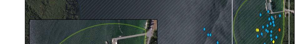


44 Figure 7. All California Sea Lion Sightings Naval Base Kitsap at Bangor 41


45 Figure 8. All Harbor Porpoise Sightings Naval Base Kitsap at Bangor 42


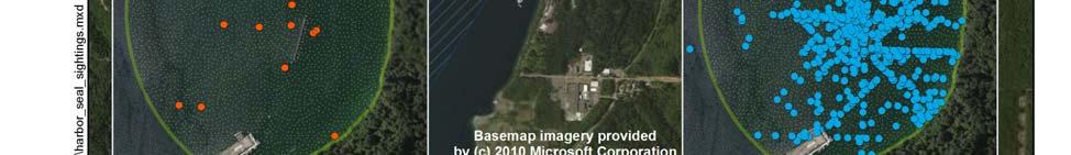
46 Figure 9. All Harbor Seal Sightings Naval Base Kitsap at Bangor 43


47 Figure 10. All Steller Sea Lion Sightings Naval Base Kitsap at Bangor 44
Description of Underwater Noise Attenuation System Design Unit 2. New NY Bridge Project
 New NY Bridge Project Description of Underwater Noise Attenuation System (NAS) Design Unit 2 Description of Underwater Noise Attenuation System Design Unit 2 for the New NY Bridge Project Revision 1 May
Caltrans compendium of underwater sound data from pile driving 2014 update
 Caltrans compendium of underwater sound data from pile driving 2014 update Richard RODKIN 1 ; Keith POMMERENCK 2 1 Illingworth & Rodkin, Inc., United States 2 Illingworth & Rodkin, Inc., United States
Final Cruise Report Marine Mammal Observer UNDET Monitoring Hawaii Range Complex, April, 2011
 213 APPENDIX I. Cruise Report, Marine Mammal Observer UNDET Monitoring Hawaii Range Complex, August 12, 2011 Final Cruise Report Marine Mammal Observer UNDET Monitoring Hawaii Range Complex, 26-27 April,
Underwater Sound Level Report: I-90 Keechelus Lake Avalanche Bridge Blasting
 I-90 SNOQUALMIE PASS EAST Underwater Sound Level Report: I-90 Keechelus Lake Avalanche Bridge Blasting Prepared by: Jim Laughlin Washington State Department of Transportation Office of Air Quality and
Trip Report, Marine Mammal Monitoring Mine Neutralization Exercise Events, September 2012 VACAPES Range Complex
 February 2013 Trip Report, Marine Mammal Monitoring Mine Neutralization Exercise Events, September 2012 VACAPES Range Complex Prepared for: Commander, United States Fleet Forces Command Prepared by: Naval
SR 411, Lexington Bridge Underwater Noise Monitoring Results
 Northwest Region 157 Dayton Avenue North P.O. Box 3331 Seattle, WA 98133-971 Washington State Department of Transportation Douglas B. MacDonald Secretary of Transportation September 21, 26 (26) 44-4 TTY:
Admiralty Inlet Pilot Tidal Project FERC No Appendix C. Derelict Gear Monitoring Plan
 Appendix C Derelict Gear Monitoring Plan ADMIRALTY INLET PILOT TIDAL PROJECT FERC PROJECT NO. 12690 DERELICT GEAR MONITORING PLAN (submitted with the Final Application for a New Pilot Project License)
San Francisco Oakland Bay Bridge East Span Seismic Safety Project FISHERIES AND HYDROACOUSTIC MONITORING PROGRAM COMPLIANCE REPORT
 San Francisco Oakland Bay Bridge East Span Seismic Safety Project FISHERIES AND HYDROACOUSTIC MONITORING PROGRAM COMPLIANCE REPORT JUNE 2004 EA 012023 04-SF-80 KP 12.2/KP 14.3 04-ALA-80 KP 0.0/KP 2.1 Sa
Near-Field Sturgeon Monitoring for the New NY Bridge at Tappan Zee. Quarterly Report July 1 September 30, 2014
 Near-Field Sturgeon Monitoring for the New NY Bridge at Tappan Zee Quarterly Report July 1 September 30, 2014 Prepared by AKRF, Inc. 7250 Parkway Drive, Suite 210 Hanover, MD 21076 for New York State Thruway
Cruise Report Marine Mammal and Sea Turtle Observer UNDET Monitoring Hawaii Range Complex: 3 April 2014
 January 15, 2015 Cruise Report Marine Mammal and Sea Turtle Observer UNDET Monitoring Hawaii Range Complex: 3 April 2014 Prepared for: Commander, U.S. Pacific Fleet Prepared by: Naval Facilities Engineering
Use of a low power, airgun sound source to accurately determine sound. Transmission Loss characteristics at the proposed Robin Rigg. Windfarm site.
 Submitted to: Submitted by: The Scottish Executive On behalf of: Mr M J Swanwick Mr S J Parvin EON-UK Subacoustech Ltd Westwood Way Chase Mill Westwood Business Park Winchester Road Coventry Bishop s Waltham
Unalaska Navigation Channel Improvements
 1 237 237 237 255 255 255 0 0 0 Unalaska Navigation Channel Improvements 217 217 217 200 200 200 163 163 163 131 132 122 239 65 53 80 119 27 252 174.59 110 135 120 112 92 56 62 102 130 102 56 48 130 120
Water Search Certification Evaluation
 Water Search Certification Evaluation Purpose The purpose of the Water Search Certification Evaluation is to accurately and uniformly assess a canine team s ability to effectively search for and locate
Final Report: Measurements of Pile Driving Noise from Control Piles and Noise-Reduced Piles at the Vashon Island Ferry Dock
 Final Report: Measurements of Pile Driving Noise from Control Piles and Noise-Reduced Piles at the Vashon Island Ferry Dock By Peter H. Dahl, Jim Laughlin, and David R. Dall Osto Executive Summary Underwater
SEISMIC SURVEY GREENLAND 2014 Underwater sound propagation for North East Greenland offshore seismic survey
 TGS February 2014 SEISMIC SURVEY GREENLAND 2014 Underwater sound propagation for North East Greenland offshore seismic survey Appendix: NEG14 modelling results Mark Mikaelsen PROJECT Seismic Survey Greenland
UNDERWATER SOUND LEVELS ASSOCIATED WITH PILE DRIVING AT THE CAPE DISAPPOINTMENT BOAT LAUNCH FACILITY, WAVE BARRIER PROJECT
 WASHINGTON STATE PARKS CAPE DISAPPOINTMENT WAVE BARRIER PROJECT UNDERWATER SOUND LEVELS ASSOCIATED WITH PILE DRIVING AT THE CAPE DISAPPOINTMENT BOAT LAUNCH FACILITY, WAVE BARRIER PROJECT Prepared by: Jim
I. Monitoring and Adaptive Management Approach. Potential Effects, Monitoring Studies & Mitigation
 I. Monitoring and Adaptive Management Approach Define the problem or management objective. Determine potential effects of the project on indicator species. Emphasis on examining potentially negative, rather
BEFORE THE ENVIRONMENTAL PROTECTION AUTHORITY JOINT STATEMENT OF EXPERTS IN THE FIELD OF MARINE MAMMALS
 BEFORE THE ENVIRONMENTAL PROTECTION AUTHORITY IN THE MATTER of the Exclusive Economic Zone and Continental Shelf (Environmental Effects) Act 2012 AND IN THE MATTER of an Application for Marine D u m p
Pile Driving and Barotrauma Effects
 Pile Driving and Barotrauma Effects AASHTO SOC Louisville, KY Jeff Lewis, Field Operations Engineer Federal Highway Administration California Division Transportation Needs Capacity Strength Constructability
Item 404 Driving Piling
 Item Driving Piling 1. DESCRIPTION Drive piling. 2. EQUIPMENT 2.1. Driving Equipment. Use power hammers for driving piling with specified bearing resistance. Use power hammers that comply with Table 1.
~ A Behavioral Response Study in 2007 &2008 (BRS 07/08) was conducted in the Bahamas to
 was conducted in the Bahamas to") Biological and Behavioral Response Studies in the Bahamas in 27 28 (BRS 7/8) ~ Project Summary ~ ~ A Behavioral Response Study in 27 &28 (BRS 7/8) was conducted in the Bahamas to study diving behavior
Biological and Behavioral Response Studies in the Bahamas in 27 28 (BRS 7/8) ~ Project Summary ~ ~ A Behavioral Response Study in 27 &28 (BRS 7/8) was conducted in the Bahamas to study diving behavior
Dredging and Pile Driving Monitoring Plan Sturgeon Monitoring During Pile Driving 60-day Report 2/16/2014 4/12/2014. New NY Bridge Project
 Sturgeon During Pile Driving 60-day Report 2/16/2014 4/12/2014 for the April 18, 2014 Prepared by Tappan Zee Constructors, LLC 555 White Plains Road, Suite 400 Tarrytown, NY 10591 60-Day Sturgeon Report
Final. Technical Guidance for Assessment and Mitigation of the Hydroacoustic Effects of Pile Driving on Fish
 Mitigation of the Hydroacoustic Effects of Pile Driving on Fish Prepared for: California Department of Transportation 1120 N Street Sacramento, CA 94274 Contact: Jim Andrews Prepared by: ICF Jones & Stokes
APPENDIX P. Noise Model Results and Supporting Material
 APPENDIX P Noise Model Results and Supporting Material Table of Contents Appendix P1 Summary of Technical Approach Appendix P2 Model Summary and Output Data Appendix P3 Illingworth & Rodkin Survey Report
Taking of Marine Mammals Incidental to Specified Activities; San Francisco- Oakland Bay Bridge Pier E3 Demolition via Controlled Implosion
 This document is scheduled to be published in the Federal Register on 09/24/2015 and available online at http://federalregister.gov/a/2015-24230, and on FDsys.gov BILLING CODE 3510-22-P DEPARTMENT OF COMMERCE
Post Model Quantitative Analysis. of Animal Avoidance Behavior and Mitigation Effectiveness. for Northwest Training and Testing Activities
 Post Model Quantitative Analysis of Animal Avoidance Behavior and Mitigation Effectiveness for Northwest Training and Testing Activities Technical Report Suggested citation: U.S. Department of the Navy.
NATIONAL MARINE FISHERIES SERVICE (NMFS) REPORT ON HIGHLY MIGRATORY SPECIES (HMS) ACTIVITIES
 REPORT ON HIGHLY MIGRATORY SPECIES (HMS) ACTIVITIES") Agenda Item J.1.a NMFS Report 1 March 2019 NATIONAL MARINE FISHERIES SERVICE (NMFS) REPORT ON HIGHLY MIGRATORY SPECIES (HMS) ACTIVITIES Deep-set Buoy Gear (DSBG) Authorization and National Environmental
Agenda Item J.1.a NMFS Report 1 March 2019 NATIONAL MARINE FISHERIES SERVICE (NMFS) REPORT ON HIGHLY MIGRATORY SPECIES (HMS) ACTIVITIES Deep-set Buoy Gear (DSBG) Authorization and National Environmental
MEASUREMENT OF LONG-TERM AMBIENT NOISE AND TIDAL TURBINE LEVELS IN THE BAY OF FUNDY
 MEASUREMENT OF LONG-TERM AMBIENT NOISE AND TIDAL TURBINE LEVELS IN THE BAY OF FUNDY 11 th European Conference on Underwater Acoustics, 3 July 2012 Bruce Martin 1, Andrew Gerber 2, Christopher Whitt 1,
Habitat Use and Behavioral Monitoring of Hawaiian Monk Seals in Proximity to the Navy Hawaii Range Complex
 Project Annual Report Habitat Use and Behavioral Monitoring of Hawaiian Monk Seals in Proximity to the Navy Hawaii Range Complex Report Period: July 2011 June 2012 Submitted by: Kenady Wilson, Scientist
Species and Area Protection with Regards to Offshore Wind Farms. Dr. Folchert R. van Dijken
 Species and Area Protection with Regards to Offshore Wind Farms Dr. Folchert R. van Dijken 25 January 2012 2 Economic activities on the NL Continental shelf Shipping - 260,000 movements - Seaport like
CHAPTER 2 PROPOSED ACTIONS AND ALTERNATIVES TABLE OF CONTENTS
 CHAPTER 2 PROPOSED ACTIONS AND ALTERNATIVES TABLE OF CONTENTS 2.0 PROPOSED ACTIONS AND ALTERNATIVES... 2 1 2.1. LWI PROPOSED ACTION... 2 1 2.2. SPE PROPOSED ACTION... 2 19 2.3. DESIGN AVOIDANCE AND MINIMIZATION
STOPPING THE UNDERWATER DIVER THREAT
 STOPPING THE UNDERWATER DIVER THREAT Dr. Robert F. De La Croix and Mr. Juergen G. Keil A non-lethal, scalable deterrent solution Updated from original article published in Maritime Technology Reporter,
Committee Input No. 35-NFPA [ Chapter 1 ] Submitter Information Verification. Committee Statement
![Committee Input No. 35-NFPA [ Chapter 1 ] Submitter Information Verification. Committee Statement](/thumbs/89/99590399.jpg "Committee Input No. 35-NFPA [ Chapter 1 ] Submitter Information Verification. Committee Statement") Committee Input No. 35-NFPA 1670-2015 [ Chapter 1 ] Chapter 1 Administration 1.1 Scope. 1.1.1* This standard shall identify and establish levels of functional capability for conducting operations at technical
Committee Input No. 35-NFPA 1670-2015 [ Chapter 1 ] Chapter 1 Administration 1.1 Scope. 1.1.1* This standard shall identify and establish levels of functional capability for conducting operations at technical
UTAS EH&S INSTRUCTION No. 036 June 2012 Revision No. 3. Purging of Flammable Gas Equipment and/or Piping (Explosion Hazard)
") Purging of Flammable Gas Equipment and/or Piping (Explosion Hazard) APPLICABILITY: This EH&S Instruction applies to UTAS sites worldwide, including contractors working at UTAS facilities. The document
Purging of Flammable Gas Equipment and/or Piping (Explosion Hazard) APPLICABILITY: This EH&S Instruction applies to UTAS sites worldwide, including contractors working at UTAS facilities. The document
Packwood Lake Intake Screen Velocity Test Report for Energy Northwest's Packwood Lake Hydroelectric Project FERC No Lewis County, Washington
 for Energy Northwest's Packwood Lake Hydroelectric Project FERC No. 2244 Lewis County, Washington Submitted to P.O. Box 968 Richland, Washington 99352-0968 Submitted by EES Consulting 1155 North State
1.0 PURPOSE AND NEED
 1.0 PURPOSE AND NEED 1.0 PURPOSE OF AND NEED FOR THE PROPOSED ACTION 1.1 INTRODUCTION The National Environmental Policy Act (NEPA) of 1969, as amended (42 United States Code Section 4321 et seq.); the
APPENDIX 9.8-A. Construction and Terminal Activity Underwater Noise Modelling Study Technical Report
 APPENDIX 9.8-A Construction and Terminal Activity Underwater Noise Modelling Study Technical Report PORT METRO VANCOUVER Roberts Bank Terminal 2 This page is intentionally left blank ROBERTS BANK TERMINAL
Underwater noise and offshore windfarms
 Underwater noise and offshore windfarms Dr Jeremy Nedwell, Mr John Langworthy and Mr Daren Howell BWEA Conference 4/3/04 Subacoustech reference: 544R0503, COWRIE Copyright. Aim of study To evaluate the
*Printed on Recycled Paper JUL Commander, u.s. Pacific Fleet 250 Makalapa Drive Pearl Harbor, HI To Whom It May Concern:
 UNITED STATES DEPARTMENT OF COMMERCE National Ocaanic and Atmoapharic Adminiatration NATIONAL MARINE FISHERIES SERVICE Silver Spring, MO 20910 JUL 1 8 2012 Commander, u.s. Pacific Fleet 250 Makalapa Drive
LOCAL NOTICE TO MARINERS
 USCG Notice to Mariners 3/7/18 (View full Notice here) LNM 10/18 Coast Guard District 1: U.S. Department of Homeland Security United States Coast Guard LOCAL NOTICE TO MARINERS COASTAL WATERS FROM EASTPORT,
Questions & Answers About the Operate within Operate within IROLs Standard
 Index: Introduction to Standard...3 Expansion on Definitions...5 Questions and Answers...9 Who needs to comply with this standard?...9 When does compliance with this standard start?...10 For a System Operator
Benefit of ESTCP/SERDP Research Program on Underwater Explosive Safety
 Benefit of ESTCP/SERDP Research Program on Underwater Explosive Safety Timothy W. Shelton, PE Supervisory Research Hydraulic Engineer ERDC CHL Oct 2017 DoD has very few options for disposing UXO recovered
FAQs: Confined Spaces in Residential Construction
 Provided by Marshall & Sterling, Inc. FAQs: Confined Spaces in Residential Construction A new standard for construction work in confined spaces became effective Aug. 3, 3015. The new standard (Subpart
Final Fish Salvage & Temporary Tailrace Barrier Report for the Wallowa Falls Hydroelectric Project Tailrace. (FERC No. P-308) December 20, 2018
 December 20, 2018") Final Fish Salvage & Temporary Tailrace Barrier Report for the Wallowa Falls Hydroelectric Project Tailrace (FERC No. P-308) December 20, 2018 Prepared by: Jeremiah Doyle PacifiCorp 825 NE Multnomah Street
Final Fish Salvage & Temporary Tailrace Barrier Report for the Wallowa Falls Hydroelectric Project Tailrace (FERC No. P-308) December 20, 2018 Prepared by: Jeremiah Doyle PacifiCorp 825 NE Multnomah Street
Scientific Technician 2 (Fulltime, Nonpermanent)
") State of Washington Dept. of Fish and Wildlife invites applications for the position of: SCIENTIFIC TECHNICIAN 2 *02124W SALARY: $2,426.00 - $3,135.00 Monthly OPENING DATE: 03/04/14 CLOSING DATE: 03/16/14
State of Washington Dept. of Fish and Wildlife invites applications for the position of: SCIENTIFIC TECHNICIAN 2 *02124W SALARY: $2,426.00 - $3,135.00 Monthly OPENING DATE: 03/04/14 CLOSING DATE: 03/16/14
7.0 Construction Noise Impact Assessment
 7.0 Construction Noise Impact Assessment Contents 7.0 Construction Noise Impact Assessment...7.1 7.1 Terrestrial Noise...7.5 7.1.1 Noise Generation, Transmission, and Reduction...7.7 7.1.2 Ambient or
ESB TONAL NOISE ASSESSMENT. 30 May West Offaly Power Station. Report Author: Stephen Kearney
 Allegro Acoustics Limited, Unit 2A Riverside, Tallaght Business Park, Tallaght, Dublin 24 Tel/Fax: +353 (0) 1 4140485 ESB West Offaly Power Station TONAL NOISE ASSESSMENT 30 May 2016 Report Author: Stephen
Dive Operations Plan for Personal Submersibles. Revision
 Dive Operations Plan for Personal Submersibles Revision 2011.1 1 Table of Contents 1 EVENT...3 1.1 Summary of planned dive...3 1.1.1 PSUBS Guidelines...3 1.1.2 Maximum dive depth planned...3 1.1.3 Number
Marine Mammal Mitigation Systems
 Marine Mammal Mitigation Systems Seiche Measurements Limited (Seiche) designs and manufactures underwater sound measurement and marine mammal monitoring equipment for the oil and gas and renewables sectors.
A Wind Profiling Platform for Offshore Wind Measurements and Assessment. Presenter: Mark Blaseckie AXYS Technologies Inc.
 A Wind Profiling Platform for Offshore Wind Measurements and Assessment Presenter: Mark Blaseckie AXYS Technologies Inc. Any Sensor, Any Telemetry, Any Environment Founded in 1974 Part of the AXYS Group
1.0 PURPOSE 2.0 SCOPE 3.0 DEFINITIONS. ANSI: American National Standards Institute. CCC: Chemical Control Centre
 Revision Date: 5/17/2016 Page: 1 of 13 Health & Safety has developed the emergency eyewash & safety shower equipment procedure which will be implemented in 3 phases over the next four years. Phase 1 will
Appendix F: Ecology F-6 Methodology for Estimating Potential Hydroacoustic Impacts to Abundant Hudson River Fish Species and Shortnose Sturgeon from
 Appendix F: Ecology F-6 Methodology for Estimating Potential Hydroacoustic Impacts to Abundant Hudson River Fish Species and Shortnose Sturgeon from Pile-driving Activities during Construction of the Tappan
Taking and Importing Marine Mammals; Taking Marine Mammals Incidental to Operation of
 This document is scheduled to be published in the Federal Register on 12/12/2013 and available online at http://federalregister.gov/a/2013-29553, and on FDsys.gov BILLING CODE: 3510-22-P DEPARTMENT OF
Oldman 2 Wind Farm Limited
 Decision 22676-D01-2017 Spring 2017 Post-Construction Sound Survey at Receptors B, J and K August 1, 2017 Alberta Utilities Commission Decision 22676-D01-2017 Proceeding 22676 Application 22676-A001 August
Confined Space Entry Safety Program
 Confined Space Entry Safety Program Table of Contents SCOPE...2 DEFINITIONS..2 PROGRAM ELEMENTS...3 SPACE EVALUATION...4 IDENTIFICATION AND CLASSIFICATION...4 POSTING...4 RECLASSIFICATION OF PERMIT SPACE...4
AGENCY: National Marine Fisheries Service, National Oceanic and Atmospheric. ACTION: Notice; issuance of an Incidental Harassment Authorization.
 This document is scheduled to be published in the Federal Register on 06/23/2014 and available online at http://federalregister.gov/a/2014-14563, and on FDsys.gov BILLING CODE 3510-22-P DEPARTMENT OF COMMERCE
TOWAGE GUIDELINES FOR THE GLOUCESTER HARBOUR. August 2018
 TOWAGE GUIDELINES FOR THE GLOUCESTER HARBOUR August 2018 Version History Version Reason for Change Date 1.0 Original Document 1 December 2011 1.1 Revised small craft requirements 3 February 2016 1.2 Revised
PENSACOLA BAY BRIDGE PROJECT DEVELOPMENT AND ENVIRONMENT (PD&E) STUDY. Appendix D to the Environmental Assessment Standard Protection Measures
 STUDY. Appendix D to the Environmental Assessment Standard Protection Measures") February 2015 PENSACOLA BAY BRIDGE PROJECT DEVELOPMENT AND ENVIRONMENT (PD&E) STUDY Appendix D to the Environmental Assessment Standard Protection Measures Construction Special Provisions, Gulf Sturgeon
February 2015 PENSACOLA BAY BRIDGE PROJECT DEVELOPMENT AND ENVIRONMENT (PD&E) STUDY Appendix D to the Environmental Assessment Standard Protection Measures Construction Special Provisions, Gulf Sturgeon
Effect on Marine Life by Noise of Offshore Wind Farm S.JIANG 1 & J.P. HOU 1
 5th International Conference on Advanced Design and Manufacturing Engineering (ICADME 2015) Effect on Marine Life by Noise of Offshore Wind Farm S.JIANG 1 & J.P. HOU 1 1 Third Institute of Oceangraphy,SOA,Xiamen,Fujian,China
Janek LAANEARU and Aleksander KLAUSON Department of Mechanics, Tallinn University of Technology
 seminar in Tallinn, 5.01.013 PRINCIPAL UNDERWATER NOISE SOURCES IN BALTIC SEA AND METRICS USED IN NOISE LEVEL ASSESSMENT Janek LAANEARU and Aleksander KLAUSON Department of Mechanics, Tallinn University
Health & Safety Policy and Procedures Manual SECTION 6 ELECTRICAL SAFETY / CONTROL OF HAZARDOUS ENERGY
 SECTION 6 ELECTRICAL SAFETY / CONTROL OF HAZARDOUS ENERGY 1. CONTROL OF HAZARDOUS ENERGY POLICY AND PROCEDURES A. OSHA References: 29 CFR 1910.147, 29 CFR 1910.332, 29 CFR 1910.333, 29 CFR 1926.417 B.
Introduction Proposed Action
 Introduction The United States Navy s Naval Special Warfare Group THREE of the Naval Special Warfare Command proposes to conduct training at multiple Western Washington locations. The purpose of the training
Energy Control. Suite 2A, 55 Frid Street Hamilton, ON L8P 4M3 office: cell:
 Energy Control Suite 2A, 55 Frid Street Hamilton, ON L8P 4M3 office: 905.577.0303 cell: 905.977.0210 consultant@staffaid.ca www.staffaid.com Safety, Energy Control, Power Lockout & Function Test Procedures
Contract No. NL/2017/03 Tung Chung New Town Extension Reclamation and Advance Works Dolphin Watching Plan
 TABLE OF CONTENT 1.0 Introduction 2.0 Site Characteristics 3.0 3.1 Regular Inspection of the Silt Curtain 3.2 Visual Inspection of the Waters Around and Outside the Silt Curtain 3.3 Action Plan to be Devised
145 FERC 62,070 UNITED STATES OF AMERICA FEDERAL ENERGY REGULATORY COMMISSION
 145 FERC 62,070 UNITED STATES OF AMERICA FEDERAL ENERGY REGULATORY COMMISSION Public Utility District No. 1 of Douglas County, Washington Project No. 2149-163 ORDER APPROVING BULL TROUT STRANDING, ENTRAPMENT,
PORTS AUSTRALIA. PRINCIPLES FOR GATHERING AND PROCESSING HYDROGRAPHIC INFORMATION IN AUSTRALIAN PORTS (Version 1.5 November 2012)
") PORTS AUSTRALIA PRINCIPLES FOR GATHERING AND PROCESSING HYDROGRAPHIC INFORMATION IN AUSTRALIAN PORTS (Version 1.5 November 2012) PREFACE These Principles have been prepared by the Hydrographic Surveyors
PORTS AUSTRALIA PRINCIPLES FOR GATHERING AND PROCESSING HYDROGRAPHIC INFORMATION IN AUSTRALIAN PORTS (Version 1.5 November 2012) PREFACE These Principles have been prepared by the Hydrographic Surveyors
[***] = both land and marine [***] = Marine only [***] = Land only + ([***] = Shallow Water) if needed
![[***] = both land and marine [***] = Marine only [***] = Land only + ([***] = Shallow Water) if needed](/thumbs/80/81921271.jpg "[***] = both land and marine [***] = Marine only [***] = Land only + ([***] = Shallow Water) if needed") Stand-By conditions: [***] = both land and marine (Terms may require capitalisation or substitution subject to terminology used in the relevant contract) The below Stand-By conditions list is non-exhaustive
Stand-By conditions: [***] = both land and marine (Terms may require capitalisation or substitution subject to terminology used in the relevant contract) The below Stand-By conditions list is non-exhaustive
Requirements for Reduced Supervision of Power Plants, Thermal Liquid Heating Systems, and Heating Plants
 the pressure equipment safety authority Requirements for Reduced Supervision of Power Plants, Thermal Liquid Heating Systems, and Heating Plants AB-528 Edition 2, Revision 1 Issued 2016-09-12 Table of
REPORT OF INITIAL SURVEY OF AN UNKNOWN BARGE OFF OF CEDAR POINT, SANDUSKY, OHIO. July 26-27, Submitted to Cleveland Underwater Explorers, Inc.
 REPORT OF INITIAL SURVEY OF AN UNKNOWN BARGE OFF OF CEDAR POINT, SANDUSKY, OHIO July 26-27, 2008 Submitted to Cleveland Underwater Explorers, Inc. By Jack Papes SUBJECT Report of Initial survey of an unknown
Takes of Marine Mammals Incidental to Specified Activities; Taking Marine Mammals
 This document is scheduled to be published in the Federal Register on 08/20/2013 and available online at http://federalregister.gov/a/2013-20310, and on FDsys.gov BILLING CODE: 3510-22-P DEPARTMENT OF
Contract HY/2011/09 Hong Kong-Zhuhai-Macao Bridge Hong Kong Link Road-Section between HKSAR Boundary and Scenic Hill. Dolphin Watching Plan
 Dragages -China Harbour-VSL JV Contract HY/2011/09 Hong Kong-Zhuhai-Macao Bridge Hong Kong Link Road-Section between HKSAR Boundary and Scenic Hill Dolphin Watching Plan April 2013 (Version 4.0) Certified
Data Collection and Processing: Elwha Estuary Survey, February 2013
 Data Collection and Processing: Elwha Estuary Survey, February 2013 Ian Miller, WA Sea Grant Olympic Peninsula Field Office, 1502 E. Lauridsen Blvd #82, Port Angeles, WA 98362 immiller@u.washington.edu
ARA PROJECT Prepared by: Peter T. Dzwilewski Applied Research Associates, Inc Shaffer Parkway Littleton, Colorado 80127
 ARA PROJECT 001974 WATER SHOCK PREDICTION FOR EXPLOSIVE REMOVAL OF OFFSHORE STRUCTURES: UNDERWATER CALCULATOR (UWC) VERSION 2.0 UPDATE BASED UPON FIELD DATA Prepared by: Peter T. Dzwilewski Applied Research
INSTRUCTOR GUIDE REFERENCES: PUMPING APPARATUS DRIVER/OPERATOR HANDBOOK, FIRST EDITION, IFSTA
 TOPIC: RELAY PUMPING OPERATIONS LEVEL OF INSTRUCTION: TIME REQUIRED: ONE HOUR INSTRUCTOR GUIDE MATERIALS: APPROPRIATE AUDIO VISUAL SUPPORT REFERENCES: PUMPING APPARATUS DRIVER/OPERATOR HANDBOOK, FIRST
OBJECTIVE 6: FIELD RADIOLOGICAL MONITORING - AMBIENT RADIATION MONITORING
 OBJECTIVE 6: FIELD RADIOLOGICAL MONITORING - AMBIENT RADIATION MONITORING OBJECTIVE Demonstrate the appropriate use of equipment and procedures for determining field radiation measurements. INTENT This
4 th Annual Nadadores 2.4 Mile Rough Water Swim
 4 th Annual Nadadores 2.4 Mile Rough Water Swim Salt Creek Beach in Dana Point, CA Saturday, May 16, 2015 EVENT SAFETY OPERATIONS: OC Lifeguards (OCLG) will manage water safety operations for the swim
DQM Annual Hopper QA Checks
 DQM Annual Hopper QA Checks The following document is intended to be a guide for conducting annual Dredge Quality Management quality assurance checks on hopper dredges. The procedures should provide general
Chapter 20.0 Marine Noise and Vibration
 Chapter 20.0 Marine Noise and Vibration www.tidallagoonswanseabay.com www.tidallagooncardiff.com 20.0 Marine Noise and Vibration 20.1 Overview of existing situation 20.1.0.1 Estuaries by their nature (relatively
PILOTAGE DIRECTIONS REVIEWED DECEMBER 2016
 PILOTAGE DIRECTIONS REVIEWED DECEMBER 2016 REVISION LIST Revision No. Date Details Approved by: Original All sections 12 Dec 2013 First edition of C W Brand v1.0 Pilotage Directions Revision 2 all sections
(2) but does not include a shaft, trench or tunnel that is a mine or is part of the workings of a mine.
 but does not include a shaft, trench or tunnel that is a mine or is part of the workings of a mine.") Health and Safety Procedure - Confined Spaces Section 1 - Background and Purpose (1) Confined spaces are, for the purposes of this procedure, defined as the following which is the definition under the
Health and Safety Procedure - Confined Spaces Section 1 - Background and Purpose (1) Confined spaces are, for the purposes of this procedure, defined as the following which is the definition under the
Measurements of underwater noise in the Arun River during piling at County Wharf, Littlehampton
 Submitted to: Submitted by: Mr Chris Moore Dr J Nedwell David Wilson Homes Ltd Subacoustech Ltd 15 Horsham Court Long Barn City Business Centre Mandalay Farm Brighton Road Forester Road Horsham Soberton
ROV Development ROV Function. ROV Crew Navigation IRATECH SUB SYSTEMS 2010
 IR AT EC H SU B SY ST EM S 20 10 Remotely Operated Vehicle ROV INTRODUCTORY 2008 2008 1 KEY POINTS ROV Introductory ROV Development ROV Function Types of ROV ROV Crew Navigation ROV Components 2 ROV Development
WOODFIBRE LNG VESSEL WAKE ASSESSMENT
 Woodfibre LNG Limited WOODFIBRE LNG VESSEL WAKE ASSESSMENT Introduction Woodfibre LNG Limited (WLNG) intends to build a new LNG export terminal at Woodfibre, Howe Sound, British Columbia. WLNG has engaged
USER S GUIDE DepthTrax 1H HawkEye Portable Depth Finder (DT1H)
") USER S GUIDE DepthTrax 1H HawkEye Portable Depth Finder (DT1H) Thank you for purchasing a HawkEye product, and welcome to the innovations of NorCross Marine Products, Inc. To ensure safety and many years
USER S GUIDE DepthTrax 1H HawkEye Portable Depth Finder (DT1H) Thank you for purchasing a HawkEye product, and welcome to the innovations of NorCross Marine Products, Inc. To ensure safety and many years
GUIDELINES FOR NAVIGATION UNDER THE CONFEDERATION BRIDGE
 (12/2009) GUIDELINES FOR NAVIGATION UNDER THE CONFEDERATION BRIDGE REVISION 1 DECEMBER 2009 Responsible Authority The Regional Director Marine Safety Atlantic Region is responsible for this document, including
MICROPHONE WIND SPEED LIMITS DURING WIND FARM NOISE MEASUREMENTS
 MICROPHONE WIND SPEED LIMITS DURING WIND FARM NOISE MEASUREMENTS Abstract Jon Cooper 1 and Tom Evans 2 1 Resonate Acoustics, Level 1/23 Peel St, Adelaide SA 5000, Australia Email: jon.cooper@resonateacoustics.com
Final Fish Salvage & Temporary Tailrace Barrier Report for the Wallowa Falls Hydroelectric Project Tailrace. (FERC No. P-308) December 18, 2017
 December 18, 2017") Final for the Wallowa Falls Hydroelectric Project Tailrace (FERC No. P-308) December 18, 2017 Prepared by: Jeremiah Doyle PacifiCorp 825 NE Multnomah Street Portland, OR 97232 December 18, 2017 Page 1
Final for the Wallowa Falls Hydroelectric Project Tailrace (FERC No. P-308) December 18, 2017 Prepared by: Jeremiah Doyle PacifiCorp 825 NE Multnomah Street Portland, OR 97232 December 18, 2017 Page 1
Remote Monitoring of Dolphins and Whales in the High Naval Activity Areas in Hawaiian Waters
 DISTRIBUTION STATEMENT A: Approved for public release; distribution is unlimited. Remote Monitoring of Dolphins and Whales in the High Naval Activity Areas in Hawaiian Waters Whitlow W. L. Au and Marc
SOP GEN-007X Crane and Winch Operations
 Page 1 of 7 SOP GEN-007X 1.0 Introduction 2.0 Responsibility 3.0 References 4.0 Training and Qualifications 5.0 Operational Inspections 6.0 Maintenance and Load Tests 7.0 Cranes 8.0 Winches 9.0 Mobile
DEPARTMENT OF ENVIRONMENTAL PROTECTION Office of Oil and Gas Management
 DEPARTMENT OF ENVIRONMENTAL PROTECTION Office of Oil and Gas Management DOCUMENT NUMBER: 800-0810-003 TITLE: EFFECTIVE DATE: AUTHORITY: POLICY: PURPOSE: APPLICABILITY: DISCLAIMER: Guidelines for Development
NATIONAL MARINE FISHERIES SERVICE REPORT ON DEEP-SET BUOY GEAR AMENDMENT SCOPING
 Agenda Item F.3.a NMFS Report March 2016 NATIONAL MARINE FISHERIES SERVICE REPORT ON DEEP-SET BUOY GEAR AMENDMENT SCOPING I. Introduction/DSBG Timeline Deep-set buoy gear (DSBG) is a novel gear type that
NAVSEA STANDARD ITEM. 1.1 Title: Contractor Crane, Multi-Purpose Machine and Material Handling Equipment at a Naval Facility; provide
 NAVSEA STANDARD ITEM ITEM NO: 009-40 DATE: 26 MARCH 2018 CATEGORY: I 1. SCOPE: 1.1 Title: Contractor Crane, Multi-Purpose Machine and Material Handling Equipment at a Naval Facility; provide 2. REFERENCES:
Pioneer Array Micro-siting Public Input Process Frequently Asked Questions
 Pioneer Array Micro-siting Public Input Process Frequently Asked Questions The National Science Foundation (NSF) has completed the micro-siting of the moored array of the Ocean Observatories Initiative
SNOWSHOEING SPORT RULES. Snowshoeing Sport Rules. VERSION: June 2016 Special Olympics, Inc., 2016 All rights reserved
 Snowshoeing Sport Rules 1 TABLE OF CONTENTS 1. GOVERNING RULES... 3 2. OFFICIAL EVENTS... 3 25 Meter Race... 3 50 Meter Race... 3 100 Meter Race... 3 200 Meter Race... 3 400 Meter Race... 3 800 Meter Race...
Scope: This plan applies to all personnel, including contractors, who enter or work in confined spaces, or supervise such activities.
 11/13/1995 4 5/20/2013 1 of 10 Authority and Scope Regulation: 29 CFR 1910.146 Scope: This plan applies to all personnel, including contractors, who enter or work in confined spaces, or supervise such
PACIFIC FISHERY MANAGEMENT COUNCIL Deep-Set Buoy Gear Exempted Fishing Permit Application Form Attachments
 PACIFIC FISHERY MANAGEMENT COUNCIL Deep-Set Buoy Gear Exempted Fishing Permit Application Form Attachments Attachment A: Specification of DSBG Configurations... 2 Attachment B: Council Data Gathering Priorities...
INCIDENT MANAGEMENT SYSTEM AND TACTICAL OPERATIONS MANUAL
 Series 354 Rapid Intervention Team(RIT) Page 1 of 6 INCIDENT MANAGEMENT SYSTEM AND TACTICAL OPERATIONS MANUAL OPERATIONAL GUIDELINE RAPID INTERVENTION TEAM (RIT) SERIES 354 PURPOSE Fire departments are
ENVIRONMENT AGENCY GREAT OUSE AND 100 FT DRAIN QUARTERLY BATHYMETRIC SURVEY DECEMBER 2013 SITE SURVEY REPORT NO. H6787
 ENVIRONMENT AGENCY GREAT OUSE AND 100FT DRAIN QUARTERLY BATHYMETRIC SURVEY DECEMBER 2013 NO. H6787 LONGDIN & BROWNING (SURVEYS) LIMITED CHERRY TREE HOUSE CARMARTHEN ROAD SWANSEA SA1 1HE H6787 1 Measured
Nanaimo Ocean Swim and Newcastle SUP Race Safety Plan
 Nanaimo Ocean Swim and Newcastle SUP Race Safety Plan Use of this document Permission is granted to reproduce any information in this document; however, please notify the author (Matthew Lamb) if doing
The Corporation of the City of Sarnia. School Crossing Guard Warrant Policy
 The Corporation of the City of Sarnia School Crossing Guard Warrant Policy Table of Contents Overview And Description... 2 Role of the School Crossing Guard... 2 Definition of a Designated School Crossing...