Underkeel Clearance Management Systems. Captain Jonathon Pearce Senior Pilotage Advisor
|
|
|
- Bonnie Cole
- 5 years ago
- Views:
Transcription
1 Underkeel Clearance Management Systems Captain Jonathon Pearce Senior Pilotage Advisor
 Consequence can be Catastrophic Effective Management")
2 Underkeel Clearance Risk Management (UKCM) The management of the touch bottom or grounding hazard Risk = Frequency * Consequence Frequency is low/rare and in region of 3x10⁻⁵ (one in movements) Consequence can be Catastrophic Effective Management required

3 Sea Empress 1996 Sea Empress resulted in a total financial cost of 52m - 109m and similar environmental costs.


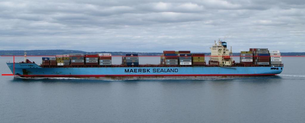
4 Iron King Port Hedland 1 August 2008 Port Hedland, was facing a loss of US$ 40 million for each tide that the channel remained closed when the Iron King grounded. Pictures by Mike Cummings

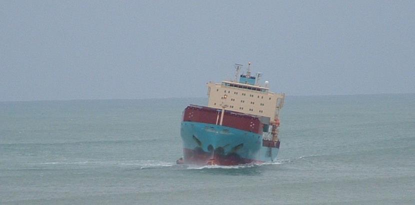
5 mv Rena 5 October 2011 NZ

6 Navigation in the Vertical Dimension
7 Static Underkeel Allowances measured waves PREDICTED TIDE DRAFT DATUM X % OF DRAFT X MUST ACCOUNT FOR measured tide and currents - WAVE RESPONSE - CHANGES IN TIDAL RESIDUAL - SQUAT DEPTH - SAFETY ALLOWANCES measured wind and pressure latest sounded depths 8 astronomical tides ship in given load state ship speed envelopes

8 Static Rule History
9 Static Rule A Top Down Approach VARIABLE RISK Nett Clearance changes for every transit Is it Safe, Marginal or Unsafe? Static Allowance Tidal Residual Squat Heel Wave Response/Setdown Nett Clearance?

10 Static Rule Compromise Optimism v Conservatism Too Too optimistic conservative - Safety - Less jeopardised cargo Static Rules are: Blunt compromise between economics and safety; Nett clearances change from day to day, ship to ship and even transit to transit!


11 Safety Case Study Marsden Point, NZ Capella Voyager 16 April 2003 Eastern Honor 27 July 2003
12 Marsden Vessel Analysis Under most conditions a static rule will be conservative However, groundings can occur when a ship is sensitive to the prevailing conditions (this is actual data!) Don t be complacent about your existing rules!
13 Static Rule Questions 1.Are existing rules adequate and justifiable? 2.Are all the factors that contribute to the static rule understood? 3.Does no incidents mean the rule is reliable? 4.Are there times when the rule may have been unsafe/marginal? 5. Are primary factors calculated and conveyed to the Master?

14 Dynamic UKC Methodology measured waves measured tide & currents measured wind & pressure latest sounded depths 8 astronomical tides ship in given load state ship speed envelopes
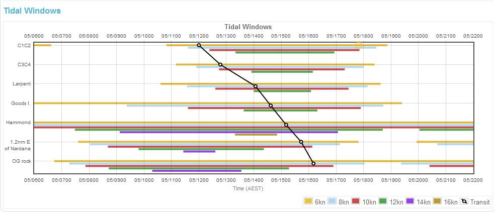
15 Underkeel Clearance Limits DUKCM limits in accordance with PIANC Guidelines Bottom Clearance Bottom touch due to vessel motions Manoeuvrability Margin Inability to manoeuvre
16 MM & BC BC Limit 25cms Manoeuvrability Safety Limit 90cms BC Limit 25cms BC Limit 25cms
17 DUKC - System Inputs/Outputs

18 High-resolution bathymetry grid

19 Bathy Nodes DUKC Bathymetry Nodes


20 Channel Segment Channel Boundary Channel Section 300m to channel boundary 100m segment 15.7m Max 14.8m BC Declared Depth MM 15.0m for 300m x 100m section Scale exaggerated by 25x for emphasis

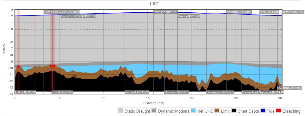
21 Hydrodynamic model Water level and currents within Prince of Wales Channel predictable Predictions use water levels at Goods Island and Ince Point
22 Complex tidal regimes Recorded water level across Prince of Wales Channel 15/16 May 2007 booby goods hammond nardana ince Water level relative to AHD [m] :00 18:00 00:00 06:00 12:00
23 Tidal Residuals Positive Residual Negative Residual Predictions Measurements
24 Residual Analysis - Lagged tides

25 Vancouver Example - 2 nd Narrows Tide; Current; Air Draft
26 Squat
27 Squat Low pressure caused by return flow creates a local depression in the water surface Vessel must sink with depression and may change trim to balance its weight
28 Which formulae? tmax CB B F Co t lpp 1 F S 2.4 l 2 nh F 2 nh 2 nh 2 2 pp 1 F nh K 0.27 T nh 1.08 / 2.75 SbE B F h T h s S C C K T br v F T S C K T sr v T S b Ho t 3 S ( Frh ) where F L F rh 2 nh 2 2 pp 1 F nh V s gh nh Sb 0.01L M 2 pp Cb L pp / T 1 F S b H L F F 2 nh 2 2 pp 1 F nh 2 2 nh K s 1 T S V C D 95 h 2 b k b S T Cb Vs. 45 h 3 2 V As S 2.20 S2 Cb where S2 g A A 1 C 1 C V SbJ h T Lpp B h T Lpp B g Note : L B R and h T R pp LB ht 3 2 b b s c s

29 Squat Channel Blockage

30 Squat Case Study Port of Lisbon
31 Actual Squat Example - Maximum Modelled Speed - Measured Speed - Measured Squat - Maximum Modelled Squat
32 Heel
33 Wave Response
34 Vessel Sensitivity Wave Energy (m 2 /Hz) Differing Wave Response 4 Formosa Fifteen 26 March 2009 Lbp 165m Beam 32.2m Draft 11.5m (Torm Gudrun Lbp 234m Beam 42m Draft 12.5m, Corona Majesty Lbp 220m Beam 38m Draft 13.8m) DUKC Predicted SA Roll: Formosa Trader [6.1] degs, WRA [2.2]m [8.7] degs, WRA [3.1]m Corona Maj [3.6] degs, WRA [1.7]m [5.2] degs, WRA - 1.8m [2.3]m Torm Gudrun [1.8] degs, WRA [0.9]m [2.9] degs, WRA [1.8]m % Exc Tom Gudrun Corona Maj Formosa Fifteen Sea Swell Period (s) 0
35 Wave Response Calculation Offshore Swell height = 2m, period = 14 seconds 2.4m EBB 1.2m PostPanamax Swell (2.8m Hm0) Handymax Tidal Current (5.0kn) 0.9m FLOOD 2.8m Swell (1.7m Hm0) Tidal Current (3.0kn)
36 DUKC A Bottom Up Methodology CONSTANT RISK Minimum Clearance maintained for every transit Always Safe! Required Water Depth Wave Response/Setdown Heel Squat Tidal Residual Minimum Clearance (Predetermined Limit)
37 UKC Safety Case Study Port Taranaki

38 Benefit Case Study - Port Taranaki

39 Benefit Case Study - Port Taranaki Orange Area DUKC Tidal Window Blue Area Static Tidal Window Static Rules not Sufficient in High Swell Conditions
40 Case Study Torres Strait AMSA Under Keel Clearance Management System

41 Operational Area Torres Strait

42 Stakeholders Involvement
43 Met Ocean Display
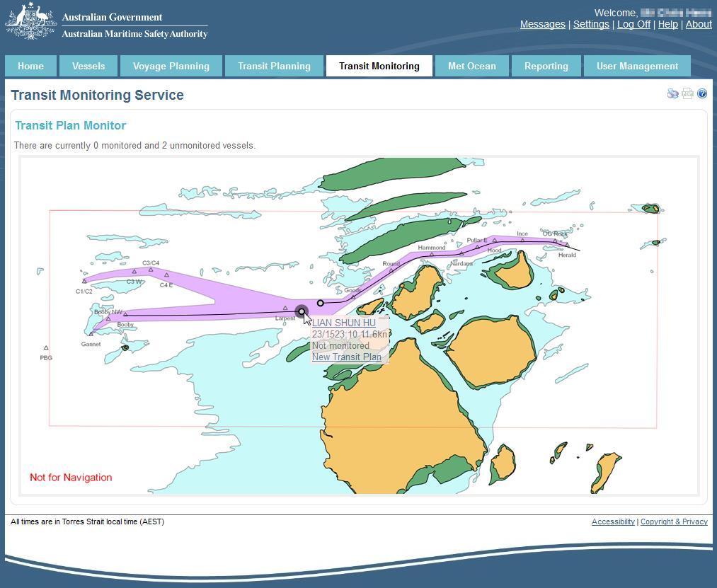
44 Met Ocean Display

45 Voyage Planning
46 Transit Planning

47 Transit Planning Report

48 Transit Overview

49 Detailed Graphs
50 Operating Envelopes/Gates

51 Outputs and Reports
52 Transit Monitoring
53 Benefits : Pilots - Port Enhanced decision making Improved Master/Pilot Information Exchange Contingency planning Increased transit plan accuracy Optimised safe speed profiling Removes commercial pressure from the Pilot - the hardest decision for a pilot to make is to say NO! Port: Improves Safety Increases Economic Benefits Greater Operating Flexibility

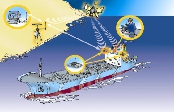
54 Full Scale Vessel Motion Analyses (FSVMA) Purpose: Determine accuracy of DUKC modelling. Calibrate DUKC models. Outcome: Has ensured the safety of over 80,000 DUKC transits Worldwide (in operational use every 1.5 hrs)


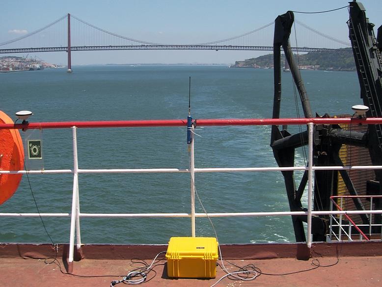
55 Full Scale Measurements Measurements at 30 different ports Over 280 vessels: Containers, Bulk Carriers, Tankers Swell ports, Rivers, Bars, Channels, Open Water Vancouver Columbia River
56 Measuring Dynamic Motions
57 Squat Validation
58 Predicted Significant Roll
59 Predicted Significant Pitch


60 iheave Severe conditions can make FSVMA hazardous or impractical


61 iheave Solid-state accelerometers & gyroscopes IMU Specification Pitch & roll to 0.03 degrees Heave to 0.05 meters (or 5%)
62 UKC developments POADSS Port Operational Approach and Decision Support System European Research Project MarNIS
 AIS feeds Includes: 3D position information IMU integration measured heave, roll and pitch motions Broadband connection real-time data, such as tide, weather, traffic,")
63 What is POADSS? (Port Operational Approach and Decision Support System) POADSS Next generation Portable Pilot Unit (PPU) Real-time position via laptop, charting software and GPS. DGPS, (also RTK corrections) AIS feeds Includes: 3D position information IMU integration measured heave, roll and pitch motions Broadband connection real-time data, such as tide, weather, traffic, WMS Up-to-date HD bathymetric data Dynamic Underkeel Clearance (DUKC) Prototype developed and tested (2008) ADX XR 1 st POADSS type PPU 2011
64 POADSS Architecture

65 Real-time Transit Planning

66 Real-time Dynamic Motions
67 Dynamic Tide Contours
68 14.7m Vessel 12k Area 1

69 14.7m Vessel 14k Area 1

70 14.7m Vessel 16k Area 1

71 14.7m Vessel 12k Area 2 High waves / Low waves
72 14.7m Vessel 14k Area 2 High waves / Low waves
73 14.7m Vessel 16k Area 2 High waves / Low waves
74 What If High Waves... High waves / Low waves

75 What If Low Waves... High waves / Low waves
76 Additional Applications with DUKC Dredge Optimisation Optimised bed depth based on DUKC simulation Thousands of simulations provide thousands of optimised bed depths


77 VOLUME OF DREDGING SAVED Different requirements result in different optimised depths. 1. Access for 14.5 metre draft tankers on 95% of high waters. 2. Access for all inbound vessels on 90% of occasions regardless of tide. 3. Minimum requirement of 4 hour operating windows for container vessels in winter.

78 Who is OMC International? Inventor and sole supplier of DUKC 17 years in operation with over 80,000 safe transits Installed at 21 Australian, NZ and EU ports OMC is the approved supplier to AMSA for the Torres Strait UKCM system
79
80
DUKC Chart Overlay. Presentation to IHO TWL and DQ Working Groups Wollongong, March 2014
 DUKC Chart Overlay Presentation to IHO TWL and DQ Working Groups Wollongong, March 2014 Outline Who is OMC? DUKC description & methodology. DUKC Chart Overlay concept. Chart Overlay application example.
Underkeel Clearance. Refresher and changes since EMPA 2015 Lisboa CATZOC s Under-keel clearance methodology
 Underkeel Clearance Refresher and changes since EMPA 2015 Lisboa CATZOC s Under-keel clearance methodology 11 May 2017 Captain Jonathon Pearce Business Development Manager jpearce@omcinternational.com
The role of UKCM now and the future
 The role of UKCM now and the future NAV18 Torres Strait use case omcinternational.com Who is OMC International? Inventor (1993) and sole supplier of DUKC (>160,000 deep draft transits without incident)
FULL SCALE MEASUREMENT OF DYNAMIC SHIP MOTIONS AND SQUAT
 FULL SCALE MEASUREMENT OF DYNAMIC SHIP MOTIONS AND SQUAT Mr. Gary Rolph Chief Hydrographic Surveyor Port of Brisbane Corporation Mr. Peter Rumball Surveyor Port of Brisbane Corporation Dr. Terry O'Brien
DUKC DYNAMIC UNDER KEEL CLEARANCE
 DUKC DYNAMIC UNDER KEEL CLEARANCE Information Booklet Prepared in association with Marine Services Department 10/10/2005 Dynamic Under Keel Clearance (DUKC) integrates real time measurement of tides and
Figure 1: The squat effect. (Top) Ship at rest. (Bottom) Ship under way.
 Ship at rest. (Bottom) Ship under way.") Under-Keel Clearance of Frigates and Destroyers in Shallow Water Tim Gourlay, Centre for Marine Science and Technology, Curtin University CMST Research Report 013-53 Abstract For RAN ships operating in
Under-Keel Clearance of Frigates and Destroyers in Shallow Water Tim Gourlay, Centre for Marine Science and Technology, Curtin University CMST Research Report 013-53 Abstract For RAN ships operating in
Paper for consideration by ENC Working Group. Use of AU6 ENC cells as an option for Bathymetric ENCs (benc)
") Paper for consideration by ENC Working Group Use of AU6 ENC cells as an option for Bathymetric ENCs (benc) Submitted by: Alvaro Sanchez (AHS) Executive Summary: Compilation of high density bathymetric
Paper for consideration by ENC Working Group Use of AU6 ENC cells as an option for Bathymetric ENCs (benc) Submitted by: Alvaro Sanchez (AHS) Executive Summary: Compilation of high density bathymetric
Accommodating Larger Vessels: Ship Maneuverability and Channel Depth; A discussion of vessel motion in shallow water and future research needs.
 Accommodating Larger Vessels: Ship Maneuverability and Channel Depth; A discussion of vessel motion in shallow water and future research needs. PANELISTS: Paul Amos: President, Columbia River Pilots. Larry
Measurement of vertical motions of bulk carriers navigating in port entrance channels
 HYDROGRAPHIC CONFERENCE Technical Awareness Seminar 2007 Cape Town, 19 21 June 2007 Measurement of vertical motions of bulk carriers navigating in port entrance channels J Moes CSIR, PO Box 320, Stellenbosch,
SOCIEDAD CHILENA DE INGENIERIA HIDRÁULICA V SEMINARIO INTERNACIONAL DE INGENIERÍA Y OPERACIONES PORTUARIAS OCTUBRE 2008, CONCEPCIÓN, CHILE
 UKC management an Australasian perspective. MATTHEW TURNER 1 PETER O BRIEN 2 RESUMEN Historically UKC management in Australia and New Zealand has been based on empirical static rules. Depending on the
HELSINKI COMMISSION HELCOM SAFE NAV 4/2014 Group of Experts on Safety of Navigation Fourth Meeting Helsinki, Finland, 4 February 2014
 HELSINKI COMMISSION HELCOM SAFE NAV 4/2014 Group of Experts on Safety of Navigation Fourth Meeting Helsinki, Finland, 4 February 2014 Agenda Item 3 Accidents and ship traffic in the Baltic Sea Document
Port of Melbourne DUKC Implementation
 Port of Melbourne DUKC Implementation Giles R. Lesser, Matthew R. Turner and Peter W. O Brien OMC International Pty Ltd, Australia Abstract Port Phillip Heads (PPH) is rightly considered one of the most
AHO s experience on HD bathymetric ENCs
 AHO s experience on HD bathymetric ENCs ENCWG3 Wollongong 16 18 April 2018 Alvaro Sanchez DD Charting Quality Assurance, Standards and Specifications Australian Hydrographic Office Background 2016 As part
Paper 52 The St Lawrence River DUKC System Implementation
 Paper 52 The St Lawrence River DUKC System Implementation TURNER M. and VILLELLA, M. (OMC International, Australia; Pilotage S.A, Argentina) Email (1 st author): m.turner@omcinternational.com ABSTRACT:
Concept Channel Design & Channel Development Strategy D R A F T. Document Ref: AGH-CEP0-EG-REP-0012
 Concept Channel Design & Channel Development Strategy Document Ref: AGH-CEP0-EG-REP-0012 In May 2016 the Special Minister of State asked Infrastructure Victoria to provide advice on the future capacity
Preventing Damage to Harbour Facilities and. Ship Handling in Harbours PART 2 INDEX
 Preventing Damage to Harbour Facilities and Ship Handling in Harbours PART 2 INDEX 1 Vessel handling is based on the basic knowledge that a vessel floats in the water and returns to its original position
AN IMPROVED INTEGRATED APPROACH FOR OPTIMISING SHIPPING CHANNEL CAPACITY FOR AUSTRALIAN PORTS
 An Improved Integrated Approach for Optimising Shipping Channel Capacity for Australian Ports 17 S. MORTENSEN, B. JENSEN, A. HARKIN, M. TREE, T. WOMERSLEY AND R. NAVE AN IMPROVED INTEGRATED APPROACH FOR
New generation of Electronic Card Systems: The 4-D Card
 New generation of Electronic Card Systems: The 4-D Card Capt. Alain Richard Project director Maritime Innovation arichard@imar.ca Context In the present context of globalization and competitiveness, it
PROJECT 1 REMOVAL OF WRECKS IN THE TRAFFIC SEPARATION SCHEME IN THE STRAITS OF MALACCA AND SINGAPORE OBJECTIVE. Generally to enhance the safety of
 PROJECT 1 REMOVAL OF WRECKS IN THE TRAFFIC SEPARATION SCHEME IN THE STRAITS OF MALACCA AND SINGAPORE OBJECTIVE Generally to enhance the safety of navigation in the Straits of Malacca and Singapore (Straits)
All comments received will be taken into consideration before the proposed amendments are implemented.
 Notice of Amendment Port Information Guide Notification date: February 13 th, 2018 Preamble In accordance with the Canada Marine Act, 1998, Section 57 Notice, the Vancouver Fraser Port Authority is proposing
Risk-Based Design of Entrance Channel Depths: A Case Study At the Entrance Channel of Mombasa Port, Kenya
 Risk-Based Design of Entrance Channel Depths: A Case Study At the Entrance Channel of Mombasa Port, Kenya Quy N.M., Vrijling J.K., and Pieter van Gelder Delft University of Technology, Delft, the Netherlands
: Hydrodynamic input for 2D Vessel Simulations (HY- 0027)
") Technical Note To : Christian Taylor (PoHDA) From : Rohan Hudson Cc : Ben Gray Date : 1/04/2015 (Final Draft) Subject : Hydrodynamic input for 2D Vessel Simulations (HY- 0027) Introduction This Technical
Technical Note To : Christian Taylor (PoHDA) From : Rohan Hudson Cc : Ben Gray Date : 1/04/2015 (Final Draft) Subject : Hydrodynamic input for 2D Vessel Simulations (HY- 0027) Introduction This Technical
WESTRIDGE MARINE TERMINAL VANCOUVER, BC PASSING SHIP ANALYSIS
 WESTRIDGE MARINE TERMINAL VANCOUVER, BC PASSING SHIP ANALYSIS Prepared for: Prepared by: WESTRIDGE MARINE TERMINAL VANCOUVER, BC PASSING SHIP ANALYSIS M&N Project No. 7773 01 Revision Description Issued
The Maritime Law Association of Australia and New Zealand
 The Maritime Law Association of Australia and New Zealand Protecting the Environment and Promoting Safe Navigation: Australia s System of Pilotage in the Torres Strait Adam McCarthy Assistant Secretary
(Refer Slide Time: 00:32)
") Port and Harbour Structures By Prof R. Sundaravadivelu Department of Ocean Engineering, Indian Institute of Technology Madras Module 8, Lecture 43 Detailed Project Report So last class we discussed about
Port and Harbour Structures By Prof R. Sundaravadivelu Department of Ocean Engineering, Indian Institute of Technology Madras Module 8, Lecture 43 Detailed Project Report So last class we discussed about
Port Sections Guide Section 01
 s Guide 01 Cow Bay Marina Date 10/1/2016 Position (lat / lon) Minimum controlled water depth Chart datum Range of water densities Tidal range alongside Bottom type Dredging regime Distance pilot station
Navigational risk management with under-keel clearance consideration
 Gucma Lucjan SSARS 2011 Summer Safety and Reliability Seminars, July 03-09, 2011, Gdańsk-Sopot, Poland Schoeneich Marta Maritime University of Szczecin, Poland Navigational risk management with under-keel
GENERAL LIMITATIONS AND RESTRICTIONS. Draft Restrictions
 RULES AND REGULATIONS GOVERNING PILOTS AND PILOTAGE ON THE CORPUS CHRISTI SHIP CHANNEL EFFECTIVE AUGUST 1, 2013 AMENDED EFFECTIVE MAY 13, 2014 AMENDED EFFECTIVE OCTOBER 1, 2014 I GENERAL The Rules and
PORTS AUSTRALIA. PRINCIPLES FOR GATHERING AND PROCESSING HYDROGRAPHIC INFORMATION IN AUSTRALIAN PORTS (Version 1.5 November 2012)
") PORTS AUSTRALIA PRINCIPLES FOR GATHERING AND PROCESSING HYDROGRAPHIC INFORMATION IN AUSTRALIAN PORTS (Version 1.5 November 2012) PREFACE These Principles have been prepared by the Hydrographic Surveyors
PORTS AUSTRALIA PRINCIPLES FOR GATHERING AND PROCESSING HYDROGRAPHIC INFORMATION IN AUSTRALIAN PORTS (Version 1.5 November 2012) PREFACE These Principles have been prepared by the Hydrographic Surveyors
WOODFIBRE LNG VESSEL WAKE ASSESSMENT
 Woodfibre LNG Limited WOODFIBRE LNG VESSEL WAKE ASSESSMENT Introduction Woodfibre LNG Limited (WLNG) intends to build a new LNG export terminal at Woodfibre, Howe Sound, British Columbia. WLNG has engaged
5.0 Channel Design and Alternatives
 5.0 Channel Design and Alternatives The dimensions of the navigational areas such as approach channel, manoeuvring areas, anchorage, etc. are based on the type and size of the vessel envisaged to visit
EMPA 2017 How can the S-102 Bathymetric Surface Product improve safety in navigation and pilotage?
 EMPA 2017 How can the S-102 Bathymetric Surface Product improve safety in navigation and pilotage? Operated by the Norwegian Mapping Authority, Hydrographic Service FREEDOM TO CHOOSE Content What is the
Taranaki Tsunami Inundation Analysis. Prepared for Taranaki Civil Defence Emergency Management Group. Final Version
 Taranaki Tsunami Inundation Analysis Prepared for Taranaki Civil Defence Emergency Management Group Final Version June 2012 AM 12/07 HBRC Plan Number 4362 Asset Management Group Technical Report Prepared
Influence of Marine Operations on Site Selection & Design of Marine Terminals
 SOCIEDAD CHILENA DE INGENIERIA HIDRÁULICA V SEMINARIO INTERNACIONAL DE INGENIERÍA Y OPERACIONES PORTUARIAS OCTUBRE 2008, CONCEPCIÓN, CHILE Influence of Marine Operations on Site Selection & Design of Marine
CALCASIEU SALINITY STRUCTURES. HYDRODYNAMIC MODELING (To Support Design of Salinity Barriers)
") CALCASIEU SALINITY STRUCTURES HYDRODYNAMIC MODELING (To Support Design of Salinity Barriers) Presentation Overview 1 2 3 4 5 Project Overview and CEA Circulation Modeling Vessel Hydrodynamics Modeling
CALCASIEU SALINITY STRUCTURES HYDRODYNAMIC MODELING (To Support Design of Salinity Barriers) Presentation Overview 1 2 3 4 5 Project Overview and CEA Circulation Modeling Vessel Hydrodynamics Modeling
ENVIRONMENT AGENCY GREAT OUSE AND 100 FT DRAIN QUARTERLY BATHYMETRIC SURVEY DECEMBER 2013 SITE SURVEY REPORT NO. H6787
 ENVIRONMENT AGENCY GREAT OUSE AND 100FT DRAIN QUARTERLY BATHYMETRIC SURVEY DECEMBER 2013 NO. H6787 LONGDIN & BROWNING (SURVEYS) LIMITED CHERRY TREE HOUSE CARMARTHEN ROAD SWANSEA SA1 1HE H6787 1 Measured
Introduction. Measuring vertical motions using GPS
 Full-Scale Measurements of Containership Sinkage, Trim and Roll Tim Gourlay & Kim Klaka Centre for Marine Science and Technology Curtin University, GPO U1987, Perth 6845, Western Australia Abstract We
Infrastructure Victoria Second Container Port Advice
 Infrastructure Victoria 4 May 2017 Infrastructure Victoria Second Container Port Advice Navigation Study Revision 0 3 May 2017 Navigation Study Client: Infrastructure Victoria ABN: 83 184 746 995 Prepared
PILOTAGE INFORMATION
 PILOTAGE INFORMATION Revised A PILOTAGE DIRECTIONS The Gloucester Harbour Trustees is the Competent Harbour Authority for the Gloucester Harbour under the Pilotage Act 1987 and responsible for the provision
Feasibility Study for Dredging of Khaprabhanga Chapalir Don River in Patuakhali District for Improvement of Navigability
 IOSR Journal of Engineering (IOSRJEN) ISSN (e): 2250-3021, ISSN (p): 2278-8719 Vol. 04, Issue 06 (June. 2014), V3 PP 32-38 www.iosrjen.org Feasibility Study for Dredging of Khaprabhanga Chapalir Don River
WORK-REST REQUIREMENTS FOR PILOTS
 AN ORDER OF THE BOARD OF PILOT COMMISSIONERS FOR THE PORT OF CORPUS CHRISTI AUTHORITY REGARDING WORK-REST REQUIREMENTS FOR PILOTS AND COMBINED BEAM RESTRICTION Whereas, the current Rules and Regulations
Gorgon - Pilotage - Passage Plan - PBG to Gorgon Marine Terminal - Alternative Route
 1.0 Introduction This work instruction outlines the passage plan to be used by vessels transiting from the Port of Barrow Island PBG to the Gorgon Marine Terminal, via the alternative route, with a Pilot
DEVELOPING PILOTAGE PLANS ON BRIDGE SIMULATORS: METHODOLOGY, BENEFITS AND CHALLENGES
 MARSIM 2018, International Conference on Marine Simulation and Ship Manoeuvrability Halifax, Canada, 12-16 August 2018 DEVELOPING PILOTAGE PLANS ON BRIDGE SIMULATORS: METHODOLOGY, BENEFITS AND CHALLENGES
GENERAL LIMITATIONS AND RESTRICTIONS. LNGC Temporary Exemption (Effective August 21, 2018)
") RULES AND REGULATIONS GOVERNING PILOTS AND PILOTAGE ON THE CORPUS CHRISTI SHIP CHANNEL EFFECTIVE AUGUST 1, 2013 AMENDED EFFECTIVE MAY 13, 2014 AMENDED EFFECTIVE OCTOBER 1, 2014 AMENDED EFFECTIVE JANUARY
RULES AND REGULATIONS GOVERNING PILOTS AND PILOTAGE ON THE CORPUS CHRISTI SHIP CHANNEL EFFECTIVE AUGUST 1, 2013 AMENDED EFFECTIVE MAY 13, 2014 AMENDED EFFECTIVE OCTOBER 1, 2014 AMENDED EFFECTIVE JANUARY
Paper for Consideration by HSSC8 Development of an Additional Bathymetry Layer standard based on S-57/S-52
 Paper for Consideration by HSSC8 Development of an Additional Bathymetry Layer standard based on S-57/S-52 Submitted by: CIRM, Germany, USA (NOAA) Executive Summary: Proposal for the standardization of
Passing Vessel Analysis in Design and Engineering. Eric D. Smith, P.E. Vice President, Moffatt & Nichol
 moffatt & nichol Passing Vessel Analysis in Design and Engineering Eric D. Smith, P.E. Vice President, Moffatt & Nichol Passing Vessel Analysis in Port Engineering and Design Passing Vessel Effects Data
Assessment Simulation study, Phase 2. Port of Roenne. FORCE / Rev. B
 / Rev. B i LIST OF CONTENTS: PAGE: 0. EXECUTIVE SUMMARY... 1 1. INTRODUCTION... 2 1.1. General... 2 1.2. Objectives... 3 2. SUMMARY... 4 2.1. Observations... 5 2.2.1 General... 5 2.2.2 Weather conditions...
Chittagong, Bangladesh (Asia Region)
") General Information: Port Information (Asia Region) Extract of port information from Chittagong Port Authority: The Port of Chittagong is the principal Port of the People's Republic of Bangladesh. It is
General Information: Port Information (Asia Region) Extract of port information from Chittagong Port Authority: The Port of Chittagong is the principal Port of the People's Republic of Bangladesh. It is
Rotary vane steering gear for smaller vessels
 Steering gear Rotary vane steering gear for smaller vessels The SR series is designed with integrated frequency controlled pumps. General description Rolls-Royce supplies a complete range of steering gear,
Hydrographic Surveying at The Port of London
 Hydrographic Surveying at The Port of London John Dillon-Leetch Port and Terminal Technology 2009 14 th October, Antwerp Overview Introduction Surveying the Thames Navigational Charting High Resolution
BWS ONLINE FORECASTING BERTH OPERATING SAFETY. Matthew R. O Halloran, Daphne Choong
 BWS ONLINE FORECASTING BERTH OPERATING SAFETY Matthew R. O Halloran, Daphne Choong OMC International Pty Ltd, 2/2 Walmer St, Abbotsford, Vic 3067, Australia matthew@omc-international.com.au daphne@omc-international.com.au
INTEGRATED METHOD FOR OPTIMAL CHANNEL DREDGING DESIGN
 Integrated Method for Optimal Channel Dredging Design 5 LUCAS SILVEIRA, GUSTAVO GOMES, LUANA TAIANI, VALDECÍLIO PINHEIRO, LINDINO BENEDET, ANDRE MARQUES AND CLAUDIO LOUREIRO INTEGRATED METHOD FOR OPTIMAL
PORT OF PORT HEDLAND PORT USER GUIDELINES AND PROCEDURES
 TABLE OF CONTENTS DISTRIBUTION LIST... 4 1. OBJECTIVE... 5 2. SCOPE... 5 3. VESSEL MOVEMENT GUIDELINES... 5 3.1 ARRIVALS / BERTHING... 6 3.2 CHANNEL ENTRY DEPTHS... 6 3.3 BERTHING DRAFTS... 6 3.3.1 Strong
Marine Renewables Industry Association. Marine Renewables Industry: Requirements for Oceanographic Measurements, Data Processing and Modelling
 Marine Renewables Industry Association Marine Renewables Industry: Requirements for Oceanographic Measurements, Data Processing and Modelling October 2009 Table of Contents 1. Introduction... 1 2. Measurements
Visiting Lake Macquarie
 Visiting Lake Macquarie Lake Macquarie is the largest coastal salt water lake in Australia and is a prime boating destination for both small and large vessels. Many sailing regattas and fishing activities
Forth Ports Limited. Port of Dundee. Marine Guidelines and Port Information
 Forth Ports Limited Port of Dundee Marine Guidelines and Port Information LIST OF AMENDMENTS DATE PAGE NUMBER 22 NEW EDITION 7 March 2016 Ruling Depths 18 23 rd Application updated 3 23 rd - Tug fleet
Validation of Container Ship Squat Modeling Using Full-Scale Trials at the Port of Fremantle
 Ha, J.H., and Gourlay, T.P. (2018). Validation of Container Ship Squat Modeling Using Full- Scale Trials at the Port of Fremantle. Journal of Waterway, Port, Coastal, and Ocean Engineering, 144(1), DOI:
14/10/2013' Bathymetric Survey. egm502 seafloor mapping
 egm502 seafloor mapping lecture 10 single-beam echo-sounders Bathymetric Survey Bathymetry is the measurement of water depths - bathymetry is the underwater equivalent of terrestrial topography. A transect
Activities of KHOA on creation of S-10X test data sets and S-100 sea trial
 Activities of KHOA on creation of S-10X test data sets and S-100 sea trial Submitted by: Executive Summary: Related Documents: Related Projects: Republic Of Korea (KHOA) KHOA has been conducting a research
NAVIGATION IN CONFINED WATERS: INFLUENCE OF BANK CHARACTERISTICS ON SHIP-BANK INTERACTION
 NAVIGATION IN CONFINED WATERS: INFLUENCE OF BANK CHARACTERISTICS ON SHIP-BANK INTERACTION Evert LATAIRE, Maritime Technology Division, Ghent University, Ghent, Belgium Marc VANTORRE, Maritime Technology
Applications of ELCIRC at LNEC
 stratification in the Guadiana estuary tidal propagation in the Óbidos lagoon Lígia Pinto Anabela Oliveira André B. Fortunato 2 O utline Stratification in the Guadiana estuary The Guadiana estuary Objectives
Optimization of Tidal Windows for Deep-Drafted Vessels by Means of ProToel
 International Workshop on Next Generation Nautical Traffic Models 2013, Delft, The Netherlands Optimization of Tidal Windows for Deep-Drafted Vessels by Means of ProToel Marc Vantorre 1, Maxim Candries
PORT INFORMATION PORT OF MARSDEN POINT NEW ZEALAND
 Northport Limited PORT INFORMATION PORT OF MARSDEN POINT NEW ZEALAND Rev 8 Contents CONTENTS...1 WHANGAREI HARBOUR...3 LOCATION...3 HARBOUR AUTHORITY...3 THE HARBOUR MASTER...3 PORT OPERATING COMPANY...3
Marine Accident Analysis of Collisions and Groundings: How to learn from past incidents to avoid them in the future
 Marine Accident Analysis of Collisions and Groundings: How to learn from past incidents to avoid them in the future Webinar: International Union of Marine Insurance 10 April 2018 Marine Accident Analysis
ROYAL VANCOUVER YACHT CLUB
 ROYAL VANCOUVER YACHT CLUB PROPOSED EXPANSION PROJECT NAVIGATION CHANNEL DESIGN COAL HARBOUR Prepared for: Royal Vancouver Yacht Club Prepared by: Typlan Consulting Ltd. March 2016 Page 1 of 17 March 23,
Port of Barrow Island - Local Knowledge Certificate Examination
 Port of Barrow Island - Local Knowledge 1.0 Introduction Safe navigation within the Port of Barrow Island requires significant local knowledge of navigation, communications, pilotage and operational procedures.
Gorgon Pilotage Passage Plan - PBG to Gorgon Marine Terminal Primary Route
 Gorgon Pilotage Passage Plan - PBG to Gorgon Marine Terminal Primary Route 1.0 Introduction Vessels transiting within port limits from the Barrow Island Outer Pilot Boarding Ground (PBG) to the Gorgon
Gorgon - Pilotage - Passage Plan - Gorgon Marine Terminal to PBG Alternative Route
 Gorgon - Pilotage - Passage Plan - Gorgon Operating Procedure - Gorgon - Pilotage - Passage Plan - Gorgon 1.0 Introduction Vessels transiting within port limits from the Gorgon Marine Terminal
ITTC Recommended Procedures and Guidelines
 Page 1 of 6 Table of Contents 1. PURPOSE...2 2. PARAMETERS...2 2.1 General Considerations...2 3 DESCRIPTION OF PROCEDURE...2 3.1 Model Design and Construction...2 3.2 Measurements...3 3.5 Execution of
WAVE FORECASTING FOR OFFSHORE WIND FARMS
 9 th International Workshop on Wave Hindcasting and Forecasting, Victoria, B.C. Canada, September 24-29, 2006 WAVE FORECASTING FOR OFFSHORE WIND FARMS Morten Rugbjerg, Ole René Sørensen and Vagner Jacobsen
Understanding the waves at Port Phillip Heads, Melbourne, Australia
 Understanding the waves at Port Phillip Heads, Melbourne, Australia Giles Lesser Matthew Turner David Provis OMC International, Melbourne, Victoria Cardno Lawson Treloar, Melbourne, Victoria Abstract Waves
GNSS Technology for the Determination of Real-Time Tidal Information
 GNSS Technology for the Determination of Real-Time Tidal Information Benjamin Kidder C-Nav Positioning Solutions European region Outline of Topics Covered Introduction to Tides Past and Present Methods
Hydrodynamic and hydrological modelling to support the operation and design of sea ports
 Hydrodynamic and hydrological modelling to support the operation and design of sea ports Data needs and examples Martijn de Jong (port/nautical requirements, waves, currents) Sofia Caires (mean and extreme
PORT OF PORT HEDLAND PORT USER GUIDELINES AND PROCEDURES
 TABLE OF CONTENTS 1. OBJECTIVE...6 2. SCOPE...6 3. VESSEL MOVEMENT GUIDELINES...6 3.1 Wind limitations...7 3.2 Channel Entry Depths...7 3.3 Berthing Drafts...7 3.4 Strong Winds / Adverse Weather...8 4.
AMSA A Roadmap Forward & Relevant Alaska Activities. Captain Bob Pawlowski, NOAA (Ret), MNI Legislative Liaison to the Denali Commission
, MNI Legislative Liaison to the Denali Commission") AMSA A Roadmap Forward & Relevant Alaska Activities Captain Bob Pawlowski, NOAA (Ret), MNI Legislative Liaison to the Denali Commission Selected AMSA Key Findings UNCLOS: Fundamental framework IMO: Competent
AMSA A Roadmap Forward & Relevant Alaska Activities Captain Bob Pawlowski, NOAA (Ret), MNI Legislative Liaison to the Denali Commission Selected AMSA Key Findings UNCLOS: Fundamental framework IMO: Competent
A methodology for evaluating the controllability of a ship navigating in a restricted channel
 A methodology for evaluating the controllability of a ship navigating in a restricted channel K. ELOOT A, J. VERWILLIGEN B AND M. VANTORRE B a Flanders Hydraulics Research (FHR), Flemish Government, Antwerp,
Uncontrolled document if printed.
 APPENDIX 3 APPRENTICE PILOT S TRAINING SYLLABUS Issue Date: 16 th March, 2010 Date of Revision: 22nd May, 2013 Revision #2 i THE PURPOSE OF THIS SYLLABUS The purpose of this training syllabus is to ensure
ADANI PORTS & SEZ LTD. ++ MUNDRA PORT ++ GENERAL INFORMATION
 ADANI PORTS & SEZ LTD. ++ MUNDRA PORT ++ GENERAL INFORMATION LOCATION Mundra Port is all weather, independent, commercial port with geographical and hydrological advantages on the West Coast of India,
Nautical sub-committee
 Nautical sub-committee Accomplishments, latest work and developments Capt. Pantelis Patsoulis Nautical sub-committee INTERTANKO s most recently established subcommittee. Established from parent committee
Gorgon - Pilotage - Passage Plan PBG to Materials Offloading Facility (MOF)
") 1.0 Introduction Vessels transiting within port limits from the Barrow Island Pilot Boarding Ground (PBG) to the require an approved passage plan which can be shared between Pilots and vessel Masters.
1.0 Introduction Vessels transiting within port limits from the Barrow Island Pilot Boarding Ground (PBG) to the require an approved passage plan which can be shared between Pilots and vessel Masters.
13. TIDES Tidal waters
 Water levels vary in tidal and non-tidal waters: sailors should be aware that the depths shown on the charts do not always represent the actual amount of water under the boat. 13.1 Tidal waters In tidal
Dr Sam BATEMAN, Australian National Centre for Ocean Resources and Security, University of Wollongong
 Dr Sam BATEMAN, Australian National Centre for Ocean Resources and Security, University of Wollongong sbateman@uow.edu.au Coastal State regulation of navigation in adjacent waters is increasing Shipping
IMO REVISION OF THE INTACT STABILITY CODE. Proposal of methodology of direct assessment for stability under dead ship condition. Submitted by Japan
 INTERNATIONAL MARITIME ORGANIZATION E IMO SUB-COMMITTEE ON STABILITY AND LOAD LINES AND ON FISHING VESSELS SAFETY 49th session Agenda item 5 SLF 49/5/5 19 May 2006 Original: ENGLISH REVISION OF THE INTACT
Marine Guide for Ship Masters Contents
 Marine Guide for Ship Masters Contents Marine Guide for Ship Masters... 1 Port Operating Company... 2 Harbour Authority... 2 Location... 2 Pilotage... 2 Pilot Boat... 3 Pilot Ladder... 3 Pilots and Tugs
TITLE: The Importance of Model Validation: Two Case Studies. AUTHOR:Julie Thomas. Scripps Institution of Oceanography, La Jolla, CA.
 TITLE: The Importance of Model Validation: Two Case Studies AUTHOR:Julie Thomas Scripps Institution of Oceanography, La Jolla, CA jothomas@ucsd.edu CO-AUTHOR: Corey Olfe Scripps Institution of Oceanography,
Understanding of Meteorology. for. Handling LNG at Ports
 Understanding of Meteorology for Handling LNG at Ports All environmental forces on the berth and the berthed ship are considered. When evaluating environmental forces, first estimates are obtained for
STATIONKEEPING DYNAMIC POSITIONING FOR YACHTS. Hans Cozijn
 STATIONKEEPING DYNAMIC POSITIONING FOR YACHTS Hans Cozijn Senior Project Manager Offshore YACHTS VS. OFFSHORE INDUSTRY 2 YACHTS VS. OFFSHORE INDUSTRY Source : www.hdmt21.com Source : www.charterworld.com
MARINE INVESTIGATION REPORT M14P0014 GROUNDING
 MARINE INVESTIGATION REPORT M14P0014 GROUNDING CONTAINER VESSEL CAP BLANCHE FRASER RIVER, BRITISH COLUMBIA 25 JANUARY 2014 The Transportation Safety Board of Canada (TSB) investigated this occurrence for
NAVIGATION CHANNEL DESIGN AND TRANSIT OPERATION AT REMOTE TEMPORARY OFFLOAD FACILITY ON SAKHALIN ISLAND, RUSSIA
 NAVIGATION CHANNEL DESIGN AND TRANSIT OPERATION AT REMOTE TEMPORARY OFFLOAD FACILITY ON SAKHALIN ISLAND, RUSSIA Aaron Porter, PE 1, Vladimir Shepsis, PhD, PE 2, and Aaron Horine, PE 3 ABSTRACT To deliver
Port of Corpus Christi
 Port of Corpus Christi Pilot Board Meeting Tuesday, May 13, 2014 8:00 AM Port of Corpus Christi Pilot Board Meeting Tuesday, May 13, 2014-8:00 AM Congressman Solomon P. Ortiz International Center located
The Shipowners Club. Loss Prevention. Tides
 The Shipowners Club Loss Prevention Tides British Crown Copyright and/or database rights. Reproduced by permission of the Controller of Her Majesty's Stationery Office and the UK Hydrographic Office (www.ukho.gov.uk).
HYDRODYNAMICS OF A SHIP WHILE ENTERING A LOCK
 HYDRODYNAMICS OF A SHIP WHILE ENTERING A LOCK T A Vergote, Dredging International, Belgium K Eloot, Flanders Hydraulics Research, Belgium & Maritime Technology Division, EA15, Ghent University, Belgium,
Appendix 12: Marine Transportation Study. (Gartner Lee Ltd. 2008)
") Appendix 12: Marine Transportation Study (Gartner Lee Ltd. 2008) memorandum to: John Woods, Minas Basin Pulp and Power Co. Ltd from: Joseph Kozak date: ref: GLL 80308 re: FINAL Technical Marine Transportation
Appendix 12: Marine Transportation Study (Gartner Lee Ltd. 2008) memorandum to: John Woods, Minas Basin Pulp and Power Co. Ltd from: Joseph Kozak date: ref: GLL 80308 re: FINAL Technical Marine Transportation
THE SYLLABUS FOR WRITTEN EXAMINATION PILOT'S FOURTH CLASS LICENCE (TEES AND HARTLEPOOL) AND
 AND") PD TEESPORT CONSERVANCY DIVISION HARBOUR MASTER'S OFFICE THE SYLLABUS FOR WRITTEN EXAMINATION IN RESPECT OF A PILOT'S FOURTH CLASS LICENCE (TEES AND HARTLEPOOL) AND PILOTAGE EXEMPTION CERTIFICATE (Issued
PD TEESPORT CONSERVANCY DIVISION HARBOUR MASTER'S OFFICE THE SYLLABUS FOR WRITTEN EXAMINATION IN RESPECT OF A PILOT'S FOURTH CLASS LICENCE (TEES AND HARTLEPOOL) AND PILOTAGE EXEMPTION CERTIFICATE (Issued
NAEST(M) training Course Structure and Session Objectives. Day Introduction and enrolment
 training Course Structure and Session Objectives. Day Introduction and enrolment") NAEST(M) training Course Structure and Session Objectives Day 1 0830-0930 Introduction and enrolment 0930-1330 Effective Bridge Procedures & Rule of the Road Lecturer will go through the PowerPoint on
NAEST(M) training Course Structure and Session Objectives Day 1 0830-0930 Introduction and enrolment 0930-1330 Effective Bridge Procedures & Rule of the Road Lecturer will go through the PowerPoint on
Port Melville Information Booklet
 August 2017 Contents 1 General Information... 4 1.1. Port Description... 4 1.2. Berth Details... 5 1.3. Weather Parameters... 5 1.4. Berthing... 5 1.5. Remaining Alongside... 5 1.6. Sailing... 5 1.7. Time
MAC Transit Advisories as of April 30, 2018
 MAC Transit Advisories as of April 30, 2018 The Mariners Advisory Committee for the Bay and River Delaware was established in October 1964. Its members and associate members are mainly comprised of master
OPERATIONS SEAFARER CERTIFICATION GUIDANCE NOTE SA MARITIME QUALIFICATIONS CODE. Deck: Chart Work
 Page 1 of 6 Compiled by Approved by Chief Examiner Syllabus Committee: 26 February 2013 OPERATIONS SEAFARER CERTIFICATION GUIDANCE NOTE SA MARITIME QUALIFICATIONS CODE Deck: Chart Work Page 2 of 6 COLUMN
Gorgon - Pilotage - Passage Plan Materials Offloading Facility (MOF) to PBG
 to PBG") Gorgon - Pilotage - Passage Plan Materials Offloading Facility (MOF) to PBG 1.0 Introduction Vessels transiting within port limits from the Materials Offloading Facility (MOF) to the Barrow Island Pilot
Gorgon - Pilotage - Passage Plan Materials Offloading Facility (MOF) to PBG 1.0 Introduction Vessels transiting within port limits from the Materials Offloading Facility (MOF) to the Barrow Island Pilot
The addition of information about Transport Canada s Navigation Protection Program.
 Notice of Amendment Port Information Guide Date issued: September 8, 2017 Date effective: October 8, 2017 Introduction This notice of amendment is posted publicly to notify industry, stakeholders and the