Geology 10 Activity 8 A Tsunami
|
|
|
- George Mills
- 5 years ago
- Views:
Transcription
1 Geology 10 Activity 8 A Materials: Marigram recorded in San Diego, May 23, Travel Time Graph To San Diego. Answer sheet Source of information: Lander, James F., Patricia A. Lockridge and Michael J. Kozuch, s Affecting the West Coast of the United States , NGDC Key to Geophysical Record Documentation No. 29, National Geophysical Data Center, Boulder, Colo., 1993, 242 p. Distant Source s A distant source tsunami is caused by an earthquake or other tsunami source 1000 km (about 2 hours travel time) or farther from a particular coastal region of interest. Distant source tsunamis are almost always the result of large subduction zone earthquakes. These earthquakes deform a large region of the sea floor, producing a series of waves which may travel across an entire ocean. The great 1960 Chilean earthquake (Mw = 9.5) produced a series of waves which devastated Hilo, Hawaii about 18 hours after the earthquake and coastal communities in Japan nearly 24 hours afterwards. It also damaged a number of communities along the California coast, including Crescent City. Features of the Distant Source : Waves arrive at a coastline without warning. The earthquake source is too far away to feel. Waves may either arrive as a draw down (initial lowering or negative wave) or an increase in the water height (positive wave). There is always a series of waves which are typically many minutes apart. The interval between successive waves is not constant. The first wave is rarely the largest in the sequence. warning systems are designed to issue warnings so that orderly evacuations of vulnerable coastal areas can be made before the first wave arrives. An earthquake which generates a significant distant source tsunami almost always produces a major local tsunami along coastlines close to the source. Marigrams: Look at the marigram on the following page. Answer questions 1 10 on the answer sheet. 1 of 6
2 2 of 6
3 A marigram shows the height of the ocean surface at a particular coastal site. When the line moves up it means the water level is higher, the line moving down means a lower water level. The gentle background curvature is caused by the tides (shown by the dashed line); the sharper peaks show the tsunami waves. The time is listed in G.M.T. (Greenwich Mean Time). This is the same as UTC. The marigram begins at 07:00:00 on 5/23/ What time (G.M.T.) did low tide occur? 2. Look at the first tsunami wave arrival. It is marked by the arrow. It arrives at about 08:50:00. Was this wave positive (a rise in the water level) or negative (a draw down in the water level)? The amplitude of a tsunami wave is defined in the same way as a seismic wave. It is the height from the median position to either the largest positive (crest) or negative (trough). In this case, the median position is the tide as shown by the dashed line. You can use the scale on the ordinate (y) axis to determine the amplitude of the tsunami at any time. For example, the first positive wave (labeled by a "1"), has an amplitude of about 1 foot. This first peak arrives at about 09:40:00. The absolute height of the water when this wave arrives is 2.4 feet. 3. Look at the positive wave crests. What time (G. M.T.) did the largest amplitude positive tsunami wave occur? Estimate the time to the nearest 5 minutes. 4. What was the amplitude (in feet) of the highest positive tsunami wave on this record? s are sometimes called tidal waves because they often appear on shore as a rapidly rising tide. The tides have nothing to do with the generation of a tsunami; however, the background tidal height can affect the tsunami's potential to do damage. 5. What is the absolute height of the highest water on this marigram? (taking into account both the tide and the tsunami height). 6. Suppose the largest waves had occurred at low, rather than high tide. Describe what the difference in effect might be. s always consist of a series of waves. The wave activity may continue for a number of hours. On this record, tsunami waves with amplitude of a foot or more continue for nine hours! The first wave is rarely the largest. 7. How many tsunami wave crests with amplitudes of more than 1 foot are shown on this record? 8. What is the average amount of time between successive 1 foot or larger wave crests? Assume the tsunami waves continue to arrive over a period of 9 hours. Round off your answer to the nearest 1/4 hour. The peak height of the water is only one factor that contributes to the damage a tsunami may cause. Just as important is the speed of the water. Look at the wave around 14:00 hours. 3 of 6
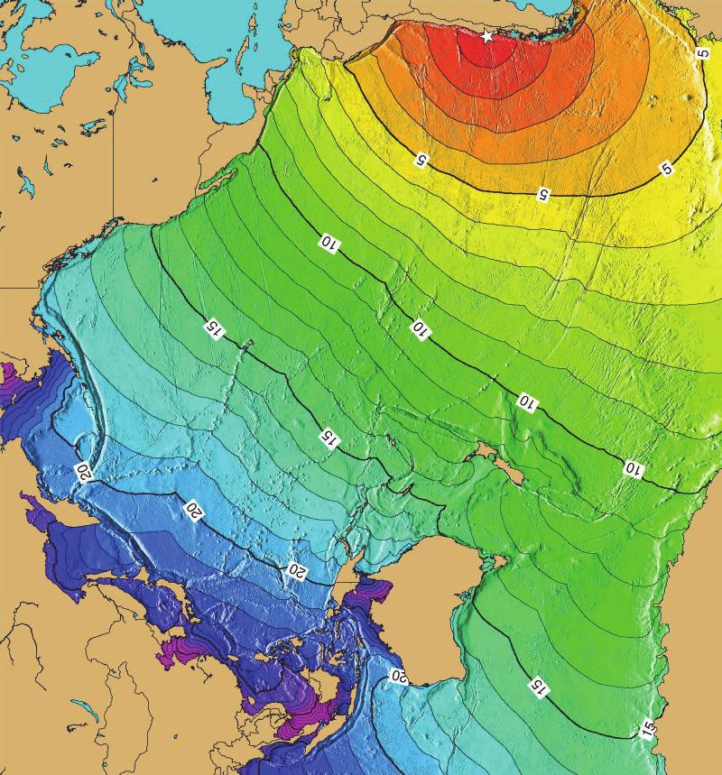
4 9. What is the range (total water level fluctuation from trough to peak) from the trough a little before 14:00 hours to the peak a little after? 10. How much time did it take for the water to go from this trough to the peak? The time it takes tides to go from low to high tide is 6 hours. The currents produced, particularly in bays and inlets, can be quite significant as the tide comes in and goes out. The range in water height from troughs to peaks produced by tsunamis may be as large or larger than the normal tidal fluctuation. But the time for the water to rise or drain is much shorter! Imagine the current velocities at Crescent City in 1964 when water levels fluctuated more than 20 feet in about an hour's time. Travel Time Maps (NOAA): Look at the Travel Time Map To San Diego (colored world map). This shows the expected travel time to anywhere in the Pacific basin. The epicenter of earthquake which generated the marigram you used in the questions above was located in southern Chile where the star is marked. This was historically the largest recorded earthquake, with a moment magnitude calculated as M = How long (round off to the nearest 1/2 hour) did it take the first tsunami wave to travel from the epicentral region of the Chilean earthquake to San Diego? 12. The distance between the epicenter of the Chilean earthquake and San Diego is about 5900 miles. What is the average velocity of the first wave on the San Diego record? (hint, velocity is measured in units of distance traveled divided by elapsed time to get m.p.h) The tsunami waves produced by the 1960 Chilean earthquake did cause damage in San Diego. Approximately 165 feet of dock were destroyed, a bridge was damaged, a barge sank and 8 boat slips were destroyed. Property losses were estimated at over $16,500. A crowd gathered on Shelter Island in San Diego Bay to watch the waves. Police were needed to break up a traffic jam and dispel spectators. 4 of 6
5 5 of 6
6 ANSWER SHEET Geology 15 Activity 8 A NAME Date: 1. Time (GMT) of low tide: 2. First wave positive or negative? 3. Time (GMT) of the largest positive tsunami wave: 4. The amplitude (in feet) of the highest tsunami wave: 5. The absolute height of the highest water: 6. Difference in effects between largest tsunami waves arriving at high or low tide? 7. Number of tsunami crests of amplitudes of more than 1 foot? 8. Average time between successive crests: 9. Total range in feet between trough and peak at 14:00 hours: 10. Total time (to nearest 1/4 hour) between low and high water: 11. Time for first tsunami wave to travel to San Diego: 12. Average speed (distance/time) of the first tsunami wave: 6 of 6
7 Geology 10 Activity 8 B Name Times, Basin Depth, Wave Height Using the equation for shallow water waves (C = gd), calculate the following water wave speeds for the following depths. This yields the speed in m/sec. Multiply by 1.94 to get the speed in knots. 8,000m: m/sec = knots; 4,000m: m/sec = knots, 200m: m/sec = knots; 100m: m/sec = knots; 10m: m/sec knots A magnitude 8.2 earthquake occurred of the southern coast of Peru (16.2 S, 73.4 W) on June 23, 2001 at 2033 GMT. The earthquake generated a tsunami that was recorded on tide gauges around the Pacific basin. Using six of these tidal records calculate the arrival time, travel speed, average depth of travel, wave height, and damage hindcast for each site. Site: ARICA, CHILE [ S, W; distance from epicenter: 412 km] Avg. Travel Speed (km/hr). Shallow water Calculation, Avg Depth of Travel = (m) Wave Height (cm) = Expect Damage? Why or why not? SITE: ANTAFOGASTA, CHILE [23.65 S, 70.4 W; distance from epicenter: 856 km] Why was the speed faster to this location? Wave Height (cm) = Expect Damage? Why or why not? SITE: CALLAO, PERU [12.05 S, W; distance from epicenter: 609 km] SITE: VALPARAISO,CHILE [ S, W; distance from epicenter: 1,886 km] SITE: SANTA CRUX, GALAPAGOS ISLANDS [00.75 S, W; distance from epicenter: 2,531 km] SITE: SAND POINT, ALASKA [ N, E; distance from epicenter: 11,298 km]
Geology 15 Activity 5 A Tsunami
 Materials: Marigram recorded in San Diego, May 23, 1960. Travel Time Graph To San Diego. Answer sheet Source of information: Lander, James F., Patricia A. Lockridge and Michael J. Kozuch, s Affecting the
Waves. Swell, Surf, and Tides
 Waves Swell, Surf, and Tides Tsunamis Tsunamis Waves of Destruction Seismic Sea Waves Seismic Sea Waves Most tsunamis are generated by earthquakes Seismic Sea Waves Most tsunamis are generated by earthquakes
WIND SPEED LENGTH OF TIME WIND BLOWS (Duration) DISTANCE OVER WHICH IT BLOWS (Fetch)
 DISTANCE OVER WHICH IT BLOWS (Fetch)") WAVES Up and down movement of ocean surface Transportation of energy across the water over vast distances If not stopped by anything, waves can travel entire oceans Size and speed depend upon: WIND SPEED
WAVES Up and down movement of ocean surface Transportation of energy across the water over vast distances If not stopped by anything, waves can travel entire oceans Size and speed depend upon: WIND SPEED
Imagine that you can see a side view of a wave as it approaches a beach. Describe how the wave changes as the wave approaches the beach.
 Geology 101 Name Reading Guide for Ch. 19: Shores and Coastal Processes (p. 612) Waves, Currents, and Tides (p. 614) Waves and Currents (p. 614) Imagine that you can see a side view of a wave as it approaches
Tsunami generation, propagation, and devastation. John Fenton
 Tsunami generation, propagation, and devastation John Fenton Tsunami Tsunami is a Japanese term that means "harbour wave". It is used worldwide to describe a large sea wave generated by sea-floor disturbance.
What are Waves? Earthquake. Waving flags. Vocal Cords Vibrate
 Waves Ch. 10 What are Waves? All waves are movement of energy through a medium (air, rock, water) Series of vibrations or undulations in a medium Wave types: ocean, sound, light, seismic Vocal Cords Vibrate
OCN 201 Tides. Tsunamis, Tides and other long waves
 OCN 201 Tides Tsunamis, Tides and other long waves Storm surges Caused by winds and low atmospheric pressure associated with large storms Can raise sea surface by up to 25 ft, bottom contours magnify effect
Waves. Types of Waves. Parts of a wave. Insert wind_wave.wmv. Shark attack
 Waves Recall: Waves = transmitted energy What causes waves? Wind gravity Earthquakes We will talk about all of these, but first Insert wind_wave.wmv Shark attack Types of Waves Body waves transmit energy
Tsunamis. Tsunamis COMMUNITY EMERGENCY RESPONSE TEAM TSUNAMIS
 Tsunamis Tsunamis Tell the participants that tsunamis are ocean waves that are produced by underwater earthquakes or landslides. The word is Japanese and means harbor wave because of the devastating effects
WHAT IS A TSUNAMI? happens.nz. Long or Strong GET GONE TSUNAMI 101
 WHAT IS A TSUNAMI? A tsunami is a series of powerful waves with strong currents. They are mostly caused by underwater or coastal earthquakes, and sometimes by underwater landslides or volcanic eruptions.
Ocean Waves. Capillary. Gravity. Wind generated. Tides Tsunamis Seiches
 Ocean Waves Capillary Wind generated Gravity Tides Tsunamis Seiches Capillary waves are driven by the surface tension produced by electrically polarized water molecule San Pedro Lighthouse Waves are alternate
The frequently asked questions are grouped under headings to make it easier to find information -
 Tsunami Inundation Mapping for Hawke s Bay Frequently Asked Questions The frequently asked questions are grouped under headings to make it easier to find information - General tsunami information Tsunami
Announcements. Project 2 due Nov 7 th Topics for today: Big waves. Tsunamis, seiches and tidal waves. Tsunamis and seiches
 Announcements Project 2 due Nov 7 th Topics for today: Big waves Tsunamis, seiches and tidal waves Tsunamis and seiches Seiche: standing wave that rocks back and forth within an enclosed or semi-enclosed
The events associated with the Great Tsunami of 26 December 2004 Sea Level Variation and Impact on Coastal Region of India
 The events associated with the Great Tsunami of 26 December 2004 Sea Level Variation and Impact on Coastal Region of India Satish R. Shetye National Institute of Oceanography, Goa Tsunamis are shallow-water
OCEAN WAVES NAME. I. Introduction
 NAME OCEAN WAVES I. Introduction The physical definition of a wave is a disturbance that transmits energy from one place to another. In the open ocean waves are formed when wis blowing across the water
L E S S O N : Tsunami Simulation Experiment
 e h p L E S S O N : Tsunami Simulation Experiment Summary: Students read the article, Building a Tsunami Warning System, and discuss what a tsunami is and why it is important to have a tsunami warning
Natural Bridges Field Trip Activity
 Natural Bridges Field Trip Activity This is due in class on MONDAY- March 1 - not in sections! Name TA: NOTE ON THE GRADING OF THIS ASSIGNMENT: Many of the questions below (especially in the tidepool part)
OCEANOGRAPHY STUDY GUIDE
 OCEANOGRAPHY STUDY GUIDE Chapter 2 Section 1 1. Most abundant salt in ocean. Sodium chloride; NaCl 2. Amount of Earth covered by Water 71% 3. Four oceans: What are they? Atlantic, Pacific, Arctic, Indian
Waves Part II. non-dispersive (C g =C)
") Waves Part II Previously we discussed Surface Gravity Waves Deep Water Waves Shallow Water Waves C g T 2 C g h dispersive (C g =C/2) Definitions: phase speed C= /T= /k non-dispersive (C g =C) group speed
Waves Part II Previously we discussed Surface Gravity Waves Deep Water Waves Shallow Water Waves C g T 2 C g h dispersive (C g =C/2) Definitions: phase speed C= /T= /k non-dispersive (C g =C) group speed
WAVES, WAVE BEHAVIOR, GEOPHYSICS AND SOUND REVIEW ANSWER KEY
 WAVES, WAVE BEHAVIOR, GEOPHYSICS AND SOUND REVIEW ANSWER KEY Instructions: Show all of your work completely in your journal, including the equations used in variable form. Pay attention to sig figs and
Chapter 22, Section 1 - Ocean Currents. Section Objectives
 Chapter 22, Section 1 - Ocean Currents Section Objectives Intro Surface Currents Factors Affecting Ocean Currents Global Wind Belts (you should draw and label a diagram of the global wind belts) The Coriolis
For Educational and Non-Profit Use Only!
 This flyer was originally created and published in Japanese by Shizuoka Prefecture, Japan. UNESCO IOC ITIC provides this English translation for portions of the original document with the kind permission
Coastal Hazards Study
 Coastal Hazards Study 2212 Beach Boulevard, Pacifica Prepared for: EXECUTIVE SUMMARY City of Pacifica 170 Santa Maria Ave Pacifica, CA 94044 Prepared by: moffatt & nichol 2185 N. California Blvd. Walnut
Oceans - Laboratory 12
 Oceans - Laboratory 12 (Name) How do ocean waves form? All waves are disturbances of a fluid medium through which energy is moved (Davis, 1997). Ocean waves travel on the interface between oceans and the
SURFACE CURRENTS AND TIDES
 NAME SURFACE CURRENTS AND TIDES I. Origin of surface currents Surface currents arise due to the interaction of the prevailing wis a the ocean surface. Hence the surface wi pattern (Figure 1) plays a key
1. What are the differences and similarities among transverse, longitudinal, and surface waves?
 Assignment Waves Reading: Giancoli, Chapters 11, 12, 22, 24 Holt, Chapters 12, 14 Objectives/HW The student will be able to: 1 Define, apply, and give examples of the following concepts: wave, pulse vs.
CHILEAN EARTHQUAKE OF 22ND MAY 1960
 COMMONWEALTH OF AUSTRALIA DEPARTMENT OF NATIONAL DEVELOPMENT, BUREAU OF MINERAL RESOURCES, GEOLOGY AND GEOPHYSICS RECORDS 1961, N. 3 c171114t. 're* 4"e;\ \ F.;^ig74 sa c_cx0v,iplk TSUNAMI EFFECTS OF THE
Tsunami Preparedness in the Capital Region
 Tsunami Preparedness in the Capital Region A presentation by: the CRD Local Government Emergency Program Advisory Commission (LG EPAC) and your community emergency programs What is a tsunami? A tsunami
Test 1: Ocean 116 (Oceanography Lab.)
") GLENDALE COMMUNITY COLLEGE Name Marks secured /25 Test 1: Ocean 116 (Oceanography Lab.) Dr. Poorna Pal Note: Answer all questions/solve all problems, giving detailed answers, as may be needed. Show all
GLENDALE COMMUNITY COLLEGE Name Marks secured /25 Test 1: Ocean 116 (Oceanography Lab.) Dr. Poorna Pal Note: Answer all questions/solve all problems, giving detailed answers, as may be needed. Show all
In this lesson, students determine the speed of a tsunami using tsunami time travel maps and Google Earth.
 Speedy Tsunami Overview: In this lesson, students determine the speed of a tsunami using tsunami time travel maps and Google Earth. Targeted Alaska Grade Level Expectations: Science [] SA1.1 The student
SEASONDE DETECTION OF TSUNAMI WAVES
 SEASONDE DETECTION OF TSUNAMI WAVES Belinda Lipa, John Bourg, Jimmy Isaacson, Don Barrick, and Laura Pederson 1 I. INTRODUCTION We here report on preliminary results of a study to assess the capability
Directed Reading. Section: Ocean Currents. a(n). FACTORS THAT AFFECT SURFACE CURRENTS
. FACTORS THAT AFFECT SURFACE CURRENTS") Skills Worksheet Directed Reading Section: Ocean Currents 1. A horizontal movement of water in a well-defined pattern is called a(n). 2. What are two ways that oceanographers identify ocean currents? 3.
Skills Worksheet Directed Reading Section: Ocean Currents 1. A horizontal movement of water in a well-defined pattern is called a(n). 2. What are two ways that oceanographers identify ocean currents? 3.
Name: Unit 5-6 Pretest. 28. Circle the picture(s) that show erosion.
 that show erosion.") Name: 28. Circle the picture(s) that show erosion. ATEP 2009 UAF Geophysical Institute 10 29. Write or draw what a ghost forest is. soil 30. These are layers from the soil. Circle the oldest layer. sand
Name: 28. Circle the picture(s) that show erosion. ATEP 2009 UAF Geophysical Institute 10 29. Write or draw what a ghost forest is. soil 30. These are layers from the soil. Circle the oldest layer. sand
Chapter 4: Currents, Waves, & Tides
 Chapter 4: Currents, Waves, & Tides Environmental Interpretation Project One of the most common interpretive strategies is use of a display to convey information. Displays can take many forms outside of
The behaviour of tsunamis
 195 The behaviour of tsunamis Maurice N. Brearley 1 Introduction The behaviour of tsunamis is not easily understood. Readers comments on a recently published paper [3] show that a mathematical analysis
Earth s oceans covers 71 % _ of the planet s surface. In reality, Earth s ocean waters are all. interconnected as part of a single large global ocean.
 Ocean Motion Met 101: Introduction to the World's Oceans Produced by The COMET Program Geography: Name Pd. Earth s oceans covers 71 % _ of the planet s surface. In reality, Earth s ocean waters are all
Tsunami Preparedness in the Capital Region
 Tsunami Preparedness in the Capital Region A presentation by: the CRD Local Government Emergency Program Advisory Commission (LG EPAC) and your community emergency programs What is a tsunami? A tsunami
Garrett McNamara, Portugal, 30 Jan What is a wave?
 Waves Garrett McNamara, Portugal, 30 Jan 2013 What is a wave? Waves transmit a disturbance / energy from one part of a material to another. The energy is transmitted without substantial movement of the
FAR-FIELD CHARACTERISTICS OF THE TSUNAMI OF 26 DECEMBER 2004
 ISET Journal of Earthquake Technology, Technical Note, Vol. 42, No. 4, December 2005, pp. 213-217 FAR-FIELD CHARACTERISTICS OF THE TSUNAMI OF 26 DECEMBER 2004 T.S. Murty*, N. Nirupama**, I. Nistor* and
Name Date L.O: SWBAT explain what breezes, planetary winds, ocean currents & monsoons are.
 Name Date L.O: SWBAT explain what breezes, planetary winds, ocean currents & monsoons are. 1. A cool breeze is blowing toward the land from the ocean on a warm, cloudless summer day. This condition is
/50. Physical Geology Shorelines
 Physical Geology Shorelines Multiple Guess: (You know the drill 2 points each) 1. The path of movement of a water particle in a wave at sea is 1. circular 2. horizontal 3. vertical 4. elliptical 5. none
Swell and Wave Forecasting
 Lecture 24 Part II Swell and Wave Forecasting 29 Swell and Wave Forecasting Motivation Terminology Wave Formation Wave Decay Wave Refraction Shoaling Rouge Waves 30 Motivation In Hawaii, surf is the number
Tsunami STUDENT ACTIVITIES
 19 Tsunami STUDENT ACTIVITIES STUDENT AC TT SU I VNI TAIM E SI 20 RUN-UP ON LLEWELLYN Recommended age: Upper primary to secondary The Tsunami Warning Centre (TWC) in Bay Town on Llewellyn Island is keeping
Oceanography 10. Tides Study Guide (7A)
") Tides Study Guide (Topic 7A) page 1 Oceanography 10 Name: Tides Study Guide (7A) Note: Do not forget to include the units of your answers. 1. Use the tide chart below to determine the height and time of
Tides Study Guide (Topic 7A) page 1 Oceanography 10 Name: Tides Study Guide (7A) Note: Do not forget to include the units of your answers. 1. Use the tide chart below to determine the height and time of
The Eastern Coromandel Tsunami Strategy. Managing tsunami risks in Mercury Bay
 The Eastern Coromandel Tsunami Strategy Managing tsunami risks in Mercury Bay January 2017 Why are we working on the Eastern Coromandel Tsunami Strategy? The release of the Review of Tsunami Hazard in
Hazard-Specific Annex Tsunami Annex Horry County, South Carolina
 Section 6-4 Hazard-Specific Tsunami Plan Hazard-Specific Annex Tsunami Annex Horry County, South Carolina 6-4 Hazard-Specific Tsunami Plan Comprehensive Emergency Management Plan Hazard Specific Annex
The speed of an inline skater is usually described in meters per second. The speed of a car is usually described in kilometers per hour.
 The speed of an inline skater is usually described in meters per second. The speed of a car is usually described in kilometers per hour. Speed How are instantaneous speed and average speed different? Average
Chapter 10 Waves. wave energy NOT the water particles moves across the surface of the sea. wave form moves and with it, energy is transmitted
 Capillary Waves, Wind Waves, Chapter 10 Waves Anatomy of a Wave more like a real wave Tsunamis, Internal waves big waves huge waves rogue waves small waves more like a sine wave Wave direction Wave wave
Make a Marigram. Overview: Targeted Alaska Grade Level Expectations: Objectives: Materials: Whole Picture: Grades 9-12
 Make a Marigram Overview: In this lesson, students briefly examine the use of acoustics for data collection then use Microsoft Excel to analyze tide gauge data. Basic knowledge of Microsoft Excel is recommended.
PROPERTIES OF NEARSHORE CURRENTS
 Terry Hendricks PROPERTIES OF NEARSHORE CURRENTS During this past year, we have initiated a program to obtain a better understanding of the properties of the currents flowing over the nearshore shelf area
COASTAL EROSION. 1 Getting Oriented
 COASTAL EROSION Many people dream of building their home on the California Coastline with its picturesque vistas of the setting sun and the gentle sounds of waves breaking. However, these waves are not
COMMENTS FOR THE NSF TSUNAMI WORKSHOP AT HILO, HAWAII, DECEMBER 2006 By Robert L. Wiegel
 COMMENTS FOR THE NSF TSUNAMI WORKSHOP AT HILO, HAWAII, 26-28 DECEMBER 2006 By Robert L. Wiegel 1. Introduction 2. Risk, Adjustment, Mitigation 3. Hilo, Hawaii 4. Designing for Tsunamis: Seven Principles
Swell and Wave Forecasting
 Lecture 25 Swell and Wave Forecasting Swell and Wave Forecasting Motivation Terminology Wave Formation Wave Decay Wave Refraction Shoaling Rouge Waves 1 2 Motivation In Hawaii, surf is the number one weather-related
Kodiak and St. Paul Harbors, Alaska
 1 D R A F T Maritime Guidance for Distant and Local Source Tsunami Events Kodiak and St. Paul Harbors, Alaska Maritime response guidance in this document follows the draft guidance developed by the National
9.2 Waves. Why learn about waves? wave - a traveling oscillation that has properties of frequency, wavelength, and amplitude.
 9.2 Waves A wave is an oscillation that travels from one place to another. A musician s instrument creates waves that carry sound to your ears. When you throw a stone into a pond, the energy of the falling
Oceans in Motion: Waves and Tides
 Oceans in Motion: Waves and Tides Waves Waves are among the most familiar features in the ocean. All waves work similarly, so although we are talking about ocean waves here, the same information would
Name Class Date. Use the terms from the following list to complete the sentences below. Each term may be used only once. Some terms may not be used.
 Assessment Chapter Test B The Movement of Ocean Water USING KEY TERMS Use the terms from the following list to complete the sentences below. Each term may be used only once. Some terms may not be used.
Ocean Waves. What is a Wave? Where re the waves?!
 Ocean Waves What is a Wave? A response to a generating force (in this case a pebble thrown into a pond) System returns to normal through restoring force (in this case, surface tension of the water) Ripple
Yasuyuki Hirose 1. Abstract
 Study on Tsunami force for PC box girder Yasuyuki Hirose 1 Abstract In this study, a waterway experiment was performed in order to understand the influence of tsunami forms on tsunami forces acting on
TSUNAMI WARNINGS - A GUIDE FOR MEDIA - August 2018
 TSUNAMI WARNINGS - A GUIDE FOR MEDIA - August 2018 Tsunami that affect New Zealand may be generated on, near, or far from our shores. New Zealand is at risk from tsunami that happen near us, and around
Waves and Water By ReadWorks
 Waves and Water Waves and Water By ReadWorks When a big boat, like a cruise ship, goes through the ocean, it often creates waves. This happens when the large engines on the back of the cruise ship churn
Waves waves Waves are defined by the following: Wave height H Wavelength L Period T Velocity V Breaking Waves
 Waves The winds not only drive surface currents, it also causes waves. Waves appear on the surface as a series of crests and troughs, moving in the direction of the wind. Waves are defined by the following:
Taranaki Tsunami Inundation Analysis. Prepared for Taranaki Civil Defence Emergency Management Group. Final Version
 Taranaki Tsunami Inundation Analysis Prepared for Taranaki Civil Defence Emergency Management Group Final Version June 2012 AM 12/07 HBRC Plan Number 4362 Asset Management Group Technical Report Prepared
Announcements. Explosions at the Fukushima nuclear power plant, Japan. Next project due online Nov. 6th A week of waves
 Announcements Next project due online Nov. 6th A week of waves Today: Gravity waves Thursday: Tidal waves Figure from Science, 3 September, 005 Explosions at the Fukushima nuclear power plant, Japan 0
2 Characteristics of Waves
 CHAPTER 15 2 Characteristics of Waves SECTION Waves KEY IDEAS As you read this section, keep these questions in mind: What are some ways to measure and compare waves? How can you calculate the speed of
(20 points) 1. ENSO is a coupled climate phenomenon in the tropical Pacific that has both regional and global impacts.
 1. ENSO is a coupled climate phenomenon in the tropical Pacific that has both regional and global impacts.") SIO 210 Problem Set 4 Answer key December 1, 2014 Due Dec. 12, 2014 (20 points) 1. ENSO is a coupled climate phenomenon in the tropical Pacific that has both regional and global impacts. (2 points) a)
SIO 210 Problem Set 4 Answer key December 1, 2014 Due Dec. 12, 2014 (20 points) 1. ENSO is a coupled climate phenomenon in the tropical Pacific that has both regional and global impacts. (2 points) a)
Although many factors contribute to car accidents, speeding is the
 74 Measuring Speed l a b o r at o ry Although many factors contribute to car accidents, speeding is the most common kind of risky driving. Unsafe speed is involved in about 20% of fatal car accidents in
Section 6. The Surface Circulation of the Ocean. What Do You See? Think About It. Investigate. Learning Outcomes
 Chapter 5 Winds, Oceans, Weather, and Climate Section 6 The Surface Circulation of the Ocean What Do You See? Learning Outcomes In this section, you will Understand the general paths of surface ocean currents.
D) 83 m D) Acceleration remains the same and speed increases. C) 216 m B) 6.0 m shorter A) 4.5 s A) 15 km/hr C) 47 m C) 20 m/sec B) 20 m/sec
 83 m D) Acceleration remains the same and speed increases. C) 216 m B) 6.0 m shorter A) 4.5 s A) 15 km/hr C) 47 m C) 20 m/sec B) 20 m/sec") 1. A truck, initially traveling at a speed of 22 meters per second, increases speed at a constant rate of 2.4 meters per second 2 for 3.2 seconds. What is the total distance traveled by the truck during
1. A truck, initially traveling at a speed of 22 meters per second, increases speed at a constant rate of 2.4 meters per second 2 for 3.2 seconds. What is the total distance traveled by the truck during
SCIENCE OF TSUNAMI HAZARDS
 SCIENCE OF TSUNAMI HAZARDS ISSN 8755-6839 Journal of Tsunami Society International Volume 31 Number 2 2012 SEA LEVEL SIGNALS CORRECTION FOR THE 2011 TOHOKU TSUNAMI A. Annunziato 1 1 Joint Research Centre,
Chapter - Oceans and Coasts
 Chapter - Oceans and Coasts Discussion: What do oceans contribute to the environment of Earth? How do Earth s major systems relate to the oceans? Oceans and Coasts Oceans are important - Thermal regulation
What is a wave? Even here the wave more or less keeps it s shape and travelled at a constant speed. YouTube. mexicanwave.mov
 Waves What is a wave? Waves transmit a disturbance / energy from one part of a material to another. The energy is transmitted without substantial movement of the material. Waves occur in lots of places,
Coastal Engineering Prof. V. Sundar Department of Ocean Engineering Indian Institute of Technology, Madras. Module - 9 Tsunami Lecture - 1 Tsunami - I
 Coastal Engineering Prof. V. Sundar Department of Ocean Engineering Indian Institute of Technology, Madras Module - 9 Tsunami Lecture - 1 Tsunami - I Now, we will get into one of the most important topic,
Port of Astoria, Clatsop County, Oregon and Lower Columbia River Estuary
 Maritime Guidance for Distant Source Tsunami Events Port of Astoria, Clatsop County, Oregon and Lower Columbia River Estuary Oregon Maritime Tsunami Response Guidance (MTRG) No. 2018-OR-01 Maritime response
114 The Oregon Coast Book, Edition. Check website for updates: hmsc.oregonstate.edu/quests
 114 The Oregon Coast Book, 2017 18 Edition HMSC Tsunami Quest Established: 2016 by the 7 th grade class at Newport Middle School, with help from their teacher Sean Bedell, Oregon State Parks, and Oregon
COASTAL ENVIRONMENTS. 454 lecture 12
 COASTAL ENVIRONMENTS Repeated movement of sediment & water constructs a beach profile reflecting the balance between average daily or seasonal wave forces and resistance of landmass to wave action Coasts
What causes the tides in the ocean?
 What causes the tides in the ocean? By NASA and NOAA, adapted by Newsela staff on 02.09.17 Word Count 769 Level 970L Flying gulls on Morro Strand State Beach, California, at low tide. Morro Rock is seen
Tsunami Misconceptions
 Tsunami Misconceptions Overview: Students learn that tsunamis reach coastlines as waves of varying heights. At times, the waves have a devastating impact; at other times, they are barely perceptible. Targeted
The Pillowcase Project Learn. Practice. Share.
 The Pillowcase Project Learn. Practice. Share. PART 6: LOCAL HAZARD SUPPLEMENT (10 MINUTES) Tsunami Preparedness Learning Objectives Students will be able to explain what causes tsunamis and what happens
HMSC Tsunami Quest. For more information about tsunami safety on the coast, visit Page 1 of 8
 HMSC Tsunami Quest Established: 2016 by the 7 th grade class at Newport Middle School, with help from their teacher Sean Bedell, Oregon State Parks, and Oregon Coast Quests Box monitor: TBD Driving Directions:
S E SKELLY ENGINEERING
 May 5, 2004 Mr. Joel Baldwin Earth Investigation Consultants P.O. Box 795 Pacifica, CA 94044 SUBJECT: Reference: Coastal Hazard Study Proposed Legacy Quest Condominiums, 1567 Beach Boulevard, Pacifica.
Beach Profiles: Monitoring Sea Level Rise. Student Activity Sheet. Name Date Class
 Beach Profiles: Monitoring Sea Level Rise Student Activity Sheet Name Date Class A shoreline is the area where the water and land meet. This is where we find beach: areas where sediments (sand or other
Physical Science Ch. 10: Waves
 Physical Science Ch. 10: Waves A wave is a rhythmic disturbance which carries energy NOT matter. A medium is a material through which a wave transfers energy. Some Waves, but not all, require a medium
6. An oscillator makes four vibrations in one second. What is its period and frequency?
 Period and Frequency 19.1 The period of a pendulum is the time it takes to move through one cycle. As the ball on the string is pulled to one side and then let go, the ball moves to the side opposite the
yarn (1-2 meters) tape sticky notes slinky short piece of yarn or ribbon calculator stopwatch
 tape sticky notes slinky short piece of yarn or ribbon calculator stopwatch") Objective: I can identify the properties of waves and relate them to the energy they carry. Materials: yarn (1-2 meters) tape sticky notes slinky short piece of yarn or ribbon calculator stopwatch Demonstration:
Objective: I can identify the properties of waves and relate them to the energy they carry. Materials: yarn (1-2 meters) tape sticky notes slinky short piece of yarn or ribbon calculator stopwatch Demonstration:
The movement of ocean water is a powerful thing. Waves created
 16. Waves and Tides Section 16. 1 FOCUS Key Concepts From where do ocean waves obtain their energy? What three factors affect the characteristics of a wave? How does energy move through a wave? What force
Waves. Name and Surname: Class: L E A R N I N G O U T C O M E. What are waves? Why are waves formed?
 L E A R N I N G O U T C O M E What are waves? Why are waves formed? Waves Y E A R 1 0, C H A P T E R 8 G J Z A H R A, B. E D ( H O N S ) Why does a pool filled with water look shallower than it really
STUDY ON TSUNAMI PROPAGATION INTO RIVERS
 ABSTRACT STUDY ON TSUNAMI PROPAGATION INTO RIVERS Min Roh 1, Xuan Tinh Nguyen 2, Hitoshi Tanaka 3 When tsunami wave propagation from the narrow river mouth, water surface is raised and fluctuated by long
Maritime Guidance for Distant and Local Source Tsunami Events. Sitka, Alaska
 1 D R A F T Maritime Guidance for Distant and Local Source Tsunami Events Sitka, Alaska Maritime response guidance in this document follows the draft guidance developed by the National Tsunami Hazard Mitigation
Name: Section: Date: Wave Review
 Name: Section: Date: Types of waves: 1. Transverse waves: Wave Review To do: take a slinky and shake the end up and down Examples: stretched strings of musical instruments and light waves Choose one of
Coastal management has lagged behind the growth in population leading to problems with pollution
 Fifty percent of the population of the industrialized world lives within 100 km of a coast. Coastal management has lagged behind the growth in population leading to problems with pollution and natural
Intergovernmental Oceanographic Commission
 Intergovernmental Oceanographic Commission International Tsunami Information Centre Intergovernmental Oceanographic Commission (IOC) United Nations Educational, Scientifi c and Cultural Organization (UNESCO)
The Failure of the Kamaishi Tsunami Protection Breakwater
 PT-13: Coastal and Ocean Engineering ENGI.8751 Undergraduate Student Forum Faculty of Engineering and Applied Science, Memorial University, St. John s, NL, Canada March, 2013 Paper Code. (PT-13 - Tucker)
THE INEVITABLE RIPPLE 2ND OF APRIL TSUNAMI
 THE INEVITABLE RIPPLE 2ND OF APRIL TSUNAMI Structure Background Preparedness for 2nd of April Response Operations 2nd of April Lessons learnt Future work Hawaii 1957 Background Approx 250,000 people live
The Impact of Tides on Tsunami Inundation Hazard
 The Impact of Tides on Tsunami Inundation Hazard Lane, E. M. 1, 2, P. A. Gillibrand 1 1 NIWA, Christchurch, New Zealand 2 e.lane@niwa.co.nz Tides and Tsunamis Motivation Do tides matter? South Pacific
6.2 Wave Motion. Investigation Wave Transmission: Pulses on a Coiled Spring. Questions. Materials
 6.2 6.2 Wave Motion high-wire artist kicks one end of the wire before starting to cross. She sees a small transverse movement dart along the wire and reflect back from the far end. The time taken for this
Motion. 1 Describing Motion CHAPTER 2
 CHAPTER 2 Motion What You ll Learn the difference between displacement and distance how to calculate an object s speed how to graph motion 1 Describing Motion 2(D), 4(A), 4(B) Before You Read Have you
9.2 Waves. Why learn about waves? -----,
 -----, CHAPTER 9: WAVES AND SOUND 9.2 Waves A wave is an oscillation that travels from one place to another. A musician's instrument creates waves that carry sound to your ears. When you throw a stone
Investigating the Speed of Earthquake Waves
 Earthquakes Laboratory Investigation TEACHER NOTES Investigating the Speed of Earthquake Waves Key Concept Earthquakes produce primary and secondary waves, which travel at different speeds. The time between
These are described using length, height, period/frequency, and speed.
 These are created by combining the gravitational pull of the Moon and Sun. The energy from these moves forward and also moves up and down. The water in these moves in a circular orbital pattern downward