San Diego County 2006 Beach Closure & Advisory Report
|
|
|
- Cameron Fisher
- 5 years ago
- Views:
Transcription


1 San Diego County 2006 Beach Closure & Advisory Report Imperial Beach pier Beach water quality contamination events and days posted for beaches within San Diego County, California, USA Prepared by the County of San Diego Department of Environmental Health Land & Water Quality Division Ocean & Bay Recreational Water Program
2 San Diego County 2006 Beach Closure & Advisory Report County of San Diego Department of Environmental Health Ocean & Bay Recreational Water Program Mark McPherson, Chief of Land & Water Quality Division Clay Clifton, Environmental Health Specialist II Frank Lupena, Environmental Health Technician Ewan Moffat, Environmental Health Specialist II Marisue Crystal, Environmental Health Technician ACKNOWLEDGEMENTS The work of the Department of Environmental Health s Ocean & Bay Recreational Water Program would not be possible without the assistance of many people. The Ocean & Bay Recreational Water Program staff wishes to acknowledge the following: County of San Diego, Public Health Laboratory City of San Diego Metropolitan Wastewater Department, Environmental Monitoring & Technical Services Division U.S. International Boundary & Water Commission (IBWC), San Diego office City of Coronado Public Services San Elijo Water Reclamation Facility Encina Wastewater Authority City of Oceanside Water Utilities Laboratory UCSD Scripps Institution of Oceanography, San Diego Coastal Ocean Observing System and the State Water Resources Control Board / Ocean Imaging Inc. Remote Sensing projects SPECIAL THANKS The staff of Environmental Health s Ocean & Bay Recreational Water Protection Program would like to thank the Marine Safety and Lifeguard Divisions of the cities of Oceanside, Encinitas, Solana Beach, Del Mar, San Diego, Coronado and Imperial Beach; and the State Department of Parks and Recreation Lifeguards for their continued assistance in posting warning signs. This report format is adapted from the County of Orange Health Care Agency, Ocean Water Protection Program, 2003 Annual Ocean and Bay Water Quality Report. Photographs courtesy of Mario Covic ( and Frank Lupena unless otherwise noted ii
3 TABLE OF CONTENTS THE OCEAN & BAY RECREATIONAL WATER PROGRAM... 1 Beach Mile Days... 3 EXECUTIVE SUMMARY... 4 Major findings of the San Diego County 2006 Beach Closure & Advisory Report:... 4 OCEAN AND BAY WATER QUALITY AND PUBLIC HEALTH... 6 Disease-causing microorganisms... 6 Indicator bacteria testing methods... 7 Locations and frequency of bacterial monitoring... 8 Bacterial Standards for Ocean Water Contact... 9 OCEAN AND BAY WATER QUALITY ADVISORIES DUE TO STANDARDS VIOLATIONS Advisories for San Diego County beaches (April - October) Advisory BMDs by coastal jurisdiction (April October) Beaches under a chronic advisory or closure OCEAN AND BAY WATER CLOSURES DUE TO SEWAGE SPILLS Closures due to sewage contamination (calendar year) OCEAN AND BAY GENERAL ADVISORIES WATER QUALITY STUDIES Bacteria Source Identification Study at P.B. Point Bacterial Exceedances in east Mission Bay During July and August, and the July 25 th Closure Due to a Sewage Spill. 24 Quantitative Assessment of Relationship between Bacterial Indicators and Viral Pathogens at South County Beaches 25 FIGURES Figure A: Dry weather flow from a storm drain outlet at Windansea Beach in La Jolla. iv Figure 1 : Surfer at a San Diego County beach. Photo: M. Covic... 1 Figure 2: Leisure Lagoon in Mission Bay. Photo: City of San Diego... 3 Figure 3: Plume from the Tijuana Estuary flowing south to Border Field State Park and Playas De Tijuana in Baja California, Mexico. Photo: Ocean Imaging, Inc. 4 Figure 4: San Luis Rey River outlet at the south jetty in Oceanside... 5 Figure 5: Beach water sample collection Figure 6: Weekly sampling at San Diego County Beaches (April - October) Figure 7: Advisory beach mile days due to bacterial exceedances Figure 8: Number of routine samples and exceedances Figure 9: Advisory events (exceedances) and days posted Figure 10: Cottonwood Creek outlet at Moonlight Beach, Encinitas Figure 11: Children s Pool in La Jolla, San Diego. Photo: P. Neubauer Figure 12: Sanitary sewer overflow (SSO) Figure 13: Graph of beach closure events Figure 14: Graph of Table 7 data Figure 15: Water contact closure sign at the south end of Seacoast Dr Figure 16: Plume from the San Diego River outlet following heavy rains in January Photo: Ocean Imaging, Inc Figure 17: The inside cove at P.B. Point during summer months with kelp accumulation. Photo: City of San Diego iii
 between April 1 and October 31... 12 Table 4: Beach closures and gallons spilled... 15 Table 5: Closure events caused by sewage spills.")
4 TABLES Table 1: Disease- causing microorganisms... 6 Table 2: Number of weekly sampling stations between April 1 and October 31, Table 3: BMDs for bacterial exceedances (Advisories) between April 1 and October Table 4: Beach closures and gallons spilled Table 5: Closure events caused by sewage spills Table 6: Recreational loss due to sewage contamination as measured by BMDs Table 7: Contribution by Tijuana River to closure Beach Mile Days Figure A: Dry weather flow from a storm drain outlet at Windansea Beach in La Jolla. Photo: P. Neubauer iv
.")
5 THE OCEAN & BAY RECREATIONAL WATER PROGRAM As part of the County of San Diego Department of Environmental Health (DEH), the Ocean & Bay Recreational Water Program is responsible for the protection of public health along the County s 52 miles of ocean and bay recreational waters. (52 of the 154 total shoreline miles {73 ocean and 81 bay} are considered recreational shoreline). Ocean and bay waters used for full body-contact recreational activities such as swimming, surfing and diving must meet specific bacteriological standards to be considered safe for such purposes. Every day the Ocean & Bay Recreational Water Program staff reviews the latest bacteriological water sample results from six different laboratories, receives reports of sewage releases, and other information needed to determine the safety of water contact at beaches within San Diego County. The California Health and Safety Code and Title 17 of the California Code of Regulations require the local health officer (the DEH Ocean & Bay Recreational Water Program) to make public notifications as soon as it has information that indicates contamination of ocean or bay recreational waters and a possible increased health risk to users. Sources of ocean and bay water contamination can include sewage releases, sewage contaminated runoff, urban runoff in both dry and wet weather, and unknown sources when results from beach water quality monitoring indicate levels of fecal indicator bacteria that violate state standards. DEH will issue a water contact Closure or Advisory (signs are posted at the beach, hotline and Web page are updated) until additional sampling results indicate bacterial levels are within state standards and/or the source of contamination is eliminated. The Ocean & Bay Recreational Water Program staff maintains a daily Beach Water Quality Report Hotline and internet podcast - The same information is shown on maps on the real time web site. Select San Diego County. Annual DEH Beach Closure & Advisory reports and other information can be found at Figure 1 : Surfer at a San Diego County beach. Photo: M. Covic 1
6 2

7 Beach Mile Days The term Beach Mile Days is used to represent the measurement of the number of days and the distance of ocean or bay shoreline waters that are closed due to a sewage spill or under advisory for a violation of the AB 411 Ocean Water-Contact Sports Standards. Using BMDs is a more meaningful measurement of recreational loss than using the number of events or the number of days posted since BMDs take into account both the length of beach posted and the duration of the event. The California State Water Resources Control Board and all California coastal counties use BMDs for reporting closures and postings which provides a standardized measure allowing comparison of different areas (beach to beach or county to county) or assessing trends over time. Beach Mile Days (BMDs) are calculated by multiplying the number of days of a closure or posting by the number of miles of beach closed or posted: (Number of Days) x (Miles of beach closed or posted) = Beach Mile Days For example, if a sewage spill resulted in the closure of ½ mile of beach for 7 days then: (7 days) x (0.5 mile) = 3.5 closure Beach Mile Days The total number of available Beach Mile Days for the county as a whole and for individual beaches (see page 17) can be used to calculate the amount of recreational loss due to water contact warnings. For example, Mission Bay beaches had 5.2 closure BMDs in This represents a 0.7% loss of the 730 available BMDs for that year. Figure 2: Leisure Lagoon in Mission Bay. Photo: City of San Diego 3

8 EXECUTIVE SUMMARY The 2006 Beach Closure and Advisory Report provides an analysis of beach water quality advisories and closures for the 52 miles of recreational ocean and bay beaches in San Diego County for the years 2000 through Major findings of the San Diego County 2006 Beach Closure & Advisory Report: Closures due to Sewage Contamination The number of closure events due to sewage contamination decreased 14% [31 in 2006 from 36 in 2005], and the number of closure Beach Mile Days (BMDs) decreased 57% to 114 in 2006 from 263 in Analysis of closure data since 2000 indicates several trends in beach closures in San Diego County: 1. The biggest contributors to closure BMDs are the closures issued for south county beaches due to sewage-contaminated runoff from the Tijuana River. These closures are often for several miles of beach shoreline (compared to several hundred yards for other closures) and can last from a few days to over two weeks at a time. Closures related to the Tijuana River are a function of rainfall frequency and intensity, which cause river flows to enter the U.S. and the Tijuana Estuary. The low amount of rainfall in the 2005/ 2006 rainy season resulted in less sewage contaminated runoff in the river entering the U.S. and estuary. 2. When closure events related to the Tijuana River are excluded, the number of closure events caused by sewage spills (SSOs) has decreased 74% since [Down from 39 in 2001 to 10 in See page 16]. Figure 3: Plume from the Tijuana Estuary flowing south to Border Field State Park and Playas De Tijuana in Baja California, Mexico. Photo: Ocean Imaging, Inc. 4
 decreased to 32 in 2006 from 41 in 2005. This represents a 61% decrease in advisory Beach Mile Days since 2000. The 11.")
9 EXECUTIVE SUMMARY (cont d) Advisories due to bacterial exceedances in monitoring (unknown source of contamination) The number of advisory BMDs due to bacterial exceedances in monitoring during the AB 411 period (April 1 October 31) decreased to 32 in 2006 from 41 in This represents a 61% decrease in advisory Beach Mile Days since The advisory BMDs for Mission Bay beaches in 2006 were likely artificially inflated due to false positive E. coli data for multiple locations in east Mission Bay during July and August. For more information on monitoring data for east Mission Bay beaches and the suspension of the Colilert 18 TM analytical test method, see page 24. The location with the most advisory days posted due to bacterial exceedances for the AB 411 period in 2006 was P.B. Point in Pacific Beach (77 days). A summary of a source identification study of bacterial contamination at P.B. Point is on page 22. The locations with the most days posted under advisory in previous years were: San Luis Rey River outlet/ south jetty in Oceanside (117 days) P.B. Point in Pacific Beach (121 days) P.B. Point in Pacific Beach (80 days) Shelter Island shoreline park in San Diego Bay (210 days) P.B. Point in Pacific Beach (129 days) P.B. Point in Pacific Beach (141 days) Figure 4: San Luis Rey River outlet at the south jetty in Oceanside 5
10 OCEAN AND BAY WATER QUALITY AND PUBLIC HEALTH Disease-causing microorganisms Polluted runoff and untreated sewage may contain pathogenic bacteria, viruses or protozoa. When polluted runoff or sewage is released into ocean or bay waters these disease-causing organisms may be present near the sites where polluted discharges enter the water, or farther away depending upon ocean currents. Swimming, surfing or other exposure to contaminated waters increases the risk of illness from pathogens found in contaminated water. The following table lists some of the pathogens found in sewage-contaminated water and possibly in runoff, and the diseases (or symptoms) they cause. Table 1: Disease- causing microorganisms Pathogenic Agent Disease Bacteria Escherichia coli (E. coli) Salmonella (not typhi) Shigella Gastroenteritis Gastroenteritis, usually with fever; less commonly septicemia Gastroenteritis, usually with fever Protozoa (intestinal parasites) Cryptosporidium Giardia lamblia Diarrhea Cryptosporidiosis Diarrhea Giardiasis Viruses Rotavirus Enteroviruses Norwalk and Norwalk-like viruses Adenovirus Gastroenteritis Respiratory infection, rash, fever; meningitis Gastroenteritis Respiratory infection and gastroenteritis The levels of bacteria, viruses and protozoa decrease in recreational waters over time by the following processes: Die off due to sun (ultraviolet exposure), salt water or age. Predation by other organisms Dilution 6
 as a means to ascertain the likelihood that human pathogens may be present in recreational waters.")
11 Indicator bacteria testing methods The detection and enumeration of disease-causing organisms (pathogens) identified with waterborne illness is difficult, time-consuming and costly. Thus, state law and regulations require permitted dischargers and local environmental health departments to test for fecal indicator bacteria (i.e., total coliforms, fecal coliforms and enterococci) as a means to ascertain the likelihood that human pathogens may be present in recreational waters. Fecal indicator bacteria are found in the intestines of all warmblooded animals, and are excreted in high numbers in feces, but can also be found in soils and decaying vegetation. The methods most commonly used to detect fecal indicator bacteria in ocean waters include: Membrane Filtration (MF): This test method produces results in 24 hours. The City of San Diego, Environmental Monitoring and Technical Services Division and the Encina Wastewater Authority use the MF method for the analyses of total coliforms, fecal coliforms and enterococci in ocean waters. Multiple-tube Fermentation (MTF): This test method produces results from 24 to 96 hours. The City of Oceanside Water Utilities Laboratory and the County of San Diego, Public Health Laboratory use the MTF method for the analyses of total coliforms and fecal coliforms in ocean waters. The San Elijo Water Reclamation Facility uses the MTF method for the analyses of total coliforms, fecal coliforms and enterococci in ocean waters. Colilert 18 : This test method produces results in 18 hours. The County of San Diego, Public Health Laboratory used the Colilert 18 method for the analyses of total coliforms and E. coli from June 2005 until September Enterolert : This test method produces results in 24 hours. The County of San Diego Public Health Laboratory and City of Oceanside Water Utilities Laboratory use the Enterolert technique for the analyses of enterococci bacteria in ocean waters. All of the methods are culture based, which means that the indicator bacteria present in water must be allowed to grow in order to be detected. Differences between the methods include how the bacteria are detected and counted, how soon the results become known, and cost. Detailed descriptions for these methods are available in the latest edition of Standard Methods for the Examination of Water and Wastewater. Samples are collected in ankle to kneedeep water, 4-6 inches below the surface Figure 5: Beach water sample collection. 7
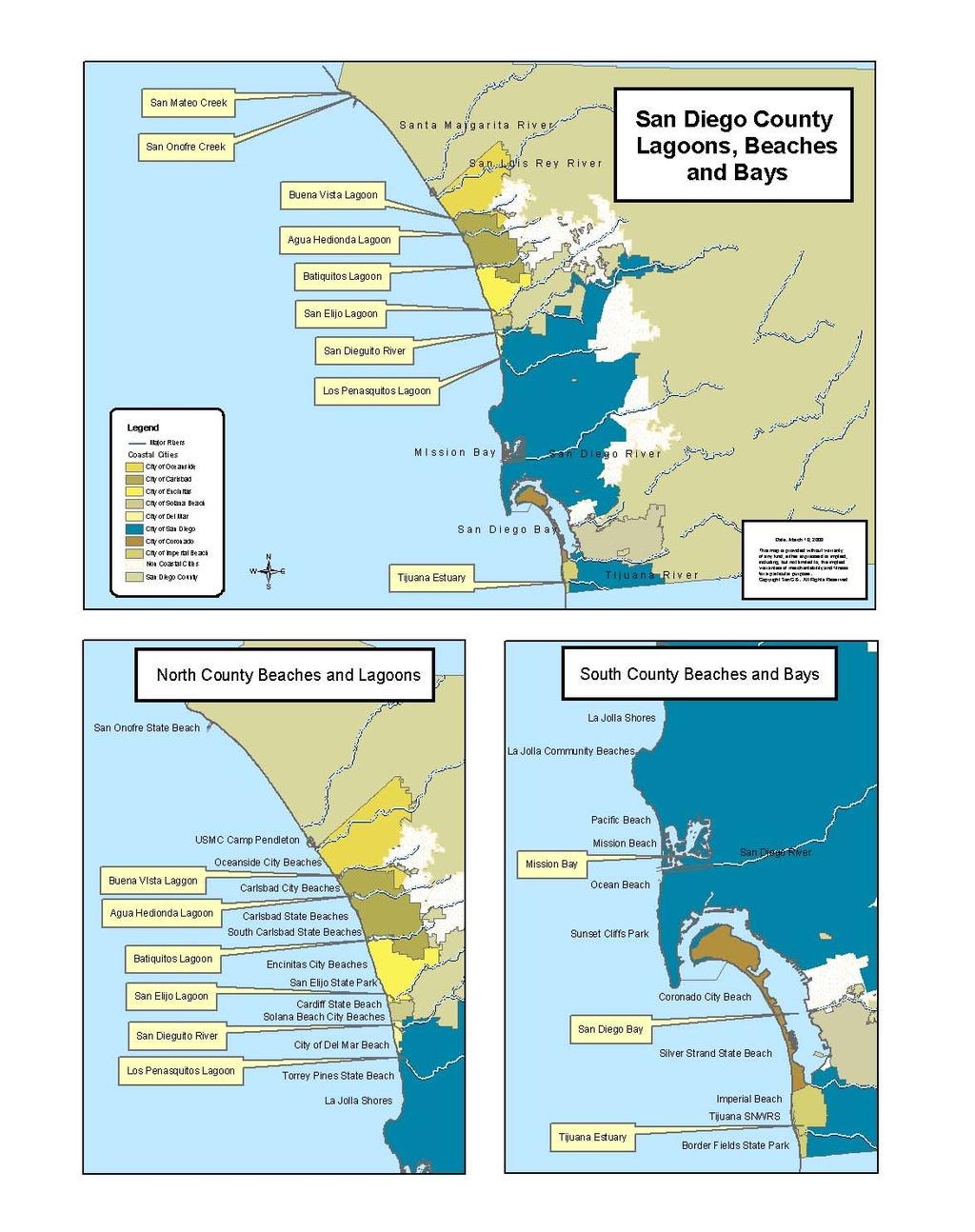
12 Locations and frequency of bacterial monitoring Over the past 20 years, the County of San Diego Department of Environmental Health and local sanitation agencies (City of San Diego, San Elijo Water Reclamation Facility, Encina Wastewater Authority, and the City of Oceanside) have been conducting bacterial monitoring of the coastal waters in San Diego County for the protection of pubic health and for regulatory permit requirements. In 1997, Assembly Bill 411 amended the California Health and Safety Code (Sections ) to require the standardization of bacterial monitoring of water quality at public beaches in California and public notification by the local health agency when results indicate bacterial levels exceed (violate) state standards [see next page]. To fulfill these requirements (called AB 411 ) the DEH Ocean & Bay Recreational Water Program collects beach water samples from 60 locations per week between April and October. Several high use beaches next to flowing storm drains or lagoons are sampled twice a week during this time. Between November and March, DEH collects samples at 13 popular surfing beaches every week. In addition to the samples collected by DEH, the county s five dischargers of treated wastewater effluent collect beach water samples as part of their discharge permit requirements. The Cities of Oceanside and Coronado also collect beach water samples voluntarily. The results from all of these monitoring efforts are shared with DEH. The total number of beach water samples collected in San Diego County is over 100 per week between April and October, and over 50 per week between November and March. Table 2 below and Figure 6 on page nine show the distribution of the weekly beach water quality monitoring in San Diego County between April and October. The numbers shown are the number of routine samples collected per week. Follow-up sampling by DEH can add an additional five to fifteen samples per week. For a detailed map of sampling locations at San Diego County beaches, go to and select San Diego County. Table 2: Number of weekly sampling stations between April 1 and October 31, 2006 San Onofre. State Beach that includes San Mateo Creek outlet 1 Camp Pendleton. USMC beaches that include San Onofre Creek outlet and Camp Del Mar 2 Oceanside. From Harbor Beach south to St. Malo. Includes Buccaneer Beach 12 includes one station sampled 2x week Carlsbad. Includes Buena Vista Lagoon outlet, municipal beach, and Carlsbad State beaches 10 Encinitas. From Leucadia south through Cardiff State Beach. Includes Moonlight Beach. Solana Beach. Includes Tide Beach Park, Fletcher Cove, and Seascape Beach Park Del Mar. From San Dieguito River Beach south through Anderson Canyon 10 includes two stations sampled 2x week 4 includes one station sampled 2x week 3 includes one station sampled 2x week San Diego, Mission Bay. Includes 18 swimming, sailing and PWC areas 18 San Diego, ocean coast. From Torrey Pines State Beach south through Sunset Cliffs Park. Includes La Jolla, Windansea, Pacific Beach, Mission Beach, and Ocean Beach 20 includes two stations sampled 2x week San Diego Bay. Includes seven locations on San Diego Bay 7 Coronado. Includes Coronado municipal beach and Silver Strand State Beach Imperial Beach. From Camp Surf south through End of Seacoast Drive 4 BF, TJSNWRS. Border Field State Park and Tijuana Slough National Wildlife Refuge Shoreline 4 Total Weekly Samples includes four stations sampled 2x week 8
13 Distribution of weekly shoreline sampling stations, April to October, 2006 Imperial Beach 4% Coronado 9% San Diego Bay 7% BF, TJSNWRS 4% San Onofre 1% Camp Pendleton 2% Oceanside 12% Carlsbad 10% San Diego, coast 18% San Diego, Mission Bay 16% Encinitas 10% Del Mar 3% Solana Beach 4% Figure 6: Weekly sampling at San Diego County Beaches (April - October). Sampling is conducted by the following agencies: County of San Diego Department of Environmental Health (DEH), City of Oceanside, Encina Wastewater Authority, San Elijo Water Reclamation Facility, City of San Diego, and the City of Coronado. Bacterial Standards for Ocean Water Contact The California Department of Health Services established the following bacterial standards for ocean water contact in the California Code of Regulations, Title 17 (Sections ) to implement AB 411. These are often referred to as the AB 411 Standards. These standards and the other requirements of AB 411 became effective in July Single sample standards for total coliforms, fecal coliforms and enterococci bacteria shall not exceed: Total Coliforms: 10,000 organisms per 100 milliliter sample. Fecal Coliforms: 400 organisms per 100 milliliter sample. Enterococci: 104 organisms per 100 milliliter sample. Fecal: Total ratio: >1,000 total coliforms if ratio exceeds day geometric mean standards (of five weekly samples) for total coliforms, fecal coliforms and enterococci bacteria shall not exceed: Total Coliforms: 1,000 organisms per 100 milliliter sample. Fecal Coliforms: 200 organisms per 100 milliliter sample. Enterococci: 35 organisms per 100 milliliter sample. Potential sources of the indicator bacteria used to test for fecal contamination of beach water quality include: Environment: soils, decaying vegetation Storm water/ urban runoff: sources vary Animal wastes: birds, dogs, cats, seals Humans: sewage, kids with diapers, shedding from body 9
 fails to meet the AB 411 Single Sample Standards (see page 9), the following occurs: Warning signs are posted at the beach indicating that bacterial levels in ocean or bay waters have exceeded")

 The information provided in this section is the data reported to the California State Water Resources Control Board beginning with")
14 OCEAN AND BAY WATER QUALITY ADVISORIES DUE TO STANDARDS VIOLATIONS When a bacteriological water sample from a beach next to a coastal outlet (storm drain, river, lagoon mouth, etc.) fails to meet the AB 411 Single Sample Standards (see page 9), the following occurs: Warning signs are posted at the beach indicating that bacterial levels in ocean or bay waters have exceeded health standards. All the information regarding the posted areas is updated on the DEH Beach Water Quality podcast, phone hotline ( ) and web page. Additional bacteriological water samples are collected at the posted areas and the results are evaluated daily to determine if the areas posted with warning signs should be increased, reduced, shifted or removed. The DEH Ocean & Bay Recreational Water Program recommends avoiding water contact at areas posted with the warning sign shown above. Advisories for San Diego County beaches (April - October) The information provided in this section is the data reported to the California State Water Resources Control Board beginning with the year 2000, the first calendar year that the AB 411 Ocean Water-Contact Sports Standards were in place. Comparisons for days posted under advisory are limited to the April to October time period due to changes in monitoring frequencies at some locations between November and March. The following charts and graphs depict the total number of advisory Beach Mile Days due to exceedances of standards [Figure 8], the total number of routine samples collected and the number of those samples causing advisories (exceedances) [Figure 9], and the total days posted [Figure 10] between April 1 and October 31 each year. Beach Mile Days for Advisories due to exceedances of standards, April 1 to October BMDs Advisory BMDs year Figure 7: Advisory beach mile days due to bacterial exceedances 10
15 Percentage of routine samples causing advisories, April 1 to October Routine samples beach water samples % 4.2% 2.8% 3.0% 2.6% 2.2% 3.8% Number of routine samples causing Advisories due to bacterial exceedances percent year Figure 8: Number of routine samples and exceedances Bacterial Exceedances (Advisories), April 1 to October Number of routine samples causing Advisories due to bacterial exceedances Days posted for bacterial exceedances These graphs do not include chronic advisory days (Children's Pool). See page year Figure 9: Advisory events (exceedances) and days posted Overall, water quality at most beaches in San Diego County is very good during dry weather. Weekly bacterial monitoring data is sent to Heal The Bay (HTB), which provides a water quality grade for each location based upon the last four weeks of monitoring data. In its Annual Beach Report Card, HTB assigned 89% of monitored locations in San Diego County with a grade of A or B for year-round dry weather water quality. The annual, summer, and weekly grades can be viewed at For most locations, the annual [dry weather] grade assigned by HTB agrees with the assessment by DEH of health risk from water contact. The weekly report card provides beach goers with the recent trend in water quality at a beach, but does not provide the current status assigned by DEH. For the current status, check the DEH Beach Water Quality Report Hotline ( ) or web page ( 11
 between April 1 and October 31 2000 2001 2002 2003 2004 2005 2006 San Onofre 0.06 0.74 0.23 0.63 0 3.3 0 Camp Pendleton 0 0 0 0 0 0 0 Oceanside 0.")
16 Advisory BMDs by coastal jurisdiction (April October) The number of advisory Beach Mile Days due to bacterial exceedances for each coastal jurisdiction is shown below. Table 3: BMDs for bacterial exceedances (Advisories) between April 1 and October San Onofre Camp Pendleton Oceanside Carlsbad Encinitas Solana Beach Del Mar San Diego, Mission Bay Mission Bay Epi study x x x 4.67 X x x San Diego, ocean coast San Diego Bay Coronado Imperial Beach BF, TJSNWRS For a detailed map of sampling locations at San Diego County beaches, go to and select San Diego County. Changes in sampling procedures by DEH: In April 2001, DEH moved its routine sample collection point at locations with outlets (storm drains, rivers, or lagoons) to 25 yards downcoast from the mixing zone, except in Mission Bay due to inadequate signage at drain outlets there. This change was made to conform to the State s and other agencies recommendations. This change in the routine sample collection procedure was applied to Mission Bay locations in June Figure 10: Cottonwood Creek outlet at Moonlight Beach, Encinitas 12
.")
17 Beaches under a chronic advisory or closure Analysis of water quality advisory and closure data in the 2006 Beach Closure and Advisory Report does not include locations posted or closed under a chronic status (i.e., Children s Pool, and the Tijuana Slough and Border Field State Park shorelines). Although sample results at chronic locations may occasionally be within state standards, the presence of known, on-going sources of contamination require these beaches to remain under a water quality advisory or closure status to protect public health. Figure 11: Children s Pool in La Jolla, San Diego. Photo: P. Neubauer 13

, volume of discharge, location of spill, ocean currents and tides, historical sewage spills in the area, and any other pertinent information.")


18 OCEAN AND BAY WATER CLOSURES DUE TO SEWAGE SPILLS Whenever a sewage release is reported to the DEH that may impact water quality at a recreational beach, staff immediately issues a water contact closure for the affected ocean or bay beach. The closure area is based on many factors, including type of sewage (e.g., untreated, secondary treated, sewage sludge), volume of discharge, location of spill, ocean currents and tides, historical sewage spills in the area, and any other pertinent information. After a water contact closure is issued: Closure signs are posted at the affected ocean or bay shoreline indicating sewage contamination has occurred. A press release is sent to the media and appropriate agencies are notified. All the information regarding the closure area is updated on the DEH Beach Water Quality podcast, phone hotline ( ), and web page. Bacterial sampling of the affected shoreline is initiated. Closed recreational beaches will be reopened or reduced in size when the contamination source has been eliminated and after two daily consecutive sampling results indicate the water quality meets the AB 411 Single Sample Standards (see page 9). The DEH Ocean & Bay Recreational Water Program strongly recommends avoiding water contact within the closure area and where closure signs are posted. A 100 gallon /minute spill through a sewer manhole. Overflows are typically caused by blockages (grease, tree roots, debris) or rain infiltration of sewer lines. Spills often flow into the street and then into storm drains, which transport flows directly to the ocean or into rivers or creeks, which flow to the ocean. The storm drain system is not connected to the sewer system in San Diego County. Figure 12: Sanitary sewer overflow (SSO) 14
19 Closures due to sewage contamination (calendar year) The following charts and graphs depict the total number of closure events and known volume of sewage spilled to recreational waters in San Diego County from 2000 to 2006 [Table 4], and total number of closure Beach Mile Days (BMDs) [Table 6] saw a reduction in the number of closure events (down 14% for all closures from 2005, and down 74% for just SSOs from 2001) [Figure 13, Table 5], and the impact of closures as measured by BMDs (down 57% from 2005). Likewise, in 2006 the volume of sewage spills from SSOs impacting recreational waters was the lowest in the six year period as shown in Table 4. Table 6 on page 17, closure Beach Mile Days due to sewage contamination, shows the extent of loss of recreational beach use by the county as a whole and by coastal jurisdiction for every year since Fewer SSOs and better containment of spills that did occur, and a drier rainy season, contributed to the reduction of closure BMDs. The yearly contribution by the Tijuana River to the total number of closure BMDs is shown in Table 7 and Figure 14 [page 18]. It is noteworthy that the closures caused by the Tijuana River account for 70% or more of closure BMDs for every year except Closures caused by sewage-contaminated runoff from the Tijuana River are seasonal because the river flow is diverted to the U.S. International Boundary & Water Commission (IBWC) treatment plant during low flow conditions (flows less than 15 million gallons per day). Therefore, years with lower amounts of rainfall tend to have fewer beach closures at south county beaches. Table 4: Beach closures and gallons spilled Beach closure events Volume (gal) of sewage spilled to recreational waters (does not include Tijuana River flows) 36,673,012 1,952,453 11,704,314 2,066,355 7,359, ,928 53,973 Figure 13: Graph of beach closure events # of closure events Beach Closures Events year Total closure events Closures due to SSOs (does not include those related to Tijuana River) 15
20 Table 5: Closure events caused by sewage spills Closure events caused by sewer spills (SSOs). Does not include closures caused by sewage-contaminated runoff from the Tijuana River coastal jurisdiction San Onofre SB (includes MCB Camp Pendleton) Oceanside (Harbor Beach, Oceanside pier, and Buccaneer Beach) Carlsbad (Carlsbad State and South Carlsbad State Beaches and Aqua Hedionda Lagoon) Encinitas (Leucadia/ Grandview, Stone Steps, Moonlight, Swami's, San Elijo State Park and Cardiff State Beach) Solana Beach (Tide Beach, Fletcher Cove, Seascape Park) Del Mar (San Dieguito River Beach to Andersen Canyon) City of San Diego, coastal beaches (Torrey Pines State Beach, La Jolla, Pacific Beach, Mission Beach, Ocean Beach, and Sunset Cliffs) and Mission Bay San Diego Bay (can include Coronado, San Diego, and Chula Vista jurisdictions) Coronado (includes Silver Strand SB) Imperial Beach Border Field State Park and TJSNWRS (non-chronic closures) Yearly event totals By removing the closure events related to sewage-contaminated runoff from the Tijuana River (closures in Coronado and Imperial Beach) in Table 5, a decreasing trend in closures caused by sewage spills can be observed in San Diego County since The lower number of closures caused by sewage spills in recent years can be attributed to better maintenance of sewer lines and better containment of spills by some municipal wastewater agencies. 16
21 Table 6: Recreational loss due to sewage contamination as measured by BMDs Closure BMDs in San Diego County. Extent of closure measured by length of shoreline and number of days closed to water contact. coastal jurisdiction available BMDs [beach miles x 365 days] San Onofre SB (includes MCB Camp Pendleton) 4.3 x 365 = Oceanside (Harbor Beach, Oceanside pier, and Buccaneer Beach) 3.7 x 365 = Carlsbad (Carlsbad State and South Carlsbad State Beaches and Aqua Hedionda Lagoon) 6.5 x 365 = Encinitas (Leucadia/ Grandview, Stone Steps, Moonlight, Swami's, San Elijo State Park and Cardiff State Beach) 5.9 x 365 = Solana Beach (Tide Beach, Fletcher Cove, Seascape Park) 1.3 x 365 = Del Mar (San Dieguito River Beach to Andersen Canyon) 2.2 x 365 = City of San Diego, coastal beaches (Torrey Pines State Beach, La Jolla, Pacific Beach, Mission Beach, Ocean Beach, and Sunset Cliffs) City of San Diego, Mission Bay 17.9 x 365 = x 365 = San Diego Bay (can include Coronado, San Diego, and Chula Vista jurisdictions) 1.0 x 365 = Coronado (and Silver Strand SB) Includes closures due to sewage contamination from Tijuana R. 3.7 x 365 = Imperial Beach Includes closures due to sewage contamination from Tijuana R. 1.4 x 365 = Border Field State Park and TJSNWRS (non-chronic closures) 2.3 x 365 = Yearly total BMDs 52.2 x 365 = Border Field State Park and TJSNWRS BMDs (chronic closures) Chronic closures: See page

22 Table 7: Contribution by Tijuana River to closure Beach Mile Days Tijuana River contribution to closure Beach Mile Days Year Total closure BMDs* SSO closure BMDs, does NOT include those due to Tijuana River % contribution of BMD closures due to the Tijuana River *non-chronic closures Figure 14: Graph of Table 7 data Beach Mile Days Beach Closure beach mile days (BMDs) caused by Tijuana River compared to SSO closures 84% 83% 45% 81% 70% 79% 91% % related to Tijuana River Tijuana River related closure BMDs SSO closure BMDS Figure 15: Water contact closure sign at the south end of Seacoast Dr. To the south is the Tijuana Slough National Wildlife Refuge Shoreline. This area typically reopens in early summer every year until the next significant rain the following winter. 18
 directly to ocean and bay waters.")
 after a")

23 OCEAN AND BAY GENERAL ADVISORIES During and after a significant rainstorm event, storm drains, creeks and rivers carry floodwaters and urban runoff (which may include fertilizers, road oils, litter and large amounts of bacteria from a variety of sources such as animal waste and decomposing vegetation) directly to ocean and bay waters. The levels of bacteria can rise significantly in ocean and bay waters, especially near storm drains, creeks, rivers and lagoon outlets that discharge urban runoff during and after rainstorms. To ensure that public health is protected, the DEH Ocean & Bay Recreational Water Program staff issue a General Advisory to avoid all ocean or bay water contact for 72 hours (three days) after a significant rain (greater or equal to 0.20"). Elevated bacterial levels in the coastal ocean waters may continue for a period of three days depending on the intensity of the rain and the volume of runoff. The General Advisory issued by the Ocean & Bay Recreational Water Program consists of a press release to the media, and listing on the Beach & Bay Water Quality podcast, phone hotline and the web page. Temporary advisory signs are not posted for General Advisories. The following is a list of significant coastal outlets in San Diego County based upon the volume or quality of flow during wet weather, or year round flow to ocean waters. Locations with low flow diversions (LFD) to sewer treatment plants or other treatment are noted. Many of these outlets are posted with the permanent health risk warning signs shown here, or older versions of this sign. Camp Pendleton and San Onofre State Beach: San Mateo Creek outlet, San Onofre Creek outlet, and Santa Margarita River outlet Oceanside: San Luis Rey River outlet, Wisconsin Street storm drain, and Loma Alta Creek outlet (LFD) Carlsbad: Buena Vista Lagoon outlet, Carlsbad Village Drive storm drain, Pine Ave storm drain, Aqua Hedionda Lagoon outlet (north Tamarack; south- Warm Water Jetty), Encina Creek outlet, Batiquitos Lagoon outlet Encinitas: Cottonwood Creek outlet /Moonlight Beach (Ultra Violet light treatment), San Elijo Lagoon outlet Solana Beach: storm drains at Fletcher Cove (LFD) and Seascape Beach Park Del Mar: San Dieguito River Beach, 15 th Street storm drain, storm drain between 12 th and 15 th Street, Sea Orbit Lane storm drain, and Andersen Canyon storm drain City of San Diego coastal beaches: Los Peñasquitos Lagoon outlet, Torrey Pines Golf Course drainage at Black s, Scripps Institute of Oceanography permitted discharge on south side of Scripps pier, storm drains at El Paseo Grande, Vallecitos, Avenida Del La Playa (LFD), La Jolla Cove (LFD), Coast Bl gazebo, north Nicholson Pt/ Hospitals, Ravina/ Horseshoes (LFD), Bonair (LFD), Playa Del Norte, P.B. Point, Tourmaline (LFD), Law Street, San Diego River outlet / Dog Beach, storm drains at Narragansett Ave, Pescadero Ave, Point Loma Ave, Osprey Street, Hill Street, Monaco Street, and Ladera Street. 19
, north Crown Point (LFD), south Crown Point (LFD), La Cima (LFD), Santa Clara Cove (LFD), Santa Barbara Cove (LFD), Bonita Cove, and Balboa Court (LFD).")
24 City of San Diego Mission Bay beaches: Tecolote Creek outlet (LFD), Tecolote Shores (LFD), Leisure Lagoon, Cuddahy Creek outlet, Visitor s Center storm drain (LFD), De Anza Cove storm drains (LFD), Rose Creek outlet (LFD), north Crown Point (LFD), south Crown Point (LFD), La Cima (LFD), Santa Clara Cove (LFD), Santa Barbara Cove (LFD), Bonita Cove, and Balboa Court (LFD). San Diego Bay beaches: Lawrence Street, Spanish Landing, Bayside Park, and Tidelands Park. City of Coronado: storm drain at north beach (LFD) Tijuana Slough National Wildlife Refuge Shoreline: Tijuana River outlet (LFD) Figure 16: Plume from the San Diego River outlet following heavy rains in January Photo: Ocean Imaging, Inc. 20
25 The dates that DEH issued a General Advisory for San Diego County ocean and bay waters due to contamination by urban runoff following rain during are listed below. YEAR 2000 (38 Total General Advisory Days) January 25 January 28, February 11 February 29 March 5 March 9, April 18 April 23 October 27 November 1, November 11 November 14 YEAR 2001 (49 Total General Advisory Days) January 9 January 15, January 26 January 29 February 13 February 17 February 24 March 2, March 6 March 9 March 10 March 12, April 7 April 13 November 13 16, November November 29 December 6, December 10 13, December YEAR 2002 (35 Total General Advisory Days) January 28 February 1 March 8 11, March March April 24 29, September 6 10 November 8 November 12 December 17 24, December YEAR 2003 (32 Total General Advisory Days) February 11 February 18 February 25 March 2 March 16 20, April May 3 6, November 1 4 November 12 15, December YEAR 2004 (48 Total General Advisory Days) January 3 6, February 3 6 February 19 29, March 2 5 April 2 5, April October 17 23, October November 9 10, November November 28 December 1 December 5 9, December YEAR 2005 (47 Total General Advisory Days) December 28, 2004 January 14 January February 11 15, February March 5 8, March April 28 May 1 October December 31 YEAR 2006 (43 Total General Advisory Days) December 31, 2005 January 5 February 19 22, Feb 28 Mar 3 March 11 14, March Mar 29 Apr 1, April 5 8, April May October 14 17, November December 10 13, December December
26 WATER QUALITY STUDIES Bacteria Source Identification Study at P.B. Point In May 2005, the City of San Diego City Council allocated $250,000 for a 12-month study to identify the source(s) of bacterial contamination in ocean waters at the inside cove of P.B. Point in north Pacific Beach. A total of 40 surveys (with sampling at 10 shoreline sites within the cove during each survey) were conducted between June 1, 2005 and March 31, 2006 to determine the spatial and temporal extent of bacterial densities in the waters of P.B. Point. 1 In addition to analysis of ocean and storm drain water by traditional test methods, PCR (polymerase chain reaction) and ribotyping genetic methods were employed as DNA finger printing techniques to track the source (human, bird, etc.) of bacteria measured in water quality samples. The major findings of the study are: Poor water circulation and the accumulation of decaying kelp in the inside cove during summer months are important factors for the high bacterial densities in adjacent ocean waters. Dry weather runoff from one of three storm drains and bird fecal matter can act as bacterial seed in the piles of decaying kelp on the beach. The kelp on the beach acts as a reservoir for bacteria. Bacterial re-growth also occurs in the kelp, and brine flies can transfer bacteria from contaminated kelp to uncontaminated kelp. Fecal coliform and enterococci bacterial levels are highest along the shoreline of P.B. Point cove during spring tides in summer and early fall. (Spring tides occur during new and full moons.) Bacteria are pulled into ocean waters during spring high tides when waves wash over the kelp and ponded storm drain water. There were no enterococci or fecal coliform exceedances measured in offshore waters (~ yards from the beach) during any of the surveys. Results for PCR analysis of 182 samples (108 ocean water and 74 storm drain) indicated fecal bacteria from warm-blooded animals in 78% of the samples. However, only 2 samples (1%) from storm drains were positive for bacteria of human origin. Analysis by ribotyping for the three most frequently contaminated shoreline sites indicated 71% of the bacterial contamination comes from birds, 18% from dog, raccoon and rodents, 9% unknown, and 2% from sewage. Analysis by ribotyping for the most problematic storm drain in the cove indicated 48% of the bacterial contamination comes from birds, 43% from dog, raccoon and rodents, 4% unknown, and 5% from human and sewage. 1 Final Report: Bacterial Source Tracking for Pacific Beach Point. June Prepared for the Metropolitan Wastewater Department, City of San Diego. Prepared by Weston Solutions, Inc. 22

27 Figure 17: The inside cove at P.B. Point during summer months with kelp accumulation. Photo: City of San Diego 23
28 Bacterial Exceedances in east Mission Bay During July and August, and the July 25 th Closure Due to a Sewage Spill Beginning on July 5 th, routine water quality monitoring by DEH at several east Mission Bay beaches revealed bacterial exceedances. Similar patterns of exceedances occurred at many of the same locations through-out July and August, DEH issued advisories for water contact at these locations beginning on July 6 (see events 101, 103, 107, 108, 109, 110, 112, 116, 117, 125, and 126 in the 2006 Beach Closure & Advisory Report, Appendix). On July 25 th, an unknown volume sewage spill to the bay from the DeAnza Cove RV trailer park was reported to DEH. The start date of the spill was reported as July 5 th and it was unknown if the spill had stopped. Lacking any other information at the time, DEH assumed a worse case scenario - a large, on-going spill to the bay for the last 20 days that was responsible for widespread bacterial exceedances, and issued a water contact closure for most recreation areas in east Mission Bay (event 102). Subsequent investigations determined the spill occurred for one day, July 5 th, for a total volume of gallons, thereby discounting this sewage spill as the source of bacterial exceedances at east Mission Bay beaches since July 5. After conducting split sample investigations with the City of San Diego at several of the east Mission Bay beaches on August 29 th, DEH learned that the test method used by the County Public Health Laboratory, Colilert 18 TM, may not always provide an accurate measurement of E. coli bacteria concentrations. On September 1 st, DEH suspended the use of the IDEXX Colilert 18 TM test method for the analysis of total coliform and E. coli bacteria in ocean and bay water quality samples. A review of published research supported the split sample findings - false positive E. coli results are possible when using Colilert 18 TM in marine waters warmer than normally experienced in Southern California. 2 [A series of heat waves early in the summer of 2006 raised ocean and bay waters to unusually high temperatures. DEH and County Public Health Laboratory conducted the required correlation study between a traditional test method and Colilert 18 TM in the winter of 2004 to validate this faster test method as an acceptable alternative, so this limitation with the Colilert 18 TM method was not identified at that time. Nor did the use of Colilert 18 TM in the summer of 2005 suggest any problem with this test method.] Taken together, this information suggests that some of the elevated bacterial levels (E. coli ) observed in east Mission Bay during July and August of 2006 may have been false positives and not true measurements of the E. coli / fecal coliform indicator bacteria that are used in state law and regulations to make determinations about the safety of water contact. While other test method data confirms bacterial contamination did occur during this time at some east Mission Bay locations, DEH does not believe it was at the same frequency and extent that the Colilert 18 TM data indicated. It should also be noted that both the Colilert 18 TM data and other test method data (including non-split samples) showed great variability, and it cannot be said that all the Colilert 18 TM E. coli results were false positives. The published research indicated that the main reason for the false positive results in their study was the presence of non-coliform bacteria such as Vibrio and Aeromonas. These genera of bacteria are widely found in the environment and some species are known to be pathogenic. 2 Pisciotta, et al; Marine Bacteria Cause False Positive Results in Colilert-18 Rapid Identification Test for Escherichia coli in Florida Waters, Applied and Environmental Microbiology, Vol. 68, No 2, Feb
29 Quantitative Assessment of Relationship between Bacterial Indicators and Viral Pathogens at South County Beaches Between 2003 and 2005, researchers at San Diego State University collected and analyzed ocean water samples from the Tijuana Estuary mouth and Imperial Beach pier using culture based tests for bacterial indicators of fecal contamination and genetic tests for human specific viral pathogens. 3 The genetic test method used was quantitative reverse transcription- polymerase chain reaction (qrt-pcr). (The qrt-pcr method is not able to discriminate between infectious and noninfectious viral particles.) Samples were collected during wet weather (within 72 hours of significant rain) and during dry weather (May to early October). The major findings of the study are: Twelve of fourteen (86%) wet weather samples (seven from the estuary mouth and seven from the IB pier) exceeded state health standards for one or both bacterial indicators, enterococci and E. coli. None of the dry weather samples exceeded state health standards for the two indicators. Analysis of viral densities and bacterial indicators show a significant correlation between elevated levels of bacterial indicators and Hepatitis A virus and enterovirus. Hepatitis A and enterovirus levels were positively related to levels of indicator bacteria, one another, Tijuana River flow rates, and rainfall amounts. Wet weather samples from the Tijuana Estuary mouth showed Hepatitis A virus and enterovirus in 86 and 100% of the samples, respectively. Wet weather samples from the Imperial Beach pier showed Hepatitis A virus and enterovirus in 71 and 86% of the samples, respectively. The results of this study verify the increased health risk from ocean water contact at south county beaches during times when sewage contaminated flows from the Tijuana River are entering ocean waters. The study also validates the traditional bacterial indicators for measuring contamination in beach water samples impacted by sewage. (However, due to the time lag in obtaining sample results from traditional test methods, DEH has been using the real time coastal ocean observing system [ data to make more timely and accurate decisions for issuing water contact closures at south county beaches since See page 25 of the San Diego County 2004 Beach Closure & Advisory Report Summary.) 3 Gersberg, et al. Quantitative Detection of Hepatitis A Virus and Enteroviruses Near the United States Mexico Border0 and Correlation with Levels of Fecal Indicator Bacteria. Applied and Environmental Microbiology, Vol. 72, No 12, Dec
California Health & Safety Code Requirement for Reporting of Sewage Spills
 Ocean Water Protection o Program OCCC 2007 Update Larry Honeybourne Health Care Agency Environmental Health Part 1: Sewage Spills and Closures Part 2: AB 411 Ocean & Bay Bacterial Monitoring Program Part
Beach Water Quality. Ewan Moffat, Environmental Health Specialist, Recreational Water Program
 Beach Water Quality Ewan Moffat, Environmental Health Specialist, Recreational Water Program Items to be Discussed Sampling Locations Advisories, General Advisories, Closures Sept, 2011 Power Outage Sewage
The Surfer Health Study
 The Surfer Health Study Surfrider Foundation collaborated with scientists at Southern California Coastal Water Research Project (SCCWRP); University of California, Berkeley, School of Public Health; and
BEACH REPORT CARD. Overview of Heal the Bay's End of Summer Report Essential water quality information for beachgoers
 END OF SUMMER REPORT 2017 CALIFORNIA BEACH REPORT CARD Essential water quality information for beachgoers IN THIS REPORT Excellent Beach Grades Across Counties New Bacteria Standards Proposed for Local
Coastal Environments Oceanographic and Engineering Expertise
 Coastal Environments Oceanographic and Engineering Expertise Coastal Environments La Jolla, CA www.coastalenvironments.com 14 May 2004 CE Ref. No. 04-05 EcoSystems Management Associates, Inc. Carlsbad,
105 CMR MINIMUM STANDARDS FOR BATHING BEACHES STATE SANITARY CODE, CHAPTER VII
 105 CMR 445.000 MINIMUM STANDARDS FOR BATHING BEACHES STATE SANITARY CODE, CHAPTER VII 445.001: Purpose The purpose of 105 CMR 445.000 is to protect the health, safety and well-being of the users of bathing
San Diego Coastal Ocean Observing System
 California Clean Beaches Initiative San Diego Coastal Ocean Observing System WWW.SDCOOS.ORG Presentation to Imperial Beach City Council August 3, 2005 Eric J. Terrill, Ph.D. Scripps Institution of Oceanography
Annual Beach Report Card
 Heal the Bay s 2011-2012 Annual Beach Report Card Heal the Bay is a nonprofit environmental organization making Southern California coastal waters and watersheds, including Santa Monica Bay, safe, healthy
PROCESSING RECORD SCRIPPS INSTITUTION OF OCEANOGRAPHY ARCHIVES. Douglas Lamar Inman Aerial Photographs,
 Accession No.: 87-26 PROCESSING RECORD SCRIPPS INSTITUTION OF OCEANOGRAPHY ARCHIVES Inman, Douglas Lamar 1920- Douglas Lamar Inman Aerial Photographs, 1884-1980 Bulk Dates; 1944-1959 PHYSICAL DESCRIPTION:
Heal the Bay s 2007 California Summer Beach Report Card SM
 Heal the Bay s 2007 California Summer Beach Report Card SM Heal the Bay s 2007 California Summer Beach Report Card provides beachgoers with essential water quality information by grading 494 monitoring
30-Day Running Geometric Means for the Dana Point Harbor Stations for
 30-Day Running Geometric Means for the Dana Point Harbor Stations for 2000-2002 The following graphs provide the 30-day running geometric means for the Dana Point Harbor stations for total coliforms, fecal
City of Encinitas Beach Attendance Report 2016
 City of Encinitas Beach Attendance Report 2016 Moonlight State Beach, July 2016 1 Introduction Since 2004, the City of Encinitas has intermittently employed counting technology to measure beach attendance.
Orange County MPA Watch A n n u a l R e p o r t
 Orange County MPA Watch 2 0 1 4 A n n u a l R e p o r t WHAT IS AN MPA? Marine Protected Areas (MPAs) are discrete geographic marine or estuarine areas designed to protect or conserve marine life and habitat.
Country report. Belgian bathing water quality in Belgium. May Photo: Peter Kristensen/EEA
 Country report Belgian bathing water quality in 2017 Belgium May 2018 Photo: Peter Kristensen/EEA BWD Report For the Bathing Season 2017 Belgium The report gives a general overview of information acquired
HEAL THE BAY W K $ Q Q X D O 5 H S R U W
 HEL THE BY Heal the Bay s 20th nnual Beach Report Card May 26, 2010 Heal the Bay is a nonprofit environmental organization dedicated to making Southern California coastal waters and watersheds, including
Heal the Bay s 12th Annual Beach Report Card SM
 001-00 Heal the Bay s 1th Annual Beach Report Card SM May 3, 00 Heal the Bay is a nonprofit environmental organization dedicated to making Santa Monica Bay and Southern California coastal waters safe and
Pathogen Transport in Coastal Environments: Case Studies of Urban Runoff in Southern California
 Pathogen Transport in Coastal Environments: Case Studies of Urban Runoff in Southern California A presentation to the Center for Water Sciences MSU Pathogens Workshop, April 20, 2007 Stanley B. Grant Henry
This report will help to direct the next steps necessary to open all remaining vertical accessways that have yet to be opened.
 STATE OF CALIFORNIA THE NATURAL RESOURCES AGENCY Arnold Schwarzenegger, Governor CALIFORNIA COASTAL COMMISSION STATEWIDE COASTAL ACCESS PROGRAM 725 FRONT STREET, SUITE 300 SANTA CRUZ, CA 95060 (831) 427-4875
The use of risk management as best practice to reduce outbreaks of recreational water illnesses in disinfected swimming facilities and spas
 The use of risk management as best practice to reduce outbreaks of recreational water illnesses in disinfected swimming facilities and spas Roy Vore, Ph.D., NSPF I, CPO Vore & Associates, LLC Email: Roy.D.Vore@gmail.com
Orange County MPA Watch Program Quarterly Report (Jan 1 March 31, 2012)
") Orange County MPA Watch Program Quarterly Report (Jan 1 March 31, 2012) What is the OC MPA Watch Program? The Orange County Marine Protected Area (OC MPA) Watch Program enlists volunteers, community groups
Orange County MPA Watch Program Quarterly Report (Jan 1 March 31, 2012) What is the OC MPA Watch Program? The Orange County Marine Protected Area (OC MPA) Watch Program enlists volunteers, community groups
SDForward.com/networks PHASE YEAR (IN ALL NETWORK CONCEPTS) ESTIMATED CAPITAL COSTS ($2018) MILLIONS* PROJECT NAME
 ESTIMATED CAPITAL COSTS ($2018) MILLIONS* PROJECT NAME") Bayshore Bikeway Segment 8B: Ada Street to Palomar Street $1.64 Border to Bayshore Bikeway $10.18 Central Avenue Bikeway $4.62 North Park/Mid-City Bikeways: Howard $8.42 North Park/Mid-City Bikeways: Monroe
Bayshore Bikeway Segment 8B: Ada Street to Palomar Street $1.64 Border to Bayshore Bikeway $10.18 Central Avenue Bikeway $4.62 North Park/Mid-City Bikeways: Howard $8.42 North Park/Mid-City Bikeways: Monroe
Heal the Bay th Annual Report
 Heal the Bay 25 26 16th nnual Report Heal the Bay s 16th nnual Beach Report Card May 24, 26 Heal the Bay is a nonprofit environmental organization dedicated to making Southern California coastal waters
STATE OF THE COAST 2016 Coastal Frontiers Corporation June 1, 2017
 STATE OF THE COAST 2016 Coastal Frontiers Corporation June 1, 2017 Shoreline Preservation Committee 1. Background OVERVIEW 2. Monitoring Program 3. Results 2015-16 El Niño Post-RBSP II Post-RBSP I 4. Conclusions
Country report. Swedish bathing water quality in Sweden. May Photo: Peter Kristensen/EEA
 Country report Swedish bathing water quality in 2017 Sweden May 2018 Photo: Peter Kristensen/EEA BWD Report For the Bathing Season 2017 Sweden The report gives a general overview of information acquired
Wave Prediction in the Santa Barbara Channel
 Wave Prediction in the Santa Barbara Channel OCS Study MMS 2001-055 Final Technical Summary Final Study Report U.S. Department of the Interior Minerals Management Service Pacific OCS Region Wave Prediction
Orange County MPA Watch A n n u a l R e p o r t
 Orange County MPA Watch 2 0 1 5 A n n u a l R e p o r t WHAT IS AN MPA? Marine Protected Areas (MPAs) are discrete geographic marine or estuarine areas designed to protect or conserve marine life and habitat.
City of Newcastle Council
 ity of Newcastle ouncil State of the eaches 22 23 Overall results Percentage of sites graded as Good or Good: % 29 ll eleven swimming sites were graded as Good or Good in 22 23. Excellent results were
VENICE LOCAL COASTAL PROGRAM UPDATE: COASTAL HAZARDS WELCOME
 VENICE LOCAL COASTAL PROGRAM UPDATE: COASTAL HAZARDS WELCOME 1 Introducing the Team Hosted by the Department of City Planning and grant funded in part by the California Coastal Commission 2 Workshop Purpose
Bathing Water Directive report The Czech Republic
 Bathing Water Directive report 2013 The Czech Republic The report gives a general overview of information acquired from the reported data, based on provisions of the Bathing Water Directive 1. The reporting
Orange County MARINE PROTECTED AREAS 2 nd Quarter 2016 Report
 Orange County MARINE PROTECTED AREAS 2 nd Quarter 2016 Report Page 1 of 7 WHAT IS THE OC MPA WATCH PROGRAM? The Orange County Marine Protected Area (OC MPA) Watch Program enlists volunteers, community
Country report. Czech bathing water quality in Czech Republic. May Photo: Peter Kristensen
 Country report Czech bathing water quality in 2016 Czech Republic May 2017 Photo: Peter Kristensen BWD Report For the Bathing Season 2016 The Czech Republic The report gives a general overview of information
Port Stephens Council
 Port Stephens ouncil State of the eaches 22 23 Overall results Percentage of sites graded as Good or Good: 9 Nine of the eleven swimming sites were graded as Good or Good in 22 23, a fall in performance
Orange County MPA Watch 2016 A n n u a l R e p o r t
 Orange County MPA Watch 2016 A n n u a l R e p o r t WHAT IS AN MPA? Marine Protected Areas (MPAs) are discrete geographic marine or estuarine areas designed to protect or conserve marine life and habitat.
Orange County MARINE PROTECTED AREAS
 Orange County MARINE PROTECTED AREAS Orange County Coastkeeper QUARTERLY REPORT 1/1/ 2013 3/30/12 2013 WHAT IS THE OC MPA WATCH PROGRAM? The Orange County Marine Protected Area (OC MPA) Watch Program enlists
Healthy Swimming: Prevention of Recreational Water Illnesses (RWIs)
") Healthy Swimming: Prevention of Recreational Water Illnesses (RWIs) Q u e s t i o n s a n d A n s w e r s f o r A q u a t i c s F a c i l i t y S t a f f The following information about recreational water
Healthy Swimming: Prevention of Recreational Water Illnesses (RWIs) Q u e s t i o n s a n d A n s w e r s f o r A q u a t i c s F a c i l i t y S t a f f The following information about recreational water
Indicators for Narragansett Bay Region WORKSHOP REPORT. Beach Closures Tuesday, October 12, 2010 Warwick Public Library
 Indicators for Narragansett Bay Region WORKSHOP REPORT Beach Closures Tuesday, October 12, 2010 Warwick Public Library Recommended Beach Closure Indicator: The group recommended a multi part indicator
Country report. Portuguese bathing water quality in Portugal. May Photo: Peter Kristensen
 Country report Portuguese bathing water quality in 2016 Portugal May 2017 Photo: Peter Kristensen BWD Report For the Bathing Season 2016 Portugal The report gives a general overview of information acquired
Orange County MPA Watch M o n i t o r i n g H u m a n U s a g e
 Orange County MPA Watch M o n i t o r i n g H u m a n U s a g e WHAT IS AN MPA? Marine Protected Areas (MPAs) are discrete geographic marine or estuarine areas designed to protect or conserve marine life
Hamilton Public Health Services 2014 Beach Monitoring Report
 Public Health Services Health Protection Division 110 King Street West, 2nd Floor, Hamilton, ON L8P 4S6 Phone: (905) 546-2424, ext. 3570 Fax: (905) 546-2787 Hamilton Public Health Services 2014 Beach Monitoring
Bathing Water Directive report Austria
 Bathing Water Directive report 2013 Austria The report gives a general overview of information acquired from the reported data, based on provisions of the Bathing Water Directive 1. The reporting process
Country report. Austrian bathing water quality in Austria. May Photo: Peter Kristensen
 Country report Austrian bathing water quality in 2016 Austria May 2017 Photo: Peter Kristensen BWD Report For the Bathing Season 2016 Austria The report gives a general overview of information acquired
Orange County MARINE PROTECTED AREAS
 Orange County MARINE PROTECTED AREAS Orange County Coastkeeper QUARTERLY REPORT 7/1/2013 9/30/2013 WHAT IS THE OC MPA WATCH PROGRAM? The Orange County Marine Protected Area (OC MPA) Watch Program enlists
Orange County MARINE PROTECTED AREAS 3 rd Quarter 2015 Report
 Orange County MARINE PROTECTED AREAS 3 rd Quarter 2015 Report Page 1 of 7 WHAT IS THE OC MPA WATCH PROGRAM? The Orange County Marine Protected Area (OC MPA) Watch Program enlists volunteers, community
INFORMATION NOTE No 353: MICROBIOLOGICAL TESTING
 INFORMATION NOTE No 353: MICROBIOLOGICAL TESTING First issued: January 2007 Updated: June 2010 ABOUT ISRM This is one of a series of Information Notes produced by the Institute of Sport and Recreation
Country report. Bulgarian bathing water quality in Bulgaria. May Photo: Peter Kristensen
 Country report Bulgarian bathing water quality in 2016 Bulgaria May 2017 Photo: Peter Kristensen BWD Report For the Bathing Season 2016 Bulgaria The report gives a general overview of information acquired
CONSERVATION AND MANAGEMENT OF COASTAL WETLANDS IN CALIFORNIA
 Studies in Avian Biology No. 2: 151-155, 1979. CONSERVATION AND MANAGEMENT OF COASTAL WETLANDS IN CALIFORNIA JOHN SPETH' The title, Conservation and Management of Coastal Wetlands in California, implies
Hamilton Public Health Services 2015 Beach Monitoring Report
 Page 1 of 6 Public Health Services Health Protection Division 110 King Street West, 2nd Floor, Hamilton, ON L8P 4S6 Phone: (905) 546-2424, ext. 3570 Fax: (905) 546-2787 Hamilton Public Health Services
Enforcement and Compliance within South Coast Marine Protected Areas
 STATE OF THE CALIFORNIA SOUTH COAST SUPPLEMENTAL REPORT ENFORCEMENT AND COMPLIANCE Enforcement and Compliance within South Coast Marine Protected Areas Proper enforcement of, and compliance with, marine
4 th Quarter 2014 Report OC MPA Watch Program Orange County Coastkeeper
 4 th Quarter 2014 Report OC MPA Watch Program Orange County Coastkeeper Intro January 1 st, 2012 was the implementation date for the South Coast MPAs from Point Conception to the Mexican border. The Orange
ELIZABETH RIVER FACTS
 ELIZABETH RIVER FACTS How is she different from inland rivers? The Elizabeth River is an estuary a tidal finger of the Chesapeake Bay, rather than a freshwater river with a spring as origin. The Elizabeth
Bathing Water Directive report Greece
 Bathing Water Directive report 2013 Greece The report gives a general overview of information acquired from the reported data, based on provisions of the Bathing Water Directive 1. The reporting process
Bathing Water Directive report Bulgaria
 Bathing Water Directive report 2013 Bulgaria The report gives a general overview of information acquired from the reported data, based on provisions of the Bathing Water Directive 1. The reporting process
Appendix U5. California Coastal Trail Technical Memoranda
 Appendix U5 California Coastal Trail Technical Memoranda Appendix U5 Contents California Coastal Trail Technical Memoranda: 1-5 Feasibility Study for the San Diego Portion of the California Coastal Trail
Country report. Swedish bathing water quality in Sweden. May Photo: Peter Kristensen
 Country report Swedish bathing water quality in 2016 Sweden May 2017 Photo: Peter Kristensen BWD Report For the Bathing Season 2016 Sweden The report gives a general overview of information acquired from
Water Discharge Best Management Practices [G-0613] Pool & Hot Tub Council of Canada May 2013
![Water Discharge Best Management Practices [G-0613] Pool & Hot Tub Council of Canada May 2013](/thumbs/77/75931339.jpg "Water Discharge Best Management Practices [G-0613] Pool & Hot Tub Council of Canada May 2013") Page 1 Document Title These guidelines are issued by the as reference documents for pool, hot tub and spa owners and companies that service swimming pools, hot tubs and spas. The guidelines also serve
Page 1 Document Title These guidelines are issued by the as reference documents for pool, hot tub and spa owners and companies that service swimming pools, hot tubs and spas. The guidelines also serve
Unit Unit 8. plankton. Lesson Outline. water: picture of a limited resource. Toxins like mercury and pesticides are absorbed by plankton.
 Unit Unit 8 1 ANIMAL LINE DRAWING plankton Toxins like mercury and pesticides are absorbed by plankton. WYLAND FOUNDATION SM 40 #5112SB Blue Star Education Unit 8 ANIMAL LINE DRAWING fish Fish eat lots
FECAL/VOMITUS INCIDENT RESPONSE IN RECREATIONAL WATER FACILITIES
 Health, Seniors and Active Living Active Living, Indigenous Relations, Population and Public Health FECAL/VOMITUS INCIDENT RESPONSE IN RECREATIONAL WATER FACILITIES Closures for fecal/vomitus incidents
Survey of Surfing at Seaside Reef
 Survey of Surfing at Seaside Reef (continued from 1st survey page) *** = required field 1. Why did you choose to surf at Seaside Reef today? (Please rank their importance) A. This spot has better surf
Where We Live and Work Today
 San Diego Forward: The 2019-2050 Regional Plan Network Concepts Transportation Committee Item 4 October 19, 2018 Where We Live and Work Today 2018 2 2019 Regional Plan Transportation Committee Item 4 October
Country report. Lithuanian bathing water quality in Lithuania. May Photo: Peter Kristensen
 Country report Lithuanian bathing water quality in 2016 Lithuania May 2017 Photo: Peter Kristensen BWD Report For the Bathing Season 2016 Lithuania The report gives a general overview of information acquired
Purple Sea Urchin Barrens
 Purple Sea Urchin Barrens Nancy, Cassie and Jessica Pattern Sea Urchins existing in two stable states. Crevices along coastlines feeding on kelp litter that drifts by Emerged from the crevices creating
The Great 33 ⅓ Relay Run Route Details
 The Great 33 ⅓ Relay Run Route Details Saturday, December 2 nd 2017 Mile 1: Dublin From: O Sullivan s Pub, Carlsbad To: 13810 Carlsbad Blvd (Intersection of 101 & Hemlock St) Approximate Start Time: 8:30am
South Bay Coastal Ocean Observing System California Clean Beaches Initiative
 South Bay Coastal Ocean Observing System California Clean Beaches Initiative Quarterly Report March 2004 to City of Imperial Beach Eric Terrill 1 1 Scripps Institution of Oceanography, University of California,
San Diego Shorebird Survey Tijuana River Survey Areas
 San Diego Shorebird Survey Tijuana River Survey Areas Legend Survey Area North McCoy South McCoy Helicopter Airfield North River Mouth- Beach North River Mouth-Marsh South River Mouth- Marsh South River
CITY COUNCIL AGENDA MEMORANDUM
 CITY COUNCIL AGENDA MEMORANDUM City and County of Broomfield, Colorado To: From: Prepared by: Mayor and City Council Charles Ozaki, City and County Manager Jim Becklenberg, Assistant City and County Manager
Bathing Water Directive report Hungary
 Bathing Water Directive report 2013 Hungary The report gives a general overview of information acquired from the reported data, based on provisions of the Bathing Water Directive 1. The reporting process
REGIONAL AND LOCAL VARIATION OF BOTTOM FISH AND INVERTEBRATE POPULATIONS
 M. James Allen and Robert Voglin REGIONAL AND LOCAL VARIATION OF BOTTOM FISH AND INVERTEBRATE POPULATIONS One of the projects included in our recently completed research for the EPA was an assessment of
South Bay Coastal Ocean Observing System California Clean Beaches Initiative
 South Bay Coastal Ocean Observing System California Clean Beaches Initiative Quarterly Report September 2003 to City of Imperial Beach Eric Terrill 1 1 Scripps Institution of Oceanography, University of
SOLANA BEACH BICYCLE TRANSPORTATION PLAN SECOND ADDENDUM
 SOLANA BEACH BICYCLE TRANSPORTATION PLAN SECOND ADDENDUM Prepared by the City of Solana Beach January 2005 Introduction In June of 1993, the Solana Beach City Council adopted a Bikeway Master Plan as directed
Existing Rule Language Compared to Proposed Rule Language
 Existing Rule Language Compared to Proposed Rule Language MINNESOTA RULES, CHAPTER 4717; REVISOR S ID NUMBER 4442 The following table is a summary of existing and proposed rules. For complete regulations
County of Santa Barbara Permit Option Analysis Goleta Beach JULY 13, 2017
 County of Santa Barbara Permit Option Analysis Goleta Beach JULY 13, 2017 Introduction 2 Goleta Beach Park welcomes 1.5 million visitors annually Amenities include: Picnic Areas and Group Areas w/bbqs
Country report. Croatian bathing water quality in Croatia. May Photo: Peter Kristensen
 Country report Croatian bathing water quality in 2016 Croatia May 2017 Photo: Peter Kristensen BWD Report For the Bathing Season 2016 Croatia The report gives a general overview of information acquired
The Maine Healthy (Coastal) Beaches Program: Training Plan for Collecting Water Samples and Recording Environmental Data
 Beaches Program: Training Plan for Collecting Water Samples and Recording Environmental Data") The Maine Healthy (Coastal) Beaches Program: Training Plan for Collecting Water Samples and Recording Environmental Data Objective: Train volunteers to take water samples using aseptic technique, and record
The Maine Healthy (Coastal) Beaches Program: Training Plan for Collecting Water Samples and Recording Environmental Data Objective: Train volunteers to take water samples using aseptic technique, and record
Recreational Water Illness Michele Hlavsa, RN, MPH Epidemiologist/Healthy Swimming OutbreakNet Conference Atlanta, GA August 30, 2012
 Recreational Water Illness Michele Hlavsa, RN, MPH Epidemiologist/Healthy Swimming OutbreakNet Conference Atlanta, GA August 30, 2012 Healthy Swimming Program National Center for Emerging and Zoonotic
Crypto Outbreak Collection
 Crypto Outbreak Collection Below are educational materials and prevention strategies a facility can implement to minimize the spread of a crypto outbreak. Save or print the documents relevant to you. FACTSHEETS:
GONE! Coastal Erosion Happens During Storms! Why Worry About Coastal Setbacks? Goals for Today
 RI Regulatory Setbacks & Buffers: Coastal Zone Management Issues New England Onsite Wastewater Training Program @ URI OWT 155 November 21, 2013 Goals for Today Understand the impacts of storms, coastal
Bathing water results 2012 Germany
 Bathing water results 2012 Germany 1. Reporting and assessment In 2012 the German authorities reported under Directive 2006/7/EC provisions a list of their bathing, start and end of bathing season for
Sec Public swimming pools and bathing places Health Department permits and approval.
 Sec. 62-211. - Findings. Sec. 62-212. - Definitions. Sec. 62-213. - Construction and operation standards. Sec. 62-214. - Public swimming pools and bathing places Health Department permits and approval.
WELCOME Mission-Geneva Transportation Study
 WELCOME Mission-Geneva Transportation Study Study Process and Schedule 2005 2006 Oct Nov Dec Jan Feb Mar Apr May Jun Jul Aug Sept Oct Task 2 Develop Outreach Plan Task 3 Document Existing Conditions/ Prioritize
Country report. Danish bathing water quality in Denmark. May Photo: Peter Kristensen
 Country report Danish bathing water quality in 2016 Denmark May 2017 Photo: Peter Kristensen BWD Report For the Bathing Season 2016 Denmark The report gives a general overview of information acquired from
Coastal Hazards Study
 Coastal Hazards Study 2212 Beach Boulevard, Pacifica Prepared for: EXECUTIVE SUMMARY City of Pacifica 170 Santa Maria Ave Pacifica, CA 94044 Prepared by: moffatt & nichol 2185 N. California Blvd. Walnut
Final Report August 2005
 2.0 REGIONAL STUDY AREA 2.1 Regional Setting 2.1.1 Topography The Los Angeles Region is located within the western portion of the Transverse Ranges Geomorphic Province. The San Andreas transform fault
Country report. Italian bathing water quality in Italy. May Photo: Peter Kristensen
 Country report Italian bathing water quality in 2016 Italy May 2017 Photo: Peter Kristensen BWD Report For the Bathing Season 2016 Italy The report gives a general overview of information acquired from
Redondo Beach Boat Launch Ramp Facility
 Redondo Beach Boat Launch Ramp Facility Feasibility Report for the California Department of Boating and Waterways 2015 Grant Cycle For the City of Redondo Beach Submitted by March 13, 2014 Table of Contents
Future Condi,ons coastal hazard modeling and mapping
 Future Condi,ons coastal hazard modeling and mapping Presented by Bob Ba:alio, PE Environmental Science Associates, Inc. (ESA) On behalf of the physical processes team (USGS, TerraCosta- Scripps, ESA)
Sandy Palmatter Office: Cell: Steven Sipes Office: Cell:
 Calvin College Swimming Pool Contingency and Emergency Action Plan Prepared by: Date: Approved by: Aquatics Director & EHS 2/18/19 Revision 9 Date: CEHS 4/27/2007 1.0 PURPOSE Michigan s Public Health Code,
Cryptosporidium Incident Response
 WWA Response Plan Cryptosporidium Incident Response Summary Cryptosporidium ( crypto ) is a diarrheal illness caused by a microscopic parasite that lives in the intestines of humans & animals. For a number
City of Del Mar Local Coastal Plan (LCP) Amendment for Sea Level Rise and Coastal Flooding
 Amendment for Sea Level Rise and Coastal Flooding") City of Del Mar Local Coastal Plan (LCP) Amendment for Sea Level Rise and Coastal Flooding 6/22/17 Presentation to Sea Level Rise Stakeholder- Technical Advisory Committee (STAC) Nick Garrity, P.E. Lindsey
City of Del Mar Local Coastal Plan (LCP) Amendment for Sea Level Rise and Coastal Flooding 6/22/17 Presentation to Sea Level Rise Stakeholder- Technical Advisory Committee (STAC) Nick Garrity, P.E. Lindsey
Aquatic Facilities Water Spray/Play Ground Application, Design & Operating Requirements Environmental Health Guide
 Aquatic Facilities Water Spray/Play Ground Application, Design & Operating Requirements Environmental Health Guide Water Play/Spray Grounds are aquatic facilities where patrons (primarily children) become
ASSISTED LIVING OR POTENTIAL 8 LOT RESIDENTIAL SUBDIVISION ACRES
 SALE PRICE: $1,100,000 Highly Visible Location Near Commercial & Public Amenities 2.02 Net Developable Acres 1 DU Per 10,000 SF Previously Approved CUP For 165 Assisted Living Units Calvin Christian ElementarySchool
RI Regulatory Setbacks & Buffers: Coastal Management Issues
 RI Regulatory Setbacks & Buffers: Coastal Management Issues New England Onsite Wastewater Training Program @ URI OWT 155 - November 29, 2012 James Boyd - Coastal Policy Analyst Photo: October 30, 2012
DEVELOPING A SEAWALL ALGORITHM FOR THE DNR MODEL WITH APPLICATION TO THE OCEANSIDE, CALIFORNIA, COASTLINE
 DEVELOPING A SEAWALL ALGORITHM FOR THE DNR MODEL WITH APPLICATION TO THE OCEANSIDE, CALIFORNIA, COASTLINE By GABRIEL A. PERDOMO A THESIS PRESENTED TO THE GRADUATE SCHOOL OF THE UNIVERSITY OF FLORIDA IN
LOCAL COASTAL PROGRAM UPDATE
 LOCAL COASTAL PROGRAM UPDATE Agenda Meeting #1 General Information (1 1:45 pm) Introductions and Background Grants involved What is a Local Coastal Program? What is required? LCP Update tasks and schedule
D.B. Wilson Station CCR Landfill
 D.B. Wilson Station CCR Landfill Disposal of Coal Combustion Residuals (CCR) from Electric Utilities Final Rule Closure and Post-closure Care Plan October 11, 2016 Prepared By: Project ID: 160030A Big
Recommended Fish Handling Guidelines for Bass Tournaments in Alabama Waters
 Recommended Fish Handling Guidelines for Bass Tournaments in Alabama Waters Damon Lee Abernethy Fisheries Development Coordinator and Brian Rinehard Fish Hatchery Coordinator Alabama Department of Conservation
Warm-up # 7 A day 5/17 - B day 5/18 UPDATE YOUR TABLE OF CONTENTS
 Warm-up # 7 A day 5/17 - B day 5/18 UPDATE YOUR TABLE OF CONTENTS Question: List all examples of surface water on Earth. Answer: Rivers and streams, lakes and reservoirs, (ponds) wetlands, estuaries and
Whose Beach Is It Anyway? Managing Seals at Children s Pool, La Jolla CA. James H. Lecky Southwest Region, National Marine Fisheries Service
 Whose Beach Is It Anyway? Managing Seals at Children s Pool, La Jolla CA James H. Lecky Southwest Region, National Marine Fisheries Service Harbor seals have been hauling out and pupping on a public beach
1. Distribute the activity sheet, and allow 20 minutes for the first use.
 A LOCAL WAY OF LEARNING Title: MISSING MANGROVE MESSAGE Author: Eulalie R. Rivera Elementary School Environmental Education Team Grade Level: 4-6 Concepts: 2.Ecosystem 6.Resources 9.Change Disciplines:
Bathing Water Directive report Finland
 Bathing Water Directive report 2013 Finland The report gives a general overview of information acquired from the reported data, based on provisions of the Bathing Water Directive 1. The reporting process
2016 West Coast Entanglement Summary
 March 2017 2016 West Coast Entanglement Summary Overview of Entanglement Data west coast region MMHSRP Permit #18786 In 2016, 71 separate cases of entangled whales were reported off the coasts of Washington,